The 50th Anniversary of the Discovery of Oil in North Dakota · PDF fileThe 50th Anniversary...
58
The 50th Anniversary of the Discovery of Oil in North Dakota by John P. Bluemle MISCELLANEOUS SERIES NO. 89 North Dakota Geological Survey John P. Bluemle, State Geologist 2001
Transcript of The 50th Anniversary of the Discovery of Oil in North Dakota · PDF fileThe 50th Anniversary...

The 50th Anniversary of the Discovery of Oil in North Dakota
by
John P. Bluemle
MISCELLANEOUS SERIES NO. 89 North Dakota Geological Survey John P. Bluemle, State Geologist 2001

Cover Photo: Nighttime photo of the Clarence Iverson #1 Well reflected in a slough by the light of the flare. Photo taken by Bill Shemorry on April 4, 1951, the day the well "came in." See story on page 25.

ISSN: 0078-1576
The SOtl' Anniversary of the Discovery of Oil in North Dakota
by
john P. Bluemle
MISCELLANEOUS SERIES NO. 89 North Dakota Geological Survey john P. Bluemle, State Geologist 2001

Preface
Colonel Drake's historic, 691fz-foot-deep oil well, drilled at Oil Creek near Titusville, Pennsylvania, in August of 1859, was the first well drilled with the intent of finding and producing oil. Previous to the Drake well, petroleum had been produced from wells in other parts of the world. The earliest well in North America was at Oil Springs, in southern Ontario, where, in 1858, James Williams, while drilling a well for drinking water, found free oil at a depth of 66 feet. Wells were drilled in China as long ago as 3000 B. C., using strings of bamboo rods much like modern cable tools. The gas discovered by these wells was distributed through bamboo pipes. But the potential of drilling for oil was not generally understood until Col. Drake's discovery. This, combined with the American entrepreneurial spirit and the need for energy to fuel the Industrial Revolution, launched the oil industry on its remarkable rise, first in the United States, and then around the world.
The first "oil boom" in the United States began in Texas in 1901, with the discovery of Spindletop Field, where the Lucas No.1 flowed oil at 75,000 barrels a day from a depth of 1,006 feet. After that, the United States was the primary source of oil in the world through the 1940s and produced more than half the world's oil until the 1950s. North Dakota lagged behind with only sporadic drilling until 1951 when oil was discovered in the State. The Williston Basin was a frontier basin that was large enough to allow leasing of large acreage blocks on good geologic plays. Drilling heated up in the Williston Basin during 1948 -1951 as wells were drilled in Montana, North Dakota, and Manitoba. In fact, the discovery of oil in the Williston Basin was almost a race among the states and provinces, because only a matter of months separated the discovery of oil in Manitoba (January, 1951), North Dakota (April, 1951), and Montana (July, 1951). The discovery in Saskatchewan came in 1953 and in South Dakota early in 1954.
The earliest North Dakota oil and gas exploration, beginning before 1910, was hampered by primitive technology - cable-tool rigs couldn't drill deep enough. One of the first modern rotary rigs used in North Dakota drilled a deep test (over
10,000 feet) near Tioga in 1938. This well, the California Kamp Well, missed oil by about a mile. In retrospect, it is probably fortunate that the Kamp well was unsuccessful; North Dakota's oil regulations would be much more confused if oil had been found in the 1930s because the State didn't have an adequate regulatory structure in effect at the time.
North Dakota's oil and gas regulations were developed by State Geologist Wilson M. Laird. Laird knew that there was an excellent chance oil would be found in North Dakota and he convinced legislators that a regulatory law was needed. It was due to his efforts that the 1941 Legislature passed the first meaningful regulatory bill. As a result, North Dakota had a sound oil-conservation law in place when oil was discovered in the State ten years later. The body of regulations has since been modified to fit changing circumstances and technology. The State was fortunate that it wasn't necessary to play "catch-up" in 1951 when oil was discovered. Had that been the case, competing interests would have made passing effective legislation much more difficult.
In 1953, the North Dakota Legislature revised the Oil and Gas Conservation Law to conform to a more recent version of the Model Act of the Interstate Oil Compact Commission. The Legislature adopted all but the special provision for statutory unitization. Also in 1953, Clarence Burton "Burt" Folsom, Jr. was hired as Chief Petroleum Engineer for the North Dakota Geological Survey. He immediately started to update the rules to reflect the new law. Folsom came to North Dakota from New Mexico, and he modeled our regulations on the best parts of older producing states, particularly those already in force in New Mexico. The main exception was the proration formula, which included a factor for spacing, and a provision for "temporary" spacing in a new pool, which would allow time to collect reservoir data before establishing a "proper" spacing.
Legislation in recent years has focused on helping companies get more oil out of the ground by reducing taxes on older, marginally economic wells, on new exploratory wells, and by encourag

ing investment in field operations (secondary recovery-water floods etc.).
The North Dakota Geological Survey was the state agency responsible for both regulation and research during the first 30 years following the discovery of oil in North Dakota, the years when the industry was young and when much of its growth took place. In 1981, responsibility for enforcing North Dakota's oil and gas conservation law was transferred from the North Dakota Geological Survey to a new Oil and Gas Division. Geologists with the Geological Survey continue to study the rocks that produce hydrocarbons. The Survey maintains the Wilson M. Laird Core and Sample Library, a regulatory responsibility, but the core library is far more important as a scientific resource, used by the industry to study the core and samples of reservoir rocks for exploration, unitization, and other purposes. The Geological Survey's role, although different from when oil was discovered in North Dakota, is still a vital one. We study and respond to questions about the geology of the oil-producing rocks. We advise other state agencies about petroleum geology.
In compiling this volume, I have selected a variety of writings and anecdotes, many of them dating to about the time the Clarence Iverson #1 Well was drilled in 1950 and 1951. I have not made
any effort to write an exhaustive or even nearly complete history of oil and gas in North Dakota. Rather, I have simply tried to bring some ideas together and to reflect on some of the changes that have taken place over the past fifty years. I've also provided some suggestions about what we might expect in the future, but predictions are dangerous! Reality usually tends to be much more interesting and surprising than the "fiction of prediction."
I thank Tom Heck, NDGS petroleum geologist, who provided a great deal of valuable input for this publication, particularly concerning the history of production and ideas about future oil and gas activity in North Dakota. I also thank Mark Gonzalez, geologist and editor with the North Dakota Geological Survey, whose rigorous review of this volume greatly improved it. Linda Johnson formatted and edited the text of this volume through several revisions and I thank her for her patience with my many last-minute changes.
I especially want to thank William E. Shemorry for his help. Bill was a photographer and writer for the Williston Press-Graphic newspaper in Williston at the time oil was discovered in 1951. He let me use several of his excellent photos. I also used some of Bill's newspaper articles, things he wrote for the newspaper that I judged were appropriate for this volume.
John P. Bluemle February 1, 2001
ii
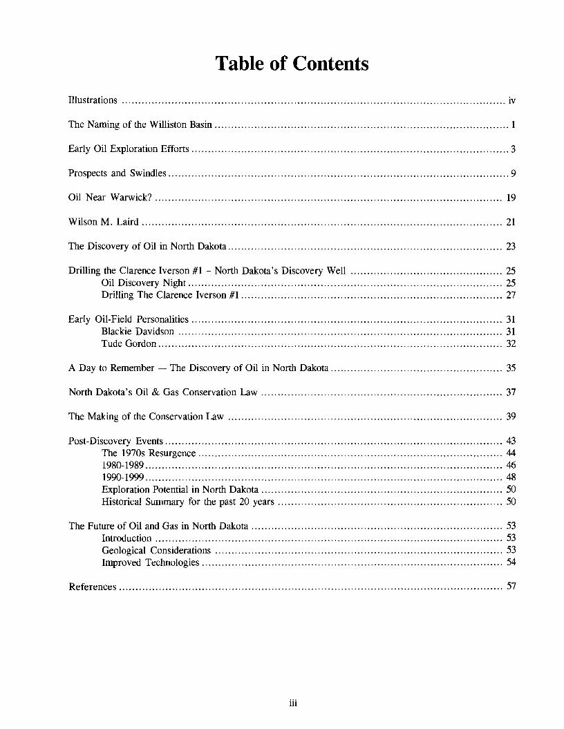
Table of Contents
Illustrations iv
The Naming of the Williston Basin 1
Early Oil Exploration Efforts 3
Prospects and Swindles 9
Oil Near Warwick? 19
Wilson M. Laird 21
The Discovery of Oil in North Dakota 23
Drilling the Clarence Iverson #1 - North Dakota's Discovery Well 25 Oil Discovery Night............................................................................................... 25 Drilling The Clarence Iverson #1 27
Early Oil-Field Personalities 31 Blackie Davidson 31 Tude Gordon........................................................................................................ 32
A Day to Remember - The Discovery of Oil in North Dakota 35
North Dakota's Oil & Gas Conservation Law 37
The Making of the Conservation Law 39
Post-Discovery Events 43 The 1970s Resurgence 44 1980-1989 46 1990-1999 ... . . . .. .. . . . . . .. .. . . . . . . . .. . . . . . . . . . . . . . . . .. . . . . . . . . . . . . . . . .. .. . . . . . . . . . . . . . .. . . . . . . . . . . . . . . . .. . . . . . . . . . . .. 48 Exploration Potential in North Dakota 50 Historical Summary for the past 20 years 50
The Future of Oil and Gas in North Dakota 53 Introduction 53 Geological Considerations 53 Improved Technologies 54
References '" 57
iii

Illustrations
Figure Page
Figure 1. Spectators gathered around a drill rig near Des Lacs, North Dakota 6
Figure 2. Example of 'stock cetificate' for oil companies 11
Figure 3. "Geologist's map" of the New England structure 12
Figure 4. Gas flare on the "Mohall Dome" 14
Figure 5. This picture appears on many pieces of promotional literature circulating during the 1920s ..... 15
Figure 6. Threshing scene in 1919 near Mohall 17
Figure 7. Composite photo of several activities relating to the uses of natural gas 17
Figure 8. Wilson M. Laird 20
Figure 9. Aerial view of the Clarence Iverson #1 Well prior to the discovery of oil 24
Figure 10. Bill Shemorry in front of a greatly enlarged photo of the Clarence Iverson Discovery Well ... 26
Figure 11. Photo of the monument placed at the discovery site..................................................... 28
Figure 12. Blackie Davidson - "Mr. Oil himself" 31
Figure 13. Tude Gordon 32
Figure 14. Clarence and Thea Iverson ride down Williston's Main Street during an oil anniversary celebration parade , 33
Figure 15. Line graph of annual oil production in North Dakota since 1951 43
Figure 16. Line graph of the number of oil and gas wells drilled annually in North Dakota since 1951 .... 45
Figure 17. Line graph of the number of wildcat wells drilled annually in North Dakota since 1951 45
Figure 18. Wilson M. Laird Core and Sample Library on the University of North Dakota campus in Grand Forks........ . .. . . . . . . . . . . . .. . . . . . . . . . . . . . . . .. . . . . . .. . . . . . . . . .. .. .. . . . . . . . . . . . . .. . . . . . . . . . . . . . . . .. .. . . .. .. 46
IV

The Naming of the Williston Basin
[Editor's note: This article is adaptedjrom one written by Bill Shemorry. It appeared in his 1991 book, "Mud, Sweat and Oil- The Early Years of the Williston Basin." I have shortened Bill's article somewhat and made some minor corrections and changes. - IPBJ
Positive evidence that a Williston Basin existed was discovered in 1912 by geologist W. Taylor Thorn, Jr., who at that time was working with two other eminent geologists, E. Russell Lloyd and L. Murray Newman. They had discovered fossil corrals in beds of clay and sandstone exposed along the banks of the Cannonball River near the South Dakota border and so concluded that the area had at one time been at the bottom of a sea.
Thorn spent the next decade trying to define the limits of what was then called the Cannonball Sea Basin. Some of this time was spent with various U.S. Geological Survey field parties working from the Rocky Mountains east. The geologists Thorn worked with included A. J. Collier, who was already well known in North Dakota as being the author of a 1918 publication that described the Nesson Anticline. The anticline was further described by another geologist, Leonard Percy Dove, who worked for the North Dakota Geological Survey. In 1922, Dove described the Nesson Anticline (in Volume 12 of the Quarterly Journal of the University of North Dakota), and in 1925 he further described it in Bulletin 4 of the North Dakota Geological Survey. It was the dissemination of this kind of information that helped create the interest that resulted in some of the attempts during the 1920s and later to drill oil wells.
During the early 1920s, the results of various studies were published in a number of North Dakota Geological Survey papers, and they were discussed in letters by Arthur Gray Leonard, who
was State Geologist of North Dakota.
Thorn provided the following comments to Bill Davidson, Jr., who was a member of the Williston Chamber of Commerce Oil Committee:
"The name 'Williston Basin' was formally used in a scientific paper" Thorn related, "which Dr. C. E. Dobbin and the writer [Thorn] presented before the Geological Society of America, December 28, 1923 - publication in the Society's bulletin following on September 30, 1924.
Before that the writer [Thorn] had used the name 'Williston Basin' on a structural sketch map which had been published in February, 1923, by the American Association of Petroleum Geologists. This map, which accompanied his article on 'The Relationship of Deep Seated Faults To The Surface Features of Central Montana, ' was the one republished as 'Figure l' of the GSA article.
Semi-formal uses of the name 'Williston Basin' had also been made in a U.S. Geological Survey memorandum to the press which the writer [Thorn] prepared on the topic, 'Possible Oil & Gas in North Dakota.' This press notice (was) No. 3761, bearing the release date of June 13, 1923." The name 'Williston Basin' was used three times in that press notice.
Through the years, Thorn became one of the nation's leading geologists. While he worked with the U.S. Geological Survey, he advanced to ChiefofFuels Section (oil, gas, and coal). By 1953, two years after the discovery of oil in North Dakota, Thorn was chairman of the Dept. of Geological Engineering and Blair Professor of Geology, Princeton University. He was also President of the Yellowstone-Bighorn Research Association.
1

Early Oil Exploration Efforts
Even though the Williston Basin is known today as an "oily" basin, the earliest wells were generally drilled in the hope of finding natural gas (methane), which was known to most people around the turn of the 20th Century as "marsh gas." People preferred the gas because it could be used essentially as it came out of the ground.
Natural gas (methane) was first reported in southeastern North Dakota in 1892 in an artesian well producing from the "Dakota" Formation sandstone. Methane gas was obtained from many artesian wells in a belt extending south from Jamestown to Merricourt. The gas was used for lights, cooking, and heating at Edgeley. It apparently occurred in an unsaturated solution with the artesian water and, as the water pressure was released when it flowed to the surface, the gas was collected in tanks. Although enough gas was found to supply the small towns in the area, improper drilling and maintenance of the wells resulted in blowouts, plugging, and loss of head. When the artesian head was lowered below the land surface, gas production stopped, and by 1920, the gas was used on only a few scattered farms. No record was made of pressure or production of the gas, which occurred at a depth of about 1,100 to 1,200 feet.
Another early gas discovery was made in Bottineau County in 1907. In the Fifth Biennial Report of the North Dakota Geological Survey, published in 1912, John Barry (NDGS, 1907 -1908) noted that gas had been struck on the Parker farm, nine miles south of Westhope on July 3, 1907. The gas came from a 19-foot-thick sand bed at the base of the glacial deposits, at a depth ranging from 175 to 210 feet. Six-inch casing was used. When the first well was opened, sand, small rocks, pieces of lignite, and twigs were blown out forming a dune 100 feet in diameter and six feet high around the well. The initial pressure was 64 psi, but this soon declined to about 20 psi. Barry also noted that Lansford, in southwestern Bottineau County, was supplied for a time with gas piped from wells located five miles to the northeast. He noted too that similar gas discoveries were made at Maxbass, and at several other farms in the Mohall area. At about that time too, a company known as the North Dakota
Gas Company supplied gas to the town ofWesthope. The gas was delivered to the town through a 20-mile pipeline. Eight wells cost 13.6 cents per foot to drill and charges to the townspeople were 30 cents per 1,000 cubic feet of gas in summer, 40 cents in winter.
The gas was used to heat and light 13 homes in Lansford by use of an underground pipeline system. Many local farmers in that area had installed separators and used the gas to heat barns and other structures, apparently for several years before 1910.
In 1911, the North Dakota Legislature passed an oil and gas conservation law (S. L. 1911, ch. 195) which prohibited the production ofgas from natural gas wells unless they were tied to a distribution system. Apparently, the law was passed in response to complaints from neighbors who were disturbed by the noise resulting from the practice of promoters opening up wells for the benefit of potential investors.
Even though shallow gas was used in parts of northwestern and southeastern North Dakota before 1910, the low-heating value gas was obtained from glacial deposits and no serious attempt was made to drill a real "oil well" until about 1915. In 1912, the Pioneer Oil & Gas Company was organized by a group of people from Bainville, Montana. According to accounts by William Shemorry (Mud, Sweat and Oil, 1991): "An Englishman by the name of A. P. Drapes may have been the founder of the Pioneer Company and it is believed he put up a good deal of the original money. J. W. Phillips, a geologist, was probably his close associate, able to 'read' surface geology, point to a spot, and say, 'Here is where we will drill'" [a talent modem geologists still aspire to! - IPBj.
After three years of fund raising, drilling began in September, 1916 on the Pioneer Oil & Gas No.1 near Williston. The well drilling was a major topic of interest in the Williston area for four years, until the well was abandoned as a dry hole at a depth of 2,107 feet in 1920. The company announced it had a producing well in November of 1919, and
3

4

although this may have attracted some additional investors, about all the well ever produced was some water.
At about the same time the Pioneer well was being drilled, a North Dakota corporation calling itself the Des Lacs Western Oil Company was organized at Minot. Officials of this company attempted to drill several wells in northwestern North Dakota; however, it is difficult to be certain just what was going on much of the time, as the various press releases and reports were a blend of hearsay, promotional statements, and facts. The quotation that follows is from a prospectus of the Des Lacs Western Oil Company. It dates to about three years after the first attempt by the company to drill a well.
July 14, 1919
"The Des Lacs Western Oil Company is a North Dakota Corporation, incorporated for 275,000 shares, all common stock and non-assessable.
We now have a Lease acreage of more than 60,000, located favorable for both Oil and Gas by prominent Geologists and Oil Men.
We encountered showings of Oil in seven test wells and also established our "Blum Anticline. " We are encountering some very nice seepages of Oil and Natural Gas in "BLUM WEU" which has now reached a total depth of 2125 feet. We are still carrying 8 1/4 Casings and have sufficient casings now on groundfor a 3000100t well. Yes, Blum Well will be carried down to 3000 to 3500 feet or even deeper in order to bring in Commercial production, which we sincerely believe will be encountered when the big Drill taps the proper formation.
This is a North Dakota proposition. Commercial Oil has been encountered in our sister state, South Dakota, and we believe that it will be only a matter of
reaching the proper formation to put North Dakota in the Oil producing column.
A small block of stock is being offered at $5.00 a share. All stockparticipates in Lease holdings and otherproperty ofthe company.
We are now below Sea Level and nearing formations which have been known to be productive of commercial Oil and Gas. You can help develop the natural resources of your home state by becoming a stockholder with us now. "
In 1915, a wildcat oil well was started by the Des Lacs Western Oil Company on the farm of A. F. Blum, I'h miles southeast of Lone Tree, Ward County (Fig. 1). The well was abandoned at 2,125 feet in October, 1916. Interestingly enough, the hole was located approximately two miles from modern production in Lone Tree Field. Wells in Lone Tree Field produce from the Sherwood (Mississippian Madison) at a depth of approximately 6,300 feet, so the choice of a location was really not too bad, and if it had been possible to drill the well deeper, it might have been a success.
In April, 1916, State Geologist, A. G. Leonard visited the Williston area to determine the probability of finding oil or gas in that vicinity. He reported his findings to John Bruegger, a local merchant, and advised against going to the expense of drilling a well. The following month he visited Marmarth for a similar purpose at the request of Governor Hanna and recommended drilling in that area. [It is not clear why he made this recommendation, but he was certainly aware ofthe Cedar Creek Anticline. - JPBJ
In December of 1916, L. L. Colby of the Des Lacs Western Oil Company of Minot visited Earle Babcock, then Dean at the University of North Dakota, asking his advice about drilling an oil well at Des Lacs (Babcock had been the first State Geologist, serving from 1895 to 1902). In a letter written in the spring of 1917, Babcock advised against drilling. At that time, Colby, who had been the original promoter, resigned from the company. However, his successors, H. S. Johnson (a United States Geological Survey geologist) and Blum
5

Figure 1. Spectators gathered around a drill rig near Des Lacs, North Dakota about 1915.
continued to promote the proposed well. In September, 1917, they asked the North Dakota Geological Survey to investigate the possibilities of finding oil and gas in the Minot area. According to Des Lacs' advertising, Leonard and Simpson found enough evidence to recommend further exploration. What Leonard or Simpson actually said is not known, but apparently neither of them actually recommended drilling a well. The Des Lacs Western Oil Company eventually did drill a well in 1923, in the NW1I4 NE1I4, Sec. 9, T. 155 N., R. 85 W. The well, which was nonproductive, was drilled to a depth of 3,980 feet at a location only four miles east of modem production in the Lone Tree Field (modem production is from a depth of about 6,300 feet - see above).
At the time the Blum Well was being drilled, and for a period of about five years from 1916 to 1921, Assistant State Geologist Howard Simpson provided technical services to the Des Lacs Western Oil Company by traveling to their well sites and observing and advising on the tests
statement for his services (dated February 9, 1917):
Feb. 7, Taxi, baggage, Grand Forks Checking baggage Breakfast Chair, GF to Minot (trainjare) (illegible entry) Lodging, Minot
Feb. 8. Taxi to depot Breakfast
Feb. 9. Lunch Checking baggage Supper on train Seat, Minot to GF (trainjare) Taxi, baggage Express
Expenses Three days services @ 10.00
.50
.20
.50 1.00
.80 1.00
.20
.55
.50
.20
.85 1.00
.50
.50 9.20
30.00 39.20
being conducted by the company. In one The addition is off slightly. A letter written handwritten letter, Simpson submitted an itemized a few months later to Simpson from the oil company
6

secretary, notes that they apologize for a delay in paying the bill, but they will be paying it as soon as they raise more money. Following a similar billing by Simpson a few years later, Simpson subsequently agreed to deduct $7.00 from his bill as a sort of "contribution to the cause" (see below).
Another series of letters written in 1921 is interesting in its dogged persistence at a single topic - attempts to measure the temperature of samples obtained during the drilling of a 4,OOO-foot hole by the Des Lacs Western Oil Company in the same general area as the 1916 well. The letters span almost all of the year 1921. The first letter is dated January 31, 1921 and is addressed to H. S. Johnson, Secretary of the Des Lacs and Western Oil Company [I have not included the entire content of some ofthese letters; in this and other quotations, I have left the spelling as it is in the original - JPB).
January 31, 1921 - Letter to Johnson from Simpson:
"I have thought often ofthe temperatur test we made on the muds. I am anxious to secure from you or Mr. Blum, ifhe owns it, the little thermometer with the blue colored wood back which we used in taking the temperature of11()O at that time, in order that I might test out the instrument at the same temperature to see what the reading would be for this on a standard thermometer. I should greatly appreciate therefore, your sending me that thermometer the next time you are at the well and have the opportunity, in order that I may make the proper correction. I will return it to the owner." The letter is signed by Howard Simpson, Assistant State Geologist.
February 14, 1921 - Letter from V. Smith to Howard Simpson:
"Mr. Johnson has instructed Mr. Blum to send you the thermometer used in your test of December 6th out at the well and will be pleased to receive your
thermometer. "
Apri/30, 1921 - Letterfrom Simpson to Johnson:
"Accept my thanks for the thermometer which was sent from Mr. Blum's residence.. .l should like very much to get some additional data on the temperature ofthe sludge as it comes up, and will try and provide you with a special thermometer which could be used for getting the temperature, in case you are still drilling. Regarding the bill on December 7, amounting to $29.76, permit me to make a contribution to the work of the company as I did in the earlier work, and deduct $7.00 from that portion of the bill rendered for service. "
May 5, 1921 - Letterfrom Simpson to the Director of the U.S. Bureau ofMines, Washington DC:
"I visited the well in December when a depth of approximately 3,800feet had been reached, and the temperature ofthe sludge, indicated on the crude thermometer available, was over 100 degrees in Fahrenheit. I have just secured the thermometer used and hope to compare it with standard instruments in order to determine the true temperature as nearly as we may from thick sludge removed by a sludge bucket...1 am very desirous of securing more satisfactory temperature date in case the well is drilled further.. .l would request your advice with regard to what type ofthermometer should be used in getting the temperature and what method you found most suitable for this purpose... Is the high temperature due to friction in the drill? Have you a thermometer suitable for deep well work which culd be loaned to the North Dakota Geological Survey for a time for
7

use in this well?"
May 5, 1921 - Letterfrom Simpson to the Director of the U.S. Geological Survey:
(Dr. Simpson wrote essentially the same letter to the USGS as he did to the Bureau ofMines.)
June 6, 1921 - Letter from Simpson to Johnson: ". .. the Director of the
U.S. Geological Survey, George Otis Smith, has assigned Mr. C. E. Van Orstrand, Physical Geologist of the U.S. Geological Survey, to work with me in securing a series of temperature observations upon the deep well." (The letter goes into more detail about how to obtain temperature readings in deep wells.)
June 17, 1921 - Letterfrom Acting Director ofthe USGS, Philip Smith, to Simpson:
"[ampleasedto leamfrom your letter of June 6 that you are making final arrangements for a temperature test of the deep well being drillednearLone Tree, North Dakota... "
July 29, 1921 - Letter from Johnson to Simpson:
"[ am starting out on the road again and will send you your expenses on last year's trip just as soon as [ can raise the money. "
October 25, 1921 - Letter from Johnson to Simpson:
"... we enclose your expenses for $30.00. [am sorry that [ have been unable to send this to you before.. .Before sending the samples to you, it will be necessary
for us to have some more ofthe little bags as [ notice that several of the little bags have dry rotted and can not be handled. "
December 19, 1921 - Letter from Director of USGS to Simpson:
"... we enclose the results ofthe temperature test taken on the well... "
Even as late as 1926, the Des Lacs Western Company, which by then was $40,000 in debt (although it's not clear whether Johnson and Blum suffered any loss) was promoting the idea that Simpson and Leonard had endorsed the drilling of the well. Leonard, in a letter written on March 3, 1926 to L. L. Colby, said that "Sofar as we know the statement ofProfessor Simpson made several years ago still holds true, 'so far as [know, at no time was there a measurable amount of oil nor a sufficient amount ofgas to produce a flame higher than a few inches. '"
Another early wildcat well was the Big Viking, spudded in the spring of 1927 about 18 miles southeast of Ray in Williams County. State Geologist A. G. Leonard gave his opinion that this was a good location for the well. From the time it spudded, for a period of eight years, drilling went on, sometimes rather intermittently, as uncertain finances and equipment problems plagued the operation.
On October 11, 1937, the California Company spudded the Nels Kamp #1 Well in Williams County. On August 15, 1938, the well was abandoned. This well was drilled to a depth of 10,281 feet, in a location less than a half mile from a producing well drilled in 1956 and approximately a quarter mile from a well completed in 1984 in the Silurian. The Kamp well was drilled into the Devonian, and was the first test well in North Dakota on which an electric log was run. It was apparently circulating mud at the time it penetrated the Madison.
8

Prospects and Swindles
In the early years of this century, numerous efforts were made to find oil and gas in various parts of North Dakota. It's likely that as much or more effort was expended soliciting for investments in stock in the small corporations formed to explore for the oil and gas as in actually looking for the oil itself. These solicitations invariably involved testimonials from eminent people: geologists, engineers, and other "credible" people. Even the State Geologist of North Dakota sometimes supplied letters of reference for use by the stock companies, and these testimonial letters were exploited extensively for advertising purposes.
A series of letters written in 1921 and 1922 between State Geologist, A. G. Leonard, and William Langer, who later become Governor of North Dakota and then Senator, begins with a letter from Langer to Leonard, dated December 7, 1921. I'll quote the letter in its entirety:
"While I was Attorney General and on the Blue Sky Board the records will show that I repeatedly, in fact almost invariably insisted that before Gov. Frazier, Sec'y of the State, Thos. Hall and myselfwould permit an oil or gas company to operate in Nonh Dakota that either your personal approval, or that of some member of your depanment be secured.
I mention the above simply as introductory. I now have the time to become personally and actively interested in the development of oil and gas prospects of Nonh Dakota.
Several of us University graduates, including Tom Johnson ofDunn County, John Williams of Washburn, Fred Graham of Ellendale and others are uniting our effons and abilities in bringing Nonh Dakota resources to thefront and incidently or rather not entirely incidently, but as a major by product, making some money for
ourselves. I should like to know how
much it would cost us in case we could getyour time andyou could so arrange your work so as to have it at your disposal, to give us ten days or two weeks in various pans of Nonh Dakota and also what it would cost us to get youfor thirty or forty days this coming summer. We do not wish to presume in any friendship and it is strictly a business proposition. "
The letter is signed by William Langer. Leonard responded, pointing out that his normal fee was $25/day, but for over a week he could drop that to $20/day. He suggested waiting until the next spring to do the work. Ensuing correspondence consisted of some negotiations about the fees and attempts to set up a time when Leonard could do the work. Leonard pointed out that he couldn't do worthwhile work when there was a heavy snow cover. Langer agreed, commenting (December 27, 1921) that "At the present time we have considerable snow. I drove out in the country yesterday and feel satisfied that you could not do careful and wonhwhile work under the present conditions. "
I cannot find any reports that Leonard may have made as a result of his work for Langer, but it appears that he did actually do the work. In a letter dated May 29, 1922, Langer writes: "I have your telegram of May 27th and will expect you here Friday night, June 2nd, for four days. I willpay you while you are here so I will not inclose a check now. "
Time has shown which of the oilexploration ventures were realistic ones, which were misguided, and which were out-and-out swindles. Almost all of them were wildly optimistic in their claims and promises, with pictures of "gushers" and promises to investors that they might become millionaires overnight for only a few dollars invested. The "geological evidence" for the oil-bearing structures promoted in the stock offers often consisted simply of a scribbled "map,"
9

or maybe a circle or oblong figure to represent an "anticline" insofar as the average person understood it in those days.
A dollar a share was a typical price for stock in these companies (Fig. 2). The stock prospectus usually extolled the virtues of this or that oil company and explained why certain areas were sure to be rich in oil or natural gas (gas was usually the preferred target of those companies because it could be used on the spot).
In a letter to Leonard dated May 15, 1925, M. W. Duffy a lawyer from Cooperstown, writes "there is a party now operating in this territory, claiming to be a geologist in the employ ofthefederal government and telling the people here that there is every indication of oil in this county." In his response, Leonard noted that he had not seen any evidence that oil is present in the Cooperstown area. He went on to say: "I hardly think the man you mention, who claims to be a geologist in the employ of the Federal Government, can be a Government geologist or he would not go about making effons to supervise drilling for his expenses. I doubt very much whether the Government would allow its employees to do this. "
In response to a request from a person in Moline, Illinois for information on a reported oil discovery in Kidder County, Leonard wrote "... the oilfound in Kidder County is refined oiland analyses show it to be Red Crown Gasoline. The oilfound in the water wells has evidently been poured in from above.. .boring oftest wells will result in nothing but failure. " [As nearly as I can tell, this was a venture of A. C. Townley, who promoted a well near Robinson in about 1925, the A. C. Townley Interests - Robinson Patented Land Company NO.1 - JPBj.
Another letter, this one written in 1926 from Leonard to Professor Glenn Dille of Coe College in Cedar Rapids, Iowa, refers to oil developments in the Bumstad area of Logan County. He recommended against drilling for oil in the area, and he went on to say that several men claiming to be oil geologists claim to have found favorable structures. However, he stated "One of these men I know to be a fake who will find oil indications anywhere for a good fee. "
Usually, Leonard wrote letters designed to
let anxious investors down gently, but not always. In a response to Herman Hanson, president of Herman Hanson Oil Syndicate in Turtle Lake, Leonard wrote the following letter in 1925:
"I was interested in receiving your letter ofNovember 17 and the report ofthefindings made with a "Mineral Indicator." I am sorry you believe the ridiculous stuff contained in that report and by the time you have spent many thousands ofdollars drilling for oil and finding none, you will realize what a fake the man was. His findings are almost too absurd to deserve notice. No instrument has yet been inventedwhich will locate oil below the swface as has been abundantly proved again and again. There is absolutely no evidence of any anticline in McLean County and if there were, the "Indicator" would never locate it.
I know, ofcourse, that you will drill one or more holes in search of oil and I certainly wish you might find the oil, but I am satisfied that the conditions are not favorable and that no oil is present below the surface. For this reason I feel that I should warn you beforehand that your money spent in drilling will be wasted and no oil will be found. "
Or consider Leonard's letter written in response to an inquiry from Bumstad:
"I remember very well my visit to Burnstad in 1923 and my trip to the top of Shell Buttes. I happened to have had some correspondence with one of the geologists you mention, Mr. Jess Vorhees, and I know ofhis claim to have found an oil structure in the Minot region. He is thoroly unreliable and I am satisfied that no consideration can be placed in what he says. To be entirely frank about it, he is a fake geologist but a very
10

..... .....
Figure 2. Example of 'stock certificate' for oil companies. Certificate courtesy of Ken Schmidt, Williston, North Dakota.

shrewd and plausible one. "
Leonard's letter went on to point out that there had been many so-called geologists in North Dakota the past year, but most of them were not reputable.
One of the prospect areas in North Dakota included the Pembina Hills Region, which was promoted in 1927 by a "former Montana geologist." This area was written up in the April 14, 1928 issue of the Montana Oil Journal and included a complete report on the "Pembina River Oil Structure." Another important area of interest was near Marmarth in 1917. Here, testimonials were solicited from several people, including State Geologist A. G. Leonard. Of course, the Cedar Creek Anticline ultimately did become an important gas-producing structure and still is. In 1927, the Turtle Lake area in McLean County was promoted by another Montana geologist. Apparently, being from Montana, where gas was already being produced, and being somehow associated with the Montana Bureau of Mines (this is implied from the article) helped to assure potential North Dakota investors that these people and, of course, the prospect, were reliable.
In the New England area a considerable effort was made to raise funds in the early 1920s
(Fig. 3). This is an involved story that apparently included mainly local people until the initial venture folded about 1923. According to an article in the Hettinger County Herald on April 4, 1927, "A. C. Townley himself" became involved. Townley was an interesting man who played a fascinating role in North Dakota oil history, to say the least, but that's a story in itself, better told by historians.
Still another venture took place, this one in 1926, by the Beaver Lake-Shell Butte Oil Company in Logan, McIntosh, and Emmons counties. It involved the Red Lake and Shell Butte areas of the Beaver Creek District, according to the prospectus. In the prospectus, three Montana geologists are quoted as saying (apparently in unison!) that the Beaver Creek District is "one of the largest and best defined structures it has been my pleasure to examine" (it is not clear which of the three is writing). One of the geologists goes on to say "In view of the intensive and world-wide search for petroleum, and of the stratigraphic and structural features here obtaining, I believe this district affords the most remarkable opportunity for a test well of any of the unexplored and undeveloped portions of the North American Continent." This promotion included a curious drawing that was purported to be a "structural sketch map." At best, the "map" may have shown some glacial moraine features, but I can't tell for sure.
Figure 3. "Geologist's map" of the New England strucrure, supposedly an anticline, that appears on many promotional brochures in 1923. On the brochures, the map is always less clear and much harder to read than is the copy I've reproduced here. I can't guess what geologic information was used to compile the map, and the geologist who compiled it is not indentified.
12
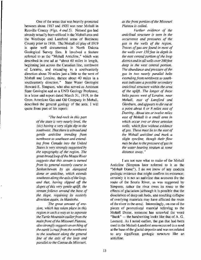
One of the areas that was heavily promoted between about 1917 and 1920 was near Mohall in Renville County (Figs. 4 and 5). Natural gas had already actually been utilized in the Mohall area and the Westhope and Lansford areas of Bottineau County prior to 1910. The Mohall oil play of 1919 is quite well documented in North Dakota Geological Survey files. It involved a feature referred to as the "Mohall Anticline," which was described in one ad as "about 60 miles in length, beginning just across the Canadian line, northwest of Loraine, and extending in a southeasterly direction about 70 miles just a little to the west of Mohall and Loraine, thence about 40 miles in a southeasterly direction." State Water Geologist Howard E. Simpson, who also served as Assistant State Geologist and as a UND Geology Professor, in a letter and report dated March 31, 1919, to the Great American Gas and Oil Company in Mohall, described the general geology of the area. I will quote from part of his report:
"The bed-rock in this part ofthe state is very nearly level, the (sic) having a very slight dip to the southwest. That there is a broadand gentle anticline trending from northwest to southeast and extending from Canada into the United States is very strongly suggested by the topography of the region. The great broad loop ofthe Mouse River suggests that this stream is turned from its general easterly course in Saskatchewan by an elongated dome or anticline, which extends southeast along the axis ofthe loop, and that, having slipped off the slopes ofthis very gentle uplift, the stream follows around the base of the slope, regaining its easterly direction again, in Manitoba.
The great amount of erosion, which has taken place in this region in such a way as to separate the Turtle Mountain outlierfrom the main front ofthe Missouri Plateau, also strongly suggests an arching of the earth's crustfrom the northwest to the southeast along the general line of the axis of the loop and parallel to the Coteau du Missouri,
as the front portion ofthe Missouri Plateau is called.
Further evidence of the anticlinal structure is seen in the occurrence and pressures of the gas in the wells of the region. Traces ofgas are found in most of the wells over 150 feet in depth in the east central portion of the loop district and in all wells over 200feet deep in the west central portion. The abundance and pressure ofthe gas in two nearly parallel belts extending from northwest to southeast indicates a possible secondary anticlinal structure within the area of the uplift. The longer of these belts passes west ofLoraine, near Mohall, east of Lansford and Glenburn, and appears to die out at a point about 6 or 8 miles east of Deering. About ten or twelve miles east of Mohall is a small area in which occur two or three artesian wells, which flow without evidence ofgas. These must lie to the east of the Mohall anticline and mark a slight syncline, though their flow may be due to the pressure ofgas in the water bearing stratum at some distance away. "
I am not sure what to make of the Mohall Anticline (Simpson later referred to it as the "Mohall Dome"). I do not know of any modern geologic evidence that might confirm its existence; certainly it is not an anticline that accounts for the route of the Souris River, as was suggested by Simpson; rather the river owes its route to the effects of glaciation (although it is possible that the dissolution of deep salt beds, and resulting collapse of overlying materials may have affected the route of the river in the area). Interestingly, on one of the pieces of promotional material referring to the Mohall Dome, someone has scrawled the word "Bunk" - the handwriting looks like that of A. G. Leonard. As I noted earlier, the gas that had been used in the Mohall-Lansford area occurred in a sand at the base of the glacial deposits and was not related to any significant geologic structure like an anticline.
13

Figure 4. Gas flare on the "Mohall Dome." Photo taken in the early I920s .
Even so, Leonard made the following statement in Unionformation at a depth of2ooto 1920: 300 feet. A company has been
formed to drill on this anticline, the "With its crest about three well to reach the Dakota sandstone
miles west of Mohall, near the in search of oil and gas. " eastern border ofRenville County, a.. .quite well defined anticline has The Great American Gas and Oil Company been located, its axis trending eventually ran into other troubles with the state north-northwest and south-south "Blue Sky Commission," which regulated and east. Within the area covered by supervised the sale of these stocks. The following the Mohall anticline a large number quotation is from a newspaper clipping dated April ofwells yield gas under pressure of 3 (but I can't find either the year or the name of the over 100 pounds, the gas being newspaper). found in sandstones of the Fort
14
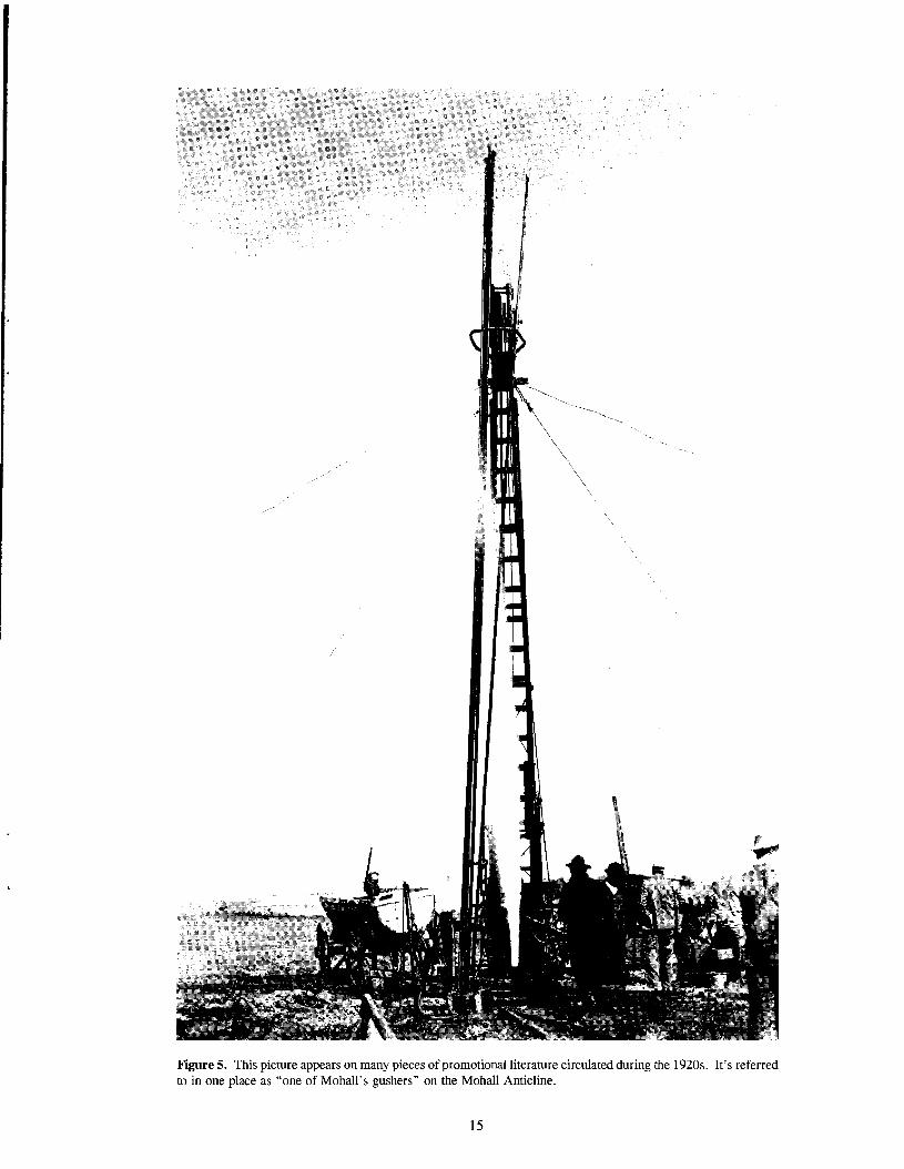
Figure 5. This picture appears on many pieces of promotional literature circulated during the 1920s. It's referred to in one place as "one of MohaIl's gushers" on the Mohall Anticline.
15

"A well was started near Mohall, Renville County. A mammoth sales campaign was inaugurated. Autos met prospects at the train and took them to the well. Gas had beenfound, it is said, and wells burned brightly at night when prospective buyers for stock were on hand.
When the well was only partly down to the depth it was planned to drill, the contract with the well drillers was broken. The Great American sued the drilling company. The company sued the well drillers. An attempt was made by some parties to remove part of the equipment to Montana, it is charged.
It is also charged by the state that stock salesmen sold stock to some people at thepar value of$1 a share and would sell stock to others the same day for as high as $5 a share."
Except for "exorbitant salaries and commissions" paid officials of the company, the commission charged that "nearly all of the remaining money was spent on promoting the venture and almost nothing was actually spent in exploring for oil."
Another interesting part of all this is the way these early North Dakota oil companies went about promoting stock sales. One example I found in our (NDGS) files includes a composite picture extolling the use of gas for farm operations. The farm may have been that of Ole Hellebust in Renville County. The photo was made in 1919, about the same time that Great American Gas and Oil Company hired a firm called Publicity Film Company to make some movies along Mohall's Main Street. According to a Mohall newspaper clipping (it is undated, but apparently is 1919 also), these movies showed the exterior and interior of the
office as well as the officers of the oil company. They also showed a threshing scene on the Mohall Anticline of a 60 h.p. gasoline engine pulling a 42inch separator, the engine being operated by natural gas in place of gasoline. I'll quote part of the article (Figs. 6 and 7):
"No important changes were made on the carburetor and the pressure from the gas wells forced the natural gas into the carburetor and the engine worked perfectly and seemed to handle its load as easily as it would on gasoline. This is probably the first time in history that such a threshing rig has ever been operated by natural gas power. They also photographed a washing scene, the gasoline engine being operated by natural gas coming direct from the well. The pictures taken of the tapping of one of the company's wells which they have put down since they began operating this Spring will also be a very interesting scene to theater goers. Then they photographed the cooking and lighting with natural gas and also the operation of the large standard oil drillers outfit operating southwest of this city.
The company has gone to considerable labor and expense having this film company come to the Mohall fields and we hope the pictures will do the different scenes photographed justice. If they do, this will be one of the most unique advertising films ever produced. "
These are just a few of the many examples of the early oil exploration promotional efforts in our files. Several of the old photos I have included here were used in brochures promoting sales for the Great American Gas & Oil Company in Mohall.
16

Figure 6. Threshing scene in 1919 near Mohall, North Dakota. A 60 hp gasolene engine is pulling a 42" separator, the engine being operated by natural gas from the wellhead at left.
Figure 7. Composite photo of several activities relating to the uses of natural gas. The scenes were probably taken in 1919, on the Ole Hellebust farm, near Mohall, in Renville County. but I cannot verify this. The pictures were used in a prospectus extolling the use of gas for farm usage. The gas well was drilled by the Great American Gas & Oil Co.
17

Oil Near Warwick?
In 1933, Professor William E. Budge, in the School of Mines, had taken an interest in the occurrence of oil shale and oil seeps along the Sheyenne River south of the Devils Lake Sioux Indian Reservation. These had been called to his attention by interested citizens of Warwick. Budge made several trips to the area and attempted to get an appropriation from the 1935 Legislature to make further studies of the area inSecs. 20and21, T. 151 N. , R. 65 W., but he was unsuccessful. Because the area is covered by glacial drift, Professor Budge felt that only seismic methods could determine the structural features of the area.
Earlier, State Geologist A. G. Leonard had responded to a letter dated April 19, 1922, from W. M. Anderson, a lawyer from Devils Lake. Anderson referred to "oil indications" south of Warwick on the Reservation. In his letter he stated: "... oil is present in a creek comingjrom a ravine and running into the Sheyenne. I do not know how
extensive this is but others have reported what they deemed to be oil indications... " Leonard's response to Anderson, dated May 3, 1922, notes that "... the Geological Survey made a rather detailed survey of the Devils Lake region some years ago but found no evidence of oil in any quantity. The shales of that district do in places contain a trace ofoil but in the absence of sandy layers it would not be found in commercial quantity... There is no evidence ofany anticlines in the eastern part of the state and, therefore, practically no chance offinding oil in any quantity. "
[Editor's note: Much later, in the late 1960s, Ire-visited the purported oil-seep areas near Warwick. Ifound no oil, but I did see many springs that hadafilm ofiron oxide and manganese dioxide, which can be mistaken for an oil slick. It is unclear whether this is what had been identified as oil in the 1920s and 1930s, or ifBudge hadfound something I did not see. - IPBJ
19

Figure 8. Wilson M. Laird
20

Wilson M. Laird
More than any other person, Dr. Wilson Morrow Laird, State Geologist from 1941 until 1969, is identified with the discovery of oil and the wise and effective regulation of the oil industry during its early development. Laird continued to oversee regulation until 1969. He is credited with the foresight that oil would one day be discovered in the Williston Basin in North Dakota. To insure that North Dakota avoided the problems that had beset some oil-producing states, he had legislation introduced in 1941 that resulted in a model oil-andgas conservation law being in place ten years prior to the discovery of oil in North Dakota.
Laird also recognized the necessity of establishing a facility for the storage and study ofoil and gas core and samples and had a "core shed" built on the University of North Dakota campus for that purpose. In 1980, the State of North Dakota recognized Wilson Laird's diligent efforts in collecting the information obtained from oil and gas wells by naming a new core repository after him the Wilson M. Laird Core and Sample Library. This North Dakota Geological Survey building is located on the UND campus in Grand Forks.
Dr. Wilson M. Laird (Fig. 8) came to North Dakota in September of 1940 from the University of Cincinnati. Born in Erie, Pennsylvania, in 1915, Laird received his B.S. from Muskingum College in 1936, his M.A. from the University of North Carolina in 1938, his Ph.D. from the University of Cincinnati in 1942, an honorary D.Sc. from Muskingum College in 1964, and another honorary D.Sc. from the University of North Dakota in 1980. Laird was appointed Assistant State Geologist in January, 1941, and served as Acting State Geologist from February 1, 1941, until July 1, 1941, when he was appointed State Geologist.
In addition to his service for the North Dakota Geological Survey, Laird worked for
Carter Oil Company in Montana during the summer of 1948 and he was employed as a geologist for Hudsons Bay Oil & Gas (Continental Oil Co.) in Calgary during the summer of 1949. He also consulted for the USGS in 1944 and 1945 and for Beers and Heroy in 1950. His research involved professional work in Ohio, Pennsylvania, North Dakota, Minnesota, Alaska, southern Manitoba, southern Germany, and central Turkey. He published more than one hundred papers on subjects as diverse as biostratigraphy, regional geology, limnology, mineral deposits, glacial geology, groundwater geology, and petroleum geology. In 1948, Laird shared (with L. L. Sloss) the President's Award of the American Association of Petroleum Geologists for work on Devonian stratigraphy in Montana. In 1981, Laird received the AAPG Public Service Award.
Laird served as Vice Chairman of the Interstate Oil Compact Commission and also as Chairman of the Research Committee. He was elected Vice President of the Association of American State Geologists in 1948 and President in 1950; following that, until his death in 1997, he was an honorary member of the Association. Laird was elected President of the North Dakota Academy of Science for the 1952 term.
In 1969, Laird moved to Washington, D. C. to become Director of the Office of Oil and Gas in the Interior Department. He subsequently served the petroleum industry as Director of the Committee on Exploration of the American Petroleum Institute. Following retirement from his position in 1979, he continued to be active as a consulting geologist from his home in Kerrville, Texas, and his summer home near Bemidji, Minnesota.
Wilson M. Laird died on May 14, 1997 in Kerrville, Texas.
21

The Discovery of Oil in North Dakota
In May of 1949, State Geologist Wilson Laird was granted a leave of absence to carry out a confidential mission for the United States Government in Turkey and Germany. During his absence, Nicholas N. Kohanowski, a mining geologist and engineer who had joined the Geology Department faculty in May, 1949, was Acting State Geologist.
It was Kohanowski who signed the drilling permit for Amerada Petroleum Corporation's No. 1 Clarence Iverson Well to be drilled in the SW1I4 SW1I4 Sec. 6, T. 155 N., R. 95 W., Williams County. The permit was issued on August 4, 1950. Drilling began at 6:00 p.m. on September 3, a Sunday. On January 2, 1951, a drill-stem test, from 10,448 to 10,803 feet, recovered one pint of free oil in the bottom of the test tool (the term "free oil" refers to oil that is free of water and drilling mud; it doesn't imply that it didn't cost anything!). The recovery was from Devonian rocks. However, the hole was carried on down to 11,400 feet without finding additional shows of oil or gas. At that time, the decision was made to core ahead as far as possible, set casing and test all possible shows.
The hole was carried to 11,744 feet where loss of the face off a core bit made further drilling in the unprotected hole too hazardous. At this depth, on February 26, 1951, 11,743 feet of 5 liz-inch casing was cemented in. Partly because of a renewed siege of winter weather, it took a month to make perforations and tests from 11,678 to 11,720 feet. These perforations were cemented off and additional ones made from 11 ,630 to 11 ,660 feet. Through these perforations, the well tested two million cubic feet of natural gas, and after another 4,000 gallons of acid, the gas increased to 7 million.
The official discovery date of oil in North Dakota, listed as April 4, 1951, records the date when economically producible oil was first recovered (Fig. 9). This production was from Silurian rocks, not Devonian. Laird was present at
the completion of the Iverson Well.
The discovery period of the early 1950s was a time of great excitement, not only in North Dakota, but in oil circles across the country. Former NDGS geologist Sid Anderson relates that he was a student at the University of North Dakota at the time, and he recalls Laird's phone ringing almost constantly following the report of the discovery. A little later that April, several students (including Anderson), accompanied Laird on a trip to St. Louis to attend a meeting of the American Association of Petroleum Geologists. At the meetings in St. Louis there was little doubt about the excitement that the Clarence Iverson had generated. Laird was paged constantly and anyone who attended the meeting certainly didn't leave without knowing who he was. This excitement continued as Amerada followed the Iverson discovery with more discoveries on the Nesson Anticline, quickly extending production 75 miles in a north-south line.
As the discoveries continued, and production and development drilling proceeded, the industry faced a problem that would probably not occur to most people now - markets had to be found for the oil. There was no shortage of oil in the country in the 1950s; plenty of gasoline was available everywhere. This meant that oil then going to refineries in the area had to be displaced. Northwest Refining in St. Paul Park, Minnesota bought North Dakota's first oil. Later, oil also went to the refinery at Wrenshell, Minnesota, as well as to other refineries. When the Amoco refinery in Mandan, the Westland refinery in Williston, and the Queen City refinery in Dickinson were completed, all in 1954, this problem was alleviated. However, there still was no shortage of oil in the country, so the production in North Dakota, along with that from the other oil-producing states, was prorated (production was limited to a calculated fraction of production capacity), thereby insuring that all producers received an equitable share of the market.
23

Figure 9. Aerial view of the Clarence Iverson #1 Well prior to the discovery of oil. Loffland Brothers drilling rig.
24

Drilling the Clarence Iverson #1 - North Dakota's Discovery Well
[Editor's note; I thank Bill Shemorry of Williston who granted permission to adapt the following passages from his 1991 book, Mud, Sweat and Oil. The first article, titled "Oil Discovery Night, " is Bill's description of the events that took place the night he took his famous picture of the Clarence Iverson discovery well on April 4, 1951. The second article provides some fascinating background on the drilling of the Clarence Iverson well. The last article describes a bit about two wellknown men who worked on the Iverson well - IPBJ
Oil Discovery Night
The telephone rang in my apartment. The time was about 7 p. m. on the night of April 4, 1951. My boss, Herman Zahl, publisher of the Williston Press-Graphic was on the line. He sounded excited. "Bill," he said, "The Clarence Iverson well has come in. Get your camera and go out there. Take your hip boots because there's a lot of snow melt water out there."
Zahl, the son of Williams County pioneers, owned a lot of land scattered around the country. With all this acreage, he reasoned that he had a good chance to get a well somewhere. So when Amerada Petroleum Corporation began drilling the Iverson, he made it a point to become acquainted with the men in charge. Consequently, when things began to happen, he was in the know. Either Roy Fuller or Blackie Davidson had tipped him off. Roy was Amerada's production supervisor. Blackie was the drilling superintendent on the well.
April 4 was on a Wednesday. The following day was publication day on the weekly letterpress Press-Graphic of which Zahl was publisher and I was managing editor. I knew if I succeeded in getting pictures that I would need printing plates to reproduce them in the paper. That meant a trip to Minot to Northwest Photoengravers, the closest such plant. I called the photoengraver and alerted him that I would be in late that night with a special job. I also called the Minot Daily News and arranged for the use of the darkroom to develop my negatives.
Then I put my camera gear, hip boots and a tripod in my 1950 Pontiac coupe and started down the road. At that time Highway 2 ran past Epping and Wheelock. When I reached the hill just west of Wheelock I could see the glow of a fire in the sky directly to the east. I wondered if the well was on fire.
I passed through Ray and headed east. The light of the fire was getting brighter. There was no problem finding the well site in the dark. I came to the turnoff south of Tioga. A gravel road led to the well. It looked like the fire was just over the next hill, but I found it was 4 miles further. When I approached the well, cars were parked all over the shoulders of the road. There was no room to stop. The glare in the sky had drawn several hundred interested spectators. The drilling rig and surrounding area were lighted by a huge gas flare. It was almost as if it were daylight.
Still no place to park. So I drove on past the derrick, came to the corner where a little church then stood. There was an open place here so I turned around and parked my car. The noise of the escaping gas that fed the flare was so loud spectators had to shout to make themselves heard.
The big Loffland Brothers drilling rig stood before me. Its silver derrick was illuminated by the light of the flare and stood out in stark detail against the black night sky. In the foreground was a big pool of snow runoff water which had gathered in a low place. The night was still. Not a breath of wind. A perfect double image of the derrick and flare was reflected.
I pulled on my hip boots, took out my camera and waded into the water. I wanted to get as close as possible. The glaring light and noise brought a sense of apprehension. "Might there be an explosion?" I wondered.
The light was so bright I didn't worry about getting a good picture. I could easily read all the aperture and shutter settings on my 4x5 Speed Graphic. I was using fast film, but just to be on the
25

safe side I made about a dozen shots, varying the exposures. On some of them I used a slip-on lens for a telephoto close-up effect.
Water started running over the tops of my boots as my feet settled down in the muddy bottom. I sloshed back to the road, put my gear in the car and headed for Minot.
The air was warm. The snow on the ground continued to melt even though it was nighttime. The farther east I drove the more water there was. There is a low spot about a mile or so west of the White Earth hill. The water was surging over the pavement, but it wasn't deep enough to stop me. I drove on. The White Earth Creek was full to the banks, but hadn't gone over the road.
Highway 2 at that time turned left at Stanley, went through town, then followed a route north of the railroad until it got to Tagus. There was an underpass there, and the road went south a ways, then east through Berthold, Lonetree, and DesLacs. Then it went down the big hill and into Minot.
When I turned at Tagus I found the underpass blocked... .it looked like the water was at least four feet deep. I knew better than to drive into it. After quite a bit of fumbling around in the dark, I discovered a road that went around the underpass ...across the tracks at the depot crossing, down Tagus' main street and then I was back on Highway 2. I breathed a little easier.
But my problems with high water had not ended. Near Lonetree there was a stretch of road that was under water nearly the length of a football field. A truck was half submerged in the ditch to the north... two cars in the south ditch. I didn't know any way around it and in the dark couldn't find one. About this time my radio brought news that a farm dam somewhere was about to break. I wondered if I'd be in the path of a greater flood ...alone in the dark it was scary.
"So," I decided, "here goes for nothing!" I edged the car into the flooded highway, driving in low gear. With vehicles ditched on both sides, at least I could tell where the road was supposed to be. The door was left open and I was ready to jump in case I ran into a wash-out hidden below the water.
As I proceeded, the water gradually got deeper and deeper, but I kept going, trying to stay half-way between the two partly submerged vehicles. Water finally flowed over the doorsill into the car. Then I started worrying that the fan would throw water onto the engine and short out the ignition. But about that time it quit coming in. Seconds later I was again on my way to Minot.
I arrived at the darkroom and quickly processed my negatives. When I saw the results I was elated. The pictures were then printed. They were better than I had thought possible.
I took the prints to the engraver and went to get a bite to eat while he made the printing plates. It was after midnight and I was thirsty, so I had a beer with my sandwich. On second thought, I bought a six-pack and set it down on the floor of the car.
When I returned to the engraving plant, the plates were finished. I inspected them to be sure they were what I had ordered. Then I started home. I edged through the pond at Lonetree, skirted the flooded underpass and headed west. Things had turned out so well I decided a little personal celebration was in order. So every once in a while I opened a beer, drank it, and threw the empty can
Figure 10. Bill Shemorry in front of a greatly enlarged photo of the Clarence Iverson Discovery well. Bill took this picture the night following the discovery of oil.
26

on the floor.
As I drove down the Main street of Stanley, my eye caught the blinking of a red light behind me. I thought, "My gosh, if that cop sees these empty beer cans, he'll run me in and I won't make it home in time for the paper.
I stepped on the brakes, made a quick stop, then threw my car door open and walked back to the patrol car. It turned out that the night policeman was merely bored and lonesome and wanted someone to talk to. At that time, I was a member of the Williston Fire Department and entitled to have a red light on the front of my car. He had seen the light as I passed where he was parked and thought I was another police officer. He only wanted to break the monotony with a little conversation. I felt relieved, but I didn't stand too close. I didn't want him to smell my beer breath. As soon as explanations and the conversation had taken place, I drove on. The rest of the trip was uneventful.
However, back in Williston, other things had been going on. Dr. Wilson Laird, the North Dakota State Geologist, had been summoned from Grand Forks for "the big event" and was on hand at the Iverson well-site when the first oil was recovered. Later, he, Herman Zahl and Jim Key, who at that time was the Press-Graphic editorwriter, had gone to the Elks for drinks, and later to the Zahl home for steaks. Laird planned to return home on the Great Northern Fast Mail train which left Williston about 3:00 a.m. and arrived in Grand Forks about six or seven hours later. Because of the timing of the Fast Mail, Laird stayed up, planning to sleep on the train. Due to the lateness of the hour, he had decided to wait until he arrived at Grand Forks to announce the oil strike. However, when he stepped off the train, he was so tired he went directly home. It was not until sometime that afternoon that the news services were informed of the oil strike.
In the meantime, the crew of the PressGraphic, all fired up by what had happened, quickly set Jim Key's story in type, locked it into a page one lead position along with the Iverson flare plate, and began to print. When the paper was distributed, it had a clear scoop on the discovery picture and story.
The release of Laird's information brought
hundreds ofphone calls to Williston, seeking further information. It was not long until the oil-men discovered the Press-Graphic. As I recall, the phone rang almost constantly the next day and part of the following.
Afterwards, the flare picture was published in the Minot Daily News, the Fargo Forum, and some other North Dakota newspapers. Later on it was printed in Life, U. S. News and World Reports Magazine, as well as a number of additional national and regional publications. Soon, Pershing Carlson and Bob Cory began covering the oil beat regularly for the Minot Daily News; Alden McLaughlin became the oil writer at the Bismarck Tribune; and Lloyd Sveen was promoted to oil editor of the Fargo Forum and began making regular trips along with Gifford Herron and Cal Olson to cover the news in oil country.
Oilmen said the photo, which has since become the symbol of the discovery of oil in North Dakota, is unique in the annals of the industry. I can readily believe this, because some months later, M. B. Rudman, Dallas independent oil man, drilled a successful well north of Tioga and spent a bundle of money on special preparations so I could make a night photo of his well...by the light of the flare. However, when the time came, the drillers could not produce a bright enough flare to do the job. Apparently there was not enough gas pressure. Sure, there were images on my negatives, but nothing at all as clear and sharp as the detailed night shots of the discovery well.
That flare on the Clarence Iverson must have been the biggest ever in the history of oil. I'll bet if it could have been measured, it would have been listed in the Guinness book of records!
[Editors note: Bill's picture of the discovery well taken the evening ofApril 4, 1951, is on the cover of this volume - lPBJ
Drilling The Clarence Iverson #1
A granite monument ten miles south of Tioga marks the location of the first producing oil well in North Dakota. It is a historic reminder of the beginning of a hustling new state industry. The No.1 Clarence Iverson, named for the mineral and land owner, was spudded on September 3, 1950. It
27

was the first real oil exploration to take place in western North Dakota since the 1930s. At that time, the Big Viking and California Company deep tests had been drilled on the Nels Kamp farm about 20 miles south.
The possibility of finding oil in North Dakota had been talked about since before World War I. The interest was there, and when the Iverson wildcat began drilling, it created a great deal of local excitement. A crowd of 100 or so people, most from the Tioga and Ray vicinity, was present to watch.
The spud date was on a Sunday. If the word had gotten out a little better, there likely would have been a much larger crowd, and press and radio coverage as well. However, company officials from Amerada Petroleum Corporation and Loffland Brothers Drilling did not deem it necessary to notify the press. As a result, the beginning of oil in North Dakota was not recorded first hand for posterity. Roy Fuller, Blackie Davidson and R. E. Tinsley, Amerada and Loffland officials on the scene, in relating the incident later, said there was nothing unusual about it.
"When the rig was up and everything was ready," remarked Fuller, "the motorman released
the clutch. The rotary table began to turn and the bit entered the ground for the first time." The time was 6:00 p.m.
As drilling went on, interest increased and so did press coverage. However, the newsmen and radio people assigned to cover the Iverson operation were inexperienced in the reporting of wildcat oil drilling and there were undoubtedly many things that were not adequately reported. As a result, many wild rumors circulated.
A comprehensive story on the Iverson well was not told until April, 1952, the first anniversary of the oil discovery, Charles S. Agey, then assistant chief geologist for the Amerada Company, wrote and released what amounted to an official account of the trials and tribulations accompanying the first successful drilling for oil in North Dakota. His story follows:
"On July 18,1950, a stake was driven into the good eanh of Nonh Dakota at a site on the Clarence Iverson farm. A big rotary rig was moved in and rigged up over this spot. At 60 'clock in the evening of September 3, 1950, a date and hour which is now
Figure 11. North Dakota Governor Norman Brunsdale (left) and Alfred Jacobsen, President of Amerada Petroleum Corp. The monument between the two was placed at the discovery site.
OIL WAS FIRST DISCOVERED IN NORTH DAKOTA BYAMERADA
PETROLEUM CORPORATION APRIL 4, 1951
THIS WILLISTON BASIN DISCOVERY CLARENCE IVERSON NO.1
OPENED A NEW ERA FOR NORTH DAKOTAAND REAFFIRMED THE
CONFIDENCE OF HER PEOPLE IN THE OPPORTUNIES AND FUTURE
OFTHIS GREAT STATE
DEDICATED OCTOBER 25,1953 TIOGA, NORTH DAKOTA
28
memorable in the history of North Dakota, the drill bit broke the suiface ofthe ground beneath, and the Clarence Iverson was spudded in.
Day and night, throughfair weather and foul, operations continuedasformation afterformation was penetrated without any indication ofthe elusive oil and gas which we sought.
On January 2, 1951, four months after spudding, on the second bull-dogged attempt to test this interval, the now famous 'pint of oil' was recovered from a drillstem test at 10,448 and 10,803 feet in the Devonian formation.
This was the first free oil, (and I certainly not using the word 'free' in a monetary sense), ever to be found in North Dakota.
With no help from the weather man, but with the obstinacy ofthe wildcatter, the hole was carried on down to 11,400 feet without finding additional shows of oil or gas. At this depth, we had 10,200feet ofopen hole beneath the suiface casing.. .hole which was only kept open by the weight of the drilling mud. Under conditions such as these, the risk of losing the hole was tremendous.
It was at this time that the decision was made to core ahead as far as possible, set casing, and test all possible shows.
The hole was carried to 11, 744 feet where loss of the face off a core bit made further drilling in the unprotected hole too hazardous. At this depth on February 26, 1951, 11,643 feet of 5l/2-inch casing was cemented in.. .Imight add... with a great sigh of relief
The relief didn't last too long, as Old Man Winter moved in to show us that he had just been fooling around up to this time. It took a month to make peiforations
and tests from 11,678 to 11, 720 feet, and all we had for our trouble were small shows ofoil and gas.
These peiforation were cemented off and additional ones made from 11,630 to 11,660 feet. Through these peiforations the well tested 2 million cubicfeet ofnatural gas, and after 4, 000 gallons ofacid, the gas increased to 7 million. It was suspected that a light spray of oil accompanied the gas. So a separator was installed to determine whether the well was making any fluid.
To the happy amazement of all concerned, the suspected spray ofoil tanked 307barrels in 17hours when tested through the separator. We will not soon forget that hectic day of April 4, 1951 when this occurred, and electrifying news that North Dakota was now an oilproducing state was spread to the comers of the earth. "
But work on the Iverson discovery location was not finished. The Iverson No.1 was not able to produce from the Devonian. However, subsequent drilling discovered oil in the shallower Madison zone in the nearby Bakken, Dilland and Math Iverson wells. So a decision was made to retest the Madison Formation under the Iverson. Agey's story continues:
"The Amerada Petroleum Corporation's No. 1 Palmer Dilland well, located in the center of the southwest quarter of the northeast quarter of Section 31, Township 156 North, Range 96 West, was spudded in August 8, 1951 (jour months following the Iverson discovery). On this well, following successful tests at the No. 1 Bakken near Tioga to the north, which found oil (September 9, 1951) in the Madison, a mud and sample analyzing trailer was installed. This equipment is capable offinding minute quantities ofoil and gas in mud and cuttings
29
and helps detectpossibleproducing zones.
Drill stem tests (in the Dilland) were made at thefollowing intervals: 8,101 to 8,172 and 8,225 to 8,330 feet, all with the same disappointing results, small gas shows. Not to be denied, continuous testing was not abandoned, and on October 10, 1951, we were rewarded when a drill stem test of the interval of8,394 to 8,444 feet flowed 219.2 barrels of 40 degree gravity oil in four hours. This, then was the date of the first oil production from the Madison formation in the Beaver Lodge Pool.
Consecutive tests from 8,396 to 8,529feet, a gross interval of 133 feet, flowed oil at a total hourly rate of159.57 barrels. "
The Dilland was located 1 3/4 miles northeast of the No. 1 Clarence Iverson location. To the southeast 1 1/4 miles, the Math Iverson was also drilling. Agey's story continues:
"The M. B. RudmanAmerican Viking-Tioga Petroleum NO.1 Math 1verson was spudded in August 21, 1951. On drillstem tests at 8,360 to 8,500 feet, gas came to the surface in ten minutes, mud in one hour andforty-five minutes and oil in three hours (November 3, 1951). This was the second well in the Beaver Lodge pool to find oil in the Madison.
Following the tests at the Dilland and the Math 1verson, Amerada Petroleum Corporation decided to plug back the original discovery well, the Clarence 1verson, to the Madison horizon. Oil shows were not observed in this section during the original drilling, but were later suspected from various logs run prior to completion.
After perforating and cementing at 8,555 to 8,557and 8,475
30
to 8,477 feet, the well was tested through perforations from 8,530 to 8,540 feet at a plugback depth of 8,543 feet. We were not sure of a shut-off, so re-cemented, and at a plugback depth of 8,529 feet, perforatedfrom 8, 520to 8, 528feet.
After 2,000gallons ofacid, the well was recompleted for a gauge of 677 barrels of oil in 24 hours, producing through a onefounh inch positive choke, to become the first well in the Beaver Lodge to producefrom two zones. "
The Clarence Iverson No. 1 Madison completion date, as recorded in North Dakota Geological Survey files, was December 17, 1951.
According to later news stories, the Iverson was produced from the Madison Formation until September 28, 1959. But after the loss of the hole due to a bad fishing job, it was switched back to the deeper Devonian horizon, crude flowing through the perforations at 10,490 to 10,530 feet. Three and one-half years later, on February 11, 1963, production began in the Silurian at 11,638 to 11,671 feet. The location was shut down for good August 2, 1979 after its 28-year-old casing had collapsed and was deemed impossible to repair.
Amerada said it spent a million dollars to drill this well. The original cost projection had been $208,708. However drilling problems, worse than usual winter weather, and remoteness from oil field supply hiked the price. To drill the same well under the same circumstances today (1991) could be as much as five times what Amerada had to pay in 1950-51.
But on the other side of the coin, the well, during its 28 years of life, produced a total of 584,529 barrels of oil and 818 million cubic feet of natural gas. Clarence Iverson received his first royalty check of $172.27 for the period of April 4 to April 30, 1951. There were many more that followed. Although the value of the well's total production is a very tidy sum, changing prices of crude and different gravities from three production zones all have made this a bit of complicated research which has never been attempted.
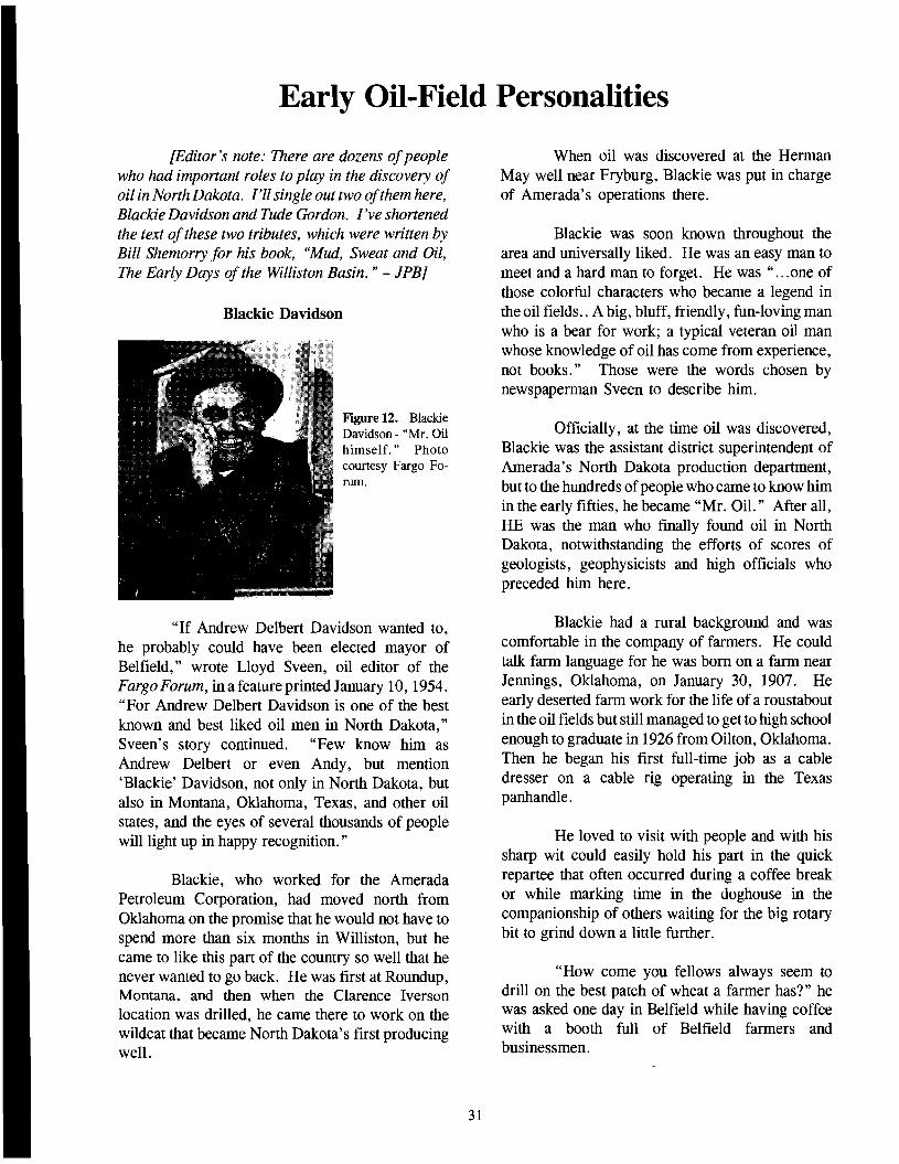
Early Oil-Field PersOllalities
{Editor's note: There are dozens ofpeople who had important roles to play in the discovery of oil in North Dakota. I'll single out two ofthem here, Blackie Davidson and Tude Gordon. I've shortened the text ofthese two tributes, which were written by Bill Shemorry for his book, "Mud, Sweat and Oil, The Early Days of the Williston Basin. " - lPBJ
Blackie Davidson
Figure 12. Blackie Davidson - "Mr. Oil himself. " Photo courtesy Fargo Forum.
"If Andrew Delbert Davidson wanted to, he probably could have been elected mayor of Belfield," wrote Lloyd Sveen, oil editor of the Fargo Forum, in a feature printed January 10,1954. "For Andrew Delbert Davidson is one of the best known and best liked oil men in North Dakota," Sveen's story continued. "Few know him as Andrew Delbert or even Andy, but mention 'Blackie' Davidson, not only in North Dakota, but also in Montana, Oklahoma, Texas, and other oil states, and the eyes of several thousands of people will light up in happy recognition. "
Blackie, who worked for the Amerada Petroleum Corporation, had moved north from Oklahoma on the promise that he would not have to spend more than six months in Williston, but he came to like this part of the country so well that he never wanted to go back. He was first at Roundup, Montana, and then when the Clarence Iverson location was drilled, he came there to work on the wildcat that became North Dakota's first producing well.
When oil was discovered at the Herman May well near Fryburg, Blackie was put in charge of Amerada's operations there.
Blackie was soon known throughout the area and universally liked. He was an easy man to meet and a hard man to forget. He was" ...one of those colorful characters who became a legend in the oil fields .. A big, bluff, friendly, fun-loving man who is a bear for work; a typical veteran oil man whose knowledge of oil has come from experience, not books." Those were the words chosen by newspaperman Sveen to describe him.
Officially, at the time oil was discovered, Blackie was the assistant district superintendent of Amerada's North Dakota production department, but to the hundreds ofpeople who came to know him in the early fifties, he became "Mr. Oil." After all, HE was the man who finally found oil in North Dakota, notwithstanding the efforts of scores of geologists, geophysicists and high officials who preceded him here.
Blackie had a rural background and was comfortable in the company of farmers. He could talk farm language for he was born on a farm near Jennings, Oklahoma, on January 30, 1907. He early deserted farm work for the life of a roustabout in the oil fields but still managed to get to high school enough to graduate in 1926 from Oilton, Oklahoma. Then he began his first full-time job as a cable dresser on a cable rig operating in the Texas panhandle.
He loved to visit with people and with his sharp wit could easily hold his part in the quick repartee that often occurred during a coffee break or while marking time in the doghouse in the companionship of others waiting for the big rotary bit to grind down a little further.
"How come you fellows always seem to drill on the best patch of wheat a farmer has?" he was asked one day in Belfield while having coffee with a booth full of Belfield farmers and businessmen.
31
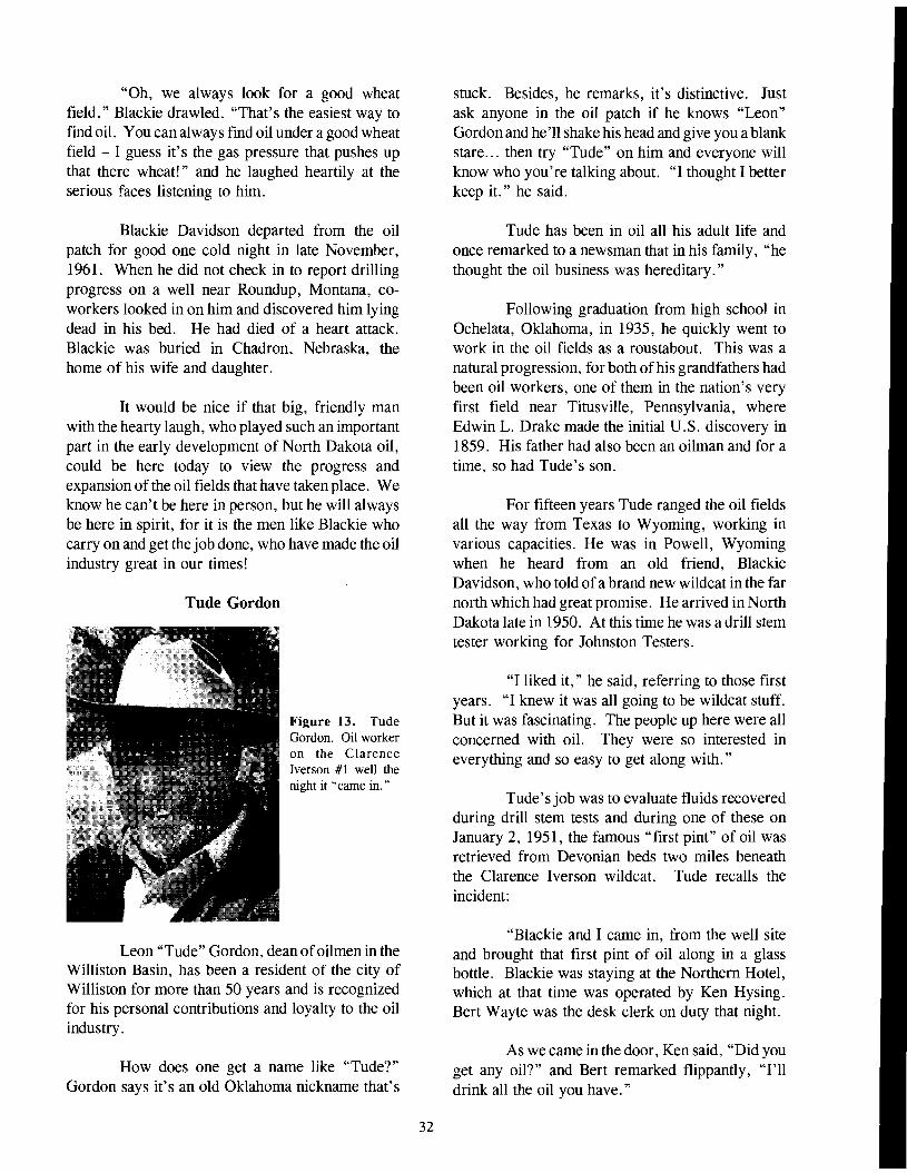
"Oh, we always look for a good wheat field," Blackie drawled. "That's the easiest way to find oil. You can always find oil under a good wheat field - I guess it's the gas pressure that pushes up that there wheat!" and he laughed heartily at the serious faces listening to him.
Blackie Davidson departed from the oil patch for good one cold night in late November, 1961. When he did not check in to report drilling progress on a well near Roundup, Montana, coworkers looked in on him and discovered him lying dead in his bed. He had died of a heart attack. Blackie was buried in Chadron, Nebraska, the home of his wife and daughter.
It would be nice if that big, friendly man with the hearty laugh, who played such an important part in the early development of North Dakota oil, could be here today to view the progress and expansion of the oil fields that have taken place. We know he can't be here in person, but he will always be here in spirit, for it is the men like Blackie who carry on and get the job done, who have made the oil industry great in our times!
Tude Gordon
Figure 13. Tude Gordon. Oil worker on the Clarence Iverson #1 well the night it "came in."
Leon "Tude" Gordon, dean ofoilmen in the Williston Basin, has been a resident of the city of Williston for more than 50 years and is recognized for his personal contributions and loyalty to the oil industry.
How does one get a name like "Tude?" Gordon says it's an old Oklahoma nickname that's
32
stuck. Besides, he remarks, it's distinctive. Just ask anyone in the oil patch if he knows "Leon" Gordon and he'll shake his head and give you a blank stare ... then try "Tude" on him and everyone will know who you're talking about. "I thought I better keep it." he said.
Tude has been in oil all his adult life and once remarked to a newsman that in his family, "he thought the oil business was hereditary."
Following graduation from high school in Ochelata, Oklahoma, in 1935, he quickly went to work in the oil fields as a roustabout. This was a natural progression, for both ofhis grandfathers had been oil workers, one of them in the nation's very first field near Titusville, Pennsylvania, where Edwin L. Drake made the initial U. S. discovery in 1859. His father had also been an oilman and for a time, so had Tude's son.
For fifteen years Tude ranged the oil fields all the way from Texas to Wyoming, working in various capacities. He was in Powell, Wyoming when he heard from an old friend, Blackie Davidson, who told ofa brand new wildcat in the far north which had great promise. He arrived in North Dakota late in 1950. At this time he was a drill stem tester working for Johnston Testers.
"I liked it," he said, referring to those first years. "I knew it was all going to be wildcat stuff. But it was fascinating. The people up here were all concerned with oil. They were so interested in everything and so easy to get along with. "
Tude's job was to evaluate fluids recovered during drill stem tests and during one of these on January 2, 1951, the famous "first pint" of oil was retrieved from Devonian beds two miles beneath the Clarence Iverson wildcat. Tude recalls the incident:
"Blackie and I came in, from the well site and brought that first pint of oil along in a glass bottle. Blackie was staying at the Northern Hotel, which at that time was operated by Ken Hysing. Bert Wayte was the desk clerk on duty that night.
As we came in the door, Ken said, "Did you get any oil?" and Bert remarked flippantly, "I'll drink all the oil you have."

"The jar of oil was out in the car, but the Iverson was a "tight hole" and we couldn't say anything about it. Bert never knew how close he came to having to back up his remark."
That was three months before the official announcement that oil had been discovered at the Iverson...Tude might have made a fortune if he'd followed up on this ...buying minerals, real estate or perhaps becoming in firm that was oil-related. But he didn't. "I didn't have fifteen cents," he recalls. "I was just working."
When Tude first came to North Dakota, he soon grew to know the area residents. There were some North Dakotans working on the Iverson rig, he said. They knew that if oil was discovered it would be important. This would be the first oil in the state. They had drilled many times before and always had come up with a dry hole. At the time, the closest drilling was in Saskatchewan or Montana...most of the nearest rigs were in Billings, Roundup, or Cutbank. He became acquainted with others on the rigs that came in after discovery. Some of them held their jobs for years.
Clarence Iverson was often a favorite subject; Tude knew him well (Photo of Clarence Iverson and his wife, Fig 14).
"I can remember when Clarence and one
of his boys came to the rig one night after we'd had that show of oil. I said to him, "Well, it looks like you'll be able to go south for the winter now." He said he didn't think he'd live long enough to see it. But he did. He spent a number of winters in Scottsdale, Arizona, and other places."
Although at first Tude was with Johnston Testers in the Williston Basin, he later moved into the wireline business with Wireline, Inc. In the 1960s, he organized the Perfalog Company, which some time after merged with Go Wireline. Tude worked as Go's sales manager then as S.M. for Gearhart Industries.
Tude's inventive mind and his loyalty to the industry in which he has worked these many years, led him to devise some bumper stickers which became quite popular. They were the ones seen on cars in the 1970s. One was: "Oil Field Trash and Proud Of it!" This was during the years of the Citizens Band short wave radio fad and his CB "handle" over air was "Oil Field Trash." Tude also designed a round sticker printed in red, white and blue, which reads, "Striving To Keep America Red, White and Blue With Gas and Oil."
After fifty some years, Tude Gordon still roams the oil fields, visiting old friends, and occasionally making a sale "to earn some spending money."
Figure 14. Clarence and Thea Iverson ride down Williston's Main Street during an oil anniversary celebration parade in which they were honored guests.
33
A Day to Remember - The Discovery of Oil in North Dakota
[Wilson Laird wrote this account of the discovery ofoil in North Dakota and sent it to me. I made minor revisions before using it in the summer, 1993, NDGS Newsletter - JPB]
"Light the flare." With those words Blackie Davidson tossed up a lighted, oil-soaked rag and the gas started to burn in a flare 30 feet long. This was the real beginning - the opening of the Williston Basin to oil production on April 4, 1951. The discovery of oil will always be remembered by those who were in North Dakota at the time. Its effect on the state and the nation can probably never be entirely assessed.
As far as I was concerned, this day had really started ten years almost to the month prior to the actual coming in of the Clarence Iverson NO.1 in Williams County. In 1941, the North Dakota legislature, primarily through the foresight of one man, had passed an adequate oil and gas conservation measure. That man, George Saumer, was a representative from Grand Forks County, about as far from the oil area in North Dakota as one could be and still stay in the same state.
Because of that law, the state was in a position to encourage, through proper regulation, the development of a resource that has come to mean so much to the state. Also because of that law, I, as State Geologist, was present at the testing of the Silurian Interlake Formation in the Clarence Iverson No.1, an event that opened the Williston Basin.
The "why" of my actually being there goes back to my friendship with Clyde Noe, a resident of Williston at the time. Clyde called me about two days before the well came in and told me he thought it was going to come in. He said he thought I should be there. How Clyde knew about the well I don't know, but I suspect he learned of it from Blackie Davidson, who was tool pusher on the rig. Blackie Davidson was someone who was believed by everyone in the area. If Blackie said it was so, it was so. He had far more credibility than any of the technical officials connected with Amerada
35
Petroleum Company or, for that matter, anyone else concerned with the industry.
In any event, I went to the President of the University, Dr. John C. West, and told him that I had heard that the oil well near Tioga was going to come in. He asked me if I was going to be there. I said that I had four classes to teach that particular day and that I thought I had better stay in Grand Forks. Dr. West said, "Laird, you don't get to see an oil well in North Dakota every day; to hell with the classes." With that kind of encouragement, I left for Williston.
I got to Williston on the evening of April 3, contacted the Amerada geologists, and said that I would like to go to the well the next day. They said that was fine. I left Williston about 9 the next morning and arrived at the well site about 10 a.m. There I met Roy Fuller, who was Amerada's district superintendent working out of Casper at the time. He later moved to Williston where he became an institution in himself. Roy explained to me what was being done with the well and the preparations that were being made for the test.
It was a beautiful clear, cool day in North Dakota. The ground was still frozen as the preceding winter had been a cold one. This was not my first visit to the well site as I had been there in January after the famous "pint of oil" had been obtained in a drill stem test of the stratigraphically higher Devonian Duperow Formation [Editor's note: January 2, 1951. JPBj. In January, the drifts of snow had been bulldozed as high as the telephone lines along the road coming from Highway 2 to the well site six miles south of the highway. Some of these drifts were still quite apparent on that April day.
Roy Fuller, Blackie Davidson, the drilling crew, and I were about the only people who witnessed this historic event, which began almost exactly at noon on April 4. A few local visitors were there also, but Roy asked me to caution them to stay behind the wire stretched across the access road to the site because of the danger always present when

such operations are underway.
On the side ofthe tank receiving the oil from the well was a trip valve which kept going up and down rather rapidly. Never having seen an oil well come in before, I wanted to know ifthis was a good sign and if this was really going to make a well. Roy kept telling me he didn't know, but I noted that he smiled a lot when he was telling me that. I knew that he had seen many wells come in during his long career with the industry. In the meantime, the flare was burning, the ground beneath it was beginning to thaw, and the steam was rising in the cool air.
About 4 p.m., I decided it was time to go back to town to get something to eat and to talk to others about this exciting and historic event I had witnessed. Among the first people I met on returning to town were the publisher of the newspaper, Herman Zahl and his wife, who invited me to have a steak at their home.
Along about 11 o'clock, someone decided that it might be a good idea to go and see how the well was doing. That seemed at the time like a capital idea, so Herman, his wife, and I piled into the car and drove to the well site. The flare could be seen for a distance of about 10 miles or more from the location. I forget now where we were when we first saw it, but it was some miles west of the well. We finally got to the well where, by this time quite
a crowd had gathered. It was this night that the famous night picture of the well was taken by Bill Shemorry. I also took a color picture of the sight, which was later reproduced and incorporated in a beautiful wooden frame and presented to me by Dr. Rodger Denison, the exploration Vice-President of Amerada.
After that night scene, we drove rather slowly back to Williston, reflecting on what we had seen and what it would mean to Williams County, Williston, and the State of North Dakota.
Like many things human, the discovery of oil in the Clarence Iverson was regarded by many as good luck. Actually it was a combination of good interpretation of the geology of the area, the knowledge and guts of the company, which took a considerable risk in drilling the well, and the vision of many geologists dating back many years who had faith in the area. Notably, in this latter group was Tom Leach, who took the leases on this land, which were later turned to Amerada. However, it is worthy of note that he and others, such as Clyde Noe, and many others associated with the early development, didn't live long enough to see how big it really was. In this respect, I feel unduly fortunate. While I am sure they thought it would be big, I doubt if they could visualize the impact the discovery ofoil would have on North Dakota.
36

North Dakota's Oil & Gas Conservation Law
North Dakota's oil and gas conservation law has undergone several transformations as circumstances have changed over the years. The North Dakota Oil and Gas Conservation Law was amended several times by succeeding legislative assemblies. The 1941 act was preceded by earlier acts in 1911,1929, and 1937. Since 1941, the act has been amended several times, most notably in 1951, 1953, 1965, and 1981.
The act of 1911 was designed to protect adjacent landowners and the public from the escape of natural gas from open or improperly abandoned gas wells. A penalty for violation of the statute was provided, but no regulatory authority was specifically charged with enforcement duties.
The 1929 act was the first statute that required the permitting of wells and the filing of basic data. The State Geologist was named as the regulatory authority and a penalty was provided for violation ofthe statute. Because of lack offunds, the State Geologist was not able to enforce the law and it was repealed in 1937.
The 1937 act provided for the conservation of oil and gas, and it provided that the State Geologist was to prescribe rules and regulations. Such rules and regulations were to be the same as those adopted by the Bureau of Mines or the Secretary of the Interior, pursuant to an act of Congress approved on February 24, 1920.
In 1941, the legislature passed the first comprehensive oil and gas conservation law, ten years before oil was discovered in North Dakota. When the 1941 act was enacted, the only commercial production in the state consisted of a minor gas field in the Eagle Pool on the Cedar Creek Anticline in Bowman County. The 1941 law was based on the then Model Act that had been drawn up by the Legal Committee of the Interstate Oil Compact Commission. The act placed the supervision and control over crude petroleum oil and natural gas with the Industrial Commission. It made the Industrial Commission the regulatory authority and designated the State Geologist as supervisor, advisor, and enforcer of the regulations
37
promulgated by the Commission. Later, in 1953, Laird assisted the Legislative Research Committee in drafting a more modern oil and gas statute. In 1965, a compulsory unitization provision was added to the statute.
Since 1911, North Dakota has had the necessary statutory regulatory control in place for the level of oil and gas exploration and development being conducted at any given time. The role of the State Geologist in the regulation of oil and gas exploration and development has been significant since 1929. The Industrial Commission has been responsible for the conservation of oil and gas in North Dakota since 1941, nearly 60 years.
The role of the North Dakota Geological Survey in regulating oil and gas exploration and production ended in 1981, when the 47th Session of the North Dakota Legislature passed House Bill 1536, amending Chapter 38-08 of the North Dakota Century Code relating to the powers and duties of the North Dakota Industrial Commission and the State Geologist. As a result of the new legislation, all North Dakota Geological Survey personnel who were involved with oil and gas regulation were transferred to a newly-created Industrial Commission Oil and Gas Division, headquartered in Bismarck. As a result, except for its operation of the core and sample library, which remained in Grand Forks, the Survey no longer had any official role in oil and gas regulation, although NDGS geologists continued to study the geology of oil- and gas-producing formations in the Williston Basin.
The new arrangement was not quite what Governor Olson had wanted. He had pushed for establishing a Department of Natural Resources (DNR) , but the Legislature was unwilling to do this. Consequently the splitting offofthe Survey's oil and gas regulatory authority was something of a compromise. The arrangement addressed the concern of some people in government who felt that the regulation of oil and gas should be closer to the center of state government, particularly because the oil and gas industry at that time was enjoying a series of "boom" years.

The Making of the Conservation Law
[Editor's note: Wilson Laird wrote this account of how North Dakota's oil and gas conservation law came about and sent it to me. I made minor revisions before including it in the summer, 1993 NDGS Newsletter. - JPB]
"If they're for it, I'm against it," said Representative Billy Crockett, from Wales, Cavalier County, when I answered a question about who favored an oil and gas conservation bill. I had said that probably all the oil and gas companies operating in the state at the time were for that legislation. So saying, Billy got up, waved his arms, and left the room. The place was the Legislative House Committee on State Affairs, chaired by Lafe Twitchell of Fargo. The time was about February 1941, and the subject was the oil and gas conservation bill that I had asked George Saumur of Grand Forks to sponsor.
The background of this interesting exchange of views is probably known to only a few people still living, but it played an important part in the oil and gas development in North Dakota. During the fall of 1940, a small oil play had been going on in western North Dakota. It began with the drilling of the California Kamp #1 Well in Williams County in the fall of 1938. This well was a dry hole, but it is interesting to note that it was located in a spot only about a half mile from later production on the Nesson Anticline in the Capa Field.
In the fall of 1940, oil-industry individuals working with the oil laws of the State recognized that the laws we had were woefully inadequate and impossible to administer. Therefore, it was suggested that my predecessor, Dr. Frank Foley, investigate what could be done about getting better legislation on the books should there ever be a time when there would be production in North Dakota. Accordingly, Foley contacted the Interstate Oil Compact Commission headquartered in Oklahoma City and obtained a copy of their Model Act for an adequate oil and gas conservation statute.
Conferences were arranged with Governor John Moses, who suggested that, instead of an additional state agency to regulate something not then in existence, and because there were already
too many state agencies, the regulation of the oil and gas industry should be placed in the hands of the State Industrial Commission, which already handled the State Mill and Elevator and the Bank of North Dakota. Inasmuch as the Commission had no full-time staff capable of handling a technical matter like oil and gas regulation, it was decided that the State Geologist would be the administrator of the act for the Commission. The State Geologist would thus be designated Supervisor ofOil and Gas.
Accordingly, a bill was drawn and introduced into the 1941 Legislative Session. House Bill 210 was sponsored by Representatives George Saumer from Grand Forks, Walter Bubel from Center (Oliver County), Theodore O. Rohde of Van Hook (Mountrail County), and Senator Lars. K. Morland from Scranton (Bowman County). After its first reading, the bill was referred to the State Affairs Committee, which was chaired by Lafe Twitchell of Fargo. Mr. Twitchell, an old timer in the Legislature, didn't suffer fools gladly, and I am sure he thought that anyone sponsoring and supporting such a bill was little short of being demented. In fact, he told George Saumur that he couldn't see why in hell anyone wanted to introduce a bill of that kind as there wasn't any oil in North Dakota now, and that there wasn't going to be any in the future. It is true that no oil was being produced in the state at that time, but some relatively shallow gas was being produced on the Cedar Creek Anticline from a few wells owned by the Montana Dakota Utilities Co. in the southwestern-most part of Bowman County. The Cedar Creek later proved to be a prolific oil and gas producer in both North Dakota and Montana.
To get back to the hearing of the State Affairs Committee at which I was appearing as the prime witness for this bill: it should be noted that I was only 26 years old at the time and had been in the state for only about 5 months. I had become State Geologist because of the resignation of Dr. Foley, my predecessor, who went with the United States Geological Survey. To say that I was a stranger to legislative processes, as well as a stranger to the state and to the people in it, would be a gross understatement.
39

I was questioned about the need for this bill and what it would mean to the state, whether it would involve any additional funds to administer and generally how it would work. I explained that there was a geological chance for oil and gas to occur in commercial quantities in North Dakota. I also pointed out that the present laws were a hopeless mess and that, without the proposed legislation, there would essentially be no state control whatever if oil was discovered. I told them what had happened in other states, notably Texas when oil was discovered in the East Texas Field in the early thirties, and what chaos had resulted. I summarized my remarks with the hope that the Legislature would be foresighted and pass the bill.
After I was finished, the questions again started, and then Billy Crockett made his famous statement. Famous, at least to me, as I thought that the whole matter had gone down the drain. I therefore left the hearing, my tail between my legs, and headed for the Grand Pacific Hotel where I packed my bag and prepared to depart on the evening train back to Grand Forks.
As I was checking out, George Saumur met me in the lobby and asked me where I was going. I told him that I felt I had failed and that I was going back to Grand Forks. He asked me to stay, and said that he would see if Mr. Twitchell would give me another hearing. I checked back in and stayed until the next day when I saw George again at breakfast time.
George told me that he had gone to Lafe Twitchell's room the previous evening and said to him, "You treated my boy kind of rough this afternoon. " To which Lafe had replied, "Why does the damn fool think we should have that sort of legislation anyway?" George reasoned with him for some time, and the end effect was that Mr. Twitchell told him to have me up at the hearing again the next day.
I was there, needless to say, and answered more questions. The atmosphere was decidedly more friendly than the previous day. After that, I went home and left the matter in George Saumur's capable hands.
After the second hearing, George circulated around the House. When the bill came to a
40
vote, there was no oppOSItlon to the measure whatsoever. I believe it passed without a dissenting vote. I think this was a tremendous tribute to the skill of George Saumur and an acknowledgment of the great affection the members of the House felt for him.
George also lobbied the bill through the State Senate, and as I recall, I didn't even have to appear on that side of the Legislature about the bill.
This legislation provided a logical plan for the development of the state's oil and gas resources should any ever be discovered. It stipulated what the State Industrial Commission and the State Geologist should do. In other words, we were all set for the development which began on April 4, 1951, when the Amerada #1 Clarence Iverson Well officially opened oil development in North Dakota. Very few, if any, states can say that they were so well prepared for the oil and gas industry to come to their respective states as was North Dakota.
The 1941 law was not perfect, but then what law ever is? Any law has to be the distilled opinion of the many people who enact it, and as a result, few laws ever satisfy everybody. The main thing that the legislation did was to provide the base upon which an even better law was passed in 1953, two years after the discovery of oil. Here again, North Dakota was very fortunate in having a Governor, Norman Brunsdale, who was an intelligent and popular man and familiar with the oil industry from business knowledge of it through his banking connections.
Ten years after the initial bill was enacted, the Legislative Research Council assigned a subcommittee to study the matter of oil and gas regulation in the interim between the discovery in 1951 and the session in 1953. This subcommittee was headed by an eminent lawyer and State Senator, Clyde Duffy of Devils Lake. Hearings were held in various parts of the state, primarily in the western part where the oil and gas occurred. Many people testified, and their views were taken into consideration by the subcommittee. Much concern was expressed about the rights of landowners and mineral owners on whose lands the oil and gas had been found or might be found in the future.

The end result of the deliberations was the writing of another law which again was modeled after the then-current model law of the Interstate Oil Compact. This bill passed almost without change except it had to be tailored to the North Dakota situation. It did not contain the section on compulsory field-wide unitization, an omission I thought was unfortunate, as I regarded it as the best and most efficient way to produce a field which falls under multiple ownership as most United States oil fields do. Unitization also preserves capital as less material is needed to put the field in production. In other words it was, and is, a true conservation measure.
It wasn't until the 1965 Legislative Session that the compulsory field-wide unitization statute was added to the North Dakota oil and gas law. The version of the Unitization Bill that I wanted passed was that which was from the model act of the Interstate Oil Compact Commission as it fitted the rest of the model act that had been passed in 1953. It should be noted that these model acts of the compact were drafted by the best oil and gas legal minds in the country.
As it turned out, the Democrats had drafted a bill modeled after the Oklahoma statute; this was
passed by the House. During this session of the Legislature, Arthur Link was Speaker. This was before he went to Congress and subsequently to the Governor's office. Now an impasse existed; the Senate had passed one, and the House another version of the same idea. It was one of those times when an idea's time had come and everyone was for it, but there was no unanimity of how the law should be worded. The end result was that the Senate acceded to the House version. They realized the law was needed, and they felt that, as the Governor, Bill Guy, was a Democrat, it was the only way a unitization law would come about. The law has stood the test of time and has been used on a number ofoccasions. Even though it is far from perfect, and while I still think the Compact version was better worded, North Dakota's law works and that is the ultimate test.
I realize that, since the law was enacted, some changes have been made in the administration of the law. For example, the State Geologist has been removed from the supervisory position. This is something that I suppose was inevitable, but the technical advice given the state by the Geological Survey was the best and most unbiased and scientifically oriented possible at the time.
41

Post-Discovery Events
Following the discovery of oil in North Dakota, annual production increased until 1966, when 26 million barrels were produced, then declined until 1974 (19.6 million barrels produced) (Fig. 15). Production in 1979 (31 million barrels) surpassed the previous 1966 high and new highs were recorded each year until 1984, when production peaked at 52.6 million barrels. Production then began to decline, falling to 27.5 million barrels in 1994. It then rebounded to more than 35 million barrels for the next few years, before again falling to about 33 million barrels. Production for the past couple of years (1998 and 1999) was about 36 and 33 million barrels respectively. Production will likely be down somewhat from this level for 2000, but official figures are not yet available at the time of this writing.
Although the initial oil discovery in North Dakota was from Silurian rocks, the early development of the Nesson Anticline was primarily from Madison reservoirs. The peak discovery period was 1952 - 1953, with development along the
75-mile anticline trend being nearly complete by 1960. Producing capacity at that time exceeded the available market (the Mandan refinery). Production was limited by prorationing until November of 1965, when natural decline of the producing reservoirs equaled the market demand. The only significant deeper horizons developed along the Nesson trend during the early 1960s were the Devonian Duperow and Silurian Interlake Pools in the Beaver Lodge and Antelope fields. The Devonian Sanish Pool in Antelope Field was also undergoing development at this time.
Significant discoveries between 1952 and 1959 included the Mississippian oil fields of Bottineau, Burke, and Renville counties. The increasing production between 1958 and 1961 largely reflects development of these pools.
Pennsylvanian Tyler sand reservoirs, which were discovered at Rocky Ridge in 1957 and at Fryburg in 1959, became important developments in the mid-60s in the Stark and Billings county areas. Peak production occurred in 1966 at Medora
ANNUAL OIL PRODUCTION
6o-,------------------------~
52.654
o 50 W
5()
40
OWo:::C
27.126a. .Q 30 CJ) .-1~ W 20 0::: 0::: «CD 10
o 1950 1955 1960 1965 1970 1975 1980 1985 1990 1995 2000
YEAR
Figure 15. Line graph of annual oil production in North Dakota since 1951. Production is in millions of U.S. barrels. Figures are preliminary since 2000 totals have not been posted as of this time. (Source: N. D. Geological Survey and N. D. Oil & Gas Division.)
43

Field and in 1967 in the Dickinson Field. This helped to offset declines in the older producing areas.
In 1960, discovery of the Cedar Creek Pool extended the Red River Fonnation production along the Cedar Creek Anticline southeastward from Montana into North Dakota. The Bowman County Red River play extended production in southwestern North Dakota to small "bumps" along the eastern flank of the structure in the period from 1967 to the mid-70s.
The decline in production from 1966 to 1974 represents the failure of new discoveries to replace the natural decline of the major producing areas. The nonnal pattern is discovery, followed by development, leading to peak production for one to three years, followed by a gradual decline. Secondary recovery methods are used in an attempt to alter this pattern. Water injection was attempted in the 60s and 70s in many of the Madison reservoirs along both the Nesson trend and in Burke County, but the technique was relatively unsuccessful. Similar programs, begun in 1967 in the NewburgSpearfish and Madison reservoirs, in 1970 in the Medora Field, and in 1973 in the Tyler sand reservoirs in the Dickinson Field increased production levels above the initial development in those fields. However, these successful programs could not offset the natural decline of the major producing areas.
The trend to lower exploratory activity during the 1960s generally followed the national trend. The upsurge of wildcatting in 1968 in North Dakota has been referred to as the "Muddy sand" (Cretaceous Newcastle) play. It followed development of the Bell Creek Field in Montana, but no similar occurrences were found in North Dakota, and exploration activity again slowed down (Figs. 16 and 17).
The 1970s Resurgence
Two events that occurred close together in the early 1970s significantly changed Williston Basin production history. First, Red Wing Creek Field was discovered in 1972 in McKenzie County. Second, the Organization of Petroleum Exporting Countries (OPEC), which was fonned in 1973, emplaced production controls (embargoes) and
44
price increases on production.
OPEC's actions created the first substantial worldwide increase in the price of oil. The price rose from about $4.00 a barrel in 1973 to about $9.00 in 1974 and prices continued to rise through the 1970s. As a result, exploration was once again a profitable venture. Prior to this, many companies found that exploration risk money had a better return in a regular bank savings account than in actual wildcat drilling. The increased price made risk capital available, and enhanced exploratory drilling.
The 1972 discovery of Red Wing Creek Field (a meteorite impact structure) at about the same time as the first OPEC production cutbacks excited basin operators because of the relatively high productivity of the wells and the anomalously thick pay section. Since no one really understood the nature of the Red Wing Creek structure at the time, industry's response was to gain lease foothold in the area. The lease play set off by the Red Wing Creek discovery set the stage for further development. The five-year-tenn leases taken in western North Dakota tended to increase exploratory activity. The availability of venture capital, coupled with the approaching expiration of five-year leases, caused exploratory drilling to increase in 1975 and 1976.
In 1977, two additional significant discoveries were drilled. The first of these, the Silurian Charlson Pool, proved that production rates in excess of2,000 barrels of oil a day were possible in North Dakota. Although the multiple-pay Mississippian Mondak Field, discovered in 1976, turned out to be one of North Dakota's larger oil fields, it was the discovery of Little Knife Field in 1977 that drew national attention to North Dakota. Located at the junction of Billings, Dunn, and McKenzie counties, Little Knife Field demonstrated potential for several zones of production.
Drilling continued to increase in 1978 and the wildcat success ratio also improved. Several important 1978 discoveries changed exploration ideas about North Dakota's Williston Basin. Perhaps the most interesting of these was the discovery of Shell Oil Company's Newporte Field in northern Renville County. This opened the first significant Cambrian production in the State,
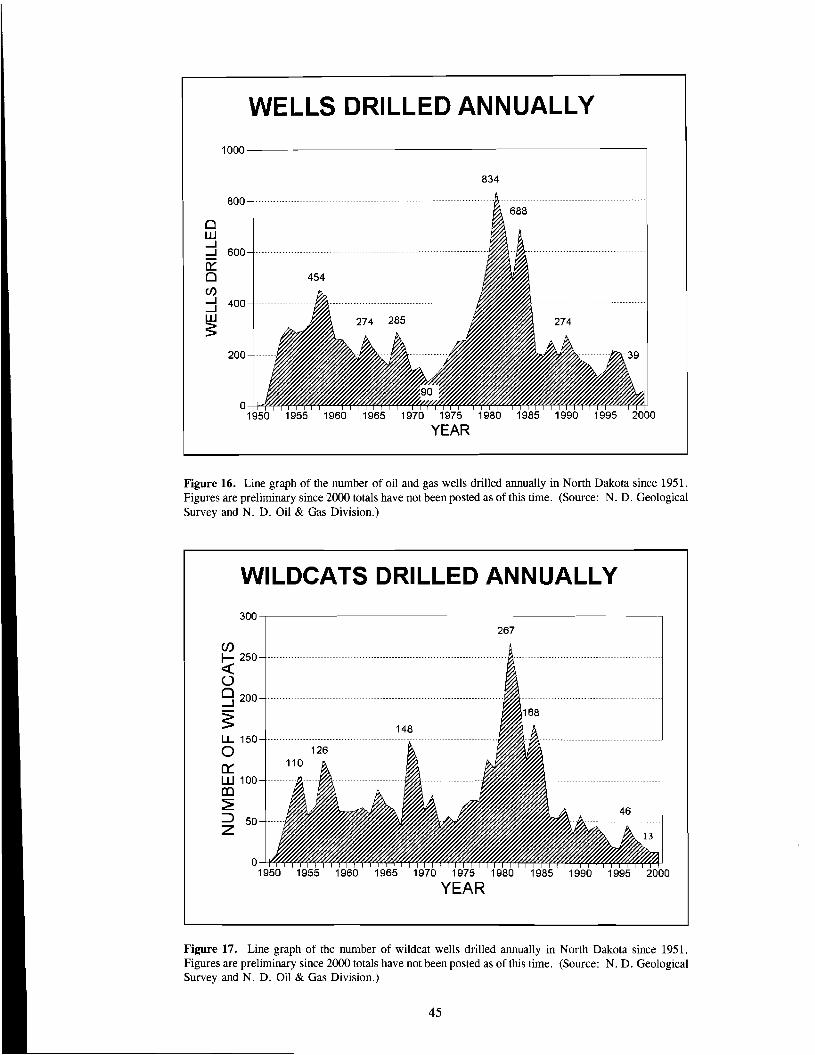
WELLS DRILLED ANNUALLY
1000---.---------------------------~
834
800
o UJ ....J ....J 600
0::: o CJ):::1 400
~ 200
----------
-------
o 1~ 1~ 1~ 1~ 1~ 1~ 1~ 1~ 1~ 1~ ~
YEAR
Figure 16. Line graph of the number of oil and gas wells drilled annually in North Dakota since 1951. Figures are preliminary since 2000 totals have not been posted as of this time. (Source: N. D. Geological Survey and N. D. Oil & Gas Division.)
WILDCATS DRILLED ANNUALLY 300---.------------------------------,
267
Cf) I- 250 « o 0 200.....J
S u.. 150 a 0=: W 100 al ~ ::J 50 Z
o
46 -----
1~ 1~ 1~ 1~ 1~ 1~ 1~ 1~ 1~ 1~ ~
YEAR
Figure 17. Line graph of the number of wildcat wells drilled annually in North Dakota since 1951. Figures are preliminary since 2000 totals have not been posted as of this time. (Source: N. D. Geological Survey and N. D. Oil & Gas Division.)
45
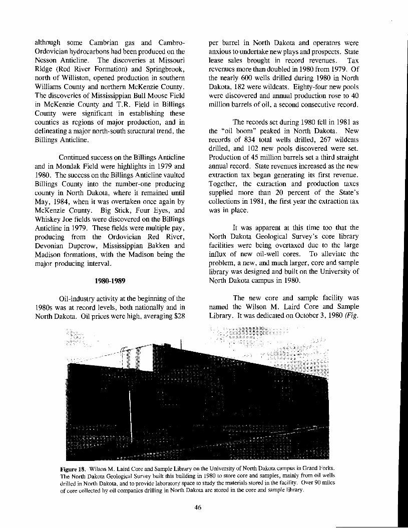
although some Cambrian gas and CambroOrdovician hydrocarbons had been produced on the Nesson Anticline. The discoveries at Missouri Ridge (Red River Formation) and Springbrook, north of Williston, opened production in southern Williams County and northern McKenzie County. The discoveries of Mississippian Bull Moose Field in McKenzie County and T.R. Field in Billings County were significant in establishing these counties as regions of major production, and in delineating a major north-south structural trend, the Billings Anticline.
Continued success on the Billings Anticline and in Mondak Field were highlights in 1979 and 1980. The success on the Billings Anticline vaulted Billings County into the number-one producing county in North Dakota, where it remained until May, 1984, when it was overtaken once again by McKenzie County. Big Stick, Four Eyes, and Whiskey Joe fields were discovered on the Billings Anticline in 1979. These fields were multiple pay, producing from the Ordovician Red River, Devonian Duperow, Mississippian Bakken and Madison formations, with the Madison being the major producing interval.
1980-1989
Oil-industry activity at the beginning of the 1980s was at record levels, both nationally and in North Dakota. Oil prices were high, averaging $28
per barrel in North Dakota and operators were anxious to undertake new plays and prospects. State lease sales brought in record revenues. Tax revenues more than doubled in 1980 from 1979. Of the nearly 600 wells drilled during 1980 in North Dakota, 182 were wildcats. Eighty-four new pools were discovered and annual production rose to 40 million barrels of oil, a second consecutive record.
The records set during 1980 fell in 1981 as the "oil boom" peaked in North Dakota. New records of 834 total wells drilled, 267 wildcats drilled, and 102 new pools discovered were set. Production of 45 million barrels set a third straight annual record. State revenues increased as the new extraction tax began generating its first revenue. Together, the extraction and production taxes supplied more than 20 percent of the State's collections in 1981, the first year the extraction tax was in place.
It was apparent at this time too that the North Dakota Geological Survey's core library facilities were being overtaxed due to the large influx of new oil-well cores. To alleviate the problem, a new, and much larger, core and sample library was designed and built on the University of North Dakota campus in 1980.
The new core and sample facility was named the Wilson M. Laird Core and Sample Library. It was dedicated on October 3, 1980 (Fig.
Figure 18. Wilson M. Laird Core and Sample Library on the University of North Dakota campus in Grand Forks. The North Dakota Geological Survey built this building in 1980 to store core and samples, mainly from oil wells drilled in North Dakota, and to provide laboratory space to study the materials stored in the facility. Over 90 miles of core collected by oil companies drilling in North Dakota are stored in the core and sample library.
46

18). It includes 20,482 square feet of total floor space; of this, 18,432 square feet are devoted to core and sample storage and the remainder is office and laboratory space for the preparation and analysis of cores. The facility can hold about 200,000 boxes of core.
Lee C. Gerhard was State Geologist at the time the new core library was built. His interest and expertise in carbonate geology led him to conduct a series of in-depth studies of Williston Basin carbonate rocks and of various modern sedimentological analogs. Gerhard's interests were also reflected in his efforts toward establishing the Williston Basin Carbonate Core and Sample Laboratory, which was set up in conjunction with the new Wilson M. Laird Core and Sample Library. Survey geologists and Geology Department students undertook a number of stratigraphic studies of core designed to better understand Williston Basin geology. The results of several of the studies were published in the 1978 Williston Basin Symposium volume. The main goal of the Survey in doing these and other studies relating to the occurrence of oil and gas was, and still is, to learn more about Williston Basin rocks and geologic processes, not to develop specific drilling prospects.
Even though the oil industry could not maintain a high level of activity when oil prices began to slip in 1982, production and tax revenues continued to climb. Drilling activity was less, but the emphasis shifted away from exploration toward developing existing fields. Another reason for the continued increase in oil production is that, typically there is a one- to three-year lag between the discovery and peak production from an oil field. In general, larger fields have longer lag times because more wells are required to develop the field. Many fields discovered during 1980 and 1981 did not reach their peak production until 1982 to 1984.
Oil prices continued to fall during 1983, further reducing drilling. Wildcat drilling was a third of 1981 levels, reflecting the lower prices, but development drilling remained high as the new fields were developed. Consequently, production continued to rise, along with tax revenues. Both wildcat and development drilling rose slightly during 1984 and production in North Dakota reached its all-time high of 52.6 million barrels.
47
Despite record oil production, tax revenues declined for the first time since 1973 because of lower oil prices.
Drilling resumed its decline during 1985 as prices continued to fall. Overproduction by OPEC caused a rapid price drop in early 1986, with prices falling below $10 a barrel for some types of crude oil. With that, drilling plummeted and oil companies began to downsize and reduce spending. The impact on the State's oil industry was a sharp drop in drilling and a decrease in the number and size of oilfield service companies. Many either went bankrupt and closed their doors or moved out of State to cut costs.
From mid-1986 through early 1987, crude oil prices rose gradually, and a modest increase in drilling occurred between mid-1987 and early 1988. The number of wells drilled increased slightly during the second half of 1987, but activity during the first halfofthe year had been so low that only 190 wells were drilled during the year. In 1988, drilling jumped sharply to 255 wells. Part of the increase was the result of development drilling in Wabek Field, an important new oil field discovered along the Mississippian Sherwood subinterval shoreline in Mountrail County. Another important field, Plaza Field, also in Mountrail County, was discovered near Wabek Field in 1989 and development of the field began. Estimated ultimate recoveries of six to eight million barrels are predicted from Wabek Field and 3.5 million barrels from Plaza Field. These two fields were the largest Madison fields discovered during the late 1980s.
From 1986 through 1991, between 188 and 274 wells were drilled annually. The 188 wells drilled in 1989 recorded the lowest numbers of wells drilled since 1974. Thirty-five of the 188 wells drilled in 1989 were wildcats and 67 of the 190 total wells drilled in 1987 were wildcats.
Horizontal drilling became important in the late 1980s when the first horizontal wells into the Bakken Shale were drilled in North Dakota and the first horizontal wells into the Madison were drilled in Saskatchewan.
The 1980s ended with the North Dakota oil industry in the best shape it had been in for several years. Oil production and drilling were up. New

plays raised industry interest and horizontal drilling technology was becoming important in North Dakota. In addition, oil prices were up slightly, increasing the positive effects at the end of the decade.
1990-1999
The 1990s began with many of the recently acquired leases in the horizontal Bakken Shale play being drilled as activity in that play peaked during 1990. Success rates for Bakken tests, as judged solely by a well being completed as a producing oil well, remained high. The success rate during 1991 was 97 %and the success rates during both 1992 and 1993 were 100 %. Despite the appearance of success by this one measure, many of these wells were economic failures because the volume of hydrocarbons recovered was not sufficient to pay for the drilling and completion costs. Many Bakken wells declined faster than expected, which meant that reserves were lower than first projected. As a result, drilling activity decreased as companies reevaluated the play. By 1995, the play was dead.
A major factor in the 1990 drilling increase was Iraq's invasion of Kuwait in August, 1990. World oil prices surged as uncertainties about the security of the Middle East oil supply rose. Oil prices in North Dakota also increased. Oil companies nearly doubled the number of wells spudded each month in North Dakota, but the rapid deployment of allied military forces during the fourth quarter of 1990 caused oil prices to fall quickly and the number of wells spudded in North Dakota fell with the oil prices. By late 1991, after Kuwait was liberated, prices had returned to preGulf War levels.
Drilling activity decreased during most of the 1990s. From 1990 through 1994, the number of wells drilled annually in the state decreased. A small increase occurred during 1995, but the decrease continued during 1996 and 1997, and the number of wells drilled fell to 121 in 1998 and 39 in 1999 in response to the oil-price collapse during this period. The 39 wells drilled in 1999 was the smallest number of wells drilled during any year since 1951, the year oil was discovered in North Dakota, when 10 were drilled.
In 1993, Conoco, Inc. discovered
48
Waulsortian bioherms or Waulsortian-like mounds in the basal Lodgepole Formation (Mississippian) while drilling a deep test in Dickinson Field. This well was the first economic Lodgepole production in North Dakota and the flow-rates of the discovery well, and subsequent wells, drew national attention. The hunt for similar mounds elsewhere in North Dakota continues, but so far unsuccessfully, and only sporadically. The last Lodgepole development wells were drilled during 1998.
The horizontal Red River "B" play began in 1994 in Bowman and Slope counties, North Dakota and in adjacent parts of Montana. Meridian Oil, Inc., which had initiated the horizontal Bakken play in 1987, drilled the first horizontal Red River "B" wells in Montana near East Lookout Butte Field on the Cedar Creek Anticline in 1988. The early horizontal Red River "B" wells in Montana were disappointing, but the discovery of Bog Creek Field during 1994 (later renamed Cedar Hills Field) sparked a large land play and widespread drilling.
By the end of 1999, 215 wells had been completed in Cedar Hills, Medicine Pole Hills, Cold Turkey Creek, and Horse Creek Red River "B" fields, and the fields had produced 21 million barrels of oil. Together, the two plays have produced nearly 45 million barrels of oil. Ultimately, primary production from the Cedar Hills Field will probably exceed the total of primary and secondary production from all the presently known Lodgepole fields in Stark County. Whether it does or not, these two plays have been very large oil producers in North Dakota and both have been important factors during the 1990s.
Wildcat drilling decreased during the early 1990s to 17 wells during 1995, the fewest wildcat wells drilled in North Dakota since 1951 when oil was first discovered in the state. Wildcat drilling jumped to 46 in 1996 as the hunt for Lodgepole mounds peaked, but then dropped.
Annual oil production in North Dakota declined during the early 1990s. Production declined to 35 million barrels, in 1991 then, during 1992,1993, and 1994 production fell eight, six, and eleven percent, respectively. During 1995, oil from two new plays, the horizontal Red River and the Lodgepole mound plays, came on-line and annual production rose 1.7 million barrels, more

than 6% above 1994 annual production. Annual production againrose during 1996 and 1997, (to 35.8 million barrels in 1997). Part of the increase can be attributed to the number of wells completed in Cedar Hills Field, but as much oil came from the discovery and subsequent unitization of the Lodgepole mound fields around Dickinson. During 1998, annual production was nearly flat at 35.6 million barrels, but it decreased to 32.8 million barrels in 1999. Part of the 1999 decrease in oil production was due to low prices. Some wells were shut-in because operating costs exceeded earnings at the low price. Once prices began to rise again, shut-in wells were put back on production. Amoco's average 1998 posted price for 40-gravity sweet crude was $1O.47/barrel, but during the first three months of 1999 it fell below $9/barrel. At the time this is being written (January, 2001) official production figures for 2000 are not available, but, based on production during the first several months of the year, it appears production will likely be down somewhat from 1999, possibly below 32 million barrels.
In 1991, the North Dakota Legislature encouraged the unitization of oil fields by enacting legislation that lowered the percentage of mineral and working-interest owners required to form a unit. An increase in unitizations began in North Dakota during 1992, just when many oil fields were approaching the end of their primary productive life-spans. Legislation like this encourages companies to invest the capital necessary to unitize an oil field. Unitizing more oil fields is an important way to minimize declining oil production. A successful secondary-recovery project will produce the remaining primary reserves in an oil field at a higher rate than an equivalent non-unitized field, and it will then go on to produce additional barrels of secondary reserves that otherwise could not be produced.
During 1999 and 2000, Burlington Resources Oil & Gas Co. and Continental Resources, Inc. were attempting to unitize the Red River "B" reservoir in Cedar Hills Field, Bowman County. These efforts are continuing (as this is being written) because a difference of opinion over which injection fluid will give the best results has delayed unitization. Burlington Resources favors a traditional water flood whereas Continental Resources wants to use air-injection. Each
49
company has shown sample secondary recovery units employing their preferred recovery method. Each maintains that the successful examples are proof that their proposed method is the best choice in Cedar Hills Field. The two companies are the major working-interest owners in the field and each has been able to block the other because it is impossible to get the required minimum of 70 % of the working-interest owners to ratify any proposed unit without both companies agreeing to it. As things stand now, it appears that two separate units will be established, each company using it's preferred method. A deal to trade producing properties so the field could be split into two separate units, with each company operating its own unit independent of the other, ended up in court and fell through. The result is that [as I write this in January,2001-JPBjoneofNorthDakota'snewest and largest oil fields has not yet been unitized and full production cannot be realized until the main operators in the field reach an agreement.
In an event related to unitization in North Dakota, Dakota Gasification Company completed its CO2 pipeline to the Weybum Midale Unit in southeastem Saskatchewan, the location of a CO
2 enhanced recovery project by PanCanadian Petroleum. Dakota Gasification completed a 200mile pipeline that runs from its gasification plant near Beulah, ND to the oil field near Weybum, Saskatchewan. The last weld on the pipeline was made on 12/1/1999 and the first CO2 entered the pipeline on 9/14/2000. The pipeline route takes it past many of the oil fields on the Nesson Anticline, many ofwhich have been unitized. Any CO
2beyond
the requirements at Weybum Field could easily be supplied to units on the Nesson Anticline for enhanced recovery programs.
Another way to slow or possibly reverse declining annual production in North Dakota might be to drill horizontal wells in existing Madison Group fields. A number of horizontal Madison wells have been re-entered and drilled out horizontally, both on the Nesson Anticline and elsewhere. In a recent study, decline curves from eight new or re-entered horizontal wells in Tioga Field were compared to decline curves from vertical wells close to the horizontal well bores. The study concluded that minimal interference occurs between the horizontal and vertical wells and that most of the produced oil was incremental
reserves; the reserves of the eight horizontal wells was estimated to be over a million barrels of oil. The study also concluded that other horizontal wells in TR Madison, Wayne Madison, Cedar Creek Ordovician, and Haas Madison pools had also added incremental oil reserves. The report concluded that the 72 studied horizontal wells had added ten million barrels of incremental oil in North Dakota. More horizontal wells are being drilled in older oil fields adding new reserves and increasing oil and natural gas production in the state.
At the end of 1999, thanks to some earlier important discoveries, North Dakota's oil industry was producing more oil than it had since the early 1990s. Drilling was minimal, but focused on exploration drilling and, to a lesser extent, on horizontal drilling in older fields. The North Dakota oil-industry was not in good financial shape after the low oil prices of 1998 and early 1999, but the higher oil prices of late 1999 were helping companies to recover.
Exploration Potential in North Dakota
North Dakota Williston Basin is still underexplored and many opportunities remain for finding large new oil fields and new plays. A 1991 North Dakota Geological Survey study of the petroleum potential of the Little Missouri National Grasslands estimated that at least 100 million barrels of oil equivalents remained undiscovered in McKenzie, Dunn, Billings, Golden Valley, Stark, and Slope counties. Some of this oil was discovered during the horizontal Bakken and the Lodgepole plays, but much of the potential resource in these areas remains to be discovered.
It has also been estimated that more than 800 million barrels of oil equivalents remain undiscovered in the productive portion of North Dakota. Ordovician strata, like the Red River Formation, likely contain the bulk of these resources. Cedar Hills Field will produce more than 40 million barrels during its primary production lifetime. This field is a significant discovery as it will be one of the ten largest oil fields ever found in the State. Cedar Hills Field is probably one of the largest onshore oil fields discovered in the U.S. during the past five years. Bowman County, where the field was discovered, is an area where oil was first discovered more than
30 years ago. This discovery is proof that new concepts and technologies can lead to surprising results in "mature" areas. Similar opportunities undoubtedly exist elsewhere in North Dakota.
Historical Summary for the past 20 years
From 1980-1985, records were set for oil prices, revenues, and numbers of wells drilled in North Dakota. In 1986, a major price drop caused drilling to plummet. Drilling remained in the 200plus wells per year range during the late 1980s, but with the exception of 1995 and 1996, drilling steadily decreased after 1990 .
Annual oil production began to decline during 1983 as fields aged and uneconomic wells were plugged. In 1990, production from two important plays, the Sherwood shoreline and the horizontal Bakken Shale plays, temporarily stopped the decline. The effect, however, was short-lived and production declined again during 1991. Decline rates of 6% to 10% per year were recorded from 1992 to 1994. Annual production during 1995 rose more than 6% above1994 production as new wells in the Red River and Lodgepole plays were brought on-line. Annual production rose another 10% during 1996 and 11 % during 1997 as Cedar Hills Field was further developed and most of the Lodgepole fields were unitized and began producing at optimal rates. Production in 1998 was virtually the same as in 1997, declining less than 1%, but annual production declined by 7.6 % in 1999 as the earlier increases of the Lodgepole and Cedar Hills discoveries were overcome by normal decline. However, voluntary production restrictions in the Cedar Hills Field and the number of wells shut-in exaggerated the 1999 decline.
The most active oil-exploration play of the past 20 years was the horizontal Bakken Shale play, but by the end of 1995, drilling for the Bakken had ceased and the play was over. Even so, the play was important to North Dakota because it generated heightened interest in the State, caused new leases to be taken, caused many wells to be drilled, produced enough oil to help stop the decline in annual oil production during 1990, and helped prove that horizontal drilling was both mechanically practical and an economically desirable technology. The North Dakota Geological Survey and Saskatchewan Energy and Mines began jointly
50

sponsoring an annual Horizontal Drilling Workshop in 1992. This conference, which has attracted several hundred participants from both sides of the International border each year, has resulted in much more rapid dissemination of horizontal drilling technology than would otherwise have occurred, and it also resulted in greatly increased Canadian investment in the North Dakota oil and gas industry.
The effect of horizontal drilling was seen during 1998 when 54 % of all the wells completed were horizontal wells. The percentage dropped to 36% during 1999, but 1999 is anomalous because there was so little drilling at the low oil prices recorded during 1998 and 1999. Horizontal drilling is commonplace now and will continue to be so in the future.
During 1994, the horizontal Red River "B" zone play in Bowman and Slope counties began with the discovery of Cedar Hills Field. This play has some common origins with the horizontal Bakken playas the first wells in this play were drilled in Montana at about the same time that the first horizontal Bakken tests were drilled in 1986 and 1987. The two plays are also similar in that very few of the wells are dry holes and initial production rates are often high. By comparison, the horizontal Red River wells in Cedar Hills Field produced slightly more oil during 1997 than did all the known Lodgepole mounds combined. Lodgepole mound wells had extremely high initial flow rates, but the greater number of Red River wells has made up for
the higher production rates from the Lodgepole units. Thirty-one wells were completed in Cedar Hills Field during 1998, but none during 1999, apparently marking the full development of the field. Unitization of Cedar Hills Field has been proposed by the operators, but disagreement over the best method of enhanced recovery stalled the effort through 2000.
Unitizations have slowed over the past couple of years. The most likely reason for this is the low price for oil over much of the period. Whether that is the only factor will be seen in 2000 and beyond now that oil prices are much higher. Stadium Field was unitized during 1999, the only Lodgepole mound unitized. It is unusual for every field in a particular play in North Dakota to be unitized.
Finally, construction of the CO pipeline,2
running from the Dakota Gasification plant near Beulah to Weyburn Field in Saskatchewan, was completed in December, 1999. This pipeline has the potential to greatly affect oil production in North Dakota. The pipeline parallels the Nesson Anticline and is close to many of the largest oil fields in the State. Many of these fields are nearing the end of their productive life and a CO
2 flood could
extend their life and recover a large volume of oil that otherwise might never be produced. The cost of such a project has been significantly reduced because a pipeline from a source of CO
2 to the fields
is now in place. The potential is there. It remains to be seen if anyone takes advantage of it.
51

The Future of Oil and Gas in North Dakota
Introduction
It is "somewhere between difficult and impossible" to predict what the future holds for oil and gas in North Dakota. What will the next 50 years of exploration and production bring to North Dakota? What is going to happen to the price - and the real value - of oil and gas? If prices continue to rise, relative to other commodities, there's going to be an incentive to keep exploring and producing oil and gas. This seems like a nearly "sure thing." Hydrocarbons are going to become increasingly scarce as the "easiest" resources are discovered and produced, causing the real value of oil and gas to rise.
Another imponderable relates to how energy technology is going to change. Will some new, less expensive form of energy come along? Still another intangible is the political arena: will OPEC nations control the flow of oil, controlling both availability and price? What as-yet unknown political factors, OPEC and others, will influence the world oil economy and how?
The balance among national energy cost, supply, and environmental issues will be a major factor that will determine which and how many lands will be lost to exploration, and which will again become available. For example, a significant part of the Little Missouri National Grasslands in western North Dakota may soon be off limits to drilling because of increased restrictions implemented by the U. S. Forest Service's new Forest Plan. So-called "roadless" areas and other restrictions will deny surface occupancy to certain federal lands for a variety of reasons. These restrictions will likely remain in effect at least until the Forest Service revises them, sometime in the next 10 to 15 years. Only after that happens, is it possible that greater access will be allowed - or perhaps restrictions will increase even further, causing more lands to be lost to oil exploration. Where future regulations will take us is uncertain.
Geological Considerations
If oil and gas remain valuable commodities
53
in great demand, a few things do seem likely. I'll provide some speculation, from the point of view of a geologist, about what might happen in the North Dakota Williston Basin over the next several years, although I think most of the following comments apply to only the next ten years, at best. Beyond that, it's anyone's guess!
We can probably expect many more deep wells to be drilled testing the Red River Formation. Many of these wells will be drilled in Divide, Williams, and eastern McKenzie counties, west of the Nesson Anticline. An oil field map of the Williston Basin shows a number of Red River oil fields in eastern Montana and in western McKenzie County. Red River Formation oil fields are also scattered in northwestern North Dakota proving that the formation is productive in that area. More wells will be drilled and more fields will be discovered as that area is "filled in." One reason this area hasn't been extensively drilled in the past is that eastern McKenzie and southeastern Williams counties are in the deepest part of the Williston Basin. There, the Red River Formation is both expensive to drill and it is gas prone. During the oil boom of the late 1970s and early 1980s, oil was the target, but in today's market, gas is desirable. If cost versus reserves are favorable, drilling for Red River gas should occur.
The area east of the Nesson Anticline is geologically similar to the west side of the anticline and it is reasonable to expect drilling for Red River targets to be extended eastward. Several Red River oil fields are already located east of the Nesson Anticline in Dunn County so the question arises: how far north and east of Dunn County does Red River production extend? This question ought to be answered soon.
Similarly, a gap in the area ofoil production exists between Dickinson and Bowman, with relatively few fields in between. How geologically real this "gap" is will likely be determined within the next few years. The area may eventually be filled in with oil fields.
We can expect to see increased efforts to

evaluate the Winnipeg and Deadwood formations. The past few years have seen several new completions from these zones in both North Dakota and Saskatchewan. We know that the Winnipeg and Deadwood can be productive - examples include discoveries on the Nesson Anticline and at Newporte and Richardton fields. It is likely that a significant volume of hydrocarbons, especially natural gas, will be discovered in these deeper horizons. We shall see.
A side effect of deeper drilling is that all the younger formations will be tested at the same time. Deeper drilling results in many new, shallower discoveries, made as the wells are drilled. Historically, the three main producing formations in the State have been the Madison, Red River, and Duperow. We probably shouldn't expect a big change, although we can expect many discoveries in some of the less-well-known formations, particularly the lower Silurian strata and the Birdbear Formation. Exploration for stratigraphic traps formed by discontinuous deposition of sandstones and conglomerates of the lower Pennsylvanian, as well as Lower Paleozoic strata could provide new plays and discoveries in the lessexplored portions of the Williston Basin in North Dakota.
A possibility exists for significant new production close to the surface, where various Cretaceous and younger strata are known to produce biogenic gas at depths of less than 1500 feet. Some of these strata, such as the Dakota Group, Newcastle ("Muddy") Sandstone, Eagle Sandstone, Judith River Sandstone, and even certain glacial sediments, already produce gas in some places. Other formations, like the Niobrara and Greenhorn, produce gas in other basins. No serious effort has yet been made to test the productive capacity of these strata across most of the Williston Basin, but certainly such efforts will be made sometime during the next 50 years.
As I write this, early in 2001, there is a lot of interest in so-called "shallow gas" in southcentral North Dakota. The idea is certainly not new - the hope of finding natural gas in the Newcastle and other Cretaceous formations goes back nearly 100 years. But if the current efforts are successful, the whole dynamic might change and other parts of North Dakota might see extensive exploratory
activity and production. Similarly, the current interest in coalbed methane, if it pans out, could result in a substantial new energy play.
Improved Technologies
Another possibility for new or "renewed" production is the Bakken Formation. However, for that to happen, we'd need to see the development of a significant new technology. A large volume of oil and gas remains trapped within the upper black shale of the Bakken Formation across much of northwestern North Dakota. However, the shale has very low permeability and economic volumes of oil or gas cannot be produced using today's technology. It was the application of an improved technology, horizontal drilling, that spurred the short-lived Bakken play during the late 1980s and early 1990s. But horizontal drilling wasn't enough to make the play economic. Perhaps some other new technology will be developed that will allow the hydrocarbons trapped in the shale to become mobilized and produced at economic rates. If this happens, many wells will be drilled for the oil and gas in the Bakken Formation.
Drilling horizontal bore holes is not new. The first horizontal wells were drilled in 1937 in the Soviet Union. The bore holes were drilled from a tunnel in Yarega Field. In 1942, in California, a major advance in horizontal drilling technology was made with the use of flexible drill-pipe and downhole motors to drill a deviated well-bore from the surface. Since this milestone in 1942, there was only sporadic horizontal drilling activity worldwide until the 1980s. Today, about 80 percent ofour Williston Basin wells are drilled horizontally and, if current horizontal drilling activity in North Dakota and Saskatchewan are any indication, we can expect horizontal wells to be drilled for as long as people drill for oil.
Worldwide, horizontal drilling has become an important method in the last 15 years. In North Dakota, horizontal drilling was responsible for the Bakken Play of the early 1990s and, more recently, for the Red River "B" Play in Bowman County. Still more recently, a number of old Madison wells in rapidly depleting oil fields on the Nesson Anticline, and elsewhere, have been re-entered and drilled out horizontally. These are now producing new oil. Many horizontal well bores will be drilled
54
in existing fields to capture oil that would otherwise not have been produced. The importance of horizontal drilling to the State cannot be overstated.
The Williston Basin has historically been explored primarily using seismic methods, searching for structure traps, mostly closed structures and antiformal "noses." Today, 3-D seismic is the preferred method of exploration. Modern 3-D seismic is the result of many, incremental improvements to technology and the availability of new computer power for data processing and display, rather than a giant leap forward in seismic technology.
Better methods of secondary and tertiary recovery will surely greatly improve the percentage of oil that is recovered from the producing reservoirs. Currently, more than 90% of
the oil in a reservoir is sometimes left in the ground. Improved technology, as well as improved prices, should greatly increase the amount of oil recovered, leaving less of it in the ground. Fields now abandoned may be re-visited using new technologies.
One method ofleaving less oil in the ground is to inject carbon dioxide into the reservoir. Carbon dioxide has been shown to be effective in producing oil from fields in carbonate rocks. Most of the oil reservoirs in North Dakota are in carbonate rocks and CO
2 has the potential to help
produce that oil. Weyburn Field, in Saskatchewan, began injecting CO
2 from the Dakota Gasification
Company near Beulah in late 2000. Assuming success in Canada, CO
2 will surely become an
important secondary-recovery method in North Dakota - it is only a matter of time.
55

References
Fischer, D. W., and Bluemle, J. P., 1988, Oil exploration and development in the North Dakota Williston Basin: 1986 -1987 update: North Dakota Geological Survey Miscellaneous Series 72, 36 p.
Heck, T. J., 2000, Oil exploration and development in the North Dakota Williston Basin: 1998 1999 update: North Dakota Geological Survey Miscellaneous Series 88, 27 p.
Helms, L. D., and Hicks, B. E., 1999, Back from the brink in Seventh International Williston Basin Horizontal Well Workshop volume.
Shemorry, W. E. 1991, Mud, Sweat and Oil - the early years of the Williston Basin: William E. Shemorry, Williston, North Dakota, 208 p.
57
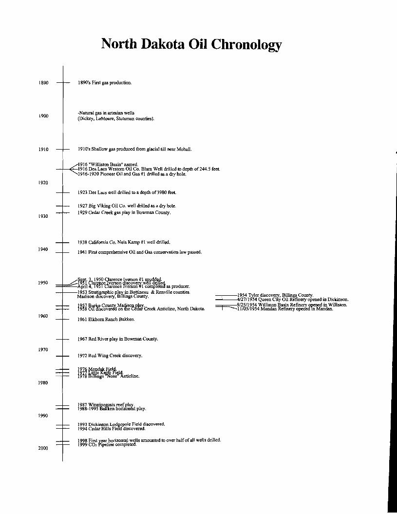
North Dakota Oil Cllronology
1890
1900
1910
1920
1930
1940
1950
1960
1970
1980
1990
2000
1890's First gas production.
-Natural gas in artesian wells (Dickey, LaMoure, Stutsman counties).
1910's Shallow gas produced from glacial till near Mohall.
1916 "Williston Basin" named. -+-+-1916 Des Lacs Western Oil Co. Blum Well drilled to depth of 244.5 feet.
1916-1920 Pioneer Oil and Gas #1 drilled as a dry hole.
1923 Des Lacs well drilled to a depth of3980 feet.
1927 Big Viking Oil Co. well drilled as a dry hole.
1929 Cedar Creek gas play in Bowman County.
1938 California Co. Nels Kamp #1 well drilled.
1941 First comprehensive Oil and Gas conservation law passed.
~§~i' ~ 1950eC~a:r<f; !r~~g #\JSyq<;,y,· .=~;::::::::Apn'1 ~:lf§!,f darence Yverson%comPte~ as producer. -1---1953 Strati,graphic play in Bottineau & Renville counties.
Madison discovery, Billings County.
1961 Elkhorn Ranch Bakken.
1967 Red River play in Bowman County.
1972 Red Wing Creek discovery.
1987 Winnijlegosis reef play.1988-1995 BaKken horizontal play.
1993 Dickinson Lodgepole Field discovered. 1994 Cedar Hills Field discovered.
954 Tyler discovery, Billings County. /27/1954 Queen City Oil Refinery opened in Dickinson. /25/1954 Williston Basin Refinery opened in Williston.~11/03/1954 Mandan Refinery opened ill Mandan.
1998 First year horizontal wells amounted to over halfof all wells drilled. 1999 CO, Pipeline completed.

Industrial Commission of North Dakota
John Hoeven
GOVERNOR
Wayne Stenehjem
ATTORNEY GENERAL
Roger Johnson
COMMISSIONER OF AGRICULTURE
North Dakota Geological Survey
John P. Bluemle, State Geologist
Randolph B. Burke, Ceologist Johnathan M. Campbell, Paleontology Lab Technician
Paul E. Diehl, Ceologist Sheila J. Glaser, Drafting Technician
Mark A. Gonzalez, Ceologist Karen M. Gutenkunst, Business Manager
Thomas J. Heck, Ceologist John W. Hoganson, Paleontologist
Kent E. Hollands, Core Library Technician Kyle W. Joersz, Data Processing Coordinator
Linda K. Johnson, Administrative Assistant Elroy L. Kadrmas, Digital Conversion Technician
Steve S. Kranich, Drafting Technician Julie A. LeFever, Ceologist/Core Library Director
Edward C. Murphy, Ceologist Russell D. Prange, Lab Technician
Evie A. Roberson, Administrative Officer Robert D. Shjeflo, Drafting Technician
Don H. Thom, Drafting Technician Kenneth Urlacher, Drafing Technician
Ryan P. Waldkirch, Geographic Information Specialist Shawna J. Zelinsky, Office Assistant
2001