.tflllllll:. - journals.flvc.org
19
Journal of Coastal Research Fort Lauderdale, Florida Spring 1995 Sediment Facies of an Embayed Coastal Sand Body, Pakiri, New Zealand Michael J. Hilton Department of Geography National University of Singapore 10 Kent Ridge Terrace Singapore 0511 ABSTRACT . .tflllllll:. euus '--: ..... 1+-- HILTON, M.J., 1995. Sediment facies of an embayed coastal sand body, Pakiri, New Zealand. Journal of Coastal Research, 11(2), 529-546. Fort Lauderdale (Florida), ISSN 0749-0208. A sedimentological investigation was conducted across the Pakiri-Mangawhai sand body located on the east coast of the Northland Peninsula, New Zealand. Nearshore, inner continental shelf and mid shelf depositional environments are recognised. The sand body extends seaward as a continuous accumulation of relatively mud-free unconsolidated sand from the landward extent of the coastal dunes to the 45 m isobath, approximately 4,500 m offshore, at the base of the inner shelf. The Pakiri-Mangawhai sand body is characterised by a regular pattern of morphological components and associated sediment types. In profile, the nearshore displays a concave geometry that extends to approximately the 22 m isobath, 1,500 m or so offshore. The inner shelf displays a convex or irregular profile and extends seaward of the nearshore to a break of slope at the 45 m isobath, approximately 4,500 m offshore, where the mid shelf commences. Nearshore gradients range between 0.4° and 1.8°, inner shelf 0.1° to 0.6° and mid shelf 0° to 0.15° Three subtidal sediment facies are recognised. Nearshore sediments comprise fine, very well sorted sands of 2 phi (0.25 mm) mean grain size. Inner shelf sediments grade offshore from medium to coarse sands (Mz = 0.0-0.5 phi, 0.71 1.00 mm) with some very coarse sand and fine gravel present. In contrast, the sediments of the mid shelf in Pakiri Bay are very fine sands (Mz = 2.0-2.5 phi, 0.177-0.250 mm), with a relatively high mud content (5-10C'c). Carbonate skeletal debris, derived mostly from mollusca, comprises a significant proportion of inner and mid shelf sediments, increasing offshore from 0-5 v; across the nearshore to (( at the base of the inner shelf. The size-graded bed of the nearshore and inner shelf is consistent with diabathic sediment transport resulting in the preferential shorewards transport of the fine sand fraction of the sediments of the inner shelf. Shoaling gravity waves have the potential to disturb sediments to at least the base of the inner shelf, however, wind generated and other currents may also be significant. Sediment exchange between the mid shelf and inner shelf is unlikely and the Pakiri-Mangawhai sand body is in effect a closed sediment system. Sand mined from the nearshore must result in a net loss of sediment from the sand body, and the sand resource should be considered finite. ADDITIONAL INDEX WORDS: Nearshore, shelf, sand body, Hauraki Gulf, New Zealand, sand mining. INTRODUCTION Investigations of the New Zealand continental shelf have revealed distinct regional variations in shelf sedimentology and morphology (see CAR- TER, 1975, for a review). These variations are at- tributed to differences in sediment supply to the coast (CARTER, 1975; GRIFFITHS and GLASBY, 1985), tectonic stability (LEWIS, 1973a,b; NORRIS, 1978), Quaternary eustatic sea level variations (SCHOFIELD, 1978; HERZER, 1981; CARTER and CARTER, 1986) as well as local variations in ge- ology,oceanographic and meteorologic climate and rates of carbonate sedimentation. The shelf adjoining the east coast of the North- land Peninsula is mostly narrow and relatively steep compared with other New Zealand coasts 92066 received 10 July 1992; accepted in revision 16 June 1993. and is not thought to receive significant quantities of sediment from fluvial sources or regional lit- toral drift (CARTER, 1975; RILEY et al., 1985). The coast comprises stretches of rocky coast punctu- ated by sandy embayments. The dune and near- shore sands of many of these bays have long been mined to provide aggregate for construction pur- poses, although historically little has been known of the nature of the subtidal deposits or the effect of mining on coastal stability (HILTON, 1989). Re- cent legislation, primarily the Conservation Act (1987) and the Resource Management Act (1991), demand of consent-granting authorities much greater cognizance of the impact of mining on coastal systems. Attention is presently focused on the impact of nearshore sand mining on the Paki- ri-Mangawhai coast. Of particular interest is the question of the areal and stratigraphic extent of the sedimentary deposits presently mined and the
Transcript of .tflllllll:. - journals.flvc.org

Journal of Coastal Research Fort Lauderdale, Florida Spring 1995
Sediment Facies of an Embayed Coastal Sand Body, Pakiri, NewZealand
Michael J. Hilton
Department of Geography
National University of Singapore
10 Kent Ridge TerraceSingapore 0511
ABSTRACT .
.tflllllll:.~euus'--: ~..... 1+--
HILTON, M.J., 1995. Sediment facies of an embayed coastal sand body, Pakiri, New Zealand. Journalof Coastal Research, 11(2), 529-546. Fort Lauderdale (Florida), ISSN 0749-0208.
A sedimentological investigation was conducted across the Pakiri-Mangawhai sand body located on theeast coast of the Northland Peninsula, New Zealand. Nearshore, inner continental shelf and mid shelfdepositional environments are recognised. The sand body extends seaward as a continuous accumulationof relatively mud-free unconsolidated sand from the landward extent of the coastal dunes to the 45 misobath, approximately 4,500 m offshore, at the base of the inner shelf.
The Pakiri-Mangawhai sand body is characterised by a regular pattern of morphological componentsand associated sediment types. In profile, the nearshore displays a concave geometry that extends toapproximately the 22 m isobath, 1,500 m or so offshore. The inner shelf displays a convex or irregularprofile and extends seaward of the nearshore to a break of slope at the 45 m isobath, approximately 4,500m offshore, where the mid shelf commences. Nearshore gradients range between 0.4° and 1.8°, inner shelf0.1° to 0.6° and mid shelf 0° to 0.15°
Three subtidal sediment facies are recognised. Nearshore sediments comprise fine, very well sortedsands of 2 phi (0.25 mm) mean grain size. Inner shelf sediments grade offshore from medium to coarsesands (Mz = 0.0-0.5 phi, 0.71 1.00 mm) with some very coarse sand and fine gravel present. In contrast,the sediments of the mid shelf in Pakiri Bay are very fine sands (Mz = 2.0-2.5 phi, 0.177-0.250 mm),with a relatively high mud content (5-10C'c). Carbonate skeletal debris, derived mostly from mollusca,comprises a significant proportion of inner and mid shelf sediments, increasing offshore from 0-5 v; acrossthe nearshore to :~o (( at the base of the inner shelf.
The size-graded bed of the nearshore and inner shelf is consistent with diabathic sediment transportresulting in the preferential shorewards transport of the fine sand fraction of the sediments of the innershelf. Shoaling gravity waves have the potential to disturb sediments to at least the base of the innershelf, however, wind generated and other currents may also be significant.
Sediment exchange between the mid shelf and inner shelf is unlikely and the Pakiri-Mangawhai sandbody is in effect a closed sediment system. Sand mined from the nearshore must result in a net loss ofsediment from the sand body, and the sand resource should be considered finite.
ADDITIONAL INDEX WORDS: Nearshore, shelf, sand body, Hauraki Gulf, New Zealand, sand mining.
INTRODUCTION
Investigations of the New Zealand continentalshelf have revealed distinct regional variations inshelf sedimentology and morphology (see CARTER, 1975, for a review). These variations are attributed to differences in sediment supply to thecoast (CARTER, 1975; GRIFFITHS and GLASBY,1985), tectonic stability (LEWIS, 1973a,b; NORRIS,1978), Quaternary eustatic sea level variations(SCHOFIELD, 1978; HERZER, 1981; CARTER andCARTER, 1986) as well as local variations in geology, oceanographic and meteorologic climate andrates of carbonate sedimentation.
The shelf adjoining the east coast of the Northland Peninsula is mostly narrow and relativelysteep compared with other New Zealand coasts
92066 received 10 July 1992; accepted in revision 16 June 1993.
and is not thought to receive significant quantitiesof sediment from fluvial sources or regional littoral drift (CARTER, 1975; RILEY et al., 1985). Thecoast comprises stretches of rocky coast punctuated by sandy embayments. The dune and nearshore sands of many of these bays have long beenmined to provide aggregate for construction purposes, although historically little has been knownof the nature of the subtidal deposits or the effectof mining on coastal stability (HILTON, 1989). Recent legislation, primarily the Conservation Act(1987) and the Resource Management Act (1991),demand of consent-granting authorities muchgreater cognizance of the impact of mining oncoastal systems. Attention is presently focused onthe impact of nearshore sand mining on the Pakiri-Mangawhai coast. Of particular interest is thequestion of the areal and stratigraphic extent ofthe sedimentary deposits presently mined and the
530 Hilton
likelih ood of na tural replenishmen t and hence thesustaina bility of the mining opera t ions .
The objectives of the presen t study are to (1)describe and offer an initial inte rpretation of thesed iments of the subtidal environments of thePakiri-Ma ngaw ha i embaym en t , and (2) exam inethe find ings in terms of t he likely susta ina bilityof nea rshore coastal sand mining in the study area.Characteristics of th is coast mak e it a useful location to investigate the nature and developm en tof sha llow marine facies, and spec ifically the offshore extent of modern sed imentation. While asubstantial body of sediment has appa rently accumu lated in the embayment, th e modern supplyof sedime nt to the coast from ot he r tha n offshoresources and in situ biogenic pr oducti on is likelyinsigni fican t (H ILTON, 1990). Ther e is thus a reasona ble expectat ion that the sed imentology of thesea bed represen ts a response to the hydrauli c regime in P akiri Bay.
COASTAL SETTING
The study area covers th e southe rn half of th ePak iri -Mangawhai embaym en t located in the outer Hauraki Gulf on the east coast of the Nort hlandP en insula, New Zealand (Figure 1). The outerHauraki Gulf coast of the lower No rt hland Pe ninsula comprises a series of sandy embaymentsseparated by rocky headlands. The P ak iri-Mangawhai embayment is separated from adjacen t embayments , Bream and Omaha Bays, by BreamTail to the north and Cape Rodney to the south(Fig ure 1).
Coastal Morphology
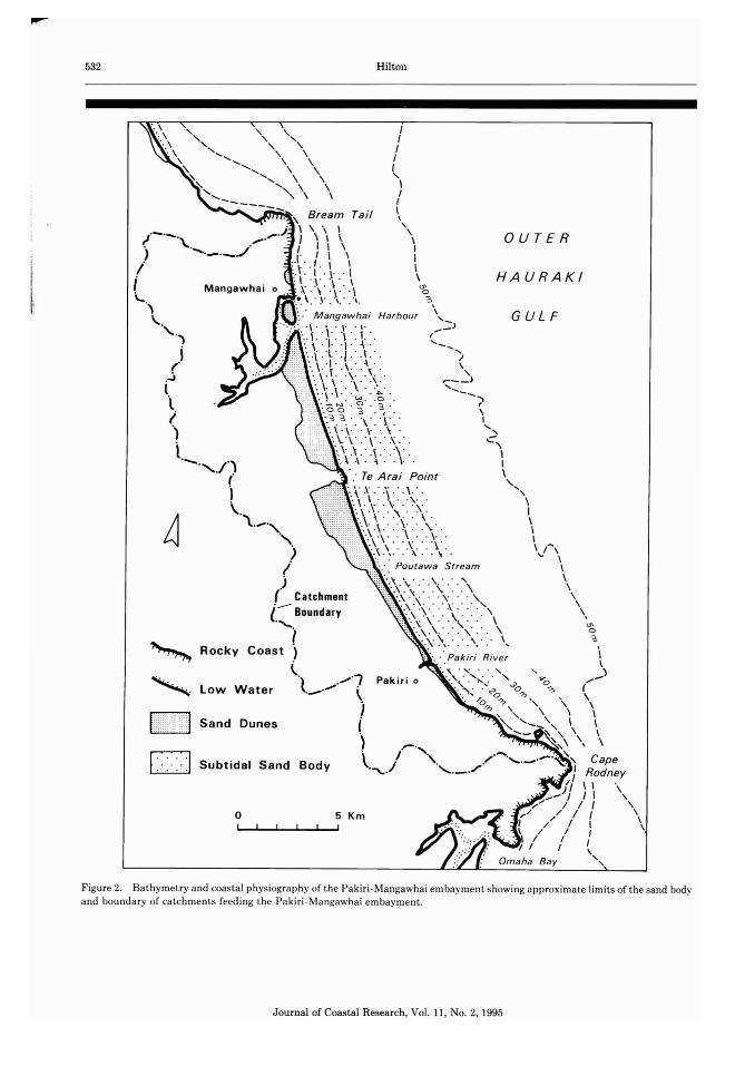
The P akiri-Mangawhai coast is backed by adune field tha t extends up to 3 km inland , increasing in width and overall elevation to th e north(Figur e 2). Dune topography is hummocky andirregular with numerous active an d stabilised parabolic blowouts. Foreshore/insh ore morphologiesare charac te ristic of W RI GHT and Snotrr's (1984)' inte rme diate' beach states; th e insh ore zone cha racterise d by a simple t rough/alongshore bar complex, extendi ng as a subtida l ledge approx imately250 m seaward of the foredune (HILTON, 1990).The morphology of the offshore has not pr eviouslybeen descri bed in detai l. Ex isti ng bathymetricsurveys indicate the presence of a broad surfaceoffshore of the sandy coast, na rrowing towardsCa pe Rodney and Bream Tail, sloping sea wardsto the mid she lf whic h commences in water depths
of between 40 and 50 m. In profile, t he seafloo rof the Pakiri-Mangaw hai embayment comp risesa relatively steeply-slopi ng segme nt of the Hauraki Gulf profile. THO;\II'SON (1975) interpretedthe base of this slope as the seaward limit of theinne r she lf.
Geology and Sediments
Pakiri Bay adjoins th e ase ismic Northland landmass, th ough t to be tecton ically stable since theupper Miocene (LENSEN, 1977). The rocks of theheadl ands, Bream T ail , T e Arai Point and CapeRodney a re Mesozoic greywacke or T ertiar y sand stone. The intervening coas ts of Man gawhai andPakiri Bays are comprised of un consolid at ed sa nddunes, mos tly of Holocene age, overlyi ng conso lida ted sa nds possibl y of last in terglacial age(SCHOFIELD, 1970).
The sed imentology of coastal and she lf environmen ts in Paki ri Bay is known from surveys ofHauraki Gu lf coasta l a nd she lf se d iments.SCHOFIELD (1970) lab els the sedi ments of the midshe lf and those of the coast (incorporating dune,near sh ore and inn er she lf envi ronme nts) as theHaurak i A and B Sa nd Facies, respect ively. T heHaurak i B Sand Fac ies is considered a coastalderivative of the sed ime nts that blanket the seafloor of the outer Haur ak i Gu lf, and to have beenwork ed shoreward and onshore during successivelate -Qua ternary sea level t ransgressions(T HOl\II'SON, 1975; SCHOF IEJ.I) , 1978).
T he Pakiri-Mangawhai coasts are not thoughtto receive signi ficant quan t it ies of new sedi mentfrom fluvia l sources (Hn.rox, 1990), or as a resultof regional alo ngs hore littoral tr anspor t (RILEYetal., 1985). LEES (1982) estimates th e rat es of erosion of rocky coast in th e embayme nt in histor ict imes as 5.7 x 10" m"/yr , which is low in compari son with th e pot ential volume of Hauraki BFacies sed iments between Bream T ail and CapeRodney (1.26 x 10' m" ass uming these sedimen tsare only 1 m thick). Biogeni c product ion of carbonates-as the tests of mollusca-is likely of fargreater signifi can ce (H ILTON, 1990). T he min eralogy of the qu artz-feld spathic sands of the Man gawhai (MCCABE, 1985) and Omaha (SCHOFIELD,1970, 1978) coas ts, to the north and south of thestudy ar ea, are consisten t with an offshore provenance and are considered to have bee n workedonshore during late Quaternary (THOMPSON, 1975).
Dune sands from the Pakiri and Mangawhaicoasts are descr ibed as having median gra in sizesof 2-2.5 phi (0.23-0.27 mm) (SCHOFIEJ.I), 1970)
Jou rna l of Coastal Research, Vol. 11, No.2, 1995

Sediment Facies of an Embayed Coast 531
\\
\\
<,-,
\\\\\\\\\\~o~
G u If
\\\II
i'J,I I'--/
Haurakl
....../1"=~ \I \
I '\Little II "',\,
Barrier Is. I I//()-~\ I (1\\ I
I \ 'I ,\ \II \ \
Cape Rodney \.J ') \,/ ~o~ ,
/// / J,/ II r, I /I / \_.~/ -r::I / Jl/ I
\
" <,
" \\\
" \\so
~ ......--
Studyarea
Tail
\ \~ \I ,\ \" \
J \I \( \\ ,\ "0
0J ~
OJo \3 \-"_.........-~) " r.;-.-;-- ...... ,
/-, " .'Mokohinau IsBream / <, JL_" ',./.~) ~--.,
/I
Auckland
oI
Figure 1. Location map of the Pakiri-Mangawhai sand body, outer Hauraki Gulf, North Island, New Zealand.
and 1.5-2.5 phi (0.35-0.18 mm) (MCCABE, 1985),respectively. The mean grain size of 44 intertidalsamples analyzed by HILTON (1990) from PakiriBay ranged from 1.17 phi (0.47 mm) to 1.83 phi(0.28 mm), although all but three of the samples
were contained in the range 1.60-1.83 phi (0.340.28 mm). The foreshore sands of the Mangawhaicoast are also medium sands (MCCABE, 1985). Thepresence of modern autochthonous carbonate facies offshore of Bream Tail and Cape Rodney,
Journal of Coastal Research, VoL 11, No.2, 1995
532 Hilton
GUL F
OUTER
HAURAKI
5 Kmo
Low Water
Sand Dunes
D Subtidal Sand Body
~
" ,~
IIIII,
\,I
"otC"""~\ Bream Tail "- ,, \ , '
1'-'- · ;<""..1 I " , '(\.. . I I 1 \ \, ....._ ._../ I' I \ , I
/ ::t:- ('.\..\ \,. : I . T . ", · . ' '
Mangawhai 0 .\ . \ "\" . \ 'bi...., ,". \ .' r .",' .". e.\, I :.:M ang awhai Harbou r \ , _
''\..') "' : " , . \ . . \, ' ,I' . : r. ,....-': '..\. .\ . \ .. .j ". \. .. ., ' \ ' . '\' . ' - .... ,j --\- 1. ./ . .1. . I
r ' ·. \.· 1 ' . , . · . ~ · . ,. '. \ .l. .\ . .\ . . ,
(...J ". , ." . y . '\ . ,,:_'.., .\ . . ... . --l ·' :" N · . ~ · . · ~ . " iI
'. 0 0 3 . , . ,'.3 3 ' \' T . I
') '.\ .\.' . \, ' . " . ...."··\."' T · " · -l. ..\\' , '. ,'.':\.. .....\
- ..........1") '. .\ . ~ .. \. . I
( : Te Arai Point \
I ...-\ \ .:\ :'\ :' . '\\.. " ,' X ' ,," \ ' I\ ". ,:"':- \ '>'. ,'-', '. \ .\ . . .\ . .\. . \..... . .\ . . _ . ,. , \'. '.\ ,. \' . .\ . \ /"
) ".\ \ .. .. ~. .. . " . " "I c. Poutawa Stream ,
) ...\ \ . .. .\ ... \ \(Catchment '. . \ . . . . \'- '.\ .\ .'.'\ .'. '.' , ,
l. ........ Boundary '--\\ . :: :~( :: :: \ \ ",,• . , . ' -, . . , 0
') ...y \ \ ... '- e.Rocky Coast '. --.Pak m Ri ver \
( ' . ", ." . . , .... ).} .......·1 "." <-,.: ' .r. "'o ->\._....... i " , --' ~ . "0 0..", ..", (
, . ....0 ..", " " '",... , \
, " \ ' \c-, -,,, \ \<,- ~,\ '\,' , \
\. CapeJ RodneyI, \I ".... j, 1\ ,
...." I / I ,,-/ , / I \I , ' 1 I \\ I I II I I II I I ,
Om aha Bay',
Figure 2. Bathy metry and coasta l ph ysiography of th e Pakiri-Mangawhai em bay ment showing approximate limi ts of th e sa nd bodyand bou ndary of catc hments feeding th e Pakiri -Man gawhai embayment.
Journal of Coastal Resear ch , Vol. 11, No.2, 1995

Sediment Facies of an Embayed Coast 533
described by MCCABE (1985) and HILTON (1990),further suggests sediment exchange between thePakiri-Mangawhai embayment and Omaha andBream Bays is unlikely.
Waves and Currents
Observations of the northeast New Zealand waveclimate have shown that wave energy is both lowerand more variable along the East Coast than otherexposed coasts around New Zealand with localstorm events the primary influence (HAI{HIS et al.,1983). The dominant swell wave arrives from anortheast direction. The mean deep water waveheight is 1.4 m and rarely exceeds 3.0 m (EwANsand KIBBLEWHITE, 1986). Periods are mainly inthe range 6 to 9 sec, with 6.55 sec the average.Episodes of high wave activity in the study arearesult from onshore winds associated with intensesub-tropical cyclones that originate to the northwest of New Zealand. The most extreme storm ofrecent times occurred in 1978 when a sub-tropicalcyclone generated near hurricane force easterly(onshore) winds and waves in the outer HaurakiGulf of 9 m maximum height and 12 sec period(PEEK, 1979). Periods of moderate and high waveenergy along the east coast of the North Islanddo not, however, persist for long. HARRIS et al.(1983) reported that waves greater than 3 m neverpersisted for longer than 36 hours. Above 4 m, thepersistence was no greater than 12 hours. In contrast, periods of low wave activity, less than 1.5m, could persist for as long as 300 hours.
Knowledge of wind-and tide-generated currents in the Pakiri-Mangawhai embayment is poor.Tides in the study area are semi-diurnal and mesotidal with a maximum range of 3.0 m at springsand 1.5 m at neaps. An Aanderaa RCM-4 Euleriancontinuous recording current meter has been operated in water depths of 30 (site 1) and 45 m(site 2) in Pakiri Bay for a 6 week period (BELL,1986). Maximum speeds do not exceed 0.19 msec 1 at site 1 and 0.15 m sec I at site 2. However,these speeds are exceptional: at site 1, speedsgreater than 0.10 m sec I were exceeded only 4.7percent of the record. The current meter recordis dominated by bidirectional tidal flows, primarily oriented alongshore. Offshore winds of unexceptional velocity and near calm seas occurredthroughout this meter deployment; hence, thereis no likelihood of the local (storm) wind-generated bottom currents reported by BHADSHAW etal. (1991) from a comparable east coast location.The East Auckland Current is not thought to im-
pinge into the Hauraki Gulf and have any significant effect on the coast (HARRIS, 1985); however,a persistent, mostly southeasterly current of maximum speed 0.06 m sec I is superimposed over thebidirectional tidal flows.
METHODS
The investigations reported, with the exceptionof some alongshore side-scan sonar surveys, wereconducted across a series of eight, regularly spaced,shore-normal transects, originally established bythe Auckland Regional Council in 1978 (Figure3). Transect lines were relocated using shoremarkers and the position of the research vesselalong the transect by radar rangefinder.
Sediment sampling involved two components.Samples were initially obtained across all transects during June and August 1986. A 20-25 litresample of the top 10-20 em of the bed was obtained at regular intervals using a pipe dredge.Sampling commenced about the crest of thealongshore bar and was discontinued approximately 8 km offshore. Samples were obtained at90 m intervals across the relatively steeply slopingseabed seaward of the alongshore bar, and every260 m thereafter. A total of 175 samples wereobtained across the seven transects. In addition,46 foreshore samples were collected from low andhigh water levels at regular intervals betweenOkakari Point and Te Arai Point.
The second sampling component entailed theextraction and analysis of multiple samples froma selection of stations across a single transect. Atotal of 59 samples were dredged from 10 stationsat water depths of 4, 10, 15, 20, 25, 30, 35, 40, 45and 47 m across Williams transect over a 3 dayperiod (Figure 3). The aim was to determinewhether the results of the one-off sampling programme, in which a single sample was obtainedat each station, accurately represents the rangeof bed sediments present, and to assess the natural variability of the bed sedimentology. Resultsare presented as means of means and the varianceabout the mean indicated by standard error bars.Williams transect was chosen because of its medial position in Pakiri Bay, and because in termsof the strength of sedimentological trends it istransitional between the three transects to thenorth (Couldrey, Walkway, Gravel) and south(Brown, Matheson, Okakari). In several respects,the results from Williams transect represent thetypical condition.
Laboratory analysis of sediments involved de-
Journal of Coastal Research, Vol. 11, No.2, 1995

534 Hilton
\
\\\\\\\\\\\\\\,(J')as\'\
/-----'
(\\\\\III\\\\\,II
Rodney,
,\
\\,I
Okakari
Side -Scan/Sonar Survey
"-,
"\\\
\
\\\J
I~
o'3
<.no:3I\\\
Walkway
\\\
'"\\JI
4'o WilliamsI
'\-//"""",I/
,\'\.
<,
_I
' .........
\\ .
\ Figure \ ••\ 8a ••\ .' ... '. \. \
\\
5 Km
Subtidal
Multiple
Foreshore
o
Samples
: \. \ \" \ \, \ I
\ I\ Te Ara; Pt. I1 \ \ I
'I \ \ " • ••• Gravel0. \ \ \ ••••
~\....\.. ":' \ } ~',\ N VJ 0 •....... 0 0"3 •••0',0"3 "3 , •••••
, '3 I \ ••
"\ I \ ••••,~ \ \ ... ~ \
'~. ,, ' \b \ \ I" \ \ \ \ • • • Couldrey~\ \ \ \ .. ~0\ \ \ \ •••
. \ \ \ \ ... \.0\ \ \ •• ~',\ \ .. \
~\. ~\" ~...." \ ....., 6 .\110, \' \ 6 @ ••"\ \ 6 .@. \6. \ \ ~.@. \
6,,'555@ ••\-\\\\....Brown, \ ...\ \ .. \
\ I ••• \
',\ \ .. \0", \~..." \
~ .. \ \
',\ \ " \", \ \ ' )0, \, \ \ Matheson
'. \ \ \ ........<,
'. \ \ '.. \" \ \, .. ~ \'\ " . ," \~.~ ".~" "
" \ "',', \-, ~
'0 ~'? \
\ '\
o
•6o
Figure 3, Location of Pakiri Bay beach and offshore samples and side scan sonargraph survey.
Journal of Coastal Research, VoL 11, No.2, 1995
Sediment Facies of an Embayed Coast 535
termining settl ing velociti es and gra in size distributions (excluding par t icles < 4 phi , 0.0625 mm )by automated settling tube (includ ing and excluding the carbonate frac tio n), th e prop ortion ofmud (sediment finer than 4 phi ) and the proport ion of carbona te mat eri al , usin g th e sta ndardmethods of CAHVI<:H(1971) an d FOI.K (1974). Percentage fines and carbonates refer to th e pr oportion of the dr y weigh t of the origina l untreat edsample.
Additional inform ati on on th e spatial distri bution of sediments , and in part icul ar variat ionsassociated with sma ll- and large-scale bedforms,was provided by SCU BA d iving and side -scan sonar , respecti vely. Side -scan data was obtained inMarch 1987 to invest igate sed iment variati ons associate d with large scale bedform s on the inn erand middle cont inental shelf. A total of 3.3 kmof seabed was survey ed using a Klein side-scansonar operat ing at a ran ge of 100 m and 375 Kh zfrequency.
RESULTS
Morphologic Features of Paki ri Bay
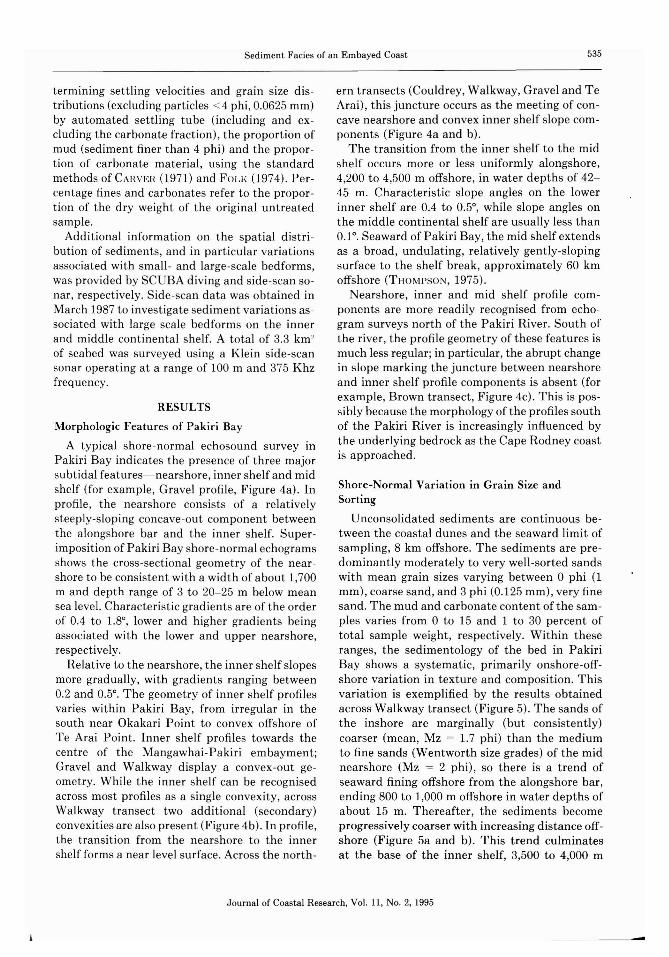
A typical shore- normal echoso und survey inPakiri Bay indicates th e presence of three majorsubt ida l features-nearshore, inn er shelf and midshelf (for example, Grave l profi le, Figur e 4a) . Inprofile, the nearshore consis ts of a relativelystee ply-sloping concave-out com ponent betweenthe alongshore bar and the inn er shelf. Supe rimp ositi on of Pakiri Bay shore-normal echogramsshows the cross-sectiona l geometry of the near shore to be consistent with a width of about 1,700m and dep th ran ge of 3 to 20-25 m below meansea level. Cha rac te rist ic gradients are of the orde rof 0.4 to 1.8°, lower and higher gradie nts beingassociat ed with th e lower and upper nearshore,respectiv ely.
Relati ve to th e nearshore, the inner shelf slopesmore gradually, with gradients ranging betw een0.2 and 0,50. The geomet ry of inn er shelf profilesvar ies within Pakiri Bay, from irr egular in thesouth near Okakari Point to convex offshore ofTe Arai Poin t. Inn er shelf pro files towards thecent re of th e Man gawhai-P ak ir i embay ment;Gravel and Walkway displ ay a convex -out geomet ry. Whil e the inne r shelf can be recognisedacross most profiles as a single convex ity, acrossWalkway tr an sect two add it iona l (seconda ry)convexit ies are also presen t (Figure 4b) . In pro file,the trans it ion from the near shore to the inn ershelf forms a near level surface. Across the north-
ern tr an sects (Couldrey, Walkw ay, Grave l and T eArai), this juncture occurs as the meetin g of concave near shore and conve x inner shelf slope components (Figure 4a and b).
The transit ion from the inn er she lf to th e midshelf occurs more or less un iformly alongshore,4,200 to 4,500 m offshore, in water dep th s of 4245 m. Characteristi c slope angles on the lowerinner shelf are 0.4 to 0.5°, while slope an gles onthe middle continenta l shelf are usually less than0.1°. Seaward of Pakir i Bay, th e mid shelf extendsas a broad, undulating, re latively gentl y-slopingsur face to the shelf brea k, ap proxima te ly 60 kmoffsh ore (THOMPSO N, 1975).
Near shore, inner and mid she lf profile componen ts are more readily recognised from echogram surveys north of the Pak iri River . Sout h ofthe river , the pr ofile geome try of these feat ures ismuch less regular ; in par t icular , t he abrupt cha ngein slope marking th e juncture between nearshoreand inn er shelf pr ofile components is absent (forexample, Br own t ra nsect, Figur e 4c). T his is possibly becau se the morphology of the profiles southof the Pakiri River is increasingly influenced bythe underlyin g bedrock as the Cape Rodn ey coastis approached.
Shore-Normal Variation in Gr ain Size andSorting
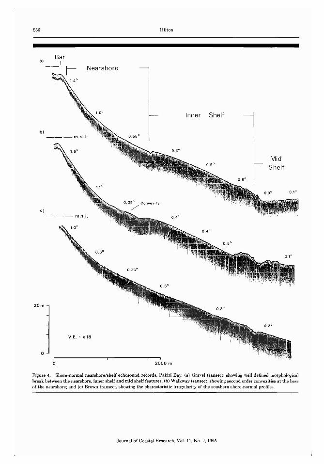
Unconsolida te d sediments are continuous between th e coastal dunes and the sea ward limit ofsampling, 8 km offshore. The sediments are pr edominantly moderately to very well-sorted sandswith mean gra in sizes varying between 0 ph i (1mm ), coarse sand, and 3 ph i (0.125 mm ), very finesand. T he mud and carbonate content of the sa mples varies from 0 to 15 and 1 to 30 percent ofto tal sa mple weigh t , respect ively. Within theseranges, the sedimentology of the bed in Paki riBa y shows a syste matic, primaril y onshore -offsho re vari ation in te xt ure and composit ion. Thisvariation is exemplified by the results obtainedacross Walkway t ransect (Figure 5). The sands ofthe insho re are mar ginally (but cons istently)coa rse r (mean, Mz = 1.7 ph i) tha n the mediumto fine sands (Wentworth size grades) of the midnearshore (Mz = 2 phi) , so there is a t rend ofseaward finin g offshore from the alongshore bar ,ending 800 to 1,000 m offshore in water dep th s ofabout 15 m. Thereafter , the sediments becomeprogressivel y coarse r with increasin g distan ce offshore (Figur e 5a and b). This trend culminatesat the base of th e inner shelf, 3,500 to 4,000 m
Jo urnal of Coastal Resea rch, Vol. 11, No.2, 1995
m .s .1.
- .-·-- m .s I.
536
a)
b)
c)
20m
o
BarI
o
Nearshore
Hilton
2000 m
Inner Shelf
MidShelf
Figure 4. Sh ore -norm al near shore/sh elf echoso und reco rds , Paki ri Bay: (a) Gravel tr an sect , showing well defined morphologicalbre ak betw een th e nearsh ore , inn er shelf and mid shelf features; (b) Walkw ay tr ansect , showing second order convexit ies at the baseof th e near shore; and (c) Brown t ran sect, showing the characteristic irregularity of t he sout hern shore-normal pr ofiles.
J ournal of Coastal Resear ch , Vol. 11, No. 2, 1995
Sediment Facies of an Embayed Coast 537
offshore, in water depths of 40 to 45 m. T hesesediments are comprise d mostly of very coarsesand, with some granules and pebbles (Mz = 0.00.8 phi) . Immediately seaward of the inner shelf,there is an ab rupt change in the sedimentologyof the bed (Figure 5a and b). The non-mud frac tion of mid shelf sediments comprise very finesands. These sands are the finest in the study areawith mean grain sizes of about 2.5 phi (0.177 mm) .
As the sediments of the mid to lower nearshoreand inner shelf become coarser they become pro gressively less well sorted. The best sorted sediments (SD = 0.35 phi) are the fine sands (Mz =2 phi, 0.25 mm) of the shallow nearshore, 200 to1,000 m offshore (Figure 5a) . The degree of sortingdecreases offshore, with the least well sorted sed iments (SD = 0.5 phi) the coarse sands and finegrave ls at the base of the inner she lf. Seaward ofthis coarse material sorting improves, althoughsamples from the mid shelf are much less wellsorted than the sands of the nea rsho re. Foreshoresands are coarser (Mz = 1.2-1.9 phi) and less wellsorted (SD = 0.36-0.61 phi) than the medium tofine, well-sorted sands of either the upper nearshore or the coastal dunes. Aeolian dune sandsare well to very well sorted, medium to fine sandsand have typical mean grain sizes of 1.7 phi anda standard deviation of 0.34 phi.
With one exception, the grain size frequencydistributions of all beac h and subtidal samplesanalyzed are unimodal. Distributions tend to benear-symmetrical (Sk = - 0.10 to 0.10) or fineskewed (Sk = 0.10 to 0.30) and mesokurtic (K =0.90 to 1.11). Samples from near the base of theinner she lf tend to be negatively skewed, reflect ing the predominance of coarse sands in thesesamples. Sediment distributions from the midd lecontinental shelf are weakly negatively skewedand near-symmetrical. In general, the distr ibutions tend to become more symmetrical across theinner she lf and nearshore with sample distributions from the alongshore bar being essentiallysymmetrical.
The textural transition from the very coarsesands of the lower inner shelf to the very finesands of the middle continental shelf coincideswith an ab rupt increase in the proportion of mudin the samp les (Figure 5c). Mud content is 0-2percent across the nearshore, and low (2-5 percent) across the inner shelf between water depthsof 25 and 42 m. However, immediately seawardof the inner shelf the proportion of mud in samples increases to between 10 and 15 percent.
We nt wo 'ih,"00
S Ize G. ade
In Fin" ,
Med Ium and
Co erse Sa nd
Grad e s
, Mud
' 0
De pt h
20
30
40 M id S htllf
500 2000 4000 6 00 0
Dist ance
Figure 5. Variation in (a) mean grain size and sorting (barsindicate standard deviations) , (b) proportion of total sample indifferent sand size grades (Wentworth classification) and (c)percent mud across (d) Walkway transect.
The pattern of offshore coarsening of bed sediments across the nearshore and inner shelf isconsistent across all Pakiri transects. However,trends are most strongly indicated over the northern transects in te rms of both the range of grainsizes present and the consistency of the stationto station trends. The range of mean grain sizespresent across the transects decreases from north(Gravel) to south (Matheson) , although there isno comparable trend in sorting. These differencesare unlikely to result sole ly from sampling errorsuch as there appears to be a systematic alongshore variation in grain size. In general, suc halongshore variations in bed texture are minorcompared with shore-normal variations.
Carbonate Content
The carbonate fraction of the sediments analyzed is largely comprised of fragments of benthicmolluscan mac rofauna. Carbonate content in-
Journal of Coastal Research, Vol. 11, No.2, 1995
538
b .
~N 10
!. 20
~
g. 30
o
~~;-o-:
-~ rl .......~ i
\...--.~A-. V.....- \ I ~\ I \0-\I ~._q!
Sand Only \.>::4Sand & Shell
Hilton
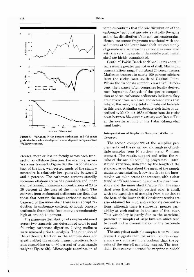
samples confirms that the size distribution of thecarbonate fraction at any site is virtually the sameas the size distribution of the non -carbonate grains.Hence, carbonate fragments associated with thesediments of the lower inner shelf are commonlyof granule size , whereas the carbonates associatedwith the very fine sands of the middle continentalshelf are highly comminuted.
South of Pakiri Beach shelf sediments containincreasingly greater quantities of shell. Maximumconcentrations range from about 20 percent acrossMatheson transect to nearly 100 percent offshorefrom the rocky coast south of Okakari Point.Where the carbonate content is less than 100 percent, the balance often comprises locally derivedrock fragments . Analysis of the species composition of these carbonate sediments indicates theyare derived from mollusca and echinoderms thatinhabit the rocky intertidal and subtidal habitatsin this area. A similar carbonate-rich facies is described by McCAHE (1985) offshore from the rockycoast between Mangawhai estuary and Bream Tailat the northern limit of the Pakiri-Mangawhaisand body.
Distance Offshore (m I
Figure 6. Variation in (a) percent carbonates and (b) meangrain size for carbonate-digested and undigested samples acrossWalkway transect.
creases, more or less uniformly across each transect in an offshore direction. For example, acrossWalkway transect (Figure 6a) the carbonate content of the fine, well-sorted sands of the shallownearshore is relatively low, generally between 2and 5 percent. The carbonate content steadilyincreases offshore across the nearshore and innershelf, attaining maximum concentrations of 20 to30 percent at the base of the inner shelf. Thecoarsest (non-carbonate) sediments are thus alsothose that contain the most carbonate material.Seaward of the inner shelf there is an abrupt reduction in carbonate content, although concentrations in the mid shelfsediments are moderatelyhigh at around 10 percent.
The grain-size distribution of samples obtainedacross two transects was determined prior to andfollowing carbonate digestion. Living molluscawere removed prior to analysis. The retention ofthe carbonate fraction in the samples does notgreatly affect the sample means, despite carbonates comprising up to 30 percent of total sampleweight (Figure 6b) . Microscopic examination of
Interpretation of Replicate Samples, WilliamsTransect
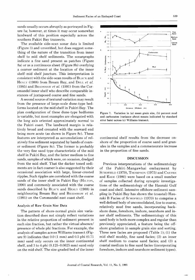
The second component of the sampling program entailed the extraction and analysis of multiple samples from 10 stations across Williamstransect. The results support and refine the results of the one-off sampling programme. Intrastation variation, indicated by the length of thestandard error bars about the mean of the samplemeans at each station, is low relative to the interstation variation across the transect, with a cleartrend of offshore coarsening across the lower nearshore and the inner shelf (Figure 7a). The standard error (indicated by vertical bars) is small ,with the exception of samples from a station atthe base of the inner shelf. Consistent results arealso obtained for mud and carbonate concentrations, although there is somewhat greater variability at each station in the case of the latter.This variability is partly due to the occasionalpresence in samples of large bivalves which tendto result in the overestimation of the carbonatecontent.
The analysis of multiple samples from Williamstransect suggests that the overall shore-normalgrain size trends are more uniform than the results of the one-off sampling suggest. The transition from coarse inner shelf to very fine mid shelf
Journal of Coastal Research, Vol. 11, No.2, 1995
Sediment Facies of an Embayed Coast 539
Distance Offshore (m)
DISCUSSION
continental shelf results from the decrease onshore of the proportion of coarse sand and granules in the samples and a commensurate increasein the proportion of fine sands.
Figure 7. Variation in (a) mean grain size, (b) percent mudand carbonates (variance about means indicated by standarderror bars) across (c) Williams transect.
E 20
l '~ 10
Previous interpretations of the sedimentologyof the Pakiri-Mangawhai embayment bySCHOFIELD (1970), THOMPSON (1975) and CARTERand EADE (1980) were based on a small numberof samples collected during synoptic investigations of the sedimentology of the Hauraki Gulfcoast and shelf. Intensive offshore sediment sampling in Pakiri Bay has shown the (coastal) Hauraki B Facies of SCHOFIELD (1970) to comprise awell defined body of unconsolidated, fine to coarse,relatively mud free sands, incorporating backshore dune, foreshore, inshore, nearshore and inner shelf sediments. The sedimentology of thissand body is both more complex and regular thanpreviously appreciated, a feature being the offshore gradation in sample grain size and sorting.Three new facies are proposed (Table 1); (1) themid shelf muddy, fine sand facies; (2) an innershelf medium to coarse sand facies; and (3) acoastal medium to fine sand facies (incorporatingforeshore, inshore and nearshore sediment types).
Analysis of Raw Grain Size Data
The pattern of shore-normal grain size variation described does not simply reflect variationsin the relative proportion of sediment present ineach size fraction, but rather the virtual absence/presence of whole phi fractions. For example, theanalysis of samples across Williams transect (Figure 9) indicates that 0.0 (1 mm) and 0.5 phi (0.71mm) sand only occurs on the inner continentalshelf, and 3 to 4 phi (0.125-0.0625 mm) sand onlyon the mid shelf. The size-graded bed of the inner
sands usually occurs abruptly as portrayed in Figure 5a; however, at times it may occur somewhatlandward of this position especially across thesouthern Pakiri Bay transects.
The available side-scan sonar data is limited(Figure 3) and unverified, but does suggest something of the nature of the transition from innershelf to mid shelf sediments. The sonargraphsindicate a fine sand present as patches (Figure8a) or as a continuous sheet (Figure 8b) overlyinga coarser sediment at the location of the innershelf-mid shelf juncture. This interpretation isconsistent with the side-scan results of BLACK andHEALY (1988) from Bream Bay, and DELL et at.(1985) and BHADSHAW et at. (1991) from the Coromandel inner shelf who describe comparable instances of juxtaposed coarse and fine sands.
A second source of textural variation may resultfrom the presence of large-scale dune-type bedforms located on the mid shelf in Pakiri Bay. Theplan configuration of these dune-type bedformsis variable, but most examples are elongated withthe long axis oriented approximately normal tothe Pakiri coast. The landward margin is relatively broad and crenated with the seaward endbeing more acute (as shown in Figure 8c). Thesefeatures are interpreted as accumulations of relatively fine sediment separated by bands of coarser sediment (Figure 8c). The former is probablythe very fine sand type characteristic of the midshelf in Pakiri Bay, and the latter medium to finesands, samples of which were, on occasion, dredgedfrom the mid shelf. That the darker toned sediments are in fact coarser is also suggested by theiroccasional association with large, linear-crestedripples. Such ripples are correlated with the coarsesands of the inner shelf in Pakiri Bay (HILTON,1990) and commonly associated with the coarsesands described by BLACK and HEALY (1988) inneighbouring Bream Bay and BHADSHAW et at.(1991) on the Coromandel east coast shelf.
Journal of Coastal Research, Vol. 11, No.2, 1995

540 Hilt on
Figure 8. Side -scan sona rgraphs of t he contac t het ween the inne r shelf (dark) an d mid shelf (light) sed iment types, (a) in thepresence of large sca le bedform s and (b) in th e abse nce of la rge sca le bedforms; and (c) sonagraph of a large-scale du ne -ty pe bedfo rmlocated on t he mid shelf. Scenes locat ed in Figur e :J.
Journ al of Coasta l Resear ch , Vol. 11, No.2, 1995

Sed iment Facies of an Em baye d Coas t 541
o
+'"IC'l
""
a>:"~ C'i- toI I I_ "" t-
C'i "":
co t- to
"" eo '""f"f"f"" '" C'l"" eo ""odo
1 0 0 0
aD M M 0)C""Joo _ oC'i "":e-.ie-i
8giJ~c-,i"": ""'; "';
..cQ.'"Q -~ Ei~ -
"B:
6
L I i .eo -T~-Y~~
o 1 I .. .. l\
; : ] At_ /"---------1I ~ ~ Y' ..... .... '", 0 1 -"'--'-, //r/::1____ t" _ _:j Io i__- -------------~
:l .."t-____ _L-J.//--------joj -- ---=:::x.=.:: 'Y . _ _
:ir\_ -1-------j--10 ' <,""1;>-- --1--+---o
~~ j\i,?---,-~~',--~---------:JI - _
o - --- - - - - .-----?:hZ/...'==--~-~' 0 ~ _.r/ -i---1- __o L _ _ ....._--~: [ - - /t--~ ..- ----,
o _---..../ ............. 'll --- -----
----~-~--~ -~
S o, . l Pl'lll
D epth
,J 0 Pt'll
,2 S Ph ,
,20 Ph,
,1 & Ph,
,00 Ph,
,OS Ph,
,1 0
Figure 9. Variation in (a) mean grain size and sorti ng andpercent weight of sample pre sen t in (b) 0.0, (c) 0.5, (d) 1.0, (e)1.5, (f) 2.0, (g) 2.5 and (h) 3.0 phi size fractions across (i) Williams t ransect. Variance about mean s indicated by standa rderror bars.
In plan view, th e sa nd body comprises two shore parallel facies, bounded to seaward by the midshelf facies (Figure 10).
Furth er work IS required to define the oute rlimits of the mid shelf facies of the ty pe described ;the sedi ments of th e Hauraki Gu lf mid shelf, asdescribed by T uoxn-so rc (1975), a re textu ra llymore variable tha n those samples analyzed fromthe mid shelf bordering the Pakiri-Man gawha isand body. With one excep ti on, all t he samplesobtained during the presen t st udy are unimoda l.T his cont ras ts wit h the polym odal sed iments ofthe middle conti nenta l she lf beyon d the 70 m isobath. T he unimodal nature and high degree ofsorting of nearsh ore and inn er she lf sedi me nts in
J ourna l of Coas ta l Research, Vol. II, No.2, 1995

542 Hilton
Facies
U Coastal - Nearshore
!::::::::::~ Inner Shelf
H:::J Mid Shelf
"\\\\\\\
\,IIII\\,'-,
\\I,
CapeRodney
\I
III/
IJI,IIII
• Carbonate
Pakiri 0
5000 m
nearshore
\\\
\\\\\
\\\\
Tail
5Km
o
V.E .• 45
o
o
50m
Figure 10. Map showing t he appro xima te d istri bu t ion of the coast a l-nea rshore, inner shelf, mid shelf (Paki ri Hay vari at ion) andcar bonat e faci es recognised in Pakir i Bay, and (inset) t he approximat e morphologic-facies relat ionsh ips acro ss th e sa nd body.Delineat ion of Mangawhai Bay facies after !'vlceAIlE (198;'),
Journal of Coastal Resea reh , Vol. 11, No.2, 1995
I .

Sediment Facies of an Embayed Coast 543
the study area supports the interpretation ofSCHOFIELD (1970) that the coastal sediments ofthe Hauraki Gulf are derived from the HaurakiA Facies.
The shore-normal morphological and sedimentological phenomena described are continuousalongshore in Pakiri Bay, although the trends described are best expressed north of the Pakiri River . At the southern end of Pakiri Bay, nearshoreand inner shelf sands grade into a locally derivedcarbonate and gravel/sand facies offshore fromthe rocky Cape Rodney to Okakari Point coast(portrayed approximately in Figure 10). A similarrocky shore facies is described between Mangawhai and Bream Tail by MCCABE (1985). Thetextural characteristics of foreshore and nearshore samples described by MCCABE (1985) arecomparable to those of Pakiri Bay, and it is likelythat the sedimentology and morphology of theseabed in Pakiri Bay is representative of the overall Pakiri-Mangawhai sand body.
The shore-normal pattern of grain size variation across that section of the Pakiri-Mangawhaisand body examined does not accord with theclassic 'equilibrium' model of offshore sedimenttining of JOHNSO N(1919). However, the results doindicate an offshore gradation in the grain sizedistribution of the sand fraction. The mean grainsize fraction of these sediments steadily increasesfrom the shallow nearshore to the base of the innercontinental shelf. At the same time, the proportion of mud increases across the inner shelf, although in all samples from this environment thetotal proportion of mud is low. I" L rther seawardsof the inner shelf, the sediments of the middleshelf (in Pakiri Bay) are very tine, muddy, sands.
The juxtaposition of a tine, well-sorted, sandand a coarser, less well-sorted, sediment furtheroffshore is comparable with results obtained fromthe Atlantic coast of North America (STETSO N,1938; GOHSI.I NE, 1963; PII.h NEY and FHANhENBEW:,1964), the east coast of New Zealand (SCHOFIELIl,1978; DELL et al ., 1985; BHAI>sHAW et al ., 1991) ,the California shelf (CA(THIONE et al ., 1984;HI INTEH et al., 1988) and from the New SouthWales coast (Roy and CHAWFOIW, 1980). The seaward limit of the tine sands has generally beeninterpreted as indicating the limit of modern sedimentation (BHaIAM, 197:~; Roy and STI':I'HENS,1980). Further seaward, the sediments of the inner shelf are usually interpreted as palimpsestand are not considered a component of the modern coastal sediment system.
The sediments of the Pakiri nearshore and inner continental shelf can be generally characterised as well sorted fine sands and less well sorted,medium to coarse sands, respectively. However,the transition from nearshore to inner shelf sediments is not abrupt; rather there exists a gradation in the grain size of bed sediments from thebase of the inner shelf, approximately 4,500 moffshore where the water depth is around 45 m,to near the top of the nearshore. This gradationinvites consideration of the extent to which: (1)the graded surface of the subtidal sand body evidences the preferential onshore transport of finesands originally contained in the heterogeneoussand body; (2) this process is ongoing and (3) thedifferentiation of nearshore and inner shelf faciesas proposed is justified.
It is problematic to determine to what extentthe fine to medium nearshore sands are the resultof former or ongoing shoreward transport of thetine sand fraction of heterogeneous offshore sediments, since the culmination of the last sea leveltransgression, or result from the reworking of eolian and other barrier sediments of potentiallygreater age, as envisaged by Roy and CHAWFOIW(1980) for the New South Wales coast. Both mechan isms may be important in the study area. Comparison of a 10 year time series of inshore-nearshore profiles (HILTON,1990) indicated that duringthe 1978 storms large volumes of backshore dunesand was eroded and subsequently deposited onthe mid to upper nearshore. SCHOFIELD (1978)interprets the coarse sand facies of neighbouringOmaha Bay as a modern lag deposit that resultsfrom the preferential shorewards transport of thetine sand fraction of an originally heterogeneoussediment; the development of fine and coarse sanddeposits is considered to be related to late Holocene second order sea level transgressions andregressions, respectively. The development of finesand coastal (nearshore, inshore, foreshore andbackshore) and medium to coarse inner shelf sandfacies in Pakiri Bay may thus be closely interrelated and ongoing.
Evidence supporting the interpretation of thetine and coarse sand deposits as modern includes:
(1) all samples obtained from Pakiri Bay are unconsolidated, with no evidence of aggregationor any form of in situ cementation;
(2) all samples obtained are moderately well tovery well sorted;
(3) low mud content of samples from these en-
.1.
Journal of Coastal Research, Vol. 11, No.2, 1995

544 Hilton
vironments compared with the adjacent midshelf;
(4) the consistency of the shore-normal grain sizetrends;
(5) the carbonate fraction of the sediments exhibits the same size gradation as that described for the bulk sample-a survey of themacrobenthos by HILTON (1990) showed thatsuch a pattern is unlikely to result from authocthonous biogenic production of carbonates and is more likely a consequence of sediment transport and resulting sorting;
(6) presence of sharply defined textural boundaries associated with large-scale bedforms atthe base of the inner shelf; and
(7) the predictable geometry of nearshore and inner shelf profiles (particularly north of thePakiri River mouth).
Differentiation of nearshore and inner shelf facies is not justified on the basis of comparison ofthe mean grain size of one-off samples since thereis overlap (Table 1). Greater confidence in thedistinction is gained from comparison of the average of the multiple samples from across Williams transect and consideration of the raw phidata from the same transect. When multiple samples from the same transect station are averaged,there is no overlap between nearshore and innershelf sediments. The inner shelf samples containa significant proportion (8-25 ~;') of sediment inthe 0.0, 0.5 and 1.0 phi sand fractions whereassuch fractions are virtually absent from nearshoresediments.
Diabathic sediment transport offshore of exposed coasts may result from a wide range of currents, including those induced by shoaling gravitywaves, rip currents, wind- and tide-driven currents, and combinations of these currents(WI{l(;HT, 1987). The potential significance ofcombined oscillatory wave- and wind shear-generated currents to the present study is suggestedby the results of BHAIJSHAW et at . (1991) whichidentify a north flowing current generated duringepisodes of strong onshore easterly winds. Probably a component of a more complex three-dimensional current system, this current is able totransport inner shelf sands to water depths of atleast 30 m. Waves formed by the same onshoreeasterly winds are likely to intensify rates oftransport. Investigations of dredge spoil dispersalon the inner shelf off Tauranga Beach by HAHMs(1989), H EALY et at. (1991) and others suggest
diabathic sediment transport to water depths ofat least 25 m. These results accord with those ofBLACK and HEALY (1988) for Bream Bay and GILLIE (1979) for stretches of the Northland innershelf. The inner shelf at Pakiri occurs in somewhat deeper water (24-45 m) and is bounded bya greater width of continental shelf. Shoalinggravity waves of 2.5 m height have the potentialto disturb fine to medium sands to the base ofthe inner shelf (HILTON, 1990); however, there hasas yet been no attempt to determine rates of sediment transport.
Implications for Coastal Mining
Sand is currently mined from Pakiri Bay bysuction dredges at the rate of approximately170,000 m '/yr. Since the 1950's, extractions haveconcentrated on the seabed a little seaward of thealongshore bar in water depths of 4-8 m (HILTO N,1989). With the passing of the Resource Management Act (1991) , local authorities and central government departments have sought an understanding of the sustainability of the extractionsand specifically the potential for the operationsto affect natural coastal development. Recent environmental impact assessments recognise thePakiri-Mangawhai sand body does not receive significant modern inputs of sand from either alongshore littoral or parabathic offshore sediment, fluvial sources or from the erosion of local rockycoasts (O'BRIEN and ASSOCIATES, 1992; BECA CARTER HOLLINGS AND FERNER, LTD., 1992). Instead,sands mined from the nearshore are thought tobe replenished by shorewards movement of innershelf sediments.
The results of the present study show that innershelf sediments are mostly comprised of sedimentin the medium to coarse sand grades, whereas thesediments mined from the shallow nearshore arepredominantly fine sands. Consequently, it is unlikely that sands mined from the nearshore wouldbe replenished by onshore transport of inner shelfsediments. Similarly, the juxtaposition of very finemid shelf and coarse lower inner shelf sedimentsindicates sediment exchange between the two environments is unlikely. Replenishment of sandsmined from the nearshore is more likely to occuras a result of either diabathic or parabathic transport of nearshore sands or erosion during stormsof foreshore /backshore sands.
The results of the present study also show thatcollectively the sediments of the coastal dunes,foreshore , inshore, nearshore and inner shelf en-
Journal of Coastal Research, Vol. 11, No.2, 1995
Sediment Facies of an Embayed Coast 545
vironments in Pakiri Bay comprise a discrete sandbody, bounded to landward by fluvial sedimentsand basement rocks, to seaward by muddy sediments, and alongshore by the coarse carbonatefacies described from offshore of the rocky headlands by MCCABE (1985) and HILTON (1990).Management of the sand mining operations shouldbe based on the understanding that the sand bodycomprises a finite resource and, with the exception of autochthonous biogenic sedimentation, aclosed sediment system. The sands mined fromthe nearshore constitute a net loss of sedimentfrom the sand body such that mining cannot beconsidered a sustainable activity.
CONCLUSIONS
This study has presented the results of a sedimentological survey of an embayed sand body onthe east coast of the Northland Peninsula. Environmental factors that distinguish this coast include the episodic exposure of the study area toeasterly storm winds and waves, the dearth offluvial sediment delivered to the coast, the embayed, isolated, nature of the sand body and theRecent tectonic stability of the area.
Bathymetric surveys conducted during thepresent study show the subtidal Pakiri-Mangawhai sand body to comprise a regular arrangement of morphologic features. In profile, the nearshore consists of a relatively steeply-slopingconcave-out component between the alongshorebar and the inner shelf with a width of about 1,700m, depth range of 3 to 20-25 m below mean sealevel and characteristic gradients of 0.4 to 1.8°.The inner shelf profiles north of the Pakiri Riverdisplay a convex-out geometry and slope moregradually, with gradients ranging between 0.2 and0.5°. The transition from the inner shelf to themid shelf occurs more or less uniformly alongshore, 4,200 to 4,500 m offshore, in water depthsof 42-45 m. Characteristic slope angles on thelower inner shelf are 0.4 to 0.5°, while slope angleson the middle continental shelf are usually lessthan 0.1°.
The southern half of the Pakiri-Mangawhai sandbody comprises an accumulation of relatively mudfree, unconsolidated sand, that is continuous between the coastal dunes and the base of the innershelf. Seaward of the inner shelf there is an abruptchange in the characteristics of the bed-the sediments of the middle continental shelf in PakiriBay comprise very fine, muddy sands. The sedimentology of the sand body comprises a regular
sequence of juxtaposed, shore-parallel, sedimenttypes. The sediments of the nearshore are fine,very well sorted sands, while samples from theinner shelf are typically medium to coarse sands.Sediments of the backshore, foreshore and inshore, are comparable with those of the nearshore,foreshore and inshore sands being marginallycoarser and less well sorted. The carbonate component of the sediments increases in an offshoredirection, the highest concentrations being associated with the coarse sands and granules at thebase of the inner shelf. The shell component ofbed sediments shows the same size grading acrossthe sand body as the non-carbonate fraction. Itis proposed that the sediments of the nearshoreinshore-foreshore- backshore, inner shelf and midshelf be recognised as distinct facies.
The juxtaposition of fine nearshore sands andmedium to coarse sands to seaward characterisesthe southern half of the Pakiri-Mangawhai sandbody offshore of the sandy coast. This pattern isreported from nearby exposed east coast NorthIsland locations, including Omaha Bay(SCHOFIEL]), 1978), Tauranga Beach (HAHMs,1989), east Coromandel Peninsula (DELL et al.,1985; BI{ADSHAW et al., 1991). However, in thePakiri case there exists a systematic shore-normalgradation in grain size across the nearshore andinner shelf. As a working hypothesis, it is proposed that this gradation results from diabathicsediment transport resulting in the preferentialshorewards transport of the fine sand fraction ofthe sediments of the inner shelf. The relativelylow mud content of inner shelf sediments impliesfrequent disturbance of the bed by currents, however, the relatively low fine sand content of innershelf sands suggests significant onshore transportof sediments may no longer be occurring. Furtherwork is required to characterise the nature of thecurrent regime, especially during episodic easterlystorms.
The offshore boundary of the Pakiri-Mangawhai sand body occurs along a well-defined sedimentological boundary between the inner andmid shelf sediment types. In terms of the potential sustainability of sand mining in Pakiri Bay,it is unlikely that the sand body is receiving significant inputs of sediment and therefore comprises a finite resource. The relationship betweeninner shelf and nearshore sediments is less equivocal. There remains the potential for sands minedfrom the shallow nearshore to be replenished asa result of the onshore transport of inner shelf
Journal of Coastal Research, Vol. 11, No.2, 1995

546 Hilton
sediments, however; the sedimentology of the inner shelf makes this environment an unlikelysource.
ACKNOWLEDGMENTS
Work for this study was supported by a grantfrom the National Water and Soil ConservationOrganisation, New Zealand. The author is grateful to the Director of the Leigh Marine Laboratory, University of Auckland, for extending accessto the Laboratories' facilities, and to the two reviewers for their incisive criticism.
LITERATURE CITED
BECA CARTER HOLLINGS and FERNEI{, Ltd., 1992. SandExtraction from the Pakiri-Mangawhai Beach System: Environmental Impact Assessment. Unpublished report for McCallum Bros Ltd. and SeatowLtd., Auckland, New Zealand, 94p.
BELL, R.G., 1986. Aanderaa Current Meter Analysisfor Pakiri-Mangawhai Coast. Consultancy Report No.T7013/1. Hamilton, New Zealand: Water QualityCentre, Department of Scientific and Industrial Research, 41p.
BIGHAM, G.N., 1973. Zone of influence-Inner continental shelf of Georgia. Journal of Sedimentary Petrology, 43, 207-214.
BLACK, K. and HEALY, T.R., 1988. Formation of ripplehands in a wave-convergence zone. Journal of Sedimentary Petrology, 58, 195-207.
BRADSHAW, B.E.; HEALY, T.R.; DELL, P.M., and BOLSTAD,W. M., 1991. Inner shelf dynamics on a storm-dominated coast, East Coromandel, New Zealand. Journalof Coastal Research, 7, 11-30.
CACCHIONE, D.A.; DRAKE, D.E.; GRANT, W.D., and 'rATE,G.B., 1984. Rippled scour depressions on the innercontinental shelf off Central California. Journal ofSedimentary Petrology, 54, 1280-1291.
CARTER, L., 1975. Sedimentation on the continental terrace around New Zealand: A review. Marine Geology,19, 209-237.
CARTER, L. and CARTER, R.M., 1986. Holocene evolutionof the nearshore sand wedge, South Otago continentalshelf, New Zealand. New Zealand Journal of Geologyand Geophysics, 29,413-424.
CARTER, L. and EADE, J.V., 1980. Hauraki Sediments.Coastal Series, 1:200,000. Wellington, New Zealand:New Zealand Oceanographic Institute, Departmentof Scientific and Industrial Research.
CARVER, R.E., 1971. Procedures in Sedimentary Petrology. New York: Wiley Interscience, 653p.
DELL, P.M.; HEALY, T.R., and NELSON, C.S., 1985. Apreliminary investigation of the sediments on theeastern Coromandel inner shelf and the implicationsfor across-shelf sediment transport. Proceedings ofthe 1985 Australasian Conference on Coastal andOcean Engineering, VoL 1, 489-499.
EWANS, K.C. and KIRRLEWHITE, A.C., 1986. Statisticsof the Ocean Wave Field off the East Coast of GreatBarrier Island 1980-1981. New Zealand: Universityof Auckland, 56p.
FOLK, R.L., 1974. Petrology of Sediment arv Rocks. Texas: Hemphill, 184p.
GILLIE, R.D., 1979. Sand and Gravel Deposits of theCoast and Inner Shelf, East Coast, Northland Peninsula, New Zealand. Ph.D Thesis, New Zealand: Department of Geography, University of Canterbury,Department of Geography, :):)1p.
GOHSLlNE, D.S., 1963. Bottom sediments of the Atlanticshelf and slope off the southern United States. Journal of Geology, 71,422-440.
GHIFFITHS, G.A. and GLASBY, G.P., 1985. Input of riverderived sediment to the New Zealand continental shelf:1. Mass. Estuarine, Coast.a! and Shelf Science, 21,773-787.
HAHMS, C., 1989. Dredge Spoil Dispersion from an InnerShelf Dump Mound. Unpublished M.Sc. Thesis, NewZealand: University of Waikato, Department of EarthSciences, 177p.
HARHIS, T.F.W., 1985. North Cape to East Cape: Aspects of the Physical Oceanography. Auckland: University of Auckland, Department of Physics, 178p.
HAHHIS, T.F.W.; Hll(an:s, T.S., and VALENTINE, E.M.,198:3. Deep water waves off Hicks Bay and the NorthEast Coast, North Island, New Zealand. Water andSoil Miscellaneous Publication, No. 56, 8;)p.
HEALY, T.; HARMS, C., and DE LAN(;E, W., 1991. Dredgespoil and inner shelf investigations off Tauranga Harbour, Bay of Plenty, New Zealand. Coastal Sediments'91, American Society of Civil Engineers, pp. 20372051.
HERZER, R.H., 1981. Late Quaternary stratigraphy andsedimentation of the Canterbury continental shelf,New Zealand. New Zealand Oceanographic InstituteMemoir, 89. Wellington, New Zealand: Departmentof Scientific and Industrial Research, 71p.
HILTON, M.~J., 1989. Management of the New Zealandcoastal sand mining industry: Some implications of ageomorphic study of the Pakiri sand body. Neu: Zealand Geographer, 4t1, 14-2t1.
HILTON, M.J., 1990. Processes of Sedimentation on theShoreface and Continental Shelf and the Development of Facies, Pakiri, New Zealand. Ph.D. Thesis,New Zealand: University of Auckland, :352p.
HllNTEH, R.E.; DINGLEH, ~J.R.; ANIMA, R.J., andRICHMOND, B.M., 1988. Coarse sediment bands on theinner shelf of Southern Monterey Bay, California.Marine Geology, 80, 81-98.
rJOHNSON, D., 1919. Shore Processes and Shoreline Development. New York: Wiley, 585p.
LEES, A., 1982. Coastal Change-Mangawhai Spit toKarepiro Bay. MA 'Thesis, New Zealand: Universityof Auckland, Department of Geography, 87p.
LENSEN, G.J., 1977. Late Quaternary Tectonic Map ofNew Zealand -First Edition. Miscellaneous SeriesMap 12. Wellington, New Zealand: Department ofScientific and Industrial Research.
LEWIS, K.B., 197:~a. Erosion and deposition on a tiltingcontinental shelf during Quaternary oscillations of sealevel. New Zealand Journal of Geolog» and Geophysics, 16, 281 <301.
LEWIS, K.B., 197:)b. Sediments on the continental shelfand slope between Napier and Castlepoint, New Zealand. New Zealand Journal of Marine and Freshwater Research, 7, 18:)-208.
MCCABE, P., 1985. Mangawhai Harhour and the De-
Journal of Coastal Research, Vol. 11, No.2, 1995

Sedim ent Facies of an Embayed Coast 547
1
velopment of its Dua l Inl et Sys te m. M.Sc. Thesis,New Zealand: Unive rsity of Waik a to , Dep artment ofEa rt h Scien ces, 219p.
NOHH IS, R.M ., 1978. Late Cenozoic geology of the WestCoast Sh elf betw een Karamea an d th e Waih o Hiver ,South Island , New Zealand. Nell' Zea land Ocean ographic In st itu te Memoir, No. 81. Well ingto n, NewZealand: Department of Scienti fic and Industrial Resea rch, 28p.
O'B HI EN, J . an d ASSOCI ATES, 1992. Off-shore Sa nd Ex traction at Pahiri: Assessment of Effect s on the Enl'ironment. Auckland , New Zealand : Unpublished report for Kaipara Ex avators Limited , 67p.
P EEI\, S.M. , 1979. A Comparative Study of Morphodynam ics on the West an d East Coasts of the NorthIsland, New Zealand . MA T hesis , New Zealand: University of Auckland , Department of Geography, 112p.
P H.KNEY , O.H . and FHANKI·:NBEIH :, D., 1964. The relictrecent sedime nt boundar y on the Geor gia cont inenta lshe lf. Bulletin Georgia Academy of Sc ience , 22, :J842.
RH.I·:Y, P .B.; MONIHl , I.S ., and SCI!OFIEl.Il, J .C., 1985.La te Hol ocene sed imenta t ion in Om ah a Bay, NorthIsland, Ne w Zealand. Nell ' Zea land J ournal of Geology and Geophysics , 28, 299-:112.
RoY, P .S. and CHA WFOIW, E.A ., 1980. Qu ate rn ar y geology of the Ne w Cas t le Bight inne r conti ne nta l she lf,New South Wales, Austral ia. NS W Geological Suroev-r-Rec ards , 19, 145-1 88.
Roy , P.S. and STEPHENS, A.W., 1980. Geologic controlson process-response, south -east Austr al ia. Proceed ings of th e 17th Int erna tional Confere nce on Coas talEngin eeri ng. Sydney, Austral ia: Amer ican Society ofCivil En gineers, 1, 913- 933.
SCHOFI~:I.i) , ,I.C ., 1970. Coas ta l sands of Northland andAuckland. New Zealand J ournal of Geology and Geophysics , rs, 767- 824.
S('JHlFIEI.I), ,J.C" 1978. Sea- floor sed iments and sea- levelcha nge , Omaha Bay, Ne w Zealand, Proceedi ngs of the4th Australian Confere nce on Coastal and Ocean Enginee ring. Adelaide, Aust ral ia , :l0-3:J .
STETSON, H,C., 1938. The sed ime nts of th e cont inentalshe lf off the eas tern coas t of th e U.S. Papers in Oceanography and Meteorology , 5, 1-48.
T uoxn-so x , I.C. , 1975. Recen t Fora mini fera and Superficial Sed iments of an Area of t he Con t ine ntal She lfand Upper Slope East of the No rt h Island , New Zealand. M,Sc. Thesis, Ne w Zealand: Uni versi ty of Auckland, Dep artmen t of Geology, 109p .
WHIl:HT, L.D ., 1987. Shelf-sur f zone coup ling: Crossshore transport me chanisms on the shore face , Coast al S ed im ents '8 7, (New York: ASCE) , pp, 25-40,
W HIl :HT, L.D, and S HOHT, A,D" 1984, Mo rphodynamicvar iability of surf zones and beaches: A synthesis,Marine Geology , 56,93- 118.