Texas Fall 1997 Volume 23 No. 2 › media › 3900 › volume-23-fall-1997.pdf · 2019-04-30 ·...
6
Fall 1997 Volume 23 No. 2 Texas Water Resour ces Institute On a typical Central Texas summer day with 98 ° tempera- tures and 95% humidity, engi- neering technician Tim Tucker toils amid a grid of abandoned airplane landing strips. In the background, lies a huge man- made hill covered with alter- nating brown- and green-col- ored strips of now mostly dead grasses and blankets made of fabrics and textiles. On this Au- gust day, Tucker, who works for the Texas Transportation Institute (TTI), powers a pump that sends a pulse of water down a series of drainage chan- nels. His job is to measure how fast the water flows down each ditch and how much dirt washes away from the canal banks. Ultimately, the information will be used by the Texas Department of Transportation (TxDOT) to gauge which erosion control materials will be allowed for use in Texas to lessen the amount of sediment runoff. “Results of these tests are vitally important to the companies that develop and market erosion control products and those who want to use them,” Tucker explains. “Passing the evaluations is required if erosion control mulches and liners are to be authorized for use on TxDOT projects.” Roughly 100 miles away in Austin, meanwhile, researcher Michael Barrett of the University of Texas Center for Research in Water Resources is investigating the effectiveness of runoff and sediment controls. Barrett takes me on an exploratory trip down a major Austin highway. After traveling only a few miles, we pull over onto the shoulder, get out of the car, and try to maintain our balance as we walk down a steep embankment. Our destination is a detention pond that lies underneath and out of sight of traffic. The pond and a vertical sand filter have been installed to store and treat runoff pollutants. A few moments later, we run quickly across the four-lane highway to stop in the wide grassy median that separates traffic. There, Barrett shows me a site that has been instrumented to measure the effectiveness of stormwater runoff treatment systems. “We located this site under the highway to collect data after major storms,” Barrett explains, “and provide us information on how effectively these ponds and sand filters remove sediments.” Why are these people, and numerous counterparts throughout Texas, doing this? The answer is relatively simple. Dating back to the passage of the Federal Clean Water Act in the 1970s, water managers realized that pollution problems could not be addressed solely by looking at point sources (mainly, wastewater treatment plants). As a result, regulators and scien- tists began many studies to better under- stand and quantify pollution caused by stormwater, runoff, and other hard to iden- tify non-point sources. Although much work has been done to document the extent of non-point pollutants and to investigate ways of reducing adverse impacts, many water managers in Texas will tell you much more still needs to be done. Specifically, local regulators and those associated with construction projects are looking for practical “best management prac- tices” (BMPs) that can be implemented to remove as much non-point source pollution as possible. Sediments constitute a major non-point pollutant, in large part because bulldozing a site strips away vegetation and exposes so much bare soil. Runoff problems are especially prob- lematic near highways — both new roads under construction and heavily trafficked freeways — because of the large amount of paved surfaces, the absence of significant vegetation, and contaminants that wash off cars, trucks, and roads during heavy rains. This issue of Texas Water Resources focuses on two major stormwater issues —sedimentation and erosion — caused by runoff from highway construction and maintenance. Research being con- ducted at Texas universities for TxDOT and other studies are high- lighted. Backgr ound Infor mation Construction activities often increase non-point pollution by in- creasing the amount of paved surfaces (impervious cover) and by removing existing vegetation and ground cover that keeps soils in place. Construction practices can introduce hazardous contaminants into the environment. Potential pollutants include fuels, grease, lime, cement, and other wastes related to construction. Many studies suggest that the most effective way to reduce sediment losses is to prevent erosion. A report by the North Central Texas Council of Governments (NCTCOG) states that the use of natural ground covers and mulches can reduce erosion by as much as 98%, while silt fences and detention ponds may remove only 70% of sediments found in runoff. Contr olling Highway Er osion Texas A&M, UT Austin, TxDOT W ork to Keep Soil in Place and Pr event Pollution By Ric Jensen, Information Specialist, TWRI Tim Tucker of the Texas Transportation Institute measures the flow of water through this culvert at the Photo by Ric Jensen/ TWRI
Transcript of Texas Fall 1997 Volume 23 No. 2 › media › 3900 › volume-23-fall-1997.pdf · 2019-04-30 ·...

Fall1997Volume23 No. 2
TexasWaterResour cesInstitute
On a typical Central Texassummer day with 98 ° tempera-tures and 95% humidity, engi-neering technician Tim Tuckertoils amid a grid of abandonedairplane landing strips. In thebackground, lies a huge man-made hill covered with alter-nating brown- and green-col-ored strips of now mostly deadgrasses and blankets made offabrics and textiles. On this Au-gust day, Tucker, who worksfor the Texas TransportationInstitute (TTI), powers a pumpthat sends a pulse of waterdown a series of drainage chan-nels. His job is to measure how fast the water flows down each ditch andhow much dirt washes away from the canal banks. Ultimately, theinformation will be used by the Texas Department of Transportation(TxDOT) to gauge which erosion control materials will be allowed foruse in Texas to lessen the amount of sediment runoff. “Results of thesetests are vitally important to the companies that develop and marketerosion control products and those who want to use them,” Tuckerexplains. “Passing the evaluations is required if erosion control mulchesand liners are to be authorized for use on TxDOT projects.”
Roughly 100 miles away in Austin, meanwhile, researcher MichaelBarrett of the University of Texas Center for Research in WaterResources is investigating the effectiveness of runoff and sedimentcontrols. Barrett takes me on an exploratory trip down a major Austinhighway. After traveling only a few miles, we pull over onto theshoulder, get out of the car, and try to maintain our balance as we walkdown a steep embankment. Our destination is a detention pond thatlies underneath and out of sight of traffic. The pond and a vertical sandfilter have been installed to store and treat runoff pollutants. A fewmoments later, we run quickly across the four-lane highway to stop inthe wide grassy median that separates traffic. There, Barrett shows mea site that has been instrumented to measure the effectiveness ofstormwater runoff treatment systems. “We located this site under thehighway to collect data after major storms,” Barrett explains, “andprovide us information on how effectively these ponds and sand filtersremove sediments.”
Why are these people, and numerous counterparts throughoutTexas, doing this?
The answer is relatively simple. Dating back to the passage of the
Federal Clean Water Act in the 1970s, watermanagers realized that pollution problemscould not be addressed solely by looking atpoint sources (mainly, wastewater treatmentplants). As a result, regulators and scien-tists began many studies to better under-stand and quantify pollution caused bystormwater, runoff, and other hard to iden-tify non-point sources.
Although much work has been done todocument the extent of non-point pollutantsand to investigate ways of reducing adverseimpacts, many water managers in Texaswill tell you much more still needs to bedone. Specifically, local regulators and thoseassociated with construction projects arelooking for practical “best management prac-
tices” (BMPs) that can be implemented to remove as much non-pointsource pollution as possible. Sediments constitute a major non-pointpollutant, in large part because bulldozing a site strips away vegetationand exposes so much bare soil. Runoff problems are especially prob-lematic near highways — both new roads under construction andheavily trafficked freeways — because of the large amount of pavedsurfaces, the absence of significant vegetation, and contaminants thatwash off cars, trucks, and roads during heavy rains.
This issue of Texas Water Resources focuses on two majorstormwater issues —sedimentation and erosion — caused by runofffrom highway construction and maintenance. Research being con-ducted at Texas universities for TxDOT and other studies are high-lighted.
Backgr ound Infor mationConstruction activities often increase non-point pollution by in-
creasing the amount of paved surfaces (impervious cover) and byremoving existing vegetation and ground cover that keeps soils inplace. Construction practices can introduce hazardous contaminantsinto the environment. Potential pollutants include fuels, grease, lime,cement, and other wastes related to construction.
Many studies suggest that the most effective way to reducesediment losses is to prevent erosion. A report by the North CentralTexas Council of Governments (NCTCOG) states that the use ofnatural ground covers and mulches can reduce erosion by as much as98%, while silt fences and detention ponds may remove only 70% ofsediments found in runoff.
Controlling Highway Er osionTexas A&M, UT Austin, TxDOT W ork to Keep Soil in Place and Pr event Pollution
By Ric Jensen, Information Specialist, TWRI
Tim Tucker of the Texas Transportation Institutemeasures the flow of water through this culvert at the
Photo by Ric Jensen/ TWRI

Texas Water Resources - Fall 19972
Texas cities with 100,000 or more residents are required toestablish stormwater management plans as part of the federal NationalPollutant Discharge Elimination System (NPDES). The Clean WaterAct played a key role in the development of stormwater regulations —it states that no one has the right to pollute U.S. waters and providedthe basis for current stormwater regulations.
Stormwater management plans should include a description ofhow site planning will be conducted, requirements for structural andnon-structural BMPs, procedures to inspect sites and enforce controlmeasures, and education and training resources and programs forconstruction site managers.
NPDES permits are required for construction activities includingclearing, grading, and excavation, that result in the disturbance of lessthan five acres of land. A NPDES general permit for constructionprovides only for the release of sediments from construction sites.Additional permits and requirements may apply for specific conditionsthat produce contaminated waters that may flow from a constructionsite.
Related issues covered by stormwater regulations include flowsfrom municipal storm sewers, runoff from industrial and manufactur-ing sites, and contaminants from highways, airports, and vehicletraffic.
TxDOT Pr ograms The Texas Department of Transportation (TxDOT) operates
many programs to construct and maintain highways throughout Texas.One of the main purposes of their programs is to lessen stormwaterrunoff and sediment losses through establishing and maintaininghighway landscapes.
TxDOT encourages the planting of wildflowers and other nativeplants in medians and rights of way as one way to reduce the amountof chemical inputs needed to sustain landscapes. As part of TxDOT’sPesticide Management Program, the agency has developed strategiesfor insect and vegetation management. This program provides high-way managers with tools to lessen erosion and runoff pollution.Strategies recommended in this program include planting and main-taining vegetation to keep slopes intact and utilizing vegetated bufferstrips to filter contaminants.
TxDOT publishes stormwater management guidelines for con-struction activities. This report provides information on stormwaterpollution prevention plans, how to design stormwater controls, prac-tices to stabilize sites to lessen erosion, structural controls, and how toapply for NPDES permits.
TxDOT sponsors research projects at universities throughoutTexas dealing with strategies to minimize erosion and sedimentationand highway pollutants, as well as ecologically sound vegetationmanagement and many other issues.
NCTCOG Stor mwater Pr ogramsThe North Central Texas Council of Governments (NCTCOG)
has provided leadership for many regional and statewide stormwaterprojects. NCTCOG’s Department of Environmental Resources workedwith the seven largest cities in the Dallas/Fort Worth metroplex andlocal TxDOT Districts to develop a regional strategy for stormwatermanagement in North Central Texas. Through participation with theTexas Public Works Association, NCTCOG was instrumental in form-ing the Statewide Storm Water Quality Task Force. The Task Force
recently received a Section 319 Non-point Source grant from the TexasNatural Resource Conservation Commission to develop an Internet-based Texas non-point source reference manual. NCTCOG is provid-ing administrative support and guidance for the project.
The North Central Texas regional strategy for stormwater man-agement included sampling 7 storm events by the U.S. GeologicalSurvey from a network of 30 regional “wet weather” monitoring sitesfor 186 parameters. The sites sampled storm sewers located in residen-tial, commercial, industrial and highway watersheds. Results showedthat stormwater quality in North Central Texas was lower than nationalvalues for most parameters, except total suspended solids (TSS) andcarbonaceous oxygen demand (COD). Sampling results yielded a listof “constituents of concern” similar to lists developed for the TexasClean Rivers Program for the Trinity River basin. Parameters includedtrace metals, nutrients, fecal coliform bacteria and oxygen demands.The regional program used NCTCOG’s geographic information sys-tem to map outfalls, and field screening to identify and target illicitconnections to storm sewers. A public information campaign, whichincluded storm drain stenciling, was part of the program.
A key product of the regional stormwater program was thedevelopment of a BMP manual for construction activities which is nowwidely used across the metroplex. The manual provides informationon how to design structures to control erosion and sediment losses. Itincludes a guide to help project managers select the most appropriateBMP to control erosion, prevent sediment losses and to managewastes from construction sites. The manual contains fact sheetsdescribing 22 BMPs and provides detailed construction specificationsfor 14 others. It describes NPDES permit requirements, instructsproject managers on how to develop plans to prevent stormwaterpollution, and provides several case histories.
Strategies identified in the NCTCOG manual include limiting thearea disturbed by construction, temporarily stabilizing and protectingsensitive areas to lessen erosion, impounding waters with significantamounts of sediments, and the use of structural controls. The manualclassifies different strategies to control erosion and sediment losses.Within each category, individual BMPs are described and their effec-tiveness is ranked.
Roger Glick of the City of Austin stands in front of this rock bermthat diverts stormwater runoff into a wet detention basin.
Photo by Ric Jensen/ TWRI

Texas Water Resources - Fall 19973
NCTCOG and the Statewide StormWater Quality Task Force of the TexasPublic Works Association are working witha consultant to develop a World Wide Web(WWW) site titled the “Texas NonpointSource Book.” The site, which is now beingdeveloped, will include detailed informa-tion on many facets of stormwater manage-ment, including guidance for small and largecommunities, how to characterize urbanwaterways, ways to set community waterquality goals, the cost-effectiveness ofBMPs, drainage management strategies,and references.
Local participation will be important inmaking the site a success. Storm WaterQuality Task Force members are gatheringlocal data on stormwater quality, BMP per-formance, and case histories that will be puton the web site. The Source book will serveas a key tool in providing public worksofficials across Texas with the information they need to make sounddecisions in stormwater management.
Local and Regional Ef for tsMany river authorities, water districts, and cities have imple-
mented stormwater management programs. Common elements ofmany of these plans include local ordinances to protect water quality,use of temporary controls during construction, sampling areas thoughtto be most affected by stormwater pollutants, and requiring specificstructural controls, especially for large developments
In 1990, the City of Austin began to evaluate the water qualitycharacteristics of stormwaters from various land uses in the region.They found that the amount of paved surfaces and population densityoften significantly influence pollutant loads. Since that time, Austin hasmonitored stormwater at more than 55 sites and tested the perfor-mance of wet and dry ponds, sand filters, and oil and grit separators toremove stormwater pollutants. Analyses of this program suggest thatstreambank erosion and materials washed off land surfaces are signifi-cant sources of pollution. Effective BMPs now being tested in theregion include systems with wet ponds and sand filtration basins,vegetated channels with mild slopes, and pretreatment followed by dryponds. Austin sponsors many community education and outreachprograms, retrofits watersheds with known stormwater pollution prob-lems, and has refined procedures to weigh the costs and benefits ofBMPs.
Many innovative stormwater management strategies are beingutilized throughout Texas. Dallas and other cities conduct regularinspections to look for illicit discharges. In El Paso, stormwatermanagement includes encouraging the use of silt detention basinsnear new developments. Fort Worth and San Antonio samplestormwater runoff from tunnels under their cities. Many Texas citiesconduct education programs, which range from stenciling stormdrains to sponsoring workshops for construction professionals.
Resear ch at UT AustinThroughout the 1990s, scientists with the Center for Research in
Water Resources (CRWR) at UT Austin have tested many aspects of
highway runoff. The projects fall into a two categories: characterizingthe pollutants and flows associated with runoff, and assessing how wellvarious treatment methods work to treat runoff pollutants in fieldsettings and laboratory experiments.
In 1993, Barrett and other researchers published a report thatsummarized TxDOT-funded studies to assess the quantity and qualityof runoff from existing and newly completed sections of the MoPacExpressway in Austin. Three sites, which reflect varying levels ofurbanization and traffic volumes, were instrumented and monitored.The researchers evaluated many factors that influence runoff, includ-ing drainage systems, traffic volume, and nearby land uses. Theystudied if pollutants were concentrated at the beginning of a storm (the“first flush”) and then decreased significantly. Results show that totalpollutant loads are a key factor in assessing the effects of runoff on theenvironment. The study demonstrated that grassy swales can be veryeffective as a pollution mitigation tool, often removing more than 90%of contaminants.
Barrett, UT student Sean Tenney, and CRWR colleagues alsoexamined the field performance of a system that uses vertical sandfilters, hazardous material traps, and sedimentation basins to removepollutants commonly found in highway runoff. The evaluation ofvertical sand filters is important because more than 1,000 of thesesystems have been installed in the Austin area within the last decade.These systems are popular because, in theory, they may provideexcellent treatment while they can be installed in a relatively smallarea. Results of this study suggest that there may be many factors thatlimit the effectiveness of vertical sand filters. High flows through theseunits were shown to wash out the sands, resulting in inadequatedetention times and little filtration. The research implies that the bestway to limit sediment runoff may be to increase detention times byinstalling rock gabions and baffles. The researchers also studied theperformance of a system that utilizes a horizontal sand filter and abelow-ground drainage system to filter and collect runoff waters. Theyfound that these systems require extensive maintenance to prevent thebuildup of algae on the surface of the sand filter and to lessen the riskof pore clogging.
Throughout the project, UT researchers developed many innova-tive strategies to gauge how highway runoff can adversely impact
Mike Barrett of UTAustin shows howthis vegetated areacan trap runoffpollutants andsediments. This siteis on the MoPacExpressway inAustin.
Photo by Ric Jensen/TWRI

Texas Water Resources - Fall 19974
water quality. In one study,CRWR researchers em-ployed a rainfall simulatorto cause a man-made stormto fall over a stretch of theMoPac freeway. The simu-lations were carried out dur-ing actual highway condi-tions, when many vehiclestraveled the highway. Thiswas the first time such testshad been conducted in theUnited States. Runoffdrained to a curb inlet wherewater quality samples werecollected to analyze the pol-lutants that washed off mov-ing vehicles. Results wereuseful in developing corre-lations between highwayconditions, rainfall events,and individual contaminants such as oil and grease, copper, lead,iron, zinc, and nutrients.
In another TxDOT -funded project, CRWR scientists com-pared the ability of different temporary runoff controls to limiterosion and sediment losses. The project was led by Barrett andUT students John Kearney and Terry McCoy. It inventoried thenumber and type of temporary runoff controls used in the Austinarea and evaluated their effectiveness. The study found that rockberms and sediment fences were the most commonly used ero-sion controls on construction sites. Sediment ponds were usedoften in early stages of construction, while erosion control blan-kets were often employed after projects were underway. Fieldevaluations showed that geotextile silt fences and single rockberms may not be effective in reducing turbidity and improvingwater quality.
TAMU Resear chResearchers at Texas A&M University (TAMU) are working
with TxDOT to evaluate the effectiveness of products and man-agement strategies to reduce pollutants in highway runoff.
Much of the work is carried out by researchers in the TTIErosion Control Field Laboratory, which is headed by HarlowLandphair. Many of the hands-on studies are supervised by JettMcFalls and are conducted at the TAMU– Riverside campus westof Bryan. A detailed description of the field laboratory and re-search conducted there is available on the TTI WWW site at http://tti.tamu.edu/divisions/econ/env_management/sp_facilities/hydraulic_lab/.
At the field laboratory, TTI has evaluated the performance ofmany different materials to control erosion since 1989. Productsevaluated by TTI include erosion control and soil retention blan-kets, hydraulic mulches used to establish vegetation, and flexiblechannel liners used to line culverts and drainage channels. Theevaluations are critically important because only materials thatpass TTI testing criteria are allowed by TxDOT for use on Texashighways.
The field laboratory covers 22 acres. Much of the testing isconducted on a one-of-a-kind man-made hill that is roughly 22 feet
high and 875 feet long. The hillwas designed and built to allowresearchers more flexibility indesigning and carrying out fieldevaluations. Sections of the hillcan be divided into as many as70 50-foot x 20-foot experimen-tal plots. Concrete boxes sited atthe bottom of the hill capturerunoff and sediments from eachexperimental plot. Each boxstores roughly 110 gallons ofwater. One side of the hill con-sists of clay soils, while the otherwas built from sandy loams.Native soils at the site are gener-ally low in organic matter. Eachside of the hill features a differ-ent slope (2-to-1 on one sectionand 3-to-1 on the other).
The site features 10, 85-footdrainage channels which are used to test products to line culvertsand drainage ditches. Six of the channels were built at a 7% gradewhile the others have a 3% slope. At their broadest point, thechannels are roughly 3 feet wide. Because one goal of this facilityis to measure how well channel liners perform under extremeflows, the site is designed so that flows of up to 36,000 gallons perminute can be generated and routed through the system.
Four rainfall simulators are available for use in the slope testsand drainage runoff studies. The simulators are powered by a 10-horsepower pump and can provide 1 to 12 inches of rainfall perhour. TTI used weather data from a region stretching fromHouston to Austin to Dallas to College Station to determine howmuch water the rainfall simulators should apply. Other equip-ment at the facility includes pump houses and weather monitoringstations. Three reservoirs at the site cover 6.5 acres and storerainfall and groundwater. The site is laid out so that water used inany of the experiments is routed back to the ponds so it can becontinually recycled and reused.
“We feel the site has a number of features that make it greatfor the types of testing we conduct,” McFalls explains. “The siteis located near an abandoned airport runway, so we’re able tosimulate the effects of heat stress that result from large amountsof paved surfaces. This creates an environment that is similar tomany urban areas in the region. Because the site is so large, we’reable to test many different types of products and combinations ofmaterials. As a result, products are submitted to us for evaluationsfrom throughout Texas and much of the Southwest.” Before theField Laboratory began operations, McFalls explains, TxDOTonly approved two products for roadside landscape managementbecause more complete testing was not possible.
Typically, manufacturers submit products for analysis to TTIearly in the year. In the spring, individual plots are seeded withvegetation recommended by TxDOT (for the Bryan area, thisincludes a mix of Bermuda-, Indian-, switch- and bluestem-grassesas well as green spangletop). Later, the specific erosion controlproducts are installed. These products are evaluated under anumber of variable conditions, including different installationmethods and slopes. Throughout the growing season, TTI re-searchers gather and analyze data on specific field performance
Researchers at the Pickle Research Center at UT Austin measurethe amount and quality of water that flows from landscaped
Photo by Ric Jensen/ TWRI
Texas Water Resources - Fall 19975
characteristics such asvegetation coverage andsediment losses. To mea-sure the amount and qual-ity of vegetation in eachplot, TTI researchers takedigital photographs. Theyuse a computer programtitled “VeCAP” to deter-mine vegetation type andabundance based on thenumber of different col-ored pixels in the image.
Results from the fieldlaboratory are impressive.Some objectives oftenused by TTI to evaluatethe success of a product include determining how well vegetativecover is established, and gauging the field performance of erosioncontrol blankets, channel liners, and hydraulic mulches. Criteriaused to assess if products are acceptable include measuringsediment losses, determining if erosion control blankets protectseed beds during simulated storms, and observing if these prod-ucts remain intact during the testing or develop large rips or tears.TxDOT often uses TTI research to develop management recom-mendations. TTI studies provided data TxDOT used to prescribea two-step process to apply mulches and to set improved stan-dards for erosion control blankets.
Recently, a TTI study by Danise Hauser and Wayne McCullyassessed the environmental impacts of TxDOT landscape man-agement practices near highway roadsides. They wanted to deter-mine if TxDOT efforts to stabilize soils with landscape plants wereeffective in reducing erosion and improving water quality. Thisproject resulted in “environmentally friendly” management rec-ommendations that can be used near highways. Some of thesestrategies include scheduling work during times of the year totake advantage of natural plant growth patterns, use of selectiveherbicides that target nuisance or undesirable plants, and post-poning road maintenance when soil erosion is likely. The resultshelped TTI develop environmental impact statements.
Summar yFor some time, sediment losses have been identified as a
major non-point source pollution problem in Texas. Areas whereconstruction is occurring and highways are being built and main-tained represent sites where special attention to control sedimentlosses and non-point pollution is essential. As a response to theseconcerns, many groups have come forth to develop solutions toreduce sedimentation and non-point source pollution. Efforts byNCTCOG and the stormwater management task force will pro-vide additional resources to effectively manage vulnerable sites.Work by TxDOT throughout Texas will have broad implicationsfor the construction and management of thousands of roadsstatewide. In addition, the contributions of research at Texasuniversities is significant. Work by the University of Texas atAustin and Texas A&M University is playing a key role in helpingus understand non-point source pollution problems and identifythe most promising products and process to maintain high waterquality.
Refer encesBarrett, Michael, John Kearney, Terry McCoy, Joseph
Malina, and Randall Charbeneau, An Evaluation of the Useand Effectiveness of Temporary Sediment Controls, Report1943-2, CRWR, UT, Austin, TX, 1996.
Barrett, Michael, Joseph Malina, Randall Charbeneau,and George Ward, Characterization of Highway Runoff inthe Austin, TX, Area, Report 263, CRWR, UT, Austin, TX,1995.
Barrett, Michael, Robert Zuber, E.R. Collins, JosephMalina, Randall Charbeneau, and George Ward, A Reviewand Evaluation of Literature Pertaining to the Quantityand Control of Pollution from Highway Runoff and Con-struction, Report 239, CRWR, UT, Austin, 1995.
Best Management Practices Manual: Storm Water Qual-ity BMPs for Construction Activities, NCTCOG, Arlington,TX, 1993.
Dodson, Roy, Stormwater Pollution Control, McGrawHill, Inc., New York, NY, 1997.
Glick, Roger, Mary Leigh Wolfe, and Thomas Thurow,Effectiveness of Native Species Buffer Zones forNonstructural Treatment of Urban Runoff (TR-156), TWRI,TAMU.
Godfrey, Sally, Jana Long, and Jett McFalls, The Perfor-mance of Flexible Erosion Control Materials and HydraulicMulches (Report 1914-2), TTI, TAMU, 1994.
Godfrey, Sally, and Joan Tatge, “Erosion-Control Ma-terials Tested at Texas Field Facility,” TransportationResearch News, November/ December 1995, pp. 11-13.
Hauser, Danise, and Wayne McCully, Final Environ-mental Impact Statement: Roadside Pest Management Pro-gram (Report 1933-3F), TTI, TAMU, 1996.
Irish, Lynton, William Lesso, Michael Barrett, JosephMalina, Randall Charbeneau, and George Ward, An Evalu-ation of the Factors Affecting the Quality of HighwayRunoff in the Austin, TX Area, Report 264, CRWR, UT,Austin, TX, 1995.
McFalls, Jett, and Harlow Landphair, Procedures andEvaluation Criteria for Erosion-Control Blankets, FlexibleChannel Lining Materials, and Hydraulically-Applied MulchProducts, TTI Report 1914-6, 1996.
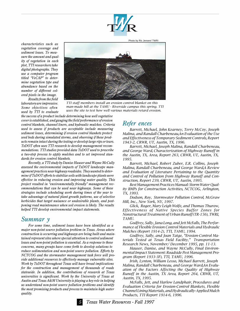
TTI staff members install an erosion control blanket on thisman-made hill at the TAMU - Riverside campus this spring. TTIuses the site to test how well various materials retard erosion.
Photo by Ric Jensen/ TWRI

NON-PROFIT ORGANIZA-TION.
U.S. POSTAGE PAIDCOLLEGE STATION, TEXAS
PERMIT NO. 215
Texas Water Resources Institute301 Scoates HallTexas A&M UniversityCollege Station, Texas 77843-2118
ADDRESS CORRECTION REQUESTED
Mention of a trademark or proprietary product does not constitute aguarantee or a warranty of the product by the cooperating agencies and doesnot imply its approval to the exclusion of other products that may be suitable. All programs and information of the cooperating agencies are available toevery one without regard to race, ethnic origin, religion, sex, or age.
is published quarterly bythe Texas Water Resources Institute.
Wayne R. Jordan, DirectorRic Jensen, Editor and Graphic Design
TWRI is supported by funds provided in part by the U.S. GeologicalSurvey, U.S. Department of the Interior, as authorized by the WaterResources Research Act of 1984. Subscriptions are available free uponrequest. For details, call TWRI at 409-845-8571. The fax number is 409-845-8554; e-mail: [email protected]; WWW URL: http://twri.tamu.edu.
Northcutt, Paul, and Jett McFalls, Field Performance Test-ing of Selected Erosion Control Products: Final PerformanceThrough the 1996 Evaluation Cycle, TTI, 1997.
Kennedy, Keith, Statistical Analysis of TxDOT HighwayStorm Runoff: Comparisons with Existing North Central TexasMunicipal Storm Water Database, NCTCOG, 1996.
Stormwater Pollutant Loading Characteristics for VariousLand Uses in the Austin Area, City of Austin EnvironmentalResources Management Division, 1990.
Tenney, Sean, Michael Barrett, Joseph Malina, RandallCharbeneau and George Ward, An Evaluation of HighwayRunoff Filtration Systems, Report 265, CRWR, UT, Austin, TX,1995.
News fr om TWRITWRI recently published an updated version of its publications
catalog. The catalog includes technical reports, newsletters, and spe-cial publications produced by TWRI. Publications are listed by date andsubject category. The catalog can be accessed at the TWRI WWW siteand limited numbers of printed copies are also available.
TWRI also announces a few staff changes. Shelley Nemec has leftthe Institute to return to school, after having worked as our staffassistant for the past three years. She was replaced by Debi Fisher.Jonathan Jones, a TAMU student who was the Institute’s webmaster,is no longer working for TWRI and has gone back to school full-time.He has been replaced by student workers Jason Middleton and TungTrang.
TWRI encourages people to visit the “Hot Topics” portion of theWWW site. Newly added sections deal with many environmental andwater-related topics, including endangered species, microbial con-tamination of drinking water, property rights, and natural and con-structed wetlands.