TESTING REAL-TIME GPS ORBIT AND CLOCK...
5
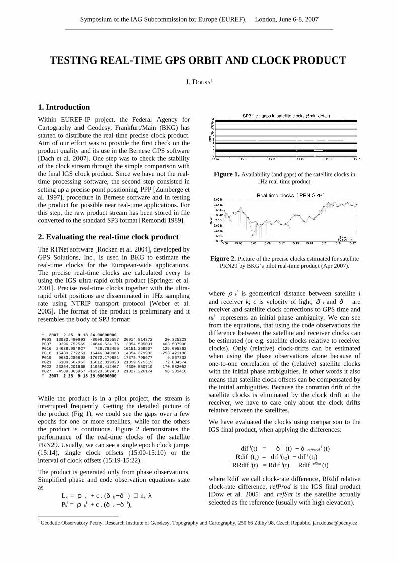
Symposium of the IAG Subcommission for Europe (EUREF), London, June 6-8, 2007 ________________________________________________________________________________ TESTING REAL-TIME GPS ORBIT AND CLOCK PRODUCT J. DOUSA 1 1. Introduction Within EUREF-IP project, the Federal Agency for Cartography and Geodesy, Frankfurt/Main (BKG) has started to distribute the real-time precise clock product. Aim of our effort was to provide the first check on the product quality and its use in the Bernese GPS software [Dach et al. 2007]. One step was to check the stability of the clock stream through the simple comparison with the final IGS clock product. Since we have not the real- time processing software, the second step consisted in setting up a precise point positioning, PPP [Zumberge et al. 1997], procedure in Bernese software and in testing the product for possible near real-time applications. For this step, the raw product stream has been stored in file converted to the standard SP3 format [Remondi 1989]. 2. Evaluating the real-time clock product The RTNet software [Rocken et al. 2004], developed by GPS Solutions, Inc., is used in BKG to estimate the real-time clocks for the European-wide applications. The precise real-time clocks are calculated every 1s using the IGS ultra-rapid orbit product [Springer et al. 2001]. Precise real-time clocks together with the ultra- rapid orbit positions are disseminated in 1Hz sampling rate using NTRIP transport protocol [Weber et al. 2005]. The format of the product is preliminary and it resembles the body of SP3 format: * 2007 2 25 9 18 24.00000000 PG03 13933.480693 -8006.625557 20914.814372 20.325223 PG07 9396.752569 24646.524176 3054.595031 403.587900 PG16 24638.084927 728.782455 10151.259507 125.005862 PG18 15489.772251 16446.040960 14354.379903 -253.421188 PG19 9633.285808 -17672.179881 17375.795677 9.567832 PG21 6109.667953 15012.819928 21059.975319 72.034574 PG22 23364.201665 11956.412407 4300.550719 170.582052 PG27 -4589.065957 -16323.602430 21027.226174 96.201418 * 2007 2 25 9 18 25.00000000 While the product is in a pilot project, the stream is interrupted frequently. Getting the detailed picture of the product (Fig 1), we could see the gaps over a few epochs for one or more satellites, while for the others the product is continuous. Figure 2 demonstrates the performance of the real-time clocks of the satellite PRN29. Usually, we can see a single epoch clock jumps (15:14), single clock offsets (15:00-15:10) or the interval of clock offsets (15:19-15:22). The product is generated only from phase observations. Simplified phase and code observation equations state as Lk i = ρ k i + c . (δ k -δ i ) + nk i λ Pk i = ρ k i + c . (δ k -δ i ), Figure 1. Availability (and gaps) of the satellite clocks in 1Hz real-time product. Figure 2. Picture of the precise clocks estimated for satellite PRN29 by BKG’s pilot real-time product (Apr 2007). where ρ k i is geometrical distance between satellite i and receiver k; c is velocity of light, δ k and δ i are receiver and satellite clock corrections to GPS time and nk i represents an initial phase ambiguity. We can see from the equations, that using the code observations the difference between the satellite and receiver clocks can be estimated (or e.g. satellite clocks relative to receiver clocks). Only (relative) clock-drifts can be estimated when using the phase observations alone because of one-to-one correlation of the (relative) satellite clocks with the initial phase ambiguities. In other words it also means that satellite clock offsets can be compensated by the initial ambiguities. Because the common drift of the satellite clocks is eliminated by the clock drift at the receiver, we have to care only about the clock drifts relative between the satellites. We have evaluated the clocks using comparison to the IGS final product, when applying the differences: dif i (t) = δ i (t) - δ refProd i (t) Rdif i (t2) = dif i (t2) - dif i (t1) RRdif i (t) = Rdif i (t) - Rdif refSat (t) where Rdif we call clock-rate difference, RRdif relative clock-rate difference, refProd is the IGS final product [Dow et al. 2005] and refSat is the satellite actually selected as the reference (usually with high elevation). 1 Geodetic Observatory Pecný, Research Institute of Geodesy, Topography and Cartography, 250 66 Zdiby 98, Czech Republic, [email protected]
-
Upload
hoangthuan -
Category
Documents
-
view
223 -
download
0
Transcript of TESTING REAL-TIME GPS ORBIT AND CLOCK...
Symposium of the IAG Subcommission for Europe (EUREF), London, June 6-8, 2007________________________________________________________________________________
TESTING REAL-TIME GPS ORBIT AND CLOCK PRODUCT
J. DOUSA1
1. Introduction
Within EUREF-IP project, the Federal Agency for Cartography and Geodesy, Frankfurt/Main (BKG) has started to distribute the real-time precise clock product. Aim of our effort was to provide the first check on the product quality and its use in the Bernese GPS software [Dach et al. 2007]. One step was to check the stability of the clock stream through the simple comparison with the final IGS clock product. Since we have not the real-time processing software, the second step consisted in setting up a precise point positioning, PPP [Zumberge et al. 1997], procedure in Bernese software and in testing the product for possible near real-time applications. For this step, the raw product stream has been stored in file converted to the standard SP3 format [Remondi 1989].
2. Evaluating the real-time clock product
The RTNet software [Rocken et al. 2004], developed by GPS Solutions, Inc., is used in BKG to estimate the real-time clocks for the European-wide applications. The precise real-time clocks are calculated every 1s using the IGS ultra-rapid orbit product [Springer et al. 2001]. Precise real-time clocks together with the ultra-rapid orbit positions are disseminated in 1Hz sampling rate using NTRIP transport protocol [Weber et al. 2005]. The format of the product is preliminary and it resembles the body of SP3 format:
* 2007 2 25 9 18 24.00000000PG03 13933.480693 -8006.625557 20914.814372 20.325223PG07 9396.752569 24646.524176 3054.595031 403.587900PG16 24638.084927 728.782455 10151.259507 125.005862PG18 15489.772251 16446.040960 14354.379903 -253.421188PG19 9633.285808 -17672.179881 17375.795677 9.567832PG21 6109.667953 15012.819928 21059.975319 72.034574PG22 23364.201665 11956.412407 4300.550719 170.582052PG27 -4589.065957 -16323.602430 21027.226174 96.201418* 2007 2 25 9 18 25.00000000
While the product is in a pilot project, the stream is interrupted frequently. Getting the detailed picture of the product (Fig 1), we could see the gaps over a few epochs for one or more satellites, while for the others the product is continuous. Figure 2 demonstrates the performance of the real-time clocks of the satellite PRN29. Usually, we can see a single epoch clock jumps (15:14), single clock offsets (15:00-15:10) or the interval of clock offsets (15:19-15:22).
The product is generated only from phase observations. Simplified phase and code observation equations state as
Lki = ρ k
i + c . (δ k − δ i) + nki λ
Pki = ρ k
i + c . (δ k − δ i),
Figure 1. Availability (and gaps) of the satellite clocks in 1Hz real-time product.
Figure 2. Picture of the precise clocks estimated for satellite PRN29 by BKG’s pilot real-time product (Apr 2007).
where ρ ki is geometrical distance between satellite i
and receiver k; c is velocity of light, δ k and δ i are receiver and satellite clock corrections to GPS time and nk
i represents an initial phase ambiguity. We can see from the equations, that using the code observations the difference between the satellite and receiver clocks can be estimated (or e.g. satellite clocks relative to receiver clocks). Only (relative) clock-drifts can be estimated when using the phase observations alone because of one-to-one correlation of the (relative) satellite clocks with the initial phase ambiguities. In other words it also means that satellite clock offsets can be compensated by the initial ambiguities. Because the common drift of the satellite clocks is eliminated by the clock drift at the receiver, we have to care only about the clock drifts relative between the satellites.
We have evaluated the clocks using comparison to the IGS final product, when applying the differences:
dif i(t) = δ i(t) − δ refProd i (t)
Rdif i(t2) = dif i(t2) − dif i (t1)RRdif i(t) = Rdif i(t) − Rdif refSat (t)
where Rdif we call clock-rate difference, RRdif relative clock-rate difference, refProd is the IGS final product [Dow et al. 2005] and refSat is the satellite actually selected as the reference (usually with high elevation).
1 Geodetic Observatory Pecný, Research Institute of Geodesy, Topography and Cartography, 250 66 Zdiby 98, Czech Republic, [email protected]

Symposium of the IAG Subcommission for Europe (EUREF), London, June 6-8, 2007________________________________________________________________________________
Figure 3. Satellite clocks differences (from top to bottom: IGR – IGS, IGS – broadcast, IGS – real-time).
Figure 4. Relative (satellite to satellite) clock-rate differences (from top to bottom: IGS – IGR, IGS –
broadcast, IGS – real-time).
Figure 5. Clock-rate differences (from top to bottom: IGS – IGR, IGS – broadcast, IGS – real-time).
Figure 6. Elevation dependent plot of clock-rates and relative clock-rates for IGS rapid, broadcast and real-
time satellite clocks.

Symposium of the IAG Subcommission for Europe (EUREF), London, June 6-8, 2007________________________________________________________________________________
In Figures 3, 4 and 5 we have plot all the calculated differences of the real-time product with respect to the IGS final clock product. For the comparison purposes, we had added also the plots for the IGS rapid clocks and broadcast clocks. Concerning the BKG real-time clocks, only the relative clock rates are relevant. We can see these values are about ten times more accurate than corresponding broadcast values and unfortunately, we still see rather frequent outliers in real-time clocks. Figure 6 then shows the elevation dependency of the comparison differences. Looking at the relative clock rates, real-time clocks are less accurate for satellites at low elevation. The figure shows possible problems connected to the beginning of individual satellite tracking (because only European network is used for the clock estimation). We do not see any outlier in elevation below approx. 17 degrees. We can expect this clocks belongs to the satellite already leaving the European region. Most of the outliers above elevation of 17 degrees belong to the rising satellites. Nevertheless, it is surprising that the outliers can be found up to the elevation of 50-60 degrees.
3. The PPP in Bernese software
To test the real-time clock product using the Bernese GPS software, we have prepared the PPP procedure derived from the Bernese example. We have processed the different interval of data (24h, 12h, 6h, 4h, 3h, 2h and 1h) using the IGS final and rapid orbit and clock products and 300sec data samples.
Figure 7. Precise point positioning at ONSA using different data intervals and the IGS final orbits and clocks
Figure 8. RMS of the ambiguities after N-iteration.
Figure 7 shows the coordinate component repeatability with respect to the known positions from PPP results using different data batches. Though some systematic subdaily changes can be observed, we were interested how the shortened interval influences the uncertainty of estimated ambiguities. With 12h interval, the averaged coordinates already reached 1cm repeatability for all the components, while 1h processing is really problematic.
Figure 8 shows the RMS of the ambiguities estimated during the iteration process. The outliers are usually rejected only after the 6th iteration and the RMS was consequently reduced. The figure also shows the relation between the formal errors of the ambiguities estimated from 24h to 1h batches.
4. NtripClientSP3
To serve the real-time products for the Bernese GPS software, we had to develop a special software tool which is capable to read NTRIP stream and to convert the preliminary format of the BKG’s real-time product into the standard SP3 format. The NtripClientSP3 software was prepared using the GPSTk library [Harris et al. 2007] and it is available under the GNU Lesser General Public License (LGPL, www.gnu.org). The software connects to NTRIP caster, reads the clock product stream and stores it every x-hours (option) in the standard SP3 format using optionally sampling rate with N-hour’s interval (option). The software takes advantage of the threads, thus N-casters could be connected in parallel. Additionally, the raw stream can be also saved and later provided as the input for the post-conversion into SP3 files. In principle, the software completes the SP3 headers and all the missing satellites and epochs with respect to required time period.
5. Trial of the product usage
After getting the high-rate SP3 files from the BKG real-time orbit and clock streams (actually CLCK1 and CLCK2), we test the application in Bernese GPS software. The first problem occurred in the reliable way of reproducing the orbits. The potential gaps in the product and especially unrecognized changes of the IGS ultra-rapid product six hour updates, the orbit modeling in Bernese software is sometime problematic (or at least inconsistent with the orbits used during the clock estimation). Also the earth orientation parameters should be applied because Bernese orbit model uses the inertial system. Because we wanted to process at least 12h data batch, we had stored the real-time product in 12h high-rate SP3 files. We then applied more (3-4) arcs for every satellite to cover the entire 12h interval.
The processing was tested using short time-period only because we didn’t succeed to get the real-time product continuously over an interval of more than one and half day. The processing was repeated hourly using 12-hour sliding window. Every single run has started with the concatenation of hourly files and preparing the orbits for Bernese software. Then 30sec sampling rate was applied and the elevation cut-of 7 degrees. The main step consisted in the iterative procedure of the least square

Symposium of the IAG Subcommission for Europe (EUREF), London, June 6-8, 2007________________________________________________________________________________
adjustment with coordinates and troposphere as estimated parameters. The ambiguities and receiver clocks were pre-eliminated. Before new adjustment step, the limit for outlier rejection was decreased. The smallest limit was set to 6mm for the phase residuals.
Figure 9. Precise point positioning at ONSA using real-time CLCK1, CLCK2 products from BKG.
As we can see in Fig 9, the results were not satisfactory for both the real-time products (CLCK1 and CLCK2). Step by step substituting the IGS final clocks and orbits we checked that problem is not in using the IGU orbits, but purely in applying precise real-time clocks. We checked the phase observation residuals for both IGS and real-time clocks (Fig 10) and we can see ten times larger values when using the real-time product. We then tried to setup manually new ambiguities in the selected epochs, where the residuals shows a clear jump and it led to reduction of the residuals to a reasonable level, because it particularly compensated occurring peaks in relative clock-drifts (see also Fig 5). Due to very short time intervals, some of the ambiguities were estimated with too high uncertainty. Nevertheless, this result showed current inability to simply use the BKG real-time clock product in the Bernese software e.g. for near real-time PPP.
Figure 10. Phase residuals using IGS (top) and real-time (bottom) precise products: no outliers rejected; different y-scale.
7. Conclusion
We obtained the first experience with the pilot real-time clock product provided by BKG within the EUREF-IP project in March-April, 2007. We tried to use the product for near real-time PPP procedure in Bernese software. At first, we have tested the precise clock products for the reliable processing interval. Using 300s observation sampling rate, twelve hours gave already 1cm accuracy in coordinate components. The same procedure has been tested using real-time product, unfortunately not achieving expected results. We have learnt real-time clocks were estimated using the phase observations only, which means only clock-rates relative to the clock-rate of the reference satellite (or sum of the satellites), are guaranteed. Consequently, the code observations could not be used with the product. But we haven’t got satisfactory results using the Bernese software and the reason is in a way of setting up and handling the ambiguities in the software. The ambiguities are setup only at the beginning of processing batch and any problem in the clock product cannot be compensated by setting up a new ambiguity. Comparing of real-time and precise clocks, such peaks has been found. Plotting the satellite availability of the product, we identified the periods with frequent gaps of single satellite or group of the satellites. Additionally, the NtripClientSP3 tool reading the BKG’s NTRIP clock and orbit stream was developed to store SP3 files.
References
DACH, R., HUGENTOBLER, U., FRIDEZ ,P., MEINDL, M.: Bernese GPS Software Version 5.0. Astronomical Institute, University of Bern, 2007
SPRINGER, T.A., HUGENTOBLER U.: IGS ultra-rapid products for (near-) real-time applications, Phys. and Chem. of the Earth, Part A, 26/6-8, pp. 623-628, 2001.
DOW, J.M., NEILAN, R.E., GENDT, G. : The International GPS Service (IGS): Celebrating the 10th Anniversary and Looking to the Next Decade, Adv. Space Res. 36 vol. 36, no. 3, pp. 320-326, 2005
HARRIS, R.B., MACH , R.G.: The GPSTk: an open source GPS toolkit, GPS Solut 11:145-150, 2007
REMONDI , B.W.: Extending the National Geodetic Survey Standard Orbit Formats. NOAA Technical Report NOS 133 NGS 46, 85 pp, 1989
ROCKEN, C., MERVART , L., LUKES, Z., JOHNSON, J., KANZAKI , M.: Testing a New Network RTK Software System. In: Proceedings of GNSS 2004. Institute of Navigation, Fairfax, pp. 2831-2839, 2004
WEBER, G., GEBARD, H., DETTMERING, D.: Networked Transport of RTCM via Internet Protocol (NTRIP). In: A Window on the Future of Geodesy, Proceedings of the International Association of Geodesy. IAG General Assembly, Sapporo, Japan June 30 - July 11, 2003, IAG Symposia Series, Vol. 128, 2005
ZUMBERGE, J.F., HEFLIN, M.B., JEFFERSON, D.C., WATKINS, M.M., WEBB, F.H.: Precise point positioning for the efficient and robust analysis of GPS data from large networks. Journal of Geophysical Research, 102 (B3), pp. 5005-5017, 1997