Testimony of Ali Sharoody Before California State Water ... · PDF fileJune 28, 2010 Testimony...
47
June 28, 2010 Testimony of Ali Sharoody Before California State Water Resources Control Board Regarding Water Right Applications 31487 and 31488 by US Bureau of Reclamation, Change Petition 5169 by Washoe County Water Conservation District, Change Petition 9247 by Truckee Meadows Water Authority, Change Petition 15673 by US Bureau of Reclamation Change Petition 18006 by US Bureau of Reclamation I am a professional water resource engineer and agricultural engineer, and a licensed agricultural and civil engineer in the State of California. I am the president of Stetson Engineers, Inc., and have been a consultant for the Pyramid Lake Paiute Tribe (Tribe) on matters pertaining to the Newlands Project and the Truckee and Carson Rivers since 1979 (31 years). I have also been a consultant and expert witness for the United States on Truckee and Carson Rivers matters. My Statement of Qualifications which includes education, professional licenses and experience is submitted with this testimony (see Exhibit 1, attached). My testimony is presented in four parts. Parts I and II are the Water Availability Analyses for the Stampede Reservoir (Application 31487) and Prosser Creek Reservoir (Application 31488), respectively. Part III describes the historic decline of Pyramid Lake and the future benefits of the Truckee River Operating Agreement (TROA) on fish passage at Pyramid Lake. Part IV explains the enhancement of instream flows and water quality in the lower Truckee River under the TROA, and explains that under the TROA the Truckee River will more often achieve flow regimes with higher flows as recommended by the U.S. Fish and Wildlife Service. Finally, Part V reviews the Newlands Project Operating Criteria and Procedures (OCAP) and its relationship to Pyramid Lake. I. Water Availability Analysis for Stampede Reservoir (Application 31487) A. Introduction The U.S. Bureau of Reclamation (Reclamation) filed Application 31487 with the California State Water Resources Control Board (SWRCB) on January 8, 2004. This application supplements Permit 11605 and seeks, among other things, to increase the maximum annual diversion to storage from 126,000 acre-feet to 226,500 acre-feet in Stampede Reservoir. SWRCB (May 2007) requested a Water Availability Analysis (WAA) in connection with water right Application 31487. Accordingly, I prepared a WAA for Reclamation for Stampede Reservoir (see Exh. 3, attached). See also Exh. 2, attached (SWRCB acceptance of WAA). B. Background The Truckee River originates at the outlet of Lake Tahoe at Tahoe City, California, and flows about 120 miles to its terminus in Pyramid Lake on the Pyramid Lake Indian Reservation. Most Page 1
-
Upload
vuongduong -
Category
Documents
-
view
215 -
download
1
Transcript of Testimony of Ali Sharoody Before California State Water ... · PDF fileJune 28, 2010 Testimony...

June 28, 2010
Testimony of Ali SharoodyBefore California State Water Resources Control Board
Regarding Water Right Applications 31487 and 31488 by US Bureau of Reclamation,Change Petition 5169 by Washoe County Water Conservation District,
Change Petition 9247 by Truckee Meadows Water Authority,Change Petition 15673 by US Bureau of Reclamation Change Petition 18006 by US Bureau of Reclamation
I am a professional water resource engineer and agricultural engineer, and a licensed agriculturaland civil engineer in the State of California. I am the president of Stetson Engineers, Inc., andhave been a consultant for the Pyramid Lake Paiute Tribe (Tribe) on matters pertaining to theNewlands Project and the Truckee and Carson Rivers since 1979 (31 years). I have also been aconsultant and expert witness for the United States on Truckee and Carson Rivers matters. MyStatement of Qualifications which includes education, professional licenses and experience issubmitted with this testimony (see Exhibit 1, attached).
My testimony is presented in four parts. Parts I and II are the Water Availability Analyses for theStampede Reservoir (Application 31487) and Prosser Creek Reservoir (Application 31488),respectively. Part III describes the historic decline of Pyramid Lake and the future benefits of theTruckee River Operating Agreement (TROA) on fish passage at Pyramid Lake. Part IV explainsthe enhancement of instream flows and water quality in the lower Truckee River under theTROA, and explains that under the TROA the Truckee River will more often achieve flowregimes with higher flows as recommended by the U.S. Fish and Wildlife Service. Finally, PartV reviews the Newlands Project Operating Criteria and Procedures (OCAP) and its relationshipto Pyramid Lake.
I. Water Availability Analysis for Stampede Reservoir (Application 31487)
A. Introduction
The U.S. Bureau of Reclamation (Reclamation) filed Application 31487 with the California StateWater Resources Control Board (SWRCB) on January 8, 2004. This application supplementsPermit 11605 and seeks, among other things, to increase the maximum annual diversion tostorage from 126,000 acre-feet to 226,500 acre-feet in Stampede Reservoir. SWRCB (May2007) requested a Water Availability Analysis (WAA) in connection with water rightApplication 31487. Accordingly, I prepared a WAA for Reclamation for Stampede Reservoir(see Exh. 3, attached). See also Exh. 2, attached (SWRCB acceptance of WAA).
B. Background
The Truckee River originates at the outlet of Lake Tahoe at Tahoe City, California, and flowsabout 120 miles to its terminus in Pyramid Lake on the Pyramid Lake Indian Reservation. Most
Page 1
cmunoz
Typewritten Text
Exhibit USBR-7

1Martis Creek Reservoir is used only for flood control purposes.
of the runoff in the Truckee River basin occurs in the Sierra Nevada in California. A portion ofthat runoff is stored in Lake Tahoe, Prosser Creek, Stampede, Boca, and Martis Creek1
Reservoirs, and Donner and Independence Lakes (see Figure 1). Operation of these reservoirsregulates much of the flow in the Truckee River basin in most years. These reservoirs togethercan store about a million acre-feet of water. A number of court decrees, agreements, andregulations govern day-to-day operations of these reservoirs, administered by the Federal WaterMaster for the Orr Ditch and Alpine Decree courts. The reservoirs are operated to capture runoffas available when flow in the Truckee River is greater than that needed to serve downstreamwater rights recognized by the Orr Ditch decree (Petitioners’ Joint Exhibit 7) and met bystreamflows in the Truckee River, known as Floriston Rates, measured at the Farad gauge nearthe California-Nevada State line. Floriston Rates provide water to serve hydropower generation,municipal and industrial use (M&I) in the Truckee Meadows area of Nevada, instream flows andagricultural water rights. Releases are made from the reservoirs as necessary to meet dam safetyor flood control requirements. Releases are made from Lake Tahoe and Boca Reservoir whenunregulated flow cannot meet Floriston Rates. Minimum reservoir releases are maintained asspecified in applicable agreements and reservoir permits or licenses (Reclamation and CDWR,August 2004).
Water is stored in Prosser Creek, Stampede and Boca Reservoirs, Lake Tahoe, and Donner andIndependence Lakes under a system of priorities. The following schedule has historically beenfollowed by the Federal Water Master's Office (Water Master, November 1998):
1. Deliver pre-1870 irrigation rights (only if Floriston Rates are not met);
2. Divert up to 60 cfs to Sierra Valley (1870 priority) in accordance with the Sierra Valleydecree;
3. Donner Lake and Independence Lake (first 3,000 acre-feet);
4. Provide Floriston Rate flows;
5. Lake Tahoe and Boca Reservoir (first 25,000 acre-feet);
6. Truckee River diversions to Newlands Project under Claim No. 3 of the Orr Ditch decreeand OCAP;
7. Boca Reservoir;
8. Independence Lake;
9. Stampede Reservoir; and
10. Prosser Creek Reservoir.
Page 2

MARTIS
Nixon
FernleyDerby Dam
WINNEMUCCALAKE (dry)
STAMPEDE
TRUCKEERIVER
CARSONLAKE
CARSON RIVER
LAKE TAHOE
DONNER
Pyramid Lake Indian Reservation
StillwaterNWR
LAHONTAN
NE
VA
DA
CA
LIF
OR
NIA
BOCAINDEPENDENCE
PROSSER
Reno/SparksNewlandsProject
CarsonCity
Fallon
Fallon Indian Reservation
PYRAMIDLAKE
Tahoe City
WALKER RIVER
WALKERLAKE
Walker River Indian
ReservationYerington
TOPAZ LAKE
Schurz
MARBLE BLUFF
Figure 1 - Location MapBureau of Reclamation - 2007
Page 3

Truckee River water is diverted at Derby Diversion Dam (located about 36 miles upstream ofPyramid Lake) and into the Truckee Canal, according to Claim No. 3 of the Orr Ditch Decree(Petitioners’ Joint Exhibit 7) and the Operating Criteria and Procedures (OCAP) for the Bureauof Reclamation's Newlands Irrigation Project (Petitioners’ Joint Exhibit 9). The Truckee Canalextends about 32 miles through the Truckee Division of the Newlands Project to LahontanReservoir, located in the Carson Division of the Project in the lower Carson River basin. Lahontan Reservoir also captures Carson River inflow (Reclamation, August 2004).
C. Truckee River Reservoirs
Information on Truckee River reservoirs is summarized in Table 1, below (CDWR, June 1991).
D. Floriston Rates
The Truckee River is regulated to meet the Floriston Rates at Farad (State line). Floriston Ratesare set forth in the Truckee River General Electric Decree (1915) (Petitioners’ Joint Exh. 2), asmodified by the Truckee River Agreement which is incorporated into the Orr Ditch Decree(Petitoners’ Joint Exh. 7).
Floriston Rates and Reduced Floriston Rates are shown in Figure 2. The Truckee River GeneralElectric Decree (Petitioners’ Joint Exh. 2), Orr Ditch Decree (which incorporated the TruckeeRiver Agreement) (Petitioners’ Joint Exh. 7), and the Tahoe-Prosser Exchange Agreement(Petitioners’ Joint Exh. 3) provide the current operational framework and rules for the operationof Lake Tahoe, Boca Reservoir and Prosser Creek Reservoir. These reservoirs may store waterin accordance with their storage priorities when Floriston Rates are met from natural flow. BothStampede and Prosser Creek Reservoirs are junior in priority to divert water in relation to otherTruckee River reservoirs. Both Stampede and Prosser Creek Reservoirs are also junior inpriority to divert water in relation to the allowable diversions at Derby Dam under Claim No. 3 ofthe Orr Ditch Decree and the OCAP (Petitioners’ Joint Exh. 7 and 9, respectively).
E. Little Truckee River
Stampede Dam and Reservoir are located on the Little Truckee River. The Little Truckee Riveris the largest tributary to the Truckee River. The Little Truckee River is regulated by a dam onWebber Lake (privately owned) and by Stampede and Boca Reservoirs. Independence Creek, atributary to the Little Truckee River upstream of Stampede Reservoir, is regulated by a dam onIndependence Lake, which is owned by Truckee Meadows Water Authority (TMWA). Insummer months, water is diverted from the Little Truckee River upstream of its confluence withIndependence Creek, through the Little Truckee Ditch to the Sierra Valley (Feather River basin).
F. Stampede Reservoir
Stampede Reservoir was completed in 1970 (storage began in August 1969) by Reclamation aspart of the Washoe Project. The zoned earthfill dam is 239 feet high and can impound up to226,500 acre-feet of water, making Stampede the second largest reservoir on the Truckee River.
Page 4

Table 1 Truckee River Reservoirs 1
Reservoir Name Dam Owner Dam Operator
UsableStorageCapacity
(Acre-Feet )
Dam Construction
Date 2
DamHeight(feet )
DrainageArea
(Square Miles )Lake Tahoe U.S. Bureau of Reclamation U.S. Bureau of Reclamation 744,600 1913 18 506
Donner LakeTruckee Meadows Water Authority/Truckee-Carson Irrigation Dist.
Truckee Meadows Water Authority 9,500 1930's 14 14
Martis Creek U.S. Army Corps of Engineers U.S. Army Corps of Engineers 20400 3 1971 113 40
Prosser Creek U.S. Bureau of Reclamation U.S. Bureau of Reclamation 29,800 1962 163 50
Independence Lake Truckee Meadows Water Authority Truckee Meadows Water Authority 17,500 1939 31 8
Stampede Reservoir U.S. Bureau of Reclamation U.S. Bureau of Reclamation 226,500 1970 239 136
Boca Reservoir U.S. Bureau of Reclamation Washoe County Water Conservation Dist. 41,100 1937 116 1721 Based on Truckee River Atlas, 1991. 2 Date existing dam was completed. With respect to Lake Tahoe and Donner and Independence Lakes, these dams replaced earlier constructions.3 Flood control storage only.
Page 5

Figure 2
Floriston Rates
Nov Dec Jan Feb Mar Apr May Jun Jul Aug Sep OctMonth
0
50
100
150
200
250
300
350
400
450
500
550
600
Flor
isto
n R
ates
in c
fs
Floriston Rates
Reduced Floriston Rates
EL Lake Tahoe Elevation
6225.25< EL < 6226.00
El < 6225.25
Page 6

Stampede Reservoir was authorized for irrigation, flood control, M&I, fish and wildlife,recreation and other beneficial purposes. The primary use to date has been to store water for thethreatened and endangered fishes of Pyramid Lake and for flood control. Incidental uses ofStampede Reservoir storage also include recreation and hydroelectric power.
Stampede is the only reservoir in the Truckee River watershed that has a hydroelectric powerplant. A small hydroelectric plant was added to the dam's outlet works in 1988, and can produceup to 3.65 megawatts of electricity, depending on reservoir releases. Power production isincidental to the operation of the reservoir for other purposes (CDWR, June 1991).
Application 15673 was filed by Reclamation on January 7, 1954. Permit 11605 (Application15673) provides for 350 cubic feet per second (cfs) of direct diversion from about April 1 toabout November 1 of each year, and for maximum diversion of 126,000 acre-feet to storage fromJanuary 1 to December 31 of each year. Application 15673 referred to a storage reservoir with acapacity of 126,000 acre-feet. However, Stampede Reservoir was actually constructed with acapacity of 226,500 acre-feet. Figure 3 shows the storage hydrograph of Stampede Reservoir forwater years 1970 through 2006. Figure 3 shows that Stampede Reservoir was filled to nearly itsfull capacity of 226,500 acre-feet in ten years over the 37 years of record.
Reclamation filed Application 31487 on January 8, 2004, for the purpose of increasing themaximum diversion to storage from 126,000 acre-feet to 226,500 acre-feet in StampedeReservoir annually. Application 31487 supplements permit 11605. The maximum annualquantity of water diverted to storage under Application 31487 and Permit 11605 is to be limitedto 226,500 acre-feet per year (SWRCB, January 2007).
Page 7

Storage in Stampede ReservoirWater Years 1970 - 2006
USGS Gage (ID #10344300)
0
50,000
100,000
150,000
200,000
250,000
300,000
1970 1971 1972 1973 1974 1975 1976 1977 1978 1979 1980 1981 1982 1983 1984 1985 1986 1987 1988 1989 1990 1991 1992 1993 1994 1995 1996 1997 1998 1999 2000 2001 2002 2003 2004 2005 2006
Water Year
Stor
age
(af)
Figure 3
* Storage began Aug. 1. 1969. Daily data available starting Aug. 8, 1970. Missing daily data linearly interpolated.
Constructed Capacity 226,500
Page 8

2Tribe gives its consent to store water from the little Truckee River in StampedeReservoir that would otherwise flow to Pyramid Lake.
G. Unappropriated Water
Section 210(a)(2)(B) of the Settlement Act (Public Law 101-618) (Petitioners’ Joint Exh. 16)states:
Section 204 of this title, the Preliminary Settlement Agreement as modified by theRatification Agreement, and the Operating Agreement, shall not take effect untilthe Pyramid Lake Tribe's claim to the remaining waters of the Truckee Riverwhich are not subject to vested or perfected rights has been finally resolved in amanner satisfactory to the State of Nevada and the Pyramid Lake Tribe.
In 1993, the Pyramid Tribe and the State of Nevada signed a Memorandum of Understanding(MOU, July 1993) to implement Section 210(a)(2)(B) of the Settlement Act . The Nevada StateEngineer's 1998 unappropriated water decisions, Rulings 4659 and 4683/4683A, approved theTribe's Applications 48061 and 48494 (Nevada State Engineer, August and November 1998).2 Approval of the Tribe's Applications 48061 and 48494 to appropriate the remaining waters of theTruckee River is consistent with the principle underlying Section 210(a)(2)(B) of the SettlementAct and 1993 MOU.
The last appeal requesting review of the Nevada State Engineer's rulings granting Applications48061 and 48494 was dismissed by the Nevada Supreme Court on March 30, 2009. The permitswhich the Nevada State Engineer had issued in the meantime, as there was no stay requested bythose appealing, Permits 48061 and 48494, became final on that date. The proceedings regardinga competing application by the Truckee-Carson Irrigation District continue, presently with aremand to the Nevada State Engineer.
H. Newlands Reclamation Project Operating Criteria and Procedures
Truckee River water is diverted at Derby Diversion Dam into the Truckee Canal for use at theNewlands Reclamation Project as provided in Claim No. 3 of the Orr Ditch Decree and theOperating Criteria and Procedures (OCAP) (Petitioners’ Joint Exh. 7 and 9, respectively). TheTruckee Canal extends about 32 miles through the Truckee Division of the Project to LahontanReservoir, which is located in the Carson Division of the Newlands Project in the lower CarsonRiver basin. Lahontan Reservoir also captures Carson River inflow (Reclamation, August 2004). Water supply for the Truckee Division of the Newlands Project is solely provided from theTruckee River through the Truckee Canal. Water supply for the Carson Division is providedfrom the Carson and Truckee Rivers. Diversion of water from the Truckee River to LahontanReservoir for the Carson Division of the Newlands Project is limited by the Orr Ditch Decreeand OCAP to what is needed to supplement the primary water supply provided by the CarsonRiver (Petitioners’ Joint Exh. 7 and 9).
OCAP were first instituted in 1967, and reinstituted annually through 1972. In 1973, the Federal
Page 9

District Court in Washington, D.C., ordered implementation of more restrictive OCAP tomaximize the use of Carson River water and to minimize the use of Truckee River water withinthe Newlands Project. OCAP were modified in 1988 and were adjusted most recently in 1997 inresponse to changes in irrigated acreage in the Newlands Project (Reclamation, December 1987and August 2004).
I. Instream Flows - Lower Truckee River
Water is released from Stampede Reservoir for maintaining instream flows for cui-ui andLahontan cutthroat trout (LCT) in the lower Truckee River. Cui-ui and LCT are listed asendangered and threatened, respectively, under the Endangered Species Act of 1973, as amended. The goal of the U.S. Fish and Wildlife Service (FWS) and the Tribe is to conserve cui-ui andLCT in the lower Truckee River. To this end, Stampede Project water has been managed for thebenefit of both species. Recently, FWS and the Tribe expanded the cui-ui/LCT conservationmanagement to restore the lower Truckee River ecosystem, including establishment andmaintenance of willows and cottonwoods in the river reach. Currently, the project water storedin Stampede and Prosser Creek Reservoirs for the benefit of Pyramid Lake fishes is managedusing flow regime criteria based on six hydrologic year types and based upon the amount ofproject water stored in Stampede Reservoir on March 1. Table 2 shows the six flow regimes asinflow targets to Pyramid Lake (Reclamation, August 2004). For the purpose of the WaterAvailability Analysis, Flow Regime No. 1 (highest target flow rates) is assumed as the targetflow in the lower Truckee River.
Table 2Pyramid Lake Inflow Targets (cfs) for Flow Regimes 1–6
Month 1 2 3 4 5 6
January 160 150 120 110 100 90
February 160 150 120 110 100 90
March 290 220 200 160 160 140
April 590 490 420 350 300 200
May 1,000 800 600 530 400 300
June 800 600 500 400 270 170
July 300 300 300 200 150 120
August 200 200 200 200 150 110
September 170 170 120 110 100 100
October 160 150 120 110 100 100
November 160 150 120 110 100 90
December 160 150 120 110 100 90
Source: Revised Draft Environmental Impact Statement/Environmental Impact Report, Truckee River Operating Agreement, Aug. 2004 (SWRCB Exh. 7)
Page 10

3It should be noted that the allowable OCAP diversions at Derby Dam changed severaltimes during the period from August 1969 through September 2006 and that there were timeswhen the historical diversions substantially exceeded the allowable OCAP diversions.
J. Water Availability Analysis
Water availability analysis for the diversion of water to storage in Stampede Reservoir ispresented in the spreadsheet in Table 3. The analysis is based on the historical operation ofStampede Reservoir from August 1969 through September 2006. The amount of available wateris calculated for the periods with higher Truckee River flows. In addition, the available amountsof water are calculated for the periods when the storage of such water would not interfere withany downstream water rights, and therefore the water would have otherwise flowed to PyramidLake if not stored. Storing this water will not interfere with any California water rights,including any new water that may be appropriated in California, because the Interstate Allocationbetween California and Nevada specifies that water for use in Nevada is junior in priority. Thestorage of water sought herein will not interfere with Nevada water rights because it will only bestored after all other Nevada water rights have been satisfied. The underpinnings of theseconditions for the analysis are summarized below.
1. Water flowing to Stampede Reservoir occurs after the satisfaction of upstreamrights in the Little Truckee River, including diversions to Sierra Valley.
2. Storage priority in Stampede Reservoir is junior to Boca Reservoir.
3. Water is not stored in Stampede and Boca Reservoirs adverse to Floriston Ratesor Reduced Floriston Rates.
4. Water is not stored in Stampede Reservoir or as Additional Supplemental Storage(above 25,000 acre-feet) in Boca Reservoir unless allowable OCAP diversions atDerby Dam are satisfied.
5. Orr Ditch water rights are satisfied by meeting Floriston Rates or ReducedFloriston Rates (whichever is in effect) at Farad and allowable Orr Ditch Decreeand OCAP diversions at Derby Dam.
6. Diversion requirements at Derby Dam are assumed to be the same as historicaldiversions for the purpose of this analysis.3
7. Water would not be diverted to storage in Stampede Reservoir unless target flowsunder Flow Regime No. 1 are met in the lower Truckee River.
Page 11

D R A F T
[1] [2] [3] [4] [5] [6] [7] [8] [9] [10] [11] [12] [13] [14] [15] [16] [17] [18] [19] [20]
EOM Stampede EOM Boca Truckee TruckeeStampede Change in Boca Change in River at Floriston Canal atStorage Storage Storage Storage Farad Rates Wadsworth
af af af af (afm) (afm) (afm)
Truckee River near Nixon (afm)
Stampede Stored Water Within Flow
Regime No. 1?
Available Water in addition to Stored
Amount in Stampede (afm)
Stampede Stored Water Adverse to Floriston Rates?
Available Water for Storage in Stampede
Reservoir (afm)Month-Year
Table 3Estimates of Available Water for Storage in Stampede Reservoir
Flow at Farad in
Excess of Floriston
Rates (afm)
Little Truckee
River above Boca (afm)
Little Truckee
River below Boca (afm)
Inflow to Pyramid Lake above Flow
Regime No. 1 (afm)
Pyramid Lake inflow targets
under Flow Regime No. 1
(afm)
Adjusted Little
Truckee River below Boca (afm)
Adjusted Little
Truckee River above Boca (afm)
111,367 32,667Apr-71 127,333 15,967 15,475 33,667 1,000 19,458 61,222 29,752 31,470 23,901 45,800 35,107 10,693 no no 10,693 26,660
May-71 157,639 30,306 23,318 37,400 3,733 20,771 114,641 30,744 83,897 45,304 75,884 61,488 14,396 no no 14,396 44,702Jun-71 177,867 20,227 25,942 40,800 3,400 21,717 137,157 29,752 107,405 30,432 103,775 47,603 56,172 no no 21,717 41,944Jul-71 180,167 2,300 12,676 39,667 -1,133 13,456 12,323 59,512 30,744 28,768 28,183 27,711 18,446 9,265 no no 9,265 11,565
TOTAL 124,871
126,667 29,433Mar-73 129,833 3,167 3,763 32,333 2,900 2,469 31,688 30,744 944 861 39,685 17,831 21,854 no no 944 4,111Apr-73 149,200 19,367 11,409 40,900 8,567 7,624 53,115 29,752 23,363 5,875 50,815 35,107 15,707 no no 7,624 26,991
May-73 193,900 44,700 3,166 40,667 -233 3,655 3,422 79,565 30,744 48,821 12,720 60,924 61,488 -563 no yes (563 af) 0 44,137TOTAL 75,239
162,633 32,733Nov-73 169,500 6,867 5,954 32,500 -233 6,512 6,278 40,693 23,802 16,891 31,595 19,513 9,521 9,993 no no 5,954 12,821Dec-73 172,793 3,293 4,532 32,200 -300 5,252 4,952 26,918 24,595 2,323 3,731 32,289 9,838 22,451 no no 2,323 5,615Jan-74 189,333 16,541 3,402 32,000 -200 6,946 6,746 62,846 24,595 38,251 835 79,702 9,838 69,864 no no 3,402 19,942Feb-74 193,267 3,933 2,146 31,500 -500 3,318 2,818 38,402 22,215 16,187 852 44,729 8,886 35,843 no no 2,146 6,079Mar-74 203,333 10,067 8,983 32,500 1,000 12,405 83,082 30,744 52,338 2,454 93,342 17,831 75,511 no no 8,983 19,050Apr-74 205,133 1,800 24,040 33,167 667 25,478 122,221 29,752 92,469 6,163 121,012 35,107 85,904 no no 24,040 25,840
May-74 220,400 15,267 30,180 39,167 6,000 23,265 135,451 30,744 104,707 11,585 115,299 61,488 53,812 no no 23,265 38,532Jun-74 224,467 4,067 25,071 40,900 1,733 23,068 92,749 29,752 62,997 12,875 74,202 47,603 26,598 no no 23,068 27,134
TOTAL 155,014
166,600 37,033May-75 197,200 30,600 23,157 34,000 -3,033 32,272 29,239 172,324 30,744 141,580 10,278 158,335 61,488 96,847 no no 23,157 53,757Jun-75 212,233 15,033 28,905 41,000 7,000 21,792 120,603 29,752 90,851 12,797 109,922 47,603 62,319 no no 21,792 36,826
TOTAL 90,583
104,000 23,233Apr-80 133,300 29,300 4,917 22,933 -300 8,465 8,165 56,985 29,752 27,233 8,791 46,695 35,107 11,587 no no 4,917 34,217
May-80 153,167 19,867 25,190 20,167 -2,767 28,931 26,164 125,117 30,744 94,374 11,808 103,835 61,488 42,347 no no 25,190 45,057TOTAL 79,274
61,000 27,600Nov-81 82,233 21,233 4,249 30,433 2,833 3,223 58,038 17,851 40,187 28,122 37,551 9,521 28,030 no no 3,223 24,456Dec-81 114,267 32,033 3,501 32,500 2,067 5,042 79,571 24,595 54,976 34,181 62,640 9,838 52,802 no no 3,501 35,534Jan-82 124,367 10,100 2,142 31,667 -833 4,465 3,631 33,402 24,595 8,807 9,306 38,579 9,838 28,740 no no 2,142 12,242Feb-82 156,067 31,700 3,418 32,400 733 9,389 78,819 22,215 56,604 689 94,207 8,886 85,321 no no 3,418 35,118Mar-82 172,667 16,600 4,887 31,400 -1,000 10,899 9,899 54,938 30,744 24,194 341 68,545 17,831 50,713 no no 4,887 21,487Apr-82 198,867 26,200 17,306 32,100 700 23,958 141,116 29,752 111,364 7,813 147,586 35,107 112,479 no no 17,306 43,506
May-82 200,800 1,933 57,122 32,700 600 56,295 264,476 30,744 233,732 13,648 248,985 61,488 187,498 no no 56,295 58,228Jun-82 176,667 -24,133 62,535 38,402 39,767 7,067 52,200 147,669 29,752 117,917 10,852 152,628 47,603 105,025 no no 38,402 38,402Jul-82 185,433 8,767 2,067 40,333 567 1,297 47,038 30,744 16,294 13,722 36,889 18,446 18,442 no no 1,297 10,064
TOTAL 279,037
202,500 24,300Mar-83 202,667 167 22,616 27,733 3,433 28,929 190,691 30,744 159,947 2,122 223,775 17,831 205,944 no no 22,616 22,782Apr-83 227,600 24,933 3,663 10,240 -17,493 29,992 12,499 185,891 29,752 156,139 4,683 201,124 35,107 166,017 no no 3,663 28,597
May-83 254,400 26,800 63,003 30,800 20,560 47,213 242,936 30,744 212,192 9,866 249,997 61,488 188,509 no no 47,213 74,013Jun-83 239,867 -14,533 103,101 88,567 28,733 -2,067 106,393 104,327 310,235 29,752 280,483 10,366 321,183 47,603 273,580 no no 88,567 88,567Jul-83 192,667 -47,200 79,987 32,787 40,400 11,667 69,515 179,583 30,744 148,840 15,560 171,295 18,446 152,848 no no 32,787 32,787
TOTAL 246,747
194,567 35,200Oct-83 197,500 2,933 1,109 32,133 -3,067 4,206 1,139 27,128 24,595 2,533 4,014 26,041 9,838 16,203 no no 1,109 4,042Nov-83 223,533 26,033 1,406 16,233 -15,900 19,447 3,547 146,916 23,802 123,114 2,364 158,221 9,521 148,701 no no 1,406 27,440
F:\DATA\1336\Stampede application\SummaryTablev2B 1 of 3 9/28/2007Page 12

D R A F T
[1] [2] [3] [4] [5] [6] [7] [8] [9] [10] [11] [12] [13] [14] [15] [16] [17] [18] [19] [20]
EOM Stampede EOM Boca Truckee TruckeeStampede Change in Boca Change in River at Floriston Canal atStorage Storage Storage Storage Farad Rates Wadsworth
af af af af (afm) (afm) (afm)
Truckee River near Nixon (afm)
Stampede Stored Water Within Flow
Regime No. 1?
Available Water in addition to Stored
Amount in Stampede (afm)
Stampede Stored Water Adverse to Floriston Rates?
Available Water for Storage in Stampede
Reservoir (afm)Month-Year
Table 3Estimates of Available Water for Storage in Stampede Reservoir
Flow at Farad in
Excess of Floriston
Rates (afm)
Little Truckee
River above Boca (afm)
Little Truckee
River below Boca (afm)
Inflow to Pyramid Lake above Flow
Regime No. 1 (afm)
Pyramid Lake inflow targets
under Flow Regime No. 1
(afm)
Adjusted Little
Truckee River below Boca (afm)
Adjusted Little
Truckee River above Boca (afm)
Dec-83 205,300 -18,233 43,690 25,457 27,533 11,300 34,941 221,117 24,595 196,522 1,379 240,139 9,838 230,301 no no 25,457 25,457Jan-84 198,933 -6,367 21,489 15,122 25,000 -2,533 25,196 22,663 187,716 24,595 163,121 724 210,883 9,838 201,045 no no 15,122 15,122Feb-84 200,600 1,667 6,613 25,467 467 7,587 100,145 23,008 77,137 1,638 118,909 9,203 109,706 no no 6,613 8,280Mar-84 202,967 2,367 16,370 31,700 6,233 14,454 81,055 30,744 50,311 4,762 95,861 17,831 78,030 no no 14,454 16,820Apr-84 204,833 1,867 22,019 32,767 1,067 22,727 62,787 29,752 33,035 6,728 65,798 35,107 30,690 no no 22,019 23,885
May-84 208,733 3,900 37,305 40,700 7,933 30,307 102,587 30,744 71,843 12,391 94,651 61,488 33,164 no no 30,307 34,207Jun-84 192,900 -15,833 39,342 23,509 40,467 -233 40,129 39,895 84,861 29,752 55,109 12,347 76,715 47,603 29,111 no no 23,509 23,509
TOTAL 178,762122,367 23,400
Feb-86 159,467 37,100 4,415 31,367 7,967 8,940 132,936 22,215 110,721 18,091 183,874 8,886 174,988 no no 4,415 41,515Mar-86 204,833 45,367 12,292 30,367 -1,000 21,572 20,572 250,413 30,744 219,669 3,110 292,899 17,831 275,068 no no 12,292 57,658Apr-86 191,433 -13,400 54,930 41,530 31,367 1,000 58,013 151,993 29,752 122,241 7,444 172,602 35,107 137,494 no no 41,530 41,530
May-86 167,067 -24,367 59,340 34,973 37,867 6,500 55,047 147,808 30,744 117,064 9,646 149,038 61,488 87,550 no no 34,973 34,973Jun-86 184,733 17,667 2,733 39,067 1,200 1,199 77,419 29,752 47,667 11,990 73,543 47,603 25,940 no no 1,199 18,865Jul-86 184,700 -33 2,559 2,525 40,600 1,533 665 31,914 30,744 1,170 12,188 15,852 18,446 -2,594 no no 0 0
TOTAL 194,542
113,055 37,442May-93 166,418 53,364 2,104 38,588 1,147 1,208 98,777 30,744 68,033 8,505 78,440 61,488 16,953 no no 1,208 54,572Jun-93 177,603 11,184 17,121 38,115 -473 17,903 17,430 75,927 29,752 46,175 6,311 63,959 47,603 16,356 no no 16,356 27,540
TOTAL 82,112
80,983 16,802Mar-95 113,122 32,140 5,601 31,206 14,404 8 67,537 18,446 49,091 27,463 72,960 17,831 55,129 no no 8 32,148Apr-95 147,337 34,215 3,283 34,853 3,647 5,004 56,987 29,752 27,235 2,910 61,892 35,107 26,785 no no 3,283 37,497
May-95 200,501 53,164 13,569 34,224 -629 17,078 16,449 138,744 30,744 108,000 4,272 150,426 61,488 88,939 no no 13,569 66,733Jun-95 231,284 30,783 28,770 38,494 4,270 25,418 124,403 29,752 94,651 5,893 138,783 47,603 91,180 no no 25,418 56,202Jul-95 226,855 -4,430 32,071 27,641 36,882 -1,611 34,028 32,417 93,977 30,744 63,233 7,105 94,437 18,446 75,991 no no 27,641 27,641
TOTAL 220,221
203,933 28,223Feb-96 204,500 567 22,982 32,661 4,438 23,034 74,269 23,008 51,261 772 99,245 9,203 90,042 no no 22,982 23,549Mar-96 203,967 -533 25,716 25,182 32,501 -160 32,122 31,962 91,039 30,744 60,296 1,049 113,752 17,831 95,921 no no 25,182 25,182Apr-96 215,967 12,000 23,788 37,208 4,707 23,764 118,155 29,752 88,403 3,015 127,220 35,107 92,112 no no 23,764 35,764
May-96 238,367 22,400 33,051 38,842 1,634 32,955 207,868 30,744 177,124 4,933 223,934 61,488 162,446 no no 32,955 55,355Jun-96 224,267 -14,100 30,718 16,618 38,589 -253 30,858 30,605 113,157 29,752 83,405 5,958 106,473 47,603 58,869 no no 16,618 16,618
TOTAL 156,469
199,833 14,144Nov-96 203,333 3,500 1,845 12,073 -2,072 3,912 1,841 31,014 23,802 7,212 4,982 32,747 9,521 23,226 no no 1,841 5,341Dec-96 209,567 6,233 14,196 23,893 11,821 5,313 126,377 24,595 101,782 20,144 125,871 9,838 116,033 no no 5,313 11,546Jan-97 203,900 -5,667 66,958 61,291 26,167 2,273 79,686 376,007 24,595 351,412 1,981 453,640 9,838 443,802 no no 61,291 61,291Feb-97 193,567 -10,333 17,153 6,820 25,891 -276 24,050 23,774 180,694 22,215 158,479 1,071 215,861 8,886 206,975 no no 6,820 6,820Mar-97 204,067 10,500 13,710 32,138 6,247 15,057 136,411 30,744 105,667 928 161,117 17,831 143,286 no no 13,710 24,210Apr-97 200,133 -3,933 28,124 24,190 34,883 2,745 33,761 95,008 29,752 65,256 2,945 106,235 35,107 71,127 no no 24,190 24,190
May-97 198,333 -1,800 27,503 25,703 34,624 -259 35,381 35,122 99,352 30,744 68,608 6,081 102,407 61,488 40,919 no no 25,703 25,703Jun-97 192,833 -5,500 14,430 8,930 35,837 1,213 15,063 74,112 29,752 44,360 4,005 77,631 47,603 30,028 no no 8,930 8,930
TOTAL 168,031
187,533 19,144Feb-98 192,467 4,933 1,864 20,255 1,111 1,687 24,956 22,215 2,741 608 34,495 8,886 25,609 no no 1,687 6,620Mar-98 203,133 10,667 8,053 32,719 12,464 1,004 86,208 30,744 55,464 756 106,637 17,831 88,806 no no 1,004 11,671Apr-98 213,000 9,867 16,348 35,200 2,481 16,661 119,980 29,752 90,228 1,408 133,448 35,107 98,340 no no 16,348 26,214
May-98 212,267 -733 44,331 43,597 32,106 -3,093 49,412 46,319 162,347 30,744 131,603 3,656 167,385 61,488 105,898 no no 43,597 43,597Jun-98 230,767 18,500 25,398 36,731 4,625 21,199 179,821 29,752 150,069 4,641 191,683 47,603 144,079 no no 21,199 39,699Jul-98 224,367 -6,400 19,753 13,353 35,523 -1,208 20,711 19,504 86,446 30,744 55,702 6,821 81,971 18,446 63,525 no no 13,353 13,353
TOTAL 141,155
F:\DATA\1336\Stampede application\SummaryTablev2B 2 of 3 9/28/2007Page 13

D R A F T
[1] [2] [3] [4] [5] [6] [7] [8] [9] [10] [11] [12] [13] [14] [15] [16] [17] [18] [19] [20]
EOM Stampede EOM Boca Truckee TruckeeStampede Change in Boca Change in River at Floriston Canal atStorage Storage Storage Storage Farad Rates Wadsworth
af af af af (afm) (afm) (afm)
Truckee River near Nixon (afm)
Stampede Stored Water Within Flow
Regime No. 1?
Available Water in addition to Stored
Amount in Stampede (afm)
Stampede Stored Water Adverse to Floriston Rates?
Available Water for Storage in Stampede
Reservoir (afm)Month-Year
Table 3Estimates of Available Water for Storage in Stampede Reservoir
Flow at Farad in
Excess of Floriston
Rates (afm)
Little Truckee
River above Boca (afm)
Little Truckee
River below Boca (afm)
Inflow to Pyramid Lake above Flow
Regime No. 1 (afm)
Pyramid Lake inflow targets
under Flow Regime No. 1
(afm)
Adjusted Little
Truckee River below Boca (afm)
Adjusted Little
Truckee River above Boca (afm)
204,133 32,800Jan-99 204,600 467 5,994 32,800 0 7,290 41,316 24,595 16,721 413 53,619 9,838 43,781 no no 5,994 6,461Feb-99 204,333 -267 8,360 8,094 32,967 167 8,481 109,474 22,215 87,259 346 128,943 8,886 120,058 no no 8,094 8,094Mar-99 204,567 233 15,646 32,467 -500 21,648 21,148 113,098 30,744 82,354 937 131,286 17,831 113,455 no no 15,646 15,879Apr-99 208,300 3,733 26,727 34,800 2,333 30,440 103,615 29,752 73,862 1,897 117,302 35,107 82,195 no no 26,727 30,461
May-99 220,200 11,900 41,399 35,933 1,133 42,653 182,340 30,744 151,597 4,931 188,588 61,488 127,101 no no 41,399 53,299Jun-99 223,433 3,233 30,530 40,000 4,067 26,223 127,240 29,752 97,488 4,253 127,716 47,603 80,112 no no 26,223 29,457
TOTAL 143,650
202,300 19,927Mar-00 204,033 1,733 9,842 31,763 11,836 299 42,167 30,744 11,423 42 47,445 17,831 29,613 no no 299 2,032Apr-00 216,233 12,200 16,818 33,415 1,652 16,330 62,047 29,752 32,295 1,885 61,811 35,107 26,703 no no 16,330 28,530
May-00 217,667 1,433 25,712 38,860 5,445 20,057 75,213 30,744 44,469 4,850 63,533 61,488 2,045 no no 2,045 3,478Jun-00 222,156 4,490 3,779 37,690 -1,170 4,509 3,339 38,811 29,752 9,059 4,550 25,214 47,603 -22,389 no yes (4490 af) 0 0
TOTAL 34,041
125,600 19,300Apr-03 128,000 2,400 14,624 23,533 4,233 12,603 44,156 29,752 14,404 31,333 15,840 35,107 -19,267 no yes (2400 af) 0 0
May-03 140,667 12,667 15,346 29,933 6,400 9,877 59,472 30,744 28,729 7,422 47,714 61,488 -13,773 no yes (12667 af) 0 0Jun-03 157,000 16,333 3,396 30,867 933 1,910 44,257 29,752 14,505 5,129 33,616 47,603 -13,987 no yes (13987 af) 0 2,346
TOTAL 2,346
126,267 21,867May-05 173,333 47,067 7,035 29,367 7,500 67 99,685 30,744 68,941 3,535 96,091 61,488 34,604 no no 67 47,134Jun-05 191,233 17,900 4,211 30,300 933 2,839 60,555 29,752 30,803 4,489 56,356 47,603 8,753 no no 2,839 20,739
TOTAL 67,873
171,300 22,467Dec-05 197,333 26,033 2,822 28,533 6,067 46 60,934 21,521 39,414 135 63,418 9,838 53,580 no no 46 26,079Jan-06 204,267 6,933 17,443 32,300 3,767 17,796 89,236 21,521 67,716 0 124,905 9,838 115,067 no no 17,443 24,376Feb-06 207,933 3,667 10,324 34,000 1,700 10,875 47,288 22,215 25,073 0 51,481 8,886 42,595 no no 10,324 13,991Mar-06 203,967 -3,967 22,869 18,903 32,167 -1,833 30,635 28,801 83,211 30,744 52,467 476 92,356 17,831 74,525 no no 18,903 18,903Apr-06 212,033 8,067 33,463 35,667 3,500 39,053 120,417 29,752 90,664 1,042 122,479 35,107 87,372 no no 33,463 41,530
May-06 221,833 9,800 46,415 38,600 2,933 48,583 175,260 30,744 144,516 4,199 166,433 61,488 104,945 no no 46,415 56,215Jun-06 231,233 9,400 15,261 40,400 1,800 14,751 96,575 29,752 66,823 4,742 85,864 47,603 38,261 no no 14,751 24,151
TOTAL 205,245
F:\DATA\1336\Stampede application\SummaryTablev2B 3 of 3 9/28/2007Page 14

Column Explanation[1] Month within water year (Oct. 1 - Sept 30.)
[2]USGS Gage (ID# 10344300) Stampede Reservoir near Truckee. End-of-month 8:00am reading was prorated to end-of-month midnight reading. (8am reading from current day * 8 + 8am reading from next day * 16 / 24 = 12 am storage of current day).
[3]Difference in Stampede storage between end of current month and end of preceding month. Positive or negative signs represent gain or reduction in storage, respectively.
[4] USGS Gage (ID# 10344400) Little Truckee River above Boca Reservoir near Truckee.
[5] USGS Gage (ID# 10344400) flow adjusted for stored water releases from Stampede Reservoir [4] + [3] if value in [3] is negative.
[6] USGS Gage (ID# 10344900) Boca Reservoir near Truckee. End-of-month reading prorated (see explanation of [2]).
[7] Difference in Boca Storage (see explanation of [3]).
[8] USGS Gage (ID# 10344500) Little Truckee River below Boca Dam near Truckee.
[9] USGS Gage (ID# 10344500) flow adjusted for stored water releases from Boca Reservoir. [8] + [7] if value in [7] is negative.
[10] USGS Gage (ID# 10346000) Truckee River at Farad
[11]See Figure 1. Months with reduced Floriston Rates include: Feb-1980, Mar-1980, Mar-1993, Feb-1995, and Mar-1995. During all of these months, Lake Tahoe elevation was below 6225.25 feet, except for February 1980 in which Lake Tahoe elevation ranged from 6224.8 to 6225.51 feet.
[12] [10] - [11]
[13]USGS Gage (ID# 10351300) Truckee Canal near Wadsworth. Diversions to Truckee Canal are implemented by U.S. Bureau of Reclamation under OCAP.
[14] USGS Gage (ID# 10351700) Truckee river near Nixon
[15] See Table 2. Flow Regime No. 1 used for water availability analysis.
[16] [14] - [15]
[17] No: if value in [12] is positive. Yes: if value in [12] is negative.
[18] No: if value in [16] is positive. Yes: if value in [16] is negative and Stampede is storing water; value shown in parentheses.
[19] Smaller of [4], [8], [12], or [16] but greater than zero. Values in [4] and [8] are substituted by [5] and [9], respectively, if flows are adjusted.
[20] [3] + [19] - [18] but greater than zero. Negative values in [3] are treated as zero.
D R A F TPage 15

The spreadsheet analysis is aimed at periods when full or near full storage in Boca Reservoir isachieved. In other words, Stampede Reservoir was in priority to store water. In addition, flowsat Farad exceed the applicable Floriston Rates and flows in the lower Truckee River exceed thetarget flows under Flow Regime No. 1.
Generally, during wet periods all downstream water rights in the Truckee River basin can beserved by unregulated runoff into the main stem of the Truckee River, leaving sufficientadditional runoff in the Little Truckee River to fill both Stampede and Boca Reservoirs.
K. Summary of Results
The estimates of water available for diversion to storage in Stampede Reservoir for water years1970 through 2006 (37 years) are summarized in Table 4.
Table 4Available Water for Storage in Stampede Reservoir (WY 1970-2006)
Water Year Acre-Feet
1971 124,870
1973 75,240
1974 155,010
1975 90,580
1980 79,270
1982 279,040
1983 246,750
1984 178,760
1986 194,540
1993 82,110
1995 220,220
1996 156,470
1997 168,030
1998 141,150
1999 143,650
2000 34,040
2003 2,350
2005 67,870
2006 205,250
Page 16
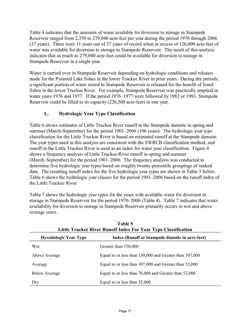
Table 4 indicates that the amounts of water available for diversion to storage in StampedeReservoir ranged from 2,350 to 279,040 acre-feet per year during the period 1970 through 2006(37 years). There were 11 years out of 37 years of record when in excess of 126,000 acre-feet ofwater was available for diversion to storage in Stampede Reservoir. The result of this analysisindicates that as much as 279,040 acre-feet could be available for diversion to storage inStampede Reservoir in a single year.
Water is carried over in Stampede Reservoir depending on hydrologic conditions and releasesmade for the Pyramid Lake fishes in the lower Truckee River in prior years. During dry periods,a significant portion of water stored in Stampede Reservoir is released for the benefit of listedfishes in the lower Truckee River. For example, Stampede Reservoir was practically emptied inwater years 1976 and 1977. If the period 1976–1977 were followed by 1982 or 1983, StampedeReservoir could be filled to its capacity (226,500 acre-feet) in one year.
L. Hydrologic Year Type Classification
Table 6 shows estimates of Little Truckee River runoff at the Stampede damsite in spring andsummer (March-September) for the period 1901–2006 (106 years). The hydrologic year typeclassification for the Little Truckee River is based on estimated runoff at the Stampede damsite. The year types used in this analysis are consistent with the SWRCB classification method, andrunoff in the Little Truckee River is used as an index for water year classification. Figure 4shows a frequency analysis of Little Truckee River runoff in spring and summer(March–September) for the period 1901–2006. The frequency analysis was conducted todetermine five hydrologic year types based on roughly twenty-percentile groupings of rankeddata. The resulting runoff index for the five hydrologic year types are shown in Table 5 below. Table 6 shows the hydrologic year classes for the period 1901–2006 based on the runoff index ofthe Little Truckee River.
Table 7 shows the hydrologic year types for the years with available water for diversion tostorage in Stampede Reservoir for the period 1970–2006 (Table 4). Table 7 indicates that wateravailability for diversion to storage in Stampede Reservoir primarily occurs in wet and aboveaverage years.
Table 5Little Truckee River Runoff Index For Year Type Classification
Hyrodologic Year Type Index (Runoff at Stampede damsite in acre-feet)
Wet Greater than 150,000
Above Average Equal to or less than 150,000 and Greater than 107,000
Average Equal to or less than 107,000 and Greater than 52,000
Below Average Equal to or less than 76,000 and Greater than 52,000
Dry Equal to or less than 52,000
Page 17

0 10 20 30 40 50 60 70 80 90 100PERCENT OF TIME FLOW AT OR BELOW
0,000
50,000
100,000
150,000
200,000
250,000
300,000
RU
NO
FF
MA
RC
H-S
EP
T
IN A
CR
E-F
EE
TLittle Truckee River Runoff at Stampede Damsite
Flow Duration Curve for Hydrologic Year Type Classification, 1901-2006
Dry Below Average Above Average WetAverage
Fig
ure 4
Page 18

Table 6 Little Truckee River Runoff at Stampede Damsite
and Hydrologic Year Type Classification 1901-2006
Year Runoff at Stampede
Damsite1, 2 (acre-feet)
Hydrologic Year Type
1901 149,000 Above Average 1902 102,180 Average 1903 88,220 Average 1904 202,190 Wet 1905 86,120 Average 1906 169,520 Wet 1907 221,250 Wet 1908 68,920 Below Average 1909 167,630 Wet 1910 105,770 Average 1911 211,290 Wet 1912 54,930 Below Average 1913 60,500 Below Average 1914 187,740 Wet 1915 96,130 Average 1916 179,040 Wet 1917 110,750 Above Average 1918 69,130 Below Average 1919 107,370 Average 1920 59,000 Below Average 1921 117,950 Above Average 1922 166,350 Wet 1923 93,480 Average 1924 19,550 Dry 1925 64,650 Below Average 1926 49,390 Dry 1927 135,420 Above Average 1928 84,700 Average 1929 42,430 Dry 1930 65,240 Below Average 1931 36,110 Dry 1932 104,370 Average 1933 52,030 Below Average 1934 31,280 Dry 1935 96,320 Average 1936 117,720 Above Average 1937 93,250 Average 1938 192,140 Wet 1939 41,040 Dry 1940 126,130 Above Average
Page 19

Table 6 (Continued) Little Truckee River Runoff at Stampede Damsite
and Hydrologic Year Type Classification 1901-2006
Year Runoff at Stampede
Damsite1, 2 (acre-feet)
Hydrologic Year Type
1941 98,690 Average 1942 120,990 Above Average 1943 112,240 Above Average 1944 56,830 Below Average 1945 84,780 Average 1946 93,180 Average 1947 42,150 Dry 1948 60,960 Below Average 1949 53,130 Below Average 1950 96,440 Average 1951 75,980 Average 1952 202,730 Wet 1953 114,850 Above Average 1954 48,890 Dry 1955 53,800 Below Average 1956 151,390 Wet 1957 81,070 Average 1958 165,280 Wet 1959 44,300 Dry 1960 57,620 Below Average 1961 29,590 Dry 1962 75,750 Below Average 1963 109,890 Above Average 1964 68,480 Below Average 1965 140,340 Above Average 1966 60,980 Below Average 1967 200,950 Wet 1968 60,810 Below Average 1969 203,630 Wet 1970 84,600 Average 1971 157,900 Wet 1972 71,392 Below Average 1973 107,961 Above Average 1974 130,703 Above Average 1975 124,803 Above Average 1976 21,639 Dry 1977 15,313 Dry 1978 123,095 Above Average 1979 57,757 Below Average 1980 129,681 Above Average 1981 28,550 Dry
Page 20

Table 6 (Continued) Little Truckee River Runoff at Stampede Damsite
and Hydrologic Year Type Classification 1901-2006
Year Runoff at Stampede
Damsite1, 2 (acre-feet)
Hydrologic Year Type
1982 175,844 Wet 1983 274,035 Wet 1984 113,526 Above Average 1985 66,169 Below Average 1986 158,405 Wet 1987 30,338 Dry 1988 20,031 Dry 1989 88,597 Average 1990 42,761 Dry 1991 42,965 Dry 1992 26,516 Dry 1993 147,109 Above Average 1994 23,127 Dry 1995 231,247 Wet 1996 135,371 Above Average 1997 86,142 Average 1998 149,196 Above Average 1999 138,651 Above Average 2000 75,971 Below Average 2001 21,909 Dry 2002 58,291 Below Average 2003 79,125 Average 2004 57,120 Below Average 2005 112,452 Above Average 2006 141,060 Above Average
1. March through September. 2. Based on data originally developed by USBR for use in the Washoe Project analysis and the OCAP analysis
(1901-1980). Flow was recorded by USGS prior to construction of Stampede Reservoir (1940-1969). Data based on USGS record of storage and releases from Stampede Reservoir (1970-2006).
Page 21
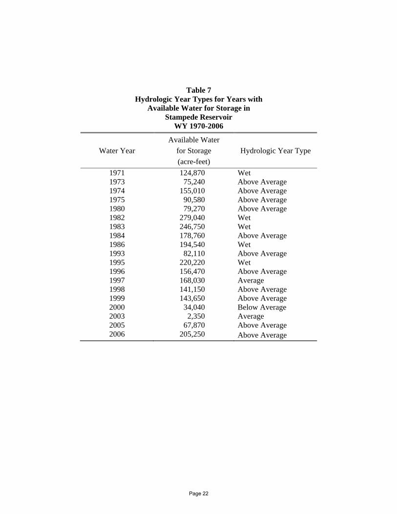
Table 7 Hydrologic Year Types for Years with
Available Water for Storage in Stampede Reservoir
WY 1970-2006
Water Year Available Water
for Storage (acre-feet)
Hydrologic Year Type
1971 124,870 Wet 1973 75,240 Above Average 1974 155,010 Above Average 1975 90,580 Above Average 1980 79,270 Above Average 1982 279,040 Wet 1983 246,750 Wet 1984 178,760 Above Average 1986 194,540 Wet 1993 82,110 Above Average 1995 220,220 Wet 1996 156,470 Above Average 1997 168,030 Average 1998 141,150 Above Average 1999 143,650 Above Average 2000 34,040 Below Average 2003 2,350 Average 2005 67,870 Above Average 2006 205,250 Above Average
Page 22

M. Conclusions.
Results of this water availability analysis show that water is available in the Little Truckee Riverto be diverted to storage in Stampede Reservoir above the current diversion quantity of 126,000acre-feet per annum. This is water that would otherwise flow into Pyramid Lake. Results of theanalysis also show that the applied for water can be diverted to storage in Stampede Reservoirwithout any impairment to downstream water rights or the flow targets in the lower TruckeeRiver. Based on the results of this water availability analysis, water is available in the LittleTruckee River to increase the maximum diversion to storage from 126,000 acre-feet per annumto 226,000 acre-feet per annum in Stampede Reservoir, as requested in Application 31487 filedby Reclamation with the SWRCB on January 8, 2004.
Page 23

II. Water Availability Analysis for Prosser Creek Reservoir (Application 31488)
A. Introduction
The U.S. Bureau of Reclamation (Reclamation) filed water right Application 31488 with theCalifornia State Water Resources Control Board (SWRCB) on January 8, 2004. This applicationsupplements License 10180 (Application 18006) and seeks, among other things, to increase themaximum annual withdrawal above 20,162 acre-feet from Prosser Creek Reservoir. In addition,the application seeks to extend the fill season for Prosser Creek Reservoir from the current April10–August 10 season under the existing license to October 1–August 10. SWRCB (May 2007)requested a Water Availability Analysis (WAA) in connection with water right Application31488. Accordingly, this WAA was prepared by the applicant for Prosser Creek Reservoir (seeExhibit 4, attached hereto). See also Exh. 2, attached (SWRCB acceptance of WAA).
B. Background
Background information on the Truckee River, reservoirs and operating criteria is provided inPart I of this testimony for Stampede Reservoir. Similarly, matters related to the Settlement Act(Public Law 101-618), Newlands Project OCAP and instream flows for the lower Truckee Riverare presented in Part I of this testimony for Stampede Reservoir.
C. Prosser Creek
Prosser Creek Dam and Reservoir are located on Prosser Creek. The drainage area of ProsserCreek at the dam site is about 50 square miles. Prosser Creek is not regulated by a dam orreservoir upstream of Prosser Creek Reservoir.
D. Prosser Creek Reservoir
Prosser Creek Reservoir was completed in 1962 (storage began in January 1963) by Reclamationas part of the Washoe Project. The zoned earthfill dam is 163 feet high and impounds about29,800 acre-feet of water. Reservoir storage is lowered to 9,800 acre-feet to provide 20,000acre-feet of space for flood control by November 1 of each year. The flood control reservation ismaintained at 20,000 acre-feet through April 10 (U.S. Army Corps of Engineers, 1985).
The reservoir was authorized for irrigation, flood control, municipal, fish and wildlife, recreationand other beneficial purposes. The primary use to date has been flood control, storage of waterfor the Tahoe-Prosser exchange and for threatened and endangered fishes of Pyramid Lake. Incidental uses of water include recreation and hydroelectric power generation by run-of-riverplants along the Truckee River.
Tahoe-Prosser exchange is implemented under the Agreement for Water Exchange Operations ofLake Tahoe and Prosser Creek Reservoir, dated June 15, 1959 (Petitioners’ Joint Exh. 3). Theagreement provides for releases from Lake Tahoe for streamflow maintenance downstream fromTahoe Dam when releases are unnecessary to meet Floriston Rates. Minimum releases of 70 cfs
Page 24

from April through September and 50 cfs the remainder of the year are maintained at the lakeoutlet when an equivalent amount of water is available for exchange in Prosser Creek Reservoir. If there is no available storage, and inflow to Prosser Creek Reservoir is less than these releases,minimum release from Lake Tahoe is reduced to that of Prosser Creek inflow. The equivalentamount of water credited in Prosser Creek Reservoir for these releases from Lake Tahoe isreferred to as "Tahoe-Prosser Exchange Water." Exchange water stored in Prosser CreekReservoir is released when necessary in amounts required to maintain Floriston Rates or ReducedFloriston Rates. Exchange water stored in Prosser Creek Reservoir does not incur reservoirevaporation losses.
Application 18006 was filed by Reclamation on February 18, 1958. License 10180 provides formaximum diversion of 30,000 acre-feet to storage from April 10 to August 10 of each year.License 10180 limits the withdrawal from storage in Prosser Creek Reservoir to a maximumamount of 20,162 acre-feet in any one year. Figure 5 shows the storage hydrograph of ProsserCreek Reservoir for water years 1964 through 2006. Figure 5 shows that Prosser CreekReservoir nearly filled to its full capacity of about 30,000 acre-feet in 17 years over the 43 yearsof record.
Reclamation filed water right Application 31488 on January 8, 2004, for the purpose ofincreasing the existing maximum withdrawal from storage in Prosser Creek Reservoir above20,162 acre-feet in any one year, and to extend the fill season from the current April 10–August10 to October 1–August 10. Application 31488 supplements License 10180. The total quantityof water diverted to storage under Application 31488 and License 10180 will remain at 30,000acre-feet per year (SWRCB, January 2007).
Page 25

Storage in Prosser Creek ReservoirWater Years 1964 - 2006
USGS Gage (ID #10340300)
0
5,000
10,000
15,000
20,000
25,000
30,000
35,000
1964 1965 1966 1967 1968 1969 1970 1971 1972 1973 1974 1975 1976 1977 1978 1979 1980 1981 1982 1983 1984 1985 1986 1987 1988 1989 1990 1991 1992 1993 1994 1995 1996 1997 1998 1999 2000 2001 2002 2003 2004 2005 2006
Water Year
Stor
age
(af)
Figure 3
* Only monthly data available for period January 1979 through September 1987.
Page 26
robynk
Typewritten Text
Figure 5
robynk
Typewritten Text
robynk
Text Box

E. Water Availability Analysis
License 10180 allows for a total quantity of water up to 30,000 acre-feet to be diverted to storagein Prosser Creek Reservoir and limits the maximum withdrawal to 20,162 acre-feet in any oneyear, leaving approximately 9,800 acre-feet in the reservoir in most years. Application 31488 isrequesting to remove the withdrawal limitation of 20,162 acre-feet in any one year, and to extendthe fill season from the current April 10–August 10 to October 1–August 10. With the removalof the withdrawal limitation, the reservoir may be lowered below 9,800 acre-feet more often. This analysis examines the availability of water to fill a lower reservoir in any one year. Inaddition, this analysis also addresses the potential availability of water to be diverted to storage inProsser Creek Reservoir during the additional fill period October–March in any one year.
A water availability analysis for the diversion of water to storage in Prosser Creek Reservoir ispresented in the spreadsheet in Table 8. The analysis is based on the historical operation ofProsser Creek Reservoir for the period when Stampede Reservoir was in operation (August 1969through September 2006). The amount of available water is calculated for those periods withhigher Truckee River flows. In addition, the amounts of water available are calculated for theperiods when the storage of such water would not interfere with any downstream water rights andwould be water which would have otherwise flowed to Pyramid Lake or been stored under theTahoe-Prosser Exchange Agreement.
Storing this water will not interfere with any California water rights, including any new waterthat may be appropriated in California, because the interstate allocation in Section 204 of theSettlement Act provides that water for use in Nevada is junior in priority to Californiaappropriations. The requested changes also will not interfere with Nevada water rights becausewater will only be stored in priority after all other Nevada water rights have been satisfied orstored under the Tahoe-Prosser Exchange Agreement. The underpinnings for the analysis aresummarized below:
1. Water flowing to Prosser Creek Reservoir occurs after the satisfaction of anyupstream rights in Prosser Creek.
2. Storage priority in Prosser Creek Reservoir is junior to Stampede and BocaReservoirs.
3. Water is not stored in Prosser Creek Reservoir adverse to Floriston Rates orReduced Floriston Rates.
4. Water is not stored in Prosser Creek Reservoir unless allowable OCAP diversionsat Derby Dam are satisfied.
5. Orr Ditch water rights are satisfied by meeting Floriston Rates or ReducedFloriston Rates (whichever is in effect) at Farad and allowable Orr Ditch
Page 27

D R A F T
[1] [2] [3] [4] [5] [6] [7] [8] [9] [10] [11] [12] [13] [14] [15] [16]
EOM Prosser Truckee TruckeeProsser Change in River at Floriston Canal atStorage Storage Farad Rates Wadsworth
af af (afm) (afm) (afm)
Truckee River near Nixon (afm)
Prosser Stored Water Within Flow Regime
No. 1?
Available Water in addition to Stored Amount in Prosser
(afm)
Prosser Stored Water Adverse to Floriston Rates?
Available Water for Storage in Prosser
Creek Reservoir (afm)
Month-Year
Table 8Estimates of Available Water for Storage in Prosser Creek Reservoir
Flow at Farad in
Excess of Floriston
Rates (afm)
Prosser Ck below
Prosser (afm)
Inflow to Pyramid Lake above Flow
Regime No. 1 (afm)
Pyramid Lake inflow targets
under Flow Regime No. 1
(afm)
Adjusted Prosser Ck
below Prosser
(afm)
9,830Apr-71 18,900 9,070 5,677 61,222 29,752 31,470 23,901 45,800 35,107 10,693 no no 5,677 14,747
May-71 15,900 -3,000 25,234 22,234 114,641 30,744 83,897 45,304 75,884 61,488 14,396 no no 14,396 14,396Jun-71 29,167 13,267 5,482 137,157 29,752 107,405 30,432 103,775 47,603 56,172 no no 5,482 18,749Jul-71 30,600 1,433 6,147 59,512 30,744 28,768 28,183 27,711 18,446 9,265 no no 6,147 7,580
TOTAL 55,472
9,073Mar-73 9,547 473 3,535 31,688 30,744 944 861 39,685 17,831 21,854 no no 944 1,417Apr-73 20,567 11,020 4,296 53,115 29,752 23,363 5,875 50,815 35,107 15,707 no no 4,296 15,316
May-73 32,267 11,700 9,584 79,565 30,744 48,821 12,720 60,924 61,488 -563 no yes (563 af) 0 11,137TOTAL 27,870
8,380Nov-73 8,687 307 7,737 40,693 23,802 16,891 31,595 19,513 9,521 9,993 no no 7,737 8,044Dec-73 9,460 773 3,721 26,918 24,595 2,323 3,731 32,289 9,838 22,451 no no 2,323 3,096Jan-74 7,873 -1,587 13,726 12,139 62,846 24,595 38,251 835 79,702 9,838 69,864 no no 12,139 12,139Feb-74 8,660 787 3,174 38,402 22,215 16,187 852 44,729 8,886 35,843 no no 3,174 3,960Mar-74 10,020 1,360 8,951 83,082 30,744 52,338 2,454 93,342 17,831 75,511 no no 8,951 10,311Apr-74 18,033 8,013 5,611 122,221 29,752 92,469 6,163 121,012 35,107 85,904 no no 5,611 13,625
May-74 27,600 9,567 12,774 135,451 30,744 104,707 11,585 115,299 61,488 53,812 no no 12,774 22,340Jun-74 30,867 3,267 8,533 92,749 29,752 62,997 12,875 74,202 47,603 26,598 no no 8,533 11,800
TOTAL 85,315
8,053May-75 13,000 4,947 22,264 172,324 30,744 141,580 10,278 158,335 61,488 96,847 no no 22,264 27,211Jun-75 24,700 11,700 8,541 120,603 29,752 90,851 12,797 109,922 47,603 62,319 no no 8,541 20,241
TOTAL 47,452
9,123Apr-80 19,716 10,593 5,034 56,985 29,752 27,233 8,791 46,695 35,107 11,587 no no 5,034 15,627
May-80 15,348 -4,368 23,260 18,892 125,117 30,744 94,374 11,808 103,835 61,488 42,347 no no 18,892 18,892TOTAL 34,519
9,730Nov-81 11,410 1,680 12,730 58,038 17,851 40,187 28,122 37,551 9,521 28,030 no no 12,730 14,410Dec-81 9,107 -2,303 18,555 16,252 79,571 24,595 54,976 34,181 62,640 9,838 52,802 no no 16,252 16,252Jan-82 9,448 341 5,086 33,402 24,595 8,807 9,306 38,579 9,838 28,740 no no 5,086 5,427Feb-82 8,808 -640 15,943 15,303 78,819 22,215 56,604 689 94,207 8,886 85,321 no no 15,303 15,303Mar-82 9,267 459 9,275 54,938 30,744 24,194 341 68,545 17,831 50,713 no no 9,275 9,734Apr-82 10,870 1,603 18,530 141,116 29,752 111,364 7,813 147,586 35,107 112,479 no no 18,530 20,133
May-82 9,316 -1,554 30,107 28,553 264,476 30,744 233,732 13,648 248,985 61,488 187,498 no no 28,553 28,553Jun-82 23,759 14,443 3,051 147,669 29,752 117,917 10,852 152,628 47,603 105,025 no no 3,051 17,494Jul-82 30,318 6,559 1,490 47,038 30,744 16,294 13,722 36,889 18,446 18,442 no no 1,490 8,049
TOTAL 135,354
9,464Mar-83 9,203 -261 12,668 12,407 190,691 30,744 159,947 2,122 223,775 17,831 205,944 no no 12,407 12,407Apr-83 9,075 -128 13,111 12,983 185,891 29,752 156,139 4,683 201,124 35,107 166,017 no no 12,983 12,983
May-83 10,906 1,831 33,517 242,936 30,744 212,192 9,866 249,997 61,488 188,509 no no 33,517 35,348Jun-83 15,881 4,975 29,377 310,235 29,752 280,483 10,366 321,183 47,603 273,580 no no 29,377 34,352Jul-83 28,804 12,923 885 179,583 30,744 148,840 15,560 171,295 18,446 152,848 no no 885 13,808
TOTAL 108,898
1,378Oct-83 2,140 762 1,480 27,128 24,595 2,533 4,014 26,041 9,838 16,203 no no 1,480 2,242Nov-83 9,011 6,871 5,971 146,916 23,802 123,114 2,364 158,221 9,521 148,701 no no 5,971 12,842
F:\DATA\1336\Testimony-052510\SummaryTablev2B-prosser.xls 1 of 3 6/16/2010Page 28

D R A F T
[1] [2] [3] [4] [5] [6] [7] [8] [9] [10] [11] [12] [13] [14] [15] [16]
EOM Prosser Truckee TruckeeProsser Change in River at Floriston Canal atStorage Storage Farad Rates Wadsworth
af af (afm) (afm) (afm)
Truckee River near Nixon (afm)
Prosser Stored Water Within Flow Regime
No. 1?
Available Water in addition to Stored Amount in Prosser
(afm)
Prosser Stored Water Adverse to Floriston Rates?
Available Water for Storage in Prosser
Creek Reservoir (afm)
Month-Year
Table 8Estimates of Available Water for Storage in Prosser Creek Reservoir
Flow at Farad in
Excess of Floriston
Rates (afm)
Prosser Ck below
Prosser (afm)
Inflow to Pyramid Lake above Flow
Regime No. 1 (afm)
Pyramid Lake inflow targets
under Flow Regime No. 1
(afm)
Adjusted Prosser Ck
below Prosser
(afm)Dec-83 10,184 1,173 10,147 221,117 24,595 196,522 1,379 240,139 9,838 230,301 no no 10,147 11,320Jan-84 7,958 -2,226 9,287 7,061 187,716 24,595 163,121 724 210,883 9,838 201,045 no no 7,061 7,061Feb-84 9,005 1,047 3,642 100,145 23,008 77,137 1,638 118,909 9,203 109,706 no no 3,642 4,689Mar-84 9,448 443 8,977 81,055 30,744 50,311 4,762 95,861 17,831 78,030 no no 8,977 9,420Apr-84 15,112 5,664 5,776 62,787 29,752 33,035 6,728 65,798 35,107 30,690 no no 5,776 11,440
May-84 22,406 7,294 12,895 102,587 30,744 71,843 12,391 94,651 61,488 33,164 no no 12,895 20,189Jun-84 26,972 4,566 6,718 84,861 29,752 55,109 12,347 76,715 47,603 29,111 no no 6,718 11,284
TOTAL 90,4869,107
Feb-86 9,706 599 22,030 132,936 22,215 110,721 18,091 183,874 8,886 174,988 no no 22,030 22,629Mar-86 9,365 -341 22,822 22,481 250,413 30,744 219,669 3,110 292,899 17,831 275,068 no no 22,481 22,481Apr-86 19,062 9,697 6,827 151,993 29,752 122,241 7,444 172,602 35,107 137,494 no no 6,827 16,524
May-86 19,977 915 17,228 147,808 30,744 117,064 9,646 149,038 61,488 87,550 no no 17,228 18,143Jun-86 29,008 9,031 3,963 77,419 29,752 47,667 11,990 73,543 47,603 25,940 no no 3,963 12,994Jul-86 30,375 1,367 2,221 31,914 30,744 1,170 12,188 15,852 18,446 -2,594 no yes (1,367 af) 0 0
TOTAL 92,772
16,233May-93 20,849 4,616 22,015 98,777 30,744 68,033 8,505 78,440 61,488 16,953 no no 16,953 21,569Jun-93 22,145 1,295 12,397 75,927 29,752 46,175 6,311 63,959 47,603 16,356 no no 12,397 13,692
TOTAL 35,261
9,875Mar-95 9,613 -262 18,155 17,892 67,537 18,446 49,091 27,463 72,960 17,831 55,129 no no 17,892 17,892Apr-95 13,615 4,002 11,520 56,987 29,752 27,235 2,910 61,892 35,107 26,785 no no 11,520 15,522
May-95 13,026 -588 29,578 28,989 138,744 30,744 108,000 4,272 150,426 61,488 88,939 no no 28,989 28,989Jun-95 27,410 14,383 9,330 124,403 29,752 94,651 5,893 138,783 47,603 91,180 no no 9,330 23,714Jul-95 30,160 2,750 9,677 93,977 30,744 63,233 7,105 94,437 18,446 75,991 no no 9,677 12,427
TOTAL 98,544
9,687Feb-96 9,597 -90 12,738 12,648 74,269 23,008 51,261 772 99,245 9,203 90,042 no no 12,648 12,648Mar-96 9,547 -50 9,727 9,677 91,039 30,744 60,296 1,049 113,752 17,831 95,921 no no 9,677 9,677Apr-96 19,600 10,053 7,817 118,155 29,752 88,403 3,015 127,220 35,107 92,112 no no 7,817 17,870
May-96 29,800 10,200 16,528 207,868 30,744 177,124 4,933 223,934 61,488 162,446 no no 16,528 26,728Jun-96 28,133 -1,667 12,127 10,460 113,157 29,752 83,405 5,958 106,473 47,603 58,869 no no 10,460 10,460
TOTAL 77,384
9,937Nov-96 9,797 -140 3,608 3,468 31,014 23,802 7,212 4,982 32,747 9,521 23,226 no no 3,468 3,468Dec-96 13,367 3,570 7,781 126,377 24,595 101,782 20,144 125,871 9,838 116,033 no no 7,781 11,351Jan-97 9,767 -3,600 34,709 31,109 376,007 24,595 351,412 1,981 453,640 9,838 443,802 no no 31,109 31,109Feb-97 9,800 33 4,998 180,694 22,215 158,479 1,071 215,861 8,886 206,975 no no 4,998 5,032Mar-97 9,960 160 11,907 136,411 30,744 105,667 928 161,117 17,831 143,286 no no 11,907 12,067Apr-97 17,267 7,307 9,132 95,008 29,752 65,256 2,945 106,235 35,107 71,127 no no 9,132 16,439
May-97 24,233 6,967 8,957 99,352 30,744 68,608 6,081 102,407 61,488 40,919 no no 8,957 15,924Jun-97 28,000 3,767 4,161 74,112 29,752 44,360 4,005 77,631 47,603 30,028 no no 4,161 7,928
TOTAL 103,317
9,600Feb-98 9,767 167 2,620 24,956 22,215 2,741 608 34,495 8,886 25,609 no no 2,620 2,787Mar-98 9,527 -240 10,159 9,919 86,208 30,744 55,464 756 106,637 17,831 88,806 no no 9,919 9,919Apr-98 18,900 9,373 4,483 119,980 29,752 90,228 1,408 133,448 35,107 98,340 no no 4,483 13,856
May-98 16,667 -2,233 22,140 19,906 162,347 30,744 131,603 3,656 167,385 61,488 105,898 no no 19,906 19,906Jun-98 28,900 12,233 9,162 179,821 29,752 150,069 4,641 191,683 47,603 144,079 no no 9,162 21,395Jul-98 26,767 -2,133 10,223 8,089 86,446 30,744 55,702 6,821 81,971 18,446 63,525 no no 8,089 8,089
TOTAL 75,953
F:\DATA\1336\Testimony-052510\SummaryTablev2B-prosser.xls 2 of 3 6/16/2010Page 29

D R A F T
[1] [2] [3] [4] [5] [6] [7] [8] [9] [10] [11] [12] [13] [14] [15] [16]
EOM Prosser Truckee TruckeeProsser Change in River at Floriston Canal atStorage Storage Farad Rates Wadsworth
af af (afm) (afm) (afm)
Truckee River near Nixon (afm)
Prosser Stored Water Within Flow Regime
No. 1?
Available Water in addition to Stored Amount in Prosser
(afm)
Prosser Stored Water Adverse to Floriston Rates?
Available Water for Storage in Prosser
Creek Reservoir (afm)
Month-Year
Table 8Estimates of Available Water for Storage in Prosser Creek Reservoir
Flow at Farad in
Excess of Floriston
Rates (afm)
Prosser Ck below
Prosser (afm)
Inflow to Pyramid Lake above Flow
Regime No. 1 (afm)
Pyramid Lake inflow targets
under Flow Regime No. 1
(afm)
Adjusted Prosser Ck
below Prosser
(afm)9,753
Jan-99 9,653 -100 3,832 3,732 41,316 24,595 16,721 413 53,619 9,838 43,781 no no 3,732 3,732Feb-99 9,927 273 4,340 109,474 22,215 87,259 346 128,943 8,886 120,058 no no 4,340 4,613Mar-99 9,723 -203 9,275 9,071 113,098 30,744 82,354 937 131,286 17,831 113,455 no no 9,071 9,071Apr-99 14,700 4,977 10,082 103,615 29,752 73,862 1,897 117,302 35,107 82,195 no no 10,082 15,059
May-99 21,533 6,833 21,380 182,340 30,744 151,597 4,931 188,588 61,488 127,101 no no 21,380 28,213Jun-99 28,367 6,833 10,062 127,240 29,752 97,488 4,253 127,716 47,603 80,112 no no 10,062 16,895
TOTAL 77,584
9,863Mar-00 9,767 -97 6,653 6,556 42,167 30,744 11,423 42 47,445 17,831 29,613 no no 6,556 6,556Apr-00 20,067 10,300 4,145 62,047 29,752 32,295 1,885 61,811 35,107 26,703 no no 4,145 14,445
May-00 28,067 8,000 5,919 75,213 30,744 44,469 4,850 63,533 61,488 2,045 no no 2,045 10,045Jun-00 28,367 300 5,702 38,811 29,752 9,059 4,550 25,214 47,603 -22,389 no yes (300 af) 0 0
TOTAL 31,046
11,400Apr-03 14,167 2,767 5,103 44,156 29,752 14,404 31,333 15,840 35,107 -19,267 no yes (2,767 af) 0 0
May-03 26,133 11,967 3,021 59,472 30,744 28,729 7,422 47,714 61,488 -13,773 no yes (11,967 af) 0 0Jun-03 29,900 3,767 6,988 44,257 29,752 14,505 5,129 33,616 47,603 -13,987 no yes (3,767 af) 0 0
TOTAL 0
16,300May-05 27,000 10,700 14,461 99,685 30,744 68,941 3,535 96,091 61,488 34,604 no no 14,461 25,161Jun-05 27,833 833 10,885 60,555 29,752 30,803 4,489 56,356 47,603 8,753 no no 8,753 9,586
TOTAL 34,748
9,993Dec-05 14,967 4,973 10,485 60,934 21,521 39,414 135 63,418 9,838 53,580 no no 10,485 15,458Jan-06 9,863 -5,103 17,209 12,105 89,236 21,521 67,716 0 124,905 9,838 115,067 no no 12,105 12,105Feb-06 11,367 1,503 6,198 47,288 22,215 25,073 0 51,481 8,886 42,595 no no 6,198 7,702Mar-06 9,490 -1,877 10,312 8,435 83,211 30,744 52,467 476 92,356 17,831 74,525 no no 8,435 8,435Apr-06 17,600 8,110 10,840 120,417 29,752 90,664 1,042 122,479 35,107 87,372 no no 10,840 18,950
May-06 25,200 7,600 19,041 175,260 30,744 144,516 4,199 166,433 61,488 104,945 no no 19,041 26,641Jun-06 30,633 5,433 7,799 96,575 29,752 66,823 4,742 85,864 47,603 38,261 no no 7,799 13,232
TOTAL 102,524
F:\DATA\1336\Testimony-052510\SummaryTablev2B-prosser.xls 3 of 3 6/16/2010Page 30

4It should be noted that the allowable OCAP diversions at Derby Dam changed severaltimes during the period from August 1969 through September 2006 and that there were timeswhen the historical diversions substantially exceeded the allowable OCAP diversions.
5See Water Availability Analysis for Stampede Reservoir, Application 31487.
Decree and OCAP diversions at Derby Dam.
6. Diversion requirements at Derby Dam are assumed to be the same as historicaldiversions for the purpose of this analysis.4
7. Water would not be diverted to storage in Prosser Creek Reservoir unless targetflows under Flow Regime No. 1 are met in the lower Truckee River.
The spreadsheet analysis is aimed at periods of full or nearly full storage in Boca Reservoir whenStampede Reservoir is in priority to store water.5 In addition, flows at Farad exceed theapplicable Floriston Rates and flows in the lower Truckee River exceed the target flows underFlow Regime No. 1.
Generally, during wet periods all downstream water rights in the basin can be served byunregulated runoff into the mainstem of the Truckee River, leaving sufficient additional runoff inProsser Creek and the Little Truckee River to fill Prosser Creek Reservoir, and Stampede andBoca Reservoirs, respectively.
F. Summary of Results
The estimates of water available for diversion to storage in Prosser Creek Reservoir for thespecified years during the period extending from water years 1970 through 2006 (37 years) aresummarized in Table 9.
Table 9 indicates that the amounts of water available for diversion to storage in Prosser CreekReservoir ranged from 27,870 to 135,350 acre-feet per year during the period 1970 through 2006(37 years). There were 17 out of 37 years of record when in excess of 30,000 acre-feet of waterwas available in each of those years for diversion to storage in Prosser Creek Reservoir. Theresult of this analysis indicates that potentially as much as 135,350 acre-feet could be availablefor diversion to storage in Prosser Creek Reservoir in a single year.
Page 31

Table 9Water Available for Storage in Prosser Creek Reservoir
WY 1970–2006
Water Year Acre-Feet
1971 55,470
1973 27,870
1974 85,310
1975 47,450
1980 34,520
1982 135,350
1983 108,900
1984 90,490
1986 92,770
1993 35,260
1995 98,540
1996 77,380
1997 103,320
1998 75,950
1999 77,580
2000 31,050
2005 34,750
2006 102,520
Water is carried over in Prosser Creek Reservoir depending on hydrologic conditions,Tahoe-Prosser exchange, and releases made for Pyramid Lake fishes in prior years. ProsserCreek Reservoir was, however, emptied in the drought years of 1976 and 1977 (see Figure 5).
Table 10 provides the estimate of water available for diversion to storage in Prosser CreekReservoir during October–March for the period of analysis extending from water years 1970through 2006 (37 years). It shows that the amounts of water available for diversion to storage inProsser Creek Reservoir during October–March ranged from 1,420 to 63,030 acre-feet per yearfor the period 1970 through 2006 (37 years). There were 13 out of 37 years of record when therewas water available for diversion to storage in October–March. However, the amount that can bediverted to storage in Prosser Creek Reservoir is limited by the inviolate flood control space fromNovember 1–April 10, and storage in Prosser Creek Reservoir is therefore limited to 9,800acre-feet during this period.
Page 32

Table 10Water Available for Storage in Prosser Creek Reservoir
During October - MarchWY 1970-2006
Water Year Acre-Feet
1973 1,420
1974 37,550
1982 61,130
1983 12,410
1984 47,570
1986 45,110
1995 17,890
1996 22,330
1997 63,030
1998 12,710
1999 17,420
2000 6,560
2006 43,700
G. Hydrologic Year Type Classification
The result of hydrologic analysis conducted for the Little Truckee River is used to classify yeartypes for Prosser Creek. The hydrologic year type analysis for the Little Truckee River ispresented in the Water Availability Analysis for Stampede Reservoir, Application 31487.
Table 11 shows the hydrologic year types for the years with water available for diversion tostorage in Prosser Creek Reservoir for the period 1970–2006 (Table 9). Table 11 indicates thatwater availability for diversion to storage in Prosser Creek Reservoir primarily occurs in wet andabove average years.
Page 33

Table 11 Hydrologic Year Types for Years with
Water Available for Storage in Prosser Creek Reservoir
WY 1970-2006
Water Year Water Available
for Storage (acre-feet)
Hydrologic Year Type
1971 55,470 Wet 1973 27,870 Above Average 1974 85,310 Above Average 1975 47,450 Above Average 1980 34,520 Above Average 1982 135,350 Wet 1983 108,900 Wet 1984 90,490 Above Average 1986 92,770 Wet 1993 35,260 Above Average 1995 98,540 Wet 1996 77,380 Above Average 1997 103,320 Average 1998 75,950 Above Average 1999 77,580 Above Average 2000 31,050 Below Average 2005 34,750 Above Average 2006 102,520 Above Average
Page 34

H. Conclusions
Results of this water availability analysis show that water which would otherwise flow toPyramid Lake is available in Prosser Creek to be diverted to storage in Prosser Creek Reservoirfrom October 1 through August 10 each year. Results of the analysis show that the removal ofthe existing withdrawal limitation and extending the fill season in Prosser Creek Reservoir willnot cause any impairment to downstream water rights or affect the achievement of flow targets inthe lower Truckee River. This water availability analysis demonstrates that water is available inProsser Creek to extend the fill season from the current April 10–August 10 to October 1–August10, and to increase the existing maximum withdrawal in any one year above 20,162 acre-feet forProsser Creek Reservoir as requested in Application 31488.
References for Stampede and Prosser Creek Reservoirs
CDWR, 1991, Truckee River Atlas, Department of Water Resources, The Resources Agency,State of California, June 1991.
MOU, 1993, Memorandum of Understanding Between the Pyramid Lake Paiute Tribe of Indiansand the Department of Conservation and Natural Resources of the State of Nevada, July 1993.
Nevada State Engineer, 1998, Ruling No. 4659, August 1998. Available at:http://water.nv.gov/Orders&Rulings/Rulings/rulings_query.cfm
Nevada State Engineer, 1998, Ruling No. 4863, November1998. Available at:http://water.nv.gov/Orders&Rulings/Rulings/rulings_query.cfm
Reclamation, 1987, Newlands Project Proposed Operating Criteria and Procedures, FinalEnvironmental Impact Statement. Prepared by URS Corporation, Sacramento, California,December 1987.
Reclamation and CDWR, 2004, Truckee River Operating Agreement, Revised DraftEnvironmental Impact Statement/Environmental Impact Report, August 2004.
SWRCB, 2007, Notice of Applications to Appropriate Water by Permit, Application Nos. 31487and 31488, January 2007.
SWRCB, 2007, Request for Water Availability Analysis for Applications 31487 and 31488 inNevada and Sierra Counties, Letter to U.S. Bureau of Reclamation dated May 3, 2007.
USACOE, 1985, Truckee River Reservoirs, Truckee River, Nevada and California, WaterControl Manual, July 1985.
Page 35

III. Pyramid Lake Decline and TROA Benefits
A. Introduction
This part of my testimony provides a summary overview of the decline in Pyramid Lakeelevation, Winnemucca Lake, Marble Bluff Dam and Fishway, Stampede Reservoir releases, andTROA benefits to fish passage at Pyramid Lake.
B. Decline in Lake Elevation
Prior to the early 1900's, fluctuations of water surface elevations in Pyramid Lake andWinnemucca Lake depended primarily on natural hydrologic factors. Construction of theTruckee Canal, a transbasin diversion canal from the lower Truckee River basin to the lowerCarson River basin, was completed in 1905. Truckee Canal and Derby Diversion Dam, as part ofthe Newlands Reclamation Project, became the largest single diversion work on the TruckeeRiver.
After diversions from the Truckee River to the Newlands Project began in 1906, water surfaceelevations in Pyramid Lake and Winnemucca Lake began to decline. Figure 6 shows thehistorical measurements of water elevation in Pyramid Lake from the early 1900's to 2010 (about100 years of record). As demonstrated, Pyramid Lake elevation followed a trend of decline afterthe Truckee Canal diversions began in 1906. By 1938, Winnemucca Lake had gone dry. Pyramid Lake elevation reached its lowest historic level (3,784 feet) in 1967, as shown on Figure6. This represented a drop of more than 85 feet from its historic highs. In 1967, the Secretary ofthe Interior issued regulations known as OCAP to limit diversions from the Truckee River to theNewlands Project.
C. Winnemucca Lake
Immediately to the east of Pyramid Lake is the bed of what was formerly Winnemucca Lake. Pyramid Lake was connected to Winnemucca Lake through an overflow channel from PyramidLake to Winnemucca Lake. In 1967, when Pyramid Lake reached its lowest elevation (3,784feet), it was 80 feet below its overflow elevation into Winnemucca Lake.
Winnemucca Lake was replenished by overflow from Pyramid Lake and with water diverted bythe bifurcation of the Truckee River during high flows at a point downstream of the town ofNixon, NV. Winnemucca Lake at one time had abundant cui-ui and Lahontan cutthroat trout(LCT), and its extensive marshes created a large migratory waterfowl habitat. Under PresidentialExecutive Order No. 7435, Winnemucca Lake was designated a National Wildlife Refuge onAugust 19, 1936. Ironically, by the time the Executive Order was issued, Winnemucca Lake wasalmost dry because of significant diversions from the Truckee River and the drought of 1930's. By 1938, Winnemucca Lake was completely dry and has been dry ever since, except for aninsignificant amount of local runoff.
Page 36

Page 37

D. Status of Cui-ui and LCT
The lowered Pyramid Lake elevation and reduced Truckee River inflows have resulted in thecreation of a delta at Pyramid Lake (U.S. Army Corps of Engineers, 1995). The delta, loweredlake elevation and reduced flows act as a barrier to cui-ui and LCT moving into the TruckeeRiver from Pyramid Lake for spawning. In the 1930s, the Pyramid Lake elevation droppedrapidly and a large delta was formed at the mouth of the Truckee River. The original strain ofLCT in Pyramid Lake became extinct by the early 1940's. In most years after the 1930's, cui-uiand LCT were not able to gain access to the river for spawning. Subsequently, the cui-ui waslisted as endangered in 1967 and the LCT as threatened in 1975.
E. Marble Bluff Dam and Fishway
Declining Pyramid Lake elevations resulted in steepening the river gradient and also created alarge delta area at the mouth of the Truckee River. This drop in elevation resulted in erosion andheadcutting upstream. In 1975, Reclamation, as part of the Washoe Project, constructed theMarble Bluff Dam and Pyramid Lake Fishway. Marble Bluff Dam was designed to stabilize therapidly degrading river channel and reduce erosion and upstream headcuttings along the lowerTruckee River. The Pyramid Lake Fishway was designed to aid migration of Pyramid Lakefishes, cui-ui and Lahontan Cutthroat Trout (LCT), when they are unable to migrate uprivereither because of low river flow or low lake elevations. The Fishway extends for a distance ofabout three miles, providing a passageway from Pyramid Lake to the Truckee River at MarbleBluff Dam. Marble Bluff Dam routes streamflow through the Pyramid Lake Fishway to provideriver access for cui-ui and LCT. Unfortunately, the Fishway has been mostly ineffective becauseof high velocities impeding cui-ui passage, design defects and maintenance problems related tochanging lake elevations.
A fish-lifting facility (mechanical hoist) was also constructed at the toe of the Marble Bluff Damto provide passage (lift). The purpose of fish lift was to aid in river access for cui-ui and LCTduring their annual spawning migration from Pyramid Lake to the Truckee River. In 1998, thehoist system was replaced by a lock system which lifts the upstream migrants to the river abovethe Marble Bluff Dam. The fish lock at the dam provides a means of capturing fish as well aspassage over the dam for fish which migrate via the river.
F. Stampede Reservoir
Water stored in Stampede Reservoir, that would have otherwise flowed to Pyramid Lake, hasbeen utilized by the United States Fish and Wildlife Service (USFWS) for the benefit of PyramidLake fishes—cui-ui and LCT. As stated in Part I of my testimony, the Stampede Project wasauthorized under the Washoe Project Act and Reclamation completed the construction of theStampede Dam and Reservoir on the Little Truckee River in 1970. The Carson-Truckee WaterConservancy District, Sierra Pacific Power Company and the State of Nevada sued the Secretaryof the Interior to contract for sale of Stampede Project water for irrigation and municipal andindustrial (M&I) purposes under the Washoe Project Act. However, the Secretary haddetermined that to do so would violate the Endangered Species Act (ESA). The Stampede Dam
Page 38

and Reservoir was being operated to conserve the Pyramid Lake listed fishes—cui-ui and LCT. As a result of the litigation (Carson-Truckee Water Conservancy District v. Clark, 1984)(Petitioners’ Joint Exh. 14), Federal courts upheld the determination of the Secretary that hisobligation under the ESA took precedence over his obligation to contract for delivery of waterfor irrigation and M&I uses from Stampede Reservoir. The courts ruled that the Secretary mustuse all water stored in Stampede Reservoir under the Stampede Project for the benefit of thePyramid Lake fishes until cui-ui and LCT are no longer endangered or threatened, or untilsufficient water for their conservation became available from other sources.
Water from Stampede and Prosser Creek reservoirs is released to support the passage flows forcui-ui to migrate and overcome the delta in the mouth of the Truckee River at Pyramid Lake,which acts as a barrier to spawning runs. In addition to releases for spawning, water is alsoreleased to maintain the habitat in the lower Truckee River year round. The flows are alsotargeted for the recruitment and maintenance of natural riparian vegetation, such as willows andcottonwood, in the lower Truckee River. However, Fish Water stored in Stampede and ProsserCreek reservoirs is not adequate to meet the flow targets to overcome the passage barrier at thedelta and provide higher flows for habitat maintenance in the lower Truckee River in most years.
G. TROA Benefits for Passage
TROA would allow the Pyramid Lake Paiute Tribe to accumulate water in the Truckee Riverreservoirs that would have otherwise flowed to Pyramid Lake. Under the TROA, such water willbe stored as Fish Credit Water in the Truckee River reservoirs within the permit conditions ofthose reservoirs. Some of the water accumulated would occur in wet years. Additionalaccumulation would be in winter months through the waiver of the hydroelectric water rights ofthe Truckee Meadows Water Authority (TMWA). In other words, a portion of water released inwinter months to meet the hydroelectric rights under the Floriston Rates would be held back instorage as Fish Credit Water. The portion held back in storage as Fish Credit Water would be thewater that would have otherwise flowed to Pyramid Lake. Under the TROA, Fish Credit Waterwould also be accumulated through the exchange or conversion of other credit waters establishedin the Truckee River reservoirs.
Fish Credit Water in the Truckee River reservoirs, as well as Stampede Project water and FishWater from Prosser Creek Reservoir, would be released to assist the cui-ui passage at thePyramid Lake delta. The delta, with its braided channels, acts as an obstacle to passage byPyramid Lake fishes—cui-ui and LCT. Increased releases would provide the hydraulic depth forcui-ui to migrate through the delta and provide protection against predation. Increased releaseswould also provide for spawning flows and improved habitat flows in the lower Truckee River. Improved habitat flows would be maintained year round. Increased releases would also help toimprove water quality in the lower Truckee River.
The average annual inflow to Pyramid Lake under the TROA would be increased compared tocurrent conditions. This is primarily attributed to 6,700 acre-feet of water rights to be providedby the Cities of Reno, Sparks and Washoe County for the purpose of water quality improvementin the lower Truckee River. Cities of Reno, Sparks and Washoe County agree to provide 6,700
Page 39

acre-feet of water rights when TROA takes effect (TROA, Section 1.E.4). Similarly, theelevation of Pyramid Lake would be higher under the TROA compared to current conditions overan extended period of time.
Page 40

IV. Instream Flows and Water Quality in the Lower Truckee River
A. Introduction
This part of my testimony briefly addresses the enhancement of instream flows and water qualityin the lower Truckee River under the TROA. It also discusses achieving these benefits to theTribe's trust resources under the TROA with no injury to any other legal user of water in thebasin.
B. Enhancement of Instream Flows
Under the TROA, the Pyramid Lake Paiute Tribe would be able to accumulate water in theTruckee River reservoirs that would have otherwise flowed to Pyramid Lake (Petitioners’ JointExh. 19). Water would be stored as Fish Credit Water. Most of this Fish Credit Water would beaccumulated in winter months and early spring. Water would be released to supplement flowsand mimic the natural hydrograph for cui-ui spawning in the lower Truckee River in the spring. Under the TROA, Fish Credit Water stored in the Truckee River reservoirs would be managed ina manner to increase the frequency of higher flows for cui-ui spawning. In addition, Fish CreditWater would be used to improve flows for the maintenance of habitat in the lower TruckeeRiver. The goal is to maintain the improved habitat flows year round. The improved instreamflows in the lower Truckee River benefit both cui-ui and LCT and help in maintaining orenhancing the growth of riparian vegetation.
The U.S. Fish and Wildlife Service (USFWS) in cooperation with the Pyramid Lake Paiute Tribedeveloped six flow regimes, shown in Table 2 (Part 1) of my testimony. Flow regimes withhigher flows are designated as Flow Regimes 1 and 2. With releases of Fish Credit Water underthe TROA, the frequency of achieving flow regimes with higher flows would be increased. Under the TROA, Flow Regimes 1 and 2 are expected to be achieved more frequently comparedto current conditions, which would be a significant beneficial effect for cui-ui and LCT.
Similarly, increased frequency of Flow Regimes 1 and 2 is expected to provide higher flows inApril-June under the TROA compared to current conditions. This is considered to be asignificant beneficial effect and reflects the intent of TROA to make more water available forcottonwood regeneration when sufficient water is available.
C. Improvement in Water Quality
The Nevada Division of Environmental Protection (NDEP) has established water qualitystandards for the Truckee River within the State of Nevada, and particularly water quality in thelower Truckee River is monitored as part of the Clean Water Act NPDES permit for the TruckeeMeadows Water Reclamation Facility (TMWRF). At times, water quality standards at variousstations in the lower Truckee River between TMWRF and Pyramid Lake are not met because ofreduced instream flows.
Page 41

The primary water quality concerns in the lower Truckee River are warm temperatures and lowdissolved oxygen (DO) concentrations. In warm weather and low flow conditions, watertemperatures gradually increase downstream. Warm temperatures, low flows and nutrients, suchas nitrogen and phosphorus, induce algae growth which results in depressed DO concentrationsin the lower Truckee River. The best indicator of water quality in the lower Truckee River isflow volume, which affects all aspects of water quality, including temperature and DO as well asnutrient concentrations. High flows improve water quality in the lower river, while low flowsresult in poor water quality downstream.
In dry and very dry hydrologic conditions, flows in the lower Truckee River would be highercompared to current conditions. This is primarily attributed to 6,700 acre-feet of water rights tobe provided by the Cities of Reno and Sparks and Washoe County for the purpose of waterquality improvement in the lower Truckee River. In addition, storage and release of water rightsacquired under the Water Quality Settlement Agreement would improve water quality in thelower Truckee River during drought periods. TROA provides for the storage of Water QualityCredit Water in the Truckee River reservoirs. Without the TROA in effect, there would not beWater Quality Credit Water in Truckee River reservoirs. Increased flows in the lower TruckeeRiver during dry periods are expected to improve water quality in terms of temperature anddissolved oxygen under the Nevada Water Quality Standards.
Higher flow rates will dilute the concentration of total dissolved solids (TDS) and assist inmeeting the TDS water quality standards in the lower Truckee River. Improvements to waterquality under the TROA are consistent with the Tribe's policy of protecting and enhancing thewater quality of the Truckee River within the Reservation.
D. No Injury to Other Water Rights
Consistent with the provisions of the Settlement Act and TROA, water would be stored andreleased from the Truckee River reservoirs without affecting the exercise of vested or perfectedOrr Ditch Decree water rights. Section 205(a)(2)(D) of the Settlement Act (Public Law 101-618(Petitioners’ Joint Exh. 16)) states that the TROA must "ensure that water is stored in andreleased from Truckee River facilities to satisfy the exercise of water rights in conformance withOrr Ditch Decree and Truckee River General Electric Decree." Additionally, the Settlement Actprotects the vested and perfected rights of the users of Truckee River water as provided inSection 210(b)(13) of Public Law 101-618:
Nothing in this title is intended to affect the power of the Orr Ditch court or theAlpine court to ensure that the owners of vested and perfected Truckee Riverwater rights receive the amount of water to which they are entitled under the OrrDitch Decree or the Alpine Decree. Nothing in this title is intended to alter orconflict with any vested and perfected right of any person or entity to use thewater of the Truckee River or its tributaries, including, but not limited to, therights of landowners within the Newlands Project for delivery of the water of theTruckee River to Derby Dam and for the diversion of such waters at Derby Dam
Page 42

pursuant to the Orr Ditch Decree or any applicable law. (Petitioners’ Joint Exh.16)
Consistent with the above provisions of the Settlement Act, the TROA makes sure that theowners of vested and perfected Truckee River water rights are protected as provided in Section1.C.1. of the TROA:
Nothing in this Agreement shall be construed to (a) affect the power of the OrrDitch Court to ensure that the owners of vested and perfected Truckee River waterrights receive the amount of water to which they are entitled under the Orr DitchDecree; or (b) alter or conflict with any vested or perfected right of any Person touse the water of the Truckee River or its tributaries, including, but not limited to,the rights of landowners within the Newlands Project for the delivery of TruckeeRiver water to Derby Dam and for the diversion of such water at Derby Dampursuant to the Orr Ditch Decree or any applicable law. (Petitioners’ Joint Exh.19)
The Truckee River Operating Agreement takes an additional step to protect owners of Orr DitchDecree water rights as provided in Section 1.C.2 of the TROA:
If the implementation of any provision or provisions of this Agreement would ordoes result in an owner of an Exercised Orr Ditch Decree Water Right notreceiving the amount of water to which that owner is legally entitled, theAdministrator shall, as soon as practicable, (a) implement a remedy mutuallyacceptable to affected parties, or (b) make up the amount of water to which theowner of the Exercised Orr Ditch Decree Water Right is legally entitled, utilizingwater of the Scheduling Party or Scheduling Parties who benefitted as a result ofimplementation of the provision or provisions of this Agreement which causedsuch result. (Petitioners’ Joint Exh. 19)
Consistent with the above provisions, TROA operations, including storage, releases andexchanges in the Truckee River reservoirs, would not impair or conflict with the exercise ofvested or perfected Orr Ditch Decree water rights. As also stated in Parts I, II and III of mytestimony, accumulation of water by the Pyramid Lake Paiute Tribe in the Truckee Riverreservoirs under the TROA would be water that would have otherwise flowed to Pyramid Lake. The storage of such water would not interfere with any downstream rights or any owners ofvested or perfected Orr Ditch decree rights.
Water Right Applications 31487 and 31488 filed by the United States Bureau of Reclamationand Petitions to Change License 3723 (Application 5169) filed Washoe County WaterConservation District, License 4196 (Application 9247) of Truckee Meadows Water Authority,Permit 11605 (Application 15673) and License 10180 (Application 18006) of the United StatesBureau of Reclamation are before the California Water Resources Control Board. Based on theprovisions of the TROA, the above water right applications and change petitions will not injureany legal user of water. The above change petitions will not initiate a new water right because
Page 43

the amount of water to be diverted to storage and the amount of water to be withdrawn fromstorage will not change under the above permits and licenses. Similarly, the diversion season orthe source will not change.
TROA allows the parties to re-store their legally stored water through Exchanges and Trades. All Credit Water will have to bear their proportionate losses (evaporation and conveyance) underthe TROA. The proposed water right applications and change petitions provide coordinated useof water through the TROA.
Page 44
V. Newlands Project Operation Criteria and Procedures (OCAP)
In 1903, the Secretary of the Interior authorized the Newlands Project under the provisions of theReclamation Act of 1902. The Newlands Reclamation Project supplies water for about 60,000acres of irrigable land, of which less than 10 percent is in the Truckee Division and over 90percent is in the Carson Division. The Truckee Canal and Derby Dam were constructed in 1905to divert Truckee River water to the Newlands Project. Construction of the Lahontan Reservoiron the lower Carson River was completed in 1915. The Truckee Canal extends about 32 milesthrough the Truckee Division of the Newlands Project to Lahontan Reservoir, located in theCarson Division of the Newlands Project in the Lower Carson River basin. Lahontan Reservoir,with a capacity of about 317,000 acre-feet, captures Carson River inflows. Water for the CarsonDivision is provided from both the Carson and Truckee Rivers. Truckee River water divertedthrough the Truckee Canal is supplemental to Carson River water supplied to the CarsonDivision of the Newlands Project. The Secretary of the Interior transferred the operation andmaintenance of the Newlands Project to the Truckee Carson Irrigation District (TCID) in acontract effective December 31, 1926.
1. Claim No. 3
In 1913, to secure water rights for the Newlands Project and Pyramid Lake Indian Reservation,the United States filed a lawsuit in Federal court (United States v. Orr Water Ditch Company, etal.), seeking a comprehensive adjudication of all surface water rights on the Truckee River andits tributaries. This resulted in the Orr Ditch Decree in 1944. The United States' rights to divertwater from the Truckee River for the Newlands Project is defined under Claim No. 3 in theOrr-Ditch decree. The provision under Claim No. 3 states:
Subject to prior appropriations and vested rights permitted and confirmed by theAct of Congress of July 26, 1866, the plaintiff [United States] is entitled andallowed to divert, with a priority of July 2, 1902, through the Truckee Canal 1,500cubic feet of water per second flowing in the Truckee River for the irrigation of232,800 acres of lands on the Newlands Project, for storage in the LahontanReservoir, for generating power, for supplying the inhabitants of cities and townson the project and for domestic and other purposes, and under such control,disposal and regulation as the plaintiff [United States] may make or desire,provided that the amount of this water allowed or used for irrigation shall notexceed, after transportation loss and when applied to the land, 3.5 acre feet peracre for the bottom lands, nor 4.5 acre feet per acre for the bench lands under theNewlands Project. (underline added)
The Orr Ditch Decree gives the United States the discretion to "control, dispos[e] and regulat[e]"water diverted under Claim No. 3 at Derby Dam, provided that the amount of water applied forthe irrigation of bottom lands and bench lands in the Newlands Project shall not exceed 3.5 and4.5 acre-feet per acre, respectively.
Page 45

2. 1967 OCAP
In 1964, the Secretary of the Interior formed a task force to study the problems concerning theuse of Truckee and Carson River water. The task force recommended, among other things, thatevery effort should be made to maintain the maximum practicable flow to Pyramid Lake. Thetask force also recommended operating criteria and procedures which subsequently led to theformulation of the Operating Criteria and Procedures (OCAP) for the Newlands Project. Theprimary objective of the OCAP was to maximize the use of Carson River water on the NewlandsReclamation Project service area (Carson Division) and minimize diversions from the TruckeeRiver, thus increasing the amount of Truckee River water reaching Pyramid Lake. As a result ofthe recommendation by the Interior task force in 1964, the Secretary of the Interior establishedthe OCAP to regulate the diversion of water from the Truckee River. The OCAP were firstinstituted in 1967, and were reinstituted annually through 1972. The 1967 OCAP limited themaximum allowable diversions (MAD) within the Newlands Project to 406,000 acre-feet peryear and eliminated the diversion and use of water for winter power generation at Lahontan Dam.
The maximum allowable diversion (MAD) is determined based on: (1) acres of eligible landsanticipated to actually be irrigated during the year; (2) water duties for those lands; and (3)established efficiency of the water distribution system within the Newlands Project. Currently,the MAD amount for the Newlands Project as determined by the Bureau of Reclamation is about290,000 acre-feet per year.
3. 1973 OCAP
The Pyramid Lake Paiute Tribe expressed concerns that the 1967 OCAP were wasteful and theSecretary had trust responsibilities that were not being met to protect Pyramid Lake and itsfishery. The Tribe also claimed that the Secretary was acting in an arbitrary and capriciousmanner by setting annual operating criteria that permitted excessive diversions of water into theNewlands Project. In 1970, the Pyramid Lake Paiute Tribe sued the Secretary of the Interior inFederal District Court in Washington, D.C. As a result of that litigation (Pyramid Lake PaiuteTribe v. Morton, 1973), the federal court ruled that the OCAP then in effect was insufficientlyprotective of Pyramid Lake and its fishery.
The federal court issued an opinion and an order setting the operating criteria for the NewlandsProject. The opinion defined the duties of the Secretary and his trust responsibilities to thePyramid Lake Paiute Tribe and Pyramid Lake, and defined his responsibility to the NewlandsReclamation Project and its water users. The court limited the MAD within the project to about288,000 acre-feet per year. The court also stated that, "[i]n satisfying the diversion foragricultural purposes, maximum use will be made of Carson River water and diversions throughthe Truckee Canal will be minimized." The Secretary issued new OCAP in February 1973 tocomply with the court order. The 1973 OCAP imposed stricter limits on diversions from theTruckee River to the Newlands Project than the 1967 OCAP. The Truckee-Carson IrrigationDistrict (TCID) did not comply with the 1973 OCAP and the Secretary attempted to terminatethe 1926 operation and maintenance contract with TCID in 1974.
Page 46

4. 1988 Final OCAP
The Alpine Decree adjudicated the rights to the use of water from the Carson River, includingNewlands Project lands diverting water from Lahontan Reservoir. Following this 1983 Courtdecision, the Secretary instituted Interim OCAP for the Newlands Project in 1985, 1986, and1987. The Secretary formed an OCAP task force in 1987 to develop Final OCAP. Following theNEPA process and publication of the Final EIS on December 24, 1987, the Secretary issued theRecord of Decision (ROD) for the 1988 Final OCAP. The Record of Decision states:
This action provides notice of final decisions made by the Secretary of the Interiorconcerning Operating Criteria and Procedures (OCAP) for the Newlands Projectwhich specify the diversion and storage of Truckee River and Carson River waterthrough and in Federal facilities, delivery of that water to valid water right holderswithin the Project, monitoring activities, and compliance procedures to achieveefficient Project operation.
The 1988 OCAP were adjusted in 1997 based on changes in the expected irrigated acreage in theNewlands Project.
5. The Settlement Act, Public Law 101-618
In implementing the OCAP, the Secretary is bound by the trust responsibilities to the PyramidLake Paiute Tribe. The Secretary's fiduciary responsibilities towards the Tribe and Pyramid Lakein carrying out the OCAP as set forth in the court decision (Pyramid Lake Paiute Tribe v.Morton, 1973) are also emphasized in the Settlement Act. Section 209(j)(1) in Public Law101-618 states: “Operating Criteria and Procedures. (1) In carrying out the provisions of thistitle, the Secretary shall act in a manner that is fully consistent with the decision in the case ofPyramid Lake Paiute Tribe of Indians v. Morton, 354 F. Supp. 252 (D. D.C. 1973).”
6. Conclusion
The OCAP should be implemented in a manner to carry out the requirements of Pyramid LakePaiute Tribe v. Morton by providing sufficient water to meet eligible decreed rights on theNewlands Project by insuring that water in the Truckee River not needed for those rights flows toPyramid Lake. Consistent with the purposes of OCAP and Pyramid Lake Paiute Tribe v.Morton, maximum use should be made of Carson River water to satisfy the agricultural rights inthe Project and diversions of Truckee River water to the Truckee Canal should be minimized.
Page 47