Tertiary–Quaternary faulting and uplift in the … · biostratigraphic ages of 260–95 Ma, and...
18
Journal of the Geological Society , London, Vol. 162, 2005, pp. 871–888. Printed in Great Britain. 871 Tertiary–Quaternary faulting and uplift in the northern Oman Hajar Mountains TIMOTHY KUSKY 1 , CORDULA ROBINSON 2 & FAROUK EL-BAZ 2 1 Department of Earth and Atmospheric Sciences, St. Louis University, St. Louis, MO 63103, USA (e-mail: [email protected]) 2 Center for Remote Sensing, Boston University, Boston, MA 02215, USA Abstract: Field mapping and remote sensing investigations reveal two new major fault sets cutting through Tertiary rocks, Quaternary terraces and a several-hundred-year-old irrigation canal system in the Hajar Mountains of northern Oman. They extend for tens of kilometres, forming fracture intensification zones several hundred metres wide. WNW- to NW-oriented faults run parallel to the mountain fronts in the plains adjoining the central Hajar range then obliquely crosscut the mountains in the north. Motion along these faults explains how Quaternary marine terraces became elevated 190m above sea level. A second fault set strikes north to NNE. The associated juvenile topography suggests that they also accommodate recent uplift, subsidiary to the WNW-striking faults, with minor strike-slip and differential movement between various segments of the Hajar Mountains. Both fault systems, and the amount of Quaternary uplift (between 100 and 500 m), are similar to those in other active and ancient forebulge environments. Using the fracture patterns observed, it is proposed here that the Hajar range lies on the active forebulge of a collision zone between the NE margins of the Arabian plate, the Zagros fold belt and the Makran accretionary prism, which resulted in the recent uplift. Keywords: Oman, Hajar Mountains, satellite images, plate collision, uplift. Combined use of satellite imagery and targeted high-resolution field mapping is able to yield structural, lithological and other data over large regions that have the potential to yield clues to the tectonic setting and evolution of entire structural provinces. This paper identifies and describes newly recognized fault sets that may have accommodated Tertiary–Quaternary uplift in the Hajar Mountains of northern Oman and the United Arab Emirates (UAE). A new structural map is presented that is compiled in a geographical information system (GIS) database using Landsat Thematic Mapper (TM), high-resolution SPOT images and Shuttle Imaging Radar (SIR-C) data as base maps. The maps also depict regional systematic relationships between several late fault sets that were previously unknown. Regional and detailed structural field investigations were conducted in areas throughout the Hajar Mountains to confirm satellite image interpretations and to assess the age of the mapped faults. Some of the newly identified faults have mapable offsets of Tertiary units. They are characterized in the field as zones several metres to several kilometres wide where fault breccia separates less-deformed lozenges of rock and minor faults with striated surfaces. Some are very young features, associated with recent downcutting of drainage, faulting of cemented Quatern- ary wadi gravels, and in one case, even cutting a falaj (a local name for a man-made irrigation canal system used to tap water seeps from fracture zones). Other examples do not noticeably offset geological map units; therefore, they probably have relatively minor displacements. Owing to the regional dimension of these structures they are called fracture intensification zones in this paper. The newly recognized fault and fracture zones were not mapped by earlier geologists in the field, possibly owing to a covering by younger deposits. The unique perspective offered through the analysis of satellite images, and the ground- penetrating ability of orbital radar, coupled with regional field investigations, however, has allowed the identification of geomor- phological features related to these structures; thus, the discovery of the fracture intensification zones. Structural setting The Hajar (meaning solid rock) Mountains in northern Oman and the United Arab Emirates (UAE) are located on the NE margin of the Arabian plate (Figs. 1 and 2). This plate is bounded to the south and SW by the active spreading axes of the Gulf of Aden and Red Sea. On the east and west its border is marked by transcurrent fault zones of the Owen Fracture Zone and the Dead Sea Transform, respectively. On the north the plate is marked by a complex continent–continent to continent–ocean collision boundary along the Zagros and Makran fold and thrust belts (Fig. 1). The mountains are made up of several major structural units ranging in age from Precambrian to Miocene (Fig. 2). These include a pre-Permian basement, the Hajar unit, the Hawasina nappes, the Samail ophiolite and metamorphic sole, and the post- nappe structural units. Of particular interest are the Quaternary fluvial and marine terraces that are preserved along the flanks of the Hajar Mountains. These can be divided into an older lower cemented terrace and an upper, younger and uncemented terrace group (e.g. Be ´chennec et al. 1992). They grade both northward and southward into coalesced alluvial fans forming the bajada that flanks the margins of the mountains (Fig. 3). The northern alluvial plains grade into a narrow coastal plain (the Batinah Plain) along the Gulf of Oman. Rocks of the Hajar supergroup preserve a history of Permian to Cretaceous subsidence of the Arabian Platform on the margin of the Neo-Tethys Ocean (Glennie et al. 1974; Be ´chennec et al. 1992). Formations that now make up the Hawasina nappes have biostratigraphic ages of 260–95 Ma, and are interpreted to have been deposited on the continental slope and in abyssal environ- ments of the Neo-Tethys Ocean (Glennie et al. 1974; Be ´chennec
Transcript of Tertiary–Quaternary faulting and uplift in the … · biostratigraphic ages of 260–95 Ma, and...

Journal of the Geological Society, London, Vol. 162, 2005, pp. 871–888. Printed in Great Britain.
871
Tertiary–Quaternary faulting and uplift in the northern Oman Hajar Mountains
TIMOTHY KUSKY 1, CORDULA ROBINSON 2 & FAROUK EL-BAZ 2
1Department of Earth and Atmospheric Sciences, St. Louis University, St. Louis, MO 63103, USA
(e-mail: [email protected])2Center for Remote Sensing, Boston University, Boston, MA 02215, USA
Abstract: Field mapping and remote sensing investigations reveal two new major fault sets cutting through
Tertiary rocks, Quaternary terraces and a several-hundred-year-old irrigation canal system in the Hajar
Mountains of northern Oman. They extend for tens of kilometres, forming fracture intensification zones
several hundred metres wide. WNW- to NW-oriented faults run parallel to the mountain fronts in the plains
adjoining the central Hajar range then obliquely crosscut the mountains in the north. Motion along these faults
explains how Quaternary marine terraces became elevated 190 m above sea level. A second fault set strikes
north to NNE. The associated juvenile topography suggests that they also accommodate recent uplift,
subsidiary to the WNW-striking faults, with minor strike-slip and differential movement between various
segments of the Hajar Mountains. Both fault systems, and the amount of Quaternary uplift (between 100 and
500 m), are similar to those in other active and ancient forebulge environments. Using the fracture patterns
observed, it is proposed here that the Hajar range lies on the active forebulge of a collision zone between the
NE margins of the Arabian plate, the Zagros fold belt and the Makran accretionary prism, which resulted in
the recent uplift.
Keywords: Oman, Hajar Mountains, satellite images, plate collision, uplift.
Combined use of satellite imagery and targeted high-resolution
field mapping is able to yield structural, lithological and other
data over large regions that have the potential to yield clues to
the tectonic setting and evolution of entire structural provinces.
This paper identifies and describes newly recognized fault sets
that may have accommodated Tertiary–Quaternary uplift in the
Hajar Mountains of northern Oman and the United Arab
Emirates (UAE). A new structural map is presented that is
compiled in a geographical information system (GIS) database
using Landsat Thematic Mapper (TM), high-resolution SPOT
images and Shuttle Imaging Radar (SIR-C) data as base maps.
The maps also depict regional systematic relationships between
several late fault sets that were previously unknown. Regional
and detailed structural field investigations were conducted in
areas throughout the Hajar Mountains to confirm satellite image
interpretations and to assess the age of the mapped faults.
Some of the newly identified faults have mapable offsets of
Tertiary units. They are characterized in the field as zones
several metres to several kilometres wide where fault breccia
separates less-deformed lozenges of rock and minor faults with
striated surfaces. Some are very young features, associated with
recent downcutting of drainage, faulting of cemented Quatern-
ary wadi gravels, and in one case, even cutting a falaj (a local
name for a man-made irrigation canal system used to tap water
seeps from fracture zones). Other examples do not noticeably
offset geological map units; therefore, they probably have
relatively minor displacements. Owing to the regional dimension
of these structures they are called fracture intensification zones
in this paper.
The newly recognized fault and fracture zones were not
mapped by earlier geologists in the field, possibly owing to a
covering by younger deposits. The unique perspective offered
through the analysis of satellite images, and the ground-
penetrating ability of orbital radar, coupled with regional field
investigations, however, has allowed the identification of geomor-
phological features related to these structures; thus, the discovery
of the fracture intensification zones.
Structural setting
The Hajar (meaning solid rock) Mountains in northern Oman
and the United Arab Emirates (UAE) are located on the NE
margin of the Arabian plate (Figs. 1 and 2). This plate is
bounded to the south and SW by the active spreading axes of the
Gulf of Aden and Red Sea. On the east and west its border is
marked by transcurrent fault zones of the Owen Fracture Zone
and the Dead Sea Transform, respectively. On the north the plate
is marked by a complex continent–continent to continent–ocean
collision boundary along the Zagros and Makran fold and thrust
belts (Fig. 1).
The mountains are made up of several major structural units
ranging in age from Precambrian to Miocene (Fig. 2). These
include a pre-Permian basement, the Hajar unit, the Hawasina
nappes, the Samail ophiolite and metamorphic sole, and the post-
nappe structural units. Of particular interest are the Quaternary
fluvial and marine terraces that are preserved along the flanks of
the Hajar Mountains. These can be divided into an older lower
cemented terrace and an upper, younger and uncemented terrace
group (e.g. Bechennec et al. 1992). They grade both northward
and southward into coalesced alluvial fans forming the bajada
that flanks the margins of the mountains (Fig. 3). The northern
alluvial plains grade into a narrow coastal plain (the Batinah
Plain) along the Gulf of Oman.
Rocks of the Hajar supergroup preserve a history of Permian
to Cretaceous subsidence of the Arabian Platform on the margin
of the Neo-Tethys Ocean (Glennie et al. 1974; Bechennec et al.
1992). Formations that now make up the Hawasina nappes have
biostratigraphic ages of 260–95 Ma, and are interpreted to have
been deposited on the continental slope and in abyssal environ-
ments of the Neo-Tethys Ocean (Glennie et al. 1974; Bechennec

et al. 1992). By about 100 Ma, spreading in the Neo-Tethys
generated the oceanic crust of the Samail ophiolite, which was
detached in the oceanic realm and thrust over adjacent oceanic
crust soon after its formation. Metamorphic ages for the
initiation of thrusting range from 105 to 89 Ma (Montigney et al.
1988; Nicolas 1989; Nicolas et al. 1996; Hacker & Liou 1999;
Searle & Cox 1999).
The ophiolitic nappes moved toward the Arabian margin,
forming the high-grade metamorphic sole during transport, and
progressively scraping off layers of the Hawasina sediments and
incorporating them as thrust nappes to the base of the ophiolite.
The ophiolite reached the Arabian continental margin and was
thrust over it before 85–75 Ma (Lanphere 1981; Nicolas 1989)
as indicated by greenschist-facies metamorphism in the meta-
morphic sole and by deformation of the Arabian margin
sediments.
Initial uplift of the dome-shaped basement cored antiforms of
Jabal Akhdar and Saih Hatat (Fig. 2) may have been initiated
during the late collision stages of the ophiolite with the Arabian
passive margin, and may have been localized by pre-existing
basement horst and graben structures (Le Metour et al. 1995).
The location and geometry of these massive uplifts is probably
controlled by basement ramps (Bernoulli & Weissert 1987).
Uplift of these domes was pronounced during the Oligocene–
Miocene, as shown by tilting of Late Cretaceous–Tertiary
formations on the flanks of the domes (Glennie et al. 1974;
Mann et al. 1990). Mount et al. (1998) have suggested that the
uplift of the domes began in the Oligocene, resulting from the
propagation of a fault beneath the southern limbs of the folds.
Al-Lazki et al. (2002) presented evidence that the uplift of the
domes includes a complex history, involving several different
events. Some uplift of the domes continues today, whereas much
of the Batinah coastal plain is subsiding.
In most of the Hajar Mountains, the Hawasina nappes
Fig. 1. Tectonic map of northern Oman and
surrounding regions, showing the
relationship between thrust load and the
flexural bulge that is responsible for active
uplift of the northern Oman Mountains.
Modified after Boote et al. (1990).
T. KUSKY ET AL .872
structurally overlie the Hajar supergroup, and form a belt of
north- or NE-dipping thrust slices. However, on the southern
margins of Jabal Akhdar, Saih Hatat, and other domes (Fig. 2),
the Hawasina units form south-dipping thrust slices (Fig. 2).
Major valleys typically occupy the contact between the Hajar
supergroup and the Hawasina nappes, because of the many, easily
erodable shale units within the Hawasina nappes. Several very
large (c. 10 km scale) allochthonous limestone blocks known as
the ‘Oman Exotics’ are also incorporated into melange zones
within the Hawasina nappes. These form light coloured, erosion-
ally resistant cuestas including Jabal Kawr and several smaller
mountains south of Al Hamra (Fig. 3).
South and SW of the belt of ophiolite blocks, sediments of the
Hamrat Duru group are complexly folded and faulted in a
regional foreland fold–thrust belt and then grade into the
Suneinah foreland basin (Fig. 2; Boote et al. 1990). The Hamrat
Duru rocks include radiolarian cherts, micritic limestones,
turbiditic sandstones, shales and calcarenite, all complexly folded
and thrust faulted in a 30 km wide fold–thrust belt (Fig. 2).
A belt of regional anticlinal uplifts brings up carbonates of the
Hajar supergroup south of the main Hajar range, as exposed at
Jabal Salakh (Figs 2 and 3). These elongate anticlinal domes
have gentle to moderate dips on their flanks, and are cut by
several thrust faults that may be linked to a deeper system (Al-
Lazki et al. 2002). The folds have been attributed to flower
structures developed over deep strike-slip faults (Boote et al.
1990). South of the Jabal Salakh fold belt, the surface is
generally flat and covered by Miocene–Pliocene conglomerates
of the Barzaman Formation, and cut by an extensive network of
Quaternary channels of the active alluvial plain (Figs 2 and 3).
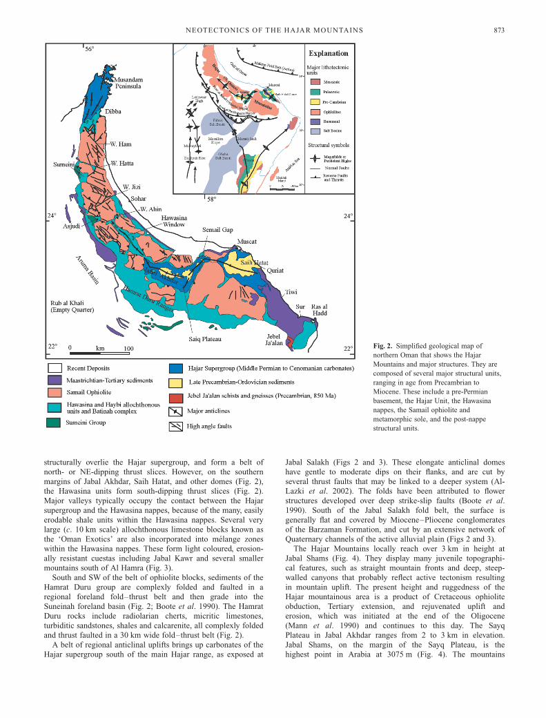
The Hajar Mountains locally reach over 3 km in height at
Jabal Shams (Fig. 4). They display many juvenile topographi-
cal features, such as straight mountain fronts and deep, steep-
walled canyons that probably reflect active tectonism resulting
in mountain uplift. The present height and ruggedness of the
Hajar mountainous area is a product of Cretaceous ophiolite
obduction, Tertiary extension, and rejuvenated uplift and
erosion, which was initiated at the end of the Oligocene
(Mann et al. 1990) and continues to this day. The Sayq
Plateau in Jabal Akhdar ranges from 2 to 3 km in elevation.
Jabal Shams, on the margin of the Sayq Plateau, is the
highest point in Arabia at 3075 m (Fig. 4). The mountains
Fig. 2. Simplified geological map of
northern Oman that shows the Hajar
Mountains and major structures. They are
composed of several major structural units,
ranging in age from Precambrian to
Miocene. These include a pre-Permian
basement, the Hajar Unit, the Hawasina
nappes, the Samail ophiolite and
metamorphic sole, and the post-nappe
structural units.
NEOTECTONICS OF THE HAJAR MOUNTAINS 873

decrease in height northward, reaching 2 km in the Musandam
Peninsula, where the mountain slopes drop directly into the
sea (Fig. 4).
Data and methods
Landsat TM and SIR-C radar data are used to produce a new structural
map of the Hajar Mountains (Fig. 5) assisted by field observations and
SPOT data analysis. Eight Landsat scenes are used in this study; the path
and row numbers are: 157–045, 157–044, 158–045, 158–044, 159–045,
159–044, 159–043 and 160–042. Six L-band and 6 C-band SIR-C
scenes are used; the processing run numbers are: 13144–13147 (April
1994 images) and 42794–42797, 46407-10 (October 1994 images). One
high-resolution SPOT image is used with a path and row number of
169–304.
Landsat TM data have a resolution of 28.5 m2. They reflect the
lithological and mineralogical variations of exposed rocks and soils by
separating the solar reflected energy into six spectral bands. Thermal
emitted energy is also collected in a separate band. TM bands 7 (2.08–
2.35 �m), 4 (0.76–0.90 �m) and 2 (0.50–0.60 �m) are used in this
analysis because they have low correlation and produce high-contrast
images suitable for geological interpretation. In this study, band 2 is
helpful for rock discrimination, band 4 for land–water contrasts, and
band 7 for discrimination of mineral and rock types (Jensen 2000, p.
194). The ability of Landsat data to aid in the identification of rock types
distinguishes them from radar data, which discern different lithological
units because of different surface roughnesses (e.g. Robinson 1998;
Inzana et al. 2003).
SIR-C data are processed using CEOS-READER (Committee on Earth
Observation Satellites) software (obtainable from the Jet Propulsion
Laboratory, Pasadena, CA). The resulting images have a resolution of
25 m. Images for all bands (L and C) and polarizations were generated.
The application of histogram equalization stretches and edge filters
(either simple 3 3 3 Laplacian filters or modified subtraction filters) is
particularly useful in the enhancement of SIR-C data (e.g. Robinson et
al. 1999).
Recognition of tectonic features in radar images is dependent on
viewing geometry and incidence angle. If these circumstances are
favourable, then radar images can be used to identify regionally extensive
Fig. 3. Landsat TM 742 band image
mosaic of the Hajar Mountains and the
surrounding landscape. Major
geomorphological units and place names
mentioned in the text are labelled. The 742
band combination is commonly used for
geological analysis. Placing band 7 in the
Red Gun emphasizes rock types.
Furthermore, little correlation exists
between these bands, which produces a
high-contrast image suitable for
interpretation.
T. KUSKY ET AL .874
linear features that are otherwise not clearly depicted in TM data (e.g.
Sabins et al. 1980; Robinson 1998; Robinson & Kusky 1998; Kusky &
Ramadan 2002). This is because the surface albedo in these images varies
much more than in optical imagery (as they respond to lithological, not
mineralogical, characteristics). This means that if the fault scarps are
oriented perpendicular to the radar look direction they appear brighter than
those parallel to the look direction, because the radar wave is backscattered
directly to the receiving antenna in this geometric configuration.
Principal structures are mapped in the field and using Landsat images
(Fig. 3), supplemented by SIR-C image interpretation, where the latter
are available. On-screen digitizing is applied to the satellite images to
generate digital maps of structural features in vector format. The
procedure uses geometrically corrected images as a template, which
further allows the geolocation of the interpreted structural features. The
spatial databases are created using ‘ESRI’s Arc/Info’ GIS software.
Principal youthful structural features are visible as distinct lines cutting
rocks that are Miocene or younger in age. Gently dipping thrusts and
shear zones, such as the basal thrust and metamorphic sole of the
ophiolite, are not included in the new fault and fracture maps. However,
these faults are mapped on the geological maps of the country
(Directorate General of Minerals 1993), and are consulted while mapping
the fault and fracture zones in the field and from the Landsat images.
There is a general agreement between the geological maps and the new
structural interpretation shown in Figure 5. Our new maps, however,
show additional faults and fractures that are not included on the
geological maps. These are discussed below.
Integrated image analysis and structural field mapping
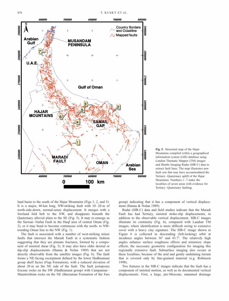
The WNW–NW-striking Tertiary–Quaternary fault set includes
numerous faults that parallel the mountain front in the central
and eastern Hajar range, and cut the mountains obliquely in the
northern Hajar region (Fig. 5). They comprise a major array of
linked faults developed with c. 50 km spacing. The most notable
of the north- to NNE-striking fault set run along the Samail Gap
(Fig. 5). They too form a major group of faults characterized by
c. 50 km spacing. Seven localities with examples of these faults
sets, and the associated Tertiary–Quaternary movement, are
described below.
1. Maradi Fault (WNW striking)
The Maradi Fault (centred on 228159N, 588E) is one of the major
WNW–NW-striking faults and is located in the Suneinah fore-
Fig. 4. Digital elevation model (DEM)
generated from 1:100 000 scale
topographical maps lent by the Ministry of
Water Resources, Oman. Significant
topographical features are labelled. The
DEM shows that the highest elevations are
found in Jabal Akhdar.
NEOTECTONICS OF THE HAJAR MOUNTAINS 875
land basin to the south of the Hajar Mountains (Figs 1, 2, and 5).
It is a major, 60 km long, NW-striking fault with 10–20 m of
north-side-down, normal-sense displacement. It merges with a
foreland fold belt to the NW, and disappears beneath the
Quaternary alluvial plain to the SE (Fig. 5). It may re-emerge as
the Saiwan–Nafun Fault in the Huqf area of central Oman (Fig.
2), or it may bend to become continuous with the north- to NW-
trending Oman line to the NW (Fig. 1).
The fault is associated with a number of west-striking minor
faults that intersect the Maradi Fault in a systematic fashion
suggesting that they are pinnate fractures, formed by a compo-
nent of sinistral shear (Fig. 5). It may also have older dextral or
dip-slip displacements (Hanna & Nolan 1989) that are not
directly observable from the satellite images (Fig. 6). The fault
forms a NE-facing escarpment defined by the lower Hadhramaut
group shelf facies (Fiqa Formation), with a reduced elevation of
about 20 m on the NE side of the fault. The fault juxtaposes
Eocene rocks on the SW (Hadhramaut group) with Campanian–
Maastrichtian rocks on the NE (Barzaman Formation of the Fars
group) indicating that it has a component of vertical displace-
ment (Hanna & Nolan 1989).
Radar (SIR-C) data and field studies indicate that the Maradi
Fault has had Tertiary, sinistral strike-slip displacements, in
addition to the observable vertical displacement. SIR-C images
illustrate its continuity (Fig. 6), compared with Landsat TM
images, where identification is more difficult owing to extensive
cover with a heavy clay signature. The SIR-C image shown in
Figure 6 is collected in descending (left-looking) orbit at
incidence angles between 368 and 43.78. The relatively high
angles enhance surface roughness effects and minimize slope
effects, the necessary geometric configuration for imaging this
regionally extensive fault. Subsurface imaging also occurs at
these localities, because of the arid and gently undulating terrain
that is covered only by fine-grained material (e.g. Robinson
1998).
Two features in the SIR-C images indicate that the fault has a
component of sinistral motion, as well as its documented vertical
displacements. First, a large, pre-Miocene, unnamed drainage
Fig. 5. Structural map of the Hajar
Mountains compiled within a geographical
information system (GIS) database using
Landsat Thematic Mapper (TM) images
and Shuttle Imaging Radar (SIR-C) data to
extract fault lines. The map illustrates new
fault sets that may have accommodated the
Tertiary–Quaternary uplift of the Hajar
Mountains. Numbers 1–7 index the
localities of seven areas with evidence for
Tertiary–Quaternary faulting.
T. KUSKY ET AL .876

Fig. 6. L band SIR-C image overlain on a
Landsat TM image of the area. The arrows
point to the leftward displacement of an
unnamed drainage channel. The Upper Fars
Group Tertiary palaeo-surface across the
fault is labelled. This indicates that the
Maradi Fault experienced sinistral motion
since the Tertiary. In the SIR-C image,
drainage trends approximately NE
compared with north–south in the TM
image.
Fig. 7. Photograph of the Maradi Fault scarp (c. 10 m high). It shows
Neogene gravels that are faulted (the label points to such an example)
and Quaternary gravels that are not. Thus, movement along the fault
must have been confined to the Tertiary.
NEOTECTONICS OF THE HAJAR MOUNTAINS 877

channel is displaced in a left-lateral direction (Fig. 6). This river
bed is more defined on the L band image than the C band image
(Robinson & Kusky 1998), indicating that it exists below 50 cm
and up to 2 m in the subsurface (Schaber et al. 1997). Further
evidence of subsurface imaging at these locations comes from
the radar drainage pattern that is shifted slightly from the surface
drainage seen in the TM image at southerly locations (Fig. 6). In
the SIR-C image, drainage trends approximately NE–SW,
whereas the surface trend of drainage visible in the TM is
dominantly north–south (Fig. 6).
The second piece of evidence supporting sinistral strike-slip
movement on the fault comes from the Tertiary ferruginized and
karstified palaeosurface of the Upper Fars group that is displaced
to the left in the SIR-C image (Fig. 6), again supporting sinistral
strike-slip movement of the fault. Thus, sinistral strike-slip
displacements must have taken place along the Maradi Fault
during the Tertiary period. This age determination is also
supported by field observations showing that Neogene semi-
consolidated non-marine gravels are cut by the Maradi Fault, but
unconsolidated Quaternary gravels are not cut by fault-related
structures (Fig. 7).
2. Quriyat and Tiwi region (WNW and NNE striking)
Clear evidence for young uplift of the Hajar Mountains comes
from the Quriyat and Tiwi areas (Fig. 8). Both major sets of
young faults are identified here. The regional picture shows that
the WNW-striking set comprises a major group or array of linked
faults occurring with c. 50 km spacing. The NNE-striking set
also shows c. 50 km spacing between fault arrays, and is
intersected by a third, NE-striking fault set that shows less well-
developed 50–100 km spacing between arrays. All of these faults
cut the Tertiary limestones and several cut Quaternary marine
terraces.
Fig. 8. Structural map of the Quriyat–Tiwi
region. It shows that both the WNW-
trending and the NNE-trending faults form
a major array of linked structures, with
about 50 km spacing. All these faults cut
Tertiary limestones and several cut
Quaternary marine terraces, providing clear
evidence for young uplift of the Hajar
Mountains here.
T. KUSKY ET AL .878
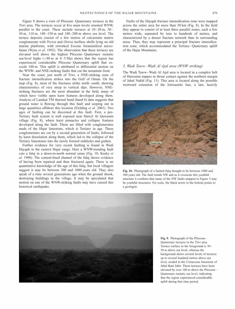
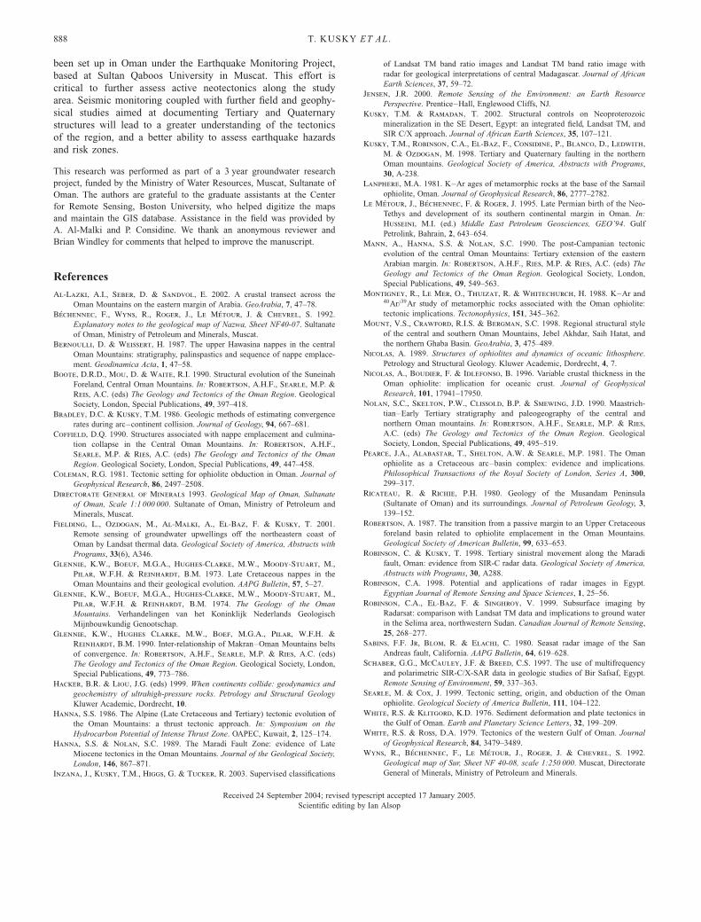
Figure 9 shows a view of Pliocene–Quaternary terraces in the
Tiwi area. The terraces occur at five main levels oriented WNW,
parallel to the coast. These include terraces at 10–20 m, 30–
50 m, 110 m, 140–150 m and 180–200 m above sea level. The
terrace deposits consist of a few metres of calcarenite matrix
conglomerate with Pecten and Ostrea mollusc shells lying on old
marine platforms, with reworked Eocene foraminiferal micro-
fauna (Wyns et al. 1992). The observation that these terraces are
elevated well above the highest Pliocene–Quaternary eustatic
sea-level highs (þ80 m at 4–5 Ma) shows that the region has
experienced considerable Pliocene–Quaternary uplift that ex-
ceeds 100 m. This uplift is attributed to differential motion on
the WNW- and NNE-striking faults that cut the mountain front.
Near the coast, just north of Tiwi, a NNE-striking zone of
fracture intensification strikes into the Gulf of Oman. On the
map (Fig. 8), most of the fractures strike north–south, showing
characteristics of very steep to vertical dips. However, NNE-
striking fractures are the most abundant in the field, many of
which have visible open karst features developed along them.
Analysis of Landsat TM thermal band (band 6) data suggests that
ground water is flowing through this fault and seeping out in
large quantities offshore this location (Fielding et al. 2001). Two
ages of faulting can be discerned at this fault. First, a pre-
Tertiary fault system is well exposed near Hawyl Al Quwasim
village (Fig. 8), where karst pinnacles and collapse features
developed along the fault. These are filled with conglomerates
made of the Hajar limestone, which is Tertiary in age. These
conglomerates are cut by a second generation of faults, followed
by karst dissolution along them, which led to the collapse of the
Tertiary limestones into the newly formed sinkholes and graben.
Further evidence for very recent faulting is found in Wadi
Dayqah in the eastern Hajar range. Here a WNW-trending fault
cuts a falaj in a down-to-north normal sense (Fig. 10; Kusky et
al. 1998). The cement-lined channel of the falaj shows evidence
of having been repaired and then fractured again. There is no
quantitative knowledge of the age of this falaj, but local villagers
suggest it may be between 300 and 1000 years old. They also
speak of a time several generations ago when the ground shook,
destroying buildings in the village. It may be speculated that
motion on one of the WNW-striking faults may have caused this
historical earthquake.
Faults of the Dayqah fracture intensification zone were mapped
across the entire area for more than 50 km (Fig. 8). In the field
they appear to consist of at least three parallel zones, each a few
metres wide, separated by tens to hundreds of metres, and
characterized by a denser fracture network than in surrounding
areas. Thus, they may represent a principal fracture intensifica-
tion zone, which accommodated the Tertiary–Quaternary uplift
of the Hajar Mountains.
3. Wadi Taww–Wadi Al Ajal area (WNW striking)
The Wadi Taww–Wadi Al Ajal area is located in a complex belt
of Hawasina nappes in thrust contact against the northern margin
of Jabal Nakhl (Fig. 11). This area is located along the possible
westward extension of the listwaenite line, a late, heavily
Fig. 9. Photograph of the Pliocene–
Quaternary terraces in the Tiwi area.
Terrace surface in the foreground is 30–
50 m above sea level, whereas the
background shows several levels of terraces
up to several hundred metres above sea
level, eroded in the Cretaceous limestone of
Jabal Bani Jabir. These terraces have been
elevated by over 100 m above the Pliocene–
Quaternary eustatic sea level, indicating
that the region experienced considerable
uplift during that time period.
Fig. 10. Photograph of a faulted falaj thought to be between 1000 and
300 years old. The fault trends NW and as it crosscuts this youthful
structure it confirms that many of the NW faults mapped in Figure 5 may
be youthful structures. For scale, the black arrow in the bottom points to
a geologist.
NEOTECTONICS OF THE HAJAR MOUNTAINS 879

mineralized fault that strikes WNW across the north end of Jabal
Nakhl.
At Wadi Taww, Hawasina nappes and interthrust ophiolitic
slices are overlain by several levels of Quaternary gravel terraces,
with the lower terrace deposits being cemented and the upper
terrace deposits being only partly cemented. A detailed map
(Fig. 12) was made of the lower terrace that directly overlies the
Hawasina Group, and a reconnaissance survey of other units in
the area was also carried out to make structural measurements of
faults cutting the different units. The detailed map clearly shows
the complex deformation in the Hawasina nappes, but more
relevant to this study is the observation that two sets of faults
(WNW and NNE) cut both the Cretaceous Hawasina sedimentary
rocks and the Quaternary gravels; therefore, these faults are
demonstrably of Quaternary age.
4. Bahla–Bisyah region (NW and NNE striking)
The area around Bisyah is structurally complex in terms of
faulting. It is situated at the extrapolated junction of two major
late fracture zones, one striking NW and the other NNE (Fig.
13). The regional fracture intensification zone is not exposed in
Bisyah because of the extensive alluvial cover of Wadi Sayfam
and its tributaries. Two complementary approaches were taken in
the field to better understand the NW- and NNE-striking fracture
zones. First, field analysis of outcrops in rocks of the Hamrat
Duru group exposed near Bisyah and in the mountains to the
north and NW was aimed at locating and characterizing any
minor structures that may be associated with the main faults.
Second, time domain electromagnetic (TDEM) geophysical
surveys were carried out, and seismic reflection profiles were
obtained from the petroleum industry, both of which cross the
alluvial channels and plains (Fig. 13). These geophysical techni-
ques are directed at finding deep channels and buried fault
traces.
With respect to the first approach, Figure 13 shows the
orientation of fractures in the ophiolite (Fig. 13, plot a) and in
the Hawasina units (Fig. 13, plot b) in the Bani Shukayl area of
Bisyah. Fractures in both units have a wide range of orientations,
but show two concentrations, the strongest of which relates to a
NW-striking set and the other to a NNE-striking set (Fig. 13).
These faults are generally open structures, although calcite veins
Fig. 11. Landsat TM image showing the
location of the Wadi Taww–Wadi Al Ajal
area, on the northern margin of Jabal
Nakhl. This area is located along the
listwaenite line, a late, heavily mineralized
fault that strikes WNW.
T. KUSKY ET AL .880

seal some. Many faults have karst features developed along them,
with strings of caves visible along the faults. Some large caverns
on Jabal Kawr, for example, are developed at the intersections of
conjugate faults.
Another outcrop demonstrates the presence of the north–NNE
and WNW sets of faults, 7 km north of Bisyah (Fig. 13; plot c).
Pink and white limestone breccia of the Triassic–Cretaceous
Aqil Formation (Umar group of the Hawasina nappes) is exposed
here, where the intersection of two major faults can be examined.
Both major faults are more than 5 m wide and are characterized
by highly porous fault breccia, and many minor faults splaying
off the major structures. The minor faults have a wide range of
orientations, the most abundant of which strike NE (Fig. 13,
plot c).
In the Bahla region, a major north–south lineament is mapped
from the satellite imagery. In the field, structural manifestations
of this fault occur in outcrops on both sides of the north–south-
striking fault zone. The measurement of c. 80 fractures from this
location reveals two statistical concentrations into a north-
striking, east-dipping set and a WNW steeply north-dipping set
(Fig. 13, plot a). Farther SE at location c (Fig. 13), the north-
striking fault set is still present, but fractures of this set are
overwhelmed in number by both NE-striking, NW- and SE-
dipping conjugate faults, and NW-striking, NE- and SW-dipping
conjugate faults (Fig. 13, plot c).
West of Bahla, more closely spaced and wider strands of a
NNE-striking fault system are present, suggesting closer proxi-
mity to a major fault (Fig. 13, plot d). The faults in the outcrop
are similar in character to those at outcrop a, but also include
some serpentinized ductile shear zones that splay into brittle
fractures, which form pinnate joints of a dextral system. On the
east side of Bahla, an outcrop of cumulate gabbro was examined
(Fig. 13, location b), and this is cut by faults of both the NNE
and the WNW sets.
Thus, structural data from the Bahla area suggest that a major
NNE-striking dextral fault passes through the town and that this
fault is associated with NE- and WNW-striking minor faults.
Figure 14 shows an interpretation of seismic profiles across
Wadi Sayfam. These are important in that they show prominent
faults extending to several kilometres depth, and the surface
traces of these faults coincide with lineaments mapped from the
TM images. This confirms that the NW- and NE-striking fracture
intensification zones exist at depth and that they reach several
hundred kilometres in length (Fig. 1).
5. Al Hamra area (NNE and NW striking)
Several areas on the southern flank of Jabal Akhdar preserve
evidence of young faulting along both the north–NNE trend and
the WNW–NW trend, as described below. For example, Al
Hamra area features prominent trellis and parallel drainage that
suggests association with fractures (Fig. 15). The SPOT image of
the area SE of Misfah, near Al Hamra, shows a small swarm of
NW-striking faults intersecting the main north–south fault.
In the field it is clear that a NE-facing escarpment south of
Misfah is formed by erosion of one of the NW-striking faults that
continues into Wadi Ma’qal (Fig. 15). Many small caves are
developed along this part of the fault system. At this location a,
exposures of Cretaceous (Albian–Cenomanian) limestone of the
Natih Formation are cut by NW- and NE-striking faults and
joints (Fig. 15, plot a). It is observed that fractures of the NW-
striking set are spaced at c. 50–100 cm, whereas those of the
NE-striking set are spaced approximately every metre. Both sets
are generally open, apparently young fractures, with apertures (at
the surface) of several millimetres. At location b near Misfah
village, the NE and NW faults and fractures are present, as well
as an additional set of north-striking, vertical fractures that
control the Misfah gorge orientation (Fig. 15, plot b).
6. Ghul area (north–south striking)
A north–south-striking fault with Quaternary displacements cuts
through the Wadi Ghul–Wadi Nakhr region, along the southern
flank of the central Hajar range (Fig. 16). It forms the western
boundary to the ‘Grand Canyon’ of Oman, which offers more
than 1000 m of vertical relief (Fig. 4). The juvenile topography
of the Grand Canyon–Wadi Ghul area suggests that it formed by
relatively recent uplift, and that erosion has not yet had a chance
to develop a more mature landscape. Furthermore, fieldwork in
the southern part of the area, SW of the modern Ghul village
(Fig. 16), shows that a cemented Quaternary terrace in the wadi
bed is preserved c. 10 m below a less cemented terrace. The
older terrace is remarkable in that it is cut by a number of faults
(Fig. 16, plot a), including several subparallel strands of a north–
south-trending fault that is parallel to the major north–south
fault mapped as the western margin of Wadi Nakhr and the
Grand Canyon. The fault (Fig. 17) cuts some cobbles in the
Fig. 12. A detailed map of the lower Quaternary gravel terrace found
upstream in Wadi Taww. The map shows that the WNW and NNE faults
cut Cretaceous Hawasina sedimentary rocks and Quaternary gravels.
NEOTECTONICS OF THE HAJAR MOUNTAINS 881

conglomerate and curves around others, showing that it formed
at very shallow levels.
7. Faulted Quaternary terrace in Al Ghail, UAE (WNWstriking)
Field investigations were also carried out in the neighbouring
regions of the UAE where the analysis of Landsat images
suggests that some young faults may cut Quaternary fluvial
terraces (Fig. 18). An area upstream from Al Ghail on the
western slopes of the Hajar Mountains was investigated where
the Landsat TM image shows a prominent NW-striking fault.
Several areas with Quaternary terraces (estimated to be about
100 ka old) are exposed, providing an opportunity to investigate
the age relationship between various sets of faults and terraces.
A low cemented fluvial terrace at this location shows several
Fig. 13. Landsat TM image of the Bahla–
Bisyah area with transects of seismic
reflection profiles (dotted lines). Bisyah is
located at the intersection of a major NW-
striking and north–south-striking fracture
intensification zones. Labels denote places
where detailed structural measurements
were made in the field. Stereonets from the
Bahla area (above the image) show
orientation of fractures at locations a, b, c
and d near Bahla. Stereonets below the
image show orientation of fractures (a and
c) and beds (b) near Bisyah.
T. KUSKY ET AL .882

tectonic fractures, some of which cut clasts in the gravel. A large
Quaternary fault that cuts both the cemented and the overlying
uncemented terraces is exposed 10 km up the wadi from Al
Ghail. The fault is one of the WNW sets that cut the mountain
range in many places and consists of a zone about half a metre
thick of brecciated gravel exposed as fault gouge. The fault cuts
through the lower 15 m thick terrace, and continues into the
overlying wadi terrace (Fig. 19).
A model for the neotectonics of the Hajar Mountains,and tectonic controls on uplift, subsidence and theformation of the late fault sets
The Hajar Mountains reside on the foreland margin of the active
collision zone between the passive Arabian margin and the
Zagros–Makran fold belts (Fig. 1). This collision involves the
shallow subduction of continental crust of the Arabian Shield
Fig. 14. Interpretations of the seismic
profiles taken across Wadi Sayfam. Profile
‘Bisyah’ is the southeasternmost profile;
line ‘North of Bisyah’ is the
northwesternmost profile. These show
prominent faults that extend to several
kilometres depth. The surface traces of
these faults (indicated by vertical arrows on
lines of section) correspond to the WNW
and north–south fracture intensification
zones mapped from the Landsat TM image.
NEOTECTONICS OF THE HAJAR MOUNTAINS 883

beneath the Zagros Mountains in the west, with shallow waters
of the Persian (Arabian) Gulf in the active foredeep (Glennie et
al. 1990; Mann et al. 1990). East of the Dibba Line on the
Arabian margin, and the Zendan Fault in Iran, the collision
includes stretched continental crust grading into sea floor in the
Gulf of Oman (White & Klitgord 1976), which is being
subducted beneath the Makran accretionary wedge (Fig. 1).
The tectonic history of the northern Oman margin is complex,
including the development of a Permian–Cretaceous carbonate
platform on the southern margin of the Tethys, a remnant of
which is preserved in the Gulf of Oman (Mann et al. 1990). Late
Cretaceous deformation associated with the collision of the north
Oman margin with a probable forearc environment terminated
passive margin sedimentation, emplaced the Samail ophiolite
(Glennie et al. 1973, 1974; Pearce et al. 1981), and initiated
foredeep sedimentation in the Aruma foreland basin on the
eastern edge of the Arabian plate (Robertson 1987). Emplace-
ment of the Samail ophiolite was thus associated with closure of
the Tethys, although the ophiolite is probably forearc lithosphere
and not true Tethyan oceanic lithosphere. Ophiolite emplacement
strongly deformed and imbricated the shelf sediments of the
Hajar Group, oceanic and continental slope sediments of the
Hawasina and Sumeini Groups, and formed metamorphic rocks
of the dynamothermal aureole. The large basement-cored anti-
formal domes of Jabal Akhdar, Nakhl and Saih Hatat are
probably related to movement of the entire thrust package over
deep basement thrust ramps, deep duplexing, or blind thrust
faults propagating under the domes in the Late Cretaceous (e.g.
Hanna 1986; Coffield 1990; Al-Lazki et al. 2002). This deforma-
tion ended by Late Campanian (Glennie et al. 1974). Latest
Cretaceous and Early Tertiary rocks record shallow marine,
quiescent conditions.
Convergence between the north Oman margin and the
Zagros–Makran appears to have been re-established by the
Eocene (Coleman 1981; Mann et al. 1990). Contractional
structures on Musandam have been related to Arabian–Zagros
convergence, whereas Tertiary structures in the central Oman
Mountains have been variously ascribed to gravity tectonics
(Glennie et al. 1974) or down-to-the-basin normal faults along
the Batinah coastal plain (Mann et al. 1990). Mann et al. (1990)
and Nolan et al. (1990) showed how Maastrichtian–Oligo-
Miocene structures have controlled the distribution of several of
Fig. 15. SPOT image (169–304) of Al
Hamra, on the southern flanks of Jabal
Akhdar. It shows a swarm of NW-striking
faults that intersect the NNE-trending fault.
The stereonets further confirm the
prevalence of the NW and NE faults at
locations a and b. Both fault sets are
generally open, with apertures of several
millimetres at the surface.
T. KUSKY ET AL .884

the Tertiary stratigraphic units, and that the Saih Hatat dome
remained high during this period.
The contact between the Tertiary sedimentary sequence and
the Samail ophiolite on the Batinah coastal plain is in many
places a WNW-striking normal fault, downthrown toward the
Gulf of Oman (Mann et al. 1990). Listric faults with roll-over
anticlines are present, as are horsts and grabens, accommodation
structures and antithetic normal faults (Mann et al. 1990). The
Late Tertiary structures have a consistent down-to-the-north or
-NE sense on the Batinah Plain, and appear to be continuous
with extensional structures in the Gulf of Oman (White & Ross
1979). Although Mann et al. (1990) recognized the Tertiary
extensional province on the Batinah plain, they were not able to
provide any clear tectonic cause for the extension, suggesting
that perhaps the structural culminations of Saih Hatat and Nakhl
were collapsing, or that gravity tectonics initiated extension. We
recognize that this extension has continued through the Quatern-
ary, and present a new tectonic mechanism that explains the
regional pattern of faulting.
The driving forces for Late Tertiary–Quaternary uplift in
the northern Oman Mountains are most probably related to the
contemporaneous collision between the NE margin of the Arabian
plate and the Zagros fold belt and the Makran accretionary prism.
The axis of recent uplift in the Hajar Mountains lies about 150 km
from the active thrust front of the Makran prism, suggesting that
the NW and WNW faults may be outer-trench slope normal faults
(e.g. Bradley & Kusky 1986) that accommodate uplift on the
flexural bulge of this collision. The NNE-striking faults are
interpreted as tear faults separating blocks that have slightly
different rotational histories. The inferred strike-slip motions of
some of the WNW-striking faults are enigmatic. The geometry of
the Makran–Arabia collision implies that these faults may have a
component of dextral shear, as suggested by Hanna & Nolan
(1989). However, new observations presented here suggest that
the Maradi fault may also have experienced sinistral motions. Al-
Lazki et al. (2002) presented deep seismic data that help resolve
the conflicting kinematics inferred for the Maradi Fault. They
showed that the Maradi Fault (Fig. 5) is a deeply penetrating thrust
fault, which displaces the top of the Hajar Supergroup 900 m up
on the NE side of the fault. The fault breaks into many splays near
the surface, forming a flower structure, some strands of which
show normal displacements and some of which show thrust and
strike-slip displacements.
Geomorphological features of the Musandam Peninsula reveal
that an east–west-striking flexure passes through the centre of
the peninsula. The flexure marks a drainage divide, where wadis
Fig. 16. SPOT image (169–304) of the
Wadi Ghul–Wadi Nakhr region, near the
Grand Canyon region of Jabal Akhdar,
which is cut by the north–south-striking
fault. The stereonet shows the presence of
the north–south fault along with the WNW
structures at location c.
NEOTECTONICS OF THE HAJAR MOUNTAINS 885

to the north of the line flow to the north and those to the south of
it flow to the south (see Fig. 20). The mountains are higher in
the south, and become progressively lower and more subdued to
the north. Valleys to the north of the drainage divide are drowned
and flooded by the sea, whereas to the south the valleys are still
alluvial.
We interpret these features to mark the position of the flexural
bulge on the Musandam Peninsula. The area north of the
drainage divide is dipping to the north and subsiding under the
weight of the Zagros fold belt; hence, the drowning of the valleys
and the gently north-sloping maximum elevation surface. The
area south of the divide is on top of the flexural bulge, or just
moving up to the maximum height as the bulge migrates south-
ward. Numerous raised beaches have been recognized in this area
(Ricateau & Richie 1980).
The flexural bulge axis is located considerably further south in
the western and eastern Hajar Mountains, and we suggest that it
is offset across the Dibba Zone (Figs 1 and 2), which apparently
separates blocks of different types of lithosphere on the west and
east. The southward displacement of the bulge axis also corre-
sponds to the southward displacement of the thrust front (and
load) from the Zagros to the Makran across the Zendan Fault
(Fig. 1). The flexural lithospheric thickness and rigidity of the
Arabian lithosphere must increase toward the SE, as the bulge
axis appears to broaden and move further from the thrust front in
this direction.
Conclusions
The present work integrates remote sensing, field mapping and
GIS techniques to reveal evidence that two major sets of late
Fig. 17. Photograph of a cemented Quaternary terrace in the Wadi Ghul
area. The older terrace is cut by several strands of a north–south-trending
fault, indicating that faulting in this area continued into the Quaternary.
Ancient house of Old Ghul village in the centre of the photograph gives
scale.
Fig. 18. Landsat TM image of Al Ghail in the UAE. It shows a large
NW fault, of the WNW trend, crosscutting the area. This fault appears to
cut several Quaternary fluvial terraces as indicated in the TM image.
This was confirmed in the field (Fig. 20), supporting Quaternary
movement along the fault at this location.
Fig. 19. Photograph of a cemented Quaternary deposit, which is cut by a
fault of the WNW set, overlying uncemented wadi terraces. The fault
cuts through the lower 15 m thick terrace, and continues into the
overlying wadi terrace.
T. KUSKY ET AL .886

faults and fracture intensification domains are responsible for
Tertiary–Quaternary uplift of the northern Oman Mountains.
Evidence for the young age of uplift and faulting includes
juvenile topography, faulted Quaternary marine terraces and a
fractured falaj. The young faults occur as a WNW-striking set
parallel to the Maradi Fault with a major group or array of linked
faults occurring with c. 50 km spacing. A second set of dextral
faults striking NNE shows less well-developed 50–100 km
spacing between arrays. It is suggested that the two late fault
systems described here may have accommodated Tertiary–
Quaternary uplift of the northern Oman Mountains, and can
account for the previously unexplained juvenile topography.
A new tectonic mechanism is proposed to explain the regional
pattern of faulting and the Tertiary–Quaternary extension. The
driving forces for Late Tertiary–Quaternary uplift in the northern
Oman Mountains are most probably related to the contempora-
neous collision between the NE margin of the Arabian plate, the
Zagros fold belt and the Makran accretionary prism, suggesting
that the axis of recent uplift in the Hajar Mountains lies about
150 km from the active thrust front of the Makran prism. This
implies that the NW and WNW faults may be outer-trench slope
normal faults (e.g. Bradley & Kusky 1986) that accommodate
uplift on the flexural bulge of this collision. This is further
supported by their similarity to those faults in active and ancient
forebulge environments, including the amount of Quaternary
uplift, estimated between 100 and 500 m. The NNE-striking
faults are interpreted as tear faults separating individual blocks
that have slightly different rotational histories.
The axis of uplift is offset to the north across the Dibba line
(striking NE) to the Musandam Peninsula (Figs 2 and 20),
suggesting that it marks a fundamental lithospheric break. The
Dibba line is close to parallel to the Zendan Fault separating the
Makran and Zagros fold belts in Iran, suggesting that this break
has manifestations in both the upper and lower plates. The offset
of the axis of uplift could be related to different lithospheric
thicknesses or flexural rigidities of blocks on either side on the
lower plate, or could be related to differences in the load
geometry on the upper plate.
Implications for active tectonics and seismic hazards
Data presented here show that the Hajar Mountains of northern
Oman and the UAE have undergone very recent to active
deformation and uplift, and therefore the region has more
serious seismic risks than previously appreciated. Global posi-
tioning system and seismic monitoring stations have recently
Fig. 20. Drainage map of the Musandam
Peninsula, showing the drainage divide with
wadis flowing north and south on either
side. This divide is thought to indicate a
flexural bulge that resulted from a collision
between the NE margin of the Arabian
plate and the Zagros fold belt and the
Makran accretionary prism in Late Tertiary
to Quaternary time. The mountains are
higher to the south of the bulge axis and
progressively become lower and more
subdued in the north (Fig. 4).
NEOTECTONICS OF THE HAJAR MOUNTAINS 887
been set up in Oman under the Earthquake Monitoring Project,
based at Sultan Qaboos University in Muscat. This effort is
critical to further assess active neotectonics along the study
area. Seismic monitoring coupled with further field and geophy-
sical studies aimed at documenting Tertiary and Quaternary
structures will lead to a greater understanding of the tectonics
of the region, and a better ability to assess earthquake hazards
and risk zones.
This research was performed as part of a 3 year groundwater research
project, funded by the Ministry of Water Resources, Muscat, Sultanate of
Oman. The authors are grateful to the graduate assistants at the Center
for Remote Sensing, Boston University, who helped digitize the maps
and maintain the GIS database. Assistance in the field was provided by
A. Al-Malki and P. Considine. We thank an anonymous reviewer and
Brian Windley for comments that helped to improve the manuscript.
References
Al-Lazki, A.I., Seber, D. & Sandvol, E. 2002. A crustal transect across the
Oman Mountains on the eastern margin of Arabia. GeoArabia, 7, 47–78.
Bechennec, F., Wyns, R., Roger, J., Le Metour, J. & Chevrel, S. 1992.
Explanatory notes to the geological map of Nazwa, Sheet NF40-07. Sultanate
of Oman, Ministry of Petroleum and Minerals, Muscat.
Bernoulli, D. & Weissert, H. 1987. The upper Hawasina nappes in the central
Oman Mountains: stratigraphy, palinspastics and sequence of nappe emplace-
ment. Geodinamica Acta, 1, 47–58.
Boote, D.R.D., Mou, D. & Waite, R.I. 1990. Structural evolution of the Suneinah
Foreland, Central Oman Mountains. In: Robertson, A.H.F., Searle, M.P. &
Reis, A.C. (eds) The Geology and Tectonics of the Oman Region. Geological
Society, London, Special Publications, 49, 397–418.
Bradley, D.C. & Kusky, T.M. 1986. Geologic methods of estimating convergence
rates during arc–continent collision. Journal of Geology, 94, 667–681.
Coffield, D.Q. 1990. Structures associated with nappe emplacement and culmina-
tion collapse in the Central Oman Mountains. In: Robertson, A.H.F.,
Searle, M.P. & Ries, A.C. (eds) The Geology and Tectonics of the Oman
Region. Geological Society, London, Special Publications, 49, 447–458.
Coleman, R.G. 1981. Tectonic setting for ophiolite obduction in Oman. Journal of
Geophysical Research, 86, 2497–2508.
Directorate General of Minerals 1993. Geological Map of Oman, Sultanate
of Oman, Scale 1:1 000 000. Sultanate of Oman, Ministry of Petroleum and
Minerals, Muscat.
Fielding, L., Ozdogan, M., Al-Malki, A., El-Baz, F. & Kusky, T. 2001.
Remote sensing of groundwater upwellings off the northeastern coast of
Oman by Landsat thermal data. Geological Society of America, Abstracts with
Programs, 33(6), A346.
Glennie, K.W., Boeuf, M.G.A., Hughes-Clarke, M.W., Moody-Stuart, M.,
Pilar, W.F.H. & Reinhardt, B.M. 1973. Late Cretaceous nappes in the
Oman Mountains and their geological evolution. AAPG Bulletin, 57, 5–27.
Glennie, K.W., Boeuf, M.G.A., Hughes-Clarke, M.W., Moody-Stuart, M.,
Pilar, W.F.H. & Reinhardt, B.M. 1974. The Geology of the Oman
Mountains. Verhandelingen van het Koninklijk Nederlands Geologisch
Mijnbouwkundig Genootschap.
Glennie, K.W., Hughes Clarke, M.W., Boef, M.G.A., Pilar, W.F.H. &
Reinhardt, B.M. 1990. Inter-relationship of Makran–Oman Mountains belts
of convergence. In: Robertson, A.H.F., Searle, M.P. & Ries, A.C. (eds)
The Geology and Tectonics of the Oman Region. Geological Society, London,
Special Publications, 49, 773–786.
Hacker, B.R. & Liou, J.G. (eds) 1999. When continents collide: geodynamics and
geochemistry of ultrahigh-pressure rocks. Petrology and Structural Geology
Kluwer Academic, Dordrecht, 10.
Hanna, S.S. 1986. The Alpine (Late Cretaceous and Tertiary) tectonic evolution of
the Oman Mountains: a thrust tectonic approach. In: Symposium on the
Hydrocarbon Potential of Intense Thrust Zone. OAPEC, Kuwait, 2, 125–174.
Hanna, S.S. & Nolan, S.C. 1989. The Maradi Fault Zone: evidence of Late
Miocene tectonics in the Oman Mountains. Journal of the Geological Society,
London, 146, 867–871.
Inzana, J., Kusky, T.M., Higgs, G. & Tucker, R. 2003. Supervised classifications
of Landsat TM band ratio images and Landsat TM band ratio image with
radar for geological interpretations of central Madagascar. Journal of African
Earth Sciences, 37, 59–72.
Jensen, J.R. 2000. Remote Sensing of the Environment: an Earth Resource
Perspective. Prentice–Hall, Englewood Cliffs, NJ.
Kusky, T.M. & Ramadan, T. 2002. Structural controls on Neoproterozoic
mineralization in the SE Desert, Egypt: an integrated field, Landsat TM, and
SIR C/X approach. Journal of African Earth Sciences, 35, 107–121.
Kusky, T.M., Robinson, C.A., El-Baz, F., Considine, P., Blanco, D., Ledwith,
M. & Ozdogan, M. 1998. Tertiary and Quaternary faulting in the northern
Oman mountains. Geological Society of America, Abstracts with Programs,
30, A-238.
Lanphere, M.A. 1981. K–Ar ages of metamorphic rocks at the base of the Samail
ophiolite, Oman. Journal of Geophysical Research, 86, 2777–2782.
Le Metour, J., Bechennec, F. & Roger, J. 1995. Late Permian birth of the Neo-
Tethys and development of its southern continental margin in Oman. In:
Husseini, M.I. (ed.) Middle East Petroleum Geosciences, GEO’94. Gulf
Petrolink, Bahrain, 2, 643–654.
Mann, A., Hanna, S.S. & Nolan, S.C. 1990. The post-Campanian tectonic
evolution of the central Oman Mountains: Tertiary extension of the eastern
Arabian margin. In: Robertson, A.H.F., Ries, M.P. & Ries, A.C. (eds) The
Geology and Tectonics of the Oman Region. Geological Society, London,
Special Publications, 49, 549–563.
Montigney, R., Le Mer, O., Thuizat, R. & Whitechurch, H. 1988. K–Ar and40Ar/39Ar study of metamorphic rocks associated with the Oman ophiolite:
tectonic implications. Tectonophysics, 151, 345–362.
Mount, V.S., Crawford, R.I.S. & Bergman, S.C. 1998. Regional structural style
of the central and southern Oman Mountains, Jebel Akhdar, Saih Hatat, and
the northern Ghaba Basin. GeoArabia, 3, 475–489.
Nicolas, A. 1989. Structures of ophiolites and dynamics of oceanic lithosphere.
Petrology and Structural Geology. Kluwer Academic, Dordrecht, 4, 7.
Nicolas, A., Boudier, F. & Idlefonso, B. 1996. Variable crustal thickness in the
Oman ophiolite: implication for oceanic crust. Journal of Geophysical
Research, 101, 17941–17950.
Nolan, S.C., Skelton, P.W., Clissold, B.P. & Smewing, J.D. 1990. Maastrich-
tian–Early Tertiary stratigraphy and paleogeography of the central and
northern Oman mountains. In: Robertson, A.H.F., Searle, M.P. & Ries,
A.C. (eds) The Geology and Tectonics of the Oman Region. Geological
Society, London, Special Publications, 49, 495–519.
Pearce, J.A., Alabastar, T., Shelton, A.W. & Searle, M.P. 1981. The Oman
ophiolite as a Cretaceous arc–basin complex: evidence and implications.
Philosophical Transactions of the Royal Society of London, Series A, 300,
299–317.
Ricateau, R. & Richie, P.H. 1980. Geology of the Musandam Peninsula
(Sultanate of Oman) and its surroundings. Journal of Petroleum Geology, 3,
139–152.
Robertson, A. 1987. The transition from a passive margin to an Upper Cretaceous
foreland basin related to ophiolite emplacement in the Oman Mountains.
Geological Society of American Bulletin, 99, 633–653.
Robinson, C. & Kusky, T. 1998. Tertiary sinistral movement along the Maradi
fault, Oman: evidence from SIR-C radar data. Geological Society of America,
Abstracts with Programs, 30, A288.
Robinson, C.A. 1998. Potential and applications of radar images in Egypt.
Egyptian Journal of Remote Sensing and Space Sciences, 1, 25–56.
Robinson, C.A., El-Baz, F. & Singhroy, V. 1999. Subsurface imaging by
Radarsat: comparison with Landsat TM data and implications to ground water
in the Selima area, northwestern Sudan. Canadian Journal of Remote Sensing,
25, 268–277.
Sabins, F.F. Jr, Blom, R. & Elachi, C. 1980. Seasat radar image of the San
Andreas fault, California. AAPG Bulletin, 64, 619–628.
Schaber, G.G., McCauley, J.F. & Breed, C.S. 1997. The use of multifrequency
and polarimetric SIR-C/X-SAR data in geologic studies of Bir Safsaf, Egypt.
Remote Sensing of Environment, 59, 337–363.
Searle, M. & Cox, J. 1999. Tectonic setting, origin, and obduction of the Oman
ophiolite. Geological Society of America Bulletin, 111, 104–122.
White, R.S. & Klitgord, K.D. 1976. Sediment deformation and plate tectonics in
the Gulf of Oman. Earth and Planetary Science Letters, 32, 199–209.
White, R.S. & Ross, D.A. 1979. Tectonics of the western Gulf of Oman. Journal
of Geophysical Research, 84, 3479–3489.
Wyns, R., Bechennec, F., Le Metour, J., Roger, J. & Chevrel, S. 1992.
Geological map of Sur, Sheet NF 40-08, scale 1:250 000. Muscat, Directorate
General of Minerals, Ministry of Petroleum and Minerals.
Received 24 September 2004; revised typescript accepted 17 January 2005.
Scientific editing by Ian Alsop
T. KUSKY ET AL .888