TERRESTRIAL RESOURCE MANAGEMENT PLAN - · PDF fileBoundary Hydroelectric Project Seattle City...
112
LICENSE APPLICATION EXHIBIT E Attachment E-3: Terrestrial Resources Management Plan Boundary Hydroelectric Project Seattle City Light FERC No. 2144 September 2009
Transcript of TERRESTRIAL RESOURCE MANAGEMENT PLAN - · PDF fileBoundary Hydroelectric Project Seattle City...

LICENSE APPLICATION EXHIBIT E
Attachment E-3: Terrestrial Resources Management Plan
Boundary Hydroelectric Project Seattle City Light FERC No. 2144 September 2009


Boundary Hydroelectric Project (FERC No. 2144)
Terrestrial Resources Management Plan
Seattle City Light
September 2009


TERRESTRIAL RESOURCES MANAGEMENT PLAN
TABLE OF CONTENTS
1 Introduction..............................................................................................................................1 1.1. Description of Project Area, Facilities, and Operations ......................................................1
1.1.1. Project Facilities........................................................................................................ 2 1.1.2. Project Boundary and Operations ............................................................................. 2 1.1.3. Environmental Setting .............................................................................................. 3
1.2. TRMP Purpose and Scope ...................................................................................................5 1.3. TRMP Content and Organization ......................................................................................18
2 Roles and Responsibilities, Communication, and Coordination .......................................19 2.1. Roles and Responsibilities .................................................................................................19
2.1.1. Seattle City Light .................................................................................................... 19 2.1.2. Terrestrial Resources Workgroup (TRWG)............................................................ 19
2.2. Communication and Coordination.....................................................................................20 2.2.1. Meetings and Decision-Making.............................................................................. 20 2.2.2. Annual Reports and Work Plans............................................................................. 21 2.2.3. TRMP Review/Revision ......................................................................................... 21
3 Terrestrial Resource Goals ...................................................................................................22
4 Existing and Desired Conditions of project area Lands.....................................................23 4.1. Project Habitat Lands (PHLs)............................................................................................23
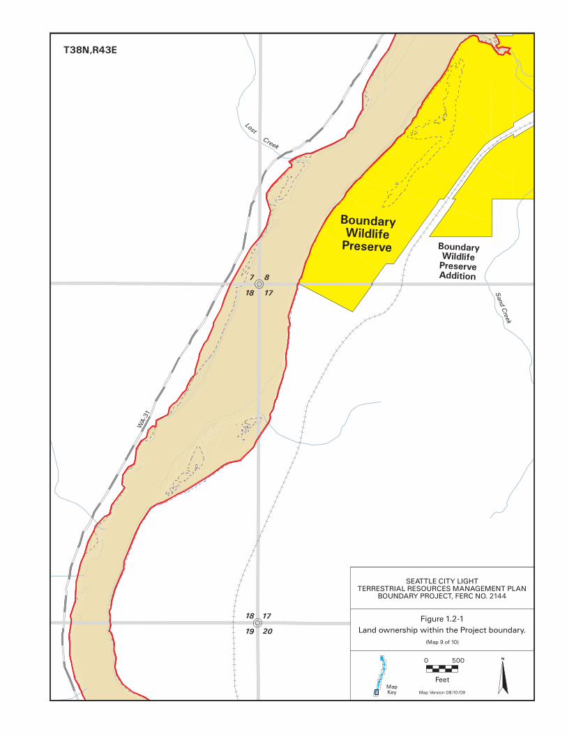
4.1.1. Tailrace Lands......................................................................................................... 24 4.1.2. Forebay/Lower Canyon Lands................................................................................ 26 4.1.3. Everett/Beaver Creek Lands ................................................................................... 27 4.1.4. Upper Canyon Lands .............................................................................................. 29 4.1.5. Sullivan Creek......................................................................................................... 31 4.1.6. Boundary Wildlife Preserve (BWP) and BWP Addition........................................ 32
4.2. Project-related Roads, Facilities, and Use Areas ...............................................................34 4.2.1. Project-Related Roads............................................................................................. 34 4.2.2. Existing Project Facilities ....................................................................................... 36 4.2.3. Existing Recreation Facilities ................................................................................. 37 4.2.4. Proposed New Recreation Sites and Existing and Dispersed Recreation Sites ...... 38
4.3. Federal Lands within the Project Boundary.......................................................................39
5 Resource Management Programs ........................................................................................39 5.1. Erosion Program ................................................................................................................39 5.2. Habitat Protection and Enhancement Program..................................................................42 5.3. Integrated Weed Management Program ............................................................................44 5.4. Rare, Threatened, and Endangered (RTE) Plant Species Program....................................58
Boundary Hydroelectric Project Seattle City Light FERC No. 2144 i September 2009

TERRESTRIAL RESOURCES MANAGEMENT PLAN
5.5. Wildlife Program ...............................................................................................................62 5.6. Shoreline Management Program........................................................................................66 5.7. Travel and Public Access Management Program ..............................................................69
6 Monitoring and Adaptive Management...............................................................................72
7 Management of Project-Related Activities and Facilities ..................................................78 7.1. Environmental Awareness Program ..................................................................................78
7.1.1. Maps........................................................................................................................ 78 7.1.2. Training Presentations ............................................................................................ 79 7.1.3. Informational Materials .......................................................................................... 79
7.2. Preconstruction Planning Program ....................................................................................80 7.3. Best Management Practices ...............................................................................................80
8 References...............................................................................................................................83 Appendices
Appendix 1: Land Ownership, Cover Type, and Proposed Project Boundary Data Appendix 2: Data Forms for TRMP Implementation
Boundary Hydroelectric Project Seattle City Light FERC No. 2144 ii September 2009
TERRESTRIAL RESOURCES MANAGEMENT PLAN
List of Tables Table 1.2-1. Lands within the Project boundary covered by the TRMP. ...................................... 7 Table 4.1-1. Vegetation associations on the Tailrace lands......................................................... 24 Table 4.1-2. Vegetation associations of the Forebay West, Peewee Falls, and Lower Canyon
lands. ..................................................................................................................................... 26 Table 4.1-3. Vegetation associations of the Everett/ Beaver Creek lands. .................................. 28 Table 4.1-4. Vegetation associations of the Upper Canyon lands. .............................................. 30 Table 4.1-5. Vegetation associations of the Sullivan Creek parcel. ............................................ 31 Table 4.1-6. Vegetation associations of the BWP and BWP Addition........................................ 33 Table 4.2-1. Project-related roads................................................................................................ 35 Table 4.2-2. Project-related facilities and use areas. ................................................................... 36 Table 5.3-1. Terrestrial noxious weed species documented in Pend Oreille County and in the
Boundary Project area (bold indicates target species for control).1...................................... 45 Table 5.3-2. Characteristics and formulations of herbicides approved for use to control weeds on
SCL-owned lands.................................................................................................................. 55 Table 5.3-3. Summary of general methods suggested for controlling target weed species in the
Boundary Project area........................................................................................................... 57 Table 5.4-1. RTE plant populations and polygons (subpopulations) delineated during 2007
surveys. ................................................................................................................................. 59 Table 5.5-1. RTE wildlife species observed in the study area during the 2007 and 2008 surveys.
............................................................................................................................................... 63 Table 6.0-1. Monitoring elements included in the Terrestrial Resource Management Plan
Implementation Programs (see Chapter 5). .......................................................................... 75 List of Figures Figure 1.2-1. Land ownership within the Project boundary. ......................................................... 8 Figure 5.7-1. Project-related roads............................................................................................... 71
Boundary Hydroelectric Project Seattle City Light FERC No. 2144 iii September 2009

TERRESTRIAL RESOURCES MANAGEMENT PLAN
List of Acronyms and Abbreviations ATV all-terrain vehicle BLM Bureau of Land Management BMP best management practice BPA Bonneville Power Administration BWP Boundary Wildlife Preserve CNF Colville National Forest DHS Department of Homeland Security EAP Emergency Action Plan Ecology Washington State Department of Ecology FERC Federal Energy Regulatory Commission FIFRA Federal Insecticide, Fungicide, and Rodenticide Act FR Forest Road GIS geographic information system GPS global positioning system GRank Global Rank HPA Hydraulic Project Approval HPMP Historic Properties Management Plan I&E interpretation and education IWMP Integrated Weed Management Program kV kilovolt NAVD North American Vertical Datum NAWMA North American Weed Management Association NFS National Forest System NPDES National Pollutant Discharge Elimination System NWCB Noxious Weed Control Board PAD Pre-Application Document PCWCB Pend Oreille County Weed Control Board PHL Project Habitat Lands PLP Preliminary Licensing Proposal PM&E Protection, Mitigation, and Enhancement POC Pend Oreille County Project Boundary Hydroelectric Project PUD Public Utility District RCW Revised Code of Washington ROW right-of-way RP Relicensing Participant RRMP Recreation Resources Management Plan RTE rare, threatened, or endangered
Boundary Hydroelectric Project Seattle City Light FERC No. 2144 iv September 2009

TERRESTRIAL RESOURCES MANAGEMENT PLAN
RRWG Recreation Resources Workgroup SCL Seattle City Light TNC The Nature Conservancy TRMP Terrestrial Resources Management Plan TRWG Terrestrial Resources Workgroup USFS U.S. Forest Service USFWS U.S. Fish and Wildlife Service USGS U.S. Geological Survey USR Updated Study Report WDFW Washington Department of Fish and Wildlife WDNR Washington State Department of Natural Resources WNHP Washington Natural Heritage Program
Boundary Hydroelectric Project Seattle City Light FERC No. 2144 v September 2009

TERRESTRIAL RESOURCES MANAGEMENT PLAN
This page intentionally left blank.
Boundary Hydroelectric Project Seattle City Light FERC No. 2144 vi September 2009

Terrestrial Resources Management Plan
Boundary Hydroelectric Project (FERC No. 2144) 1 INTRODUCTION
Seattle City Light (SCL) owns and operates the Boundary Project (FERC No. 2144) (Project), which is located on the Pend Oreille River in Pend Oreille County, Washington. The Project was constructed in the mid-1960s and operates under a license administered by the Federal Energy Regulatory Commission (FERC). The current license for the Project expires on September 30, 2011, and in accordance with FERC regulations, SCL must file its application for a new license no later than September 30, 2009.
As part of a comprehensive protection, mitigation, and enhancement (PM&E) program, SCL, in coordination with the relicensing participants (RPs), has prepared this draft Terrestrial Resources Management Plan (TRMP) to describe the measures that will be implemented over the next Project license period to protect and enhance plant and wildlife resources within the FERC Project boundary (Project area). Some sections of this TRMP are more fully developed than others. Before the plan is completed, all sections will be developed to the extent needed to achieve the objectives described herein. This TRMP will be revised and refined by SCL and RPs following the filing of the License Application to develop a final TRMP during 2010. SCL will implement the final TRMP in coordination with a Terrestrial Resources Workgroup (TRWG), which currently includes SCL and representatives from the U.S. Department of Agriculture, Forest Service (USFS), Washington Department of Fish and Wildlife (WDFW), U.S. Fish and Wildlife Service (USFWS), and the Pend Oreille County Weed Board (see Section 2.1.2 for more detail). This introductory chapter of the TRMP provides general information on Project facilities and operations and the Project's environmental setting (Section 1.1). It also describes the purpose, scope, content, and organization of the TRMP (Sections 1.2 and 1.3). 1.1. Description of Project Area, Facilities, and Operations
The Project is located in the northeast corner of Washington State. The dam is located approximately 1 mile south of the U.S.-Canada border and 16 miles west of the Idaho border. Overall, there is relatively little development along the reservoir. Land along the reservoir is owned by SCL, the USFS, U.S. Department of Interior, Bureau of Land Management (BLM), Washington State Department of Natural Resources (WDNR), Pend Oreille County, and private entities. The communities of Metaline Falls and Metaline are located midway along the reservoir, on its east and west sides, respectively. Both sides of the northern portion of the reservoir, from Metaline Falls to Boundary Dam, are relatively inaccessible by road and are bordered mostly by land in federal ownership. Lands along the southern portion of the reservoir are a mixture of private and publicly owned parcels, including SCL’s Boundary Wildlife Preserve (BWP). The western side of the reservoir south of Metaline is bordered by U.S. Highway 31.
Boundary Hydroelectric Project Seattle City Light FERC No. 2144 1 September 2009
TERRESTRIAL RESOURCES MANAGEMENT PLAN
1.1.1.
1.1.2.
Project Facilities
Boundary Dam is a 340-foot-high, variable-radius concrete arch dam and is situated in a narrow canyon and founded on interbedded limestone and dolomite of the Metaline Limestone formation. The dam impounds the Pend Oreille River to a normal maximum water surface elevation of 1,994 feet North American Vertical Datum (NAVD) 881, as measured in the forebay. The underground power plant was excavated within the massive rock forming the left abutment of the dam. Power from the Project is transmitted to a Bonneville Power Administration (BPA) interconnection via a 0.5-mile-long, 500-kilovolt (kV) transmission line. Boundary reservoir extends approximately 17.5 miles south from Boundary Dam to the Box Canyon Dam tailrace. At its normal maximum water surface elevation (1,994 feet at the forebay), Boundary Reservoir has a surface area of approximately 1,794 acres, a shoreline length of roughly 47 miles, and a maximum depth in the forebay of approximately 270 feet. Inflows to the reservoir on annual, seasonal, and monthly time intervals are influenced by the operations of upstream projects. Near the town of Metaline Falls, the Pend Oreille River passes through a bedrock-controlled constriction (elevation 1,970.6) that geographically divides the reservoir into two distinct reaches: an upstream reach that extends from Box Canyon Dam to Metaline Falls, and a downstream reach that extends from Metaline Falls to Boundary Dam. Depths in the upstream reach typically range from 10 to 25 feet, while the lower reservoir is much deeper.
Project Boundary and Operations
North of Metaline Falls, the current Project boundary is located 200 feet horizontally above the reservoir’s normal maximum pool elevation (1,994 feet NAVD 88 at the forebay); south of Metaline Falls, the boundary follows specified contour lines that generally approximate the pre-Project ordinary high water line. The Boundary Project is operated in a load-following mode that uses available water to deliver power during peak-load hours. The normal maximum reservoir water surface varies from elevation 1,994 feet at the forebay to 1,999 feet at the Box Canyon tailrace. The reservoir has relatively little active storage (about 40,843 acre-feet) within the maximum drawdown of 40 feet (active storage from elevation 1,994 NAVD 88 to elevation 1,954 NAVD 88 feet) authorized under the current license. Currently, SCL voluntarily restricts and maintains the summer forebay pool level to facilitate recreational access and use. In its License Application, SCL proposes to formalize this operation as follows: from Memorial Day weekend (starting Friday evening) through Labor Day weekend (on Monday evening), forebay water surface elevations will be maintained at or above 1,984 feet NAVD 88 from 6:00 am through 8:00 pm. From 8:00 pm through 6:00 am, forebay water surface elevations will be maintained at or above elevation 1,982 feet NAVD 88. Under SCL's proposed operation, the 1,984 and 1,982 foot elevations would be license requirements that could not be violated except for conditions such as equipment failures, maintenance activities, electrical and mechanical
1 Elevation values are in datum NAVD 88 unless otherwise noted.
Boundary Hydroelectric Project Seattle City Light FERC No. 2144 2 September 2009

TERRESTRIAL RESOURCES MANAGEMENT PLAN
device limitations, safety inspections, testing, natural disasters (e.g., lightning), compliance with WECC and NERC requirements, capacity and energy emergencies, and any event that triggers the Project Emergency Action Plan (EAP). From Labor Day weekend to Memorial Day weekend, the Project will be operated as it currently is, with forebay water surface elevations generally fluctuating between 1,994 feet and 1,974 feet NAVD 88, although minimum forebay elevations will often be above 1,980 feet and will only occasionally be below 1,974 feet. The range of water surface elevations for dry (2001), average (2002), and wet (1997) inflow years is shown in Figures E.2-6 through E.2-8 of Exhibit E of SCL's License Application. 1.1.3. Environmental Setting
The Project is located in the Selkirk Mountains, a western extension of the Rocky Mountains. The topography surrounding the Project is relatively rugged, with nearby mountains rising more than 6,500 feet in elevation and intervening valleys ranging from approximately 2,000 to 2,400 feet. The Pend Oreille River bisects the Selkirk Mountains and cuts through the Metaline Limestone and Ledbetter Slate formations. These two formations predominate along Boundary Reservoir downstream of Metaline Falls and confine the reservoir to a narrow canyon. The adjacent area is characterized by cliffs, rock talus, and steep slopes (SCL 2006). In contrast, the area upstream of Metaline Falls consists predominantly of unconsolidated glacial sediments and river alluvial deposits. The river channel in this area is broader and the surrounding topography more moderate (SCL 2006). The Project area is within the eastern portion of the Okanogan Highlands physiographic province, which lies east of the Cascade Range, north of the Columbia Basin, and extends into northern Idaho and southern British Columbia (Lasmanis 1991). The climate of the Okanogan Highlands has both continental and Pacific maritime aspects. The continental aspect results from a combination of the inflow of dry, cold air from the interior valleys of British Columbia and the rain shadow effect that the Cascade Mountains exert on most of eastern Washington. The maritime influence on climate primarily occurs in the eastern portions of the Okanogan Highlands, where the Selkirk Mountains intercept the westerly maritime air flow, resulting in greater precipitation than is typical in eastern Washington. Within the Pend Oreille River valley in the vicinity of the Project, mean annual precipitation is approximately 27 inches. December and January account for about 25 to 35 percent of the annual precipitation, while July and August account for only 6 percent. On average, approximately 30 days each year have rainfall of at least 0.1 inches, and approximately 73 days receive at least 1.0 inch of snow. Winters are typically cold, and the snowpack normally covers all but the lowest elevations continuously from November through May (ENTRIX 2001). Summers are generally warm and sunny with periodic light rainfall, although localized thunderstorms occasionally cause heavier amounts of precipitation (Pend Oreille Conservation District 2004).
Boundary Hydroelectric Project Seattle City Light FERC No. 2144 3 September 2009

TERRESTRIAL RESOURCES MANAGEMENT PLAN
1.1.3.1. Vegetation
The influence of the maritime climate on the dominant vegetation types in the Selkirk Mountains is profound and likely exceeds the influence of geology and soils in most parts of the eastern Okanogan Highlands (Philip and Durke 1972). Vegetation zones, or climax vegetation, in the Project area include the Douglas-fir/Grand Fir Zone on drier sites and the Western Hemlock/Cedar Zone on more mesic sites (Williams et al. 1995). Forest communities in the Pend Oreille River valley, including the Project area, are characterized by a higher diversity of tree species than other regions in Washington. These species include:
Douglas-fir (Pseudotsuga menziesii) Lodgepole pine (Pinus contorta) Western hemlock (Tsuga heterophylla) Ponderosa pine (Pinus ponderosa) Western red-cedar (Thuja plicata) Trembling aspen (Populus tremuloides) Grand fir (Abies grandis) Black cottonwood (Populus balsamifera ssp. tricocarpa) Western larch (Larix occidentalis) Paper birch (Betula papyrifera) Western white pine (Pinus monticola) Most of the land within the Project area has been logged or burned within the last 80 years, and the forested slopes adjacent to the reservoir are dominated by second-growth Douglas-fir and western larch. Mixed stands of western red-cedar and western hemlock occur in ravines and other shaded, moist areas. Riparian and wetland communities are uncommon, particularly downstream of Metaline Falls, where they occur only in sheltered coves and at the mouths of the few tributary streams in this reach. One of the largest and most diverse wetland/riparian communities in the Project area occurs on the BWP. More detail on vegetation communities in the Project vicinity can be found in SCL's Preliminary Application Document (PAD; SCL 2006) and Updated Study Report (USR; SCL 2009). Surveys conducted during relicensing documented 52 populations of 15 vascular plant species in the Project area that are considered rare, threatened, or endangered (RTE) by state and/or federal agencies. In comparison to other similarly sized areas, the Project area has a relatively large number of both RTE plant species and populations. Four RTE plant species–yellow mountain-avens (Dryas drummondii), least bladdery milk-vetch (Astragalus microcystis), orange balsam (Impatiens aurella), and purple meadowrue (Thalictrum dasycarpum)–are locally abundant. 1.1.3.2. Wildlife
The northeastern corner of Washington is unique because it encompasses the edges of several species’ ranges, and thus supports a number of species more commonly found in areas farther north or nearer to the coast, including several that occur nowhere else in the state. The combination of topography, geographical location, and diversity of vegetation communities in the Pend Oreille River valley and surrounding Selkirk Mountains results in high wildlife species richness, particularly for mammals and birds (Cassidy 1997). In total, 307 wildlife species potentially occur in the general vicinity of the Project. Of these, more than 100 species were confirmed to occur within the Project area during reconnaissance inventories conducted in 2005 and wildlife studies conducted in 2007-2008. Three federally listed species that have been observed in the Project area are the grizzly bear (Ursus arctos),
Boundary Hydroelectric Project Seattle City Light FERC No. 2144 4 September 2009
TERRESTRIAL RESOURCES MANAGEMENT PLAN
woodland caribou (Rangifer tarandus caribou), and Canada lynx (Lynx canadensis), although it appears that their use of the area is occasional and transitory. The gray wolf (Canis lupus), which is state listed as endangered, has expanded into northeastern Washington from Idaho and/or British Columbia, and there is some evidence that wolves occasionally use the Project area. Recently, the WDFW documented an active breeding wolf pack in Pend Oreille County. More detail on wildlife in the Project area can be found in the PAD (SCL 2006) and the USR (SCL 2009). 1.2. TRMP Purpose and Scope
The purpose of the TRMP is to provide for the protection, management, and enhancement of terrestrial resources occurring within the FERC Project boundary or affected by Project-related operations.2 The TRMP establishes the goals, program objectives, tasks, and schedule for implementing the terrestrial resource protection, mitigation, and enhancement measures included in the Project license. The TRMP focuses on the 1,743 acres in the Project boundary (Project Area) (this total includes acreage proposed for addition to the current Project boundary) owned by SCL, USFS, and BLM (Table 1.2-1 and Figure 1.2-1). These lands include the following:
• Project Habitat Lands (PHLs) - Lands owned by SCL that will be managed primarily to benefit terrestrial plant and wildlife communities. Specific habitat protection and enhancement measures will be implemented on PHLs, as well as weed and erosion control/monitoring and RTE plant and wildlife surveys. More detail on SCL-owned PHLs is found in Chapter 4 of this TRMP.
• SCL Project Facility Lands - Lands owned by SCL that support Project facilities and operations, including the dam, power plant, warehouses, and approximately 3,000 feet of transmission line right-of-way (ROW) that link to the BPA Substation, as well as Project recreation facilities and Project roads. These lands will be managed to prevent the degradation of natural resources on site or on adjacent lands. TRMP activities will include erosion and weed control/monitoring and the protection of RTE plant and wildlife populations that occur. Enhancement measures may be implemented where appropriate.
• Other SCL Lands - Lands owned by SCL, including small parcels, steep cliffs, or talus slopes that generally provide less habitat value than the PHLs. No specific management prescriptions are proposed for these lands except for weed and erosion control/monitoring and RTE plant and wildlife surveys (to the extent the lands can be accessed).
2 Acreage calculations in this TRMP are based on the Project boundary in Exhibit K of the existing Project license. In contrast, acreages presented in Exhibit A of the License Application are based on the updated depiction of the Project boundary in Exhibit G of the License Application. As such, the TRMP presents some acreage values that differ slightly from those presented in Exhibits A and G. In addition, the Project boundary shown on maps in this TRMP is the existing Project boundary of Exhibit K. For the location of the proposed Project boundary, see Exhibit G of the License Application.
Boundary Hydroelectric Project Seattle City Light FERC No. 2144 5 September 2009

TERRESTRIAL RESOURCES MANAGEMENT PLAN
• Federal Lands - Lands managed by the USFS and BLM. USFS lands are part of the Colville National Forest (CNF) and are managed under the CNF Land and Resource Management Plan, as amended (USFS 1988), which is currently being revised. BLM-managed lands are guided by the Spokane District Resource Management Plan, as amended (BLM 1985). TRMP activities on federal lands will include weed and erosion control/monitoring and RTE plant and wildlife surveys. Habitat protection and/or enhancement measures also may be conducted on federal lands where adverse any Project-related effects are documented.
SCL lands and facilities are described in detail in Chapter 4 of this TRMP. Specific management actions to be conducted on SCL-owned lands, wildlife and plant monitoring, and cooperative efforts on federally-owned lands are described in detail in Chapter 5 of this TRMP.
Boundary Hydroelectric Project Seattle City Light FERC No. 2144 6 September 2009
TERRESTRIAL RESOURCES MANAGEMENT PLAN
Table 1.2-1. Lands within the Project boundary covered by the TRMP.
Land designations Acres SCL - Project Habitat Lands
• Tailrace East 27 • Tailrace West1 101.9 • Forebay/Lower Canyon Lands 202.6 • Everett Creek/Beaver Creek Lands 37.3 • Upper Canyon Lands 39.3 • Sullivan Creek 17.3 • Metaline Waterfront Park Island 4.5 • BWP2 1493
• BWP Addition2 894
Subtotal 667.9 SCL - Project Facility Lands
• Tailrace East Facilities 0.03 • Tailrace East Recreation Lands (Vista House) 0.6 • Tailrace West Facilities 24.3 • Forebay West Facilities 31.2 • Forebay West Recreation Area 8.5 • Metaline Park 14.5 • Dispersed Recreation Lands N/A
Subtotal 79.1 SCL - Other Lands
• Junction Isolate 1.5 • Cliff Isolate 1.3 • Mine Isolate 0.3 • Flume Creek 73
Subtotal 76.1 Federal Lands
• USFS 606 • BLM 314
Subtotal 920 TRMP Total 1,743.1
Notes: 1 SCL’s Tailrace West parcel has been proposed for inclusion in the new FERC Project boundary. 2 SCL’s BWP and BWP Addition have been proposed for inclusion in the new FERC Project boundary. See
Appendix 1 for acreage calculations of individual parcels in the Project boundary and in the Project vicinity; for each parcel, information is presented for land ownership, location within or outside the Project boundary (as proposed), parcel name, and area.
3 Due to parcel delineation updates, this summation has been changed from the previously cited value of 155 acres.
4 The size of the adjoining SCL-owned parcels is 89 acres, not 88 acres as previously reported.
Boundary Hydroelectric Project Seattle City Light FERC No. 2144 7 September 2009


TERRESTRIAL RESOURCES MANAGEMENT PLAN
1.3. TRMP Content and Organization
The TRMP is organized into the following eight chapters:
• Chapter 1 - introduces the TRMP within the context of relicensing, describes Project facilities and operations and the Project's environmental setting, presents the purpose and scope of the TRMP, and provides an overview of document content and organization.
• Chapter 2 - describes the structure, roles, and responsibilities of the TRWG in coordinating and implementing the TRMP over the life of the license. It also summarizes the content and schedule for annual reports, work plans, and periodic reviews and updates to the TRMP.
• Chapter 3 - provides the overarching goals for monitoring and managing terrestrial resources covered by the TRMP over the new license period. These goals form the foundation of the TRMP and are directed at mitigating Project effects, protecting habitats and species within and near the Project boundary, and enhancing select habitats.
• Chapter 4 - describes the lands to be actively managed as wildlife habitat under the TRMP. It addresses the physical location, existing conditions, previous land uses and management practices, desired conditions, and management considerations.
• Chapter 5 - includes seven individual resource management programs that are considered essential for protecting, mitigating, and/or enhancing terrestrial resources associated with the Project and describes each program’s goals, objectives, and fundamental components.
• Chapter 6 - describes monitoring and adaptive management that will apply to all aspects of the TRMP. Monitoring is intended to confirm implementation of the measures included in the TRMP and to determine the effectiveness of specific management actions. Adaptive management requires modifying PM&E measures, as needed, to meet resource-specific goals and objectives.
• Chapter 7 - presents standard procedures and best management practices (BMPs) that apply throughout the entire Project area. These are intended to protect terrestrial resources from disturbance associated with Project operations, maintenance, and construction.
• Chapter 8 - provides the references cited in the TRMP.
Data forms associated with implementation of the TRMP will be developed following the filing of the License Application and completed during 2010; data forms will be included in Appendix 2 of the TRMP.
Boundary Hydroelectric Project Seattle City Light FERC No. 2144 18 September 2009
TERRESTRIAL RESOURCES MANAGEMENT PLAN
2 ROLES AND RESPONSIBILITIES, COMMUNICATION, AND COORDINATION
SCL will be responsible for implementing the TRMP in coordination with the TRWG. This section describes the roles and responsibilities of SCL and the TRWG, communication protocols, and administration of meetings and periodic review of the implementation and effectiveness of the TRMP. 2.1. Roles and Responsibilities
Although a member of the TRWG, SCL, as the Licensee, has unique responsibilities for protecting and managing resources in the Project area, meeting license requirements, and implementing the TRMP. The roles and responsibilities of SCL and the TRWG are described below. 2.1.1.
2.1.2.
Seattle City Light
SCL will perform the following functions:
• Fund and implement all aspects of the TRMP, unless otherwise indicated. • Appoint an SCL representative to the TRWG. • Coordinate all elements of the TRMP and consult with the TRWG, FERC, and other
parties as directed by the Project license and as needed. • Prepare a Rolling 3-Year Annual Report/Work Plan in consultation with the TRWG,
submit the report to FERC, and distribute it to the TRWG and other parties, as appropriate.
• Update the TRMP every 5 years, as applicable, in consultation with the TRWG, submit the update to FERC, and distribute it to the TRWG and other parties, as appropriate.
• Plan and hold an annual meeting and additional meetings as needed throughout the year.
• Complete required surveys for cultural clearances, as specified in the Historic Properties Management Plan (HPMP) (Attachment E-10 to the License Application), prior to implementing any PM&E measures that involve ground disturbance.
Terrestrial Resources Workgroup (TRWG)
The TRWG will consist of one representative each from SCL, the USFS, USFWS, WDFW, and the Pend Oreille County Weed Control Board (PCWCB). This list represents the agencies that regularly attended Boundary Project relicensing meetings on terrestrial resource issues and actively participated in the development of terrestrial PM&E measures and the TRMP. It is recognized that in the future, other agencies or entities may request to participate in implementation of the TRMP. Designating specific agencies for representation in the TRWG is not intended to exclude other parties who may have a legitimate interest in implementation of the TRMP. It is, however, important that the vision, intent, and programs developed and agreed to by SCL and RPs and reflected in the TRMP be preserved into the future. Accordingly, after the TRMP has been finalized and accepted by FERC, any agency or entity requesting to participate
Boundary Hydroelectric Project Seattle City Light FERC No. 2144 19 September 2009

TERRESTRIAL RESOURCES MANAGEMENT PLAN
in implementation of the TRMP must submit to SCL, in writing, a statement of its interest and purpose in joining the TRWG. SCL will then distribute the request to the other TRWG members and convene a teleconference within 21 days to discuss the request. Acceptance of a new member will be by unanimous consent of the TRWG members. The responsibilities of the other TRWG members (i.e., other than SCL) include performance of the following:
• Consult with SCL in a timely manner when required by the license or the TRMP. • Participate in the annual meeting (which will include review and comment on the
Rolling 3-Year Annual Report/Work Plan). • Provide technical data and expertise as needed to assist in achieving TRMP resource
management objectives. • Coordinate implementation of activities that have the potential to affect lands covered
by the TRMP on which TRWG members’ agencies have authority/jurisdiction. • Provide updates on RTE species listings and associated maps indicating known
occurrence locations. • Keep the TRWG informed of any changes in agency policies or land management
direction that could have implications for the TRMP. • Advise SCL and the TRWG to ensure that the TRMP is in compliance with all
applicable state and federal regulations. 2.2. Communication and Coordination
Timely and effective communication and coordination among members of the TRWG are critical for the successful implementation of the TRMP and achievement of the resource goals and objectives. Specific elements related to annual meetings, work plans and progress reports, and TRMP updates are described in the following sections. 2.2.1. Meetings and Decision-Making
The TRWG will meet at least once per year, generally in February, to review the previous year’s achievements and activities, to discuss and approve a final work plan for the upcoming year, and to discuss potential actions for the next year (see Section 2.2.2). In addition to this annual meeting, the TRWG may choose to hold additional meetings, as needed. It is anticipated that the TRWG may meet more frequently early in the license period during program initiation. Decisions by the TRWG will be made by consensus. Consensus is defined as general agreement by the group. Consensus implies that all parties have stated their opinions and preferences, that discussion and/or debate has taken place, that the solution is generally accepted by all parties, and that agreement is strong enough so that it will hold for some time without the need to revisit the issue. If consensus cannot be reached, any member of the TRWG can invoke the dispute resolution process described in the applicable license article. Decisions that need to be made by the TRWG at meetings will be identified in advance and noted on agendas. In the event that a TRWG member agrees to participate in a meeting where
Boundary Hydroelectric Project Seattle City Light FERC No. 2144 20 September 2009

TERRESTRIAL RESOURCES MANAGEMENT PLAN
decisions will be made and then fails to attend, the decision made by the members present will be considered the final decision of the TRWG. 2.2.2.
2.2.3.
Annual Reports and Work Plans
Each year, SCL will prepare a Rolling 3-Year Annual Report/Work Plan that will:
• Document the implementation of PM&E measures conducted in the preceding year. • Describe the plan for implementing scheduled management actions for the upcoming
or current year. • Describe the tentative plan for implementing actions for the next year (the Out Year). • Summarize consultation activities related to the TRMP. • Document the results of monitoring and associated adaptive management (to the
extent that monitoring is required for any particular action) to ensure proper implementation and effectiveness of the TRMP. This may include proposed revisions to the TRMP based on monitoring results.
A draft of the Rolling 3-Year Annual Report/Work Plan will be distributed to the TRWG by January 15 of each year. The annual meeting will be scheduled within 30 days of distribution of the draft. The TRWG members will come to the annual meeting prepared to discuss and provide input on the report/work plan. Specifically, the TRWG will:
• Discuss and seek clarification on the material that describes activities conducted in the previous year.
• Discuss and approve plans for work to be conducted in the current year. • Discuss the Out-Year Work Plan.
A final draft copy of the plan will be circulated to the TRWG to ensure that comments addressed by SCL have been adequately addressed. SCL will produce the final Rolling 3-Year Annual Report/Work Plan and send copies to FERC and the TRWG by March 31 of each year.
TRMP Review/Revision
SCL, in consultation with the TRWG, will review, update, and/or revise the TRMP every five years, if needed. The need for updating the TRMP will be discussed with the TRWG during the annual meeting in the year in which the review and update is scheduled to occur. The need to change or revise the TRMP may be related to changes in terrestrial resource conditions resulting from unforeseen effects, from new or existing Project-related activities, or from natural events (e.g., wildfire) in the Project area. Changes may also be warranted if monitoring indicates that resource objectives are not being met and/or it is determined that a specific PM&E measure is not providing the intended result. The updated or revised TRMP will document the rationale for changes and the consultation process with the TRWG. The initial five-year update of the TRMP will be completed during the sixth calendar year following FERC approval of the TRMP. SCL will be responsible for preparing the draft and
Boundary Hydroelectric Project Seattle City Light FERC No. 2144 21 September 2009

TERRESTRIAL RESOURCES MANAGEMENT PLAN
final revised TRMP, coordinating the review process and schedule with the TRWG, and submitting the final revised TRMP to FERC. SCL will compile a running list of potential changes to the TRMP suggested by the TRWG or indicated by monitoring results for the period outside the year in which the review and update are scheduled to occur. This list will be included in the Rolling 3-Year Annual Report/Work Plan for consideration during the next five-year review/revision cycle.
3 TERRESTRIAL RESOURCE GOALS
This chapter presents the goals that serve as the basis for the resource programs outlined in Chapter 5, Resource Management Programs. The goals reflect the overall intent of the TRMP to protect and enhance wildlife and habitats associated with the Project while providing for compatible human uses, and to avoid, minimize, or mitigate the effects of Project operations, maintenance, and construction activities. Each goal includes a number of sub-goals, and for each sub-goal, reference is made to the individual program(s) designed to address that sub-goal. Measureable objectives and associated tasks are described in detail for each program in Chapter 5 and Chapter 7, Management of Project-related Activities and Facilities. Goal 1: Foster biodiversity, ecosystem function, and habitat connectivity within the Project area.
• 1a: Manage erosion at select sites to reduce the loss of terrestrial habitat and monitor long-term erosion along Boundary Reservoir (Erosion Program).
• 1b: Protect, enhance, and manage wetland, upland, and riparian habitats on PHLs (Habitat Enhancement Program).
• 1c: Monitor select weed species on lands covered by the TRMP and control, suppress, and contain weeds on PHLs and in areas affected by the Project (Integrated Weed Management Program).
• 1d: Monitor and manage RTE plants (RTE Plant Program).
• 1e: Monitor select wildlife species, including bald eagle (Haliaeetus leucocephalus), peregrine falcon (Falco peregrinus), osprey (Pandion haliaetus), and bank swallow (Riparia riparia) (Wildlife Program).
• 1f: Protect and enhance habitat diversity and function on PHLs (all programs).
Goal 2: Manage Project-related recreation and other human uses in a manner that is compatible with maintaining biodiversity, ecosystem function, and habitat connectivity.
• 2a: Manage Project-related recreation to minimize effects on wildlife and habitats (all programs).
• 2b: Protect shoreline habitats and associated RTE plant populations from trampling associated with over use, and control the development of docks and other shoreline structures (Shoreline Management Program).
Boundary Hydroelectric Project Seattle City Light FERC No. 2144 22 September 2009

TERRESTRIAL RESOURCES MANAGEMENT PLAN
• 2c: Protect wildlife from human interference during critical times of the year, close unneeded roads to improve habitat effectiveness, and reduce uncontrolled vehicle use on SCL lands within the proposed Project boundary (Travel and Public Access Management Program).
• 2d: Work cooperatively with the USFS and BLM to minimize effects on wildlife and habitats on their lands (all programs).
Goal 3: Avoid, minimize, or mitigate effects on wildlife and habitat from ongoing Project-related operations and maintenance.
• 3a: Educate Project personnel and contractors on ways to minimize the effects of ongoing Project-related operations and maintenance on wildlife and habitats (Management of Project-Related Activities and Facilities).
• 3b: Develop and implement appropriate planning guidelines and protection measures for avoiding, minimizing, and mitigating impacts from construction activities on wildlife and/or their habitats on a site-specific and Project-specific basis (Management of Project-Related Activities and Facilities).
• 3c: Implement BMPs to avoid or minimize adverse environmental effects of Project operations, maintenance, and construction activities (Management of Project-Related Activities and Facilities).
4 EXISTING AND DESIRED CONDITIONS OF PROJECT AREA LANDS
4.1. Project Habitat Lands (PHLs)
Approximately 668 acres of SCL-owned land within the proposed Project boundary will be managed primarily for the benefit of wildlife and plant communities; these parcels are designated as PHLs. Although some SCL-owned parcels extend beyond the Project boundary, only those portions within the Project boundary are designated as PHLs. This section describes the current and desired condition of the PHLs. Information for each parcel includes the following, where available:
• The geographic extent and condition of existing habitats. • Known wildlife use. • Presence of RTE plant populations. • The ecological processes and past land uses that have influenced current vegetation
communities and habitat conditions, if known. • Observed human uses. • Desired land/habitat conditions. • Management considerations/constraints.
Information for each parcel was obtained during relicensing studies (2005-2008) and from observations made during a site visit by SCL in May 2009. Key management objectives for
Boundary Hydroelectric Project Seattle City Light FERC No. 2144 23 September 2009

TERRESTRIAL RESOURCES MANAGEMENT PLAN
several of the parcels are to allow the relatively young mixed conifer forests to continue to mature, and to control unauthorized vehicle use. Active management prescriptions are provided for a limited number of parcels where cost effective measures could be expected to result in a significant increase in value to the resource. More detailed descriptions of proposed habitat protection and enhancement measures are provided in Chapter 5, Resource Management Programs. 4.1.1. Tailrace Lands
SCL owns two land parcels below the dam, one on the east side of the tailrace and one on the west side. Both of these parcels border the Pend Oreille River; vegetation associations are summarized in Table 4.1-1. Table 4.1-1. Vegetation associations on the Tailrace lands.
Property (acres) Vegetation Association Tailrace East Tailrace West Bedrock & Cliffs 0.6 - Moist Mixed Coniferous Forest 23.7 100.6 Dry Mixed Coniferous Forest 1.5 - Upland Shrub 0.6 - Riparian 0.1 - Riverine Unconsolidated Shore 0.5 1.3 Riverine Unconsolidated Bottom - <0.1
Total Acres 27.0 101.9 4.1.1.1. Tailrace East
The Tailrace East property (27 acres in the Project boundary) is dominated by early seral stage mixed conifer forest. A number of seeps occur on the lower hill slope, particularly at the topographic break where the terrain transitions into the river terrace. The seeps likely contribute to the prevalence of western red-cedar on the slopes. Scattered fruit trees provide forage opportunities for Columbian white-tailed deer (Odocoileus virginianus leucurus), mule deer (O. hemionus), elk (Cervus elaphus), and black bear (Ursus americanus), and there is evidence that all of these species use this area. Species observed on the site include osprey, bald eagle, Canada goose (Branta canadensis), painted turtle (Chrysemys picta), Columbia spotted frog (Rana luteiventris), muskrat (Ondatra zibethicus), bobcat (Lynx rufus), and coyote (Canis latrans). Wolves might also be expected to use this area as a new pack has been confirmed in northeastern Pend Oreille County, and wolves north of the international boundary were heard howling during relicensing studies of the Tailrace East property. Although the area to the north of this parcel has been logged recently and extensively, the shoreline likely serves as an important movement corridor for wildlife, particularly mammals. Cattle regularly trespass onto this parcel and may be contributing to the spread of weeds. No RTE plant species were found on this parcel.
Boundary Hydroelectric Project Seattle City Light FERC No. 2144 24 September 2009

TERRESTRIAL RESOURCES MANAGEMENT PLAN
4.1.1.1.1. Desired Conditions
• A structurally diverse, mature, mixed conifer forest that provides wildlife habitat and contributes to ecological functions.
• Seeps that continue to function and support the western red-cedar community and associated wildlife.
• Continued functional wildlife corridor. • No cattle use. • No vehicle access (except for Project purposes), but continued pedestrian access for
recreation.
4.1.1.1.2. Management Considerations/Constraints
• It will be necessary to coordinate with BPA and/or B.C. Hydro to determine the extent of vehicle access necessary to maintain the transmission line that crosses SCL-owned land.
• Management measures that prohibit cattle from using the site will require the cooperation of adjacent land owners in Canada.
4.1.1.2. Tailrace West
The Tailrace West parcel (101.9 acres; most of this land is not currently located within the Project boundary but is proposed for inclusion) encompasses part of the maintenance and storage facilities adjacent to the dam and is dominated by early seral stage, mixed conifer forest. This parcel provides forest cover for big game, especially because much of the adjacent landscape to the west has been extensively logged in the past few decades. There are a few scattered large snags, especially near the river’s edge. A portion of the parcel has been cleared and is used on a daily basis as a Project maintenance facility, thus reducing the value of part of the property due to habitat disturbance and human presence. The area to the north of this parcel is a large expanse of relatively undisturbed land that has not been logged in the recent past and contains few roads; it is likely that the Tailrace West property provides a movement corridor for wildlife traveling to and from Canada. No RTE plant species were found on this parcel. 4.1.1.2.1. Desired Conditions
• A more mature and structurally diverse conifer forest community. • Fewer roads, contingent upon Project needs.
4.1.1.2.2. Management Considerations/Constraints Because of the proximity of Project facilities and associated human activities, habitat management opportunities are limited and will need to be coordinated closely with Project operations and maintenance objectives for this area.
Boundary Hydroelectric Project Seattle City Light FERC No. 2144 25 September 2009

TERRESTRIAL RESOURCES MANAGEMENT PLAN
4.1.2. Forebay/Lower Canyon Lands
Three properties are included in this portion of the Project area: the Forebay West, Peewee Falls, and the Lower Canyon lands (Table 4.1-2). Table 4.1-2. Vegetation associations of the Forebay West, Peewee Falls, and Lower Canyon lands.
Property (acres)
Vegetation Association Forebay West Peewee Falls Lower Canyon
Lands Moist Mixed Conifer Forest 58.8 19.8 21.2 Dry Meadow 4.2 Bedrock & Cliffs 1.4 2.2 Erosion Areas 2.5 3.6 Lacustrine Unconsolidated Bottom 46.4 31.8 9.3 Lacustrine/Littoral Unconsolidated Shoreline 0.5 0.3 Palustrine Scrub Shrub 0.1 Palustrine Emergent 0.1 Lacustrine Wetland 0.1
Total Acres 112.4 56.8 33.4 4.1.2.1. Forebay West
The Forebay West property (112.4 acres) includes a large stand of young mixed conifer forest that dominates the area upslope of the Forebay Recreation Area. Bald eagles and osprey often perch in trees here, and great blue herons (Ardea herodias) forage in the shallows of the reservoir. No RTE plants were recorded on this parcel. 4.1.2.1.1. Desired Conditions
• A structurally diverse, mature, mixed conifer forest that provides wildlife habitat and ecological functions.
• Native plant communities that are protected from human disturbances associated with the nearby Forebay Recreation Area (social trails, trash, wood cutting).
4.1.2.1.2. Management Considerations/Constraints Habitat protection and management will need to be coordinated with implementation of the Recreation Resource Management Plan (RRMP) (Attachment E-12 to the License Application). 4.1.2.2. Peewee Falls
The Peewee Falls parcel (56.8 acres in the Project boundary) includes the shoreline of the reservoir, steep slopes between the uplands and riparian edge, and Peewee Falls. Much of the area is extremely steep and dominated by moist mixed conifer forest and cliffs. Because of the steepness of the terrain, it is considered marginal as habitat for big game but is used by a variety
Boundary Hydroelectric Project Seattle City Light FERC No. 2144 26 September 2009

TERRESTRIAL RESOURCES MANAGEMENT PLAN
of bird species. Moderate-sized snags are available, and evidence of foraging by woodpeckers is common. Peewee Falls provides potential habitat for nesting black swifts (Cypseloides niger) in the rock cliff behind the waterfall, but no individuals were observed here during relicensing studies. Bank swallows have been observed nesting in a steep, eroded area east of the falls. No RTE plants were recorded for this parcel. 4.1.2.2.1. Desired Conditions A structurally diverse, mature, mixed conifer forest, where possible, that provides ecological functions and habitat for songbirds and woodpeckers. 4.1.2.2.2. Management Considerations/Constraints Because of the steepness of the terrain and lack of resource concerns, it is unlikely that this parcel would benefit from active habitat management. 4.1.2.3. Lower Canyon
The Lower Canyon parcel (33.4 acres) includes cliffs, talus slopes, mixed conifer forest, and patches of Sitka alder (Alnus sitchensis). This area of the canyon appears to be used regularly by deer and elk to cross the river, as the terrain is less steep, the reservoir is relatively narrow, and human use is low. Canada geese make limited use of cliff faces for nesting, and roosting bats have been observed in two caves within this parcel. Three populations of Steller’s rockbreak (Cryptogramma stelleri) and yellow mountain avens and two populations of wirestem muhly (Muhlenbergia mexicana var. mexicana) and purple meadowrue occur on this parcel. 4.1.2.3.1. Desired Conditions
• A structurally diverse, mature, mixed conifer forest, where possible, that provides ecological functions and wildlife habitat, including cover for big game.
• A functional wildlife corridor with suitable locations for crossing the reservoir. • Undisturbed cave habitat for roosting bats. • Undisturbed RTE plant populations.
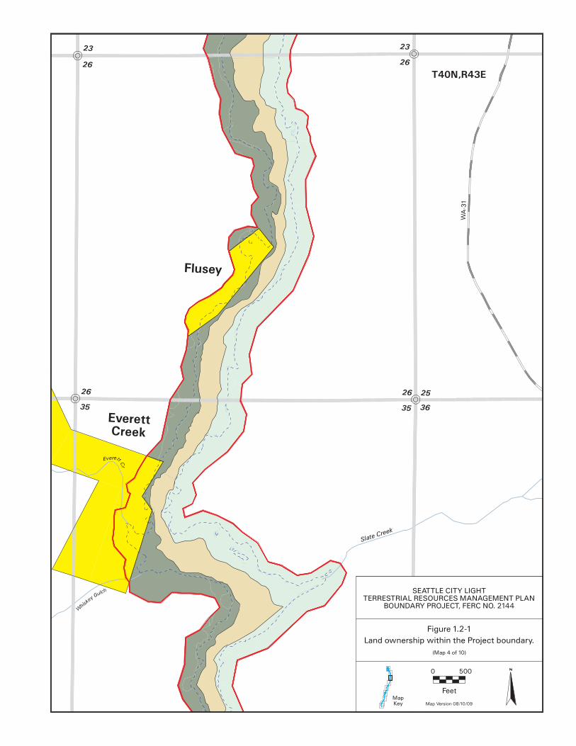
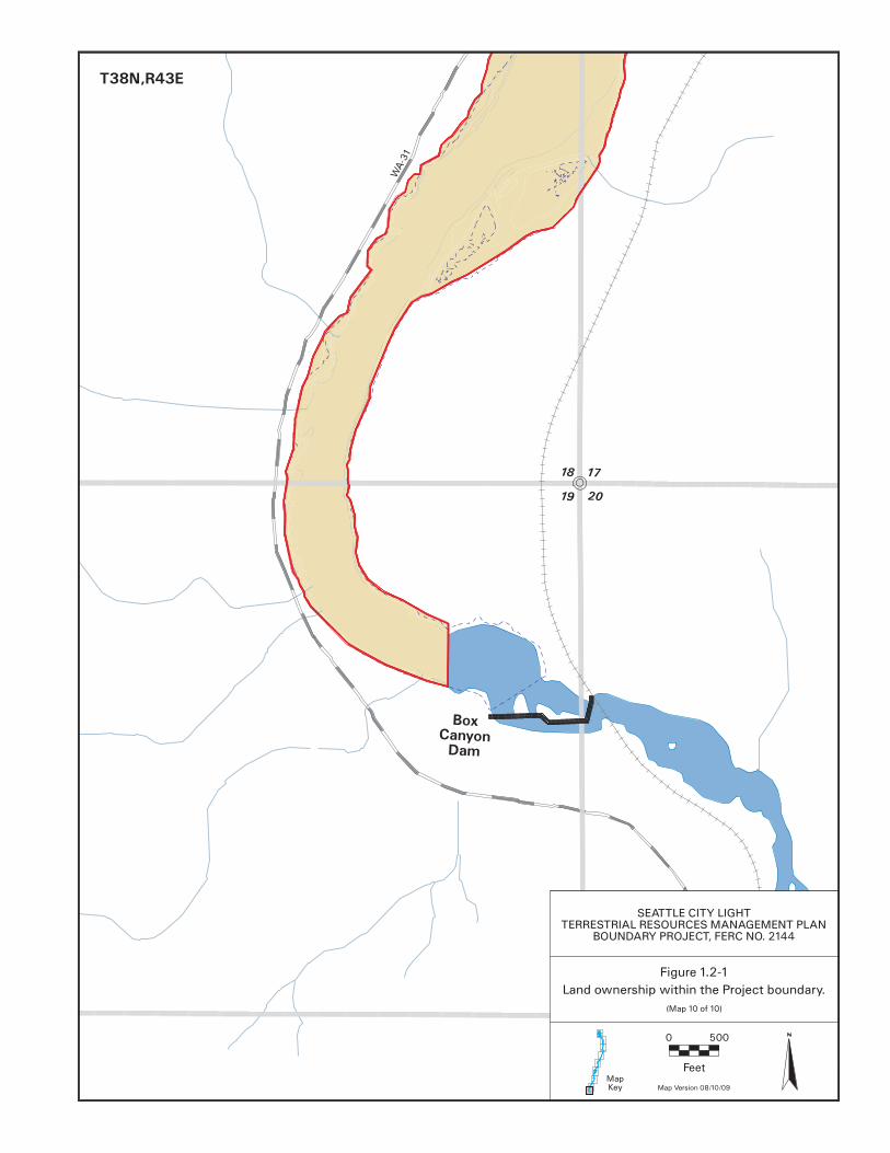
4.1.2.3.2. Management Considerations/Constraints Any measures to protect the caves on this site will need to be balanced against drawing unwanted attention to them. 4.1.3. Everett/Beaver Creek Lands
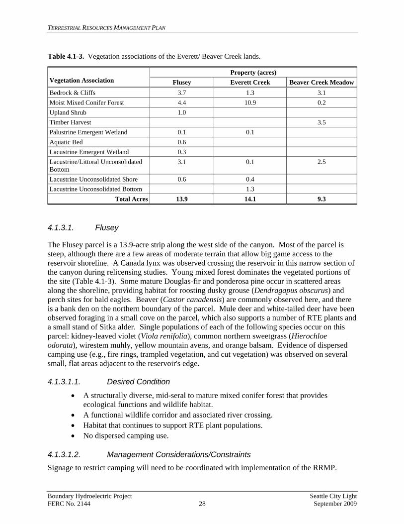
This group of SCL-owned lands along the reservoir includes three SCL properties: the Flusey, Everett Creek, and Beaver Creek Meadow parcels (Table 4.1-3).
Boundary Hydroelectric Project Seattle City Light FERC No. 2144 27 September 2009
TERRESTRIAL RESOURCES MANAGEMENT PLAN
Table 4.1-3. Vegetation associations of the Everett/ Beaver Creek lands.
Property (acres) Vegetation Association Flusey Everett Creek Beaver Creek MeadowBedrock & Cliffs 3.7 1.3 3.1 Moist Mixed Conifer Forest 4.4 10.9 0.2 Upland Shrub 1.0 Timber Harvest 3.5 Palustrine Emergent Wetland 0.1 0.1 Aquatic Bed 0.6 Lacustrine Emergent Wetland 0.3 Lacustrine/Littoral Unconsolidated Bottom
3.1 0.1 2.5
Lacustrine Unconsolidated Shore 0.6 0.4 Lacustrine Unconsolidated Bottom 1.3
Total Acres 13.9 14.1 9.3 4.1.3.1. Flusey
The Flusey parcel is a 13.9-acre strip along the west side of the canyon. Most of the parcel is steep, although there are a few areas of moderate terrain that allow big game access to the reservoir shoreline. A Canada lynx was observed crossing the reservoir in this narrow section of the canyon during relicensing studies. Young mixed forest dominates the vegetated portions of the site (Table 4.1-3). Some mature Douglas-fir and ponderosa pine occur in scattered areas along the shoreline, providing habitat for roosting dusky grouse (Dendragapus obscurus) and perch sites for bald eagles. Beaver (Castor canadensis) are commonly observed here, and there is a bank den on the northern boundary of the parcel. Mule deer and white-tailed deer have been observed foraging in a small cove on the parcel, which also supports a number of RTE plants and a small stand of Sitka alder. Single populations of each of the following species occur on this parcel: kidney-leaved violet (Viola renifolia), common northern sweetgrass (Hierochloe odorata), wirestem muhly, yellow mountain avens, and orange balsam. Evidence of dispersed camping use (e.g., fire rings, trampled vegetation, and cut vegetation) was observed on several small, flat areas adjacent to the reservoir's edge. 4.1.3.1.1. Desired Condition
• A structurally diverse, mid-seral to mature mixed conifer forest that provides ecological functions and wildlife habitat.
• A functional wildlife corridor and associated river crossing. • Habitat that continues to support RTE plant populations. • No dispersed camping use.
4.1.3.1.2. Management Considerations/Constraints Signage to restrict camping will need to be coordinated with implementation of the RRMP.
Boundary Hydroelectric Project Seattle City Light FERC No. 2144 28 September 2009

TERRESTRIAL RESOURCES MANAGEMENT PLAN
4.1.3.2. Everett Creek
The Everett Creek parcel (14.1 acres in the Project boundary) includes steep slopes of young mixed conifer forest, mature mixed conifer forest, and the mouth of Everett Creek (Table 4.1-3). A number of large conifers and snags occur along the lower portion of this stream, which provide valuable habitat for woodpeckers and songbirds and perch sites for raptors. The forest provides cover for big game but lacks a well-developed understory that would provide forage for big game or cover for game birds. The drainage offers a corridor connection for big game between forage habitat in the meadows upslope and the reservoir. A pair of bald eagles has regularly been observed here, but no nest site has been located, and the nest is unlikely to be within the Project boundary. Three populations of wirestem muhly and three of purple meadowrue occur on the property. 4.1.3.2.1. Desired Conditions
• A structurally diverse, mid-seral to mature mixed conifer forest that provides ecological functions and wildlife habitat.
• Continued function as a wildlife travel corridor and reservoir crossing site. • A source of large snags for woodpeckers and other cavity-nesting species.
4.1.3.2.2. Management Considerations/Constraints None identified. 4.1.3.3. Beaver Creek Meadow
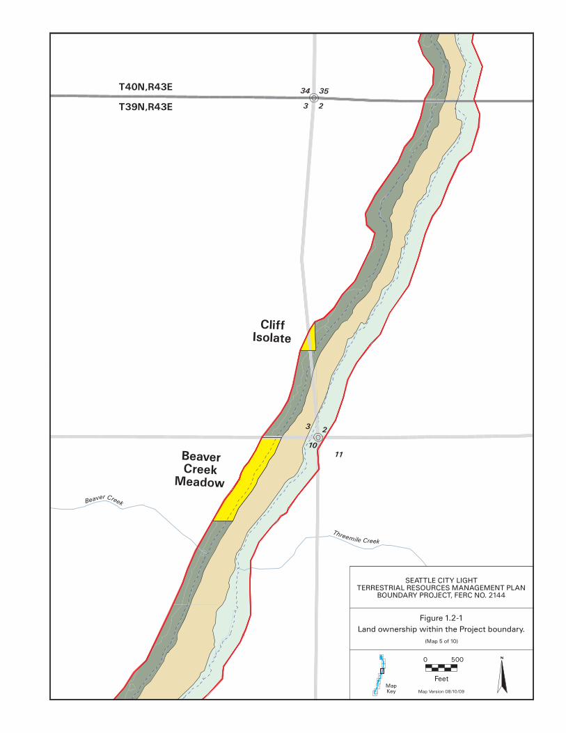
The Beaver Creek Meadow parcel (9.3 acres) consists of a steep, eroding slate slope and a narrow band of mixed conifer forest on top of the slope (Table 4.1-3). This parcel is regularly traversed by elk and deer that forage in adjacent meadows outside the Project area and then cross the reservoir. Well-used big game trails are evident, leading down weaknesses in the steep and eroding slate slope. No RTE plants were recorded on this parcel. 4.1.3.3.1. Desired Conditions Continued function as a wildlife travel corridor and resting site for deer and elk that extensively use the adjacent private property. 4.1.3.3.2. Management Considerations/Constraints None identified. 4.1.4. Upper Canyon Lands
Two properties and one complex of parcels are included in this reach of the reservoir: The Pend Oreille Mine Complex (two separate properties) and the Metaline Gorge properties are described in Table 4.1-4.
Boundary Hydroelectric Project Seattle City Light FERC No. 2144 29 September 2009

TERRESTRIAL RESOURCES MANAGEMENT PLAN
Table 4.1-4. Vegetation associations of the Upper Canyon lands.
Property (acres)
Vegetation Association Pend Oreille Mine
Complex Metaline Gorge Bedrock & Cliffs 8.2 Moist Mixed Conifer Forest 11.6 9.1 Dry Mixed Conifer Forest 0.7 Erosion Areas 0.1 1.0 Palustrine Emergent Wetland 0.9 Perennial Grassland 0.6 Timber Harvest 1.5 Upland Shrubs 0.5 Disturbed/Developed 0.3 Lacustrine Unconsolidated Bottom 1.0 2.4 Lacustrine Unconsolidated Shore 0.8 0.1 Palustrine Scrub-Shrub 0.1 Riverine Unconsolidated Shore 0.2
Total Acres 14.5 24.8 4.1.4.1. Pend Oreille Mine Complex
The Pend Oreille Mine Complex (14.5 acres) includes a series of small parcels between the Pend Oreille Mine and the reservoir that are dominated by young mixed conifer forest (Table 4.1-4). The habitat is generally unexceptional and functions as a travel corridor for deer moving between the reservoir shoreline and the open grass forage habitat associated with the developed mine areas. One population each of wirestem muhly, adder’s tongue (Ophioglossum pusillum), and orange balsam and three populations of purple meadowrue occur on this parcel. Evidence of dispersed camping was observed at two flat areas adjacent to the reservoir's edge. 4.1.4.1.1. Desired Conditions
• Continued function as a wildlife travel corridor that will improve in value as the forest matures.
• No dispersed camping use of limited flat areas along the reservoir. • Habitat that continues to support RTE plant species.
4.1.4.1.2. Management Considerations/Constraints Signage to restrict camping will require coordination with implementation of the RRMP. 4.1.4.2. Metaline Gorge
The Metaline Gorge parcel (24.8 acres in the Project boundary) is dominated by rock bluffs and outcrops with sparse vegetation that has little value as wildlife habitat. Raptors perch on the
Boundary Hydroelectric Project Seattle City Light FERC No. 2144 30 September 2009

TERRESTRIAL RESOURCES MANAGEMENT PLAN
cliffs, and bats may use some cervices in the rock as daytime roost sites. Yellow-bellied marmots (Marmota flaviventris) and violet-green swallows (Tachycineta thalassina) likely use these areas as well. One population of yellow mountain avens and one of purple meadowrue occur on this parcel. Because of the steep terrain, the area does not experience human use. 4.1.4.2.1. Desired Condition
• Continued function as habitat for perching raptors, swallows, marmots, and possibly roosting bats.
• Habitat that continues to support RTE plant species.
4.1.4.2.2. Management Considerations/Constraints None identified. 4.1.5. Sullivan Creek
The Sullivan Creek parcel (17.3 acres in the Project boundary), located at the mouth of the creek, includes a mixture of riparian deciduous forest, grass and shrub habitat, open water ponds, wetlands, and mixed forest (Table 4.1-5). The complex is located adjacent to the creek on a wide bench at the confluence with the reservoir. Observed wildlife includes nesting Canada geese, wood duck (Aix sponsa) broods, nesting northern flickers (Colaptes auratus), osprey, nesting great blue herons, a variety of bats (Myotis spp.), Pacific treefrogs (Pseudacris regilla), beaver, river otter (Lontra canadensis), and mule deer and white-tailed deer. The parcel has a high wildlife habitat value because of the diversity and interspersion of vegetation communities and its adjacency to upland forested land and water. A small (0.8 acre) stand of mature cottonwood occurs along the southern border of this parcel and extends off site. One population of orange balsam and two populations of purple meadowrue occur on this parcel. Table 4.1-5. Vegetation associations of the Sullivan Creek parcel.
Vegetation Association Sullivan Creek Parcel (acres) Bedrock & Cliffs 0.1 Mixed Deciduous/Conifer 0.1 Palustrine Aquatic Bed 0.4 Riparian Deciduous Tree 0.8 Riparian Grass 1.7 Riparian Shrub 5.2 Riverine Unconsolidated Bottom 5.7 Lacustrine Unconsolidated Bottom 0.2 Lacustrine/Littoral Unconsolidated Shore 0.3 Riverine Unconsolidated Shore 2.8
Total Acreage 17.3 4.1.5.1.1. Desired Conditions
• An interspersed mix of wetland, riparian, and upland habitats.
Boundary Hydroelectric Project Seattle City Light FERC No. 2144 31 September 2009

TERRESTRIAL RESOURCES MANAGEMENT PLAN
• Habitat connection between upper Sullivan Creek and the reservoir that allows for wildlife movement and genetic exchange for a diverse array of plants and wildlife.
• Habitat that continues to support RTE plant species. 4.1.5.1.2. Management Considerations/Constraints None identified. 4.1.6.
Boundary Wildlife Preserve (BWP) and BWP Addition
4.1.6.1. Boundary Wildlife Preserve
The 149-acre3 BWP consists of backwater sloughs, wetlands, river terraces, and adjacent forested slopes (Table 4.1-6). The river terrace areas include grassland meadows, fruit trees, and riparian forest stands consisting of mature black cottonwood stands and aspen with an understory of snowberry (Symphoricarpos albus) and hawthorn (Crataegus douglassi). The adjacent slopes and uplands support dense stands of young mixed conifer forest that have virtually no understory. There are also a few openings in the upland forest stands that are dominated by grasses and forbs and that appear to be heavily used by big game for foraging. Moose (Alces alces), elk, mule deer, and white-tailed deer are regularly observed in the BWP and the area provides both cover and forage habitat for these species. Bald eagles and Canada geese have nested on the site. Black bear and turkey (Meleagris gallopavo) use the area, along with a variety of songbirds, woodpeckers, and other cavity-nesting species. The BWP and BWP Addition (see below) provide a large, contiguous block of habitat that connects the reservoir to vast tracts of forests in the Colville National Forest. Two populations of least bladdery milk-vetch and seven large populations of purple meadowrue are located on the BWP. The BWP is used by snowmobiles and all-terrain vehicles (ATV), which damage habitat and disturb wildlife. Road access to the BWP is from atop the adjacent ridge via a single road leading from a railroad right-of-way or from a road that parallels the river and crosses the BWP and adjacent properties. 4.1.6.1.1. Desired Conditions
• A structurally complex, mature, self-sustaining cottonwood forest along the reservoir that provides habitat for multiple wildlife species and ecological functions.
• Functional habitat connections between adjacent upland forest and reservoir shoreline.
• Upland conifer forest stands that are less densely stocked, have a more open canopy, and support a diverse understory of shrubs, small trees, grasses, and forbs.
• Forest openings that support a diversity of native grasses and forbs and are used by big game for foraging.
• No use by ATVs or snowmobiles. • Habitat that continues to support RTE plants and wildlife.
3 Due to parcel delineation updates, this summation has been changed from the previously cited value of 155 acres.
Boundary Hydroelectric Project Seattle City Light FERC No. 2144 32 September 2009

TERRESTRIAL RESOURCES MANAGEMENT PLAN
4.1.6.1.2. Management Considerations/Constraints
• Restricting access from the adjacent ridge to the BWP can likely be accomplished with the installation of a gate; however, restricting access from adjacent properties to the north and south will likely be more difficult because of topography and vegetation.
• A professional assessment of the dense mixed conifer stands between the railroad tracks and the slope down to the wetlands and riparian areas will be needed to determine the best way to reduce fuel loads and improve habitat quality in this area.
Table 4.1-6. Vegetation associations of the BWP and BWP Addition.
Vegetation Association Property BWP BWP Addition Erosion Areas 0.4 Moist Mixed Conifer Forest 72.8 80.1 Mixed Deciduous/Conifer Forest 10.1 Palustrine Emergent Wetland 21.2 0.6 Palustrine Forested Wetland 27.3 Palustrine Unconsolidated Bottom 0.2 Palustrine Scrub-Shrub Wetland 10.5 1.2 Riparian Shrub 0.6 Riparian Deciduous Tree 0.2 Timber Harvest 6.8 Upland Shrub 2.4 0.3 Lacustrine/Littoral Unconsolidated Shore 3.3
Total Acres 149 89 4.1.6.2. BWP Addition
The BWP Addition (89 acres4) consists of young mixed conifer forest and a series of artificially constructed ponds (Table 4.1-6). Because of the cover afforded by the mixed conifer forest, its size, and its position adjacent to the BWP and other forested landscapes, this parcel provides good hiding and thermal habitat for big game and a protected travel corridor between the reservoir and the adjacent uplands. Two excavated ponds are located in the west central portion of the site, adjacent to the railroad corridor. Beaver have modified one of the ponds and dammed the outlet of the small creek that flows through the site. There are no records of RTE plants on this parcel, but it was not included in the 2008 relicensing study area for RTE plants.
4 The size of the adjoining SCL-owned parcels is 89 acres, not 88 acres as previously reported.
Boundary Hydroelectric Project Seattle City Light FERC No. 2144 33 September 2009
TERRESTRIAL RESOURCES MANAGEMENT PLAN
4.1.6.2.1. Desired Conditions
• Mixed conifer forest of mid- to late seral stages that provides a buffer to the BWP, cover for big game, and nesting habitat for birds.
• A diverse scrub-shrub wetland community along the southern excavated pond adjacent to the railroad right-of-way.
4.1.6.2.2. Management Considerations/Constraints
• Wetland enhancement will be considered but will require study of the hydrology and soil conditions of this system.
• A RTE plant survey will need to be conducted to help establish a land management baseline condition for this parcel.
4.1.6.3. Other SCL Lands
Other SCL-owned lands in the Project area are relatively small parcels that are isolated, on steep terrain, and are dominated by cliffs or talus. The habitat value of these lands is minimal. The Junction Isolate, Cliff Isolate, and Mine Isolate parcels have a combined total area of 3.1 acres and none of the parcels is adjacent to other SCL lands. The Junction Isolate is essentially the right-of-way for the upper part of the West Side Access Road leading down to the dam and provides no habitat value. The Cliff Isolate is a 1.3-acre parcel of young mixed conifer forest, and the Mine Isolate is a 0.3-acre parcel of mixed conifer forest. The Flume Creek parcel is a 1-mile-long reach of the reservoir that includes the mouth of Flume Creek and Deadman’s Eddy. A small amount (1.6 acres) of terrestrial habitat is associated with this parcel and is of marginal habitat value. Waterfowl are occasionally observed in the eddy (including wood ducks), and this stretch of the river is regularly crossed by deer and elk. No specific management actions are included for these lands, but RTE plant and wildlife monitoring and weed monitoring and control will be conducted as appropriate. 4.2. Project-related Roads, Facilities, and Use Areas
While the habitat and ecological value of most Project roads and facility areas may not be significant, the management and maintenance of these areas is important to protect existing natural resource values on these parcels, as well as on adjacent lands. Weeds growing along Project roads and erosion along steep banks, as well as maintenance activities such as brushing, paving, and grading, have the potential to cause adverse effects to resources such as the few RTE plant populations that occur near Project facilities. As discussed in Chapter 7, SCL will consider the potential impacts of any planned activities that may affect habitat and ecological values on all lands in the Project area. 4.2.1. Project-Related Roads
SCL has identified nine roads in the Project vicinity that are used for Project-related purposes (Table 4.2-1). Some of these roads are used exclusively by SCL, although some are also used by other parties. The condition of all Project-related roads is consistent with SCL’s need for and use of the roads and with USFS management objectives, where applicable. Of the 7.25 miles of
Boundary Hydroelectric Project Seattle City Light FERC No. 2144 34 September 2009
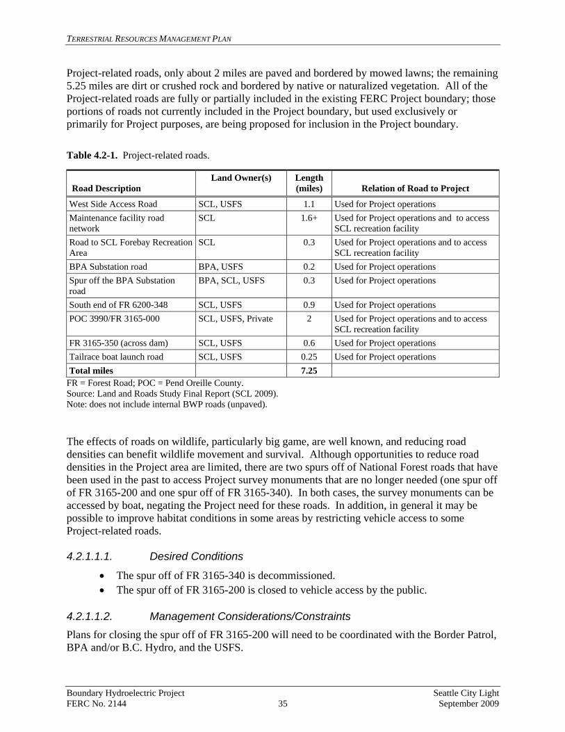
TERRESTRIAL RESOURCES MANAGEMENT PLAN
Project-related roads, only about 2 miles are paved and bordered by mowed lawns; the remaining 5.25 miles are dirt or crushed rock and bordered by native or naturalized vegetation. All of the Project-related roads are fully or partially included in the existing FERC Project boundary; those portions of roads not currently included in the Project boundary, but used exclusively or primarily for Project purposes, are being proposed for inclusion in the Project boundary. Table 4.2-1. Project-related roads.
Road Description
Land Owner(s) Length (miles)
Relation of Road to Project
West Side Access Road SCL, USFS 1.1 Used for Project operations Maintenance facility road network
SCL 1.6+ Used for Project operations and to access SCL recreation facility
Road to SCL Forebay Recreation Area
SCL 0.3 Used for Project operations and to access SCL recreation facility
BPA Substation road BPA, USFS 0.2 Used for Project operations Spur off the BPA Substation road
BPA, SCL, USFS 0.3 Used for Project operations
South end of FR 6200-348 SCL, USFS 0.9 Used for Project operations POC 3990/FR 3165-000 SCL, USFS, Private 2 Used for Project operations and to access
SCL recreation facility FR 3165-350 (across dam) SCL, USFS 0.6 Used for Project operations Tailrace boat launch road SCL, USFS 0.25 Used for Project operations Total miles 7.25
FR = Forest Road; POC = Pend Oreille County. Source: Land and Roads Study Final Report (SCL 2009). Note: does not include internal BWP roads (unpaved). The effects of roads on wildlife, particularly big game, are well known, and reducing road densities can benefit wildlife movement and survival. Although opportunities to reduce road densities in the Project area are limited, there are two spurs off of National Forest roads that have been used in the past to access Project survey monuments that are no longer needed (one spur off of FR 3165-200 and one spur off of FR 3165-340). In both cases, the survey monuments can be accessed by boat, negating the Project need for these roads. In addition, in general it may be possible to improve habitat conditions in some areas by restricting vehicle access to some Project-related roads. 4.2.1.1.1. Desired Conditions
• The spur off of FR 3165-340 is decommissioned. • The spur off of FR 3165-200 is closed to vehicle access by the public.
4.2.1.1.2. Management Considerations/Constraints Plans for closing the spur off of FR 3165-200 will need to be coordinated with the Border Patrol, BPA and/or B.C. Hydro, and the USFS.
Boundary Hydroelectric Project Seattle City Light FERC No. 2144 35 September 2009
TERRESTRIAL RESOURCES MANAGEMENT PLAN
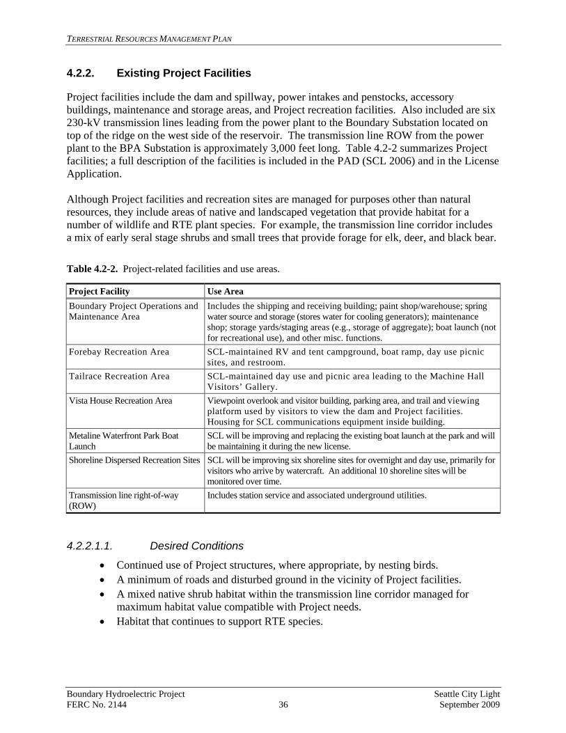
4.2.2. Existing Project Facilities
Project facilities include the dam and spillway, power intakes and penstocks, accessory buildings, maintenance and storage areas, and Project recreation facilities. Also included are six 230-kV transmission lines leading from the power plant to the Boundary Substation located on top of the ridge on the west side of the reservoir. The transmission line ROW from the power plant to the BPA Substation is approximately 3,000 feet long. Table 4.2-2 summarizes Project facilities; a full description of the facilities is included in the PAD (SCL 2006) and in the License Application. Although Project facilities and recreation sites are managed for purposes other than natural resources, they include areas of native and landscaped vegetation that provide habitat for a number of wildlife and RTE plant species. For example, the transmission line corridor includes a mix of early seral stage shrubs and small trees that provide forage for elk, deer, and black bear. Table 4.2-2. Project-related facilities and use areas.
Project Facility Use Area Boundary Project Operations and Maintenance Area
Includes the shipping and receiving building; paint shop/warehouse; spring water source and storage (stores water for cooling generators); maintenance shop; storage yards/staging areas (e.g., storage of aggregate); boat launch (not for recreational use), and other misc. functions.
Forebay Recreation Area SCL-maintained RV and tent campground, boat ramp, day use picnic sites, and restroom.
Tailrace Recreation Area SCL-maintained day use and picnic area leading to the Machine Hall Visitors’ Gallery.
Vista House Recreation Area Viewpoint overlook and visitor building, parking area, and trail and viewing platform used by visitors to view the dam and Project facilities. Housing for SCL communications equipment inside building.
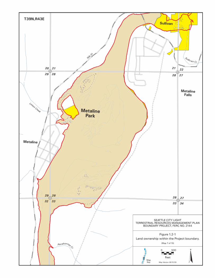
Metaline Waterfront Park Boat Launch
SCL will be improving and replacing the existing boat launch at the park and will be maintaining it during the new license.
Shoreline Dispersed Recreation Sites SCL will be improving six shoreline sites for overnight and day use, primarily for visitors who arrive by watercraft. An additional 10 shoreline sites will be monitored over time.
Transmission line right-of-way (ROW)
Includes station service and associated underground utilities.
4.2.2.1.1. Desired Conditions
• Continued use of Project structures, where appropriate, by nesting birds. • A minimum of roads and disturbed ground in the vicinity of Project facilities. • A mixed native shrub habitat within the transmission line corridor managed for
maximum habitat value compatible with Project needs. • Habitat that continues to support RTE species.
Boundary Hydroelectric Project Seattle City Light FERC No. 2144 36 September 2009
TERRESTRIAL RESOURCES MANAGEMENT PLAN
4.2.2.1.2. Management Considerations/Constraints Habitat management activities in the vicinity of Project facilities will need to be developed and implemented in cooperation with Project staff; Project needs will take precedent when management options are being considered. 4.2.3. Existing Recreation Facilities
There are three existing SCL-owned recreation facilities located within the Project boundary: the Forebay, Tailrace, and Vista House Recreation Areas. Two other recreation sites, Metaline Waterfront Park and Campbell Park, provide boat access to Boundary Reservoir. The Forebay Recreation Area consists of a boat launch, camping, and picnic facilities. It is located on the west side of the Project forebay just upstream of the dam. Although the recreation facilities are subject to a high level of human use, the lawn areas are utilized as foraging sites for Canada goose broods and support a colony of yellow-bellied marmots. The Forebay Recreation Area is the only site where western toads (Bufo boreas) were found during relicensing studies. A small population of least bladdery milk-vetch and one of purple meadowrue occur along the reservoir edge of the Forebay Recreation Area. The Tailrace Recreation Area is dominated by Project facilities, roads, and parking lots. Violet green, barn, and cliff swallows use Project structures in this area for nesting, and several RTE plant populations occur along the road to the power plant. Although routinely mowed, the picnic area near the power plant provides a mix of open areas, shrubs, and trees that is used by a variety of birds. Columbia spotted frogs were observed in the stream that runs through this area. The Vista House Recreation Area includes a building that provides interpretive displays and views of Boundary Dam and the Pend Oreille River, an outdoor viewing platform that also provides views of the dam and reservoir, a trail connecting the Vista House to the viewing platform, and a gravel parking area, among other site amenities (e.g., restrooms, trash receptacles, picnic tables, etc.). The two other recreation areas along Boundary Reservoir, Metaline Waterfront Park and Campbell Park, are operated by the City of Metaline and Pend Oreille County Public Utility District (PUD), respectively. Shoreline-related features at Metaline Waterfront Park include a boat ramp, dock, and associated parking. Campbell Park, located just downstream from Box Canyon Dam, also offers a boat ramp that provides access to Boundary Reservoir. At four of the sites (all but Campbell Park), SCL plans improvements and enhancements during the new license term. 4.2.3.1.1. Desired Conditions
• Habitat that continues to support RTE plant populations. • Increased native vegetation and improved wildlife habitat conditions in the Tailrace
picnic area, particularly along the stream corridor. • Continued use of the Forebay Recreation Area by marmots, western toads, and
Canada geese.
Boundary Hydroelectric Project Seattle City Light FERC No. 2144 37 September 2009

TERRESTRIAL RESOURCES MANAGEMENT PLAN
• Recreation areas and activities that are managed for compatibility with existing wildlife use.
4.2.3.1.2. Management Considerations/Constraints
• Recreational improvements should be consistent with the protection of native plant communities, including any RTE species, and be compatible with wildlife use.
• Habitat management activities in the vicinity of Project facilities will need to be developed and implemented in cooperation with Project staff.
• The Project interpretive/education program may need to consider providing information to visitors to ensure the continued use of Project recreation areas by wildlife and to reduce human-wildlife interactions/conflicts.
4.2.4. Proposed New Recreation Sites and Existing and Dispersed Recreation
Sites
SCL plans to develop two new recreation sites: Peewee Falls Viewpoint and Trail, and Metaline Falls Portage Trail. Details on the plans for these facilities can be found in the RRMP. SCL also plans to manage multiple dispersed recreation sites and use areas along the reservoir shoreline (within the Project boundary) to support Project-related recreational use. Under the new license, six of these shoreline sites will be enhanced to protect resources from potential recreation-related impacts; ten other shoreline dispersed recreation sites will be designated and monitored over time. Some of these sites are located on SCL lands, while others are on USFS- and BLM-managed lands. Since the potential exists for overlap between recreation and terrestrial resource goals and actions at shoreline dispersed recreation sites, resource integration and communication will help ensure that potential resource conflicts are addressed over the term of the new license. Three dispersed recreation sites, one along the forebay and two in the canyon reach, have been selected for erosion control (see Erosion Control Program). The TRWG will coordinate with the Recreation Resources Workgroup (RRWG) as this work progresses. 4.2.4.1.1. Desired Conditions
• Habitat and other natural resource values are preserved at new and dispersed recreation sites.
• Recreation/natural resource conflicts are minimal. • Opportunities for natural resource interpretation/education are incorporated into the
new recreation sites. 4.2.4.1.2. Management Considerations/Constraints Developing and monitoring new recreation sites will require close coordination between the TRWG and RRWG.
Boundary Hydroelectric Project Seattle City Light FERC No. 2144 38 September 2009

TERRESTRIAL RESOURCES MANAGEMENT PLAN
4.3. Federal Lands within the Project Boundary
The USFS and BLM manage approximately 606 and 314 acres of land, respectively, within the Project boundary (30 of these acres are associated with Project facilities). Most of the federal ownership is located north of Metaline Falls and has a long history of being managed for timber production, mining, and resource protection. These lands are dominated by mixed second-growth conifer forests and include the mouths of Lime, Slate, and Threemile Creeks where they enter the reservoir. Management of these lands is the responsibility of the federal agencies, and SCL will coordinate with these entities regarding weed control and other cooperative management actions. Recreation-related actions on federal lands are addressed in the RRMP, including monitoring potential shoreline impacts from Project-related recreational use. Some overlap may occur among SCL, USFS, and BLM for activities such as RTE plant monitoring, weed control, and erosion control. SCL will coordinate these efforts through the TRWG and other workgroups as needed.
5 RESOURCE MANAGEMENT PROGRAMS
This section describes the objectives and implementation tasks for each of the seven resource programs included in the TRMP:
• Erosion Program • Habitat Protection and Enhancement Program • Integrated Weed Management Program • RTE Plant Species Program • Wildlife Program • Shoreline Management Program • Travel and Public Access Management Program
In addition, separate programs have been developed to address monitoring and adaptive management, as well as for the management of Project-related activities and facilities; these programs are described in Chapters 6 and 7, respectively. In general, SCL will actively manage PHLs to protect and/or enhance terrestrial resource values and will coordinate with the USFS and BLM during the annual meeting regarding federal management activities adjacent to SCL-owned lands. The Erosion Program and the survey and monitoring aspects of all other programs apply to federal lands, as well as SCL–owned lands, within the Project boundary. 5.1. Erosion Program
Past erosion along the Project reservoir has contributed to the loss of approximately 15 acres of land (Erosion Study Final Report, SCL 2009). Erosion rates in the years immediately following the filling of the reservoir were likely greater than the current rate of erosion. To determine the
Boundary Hydroelectric Project Seattle City Light FERC No. 2144 39 September 2009
TERRESTRIAL RESOURCES MANAGEMENT PLAN
amount and the rate of erosion over the next license period, it is necessary to develop and implement a long-term erosion monitoring program. The long-term monitoring program will use baseline data collected during relicensing studies and will be developed in consultation with the TRWG. The purpose of the monitoring program is to:
• Determine if there are substantial changes to the length of eroding shoreline over
time. • Determine the rate of Project-related erosion, measured as the average area (acres) of
land lost to bank retreat per 10-year monitoring period. The Erosion Study also identified three sites with particularly high resource values where implementation of erosion control measures would be expected to stabilize the sites and improve natural resource conditions. One site is in the forebay and two are on BLM land in the canyon reach. All three of these sites are shoreline sites that are also used for recreation. Objectives and tasks for the erosion control and long-term erosion monitoring elements of the Erosion Program are described below. Objective 1 – Erosion control: Develop and implement erosion control measures specific to the three sites identified in the feasibility analysis of the Erosion Study Final Report (SCL 2009). Develop a schedule within one year of license issuance. Implement measures consistent with the schedule and design of recreation improvements at each site. Task 1.1: Prepare a schedule for the development of erosion control plans for each of the three sites that is integrated with the schedule for recreation improvements at each site.
Task 1.2: Work with a geologist and/or civil engineer to develop site-specific erosion control plans for each of the three sites. Each plan should include the specific erosion control objectives for the site, the methods to be applied, the location and extent of any required grading and drainage modifications to the site, scale drawings and maps, estimated quantities of materials, approximate cost, and monitoring. Task 1.3: Implement erosion control measures consistent with the schedule and design of recreation improvements at each site.
Task 1.4: Monitor the three sites annually for three years following implementation to ensure that actions are meeting the stated objectives. Continue monitoring every 10 years as part of a long-term monitoring plan and repair structures as needed to maintain intended erosion control function.
Objective 2 – Long-term erosion monitoring: Develop and implement a long-term erosion monitoring plan for lands adjacent to Boundary Reservoir. Develop a plan within two years of license issuance; conduct the first year of monitoring within three years of license issuance. Task 2.1: Work with the TRWG to refine the erosion monitoring methods and identify specific sites for monitoring.
Boundary Hydroelectric Project Seattle City Light FERC No. 2144 40 September 2009

TERRESTRIAL RESOURCES MANAGEMENT PLAN
Task 2.2: Monitor erosion every 10 years and include the results in the Rolling 3-Year Annual Report/Work Plan.
The monitoring program will use the results of the Erosion Study Final Report (SCL 2009) as a baseline so that data collected during the new license term will be comparable to the information generated during the relicensing study program. The monitoring will consist of the following components:
• Visually inspect the entire reservoir shoreline every 10 years through the term of the new license. This inspection will use as a base the original field forms and aerial photograph overlays produced during the erosion study. The position, length, height, and condition of each erosion area will be evaluated to determine if any changes have occurred since the previous survey. Any previously undocumented areas of erosion will be mapped and catalogued using the field forms. A photograph will be taken of each site.
• To determine the rate of erosion over time, bank retreat rates will be monitored every 10 years at 15 representative sites, to be selected from the 87 sites identified during the erosion inventory. The 15 sites will be selected from sites rated during the initial study as having high, medium, and low erosion rates (combination of bank height and shoreline length). The number of high, medium and low sites will be chosen in a ratio that is proportional to the occurrence of each of these erosion categories. A preliminary ratio of four low category sites, four medium category sites, and eight high category sites has been identified and will be refined in coordination with the TRWG. In addition, during each survey period, bank retreat rates will be measured at each of the three recreation sites where erosion control measures are implemented (as described above under Objective 1), plus any additional sites where erosion control measures are implemented during the term of the new license.
• Bank retreat will be monitored by establishing a series of metal pins close to the top of the bank at each of the monitoring locations. The distance from each pin to the top of the bank (edge of vegetation mat or top edge of soil) will be measured and recorded. At banks suspected to have high bank retreat rates, a second set of pins will be placed 5 feet back from the first set in case the first set is lost. The location of each pin will be located by global positioning system (GPS) to enable researchers to find the pins during future monitoring periods. Photographs will be taken of each site. Average bank retreat rates at each site will be calculated as the average of the retreat rate from all the pins at that site.
• Evaluation of shoreline erosion length during each 10-year monitoring period will be determined by comparing the total length of eroding shoreline in each erosion rating category (high, medium, low) with the length from previous monitoring periods. An estimate of any area lost to erosion will be made by multiplying the length of shoreline in each category by the average bank retreat rate for that category.
Task 2.3: If monitoring reveals that high value resources are being affected by Project-related erosion, conduct an assessment to determine the feasibility of controlling erosion at the site(s).
Boundary Hydroelectric Project Seattle City Light FERC No. 2144 41 September 2009

TERRESTRIAL RESOURCES MANAGEMENT PLAN
5.2. Habitat Protection and Enhancement Program
The intent of the Habitat Protection and Enhancement Program is to reach the goals and desired conditions for the PHLs and several Project facility areas as outlined in Chapters 3 and 4. There are two main elements of this program: (1) passive management to protect the existing habitat values of the PHLs and to allow the natural maturation of the relatively young mixed conifer stands that dominate the SCL-owned lands, and (2) active management for parcels where there is a clear resource need and a cost-effective management solution. Habitat enhancement measures were developed by reviewing the habitat information provided from the terrestrial resource relicensing studies, visiting PHLs with the highest habitat values, and continuing discussions with the TRWG. A few areas associated with Project facilities also have wildlife habitat values identified as potentially benefiting from enhancement measures. Habitat enhancement measures are parcel-specific and include the following:
• Vehicle access control. • Wetland enhancement at the BWP Addition. • Riparian habitat enhancement near the power plant. • BWP forest and meadow management. • Island and shoreline access control.
Objective 1 –Vehicle access control: Identify and implement vehicle access control measures, as needed, on lands owned by SCL within the Project boundary. Implement within five years of license issuance. Generally, public access to most PHLs is not causing problems, but unauthorized use of vehicles can cause substantial damage to habitat, particularly to wetlands, and disturb wildlife at critical times of the year. In addition, once public use is established in an area, it can be difficult to stop. Controlling vehicle access is therefore a key objective for the protection of wildlife habitat on several PHLs. Task 1.1: Install a gate to prevent vehicle access on the road near the Vista House Recreation Area that leads downslope to the Tailrace East parcel (spur off of FR 3165-200). Include a sign noting that vehicle use is prohibited to protect the site’s natural resource values, but access on foot is allowed. Coordinate this action with the RRMP and the Travel and Public Access Management Program of this TRMP. Task 1.2: Develop and implement vehicle access control measures for the BWP.
• Subtask 1.2.1: Assess the likelihood of successfully implementing access control measures, such as installing a gate on the road leading from the ridge downslope to the BWP in a way that does not affect access to adjacent private property.
• Subtask 1.2.2: Coordinate with the TRWG to develop options for prohibiting access along the road that parallels the river.
Boundary Hydroelectric Project Seattle City Light FERC No. 2144 42 September 2009
TERRESTRIAL RESOURCES MANAGEMENT PLAN
• Subtask 1.2.3: Develop signage for both roads leading to the BWP, indicating that access by foot is allowed. Signs should be coordinated with the RRMP’s Interpretation and Education (I&E) Program and the Travel and Public Access Management Program in this TRMP.
• Subtask 1.2.4: Implement periodic enforcement checks.
Objective 2 – Wetland enhancement on BWP Addition: Assess the feasibility of successfully enhancing the habitat associated with the excavated pond on the BWP Addition (on the pond that is closest to the existing railroad right-of-way). Use the results of the study to determine the need for a Wetland Enhancement Plan. Complete assessment within three years of license issuance. If an enhancement plan is warranted, develop and implement the plan within five years of license issuance. Task 2.1: Conduct a year-long study to determine the seasonal hydrologic and soil conditions of the site and to assess the feasibility and likelihood of success of habitat improvement opportunities at the site, in coordination with the TRWG. Task 2.2: If the feasibility study indicates that wetland enhancement is possible and would provide tangible ecological benefits, develop a site-specific wetland enhancement plan for the existing excavated pond. Objective 3 –Tailrace recreation area habitat improvements: Identify and implement specific measures to improve the habitat associated with the picnic area adjacent to the employee parking area near the power plant portal. Develop and implement measures within three years of license issuance. Task 3.1: Coordinate with Project staff to identify and implement measures to improve wildlife habitat in and around the picnic area near the power plant under the RRMP. Consider ceasing mowing of the riparian zone and planting native trees and shrubs to enhance habitat. Task 3.2: Monitor the stream for presence of Columbia spotted frogs and plant survival for five years following implementation. Objective 4 – Forest management on the BWP: Develop a forest management plan for the BWP to reduce tree density in overstocked stands, increase plant diversity, and improve wildlife habitat values. Develop and implement plan within five years of license issuance. Task 4.1: Hire a professional forester or silviculturist to conduct a forestry inventory and assessment of stands on the BWP and assist with the development of a forest management plan for the site. The plan should include goals and expected outcomes, a monitoring and contingency plan, and harvest and wood disposal or sale plans.
Task 4.2: Selectively thin and clear densely stocked conifer stands and maintain existing meadow habitat as directed by the plan.
Boundary Hydroelectric Project Seattle City Light FERC No. 2144 43 September 2009

TERRESTRIAL RESOURCES MANAGEMENT PLAN
Objective 5 – Shoreline protection from human disturbance: Protect Canada goose nests on Metaline Island and Rat Island from human disturbance and limit recreational use at other sites along the reservoir to protect ecological values. Develop and implement protection measures within three years of license issuance. Task 5.1: In coordination with the TRMP Travel and Access Management Program and the RRMP I&E Program, install signs prohibiting the use of Metaline and Rat islands during the Canada goose nesting season from March 15 through May 15. Monitor these sites to ensure compliance. Task 5.2: In coordination with the TRMP Travel and Access Management Program and the RRMP I&E Program, install signs prohibiting camping outside of designated use areas at specified locations along the reservoir. Task 5.3: Monitor sites in the upper reservoir where terrestrial resource impacts were observed at sensitive sites in association with recreational use (i.e., trampling of vegetation). 5.3. Integrated Weed Management Program
For the purposes of this document, weeds are defined as terrestrial plant species that have been classified as noxious weeds by the Washington State Noxious Weed Control Board (State NWCB 2009). In Washington, noxious weeds are defined as non-native plants that result in economic losses and adverse effects on the State’s agricultural, natural, and human resources (Washington Weed Law, Chapter 17.10 Revised Code of Washington [RCW]). Noxious weeds are classified based on the stage of invasion of a species. The classification system is designed to: (1) prevent small infestations from becoming large infestations, (2) contain already-established infestations to regions of the state where they occur and prevent their movement to un-infested areas, and (3) allow flexibility at the local level for landowner management programs (State NWCB 2009). Weeds are classified as follows (State NWCB 2009; RCW 17.10.010(2)):
• Class A Weeds - Non-native species with a limited distribution in the state. Eradication is required by state law.
• Class B Weeds - Non-native species established in some regions of Washington, but of limited distribution or not present in other regions of the state. Because of differences in distribution, treatment of Class B weeds varies between regions of the state. In regions where a Class B species is unrecorded or of limited distribution, prevention of seed production is required. In these areas, the weed is a “Class B designate,” meaning it is designated for control by state law. In regions where a Class B species is already abundant or widespread, control is a local option. In these areas, the weed is a “Class B” with the chief goals of containment, gradual reduction, and prevention of further spread.
• Class C Weeds - Non-native species that are already widely established in Washington or of special concern to the state’s agricultural industry. Counties may enforce control if locally desired, or choose simply to provide education or technical consultation to county residents.
Boundary Hydroelectric Project Seattle City Light FERC No. 2144 44 September 2009

TERRESTRIAL RESOURCES MANAGEMENT PLAN
As of 2009, there were 140 plants designated as noxious weeds in Washington. Of these, 54 terrestrial noxious weed species have been documented in Pend Oreille County (Pend Oreille County Noxious Weed Control Board [County NWCB] 2009), including 4 Class A, 29 Class B-designate, 10 Class B, and 11 Class C noxious weeds (Table 5.3-1). Table 5.3-1. Terrestrial noxious weed species documented in Pend Oreille County and in the Boundary Project area (bold indicates target species for control).1
Common Name Scientific Name Class2Documented in or near
Project Area
Bighead knapweed Centaurea macrocephala A Vochin knapweed Centaurea nigrescens A Buffalobur Solanum rostratum A Clary sage Salvia sclarea A Annual bugloss Anchusa arvensis B - designate Common bugloss Anchusa officianalis B - designate Hoary alyssum Bertero aincana B Butterfly bush Buddleja davidii B - designate Plumeless thistle Carduus acanthoides B - designate Musk thistle Carduus nutans B - designate Diffuse knapweed Centaurea diffusa B X Spotted knapweed Centaurea biebersteinii B X Meadow knapweed Centaurea jacea x nigra B - designate Yellow starthistle Centaurea solstitialis B - designate Rush skeletonweed Chondrilla juncea B - designate Houndstongue Cynoglossum officianale B X Scotch broom Cytisus scoparius B - designate X Spurge laurel Daphne laureola B-designate Wild carrot Daucus carota B X Viper's bugloss Echium vulgare B - designate Leafy spurge3 Euphorbia esula B - designate X Herb robert Geranium robertianum B - designate Queen-devil hawkweed H. glomeratum B - designate Orange hawkweed Hieracium aurantiacum B X Yellow hawkweed Hieracium caespitosum B X Common catsear Hypochaeris radicata B - designate Policeman’s helmet Impatiens glandulifera B - designate Kochia Kochia scoparia B - designate Perennial pepperweed Lepidium latifolium B - designate Leprodiclis Lepyrodiclis holosteoides B - designate Oxeye daisy Leucanthemum vulgare B X Dalmatian toadflax Linaria dalmatica ssp. dalmatica B X Purple loosestrife Lythrum salicaria B - designate X
Boundary Hydroelectric Project Seattle City Light FERC No. 2144 45 September 2009

TERRESTRIAL RESOURCES MANAGEMENT PLAN Table 5.3-1, continued…
Documented in or near Class2Common Name Scientific Name Project Area
Wand loosestrife L. virgatum B - designate Scotch thistle Onopordum acanthium B - designate Common reed Phragmites australis B - designate Bohemian knotweed Polygonum, bohemicum B - designate Japanese knotweed P. cuspidatum B - designate Giant knotweed P. sachalinense B - designate X Sulfur cinquefoil Potentilla recta B X Tansy ragwort Senecio jacobaea B - designate Perennial sowthistle4,5 Sonchus arvensis ssp. arvensis B - designate X Saltcedar Tamarix ramossisma B - designate Canada thistle Cirsium arvense C X Bull thistle4 Cirsium vulgare C X Myrtle spurge Euphorbia myrsinities C Babysbreath Gypsophila paniculata C English ivy (4 cultivars) Hedera helix, H. hibernica C Black henbane (shoofly) Hyoscyamus niger C St. johnswort Hypericum perforatum C X Yellow flag iris Iris pseudacorus C X Reed canarygrass Phalaris arundinacea C X Common tansy Tanecetum vulgare C X
Notes: 1 Source: Pend Oreille County NWCB 2009. 2 Class A, B-Designate, Class B non-designate, and Class C noxious weed species. See text for explanation of
weed classification system. 3 Species is being controlled by the Pend Oreille County NWCB and was not observed during relicensing studies
in 2005, 2007, or 2008. 4 Species does not appear on the 2009 list of noxious weeds for Pend Oreille County (County NWCB 2009) but is
on the 2009 state list and has been found in the Project area. 5 There is some question on the taxonomy of the perennial sowthistle found during relicensing surveys; the plants
in the Project area may be marsh sowthistle, which is not classified as a noxious weed in Washington. Studies conducted during relicensing in 2005, 2007, and 2008, and earlier by the Pend Oreille County NWCB, documented a total of 20 terrestrial noxious weed species in and near the Project area, five classified as Class B-designate, nine Class B, and six Class C (SCL 2006, 2009; Table 5.3-1). No Class A species were found. Infestations of one or more of the Class B-designate species were mapped in six different locations. In general, the number of noxious weed species found in and near the Project area is low compared to many other locations in eastern Washington, but the Class B and Class C weed species that do occur are widespread and pervasive (SCL 2006). The goal of the Integrated Weed Management Program (IWMP) for the Project is to monitor, control, suppress, and contain terrestrial noxious weed species to maintain or achieve diverse and naturally functioning plant communities in the Project area. Aquatic weeds are not included in
Boundary Hydroelectric Project Seattle City Light FERC No. 2144 46 September 2009
TERRESTRIAL RESOURCES MANAGEMENT PLAN
the IWMP but are addressed under the Aquatic Invasive Species Control and Prevention Plan (Attachment E-6 to the License Application). All IWMPs have three inter-related components: inventory, prevention, and control/treatment. Each of these components is addressed by the following IWMP objectives. Objective 1 – Initial and periodic inventories: Conduct an initial inventory to update information regarding the locations of existing weed infestations and then re-inventory every three years to identify areas where new weeds or new infestations have become established. Conduct initial inventory within two years of license issuance. Task 1.1: Conduct an initial inventory of weeds in the Project area.
• Subtask 1.1.1: Consult with the County NWCB to update the list of noxious weeds known to occur or potentially occurring in the Project vicinity.
• Subtask 1.1.2: Map the locations of new infestations onto U.S. Geological Survey (USGS) topographic maps or record using a GPS unit. Map each infestation as accurately as possible to a resolution of 0.1 acre. Estimate the extent and number of plants in each mapped infestation and record data using the following cover classes developed by the North American Weed Management Association (NAWMA 2003): trace (T=<1%), low (L=1-5%), moderate (M=5.1-25%), and high (H=25.1-100%).
• Subtask 1.1.3: Work with the County NWCB to resolve the taxonomy of the sowthistle plants found during relicensing surveys in the Project area.
Task 1.2: Consult with the County NWCB annually to update the list of noxious weeds known to occur or that potentially occur in the Project vicinity. Determine if any of the Class A or B-designate species added to the list require surveys in that year or if they can be included in the next three-year cycle.
Task 1.3: Conduct inventories every three years to identify any new infestations of noxious weeds in the Project area. Use the same methods as the initial inventory so that results are comparable between survey periods. Task 1.4: During each three-year inventory, monitor existing infestations that have not been designated for treatment. At each of these sites, record the extent, estimated number of plants, and cover class so that data can be compared between inventory periods.
Task 1.5: Update the associated database and maps, and summarize the periodic inventory results in the Rolling 3-Year Annual Report/Work Plan for that year. Objective 2 – Prevention: Develop an integrated program to minimize the establishment of noxious weeds in the Project area and along roads and in recreation areas covered by the TRMP. Develop and implement program within three years of license issuance.
Boundary Hydroelectric Project Seattle City Light FERC No. 2144 47 September 2009

TERRESTRIAL RESOURCES MANAGEMENT PLAN
Task 2.1: Integrate weed management into the Environmental Awareness Program (see Section 7.1).
• Subtask 2.1.1: Set up a meeting in the first quarter of each year between SCL’s environmental staff and Project operators, managers, and maintenance personnel to review the maps of noxious weeds and BMPs for preventing the spread of these species relative to any planned construction, erosion control, or maintenance activities.
• Subtask 2.1.2: Provide information on noxious weeds to new staff engaged in Project construction and maintenance activities.
Task 2.2: Implement the following BMPs when planning and implementing construction and maintenance activities that involve ground disturbance:
• Treat existing infestations before the maintenance activity occurs. If possible, treat known noxious weed infestations prior to initiating vegetation clearance or other maintenance activities. Treatment may include any of the methods described under Objective 3.
• Work toward noxious weed infestations. Where possible, initiate maintenance activities in weed-free locations and work toward infested areas. This sequence minimizes the spread of weed seeds and/or rhizomes via equipment and vehicles.
• Perform work in and through invasive non-native plant infestations prior to seed set or after dispersal. Seed set times differ for the various weed species in the Project area, and vary within species depending on elevation and aspect. Seed set time is not a factor for work performed in areas infested with species that spread mostly vegetatively. Approximate seed set times for the noxious weeds that do not spread primarily by rhizomes or root buds are as follows:
o Scotch broom (Cystic scoparius): May. o Spotted knapweed (Centaurea biebersteinii): July-September. o Hawkweeds (Hieracium spp.): June-September. o Reed canarygrass (Phalaris arundinacea): August-September. o Thistles: August-October. o Dalmatian toadflax (Linaria dalmatica ssp. Dalmatica): June-September.
• Equipment and vehicle cleaning. Implement a cleaning program for equipment and vehicles that involves power spraying with water before and after working off of paved or gravel roads on Project lands. In general, this program will apply to the following:
o Contract equipment and vehicles that will be used off of paved or gravel roads in the Project area.
o SCL vehicles and equipment used along the transmission line ROW or on the BWP.
o SCL vehicles and equipment that have been used off of paved or gravel roads outside the Pend Oreille River drainage.
Boundary Hydroelectric Project Seattle City Light FERC No. 2144 48 September 2009

TERRESTRIAL RESOURCES MANAGEMENT PLAN
o Equipment and vehicles that have been used off of paved or gravel roads and that are being taken off Project to locations outside the Pend Oreille River drainage.
• Minimize ground disturbance. Prepare a plan for all construction and ground-disturbing maintenance projects outside of previously disturbed areas to minimize ground disturbance. The plan should stipulate the location and size of equipment storage pads, vehicle parking sites, and other areas expected to be cleared or disturbed. The estimated size of the disturbed area and site characteristics should dictate how disturbance is managed (one concentrated site or several dispersed sites).
• Use weed-free material. Ensure that sand, gravel, and other fill material used for construction projects are generally weed-free. Stipulate the use of weed-free sand, gravel, and borrow material for any Project maintenance or construction activity that requires fill.
• Revegetate disturbed sites. Revegetate sites disturbed by Project maintenance and construction activities using native plant seed mixes and shrubs and saplings.
Task 2.3: Monitor the effectiveness of BMPs at construction/soil disturbance sites and treat noxious weeds as necessary. Summarize the sites requiring monitoring in the Rolling 3-Year Annual Report/Work Plan for that year.
• Subtask 2.3.1: Check active construction sites involving ground disturbance at least once to ensure that prevention measures have been implemented.
• Subtask 2.3.2: Visit completed construction sites that involved ground disturbance for at least three consecutive years and reseed or replant if needed.
• Subtask 2.3.3: Summarize the results of BMP effectiveness monitoring in the Rolling 3-Year Annual Report/Work Plan for that year.
Objective 3 – Control and effectiveness monitoring: Eradicate, suppress, or contain infestations of Class A and Class B-designate weed species on SCL lands within the Project boundary and along roads and at recreation areas covered by the TRMP, and on federal lands along the reservoir shoreline where infestations are determined to be Project-related. Monitor the effectiveness of control measures. Implement within two years of license issuance. For this IWMP, control and effectiveness monitoring tasks will focus on the noxious weed species that are required for land owner control, i.e., Class A and Class B-designate species. It will also include diffuse knapweed (Centaurea diffusa) and yellow flag iris (Iris psuedacorus), which are Class B and C species, respectively, but are not yet well established around Boundary Reservoir (Table 5.3-1). No Class A weed species are currently known in the Project area, but five Class B-designate species have been documented: Scotch broom, leafy spurge (Euphorbia esula), purple loosestrife (Lythrum salicaria), giant knotweed (Polygonum sachalinense), and perennial sowthistle (Sonchus arvensis ssp. arvensis). For the IWMP, the seven species designated for control are referred to as “target weeds.” The list of species targeted for control
Boundary Hydroelectric Project Seattle City Light FERC No. 2144 49 September 2009

TERRESTRIAL RESOURCES MANAGEMENT PLAN
under the IWMP may expand in the future if species are added to the state and county lists and are documented in the Project area. There is no single treatment method for effectively controlling weeds. Treatment methods include manual, mechanical, cultural, chemical, and biological techniques. Effective control typically requires integrating several treatment methods depending on the species, the characteristics and location of the infestation, and site objectives for the infestation. Site objectives can range from complete eradication, to containing the spread of the species, to suppressing the population. Task 3.1: Develop treatment plans for each target weed infestation on SCL lands within the Project boundary and along roads and at recreation areas covered by the TRMP, and for Project-related weed infestations on federal lands along the reservoir shoreline. The treatment plan for each infestation should establish the site objectives and the appropriate control methods based on the target species’ biological characteristics, as well as infestation characteristics and location. The following factors should be considered when establishing site objectives and selecting control methods to be applied at any given infestation:
• Biological characteristics:
o Growth characteristics (annual, biennial, or perennial) o Growth form (grass, forb, shrub, tree) o Root structure (fibrous, tuber, tap, rhizome) o Seed viability o Seed dispersal mechanism o Species’ known response to available control methods o Allelopathic properties of the species
• Infestation characteristics:
o Size and density o Single or multi-species o Presence and density of desired and/or RTE species
• Location factors:
o Proximity to water o Slope o Access o Proximity to transportation vectors o Soil type
• Subtask 3.1.1: Work with the County NWCB to develop treatment plans for each mapped infestation of target weeds on SCL lands within the Project boundary and along roads and at recreation areas covered by the TRMP.
• Subtask 3.1.2: Work with the County NWCB, USFS, and/or BLM to develop treatment plans for Project-related weed infestations on federal lands along the reservoir shoreline.
Boundary Hydroelectric Project Seattle City Light FERC No. 2144 50 September 2009

TERRESTRIAL RESOURCES MANAGEMENT PLAN
• Subtask 3.1.3: Document treatment plans on a standard form (to be included in Appendix 2).
• Subtask 3.1.4: Revise and update treatment plans based on the results of effectiveness monitoring and to reflect the use of improved treatment methodologies as identified by the County NWCB.
Task 3.2: Treat Project-related weed infestations annually on SCL lands, along roads, at recreation areas covered by the TRMP, and on federal lands along the reservoir shoreline using the methods identified in the site treatment plans. Weed treatment methods can be grouped into five categories: manual, mechanical, cultural, chemical, and biological. Treatment should be followed by revegetation when it is unlikely that native vegetation from the surrounding area will readily colonize the site. Methods to control weed infestations in the area covered by the TRMP are described below.
• Manual Methods - Manual treatment methods involve hand-pulling, the use of non-mechanized tools, and/or passive approaches to control weeds. Manual techniques that may be used as part of the IWMP include the following:
o Hand-pulling - Physically pulling plants from the soil. o Cutting/lopping/clipping - Using shears, clippers, or brush saws to sever
aboveground parts of plants. o Solarizing - Covering plants with black plastic or jute to deprive them of
sunlight. o Grubbing - Using a Pulaski, hoe, or shovel to remove entire plants, including
roots, from the ground.
For this IWMP, manual methods will usually be restricted to weed infestations less than 1 acre in size, or for the treatment of individual plants scattered over a large area that are either just beginning to invade or that remain following the use of other control methods. Manual methods, particularly grubbing, may be most appropriate for controlling small patches of yellow flag iris along the Boundary Reservoir shoreline. Solarizing has been shown to effectively eradicate small patches of giant knotweed when combined with other methods.
• Mechanical Methods - Mechanical methods to treat weeds typically involve power tools and/or mowing equipment and include the following:
o Cutting - Using chainsaws and other power tools to remove the branches and stems from woody invasive non-native plants.
o Mowing - Cutting weeds by mowing with a high-wheeled mower, weed-eater, or a rotary head attached to a tractor or rubber-tired vehicle.
o Discing/plowing - Using a tractor-pulled disc or plow to blade and turn the soil in areas infested with weeds.
Mechanical treatment methods are likely to have limited practicality in the Project area because none of the current target weeds are shrubs and because access and
Boundary Hydroelectric Project Seattle City Light FERC No. 2144 51 September 2009

TERRESTRIAL RESOURCES MANAGEMENT PLAN
terrain restrict the ability to use mowers for control. The exception is leafy spurge, which is currently being suppressed by mowing in the Forebay Recreation Area.
• Cultural Methods - Cultural methods for controlling invasive, non-native terrestrial plant species involve measures that help establish or maintain competitive native vegetation. Cultural methods include the following:
o Grazing - Using livestock (cattle, sheep, or goats) to reduce aboveground portions of plants.
o Burning - Using fire to remove or reduce the aboveground portions of plants and seed banks.
o Reseeding, mulching, and fertilizing - Planting and amending the soil to provide competitive vegetation.
It is unlikely that cultural methods will be appropriate for controlling infestations of any of the seven current target species, which occur mostly in small patches along the reservoir shoreline. The size and location of these infestations make them unsuitable for control by grazing, and the adjacent habitat precludes the use of burning as a control method.
• Chemical Methods - Chemical methods involve the use of naturally derived or synthetic chemicals, otherwise referred to as herbicides, to eliminate or control the growth of weed species (USFS 2004). The effectiveness of any herbicide depends on the application rate, climatic conditions, timing, and the species to which it is applied. Some herbicides are specific to broad-leaved plants but do not kill grasses; others are not selective and kill both. Several herbicides have aquatic formulas that allow for use in or near water. A few herbicide compounds inhibit seed germination in the soil, but most do not and therefore require application for several years. Proper application of chemicals typically avoids disturbing soils and nearby desirable vegetation. Depending on the method of application, herbicides can be used to control large and small weed infestations as well as scattered individual plants.
All herbicides sold in the United States are regulated by the Federal Insecticide, Fungicide, and Rodenticide Act (FIFRA). This act requires herbicides to have labels that contain, at a minimum, the following information: application rates, health warnings, clean-up and disposal directions, personal protection equipment requirements, target species for application, and restrictions. All herbicide applicators are required by law to follow the label. Application rates can be less than label recommendations, but only in a few circumstances with regulatory approval can application rates be exceeded.
In general, herbicides in the terrestrial environment should be applied before plants set seed, although fall can be a good time for perennials (Mazzu 2004). Care must be taken to avoid spraying non-target species (Carpenter and Murray 1998a, 1998b). Herbicides can be applied as spot treatments to individual plants or by hand to a small area, using a squirt bottle, spray gun, backpack spray unit, or truck-mounted sprayer with a handgun (BPA 2000). Spot treatment of knotweed can also be accomplished by stem injection, cut-and-wick, or cut-and-pour methods. For larger areas, herbicide applications can be accomplished by broadcasting with a spray gun, broadcast nozzle,
Boundary Hydroelectric Project Seattle City Light FERC No. 2144 52 September 2009

TERRESTRIAL RESOURCES MANAGEMENT PLAN
or boom attached to a truck, ATV, or tractor (BPA 2000). Broadcast applications are typically limited to large, dense infestations where there is minimal risk of affecting non-target species. Buffers should be established around RTE plant populations, streams, and wetlands for broadcast application of certain chemicals.
City of Seattle Policy 6.13 (Landscapes and Grounds Management Policy) requires City departments to control noxious weeds but also to limit the use of chemicals on City-owned lands. Numerous herbicide products are approved for use (Table 5.3-2), and an additional 59 can be used with special permission. SCL has trained and licensed applicators on staff and also contracts with the County NWCB and other licensed companies to apply herbicides for weed control in the Project area. Virtually all infestations of target weeds currently documented in the Project area occur as small infestations along or near the water and are probably most appropriately treated by applying herbicides as spot treatments.
All use of herbicides by SCL or its contractors will be in accordance with label instructions. Aquatic formulas will be used for weed control near water. SCL will obtain a National Pollutant Discharge Elimination System (NPDES) permit annually, as required by the Washington State Department of Ecology (Ecology) and the U.S. Environmental Protection Agency (EPA), if aquatic herbicide application is done by in-house staff.
• Biological Controls - Insects, diseases, and other pathogens can attack plants, affecting their survival and productivity. However, many non-native plants lack natural enemies, giving them a competitive advantage over native species. Biological control is defined as the use of non-native agents, including invertebrate parasites, predators, and plant pathogens, to reduce weed populations (USFS 2004). Biological control works best when there are several insects or pathogens that attack a given weed species. Unfortunately, not all noxious weed species have available biological controls. A good summary of biological control information is available from Rees et al. (1996).
Biological controls have two effects on invasive non-native species: a direct impact by destroying plant tissue and an indirect impact by stressing the species and reducing its ability to compete with desirable species. Biological controls can be applied by helicopter over large areas or transported to specific sites by vehicle or on foot.
Biological controls are also used to reduce populations of naturalized nuisance species and weeds in remote areas. For example, in the near future there may be effective biological controls for spotted knapweed, which is widespread in the Project area. The Washington Department of Agriculture regulates and coordinates the dissemination of insects for biological control within the state.
The specific measures selected to control target weeds will depend on the treatment plan developed for each infestation site and will vary by species and location. Successful control will likely require multiple methods in combination and over time. Potential control methods for each of the current target species are listed in Table 5.3-3. Control of target weed species infestations will occur annually, unless otherwise specified by the treatment plan. In addition,
Boundary Hydroelectric Project Seattle City Light FERC No. 2144 53 September 2009
TERRESTRIAL RESOURCES MANAGEMENT PLAN
Boundary Hydroelectric Project Seattle City Light FERC No. 2144 54 September 2009
annual control efforts will include treating any “satellite” target weed infestations observed in proximity to each infestation. Task 3.3: Coordinate with the USFS and BLM during the annual TRWG meeting to control Project-related weed infestations on federal lands along the reservoir shoreline. Task 3.4: Monitor treated noxious weed infestations annually to determine the effectiveness of the control methods being used. Use this information to update and change, if necessary, the methods in the treatment plans.

TERRESTRIAL RESOURCES MANAGEMENT PLAN
Table 5.3-2. Characteristics and formulations of herbicides approved for use to control weeds on SCL-owned lands.
Chemical Name & Action Product Characteristics/ Selectivity
Environmental Issues/Recommendations
Acetic Acid Causes rapid dissolution of cell membrane integrity resulting in foliar tissue desiccation
Nature’s Glory Non-selective; will damage the leaves of most plants
Often does not kill roots; not recommended for larger perennials
Most effective for small annuals and young emergent plants
Aminopyralid Milestone Selective to broad-leaved plants Low soil mobility Moderately persistent in soils
Clove Oil/Sodium Lauryl Sulfate Disrupts cellular structure, leading to dehydration & eventual death
Burn Out Weed & Grass Killer II
Non-selective; will damage or kill species from nearly all plant families
Degrades rapidly Low soil mobility Perennials may regenerate after a single application and require additional treatment
Fosamine ammonium Enzyme inhibititor-
Krenite Inhibits growth in woody plants and some forbs
Readily degraded by soil microbes Half-life in soils ranging from 1 to 2 weeks, which limits its movement
Glyphosate* Inhibits 3 amino acids & protein synthesis
Roundup Roundup Pro Rodeo Expedite Expedite Plus Expedite Pro Knockout
Non-selective; will damage or kill species from nearly all plant families. Translocates to roots & rhizomes of perennials
Low volume applications most effective No apparent soil activity Some formulations can be used over water Rain within 6 hours can reduce effectiveness May require retreatment Off-site drift can damage sensitive species up to 100 ft
Isoxaben Disrupts an enzyme necessary for protein synthesis
Gallery 75 DF Broad spectrum pre-emergent that kills the seeds of broadleaf weeds, grasses
Moderately persistent in soil Slightly toxic to mammals & birds; toxicity to fish unknown
Napropamide Inhibits root growth of seedlings
Devrinol 5-G Devrinol 50WP
Broad spectrum pre-emergent that kills the seeds of broadleaf weeds, grasses
Moderately persistent in soil Low soil mobility
Boundary Hydroelectric Project Seattle City Light FERC No. 2144 55 September 2009

TERRESTRIAL RESOURCES MANAGEMENT PLAN Table 5.3-2, continued…
Chemical Name & Action Product Characteristics/ Environmental Issues/Recommendations Selectivity
Oryzalin Inhibits growth of germinating seed
Surflan 75W Surflan AS Weed Stopper
Selective pre-emergent agent that prevents seed germination of many annual grasses & broadleaf weeds
Slightly toxic to mammals & birds; moderately toxic to fish Moderately persistent in soil Can be used in combination with other herbicides for pre-
emergent and emergent control Low risk of groundwater contamination except in soils with
low organic matter or low clay content & with increased rainfall or high water tables
Pendimethalin Inhibits cell division in roots and shoots
Pendulum
Selective pre-emergent agent that prevents seed germination of many annual grasses & broadleaf weeds
Can be used for both a pre- & post-emergent applications; incorporation into the soil by cultivation or irrigation is recommended within 7 days
Moderately persistent in soils (half life of 40 days) Low risk of groundwater contamination Highly toxic to fish and aquatic invertebrates
Sethoxydim Inhibits acetyl con-enzyme, a key step in the synthesis of fatty acids
Poast Selective against many annual & perennial grasses
Potentially mobile off site but degrades rapidly Off-site drift can damage sensitive species up to 50 ft
Sulfometuron methyl Inhibits the plant enzyme acetolactate
Oust Pre-emergent; non-selective against both broadleaf & grass species
Effective at low rates as a pre-emergent along roadsides Highly mobile off site through wind or water runoff Peak concentrations may damage nearby aquatic plants Off-site drift can damage sensitive species up to 900 ft
Triclopyr* Synthetic auxin – mimics natural plant hormones
Garlon 4 Pathfinder II Turflon Ester
Selective against woody & perennial broadleaf species
Garlon 4 is toxic to fish & aquatic invertebrates Amine formulations may be used near or over water Potentially mobile off site through water runoff Off-site drift can damage sensitive species up to 100 ft
Boundary Hydroelectric Project Seattle City Light FERC No. 2144 56 September 2009

ERRESTRIAL RESOURCES MANAGEMENT PLAN
Boundary Hydroelectric Project Seattle City Light FERC No. 2144 57 September 2009
Table 5.3-3. Summary of general methods suggested for controlling target weed species in the Boundary Project area.
Methods Target Species Manual Mechanical Cultural Chemical Biological
Diffuse knapweed Hand pulling Repeated mowing • Deep plowing • Grazing by sheep &
goats Glyphosate
• Bronze knapweed root-borer • Seed head flies • Knapweed flower weevil • Broad-nosed seed head weevil • Knapweed root weevil
Giant knotweed • Digging • Solarizing
Repeated mowing or cutting Grazing by goats • Tricloyr
• Glyphosate None known
Leafy spurge None recommended Repeated mowing Grazing by cattle
• Fosamine ammonium
• Glyphosate • Sulfomenturon
6 species of flea beetles – best for very large infestations.
Perennial sowthistle Tilling None recommended Grazing by cattle or sheep
Glyphosate None known
Purple loosestrife Hand pulling None recommended None recommended Glyphosate • Leaf-eating beetles • Root-mining weevil • Flower-feeding weevil
Scotch broom • Hand pulling • Digging
• Mowing • Cutting (mature plants
only)
• Burning • Grazing by goats
• Tricloyr • Glyphosate
• Seed weevil • Bruchid seed beetle
Yellow flag iris Grubbing Cutting is recommended only if followed by herbicide application.
None recommended Tricloyr Glyphosate None known
Sources: TNC Website; Team Leafy Spurge 2002; King County Website; State NWCB Website.
T
TERRESTRIAL RESOURCES MANAGEMENT PLAN
5.4. Rare, Threatened, and Endangered (RTE) Plant Species Program
Surveys conducted during relicensing studies in 2007 documented 15 vascular RTE plant species in the Project area. These species occurred in 206 polygons or subpopulations, which were combined into 53 populations. Since the completion of the plant surveys, two species (Thalictrum dasycarpum and Impatiens aurella) have been delisted from the Washington Natural Heritage Program (WNHP), which will likely affect their status on the federal agencies’ lists when these are updated (Table 5.4-1). Although relicensing studies provided substantial data on the occurrence and distribution of RTE plant species within the Project boundary, there is a need for information regarding the population trends over the life of the new FERC license. To meet this need the RTE Plant Species Program includes the three elements listed below. This program also includes a provision for surveys in areas that are significantly affected by a natural disaster, such as a large-scale wildfire.
• Qualitative surveys to evaluate distribution and population trends for widespread RTE species in the Project area.
• Censuses to monitor trends of discrete RTE plant populations that could be significantly affected by disturbance because of their rarity and limited distribution in the Project area.
• Sampling to assess the distribution and density of invasive, non-native plant species within RTE plant populations.
Boundary Hydroelectric Project Seattle City Light FERC No. 2144 58 September 2009
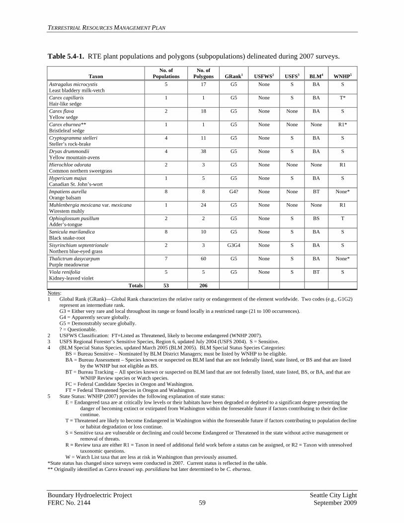
TERRESTRIAL RESOURCES MANAGEMENT PLAN
Table 5.4-1. RTE plant populations and polygons (subpopulations) delineated during 2007 surveys.
Taxon No. of
Populations No. of
Polygons GRank1 USFWS2 USFS3 BLM4 WNHP5
Astragalus microcystis Least bladdery milk-vetch
5 17 G5 None S BA S
Carex capillaris Hair-like sedge
1 1 G5 None S BA T*
Carex flava Yellow sedge
2 18 G5 None None BA S
Carex eburnea** Bristleleaf sedge
1 1 G5 None None None R1*
Cryptogramma stelleri Steller’s rock-brake
4 11 G5 None S BA S
Dryas drummondii Yellow mountain-avens
4 38 G5 None S BA S
Hierochloe odorata Common northern sweetgrass
2 3 G5 None None None R1
Hypericum majus Canadian St. John’s-wort
1 5 G5 None S BA S
Impatiens aurella Orange balsam
8 8 G4? None None BT None*
Muhlenbergia mexicana var. mexicana Wirestem muhly
1 24 G5 None None None R1
Ophioglossum pusillum Adder’s-tongue
2 2 G5 None S BS T
Sanicula marilandica Black snake-root
8 10 G5 None S BA S
Sisyrinchium septentrionale Northern blue-eyed grass
2 3 G3G4 None S BA S
Thalictrum dasycarpum Purple meadowrue
7 60 G5 None S BA None*
Viola renifolia Kidney-leaved violet
5 5 G5 None S BT S
Totals 53 206 Notes: 1 Global Rank (GRank)—Global Rank characterizes the relative rarity or endangerment of the element worldwide. Two codes (e.g., G1G2)
represent an intermediate rank. G3 = Either very rare and local throughout its range or found locally in a restricted range (21 to 100 occurrences). G4 = Apparently secure globally. G5 = Demonstrably secure globally.
? = Questionable. 2 USFWS Classification: FT=Listed as Threatened, likely to become endangered (WNHP 2007). 3 USFS Regional Forester’s Sensitive Species, Region 6, updated July 2004 (USFS 2004). S = Sensitive. 4 (BLM Special Status Species, updated March 2005 (BLM 2005). BLM Special Status Species Categories:
BS = Bureau Sensitive – Nominated by BLM District Managers; must be listed by WNHP to be eligible. BA = Bureau Assessment – Species known or suspected on BLM land that are not federally listed, state listed, or BS and that are listed
by the WNHP but not eligible as BS. BT = Bureau Tracking – All species known or suspected on BLM land that are not federally listed, state listed, BS, or BA, and that are
WNHP Review species or Watch species. FC = Federal Candidate Species in Oregon and Washington. FT = Federal Threatened Species in Oregon and Washington.
5 State Status: WNHP (2007) provides the following explanation of state status: E = Endangered taxa are at critically low levels or their habitats have been degraded or depleted to a significant degree presenting the
danger of becoming extinct or extirpated from Washington within the foreseeable future if factors contributing to their decline continue.
T = Threatened are likely to become Endangered in Washington within the foreseeable future if factors contributing to population decline or habitat degradation or loss continue.
S = Sensitive taxa are vulnerable or declining and could become Endangered or Threatened in the state without active management or removal of threats.
R = Review taxa are either R1 = Taxon in need of additional field work before a status can be assigned, or R2 = Taxon with unresolved taxonomic questions.
W = Watch List taxa that are less at risk in Washington than previously assumed. *State status has changed since surveys were conducted in 2007. Current status is reflected in the table. ** Originally identified as Carex krausei ssp. porsildiana but later determined to be C. eburnea.
Boundary Hydroelectric Project Seattle City Light FERC No. 2144 59 September 2009

TERRESTRIAL RESOURCES MANAGEMENT PLAN
Objective 1 – Surveys of widely distributed RTE plant species: Conduct qualitative surveys to evaluate distribution and population trends for widespread RTE plant species in the Project area. Begin surveys within two years of license issuance and then once every six years. The intent of these periodic surveys is to determine general population trends for the four most widely distributed and abundant RTE plant species in the Project area:
• Least bladdery milk-vetch • Yellow mountain-avens • Black snake-root (Sanicula marilandica) • Yellow sedge (Carex flava)
Subsampling will be required because of the wide distribution of these species and the inaccessibility of some of the habitat (i.e., cliffs). Information will be collected on the extent of plant subpopulations, level of potential threats, ongoing disturbances, and any major changes in the number of subpopulations compared to the baseline data in the USR (SCL 2009). Purple meadowrue and orange balsam are not included in the periodic surveys because these species are both very common in the Project area, have been delisted by the WNHP, and are likely to be delisted by the BLM and USFS by the time of license issuance. Task 1.1: For each survey, select 25 percent of the subpopulations of each of the four species for sampling. Include all subpopulations that are vulnerable to disturbance (near roads, campgrounds, or Project Facilities) as part of the 25 percent subsample for each survey. Select subpopulations of each species in undisturbed locations on a rotating basis to bring the number of subpopulations surveyed to 25 percent of the known total plant population. Use previously mapped data showing the distribution and extent of each of the four RTE plants to select the subpopulations to sample.
Task 1.2: For each survey, collect data on the current number and distribution of each selected RTE plant subpopulation, and record any disturbances and potential threats. Also record the presence and species of invasive, non-native plants and collect data on density (according to criteria in the IWMP) and/or cover. Task 1.3: Evaluate any changes in RTE plant subpopulations in the context of the expected range of fluctuations. In consultation with the TRWG, determine the need for more intensive surveys or management actions, including weed control measures if warranted. Task 1.4: Include newly listed RTE species designated for survey by the TRWG into the next round of surveys on the standard 6-year schedule. Objective 2 – Censuses of RTE plant species with limited distribution: Conduct a census to evaluate distribution and population trends for RTE plant species with limited distribution in the Project area. Conduct the first census within three years of license issuance and then census every three years thereafter.
Boundary Hydroelectric Project Seattle City Light FERC No. 2144 60 September 2009
TERRESTRIAL RESOURCES MANAGEMENT PLAN
The intent of these censuses is to closely monitor RTE species that have limited populations in the Project area or are particularly rare or vulnerable, including the following nine species:
• Bristleleaf sedge (Carex eburnea) • Hair-like sedge (Carex capillaris) • Steller’s rock-brake (Cryptogramma stelleri) • Canadian St. John’s-wort (Hypericum majus) • Common northern sweetgrass • Wirestem muhly • Adder’s tongue • Northern blue-eyed grass (Sisyrinchium septentrionale) • Kidney-leaved violet
Task 2.1: Collect the following data on each subpopulation of the nine RTE plant species with limited distribution in the Project area: number of plants, distribution, and type and level of disturbance. Also collect information on the species and cover of invasive, non-native plants that occur in the Project area (coordinated with the IWMP). Survey suitable habitat adjacent to known subpopulations to determine if new areas have been colonized by RTE plant species. Task 2.2: Evaluate any changes in RTE plant subpopulations in the context of the expected range of fluctuations and in consultation with the TRWG, determine the need for more intensive surveys or management actions, and provide recommendations for weed control (likely hand pulling), as appropriate. Task 2.3: Include newly listed species designated for census by the TRWG into the next round of censuses on the standard three-year schedule. Objective 3 – Extensive RTE plant survey: Conduct an extensive survey following a catastrophic event in the Project area to determine effects on RTE plants. Task 3.1: Determine the appropriate extent of a post-catastrophic event survey for RTE plants in consultation with the TRWG. Task 3.2: Use survey, mapping, and reporting methods similar to those used in relicensing studies to conduct the survey.
Task 3.3: Work with the TRWG to identify any appropriate restoration measures for affected RTE plant populations.
Objective 4 – Update and Coordination: Update the Project database and coordinate with TRWG on RTE plant findings following each survey or census. Task 4.1: Update the GIS database annually.
Boundary Hydroelectric Project Seattle City Light FERC No. 2144 61 September 2009

TERRESTRIAL RESOURCES MANAGEMENT PLAN
Task 4.2: Coordinate with the TRWG annually to obtain up-to-date RTE plant population data that may have been collected by those agencies. Objective 5 – Coordination with the RRMP: Use the findings from RTE plant species monitoring surveys and censuses to inform Project-related recreation management, with the goal of protecting RTE plant populations. Task 5.1: Coordinate with RRMP implementation to ensure that RTE plant populations are protected. Develop site-specific plans as appropriate to protect RTE plants near recreation sites. Task 5.2: Monitor RTE plant populations near Project recreation sites during the surveys and censuses to ensure protection. 5.5. Wildlife Program
Relicensing studies documented over 100 wildlife species in the Project area, including a wide variety of birds and mammals and a few amphibian and reptile species. Twenty RTE wildlife species were recorded in or near the Project area (Table 5.5-1). The TRWG has identified four wildlife species that would potentially benefit from long-term monitoring: bald eagle, peregrine falcon, osprey, and bank swallow. The Project has the potential to affect habitat for these species and long-term monitoring data may be used to determine the need for management actions to mitigate identified issues. Elements of the Wildlife Program include the following:
• Annual bald eagle nest monitoring surveys. • Management plans for bald eagle nests affected by Project-related activities. • Annual surveys for peregrine falcon, osprey, and bank swallows. • Documenting wildlife observations in the Project area.
Boundary Hydroelectric Project Seattle City Light FERC No. 2144 62 September 2009

TERRESTRIAL RESOURCES MANAGEMENT PLAN
Table 5.5-1. RTE wildlife species observed in the study area during the 2007 and 2008 surveys.
RTE Species General Location Information Amphibians (2) Western toad Bufo boreas
One individual observed at the Boundary Forebay campground.
Columbia spotted frog Rana luteiventris
Ten individuals observed downstream of Boundary Dam on both the west and east banks of the river.
Birds (12) Common loon Gavia immer
Recorded five times (5 individuals); in the Boundary Forebay, Canyon Reach, and upper reservoir near Metaline.
Eared grebe Podiceps nigricollis
Recorded nine times (138 individuals); nearly all in the Boundary Forebay or just upstream from the Metaline Falls bridge.
Western grebe Aechmophorus occidentalis
Recorded six times (13 individuals) near Metaline.
Great blue heron Ardea herodias
Thirty-one observations (41 individuals) throughout the study area.
Vaux’s swift Chaetura vauxi
Small group observed foraging over Sullivan Creek.
Turkey vulture Cathartes aura
Thirty-six observations (77 individuals) throughout the study area.
Osprey Pandion haliaetus
Sixty-six observations throughout the study area; common.
Bald eagle Haliaeetus leucocephalus
More than 100 observations throughout the study area; ubiquitous.
Northern goshawk Accipiter gentilis
Observed near Selkirk High School and Slate Creek.
American peregrine falcon Falco peregrines anatum
An active territory occurs on Washington Rock.
Merlin Falco columbarius
Single merlin observed perched at the top of a cottonwood tree at the BWP.
Pileated woodpecker Dryocopus pileatus
Observed four times; Canyon Reach, the BWP, Box Canyon Motel, and near Pend Oreille mine.
Mammals (6) Long-legged myotis Myotis volans
Acoustically detected at the Box Canyon tailrace.
Long-eared myotis Myotis evotis
Acoustically detected at the Box Canyon tailrace.
Western small-footed myotis Myotis ciliolabrum
Acoustically detected at the Box Canyon tailrace.
Townsend’s big-eared bat Corynorhinus townsendii
Observed roosting in two mine adits and a cave. Also visually and acoustically detected near Washington Mine.
Beaver Castor canadensis
Commonly seen throughout the study area.
Canada lynx Lynx canadensis
Observed swimming across the reservoir in the Canyon Reach.
Boundary Hydroelectric Project Seattle City Light FERC No. 2144 63 September 2009

TERRESTRIAL RESOURCES MANAGEMENT PLAN
Objective 1 – Bald eagle nest monitoring: Monitor bald eagle nesting sites within the Project boundary annually. Begin monitoring within three years of license issuance. Task 1.1: Conduct two bald eagle nest surveys, one early in the season (April) and one late (June) of each year to determine occupancy of known nest sites within the Project boundary.
• Subtask 1.1.1: Record on standard forms productivity data, including the number of adult birds and growth stage and number of young (data form and growth stage criteria to be included in Appendix 2).
• Subtask 1.1.2: To the extent possible, determine productivity based on the two surveys.
• Subtask 1.1.3: Conduct a helicopter survey in April once every five years within 0.5 mile of Boundary Reservoir to search for new eagle nests.
• Subtask 1.1.4: Document new nest sites within the Project boundary using a GPS unit or by mapping onto topographic maps and then entering data into the GIS database.
Task 1.2: Develop an annual summary report to include the following:
• Number of occupied territories. • Number of successful nests. • Number of young per occupied territory. • Number of young produced in the survey area.
Task 1.3: Report results of the annual surveys through the Rolling 3-Year Annual Report/Work Plan. Objective 2 – Bald eagle nest management plans: Develop and implement management plans for bald eagle nest sites on SCL-owned land. Implement within three years of license issuance. Task 2.1: Prepare management plans for bald eagle nest sites on SCL-owned lands. Include the following information in each plan:
• Location on map. • Setting (description of territory, land use, roads, etc.). • Habitat conditions, perch sites, etc. • Description of desired future conditions. • Description of any current protection measures implemented by SCL or other entity. • Description of existing risks to successful breeding. • Recommended protection measures and implementation schedule. • Monitoring plan, if necessary.
Task 2.2: Fund and implement protection measures, as identified in the nest management plans, which are within SCL control. Coordinate with the USFS and/or BLM on any needed protection measures for bald eagle nests on federal lands.
Boundary Hydroelectric Project Seattle City Light FERC No. 2144 64 September 2009

TERRESTRIAL RESOURCES MANAGEMENT PLAN
Objective 3 – Other wildlife monitoring: Monitor peregrine falcon nesting habitat (cliffs) and bank swallow colonies along and immediately adjacent to the reservoir shoreline, and osprey nest sites visible from Boundary Reservoir. Begin monitoring within three years of license issuance and continue annually thereafter. Task 3.1: Conduct two nest surveys annually (May and June) for peregrine falcons, ospreys, and bank swallows and collect the following data:
• Bank swallow colony location and number of burrows. • Peregrine falcon and osprey nest site locations and productivity data, if possible. • Evidence of disturbance or other management concerns.
Task 3.2: Document new nest sites using GPS or by mapping and then entering data into the GIS database.
Task 3.3: Develop an annual summary report to include the following:
• Number of occupied osprey and falcon territories. • Number of successful nests (osprey and falcon). • Number of young per occupied territory (osprey and falcon). • Number of young produced in the survey area (osprey and falcon). • Estimated occupancy and location of bank swallow nest colonies.
Task 3.4: Report results of the annual surveys through the Rolling 3-Year Annual Report/Work Plan. Objective 4 – Wildlife database and records: Develop a database for tracking wildlife observations in the Project area and coordinate with the USFS and WDFW to update lists of RTE species in conjunction with the schedule for revising the TRMP (see Chapter 2). Implement within three years of license issuance. Task 4.1: Develop and maintain a database for tracking wildlife observations within the Project area using the database created during relicensing studies as a baseline.
• Subtask 4.1.1: Coordinate with the TRWG to develop a list of wildlife species for which additional information would be useful for management purposes.
• Subtask 4.1.2: Record these species as observed incidentally during other survey/monitoring activities conducted in the Project area (bald eagle, bank swallow, osprey, peregrine falcon, RTE plants, and weed surveys).
• Subtask 4.1.2: Provide Project staff with hard copy or electronic forms for recording wildlife they observe in and near the Project and enter this information into the database.
• Subtask 4.1.3: Summarize wildlife observations in the Rolling 3-Year Annual Report/Work Plan and evaluate the usefulness of this tracking program after 10 years.
Boundary Hydroelectric Project Seattle City Light FERC No. 2144 65 September 2009
TERRESTRIAL RESOURCES MANAGEMENT PLAN
Task 4.2: Update records for grizzly bear, gray wolf, Canada lynx, and woodland caribou sightings within the Project area from the USFWS, WDFW, and/or USFS and enter these data into the Project GIS database developed during relicensing. The updates will be conducted annually beginning the first year the database is developed.
Task 4.3: Coordinate with the TRWG if there is a substantial change in use patterns of grizzly bear, gray wolf, Canada lynx, or woodland caribou on or adjacent to the Project boundary. Work cooperatively to identify any needed protection measures based on specific habitat use parameters. A substantial change in use patterns by these species would include the following:
• A significant increase, as determined by the TRWG, in sightings of these species in or near the Project area.
• Multiple sightings within a year of adult and young grizzly bear, gray wolf, Canada lynx, or woodland caribou within the Project boundary.
Task 4.4: In cooperation with the TRWG, determine if newly-listed RTE wildlife species or increased use of the Project area by RTE wildlife warrant the development of specific measures to protect them or their habitats from human disturbance associated with Project operation, maintenance, or construction. 5.6. Shoreline Management Program
As the Licensee, SCL is responsible for ensuring an appropriate balance among multiple interests in the use of Project lands and waters. FERC requires licensees to manage for power generation and environmental and cultural resources at hydroelectric projects and has included standard license conditions pertaining to Project lands and waters in almost all new licenses. These standard conditions define the types of land conveyances, land uses, and structures that licensees can and cannot permit on Project lands and waters, some of which require no prior approval from FERC. For some uses, a licensee must give prior notice after which it may proceed if FERC has no objection. Some other actions require prior FERC approval. These requirements will be defined in the license order issued by FERC. Pend Oreille County administers a Shoreline Master Program (POC 2009) per the State’s Shoreline Management Act. The area over which the County has shoreline jurisdiction coincides with portions of the Project. SCL must comply with the County’s shoreline regulations but also has the authority under its FERC license to impose additional conditions on land uses within the Project boundary to protect Project resources and ensure that the requirements of the FERC license can be met. Similarly, the USFS and BLM have jurisdiction over federal lands within the Project boundary and SCL must adhere to the respective agencies’ guidelines and policies when conducting activities on federal lands. This Shoreline Management Program was designed to be consistent with the Pend Oreille County Shoreline Master Program and the USFS’s and BLM’s management plans. For the Project, shoreline management activities and land uses are addressed in several related plans and programs. Other sections of the TRMP address Project land management topics
Boundary Hydroelectric Project Seattle City Light FERC No. 2144 66 September 2009

TERRESTRIAL RESOURCES MANAGEMENT PLAN
including programs to address shoreline erosion, habitat protection and enhancement, integrated weed management, and RTE plant and wildlife species management. The TRMP also includes a section on monitoring (see Chapter 6). Other resource-specific management plans in the License Application also address Project shoreline management: (1) the RRMP addresses the management of developed and dispersed recreation use and activities on Project lands and waters, and (2) the HPMP addresses the protection of cultural resources on Project lands. This Shoreline Management Program (1) identifies appropriate shoreline land uses within the Project boundary intended to minimize potential environmental effects on sensitive plant and wildlife species and habitat and to protect and enhance the Project shoreline, (2) provides for management and coordination of private and public (non-federal) shoreline development permitting within the Project boundary, and (3) manages debris accumulation and removal along the Project shoreline, particularly following high-flow spring runoff. Concerning federal lands, SCL will coordinate directly with the BLM and USFS regarding actions affecting those lands. Under its current license, SCL has the authority to implement a shoreline permit system for the development of facilities within the Project boundary, such as boat docks and moorage. Because of the minimal private shoreline development on Boundary Reservoir (only two docks exist at this time), SCL has thus far not initiated such a process. SCL anticipates that FERC will include similar provisions for a permit system in the new license and that SCL will continue to rely on existing permit processes, specifically those administered by Pend Oreille County. SCL does not anticipate the need in the near future to implement a permit system as it is expected that levels of private shoreline development during the new license term will remain low, as predicted in the Land and Roads Study Final Report (SCL 2009). Objective 1 – Define and map Project shoreline land use designations, allowed uses, and required approvals: These will be based on FERC requirements and the license order, SCL License Application, Pend Oreille County Comprehensive Plan (POC 2005) and Shoreline Master Program, BLM Spokane District Resource Management Plan (BLM 1985), and USFS Colville National Forest Land and Resource Management Plan, as amended (USFS CNF 1988). Implement within two years of license issuance. Task 1.1: Develop shoreline land use designations and apply these designations to Project lands and waters, consistent with Pend Oreille County shoreline regulations, with categories likely including Conservancy, Urban, and Rural. Prepare a map of these land use designations specific to the Project area. Coordinate the development of the map and shoreline land use definitions and restrictions with Pend Oreille County, towns of Metaline and Metaline Falls, state of Washington, BLM, and USFS. Once developed, manage Project shoreline areas per the shoreline land use designations (definitions, allowed uses, etc.) during the license term. Task 1.2: Define those actions (e.g., activities, uses, conveyances, leases) that require prior FERC approval or prior notice to FERC. Define the authority and approval process by BLM and USFS for Project-related actions on federal lands.
Boundary Hydroelectric Project Seattle City Light FERC No. 2144 67 September 2009

TERRESTRIAL RESOURCES MANAGEMENT PLAN
Objective 2 – Develop and implement guidelines for private shoreline facilities along the Boundary Reservoir shoreline (within the Project boundary): In consultation with permitting agencies, prepare guidelines for facilities and allowed uses on private land within the Project boundary. Define allowed and prohibited facilities and develop general design guidelines. Communicate these guidelines to the public. Coordinate with permitting agencies on shoreline permit applications over the new license term. Implement within three years of license issuance. Task 2.1: Assess and define the current and potential future types of allowed private shoreline facilities (e.g., docks, boarding floats, mooring buoys, stairways, etc.) along the Project shoreline. Develop appropriate guidelines for ongoing maintenance of existing private shoreline facilities within the Project boundary, and develop design guidelines for new facilities. Guidelines for additional/future types of facilities could be prepared, as needed, during the new license term.
Task 2.2: Develop and implement a public awareness program regarding shoreline permitting, allowed and prohibited uses, and design and maintenance guidelines. Coordinate the development of these guidelines with permitting agencies, including Pend Oreille County (applicants wishing to construct new or modified shoreline improvements, such as new docks and boat moorage, within the Project boundary must comply with the Pend Oreille County Shoreline Master Program and must satisfy all County permit requirements). Work with permitting agencies to review shoreline applications and implement the guidelines, as appropriate. Define a process for resolving potential disagreements with or among permitting agencies about allowable uses and/or guidelines.
Task 2.3: Monitor long-term compliance with established design guidelines and permit requirements, and ongoing maintenance. Establish enforcement procedures to address facilities that are not built to the established standards, not maintained, or are abandoned. Task 2.4: If design guidelines and/or County permit requirements are not consistently being met and/or existing processes do not adequately protect Project resources, develop and administer a Project-specific permit system.
Objective 3 – Coordinate the implementation of RRMP actions at shoreline public recreation sites and use areas with the TRMP: Manage public (SCL and town of Metaline) shoreline recreation facilities (both developed and dispersed) and use areas as defined in the RRMP. Coordinate these actions with other TRMP programs. Implement within two years of license issuance. Task 3.1: Coordinate recreation programs defined in the RRMP with the TRMP Shoreline Management Program and with other TRMP programs, as appropriate. Task 3.2: Coordinate the review of shoreline permits and other agency approvals (e.g., state Hydraulic Project Approval [HPA]) with Pend Oreille County and other agencies, as applicable, for public (non-federal) recreation facilities defined in the RRMP.
Boundary Hydroelectric Project Seattle City Light FERC No. 2144 68 September 2009
TERRESTRIAL RESOURCES MANAGEMENT PLAN
Objective 4 – Periodically remove shoreline debris: Remove shoreline debris that accumulates, particularly after high-flow spring runoff, and dispose of debris as necessary. Implement within one year of license issuance. Task 4.1: Develop a schedule to adequately manage shoreline debris on Boundary Reservoir over the new license term. Prioritize debris removal activities, focusing first on potential public health and safety, water quality, and navigational hazards and concerns. Objective 5 – Develop and implement a Project public safety and education program: Manage the Project shoreline and waters to ensure adequate public safety. Develop and implement plan within two years of license issuance. Task 5.1: As required by FERC in its license order, develop and implement a Project Emergency Action Plan (EAP) and other actions as required. Task 5.2: As part of the RRMP I&E Program, assess potential public safety, interpretation, and education needs and concerns on Project lands and waters. Develop actions to adequately address these needs and concerns. Such actions may include: enhanced public education, public notice, and information about Project operations including reservoir water surface elevation fluctuations, maintenance drawdowns, Project security and safety restrictions, high-flow spring runoff conditions, boating navigation conditions, watercraft use through Metaline Falls and the portage option, shoreline access points to leave or enter the Project, and contacts for emergency help. Task 5.3: Monitor public safety and visitor education through the RRMP Recreation Monitoring Program and take appropriate actions to respond to issues that arise over the license term. 5.7. Travel and Public Access Management Program
FERC requires that licensees secure adequate road access to all Project facilities or areas needed to properly operate their hydroelectric projects. Road and/or boat access is also needed for other Project purposes, including access to areas designated for wildlife preserves, recreation use, habitat enhancement, and others. In response, the Travel and Public Access Management Program addresses a number of Project-related access topics including: operational access to Project hydroelectric facilities and the reservoir, restricted public access at or near Project hydroelectric facilities and areas where public safety is a concern, adequate public access to Project recreation facilities and lands and waters used for general public recreational use, compatible access to the BWP, and compatible access to Metaline Island. In accordance with FERC guidance, the public is to be provided reasonable access to the lands and waters of licensed hydroelectric projects. The public may access Project lands by vehicle, foot, or watercraft but the primary form of access is by vehicle. Vehicle access is constrained by steep topography, water bodies, dense forest vegetation, land ownership, and minimal roadway infrastructure. The Land and Roads Study Final Report (SCL 2009) identified 11 existing roads that are needed for Project purposes. Subsequent to completion of that study, it was determined
Boundary Hydroelectric Project Seattle City Light FERC No. 2144 69 September 2009

TERRESTRIAL RESOURCES MANAGEMENT PLAN
that only nine of these roads are needed for Project purposes and will be included in the new Project boundary. These nine roads are listed in Table 4.3-1 and displayed in Figure 5.7-1.
Objective 1 – Provide adequate operational access to Project hydroelectric facilities and operations areas: Continue to provide needed roadway access to adequately operate and maintain the Project hydroelectric facilities. Task 1.1: Ensure that revisions to the Project boundary include all roads needed to access Project hydroelectric facilities and all use areas needed to perform Project maintenance (see Table 4.3-1). Refer to the License Application for proposed modifications to the Project boundary. Task 1.2: Improve the Forebay Recreation Area to provide an area to maintain the sluice maintenance gate (maintenance of the gate will occur approximately every 10 years) (see RRMP). Objective 2 – Restrict and manage public access at or near Project facilities and hazardous operational areas for security and safety reasons, as needed: Continue to manage public access in response to changing Department of Homeland Security (DHS) National Threat Levels, where necessary. Prohibit public access where safety and security are a concern. Educate the public regarding these restrictions. Task 2.1: Continue to manage and restrict public access to Project hydroelectric facilities and areas (dam, intake forebay, trash racks, tailrace, operations and maintenance area, machine hall, spillways, road across the dam, transmission lines, and other facilities) by maintaining a security program consistent with the DHS National Threat Level. Modify this program, including its procedures and facilities, based on changes to safety and/or security needs or requirements. Task 2.2: Educate the visiting public about security procedures at the Project. Provide adequate warning signs. Task 2.3: Periodically reassess public access and group tour restrictions to the Tailrace Recreation Area and Machine Hall Visitors’ Gallery over the new license term. Objective 3 – Provide adequate public access to Project recreation facilities and use areas: Provide safe vehicle, watercraft, and/or pedestrian access to Project recreation facilities and use areas defined in the RRMP. Implement within three years of license issuance.
Boundary Hydroelectric Project Seattle City Light FERC No. 2144 70 September 2009

TERRESTRIAL RESOURCES MANAGEMENT PLAN
Task 3.1: Develop and implement a plan to maintain single-purpose roadways used to access Project recreation facilities. For multi-purpose roadways, such as the road to the Vista House Recreation Area from Highway 31, work with the primary party responsible for maintaining the roadway to ensure that the roadway is adequately maintained for Project visitors. If necessary, provide for adequate snow removal during the primary recreation season. Communicate with the public when vehicle access is impossible. Task 3.2: Per the RRMP, implement the following boating enhancement measures: improve public boat launching at the Boundary Forebay Recreation Area and at Metaline Waterfront Park; provide a portage trail at Metaline Falls for human-powered watercraft, and ensure watercraft access to dispersed recreation sites along the shoreline. Task 3.3: Implement the trail enhancement measures listed in the RRMP to provide increased pedestrian access to Project recreation sites and unique natural features of the Project area. Objective 4 – Provide compatible access to the BWP and manage public use: Manage general public access to the BWP. Define compatible public use, prohibited uses, barrier needs, operational road access needs, and non-motorized boating access, and develop a monitoring program. Implement within three years of license issuance. Task 4.1: Manage general public access to the BWP. Define compatible public use types and levels. Develop and implement a program to control unwanted human use and related impacts. Control access from adjacent roadways to the BWP and prohibit on-site use of ATVs and snowmobiles. Develop and implement a barrier program to control such use. Develop and implement appropriate means to provide operational road access from adjacent roads for periodic management and monitoring. Educate visitors about proper behavior and use of the BWP and about wildlife and habitat values (refer to the RRMP I&E Program).
6 MONITORING AND ADAPTIVE MANAGEMENT
Two types of monitoring are provided for in this TRMP. The first is monitoring to track the ongoing condition/status of natural resources in the Project area, such as monitoring of selected RTE wildlife and plant species (trend monitoring). Significant declines in the status of the plant or wildlife communities being monitored may trigger the need for additional study and/or management actions. The second type of monitoring evaluates specific management actions or programs, such as monitoring of erosion mitigation measures, to ensure the effectiveness of an action or the need to reassess the measure and implement a corrective measure. This type of monitoring, known as effectiveness monitoring, is the basis for adaptive management. There are two other generally recognized types of monitoring: implementation and validation monitoring. Implementation monitoring is simply confirming that a specific task was completed as planned. The TRWG will be responsible for ensuring that all measures in this TRMP are implemented, as described as part of their roles and responsibilities in Chapter 2. Validation monitoring has the purpose of determining whether underlying research assumptions are valid and is beyond the scope of this TRMP.
Boundary Hydroelectric Project Seattle City Light FERC No. 2144 72 September 2009
TERRESTRIAL RESOURCES MANAGEMENT PLAN
The objectives and associated tasks for monitoring and adaptive management described below will apply to the resource management programs presented in Chapter 5, all of which include some type and level of monitoring (Table 6.0-1). Most of the monitoring tasks identified for those programs, such as the bald eagle surveys, already have established protocols and schedules, although some of these may need to be refined. Others have not yet been defined and will require the development of protocols and schedules and, in some cases, hypotheses for testing effectiveness. In addition, other monitoring needs related to TRMP measures may not currently be known but may become apparent over the term of the new license. Objective 1 – Monitoring protocol review/development: Review the monitoring tasks included in each of the resource management programs in Chapter 5 and, if needed, develop or refine protocols for evaluating resource trends/status or effectiveness of specific PM&E measures. Implement within three years of license issuance or as appropriate to support the schedule for each individual program. Task 1.1.: In coordination with the TRWG, determine if the parameters or indicators being monitored best reflect the condition and dynamics of the system being managed or tracked (Gibbs et al. 1999) and, if possible, can demonstrate not only the existence of change, but the cause of change. Task 1.2: In coordination with the TRWG, determine if monitoring intensities are sufficient to obtain the data needed to have a reasonable chance of detecting change. Objective 2 – Monitoring planning and tracking: Establish baseline conditions prior to initiating any management action and develop the tools needed for storing and analyzing data for all monitoring tasks outlined in Chapter 5. Task 2.1: Collect baseline biological data for the resources that will be monitored. Use existing data if available and/or collect new data through appropriately designed field surveys. Task 2.2: Develop the tools, including databases and maps, to track and assess the effects of specific resource management programs on wildlife and plant communities. Task 2.3: Develop and implement specific monitoring proposals for the current year and incorporate monitoring activities into the Rolling 3-Year Annual Report/Work Plan for terrestrial resources. Task 2.4: Report the results of the previous year’s monitoring activities in the Rolling 3-Year Annual Report/Work Plan. Objective 3 – Adaptive management: Evaluate the PM&E measures described in Chapter 5 and determine if resource-specific objectives and/or desired conditions are being achieved. Revise the TRMP as needed to reflect any new or revised management actions. Implement within five years of license issuance and every five years thereafter.
Boundary Hydroelectric Project Seattle City Light FERC No. 2144 73 September 2009
TERRESTRIAL RESOURCES MANAGEMENT PLAN
Boundary Hydroelectric Project Seattle City Light FERC No. 2144 74 September 2009
Task 3.1: Analyze the data generated from effectiveness monitoring and evaluate changes in condition and progress toward meeting resource management objectives and/or desired conditions. As needed, obtain outside peer review of the monitoring results to assist in developing and evaluating adaptive management actions. Task 3.2: Analyze the data generated from the trend/status monitoring and determine if additional study is needed to better understand or correct significant declining trends. Task 3.3: Based on monitoring results and in coordination with the TRWG, determine the need to change resource management programs or implement new management actions, and make the necessary revisions programmatically or on a site-specific basis. Task 3.4: Develop a process for documenting and tracking changes in resource management programs. Incorporate any modifications into future versions of the TRMP.

TERRESTRIAL RESOURCES MANAGEMENT PLAN
Table 6.0-1. Monitoring elements included in the Terrestrial Resource Management Plan Implementation Programs (see Chapter 5).
RESOURCE OBJECTIVE/MONITORING MEASURE OR TASK Type of
Monitoring1 Start Year(s)2Frequency & Duration
Protocols Not Yet
Developed
EROSION PROGRAM
Objective 1: Erosion control
Task 1.4: Monitor the three erosion control sites annually for 3 years following implementation.
E Consistent with RRMP
Annually for 3 years, then
every 10 years
X
Objective 2: Long-term erosion monitoring
Task 2.2: Monitor erosion every 10 years with associated reporting to TRWG. ST Year 3 Every 10 years
HABITAT PROTECTION AND ENHANCEMENT PROGRAM
Objective 1 – Vehicle access control
Task 1.2: Develop and implement a vehicle access control plan for the BWP – monitor results.
E Year 5 Annually X
Objective 3 – Tailrace recreation area habitat improvements
Task 3.2: Monitor stream for presence of Columbia spotted frogs and plant survival for 5 years following implementation.
E Year 3 TBD X
Objective 4 – Forest management on BWP
Task 4.2: Develop and implement a plan to conduct selective thinning and clearing to improve habitat values of densely stocked conifer stands and to maintain existing meadow habitat. The plan should include goals and expected outcomes, a monitoring and contingency plan, and harvest and wood disposal or sale plans.
E Year 5 TBD X
Objective 5 – Protect Canada goose nests on Metaline Island and Rat Island from human disturbance
Task 5.1: Develop and implement a system to install signs prohibiting the use of these islands during the Canada goose nesting season; monitor results.
E Year 3 Annually X
Boundary Hydroelectric Project Seattle City Light FERC No. 2144 75 September 2009

TERRESTRIAL RESOURCES MANAGEMENT PLAN Table 6.0-1, continued…
RESOURCE OBJECTIVE/MONITORING MEASURE OR TASK Type of
Monitoring1 Start Year(s)2Frequency & Duration
Protocols Not Yet
Developed
INTEGRATED WEED MANAGEMENT PROGRAM
Objective 1 – Initial and periodic inventories
Task 1.4: Monitor existing infestations that have not been designated for treatment ST Year 2 Every 3 years
Objective 2 – Prevention
Task 2.3: Monitor the effectiveness of BMPs at construction/soil disturbance sites and treat noxious weeds as necessary.
E Year 3 As needed X
Objective 3 – Control and effectiveness monitoring
Task 3.2: Treat target weed infestations annually on SCL lands and along roads and at recreation areas covered by the TRMP – revise plans as needed based on monitoring.
E Year 2 As needed
RTE PLANT SPECIES PROGRAM
Objective 5 – Coordinate RTE plant findings with implementation of the RRMP
Task 5.2: Monitor recreation sites near RTE plant populations during a 3-year cycle. ST Year 3 Every 3 years
X
WILDLIFE PROGRAM
Objective 2 – Develop a bald eagle nest management plan
Task 2.1: Monitor bald eagle nests as needed to determine management plan effectiveness.
E Year 3 Annually
SHORELINE MANAGEMENT PROGRAM
Objective 2 – Develop and implement guidelines for private facilities along the Boundary Reservoir shoreline
Task 2.3: Monitor long-term compliance with established design guidelines and permit requirements.
E Year 3 Every 2 years
X
Boundary Hydroelectric Project Seattle City Light FERC No. 2144 76 September 2009
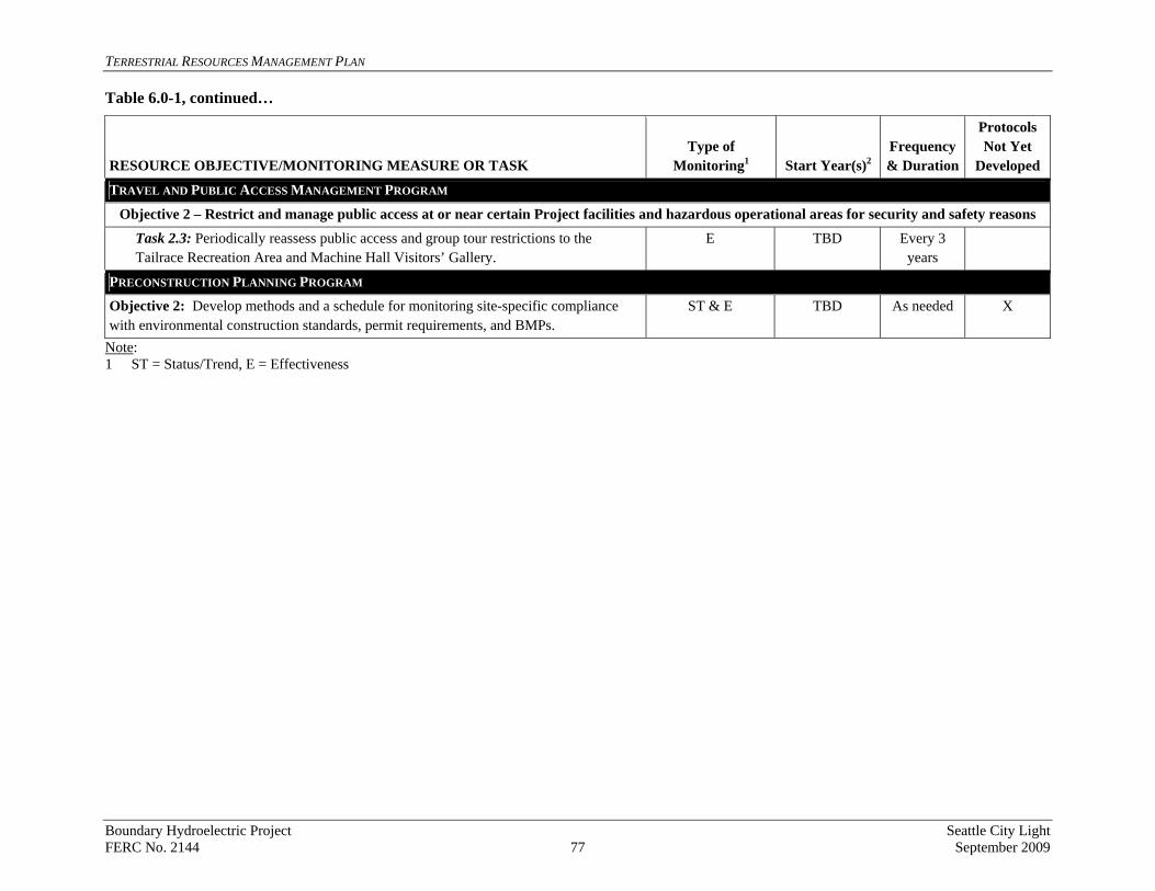
ERRESTRIAL RESOURCES MANAGEMENT PLAN Table 6.0-1, continued…
Boundary Hydroelectric Project Seattle City Light FERC No. 2144 77 September 2009
RESOURCE OBJECTIVE/MONITORING MEASURE OR TASK Type of
Monitoring1 Start Year(s)2Frequency & Duration
Protocols Not Yet
Developed
TRAVEL AND PUBLIC ACCESS MANAGEMENT PROGRAM
Objective 2 – Restrict and manage public access at or near certain Project facilities and hazardous operational areas for security and safety reasons
Task 2.3: Periodically reassess public access and group tour restrictions to the Tailrace Recreation Area and Machine Hall Visitors’ Gallery.
E TBD Every 3 years
PRECONSTRUCTION PLANNING PROGRAM
Objective 2: Develop methods and a schedule for monitoring site-specific compliance with environmental construction standards, permit requirements, and BMPs.
ST & E TBD As needed X
Note: 1 ST = Status/Trend, E = Effectiveness
T

TERRESTRIAL RESOURCES MANAGEMENT PLAN
7 MANAGEMENT OF PROJECT-RELATED ACTIVITIES AND FACILITIES
Boundary Project staff plays a critical role in ensuring that sensitive Project resources are protected. The following three programs have been developed to address the ongoing operation of the Project and apply to all Project lands, facilities, roads, and operations and maintenance activities: Environmental Awareness, Preconstruction Planning, and BMPs. 7.1. Environmental Awareness Program
The purpose of the Environmental Awareness Program is to ensure that Project staff members are informed about the sensitive biological resources associated with the Project and are knowledgeable about the measures necessary to protect those resources. This program will apply to SCL staff members who work at the Project. The goals of the program are to educate Project staff on the potential impacts of Project operations, maintenance, and construction on wildlife and habitat, including RTE species, and to put into practice ways to avoid or minimize effects on those resources. The objectives of this program are as follows:
• Objective 1: Create a training program and associated schedule to educate Project staff on wildlife, sensitive species habitats, and other sensitive biological resources, including information on federally listed Threatened and Endangered species, within two years of license issuance.
• Objective 2: Incorporate requirements for contractor environmental awareness into contracts for work that will be conducted at the Project.
• Objective 3: Review environmental materials as part of the TRMP update process and revise as necessary.
Training and education for the Environmental Awareness Program will include maps, presentations, and informational materials, as described below. 7.1.1. Maps
The intent of developing maps for worker training/education is to provide SCL staff with information on the locations of sensitive plant and wildlife habitats in the Project area. SCL will create a set of maps showing areas with sensitive resources that require special consideration in planning and conducting operations, maintenance, and construction activities. These maps will be updated every two years and will include the locations of active and inactive bald eagle and osprey nests, known sites of RTE plant populations, and the locations of other RTE wildlife and sensitive resources. The maps will be developed as 11x17 sheets and will include the name and phone number of the responsible SCL environmental staff member to contact if work is to be done in these areas. Maps will be labeled as confidential and will be provided only to key SCL staff.
Boundary Hydroelectric Project Seattle City Light FERC No. 2144 78 September 2009
TERRESTRIAL RESOURCES MANAGEMENT PLAN
7.1.2.
7.1.3.
Training Presentations
Presentations will be the primary means of providing environmental awareness training to Project staff, although web-based video may also be used. The intent of the training will be to: (1) build awareness of the natural environment associated with the Project and (2) provide a foundation of cooperation and communication among employees engaged in operations, maintenance, and construction and SCL environmental staff. Environmental awareness training will be conducted at least once annually for new Project employees by SCL environmental staff. As needed, environmental resource informational materials will be developed for and distributed at the training sessions. Examples of material to be covered at the training sessions include:
• BMPs to minimize disturbance to or mortality of wildlife - Requirements for work and travel within the Project area, including staying on existing roads, obeying posted speed limits, keeping construction areas free of garbage, and prohibiting the illegal use of fire arms.
• Endangered species awareness - Information on federally protected species known or potentially occurring in the Project area, including: (1) legal requirements for protection, (2) descriptions of the species and their local habitats, (3) the need for a site evaluation prior to ground-disturbing activity, and (4) instructions on required actions if protected species occur in a proposed activity area.
• Wildlife mortality - What to do and whom to contact if dead, injured, or diseased wildlife is found.
• Enforcement - Whom to contact if the following is observed: (1) vehicle use in the BWP, (2) trespassing in seasonally or permanently closed sites in the Project area, or (3) wildlife poaching or harassment.
• Guidelines for minimizing the establishment and spread of weeds - Actions to minimize the transport and spread of invasive species, such as staying on roads when possible and cleaning vehicles that have been off-road and boats that have been used off the reservoir.
These sessions will be interactive to make the training effective and meaningful. In addition, each session will include a feedback process to evaluate and improve the training program over time.
Informational Materials
In addition to materials developed for the training sessions, a concise guide will be developed that summarizes important natural resource information. The guide will be created as one or two sheets that can be posted on bulletin boards, added to field manuals, or kept in boats and trucks. The guide will include illustrations and limited text that summarizes the information presented during the training presentations, including contact information. Contact information will be updated annually if needed.
Boundary Hydroelectric Project Seattle City Light FERC No. 2144 79 September 2009

TERRESTRIAL RESOURCES MANAGEMENT PLAN
7.2. Preconstruction Planning Program
Preconstruction planning is intended to avoid, minimize, or mitigate effects on terrestrial resources from non-routine Project-related construction activities. SCL environmental staff will coordinate with Project staff to identify appropriate preconstruction surveys, site-specific environmental standards, and BMPs. Environmental staff will also ensure that the Project complies with all federal, state, and local environmental regulations. Preconstruction surveys and environmental construction standards do not apply to emergencies or situations involving public safety. Objectives associated with preconstruction planning are as follows:
• Objective 1: During project planning, designate an SCL environmental staff member responsible for identifying and conducting appropriate preconstruction surveys, obtaining required permits, and developing site-specific environmental construction standards and BMPs.
• Objective 2: In advance of project implementation, develop methods and a schedule for monitoring site-specific compliance with environmental construction standards, permit requirements, and BMPs.
Environmental construction standards relevant to terrestrial resources are listed below:
• Avoidance or mitigation of adverse effects, including seasonal/timing constraints on construction, design revisions, and habitat restoration.
• Erosion control, weed control, and revegetation plans for areas temporarily disturbed by construction activities.
• Consultation with the USFWS on activities that have the potential to affect federally-listed or proposed species.
• Compliance with the protection measures outlined in the bald eagle nest site management plans (to be completed following license issuance).
7.3. Best Management Practices
Although BMPs will be incorporated into larger-scale construction activities, the purpose of this section is to adopt measures that govern routine, day-to-day activities to avoid or minimize environmental effects potentially resulting from Project operations, maintenance, or minor construction activities. BMPs do not apply to emergency maintenance or activities involving public safety. Objectives associated with BMPs are as follows:
• Objective 1: Create training materials for selecting and implementing appropriate standard BMPs and incorporate them into the environmental awareness training (see Section 7.1) within two years of license issuance.
Boundary Hydroelectric Project Seattle City Light FERC No. 2144 80 September 2009

TERRESTRIAL RESOURCES MANAGEMENT PLAN
• Objective 2: Develop methods and a schedule for monitoring compliance with standard BMPs for routine Project operations, maintenance, and minor construction activities, within two years of license issuance.
BMPs for large construction activities will be developed on a site- and activity-specific basis. Standard BMPs for preventing the spread of weeds and protecting wildlife and vegetation during routine operations, maintenance, and minor construction activities are listed below:
• Weed Prevention BMPs
o Minimize ground disturbance associated with maintenance activities, including road grading.
o Revegetate disturbed sites using native species, as well as plant materials that meet USFS and Pend Oreille County NWCB standards, where necessary.
o Follow established guidelines for revegetation of disturbed sites including site assessment, planning and preparation, and timing of planting.
o Clean vehicles and equipment before and after use off of paved or gravel roads or on non-reservoir waters to minimize the risk of spreading weeds.
o Treat existing infestations of noxious weeds before maintenance or construction activities occur in these areas, if possible.
o Use certified weed-free seed and other materials for revegetation and erosion control.
o Implement other measures to avoid or minimize the establishment and spread of invasive non-native plants, as identified in the Integrated Weed Management Program.
• Wildlife and Vegetation BMPs
o Schedule maintenance, monitoring, and construction activities to avoid disturbance to plants and wildlife during sensitive time periods (e.g., wintering, breeding).
o Avoid or minimize vegetation removal during the nesting season. o Minimize the development of new linear structures, such as fences, pipelines,
roads, and trenches, that fragment habitat. o Clean equipment (e.g., nets, hip boots, boats, and traps) before use at another
location to minimize the risk of spreading disease organisms and invasive plants, snails, fish, and amphibians.
o Ensure that work site conditions comply with WDNR fire precaution levels, where appropriate.
o Properly dispose of all trash. o Identify and clearly mark sensitive biological habitats for avoidance. o Avoid or minimize the removal or disturbance of wetland and riparian
vegetation to the maximum extent feasible.
Boundary Hydroelectric Project Seattle City Light FERC No. 2144 81 September 2009

TERRESTRIAL RESOURCES MANAGEMENT PLAN
This page intentionally left blank.
Boundary Hydroelectric Project Seattle City Light FERC No. 2144 82 September 2009

TERRESTRIAL RESOURCES MANAGEMENT PLAN
8 REFERENCES
BLM (U.S. Bureau of Land Management). 1985. Spokane Resource Management Plan/EIS. August 1985. Spokane District Office, Spokane, Washington.
BLM. 2005. Oregon/Washington Special Status Species. Available at URL = http://www.blm.gov/or/resources/sss/index.php.
Bonneville Power Administration (BPA). 2000. Transmission system vegetation management program. Final environmental impact statement. DOE/EIS-0285. Portland, Oregon.
Carpenter, A.T., and T.A. Murray. 1998a. Element stewardship abstract for Centaurea diffusa. The Nature Conservancy.
Carpenter, A.T., and T.A. Murray. 1998b. Element stewardship abstract for Linaria genistifolis and Linaria dalmatica. The Nature Conservancy.
Cassidy, K.M. 1997. Land cover of Washington State: Description and Management Volume 1. In Washington State Gap Analysis Project Final Report, edited by K.M. Cassidy, C.E. Grue, M.R. Smith, and K.M. Dvornich. Washington Cooperative Fish and Wildlife Research Unit, University of Washington, Seattle.
County NWCB (Pend Oreille County Noxious Weed Control Board). 2009. 2009 Pend Oreille County Noxious Weed List. Newport, Washington. Available: http://www.pendoreilleco.org/county/weed.asp.
ENTRIX. 2001. Phase II, Level Assessment for Watershed Resource Inventory Area 62. Prepared for the Pend Oreille Conservation District, Pend Oreille (WRIA 62) Watershed Planning Unit. September 17, 2001.
Gibbs, J. P., H. L. Snell, and C. E. Causton. 1999. Effective Monitoring for Adaptive Wildlife Management: Lessons from the Galapagos Islands. Journal of Wildlife Management, Vol. 63, No. 4. pp. 1055-1065.
King County. Website. Noxious Weeds, Brochures and Publications. Available at URL = http://www.kingcounty.gov/environment/animalsAndPlants/noxious-weeds/brochures-reports.aspx. Updated June 23, 2009.
Lasmanis, R. 1991. The Geology of Washington: Rocks and Minerals. Heldref Publications. 66(4):262-277.
Mazzu, L. 2004. Common control measures for invasive plants of the Pacific Northwest Region. USDA-FS, Region 6, Invasive Plants EIS Team, Portland, Oregon.
NAWMA (North American Weed Management Association). 2003. Mapping standards posted by the NAWMA Mapping Standards Committee on January 29, 2003. Available at URL = http://www.nawma.org/documents/Mapping%20Standards/ Mapping%20Standards%20Index.html.
Boundary Hydroelectric Project Seattle City Light FERC No. 2144 83 September 2009

TERRESTRIAL RESOURCES MANAGEMENT PLAN
Pend Oreille Conservation District. 2004. Final Pend Oreille Watershed Ranking Report, December 2004. Prepared in cooperation with the Washington State Department of Ecology. Newport, Washington.
Philip, E.L., and D.C. Durke. 1972. Washington climate for Ferry, Pend Oreille, and Stevens Counties. Washington State University Cooperative Extension Service Bulletin EM-3554. Pulman, Washington. 63 pp.
POC (Pend Oreille County). 2005. Pend Oreille County Comprehensive Plan, updated February 2008. Newport Washington.
POC. 2009. Pend Oreille County Shoreline Master Program, Preliminary Draft Goals and Policies. Pend Oreille County Planning Commission. February 24, 2009.
Rees, N.E., P.C. Quimby, Jr., G.L. Poper, E.C. Coombs, C.E. Turner, N.R. Spencer, and L. Knutson. 1996. Biological control of weeds in the west. Western Society of Weed Science. Bozeman, Montana.
SCL (Seattle City Light). 2006. Pre-Application Document for the Boundary Hydroelectric Project (FERC No. 2144). Prepared by Long View Associates. Seattle, Washington. May 2006. Available: http://www.seattle.gov/light/news/issues/bndryRelic/br_document.asp. May 2006.
SCL. 2009. Updated Study Report. Boundary Hydroelectric Project (FERC No. 2144). Seattle, Washington. Available: http://www.seattle.gov/light/news/issues/bndryRelic/br_document.asp. March 2009.
State NWCB (Washington State Noxious Weed Control Board). 2009. 2009 Washington State Noxious Weed List. Olympia Washington. Available: http://www.nwcb.wa.gov/documents/weed%20lists/State%20Weed%20List%202009.pdf
State NWCB. Website. Available at URL http://www.nwcb.wa.gov.
Team Leafy Spurge. 2002. Biological Control of Leafy Spurge; a comprehensive, easy-to-read manual on how to use biological control as an effective leafy spurge management tool. A product of the USDA-ARS TEAM Leafy Spurge Area-Wide IPM Program.
TNC (The Nature Conservancy). Website. IMap Invasives. Invasive Species Plant summaries. Available at URL = http://www.imapinvasives.org/GIST/ESA/index.html.
TNC. Website. TNC’s Invasive Species Initiative. URL = http://tncweeds.ucdavis.edu. Accessed December 2004.
USFS (U.S. Forest Service) Colville National Forest (CNF). 1988. Colville National Forest Land and Resource Management Plan (Forest Plan). Colville, Washington. Available: http://www.fs.fed.us/r6/colville/projects/cnf-plan.
Boundary Hydroelectric Project Seattle City Light FERC No. 2144 84 September 2009

TERRESTRIAL RESOURCES MANAGEMENT PLAN
USFS. 2004. Preventing and managing invasive plants, Draft Environmental Impact Statement (EIS), Pacific Northwest Region invasive plant program. Region 6, Portland, Oregon.
WNHP (Washington Natural Heritage Program). 2007. State of Washington Natural Heritage Plan 2007. Washington State Department of Natural Resources, Olympia, Washington. September 2007. Available at URL = http://www.dnr.wa.gov/ResearchScience/Topics/ NaturalHeritage/Pages/amp_nh.aspx.
Williams, C.K., B.F. Kelly, B.G. Smith, and T.R. Lillybridge. 1995. Forested Plant Associations of the Colville National Forest. Gen. Tech. Rep. PNW-GTR-360. United States Department of Agriculture, U.S. Forest Service, Pacific Northwest Research Station. Portland, Oregon.
Boundary Hydroelectric Project Seattle City Light FERC No. 2144 85 September 2009

TERRESTRIAL RESOURCES MANAGEMENT PLAN
This page intentionally left blank.
Boundary Hydroelectric Project Seattle City Light FERC No. 2144 86 September 2009

TERRESTRIAL RESOURCES MANAGEMENT PLAN
Appendix 1 Land Ownership, Cover Type, and Proposed Project Boundary Area
Boundary Hydroelectric Project Seattle City Light FERC No. 2144 September 2009

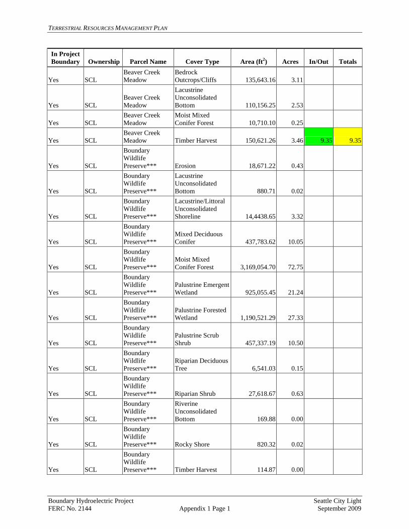
TERRESTRIAL RESOURCES MANAGEMENT PLAN
In Project Boundary Ownership Parcel Name Cover Type Area (ft2) Acres In/Out Totals
Yes SCL Beaver Creek Meadow
Bedrock Outcrops/Cliffs 135,643.16 3.11
Yes SCL Beaver Creek Meadow
Lacustrine Unconsolidated Bottom 110,156.25 2.53
Yes SCL Beaver Creek Meadow
Moist Mixed Conifer Forest 10,710.10 0.25
Yes SCL Beaver Creek Meadow Timber Harvest 150,621.26 3.46 9.35 9.35
Yes SCL
Boundary Wildlife Preserve*** Erosion 18,671.22 0.43
Yes SCL
Boundary Wildlife Preserve***
Lacustrine Unconsolidated Bottom 880.71 0.02
Yes SCL
Boundary Wildlife Preserve***
Lacustrine/Littoral Unconsolidated Shoreline 14,4438.65 3.32
Yes SCL
Boundary Wildlife Preserve***
Mixed Deciduous Conifer 437,783.62 10.05
Yes SCL
Boundary Wildlife Preserve***
Moist Mixed Conifer Forest 3,169,054.70 72.75
Yes SCL
Boundary Wildlife Preserve***
Palustrine Emergent Wetland 925,055.45 21.24
Yes SCL
Boundary Wildlife Preserve***
Palustrine Forested Wetland 1,190,521.29 27.33
Yes SCL
Boundary Wildlife Preserve***
Palustrine Scrub Shrub 457,337.19 10.50
Yes SCL
Boundary Wildlife Preserve***
Riparian Deciduous Tree 6,541.03 0.15
Yes SCL
Boundary Wildlife Preserve*** Riparian Shrub 27,618.67 0.63
Yes SCL
Boundary Wildlife Preserve***
Riverine Unconsolidated Bottom 169.88 0.00
Yes SCL
Boundary Wildlife Preserve*** Rocky Shore 820.32 0.02
Yes SCL
Boundary Wildlife Preserve*** Timber Harvest 114.87 0.00
Boundary Hydroelectric Project Seattle City Light FERC No. 2144 Appendix 1 Page 1 September 2009
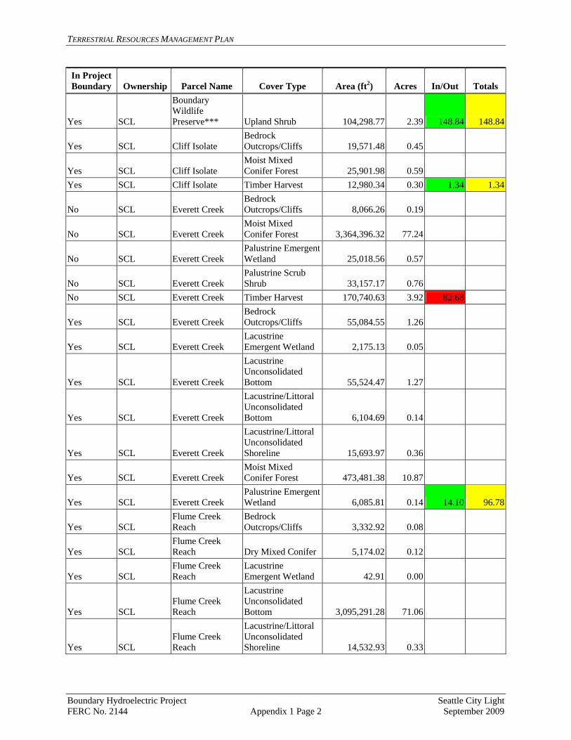
TERRESTRIAL RESOURCES MANAGEMENT PLAN
In Project Area (ft2) Boundary Ownership Parcel Name Cover Type Acres In/Out Totals
Yes SCL
Boundary Wildlife Preserve*** Upland Shrub 104,298.77 2.39 148.84 148.84
Yes SCL Cliff Isolate Bedrock Outcrops/Cliffs 19,571.48 0.45
Yes SCL Cliff Isolate Moist Mixed Conifer Forest 25,901.98 0.59
Yes SCL Cliff Isolate Timber Harvest 12,980.34 0.30 1.34 1.34
No SCL Everett Creek Bedrock Outcrops/Cliffs 8,066.26 0.19
No SCL Everett Creek Moist Mixed Conifer Forest 3,364,396.32 77.24
No SCL Everett Creek Palustrine Emergent Wetland 25,018.56 0.57
No SCL Everett Creek Palustrine Scrub Shrub 33,157.17 0.76
No SCL Everett Creek Timber Harvest 170,740.63 3.92 82.68
Yes SCL Everett Creek Bedrock Outcrops/Cliffs 55,084.55 1.26
Yes SCL Everett Creek Lacustrine Emergent Wetland 2,175.13 0.05
Yes SCL Everett Creek
Lacustrine Unconsolidated Bottom 55,524.47 1.27
Yes SCL Everett Creek
Lacustrine/Littoral Unconsolidated Bottom 6,104.69 0.14
Yes SCL Everett Creek
Lacustrine/Littoral Unconsolidated Shoreline 15,693.97 0.36
Yes SCL Everett Creek Moist Mixed Conifer Forest 473,481.38 10.87
Yes SCL Everett Creek Palustrine Emergent Wetland 6,085.81 0.14 14.10 96.78
Yes SCL Flume Creek Reach
Bedrock Outcrops/Cliffs 3,332.92 0.08
Yes SCL Flume Creek Reach Dry Mixed Conifer 5,174.02 0.12
Yes SCL Flume Creek Reach
Lacustrine Emergent Wetland 42.91 0.00
Yes SCL Flume Creek Reach
Lacustrine Unconsolidated Bottom 3,095,291.28 71.06
Yes SCL Flume Creek Reach
Lacustrine/Littoral Unconsolidated Shoreline 14,532.93 0.33
Boundary Hydroelectric Project Seattle City Light FERC No. 2144 Appendix 1 Page 2 September 2009
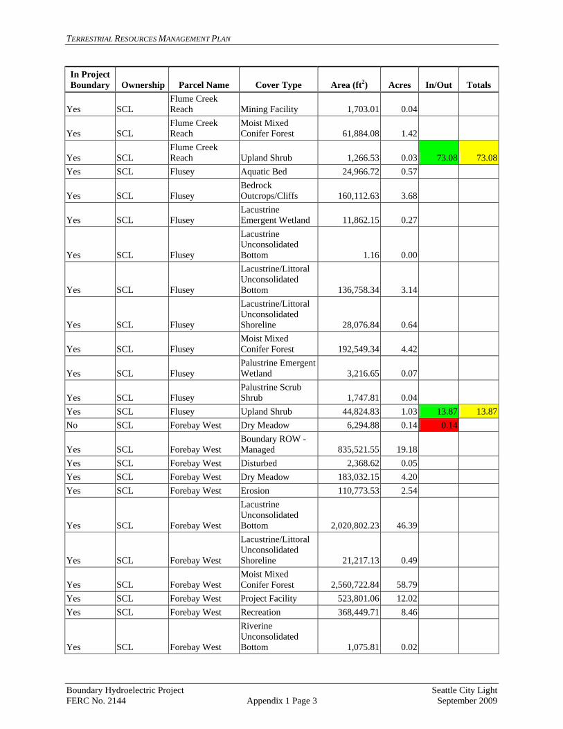
TERRESTRIAL RESOURCES MANAGEMENT PLAN
In Project Area (ft2) Boundary Ownership Parcel Name Cover Type Acres In/Out Totals
Yes SCL Flume Creek Reach Mining Facility 1,703.01 0.04
Yes SCL Flume Creek Reach
Moist Mixed Conifer Forest 61,884.08 1.42
Yes SCL Flume Creek Reach Upland Shrub 1,266.53 0.03 73.08 73.08
Yes SCL Flusey Aquatic Bed 24,966.72 0.57
Yes SCL Flusey Bedrock Outcrops/Cliffs 160,112.63 3.68
Yes SCL Flusey Lacustrine Emergent Wetland 11,862.15 0.27
Yes SCL Flusey
Lacustrine Unconsolidated Bottom 1.16 0.00
Yes SCL Flusey
Lacustrine/Littoral Unconsolidated Bottom 136,758.34 3.14
Yes SCL Flusey
Lacustrine/Littoral Unconsolidated Shoreline 28,076.84 0.64
Yes SCL Flusey Moist Mixed Conifer Forest 192,549.34 4.42
Yes SCL Flusey Palustrine Emergent Wetland 3,216.65 0.07
Yes SCL Flusey Palustrine Scrub Shrub 1,747.81 0.04
Yes SCL Flusey Upland Shrub 44,824.83 1.03 13.87 13.87No SCL Forebay West Dry Meadow 6,294.88 0.14 0.14
Yes SCL Forebay West Boundary ROW - Managed 835,521.55 19.18
Yes SCL Forebay West Disturbed 2,368.62 0.05 Yes SCL Forebay West Dry Meadow 183,032.15 4.20 Yes SCL Forebay West Erosion 110,773.53 2.54
Yes SCL Forebay West
Lacustrine Unconsolidated Bottom 2,020,802.23 46.39
Yes SCL Forebay West
Lacustrine/Littoral Unconsolidated Shoreline 21,217.13 0.49
Yes SCL Forebay West Moist Mixed Conifer Forest 2,560,722.84 58.79
Yes SCL Forebay West Project Facility 523,801.06 12.02 Yes SCL Forebay West Recreation 368,449.71 8.46
Yes SCL Forebay West
Riverine Unconsolidated Bottom 1,075.81 0.02
Boundary Hydroelectric Project Seattle City Light FERC No. 2144 Appendix 1 Page 3 September 2009

TERRESTRIAL RESOURCES MANAGEMENT PLAN
In Project Area (ft2) Boundary Ownership Parcel Name Cover Type Acres In/Out Totals
Yes SCL Forebay West Upland Shrub 29.63 0.00 152.15 152.30No SCL Junction Isolate Dry Meadow 13,197.79 0.30 No SCL Junction Isolate Erosion 10,389.96 0.24
No SCL Junction Isolate Moist Mixed Conifer Forest 172,453.74 3.96 4.50
Yes SCL Junction Isolate Dry Meadow 46,116.01 1.06
Yes SCL Junction Isolate Moist Mixed Conifer Forest 14,081.05 0.32
Yes SCL Junction Isolate Riparian Shrub 3,764.21 0.09 1.47 5.97
Yes SCL BWP Addition*** 1,539,921.66 35.35
Yes SCL BWP Addition***
Moist Mixed Conifer Forest 2,254,157.78 51.75
Yes SCL BWP Addition*** Riparian Shrub 255.72 0.01
Yes SCL BWP Addition*** Timber Harvest 76,713.97 1.76
Yes SCL BWP Addition*** Upland Shrub 12,563.56 0.29 89.16 89.16
Yes SCL Lower Reach Bedrock Outcrops/Cliffs 96,458.12 2.21
Yes SCL Lower Reach Lacustrine Emergent Wetland 4,962.19 0.11
Yes SCL Lower Reach
Lacustrine Unconsolidated Bottom 405,015.50 9.30
Yes SCL Lower Reach
Lacustrine/Littoral Unconsolidated Shoreline 14,663.35 0.34
Yes SCL Lower Reach Moist Mixed Conifer Forest 924,276.69 21.22
Yes SCL Lower Reach Palustrine Emergent Wetland 3,855.21 0.09
Yes SCL Lower Reach Palustrine Scrub Shrub 4,641.73 0.11 33.38 33.38
No SCL Metaline Falls Moist Mixed Conifer Forest 10.44 0.00 0.00
Yes SCL Metaline Falls
Lacustrine Unconsolidated Bottom 576.43 0.01
Yes SCL Metaline Falls
Lacustrine/Littoral Unconsolidated Shoreline 31,029.37 0.71
Yes SCL Metaline Falls Mixed Deciduous Conifer 1,578.05 0.04
Boundary Hydroelectric Project Seattle City Light FERC No. 2144 Appendix 1 Page 4 September 2009

TERRESTRIAL RESOURCES MANAGEMENT PLAN
In Project Area (ft2) Boundary Ownership Parcel Name Cover Type Acres In/Out Totals
Yes SCL Metaline Falls Moist Mixed Conifer Forest 776.04 0.02
Yes SCL Metaline Falls Upland Shrub 7,645.03 0.18 0.96 0.96No SCL Metaline Gorge Disturbed 0.89 0.00
No SCL Metaline Gorge Moist Mixed Conifer Forest 47,783.68 1.10
No SCL Metaline Gorge Perennial Grassland 1,087.31 0.02 No SCL Metaline Gorge Residential 18.41 0.00 No SCL Metaline Gorge Upland Shrub 3,805.93 0.09 1.21
Yes SCL Metaline Gorge Bedrock Outcrops/Cliffs 359,359.00 8.25
Yes SCL Metaline Gorge Dry Mixed Conifer 29,166.21 0.67 Yes SCL Metaline Gorge Erosion 42,125.44 0.97
Yes SCL Metaline Gorge
Lacustrine Unconsolidated Bottom 104,324.88 2.39
Yes SCL Metaline Gorge
Lacustrine/Littoral Unconsolidated Shoreline 5,429.09 0.12
Yes SCL Metaline Gorge Moist Mixed Conifer Forest 396,962.72 9.11
Yes SCL Metaline Gorge Palustrine Emergent Wetland 418.59 0.01
Yes SCL Metaline Gorge Palustrine Scrub Shrub 3,138.34 0.07
Yes SCL Metaline Gorge Perennial Grassland 28,238.56 0.65 Yes SCL Metaline Gorge Residential 15,134.53 0.35 Yes SCL Metaline Gorge Riparian Shrub 1,702.35 0.04
Yes SCL Metaline Gorge
Riverine Unconsolidated Shoreline 6,980.65 0.16
Yes SCL Metaline Gorge Timber Harvest 65,746.68 1.51 Yes SCL Metaline Gorge Upland Shrub 20,908.27 0.48 24.79 25.99No SCL Metaline Park Erosion 7,381.77 0.17
No SCL Metaline Park Lacustrine Emergent Wetland 804.78 0.02
No SCL Metaline Park
Lacustrine/Littoral Unconsolidated Shoreline 2,440.56 0.06
No SCL Metaline Park Palustrine Emergent Wetland 9,387.59 0.22
No SCL Metaline Park Palustrine Forested Wetland 79,447.82 1.82
No SCL Metaline Park Palustrine Scrub Shrub 46,940.65 1.08
Boundary Hydroelectric Project Seattle City Light FERC No. 2144 Appendix 1 Page 5 September 2009

TERRESTRIAL RESOURCES MANAGEMENT PLAN
In Project Area (ft2) Boundary Ownership Parcel Name Cover Type Acres In/Out Totals
No SCL Metaline Park Recreation 51,480.01 1.18 4.54 4.54Yes SCL Mine Isolate Dry Mixed Conifer 13,047.74 0.30 0.30 0.30
No SCL Pend Oreille Mine Complex
Moist Mixed Conifer Forest 63.00 0.00 0.00
Yes SCL Pend Oreille Mine Complex Erosion 6,097.58 0.14
Yes SCL Pend Oreille Mine Complex
Lacustrine Unconsolidated Bottom 45,726.64 1.05
Yes SCL Pend Oreille Mine Complex
Lacustrine/Littoral Unconsolidated Shoreline 34,443.83 0.79
Yes SCL Pend Oreille Mine Complex
Moist Mixed Conifer Forest 507,012.87 11.64
Yes SCL Pend Oreille Mine Complex
Palustrine Emergent Wetland 38,915.28 0.89
Yes SCL Pend Oreille Mine Complex Upland Shrub 153.24 0.00 14.52 14.52
No SCL Pewee Falls Bedrock Outcrops/Cliffs 7,656.73 0.18
No SCL Pewee Falls Moist Mixed Conifer Forest 498,187.37 11.44 11.61
Yes SCL Pewee Falls Bedrock Outcrops/Cliffs 62,674.79 1.44
Yes SCL Pewee Falls Erosion 157,595.96 3.62
Yes SCL Pewee Falls
Lacustrine Unconsolidated Bottom 1,386,728.91 31.83
Yes SCL Pewee Falls
Lacustrine/Littoral Unconsolidated Shoreline 930.81 0.02
Yes SCL Pewee Falls Moist Mixed Conifer Forest 863,760.63 19.83
Yes SCL Pewee Falls Palustrine Scrub Shrub 751.71 0.02 56.76 68.37
No SCL Sullivan Bedrock Outcrops/Cliffs 1,706.08 0.04
No SCL Sullivan Disturbed 8,170.85 0.19
No SCL Sullivan
Lacustrine/Littoral Unconsolidated Shoreline 2,324.96 0.05
No SCL Sullivan Mixed Deciduous Conifer 133,463.38 3.06
No SCL Sullivan Moist Mixed Conifer Forest 163,789.58 3.76
No SCL Sullivan Palustrine Aquatic Bed 9,538.28 0.22
Boundary Hydroelectric Project Seattle City Light FERC No. 2144 Appendix 1 Page 6 September 2009
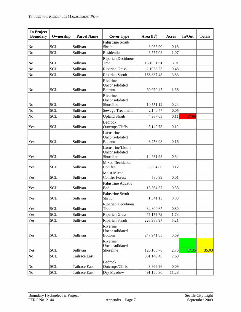
TERRESTRIAL RESOURCES MANAGEMENT PLAN
In Project Area (ft2) Boundary Ownership Parcel Name Cover Type Acres In/Out Totals
No SCL Sullivan Palustrine Scrub Shrub 8,036.90 0.18
No SCL Sullivan Residential 46,577.08 1.07 Riparian Deciduous Tree No SCL Sullivan 13,1031.61 3.01
No SCL Sullivan Riparian Grass 2,1038.25 0.48 No SCL Sullivan Riparian Shrub 166,837.48 3.83
No SCL Sullivan
Riverine Unconsolidated Bottom 60,070.45 1.38
No SCL
Riverine Unconsolidated Shoreline 10,551.12 0.24 Sullivan
No SCL Sullivan Sewage Treatment 2,140.47 0.05 No SCL Sullivan Upland Shrub 0.11 17.68 4,937.63
Yes SCL Sullivan Bedrock Outcrops/Cliffs 5,149.78 0.12
Yes Sullivan
Lacustrine Unconsolidated Bottom 6,758.98 0.16 SCL
Yes SCL
Lacustrine/Littoral Unconsolidated Shoreline 14,981.98 0.34 Sullivan Mixed Deciduous Conifer Yes SCL Sullivan 5,084.86 0.12
Yes SCL Sullivan Moist Mixed Conifer Forest 580.39 0.01
Yes SCL Sullivan Palustrine Aquatic Bed 16,564.57 0.38
Yes Sullivan Palustrine Scrub Shrub 1,341.13 0.03 SCL Riparian Deciduous Tree Yes SCL Sullivan 34,800.67 0.80
Yes SCL Sullivan Riparian Grass 75,175.73 1.73 Yes SCL Sullivan Riparian Shrub 226,988.97 5.21
Riverine Unconsolidated Bottom Yes SCL Sullivan 247,941.85 5.69
Yes SCL Sullivan
Riverine Unconsolidated Shoreline 120,188.78 2.76 17.35 35.03
No SCL Tailrace East 331,140.48 7.60
No SCL Tailrace East Bedrock Outcrops/Cliffs 3,969.26 0.09
No SCL Tailrace East Dry Meadow 491,156.30 11.28
Boundary Hydroelectric Project Seattle City Light FERC No. 2144 Appendix 1 Page 7 September 2009

TERRESTRIAL RESOURCES MANAGEMENT PLAN
In Project Area (ft2) Boundary Ownership Parcel Name Cover Type Acres In/Out Totals
No SCL Tailrace East Moist Mixed Conifer Forest 2,833,361.62 65.05
No SCL Tailrace East Palustrine Aquatic Bed 1,221.83 0.03
No SCL Tailrace East Palustrine Emergent Wetland 18,659.21 0.43
No SCL Tailrace East Palustrine Scrub Shrub 18,835.61 0.43
No SCL Tailrace East
Palustrine Unconsolidated Bottom 4,516.74 0.10
No SCL Tailrace East Riparian Grass 2,951.27 0.07 No SCL Tailrace East Riparian Shrub 67,902.75 1.56
No SCL Tailrace East
Riverine Unconsolidated Shoreline 6,678.37 0.15 86.79
Yes SCL Tailrace East Bedrock Outcrops/Cliffs 25,410.41 0.58
Yes SCL Tailrace East Dry Mixed Conifer 67,082.82 1.54
Yes SCL Tailrace East Moist Mixed Conifer Forest 1,033,958.57 23.74
Yes SCL Tailrace East Project Facility 1,149.81 0.03 Yes SCL Tailrace East Recreation 27,490.69 0.63
Yes SCL Tailrace East Riparian Deciduous Tree 4,689.35 0.11
Yes SCL Tailrace East
Riverine Unconsolidated Shoreline 20,963.98 0.48
Yes SCL Tailrace East Upland Shrub 25,404.35 0.58 27.69 114.48
Yes SCL Tailrace West***
Moist Mixed Conifer Forest (probable) 1,852,207.11 42.52
Yes SCL Tailrace West***Moist Mixed Conifer Forest 2,433,630.50 55.87
Yes SCL Tailrace West*** Project Facility 852,111.53 19.56
Yes SCL Tailrace West***
Riverine Unconsolidated Bottom 1,355.22 0.03
Yes Tailrace West***
Riverine Unconsolidated Shoreline 56,540.83 1.30 SCL
Yes SCL Tailrace West***Moist Mixed Conifer Forest 94,794.75 2.18
Yes SCL Tailrace West*** Project Facility 206,757.45 4.75 126.20 126.20Yes BLM Aquatic Bed 83,186.14 1.91
Boundary Hydroelectric Project Seattle City Light FERC No. 2144 Appendix 1 Page 8 September 2009
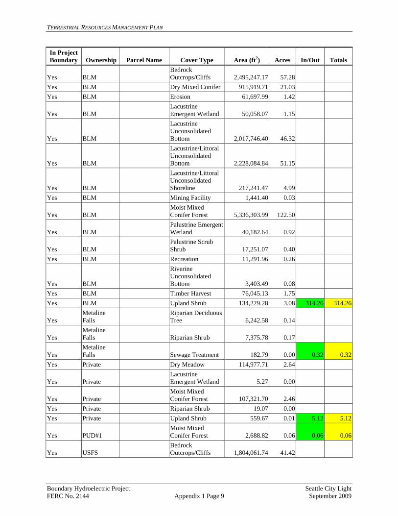
TERRESTRIAL RESOURCES MANAGEMENT PLAN
In Project Area (ft2) Boundary Ownership Parcel Name Cover Type Acres In/Out Totals
Yes BLM Bedrock Outcrops/Cliffs 2,495,247.17 57.28
Yes BLM Dry Mixed Conifer 915,919.71 21.03 Yes BLM Erosion 61,697.99 1.42
Yes BLM Lacustrine Emergent Wetland 50,058.07 1.15
Yes BLM
Lacustrine Unconsolidated Bottom 2,017,746.40 46.32 Lacustrine/Littoral Unconsolidated Bottom Yes BLM 2,228,084.84 51.15
Yes BLM
Lacustrine/Littoral Unconsolidated Shoreline 217,241.47 4.99
Yes BLM Mining Facility 1,441.40 0.03
Yes BLM Moist Mixed Conifer Forest 5,336,303.99 122.50
Yes BLM Palustrine Emergent Wetland 40,182.64 0.92
Yes BLM Palustrine Scrub Shrub 17,251.07 0.40
Yes BLM Recreation 11,291.96 0.26
Yes BLM
Riverine Unconsolidated Bottom 3,403.49 0.08
Yes BLM Timber Harvest 76,045.13 1.75 Yes BLM Upland Shrub 134,229.28 3.08 314.26 314.26
Yes Metaline Falls
Riparian Deciduous Tree 6,242.58 0.14
Yes Metaline Falls Riparian Shrub 7,375.78 0.17
Yes Metaline Falls Sewage Treatment 182.79 0.00 0.32 0.32
Yes Private Dry Meadow 114,977.71 2.64
Yes Private Lacustrine Emergent Wetland 5.27 0.00
Yes Private Moist Mixed Conifer Forest 107,321.70 2.46
Yes Private Riparian Shrub 19.07 0.00 Yes Private Upland Shrub 559.67 0.01 5.12 5.12
Yes PUD#1 Moist Mixed Conifer Forest 2,688.82 0.06 0.06 0.06
Yes USFS Bedrock Outcrops/Cliffs 1,804,061.74 41.42
Boundary Hydroelectric Project Seattle City Light FERC No. 2144 Appendix 1 Page 9 September 2009

TERRESTRIAL RESOURCES MANAGEMENT PLAN
In Project Area (ft2) Boundary Ownership Parcel Name Cover Type Acres In/Out Totals
Boundary ROW - Managed Yes USFS 341,508.22 7.84
Yes USFS Dry Meadow 80,967.92 1.86 Yes USFS Dry Mixed Conifer 291,002.52 6.68 Yes USFS Erosion 279,069.09 6.41
Lacustrine Emergent Wetland Yes USFS 14,468.68 0.33 Lacustrine Unconsolidated Bottom Yes USFS 6,293,754.50 144.48 Lacustrine/Littoral Unconsolidated Bottom Yes USFS 2,486,328.58 57.08 Lacustrine/Littoral Unconsolidated Shoreline Yes USFS 201,136.03 4.62
Yes USFS Mining Facility 19,780.13 0.45 Moist Mixed Conifer Forest Yes USFS 11,711,390.15 268.86 Palustrine Emergent Wetland Yes USFS 45,538.72 1.05
Yes USFS Palustrine Scrub Shrub 48,958.70 1.12
Yes USFS Ponderosa Pine 174,831.05 4.01 Yes USFS Project Facility 1,344,021.35 30.85 Yes USFS Recreation 9,059.68 0.21 Yes USFS Riparian Grass 12,892.94 0.30
Yes USFS
Riverine Unconsolidated Bottom 65,915.43 1.51
Yes USFS
Riverine Unconsolidated Shoreline 77,713.71 1.78
Yes USFS Timber Harvest 387,225.01 8.89 Yes USFS Upland Shrub 701,376.37 16.10 605.85 605.85Yes WADNR Aquatic Bed 4,788,680.71 109.93
Bedrock Outcrops/Cliffs Yes WADNR 58,005.94 1.33
Yes WADNR Disturbed 39,716.70 0.91 Yes WADNR Dry Mixed Conifer 2.47 0.00 Yes WADNR Dry Pasture 4,432.62 0.10 Yes WADNR Erosion 281,995.43 6.47
Lacustrine Emergent Wetland Yes WADNR 551,510.36 12.66
Boundary Hydroelectric Project Seattle City Light FERC No. 2144 Appendix 1 Page 10 September 2009

TERRESTRIAL RESOURCES MANAGEMENT PLAN
In Project Area (ft2) Boundary Ownership Parcel Name Cover Type Acres In/Out Totals
Yes WADNR
Lacustrine Unconsolidated Bottom 36,639,988.93 841.14
Yes WADNR
Lacustrine/Littoral Unconsolidated Bottom 3,151,229.02 72.34
Yes WADNR
Lacustrine/Littoral Unconsolidated Shoreline 5,213,682.73 119.69
Yes WADNR Mixed Deciduous Conifer 37,039.05 0.85
Yes WADNR Moist Mixed Conifer Forest 344,860.99 7.92
Yes WADNR Palustrine Emergent Wetland 2,784,177.19 63.92
Yes WADNR Palustrine Forested Wetland 94,697.21 2.17
Yes WADNR Palustrine Scrub Shrub 524,771.50 12.05
Yes WADNR Ponderosa Pine 1,876.70 0.04 Yes WADNR Project Facility 136,438.37 3.13
Yes WADNR Recreation 120,236.64 2.76 Yes WADNR Residential 6,504.24 0.15
Yes WADNR Riparian Deciduous Tree 17,321.83 0.40
Yes WADNR Riparian Grass 61,738.33 1.42 Yes WADNR Riparian Shrub 190,071.86 4.36
Yes WADNR
Riverine Unconsolidated Bottom 1,243,709.89 28.55
Yes WADNR
Riverine Unconsolidated Shoreline 267,041.24 6.13
Yes WADNR Rocky Shore 333,678.61 7.66 Yes WADNR Sewage Treatment 28,134.96 0.65 Yes WADNR Timber Harvest 343.57 0.01 Yes WADNR Upland Shrub 80,516.94 1.85 1308.60 1308.60Yes WSDOT Erosion 5,149.98 0.12
Yes WSDOT
Lacustrine/Littoral Unconsolidated Shoreline 824.32 0.02
Yes WSDOT Palustrine Emergent Wetland 3,748.96 0.09
Yes WSDOT Palustrine Scrub Shrub 56.90 0.00
Yes WSDOT Ponderosa Pine 341.01 0.01 0.23 0.23
Boundary Hydroelectric Project Seattle City Light FERC No. 2144 Appendix 1 Page 11 September 2009
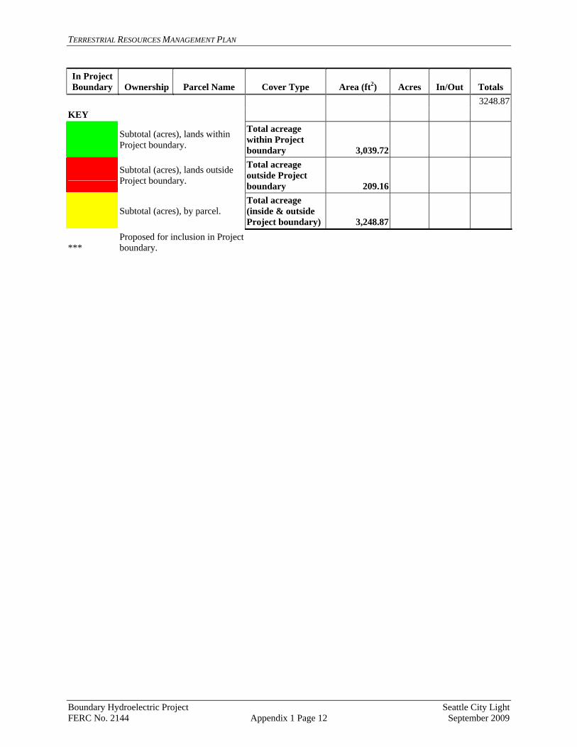
TERRESTRIAL RESOURCES MANAGEMENT PLAN
In Project Area (ft2) Boundary Ownership Parcel Name Cover Type Acres In/Out Totals
3248.87KEY
Subtotal (acres), lands within Project boundary.
Total acreage within Project boundary 3,039.72
Subtotal (acres), lands outside Project boundary.
Total acreage outside Project boundary 209.16
Subtotal (acres), by parcel.
Total acreage (inside & outside Project boundary) 3,248.87
*** Proposed for inclusion in Project boundary.
Boundary Hydroelectric Project Seattle City Light FERC No. 2144 Appendix 1 Page 12 September 2009

TERRESTRIAL RESOURCES MANAGEMENT PLAN
Appendix 2 Data Forms for TRMP Implementation
[To be developed]
Boundary Hydroelectric Project Seattle City Light FERC No. 2144 September 2009