Terra Quest Info Sheet
4
Specialists in Quality High Resolution Airborne Geophysical Mapping Terraquest Ltd. was established in 1984 and since then, our dedicated team has flown over 2,000 airborne geophysical surveys using both fixed wing and helicopter platforms. Our professional crews provide significant experience having carried out airborne magnetic, gamma spectrometry, and electromagnetics on most continents. Our in-house geophysical processing department produces quality data sets that have been utilized in the exploration for base and precious metals, kimberlite, hydrocarbons, uranium and water. What’s coming up at Terraquest? Recently Terraquest has been active in West Africa and has plans to open an office in South Africa in 2008. Terraquest has also contracted an African owned and operated Cessna Caravan 208 for exploration work throughout Africa and the Middle East. 2 – 2800 John St., Markham ON L3R 0E2 Canada T: 905.477.2800 F: 905.477.2820 [email protected] terraquest.ca
description
Terra Quest Airborne Geophysics
Transcript of Terra Quest Info Sheet

Specialists in Quality High Resolution AirborneGeophysical MappingTerraquest Ltd. was established in1984 and since then, our dedicatedteam has flown over 2,000 airbornegeophysical surveys using both fixedwing and helicopter platforms. Ourprofessional crews provide significantexperience having carried out airbornemagnetic, gamma spectrometry, andelectromagnetics on most continents.Our in-house geophysical processingdepartment produces quality data setsthat have been utilized in theexploration for base and preciousmetals, kimberlite, hydrocarbons,uranium and water.
What’s coming up at Terraquest?Recently Terraquest has been active in West Africa and has plans to openan office in South Africa in 2008.Terraquest has also contracted anAfrican owned and operated CessnaCaravan 208 for exploration workthroughout Africa and the Middle East.
2 – 2800 John St.,Markham ON L3R 0E2Canada
T: 905.477.2800 F: [email protected]

1
OUR AIRBORNE SYSTEMSTOTAL FIELD MAGNETOMETERSOptically pumped cesium vapourmagnetometer sensors for scalarmeasurements of earth’s magnetic field,include the Scintrex models CS-2 and CS-3and the Geometrics Inc. model G-822A. Bothsystems output a Larmour frequency whichcan be processed to a resolution of 0.001 nTby larmour signal processors.
DATA ACQUISITION SYSTEMSOur ever-expanding technical capability and strategic affiliation with associatedgeoscientific groups, provides for unsurpassedcapability to our match each of our client’sspecific needs.
Terraquest currently utilizes several DataAcquisition Systems (DAS) including the AGIS100 from Pico Envirotec Inc. as well as theDAARC500 by RMS Instruments. Each systemis designed to provide optimum performancefor specific project requirements. They arerobust, reliable and suitable for field supportwith a minimum of maintenance.
DAARC500Designed and manufactured by RMSInstruments, the DAARC500 is the mostinnovative comprehensive and flexible dataacquisition system available today. Thesystem offers the ultimate in aeromagneticcompensation together with comprehensiveand flexible data acquisition and recording,the DAARC500 is ideally suited to airbornegeophysical applications, offering unparalleledperformance, accuracy and reliability.
Features include:� Real time graphical display� Up to 8 magnetometer inputs� Real-time compensation of pitch, roll,
yaw and heading effects – total fields and gradients
� Adaptive signal processing techniques,improved compensation and simplifiedcalibration procedures
� 32 bit state of the art HW & FW architecturebased on advanced 32-bit processors
� 16 differential analog inputs� High resolution self calibrating A/D
converter
Benefits of the RMS DAARC500 System� Immediate quality control, onboard the
aircraft in real time� Immediate notification of any changes
in the aircraft’s magnetic signature ormagnetic drop-outs which can be identified and corrected as they occur
� Reliability is field proven, tried and true. � No post flight signal processing is required� Separate calibrations for each heading are
not required� No need for post flight corrections
AGIS100By Pico Envirotec Inc. the AGIS100 is a RealTime Data Acquisition and Navigation Systemwhich has a combined data acquisition/datadisplay/GPS navigation module. AGIS is one of the most advanced, fully integrated,sophisticated data acquisition systemscurrently in use. AGIS records data from all sensors in digital form, while PEIVIEWsoftware provides data verification, andplotting capabilities.
Features include:� Navigation interface for all available GPS
instrumentation — eg. Trimble AG132� Flight path planning and graphical display
for operator with pilot guidance onseparate display
OUR EXPERTISE IS FOCUSED ON THE ACQUISITION AND PROCESSING OF GEOSCIENTIFIC DATA FOR THE EXPLORATION SECTOR INCLUDING USING THE FOLLOWING TECHNOLOGIES:HIGH RESOLUTION AERO-MAGNETICSADVANCED RADIOMETRICSHORIZONTAL GRADIOMETERXDS/VLF -EM
SPECIALISTS IN QUALITY HIGH RESOLUTION AIRBORNE GEOPHYSICAL MAPPING
Piper Navajo equipped with long range tanks,Configured with Horizontal Gradiometer, XTerraEM,
Digital Radiometrics, Digital Camera
Terraquest Ltd owns five completeairborne geophysical systems which are installed on different aircraft suitedto a wide range of topographic andenvironmental conditions;
� A King Air 90 (twin engine turbine)� A Piper Navajo (twin engine piston)� A Cessna 206 (single engine, piston)� A Cessna Caravan 208 (single engine
turbine)� Airframe mounted Stinger configured
for AStar or B206L-iii/iv Helicopters
All fixed wing aircraft are speciallymodified to carry out high resolutionairborne geophysical surveys. They areequipped with three, split beam cesiumvapour sensor magnetometers toprovide detailed horizontal gradientmagnetics. The Terraquest team is available toassist with the planning, implementationof surveys. We have the demonstratedcapability to carry out specialized
airborne surveys to individuals,consultants, exploration companies and governments around the world.
The general products delivered as partof Terraquest airborne magneticgeophysical survey usually consist of;
� Total Magnetic Intensity:From the tail magnetometer. Levelling is enhanced by themeasured horizontal component.
� Vertical Magnetic Gradient:Vertical derivative of the TMI.
� Radiometrics:Total Count, K (%), Th (ppm), U (ppm)
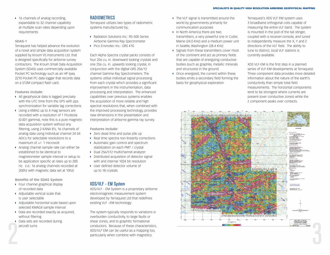
� XDS / VLF EM: Contour plots of eachX,Y,Z normalized component.
� Archive Data Set; CD-ROM disk of all map products in aGeosoft format and profile data
� Operations Report: Report listing equipment specifications,operational statistics and techniques ofthe airborne survey.
2 3
� The VLF signal is transmitted around theworld by governments primarily forcommunication purposes
� In North America there are twotransmitters, a very powerful one in Cutler,Maine (24.0 KHz) and a medium power unitin Seattle, Washington (28.4 KHz)
� Signals from these transmitters cover mostof the continent and act as primary fieldsthat are capable of energizing conductivebodies (such as graphite, metallic mineralsand structures) in the ground
� Once energized, the current within thesebodies emits a secondary field forming thebasis for geophysical exploration
Terraquest’s XDS VLF EM system uses 3 broadband orthogonal coils capable ofmeasuring the entire VLF band. The system is mounted in the pod of the tail stinger,coupled with a receiver-console, and tuned to independently measure the X, Y and Zdirections of the VLF field. The ability to tune to distinct, local VLF stations is currently available.
XDS VLF-EM is the first step in a plannedseries of VLF-EM developments at Terraquest.Three component data provides more detailedinformation about the nature of the earth’sconductivity than simple total fieldmeasurements. The horizontal componentstend to be strongest where currents arepresent (over conductive zones) while the z component peaks over contacts.
� 16 channels of analog recording,expandable to 32 channel capability at multiple scan rates depending uponrequirements
SDAS-1Terraquest has helped advance the evolutionof a novel and simple data acquisition systemsupplied by Kroum VS Instruments Ltd. that is designed specifically for airborne surveycontractors. The Kroum Small Data AcquisitionSystem (SDAS) uses commercially availablePocket PC technology such as an HP Ipaq2210 Pocket PC data logger that records dataon a 512M compact flash card.
Features include:� All geophysical data is tagged precisely
with the UTC time from the GPS with ppssynchronization for variable lag corrections
� Using a KMAG up to 4 mag sensors arerecorded with a resolution of 1 Picotesla(0.001 gamma), note this is a pure magneticdata acquisition system without anyfiltering, using 2 KANA 8’s, 16 channels ofanalog data using individual channel 24 bitADCs for selectable resolutions to amaximum of +/- 1 microvolt
� Analog channel sample rate can either beestablished to be identical tomagnetometer sample interval or setup tobe application specific at rates up to 200Hz. (i.e.: 16 analog channels recorded at200hz with magnetic data set at 10hz)
Benefits of the SDAS System� Four channel graphical display
of recorded data� Adjustable vertical scale that
is user selectable � Adjustable horizontal scale based upon
selected KMAG4 sample interval � Data are recorded exactly as acquired,
without filtering � Data sets are recorded during
aircraft turns
RADIOMETRICSTerraquest utilizes two types of radiometricsystems manufactured by;
� Radiation Solutions Inc.: RS-500 SeriesAirborne Gamma Ray Spectrometer
� Pico Envirotec Inc.: GRS 410
Each Alpha Spectra crystal packs consists offour 256 cu. in. downward looking crystals andone 256 cu. in. upwards looking crystal, inconjunction with the digital GRS 256/12channel Gamma Ray Spectrometers. Thesystems utilize individual signal processingfrom each crystal which provides a significantimprovement in the instrumentation, dataprocessing and interpretation. The enhancedcapabilities over previous systems enablesthe acquisition of more reliable and highspectral resolutions that, when combined withthe improved processing technology, providesnew dimensions in the presentation andinterpretation of airborne gamma ray survey.
Features include:� Zero dead time and pulse pile up� Real time spectra non-linearity corrections� Automatic gain control and spectrum
stabilization on each PMT / crystal� Dual 256/512 multichannel analyzer� Distributed acquisition of detector signal
with and internal 1024 bit resolution� User defined detector volume of
up to 18 crystals
XDS/VLF - EM SystemXDS/VLF - EM System is a proprietary airborneelectromagnetic measurement systemdeveloped by Terraquest Ltd that redefinesexisting VLF –EM technology.
The system typically responds to variations isoverburden conductivity, to large faults orshear zones, and to graphitic formationalconductors. Because of these characteristics,XDS/VLF EM can be useful as a mapping too,particularly when combine with magnetics.
SPECIALISTS IN QUALITY HIGH RESOLUTION AIRBORNE GEOPHYSICAL MAPPING
100 METER DRAPE AIRBORNE SURVEYPRE-PLANNED DRAPE FLYING
Pre-planned drape flight operationssignificantly enhance the quality of the dataset being gathered. It is most suitable forhigher altitudes and / or rough terrain. It ensures good line to line correlationincluding accurate intersections of thetraverse and tie lines. Knowing the aircraft’s precise positioning and altitudecontributes significantly to the quality of thedata set when it levelled and lends to higherresolution for future modeling.
54
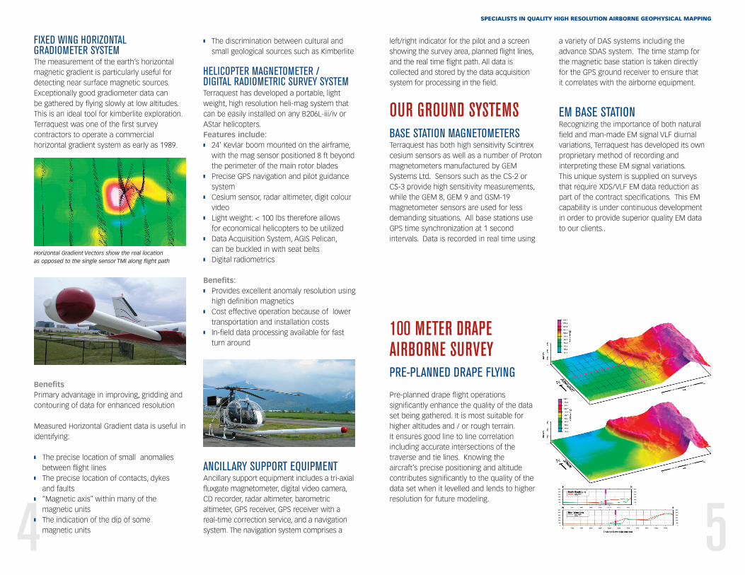
FIXED WING HORIZONTALGRADIOMETER SYSTEMThe measurement of the earth’s horizontalmagnetic gradient is particularly useful fordetecting near surface magnetic sources.Exceptionally good gradiometer data can be gathered by flying slowly at low altitudes. This is an ideal tool for kimberlite exploration.Terraquest was one of the first surveycontractors to operate a commercialhorizontal gradient system as early as 1989.
Horizontal Gradient Vectors show the real location as opposed to the single sensor TMI along flight path
BenefitsPrimary advantage in improving, gridding andcontouring of data for enhanced resolution
Measured Horizontal Gradient data is useful inidentifying:
� The precise location of small anomaliesbetween flight lines
� The precise location of contacts, dykes and faults
� “Magnetic axis” within many of themagnetic units
� The indication of the dip of some magnetic units
� The discrimination between cultural andsmall geological sources such as Kimberlite
HELICOPTER MAGNETOMETER / DIGITAL RADIOMETRIC SURVEY SYSTEMTerraquest has developed a portable, lightweight, high resolution heli-mag system thatcan be easily installed on any B206L-iii/iv orAStar helicopters.Features include:� 24’ Kevlar boom mounted on the airframe,
with the mag sensor positioned 8 ft beyondthe perimeter of the main rotor blades
� Precise GPS navigation and pilot guidancesystem
� Cesium sensor, radar altimeter, digit colourvideo
� Light weight: < 100 lbs therefore allows for economical helicopters to be utilized
� Data Acquisition System, AGIS Pelican, can be buckled in with seat belts
� Digital radiometrics
Benefits:� Provides excellent anomaly resolution using
high definition magnetics� Cost effective operation because of lower
transportation and installation costs � In-field data processing available for fast
turn around
ANCILLARY SUPPORT EQUIPMENTAncillary support equipment includes a tri-axialfluxgate magnetometer, digital video camera,CD recorder, radar altimeter, barometricaltimeter, GPS receiver, GPS receiver with areal-time correction service, and a navigationsystem. The navigation system comprises a
SPECIALISTS IN QUALITY HIGH RESOLUTION AIRBORNE GEOPHYSICAL MAPPING
left/right indicator for the pilot and a screenshowing the survey area, planned flight lines,and the real time flight path. All data iscollected and stored by the data acquisitionsystem for processing in the field.
OUR GROUND SYSTEMSBASE STATION MAGNETOMETERSTerraquest has both high sensitivity Scintrexcesium sensors as well as a number of Protonmagnetometers manufactured by GEMSystems Ltd. Sensors such as the CS-2 or CS-3 provide high sensitivity measurements,while the GEM 8, GEM 9 and GSM-19magnetometer sensors are used for lessdemanding situations. All base stations useGPS time synchronization at 1 secondintervals. Data is recorded in real time using
a variety of DAS systems including theadvance SDAS system. The time stamp forthe magnetic base station is taken directly for the GPS ground receiver to ensure that it correlates with the airborne equipment.
EM BASE STATIONRecognizing the importance of both naturalfield and man-made EM signal VLF diurnalvariations, Terraquest has developed its ownproprietary method of recording andinterpreting these EM signal variations. This unique system is supplied on surveysthat require XDS/VLF EM data reduction aspart of the contract specifications. This EMcapability is under continuous development in order to provide superior quality EM data to our clients..