Tena koe Todd - Taupo District Council
12
WWW.ROAMCONSULTING.CO.NZ Taupō, New Zealand ROWAN SAPSFORD : 021 744 957 : [email protected] T E MARION ROSS : 021 544 715 : [email protected] T E 31 October 2019 Todd Whittaker c/-Taupō District Council 46 Horomatangi Street Taupō 3352 Tena koe Todd SKY PLAY ADVENTURES RESOURCE CONSENT APPLICATION FURTHER INFORMATION REQUEST RESPONSE Thank you for your letter of 10 October requesting further information to better understand the proposed Wairakei Canopy Tour application. I have set out my response to your queries below. 1. SIGNAGE One sign is proposed to be located on site as shown on the base area plan. The sign will be dual facing with each face area being no greater than 1m 2 . The purpose of the sign will be to identify the location of the attraction to visitors. 2. FENCING The current post and rail fence on site will be relocated back to the legal boundary of the site so that it is no longer on road reserve. 3. HOME BASE OFFICE ELEVATIONS Please see below an image of the building proposed to be used for the site office situated at Home Base. The height of the building will be 5m at the apex of the roof. As shown in the application, the building will be 14m long and 5m wide and situated 5.15 m from the western boundary fronting Huka falls Road. The building will be relocated to the site and reclad in a board and baton finish and painted with recessive colours.
Transcript of Tena koe Todd - Taupo District Council
W W W . R O A M C O N S U L T I N G . C O . N ZTaupō, New Zealand
R O W A N S A P S F O R D: 021 744 957: [email protected]
TE
M A R I O N R O S S: 021 544 715: [email protected]
TE
31 October 2019 Todd Whittaker c/-Taupō District Council 46 Horomatangi Street Taupō 3352
Tena koe Todd
SKY PLAY ADVENTURES RESOURCE CONSENT APPLICATION FURTHER INFORMATION
REQUEST RESPONSE
Thank you for your letter of 10 October requesting further information to better understand the
proposed Wairakei Canopy Tour application. I have set out my response to your queries below.
1. SIGNAGE
One sign is proposed to be located on site as shown on the base area plan. The sign will be dual facing with
each face area being no greater than 1m2. The purpose of the sign will be to identify the location of the
attraction to visitors.
2. FENCING
The current post and rail fence on site will be relocated back to the legal boundary of the site so that it is
no longer on road reserve.
3. HOME BASE OFFICE ELEVATIONS
Please see below an image of the building proposed to be used for the site office situated at Home Base.
The height of the building will be 5m at the apex of the roof. As shown in the application, the building will
be 14m long and 5m wide and situated 5.15 m from the western boundary fronting Huka falls Road.
The building will be relocated to the site and reclad in a board and baton finish and painted with recessive
colours.

The building has been positioned here to allow optimum room for parking behind it and to maximise
visibility from the road frontage. Given the width of the road reserve the building will be situated 15m
from the edge of Huka Falls Road. The width of the road reserve will mean that the building will not crowd
the road or impeded visibility at the intersection. As discussed in the AEE the area is zoned Rural
Environment, however the area does not have a typical rural amenity given its tourism and visitation use.
The two closest buildings being the 4B Bike hire and Hub café, are also located within the front setback
(19m and 9.2m respectively) to maximise business visibility and ease of access. It is not considered that
the proximity of the building to the front boundary will be out of character for this location and reflects
the tourism/visitor based use of not only the development but the wider area.
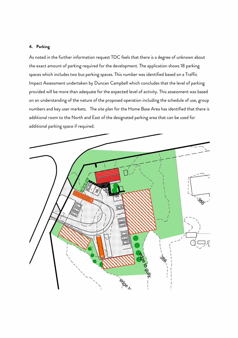
4. Parking
As noted in the further information request TDC feels that there is a degree of unknown about
the exact amount of parking required for the development. The application shows 18 parking
spaces which includes two bus parking spaces. This number was identified based on a Traffic
Impact Assessment undertaken by Duncan Campbell which concludes that the level of parking
provided will be more than adequate for the expected level of activity. This assessment was based
on an understanding of the nature of the proposed operation including the schedule of use, group
numbers and key user markets. The site plan for the Home Base Area has identified that there is
additional room to the North and East of the designated parking area that can be used for
additional parking space if required.
These areas are shown as red hatched areas on the plan above. In addition, dependant on use, the bus
parks can be moved to the identified overflow area north of the Hub Cafe with that space used for
additional car parking. Subsequent to the information request the client has talked representatives of Kiwi
Experience and Stray about their operations. They indicated that they would not park their busses at the
site instead drop off (by bus) those clients who have indicated that they are willing to do the tour and head
back to town. On this basis it is highly likely that parks 18 and 19 can be used for car parks.
5. VISUAL ASSESSMENT OF TOWERS
Please find attached at the end of this letter a report from Jason Hogan of LA4 Landscape Architects
regarding your queries relating to viewpoint 3 of Tower 7. These report concludes that
“… the proposal is consistent with the intent of the key relevant statutory documents and management strategies
which seek to facilitate public access use and enjoyment of this area while maintaining and enhancing the
natural and scenic values.”
6. TOILET FACILITIES
There will be two toilets in the office building for use by staff and visitors. These will include an
accessible toilet. The toilets at the base area will not discharge to a sceptic tank but will be a
capture vault system where the effluent will be pumped out and transported to the treatment
centre.
In addition, a porta loo is proposed to be located adjacent to Station 7 for use by clients, as
required, during the tour.
7. REGIONAL CONSENTS
We have provided plans and discussed the proposed application with Tammy Valler from the
Waikato Regional Council. Tammy has indicated that the development of the towers and tracks
is able to be done under Waikato Regional Plan Permitted Activity Rule 5.1.4.11. The zip lines
across the river will fall under Permitted Activity Rule 4.2.14.1.
The Waikato Regional Council are comfortable that the proposed development is permitted by
the Waikato Regional Plan.

8. STRUCTURES IN THE FORESHORE PROTECTION AREA
The following table sets out the status of the stations in respect to the foreshore protection area
and associated 5m setback. In addition to the stations, all of the proposed zip wires, which are
considered to be buildings, are within the FPA and associated setback.
Structure Within FPA Within FPA
Setback
Notes
Station 1 No No Located 174m from river edge.
Station 2 No No Located 27m from the river edge.
Station 3 No No Located 56m from the river edge.
Station 4 No No Located 198m from the river edge.
Station 5 Yes Yes Located 16m from the river edge.
Station 6 Yes Yes Located 16m from the river edge.
Station 7 No No Located 230 from the river edge.
Station 8 No Yes Located 22m from the river edge
Please note that that impact which these structures have on the Waikato river is considered
within the application documents.
9. REVISED CROSS SECTIONS
As per previous emails, please find attached a revised version of Schematic Course Route
showing the correct location of Zip Run 5 and Station 8.
10. CULTURAL MATTERS AND REFERRALS
We acknowledge that that TDC has provided copies of the application to Tuwharetoa Maori Trust
Board, Raukawa, Ngati Tahu Ngati Whaoa, Te Arawa River Iwi Trust, and Te Kotahitanga O
Ngāti Tūwharetoa. The applicants have been in contact with all these entities in the design and
development of the proposal prior to development.

Subsequent to the TDC information request I understand that parties working with the
applicants have been in contact with the Tuwharetoa Maori Trust Board to discuss the proposed
development.
11. NOTIFICATION AND DOC CONCESSION PROCESSES
We acknowledge the likelihood that the application is to be subject to public notification for the
reasons outlined in your letter. As noted in the application, the proposal is also likely to be
publicly notified by the Department of Conservation as well. We understand that the
Department allocated the application for processing to Karina Brennan Evans who can be
contacted at mailto:[email protected] . Further to that we do not have an indication
from the Department on process and timeframes. Our preference is for a concurrent
notification process to allow a more efficient and effective notification process for the applicants,
the TDC and the Department and also for the community. We understand that this may mean a
delay in processing the resource consent however we feel that the advantages of a concurrent
notification process will be more beneficial to the process overall. We suggest you contact the
Department to discuss.
Please do not hesitate to contact me if you wish to discuss this information and assessment
further.
Your sincerely,
Rowan Sapsford - Director
Roam Consulting Limited
30-05-2019 1 LA4 LANDSCAPE ARCHITECTS
SKY PLAY ADVENTURES
HUKA FALLS, WAIKATO RIVER, TAUPO
Response to S92 Request
1.0 INTRODUCTION
1.1 This statement has been prepared in response to Council’s request for further information
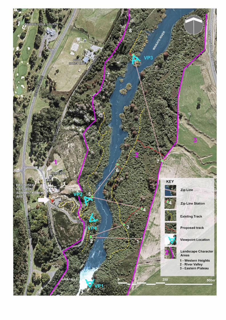
in relation to this application concerning landscape and visual matters:
5. As noted on the site visit, the landscape report provides a Viewpoint 3 of Tower 7 which shows the platform and structure protruding above the canopy line. This may be largely due to the perspective of the photo montage. We would appreciate further discussion on the platform structures and the backdrop of these structures and viewing audience. In our opinion, the platforms and structures will need to be placed within the landscape in such a manner that they do not detract from the landscape and natural character values of the area.
1.2 I consider that the current placement of the proposed structures will not detract significantly
from the landscape and natural character values for the reasons set out below.
1.3 Although, as identified in previous relevant landscape studies and the applicable overlays
in the District Plan, the area has high landscape and natural character values, it is by no
means pristine and the prevailing character is significantly influenced by past modification,
existing recreational use, tourism activities as well as adjacent infrastructure and activity.
These combine with the natural attributes to create an established character which can
accommodate the type of development proposed.
1.4 The most sensitive areas locally include the Waikato River and its immediate environs
which exhibit the highest degree of natural character and amenity values. The proposal
will have a negligible influence on these areas. Platforms and structures located within the
river valley would cause limited and very localised disturbance and would be well
integrated visually due to appearance, form and the vegetated backdrop.
1.5 As highlighted in the landscape and visual assessment, apart from on the river, the Huka
Falls lookouts and some clearings associated with the track on the western side of the river
near the informal Loop Road lookout, and for a short distance north, there would be very
limited opportunities for people using the local area to see the proposed structures due to
the dense vegetation cover which largely limits visibility from the walking tracks, nearby
roads and other key vantage points. The view depicted from Viewpoint 3 is not from one of
the established walking tracks, but the edge of the river near zipline station 8, which is the
receiving station for the zipline from station 7 (shown in the view).
SKY PLAY ADVENTURES LANDSCAPE AND VISUAL MATTERS
30-10-2019 2 LA4 LANDSCAPE ARCHITECTS
1.6 It is important to note at this point that the visibility of a feature or structure within a
landscape setting does not necessarily constitute an adverse visual effect. Visual effects
are dependent on the context, the visual sensitivity of the view and the type and magnitude
of change something will bring.
1.7 Eight of the 10 stations are located within the bush-clad valley where they will be readily
integrated. Consequently, only 2 of the 10 stations, being those in the elevated locations
on the interface with the Eastern Plateau (Stations 1 and 7) are likely to have any visual
prominence. It should be noted however that these are simple structures with a high
degree of visual permeability which are consistent with the type of outdoor recreational
infrastructure that could be readily anticipated in this area given the nature of the
landscape and the landuse.
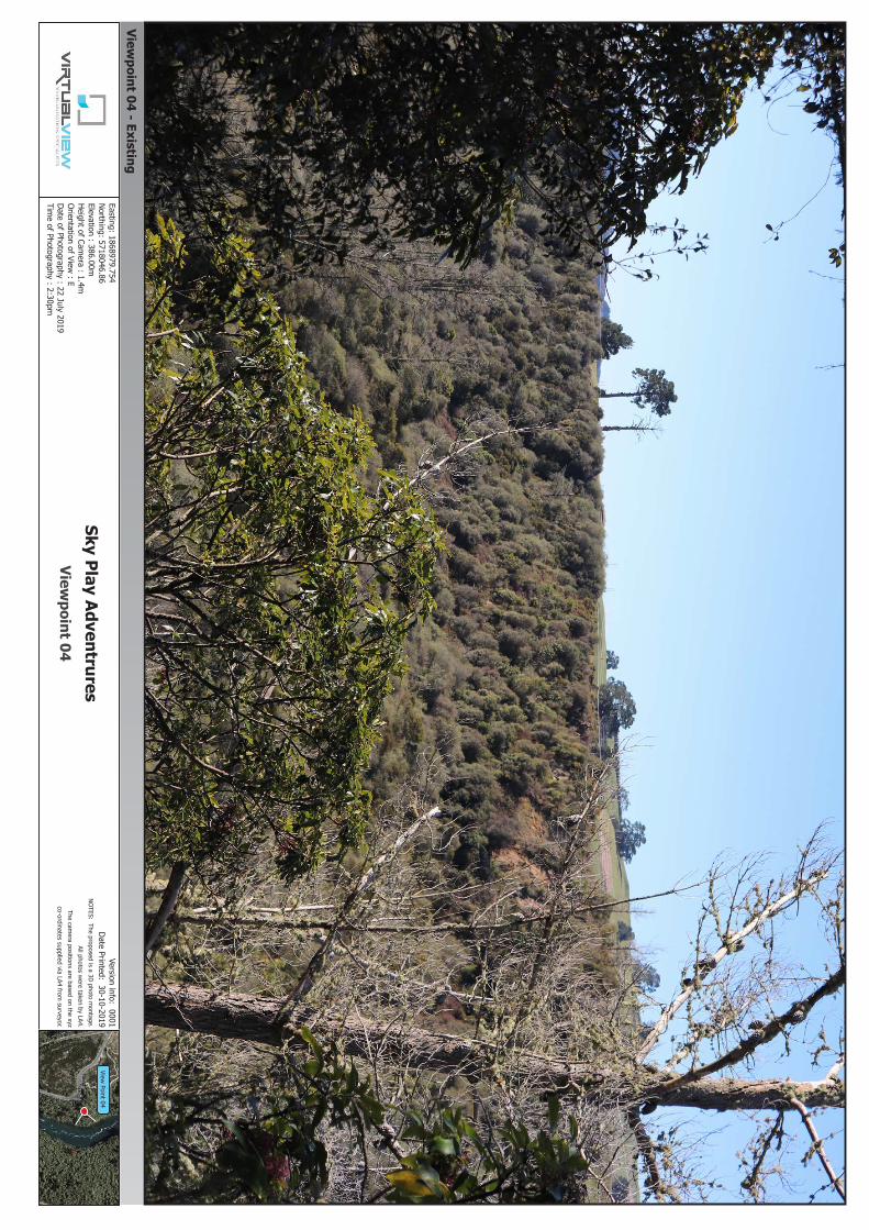
1.8 An additional photo-simulation has also been prepared (VP4) to further assist in
understanding the type and magnitude of effects. This depicts the view from one of the
most accessible and popular public viewing locations, the informal lookout at the eastern
end of Loop Road looking to the northeast toward Zipline Station 7. Both this station
platform and Station 1 are located in the area zoned Rural Environment removed from the
overlay areas of OLA56 and SNA216. From this viewpoint Station 7 can be seen emerging
from behind the low canopy of vegetation at the top of the slope where it appears as part of
the contrasting landscape beyond and although only partially integrated by a backdrop of
landform does not appear incongruous or obtrusive in this large scale setting. Its verticality
is also offset by the scattering of tall exotic trees in the vicinity. Additionally, with time the
structure would weather and become further visually integrated as the regenerating
vegetation continues to establish on the slopes of the river valley. For these reasons the
platform would very low adverse effects on the visual amenity from this popular vantage
point.
1.9 Where platforms 1 & 7 are visible from the east beyond the river valley they would be
viewed as relatively insignificant elements as part of the wider large scale and open rural
landscape which has limited visual sensitivity and the ability to accommodate these simple
structures within a backdrop of hills to the west without detracting significantly from the
rural character and amenity currently experienced.
1.10 Consequently, I consider that the proposal is consistent with the intent of the key relevant
statutory documents and management strategies which seek to facilitate public access use
and enjoyment of this area while maintaining and enhancing the natural and scenic values.
Jason Hogan
(NZILA) Registered Landscape Architect
Director - LA4 LANDSCAPE ARCHITECTS
View Point 04
Viewpoint 04 - Existing
Viewpoint 04
Easting: 1868979.754 Northing: 5718046.86Elevation : 386.00mHeight of Cam
era : 1.4mOrientation of View
: EDate of Photography : 22 July 2019Tim
e of Photography : 2:30pm
Version info: 0001Date Printed: 30-10-2019
NOTES: The proposed is a 3D photo montage.
All photos were taken by LA4.
The camera positions are based on the xyz
co-ordinates supplied via LA4 from surveyor.
Sky Play Adventrures

View Point 04
Viewpoint 04 - Proposed
Viewpoint 04
Easting: 1868979.754 Northing: 5718046.86Elevation : 386.00mHeight of Cam
era : 1.4mOrientation of View
: EDate of Photography : 22 July 2019Tim
e of Photography : 2:30pm
Version info: 0001Date Printed: 30-10-2019
NOTES: The proposed is a 3D photo montage.
All photos were taken by LA4.
The camera positions are based on the xyz
co-ordinates supplied via LA4 from surveyor.
Sky Play Adventrures
(Toward Zipline S
tation 7)