Temple’s First Pylon. Fig. - Amazon...
38
The Brooklyn Museum’s 2010 Season of Fieldwork at the Precinct of the Goddess Mut at South Karnak by Richard Fazzini, Brooklyn Museum Abstract The main emphasis of the Expedition’s fieldwork in the 2010 Season was on the area of Chapel D and the Taharqa Gateway. We further excavated the walls built in and around both stone structures and between the Taharqa Gate and the baked brick building (probably a bath) to the south. The most significant result was confirmation of what we had long believed was true of the history of the Mut Precinct: it was not until the reign of Taharqa that the precinct was expanded to include the area between the First Pylon of the Mut Temple and the later north enclosure wall. In fact, the wall running north from the Taharqa Gate ran up to (and possibly under) the enclosure wall, while its southern wall ran to join the earlier Tuthmoside precinct wall running to the west end of the Mut Temple’s First Pylon. The main restoration/conservation project was reconstruction and re-erection of the small healing magic chapel of Horwedja before the east wing of the Mut Temple’s First Pylon. The Brooklyn Museum’s archaeological expedition to the Precinct of Mut is conducted under the auspices of the American Research Center in Egypt and with the permission of the Supreme Council of Antiquities. 1 Fig. 1 is a plan of the northern part of the site showing the areas where the expedition worked in 2010; that work is described below. North of the Mut Temple’s 1 st Pylon Work continued on the Ptolemaic and Roman Period buildings between the Mut Temple’s First Pylon and Temple A’s porch 2 where in 2009 we had begun to uncover 1 The Expedition acknowledges with gratitude the cooperation and assistance of officials of the Supreme Council of Antiquities, in particular Dr. Zahi Hawass, Secretary General of the SCA; Dr. Mohamed Ismail, General Director for Foreign and Egyptian Missions; Dr. Sabri Abdel Aziz, General Director for Upper Egypt; Dr. Mansour Boraik, Director for Southern Upper Egypt; Dr. Mohammed Asem, Director for Karnak and Luxor; Dr. Ibrahim Suleiman, Director for Karnak; and Hassan Mahmoud Hussein, the SCA Inspector assigned to the Expedition. We thank them all for their help with the season’s work. The staff for this season were Richard A. Fazzini, Egyptologist, Director and Co-Field Director; William H. Peck, Co-Field Director, Egyptologist and Architect; Mary E. McKercher, Assistant Director, archaeologist and photographer; Elsie H. Peck, archaeologist and artist; Jacobus van Dijk, Egyptologist and epigrapher; Julia Harvey, Egyptologist and pottery consultant; W. Benson Harer, Jr., artist and consultant; Anna Serotta, Conservator; and Khaled Mohamed Wassel, SCA Conservator. Major funding for the 2010 season was provided by the Brooklyn Museum’s Charles Edwin Wilbour Fund, with additional support from R. Fazzini. M. McKercher, W. Peck and E. Peck. 2 Detailed descriptions of the work in this area are given in R. Fazzini, “Report on the Brooklyn Museum’s 2006 Season of Fieldwork at the Precinct of the Goddess Mut at South Karnak” ASAE 81 (2007), pp. 101- 115; idem, “The Brooklyn Museum’s 2007 Season of Fieldwork at the Precinct of Mut, South Karnak”, ASAE 82 (2008), pp. 67-87; idem, “Report on the Brooklyn Museum’s 2008 Season of Fieldwork at the Precinct of the Goddess Mut at South Karnak”; and idem, “Report on the Brooklyn Museum’s 2009 Season
Transcript of Temple’s First Pylon. Fig. - Amazon...

The Brooklyn Museum’s 2010 Season of Fieldwork at the Precinct of the Goddess Mut at South Karnak
by Richard Fazzini, Brooklyn Museum Abstract The main emphasis of the Expedition’s fieldwork in the 2010 Season was on the area of Chapel D and the Taharqa Gateway. We further excavated the walls built in and around both stone structures and between the Taharqa Gate and the baked brick building (probably a bath) to the south. The most significant result was confirmation of what we had long believed was true of the history of the Mut Precinct: it was not until the reign of Taharqa that the precinct was expanded to include the area between the First Pylon of the Mut Temple and the later north enclosure wall. In fact, the wall running north from the Taharqa Gate ran up to (and possibly under) the enclosure wall, while its southern wall ran to join the earlier Tuthmoside precinct wall running to the west end of the Mut Temple’s First Pylon. The main restoration/conservation project was reconstruction and re-erection of the small healing magic chapel of Horwedja before the east wing of the Mut Temple’s First Pylon.
The Brooklyn Museum’s archaeological expedition to the Precinct of Mut is conducted under the auspices of the American Research Center in Egypt and with the permission of the Supreme Council of Antiquities.1 Fig. 1 is a plan of the northern part of the site showing the areas where the expedition worked in 2010; that work is described below. North of the Mut Temple’s 1st Pylon Work continued on the Ptolemaic and Roman Period buildings between the Mut Temple’s First Pylon and Temple A’s porch2 where in 2009 we had begun to uncover
1 The Expedition acknowledges with gratitude the cooperation and assistance of officials of the Supreme Council of Antiquities, in particular Dr. Zahi Hawass, Secretary General of the SCA; Dr. Mohamed Ismail, General Director for Foreign and Egyptian Missions; Dr. Sabri Abdel Aziz, General Director for Upper Egypt; Dr. Mansour Boraik, Director for Southern Upper Egypt; Dr. Mohammed Asem, Director for Karnak and Luxor; Dr. Ibrahim Suleiman, Director for Karnak; and Hassan Mahmoud Hussein, the SCA Inspector assigned to the Expedition. We thank them all for their help with the season’s work. The staff for this season were Richard A. Fazzini, Egyptologist, Director and Co-Field Director; William H. Peck, Co-Field Director, Egyptologist and Architect; Mary E. McKercher, Assistant Director, archaeologist and photographer; Elsie H. Peck, archaeologist and artist; Jacobus van Dijk, Egyptologist and epigrapher; Julia Harvey, Egyptologist and pottery consultant; W. Benson Harer, Jr., artist and consultant; Anna Serotta, Conservator; and Khaled Mohamed Wassel, SCA Conservator. Major funding for the 2010 season was provided by the Brooklyn Museum’s Charles Edwin Wilbour Fund, with additional support from R. Fazzini. M. McKercher, W. Peck and E. Peck. 2 Detailed descriptions of the work in this area are given in R. Fazzini, “Report on the Brooklyn Museum’s 2006 Season of Fieldwork at the Precinct of the Goddess Mut at South Karnak” ASAE 81 (2007), pp. 101-115; idem, “The Brooklyn Museum’s 2007 Season of Fieldwork at the Precinct of Mut, South Karnak”, ASAE 82 (2008), pp. 67-87; idem, “Report on the Brooklyn Museum’s 2008 Season of Fieldwork at the Precinct of the Goddess Mut at South Karnak”; and idem, “Report on the Brooklyn Museum’s 2009 Season

2
what appeared to be the foundation level of the earliest structures. Our goal in 2010 was to define these remains further and map what is preserved. fig. 2a is a plan of the brick on this lowest level and fig. 2b shows the area at the end of the season, and. There are two main masses of brick. The northern mass was heavily damaged by Roman Period pits, in one of which this season we found part of a statue of a kneeling man holding a large bowl (fig. 3).3 Further exploration of the robbed out area confirmed that three courses of brick are preserved, with traces of the sand of the foundation trench. It was also clear that the rows of limestone running from the south side of Temple A’s porch did, in fact, meet the north face of the brick mass; in one place we could see where the limestone had been displaced by the cutting of the pit (fig. 4). The walls shown in grey on fig. 2a are a later phase, built partly over the earlier foundations. What is left of the south wall and southern part of the east wall are a single course deep, resting directly on earth. Projecting from the north side of the south wall was a large jar (visible in fig. 2b) whose rim was broken by the construction of the wall. The restored jar (fig. 2c) is 35 cm tall with a burnished orange slip inside the rim and over its edge. The kiln or oven is also a later feature, but the walls to its east and south (green on fig. 2a) are probably part of the earliest building. Between the west side of the kiln/oven and the East Porch we found only bricky rubble at this level. The northern mass of mud brick seems to belong with the paving along its west edge, although that is not clear from the map as the western part of the brick was rather deteriorated. As can be seen in figs. 2b and 5a, the 2nd through 4th columns of the East Porch (counting from the north) were built directly on this paving, which continues across the width of the porch; it is a single course thick and rests on dirt. No trace of the paving has been found south of the 4th column within or east of the porch. The west edge of the southern mass of brick, opposite the 5th column of the Mut Temple’s East Porch, was probably cut during the construction of the southern part of the porch, which rests on a foundation of three courses of large blocks (fig. 5b), some bearing the name of Ramesses II. The brick here ends raggedly in a line of stone chips and debris that was also found further to the south. The patch of brick shown on the plan running north from the west end of the pylon is most likely a fragment of the wall of which only a stub remains running south from the south side of this part of the foundation.
of Fieldwork at the Precinct of the Goddess Mut at South Karnak”. The latter three reports, as well as the reports for 1996-2005, are available online at www.brooklynmuseum.org/features/mut/. 3 24ME.3, diorite. H. of kneeling figure: 24.0 cm; max. w. of basin: 26.0 cm. For more complete examples of what he calls a rare statue type, see D. Wildung, “Die Kniefigur am Opferbecken. Überlegungen zur Funktion altägyptischer Plastik,” Münchner Jahrbuch der bildenden Kunst XXXVI (1985), pp. 17-38; see also K. Priese, Museuminsel Berlin. Ägyptisches Museum (Mainz, 1991), p. 96, for a limestone statue of Hui of late Dynasty 18. In most of the examples Wildung cites, the donor kneels before a rectangular vessel, but in his example 8 (Abb. 21 on p. 29) the vessel is round, as is the Mut example. Wildung also notes that the provenance, where known or likely, of all the examples of which he is aware is the region of Memphis, so this figure from the Mut Precinct is possibly the first New Kingdom statue of this type from Thebes. For a 25th Dynasty example of a round bowl with kneeling figure (of which only the hands grasping the edge of the bowl are preserved), see J. Leclant, Montouemhat: quatrième prophète d’Amon, prince de la ville, BdÉ 35 (Cairo, 1961), doc. 30, pp. 141-148 and pls. XLVI-XLIX. In fn. 3 he lists additional examples of this type of sculpture.

3
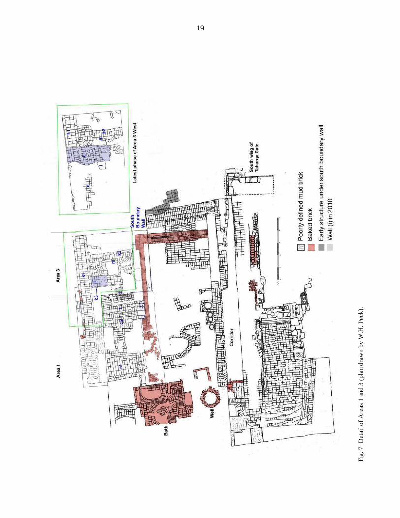
The two areas of brick laid in straight rows to the east seem to belong with the earliest building as well. The lowest course of a baked brick Roman Period cistern or tub cut the southeast corner of the brick, while the foundation trench of a later wall and the hole cut for a pottery bin damaged the west side. A pottery bin from that later phase was sunk into the smaller, southwest section whose north end is also cut by a pit. At the east side of the area, room 14, with an apparent mud brick floor abutting its north side, also represents a later phase of construction. Despite having a clearer picture of the foundations of this large building, we are not much closer to understanding its purpose. It may have been dismantled during Dynasty 25 when the columned porches in front of the Mut Temple were built, or during the Ptolemaic Period rebuilding of the porches. The Taharqa Gate Area Our excavation efforts this year focused on the Taharqa Gate, the wall to its north, and the area to its south and west. The areas in which we worked are described below, using the same wall designations as the 2009 report5 where applicable. Fig 6 is a plan showing the whole of the 2010 excavation area while fig. 7 covers Areas 1 and 3 only. Fig. 8 shows the area at the start and end of the season. North of the Taharqa Gate During the New Kingdom, the walls associated with the Tuthmoside gate west of the Mut Temple (discovered by the Brooklyn Museum Mut Expedition and further excavated by the Johns Hopkins University Expedition) and its associated walls formed the west and north limits of the Mut Precinct, the north enclosure wall being on a line with the wall of the Mut Temple’s present first pylon.6 The area to the north, which includes Temple A, lay outside the Mut Precinct throughout the New Kingdom and was known as Ipet (the Mut Precinct is Isheru). This area did not become part of the Mut Precinct until King Taharqa enlarged the Mut Precinct to take in the area north of the present First Pylon of the Mut Temple.7
4 See reports cited in n. 2 for the numbering of the rooms built against the face of the pylon. 5 R. Fazzini, “Report on the Brooklyn Museum’s 2009 Season of Fieldwork”, fig. 12. 6 For the Tuthmoside wall and gateway see, e.g., R. Fazzini, “Report on the 1983 Season of Excavation at the Precinct of the Goddess Mut,” ASAE 70 (1984-1985), pp. 303-307, and pl. II (plan) and IV; R. Fazzini, “Some Aspects of the Precinct of the Goddess Mut in the New Kingdom,” in E. Ehrenberg (ed.), Leaving No Stones Unturned. Essays on the Ancient Near East and Egypt in Honor of Donald P. Hansen (Winona Lake, Indiana, 2002), pp. 63-70, with figs. I (plan with growth of precinct indicated), 2, 3, 4 and 6 7 See already, R. Fazzini, “Report on the Brooklyn Museum’s 2008 Season of Fieldwork,” n. 13 on pp. 7-8. The footnote reads: “The name of the area that lay outside the original Mut Precinct and was incorporated into it in Dynasty 25 is provided by a stela that originally stood before Temple A’s First Pylon and was discovered in 1979 by the Brooklyn Expedition. This stela’s text and another Ramesses II block re-used in Temple A’s Second Pylon demonstrate that Temple A was a “Temple of Millions of Years” associated with Amun, renewed by Ramesses II, that stood in a place termed Ipet (or Opet). As noted by others, there were a number of places called Ipet/Opet associated with Amun-Re. For Ipet/Opet as a generic term and Amon-Re sometimes called khenty ipwt.f “qui préside à ses ipet”, see J. Quaegebeur, “Aménophis, nom royal et nom divin; questions méthodologiques,” RdÉ 37 (1986), 97-106, and especially pp. 104 and 105. For a recent discussion of the use of the terms ipet or opet at Thebes, see W. Waitkus, Untersuchungen zu Kult und Funktion des Luxortempels I: Untersuchung (Gladbeck, Germany 2008), pp. 216-222.

4
The Taharqa Gate was set into a wall that formed the new western limit of the larger precinct. The wall from the gate’s south wing is fairly well-preserved, but the wall running north from the gate was extensively robbed out. Previous excavation had only revealed a small stub of wall at the west end of the gate (fig. 9a). In 2010 we initially opened a 5 x 5 m square north of the gate (extended an additional 3 m to the north) to see if more of the wall survived at a lower level. The excavation was later extended north to the enclosure wall in a trench 3 m wide. Below the disturbed levels in the main square we were found the full width of the Dynasty 25 enclosure wall, which ran at least to the south face of the enclosure wall that was built in Dynasty 30 or the early Ptolemaic Period. Fig. 9b shows the area north of the gate at the end of the season. The wall and the gate itself were presumably still functional during the reigns of Ptolemy VI (180-145 BC) and Ptolemy VIII (170-116 BC), who built Chapel D just inside the gate and against the east side of the wall. The east wall of the chapel’s first room abuts the E side of the mud brick Taharqa wall (see plan, fig. 7 and fig. 9b), which is preserved to its greatest height in this area. By the late 2nd century BC or early 1st century BC, however, the northern part of the wall had been dismantled almost down to its foundations. It is possible that the large rectangular cut west of the rear of the chapel (fig. 6) is the result of later construction set into the ruins of the wall, but the whole area is too damaged to be sure. However, the smaller cut just south of the enclosure wall was certainly intentional as we found within it a tall jar standing upright (fig. 10a-b), with a small burnished blackware bowl8 set in its neck as a lid (fig. 10c). Against the neck of the jar were 13 coins of a type known from the time of Ptolemy IX Soter II (116-107 BC and 88-80 BC) to the end of the Ptolemaic Period (fig. 10d)9. In the southwest corner of the excavation two more walls projected from the west baulk and ran at generally the same angle as the north boundary wall of the approach to the gate (see figs. 6, 9b). The northern wall seems to have been cut by the construction of the Taharqa Gate wall. The southern wall, constructed of large, dark grey bricks, was built after the Taharqa wall was in ruins; its sand foundation lies on a layer of debris c. 30 cm above the preserved top of the Taharqa wall. The rear 2 rooms of Chapel D are narrower than the front room, leaving a gap between the chapel and the Taharqa wall that may have been a passageway to the north enclosure wall, accessible through a small doorway in the north wall of room 1. This season’s work uncovered the sandstone footing of the chapel’s rear two rooms.10 Set into the east side of the Taharqa wall at the south end of the rear part of the chapel are the
8 The Mut Expedition’s pottery is being studied by M. McKercher who contributed the information presented in this article. 9 We thank Dr. Penelope Weadock Slough for providing the initial identification of these coins as time of Ptolemy IX Soter, and Dr. Thomas Faucher of the CNRS for explaining the wider dating range of this type of coin. 10 As we discovered a few years ago, the outer face of the limestone blocks of Chapel D’s rear wall – the side against the enclosure wall -- are decorated with 18th Dynasty reliefs. We found this year that brick debris from the enclosure wall had again begun to fill the gap between the blocks and the wall. To prevent damage to these carvings we cleaned out the accumulated debris, built up the space between the undecorated ends of the chapel wall and the enclosure wall with mud brick, and filled the space between the enclosure wall and the chapel with sand.

5
remains of a small baked brick structure (figs. 7, 9b) of which only the west side is preserved for its full length, to a height of 2 courses; of the north and south sides only a few bricks remain. The space between the rear part of the chapel and the Taharqa wall has been so thoroughly robbed out that no clue remains as to the construction date or purpose of this baked brick feature. Indeed, because of the extremely disturbed nature of the whole space between the Taharqa Gate and the enclosure wall, the pottery from the excavations here is rather uninformative. Area 2: West of the Taharqa Gate This season we completed clearing the area immediately west of the Taharqa Gate that had been left unexcavated at the end of the 2009 season11. Figs. 11a-b show the area at the beginning and end work. In Area 2 north we removed the remains of the Ptolemaic/Roman houses down to the level of the packed earth surface that borders the north side of the paving leading to the gate, confirming that the houses were built on three main levels of debris that seem to have been dumped intentionally. The pottery from within the lowest level of the house and from all three debris strata appears to be Ptolemaic (fig. 13). From the lowest stratum, c. 30 cm above the paving, came the base of an imported black-glazed dish with palmettes also shown in fig. 13. On the surface north of the paving were stubs of three mud brick walls (figs. 6, 11b), but not enough is preserved to determine how they relate to each other. Traces of a layer of packed stone chips and small pot sherds similar to the very clear stone chip layer found in Area 2 south (described below) were also found. In Area 2 south we found the south edge of the paving under the remaining debris, as expected12. It was in generally good condition, but with one block (visible in fig. 12) standing on edge. Rather than running directly west from the Taharqa Gate, the paving angles toward the south. Excavation further to the west (see below) confirmed this direction, which is clearly visible in figs. 6 and 20. Of more interest was the mud brick south of the paving, visible in fig. 12 and on the left in fig. 11a, where it sticks up from the surrounding earth. It is built of dark grey bricks with thick white/grey mortar and sits on a layer of stone chips over c. 10 cm sand on a hard-packed surface at about the level of the paving. This surface continues along the full length of south side of the paving excavated this season (fig. 14) and was probably the walking surface that ran beside the paved roadway. What is left of the mud brick structure is 4 courses of a roughly east-west wall that turns to the north at its east end (figs. 6, 15; another fragment of the structure can be seen on the left in fig. 15). The south boundary wall of the approach to the gate is built directly atop the wall. What makes this fragmentary building frustrating is that it is the only structure found to date that is probably contemporary with the Taharqa Gate, or at least with the first phase of the gate’s existence, before dirt accumulated over the paving and the
11 R. Fazzini, “Report on the 2009 Season of Fieldwork”, pp. 12-17. 12 At the end of the season we filled gaps in the paving with gravel to level up the area for the safety of future visitors and to protect the paving stones from further deterioration.

6
threshold of the gate was raised.13 Interestingly, it seems to be aligned with the southerly line of the paving rather than with the face of the gate. Of course, given the minimal remains of the structure this apparent alignment may be illusory. Area 2 West This season we opened a new 5 x 5 m square 1 m west of the west baulk of Area 2 and spanning the area from the midpoint of the south boundary wall to the middle of the paving. At c. 50 cm below the modern surface we came on a line of mud brick that ran along the south baulk for the full east-west width of the square, its uppermost course being just below the top of the thick stratum of white-flecked earth mentioned earlier. The white flecks, in fact, defined the edges of the bricks of this top course, which were very friable. We first thought that here the flecks were part the mortar itself, but it is more likely that they merely adhered more easily to the softer mortar than to the denser mud brick. The mud brick wall proved to be a continuation of the south boundary wall, preserved to a greater height than further east. Below the modern surface was over a meter of the same white-flecked fill that we found in Area 2 in 2008-2009. It contained a number of broken and unidentifiable bits of faience, bronze (including 4 indecipherable small coins), glass and bone as well as a few more complete objects illustrated here as fig. 17: a faience amulet of a kneeling ram, the crossed paws of a reclining lion figure, and a fragment of a bronze aegis (very corroded) of Mut and possibly Horus14. The pottery from this stratum seems generally to be late Ptolemaic-early Roman (see fig. 19). At 1.3 m below the modern surface, and immediately below the white-flecked stratum, the earth was cleaner with only a few fragments of broken sandstone. In this stratum we found a single, damaged mud brick wall along the north side of the square (fig. 17). Although 4 courses are visible in the west baulk, only a single course survives east of the baulk to run 3 m further east before disappearing. Because of time constraints we were unable to excavate the northern half of this square down to the paving and so do not know if more of this wall is preserved at a lower level; we found no trace of such a wall further to the east in 2009. At c. 120 cm below the top of the boundary wall and against its west face we encountered the top of a fairly extensive heap of pottery that seems to have been dumped over the wall from the south. Many of the vessels were complete or almost complete and formed a sloping mound whose base extended from the southwest corner of the square along about half the length of the square and lay on the surface at the base of the south boundary wall (fig. 18a). The south boundary wall is preserved to a height of 160 cm, its lowest course being c. 70 cm above the paving of the approach to the gate. In the southwest corner of the square and running under the wall was a shallow rectangular pit lined with grey clay-like earth with a concentration of ash in the northwest corner (fig. 18b). Within the pit we found a large quantity of what may be Nile oysters (fig. 18c), a broken blue faience bowl
13 For a discussion of the development of the approach to the Taharqa Gate, see R. Fazzini, “Report on the Brooklyn Museum’s 2008 Season of Fieldwork”, pp. 7-10. 14 Lion’s paws (24MW.13): faience, h 2.1 cm; w. 3.6 cm; ram amulet (24MW.15): faience, h. 2.1 cm; w. 1.1 cm; l. 3.1 cm; aegis (24MW.18): h: 3.7 cm; w. 2.6 cm; d. 1.4 cm.

7
(fig. 18d), and a ceramic alabastron very similar to examples published by Schreiber15 (fig. 19). To the east a similar clay-lined pit projected from the north baulk. At 30 cm below the “oyster pit” (i.e., c. 40 cm above the paving) was a scattering of broken baked brick, some of which formed 2 apparently parallel rows running north from the boundary wall. A few large pieces of broken sandstone and large potsherds were also found at this level, recalling the mixture of pottery, brick and stone found at the same level in Area 2 last year.16 A selection of pottery from Area 2 West is shown in fig. 19. Parallels to these vessels were found at Karnak, Elephantine, Coptos and Athribis.17 The painted sherds seem to be Schreiber’s early Floral Style A,18 although the shoulder fragment with the floral decoration painted directly on the uncoated clay rather than on a white slip is unusual19. The fragment of a spouted vessel resembles his linear style A20. All of these parallels suggest a possible date of late 3rd-early 2nd century BC, which fits with pottery found in the area in earlier seasons.
We were only able to excavate the southern half of this square all the way to the paving, which continues the southward curve noted earlier (fig. 19). Area 2-3: The south boundary wall of the Taharqa Gate roadway In order to discover what earlier structures might remain beneath the south boundary wall and how that wall relates to the wall forming the west side of the corridor running the length of the Taharqa Gate wall we dismantled the south boundary wall down to the level of the paving and as far west as the 2009 west baulk. This part of the boundary wall was constructed in several phases, shown in figs. 21a-c (plan) and 22a-c. At the highest level preserved, the northeast corner, where the boundary wall should intersect the corridor wall, had sustained some damage. Once this was cleared, however it could be seen that the boundary wall and the west wall of the corridor were contiguous, suggesting the two walls are contemporary.
15G. Schreiber, Late Dynastic and Ptolemaic Painted Pottery from Thebes (4th-2nd B.C.) Dissertationes Pannonicae Ser. III, Vol. 6 (Budapest, 2003), p. 28-29, 55 and pl. 6, #77-79: alabastra with linear decoration. While Schreiber dates these specific examples to the late 4th-3rd centuries BC, he points out (personal communication) that this type of vessel, with linear decoration, was made as late as the 2nd century BC. We wish to take this opportunity to thank Dr. Schreiber for his very helpful comments and his patient and detailed response to our many questions on this season’s pottery. 16 R. Fazzini, “Report on the Brooklyn Museum’s 2009 Season of Fieldwork”, pp. 15-17. 17 For the plates: D. Aston, Elephantine XIX: Pottery from the Late New Kingdom to the Early Ptolemaic Period (Mainz am Rhein, 1999) , pl. 111, #2928; S.C. Herbert, et al., Excavations at Coptos (Qift) in Upper Egypt 1987-1992 (Portsmouth, Rhode Island, 2003), p.62, H2.6; K. Myśliwiec et al., “Remains of a Ptolemaic Villa at Athribis”, MDAIK 44 (1988), p. 44 and fig. 4. For the jug: J. Lauffray, La chapelle d’Achôris à Karnak: 1. Les fouilles, l’architecture, le mobilier et l’anastylose (Editions Recherche sur les Civilisations, 1995), pp. 89, 91 and fig. 42.377. 18 E.g., G. Schreiber, op. cit., pp. 46-47 and pl. 15, #208, #214a 19 Based on a photograph of this sherd, Dr. Schreiber suggests that the body of the vessel may have been self-slipped before the white wash and painted decoration were added. The style of the decoration on this vessel is very similar to Schreiber, op. cit., p. 87 and pl. 21 #258: yellow-slipped with black decoration. 20 ibid., p. 44 and pl. 15, #210. However not enough of the spouted vessel is preserved to determine whether it displayed the bichrome decoration Schreiber says is typical of this style, or even whether it is actually linear style A rather than floral style A.

8
The south face of the wall as we understood it at the end of 2009 season is shown in figs. 6-7 and in detail in fig. 21a, with what appears to be a mud brick floor immediately to the south on which sat 3 clay bins or ovens (not shown on this plan).21 Both the east and west ends of this area were cut by pits. The east pit was very shallow with brick immediately below, but the west pit cut through 3 courses of brick. Below it three rows of brick extended the south side of the wall past the line of the 2 northern rows of the “floor”, which is now clearly part of the wall itself (fig. 22a). With the pits cleared, we dismantled the boundary wall and the mud brick abutting it one course at a time. The bricks of the 3 southern rows of the presumed floor south of the wall were only one course deep. At four courses below the top of the wall (figs. 21b, 22b) a stone-chip-filled gap was continuous between the south face of the wall and the line of baked brick. At the eighth and lowest course, the formerly solid wall becomes 2 separate walls: a single row of bricks making up the wall’s north face and a second 2-row wall 40 cm to the south (figs. 21c, 22c). The space between the walls and under the center of the southern wall in particular contains many large broken pieces of stone. They are part of a mound of broken rock filling a pit that cut the remains of the earlier mud brick building and extended almost down to the level of the paving. The earth that accumulated around the center of the heap contained fewer and smaller pieces of stone. When the line of brick forming the north face of the boundary wall was removed, more of the earlier mud brick structure was revealed, continuing into the west baulk (fig. 14). At the east end of the boundary wall the only hints of this building were the stub visible in fig. 14 and an area of dark grey bricky material behind it sloping down to the west. Fig. 23 shows the area at the end of the season. The line of baked brick south of the boundary wall was built on a thin stratum of earth above the stone heap. The east and west ends of the line have sagged somewhat, perhaps because the smaller amount of stone in the fill provided a less solid foundation than the more concentrated stone under the center of the line. Area 3 West/Area 1 West: Mud brick buildings south and west of the Taharqa Gate In 2010 we laid out a 5 m E-W x 4 m N-S square (Area 3 West) south of Area 2 West (fig. 7). The south baulk, between Area 3 West and Area 1 was removed early on in order to allow us to link the structures being uncovered with those found last year in Area 1. Eventually we expanded the west baulk of Area 1 to the line of the west baulks of the rest of this season’s excavations; this area is referred to as Area 1 West. Fig. 24 shows Area 3 West and the northern part of Area 1 West near the end of the season. Once again, we found mud brick 10-15 cm below the modern surface in both areas, although the upper levels were very decayed and difficult to follow. The inset of fig. 7 shows this latest phase of construction. In Area 3 West, a mud brick wall (L) ran 290 cm from the west baulk before being broken (fig. 7, inset; only the southern section is shown in the larger plan). Its north face was irregular but was 155 cm at its widest. At this level we also found mud brick along the west baulk that turned to the east c. 80 cm from the north baulk of the square. This E-W segment is visible in fig. 25, north of wall (k2) and was built over and against the remains of walls (k1) and (k2). At the west end of
21 R. Fazzini, “Report on the 2009 Seasonof Fieldwork”, p. 19.

9
wall (L) was a small sandstone block that may have originally stood vertically in a gap in the brick immediately to its south. It and the row of 3 displaced bricks to its west (fig. 25) may be the remains of a doorway with a stone jamb and baked brick threshold. Below the decayed brick along the west baulk the well-preserved, 105 cm-wide wall (k1) eventually ran the full length of the area to the south side of walls (a)/(c1), with which it may form a corner (fig. 26); more of the decayed upper brick will have to be removed to confirm this. The cross wall linking walls (c1) and (c2), which had eluded us last year, was found under the 2009 baulk. Although partly cut by an animal hole it clearly meets the east face of (k1). Wall (i), protruding from Area 1’s north baulk, had decayed since 2009; the portion in grey on fig. 7 indicates all that remains. Although damaged, it did turn north and meet the south face of wall (L) (fig. 24). Fig. 27 and the inset of fig. 7 show the area between wall (L) and the extension of (c1) early in the excavation. Along the west baulk a line of baked brick and stone extends 4 m south from the southwest corner of wall (L) (with a 1 m gap between the north and south sections); it may be associated with the 1-course thick wall (n) to the east that runs from the north face of (c2) to the south face of wall (L). Only 3 rows of this wall could be distinguished with any confidence. When we extended Area 1 West 70 cm the west we found that the line of baked brick and stone sits directly on the stretchers forming (k1)’s west face. Two lines of brick run west from (k1) (fig. 26), but only the one north of the gap was distinct enough to be mapped precisely. It is 3 rows wide and, as can be seen in fig. 7, the northern row lines up with the stone of at the south end of the first section of brick, suggesting a threshold. Wall (n) and at least the northern section of wall (L) were built on a stratum of collapsed brick that ran across the whole area, overlying the earlier walls. We had encountered more of this collapse during work in Area 3 in 2009. When we removed the north baulk of Area 3 West looking for the south face of the south boundary wall, we found that this stratum continued right up to the face of the wall, which was only c. 70 cm wide at this level. The curved wall (m), lay partially below wall (L) and may have cut through the collapsed brick; at any rate, its north edge lies over the presumed south face of wall (k2), which runs east from (k1) (fig. 25). East of wall (m) we did not explore much below upper courses of wall (L); the brick shown in fig. 7 seems to be part of the collapse. Below wall (n) the mud brick collapse spilled into the space between walls (k1) and (f) from the south face of wall (L) to the extended north face of (c2). This brick contained a heavy concentration of thick, white plaster with traces of red, black and yellow paint (fig. 28) although no plaster was found on the east face of wall (k1) itself; additional traces of plaster were found atop the N-S portion of (i) as well. This plaster seems to be the same in thickness and composition as the plastered portions of the probable bath22 to the south. Beneath the plaster debris we found the south face of the earlier wall (k3) on which wall (L) was built (visible in fig. 24).
22 As we study this structure further, we are becoming more convinced that it is a bath than a place for dyeing fabric, particularly as several 1st century AD Greek and demotic ostraca found in the houses northwest of the Taharqa Gate mention a bath tax. The Greek ostraca will be published by K. Worp of the Rijksuniversiteit Leiden in a forthcoming festschrift. For the demotic ostraca, see R. Fazzini and R. Jasnow,

10
The stratum of collapsed brick throughout the area suggests a fairly catastrophic collapse of major structures that included the boundary wall of the approach to the Taharqa Gate and all the (k) walls. Could this have been the result of an earthquake, perhaps the one that caused the subsidence of the east portion of the bath (see below)? The layers of black ash that had lain just below the surface in much of Areas 1 and 3 in 2009 was mostly absent in the areas excavated this year, except along the east balk of Area 3, where they lay over the top of a projecting segment of a large mud storage bin (visible in fig. 24). When we removed part of the baulk to trace the N-S portion of the line of baked brick (see below), we discovered that this bin was 105 cm in diameter and 80 cm deep, its base 40 cm above the line of baked brick, i.e., just above the stratum of grey ash described below. Beneath the bin we found a fragment of a brown and green faience bowl with a griffin on the outer surface and a white garland of laurel leaves below the rim on the inner surface (fig.29), both of which are common decorative elements in Ptolemaic faience vessels.23 Area 3 West – Northeast Corner
The only discernible feature between Area 3 West’s north baulk and (k2) was a single row of brick running east from (k1), so this seemed an ideal place for a sounding to follow the south face of the south boundary wall of the Taharqa Gate roadway and to discover whether the line of baked brick in Area 2 ran further to the west. The boundary wall remained only 70 cm wide for a depth of 50 cm, where we found an additional 2 rows of brick. A surface sloping to the east lay immediately over these bricks between the boundary wall and (k2). About 2 courses lower the full width of the boundary was exposed. At this level it was preserved to the same height and width as the section to the east (see fig. 24). The baked brick line did not extend into the sounding; at the level where it should have been was a layer of pot sherds that ran across the whole sounding; walls (k1) and (k2) were built on earth above this stratum.
A mud brick wall running from the south face of the boundary wall to the south baulk of the sounding was found a few courses lower with a second wall running into the east baulk from its east face (fig. 30). We found no trace of the mound of broken stone on which the eastern portion of the boundary wall was built.
Exploration of the line of baked brick Once we confirmed that the baked brick line did not continue into Area 3 West, we cut a section through the baulk between the eastern and western portions of Area 3; the baked brick line turned to the south at about the midpoint of the baulk (fig. 24). We cut the east side of the baulk back to the middle of the newly exposed N-S line of baked and were able to follow it to its southern limit, although the last several meters are broken.
“Demotic Ostraca from the Mut Precinct in Karnak,” Enchoria 16 (1988), pp. 23- 48. For a recent study of baths in Egypt from antiquity to modern times, see M.-F. Broussac, T. Fournet and B. Redon (eds.), Le bain collectif en Égypte: βαλανεĩα, Thermae, ت����� , IFAO Études urbaines 7 (Cairo, 2009). 23 24MW.60: h. 5.5 cm; w. 6.0 cm. For the decoration, see M-D Nenna and M. Seif el-Din, La vaisselle en faïence d’époque gréco-romaine. Catalogue du Musée gréco-romain d’Alexandrie, IFAO Études alexandrines 4 (Cairo, 2000), pp. 84-86 (griffin), 73-74 (laurel garland); the garland on this fragment most resembles their fig. 18.6b.

11
The E-W line is made up of 2 headers laid on edge with a stretcher, also on edge, between them and a second course of stretchers laid flat; the N-S line omits the intervening row of stretchers (see figs. 6, 7) and is also 2 courses deep for most of its length. At c. 6 m from the northwest corner the upper course is missing, revealing a lower course that extends the east face of the line another half-brick. Where the line is finally broken slightly further south, it is not only wider than the northern section but is also at least 5 courses deep (fig. 31). For 4 m south of the break there is only a jumble of broken brick, terminating at baked brick rectangle 90 cm N-S x 70 cm E-W and lying c. 25 cm north of the bath and 30 cm below its foundations (fig. 32a). Eight courses of baked brick remain here, making the rectangle 4 courses taller than the rest of the wall. Its west face is on the line of the west face of the wall north of the break. The whole feature has slipped to the east along the same line as the collapse of the bath to the south and the discontinuity in the ash layer below the bath’s foundations (fig. 32b). Fig. 33 shows most of the 2 baked brick lines at the end of the season. While these brick rows clearly define an area bounded on the east by the west wall of the Taharqa Gate corridor, they remain puzzling. The brick is solid, so cannot be a drain. The abrupt end of the N-S section not only north of but significantly below the bath provides no further clue, although it does suggest the bath is a later construction. No trace remains of any superstructure, whether baked or mud brick. It lies under c. 30 cm of earth above which is a thick layer of pale grey ash that runs across most of the area west of the Taharqa Gate corridor wall, becoming thinner toward the south. The pottery and small finds of 2009 from the ash and the earth below (including a stamped amphora handle),24 and the faience bowl fragment from below the large storage bin, whose profile is visible in the baulk in fig. 33, all suggest a Ptolemaic date for its creation but not a purpose. Corridor South of the Gate In 2010 the expedition cleared the corridor between the wall running south from the Taharqa Gate and the mud brick wall to its west that was the eastern limit of the 2009 excavations. At the north end we found the lowest course of the damaged east face of the south boundary wall. Abutting its south side is a row of mud brick laid as headers that makes the corridor narrower at its entrance than its otherwise uniform 130 cm width (see fig. 7). To the east of and about 2 courses below the top of this wall a curving line of mud brick one course deep with blocks of stone at its north and south ends ran NE-SW across the corridor, its southern end seems to continue in a ragged line of broken limestone (fig. 35a). An uneven stratum of large and small pieces of stone mixed with pottery filled the corridor, covering and surrounding both the line of brick just described and a mud brick wall to its south that was built against the face of the corridor’s west wall and filled about half the corridor’s width (fig. 34b). As can be seen in fig. 34b, this wall had been quite cut up. It was built on a thick layer of stone chips (distinct from the stony debris around it) that filled the width of the corridor and was the foundation for the central portion of the corridor’s west wall as well (fig. 34c). This layer is probably part of the mound of broken stone on which the south boundary wall of the Taharqa Gate roadway was also built. The north and south ends of the corridor wall, however, were solid mud brick to the
24R. Fazzini, “Report on the 2009 Season of Fieldwork”, pp. 18-20.
12
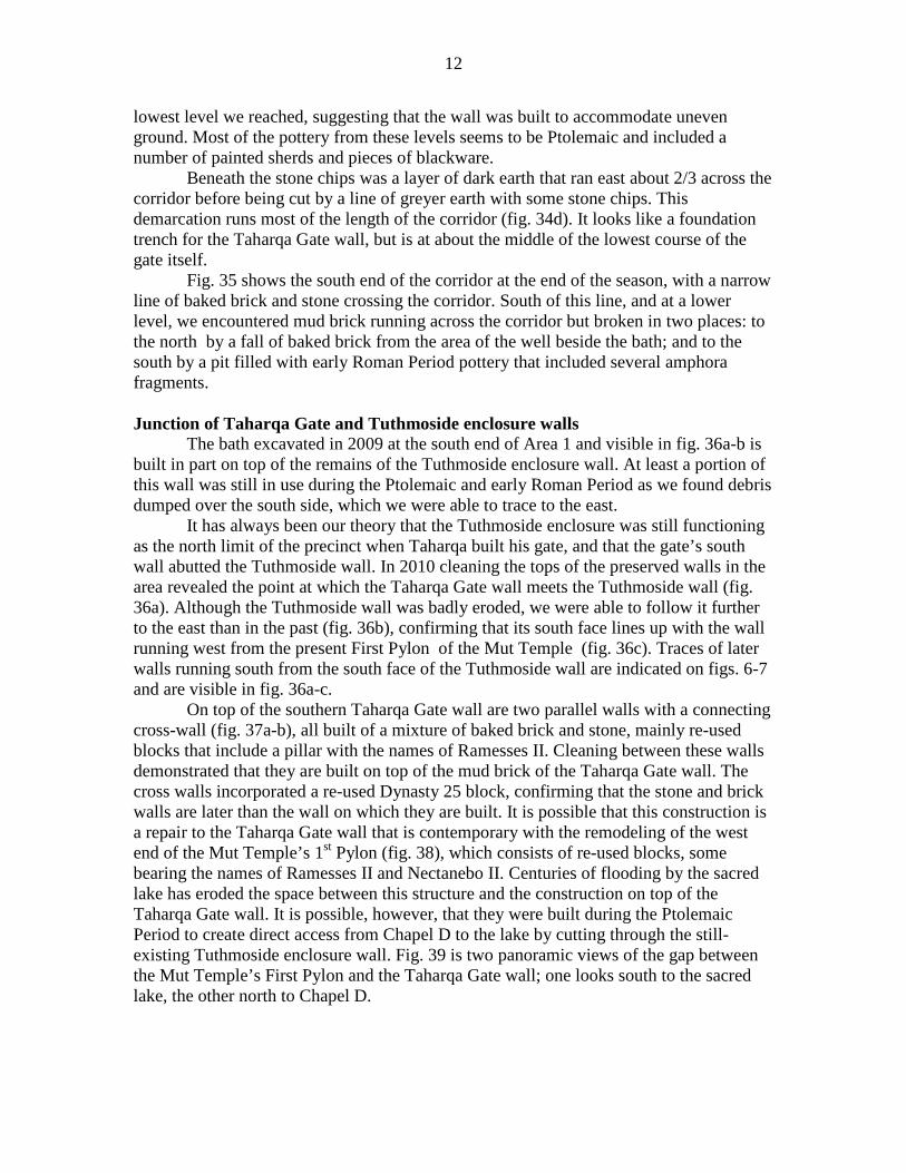
lowest level we reached, suggesting that the wall was built to accommodate uneven ground. Most of the pottery from these levels seems to be Ptolemaic and included a number of painted sherds and pieces of blackware. Beneath the stone chips was a layer of dark earth that ran east about 2/3 across the corridor before being cut by a line of greyer earth with some stone chips. This demarcation runs most of the length of the corridor (fig. 34d). It looks like a foundation trench for the Taharqa Gate wall, but is at about the middle of the lowest course of the gate itself. Fig. 35 shows the south end of the corridor at the end of the season, with a narrow line of baked brick and stone crossing the corridor. South of this line, and at a lower level, we encountered mud brick running across the corridor but broken in two places: to the north by a fall of baked brick from the area of the well beside the bath; and to the south by a pit filled with early Roman Period pottery that included several amphora fragments. Junction of Taharqa Gate and Tuthmoside enclosure walls The bath excavated in 2009 at the south end of Area 1 and visible in fig. 36a-b is built in part on top of the remains of the Tuthmoside enclosure wall. At least a portion of this wall was still in use during the Ptolemaic and early Roman Period as we found debris dumped over the south side, which we were able to trace to the east.
It has always been our theory that the Tuthmoside enclosure was still functioning as the north limit of the precinct when Taharqa built his gate, and that the gate’s south wall abutted the Tuthmoside wall. In 2010 cleaning the tops of the preserved walls in the area revealed the point at which the Taharqa Gate wall meets the Tuthmoside wall (fig. 36a). Although the Tuthmoside wall was badly eroded, we were able to follow it further to the east than in the past (fig. 36b), confirming that its south face lines up with the wall running west from the present First Pylon of the Mut Temple (fig. 36c). Traces of later walls running south from the south face of the Tuthmoside wall are indicated on figs. 6-7 and are visible in fig. 36a-c.
On top of the southern Taharqa Gate wall are two parallel walls with a connecting cross-wall (fig. 37a-b), all built of a mixture of baked brick and stone, mainly re-used blocks that include a pillar with the names of Ramesses II. Cleaning between these walls demonstrated that they are built on top of the mud brick of the Taharqa Gate wall. The cross walls incorporated a re-used Dynasty 25 block, confirming that the stone and brick walls are later than the wall on which they are built. It is possible that this construction is a repair to the Taharqa Gate wall that is contemporary with the remodeling of the west end of the Mut Temple’s 1st Pylon (fig. 38), which consists of re-used blocks, some bearing the names of Ramesses II and Nectanebo II. Centuries of flooding by the sacred lake has eroded the space between this structure and the construction on top of the Taharqa Gate wall. It is possible, however, that they were built during the Ptolemaic Period to create direct access from Chapel D to the lake by cutting through the still-existing Tuthmoside enclosure wall. Fig. 39 is two panoramic views of the gap between the Mut Temple’s First Pylon and the Taharqa Gate wall; one looks south to the sacred lake, the other north to Chapel D.

13
Conservation and Restoration The main conservation/restoration project of the season was that of the Magical Healing Chapel of Horwedja, Great Seer of Heliopolis, and an important official in early Dynasty 26 known from several monuments in Lower Egypt. In the 1978-79 seasons we found several blocks of this small (less than 2 meters square) chapel that once stood in the precinct. The building had been dismantled and its blocks re-used in a late Ptolemaic or early Roman Period structure built in the ruins of the forecourt of Temple A. The blocks were published in 1983 by French Egyptologist Claude Traunecker of the CFEETK.25
The base of one of the sphinxes along the northern enclosure wall east of the precinct entrance is made up mainly of re-used blocks dating to Dynasties 25-26 (fig. 40), including half of a lintel from a chapel of Montuemhat under the sphinx’s paws. However, the uppermost rear block in this base was an upside down lintel bearing the name of Horwedja, Chief Seer of Re at Heliopolis, and Claude Traunecker agreed with the Expedition’s director that the lintel-- discovered after he did his reconstruction--must originally have come from the magical healing chapel its width was only 1 cm. different than his reconstruction. An additional block from the chapel, found after Traunecker’s publication, also bore Horwedja’s titles but not his name.
With the permission of the SCA, we re-erected the chapel this season.26 We do not know where it originally stood, although it was probably somewhere in the Front area of the precinct, where there were several other small chapels. A chapel for healing magic, often associated with a child god, would make sense standing before Temple A, which became a mammisi no later than Dynasty XXV.27 We therefore rebuilt it in front of the east wing of the Mut Temple’s 1st pylon in an area we had already excavated.
The chapel’s new sandstone floor was separated by an impermeable barrier from the foundation of sand, gravel and reinforced concrete. The missing sections of the walls were replaced with blocks of newly-cut sandstone. Break edges were consolidated with Paraloid B-72 and the breaks joined with SikaDur 52. A finishing coat of the mix used by the SCA (Portland cement, sand and lime) tinted to match the color of the original blocks was applied to reconstructed but undecorated areas.
The lintel block was removed from the rear of the sphinx and restored (fig. 41a) before being reinstalled. During the restoration the two sockets for the chapel’s doors and the line against which they closed were found on the lintel’s underside (fig. 41b). The gap in the rear of the sphinx base was cleaned and filled with new stone (fig. 42a-b).
According to Dr. Laurent Coulon of the IFAO, who visited the site at the end of the season, the finished chapel (fig. 45a-c) is the smallest standing chapel in the whole Karnak area.
25 C. Traunecker, “Une chapelle de magie guérisseuse sur le parvis du temple de Mout à Karnak,” JARCE XX (1983), pp. 65-92 (“Introduction” by R. Fazzini and W. Peck, pp. 65-67). 26 The work was supervised by SCA conservator Khaled Mohamed Wassel, in consultation with the expedition’s director and Dr. J. van Dijk, and was carried out by SCA stone masons. 27 For Temple A as mammisi, see, e.g., H. De Meulenaere, “Isis et Mout du mammisi,” OLA 13 (1982), pp. 15-29; R. Fazzini and W. Peck, “The Precinct of Mut During Dynasty XXV and Early Dynasty XXVI: a Growing Picture, SSEAJ XI, 3 (May, 1981), pp. 122-125.

14
Some Comments on Temple A The chapel now stands, as it may have in the past, before Temple A, which even
without including its pillared porch, eventually became the largest temple at South Karnak28. This growth is presumably a reflection of the importance of the temple’s transformation from a Temple of Millions of Years in the Ramesside Period into a mammisi.
Indeed, as our work has shown, Temple A was rebuilt in two phases in Dynasty XXV. To judge from the style of its raised relief figures and the one partially preserved cartouche, the rear part appears to have been a work of Shabaka.29 On the other hand, even though none of its cartouches are preserved, the style of the front part indicates that it was all but certainly at least decorated in the reign of Taharqa and presumably also built then.30 In this connection it is worth noting that in his book on the reign of Taharqa, K. Dallibor, who has accepted Temple A’s prior definition as dedicated to Khonsu-the-Child31 but not as a mammisi,32 claimed it as the architectural model of each Kushite “Krönungstempel” at Sanam, Kawa and Pnubs/Tabo on Argo.33 This may be so, but the present writer would also continue to stress Temple A’s significance in terms of another monument most probably related to Shabaka and Taharqa: the Amun Precinct’s Lake Edifice.34 As this writer has already noted, while admitting that ideas of divine and royal rebirth/justification are also known in the Lake Edifice and other Theban structures in Dynasty XXV, it seems reasonable to see Temple A, apparently just brought into the Mut Precinct at the beginning of Dynasty XXV, as a structure devoted to mammisiac royal renewal/justification that served as an important Kushite religious/political counterpoint to the Lake Edifice and its emphasis on solar-Osirian renewal/justification.35
28 R. Fazzini, “The Brooklyn Museum’s 2007 Season of Fieldwork”, p. 70 and p. 80, fig. 5. 29 R. Fazzini, “Two Semi-Erased Kushite Cartouches in the Precinct of Mut at South Karnak,” in P. Brand and L. Cooper (eds), Causing His Name to Live. Studies in Egyptian Epigraphy and History in Memory of William J. Murnane. CANE 37 (Leiden and Boston, 2009), pp. 98-100. 30 It should also be noted that some of the figures in the presumably Taharqa sunk reliefs on the north wall of the first court of Temple have their belts represented as having each broader than a tie between them. (e.g., W.J. de Jong, “De tempels van Karnak 6o: Het heiligdom van koning Taharka,” De Ibis 10, no. 3 [1985], p. 107, pl. 32). This is not the case with the Shabaka figures in the more northern parts of the temple, but there are parallels of sorts for such belts in reliefs of the reign of Taharqa: e.g, de Jong, “De tempels van Karnak 6o,” pl. 20 = R. Parker, J. Leclant, J.-C. Goyon, The Edifice of Taharqa by the Sacred Lake of Karnak, Brown Egyptological Studies VIII (Providence, 1979), pl.. 10A 31Dieter Arnold, Temples of the Last Pharaohs (New York and Oxford, 1999), p. 57. 32 However, Arnold later came to accept Temple A as a mammisi: D. Arnold, The Encyclopedia of Ancient Egyptian Architecture, trans. by S. Gardiner and H. Strudwick (Princeton, 2003), p. 33. 33 K. Dallibor, Taharqo-Pharao aus Kusch. Ein Beitrag zur Geschichte und Kultur der 25. Dynastie = ACHET Schriften zur Ägyptologie A 6 2005 [2007], pp. 43-46, with plans on p. 45, and pp. 110-112. 34 R. Parker, J. Leclant, J.-C. Goyon, The Edifice of Taharqa by the Sacred Lake of Karnak; K. Cooney, “The Edifice of Taharqa: Ritual Function and the Role of the King,”JARCE XXXVII (2000), pp. 15-47. 35 R. Fazzini, “Two Semi-Erased Kushite Cartouches in the Precinct of Mut at South Karnak,” p. 101.

15
Fig
. 1
P
lan
of t
he
nort
her
n p
art o
f th
e M
ut P
reci
nct
ind
icat
ing
the
area
s o
f w
ork
in 2
01
0.

16
Fig. 2a Plan of the area north of the Mut Temple’s First Pylon with the lowest level of brick defined(plan drawn by W.H. Peck).
Fig. 2b View north of the area near the end of the season. The large bowl cut by the foundations of the later building is behind the meter stick.
Fig. 2c The bowl restored.

17
Fig. 3 Fragment of a diorite statue of a kneeling man holding a large bowl; found in the Roman
Period pit north of the Mut Temple’s First Pylon.
Fig. 4 View west across the northern mass of brick, with the East Porch in the background.
Fig. 5a (left) Looking south along the paving on which columns 2-4 of the East Porch was built.
Fig. 5b (right) View north of the massive foundations of the southern section of the East Porch.

18
Fig
. 6
P
lan
sh
ow
ing
the
resu
lts o
f th
e 2
010
exc
ava
tion
s in
the
vici
nity
of
the
Tah
arq
a G
ate
(pla
n d
raw
n b
y W
.H.
Pec
k).
19
Fig
. 7
D
etai
l of
Are
as 1
an
d 3
(p
lan
dra
wn
by
W.H
. P
eck)
.

20
Fig. 8 A view to the south of the area of the Taharqa Gate at the beginning (top) and end of the 2010 season (bottom).

21
Fig. 9a North face of the Taharqa Gate at the start of the season. The patch of brick on the right is all that remained of the wall running north from the gate.
Fig. 9b The same area at the end of the season, seen from the northern enclosure wall. It show the full width of the wall and the relationship between Chapel D (left) and the Taharqa Gate. The wall runs all the way to the current enclosure wall, built in Dynasty 30 or the early Ptolemaic Period.

22
Fig. 10a shows the pit at the northern end of the Taharqa Gate wall and the jar against whose neck 13 Ptolemaic coins were found; (b) is some of the coins as found.
Fig. 10c The jar and the small burnished bowl used as its lid.
Fig. 10d The thirteen coins, showing obverse and reverse of each.

23
Fig. 11a A view west of the approach to the Taharqa Gate at the start of the season showing the unexcavated areas from 2009 on the left and right.
Fig. 11b The same area, cleared to the level of the paving; on the left are remains of an earlier mud brick structure over which the roadway’s later south boundary wall was built.
Fig. 12 A more detailed view of the earlier brick structure and the surface of packed earth and stone chips on a thin layer of sand at the level of the paving.

24
Fig. 13 A selection of the pottery from Area 2 North.

25
Fig. 14 This view to the southwest was actually taken after fig. 15. The stone chip, packed earth and sand on which the earlier mud brick structure stood (foreground) continues along the south baulk of Area 2 West.
Fig. 15 With the south boundary wall removed, the stone-filled earth on which it was built can be seen clearly. All that remains of the earlier building are the stub on the left and the longer portion on the right.

26
Fig. 16 Three small finds from the white-flecked debris stratum of Area 2 West
Fig. 17 The mud brick wall along the north baulk of Area 2 West.
Fig. 18a The pottery concentration at the south side of the square west of the Taharqa Gate opened in 2010.
Fig. 18b-d The clay-lined pit (above) in which the oyster(?) shells (upper right) and faience bowl (lower right) were found. In the foreground are a beginnings of the layer of baked brick and stone below the pit.

27
Fig. 20 A view to the northeast showing the newly-uncovered paving curving to the south (foreground). The roadway’s south boundary wall is on the right.
Fig. 19 Pottery from Area 2 West. The jar and the fragment of a bowl with stamped decoration are at a larger scale. For some vessels both interior and exterior are shown.

28
Fig.21a-c Three phases in the construction of the eastern portion of the south boundary wall from latest (left) to earliest (right). (Plans drawn by W.H. Peck)
Fig. 22a-c Three phases in the construction of the south boundary wall, corresponding to fig. 21a-c. (a) Shows the brick at the bottom of the west pit of fig. 21a.
Fig. 23 The area of the south boundary wall at the end of the season showing the west wall of the corridor (left), the line of baked brick (center); and the continuation of the boundary wall to the west (right).

29
Fig. 24 Looking east across Area 3 West (left) and Area 1 West near the end of the season, with the lowest level of the south boundary wall is at the left. The section through the baulk exposed the corner of the baked brick line.
Fig. 25 Area 3West seen from the northwest early in the season. The north part of wall (L) has been removed, revealing more of wall (m), with collapsed brick to the right and left.

30
Fig. 26 A view north along the west face of wall (k1), with two lines of brick running into the west baulk. The corner with wall (a)/(c1) is in the foreground.
Fig. 27 The decayed brick of wall (n) running from (c2) to (L) and the row of baked brick and stone along the west baulk.
Fig. 28 Broken brick and chunks of thick plaster filled the space between walls (k1) and (f) from (c2) to (L).
Fig. 29 Fragment of a faience bowl with griffin, found below a large bin above the line of baked brick.
31
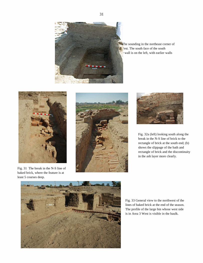
Fig. 30 The sounding in the northeast corner of Area 3 West. The south face of the south boundary wall is on the left, with earlier walls below.
Fig. 31 The break in the N-S line of baked brick, where the feature is at least 5 courses deep.
Fig. 32a (left) looking south along the break in the N-S line of brick to the rectangle of brick at the south end; (b) shows the slippage of the bath and rectangle of brick and the discontinuity in the ash layer more clearly.
Fig. 33 General view to the northwest of the lines of baked brick at the end of the season. The profile of the large bin whose west side is in Area 3 West is visible in the baulk.

32
Fig. 34a The north end of the corridor at the start of work, showing the curving mud brick wall and its southern stone extension.
Fig. 34b Looking north along the corridor. At the north end (rear) mud brick walls partly block the corridor, with broken stone and earth around them continuing to the south (foreground).
Fig. 34c The west wall of the corridor and the stone chip layer on which it was partly built.
Fig. 34d View north of the relatively clean earth under the stone chip layer on which this part of the corridor’s wall was built, cut on the east by a line of lighter earth with a few fragments of stone.

33
Fig. 35 The south end of the corridor cut by a pit with Roman pottery (foreground) and a fall of baked brick (center). A narrow line of baked brick runs across the corridor north of the pits.
Fig. 36a The point at which the Taharqa Gate wall meets the Tuthmoside enclosure wall. Later mud brick walls built against the south face of the Tuthmoside wall are on the left.

34
Fig. 36b The southeast corner of the Tuthmoside enclosure wall.
Fig. 36c Looking west at the Tuthmoside enclosure wall from the Mut Temple’s First Pylon.

35
Fig. 37 View south (top) and north (bottom) of the later stone and brick walls built atop the Taharqa Gate’s south wall.
Fig. 38 The west end of the Mut Temple’s 1st Pylon showing the possibly Ptolemaic construction.

36
Fig
. 3
9 P
anor
amic
vie
ws
sou
th (
top
) an
d n
ort
h (
bott
om
) al
ong
the
po
ssib
le a
cces
s ro
ute
bet
wee
n C
hap
el
D a
nd
the
sacr
ed la
ke.

37
Fig. 40 The sphinx east of the Precinct’s gateway whose base is made up mainly of re-used blocks, including the lintel of Horwedja.
Fig. 41a The lintel after restoration.
Fig. 41b The fittings for the chapel doors on the underside of the lintel.

38
Fig. 42a-b The sphinx base with the lintel block removed (left ) and with the missing area restored.
Fig. 43 Three views of Horwedja’s healing magic chapel, rebuilt in front of the Mut Temple’s First Pylon.