
TELEMATICS 2017 - Western Cape · TELEMATICS 2017 GEOGRAPHY Grade 11 . Page 2 Dear Grade 11 Learner...
20
Page1 Directorate: Curriculum FET TELEMATICS 2017 G GEOGRAPHY Grade 11
Transcript of TELEMATICS 2017 - Western Cape · TELEMATICS 2017 GEOGRAPHY Grade 11 . Page 2 Dear Grade 11 Learner...
Pa
ge1
Directorate: Curriculum FET
TELEMATICS 2017
GGEOGRAPHY
Grade 11
Pa
ge2
Dear Grade 11 Learner The Telematics Teaching Project stems from cooperation between the Western Cape Education Department and the Stellenbosch University. To be able to have success at the end of the year it will be very important to keep on learning and applying the prescribed key concepts/processes and process skills in the different knowledge areas throughout the year. Make sure that you are able to analyse and interpret geography related concepts in newspapers and magazines to the concepts and content you have discussed in the classroom. In addition, spend at least a few hours per week studying / reading / making summaries about the four components in the theory section and attempt to integrate it with the mapwork section. This resource pack includes the following:
� Theory: Mindmaps of the lessons that will be broadcast. This is a good summary of your class notes and can help you with your examination preparation.
� Geomorphology and Mapwork: Notes, techniques, questions and answers as well as a guideline to calculations.
TELEMATICS TEACHING SCHEDULE FOR 2017
GRADE 11 GEOGRAPHY SUPPORT – FIRST QUARTER DATE TIME TOPIC
Tuesday 14 February 16:00 – 17:00 Climate
GRADE 11 GEOGRAPHY SUPPORT – FOURTH QUARTER DATE TIME TOPIC
Wednesday 25 October 16:00 – 17:00 Geomorphology
Pa
ge3
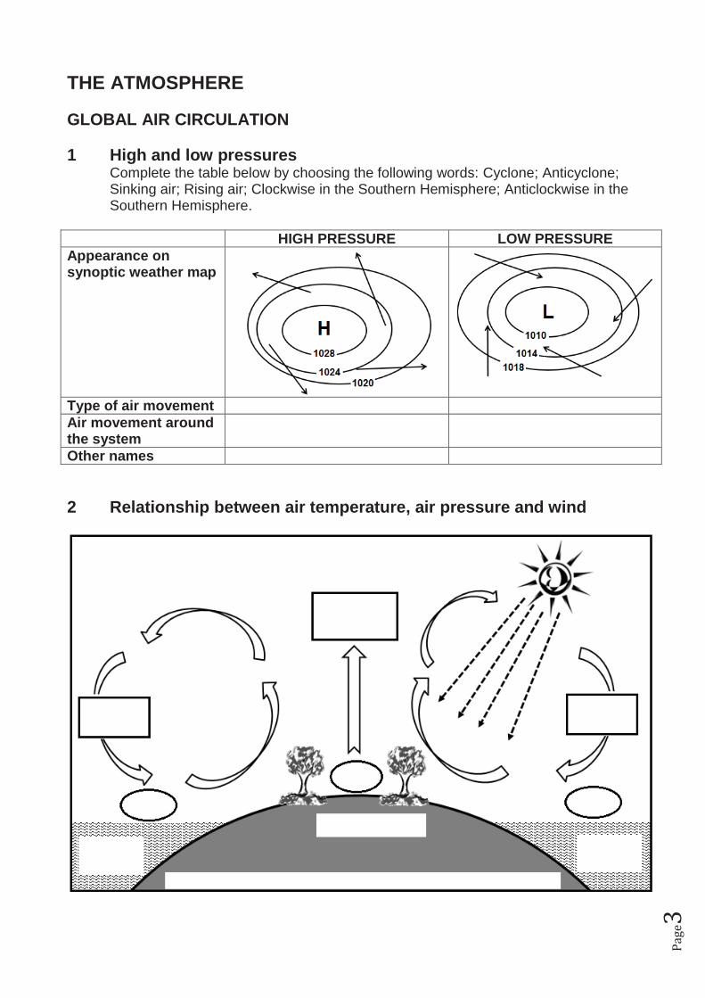
THE ATMOSPHERE GLOBAL AIR CIRCULATION 1 High and low pressures
Complete the table below by choosing the following words: Cyclone; Anticyclone; Sinking air; Rising air; Clockwise in the Southern Hemisphere; Anticlockwise in the Southern Hemisphere.
HIGH PRESSURE LOW PRESSURE Appearance on synoptic weather map
Type of air movement Air movement around the system
Other names 2 Relationship between air temperature, air pressure and wind
Pa
ge4
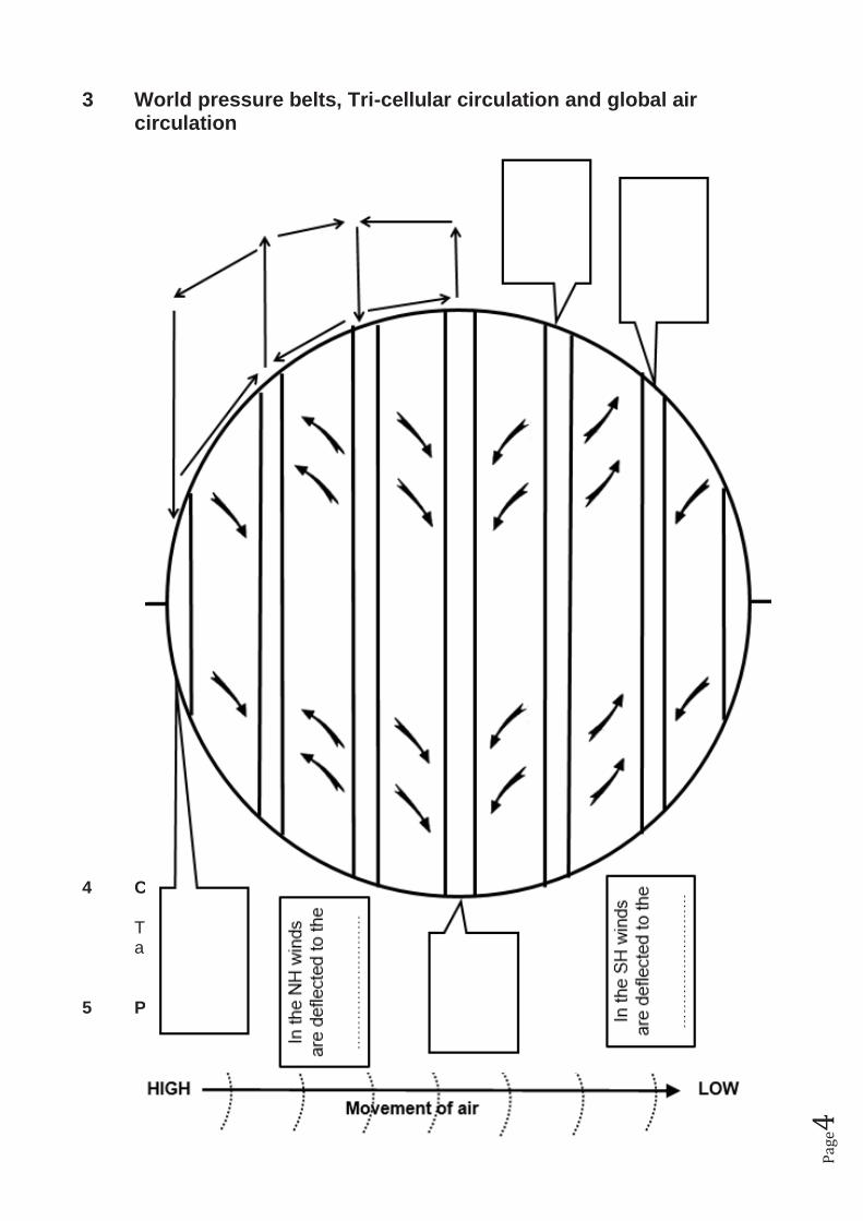
3 World pressure belts, Tri-cellular circulation and global air circulation
4 Coriolus force
The force that causes air to be deflected to the RIGHT in the Northern Hemisphere and to the LEFT in the Southern Hemisphere.
5 Pressure gradient
Pa
ge5
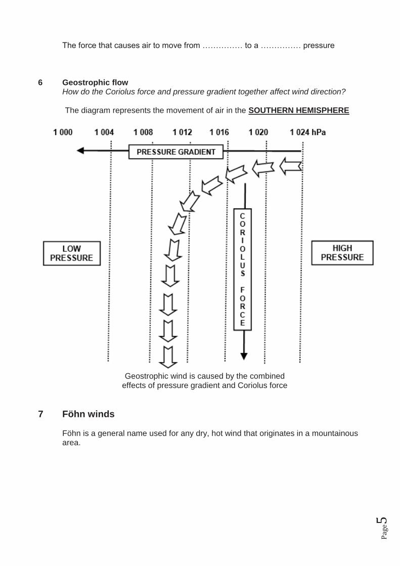
The force that causes air to move from …………… to a …………… pressure 6 Geostrophic flow How do the Coriolus force and pressure gradient together affect wind direction? The diagram represents the movement of air in the SOUTHERN HEMISPHERE
Geostrophic wind is caused by the combined
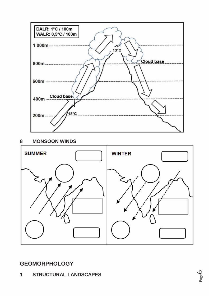
effects of pressure gradient and Coriolus force 7 Föhn winds
Föhn is a general name used for any dry, hot wind that originates in a mountainous area.
Pa
ge6
8 MONSOON WINDS
GEOMORPHOLOGY 1 STRUCTURAL LANDSCAPES
Pa
ge7
2 SLOPES
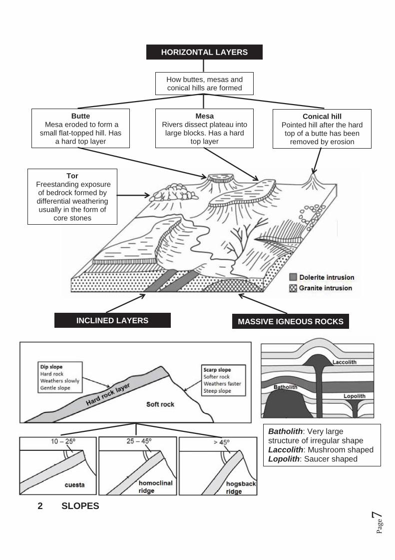
How buttes, mesas and conical hills are formed
MASSIVE IGNEOUS ROCKS INCLINED LAYERS
HORIZONTAL LAYERS
Butte Mesa eroded to form a
small flat-topped hill. Has a hard top layer
Mesa Rivers dissect plateau into large blocks. Has a hard
top layer
Conical hill Pointed hill after the hard top of a butte has been
removed by erosion
Batholith: Very large structure of irregular shape Laccolith: Mushroom shaped Lopolith: Saucer shaped
Tor Freestanding exposure
of bedrock formed by differential weathering usually in the form of
core stones
Pa
ge8
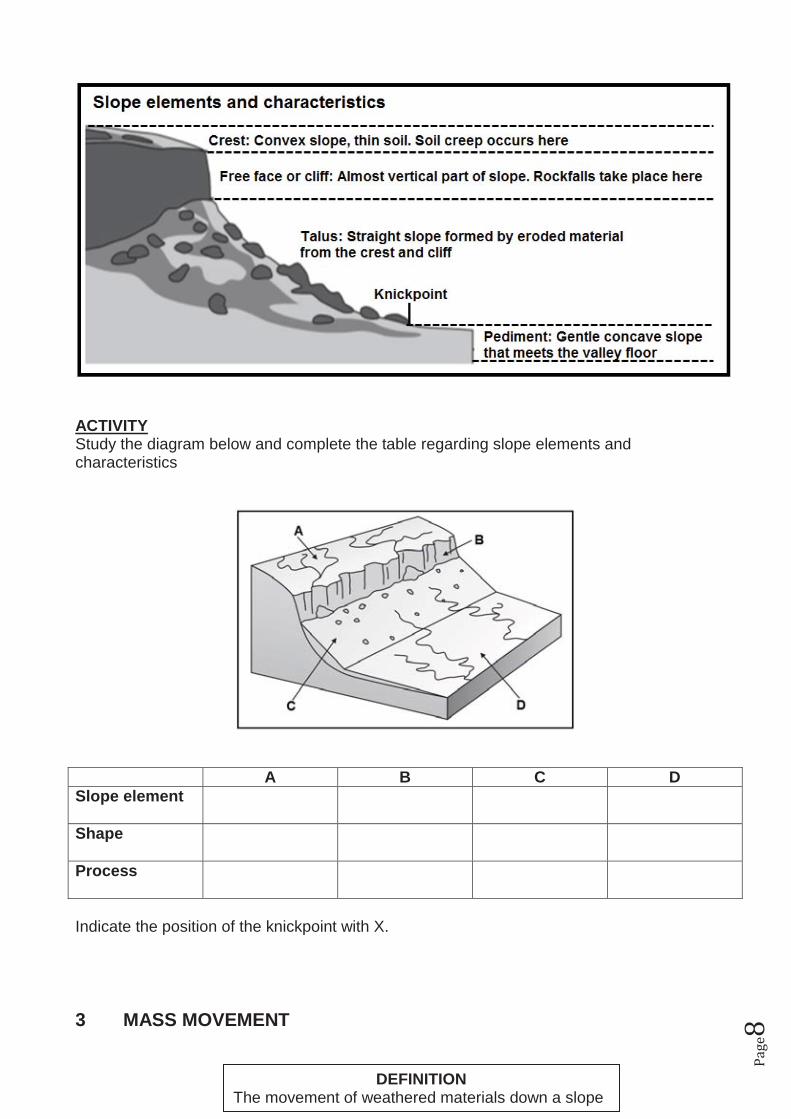
ACTIVITY Study the diagram below and complete the table regarding slope elements and characteristics
A B C D Slope element
Shape
Process
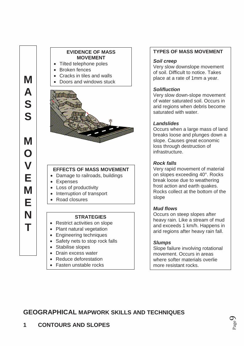
Indicate the position of the knickpoint with X. 3 MASS MOVEMENT
DEFINITION The movement of weathered materials down a slope
Pa
ge9
GEOGRAPHICAL MAPWORK SKILLS AND TECHNIQUES 1 CONTOURS AND SLOPES
M A S S
M O V E M E N T
EVIDENCE OF MASS MOVEMENT
� Tilted telephone poles � Broken fences � Cracks in tiles and walls � Doors and windows stuck
EFFECTS OF MASS MOVEMENT � Damage to railroads, buildings � Expenses � Loss of productivity � Interruption of transport � Road closures
STRATEGIES � Restrict activities on slope � Plant natural vegetation � Engineering techniques � Safety nets to stop rock falls � Stabilise slopes � Drain excess water � Reduce deforestation � Fasten unstable rocks
TYPES OF MASS MOVEMENT Soil creep Very slow downslope movement of soil. Difficult to notice. Takes place at a rate of 1mm a year. Solifluction Very slow down-slope movement of water saturated soil. Occurs in arid regions when debris become saturated with water. Landslides Occurs when a large mass of land breaks loose and plunges down a slope. Causes great economic loss through destruction of infrastructure. Rock falls Very rapid movement of material on slopes exceeding 40°. Rocks break loose due to weathering frost action and earth quakes. Rocks collect at the bottom of the slope Mud flows Occurs on steep slopes after heavy rain. Like a stream of mud and exceeds 1 km/h. Happens in arid regions after heavy rain fall. Slumps Slope failure involving rotational movement. Occurs in areas where softer materials overlie more resistant rocks.

Pa
ge1
0
� Contour lines join places with the same height above sea level. � Contours far apart show a gentle slope. � Contours close together show a steep slope
1.1 Concave slope
1.2 Convex slope
1.3 Terraced slope
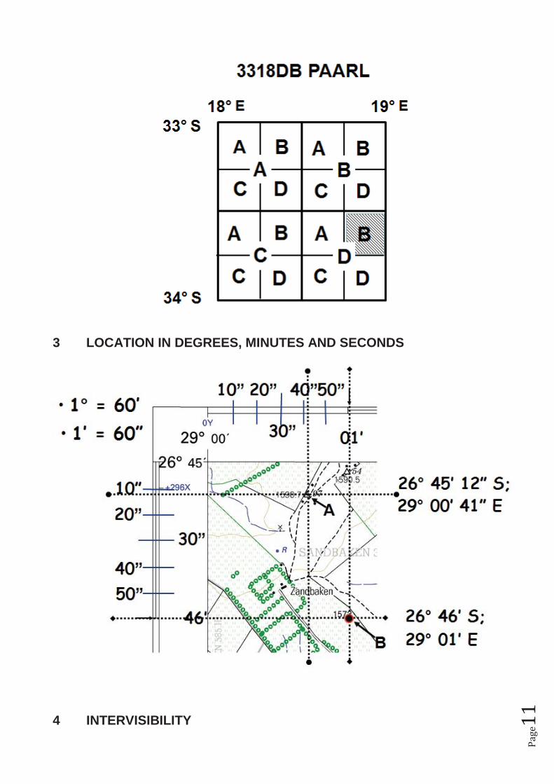
2 MAP REFERENCE
Pa
ge1
1
3 LOCATION IN DEGREES, MINUTES AND SECONDS
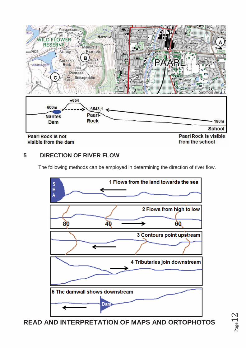
4 INTERVISIBILITY
Pa
ge1
2
5 DIRECTION OF RIVER FLOW The following methods can be employed in determining the direction of river flow.
READ AND INTERPRETATION OF MAPS AND ORTOPHOTOS
Pa
ge1
3
The goal of this guide is to empower you with regard to the answer of interpretation questions in mapwork. Remember that there is a large amount of information on the topographical- and ortophoto map. To answer these questions successfully, you must know what to look at to get to the answer. Most of these questions come from previous exam question papers. Other questions have also been included. Remember that this is not a memorandum which has been given with the questions, but an attempt to show what you should look at to get to the answers. It is important to take note that ALL content, modules and skills can be assessed in the mapwork paper. Use this guide to study and prepare yourself for the mapwork question paper (Paper 2). CLIMATOLOGY 1 Does the area receive seasonal rainfall or rainfall throughout the year?
Seasonal: Non-perennial rivers/ dams/ cultivated lands near rivers/ irrigation/ furrows 2 Which slope is the warmest? The northward-facing slope – identify the northward-facing slope 3 In which direction will an airplane take off and land? (Remember that airplanes take off and land against the wind.) GEOMORPHOLOGY 1 Physical aspects influencing the construction of railways and roads. Mountains/ steep slopes/ marshes/ rivers/ 2 In which direction does the river flow? -To the sea
-Always from high to low -Contours bend upstream -Dam wall on downstream side -Tributaries join at acute angles
4 Identify the landforms regarding structural landscapes: -Horizontal layers: Mesas/ buttes/ conical hills -Inclined layers: dip and escarp slopes -Massive igneous rocks: dome-shaped landforms 5 In which direction do the layers dip? Layers always dip in the direction of the GRADUAL slope
Pa
ge1
4
ENVIRONMENTAL STUDIES AND SUSTAINABILITY 1 Evidence of nature conservation Nature reserve/ hiking trail/ fire break/ game reserve 2 Evidence of conservational farming. Anti-erosion walls/ camps/ rows of trees to reduce wind/ contour ploughing 3 Are there sources of air pollution in the area?? -Air pollution: Industries -Noise pollution: Airport -Water pollution: Factories / camping sites/ Power station near river ECONOMIC GEOGRAPHY (a) PRIMARY ACTIVITIES (FARMING / MINING) 1 Commercial or subsistence farming?
Commercial: Good infrastructure/ irrigation/ large farms/ farm names/ cellar/ dipping tank/ experimental farm/ estate/ sugar mill/ service rail/ abbatoir/ dairy
Subsistence: Few roads/ footpaths/ no power lines/ small patches of cultivated land 2 Describe factors that advantage/disadvantage farming activities Advantage: Rivers/ dams/ flat land/ power lines/ railway lines Disadvantage: Steep slopes/ water scarce/ marshes 3 Identify mining activities
Excavations/ mine dump/ conveyer belt/ terraces/ names of mines/ old mines/ subsiding ground
4 Identifying of fishing activities Fishing harbours/ fishermen’s houses/ factories near coast 5 Identifying of forestry Trees/ woodlands/ saw mill/ lookout towers/ fire break/ state forest (b) SECONDARY ACTIVITIES ( INDUSTRIES) 1 Describe the factors that influenced the location of the industries
Flat surface/ raw material/ Transport(name the types)/ power (power station, power lines, coal mines)/ water/ labour(residential areas)/ Market/ outskirts/
2 Heavy or light industries? Heavy: Far from CBD/ railway transport/ Raw material-mining/ large spaces/ Light: close to CBD / road transport/ raw material - farming
Pa
ge1
5
(c) TERTIARY ACTIVITIES (SERVICES) 1 Tourist attractions, holiday resorts, camping sites
Close to beaches/ close to road railway/ wine tasting/ historical buildings/ monuments/ museums
2 Types of services found
Electricity supply/ telephone/ medical/ pot office/ educationl(school/ college/ university) transport (roads airport railway)/ police services etc. (buildings on map)
3 Recreation facilities? Golf course/ athletics/ rifle range/ racing track/ etc 4 Factors that determined the location of the airport Flat area/ far from built-up area for safety/ noise/ roads/ 5 Does the railway line and the road follow the same routs? Why not? The same? NB influence of topography
Road: through mountain pass . Railway around mountain (between Paarl and Worcester)
6 For what is the dam on the map used? Give reasons
Drinking water: Water purification works Irrigation: cannels and furrows Recreation: Yacht club, Hotels at dam, camping site, caravan park, slipway, etc.
SETTLEMENT 1 Why is the settlement located there? Flat area/ roads/ river/ mountain/ sea/ etc 2 Is it an urban or a rural settlement? Rural: Primary activities Urban: Secondary and Tertiary activities
Pa
ge1
6
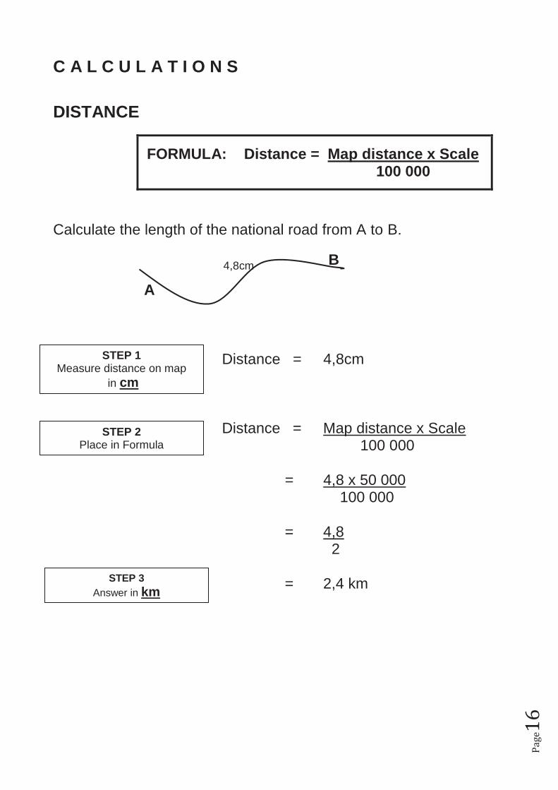
C A L C U L A T I O N S DISTANCE
FORMULA: Distance = Map distance x Scale 100 000
Calculate the length of the national road from A to B. B A Distance = 4,8cm Distance = Map distance x Scale 100 000 = 4,8 x 50 000 100 000 = 4,8 2 = 2,4 km
STEP 1 Measure distance on map
in cm
STEP 2 Place in Formula
STEP 3 Answer in km
4,8cm
Pa
ge1
7
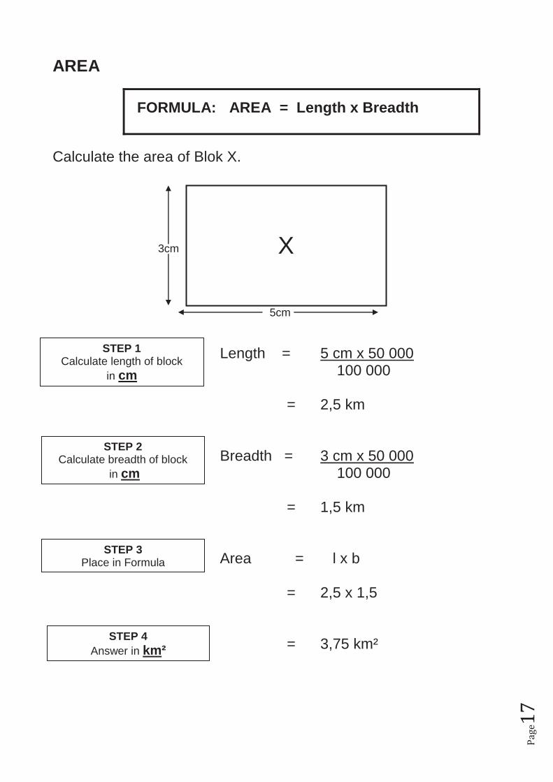
AREA
FORMULA: AREA = Length x Breadth
Calculate the area of Blok X. 3cm 5cm Length = 5 cm x 50 000 100 000 = 2,5 km Breadth = 3 cm x 50 000 100 000 = 1,5 km Area = l x b = 2,5 x 1,5 = 3,75 km²
STEP 1 Calculate length of block
in cm
STEP 2 Calculate breadth of block
in cm
STEP 4 Answer in km²
STEP 3 Place in Formula
X
Pa
ge1
8
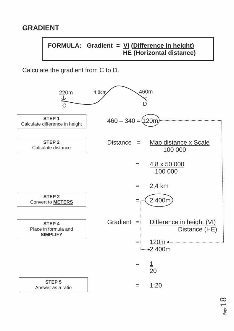
GRADIENT
FORMULA: Gradient = VI (Difference in height) HE (Horizontal distance)
Calculate the gradient from C to D. 460 – 340 = 120m Distance = Map distance x Scale 100 000 = 4,8 x 50 000 100 000 = 2,4 km = 2 400m
Gradient = Difference in height (VI) Distance (HE) = 120m 2 400m = 1 20
= 1:20
STEP 1 Calculate difference in height
STEP 2 Calculate distance
STEP 5 Answer as a ratio
STEP 4 Place in formula and
SIMPLIFY
C D
220m 460m 4,8cm
STEP 2 Convert to METERS
Pa
ge1
9
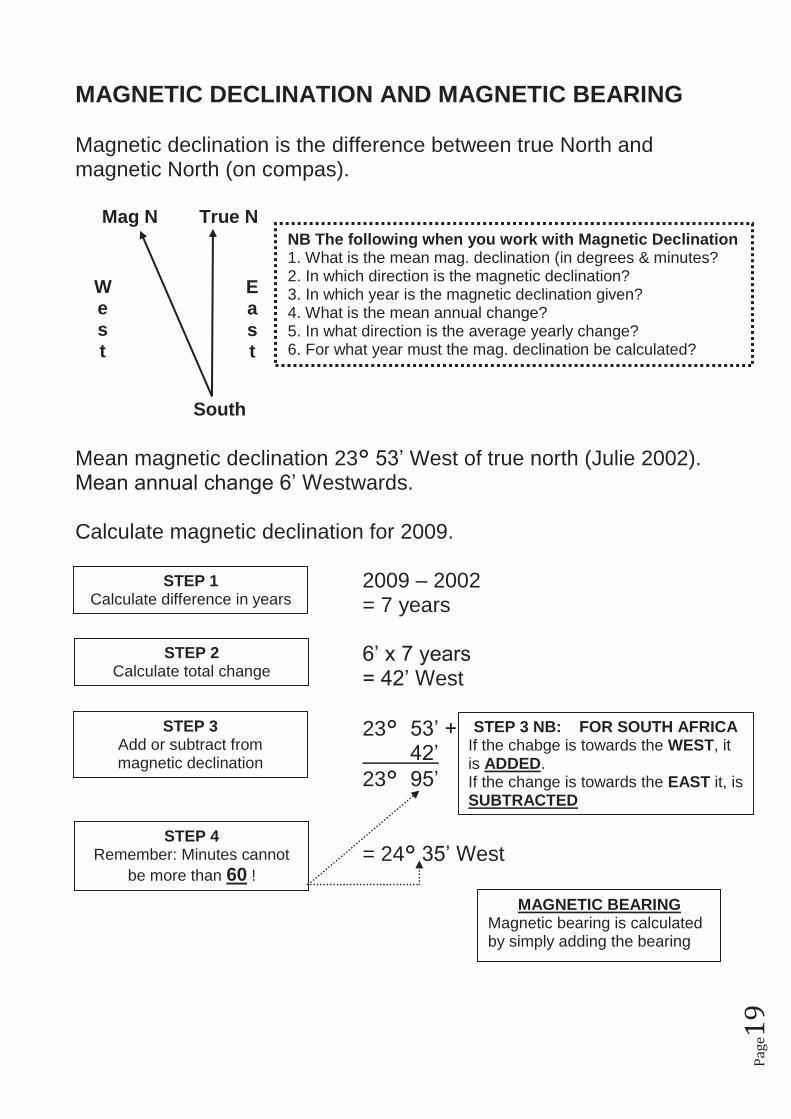
MAGNETIC DECLINATION AND MAGNETIC BEARING Magnetic declination is the difference between true North and magnetic North (on compas). Mag N True N
South Mean magnetic declination 23° 53’ West of true north (Julie 2002). Mean annual change 6’ Westwards. Calculate magnetic declination for 2009. 2009 – 2002 = 7 years 6’ x 7 years = 42’ West 23° 53’ + 42’ 23° 95’ = 24° 35’ West
STEP 1 Calculate difference in years
STEP 2 Calculate total change
STEP 3 Add or subtract from magnetic declination
STEP 4 Remember: Minutes cannot
be more than 60 !
STEP 3 NB: FOR SOUTH AFRICA If the chabge is towards the WEST, it is ADDED. If the change is towards the EAST it, is SUBTRACTED
MAGNETIC BEARING Magnetic bearing is calculated by simply adding the bearing
W e s t
E a s t
NB The following when you work with Magnetic Declination 1. What is the mean mag. declination (in degrees & minutes? 2. In which direction is the magnetic declination? 3. In which year is the magnetic declination given? 4. What is the mean annual change? 5. In what direction is the average yearly change? 6. For what year must the mag. declination be calculated?
Pa
ge2
0
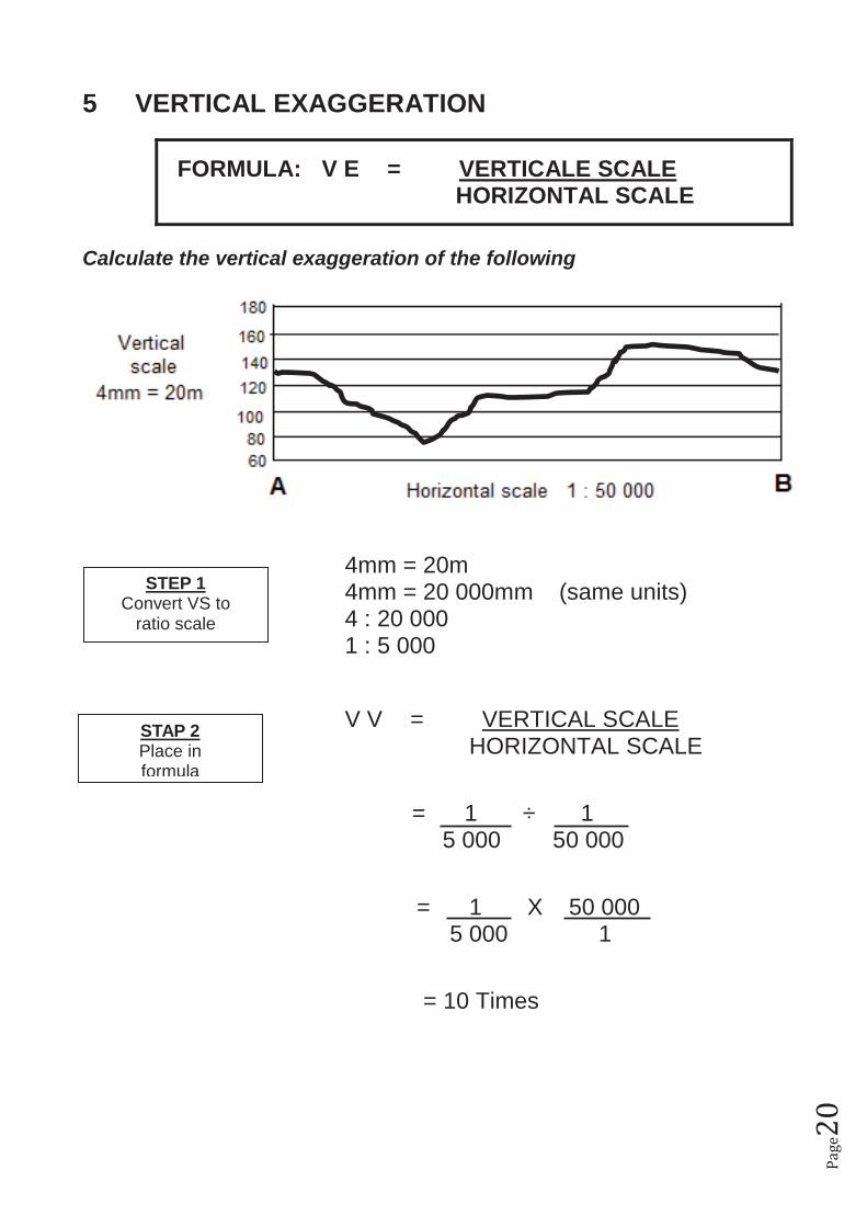
5 VERTICAL EXAGGERATION
FORMULA: V E = VERTICALE SCALE HORIZONTAL SCALE
Calculate the vertical exaggeration of the following
4mm = 20m 4mm = 20 000mm (same units) 4 : 20 000 1 : 5 000
V V = VERTICAL SCALE HORIZONTAL SCALE = 1 ÷ 1 5 000 50 000
= 1 X 50 000 5 000 1
= 10 Times
STEP 1 Convert VS to
ratio scale
STAP 2 Place in formula