
Tectonic expression of an active slab tear from high...
16
Tectonic expression of an active slab tear from high-resolution seismic and bathymetric data offshore Sicily (Ionian Sea) Marc-André Gutscher 1 , Stephane Dominguez 2 , Bernard Mercier de Lepinay 3 , Luis Pinheiro 4 , Flora Gallais 1,5 , Nathalie Babonneau 1 , Antonio Cattaneo 5 , Yann Le Faou 6 , Giovanni Barreca 7 , Aaron Micallef 8 , and Marzia Rovere 9 1 Domaines Océaniques, Université de Brest/CNRS, IUEM, Plouzané, France, 2 Geosciences Montpellier, University of Montpellier II/CNRS, Montpellier, France, 3 GeoAzur, Université de Nice/CNRS, Sophia-Antipolis, Valbonne, France, 4 Department of Geosciences and CESAM, University of Aveiro, Aveiro, Portugal, 5 Ifremer, Institut Carnot Géosciences Marines, Ifremer EDROME Géosciences Marines, Plouzané, France, 6 Service Hydrographique et Océanographique de la Marine, Brest, France, 7 Department of Biology, Geology and Environmental Science, University of Catania, Catania, Italy, 8 Department of Geosciences, University of Malta, Msida, Malta, 9 Institute for Marine Sciences/CNR via Gobetti, Bologna, Italy Abstract Subduction of a narrow slab of oceanic lithosphere beneath a tightly curved orogenic arc requires the presence of at least one lithospheric scale tear fault. While the Calabrian subduction beneath southern Italy is considered to be the type example of this geodynamic setting, the geometry, kinematics and surface expression of the associated lateral, slab tear fault offshore eastern Sicily remain controversial. Results from a new marine geophysical survey conducted in the Ionian Sea, using high-resolution bathymetry and seismic profiling reveal active faulting at the seafloor within a 140 km long, two-branched fault system near Alfeo Seamount. The previously unidentified 60 km long NW trending North Alfeo Fault system shows primarily strike-slip kinematics as indicated by the morphology and steep-dipping transpressional and transtensional faults. Available earthquake focal mechanisms indicate dextral strike-slip motion along this fault segment. The 80 km long SSE trending South Alfeo fault system is expressed by one or two steeply dipping normal faults, bounding the western side of a 500+ m thick, 5 km wide, elongate, syntectonic Plio-Quaternary sedimentary basin. Both branches of the fault system are mechanically capable of generating magnitude 6–7 earthquakes like those that struck eastern Sicily in 1169, 1542, and 1693. 1. Introduction Subduction of oceanic lithosphere beneath tightly curved orogenic arcs is common in the Mediterranean region, where overall plate convergence between Africa and Eurasia is slow (~5 mm/yr) [D’Agostino et al., 2011] and where narrow slabs sink down into the upper mantle causing rollback and back-arc extension [Wortel and Spakman, 2000; Faccenna et al., 2004]. Slab rollback can only occur if the small oceanic basin detaches itself from the adjacent (commonly continental) lithosphere along subvertical tear faults also known as “STEP” faults [Govers and Wortel, 2005]. This type of lithospheric scale fault is thought to be present at the edge of numerous subduction systems around the world (Caribbean, South Sandwich, Sulawesi, Fiji-Tonga, New Hebrides). As first discussed by Govers and Wortel [2005], a STEP fault includes a deep (20–100 km) component—the edge of the subducting slab and a shallow expression alongside the kinematically independent upper plate block, which typically advances toward the foreland due to slab rollback. Many consider the Calabrian arc of southern Italy (Figure 1) as the type example of a narrow, retreating slab [Faccenna et al., 2004; Rosenbaum et al., 2002, 2008]. The geodynamic evolution of the Western Mediterranean and Italy was largely controlled by a NW dipping subduction zone beneath southern France and Iberia, which began around 35 Ma [Malinverno and Ryan, 1986; Jolivet and Faccenna, 2000]. As the slab of Tethys oceanic lithosphere between Africa and Europe retreated to the SE, it opened a series of back-arc basins and left several small continental blocks in its wake (e.g., Corsica-Sardinia) [Faccenna et al., 2001, 2004; Rosenbaum et al., 2002]. Tomographic studies of the upper mantle image a steeply NW dipping slab descending beneath Calabria and the SE Tyrrhenian Sea to depths of >500 km and with a sharp SW boundary at depth below Mount Etna [Wortel and Spakman, 2000; Neri et al., 2009]. Several workers have proposed a causal effect between the lateral slab tear, creating an asthenospheric GUTSCHER ET AL. SLAB TEAR OFFSHORE SICILY 39 PUBLICATION S Tectonics RESEARCH ARTICLE 10.1002/2015TC003898 Key Points: • First clear observations of surface tectonics of a slab tear • High-resolution bathymetric and seismic images of unprecedented quality • Two active fault systems at the seafloor (60 and 80 km long) may pose seismic hazard Supporting Information: • Figures S1–S5 Correspondence to: M.-A. Gutscher, [email protected] Citation: Gutscher, M.-A., et al. (2016), Tectonic expression of an active slab tear from high-resolution seismic and bathymetric data offshore Sicily (Ionian Sea), Tectonics, 35, 39–54, doi:10.1002/2015TC003898. Received 3 APR 2015 Accepted 16 OCT 2015 Accepted article online 19 OCT 2015 Published online 6 JAN 2016 ©2015. American Geophysical Union. All Rights Reserved.
Transcript of Tectonic expression of an active slab tear from high...

Tectonic expression of an active slab tearfrom high-resolution seismic and bathymetricdata offshore Sicily (Ionian Sea)Marc-André Gutscher1, Stephane Dominguez2, Bernard Mercier de Lepinay3, Luis Pinheiro4,Flora Gallais1,5, Nathalie Babonneau1, Antonio Cattaneo5, Yann Le Faou6, Giovanni Barreca7,Aaron Micallef8, and Marzia Rovere9
1Domaines Océaniques, Université de Brest/CNRS, IUEM, Plouzané, France, 2Geosciences Montpellier, University ofMontpellier II/CNRS, Montpellier, France, 3GeoAzur, Université de Nice/CNRS, Sophia-Antipolis, Valbonne, France,4Department of Geosciences and CESAM, University of Aveiro, Aveiro, Portugal, 5Ifremer, Institut Carnot GéosciencesMarines, Ifremer EDROME Géosciences Marines, Plouzané, France, 6Service Hydrographique et Océanographique de laMarine, Brest, France, 7Department of Biology, Geology and Environmental Science, University of Catania, Catania, Italy,8Department of Geosciences, University of Malta, Msida, Malta, 9Institute for Marine Sciences/CNR via Gobetti, Bologna, Italy
Abstract Subduction of a narrow slab of oceanic lithosphere beneath a tightly curved orogenic arc requiresthe presence of at least one lithospheric scale tear fault. While the Calabrian subduction beneath southern Italy isconsidered to be the type example of this geodynamic setting, the geometry, kinematics and surface expressionof the associated lateral, slab tear fault offshore eastern Sicily remain controversial. Results from a new marinegeophysical survey conducted in the Ionian Sea, using high-resolution bathymetry and seismic profiling revealactive faulting at the seafloor within a 140 km long, two-branched fault system near Alfeo Seamount. Thepreviously unidentified 60 km long NW trending North Alfeo Fault system shows primarily strike-slipkinematics as indicated by the morphology and steep-dipping transpressional and transtensional faults.Available earthquake focal mechanisms indicate dextral strike-slip motion along this fault segment. The 80 kmlong SSE trending South Alfeo fault system is expressed by one or two steeply dipping normal faults, boundingthe western side of a 500+ m thick, 5 km wide, elongate, syntectonic Plio-Quaternary sedimentary basin. Bothbranches of the fault system are mechanically capable of generating magnitude 6–7 earthquakes like those thatstruck eastern Sicily in 1169, 1542, and 1693.
1. Introduction
Subduction of oceanic lithosphere beneath tightly curved orogenic arcs is common in the Mediterraneanregion, where overall plate convergence between Africa and Eurasia is slow (~5mm/yr) [D’Agostino et al.,2011] and where narrow slabs sink down into the upper mantle causing rollback and back-arc extension[Wortel and Spakman, 2000; Faccenna et al., 2004]. Slab rollback can only occur if the small oceanic basindetaches itself from the adjacent (commonly continental) lithosphere along subvertical tear faults alsoknown as “STEP” faults [Govers and Wortel, 2005]. This type of lithospheric scale fault is thought to be presentat the edge of numerous subduction systems around the world (Caribbean, South Sandwich, Sulawesi,Fiji-Tonga, New Hebrides). As first discussed by Govers and Wortel [2005], a STEP fault includes a deep(20–100 km) component—the edge of the subducting slab and a shallowexpression alongside the kinematicallyindependent upper plate block, which typically advances toward the foreland due to slab rollback. Many considerthe Calabrian arc of southern Italy (Figure 1) as the type example of a narrow, retreating slab [Faccenna et al.,2004; Rosenbaum et al., 2002, 2008].
The geodynamic evolution of the Western Mediterranean and Italy was largely controlled by a NW dippingsubduction zone beneath southern France and Iberia, which began around 35 Ma [Malinverno and Ryan,1986; Jolivet and Faccenna, 2000]. As the slab of Tethys oceanic lithosphere between Africa and Europeretreated to the SE, it opened a series of back-arc basins and left several small continental blocks in its wake(e.g., Corsica-Sardinia) [Faccenna et al., 2001, 2004; Rosenbaum et al., 2002]. Tomographic studies of the uppermantle image a steeply NW dipping slab descending beneath Calabria and the SE Tyrrhenian Sea to depths of>500 km and with a sharp SW boundary at depth below Mount Etna [Wortel and Spakman, 2000; Neri et al.,2009]. Several workers have proposed a causal effect between the lateral slab tear, creating an asthenospheric
GUTSCHER ET AL. SLAB TEAR OFFSHORE SICILY 39
PUBLICATIONSTectonics
RESEARCH ARTICLE10.1002/2015TC003898
Key Points:• First clear observations of surfacetectonics of a slab tear
• High-resolution bathymetric and seismicimages of unprecedented quality
• Two active fault systems at the seafloor(60 and 80 km long) may pose seismichazard
Supporting Information:• Figures S1–S5
Correspondence to:M.-A. Gutscher,[email protected]
Citation:Gutscher, M.-A., et al. (2016), Tectonicexpression of an active slab tear fromhigh-resolution seismic and bathymetricdata offshore Sicily (Ionian Sea), Tectonics,35, 39–54, doi:10.1002/2015TC003898.
Received 3 APR 2015Accepted 16 OCT 2015Accepted article online 19 OCT 2015Published online 6 JAN 2016
©2015. American Geophysical Union.All Rights Reserved.

window and enhancing toroidal flow in the upper mantle and the presence of Mount Etna in northeastern Sicily[Gvirtzman and Nur, 1999; Faccenna et al., 2011]. Today most of the oceanic lithosphere has been consumed, andthere remains at most a narrow corridor (150 km to 300 km wide) connecting the oceanic domain of the IonianSea to the slab observed beneath the SE Tyrrhenian Sea [Wortel and Spakman, 2000; Neri et al., 2009; Giacomuzziet al., 2012].
The combination of NW directed subduction and the southeastward advance of the Calabrian-Peloritan blockdrove shortening and thrusting in the thick layers of marine sediments within the Ionian Sea, leading to theconstruction of a large accretionary wedge imaged by deep seismic reflection lines [Finetti, 1982; Cernoboriet al., 1996; Nicolich et al., 2000; Minelli and Faccenna, 2010]. A broad belt of undulating seafloor occupies agentle slope down to the Ionian abyssal plain and is characterized by anticlinal ridges as seen in high-resolution seismic profiles and bathymetry [Hieke et al., 2005; Gutscher et al., 2006; Loubrieu et al., 2007].Some researchers interpreted this compressional deformation as caused by regional gravitational sliding[Chamot-Rooke et al., 2005]. However, more recent studies have concluded that deformation in this outerCalabrian arc is caused by large-scale compression affecting the Plio-Quaternary and Messinian sedimentsabove a decollement at the base of the Messinian [Polonia et al., 2011; Gallais et al., 2012]. While the positionof the outer deformation front in the Ionian abyssal plain is well documented by seismic profiles and existingbathymetric compilations [Loubrieu et al., 2007; Polonia et al., 2011; Gallais et al., 2012], the position of thelateral ramp offshore eastern Sicily is largely uncertain and has been interpreted in a wide range of locationsby different workers [Chamot-Rooke et al., 2005; Minelli and Faccenna, 2010; Polonia et al., 2011; Gallais et al.,2012, 2013].
Figure 1. Simplified tectonic map of southern Italy region, showing seismicity (red circles) from PDE-NEIC earthquake catalog(1973–2014, M ≥ 2.5), accretionary wedge thrust structures (green lines, with black teeth at the deformation front) [Poloniaet al., 2011; Gallais et al., 2012], active volcanoes (yellow triangles), normal faults proposed as likely surface expressions of theSTEP fault (red lines with barbs), possible prolongations of the STEP fault, north of Mount Etna in NE Sicily [Jenny et al., 2006;Palano et al., 2012] (black dashed lines) Lip.-Tind. line = Lipari-Tindari Line, Taorm. line = The Taormina Line, forming the SWboundary of the Variscan crystalline basement of Calabria and the Peloritan Mountains (Pel. Mountains) shown in magenta.Inset shows the study area located in southern Italy and the Central Mediterranean Sea (Ionian Sea).
Tectonics 10.1002/2015TC003898
GUTSCHER ET AL. SLAB TEAR OFFSHORE SICILY 40

According to available geodetic data, there is slow, but significant convergence (≥3mm/yr) occurringbetween the Hyblean platform (SE Sicily) and NE Sicily (the Peloritan Mountains domain) and slow (3–5mm/yr)southeastward motion of the Calabrian block with respect to the Apulian and Hyblean domains[D’Agostino et al., 2011; Devoti et al., 2011; Palano et al., 2012]. These authors attribute most of this motionto the Calabria subduction, with rollback of the Ionian slab inducing southeastward motion of the Calabria-Peloritan block. However, Sicily itself and the neighboring regions appear to be composed of a mosaic ofmicroblocks with slow moving, but complex kinematics [Serpelloni et al., 2010].
Researchers have been seeking for the lithospheric scale tear fault associated with subduction rollback,presumably located offshore eastern Sicily, since it was first suggested [Gvirtzman and Nur, 1999; Orecchio et al.,2014]. Many have proposed the Malta Escarpment to be the active tear fault, primarily due to its striking morpho-logical expression as a 3–4km high step on the seafloor [Argnani and Bonazzi, 2005; Govers and Wortel, 2005;Argnani, 2009; Argnani et al., 2012]. The Malta Escarpment is widely considered to be an ancient Tethyan passivemargin formed by rifting in the Mesozoic (or earlier) [Catalano et al., 2001; Nicolich et al., 2000; Frizon de Lamotteet al., 2011; Gallais et al., 2013]. Several studies have reported active normal faulting on the northern portion of thisescarpment [Argnani and Bonazzi, 2005; Argnani, 2009; Argnani et al., 2012]. Other researchers have identifiedmajor normal faults imaged in seismic profiles farther east and interpreted these as the tear fault [Cernoboriet al., 1996; Nicolich et al., 2000; Polonia et al., 2011; Gallais et al., 2013] (Figure 1). The exact geometry and degreeof activity of the network of faults offshore Sicily in the Ionian Sea remain uncertain and highly controversial[Argnani, 2014; Gallais et al., 2014; Orecchio et al., 2014]. These faults pose a significant seismic and tsunami hazardin this region where nearly 200,000 deaths have occurred over the past five centuries [Jenny et al., 2006]. However,the sources of many of these earthquakes and tsunamis remain unknown or disputed to this day [Piatanesi andTinti, 1998;Gutscher et al., 2006; Argnani et al., 2012; Aloisi et al., 2013], with someworkers arguing for a contributionfrom submarine landslides in some cases [Billi et al., 2008, 2010]. There is no consensus on the surface expressionof the STEP fault and its trace through eastern and northern Sicily is uncertain (Figure 1) [Orecchio et al., 2014]. Theobjective of this study is to map active faults offshore eastern Sicily, which may pose as a seismic hazard, and toidentify the tectonic expression of the lateral slab tear or STEP in the Ionian Sea.
2. Data/Methods
A marine geophysical survey was conducted onboard the French research vessel Le Suroit in October 2013using high-resolution seismic reflection profiling and bathymetric swathmapping. The seismic data wereacquired using a 450m long, 72 channel Sercel seismic streamer with an average geophone spacing of6.25m and towed 150m behind the vessel. The seismic source was a six mini-GI airgun array with a totalvolume of 111 cubic inches (1.8 liters) fired at a cadence of once every 6 s, for an average shot spacing of16m and a 24-fold coverage for each common midpoint. Quality control of the seismic data, includingprocessing of the navigation files (shot position and streamer geometry), was performed with the SISPEEDsoftware (Ifremer). The seismic data were subsequently band-pass filtered (70–425Hz), stacked and timemigrated using a water velocity of 1500m/s, using the Seismic Unix software package.
The bathymetric data (Figure 2) were acquired using an EM302 Simrad bathymetric echosounder. It emits 860beams at an aperture commonly between 50° and 70° to each side and typically covers a 6 km wide swath at3000m water depth, with a resolution of 10–30m. The Simrad echosounder software automatically performsan initial quality control, which flags doubtful data. Thereafter, swaths of pings are reprocessed by hand toremove data outliers using CARAIBES software. The processed depth soundings were then gridded usingGMT software at a grid spacing of 2 arc sec (about 60m).
3. Results
The seismic and bathymetric data were used to probe several morphotectonic provinces offshore easternSicily: the ≥3 km high bathymetric step formed by the Malta Escarpment, broad flat-bottomed turbiditevalleys and the western portion of the Calabrian accretionary wedge (Figures 2 and 3).
3.1. Morphobathymetry
Themost striking feature in the bathymetry is the>150 km long, Malta-Hyblean Escarpment (Figures 2 and 3),which over a lateral distance of 20–30 km marks the transition from the Hyblean continental platform
Tectonics 10.1002/2015TC003898
GUTSCHER ET AL. SLAB TEAR OFFSHORE SICILY 41

(with shallow water carbonates) on the west to a deep marine environment to the east with water depthsof 3000–4000m. The slopes here are 10–20° on average and can locally reach 30° (Figure 2). The escarp-ment is deeply incised by submarine canyons, commonly running orthogonal to the escarpment andlocally joining together to form large amphitheater-like structures (e.g., at 36°48′N). This incision may be
Figure 2. High-resolution swath bathymetry (color slope map) acquired with R/V Suroit and a Simrad EM302 echosounder(90 m grid, NW illumination) superposed on the gray shaded relief from MediMap bathymetric compilation [Loubrieuet al., 2007] (500 m grid). (inset) Color shaded relief of new swath data and existing compilation [Loubrieu et al., 2007],(NW illumination).
Tectonics 10.1002/2015TC003898
GUTSCHER ET AL. SLAB TEAR OFFSHORE SICILY 42

Figure 3. Morphobathymetric interpretation showing: position of seismic profiles (straight black lines), sediment waves(alternating green and blue lines), accretionary wedge anticlines and synclines (black and green lines), likely faults (redlines), the upper and lower limits of the Malta Escarpment (orange lines), flat lying sedimentary basins (yellow shading), andearthquake focal mechanisms, taking a representative subset (20 out of 80) of the earthquakes at sea and along the coastfrom a published study [Musumeci et al., 2014]. (inset) Simplified morphotectonic interpretation. Symbols: minor thrustfaults in the accretionary wedge (green lines); sedimentary structures, (blue lines); basin boundaries and other tectoniclineaments (black lines); major faults (red lines) with kinematics indicated (barbs for normal faults, arrows for strike-slipfaults, teeth for thrust faults) NAF = North Alfeo Fault system and SAF = South Alfeo Fault system; position of seismic profiles(straight magenta lines), Faults on the SE flank of Mount Etna are from mapping and InSAR studies [Bonforte et al., 2011;Chiocci et al., 2011; Barreca et al., 2013] and show dextral strike-slip motion.
Tectonics 10.1002/2015TC003898
GUTSCHER ET AL. SLAB TEAR OFFSHORE SICILY 43

in large part due to erosion during the Messinian salinity crisis when sea level was approximately 1500m lowerthan today [Lofi et al., 2011]. Offshore SE Sicily (south of 36°30′N) the escarpment is highest (nearly 4000m) andmost rugged. To thenorth between Syracuse (37°00′N) andAugusta (37°15′N), the slope is less steep anddividedinto a subplatform at 1500–2000m depth and a larger step at the base of the escarpment (Figure 2).
At the foot of the Malta Escarpment is a 10–20 km wide, curvilinear trough running gently downslope to thesouth (Figures 2 and 3). This broad valley is marked by abundant sinusoidal ridges and troughs, orientedroughly orthogonal to the downslope direction. They have a characteristic spacing of 2–3 km and an averageheight of about 30m and represent deep water sedimentary structures known as sediment waves (bed formscreated either by downslope flowing turbidity currents, or alongslope-flowing bottom currents in deep watersettings) [Wynn et al., 2000]. Originating from gently sloping regions farther east, some smaller tributarychannels and broad valleys (locally marked by sediment waves) join this main N-S trending trough knownhereafter as the “broad turbidite valley.”
Themorphology east of the broad turbidite valley is irregular and rugose in general but has certain clearly iden-tifiable structural patterns. The region immediately east is mostly dominated by N170° to N140° trending sub-parallel ridges, typically spaced 0.5–2 km apart and which locally curve into a lobe-like pattern (e.g., at 36°45′Nand between 36°20′N and 36°30′N) (Figure 2). A small but striking feature which emerges from this gentlyfolded pattern is a morphologic high named Alfeo Seamount and known from Italian dredging work in the1970s to contain shallow platform carbonate rocks, which suggests a continental affinity [Argnani andBonazzi, 2005]. Steep, linear scarps bound Alfeo Seamount on three out of four sides, the steepest located onits west side where a narrow linear graben feature is observed. Beginning directly east of Alfeo Seamountand extending to the SSE is an elongate basin, 60 km long, 5 km wide, oriented N150° which ends abruptlyat 36°24′N. East of this elongate basin, a series of subparallel NE-SW trending ridges, spaced about 2–3 km apartis observed and extends to the eastern limit of our mapped area. The narrowly spaced (~1 km) N160° trendingridges and troughs, as well as the 2–3 km spaced NE-SW oriented ridges are located within the tectonicdomain known as the Calabrian accretionary wedge [Polonia et al., 2011; Gallais et al., 2012] and have astructural pattern consistent with compressional folding. Two zones of tightly spaced folds seem to wraparound Alfeo Seamount and form two distinct lobes. The structural pattern at the northern and easternlimits of our mapped area, within the accretionary wedge, is generally rugged and chaotic, though localbasins (including a roughly 5 × 8 km subcircular basin) and submarine channels are present. East of theelongate basin, fold axes are oriented primarily NE-SW, nearly orthogonal to fold axes west of the basin.
3.2. High-Resolution Multichannel Seismic Profiles
Five multichannel seismic profiles, oriented ENE-WSW and crossing the morphostructural domains describedabove are presented here (Figures 4–6). They allow a better understanding of the tectonic and sedimentaryprocesses that shaped the morphotectonic provinces. The southernmost profile, CIR-03 (Figure 4) begins onthe Hyblean platform, where well-laminated, undeformed reflectors are observed. The rugged 3.5 km high dropof theMalta Escarpment is crossed in two half steps, with a prominent midslope valley overlain by 0.5–0.8 s TWT(TwoWay Travel time) of slope sediments. Three enigmatic diapiric structures are observed here, which may beserpentine diapirs related to the transformmargin origin of the Malta Escarpment. Nearby, in outcrops onshorein SE Sicily, serpentine-rich mud diapirs have been reported [Barreca, 2014]. At the foot of the MaltaEscarpment three separate seismic units can be identified. The shallowest unit consists of 0.4 s TWT thick,finely laminated, horizontal to slightly undulating strata, typical of turbiditic infill. Next is a nearly transpar-ent unit, about 0.3 s TWT thick with a chaotic seismic facies. Below this are a series of about 0.1–0.2 s thickstrong, subhorizontal, but slightly discontinuous reflectors. This seismic pattern is well known throughout theMediterranean and in particular here in the Ionian Sea to mark the top of the Messinian evaporites [Lofi et al.,2011; Gallais et al., 2011, 2013].
On its eastern side, the broad turbidite valley ends, where tightly spaced sinusoidal folds appear affecting thetop Messinian reflector and the Plio-Quaternary strata above (Figure 4). The boundary between the foldedand unfolded strata forms the lateral ramp of the accretionary wedge. Although this fault appears as a blindthrust (not directly cutting through to the seafloor), it affects even the most recently deposited turbidite sedi-ments and thus appears to be active. The central part of the profile is dominated by these evenly spaced salt-cored anticlines, comprising the external (evaporitic) part of the Calabrian accretionary wedge as describedpreviously [Finetti, 1982; Polonia et al., 2011; Gallais et al., 2012, 2013].
Tectonics 10.1002/2015TC003898
GUTSCHER ET AL. SLAB TEAR OFFSHORE SICILY 44

In the eastern portion of the profile, a remarkable deep narrow basin is observed (Figure 4). Well-laminatedand gently west dipping reflectors are observed providing evidence of syntectonic sedimentation (tilting andfanning of the strata) with a thickness of about 500m (0.6 s TWT). The basin is bounded by a master normalfault on the WSW side, though at a very fine scale, steeply dipping subfaults can be observed on both sides ofthis half-graben. The sense of motion appears to be predominantly normal, though some strike-slip compo-nent (transtensional deformation) cannot be excluded. The eastern end of the profile ends in a much moregently undulating domain, consistent with folding in the main Calabrian accretionary wedge. Here the meanfold spacing appears much larger (10 km) though the anticlinal ridges are cut rather obliquely and the truespacing is closer to 2 or 3 km.
The northernmost seismic line CIR-01 (Figure 5 and Figure S1 in the supporting information) begins on themidslope offshore Augusta where 0.5–0.7 s TWT of well-laminated and gently dipping reflectors are imagedand represent slope sediments. On themidslope and at the base of theMalta Escarpment, where the observedsediment thickness increases slightly to 0.8 s TWT, the strata are crosscut and slightly tilted by a network of twomajor and several minor faults. These faults all show a predominantly normal sense of motion. Farther east(Figure 5, zooms) a series of tightly spaced, steeply dipping faults is observed, showing alternating normaland reverse motion. These resemble transpressional and transtensional flower structures common instrike-slip environments.
Between these two lines, three other high-resolution seismic profiles were acquired making a total set of fivelines roughly orthogonal to the East Sicily Margin. All lines are displayed together as line drawings below(Figure 6) and are shown individually as seismic sections in the supporting information (Figures S1–S5).Taken together, these profiles illustrate nicely the juxtaposition of the morphotectonic domains and themajor bounding faults in the study area and how several structures converge in the north (Figure 6).
The southern seismic reflection profiles (CIR-03 and CIR-04) distinctly image three tectonic elements sepa-rated by distances of 10–40 km: the base of theMalta Escarpment, the lateral ramp of the accretionary wedge,and the deep, narrow (5 km wide) basin marked by normal faults (Figures 4, S4, and S5). Farther north thesethree structures become progressively more tightly spaced and nearly overlap (profiles CIR-05 and CIR-07,
Figure 4. Seismic line CIR-03. Line drawing showing continental basement (orange shading); the Pliocene unit with a transparent, chaotic seismic facies (light green shading),representing post-Messinian detritic infill; and major interpreted faults (red lines with sense of motion). Boxes show zooms of the original 72 channel seismic data.
Tectonics 10.1002/2015TC003898
GUTSCHER ET AL. SLAB TEAR OFFSHORE SICILY 45

Figures 6, S2, and S3). The deep narrow basin, with syntectonic sedimentation thickens from about 500m(0.6 s TWT) in the south, to 800m (1.0 s TWT) in the north. The seismic profiles commonly show one or twoclosely spaced master normal faults on the WSW side, which control the generally WSW dip of thegrowth strata (Figure 4, zoom at bottom right). This deep, narrow basin imaged in the three southernprofiles (CIR-03, CIR-04, and CIR-05) coincides spatially with the 60 km N150° trending elongate basinand for the next profile north (CIR-07) with the circular basin (Figures 3 and 6). Earlier seismic studieshad already mapped normal faulting here [Cernobori et al., 1996; Nicolich et al., 2000; Polonia et al., 2011;Gallais et al., 2013]. However, the associated elongate syntectonic basin imaged by our new bathymetricdata (Figure 3) was unmapped. In the northernmost profile (CIR-01) this syntectonic basin is absent andthe central and eastern part of the profile is dominated by a network of tightly spaced steep-dipping faults,offsetting the seafloor, resembling a transtensional strike-slip fault system (Figures 5 and S1).
The seismic profiles image the top of the Messinian evaporites at the foot of the Malta Escarpment and withinthe outer lobe of the accretionary wedge (Figure 6). Previous deep seismic surveys showed that Messinianevaporites form the basal detachment of the external Calabrian accretionary wedge [Minelli and Faccenna,2010; Polonia et al., 2011; Gallais et al., 2012]. Above the evaporites, there is a nearly transparent layer about250–300m thick (0.3 s TWT) with a chaotic facies, and above this a 0.3–0.5 s TWT thick, highly reflective, well-stratified Plio-Quaternary turbiditic series, with some internal sedimentary structure.
These seismic profiles and the morphobathymetry of the seafloor reveal two kinematically distinct faultsegments: an 80 km long southern segment, the South Alfeo Fault (SAF) with primarily down to the east normalfaulting, and a set of previously unmapped, en echelon strike-slip faults extending from a circular basin in aroughly N50°W direction toward Mount Etna, the North Alfeo Fault (NAF) system (Figure 3) with a cumulativelength of about 60 km. This latter fault system appears to connect to a 15 km long strike-slip fault on thecontinental slope offshore east Sicily, which in turn links to a system of dextral strike-slip faults on the SE flankof Mount Etna [Chiocci et al., 2011].
Figure 5. Seismic line CIR-01. Line drawing showing continental basement (orange shading, dashed when uncertain); andmajor interpreted faults (red lines with sense of motion). Boxes show zooms of the original 72 channel seismic data.
Tectonics 10.1002/2015TC003898
GUTSCHER ET AL. SLAB TEAR OFFSHORE SICILY 46

4. Discussion4.1. Malta Escarpment
The activity of the Malta Escarpment has long been a subject of debate [Argnani and Bonazzi, 2005; Argnani,2009; Argnani, 2014]. We interpret the chaotic facies layer at the foot of the escarpment (green layer in
Figure 6. Line drawings of five seismic profiles acquired perpendicular to the East Sicily margin (for location see Figure 3)showing continental basement (orange shading, dashed when uncertain); the Pliocene unit with a transparent, chaoticseismic facies (yellow-green shading), representing post-Messinian detritic infill; andmajor interpreted faults (red lines withsense of motion).
Tectonics 10.1002/2015TC003898
GUTSCHER ET AL. SLAB TEAR OFFSHORE SICILY 47

Figures 4 and 6) as Pliocene detritic infill after the Messinian salinity crisis, when sea level was ~1500m lowerthan today. During the reflooding event, extensive mass wasting from the exposed continental shelf edgesmust have occurred filling the broad trough between the foot of the escarpment and the approaching andrapidly growing accretionary wedge.
In the southern part of our study area, the top Messinian reflector, the chaotic facies layer, and the overlyingturbiditic sediments are perfectly horizontal and undisturbed (profiles CIR-03 and CIR-04), implying no signif-icant reactivation of the Malta Escarpment here since the late Messinian (5.2Ma) (Figure 4). In the northern-most profile (CIR-01) there are two major and a set of minor normal faults bounding and crosscutting thesedimentary basin at the foot of the escarpment in agreement with earlier interpretations of normal faultinghere [Argnani and Bonazzi, 2005; Argnani, 2009; Argnani et al., 2012] (Figures 5 and S1). The Malta Escarpmentis not currently active along its entire length but only shows signs of recent normal faulting north of Syracuse.4.1.1. Lateral Ramp and Lateral Lobe of the Accretionary WedgeAs noted in section 1, the lateral ramp of the accretionary wedge was poorly described until now. This workclearly images the lateral ramp in the three southern seismic profiles and somewhat less clearly in line CIR-07(the secondmost northerly profile) (Figure 6). The lateral ramp forms the eastern boundary of the broad tur-bidite valley, which is filled with abundant sediment waves (Figures 2 and 3). To the west of Alfeo Seamountthere is a V-shaped domain about 50 km (N-S) by 15–30 km wide (E-W) (Figure 3) and marked by more than adozen anticlinal folds, as imaged on seismic profiles CIR-05 and CIR-07 (Figure 6). This structural domain hasall the same characteristics as the outer (evaporitic) Calabrian accretionary, and we interpret it as a lateral lobeof the evaporitic accretionary wedge that has been isolated from the rest of the accretionary wedge. This hasbeen achieved via two processes: first, the insertion into a formerly sheltered domain between AlfeoSeamount and the Malta Escarpment and second, the isolation and separation by translation of the remain-ing part of the accretionary wedge along the NAF dextral strike-slip fault (see also below). This isolated lobe ofthe accretionary wedge (Figure 3) has not been previously described and represents an important structuralelement in this portion of the East Sicily margin that is distinct from the Malta Escarpment. The clearexpression of the lateral ramp in the bathymetry (as a long sharp lineament with up to 10° slopes) suggestsrecent activity, since it would otherwise be rapidly buried by the sediment waves filling the turbidite valley(Figures 2 and 3).4.1.2. Surface Expressions of the STEP FaultWe interpret the two-part fault system (NAF and SAF) described above, as surface expressions of the STEPfault (Figure 7). These two fault systems are distinct from the Malta Escarpment, passing 10–50 km farthereast over the majority of our mapped area (Figures 3 and 5). Southeast of Mount Etna, the NAF intersectsthe Malta escarpment and here normal faulting is observed. The strike-slip NAF system has a length of about60 km (as mapped by our new data) with a possible prolongation of 30 km, 15 km mapped offshore [Chiocciet al., 2011] and 15 km flank faults on Mount Etna [Bonforte et al., 2011]. The dextral sense of motion we inter-pret for the NAF system is based partly on focal mechanisms of earthquakes for the offshore portion [Palanoet al., 2012; Musumeci et al., 2014] (Figure 3). It is also based on structural interpretation of linear fault strandslinked to transtensional (pull-apart) basins indicating dextral strike-slip kinematics (Figure 8). These detailedimages show the fault strands crossing the broad turbidite valley, which serves as a channel for downslopetransport of turbidity currents like the one triggered by the 1908 Messina (M7.2) earthquake, with associatedsubmarine cable rupture [Ryan and Heezen, 1965]. The clear morphological expression of faults here testifiesto ongoing tectonic activity. Farther to the NW, along the coast and in shallow water, field mapping andscuba diving studies have shown dextral offsets in young basalt flows [Chiocci et al., 2011]. Finally, a set ofNW-SE trending dextral strike-slip faults on the SE flank of Mount Etna are known from interferometricsynthetic aperture radar (InSAR) studies and may represent the NW termination of this segment[Bonforte et al., 2011].
Previous workers have proposed a variety of fault traces in the study area and offered contrasting interpreta-tions for the surface expression of the lithospheric tear or STEP fault. The two most common interpretationsare along the Malta Escarpment [Argnani and Bonazzi, 2005; Argnani et al., 2012; Argnani, 2014] or faultslocated farther east in the vicinity of our NAF system [Chamot-Rooke et al., 2005; Polonia et al., 2011; Gallaiset al., 2013]. The fault maps proposed by these previous studies have been compiled in order to compareto our new structural interpretation (Figure 9). As can be seen, in all these previous publications, the inter-preted faults and the proposed surface expression of the STEP fault were normal faults. Our results show
Tectonics 10.1002/2015TC003898
GUTSCHER ET AL. SLAB TEAR OFFSHORE SICILY 48
three parallel, N160°E striking normal faults reactivating the base of the Malta Escarpment north of Syracuse,in good agreement with the active faults mapped here by earlier studies [Nicolich et al., 2000—their faults F3,F4, and F5] (Figure 9c) [Argnani and Bonazzi, 2005; Argnani, 2009; Argnani et al., 2012; Minelli and Faccenna,2010] (Figure 9d), though our detailed bathymetry allows the fault traces to be followed more accuratelytoward the south where they merge. Our newly mapped and roughly N130°E oriented, dextral strike-slipNAF system was not reported previously. All prior work had one or several N150°E trending normal faultsin this area, most commonly following the fault F6 (Figure 9c) [Nicolich et al., 2000]. Our N150°E trendingSAF system is located close to previously identified normal faults [Nicolich et al., 2000; Minelli and Faccenna,2010; Polonia et al., 2011, 2012; Gallais et al., 2013], though there are common shifts of 5–10 km in locationand a few degrees in strike. The most novel aspects of the SAF system are the newly mapped associatedelongate basin imaged in the bathymetry and the interpretation of large-scale dextral displacement alongthis boundary. Other limits that were poorly constrained or even unmapped in earlier work include the outerdeformation front of the evaporitic (external) Calabrian accretionary wedge, the lateral ramp, and the isolated(evaporitic) lobe of the accretionary wedge (Figure 9).
4.2. Seismic Hazard
Considering the length of the two identified fault systems offshore eastern Sicily (60 km long NAF and 80 kmSAF), empirical scaling relationships suggest that each of these could be capable of generating magnitude6.5–7 earthquakes [Wells and Coppersmith, 1994]. This corresponds well to the estimated magnitudes of sev-eral large historical earthquakes in eastern Sicily; 1693 (M7.4), 1542 (M6.6), and 1169 (M6.6) [Jenny et al., 2006].Given that the 1693 earthquake produced a major tsunami with 5–10m high waves, a strike-slip origin seemsunlikely and indeed some workers argue in favor of a major normal fault along the Malta Escarpment[Piatanesi and Tinti, 1998]. It has also been suggested that this powerful M7.4 earthquake occurred on thesubduction fault plane [Gutscher et al., 2006], which would be consistent with historical reports of an extre-mely long shaking duration of 4min [Bonajutus and Malpighius, 1694]. Interestingly, on 9 January 1693,two days before the M7.4 event, a magnitude 6.2 earthquake struck causing damage in eastern Sicily, appar-ently a foreshock. An intriguing hypothesis proposed here is that theM6.2 earthquake may have occurred on
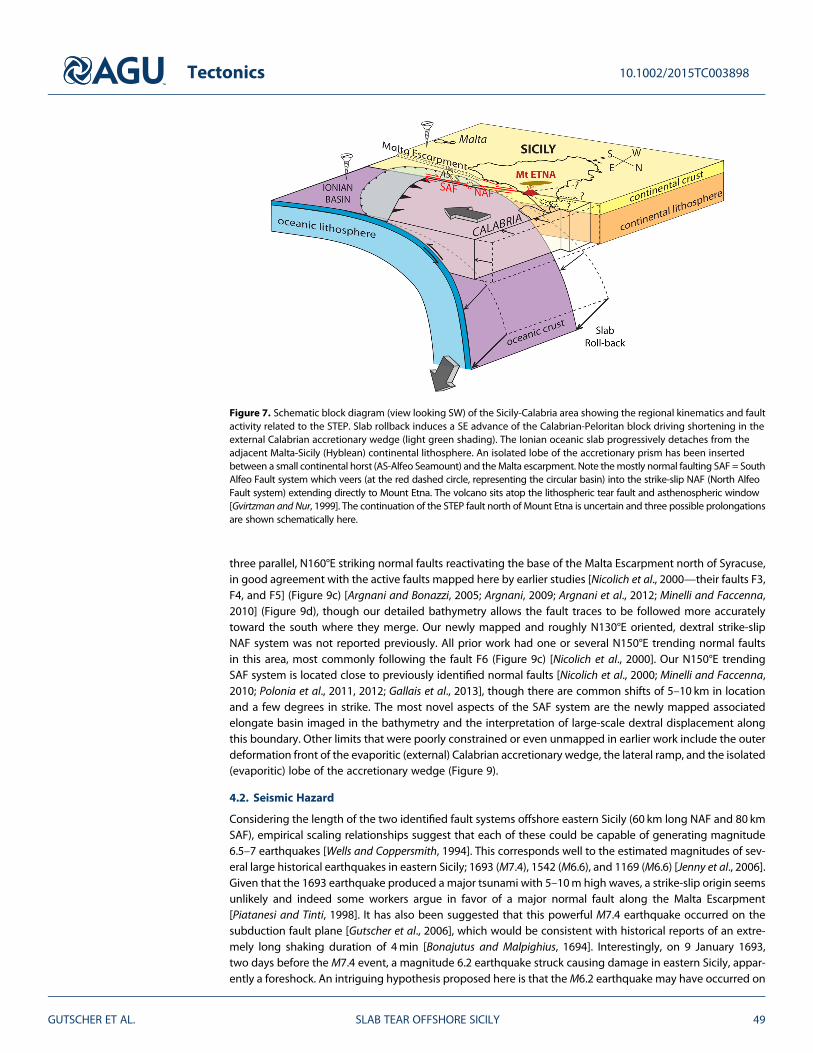
Figure 7. Schematic block diagram (view looking SW) of the Sicily-Calabria area showing the regional kinematics and faultactivity related to the STEP. Slab rollback induces a SE advance of the Calabrian-Peloritan block driving shortening in theexternal Calabrian accretionary wedge (light green shading). The Ionian oceanic slab progressively detaches from theadjacent Malta-Sicily (Hyblean) continental lithosphere. An isolated lobe of the accretionary prism has been insertedbetween a small continental horst (AS-Alfeo Seamount) and theMalta escarpment. Note themostly normal faulting SAF = SouthAlfeo Fault system which veers (at the red dashed circle, representing the circular basin) into the strike-slip NAF (North AlfeoFault system) extending directly to Mount Etna. The volcano sits atop the lithospheric tear fault and asthenospheric window[Gvirtzman and Nur, 1999]. The continuation of the STEP fault north of Mount Etna is uncertain and three possible prolongationsare shown schematically here.
Tectonics 10.1002/2015TC003898
GUTSCHER ET AL. SLAB TEAR OFFSHORE SICILY 49

one segment of the lateral slab tear, thereby liberating the subduction fault plane to slip a few days later.Unfortunately, our knowledge of historical earthquakes is seriously hampered by the lack of instrumentalobservations and thus it is difficult to impossible to reconstruct focal mechanisms. Given the slow fault sliprates (a few mm/yr) and long characteristic return intervals (several centuries) for earthquakes in southernItaly, additional observations are necessary to improve the regional hazard assessment. These could includepaleoseismological work to extend the earthquake record back in time and more detailed geodetic work tobetter constrain the current strain field and to clarify the regional kinematics.4.2.1. Kinematics of the Calabrian Arc SystemUntil now, while there was wide disagreement on the exact location of the STEP fault offshore eastern Sicily[Orecchio et al., 2014], most authors agreed that the surface expression would be one or several major normalfaults [Polonia et al., 2011; Argnani et al., 2012; Gallais et al., 2013; Argnani, 2014]. A major strike-slip fault, asreported here (the NAF system) was not expected. However, kinematically, large-scale strike-slip movementsare predicted along a STEP fault between the advancing upper plate block and the adjacent upper plate[Govers and Wortel, 2005]. There is a broad concensus that the Tyrrhenian Sea basin formed mostly after6Ma and that the southeastern Tyrrhenian Sea formed primarily during the Pleistocene, when the UpperMiocene-Pliocene rifting migrated from the central Tyrrhenian Sea (Vavilov basin) toward the SE (Marsili basin)as confirmed by deep-sea drilling [Sartori, 1990] and dating of basalts [Marani and Trua, 2002]. Thus, theCalabrian-Peloritan block must have been displaced by several hundred kilometers as indicated in most platekinematic reconstructions [Faccenna et al., 2001, 2004; Rosenbaum et al., 2002; Jolivet et al., 2006]. On the basisof our newly mapped faults, we propose here a kinematic reconstruction of the Sicily-Calabria-Ionian Sea regionsince 6Ma (Figure 10). This reconstruction offers a plausible explanation for the abrupt change in strike directionof compressional anticline fold axes east and west of the elongate basin. The accretionary wedge west of theelongate basin consists of the external evaporitic post-Messinian wedge, with fold axes aligned generallyparallel to the external deformation front (green lines in Figures 10c and 10d). On the other hand, the portionof the accretionary wedge east of the elongate basin represents the internal clastic pre-Messinian wedge
Figure 8. Zoom of bathymetry at the northern end of the NAF system. (left) Slope map (in black and white), (right) Residualbathymetric map (after filtering and removing a regional trend for long wavelength relief). Several of the NAF strandsconnect to small transtensional (pull-apart) basins indicating dextral strike-slip kinematics. Note that the NAF crosses thebroad turbidite channel and offsets a submarine canyon (see white arrows).
Tectonics 10.1002/2015TC003898
GUTSCHER ET AL. SLAB TEAR OFFSHORE SICILY 50

Figure 9. Compilation of all major published fault maps for the East Sicily margin. (a) Simplified morphological interpretationand tectonic map from this study (same color code as inset to Figure 3), with primary interpreted active faults shown inred (the dashed line in the remaining three panels marks the base of the Malta Escarpment); (b) gray lines [Polonia et al.,2011, 2012] NB, lines without symbols are described as “normal faults from Chamot-Rooke et al. [2005]”, red lines, faultsfrom this study. (c) Black lines [Nicolich et al., 2000], dark blue lines [Chiocci et al., 2011], and dark green line show aninterpreted trace of the STEP fault [Gallais et al., 2013]; red lines, faults from this study. (d) pink lines [Argnani and Bonazzi,2005; Argnani, 2009; Argnani et al., 2012] and light blue lines [Minelli and Faccenna, 2010] with the outer deformationfront shown as a dashed line, red lines, faults from this study.
Tectonics 10.1002/2015TC003898
GUTSCHER ET AL. SLAB TEAR OFFSHORE SICILY 51

(tightly spaced brown lines in Figure 10, see also Figure 3). While the exact limit between the external evaporiticand internal clastic wedges is not perfectly well constrained, there is general agreement that it is located here asmapped by previous authors [Minelli and Faccenna, 2010, Figure 4 and Figure 11, inset; Polonia et al., 2011,Figure 13; Ceramicola et al., 2014, Figure 1 inset]. An industry seismic profile images this boundary betweenthe clastic and evaporitic wedges coinciding to the edge of the elongate basin [Minelli and Faccenna, 2010].This limit is also confirmed by velocity analysis of seismic reflection profiles crossing this boundary [Gallaiset al., 2013]. The resulting large dextral displacement of the internal clastic wedge allows us to reconcile theconflicting orientations of fold axes east and west of the elongate basin (the SAF) and offers a simple,elegant explanation why the evaporitic post-Messinian wedge ends abruptly along this structure. It does,
Figure 10. Kinematic reconstruction of the Sicily-Calabria–Ionian Sea region since 6Ma showing (a) at 6.0 Ma, thepre-Messinian (clastic) accretionary wedge developed in front of the advancing Calabro-Peloritan block, (b) at 5.2 Ma, atthe end of the Messinian salinity crisis a thick layer of evaporites was deposited in the large Ionian abyssal plain, (c) at4.0 Ma, the construction of a large evaporitic accretionary wedge in front of the internal pre-Messinian (clastic) wedge, theevaporite wedge is wrapping around Alfeo Seamount (AS) which acts as an indenter; note that the Ionian abyssal plain isdiminishing in size and the West Mediterranean Ridge appears (moving to the west and SW), (d) at 0Ma, the present daysituation, with a large-scale dextral offset between the internal (clastic) wedge and lateral (western) portions of the evaporiticwedge stranded between Alfeo Seamount and the Malta Escarpment. The Ionian abyssal plain is greatly reduced in size as theCalabrian and West Mediterranean Ridge accretionary wedges collide and intersect.
Tectonics 10.1002/2015TC003898
GUTSCHER ET AL. SLAB TEAR OFFSHORE SICILY 52

however, require large dextral displacement, which is not directly observed in the seismic profiles, thoughthe long narrow trough (elongate basin) bounded by normal (or transtensional) faults on both sides is acharacteristic feature of strike-slip environments.
5. Conclusions
New, high-resolution seismic profiles and detailed morphobathymetry of the seafloor reveal a two-part faultsystem, interpreted as the shallow tectonic expression of a lithospheric scale lateral slab tear (STEP fault); the80 km long South Alfeo Fault (SAF) system with primarily down-to-the-east normal faulting (and possiblylarge dextral strike-slip displacement) and the 60+ km long, previously unknown North Alfeo Fault (NAF) sys-tem, striking N130°E and showing strike-slip kinematics. The NAF merges with known dextral strike-slip faultson the shallow continental slope offshore east Sicily and on the SE flank of Mount Etna. These active offshorefaults are mechanically capable of generating magnitude 6–7 earthquakes and may be responsible for someenigmatic historical earthquakes.
ReferencesAloisi, M., V. Bruno, F. Cannavo, L. Ferranti, M. Mattia, C. Monaco, and M. Palano (2013), Are the source models of the M7.1 1908 Messina earth-
quake reliable? Insights from a novel inversion and sensitivity analysis of leveling data, Geophys. J. Int., 192, 1025–1041, doi:10.1093/gji/ggs062.Argnani, A. (2009), Evolution of the Tyrrhenian slab tear and active tectonics along the western edge of the Tyrrhenian subducted slab, in
Collision and Collapse at the Africa-Arabia-Eurasia Subduction Zone, edited by D. J. J. van Hinsbergen, M. A. Edwards, and R. Govers,Geol. Soc. London Spec. Publ., 311, 193–212.
Argnani, A. (2014), Comment on the article “Propagation of a lithospheric tear fault (STEP) through the western boundary of the Calabrianaccretionary wedge offshore eastern Sicily (southern Italy)” by Gallais et al., 2013 Tectonophysics, Tectonophysics, 610, 195–199.
Argnani, A., and C. Bonazzi (2005), Malta Escarpment fault zone offshore eastern Sicily: Plio-Quaternary tectonic evolution based on newmulti-channel seismic data, Tectonics, 24, TC4009, doi:10.1029/2004TC001656.
Argnani, A., A. Armigliato, G. Pagnoni, F. Zaniboni, S. Tinti, and C. Bonazzi (2012), Active tectonics along the submarine slope of south-eastern Sicilyand the source of the 11 January 1693 earthquake and tsunami, Nat. Hazards Earth Syst. Sci., 12, 1311–1319, doi:10.5194/nhess-12-1311-2012.
Barreca, G. (2014), Geological and geophysical evidences for mud diapirism in south-eastern Sicily (Italy) and geodynamic implications,J. Geodyn., 82, 168–177, doi:10.1016/j.jog.2014.02.003.
Barreca, G., A. Bonforte, and M. Neri (2013), A pilot GIS database of active faults on the flank of Mt. Etna (Sicily): A tool for integrated hazardévaluation, J. Volcanol. Geotherm. Res., 251, 170–186.
Billi, A., R. Funiciello, L. Minelli, C. Faccenna, G. Neri, B. Orecchio, and D. Presti (2008), On the cause of the 1908 Messina tsunami, southernItaly, Geophys. Res. Lett., 35, L06301, doi:10.1029/2008GL033251.
Billi, A., L. Minelli, B. Orecchio, and D. Presti (2010), Constraints to the cause of three historical tsunamis (1908, 1783, 1693) in the MessinaStraits region, Sicily, Southern Italy, Seismol. Res. Lett., 81(6), 907–915, doi:10.1785/gssrl.81.6.907.
Bonajutus, V., and M. Malpighius (1694), An account of the earthquakes in Sicilia, on the ninth and eleventh of January 1692/3, Philos. Trans.R. Soc., 18, 2–10.
Bonforte, A., F. Guglielmino, M. Colteli, A. Ferretti, and G. Puglisi (2011), Structural assessment of Mount Etna volcano from PermanentScatterers analysis, Geochem. Geophys. Geosyst., 12, Q02002, doi:10.1029/2010GC003213.
Catalano, S., C. Doglioni, and S. Merlini (2001), On the Mesozoic Ionian basin, Geophys. J. Int., 144, 49–64.Ceramicola, S., D. Praeg, A. Cova, D. Accettella, and N. Zecchin (2014), Seafloor distribution and last glacial to postglacial activity of mud
volcanoes on the Calabrian accretionary prism, Ionian Sea, Geo-Mar. Lett., 34(2), 111–129, doi:10.1007/s00367-013-0354-y.Cernobori, L., A. Hirn, J. H. McBride, R. Nicolich, L. Petronio, M. Romanelli, and STREAMERS/PROFILES Working Groups (1996), Crustal image of
the Ionian basin and its Calabrian margins, Tectonophysics, 264, 175–189.Chamot-Rooke, N., C. Rangin, X. Le Pichon, and Dotmed Working Group (2005), DOTMED—Deep Offshore Tectonics of the Mediterranean:
A synthesis of deep marine data in eastern Mediterranean Mémoire de la Société géologique de France & American Association ofPetroleum Geologists. special number, 177: 64 pp., 9 maps with CD-ROM.
Chiocci, F. L., M. Coltelli, A. Bosman, and D. Cavallaro (2011), Continental margin large-scale instability controlling the flank sliding of Etnavolcano, Earth Planet. Sci. Lett., 305, 57–64.
D’Agostino, N., E. D’Anastasio, A. Gersavi, I. Guerra, M. R. Nedimović, L. Seeber, and M. S. Steckler (2011), Forearc extension and slow rollbackof the Calabrian Arc from GPS measurements, Geophys. Res. Lett., 38, L17304, doi:10.1029/2011GL048270.
Devoti, R., A. Esposito, G. Pietrantonio, A. R. Pisani, and F. Riguzzi (2011), Evidence of large scale deformation patterns from GPS data in theItalian subduction boundary, Earth Planet. Sci. Lett., 311, 230–241, doi:10.1016/j.epsl.2011.09.034.
Faccenna, C., F. Funiciello, D. Giardini, and F. P. Lucente (2001), Episodic back-arc extension during restricted mantle convection in theCentral Mediterranean, Earth Planet. Sci. Lett., 187, 105–116.
Faccenna, C., C. Piromallo, A. Crespo-Blanc, L. Jolivet, and F. Rossetti (2004), Lateral slab deformation and the origin of the westernMediterranean arcs, Tectonics, 23, TC1012, doi:10.1029/2002TC001488.
Faccenna, C., P. Molin, B. Orecchio, V. Olivetti, O. Bellier, F. Funiciello, L. Minelli, C. Piromallo, and A. Billi (2011), Topography of the Calabriasubduction zone (southern Italy): Clues for the origin of Mt. Etna, Tectonics, 30, TC1003, doi:10.1029/2010TC002694.
Finetti, I. (1982), Structure, stratigraphy and evolution of Central Mediterranean, Boll. Geofis. Teor. Appl., 24(96), 247–312.Frizon de Lamotte, D., C. Raulin, N. Mouchot, J. C. Wrobel-Daveau, C. Blanpied, and J. C. Ringenbach (2011), The southernmost margin of the Tethys
realm during the Mesozoic and Cenozoic: Initial geometry and timing of the inversion processes, Tectonics, 30, TC3002, doi:10.1029/2010TC002691.Gallais, F., M.-A. Gutscher, D. Graindorge, N. Chamot-Rooke, and D. Klaeschen (2011), A Miocene tectonic inversion in the Ionian Sea (central
Mediterranean): Evidence from multichannel seismic data, J. Geophys. Res., 116, B12108, doi:10.1029/2011JB008505.Gallais, F., M. A. Gutscher, D. Graindorge, and D. Klaeschen (2012), Two-stage growth of the Calabrian accretionary wedge in the Ionian Sea
(Central Mediterranean): Constraints from depth migrated multi-channel seismic data, Mar. Geol., 326–328, 28–45.
Tectonics 10.1002/2015TC003898
GUTSCHER ET AL. SLAB TEAR OFFSHORE SICILY 53
AcknowledgmentsWe thank Captain Jean-René Glehenand the crew of the R/V Le Suroît, whoseexcellent work was crucial to acquirethese data. We acknowledge INSU forcruise-related funding and theEuropean Union FP7 project ASTARTEfor postcruise financial support. A.M.was funded by Marie Curie CareerIntegration grant PCIG13-GA-2013618149 within the 7th EuropeanCommunity Framework Programme.Seismic and bathymetric data are archivedand available upon request in the Frenchnational oceanographic data center—SISMER (Ifremer, Plouzané) http://www.ifremer.fr/sismer/index_UK.htm.

Gallais, F., D. Graindorge, M.-A. Gutscher, and D. Klaeschen (2013), Propagation of a lithospheric tear fault (STEP) through the westernboundary of the Calabrian accretionary wedge offshore eastern Sicily (southern Italy), Tectonophysics, 602, 141–152, doi:10.1016/j.tecto.2012.12.026.
Gallais, F., D. Graindorge, and M.-A. Gutscher (2014), Reply to Comment on “Propagation of a lithospheric tear fault (STEP) through thewestern boundary of the Calabrian accretionary wedge offshore eastern Sicily (southern Italy)” by Gallais et al., 2013 Tectonophysics,Tectonophysics, 610, 200–203.
Giacomuzzi, G., M. Civalleri, P. De Gori, and C. Chiarabba (2012), A 3D Vs model of the upper mantle beneath Italy: Insight on the geodynamics ofcentral Mediterranean, Earth Planet. Sci. Lett., 335–336, 105–120, doi:10.1016/j.epsl.2012.05.004.
Govers, R., and M. J. R. Wortel (2005), Lithosphere tearing at STEP faults: Response to edges of subduction zones, Earth Planet. Sci. Lett., 236,505–523.
Gutscher, M.-A., J. Roger, M. A. Baptista, J. M. Miranda, and S. Tinti (2006), The source of the 1693 Catania earthquake and tsunami (SouthernItaly): New evidence from tsunami modeling of a locked subduction fault plane, Geophys. Res. Lett., 33, L08309, doi:10.1029/2005GL025442.
Gvirtzman, Z., and A. Nur (1999), The formation of Mount Etna as the consequence of slab rollback, Nature, 401, 782–785.Hieke, W., H. B. Hirschleber, and G. A. Dehghani (2005), The Ionian Abyssal Plain (central Mediterranean Sea): Morphology, subbottom
structures and geodynamic history—An inventory, Mar. Geophys. Res., 24, 279–310.Jenny, S., S. Goes, D. Giardini, and H.-G. Kahle (2006), Seismic potential of Southern Italy, Tectonophysics, 415, 81–101, doi:10.1016/
j.tecto.2005.12.003.Jolivet, L., and C. Faccenna (2000), Mediterranean extension and the Africa-Eurasia collision, Tectonics, 19(6), 1095–1106, doi:10.1029/
2000TC900018.Jolivet, L., R. Augier, C. Robin, J. P. Suc, and J. M. Rouchy (2006), The geodynamic context of the Messinian salinity crisis, Sediment. Geol.,
188-189, 9–33.Lofi, J., et al. (Eds.) (2011), Seismic Atlas of The “Messinian Salinity Crisis” Markers in the Mediterranean and Black Seas, Mem. Soc. Geol. Fr.,
vol. 179, pp. 72, World Geological Map Commission, Paris.Loubrieu, B., J. Mascle, and MediMap Group (2007), Morpho-bathymetry of the Mediterranean Sea CIESM & Ifremer Special Publications,
1:3.000.000 scale.Malinverno, A., and W. B. Ryan (1986), Extension in the Tyrrhenian Sea and shortening in the Appenines as a result of arc migration driven by
sinking of the lithosphere, Tectonics, 5, 227–245.Marani, M. P., and Trua, T. (2002), Thermal constriction and slab tearing at the origin of a superinflated spreading ridge: Marsili volcano
(Tyrrhenian Sea), J. Geophys. Res., 107(B9), 2188, doi:10.1029/2001JB000285.Minelli, L., and C. Faccenna (2010), Evolution of the Calabrian accretionary wedge (Central Mediterranean), Tectonics, 29, TC4004,
doi:10.1029/2009TC002562.Musumeci, C., L. Scarfì, M. Palano, and D. Patanè (2014), Foreland segmentation along an active convergent margin: New constraints in
southeastern Sicily (Italy) from seismic and geodetic observations, Tectonophysics, 630, 137–149, doi:10.1016/j.tecto.2014.05.017.Neri, G., B. Orecchio, C. Totaro, G. Falcone, and D. Presti (2009), Subduction beneath Southern Italy close the ending: Results from seismic
tomography, Seismol. Res. Lett., 80(1), 63–70, doi:10.1785/gssrl.80.1.63.Nicolich, R., M. Laigle, A. Hirn, L. Cernobori, and J. Gallart (2000), Crustal structure of the Ionian margin of Sicily: Etna volcano in the frame of
regional evolution, Tectonophysics, 329, 121–139.Orecchio, B., D. Presti, C. Totaro, and G. Neri (2014), What earthquakes say concerning residual subduction and STEP dynamics in the
Calabrian Arc region south Italy, Geophys. J. Int., 199, 1929–1942, doi:10.1093/gji/ggu373.Palano, M., L. Ferranti, C. Monaco, M. Mattia, G. Aloisi, V. Bruno, F. Cannavò, and G. Siligato (2012), GPS velocity and strain fields in Sicily and
southern Calabria, Italy: Updated geodetic constraints on tectonic block interaction in the central Mediterranean, J. Geophys. Res., 117,B07401, doi:10.1029/2012JB009254.
Piatanesi, A., and S. Tinti (1998), A revision of the 1693 eastern Sicily earthquake and tsunami, J. Geophys. Res., 103, 2749–2758, doi:10.1029/97JB03403.
Polonia, A., L. Torelli, P. Mussoni, L. Gasperini, A. Artoni, and D. Klaeschen (2011), The Calabrian arc subduction complex in the Ionian Sea:Regional architecture, active deformation and seismic hazard, Tectonics, 30, TC5018, doi:10.1029/2010TC002821.
Polonia, A., L. Torelli, L. Gasperini, and P. Mussoni (2012), Active faults and historical earthquakes in the Messina Straits area (Ionian Sea), Nat.Hazards Earth Syst. Sci., 12, 2311–2328, doi:10.5194/nhess-12-2311-2012.
Rosenbaum, G., G. S. Lister, and C. Duboz (2002), Reconstruction of the tectonic evolution of the western Mediterranean since the Oligocene, inReconstruction of the Evolution of the Alpine-Himalayan Orogen, J. Virtual Explorer, vol. 8, edited by G. Rosenbaum and G. S. Lister, pp. 107–126,The Virtual Explorer Party Ltd., Conder, Australia.
Rosenbaum, G., G. Massimo, F. P. Lucente, A. Peccerillo, andM. S. Miller (2008), Kinematics of slab tear faults during subduction segmentationand implications for Italian magmatism, Tectonics, 27, TC2008, doi:10.1029/2007TC002143.
Ryan, W. B. F., and B. C. Heezen (1965), Ionian Sea submarine canyons and the 1908Messina turbidity current, Geol. Soc. Am. Bull., 76, 915–932.Sartori, R. (1990), The main results of ODP Leg 107 in the frame of Neogene to recent geology of peri- Tyrrhenian areas, Proc. Ocean Drill.
Program Sci. Results, 107, 715–730.Serpelloni, E., R. Bürgmann, M. Anzidei, P. Baldi, B. Mastrolembo, and E. Boschi (2010), Strain accumulation across the Messina Straits and
kinematics of Sicily and Calabria from GPS data and dislocation modeling, Earth Planet. Sci. Lett., 298(3–4), 347–360.Wells, D., and K. Coppersmith (1994), New empirical relationships amongmagnitude, rupture length, rupture width, rupture area and surface
displacement, Bull. Seismol. Soc. Am., 84, 974–1002.Wortel, M. J. R., and W. Spakman (2000), Subduction and slab detachment in the Mediterranean-Carpathian region, Science, 290, 1910–1917.Wynn, R. B., P. P. E. Weaver, G. Ercilla, D. A. V. Stow, and D. G. Masson (2000), Sedimentary processes in the Selvage sediment-wave field, NE
Atlantic: New insights into the formation of sediment waves by turbidity currents, Sedimentology, 47, 1181–1197.
Tectonics 10.1002/2015TC003898
GUTSCHER ET AL. SLAB TEAR OFFSHORE SICILY 54