Technische Universität München Coastal altimetry at high … · 2 days ago · Deutsches...
32
Deutsches Geodätisches Forschungsinstitut (DGFI-TUM) Technische Universität München Marcello Passaro 1 , Felix L. Müller 1 , Adili Abulaitijiang 2 , Ole B. Andersen 2 , Denise Dettmering 1 , Jacob L. Høyer 3 , Milla Johansson 4 , Kristine Skovgaard Madsen 3 , Laura Rautiainen 4 , Ida M. Ringgaard 3 , Eero Rinne 4 , Jani Särkkä 4 , Rory Scarrott 5 , Christian Schwatke 1 , Florian Seitz 1 , Eimear Tuohy 5 , Laura Tuomi 4 , Americo Ambrozio 6* , Marco Restano 6** , Jérôme Benveniste 6 Coastal altimetry at high-latitudes: the Baltic SEAL project observing sea level among jagged coastline and sea ice 1 Deutsches Geodätisches Forschungsinstitut, Technische Universität München (DGFI-TUM), Germany 2 SPACE National Space Institute, Technical University of Denmark, (DTU), Denmark 3 Danish Meteorological Institute (DMI), Denmark 4 Finnish Meteorological Institute (FMI), Finland 5 MaREI Centre, Environmental Research Institute, University College Cork (UCC), Ireland 6* DEIMOS, c/o ESA-ESRIN, Italy 6** SERCO, c/o ESA-ESRIN, Italy 6 ESA-ESRIN, Italy 12 th Coastal Altimetry Workshop ESA-ESRIN, 4-7.02.2029
Transcript of Technische Universität München Coastal altimetry at high … · 2 days ago · Deutsches...

Deutsches Geodätisches Forschungsinstitut (DGFI-TUM)Technische Universität München
Marcello Passaro1, Felix L. Müller1, Adili Abulaitijiang2, Ole B. Andersen2, Denise Dettmering1, Jacob L. Høyer3, Milla Johansson4, Kristine Skovgaard
Madsen3, Laura Rautiainen4, Ida M. Ringgaard3, Eero Rinne4, Jani Särkkä4, Rory Scarrott5, Christian Schwatke1, Florian Seitz1, Eimear Tuohy5, Laura
Tuomi4, Americo Ambrozio6*, Marco Restano6**, Jérôme Benveniste6
Coastal altimetry at high-latitudes: the Baltic SEAL project observing sea level among jagged coastline and sea ice
1 Deutsches Geodätisches Forschungsinstitut, Technische Universität München (DGFI-TUM), Germany2 SPACE National Space Institute, Technical University of Denmark, (DTU), Denmark3 Danish Meteorological Institute (DMI), Denmark4 Finnish Meteorological Institute (FMI), Finland5 MaREI Centre, Environmental Research Institute, University College Cork (UCC), Ireland6* DEIMOS, c/o ESA-ESRIN, Italy6** SERCO, c/o ESA-ESRIN, Italy6 ESA-ESRIN, Italy
12th Coastal Altimetry Workshop
ESA-ESRIN, 4-7.02.2029

Deutsches Geodätisches Forschungsinstitut (DGFI-TUM) | Technische Universität München 2
What?
• Generation of a novel multi-mission sea level (MMSL) along-
track and gridded product
The Baltic Sea – Motivation
© Sentinel-2 (Copernicus)

Deutsches Geodätisches Forschungsinstitut (DGFI-TUM) | Technische Universität München 3
What?
• Generation of a novel multi-mission sea level (MMSL) along-
track and gridded product
Why?
• Previous products show only sparse information in the
northern Baltic Sea (no sea-ice treatment)
The Baltic Sea – Motivation
© Sentinel-2 (Copernicus)

Deutsches Geodätisches Forschungsinstitut (DGFI-TUM) | Technische Universität München 4
What?
• Generation of a novel multi-mission sea level (MMSL) along-
track and gridded product
Why?
• Previous products show only sparse information in the
northern Baltic Sea (no sea-ice treatment)
• Improvements in algorithms (classification, retracking),
geophysical adjustments and corrections, radar techniques
(Delay-Doppler Altimetry)
The Baltic Sea – Motivation
© Sentinel-2 (Copernicus)

Deutsches Geodätisches Forschungsinstitut (DGFI-TUM) | Technische Universität München 5
What?
• Generation of a novel multi-mission sea level (MMSL) along-
track and gridded product
Why?
• Previous products show only sparse information in the
northern Baltic Sea (no sea-ice treatment)
• Improvements in algorithms (classification, retracking),
geophysical adjustments and corrections, radar techniques
(Delay-Doppler Altimetry)
• Perfect laboratory for Satellite Altimetry (challenging
coastlines, sea-ice coverage, small scale variability)
The Baltic Sea – Motivation
© Sentinel-2 (Copernicus)

Deutsches Geodätisches Forschungsinstitut (DGFI-TUM) | Technische Universität München 6
Workflow Baltic+ SEAL
Altimetry
along-track
observations
Geophysical
Corrections
Retracking
ALES+
Unsupervised
Classification
Multi-Mission
Calibration
Sea Surface
Heights
Validation
Tide Gauges
Mean Sea
Surface
Seasonal
sea level
variations
Identification
of extreme
events
High-temporal
resolution
gridding
Gridded
altimetry
dataset
18 months ESA Tender Project
6 Work Packages
1. Scientific Requirements (FMI)
2. Dataset collection (DMI)
3. Algorithm Development and Validation (TUM)
4. Dataset Generation and Impact Assessment (DTU)
5. Scientific Roadmap (UCC)
6. Management and Promotion (TUM)
Deutsches Geodätisches Forschungsinstitut (DGFI-TUM) | Technische Universität München 7
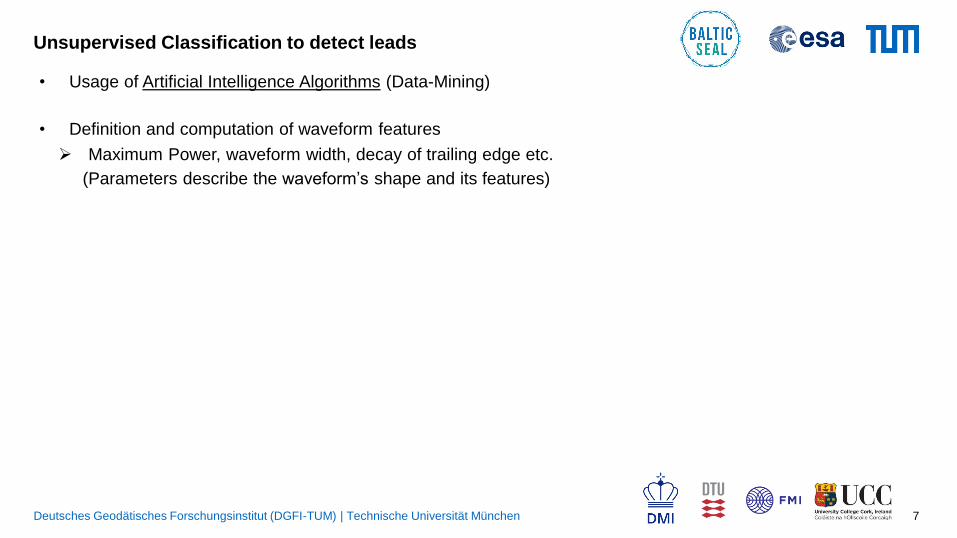
Unsupervised Classification to detect leads
• Usage of Artificial Intelligence Algorithms (Data-Mining)
• Definition and computation of waveform features
Maximum Power, waveform width, decay of trailing edge etc.
(Parameters describe the waveform’s shape and its features)

Deutsches Geodätisches Forschungsinstitut (DGFI-TUM) | Technische Universität München 8
Unsupervised Classification to detect leads
• Usage of Artificial Intelligence Algorithms (Data-Mining)
• Definition and computation of waveform features
Maximum Power, waveform width, decay of trailing edge etc.
(Parameters describe the waveform’s shape and its features)
• Clustering of waveforms applying K-medoids
Waveform reference model
• Assigning waveform clusters to surface conditions
4 classes: lead, ocean, sea-ice and undefined
Example: a Lead cluster (left) and an Ocean cluster in Cryosat-2

Deutsches Geodätisches Forschungsinstitut (DGFI-TUM) | Technische Universität München 9
Unsupervised Classification to detect leads
• Usage of Artificial Intelligence Algorithms (Data-Mining)
• Definition and computation of waveform features
Maximum Power, waveform width, decay of trailing edge etc.
(Parameters describe the waveform’s shape and its features)
• Clustering of waveforms applying K-medoids
Waveform reference model
• Assigning waveform clusters to surface conditions
4 classes: lead, ocean, sea-ice and undefined
More info: Müller F.L et al.: Monitoring the Arctic Seas: How
Satellite Altimetry Can Be Used to Detect Open Water in
Sea-Ice Regions. Remote Sensing, 9(6),
551, 10.3390/rs9060551, 2017c
Example: a Lead cluster (left) and an Ocean cluster in Cryosat-2

Deutsches Geodätisches Forschungsinstitut (DGFI-TUM) | Technische Universität München 10
Retracking
• Sub-waveform retracker to avoid coastal contamination
• Adaptive trailing edge decay to retrack peaky waveforms from leads
• Homogenous range estimation of lead/polynya, open ocean and coastal waveforms (avoids internal biases)
More Information: Passaro M. et al. (2017): ALES+:
Adapting a homogenous ocean retracker for satellite
altimetry to sea ice leads, coastal and inland waters.,
Remote Sensing of Environment
Ocean - LRM Coastal - LRM Lead

Deutsches Geodätisches Forschungsinstitut (DGFI-TUM) | Technische Universität München 11
Retracking
• Sub-waveform retracker to avoid coastal contamination
• Adaptive trailing edge decay to retrack peaky waveforms from leads
• Homogenous range estimation of lead/polynya, open ocean and coastal waveforms (avoids internal biases)
More Information: Passaro M. et al. (2017): ALES+:
Adapting a homogenous ocean retracker for satellite
altimetry to sea ice leads, coastal and inland waters.,
Remote Sensing of Environment
Ocean - LRM Coastal - LRM Lead Ocean - SAR Coastal - SAR

Deutsches Geodätisches Forschungsinstitut (DGFI-TUM) | Technische Universität München 12
- Correction applied using high-rate ALES+retracked sea
state, to decrease intercorrelated errors
- Specific ALES+SAR Sea State Bias model derived
Sea State Bias
Dataset XO var
before
SSB
(cm^2)
XO var
after
SSB
(cm^2)
Explained
Variance
Gaspar et al. (1994) 127.7 120.4 6%
SGDR Jason Med
Passaro et al. (2018)
135.6 108.4 20%
ALES+ SAR 106.0 84.9 20%
Variance at crossover locations before and after the
application of the sea state bias correction

Deutsches Geodätisches Forschungsinstitut (DGFI-TUM) | Technische Universität München 13
- Correction applied using high-rate ALES+retracked sea
state, to decrease intercorrelated errors
- Specific ALES+SAR Sea State Bias model derived
Sea State Bias
Dataset XO var
before
SSB
(cm^2)
XO var
after
SSB
(cm^2)
Explained
Variance
Gaspar et al. (1994) 127.7 120.4 6%
SGDR Jason Med
Passaro et al. (2018)
135.6 108.4 20%
ALES+ SAR 106.0 84.9 20%
Variance at crossover locations before and after the
application of the sea state bias correction
ALES+ SARSentinel3-a
(SAMOSA2 and
1-Hz SSB)
More info: Passaro M. et al..: Improving the precision of sea
level data from satellite altimetry with high-frequency and
regional sea state bias corrections. Remote Sensing of
Environment, 245-254, 10.1016/j.rse.2018.09.007, 2018

Deutsches Geodätisches Forschungsinstitut (DGFI-TUM) | Technische Universität München 14
Cross-Calibration
• Offset not always time-constant => drifts!
• Differences in sea level heights can have large-scale geographical pattern
• A location-dependent cross-calibration between all missions is needed
• Output: time series of radial errors => applied as corrections to each measurement

Deutsches Geodätisches Forschungsinstitut (DGFI-TUM) | Technische Universität München 15
Cross-Calibration
• Offset not always time-constant => drifts!
• Differences in sea level heights can have large-scale geographical pattern
• A location-dependent cross-calibration between all missions is needed
• Output: time series of radial errors => applied as corrections to each measurement
More Information: Bosch W. et al.: Multi-mission cross-
calibration of satellite altimeters: constructing a long-term
data record for global and regional sea level change studies.
Remote Sensing 6(3): 2255-2281, 10.3390/rs6032255, 2014
before MMXO
after MMXO

Deutsches Geodätisches Forschungsinstitut (DGFI-TUM) | Technische Universität München 16
First validation
- 31 cycles of Sentinel-3a
- Points within 5 km from the coast
averaged and compare to Tide Gauges
- Outlier check based on Tide Gauges
ALES+ SAMOSA2
Valid Points 727 <690
Median
Correlation(only of valid
points)
0.93 0.88

Deutsches Geodätisches Forschungsinstitut (DGFI-TUM) | Technische Universität München 17
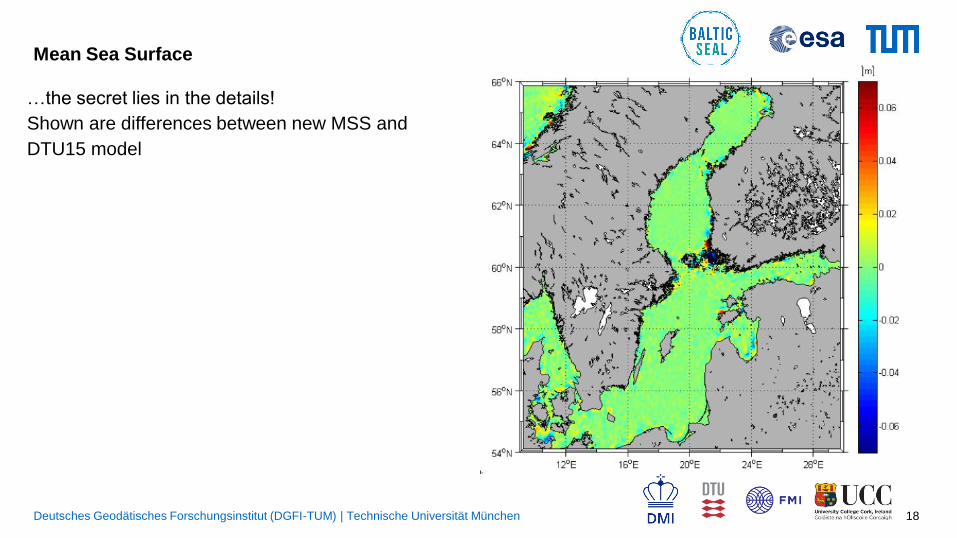
Mean Sea Surface
• A new Mean Sea Surface is being produced
within the project
• In the current version, leads among sea ice and
SAR altimetry not yet included
• …and yet, if we consider the differences with
DTU15…
Deutsches Geodätisches Forschungsinstitut (DGFI-TUM) | Technische Universität München 18
Mean Sea Surface
…the secret lies in the details!
Shown are differences between new MSS and
DTU15 model

Deutsches Geodätisches Forschungsinstitut (DGFI-TUM) | Technische Universität München 19
Mean Sea Surface
…the secret lies in the details!
Shown are differences between new MSS and
DTU15 model
Danish StraitsFinnish Coast

Deutsches Geodätisches Forschungsinstitut (DGFI-TUM) | Technische Universität München 20
Sea Level Analysis: First Results -> Amplitude of annual cycle
Sloping annual cycle amplitude in the
Skagerrak Sea [Passaro 2015]
Mean annual cycle amplitude:
9cm
consistent with
Stramska, M., and Chudziak, N.
(2013)

Deutsches Geodätisches Forschungsinstitut (DGFI-TUM) | Technische Universität München 21
Sea Level Analysis: First Results
Madsen et al. 2019Average trend 4.433 +- 2.21 mm/year
Higher uncertainty: just Jason mission for now and shorter time series

Deutsches Geodätisches Forschungsinstitut (DGFI-TUM) | Technische Universität München 22
Additional products: experimental high-temporal resolution gridding
- The recent availability of several altimeters opens new possibilities for optimal
interpolation every few days
- The objective is to provide a storm surge model with the best possible initial state (SSH
BEFORE the surge)

Deutsches Geodätisches Forschungsinstitut (DGFI-TUM) | Technische Universität München 23
Conclusions
- Baltic SEAL is a laboratory for advanced satellite
altimetry
- Regionally-dedicated analysis, featuring the
latest advances at different level of products
(from classification to gridding)
- By the end of 2020, a multi-mission cross-
calibrated along-track product, a monthly
gridded product, a new mean sea surface will be
available to all users
- The techniques exploited in this framework can
be easily transferred to other regions

Deutsches Geodätisches Forschungsinstitut (DGFI-TUM) | Technische Universität München 24
Thank you!
Stay tuned and visit:
balticseal.eu

Deutsches Geodätisches Forschungsinstitut (DGFI-TUM) | Technische Universität München 25
SPARE SLIDES

Deutsches Geodätisches Forschungsinstitut (DGFI-TUM) | Technische Universität München 26
Validation
• Data averaged in the last 10 km
• ALES+ increases the valid cycles in the sea-ice covered
areas

Deutsches Geodätisches Forschungsinstitut (DGFI-TUM) | Technische Universität München 27
Dataset collection (Altimetry)
• ~ 25 years Multi-mission altimetry data (LRM & SAR)
• Usage of ALES+ retracked high-frequency along-track observations
• Multi-mission cross calibrated Sea Surface Heights
• Regional cross calibration based on high-frequency along-track observations
© Open Altimeter Database (OpenADB) DGFI-TUM
Deutsches Geodätisches Forschungsinstitut (DGFI-TUM) | Technische Universität München 28
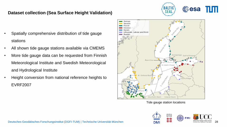
Dataset collection (Sea Surface Height Validation)
• Spatially comprehensive distribution of tide gauge
stations
• All shown tide gauge stations available via CMEMS
• More tide gauge data can be requested from Finnish
Meteorological Institute and Swedish Meteorological
and Hydrological Institute
• Height conversion from national reference heights to
EVRF2007
Tide gauge station locations
Deutsches Geodätisches Forschungsinstitut (DGFI-TUM) | Technische Universität München 29
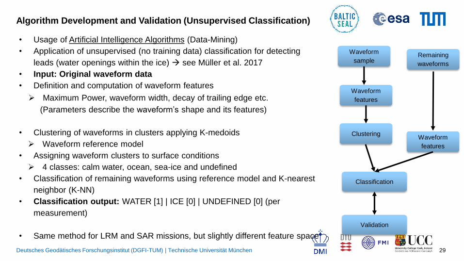
Algorithm Development and Validation (Unsupervised Classification)
Waveform
features
ClusteringWaveform
features
Classification
Waveform
sampleRemaining
waveforms
Validation
• Usage of Artificial Intelligence Algorithms (Data-Mining)
• Application of unsupervised (no training data) classification for detecting
leads (water openings within the ice) see Müller et al. 2017
• Input: Original waveform data
• Definition and computation of waveform features
Maximum Power, waveform width, decay of trailing edge etc.
(Parameters describe the waveform’s shape and its features)
• Clustering of waveforms in clusters applying K-medoids
Waveform reference model
• Assigning waveform clusters to surface conditions
4 classes: calm water, ocean, sea-ice and undefined
• Classification of remaining waveforms using reference model and K-nearest
neighbor (K-NN)
• Classification output: WATER [1] | ICE [0] | UNDEFINED [0] (per
measurement)
• Same method for LRM and SAR missions, but slightly different feature space

Deutsches Geodätisches Forschungsinstitut (DGFI-TUM) | Technische Universität München 30
Algorithm Development and Validation (Sea Surface Heights)
Sea Surface Heights ALES+ 2009-04 (J1-EM,J2,ENV)
External
Classification
Unsupervised
Classification

Deutsches Geodätisches Forschungsinstitut (DGFI-TUM) | Technische Universität München 31
Dataset Generation and Impact Assessment (Gridded/Meshed altimetry dataset)
Grid-node with cap size and sea
surface height distribution
• Generation of a meshed altimetry dataset (TUM)
• Gridding profiled SSH data on an unstructured, triangulated grid
• Monthly temporal resolution 7,5 km spatial resolution
• Using least-square approach with spatio-temporally Gaussian weighting
• Fitting a plane to the individual grid nodes
• Defining proper weights and circular cap size
ℎ 𝑥, 𝑦 = 𝑐0 + 𝑐1𝑥 + 𝑐2𝑦
Unstructured grid
• Production of high-temporal resolution gridding (DTU/DMI)
• Development of a high-temporal (1-3 days) gridded dataset
• Combination of altimetry, tide gauges observations and the output of a
hydrodynamic ocean model
• Based on Optimal Interpolation and error covariance statistics

Deutsches Geodätisches Forschungsinstitut (DGFI-TUM) | Technische Universität München 32
Appendix
From Comas-Bru and McDermott, 2013
DJF – SLP leading
modes
[mb]
NAO
EA
SCA