TECHNICAL REPORT ON THE SAN IGNACIO PROJECT …s1.q4cdn.com/278725388/files/doc_downloads/NI 43-101...
50
TECHNICAL REPORT ON THE SAN IGNACIO PROJECT MINERAL RESOURCE GUANAJUATO STATE, MEXICO EFFECTIVE DATE: 31 MARCH 2012 Prepared by MFW GEOSCIENCE INC. Michael F. Waldegger, P.Geo. Prepared for GREAT PANTHER SILVER LIMITED Suite 800, 333 Seymour Street Vancouver, BC, Canada V6B 5A6
Transcript of TECHNICAL REPORT ON THE SAN IGNACIO PROJECT …s1.q4cdn.com/278725388/files/doc_downloads/NI 43-101...

TECHNICAL REPORT ON THE
SAN IGNACIO PROJECT MINERAL RESOURCE
GUANAJUATO STATE, MEXICO
EFFECTIVE DATE: 31 MARCH 2012
Prepared by
MFW GEOSCIENCE INC.
Michael F. Waldegger, P.Geo.
Prepared for
GREAT PANTHER SILVER LIMITED
Suite 800, 333 Seymour Street
Vancouver, BC, Canada
V6B 5A6

Technical Report on the San Ignacio Project Mineral Resource, Guanajuato State, Mexico TOC i 25 June 2012
CONTENTS
1.0 SUMMARY ................................................................................................. 1-1
2.0 INTRODUCTION .......................................................................................... 2-1 2.1 Terms of Reference ............................................................................ 2-1
3.0 RELIANCE ON OTHER EXPERTS ....................................................................... 3-1
4.0 PROPERTY DESCRIPTION AND LOCATION .......................................................... 4-1 4.1 Property Area ................................................................................... 4-1 4.2 Property Location .............................................................................. 4-1 4.3 Land Tenure ..................................................................................... 4-1 4.4 Royalties ......................................................................................... 4-1 4.5 Environmental Liabilities ...................................................................... 4-3 4.6 Permitting Applications and Status ......................................................... 4-3 4.7 Other Significant Factors and Risks ......................................................... 4-3
5.0 ACCESSIBILITY, CLIMATE, LOCAL RESOURCES, INFRASTRUCTURE, AND PHYSIOGRAPHY .......................................................................................... 5-1 5.1 Topography, Elevation, and Vegetation .................................................... 5-1 5.2 Accessibility ..................................................................................... 5-1 5.3 Climate and Physiography .................................................................... 5-1 5.4 Infrastructure and Local Resources ......................................................... 5-1
6.0 HISTORY .................................................................................................. 6-1
7.0 GEOLOGICAL SETTING AND MINERALIZATION ..................................................... 7-1 7.1 Regional Geology ............................................................................... 7-1 7.2 Local and Property Geology .................................................................. 7-2 7.3 Mineralization ................................................................................... 7-4
8.0 DEPOSIT TYPES .......................................................................................... 8-1
9.0 EXPLORATION ........................................................................................... 9-1
10.0 DRILLING ................................................................................................. 10-1 10.1 Summary of Results .......................................................................... 10-1 10.2 Summary of Procedures ..................................................................... 10-3
11.0 SAMPLE PREPARATION, ANALYSES, AND SECURITY ............................................ 11-1 11.1 Assay Samples ................................................................................. 11-1 11.2 Bulk Density Samples ........................................................................ 11-3
12.0 DATA VERIFICATION ................................................................................... 12-1
13.0 MINERAL PROCESSING AND METALLURGICAL TESTING ........................................ 13-1
14.0 MINERAL RESOURCE ESTIMATE ..................................................................... 14-1 14.1 Introduction ................................................................................... 14-1 14.2 Sample Database ............................................................................. 14-1 14.3 Domain Modelling ............................................................................. 14-2 14.4 Bulk Density ................................................................................... 14-4 14.5 Treatment of High-Grade Outliers ........................................................ 14-5

Technical Report on the San Ignacio Project Mineral Resource, Guanajuato State, Mexico TOC ii 25 June 2012
14.6 Composited Drill Hole Samples ............................................................ 14-6 14.7 Block Model Parameters ..................................................................... 14-7 14.8 Grade Interpolation .......................................................................... 14-8 14.9 Resource Classification ...................................................................... 14-8 14.10 Mineral Resource Tabulation ............................................................... 14-8 14.11 Block Model Validation ...................................................................... 14-9 14.12 Comparison to Previous Resource Estimate .............................................. 14-9
15.0 ADJACENT PROPERTIES .............................................................................. 15-1
16.0 INTERPRETATIONS AND CONCLUSIONS ............................................................ 16-1
17.0 RECOMMENDATIONS ................................................................................... 17-1 17.1 Phase 1 ......................................................................................... 17-1 17.2 Phase 2 ......................................................................................... 17-1
18.0 REFERENCES ............................................................................................ 18-1
19.0 CERTIFICATE OF A QUALIFIED PERSON ........................................................... 19-1
20.0 DATE AND SIGNATURE PAGE ........................................................................ 20-1
TABLES
Table 4.1: Claims Comprising Great Panther’s Holdings at San Ignacio .............................. 4-1 Table 11.1: QC Sample Failure Rates....................................................................... 11-2 Table 12.1: Independent Check Samples vs. Original Samples ........................................ 12-1 Table 14.1: Descriptive Statistics for the Drill Hole Sample Database ............................... 14-1 Table 14.2: Descriptive Statistics of Silver Grade Grouped by Domain .............................. 14-2 Table 14.3: Descriptive Statistics of Gold Grade Grouped by Domain ............................... 14-3 Table 14.4: Descriptive Statistics of Bulk Density Grouped by Domain .............................. 14-4 Table 14.5: Capping Levels for Silver and Gold Grouped by Domain ................................. 14-6 Table 14.6: Descriptive Statistics of Composited Silver Grade Grouped by Domain ............... 14-7 Table 14.7: Descriptive Statistics of Composited Gold Grade Grouped by Domain ................ 14-7 Table 14.8: Extent of the San Ignacio Block Model ...................................................... 14-8 Table 14.9: Inferred Resources above a 125 AgEq g/t Cutoff .......................................... 14-9 Table 17.1: Budget for Proposed Work Plan .............................................................. 17-1
Technical Report on the San Ignacio Project Mineral Resource, Guanajuato State, Mexico TOC iii 25 June 2012
FIGURES
Figure 4.1: Property Claims Map ............................................................................. 4-2 Figure 5.1: San Ignacio Property Guanajuato Location Map ............................................. 5-2 Figure 7.1: San Ignacio Project Property Geology Map ................................................... 7-3 Figure 9.1: Exploration Rock Sample Locations ............................................................ 9-2 Figure 10.1: Drill Hole Location Map ........................................................................ 10-2 Figure 10.2: Cross-Section 700N ............................................................................. 10-3 Figure 14.1: Box and Whisker Plot of Silver Grade Grouped by Domain .............................. 14-3 Figure 14.2: Box and Whisker Plot of Gold Grade Grouped by Domain ............................... 14-4 Figure 14.3: Box and Whisker Plot of Bulk Density Grouped by Domain .............................. 14-5
GLOSSARY
UNITS OF MEASURE
Centimetre ..................................................................................... cm
Grams per tonne ............................................................................... g/t
Hectare .......................................................................................... ha
Kilometre ....................................................................................... km
Kilotonnes ....................................................................................... kt
Metre ............................................................................................ m
Metres above sea level ....................................................................... masl
Millimetres ...................................................................................... mm
Million tonnes .................................................................................. Mt
Million ........................................................................................... M
Ounce ............................................................................................ oz
Parts per million ............................................................................... ppm
Tonne ............................................................................................ t
Tonnes per cubic metre ...................................................................... t/m3
ABBREVIATIONS AND ACRONYMS
Atomic Absorption Spectography ........................................................... AAS
Canadian Institute of Mining, Metallurgy and Petroleum ............................... CIM
Gold Equivalent ................................................................................ AuEq
Gold .............................................................................................. Au
Great Panther Silver Limited ................................................................ Great Panther
Instituto Nacional de Estadistica y Geografia ............................................ INEGI
MFW Geoscience Inc. ......................................................................... MFW
Minera Villa Seca SA CV ...................................................................... MVS
National Instrument NI 43-101 .............................................................. NI 43-101

Technical Report on the San Ignacio Project Mineral Resource, Guanajuato State, Mexico TOC iv 25 June 2012
Qualified Person ............................................................................... QP
Quality Assurance/Quality Control ......................................................... QA/QC
San Ignacio Property .......................................................................... the Property
Silver Equivalent ............................................................................... AgEq
Silver ............................................................................................. Ag
Specific Gravity ................................................................................ SG
Standard Deviation ............................................................................ Std Dev

Technical Report on the San Ignacio Project Mineral Resource, Guanajuato State, Mexico Page 1-1 25 June 2012
1.0 SUMMARY
This technical report and Mineral Resource estimate was prepared for Great Panther Silver Limited
(Great Panther), a Canadian mining and exploration company active in Mexico. The Mineral
Resource estimate is an update of a previous estimate from 2011.
The San Ignacio property consists of a block of seven contiguous mineral claims totalling 324.7 ha.
The Company owns 100% interest in the claims through Great Panther’s wholly-owned Mexican
subsidiary, Minera Mexicana El Rosario SA de CV (MMR). The property is located approximately
8 km northwest of the city of Guanajuato, in Guanajuato State, Mexico.
Exploration in the Guanajuato mining district dates back to 1548, when silver mineralization was
first discovered in La Luz area by Spanish miners. The Sociedad Cooperativa Minera Metalurgica
Santa Fe de Guanajuato (the Cooperative) which began its existence in 1939 amassed what is now
the San Ignacio property. Great Panther acquired the San Ignacio property from the Cooperative in
2005.
The San Ignacio Project lies within La Luz mining camp of the Guanajuato Mining District, which is
located in the southern part of the Mesa Central physiographic province. The Mesa Central is an
elevated plateau of Cenozoic volcanics and volcaniclastics located in central Mexico. It is bounded
to the north and east by the Sierra Madre Oriental, to the west by the Sierra Madre Occidental, and
to the south by the Trans-Mexican Volcanic Belt. Cretaceous volcanic rocks of La Luz Basalt underlie
the San Ignacio property.
The mineralization on the property consists of epithermal silver-gold veins. Average silver grades of
the veins range from 55 g/t Ag to 150 g/t Ag and average gold grades from 1.2 g/t Au to 2.5 g/t Au.
Detailed geological mapping, structural geological studies, outcrop sampling, and re-sampling of old
underground workings are ongoing to highlight additional priority targets along the 4 km of
prospective structures.
Great Panther has completed 73 diamond drill holes at the San Ignacio Property between grid line
450N and 1100N and delineated mineralized veins up to a strike length of 650 m.
MFW estimated that the San Ignacio property contains 826,000 tonnes of Inferred Resources above
a cutoff grade of 125 g/t Ag equivalent grade, averaging 2.28 g/t Au and 121 g/t Ag, and containing
61 koz of gold and 3.2 Moz of silver. This update represents an increase in tonnes of 35%, contained
silver ounces of 29%, and contained gold ounces of 53% over the previous Mineral Resource
estimate completed in 2011.

Technical Report on the San Ignacio Project Mineral Resource, Guanajuato State, Mexico Page 1-2 25 June 2012
MFW recommends a two-phase work program of surface drilling and underground development
followed by underground drilling. The recommended work program is estimated to cost
US$5,200,000.
Technical Report on the San Ignacio Project Mineral Resource, Guanajuato State, Mexico Page 2-1 25 June 2012
2.0 INTRODUCTION
This Technical Report was prepared for Great Panther Silver Limited (Great Panther), a Canadian
mining and exploration company active in Mexico. The company operates two mines: the Topia
silver-gold-lead-zinc mine in west-central Durango State, and the Guanajuato Silver-Gold Mine in
Guanajuato State. In accordance with TSX regulations, Great Panther became a producing issuer as
of mid-March 2011.
All costs are expressed in United States dollars.
2.1 Terms of Reference
Great Panther commissioned MFW Geoscience Inc. (MFW) to estimate Mineral Resources on the
San Ignacio Property and prepare a National Instrument 43-101 (NI 43-101) compliant Technical
Report on the property.
The Mineral Resource estimate was an update of a previous estimate described in a Technical
Report prepared by Janelle Smith AIG., titled “Technical Report on the San Ignacio Project Mineral
Resource Guanajuato State, Mexico” dated 20 September 2011.
The Mineral Resource estimate was based on data provided by the company including drill hole data
from 73 diamond drill holes, and wireframe domains which represent four mineralized veins known
as Veta Melladito, Veta Intermediate, Veta Nombre de Dios 1, and Veta Nombre de Dios 2. An
Inferred Resource was tabulated at a cutoff of 125 g/t Ag equivalent grade based on a ratio of silver
to gold value of 60.8 to 1. Great Panther established the ratio and cutoff grade.
Mr. Waldegger, P.Geo., completed a personal inspection of the property during a site visit on the 8th
and 9th of May, 2012. He reviewed data and sample collection procedures, collected independent
drill hole samples, verified the location of the property and drill holes, and inspected the laboratory
where samples were prepared and assayed by conventional analytical methods. He also toured the
processing facilities at the company’s Cata Mine and observed active underground mining at the
Santa Margarita zone at the Cata Mine.

Technical Report on the San Ignacio Project Mineral Resource, Guanajuato State, Mexico Page 3-1 25 June 2012
3.0 RELIANCE ON OTHER EXPERTS
The conclusions and opinions in this report were based on:
information available to MFW at the time of preparation of this report
assumptions and qualifications as set out in this report
data, reports, and other information supplied by Great Panther and other third party
sources.
The author has relied on ownership information provided by Great Panther. Mr. Waldegger has not
researched property title or mineral rights for the Property and expresses no opinion as to the
ownership status of the Property.
MFW has relied on Great Panther for guidance on legal status, applicable taxes, royalties, and other
government levies or interests, applicable to the property, including environmental liabilities and
permits required to perform the work on the property.
Information and opinions relied on in this report was provided by the following Great Panther
personnel:
Nancy Morales
Carlos Armando Argumosa Sosa
Ing. Maria de los Angeles Neri Caldron
Ing. Alejandro García Badilla
Ing. Jorge Ortega P.Geo., Exploration Country Manager Mexico
Robert Brown P.Eng., Vice-President Exploration
Charles Brown, Chief Operating Officer
Carmen Lopez, Guanajuato Assay Lab Supervisor, SGS Lakefield (under contract to Great
Panther).
The documentation reviewed, along with other sources of information referred to in this report, are
listed in Section 18 – References.

Technical Report on the San Ignacio Project Mineral Resource, Guanajuato State, Mexico Page 4-1 25 June 2012
4.0 PROPERTY DESCRIPTION AND LOCATION
4.1 Property Area
The San Ignacio property consists of a block of seven contiguous mineral claims totalling 324.7 ha.
Figure 4.1 shows the legally surveyed claim boundaries.
4.2 Property Location
The Property is centered at 21˚02’ north, 101˚19' west (lat/long WGS 84), and is located
approximately 8 km due west of the company’s wholly-owned Cata Mine.
4.3 Land Tenure
The Company owns 100% interest in the claims through Great Panther’s wholly-owned Mexican
subsidiary, Minera Mexicana El Rosario SA de CV (MMR). Surface rights owned by the Company are
limited to a small block of ground around the San Ignacio shaft. Surface access is negotiated with
various individual owners. Mexican taxes on mineral claims are due bi-annually in January and July
(the Company is up to date), and assessment must be filed annually each May (the Company is up to
date).
Table 4.1: Claims Comprising Great Panther’s Holdings at San Ignacio
Claim Name Title # Hectares Date of Record Expiration Date
San Francisco de Pili 168161 97.2871 02/03/1981 01/03/2031
Purísima Conception 168166 66 02/03/1981 01/03/2031
San Pedro Gilmonene 168168 72.1458 02/03/1981 01/03/2031
San Francisco de Asis 169359 6.8808 11/11/1981 10/11/2031
La Chuparrosa 169360 1.2 11/11/1981 10/11/2031
San Antonio 177934 49 29/05/1986 28/05/2036
Primera Ampl. de San Antonio 215568 32.1847 19/12/1991 18/12/2041
Total - 324.70 - -
4.4 Royalties
Other than bi-annual taxes and annual assessment filing, there are no royalties, back-in rights,
payments, agreements, or encumbrances to which the property is subject.

Technical Report on the San Ignacio Project Mineral Resource, Guanajuato State, Mexico Page 4-2 25 June 2012
Figure 4.1: Property Claims Map
Source: Great Panther Silver Ltd., June 2012

Technical Report on the San Ignacio Project Mineral Resource, Guanajuato State, Mexico Page 4-3 25 June 2012
4.5 Environmental Liabilities
Great Panther has completed a drill program carried out under the Phase IV permit applied for and
granted by SEMARNAT, which is the Mexican federal agency that oversees environmental permitting
of surface work programs.
4.6 Permitting Applications and Status
All Mexican government permits in place for the exploration program and all agreements with the
site landowners are current.
4.7 Other Significant Factors and Risks
There are no significant factors or risks that may affect access, title or the right, or ability to perform
work on the property.
Technical Report on the San Ignacio Project Mineral Resource, Guanajuato State, Mexico Page 5-1 25 June 2012
5.0 ACCESSIBILITY, CLIMATE, LOCAL RESOURCES, INFRASTRUCTURE, AND PHYSIOGRAPHY
5.1 Topography, Elevation, and Vegetation
The Property area is characterized by rolling hills with small-incised drainages, which generally
provide windows through thin soil cover to good bedrock exposures.
Two small villages (San Pedro and Mexiamora) are located within the property, as are several other
isolated homes and small farms. Some of the property is underlain by cultivated land on which local
farmers grow corn.
5.2 Accessibility
Access to the property is via a 35-minute drive from the outskirts of the city of Guanajuato, mostly
by gravel road through the towns of Santa Ana and Cristo Del Rey.
The property is located approximately 8 km northwest of the city of Guanajuato, in Guanajuato
State, Mexico, and approximately 380 km by road northwest of Mexico City. The city of Guanajuato
has a population of nearly 150,000 inhabitants and is serviced by an international airport located on
the outskirts of Silao, a 30-minute drive on a toll road from Guanajuato. The San Ignacio Property
location is illustrated in Figure 5.1.
5.3 Climate and Physiography
Exploration and mining work can be conducted year-round uninterrupted by weather. The area has
a dry climate with an annual precipitation of about 600 mm, generally falling between June and
October. The annual mean temperature is 25°C; however, winters can be cool, with lows
approaching 0°C.
5.4 Infrastructure and Local Resources
The Company and various property owners in the area are negotiating surface rights sufficient for
mining operations. Grid power is available to the property, and some buildings and storage sheds
exist on site at the old San Ignacio shaft. Most of the supplies and labour required for the
exploration programs were sourced from the cities of Guanajuato or Leon. The area has a long
history of mining, and there is an ample supply of skilled personnel and the surface facilities
sufficient for a mining operation.

Technical Report on the San Ignacio Project Mineral Resource, Guanajuato State, Mexico Page 5-2 25 June 2012
Figure 5.1: San Ignacio Property Guanajuato Location Map
Source: Great Panther Silver Ltd., August 2011

Technical Report on the San Ignacio Project Mineral Resource, Guanajuato State, Mexico Page 6-1 25 June 2012
6.0 HISTORY
Exploration in the Guanajuato mining district dates back to 1548, when silver mineralization was
first discovered in La Luz area by Spanish miners on their way to find their fortune on the newly
discovered bonanza veins in the Mexican state of Zacatecas. Historical documentation has indicated
that mining activity on the La Luz vein system has passed through numerous of boom and bust
cycles. No mining records remain of work undertaken in the area from 1548 until 1793. Research
by Great Panther geologists has turned up a number of maps post-dating 1793, depicting the
development and mining from a number of shafts and adits.
The Sociedad Cooperativa Minera Metalurgica Santa Fe de Guanajuato (the Cooperative), which
began its existence in 1939, amassed what is now the San Ignacio property.
The Cooperative operated several mines in the Guanajuato Mining district throughout the latter half
of the 20th and into the 21st Century, including the Guanajuato mine complex at Guanajuato State,
Mexico.
On the San Ignacio Property there are twelve known historical workings including major shafts at
San Ignacio, Purísima, Pili, and San Jose de Garcia. No production figures for these workings are
available except for those relating to the mining by the Cooperative from the San Ignacio shaft.
Cooperative records from 1977 to 2001 indicate that a total of 617,455 tonnes at a grade of
113 g/t Ag and 1.01 g/t Au were extracted from the San Ignacio shaft along a parallel structure to
those in this mineral resource estimate report, at an average rate of 85 t/d. As there was no
processing facility at San Ignacio, ore was trucked back to the Cata plant in the main Guanajuato
Mine Complex, approximately 20 km by road.
The Cooperative initiated diamond drilling on the San Ignacio property in 1979 with drilling from
underground workings at the San Ignacio shaft. Holes from surface were drilled sporadically during
the period from 1982 until 1990 and focused on a vein system parallel and to the east of the mineral
resource in this report. Robert Brown has informed Mr. Waldegger through personal
communication that the drill core from these holes no longer exists, although the logs and assays
from these holes are available in the Mine Geology Department at the Cata mine site in Guanajuato
and in electronic format. Mr. Waldegger has not reviewed the logs and the data was not included in
the resource estimate.
Great Panther acquired the Guanajuato Mine Complex from the Cooperative in 2005. The operation
included two main properties, a plant, workshops, and administration facilities, mining
infrastructure, equipment, and certain surface rights (real estate) and leases outside the Guanajuato
Mine Complex, including the leases that define the San Ignacio property. The total purchase price
was US$7,250,000, paid in staged cash payments to the end of 2006.
Technical Report on the San Ignacio Project Mineral Resource, Guanajuato State, Mexico Page 6-2 25 June 2012
Great Panther has been recovering material from low-grade surface stockpiles on the San Ignacio
property and is successfully processing it in the Cata plant. A total of 10,252 tonnes averaging
0.42 g/t Au and 61 g/t Ag has been processed since the start of the campaign in March 2011 up to
the end of March 2012.

Technical Report on the San Ignacio Project Mineral Resource, Guanajuato State, Mexico Page 7-1 25 June 2012
7.0 GEOLOGICAL SETTING AND MINERALIZATION
This section is taken broadly from the Equity Exploration Group structural geology report on the San
Ignacio project prepared for Great Panther in 2011.
7.1 Regional Geology
The San Ignacio Project lies within La Luz mining camp of the Guanajuato Mining District, which is
located in the southern part of the Mesa Central physiographic province. The Mesa Central is an
elevated plateau of Cenozoic volcanics and volcaniclastics located in central Mexico. It is bounded
to the north and east by the Sierra Madre Oriental, to the west by the Sierra Madre Occidental, and
to the south by the Trans-Mexican Volcanic Belt.
Rocks within the Mesa Central consist of a Paleocene to Pliocene sequence of dacite-rhyolite,
andesite, and basalt, with related intrusive bodies and intercalated local basin fill deposits of coarse
sandstones and conglomerates. This Cenozoic volcanic-sedimentary sequence overlies a package of
deformed and weakly metamorphosed Mesozoic submarine mafic volcanics and turbidites.
Within the Mesa Central, the project is located in the Sierra de Guanajuato, a northwest-trending
anticlinal structure approximately 100 km long and 20 km wide. The strata within the belt are
transected by northwest, north, east-to-west, and northeast-trending regional scale faults. It is
predominantly the northwest-trending structures, however, which control the position of
mineralization. Normal fault movement along northeast-trending faults resulted in the downward
displacement of certain blocks and the preservation of strata that was eroded in other areas. The
northeast faults are therefore important locators of mineral camps within the belt.
Cretaceous volcanic rocks of La Luz Basalt underlie the San Ignacio property. These rocks are part of
a volcanic-sedimentary complex that has various tectonic interpretations, but in general preserves a
tectonic history probably related to northeastward tectonic thrust emplacement. By contrast, much
of the area to the south (e.g., in and around Guanajuato city) is underlain by a series of Tertiary
volcanic rocks that lie unconformably on La Luz Basalt. The lower Guanajuato Conglomerate is
widespread and is of mid-Eocene to early Oligocene. Later, volcanic rocks were deposited
unconformably on the Guanajuato conglomerate in a caldera setting at the intersection of regional
northeast and northwest mid-Oligocene extensional fracture systems.
Three main northwest-trending precious metal-bearing vein systems occur in the district: the Sierra,
Veta Madre, and La Luz systems.
Technical Report on the San Ignacio Project Mineral Resource, Guanajuato State, Mexico Page 7-2 25 June 2012
7.2 Local and Property Geology
The San Ignacio property is underlain by a monotonous package of basalt (Kbas) and andesite (Kanlf)
volcanic rocks belonging to the lower Cretaceous La Luz andesite (Randall R. et al., 1994; Stewart,
2006). The basalt generally has subtle to well-developed pillow structures that are locally flattened.
In a few localities, inter-pillow hyaloclastite is present and is characterized by a fine breccia
composed of devitrified glass shards in a fine groundmass. Primary layering and tops-up indicators
are generally difficult to determine from the small outcrops typical of the property, but according to
Stewart (2006), the San Ignacio property stratigraphy is not overturned.
Andesite is generally massive to locally feldspar-phyric to laminated (very rarely), and was probably
formed by accumulation of a series of extrusive flows and ash falls.
Locally, these volcanic rocks have interbeds composed of sandstone, siltstone, or fine, pale ash
layers (generally sericite-quartz). A more coarse-grained felsic (possibly dacite) unit is exposed
northwest of the San Jose Mine in the southern part of the property. Where observed, bedding is
generally shallowly dipping.
The mapped distribution of basalt and andesite units is consistent with a lower unit of pillowed
basalt, overlain and broadly in-folded with andesite. Although Stewart (2006) mapped mostly Kbas
across the San Ignacio property, he also reported that the stratigraphy east of Guanajuato generally
consists of a lower pillowed basalt unit overlain by varied andesite volcanic rocks, so it is likely that
similar stratigraphy is present at San Ignacio.
The mapped distribution of basalt and andesite units is consistent with open, shallowly plunging,
property-scale folding.
Two types of dykes are present on the property, and both are quite rare. In the northern part of the
property, a few fine-grained mafic dykes are exposed and preserve foliation and fractures similar to
the host volcanic rocks, so these dykes are probably quite early. Fine-grained felsic dykes occur
locally near the Veta Nombre de Dios structure, and are generally moderately silicified with minor
fine-grained pyrite.
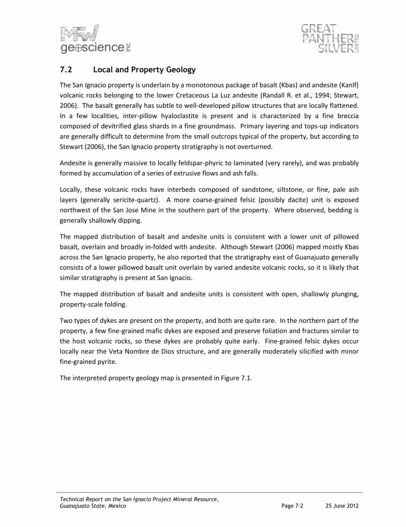
The interpreted property geology map is presented in Figure 7.1.
Technical Report on the San Ignacio Project Mineral Resource, Guanajuato State, Mexico Page 7-3 25 June 2012
Figure 7.1: San Ignacio Project Property Geology Map
Source: Great Panther Silver Ltd., 2012
Technical Report on the San Ignacio Project Mineral Resource, Guanajuato State, Mexico Page 7-4 25 June 2012
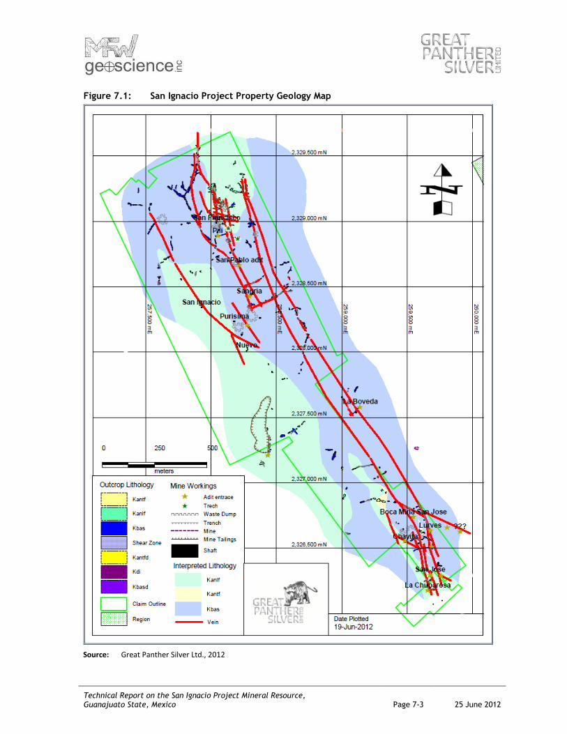
7.3 Mineralization
The most important phase of mineralization in the Guanajuato district consists of epithermal silver-
gold veins contained within northwest-trending, Cenozoic-age faults. La Luz structure consists of
numerous mineralized fractures in a northwesterly-trending orientation, which extends for a known
strike of approximately 8 km long. Historically productive veins on the property include the Veta
Nombre de Dios, Veta Melladito, and Veta Plateros. Other veins identified in the recent Great
Panther drilling are the Veta Intermediate, and Veta Nombre de Dios 2. Within the veins,
mineralization is contained within tabular veins, vein stockworks, and breccias. The four veins with
structural continuity inferred from surface mapping and diamond drilling from surface have been
defined up to 650 m along strike and 350 m down dip. Two of the veins are very steeply dipping and
two are shallowly dipping and are likely off-shoots of the other veins. The veins are accompanied by
hydrothermal alteration, consisting of argillic, phyllic, silicic, and propylitic facies.
The primary economic components are silver and gold, with silver the more important of the two.
Base metals do not occur in significant concentrations, and the mineralized material is lead-poor.
Economic mineralization consists of fine-grained disseminations of acanthite and pyrargerite, with
accessory pyrite, and relatively minor sphalerite, and chalcopyrite. Mineral textures in this zone are
typically fracture filling, drusy, and colloform masses.
Average silver grades of the four veins range from 55 g/t Ag to 150 g/t Ag; average gold grades from
1.2 g/t Au to 2.5 g/t Au.

Technical Report on the San Ignacio Project Mineral Resource, Guanajuato State, Mexico Page 8-1 25 June 2012
8.0 DEPOSIT TYPES
The mineral deposit type being investigated on the San Ignacio property is classic fissure-hosted,
low-sulphidation epithermal gold-silver-bearing veins and stockworks. Epithermal systems form
near surface, usually in association with hot springs, and to depths of around a few hundred metres
below the paleosurface. Hydrothermal processes are driven by remnant heat from volcanic activity,
which in the case of the Guanajuato mining district, occurred in the middle to late Tertiary. Fluids
rising up through fissures reach an elevation at which the hydrostatic pressure is low enough to
allow boiling to occur. This emplacement model explains why there can be a limit to the vertical
extent of the mineralization, as the boiling and deposition of minerals is confined to a relatively
narrow band of thermal and hydrostatic conditions.
Epithermal type precious metal deposits in the La Luz vein system and specifically on the San Ignacio
property are strongly vertically controlled and pinch to centimetre scale at surface, associated with
weak shear zones, minor argillic alteration, and weakly anomalous precious metal values. The
mineralized vertical interval typically is 100 m to 150 m; however, it can range from 50 m to 250 m.

Technical Report on the San Ignacio Project Mineral Resource, Guanajuato State, Mexico Page 9-1 25 June 2012
9.0 EXPLORATION
Great Panther has conducted geological and structural mapping, including sampling of outcrops, and
exposures from underground workings.
Alejandro Garcia Badilla, senior project geologist for Great Panther, completed detailed surface
mapping, and outcrop rock chip sampling, including mapping and sampling all accessible
underground workings. This work is ongoing (see Figure 9.1). A total of 147 surface samples and 57
underground samples were collected by chip and channel sampling. A coarse blanket was laid out
to collect at least 1 kg of broken rock chips falling from the sample site and the rock was transferred
into a clear rock sample bag. Each sample was identified by a plastic numbered sample tag and the
sample bag was labelled with the same number. The blanket was shaken vigorously in between
sample sites to minimize contamination. Samples were grouped together into rice bags and shipped
to the SGS lab at the Cata plant. Standard chain of custody documents were used including forms
requiring signature upon receipt of shipment by the lab.
Dr. Darcy Baker of Equity Exploration Consultants completed structural mapping and logging of one
diamond core hole in February 2011.
The exploration work has confirmed that the top of the mineralized epithermal system is below
surface, estimated at approximately 2,350 masl. This vertical limit was indicated on longitudinal
sections from the historical operations of the Cooperative on veins on the San Ignacio property, and
from longitudinal sections of deposits on an adjacent property owned by Endeavour Silver. The
strong vertical control on mineralization is characteristic of the area and the mineralized intervals
are typically 100 m to 150 m in vertical range; however, it can range from 50 m to 250 m.
Detailed geological mapping, structural geological studies, outcrop sampling, and re-sampling of old
underground workings are ongoing to highlight additional priority targets along the 4 km of
prospective structures.

Technical Report on the San Ignacio Project Mineral Resource, Guanajuato State, Mexico Page 9-2 25 June 2012
Figure 9.1: Exploration Rock Sample Locations
Source: Great Panther Silver Ltd., 2012
Technical Report on the San Ignacio Project Mineral Resource, Guanajuato State, Mexico Page 10-1 25 June 2012
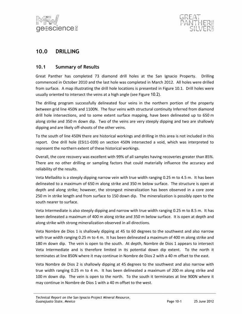
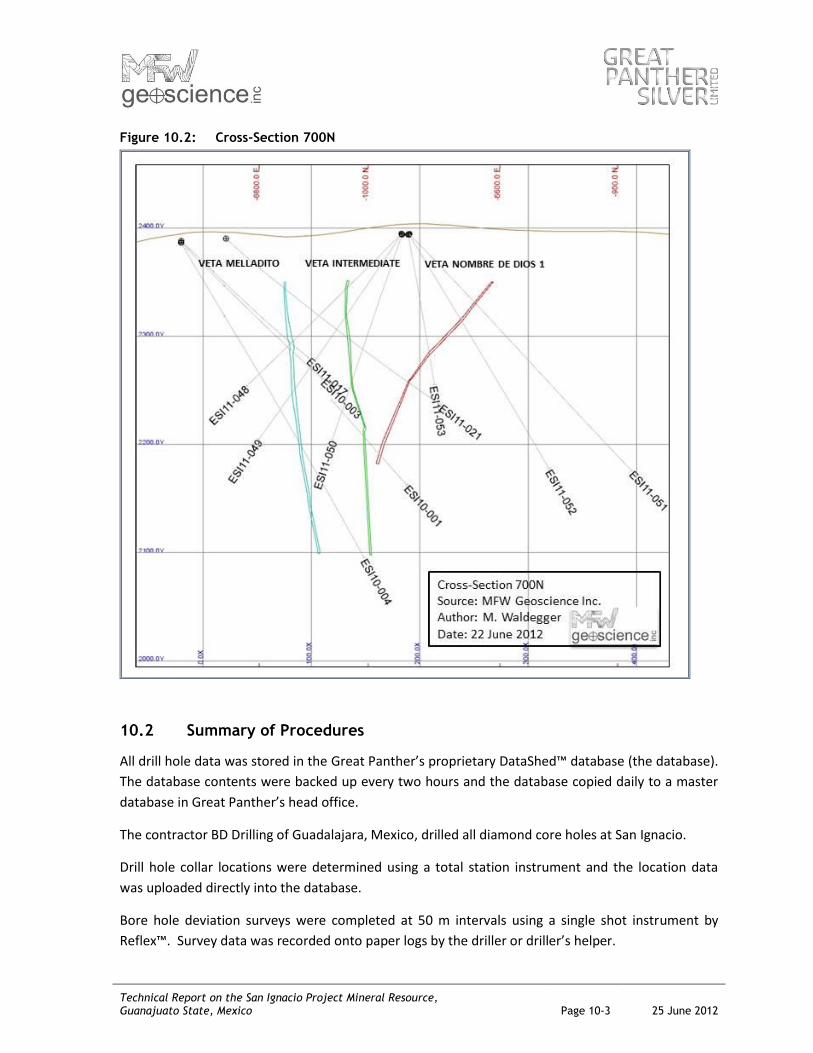
10.0 DRILLING
10.1 Summary of Results
Great Panther has completed 73 diamond drill holes at the San Ignacio Property. Drilling
commenced in October 2010 and the last hole was completed in March 2012. All holes were drilled
from surface. A map illustrating the drill hole locations is presented in Figure 10.1. Drill holes were
usually oriented to intersect the veins at a high angle (see Figure 10.2).
The drilling program successfully delineated four veins in the northern portion of the property
between grid line 450N and 1100N. The four veins with structural continuity Inferred from diamond
drill hole intersections, and to some extent surface mapping, have been delineated up to 650 m
along strike and 350 m down dip. Two of the veins are very steeply dipping and two are shallowly
dipping and are likely off-shoots of the other veins.
To the south of line 450N there are historical workings and drilling in this area is not included in this
report. One drill hole (ESI11-039) on section 450N intersected a void, which was interpreted to
represent the northern extent of these historical workings.
Overall, the core recovery was excellent with 99% of all samples having recoveries greater than 85%.
There are no other drilling or sampling factors that could materially influence the accuracy and
reliability of the results.
Veta Melladito is a steeply dipping narrow vein with true width ranging 0.25 m to 4.5 m. It has been
delineated to a maximum of 650 m along strike and 350 m below surface. The structure is open at
depth and along strike; however, the strongest mineralization has been observed in a core zone
250 m in strike length and from surface to 150 down dip. The mineralization is possibly open to the
south nearer to surface.
Veta Intermediate is also steeply dipping and narrow with true width ranging 0.25 m to 8.5 m. It has
been delineated a maximum of 400 m along strike and 350 m below surface. It is open at depth and
along strike with strong mineralization observed in all directions.
Veta Nombre de Dios 1 is shallowly dipping at 45 to 60 degrees to the southwest and also narrow
with true width ranging 0.25 m to 4 m. It has been delineated a maximum of 400 m along strike and
180 m down dip. The vein is open to the south. At depth, Nombre de Dios 1 appears to intersect
Veta Intermediate and is therefore limited in its potential down dip extent. To the north it
terminates at line 850N where it may continue in Nombre de Dios 2 with a 40 m offset to the east.
Veta Nombre de Dios 2 is shallowly dipping at 45 degrees to the southwest and also narrow with
true width ranging 0.25 m to 4 m. It has been delineated a maximum of 200 m along strike and
100 m down dip. The vein is open to the north. To the south it terminates at line 900N where it
may continue in Nombre de Dios 1 with a 40 m offset to the west.

Technical Report on the San Ignacio Project Mineral Resource, Guanajuato State, Mexico Page 10-2 25 June 2012
Figure 10.1: Drill Hole Location Map
Source: Great Panther Silver Ltd., 2012
Technical Report on the San Ignacio Project Mineral Resource, Guanajuato State, Mexico Page 10-3 25 June 2012
Figure 10.2: Cross-Section 700N
10.2 Summary of Procedures
All drill hole data was stored in the Great Panther’s proprietary DataShed™ database (the database).
The database contents were backed up every two hours and the database copied daily to a master
database in Great Panther’s head office.
The contractor BD Drilling of Guadalajara, Mexico, drilled all diamond core holes at San Ignacio.
Drill hole collar locations were determined using a total station instrument and the location data
was uploaded directly into the database.
Bore hole deviation surveys were completed at 50 m intervals using a single shot instrument by
Reflex™. Survey data was recorded onto paper logs by the driller or driller’s helper.

Technical Report on the San Ignacio Project Mineral Resource, Guanajuato State, Mexico Page 10-4 25 June 2012
Drill core was transported twice per day from the drill site by pick-up truck to the core storage and
logging facility located at the company’s Guanajuato Mine plant site, which is gated, guarded, and
secure.
Core boxes were laid out by field technicians onto angled tables suitable for logging. The
technicians fitted the core pieces together and cleaned the core surface in preparation for logging
by the geologist. Depth markers were checked for proper labelling, and the boxes were labelled
with the drill core intervals. The technicians also completed measurements of core recovery and
rock quality designation (RQD) and recorded the data onto paper logs.
Geological logging was completed by the geologists and recorded directly into a local database using
LogChief Software™ installed on Toughbook™ computers for later upload to the database.
Sample intervals for assaying were marked on the core boxes by the geologists. Sample lengths
were generally determined by mineralogical or lithological characteristics and the protocol is for
maximum sample lengths to be 1.5 m and the minimum length to be 0.5 m. Field technicians then
photographed the core.
The field technician selected samples for bulk density measurements from several locations within
the mineralized intervals, usually one density sample per assay sample interval. The water
immersion procedure was followed and the data was recorded onto paper logs. The samples were
returned to the core box after the tests were completed.
Core samples for assaying were collected by the field technicians. Sample interval data was
recorded in a numbered ticket book. Each ticket had three portions: a stub and two tags. All
portions of the sample ticket shared the same unique identification number. The two tag portions
of each ticket were detached from the stub and stapled to the core tray at the start of the sample
interval. The drill core was then cut using a diamond-tipped blade with clean water being used to
lubricate and cool the blade. Half of the sample interval was placed inside a clear plastic rock
sample bag labelled with the same ID as the ticket number. One tag was then removed from the
core box and inserted into the sample bag along with the cut sample. The remaining stub, retained
in the sample book, was completed with details such as drill hole ID and depth interval. The bag was
then sealed and 25 samples were inserted into rice sacks and delivered with other samples from the
same hole. One sample submission sheet per hole accompanied the samples to the on-site SGS
assay laboratory. Samples were usually sent every other day.
Assay certificates were received directly from SGS laboratory via email. Site geologists reviewed
quality control sample results for out of tolerance failures prior to merging the assay results with
sample intervals in the database.
The first nine diamond core holes at San Ignacio (ESI10-001 – ESI11-009) were completed under the
management of the Guanajuato Mine Geology Department. Mine geologists logged and sampled
the core. Following an internal audit by the company, which identified deficiencies in core handling

Technical Report on the San Ignacio Project Mineral Resource, Guanajuato State, Mexico Page 10-5 25 June 2012
and sampling procedures, the responsibility for diamond drilling and exploration at San Ignacio
changed to Great Panther’s exploration department. The exploration staff re-logged and re-
sampled all nine drill holes. The remaining drill holes were completed under the management and
direction of the exploration department.

Technical Report on the San Ignacio Project Mineral Resource, Guanajuato State, Mexico Page 11-1 25 June 2012
11.0 SAMPLE PREPARATION, ANALYSES, AND SECURITY
All sampling and analytical work was conducted by employees, contractors, or designates of Great
Panther.
11.1 Assay Samples
Sample preparation prior to dispatch to the analytical laboratories consisted of splitting the sample
in half by cutting the core using a rock saw (procedure described in Section 10 - Drilling).
Quality control measures included the insertion of quarter-core duplicates, standard reference
materials, and blanks into the sample stream.
Chain of custody was established upon sample collection with the use of unique sample ID,
documentation of samples per shipment to the lab, and sign-off forms for receipt of samples by the
laboratory.
Prior to dispatch, the samples were stored within the core storage and logging facility located at the
company’s Guanajuato Mine plant site, which is a gated, guarded, and secure compound. The site
security is of a reasonable standard, consistent with common practical industry standards.
Most of the analytical work was completed by the SGS Lakefield Laboratory (SGS) located on the
company-owned Cata mine site. The lab was working towards ISO-19000 certification and most of
the assessment was complete at the time of writing (personal communications with Robert Brown,
VP Exploration).
Sample preparation consisted of crushing through a two-stage crusher to 10 mesh and then split to
a 200 g sub-sample for pulverizing to 98% passing 200 mesh. Samples are analyzed by fire assay
with an AA finish using a 30 g aliquot, and any that report greater than 10 g/t Au or 300 g/t Ag are
reanalyzed by fire assay using a gravimetric finish. The laboratory can also perform AAS
determinations for As, Cu, Pb, Sb, and Zn.
Samples from holes ESI11-014 to 017 were sent to ALS Chemex in Guadalajara for sample
preparation and then for analysis in Vancouver, Canada. Gold and silver was determined by fire
assay using a 30 g aliquot and gravimetric finish (ALS method ME-GRA21) and a 33 element ICP
package was also selected using a four acid near-total digestion (ALS method ME-ICP61).
The SGS laboratory manager conducted routine Quality Assurance/Quality Control (QA/QC) tests
and instrument calibrations, and maintains a database of the results. SGS Group conducts a
monthly round robin comparison against three other laboratories, and Laboratory Quality Services
International conducts monthly checks as well.

Technical Report on the San Ignacio Project Mineral Resource, Guanajuato State, Mexico Page 11-2 25 June 2012
Great Panther’s geological personnel inserted quarter-core duplicates, standard reference material,
and blanks into the sample stream each at a frequency of one in twenty samples. Analytical results
of control samples were reviewed immediately upon receipt of the assay certificates. A sample
batch was rejected if any blank returned a result greater than 0.05 g/t Au or 3 g/t Ag, or if a standard
returned a result greater than three standard deviations from the expected mean or two sequential
results greater than two standard deviations away from, both above or both below, the mean.
Batches were also re-run if the field duplicate grades were greater than 10% from the original
sample grade.
A total of 11 failures due to out of tolerance assay values were observed and corrective actions were
followed. Table 11-1 provides a summary of expected values of each standard and the failure rates
of the standards and blanks. The pulps of the batches in question were returned to the laboratory
for re-assay, with new standards and blanks inserted. A reasonable correlation between the silver
and gold grades of the original pulps and re-assayed pulps provided confidence in the original silver
and gold values and no failures with respect to the additional inserted standards and blanks were
observed.
Table 11.1: QC Sample Failure Rates
GTS03 GTS04 Blank
Ag Expected Value (g/t) 45.64 165 0
Number of Failures 0 6 2
Number of Samples 83 72 164
Au Expected Value (g/t) 0.3 1.15 0
Number of Failures 0 3 0
Number of Samples 83 72 164
The standard reference materials (SRM) used were sourced from two 100 kg bulk samples of
material from the Great Panther’s Cata Mine in Guanajuato with expected values, which reflect
grade ranges present on the property. SRM GTS03 was produced from one of the bulk samples by
SGS in Durango, and SRM GTS04 by Skyline laboratories in Tucson, Arizona.
The blank material was sourced from barren Rhyolite at roadside cuts on the Guanajuato to San
Miguel de Allende route in Guanajuato State, Mexico. The material was assayed to ensure values of
gold and silver were present in trace amounts only and then packaged in small bags of 60 g each.
Quarter core duplicate sample results were compared with the original quarter core sample results
to see if the two results fall within 10% of each other. A total of nine failures lead to sample batch
re-runs and the new values were accepted as final if the new values were within 10%; otherwise, the
original values were used since the perceived problem persisted. This is because the duplicate
sample may actually contain different mineralization and since both values may be equally valid
results, the company used the “first pass the post” approach.

Technical Report on the San Ignacio Project Mineral Resource, Guanajuato State, Mexico Page 11-3 25 June 2012
Mr. Waldegger is of the opinion that the results of the analytical procedures for sample grade
determination are suitable for use in resource estimation.
11.2 Bulk Density Samples
Samples approximately 10 cm in length were selected from whole or half-core (NQ or HQ) by the
field technician and returned to the core box after bulk density determinations were completed.
The testwork was completed on site by field technicians and followed the water submersion method
on air-dried samples (not in an oven). Non-friable, non-porous core samples were weighed in air
and then weighed while suspended from the scale in a basket, which was submerged in water. The
raw information was recorded on paper logs.
Although no formal QC program was in place to provide confidence in the precision or accuracy of
the results, the results are within the range of expected density values for the material tested. Mr.
Waldegger recommends duplicate samples selected at a standard frequency be sent to an external
laboratory for testing and the scale monitored regularly using a standard weight to add confidence
to the dataset.
Mr. Waldegger is of the opinion that the bulk density testwork was conducted using appropriate
procedures and is reliable for resource estimation.
Technical Report on the San Ignacio Project Mineral Resource, Guanajuato State, Mexico Page 12-1 25 June 2012
12.0 DATA VERIFICATION
Drill hole data was provided by Great Panther in an organized manner on several worksheets of one
MS Excel workbook. The datasets included were: hole location, down hole survey, lithology,
mineralogy, alteration, density, structural features, recovery and RQD, and sample assays, including
the results from quality control samples. Also received were contour lines (10 m intervals) based on
satellite data and purchased from the Instituto Nacional De Estadistica y Geografia (INEGI).
Mr. Waldegger checked the assay data from the supplied database for missing intervals, out of
sequence intervals, non-numerical values, negative values, and any other obvious errors. No errors
were observed in the assay table and only a small number of interval errors were observed and
corrected in the alteration table.
Mr. Waldegger reviewed logging and sampling procedures while on site and was satisfied that they
meet industry standard practices. Geological logs were reviewed against selected intersections of
half core from three drill holes. Mr. Waldegger checked core box intervals and compared
measurements of core recovery and RQD against values recorded in the database. Mr. Waldegger
observed geology and mineralization as described in the logs. No significant discrepancies were
observed.
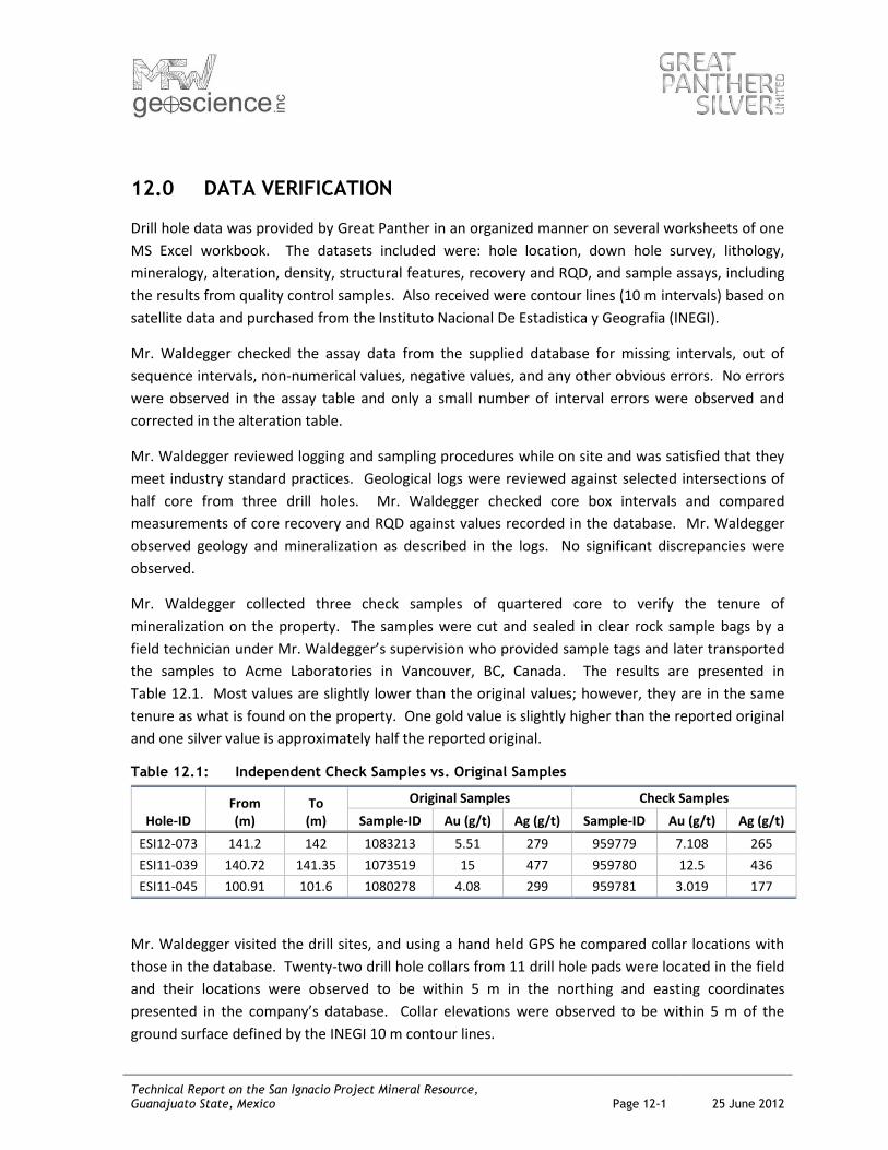
Mr. Waldegger collected three check samples of quartered core to verify the tenure of
mineralization on the property. The samples were cut and sealed in clear rock sample bags by a
field technician under Mr. Waldegger’s supervision who provided sample tags and later transported
the samples to Acme Laboratories in Vancouver, BC, Canada. The results are presented in
Table 12.1. Most values are slightly lower than the original values; however, they are in the same
tenure as what is found on the property. One gold value is slightly higher than the reported original
and one silver value is approximately half the reported original.
Table 12.1: Independent Check Samples vs. Original Samples
Hole-ID From (m)
To (m)
Original Samples Check Samples
Sample-ID Au (g/t) Ag (g/t) Sample-ID Au (g/t) Ag (g/t)
ESI12-073 141.2 142 1083213 5.51 279 959779 7.108 265
ESI11-039 140.72 141.35 1073519 15 477 959780 12.5 436
ESI11-045 100.91 101.6 1080278 4.08 299 959781 3.019 177
Mr. Waldegger visited the drill sites, and using a hand held GPS he compared collar locations with
those in the database. Twenty-two drill hole collars from 11 drill hole pads were located in the field
and their locations were observed to be within 5 m in the northing and easting coordinates
presented in the company’s database. Collar elevations were observed to be within 5 m of the
ground surface defined by the INEGI 10 m contour lines.
Technical Report on the San Ignacio Project Mineral Resource, Guanajuato State, Mexico Page 12-2 25 June 2012
During Mr. Waldegger’s site visit, he inspected the SGS laboratory and found it to be secure, orderly,
and appropriately configured for the analytical work required. The assay protocols are conventional
methods, commonly used in the industry, and a reasonable level of QA/QC monitoring was applied
to assure that the results were accurate.
Mr. Waldegger selected five of the 54 drill holes completed since the last Technical Report was
released and cross-checked sample results with the original assay certificates. Five certificates were
received via email directly from Carmen Lopez (SGS-GTO laboratory manager). No discrepancies in
silver or gold values were observed; however, the company database provided to the author had
gold values to two decimals places, whereas the original certificates had gold values to three
decimal places.
Mr. Waldegger is of the opinion that the data supplied by the company was sufficiently free from
errors, such that it was suitable for use in resource estimation.
Technical Report on the San Ignacio Project Mineral Resource, Guanajuato State, Mexico Page 13-1 25 June 2012
13.0 MINERAL PROCESSING AND METALLURGICAL TESTING
Metallurgical testing of mineralized vein material included in the Mineral Resource estimate was
completed at the Company metallurgical laboratory at the Cata Plant. Testwork on fresh drill core
demonstrated viable ore floatation with recoveries ranging from 78.9% to 91.8% for Au and from
76.4% to 89.0% for Ag. Variations among tests included different grinding times of the sample to
achieve finer material. The best test result came after grinding a sample with a head grade of
2.68 g/t Au and 198 g/t Ag, to 100% passing 200 mesh.
Through optimization of the plant grinding and flotation circuits, similar recoveries to those
obtained in the testwork would be expected when processing mineralized material from the veins
that are subject of the Mineral Resource estimate. While the Cata processing plant may not be able
to achieve 100% passing 200 mesh, the recirculation and regrinding of middlings (intermediate
flotation products from scavenger cells and rejected material from cleaner flotation cells) typically
results in better than testwork recoveries for a similar grind (personal communications with Charles
Brown, COO Great Panther).
The testwork was completed on one 35 kg composite sample of mineralized material from the Veta
Intermediate. The sample comprised coarse sample rejects of 27 samples from 11 drill holes
representing approximately 25% of intersection length with the Veta Intermediate. The company
considered the sample to be reasonably representative of all four mineralized veins since the
mineralogical differences between the veins consists of the ratio of quartz to calcite and this ratio
does not significantly affect the process recoveries.
In addition, low-grade material discarded in waste dumps from historical workings on the property
has been processed in the Cata processing plant since early 2011. To date, 10,252 tonnes of low-
grade dump material, at grades of 0.42 g/t Au and 61 g/t Ag, have been processed to produce high
quality, saleable concentrates. Metal recoveries, at 70.6% for gold and 64.4% for silver, are
consistent with those achieved in the testwork considering the much lower grades.
No known processing factors or deleterious elements are present that could have a significant effect
on the potential economic extraction of the mineralized material in the veins that are the subject of
this report.

Technical Report on the San Ignacio Project Mineral Resource, Guanajuato State, Mexico Page 14-1 25 June 2012
14.0 MINERAL RESOURCE ESTIMATE
14.1 Introduction
MFW estimated the Mineral Resources on the San Ignacio Property.
The geological interpretation and resource modelling was carried out using 3D geological modelling
software provided by Gemcom Software International Inc. (Gemcom) of Vancouver. Modelling was
completed using GEMS™ Version 6.3.
14.2 Sample Database
MFW received drill hole data from Great Panther for 73 diamond drill holes. No surface or
underground rock samples were used in the resource estimate.
Sample intervals with assay values lower than the detection limit for silver and gold were converted
to 0.5 g/t and 0.005 g/t values, respectively, which for the majority of these samples was half the
detection limit.
Descriptive statistics of the raw assays are presented in Table 14.1.
Table 14.1: Descriptive Statistics for the Drill Hole Sample Database
Ag (g/t)
Au (g/t)
Sample Length (m)
Valid Cases 5,331 5,331 5,331
Mean 18.7 0.31 1.00
Variance 5,112.3 1.11 0.16
Std. Deviation 71.5 1.05 0.41
Variation Coefficient 3.8 3.34 0.41
Minimum 0.5 0.01 0.05
1st
Percentile 0.5 0.01 0.45
25th
Percentile 1 0.02 0.7
Median 2 0.05 1
75th
Percentile 7 0.16 1.25
99th
Percentile 328 5.28 1.6
Maximum 1,390 16.9 11.9
Technical Report on the San Ignacio Project Mineral Resource, Guanajuato State, Mexico Page 14-2 25 June 2012
14.3 Domain Modelling
Domain modelling is generally considered the first step in estimating resources for a mineral
deposit. It consists of separating the mineralized material into different domains with distinct
geological characteristics, grade distributions, and spatial continuity of grade. In practice, each
domain takes the form of a 3D envelope often interpreted on sections or levels by a geologist
(summarized from Dagbert, 2008 seminar notes).
Great Panther supplied to MFW domain models representing four mineralized veins. The domains
were modelled to include vein, vein breccia, and stockwork material that were interpreted to form
continuous veins called Melladito, Intermediate, Nombre de Dios 1, and Nombre de Dios 2. Not all
material that was logged as vein, vein breccia, or stockwork was included in the four modelled
domains, as some of this material could not be correlated between drill holes, and not all of the
intersections used to model the veins were mineralized. Additionally, waste material was included
within the domains at very narrow intersections, when modelling the horizontal width to a
minimum of one metre.
Mr. Waldegger reviewed the domain interpretations in detail, and made several modifications to
increase the minimum horizontal width of the domains to 1 m.
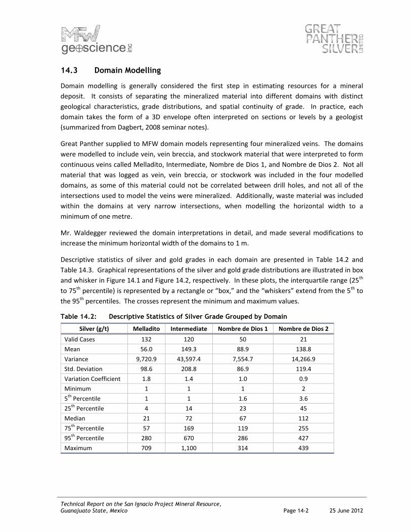
Descriptive statistics of silver and gold grades in each domain are presented in Table 14.2 and
Table 14.3. Graphical representations of the silver and gold grade distributions are illustrated in box
and whisker in Figure 14.1 and Figure 14.2, respectively. In these plots, the interquartile range (25th
to 75th percentile) is represented by a rectangle or “box,” and the “whiskers” extend from the 5th to
the 95th percentiles. The crosses represent the minimum and maximum values.
Table 14.2: Descriptive Statistics of Silver Grade Grouped by Domain
Silver (g/t) Melladito Intermediate Nombre de Dios 1 Nombre de Dios 2
Valid Cases 132 120 50 21
Mean 56.0 149.3 88.9 138.8
Variance 9,720.9 43,597.4 7,554.7 14,266.9
Std. Deviation 98.6 208.8 86.9 119.4
Variation Coefficient 1.8 1.4 1.0 0.9
Minimum 1 1 1 2
5th
Percentile 1 1 1.6 3.6
25th
Percentile 4 14 23 45
Median 21 72 67 112
75th
Percentile 57 169 119 255
95th
Percentile 280 670 286 427
Maximum 709 1,100 314 439
Technical Report on the San Ignacio Project Mineral Resource, Guanajuato State, Mexico Page 14-3 25 June 2012
Figure 14.1: Box and Whisker Plot of Silver Grade Grouped by Domain
Table 14.2 and Figure 14.1 illustrate the different distributions of silver grade per domain. Also
illustrated is the presence of mineralized samples in the waste or outside of the four domains.
Table 14.3: Descriptive Statistics of Gold Grade Grouped by Domain
Gold (g/t) Melladito Intermediate Nombre de Dios 1 Nombre de Dios 2
Valid Cases 132 120 50 21
Mean 1.21 2.31 1.65 2.50
Variance 1.7 7.1 3.9 7.4
Std. Deviation 1.3 2.7 2.0 2.7
Variation Coefficient 1.1 1.2 1.2 1.1
Minimum 0.01 0.01 0.03 0.02
5th
Percentile 0.01 0.04 0.04 0.04
25th
Percentile 0.21 0.42 0.23 0.65
Median 0.78 1.57 0.90 1.16
75th
Percentile 1.94 3.04 2.11 4.23
95th
Percentile 3.52 7.43 5.48 9.76
Maximum 6.74 15 9.37 9.94
Technical Report on the San Ignacio Project Mineral Resource, Guanajuato State, Mexico Page 14-4 25 June 2012
Figure 14.2: Box and Whisker Plot of Gold Grade Grouped by Domain
Table 14.3 and Figure 14.2 illustrate the different distributions of gold grade per domain. Also
illustrated is the presence of mineralized samples in the waste or outside of the four domains.
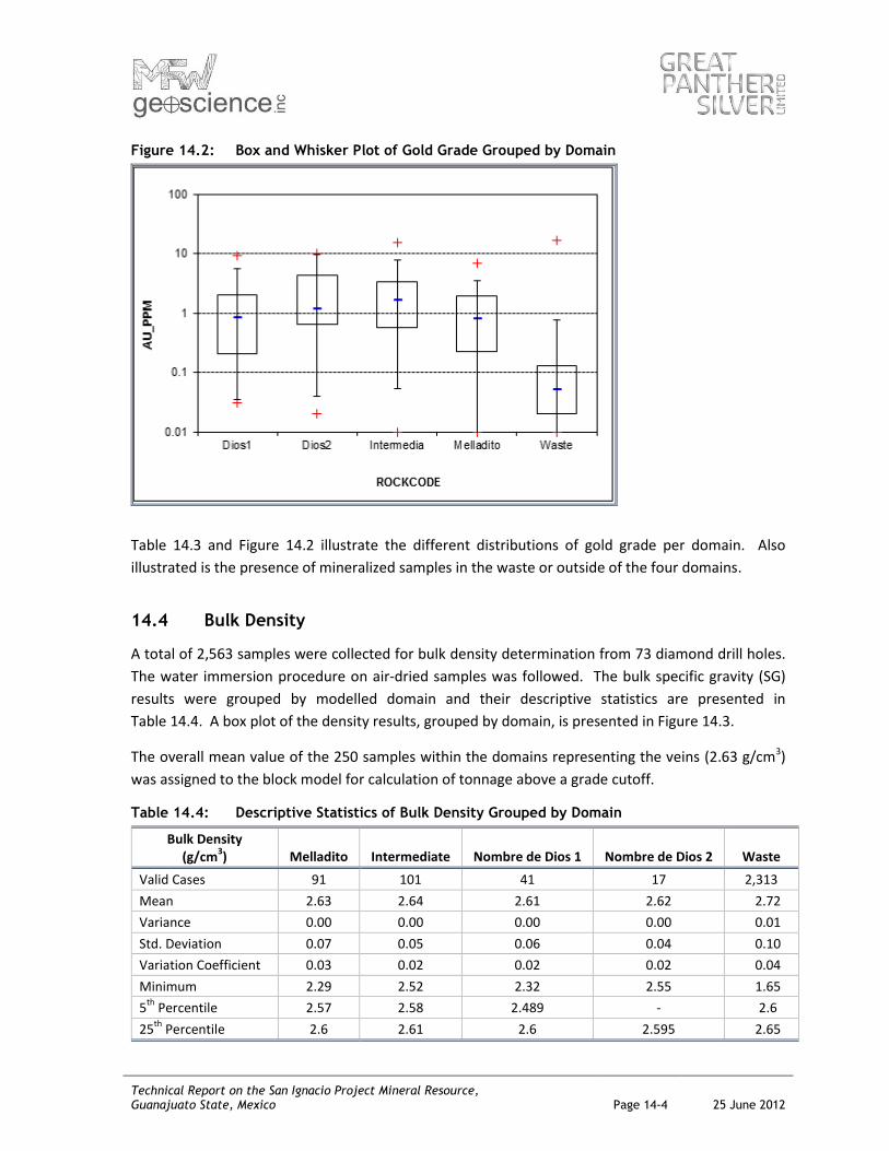
14.4 Bulk Density
A total of 2,563 samples were collected for bulk density determination from 73 diamond drill holes.
The water immersion procedure on air-dried samples was followed. The bulk specific gravity (SG)
results were grouped by modelled domain and their descriptive statistics are presented in
Table 14.4. A box plot of the density results, grouped by domain, is presented in Figure 14.3.
The overall mean value of the 250 samples within the domains representing the veins (2.63 g/cm3)
was assigned to the block model for calculation of tonnage above a grade cutoff.
Table 14.4: Descriptive Statistics of Bulk Density Grouped by Domain
Bulk Density (g/cm
3) Melladito Intermediate Nombre de Dios 1 Nombre de Dios 2 Waste
Valid Cases 91 101 41 17 2,313
Mean 2.63 2.64 2.61 2.62 2.72
Variance 0.00 0.00 0.00 0.00 0.01
Std. Deviation 0.07 0.05 0.06 0.04 0.10
Variation Coefficient 0.03 0.02 0.02 0.02 0.04
Minimum 2.29 2.52 2.32 2.55 1.65
5th
Percentile 2.57 2.58 2.489 - 2.6
25th
Percentile 2.6 2.61 2.6 2.595 2.65
Technical Report on the San Ignacio Project Mineral Resource, Guanajuato State, Mexico Page 14-5 25 June 2012
Bulk Density (g/cm
3) Melladito Intermediate Nombre de Dios 1 Nombre de Dios 2 Waste
Median 2.62 2.63 2.62 2.62 2.71
75th
Percentile 2.66 2.66 2.64 2.655 2.78
95th
Percentile 2.75 2.74 2.67 - 2.89
Maximum 2.88 2.78 2.68 2.7 3.34
Figure 14.3: Box and Whisker Plot of Bulk Density Grouped by Domain
14.5 Treatment of High-Grade Outliers
When estimating resources, high-grade outliers can contribute excessively to the total metal
content of the estimate. In a geologic context, outliers can represent a separate grade population
characterized by its own continuity; generally, there is less physical continuity of high grades than in
the more prevalent lower grades. Thus, serious overestimation of both tonnage and average grade
above a cutoff grade can result if a general model, normally dominated by the lower, more
continuous grades, is applied to very high-grade values. The problem is further exaggerated when
the high-grade samples are isolated in a field of lower grade samples (Sinclair, 2002).
Decile analyses were conducted and histograms and probability plots were reviewed to determine
the potential risk of grade distortion from higher-grade samples.
To select a capping level, one approach is to identify natural breaks in the distribution of the assay
data and probability plot. The silver and gold grade distributions for the raw samples are quasi-
lognormal and, in general, distinct populations and natural breaks were observed.
Technical Report on the San Ignacio Project Mineral Resource, Guanajuato State, Mexico Page 14-6 25 June 2012
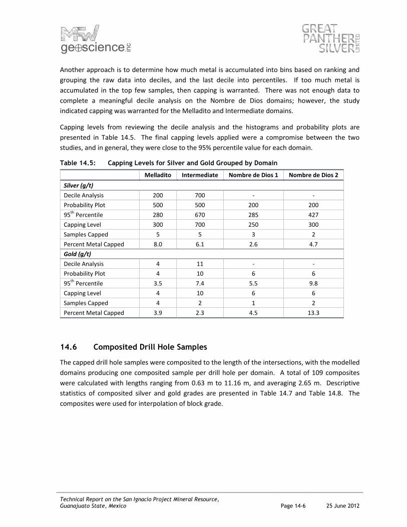
Another approach is to determine how much metal is accumulated into bins based on ranking and
grouping the raw data into deciles, and the last decile into percentiles. If too much metal is
accumulated in the top few samples, then capping is warranted. There was not enough data to
complete a meaningful decile analysis on the Nombre de Dios domains; however, the study
indicated capping was warranted for the Melladito and Intermediate domains.
Capping levels from reviewing the decile analysis and the histograms and probability plots are
presented in Table 14.5. The final capping levels applied were a compromise between the two
studies, and in general, they were close to the 95% percentile value for each domain.
Table 14.5: Capping Levels for Silver and Gold Grouped by Domain
Melladito Intermediate Nombre de Dios 1 Nombre de Dios 2
Silver (g/t)
Decile Analysis 200 700 - -
Probability Plot 500 500 200 200
95th
Percentile 280 670 285 427
Capping Level 300 700 250 300
Samples Capped 5 5 3 2
Percent Metal Capped 8.0 6.1 2.6 4.7
Gold (g/t)
Decile Analysis 4 11 - -
Probability Plot 4 10 6 6
95th
Percentile 3.5 7.4 5.5 9.8
Capping Level 4 10 6 6
Samples Capped 4 2 1 2
Percent Metal Capped 3.9 2.3 4.5 13.3
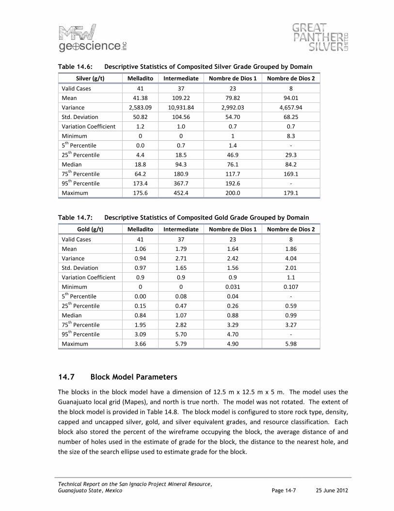
14.6 Composited Drill Hole Samples
The capped drill hole samples were composited to the length of the intersections, with the modelled
domains producing one composited sample per drill hole per domain. A total of 109 composites
were calculated with lengths ranging from 0.63 m to 11.16 m, and averaging 2.65 m. Descriptive
statistics of composited silver and gold grades are presented in Table 14.7 and Table 14.8. The
composites were used for interpolation of block grade.
Technical Report on the San Ignacio Project Mineral Resource, Guanajuato State, Mexico Page 14-7 25 June 2012
Table 14.6: Descriptive Statistics of Composited Silver Grade Grouped by Domain
Silver (g/t) Melladito Intermediate Nombre de Dios 1 Nombre de Dios 2
Valid Cases 41 37 23 8
Mean 41.38 109.22 79.82 94.01
Variance 2,583.09 10,931.84 2,992.03 4,657.94
Std. Deviation 50.82 104.56 54.70 68.25
Variation Coefficient 1.2 1.0 0.7 0.7
Minimum 0 0 1 8.3
5th
Percentile 0.0 0.7 1.4 -
25th
Percentile 4.4 18.5 46.9 29.3
Median 18.8 94.3 76.1 84.2
75th
Percentile 64.2 180.9 117.7 169.1
95th
Percentile 173.4 367.7 192.6 -
Maximum 175.6 452.4 200.0 179.1
Table 14.7: Descriptive Statistics of Composited Gold Grade Grouped by Domain
Gold (g/t) Melladito Intermediate Nombre de Dios 1 Nombre de Dios 2
Valid Cases 41 37 23 8
Mean 1.06 1.79 1.64 1.86
Variance 0.94 2.71 2.42 4.04
Std. Deviation 0.97 1.65 1.56 2.01
Variation Coefficient 0.9 0.9 0.9 1.1
Minimum 0 0 0.031 0.107
5th
Percentile 0.00 0.08 0.04 -
25th
Percentile 0.15 0.47 0.26 0.59
Median 0.84 1.07 0.88 0.99
75th
Percentile 1.95 2.82 3.29 3.27
95th
Percentile 3.09 5.70 4.70 -
Maximum 3.66 5.79 4.90 5.98
14.7 Block Model Parameters
The blocks in the block model have a dimension of 12.5 m x 12.5 m x 5 m. The model uses the
Guanajuato local grid (Mapes), and north is true north. The model was not rotated. The extent of
the block model is provided in Table 14.8. The block model is configured to store rock type, density,
capped and uncapped silver, gold, and silver equivalent grades, and resource classification. Each
block also stored the percent of the wireframe occupying the block, the average distance of and
number of holes used in the estimate of grade for the block, the distance to the nearest hole, and
the size of the search ellipse used to estimate grade for the block.

Technical Report on the San Ignacio Project Mineral Resource, Guanajuato State, Mexico Page 14-8 25 June 2012
Table 14.8: Extent of the San Ignacio Block Model
Minimum Maximum Size (m) No. of Blocks
East -6,993.75 -6,493.75 12.5 40
North -1,431.25 -493.75 12.5 75
Elevation (masl) 1,940 2,415 5 95
14.8 Grade Interpolation
Block grades were interpolated from the drill hole composites. Inverse Distance weighted to the
second power was selected as the distance-weighted method to interpolate grade for all blocks.
Block grades were interpolated in two passes using flattened search ellipses of increasing size for
sample selection. The search ellipses were oriented parallel to each domain, and hard boundaries
were applied between domains to prevent grade smearing from one vein to another.
The search ellipse used in Pass 1 had a radius of 60 m x 30 m thick and for Pass 2 a radius of 120 m x
60 m thick. Block grades were interpolated in the first pass using a minimum of three composites,
and not more than twelve of the nearest composites. Block grades were interpolated in the second
pass using a minimum of two composites, and not more than twelve of the nearest composites.
14.9 Resource Classification
MFW classified resources at San Ignacio as Inferred, in accordance with the Canadian Institute of
Mining and Metallurgy and Petroleum Definition Standards for Mineral Resources and Reserves
(CIM definitions).
It is reasonable to assume that the continuity of the veins has been demonstrated sufficient to
support the Inferred category of resources through Great Panther’s drilling on sections spaced 50 m
apart. Therefore, groups of blocks generally falling within 50 m of a composite were selected on
long section for each domain and classified as Inferred. Blocks beyond the outlined regions were
left unclassified.
14.10 Mineral Resource Tabulation
MFW estimated that the San Ignacio property contains 826,000 tonnes of Inferred Resources above
a cutoff grade of 125 g/t Ag equivalent grade, averaging 2.28 g/t Au and, 121 g/t Ag, and containing
61 koz of gold and 3.2 Moz of silver. The resource grouped by domain is presented in Table 14.9.

Technical Report on the San Ignacio Project Mineral Resource, Guanajuato State, Mexico Page 14-9 25 June 2012
Table 14.9: Inferred Resources above a 125 AgEq g/t Cutoff
Tonnage (kt)
AgEq (ppm)
Au (ppm)
Ag (ppm)
AgEq (koz)
Au (koz)
Ag (koz)
DIOS1 178 224 1.99 103 1,287 11.4 591
DIOS2 147 285 2.38 141 1,346 11.2 663
INT 330 309 2.71 144 3,274 28.8 1,526
MELL 171 180 1.68 77 987 9.3 425
Total 826 260 2.28 121 6,894 60.7 3,205
Equivalent grades are commonly used to simplify the problem of mineral inventory tabulation in
polymetalic deposits. An equivalent grade is one that is a combination of two or more grade
variables in an arbitrary manner to produce a single variable for reporting tonnes and grades above
the equivalent grade cutoff.
At San Ignacio, the silver equivalent grade was calculated as a function of gold and silver grades in
the block model and based on the value ratio of 60.8 to 1 (Ag to Au). The ratio was being used at
Great Panther’s underground operation at the Cata Mine in Guanajuato State, and is considered
applicable for use in this estimate. The ratio considers metallurgical recoveries.
The equation used for silver equivalent grade was:
Ag Equivalent grade = Ag grade + (Au grade x 60.8)
14.11 Block Model Validation
The block grades were validated by visual inspection of the block grades on long section and
comparison with the composited assays. The block grades were observed to honour the composited
grades reasonably well.
MFW also validated the block grades by comparing to a check model. The check model block grade
was estimated using the nearest neighbour method, whereby block grades were assigned the grade
of the closest composite. At a zero cutoff for blocks classified as Inferred, the nearest neighbour
estimate contains 4% fewer ounces of silver and 1% fewer ounces of gold.
14.12 Comparison to Previous Resource Estimate
Great Panther estimated that the San Ignacio project contained Inferred Mineral Resources of
611,000 tonnes averaging 127 g/t Ag and 2.05 g/t Au using a 118 g/t AgEq cutoff grade. The
Company’s qualified mineral resource person, Janelle Smith, AIG, prepared it in-house.
The estimate included data from the first 24 drill holes completed on the property, which covered a
strike length of approximately 300 m between sections 600N to 900N.
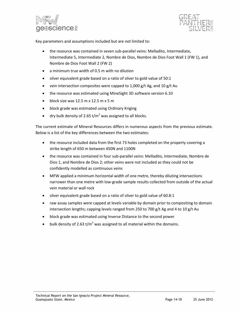
Technical Report on the San Ignacio Project Mineral Resource, Guanajuato State, Mexico Page 14-10 25 June 2012
Key parameters and assumptions included but are not limited to:
the resource was contained in seven sub-parallel veins: Melladito, Intermediate,
Intermediate 5, Intermediate 2, Nombre de Dios, Nombre de Dios Foot Wall 1 (FW 1), and
Nombre de Dios Foot Wall 2 (FW 2)
a minimum true width of 0.5 m with no dilution
silver equivalent grade based on a ratio of silver to gold value of 50:1
vein intersection composites were capped to 1,000 g/t Ag, and 10 g/t Au
the resource was estimated using MineSight 3D software version 6.10
block size was 12.5 m x 12.5 m x 5 m
block grade was estimated using Ordinary Kriging
dry bulk density of 2.65 t/m3 was assigned to all blocks.
The current estimate of Mineral Resources differs in numerous aspects from the previous estimate.
Below is a list of the key differences between the two estimates:
the resource included data from the first 73 holes completed on the property covering a
strike length of 650 m between 450N and 1100N
the resource was contained in four sub-parallel veins: Melladito, Intermediate, Nombre de
Dios 1, and Nombre de Dios 2; other veins were not included as they could not be
confidently modelled as continuous veins
MFW applied a minimum horizontal width of one metre, thereby diluting intersections
narrower than one metre with low-grade sample results collected from outside of the actual
vein material or wall rock
silver equivalent grade based on a ratio of silver to gold value of 60.8:1
raw assay samples were capped at levels variable by domain prior to compositing to domain
intersection lengths; capping levels ranged from 250 to 700 g/t Ag and 4 to 10 g/t Au
block grade was estimated using Inverse Distance to the second power
bulk density of 2.63 t/m3 was assigned to all material within the domains.
Technical Report on the San Ignacio Project Mineral Resource, Guanajuato State, Mexico Page 15-1 25 June 2012
15.0 ADJACENT PROPERTIES
Endeavour Silver Corp. (Endeavour) owns most of the surrounding mineral claims, with Peñoles
owning several small claims. These surrounding claims host both the on-strike continuation of veins
on the property, as well as parallel structures to the east of the property.
Endeavour operates the Bolañitos Mine approximately 3 km north of the San Ignacio shaft, and has
a 1,000 t/d concentrator with plans to expand to 1,600 t/d during 2012. Endeavour is also
developing the Lucero Mine located approximately 200 m east of the north east corner of the
property, which consists of numerous veins parallel to the structures on the property (Endeavour
news release, January 24, 2012).
The author has not verified the information and it is not necessarily indicative of the mineralization
on, nor does it speak to the economic viability of the property that is the subject of this report.

Technical Report on the San Ignacio Project Mineral Resource, Guanajuato State, Mexico Page 16-1 25 June 2012
16.0 INTERPRETATIONS AND CONCLUSIONS
The area in which the San Ignacio property is located has a long history of mining dating back to
1548. There are numerous historical workings on the property and as such, there is a likelihood that
Great Panther could successfully explore for additional mineral resources.
The drilling of 73 diamond drill holes on the San Ignacio property delineated four mineralized
epithermal veins with the primary economic minerals of silver and gold. The veins were observed to
be continuous along strike of up to 650 m and 350 m down dip. The mineralization is open in
several directions most notably to the south where historic mining has occurred.
Logging and sampling procedures followed by Great Panther were appropriate for the deposit type
and mineralization style. The assaying completed at Great Panther’s wholly owned Cata Mine was
managed by SGS Lakefield using conventional methods that are commonly used in the industry.
Metallurgical testwork on fresh drill core from one of the veins in the estimate demonstrated viable
floatation into a suitable concentrate with recoveries ranging from 78.9% to 91.8% for Au and from
76.4% to 89.0% for Ag.
MFW estimated the San Ignacio property contains 826,000 tonnes of Inferred Resource above a
cutoff grade of 125 g/t Ag equivalent grade, averaging 2.28 g/t Au and 121 g/t Ag, and containing
61 kt oz of gold and 3.2 Moz of silver.
This update represents an increase in tonnes of 35%, contained silver ounces of 29%, and contained
gold ounces of 53% over the previous Mineral Resource estimate completed in 2011.
Technical Report on the San Ignacio Project Mineral Resource, Guanajuato State, Mexico Page 17-1 25 June 2012
17.0 RECOMMENDATIONS
MFW recommends a two-phase work program to update the current resource estimate and explore
for additional resources on the San Ignacio property. The budget for this program is summarized in
Table 17.1.
17.1 Phase 1
Additional sampling of the four veins comprising the mineral resource is required before the
resources can be upgraded to indicated and measured categories. To that end, MFW recommends
developing an underground level where sampling the exposed veins in detail will add considerable
confidence to the understanding of grade continuity and geologic controls on mineralization.
Concurrently, surface drilling is recommended to delineate the on strike extension of the Veta
Intermediate, which is currently open to the south of the current resource estimate. The drilling of
6,000 m should continue at the 50 m line spacing from line 400N southward towards line 200S.
MFW also recommends 1,000 m of drilling be budgeted for additional areas such as south of the San
Jose de Garcia shaft in an area of historic underground mining.
17.2 Phase 2
Contingent on positive results of the underground development and sampling from the Phase 1
program, underground drilling of 5,000 m is recommended. At this time, the amount of drilling
estimated is highly uncertain.
Table 17.1: Budget for Proposed Work Plan
Item Units Cost per Unit
(US$) Cost (US$)
Phase 1 Surface Drilling 7,000 200 1,400,000
Underground Development and Sampling - - -
Portal - - 100,000
Ramp 800 m 1,500 1,200,000
Cross-Cuts 100 m 1,000 100,000
Vein Development 250 m 1,000 250,000
Sampling and Testwork - - 350,000
Infrastructure - - 600,000
Security - - 400,000
Total - - 4,400,000
Phase 2 Underground Drilling 5,000 150 750,000
Total - - 750,000
Technical Report on the San Ignacio Project Mineral Resource, Guanajuato State, Mexico Page 18-1 25 June 2012
18.0 REFERENCES
Baker D., 2011. 2011 Geology and Structure Report on the San Ignacio project Guanajuato Mexico.
Prepared for Great Panther Silver Limited by Equity Exploration Consultants Ltd.
Dagbert, 2009. Geostatistical Mineral Resource/Ore Reserve Estimation and Meeting New
Regulatory Environment: Step by Step from Sampling to Grade Control – Seminar Notes,
236 pp.
Lewis W.J., Murahwi C.Z., and Leader R.J. 2011. NI 43-101 Technical Report Audit of the Resources
and Reserve Estimates for the Guanajuato Mines Project, Guanajuato State, Mexico. Prepared
for Endeavour Silver by Mincon International Limited
Rennie D.W., Bergen R.D., 2011. NI 43-101 Technical Report on the Guanajuato Mine Guanajuato
State Mexico. Prepared for Great Panther Silver Limited by Scott Wilson Roscoe Postle
Associates Inc.
Sinclair and Blackwell, Cambridge, 2002. Applied Mineral Inventory Estimation, 381 pp.
Smith J., 2011. Technical Report on the San Ignacio Project Mineral Resource Guanjuato, Mexico.
Prepared for Great Panther Silver Limited by Janelle Smith AIG.
Stewart M., 2006. Lithostratigraphy, Geology and Structure of the Guanajuato Area: Results of
Mapping and Analysis. Prepared for Great Panther Resources Ltd. by Stewart Geoscience
Consulting.
Velazquez P., 1973. A Study of the Possibility that the Luz Mineral Camp of Guanajuato can be a
Resurgent Producer of Silver and Gold. Submitted as part of a Thesis requirement at the
University of Guanajuato School of Mining and Metallurgy.

Technical Report on the San Ignacio Project Mineral Resource, Guanajuato State, Mexico Page 19-1 25 June 2012
19.0 CERTIFICATE OF A QUALIFIED PERSON
I, Michael Waldegger of Vancouver, British Columbia, as the author of this Technical Report titled
“Technical Report on the San Ignacio Project Mineral Resource, Guanajuato State, Mexico,” dated 25
June 2012, do hereby certify that, and make the following statements:
I am the president of MFW Geoscience Inc., with a business address at 5-3437 Wilkie
Avenue, Coquitlam, British Columbia, V3B 0E5.
I am a graduate of the University of Ottawa (B.Sc. Hons., 1998).
I am a member in good standing of the Association of Professional Engineers and
Geoscientists of British Columbia, Registration #33582.
I have practised my profession in the mining industry continuously since graduation.
I have read the definition of “qualified person” set out in NI 43-101 and certify that, by
reason of my education, affiliation with a professional association (as defined in NI 43-101),
and past relevant work experience, I fulfill the requirements to be a “qualified person” for
the purpose of NI 43-101.
My relevant experience includes 15 years working as a geologist in the mining sector. Most
relevant to the subject of this report are the recent six years of estimating mineral resources
on numerous projects around the world in both base metals and precious metals deposits. I
have also been involved in many drill programs in a management capacity, on site logging,
sample chain of custody, and managing drill hole databases.
I am responsible for the contents of this Technical Report titled “Technical Report on the
San Ignacio Project Mineral Resource, Guanajuato State, Mexico,” dated 25 June 2012.
I have no prior involvement with the property that is the subject of the Technical Report.
I have visited the property described in this report on the 8th and 9th of May 2012.
As of the date of this Certificate, to my knowledge, information, and belief, this Technical
Report contains all scientific and technical information that is required to be disclosed to
make the technical report not misleading.
I am independent of the Issuer as defined by Section 1.4 of the Instrument.
I have read NI 43-101 and the Technical Report has been prepared in compliance with
NI 43-101 and Form 43-101F1.
Signed and dated this 25th day of June 2012, at Vancouver, British Columbia.
“Original Signed and Sealed”
Michael Waldegger, P.Geo.
Technical Report on the San Ignacio Project Mineral Resource, Guanajuato State, Mexico Page 20-1 25 June 2012
20.0 DATE AND SIGNATURE PAGE
The effective date of this Technical Report titled “Technical Report on the San Ignacio Project
Mineral Resource, Guanajuato State, Mexico,” is March 31st, 2012.
This report is issued on June 25th, 2012.
“Original Signed and Sealed”
Michael F. Waldegger, P.Geo.
MFW Geoscience Inc.