TECHNICAL REPORT ON THE CERRO QUEMA … REPORT ON THE CERRO QUEMA PROJECT, PANAMA NI 43-101 Report...
87
PERSHIMCO RESOURCES INC. TECHNICAL REPORT ON THE CERRO QUEMA PROJECT, PANAMA NI 43-101 Report Authors: Wayne W. Valliant, P.Geo. Stuart E. Collins, P.E. Holger Krutzelmann, P.Eng. September 10, 2010 SCOTT WILSON ROSCOE POSTLE ASSOCIATES INC. Scott Wilson Mining
Transcript of TECHNICAL REPORT ON THE CERRO QUEMA … REPORT ON THE CERRO QUEMA PROJECT, PANAMA NI 43-101 Report...

PERSHIMCO RESOURCES INC.
TECHNICAL REPORT ON THECERRO QUEMA PROJECT,PANAMA
NI 43-101 Report
Authors:Wayne W. Valliant, P.Geo.Stuart E. Collins, P.E.Holger Krutzelmann, P.Eng.
September 10, 2010
SCOTT WILSON ROSCOE POSTLE ASSOCIATES INC.
Scott Wilson Mining

Report Control Form Document Title Technical Report on the Cerro Quema Project, Panama
Client Name & Address
Pershimco Resources Inc. 7, rue Perreault Est Rouyn-Noranda, Québec J9X 3C1
Document Reference
Project # 1521
Status & Issue No.
Final Version
Issue Date September 10, 2010 Lead Author Wayne W. Valliant
(signed)
Peer Reviewer Richard J. Lambert
(signed)
Project Manager Approval Wayne W. Valliant
(signed)
Project Director Approval
(name)
(signature & date) Report Distribution Name No. of Copies Client Scott Wilson RPA Filing 1 (project box)
1 (project file) Scott Wilson Roscoe Postle Associates Inc.
55 University Avenue, Suite 501 Toronto, Ontario M5J 2H7
Canada Tel: +1 416 947 0907
Fax: +1 416 947 0395 [email protected]

SCOTT WILSON RPA www.scottwilson.com
Pershimco Resources, Inc. – Cerro Quema Project
Technical Report NI 43-101 – September 10, 2010 Page i
TABLE OF CONTENTS PAGE
1 SUMMARY .................................................................................................................... 1-1 Executive Summary ................................................................................................... 1-1 Technical Summary ................................................................................................... 1-3
2 INTRODUCTION .......................................................................................................... 2-1
3 RELIANCE ON OTHER EXPERTS .............................................................................. 3-1
4 PROPERTY DESCRIPTION AND LOCATION ............................................................ 4-1
5 ACCESSIBILITY, CLIMATE, LOCAL RESOURCES, INFRASTRUCTURE AND PHYSIOGRAPHY ............................................................................................................ 5-1
6 HISTORY ...................................................................................................................... 6-1
7 GEOLOGICAL SETTING.............................................................................................. 7-1 Regional Geology ...................................................................................................... 7-1 Local Geology ............................................................................................................ 7-3 Property Geology ....................................................................................................... 7-5
8 DEPOSIT TYPES ......................................................................................................... 8-1
9 MINERALIZATION ........................................................................................................ 9-1
10 EXPLORATION ........................................................................................................ 10-1 Topographical Surveys ............................................................................................ 10-1 Geochemical Surveys .............................................................................................. 10-1 Geophysical Surveys ............................................................................................... 10-2
11 DRILLING .................................................................................................................. 11-1 RC Drill Recovery .................................................................................................... 11-4 Twinned Holes ......................................................................................................... 11-6
12 SAMPLING METHOD AND APPROACH ................................................................ 12-1
13 SAMPLE PREPARATION, ANALYSES AND SECURITY ....................................... 13-1 Sample Preparation and Analyses .......................................................................... 13-1 Specific Gravity Determinations .............................................................................. 13-1
14 DATA VERIFICATION .............................................................................................. 14-1
15 ADJACENT PROPERTIES ...................................................................................... 15-1
16 MINERAL PROCESSING AND METALLURGICAL TESTING ............................... 16-1 Metallurgical Testing ................................................................................................ 16-1 Mineral Processing .................................................................................................. 16-2
17 MINERAL RESOURCE AND MINERAL RESERVE ESTIMATES .......................... 17-1
18 OTHER RELEVANT DATA AND INFORMATION ................................................... 18-1 Mining Operations .................................................................................................... 18-1 Markets..................................................................................................................... 18-5

SCOTT WILSON RPA www.scottwilson.com
Pershimco Resources, Inc. – Cerro Quema Project
Technical Report NI 43-101 – September 10, 2010 Page ii
Environmental Considerations ............................................................................... 18-5
19 INTERPRETATION AND CONCLUSIONS ............................................................. 19-1
20 RECOMMENDATIONS ........................................................................................... 20-1
21 REFERENCES ........................................................................................................ 21-1
22 DATE AND SIGNATURE PAGE ............................................................................. 22-1
23 CERTIFICATE OF QUALIFIED PERSON .............................................................. 23-1
LIST OF TABLES PAGE
Table 1-1 Recommended Work Program .................................................................... 1-3 Table 6-1 Exploration History ....................................................................................... 6-2 Table 6-2 Drilling Summary .......................................................................................... 6-3 Table 6-3 Historical Mineral Resources, Datamine 1996 ............................................. 6-4 Table 9-1 Geographic Limits of the Cerro Quema Mineralization ................................ 9-1 Table 11-1 Drilling Summary ...................................................................................... 11-2 Table 11-2 Twinned Drill Holes Summary .................................................................. 11-7 Table 13-1 Specific Gravity ........................................................................................ 13-2 Table 18-1 Mining Equipment .................................................................................... 18-4 Table 20-1 Recommended Work Program ................................................................ 20-2
LIST OF FIGURES PAGE
Figure 4-1 Location Map .............................................................................................. 4-2 Figure 4-2 Exploitation Concessions ............................................................................ 4-5 Figure 7-1 Regional Geology ....................................................................................... 7-2 Figure 7-2 Local Geology ............................................................................................. 7-4 Figure 7-3 La Pava Deposit Cross Section .................................................................. 7-6 Figure 10-1 Stream Sediment Geochemistry ............................................................. 10-3 Figure 10-2 Regional Soil Geochemistry - Gold ......................................................... 10-4 Figure 10-3 Regional Soil Geochemistry - Copper .................................................... 10-5 Figure 10-4 Regional Soil Geochemistry - Arsenic .................................................... 10-6 Figure 11-1 La Pava Drill Hole Locations ................................................................... 11-3 Figure 11-2 Sample Weight Frequency Distribution for RC samples ......................... 11-4 Figure 11-3 Sample Weight vs. Sample Length for RC Samples .............................. 11-5 Figure 11-4 Sample Weight vs. Weighted Length for RC Samples ........................... 11-6 Figure 11-5 Q-Q Plots of Twinned Holes - La Pava ................................................... 11-8 Figure 11-6 Q-Q Plots of RC vs. DD Twinned Holes - La Pava ................................. 11-8 Figure 16-1 Cerro Quema Overall Flowsheet ............................................................ 16-3

SCOTT WILSON RPA www.scottwilson.com
Pershimco Resources, Inc. – Cerro Quema Project
Technical Report NI 43-101 – September 10, 2010 Page iii
Figure 16-2 Cerro Quema Crushing Plant Flowsheet ................................................. 16-4 Figure 16-3 Cerro Quema Leaching Flowsheet .......................................................... 16-5 Figure 18-1 La Pava Final Pit Design .......................................................................... 18-2

SCOTT WILSON RPA www.scottwilson.com
Pershimco Resources, Inc. – Cerro Quema Project
Technical Report NI 43-101 – September 10, 2010 Page 1-1
1 SUMMARY EXECUTIVE SUMMARY
INTRODUCTION Scott Wilson Roscoe Postle Associates Inc. (Scott Wilson RPA) was retained by
Pershimco Resources Inc. (Pershimco) to prepare an independent Technical Report on
the Cerro Quema Project (the Project) on the Azuero Peninsula in Los Santos Province,
Panama. The purpose of this report is to support an acquisition of the Project. On
September 2010, Pershimco agreed with all stakeholders to acquire all the interest in the
Cerro Quema Project held by Minera Cerro Quema, S.A. (MCQ). The stakeholders are
Central Sun Mining Inc., RNC (Panama) Ltd., Carena Equities Corp., Bellhaven Copper
& Gold Inc. (Bellhaven), and Julio Benedetti. The purchase price is US$6.4 million
including cash payments and Pershimco shares and warrants. There are no royalties or
back-in rights to the vendor. The surface rights of 16 properties, approximately 813 ha,
have been purchased for the Project.
This Technical Report conforms to NI 43-101 Standards of Disclosure for Mineral
Projects. Scott Wilson RPA personnel visited the property on February 2-4, 2010.
The Project has a historical mineral resource estimate. In 1997, a previous owner
completed a feasibility study and initiated open pit development and surface works for a
valley heap leach and process plant. The current concept is to validate the historical
data and mineral resources, re-evaluate the economic viability of developing the Project,
and explore for additional mineralization.
CONCLUSIONS Based on the site visit and review of available documentation, Scott Wilson offers the
following conclusions.
• The favourable results of geochemical surveys identified targets for drill programs which were subsequently completed resulting in the discovery of gold mineralization and mineral resource estimation.
• The sampling approach, sample preparation and analyses are in keeping with industry standard.

SCOTT WILSON RPA www.scottwilson.com
Pershimco Resources, Inc. – Cerro Quema Project
Technical Report NI 43-101 – September 10, 2010 Page 1-2
• The geology and mineralization of the deposit are uncomplicated and facilitate efficient mine planning and grade control.
• The historical 1996 Datamine North America Inc. (Datamine) block model for La Pava is relevant but not reliable.
• There is potential to add to the resource base through exploration.
• There is potential to add to the resource base by testing the possible copper potential below the oxide-sulphide interface.
• The mine design and proposed mining method are appropriate for the deposit.
• The proposed process appears to be amenable to the Cerro Quema Project, although it has not been used for commercial operations.
• The renewed environmental licence (PAMA) has invoked additional work to deal with potential acid mine drainage issues as well as other project preparatory work.
• Acid mine drainage will need to be effectively managed.
• The current data is in numerous reports over two decades and stored on site and at the Bellhaven office in Panama City and on several computers.
RECOMMENDATIONS Scott Wilson RPA offers the following recommendations:
• Continue data verification drilling on the La Pava deposit.
• Investigate quality assurance/quality control procedures and results from previous drill campaigns.
• Complete a NI 43-101 compliant mineral resource estimate of the La Pava deposit based on historical data, data verification drilling and current estimates of gold price, metallurgical recovery, and operating costs.
• Evaluate the possible economic significance of silver.
• Obtain an opinion regarding the legal title of the concessions.
• Develop further design and costing of the waste/tailings dump, earthworks structures, mine contracting, processing, infrastructure, and administration.
• Evaluate economic viability of mining the Quema deposit.
• Evaluate potential copper mineralization below oxidized horizon.
• Do confirmatory pilot plant testwork on representative ore.

SCOTT WILSON RPA www.scottwilson.com
Pershimco Resources, Inc. – Cerro Quema Project
Technical Report NI 43-101 – September 10, 2010 Page 1-3
• The various reports and databases should be centralized and catalogued.
• Complete “Preliminary Assessment” including most current mineral resource estimate, mine and process design, capital and operating costs, social and environmental aspects, and economic analysis. The scope for the mineral processing aspects should include updating testwork incorporating representative mineralization as well as variability testwork. The cost is estimated at approximately US$245,000.
The estimated cost of the recommended work program is summarized in Table 1-1.
TABLE 1-1 RECOMMENDED WORK PROGRAM Pershimco Resources Inc. - Cerro Quema Project
Item Units Cost/Unit Total Cost
($) ($) Data Verification Program Drilling 2,000 m 120 240,000 Assays 2,000 50 100,000 Supervision Lump Sum 60,000 60,000 Other Lump Sum 60,000 60,000 Sub-Total 460,000 Legal Due Diligence Lump Sum 20,000 20,000 Preliminary Assessment Mineral Resource Estimation Lump Sum 25,000 25,000 Life of Mine Plan Lump Sum 10,000 10,000 Metallurgical Testwork Lump Sum 140,000 140,000 Geotechnical Studies Lump Sum 50,000 50,000 Capital & Operating Cost Lump Sum 10,000 10,000 Economic Analysis Lump Sum 10,000 10,000 Sub-Total 245,000 Total 725,000
TECHNICAL SUMMARY
PROPERTY DESCRIPTION AND LOCATION The Project is located on the Azuero Peninsula in Los Santos Province of southwestern
Panama, about 45 km southwest of the city of Chitré and about 190 km, by air,

SCOTT WILSON RPA www.scottwilson.com
Pershimco Resources, Inc. – Cerro Quema Project
Technical Report NI 43-101 – September 10, 2010 Page 1-4
southwest of Panama City. Access to the site from Chitré, the nearest town with regular
air service, is by paved highway for 75 km.
LAND TENURE The Project comprises three exploitation concession contracts totalling 14,893 ha
between the Republic of Panama and Minera Cerro Quema, S.A.
SITE INFRASTRUCTURE Currently, the major assets and facilities associated with the Project are:
• The La Pava and Quema-Quemita gold-silver deposits;
• The drilling database, geological models, and mineral resource models generated since 1993;
• Exploration Camp buildings and facilities;
• Access by public highway and gravel roads to the proposed open pit; • Environmental Management Program (PAMA) permits.
HISTORY Cerro Quema was identified as a potential economic mineral deposit during the United
Nations-supported national surveys in the late 1960s. Various companies explored the
Project over the following 30 years including Compañía de Exploración Minera, S.A.,
Cyprus Minerals Company, Amax Gold Inc. (Amax), and Campbell Resources Inc.
(Campbell). Exploration work included geochemical and geophysical surveys and
drilling.
In 1996, Campbell reported indicated mineral resources of 8.773 million tonnes, grading
1.16 g/t Au, containing 328,000 oz Au.
In 2002, RNC Resources Limited and Bikerman Engineering & Technology Associates
Inc. estimated mineral reserves in the La Pava deposit of 6.037 million tonnes grading,
1.236 g/t Au, containing 240,000 oz Au. This mineral reserve estimate was based on
the Campbell 1996 block model and re-optimized pit shell.

SCOTT WILSON RPA www.scottwilson.com
Pershimco Resources, Inc. – Cerro Quema Project
Technical Report NI 43-101 – September 10, 2010 Page 1-5
In Scott Wilson RPA’s opinion, the foregoing mineral resource and mineral reserve
estimates are relevant in that they were estimated using industry standard procedures by
experienced professionals. However, they should not be considered reliable as the data
cannot be verified, the gold price and estimated operating cost are outdated, and the
mineral resource estimate pre-dates NI 43-101. The subsequent mineral reserve
estimates were based on the 1966 mineral resource estimate and for the same reasons
should not be relied upon.
There has been no historic production from the Cerro Quema Project.
GEOLOGY The geology of the Azuero Peninsula consists of an assemblage of late Cretaceous
through Tertiary intercalated volcanics, volcaniclastics, and marine and terrestrial
sedimentary rocks, intruded by a number of small quartz diorite plutons. Rocks within
the Project area have been classified in government geological maps as being part of
the Ocu Formation that consists of andesitic/dacitic volcanic rocks, limestones,
sandstones, and siltstones.
The deposits at Cerro Quema are hosted in an east to west trending belt of hornblende-
rich porphyritic, pyroclastic flows, and lavas of dacite and andesite composition. The
host rock forms a belt about 10 km long and 1.5 km wide. These rocks are enclosed to
the north and south by epiclastic submarine sediments of andesitic composition.
Geologic mapping suggests that the host rocks at Cerro Quema are conformable with
the enclosing epiclastic sequence. This sequence is thought to be of Upper Cretaceous
age (65 to 70 million years).
The majority of mineralization and waste rock from the Project will likely be composed of
three types of rocks: saprolitic dacite clays, siliceous dacites with varying degrees of acid
leaching, and iron oxide-cemented fault breccias.
Detailed geologic mapping and drill core logging coupled with petrographic and X-ray
diffraction studies have led to the classification of three alterations types: silica-pyrite,
clay-pyrite, and propylitic alteration. The mineralization is mostly restricted to the silica-
pyrite alteration.

SCOTT WILSON RPA www.scottwilson.com
Pershimco Resources, Inc. – Cerro Quema Project
Technical Report NI 43-101 – September 10, 2010 Page 1-6
MINERAL RESOURCES AND MINERAL RESERVES There are no current Mineral Resources or Mineral Reserves as defined by NI 43-101.
METALLURGICAL TESTWORK McClelland Laboratories Inc. and Kappes Cassiday & Associates (KCA), Reno, Nevada,
tested the mineralization from La Pava, Quemita, and Cerro Quema for Amax and others
in 1995, using traditional bottle roll and column tests and determined that the
mineralization was easily crushed and leached rapidly to acceptable levels for heap
leaching.
In 2008, SGS Lakefield Research, Lakefield, Ontario, Canada (SGS Lakefield), on
behalf of INNOVAT Limited (INNOVAT) ran tests for the INNOVAT or ECO-VAT leaching
process. Bench scale work yielded bottle roll recoveries in the 80% to 95% range after
48 hours leaching, on samples from Cerro Quema having gold values ranging from 0.08
g/t Au to 3.01 g/t Au. They also did pulsed column tests to simulate continuous vat
leaching with recoveries ranging from 83% to 96%. Pilot plant testing using continuous
vat leaching was also carried out with mineralized material that had somewhat higher
grades than the overall mineral resource grade. Preliminary, continuous vat leaching
testing was carried out on Cerro Quema ore at SGS Lakefield. Recoveries of 93% were
achieved after 36 hours of leaching.
ENVIRONMENTAL CONSIDERATIONS There is potential for acid mine drainage issues at the Project, however, various studies
have presented mitigation measures.
A closure plan has been developed including a reclamation program at an estimated
cost of approximately US$2.97 million. The Project area naturally reclaims itself due to
the amount of rainfall and nutrients in the soil.
The PAMA permit in place since 2004 expired on December 31, 2009. Bellhaven has
recently resubmitted its environmental permit application to the Panamanian government
for extension, which would allow approximately two years to put the Project into
production. The extension to the PAMA has been granted, with requirements for

SCOTT WILSON RPA www.scottwilson.com
Pershimco Resources, Inc. – Cerro Quema Project
Technical Report NI 43-101 – September 10, 2010 Page 1-7
additional work usually required as a project is brought into production. The extension is
good until December 2012.

SCOTT WILSON RPA www.scottwilson.com
Pershimco Resources, Inc. – Cerro Quema Project
Technical Report NI 43-101 – September 10, 2010 Page 2-1
2 INTRODUCTION Scott Wilson Roscoe Postle Associates Inc. (Scott Wilson RPA) was retained by
Pershimco Resources Inc. (Pershimco) to prepare an independent Technical Report on
the Cerro Quema Project (the Project) on the Azuero Peninsula in Los Santos Province,
Panama. The purpose of this report is to support an acquisition of the Project. On
September 2010, Pershimco agreed with all stakeholders to acquire all the interest in the
Cerro Quema Project held by Minera Cerro Quema, S.A. (MCQ). The stakeholders are
Central Sun Mining Inc., RNC (Panama) Ltd., Carena Equities Corp., Bellhaven Copper
& Gold Inc. (Bellhaven), and Julio Benedetti. The purchase price is US$6.4 million
including cash payments and Pershimco shares and warrants. There are no royalties or
back-in rights to the vendor. The surface rights of 16 properties, approximately 813 ha,
have been purchased for the Project.
Pershimco is a Canadian-based resource exploration corporation that controls up to
100% of the Courville Gold Project in the Abitibi Region of Quebec, Canada, and 50% to
100% of various exploration properties in Chihuahua, Mexico.
As of the date of this report, Pershimco has reached an understanding with Bellhaven
Copper and Gold Inc. (Bellhaven) whereby it will acquire 100% of Bellhaven’s shares of,
and liabilities to, Minera Cerro Quema S.A. (MCQ), a wholly-owned subsidiary of
Bellhaven.
Currently, the major assets and facilities associated with the Project are:
• The La Pava and Quema-Quemita gold-silver deposits;
• The drilling database, geological models, and mineral resource models generated since 1993;
• Exploration Camp buildings and facilities;
• Access by public highway and gravel roads to the proposed open pit; • Environmental Management Program (PAMA) permits.
Scott Wilson RPA has had no previous involvement with the Project. Wayne Valliant,
P.Geo., currently Principal Geologist, Scott Wilson RPA, worked on the Project in 1997
when employed by a previous owner, Campbell Resources Ltd.

SCOTT WILSON RPA www.scottwilson.com
Pershimco Resources, Inc. – Cerro Quema Project
Technical Report NI 43-101 – September 10, 2010 Page 2-2
Pershimco is currently performing data verification and exploration drilling on the Project.
SOURCES OF INFORMATION The site visit was carried out by Principal Geologist Wayne W. Valliant, P. Geo., and
Principal Mining Engineer Stuart E. Collins, P.E., both of Scott Wilson RPA, on February
2–4, 2010.
Discussions were held with personnel from Bellhaven:
• Mr. Julio C. Benedetti, President/CEO of Bellhaven.
• Mr. Thomas Baxter, Consulting Geologist for Bellhaven.
The following Pershimco personnel were present during Scott Wilson RPA’s site visit,
and were instrumental in providing key company and Project information:
• Mr. Loïc Bureau, Engineer, Pershimco.
• Mr. Michel Bureau, Exploration Manager, Pershimco.
Mr. Valliant is the lead Qualified Person for this NI 43-101 report. Mr. Valliant is
responsible for Sections 1-15, 17, 19, and 20; Mr. Collins contributed to Sections 1, 17,
18, 19, and 20. Mr. Krutzelmann contributed to Sections 1, 16, 18, 19, and 20. Because
of the stage of the Project at this time, NI 43-101 Item 25, Additional Requirements
topics were addressed in Section 18.
The documentation reviewed, and other sources of information, are listed at the end of
this report in Section 21, References.

SCOTT WILSON RPA www.scottwilson.com
Pershimco Resources, Inc. – Cerro Quema Project
Technical Report NI 43-101 – September 10, 2010 Page 2-3
LIST OF ABBREVIATIONS Units of measurement used in this report conform to the SI (metric) system. All currency
in this report is US dollars (US$), unless otherwise noted.
µ micron kPa kilopascal °C degree Celsius kVA kilovolt-amperes °F degree Fahrenheit kW kilowatt µg microgram kWh kilowatt-hour A ampere L litre a annum L/s litres per second bbl barrels m metre Btu British thermal units M mega (million) C$ Canadian dollars m2 square metre cal calorie m3 cubic metre cfm cubic feet per minute min minute cm centimetre MASL meters above sea level cm2 square centimetre mm millimetre d day mph miles per hour dia. diameter MVA megavolt-amperes dmt dry metric tonne MW megawatt dwt dead-weight ton MWh megawatt-hour ft foot m3/h cubic meters per hour ft/s foot per second opt, oz/st ounce per short ton ft2 square foot oz Troy ounce (31.1035g) ft3 cubic foot oz/dmt ounce per dry metric tonne g gram PAB Panama Balboa G giga (billion) ppm part per million Gal Imperial gallon psia pound per square inch absolute g/L gram per litre psig pound per square inch gauge g/t gram per tonne RL relative elevation gpm Imperial gallons per minute s second gr/ft3 grain per cubic foot st short ton gr/m3 grain per cubic metre stpa short ton per year hr hour stpd short ton per day ha hectare t metric tonne hp horsepower tpa metric tonne per year in inch tpd metric tonne per day in2 square inch US$ United States dollar J joule USg United States gallon k kilo (thousand) USgpm US gallon per minute kcal kilocalorie V volt kg kilogram W watt km kilometre wmt wet metric tonne km/h kilometre per hour yd3 cubic yard km2 square kilometre yr year

SCOTT WILSON RPA www.scottwilson.com
Pershimco Resources, Inc. – Cerro Quema Project
Technical Report NI 43-101 – September 10, 2010 Page 3-1
3 RELIANCE ON OTHER EXPERTS This report has been prepared by Scott Wilson Roscoe Postle Associates Inc. (Scott
Wilson RPA) for Pershimco Resources Inc. (Pershimco). The information, conclusions,
opinions, and estimates contained herein are based on:
• Information available to Scott Wilson RPA at the time of preparation of this report;
• Assumptions, conditions, and qualifications as set forth in this report; and • Data, reports, and other information supplied by Pershimco, and other third
party sources.
For the purpose of this report, Scott Wilson RPA has relied on ownership information
provided by Pershimco. Scott Wilson RPA has not researched property title or mineral
rights for the Cerro Quema Project and expresses no opinion as to the ownership status
of the property.
Scott Wilson RPA has relied on Pershimco for guidance on applicable taxes, royalties,
and other government levies or interests, applicable to revenue or income from Cerro
Quema Project, in particular, the La Pava resource area.
Except for the purposes legislated under provincial securities a law, any use of this
report by any third party is at that party’s sole risk.

SCOTT WILSON RPA www.scottwilson.com
Pershimco Resources, Inc. – Cerro Quema Project
Technical Report NI 43-101 – September 10, 2010 Page 4-1
4 PROPERTY DESCRIPTION AND LOCATION The Cerro Quema property is located on the Azuero Peninsula in Los Santos Province of
southwestern Panama, about 45 km southwest of the city of Chitré and about 190 km
southwest of Panama City by air. The Panama Canal, which connects the Atlantic and
Pacific oceans, transects the country of Panama. The UTM coordinates for the La Pava
deposit are 549,486 E to 550,303 E and 834,554 N to 834,891 N. The UTM coordinates
for the Quema deposit are 552,918 E to 553,385 E and 834,454 N to 835,984 N. The
Project location is shown in Figure 4-1.

Panama
Rio Telire
Rio General
Rio Grandede Terraba
Rio Coto Brus
Rio
Changuin
ola
Rio
Indio
PanamaCanal
RioChe
po
Rio
Chucunaque
Rio
Atra
to
Rio Tuira
Rio
Balsa
s
Rio Santa Maria
Rio
SanP
ablo
Caribbean Sea
NORTH PACIFIC OCEAN
Gulf of Panama
Bay of Panama
Golfo de losMosquitos
Golfo de Chiriqui
MaddenLake
GatunLake
LagoBayano
ARCHIPIELAGODE LAS PERLAS
Isla deCoiba
BOCAS DEL TORO
CHIRIQUIVERAGUAS
COCLE
COLON
HERRERA
LOSSANTOS
DARIEN
SAN BLAS
PANAMA
COSTARICA
COLOMBIA
PANAMA
San Isidro
UatsiElena
CerroPunta
AlmiranteSalud Chepo
Canita
BalboaLa Chorrera
El ValleEl Cope
Santa FeSoloy
SanAndres
Corredor
Golfito
PalmarSur
Pedregal
Aguadulce YavizaTurbo
Los Asientos
ElTigre
Portobelo
BajoBoquete
PuertoArmuelles
La Concepcion
Tole
Bocas del Toro Colon
PenonomeDavid
Chitre
El Porvenir
Santiago
LaPalma
Las Tablas
83° 81° 79° 77°
9°
7°
77°79°81°83°
7°
9°
Caribbean
Gulf of Mexico
Pacific
Ocean
Sea
Islas de la Bahia
Lago de Nicaragua
Colón
La Palma
Chitré
CERRO QUEMA
Montego Bay
George Town
David
Tegucigalpa
Managua
San Salvador
Guatemala
Belmopan
Panamá
Kingston
Swan Islands (Honduras)
Isla de Providencia (Colombia)
Isla de San Andréas (Colombia)
Cayos Miskitos
Islas del Maíz
Isla del Rey
Isla de San José
Isla de Coiba
Honduras
Panama
Nicaragua
Costa Rica
Guatemala
El Salvador
Belize
Mexico Jamaica
Cayman Islands (U.K.)
80°85°90°
10°
15°
Central America
San José
Colombia
Panama Canal
200 nautical miles
0
0
100
100
200 kilometers
CERRO QUEMA
International Boundary
Legend:
National Capital
Province Boundary
Provincial Capital
Road
Railroad
Major Cities
San Blas is a territory (comarca).
0
0
25 50
25 50
75 Kilometers
75 Miles
N
September 2010
Cerro Quema Project
Location Map
Pershimco Resources Inc.
Los Santos Province, Panama
Figure 4-1
SC
OT
TW
ILS
ON
RP
A
4-2
ww
w.sco
ttwilso
n.co
m

SCOTT WILSON RPA www.scottwilson.com
Pershimco Resources, Inc. – Cerro Quema Project
Technical Report NI 43-101 – September 10, 2010 Page 4-3
LAND TENURE The Cerro Quema property comprises three exploitation concession contracts between
the Republic of Panama and Minera Cerro Quema, S.A. (MCQ):
• Contract No. 19 (No. MCQSA-EXTR (gold and silver 96-63) for 5,000 ha dated
February 26, 1997, and effective for 20 years).
• Contract No. 20 (No. MCQSA-EXTR (gold and silver 96-62) for 5,000 ha dated February 26, 1997, and effective for 20 years).
• Contract No. 21 (No. MCQSA-EXTR (gold and silver 96-64) for 4,893 ha dated March 3, 1997, and effective for 20 years).
The exploitation concessions listed above total 14,893 ha, and are in good standing. It
is unknown how the property boundaries are located, i.e., paper staking or physical
staking.
Concession contracts include the following provisions:
• A land tax and royalty against production must be paid to the government as per Article 211 of the Natural Resources Code.
• The concession holder must submit to the government a detailed work plan each year including approximate cost.
• The concession holder has the right to import equipment, parts, and supplies to be used in any mining operation free of importation taxes and custom fees, except for fuel and vehicles that are not used in the mining operation.
• A warranty fund in the amount of 100,000 PAB (approximately equivalent to US$100,000) in the form of an insurance company deposit must be put in place to guarantee the payment of repairs for damage caused by dangerous acts or restoration due to abandonment for each concession. The fund must stay in place for two years after the expiration of the contract to ensure compliance.
• A warranty fund in the amount of 15,000 PAB must be put in place to guarantee compliance with the obligations of each contract.
On September 2010, Pershimco agreed with all stakeholders to acquire all the interest in
the Cerro Quema Project held by MCQ. The stakeholders are Central Sun Mining Inc.,
RNC (Panama) Ltd., Carena Equities Corp., Bellhaven Copper & Gold Inc., and Julio
Benedetti. The purchase price is US$6.4 million including cash payments and
Pershimco shares and warrants. There are no royalties or back-in rights to the vendor.
SCOTT WILSON RPA www.scottwilson.com
Pershimco Resources, Inc. – Cerro Quema Project
Technical Report NI 43-101 – September 10, 2010 Page 4-4
The possessory rights (surface rights) of 16 properties, approximately 813 ha, have been
purchased for the Project. All possessory rights were purchased by Thomas Baxter on
behalf of Compañía de Exploración Minera, S.A. (CEMSA). An agreement exists
between Baxter and Minera Cerro Quema S.A. ceding all possessory rights to MCQ.
Pershimco will acquire the possessory rights to the Project through its acquisition of
MCQ.
On July 19, 1993, the National Directorate of the Agrarian Reform approved resolution
No. DN 082-93 authorizing CEMSA the use of land for mining purposes for the duration
of the concessions. This resolution covers 645.574 ha. This resolution requires
updating, as MCQ is the current concession holder and additional possessory rights
have been purchased by RNC Resources Limited (RNC).
Pershimco has retained legal representation to ensure that the Project has clear title and
confirm that there are no lawsuits that are related to the Project.
The limit of the exploitation concessions are illustrated in Figure 4-2.

0 1 4
Kilometres
2 3
N
Current Concession Limits
560000 m
E
55
00
00
mE
55
50
00
mE
830000 mN
835000 mN
Source: Bellhaven Copper & Gold Inc., 2009.September 2010
Cerro Quema Project
Exploitation Concessions
Pershimco Resources Inc.
Los Santos Province, Panama
Figure 4-2
4-5
SCOTT WILSON RPA www.scottwilson.com

SCOTT WILSON RPA www.scottwilson.com
Pershimco Resources, Inc. – Cerro Quema Project
Technical Report NI 43-101 – September 10, 2010 Page 5-1
5 ACCESSIBILITY, CLIMATE, LOCAL RESOURCES, INFRASTRUCTURE AND PHYSIOGRAPHY The “Accessibility, Climate, Local Resources, Infrastructure and Physiography” are taken
largely from RNC and Bikerman, 2002.
ACCESSIBILITY The Cerro Quema Project is at the intersection of three districts within the Los Santos
Province: Macaracas, Tonosi, and Las Tablas. The closest large villages are
Bombachito, Llano de Piedra, and Macaracas to the north and Tonosi to the southeast.
Access to the site from Chitré, the nearest town with regular air service, is by paved
highway for 75 km, via the northern villages to the small village of Río Quema, then by
all-weather road for five kilometres to the Project site. The portion of the access road
between Río Quema and the southern concession boundary is a public road.
CLIMATE There are no long-term reliable meteorological data from Cerro Quema. The nearest
station is located in Santiago, approximately 80 km northwest of the Project site. Other
climatological stations, such as Los Santos and Tonosi, are closer to the site; however,
according to the Atlas Nacional de la República de Panamá, the average annual
precipitation and monthly distribution of precipitation at the Santiago stations is closer to
that expected at the site. Therefore, data from this weather station were adjusted for
elevation differences and applied to the Project design. A meteorological station is
currently in place at the Project site. The data collected includes temperature, rainfall,
wind speed, and direction.
Monthly average air temperatures at the Cerro Quema site were determined by adjusting
data from the Santiago station. The Cerro Quema monthly average maximum and
minimum air temperatures were determined to be 28.5°C and 20.4°C. The Atlas
Nacional de la República de Panamá indicates that the annual mean temperature at the
project site is about 25.5°C.

SCOTT WILSON RPA www.scottwilson.com
Pershimco Resources, Inc. – Cerro Quema Project
Technical Report NI 43-101 – September 10, 2010 Page 5-2
Regionally, wind velocity averages approximately 1.30 km/h with the strongest winds
from January to March. Wind direction is typically from the north and northwest during
the dry season and from the west during the rainy season. Wind data from the Project
site indicates that the wind is predominantly from the north-northeast.
Panama has two distinct seasons: a warm, dry season that lasts from December to mid-
May, and a wet, humid season from mid-May through November. Precipitation typically
occurs during torrential tropical thunderstorms. The Santiago station had a precipitation
record from 1971 through 1990, a period of 20 years. The maximum annual precipitation
was approximately 3,160 mm, and the minimum was approximately 1,454 mm.
Preliminary analysis of the data indicates that site precipitation generally increases
toward the southwest. The annual average precipitation for Santiago is about 2,512 mm
per year.
LOCAL RESOURCES Macaracas and Tonosi will be the districts more directly affected by the Project because
they are proximate to the Project and the highway that connects the district seats passes
near the Project area. The 1990 census reported that these districts have populations of
9,280 and 9,336, respectively. Populations in the towns of Macaracas and Tonosi are
1,768 and 1,411, respectively.
The towns under the immediate influence of the Project include Río Quema, La Llana,
Quebrada Quema, and Boca de Quema in Tonosi District, and Río Abajo in Macaracas
District. All of these communities are small villages with the exception of Quebrada
Quema and Río Abajo, which are dispersed residences. The combined population of
these communities, according to the 1990 census, is 399 people living in 116 houses.
Most of the population stems from emigrants to the region in the 1940s and 1950s.
Population densities in the subdistricts containing these communities are very low, at
approximately five people per square kilometre. Fifty-four percent of the local residents
are 20 years of age or older.
This Project can be operated on a continuous basis. However, there will be periods of
time that operations may be suspended due to high precipitation.

SCOTT WILSON RPA www.scottwilson.com
Pershimco Resources, Inc. – Cerro Quema Project
Technical Report NI 43-101 – September 10, 2010 Page 5-3
INFRASTRUCTURE No infrastructure exists at the Project. However, within five kilometres of the Project
area, there are offices, an equipment laydown area, and a sample storage area under
the control of MCQ. Electrical power for a mining and processing facility would likely be
generated from on-site diesel-powered generators.
PHYSIOGRAPHY The terrain in the region is rugged, with a maximum relief of about 850 m.
Approximately 20% of the area has slopes of less than 55%, while the remaining 80%
has steeper slopes. With the exception of the site access road and exploration drill
roads, the surrounding countryside is only accessible via footpaths. Much of the
surrounding area has been deforested and converted to pasture lands. The deforested
areas are covered by one metre to two metre high hummocks of grasses, matted ferns,
and scattered small trees. Thick stands of forest persist along some of the drainages
and in the steeper valleys. Less than 5% of the Project area consists of rock exposures.
Rockiness is typically slight in the soils on shallower slopes and moderate on steeper
slopes. More extensive rock exposures are typically along active stream beds.

SCOTT WILSON RPA www.scottwilson.com
Pershimco Resources, Inc. – Cerro Quema Project
Technical Report NI 43-101 – September 10, 2010 Page 6-1
6 HISTORY OWNERSHIP HISTORY Cerro Quema was identified as a potential economic mineral deposit during the United
Nations-supported national surveys in the late 1960s. CEMSA investigated the area in
1986, and obtained the exploration concession for Cerro Quema in 1988. The
exploration program revealed the prospect of a mineable gold deposit.
Cyprus Minerals Company (Cyprus) formed a joint venture with CEMSA in 1990 to
create Cyprus Minera de Panama, S.A. (Cyprus S.A.). From 1990 to 1994, Cyprus S.A.
conducted advanced exploration drilling of the La Pava, Quema, and Quemita
mineralization.
Amax Gold Inc. (Amax) merged with Cyprus in 1993 to form Cyprus Amax Minerals and
formed MCQ, to proceed with permitting and development.
Campbell Resources Inc. (Campbell) purchased the right of first refusal on the Project
from CEMSA, and exercised that right when Cyprus S.A. put the property up for sale in
1996. Campbell subsequently earned a 100% interest in the Project, carried out an infill
drilling program to further define the resources, and completed a Project Feasibility
Study. Campbell sold its 100% interest in the Project to Carena Equities Corporation of
Panama (Carena) in August 2001.
RNC Resources Ltd. (RNC) entered into an agreement with Carena in January 2002,
wherein RNC agreed to complete a “bankable” Feasibility Study on the Cerro Quema
Project and to place the Project into production for a 50% participation in the Project.
On September 27, 2007, Bellhaven Copper and Gold Inc. (Bellhaven) signed a Definitive
Agreement (DA) with Carena to acquire a 40% interest in the Project. Further, on
November 1, 2007, Bellhaven signed a DA to acquire the remaining 60% interest from
Central Sun Mining Inc. (formerly Glencairn Gold Corp.). The total purchase price of the
property was US$10.4 million and is equivalent to US$23 per ounce of gold in the
measured and indicated resource categories. At that time and upon completion of
payments, Cerro Quema would be 100% wholly-owned by Bellhaven, subject to a 4%

SCOTT WILSON RPA www.scottwilson.com
Pershimco Resources, Inc. – Cerro Quema Project
Technical Report NI 43-101 – September 10, 2010 Page 6-2
net smelter return (NSR) royalty and 9% net profits interest (NPI) royalty. Subsequent to
the completion of payments, on November 13, 2008, Bellhaven and Weston Resources
Inc. signed a letter of intent for Bellhaven to purchase the 9% NPI royalty. This purchase
was to be completed by December 15, 2008. Bellhaven retained INNOVAT Limited
(INNOVAT) to prepare a feasibility study for the Project. The results are summarized in
Section 16, Mineral Processing and Metallurgical Testing and Section 18, Other
Relevant Data and Information.
Scott Wilson RPA understands from Pershimco that the 9% NPI purchase has been
completed.
Land required for the operation of the Project has been acquired. The possessory rights
(surface rights) are controlled by Bellhaven and there is no title to the land. As long as
the concessions are in existence, no other parties can request title to the properties. A
purchase agreement between Carena and RNC to purchase 50% of the outstanding
shares of MCQ was completed on February 11, 2004. Currently, it is understood
through conversations with Julio Benedetti, president of Aurum Exploration (a subsidiary
of Bellhaven), that the Project is subject to a 4% NSR royalty, 2% to be paid to CEMSA
and 2% to be paid to the Government of Panama. Current Project holding costs are
estimated to range between US$1.0 million to US$1.5 million per year.
There has been no historic production from the Cerro Quema Project.
EXPLORATION HISTORY The exploration history is summarized in Table 6-1 and Table 6-2. Further details are
provided in Section 10, Exploration and Section 11, Drilling.
TABLE 6-1 EXPLORATION HISTORY Pershimco Resources Inc. - Cerro Quema Project
Year Company Work Completed 1990-1994 Cyprus Geochemical surveys
Geophysical surveys
Drilling (see Table 6-2)
1996 Campbell Drilling (see Table 6-2)

SCOTT WILSON RPA www.scottwilson.com
Pershimco Resources, Inc. – Cerro Quema Project
Technical Report NI 43-101 – September 10, 2010 Page 6-3
TABLE 6-2 DRILLING SUMMARY Pershimco Resources Inc.– Cerro Quema Project
Company
La Pava Remainder of Concession RC Drilling Core Drilling RC Drilling Core Drilling
No. Holes
Length (m)
No. Holes
Length (m)
No. Holes
Length (m)
No. Holes
Length (m)
1990 (Cyprus) 3 298.8 1991 (Cyprus) 28 1,820.1 2 119.3 11 662 2 168 1992 (Cyprus) 41 3,271.5 3 324.8 35 2,186 1993 (Cyprus) 11 1,086.3 23 1,289.9 1994 (Cyprus) 80 6,400.7 13 1,180.5 51 3,238.5 7 453.7 1996 (Campbell) 29 1,749.6 Total 149 11,492.3 61 4,759.3 97 6,086.5 32 1,911.6
HISTORICAL MINERAL RESOURCES AND MINERAL RESERVES ESTIMATES CAMPBELL RESOURCES INC. Mineral resources were estimated by Datamine North America Inc. (Datamine) under the
supervision of Wayne Valliant (previously of Campbell) in 1996. Mineralized envelopes
were correlated based on silica, pyrite, oxidation, and gold grade. The saprolite cap was
excluded from the mineral resource estimate. Block models were created for La Pava
and Quema using block dimensions of 10 m x 10 m x 3 m high. Grade interpolation
incorporated search distances and directions were consistent with the variography.
Datamine used nearest neighbour, inverse distance cubed (ID3), and ordinary kriging for
grade interpolation and determined that ordinary kriging was the most appropriate
method based on the coefficient of variation for each model.
Datamine created optimized pit shells using mining costs at US$1.27/t, processing costs
at US$2.34/t (based on valley leach), general and administrative costs (G&A) at
US$1.58/t, US$400/oz Au, 86% metallurgical recover, and variable pit slopes. The
resultant mineral resources within the optimized pit shells are summarized in Table 6-3.

SCOTT WILSON RPA www.scottwilson.com
Pershimco Resources, Inc. – Cerro Quema Project
Technical Report NI 43-101 – September 10, 2010 Page 6-4
TABLE 6-3 HISTORICAL MINERAL RESOURCES, DATAMINE 1996 Pershimco Resources Inc. - Cerro Quema Project
Zone Tonnes Grade Contained Au
(t 000s) (g/t Au) (oz) La Pava 5,854 1.19 224,000 Quema 2,919 1.11 104,000 Total 8,773 1.16 328,000 Notes: 1. Mineral resources are not NI 43-101 compliant 2. Mineral resources estimated at US$400/oz Au 3. Mineral resources estimated at 0.35 g/t Au cut-off grade
RNC RESOURCES LTD. In 2002, RNC and Bikerman completed a feasibility study on the La Pava deposit.
Bikerman reviewed and accepted the kriged Datamine block model and re-optimized the
pit based on mining costs at US$0.81/t for ore and US$0.86 for waste, processing costs
at US$2.92/t, G&A at US$0.68/t, US$325/oz Au, 80% metallurgical recovery, and 45° pit
slopes. The resultant cut-off grade was 0.45 g/t Au. Ten percent dilution was added to
the mineral resources for conversion to mineral reserves. Only the La Pava zone was
considered for the study. The resultant mineral reserve estimate was 6.037 million
tonnes grading 1.24 g/t Au, containing 240,000 oz Au.
Bikerman estimated mineral reserves based on a designed pit with 6.0 m benches, 18 m
wide haul roads with a maximum 10% grade, mining dilution of 2.0 m at 0.30 g/t Au, and
pit slopes ranging from 40° to 50°. The resultant proven plus probable mineral reserve
estimate was 6.037 million tonnes grading 1.236 g/t Au, containing 240,000 oz Au.
CHLUMSKY, ARMBRUST AND MEYER In 2002, Chlumsky, Armbrust and Meyer, LLC (CAM) prepared a mineral reserve audit
for RNC. CAM reviewed and accepted the kriged, Datamine block model and re-
optimized the pit based on mining costs of US$0.85/t and US$0.83/t for ore and waste
respectively, processing costs of US$2.95/t, G&A of US$0.71/t US$325/oz Au, 80%
metallurgical recovery, and variable pit slopes. The resultant cut-off grade was 0.57 g/t
Au. A two metre shell was added to the mineral resources for conversion to mineral
reserves for a total in La Pava of 6.344 million tonnes, grading 1.178 g/t Au, containing
240,000 oz Au.

SCOTT WILSON RPA www.scottwilson.com
Pershimco Resources, Inc. – Cerro Quema Project
Technical Report NI 43-101 – September 10, 2010 Page 6-5
SCOTT WILSON RPA OPINION REGARDING HISTORICAL RESOURCE ESTIMATES In Scott Wilson RPA’s opinion, the foregoing mineral resource and mineral reserve
estimates are relevant in that they were estimated using industry standard procedures
done by experienced professionals. However, they should not be considered reliable as
the data cannot be verified, the gold price and estimated operating cost are outdated,
and the mineral resource estimate pre-dates NI 43-101. The subsequent mineral
reserve estimates were based on the 1996 mineral resource estimate and for the same
reasons should not be relied upon.

SCOTT WILSON RPA www.scottwilson.com
Pershimco Resources, Inc. – Cerro Quema Project
Technical Report NI 43-101 – September 10, 2010 Page 7-1
7 GEOLOGICAL SETTING The “Geological Setting” of the property is taken largely from RNC and Bikerman (2002).
REGIONAL GEOLOGY The geology of the Azuero Peninsula consists of an assemblage of late Cretaceous
through Tertiary intercalated volcanics, volcaniclastics, and marine and terrestrial
sedimentary rocks, intruded by a number of small quartz diorite plutons. Tectonically,
the region is near the intersection of the Cocos, Caribbean, and Nazca plates, and is
undergoing strike-slip faulting, subduction, and some rotational movements along
different portions of the plate boundaries. At the time of deposition/emplacement of the
rocks in the area, the region appears to have been a forearc basin, with the felsic
plutons representing the remnants of the root system of a late Mesozoic to early Tertiary
magmatic island arc.
Three major northwest-trending faults cross the region. One of these faults, the Sona-
Azuero fault, is an apparent crustal suture zone. Strong N60°W trending lineaments
flank this fault in a 40 km wide zone that includes the Project area.
Rocks within the Project area have been classified in government geological maps as
being part of the Ocu Formation that consists of andesitic/dacitic volcanic rocks,
limestones, sandstones, and siltstones.
The regional geology is illustrated in Figure 7-1.

0 5 25
Kilometres
10 15 20
N
Source: CAM, 2003.September 2010
Cerro Quema Project
Regional Geology
Pershimco Resources Inc.
Los Santos Province, Panama
Figure 7-1
7-2
SCOTT WILSON RPA www.scottwilson.com

SCOTT WILSON RPA www.scottwilson.com
Pershimco Resources, Inc. – Cerro Quema Project
Technical Report NI 43-101 – September 10, 2010 Page 7-3
LOCAL GEOLOGY The deposits at Cerro Quema are hosted in an east to west trending belt of hornblende-
rich porphyritic, pyroclastic flows, and lavas of dacite and andesite composition. The
host rock forms a belt about 10 km long and 1.5 km wide. These rocks are enclosed to
the north and south by epiclastic submarine sediments of andesitic composition. These
epiclastics display repetitive graded bedding indicative of cyclic deposition as submarine
turbidity flows and are locally intercalated with dirty marls and cherts. This sequence
dips to the south at 40° to 60°, but is not overturned. Intercalated with the epiclastics to
the south are outcrops of highly sheared basalts that locally contain pillow structures.
Geologic mapping suggests that the host rocks at Cerro Quema are conformable with
the enclosing epiclastic sequence. This sequence is thought to be of Upper Cretaceous
age (65 to 70 million years).
The local geology is illustrated in Figure 7-2.

Gold Deposits
Indications of Gold andf Copper
0 1 4
Kilometres
2 3
N
September 2010 Source: CAM, 2003.
Cerro Quema Project
Local Geology
Pershimco Resources Inc.
Los Santos Province, Panama
Figure 7-2
7-4
SCOTT WILSON RPA www.scottwilson.com

SCOTT WILSON RPA www.scottwilson.com
Pershimco Resources, Inc. – Cerro Quema Project
Technical Report NI 43-101 – September 10, 2010 Page 7-5
PROPERTY GEOLOGY The three known target areas are cut by sets of north, northwest, and northeast trending
faults, generally with indeterminate attitudes. Rocks in the Project’s resource areas
frequently exhibit jointing on a 30 cm to 50 cm scale, with joint orientations tending to
parallel fault strikes. The Chontal shear zone, a N20°W trending structure, appears to
have undergone vertical and left-lateral displacement, and offsets the La Pava and
Quema/Quemita ridgelines. Well developed shear lineations are apparent in the bedrock
exposed in the Quebrada Chontal drainage.
The majority of ore and waste rock produced from the three open pits will likely be
composed of three types of rocks: saprolitic dacite clays, siliceous dacites with varying
degrees of acid leaching, and iron oxide-cemented fault breccias. The saprolitic dacites
are highly argillized and generally retain many of the lithologic and structural features
seen in non-argillized dacite; euhedral hornblende phenocrysts are often altered to clays
without sign of oxidation. Silica and iron oxides account for the bulk of the mineralogy in
the siliceous dacites. In some zones, acid leaching was strong enough to leach the rock
of all constituents except silica, producing an extremely friable rock. These highly
leached rocks often resemble tuffs or fine-grained quartz sandstones. Fault traces were
frequently mapped by the occurrences of the third common pit rock type, recemented
iron oxide breccias. The breccias range in texture from rubble and fragmental to fine-
grained micro-stockwork quartz veinlets in a hematitic matrix.
The property geology is illustrated in a typical cross section on the La Pava deposit in
Figure 7-3.
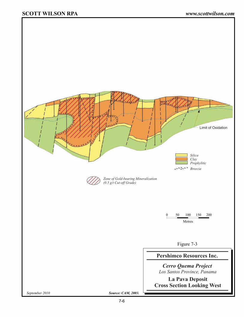
Silica
Limit of Oxidation
ClayProphylitic
Breecia
Zone of Gold-bearing Mineralization(0.5 g/t Cut-off Grade)
0 50 200
Metres
100 150
Source: CAM, 2003.September 2010
Cerro Quema Project
La Pava DepositCross Section Looking West
Pershimco Resources Inc.
Los Santos Province, Panama
Figure 7-3
7-6
SCOTT WILSON RPA www.scottwilson.com

SCOTT WILSON RPA www.scottwilson.com
Pershimco Resources, Inc. – Cerro Quema Project
Technical Report NI 43-101 – September 10, 2010 Page 7-7
STRUCTURAL GEOLOGY Access roads built during the 1996 field investigation provided exposures of bedrock in
the Chontal drainage area, which allowed geologists to gain significant insight into the
local structural conditions. Three fault systems are evidenced in the Chontal drainage
basin. A N85°E trending fault associated with the regional structural system crosses the
Chontal drainage to the north of the leach pad area. The fault dips to the north at
approximately 40°, and is associated with silicic and argillic alteration similar to that
present at La Pava and Quema/Quemita.
In the Quebrada Chontal drainage basin, the N20°W Chontal shear zone intersects and
offsets the east-west fault with estimated left-lateral displacement of 100 m to 150 m in
the pad/pond embankment area. The Quebrada Chontal waterway generally follows the
fault zone. Displacement and shearing associated with the Chontal fault seem to
diminish to the northwest and no lateral displacement is evident on aerial photographs in
the area near the Quebrada Chontal and Rio Quema confluence. Likewise, in the pond
area and upstream in the Chontal drainage the displacement becomes less evident to
the southeast, although drainages to the southeast have similar orientations. The fault
trace may have been covered by a younger dacite tuff that makes up the ridgeline of the
upper Chontal basin.
A younger fault system striking roughly N40°E cuts both the east-west and Chontal faults
and is evidenced by several faults in the area. No apparent offset is associated with
these faults. In the upper Chontal drainage, two faults were observed which are
believed to be part of this system. A small fault trending N45°E was visible in dozer road
cuts where it crosses Quebrada Chontal within the proposed pad/pond site. The
northwest fork of the upper Quebrada Chontal drainage appears to follow another fault in
this system. Similar trending faults cut the La Pava and Quema/Quemita deposits. It
was not possible to determine whether any of the fault systems showed recent activity
using field and aerial reconnaissance.
ALTERATION AND MINERALOGY Detailed geologic mapping and drill core logging coupled with petrographic and X-ray
diffraction studies have led to the classification of three alterations types: silica-pyrite,
clay-pyrite, and propylitic alteration.

SCOTT WILSON RPA www.scottwilson.com
Pershimco Resources, Inc. – Cerro Quema Project
Technical Report NI 43-101 – September 10, 2010 Page 7-8
The silica-pyrite alteration is characterized on surface by a highly fractured, vuggy,
locally brecciated rock composed of silica and iron oxides. Open casts which were once
hornblendes or feldspars are common. This oxidized rock is referred to as a leached
cap and extends to a depth of up to 150 m. Beneath the oxidation boundary, pyrite is
abundant (up to 35% of the rock) and occurs in fractures, disseminations, and as
replacements after feldspar and hornblende. The mineral assemblage includes alunite,
pyrite, dickite, quartz, pyrophyllite, barite, interlayered illite-smectite, illite, kaolinite,
apatite, and rutile. This assemblage is indicative of deposition under low pH conditions
and high sulphur fugacites.
With few exceptions, ore grade mineralization (>0.5 g/t Au) is restricted to this alteration
type within the leached cap. Anomalous gold occurs in deep pyrite-bearing breccias at
La Pava (0.2 g/t Au to 0.7 g/t Au range). The silica-pyrite alteration forms the core of the
deposits and is flanked on all sides by a clay envelope. At the La Pava and Quemita
deposits, clay locally overlies the silicified core forming an unmineralized veneer over
mineralized rock from 5 m to 20 m thick.
Within the silica-pyrite zone and locally cross-cutting the adjacent clay zone on the south
side of the La Pava pit, late, steeply dipping chalcopyrite veinlets with white vuggy silica
halos occur. These appear to be associated with late fracturing during a major
brecciation event. In this area, a restricted zone of high-grade supergene copper
mineralization (0.5% to 5.0%) is present immediately beneath the oxidation interface
associated with gold mineralization in the 0.5 g/t Au to 2.5 g/t Au range. Copper
minerals are dominated by chalcopyrite and covellite.
The clay-pyrite alteration contains illite, kaolinite, and hematite. This alteration type is
characterized in weathered outcrops by its soft, clayey nature and reddish mottled
colouring. Abundant disseminated pyrite occurs at depth. Much of the clay seen at
surface may have formed during supergene oxidation of the pyrite. Clay alteration forms
a boundary between the silicic mineralized core and an outer propylitic alteration zone. It
is less permeable that the silicic alteration, and is consequently less weathered and
rarely contains gold mineralization.
Propylitic alteration forms the outer margins of the deposits and is characteristically a
green rock which contains chlorite, calcite, siderite, halloysite, laumonite, hematite, and

SCOTT WILSON RPA www.scottwilson.com
Pershimco Resources, Inc. – Cerro Quema Project
Technical Report NI 43-101 – September 10, 2010 Page 7-9
illite. At La Pava, down-faulted blocks of propylitic alteration overlie deeper clay and
silica-pyrite zones.

SCOTT WILSON RPA www.scottwilson.com
Pershimco Resources, Inc. – Cerro Quema Project
Technical Report NI 43-101 – September 10, 2010 Page 8-1
8 DEPOSIT TYPES The “Deposit Type” of the property is taken largely from RNC and Bikerman (2002).
The deposit is a high sulphidation epithermal deposit and mineralization is believed to
have evolved in four distinct stages as shown in the following model.
Stage 1 – Initial: Magmatic gases (HCl, CO2, HF, SO2, H2S) rise along the conduit and
form a low-density vapour plume. This vapour condenses into the groundwater and
heats the sulphuric acid produced by the oxidation of pyrite or other sulphides, acidifying
the groundwater.
Stage 2 – Highly Reactive: Extensive leaching, strong mixing of groundwater and
vapour. Increased permeability.
Stage 3 – Mineralization: Gold-bearing saline fluid reaches the leached zone. Mixing
with meteoric waters causes mineral deposition.

SCOTT WILSON RPA www.scottwilson.com
Pershimco Resources, Inc. – Cerro Quema Project
Technical Report NI 43-101 – September 10, 2010 Page 8-2
Stage 4 – Brecciation: Over-pressured magmatic fluid causes extensive brecciation.
Introduction of copper and more gold.
Given that the known deposits on the Project outcrop at surface, display visual alteration,
and are sulphide-bearing, future exploration programs will begin with geological
mapping, soil and stream geochemistry, and ground geophysics.

SCOTT WILSON RPA www.scottwilson.com
Pershimco Resources, Inc. – Cerro Quema Project
Technical Report NI 43-101 – September 10, 2010 Page 9-1
9 MINERALIZATION The mineralization has been subdivided into four zones, i.e., La Pava West, La Pava
East, Quema, and Quemita. The La Pava West and La Pava East zones are collectively
referred to as La Pava. Similarly, the Quema and Quemita zones are collectively
referred to as Quema. The geographic limits of the four zones are provided in Table 9-1.
TABLE 9-1 GEOGRAPHIC LIMITS OF THE CERRO QUEMA MINERALIZATION Pershimco Resources Inc. – Cerro Quema Project
La Pava East La Pava West Min Max Min Max
Easting 549,955 550,303 549,486 549,949 Northing 834,554 834,775 834,640 834,891 Elevation 448 556 389 557
Quema East Quemita Min Max Min Max
Easting 553,249 553,385 552,918 553,183 Northing 835,558 835,684 835,454 835,662 Elevation 819 895 724 856
The basis of coordinates for the data is presumed to be the Universal Transverse
Mercator (UTM) system, WGS84, Zone 17.
Each mineralized zone has a different orientation:
• Quema East strikes 90° E-W, dips 15° to the north, and plunges 18° to the west.
• Quema West strikes 61° NE-SW, dips 25° to the north, and plunges 10° to the east.
• La Pava East strikes 100° SE-NW, is horizontal, and has no plunge.
• La Pava West strikes 90° E-W, is horizontal, and has no plunge.
The metallogeny appears straightforward, with the host volcanic rocks which originally
contained pyrite and very low grade gold but underwent intensive weathering that
resulted in a concentration of gold near surface. A notable feature is that the highest
grade mineralization is near surface and the grade gradually decreases with depth down
to the lower limit of the oxidation boundary.

SCOTT WILSON RPA www.scottwilson.com
Pershimco Resources, Inc. – Cerro Quema Project
Technical Report NI 43-101 – September 10, 2010 Page 9-2
There is no apparent nugget effect and the higher grade areas gradually taper off to
lower grades, which facilitates mine planning and mining to a cut-off grades. The gold is
very fine and assay grades are reproducible with no coarse gold.

SCOTT WILSON RPA www.scottwilson.com
Pershimco Resources, Inc. – Cerro Quema Project
Technical Report NI 43-101 – September 10, 2010 Page 10-1
10 EXPLORATION Bellhaven has performed no exploration work on the property. Exploration work
described in this section was performed by previous owners. It is unknown whether the
geochemical and geophysical surveys were carried out by the previous owners or by
contractors. The potential merit of the Project is not predicated on the results of
geophysical and geochemical surveys as the Project has advanced to a mineral
resource estimate (historical as defined by NI 43-101), metallurgical testwork, and
proposed mining and processing studies.
TOPOGRAPHICAL SURVEYS The block model utilizes topographical data generated in 1995 by Amax for use in their
feasibility study. Campbell updated this topography in 1996 and 1997. Topography was
reportedly obtained from the Instituto Geográphico Nacional and was corrected with
survey data gathered in the area of the Cerro Quema Project where preliminary
development had since changed the relief. RNC reported that qualified survey
engineers using modern electronic survey equipment confirmed the Amax and Campbell
data. The block model utilizes survey data for the pit area updated to the end of 1997.
GEOCHEMICAL SURVEYS Exploration of the Project included extensive soil sampling on a grid. Approximately
3,100 soil samples were collected. Gold, arsenic, antimony, and mercury anomalies (all
indicator elements for gold mineralization) occur in soils over outcropping mineralization.
The 0.1 g/t Au contour broadly defines the clay alteration envelope. The 0.5 g/t Au
contour defines outcroppings of potentially economic mineralization. Grades greater
than 2.0 g/t Au are common within this contour. Arsenic, antimony, and mercury
anomalies (>100 ppm, >10 ppm, and >0.5 ppm, respectively) generally coincide with
elevated Au values. Copper anomalies in soils are displaced down slope of the deposit
and are thought to represent zones of deposition of copper from solutions transported by
meteoric water. Some of this copper is re-deposited as supergene mineralization at the
oxidation surface. Drill intersections up to 30 m of 3.2% Cu and 3.3 g/t Au have been

SCOTT WILSON RPA www.scottwilson.com
Pershimco Resources, Inc. – Cerro Quema Project
Technical Report NI 43-101 – September 10, 2010 Page 10-2
identified. The remainder of the copper has been deposited in superficial deposits on
the flanks of the deposit where meteoric water locally interfaces with dissolved copper in
seeps on the hillside. Values of up to 2,500 ppm copper occur in ferricrete in these
areas. A program of trenching of some of these copper anomalies has failed to reach
bedrock. A stream sediment survey of the concession was conducted in late 1992. This
work showed that the streams draining the known deposits and a number of prospects
(East Quema Jungle and SE Quema) returned anomalous responses in gold, copper,
and arsenic in 80-mesh silt samples. An unexpected result of this survey was the
delineation of weak, but widespread copper and spotty stream sediment gold anomalies
draining the flanks of Lomo Prieta. This area is south of the main belt of alteration.
The results of the foregoing geochemical surveys are illustrated in Figures 10-1 through
10-4.
GEOPHYSICAL SURVEYS Geophysical surveys were undertaken by Cyprus in February 1995. A radiometric
survey identified areas of potassic alteration. The results of the magnetometer survey
clearly showed the east-west to west-northwest trending lithological units and structures,
and should be useful in interpreting the geology of the area.

555,000 mE550,000 mE835,0
00 m
N835,0
00 m
N
0 500
Metres
1000 1500 2000
N
September 2010 Source: Pershimco Resources Inc., 2010.
Cerro Quema Project
Stream Sediment Geochemistry
Pershimco Resources Inc.
Panama
Figure 10-1
SC
OT
TW
ILS
ON
RP
A
10-3
ww
w.sco
ttwilso
n.co
m

555,000 mE549,000 mE
837,0
00 m
N
550,000 mE 552,000 mE510,000 mE 553,000 mE 554,000 mE
836,0
00 m
N835,0
00 m
N834,0
00 m
N833,0
00 m
N837,0
00 m
N836,0
00 m
N835,0
00 m
N834,0
00 m
N833,0
00 m
N
550,000 mE 552,000 mE510,000 mE 553,000 mE
0 250
Metres
500 750 1000
N
September 2010 Source: Pershimco Resources Inc., 2010.
Cerro Quema Project
Regional Soil GeochemistryGold
Pershimco Resources Inc.
Panama
Figure 10-2
SC
OT
TW
ILS
ON
RP
A
10-4
ww
w.sco
ttwilso
n.co
m

555,000 mE549,000 mE
837,0
00 m
N
550,000 mE 552,000 mE510,000 mE 553,000 mE 554,000 mE
836,0
00 m
N835,0
00 m
N834,0
00 m
N833,0
00 m
N837,0
00 m
N836,0
00 m
N835,0
00 m
N834,0
00 m
N833,0
00 m
N
550,000 mE 552,000 mE510,000 mE 553,000 mE
0 250
Metres
500 750 1000
N
September 2010 Source: Pershimco Resources Inc., 2010.
Cerro Quema Project
Regional Soil GeochemistryCopper
Pershimco Resources Inc.
Panama
Figure 10-3
SC
OT
TW
ILS
ON
RP
A
10-5
ww
w.sco
ttwilso
n.co
m

555,000 mE549,000 mE
837,0
00 m
N
550,000 mE 552,000 mE510,000 mE 553,000 mE 554,000 mE
836,0
00 m
N835,0
00 m
N834,0
00 m
N833,0
00 m
N837,0
00 m
N836,0
00 m
N835,0
00 m
N834,0
00 m
N833,0
00 m
N
550,000 mE 552,000 mE510,000 mE 553,000 mE
0 250
Metres
500 750 1000
N
September 2010 Source: Pershimco Resources Inc., 2010.
Cerro Quema Project
Regional Soil GeochemistryArsenic
Pershimco Resources Inc.
Panama
Figure 10-4
SC
OT
TW
ILS
ON
RP
A
10-6
ww
w.sco
ttwilso
n.co
m

SCOTT WILSON RPA www.scottwilson.com
Pershimco Resources, Inc. – Cerro Quema Project
Technical Report NI 43-101 – September 10, 2010 Page 11-1
11 DRILLING The summary of the drilling executed on the property is taken from CAM, 2003. The RC
drill recovery and the twin, drill hole comparison are taken from Datamine, 1996.
In the La Pava area, the database contains information on 149 reverse circulation (RC)
holes (11,492.3 m) and 61 diamond drill holes (4,759.3 m) for a total of 210 holes
(16,251.6 m). A total of 138 drill holes intersect La Pava deposit. Most of the holes were
vertical, but approximately 10 inclined holes can be located on the geological cross
sections. Eleven of Campbell’s holes were twin holes to check the results of previous
drilling. The drilling by Cyprus/Amax was on a grid with a drill hole spacing of
approximately 40 m to 50 m. Campbell conducted an in-fill drilling program on the La
Pava deposit resulting in a final drill hole spacing of about 25 m.
All drill hole collars were surveyed, and downhole surveys were conducted on the
deeper holes. The general attitude of the mineralization is horizontal. Therefore, for the
most part, the mineralization intersected by the drill holes represents the true width.
Reports on individual drilling programs, including dates, number of holes, and cumulative
length of drilling per program, were not available for review by CAM. Using the drill hole
prefixes from the drill hole database supplied by RNC, CAM prepared Table 11-1
showing the core and RC drill holes completed by Cyprus (1991-94) and Campbell
(1996). The drill holes are listed separately for the La Pava area and the remainder of
the concession, mostly in the Quemita deposit area. The drill hole locations and the
proposed La Pava pit outline are illustrated in Figure 11-1

SCOTT WILSON RPA www.scottwilson.com
Pershimco Resources, Inc. – Cerro Quema Project
Technical Report NI 43-101 – September 10, 2010 Page 11-2
TABLE 11-1 DRILLING SUMMARY Pershimco Resources Inc.– Cerro Quema Project
Company
La Pava Remainder of Concession RC Drilling Core Drilling RC Drilling Core Drilling
No. Holes
Length (m)
No. Holes
Length (m)
No. Holes
Length (m)
No. Holes
Length (m)
1990 (Cyprus) 3 298.8 1991 (Cyprus) 28 1,820.1 2 119.3 11 662 2 168 1992 (Cyprus) 41 3,271.5 3 324.8 35 2,186 1993 (Cyprus) 11 1,086.3 23 1,289.9 1994 (Cyprus) 80 6,400.7 13 1,180.5 51 3,238.5 7 453.7 1996 (Campbell) 29 1,749.6 Total 149 11,492.3 61 4,759.3 97 6,086.5 32 1,911.6 Other Holes* 1 56 * Possible water or condemnation holes, not used in the resource estimation.
The results of individual mineralized intersections from the 339 drill holes are not
included in this report. Data from the RC and diamond drilling was used for the historical
mineral resource estimate described in Section 6, History.

N3
4500
N3
4600
N3
4700
N3
4800
N3
4900
N3
5000
E 49300 E 49400 E 49500 E 49600 E 49700 E 49800 E 49900 E 50000 E 50100 E 50200 E 50300
63
5
6 3 5
33
5
3 3 5
0
35
0 3 5
03
5
7 2 5
72
5
7 2 5
7 25
725
72
5
72
5
4 2 5
42
5
4 2 54 2 5
42
5
42
5
425
425
42
5
42
5
1 25
1 2 5
125
1 2 5 12 5
1 25
125
125
125
12
5
12
5
81 5
8 1 5
81
5
8 15
8 1 5
81
5
81
5
815
815815
81
5
81
5
81
5
5 15
51 5
51
5
515
515
515
515
51
5
5 15
5 15
5 15
5 1 5
51
5
5
15
51
5
515
51
5
51
5
515
51
5
2 1 5
21 5
21
5
21
5
21
5
215
215
21
5
21
5
215
21
5
2 1 5
21 5
2 1 5
215
215
215
215
21
5
21
5
215
215
21
5
21
5
9 05
90
5
9 05
905
90
5
905
90
5
90
5
905
905
90
5
90
5
90
5
9 0 5
90
5
9
05905
90
5
905
905
905
90
5
90
5
90
5
9 0 5
90 5
9 0 5
60
5
6 0 5
60
5
605
60
5
605
605
605
605
60
5
605
6 05
6 0 5
60
5
6 0 5
60
5
605
60
5
60
5
60
5
60
5
605
60
5
605
60
5
605
30
5
30
5
30
5
305
30
5
305
30
5
30
5
30
5
3 05
305
30
5
305
3 05
30
5
3 05
3 05
3 05
3 0 5
30
5
3 05
30
5
305305
30
5
305
30
5
00
5
00
5
00
5
005
005
005005
005
00
5
00
5
00
5
00
5
005
005
005
005
00
5
00
5
0 05
00 5
0 0 5
005
005
00
5
005
005
79
4
79
4
794
794
794
794
794
794
79
4
79 4
79
4
7 9 4
7 9 4
794
79
4
794
79 4
7 9 4
79
4
7 9 4
7 9 4
79
4
794
794
79
4
794
794
494
4
94
494
49 4
49
4
49 4
4 9 4
49
4
494
494
494
494
49
4
49
4
49
4
494
49
4
494
494
494
4
94
49
4
49
4
49
4
19
4
19
4
194
194
194
194
194
194
19
4
194
19
4
19
4
194
194
194
194
194
19
4
1 9 4
88
4
88
4
884
884
884
884
884
884
88
4
884
88
4
88
4
884
88
4
884
88
4
88
4
8 8 4
58
4
58
4584
584
584
584
584
58
4
58
4
584
584
584
58
4
584
584
584
58
4
284
284
28 4
28
4
28
42
84
28
4
284
284
284
284
28
4
28
4
28
4
2 84
9 7 4
974
974
974
974
974
97
4
97
4
97
4
97 4
97
4
97
4
97
4
974
974
674
674
67
4
67
4
67
4
67
4
67
4
67
4
674
674
6 7 4 67
4
674
37
4
37
4
374
374
374
37
4
37
4
37 4
37
4
3
74
374
37
4
37
4
07
4
07
4
07
4
074
074
074
074
07
4
07
4
07
4
074
07
4
76
4
76
4
764
764
764
76
4
7
64
7 6 4
76
4
7 64
76
4
764
464
464
464
464
46
4
4
64
46
4
4 64
46
4
46
4
46
4
16
4
16
4
164
164
164
16
4
1
64
1 6 4
16
4
16
4
16
4
85
4
854
854
854
854
8
54
8
54
85
4
85
4
8 54
85
4
55
4
554
554
554
55
4
55
45
54
5 5 4
55 4
55
4
55
4
55
4
25
4
254
254
254
25
4
25
4
25
4
2 54
2 5 4
25 4
25
49
44
944
944
944
94
4
944
94
4
94 4
9 4 4
944
94
4
644
644
644
644
6 4 4
64
4
64 4
6 44
64
4
64
4
344
344
344
34
4
34
4
34 4
3 44
34 4
34
4
04
4
044
044
04
4
04
4
04 4
0 4 4
0 44
04
4
734
734
734
73
4
73
4
7 3 4
73 4
73
4
434
434
43
4
43
4
434
4 3 4
43 4
43
4
13
4
134
134
13
4
13
4
1 34
13 4
824
824
82
4
82
4
82 4
8 24
82
4
524
52
4
52
4
524
5 2 4
524
224
224
22
4
22
4
224
224
91
4
91
4
914
914
91
4
6 14
61
4
614
61
4
61 4
31
4
314
314
314
31
4
014
014
0 1 4
0 14
70
4
704
N3
4500
N3
4600
N3
4700
N3
4800
N3
4900
N3
5000
E 49300 E 49400 E 49500 E 49600 E 49700 E 49800 E 49900 E 50000 E 50100 E 50200 E 50300
0 100 400
Metres
200 300
N
Source: CAM, 2003.September 2010
Cerro Quema Project
La Pava Drill Hole Locations
Pershimco Resources Inc.
Los Santos Province, Panama
Figure 11-1
11-3
SCOTT WILSON RPA www.scottwilson.com

SCOTT WILSON RPA www.scottwilson.com
Pershimco Resources, Inc. – Cerro Quema Project
Technical Report NI 43-101 – September 10, 2010 Page 11-4
RC DRILL RECOVERY An attempt was made to determine whether a bias due to sample recovery was present
in the sample data for RC holes. Figure 11-2 shows the frequency distribution for
sample weights (WT) for the RC holes. At first inspection the distribution does not
appear abnormal. The distribution appears normal, centred on a mean of 29.35 (the
units of WT are not known at this time but are irrelevant so long as they are in the same
units).
FIGURE 11-2 SAMPLE WEIGHT FREQUENCY DISTRIBUTION FOR RC SAMPLES
However, further studies determined that no correlation existed between the sample
length and its weight as shown in Figure 11-3. This implies that either the density varies
greatly with each sample, or that drill recovery ranges from near zero to well over 100%.
In order to properly investigate correlation between drill recovery and gold grade, the
sample data must include a stated recovery, or a theoretical recovery can be calculated
from the hole diameter or sample density were available and therefore the drill recovery
investigation was terminated. It was determined that a cursory look at gold grade
compared to the length normalized sample weight, i.e., sample weight divided by sample

SCOTT WILSON RPA www.scottwilson.com
Pershimco Resources, Inc. – Cerro Quema Project
Technical Report NI 43-101 – September 10, 2010 Page 11-5
length, may be informative. The results of this analysis are shown in Figure 11-4 and
are equally inconclusive. It was expected that when the sample weight was normalized
to a unit length, a dominant weight/length would be obvious. However, it can be seen
from Figure 11-4 that there is again a broad distribution to the graph. Datamine
recommended that further work be done on this subject. Scott Wilson RPA concurs.
FIGURE 11-3 SAMPLE WEIGHT VS. SAMPLE LENGTH FOR RC SAMPLES

SCOTT WILSON RPA www.scottwilson.com
Pershimco Resources, Inc. – Cerro Quema Project
Technical Report NI 43-101 – September 10, 2010 Page 11-6
FIGURE 11-4 SAMPLE WEIGHT VS. WEIGHTED LENGTH FOR RC SAMPLES
TWINNED HOLES There are 15 drill holes on the Project. Holes were considered twins if they were within
10 m of an adjacent hole. Four of these drill holes are within the Quema/Quemita area
and 11 within the La Pava area as summarized in Table 11-2.
At La Pava, all the twin holes are vertical except for one pair of holes, which have been
drilled at 45o. Seven drill holes are RC twinned, three drill holes are core/RC twinned,
and one drill hole is a twinned core hole.

SCOTT WILSON RPA www.scottwilson.com
Pershimco Resources, Inc. – Cerro Quema Project
Technical Report NI 43-101 – September 10, 2010 Page 11-7
TABLE 11-2 TWINNED DRILL HOLES SUMMARY Pershimco Resources Inc. – Cerro Quema Project
Deposit First Drill Hole
Second Drill Hole
Distance Apart (m)
Angle of Drill Hole Section
Quema PDH91004 PRH91006 5 90 15
PDH91005 PRH91009 4 90 12
PDH9048 PRH94201 2 90 3
PRH91010 PRH92055 5 90 10
La Pava PDH3022 PDH90003 7 90 16
PDH91006 PRH91011 6.5 90 22
PDH90001 PRH91001 5.5 90 15
PDH91007 PRH94122 10 90 21
PRH91033 PRH92087 6.5 90 12
PRH92119 PRH92072 5.3 90 12
PRH94140 PRH91002 6 90 15
PRH94233A PRH94233 0-7.5 45 20
PRH91012 PRH92084 7.5 90 24
PRH94127 PRH94127A 2 90 17
PRH91026 PRH92085 6 90 20
A quartile-quartile (q-q) plot of the gold values for the La Pava twinned holes prepared
by Datamine is shown in Figure 11-5. The plot shows that there is no overall bias
between the twinned holes.
Figure 11-6 shows the q-q plot for RC and core drill holes. There is no evidence that
there is a difference in the distributions of the data sets. This suggests that both types of
drilling are sampling the same population of grades and there is no evidence to suggest
bias or difference in the sampling of those grades. It should be noted, however, that the
data sets are statistically quite small.

SCOTT WILSON RPA www.scottwilson.com
Pershimco Resources, Inc. – Cerro Quema Project
Technical Report NI 43-101 – September 10, 2010 Page 11-8
FIGURE 11-5 Q-Q PLOTS OF TWINNED HOLES - LA PAVA
FIGURE 11-6 Q-Q PLOTS OF RC VS. DD TWINNED HOLES - LA PAVA

SCOTT WILSON RPA www.scottwilson.com
Pershimco Resources, Inc. – Cerro Quema Project
Technical Report NI 43-101 – September 10, 2010 Page 12-1
12 SAMPLING METHOD AND APPROACH Diamond drill core was sampled in mineralization at 1.0 m or 1.5 m intervals and
occasionally with smaller samples to respect alteration or mineralization boundaries.
The core was split using a diamond saw, and one half of the core was submitted for
assay analysis. The other half was retained and placed in storage. Scott Wilson RPA
examined the core storage area and several sections of mineralized core. The core is
stored in core boxes in an orderly manner, and is easily accessible.
RC cuttings were sampled at 1.0 m or 1.5 m intervals. These are stored in plastic and
wooden trays with compartments for each sample interval.
Drill logs were prepared by the geologists. RC logs included depth, rock type, alteration
type, mineralization type, and percent oxidation. Logs for core holes included the same
information recorded for RC holes, but also included information on core recovery, rock
quality designation (RQD), percent veining, and structural features.
In Scott Wilson RPA’s opinion, the logs were prepared in a careful and acceptable
manner and represent a reasonable description of the core and RC samples.
In Scott Wilson RPA’s opinion, the drill hole sampling program was representative of the
mineralization and there are no drilling, sampling, or recovery factors that could
materially impact on the accuracy and reliability of the results. There are no anomalous
grade intervals that would affect the overall grade estimate of the mineralization. Scott
Wilson RPA considers the sampling method and approach appropriate for use in mineral
resource estimation.

SCOTT WILSON RPA www.scottwilson.com
Pershimco Resources, Inc. – Cerro Quema Project
Technical Report NI 43-101 – September 10, 2010 Page 13-1
13 SAMPLE PREPARATION, ANALYSES AND SECURITY SAMPLE PREPARATION AND ANALYSES The sample preparation method is taken from CAM, 2003.
No aspects of the sample preparation or analyses were conducted by the vendors or
previous owners.
Written descriptions of the methods used for sampling, sample preparation, and analysis
were not available for review by Scott Wilson RPA. Thomas Baxter, the geologist who
worked on the exploration projects, reports that half of the split core and a split of the RC
cuttings were sent to the Bondar Clegg (BC) laboratory in Santiago, Panama, for sample
preparation. The samples were dried in an oven, crushed in a jaw crusher, pulverized to
minus 200 mesh size, and a 500-gram split was sent to the BC laboratory in Vancouver,
British Columbia, for assaying by fire assay for Au and Ag. Mr. Baxter also reports that
blanks and duplicate samples were included in each batch of samples sent to the
laboratory at a rate of about one check sample in every 20 to 30 exploration samples.
Inter-laboratory checks were conducted by sending sample splits apparently to Monitor
Geochemical Laboratory in Elko, Nevada. It is unknown if the laboratories were certified
by any standards association at the time of the sample preparation and analyses. The
quality assurance/quality (QA/QC) control procedures at the laboratories are unknown.
In Scott Wilson RPA’s opinion, the method of sample preparation and analyses, as
reported by Thomas Baxter, was adequate, however, the QA/QC measures at the
laboratories should be investigated if further mineral resource estimates are undertaken.
SPECIFIC GRAVITY DETERMINATIONS The specific gravity determination is taken from INNOVAT, 2009.
McClelland Laboratories Inc., Reno, Nevada, conducted specific gravity measurements
on 125 samples from five core holes. Four of the holes were from La Pava and the other

SCOTT WILSON RPA www.scottwilson.com
Pershimco Resources, Inc. – Cerro Quema Project
Technical Report NI 43-101 – September 10, 2010 Page 13-2
hole was from the Quemita area (Drill hole PDH94063). The mean results for each hole
are listed in Table 13-1.
TABLE 13-1 SPECIFIC GRAVITY Pershimco Resources Inc.– Cerro Quema Project
Hole Deposit Mean Specific Gravity
PDH94045 La Pava 2.37
PDH94046 La Pava 2.23
PDH94047 La Pava 2.23
PDH95064 La Pava 2.26
PDH94063 Quemita 2.13
All hole average 2.23
The relationship of the specific gravity with depth was examined by Campbell. It was
determined that within the first 20 m from surface, the specific gravity was related to
depth, i.e., the near surface samples had lower specific gravity than the deeper samples.
The remaining data shows no relationship with depth. The 19 near-surface samples had
a mean specific gravity of 2.13 and the remaining samples had a mean specific gravity of
2.24. The specific gravity data was merged with the geological core logs in order to
determine if there was any relationship between geological parameters, i.e., silicification
and argillization, and the specific gravity. There was no statistically significant
correlation of either of these parameters. Based on the results of the specific gravity
studies, a value of 2.2 was used by RNC to prepare the resource estimate. Scott Wilson
RPA agrees with CAM that this specific gravity value is an appropriate value for use in
converting rock volumes to the resource estimate.
A bulk sample of approximately 70 t was taken in 2008 for pilot plant tests. Six specific
gravity measurements were taken and ranged from 2.72 to 2.78 with an average of 2.74.

SCOTT WILSON RPA www.scottwilson.com
Pershimco Resources, Inc. – Cerro Quema Project
Technical Report NI 43-101 – September 10, 2010 Page 14-1
14 DATA VERIFICATION In 1996, Campbell drilled 29 diamond drill holes for a total of 1,749.6 m to verify the
previous data and to provide infill information to conduct a mineral resource estimate. In
addition, Campbell re-assayed a suite of reverse circulation cuttings from drill campaigns
by previous owners. The programs were supervised by Wayne Valliant, author of this
report and previously General Manager, Technical Services for Campbell. The results of
the programs confirmed the presence of economically significant gold values at the
Project and in general agreed well with previous data. The data from these programs
has not been recovered.
Assay, survey and collar data were provided to Datamine by Campbell as ASCII files.
The assay data file included hole identifier, assays for Au, cyanide soluble Au, total Cu,
cyanide soluble Cu, Ag, oxide percent, oxidization, silicification, argillization, chlorite,
acid leach, sericite, bleaching, iron oxide, pyrite percent, and pit number. Survey data
included collar X, Y, and Z co-ordinates, hole depth, and downhole distance, azimuth
and dip. In addition to the data provided to Datamine as ASCII files, assay data for the
new drill holes on La Pava were entered from handwritten sample logs.
A series of tests were carried out by RNC on the data using Datamine’s database
functions. The test included from/to validation whereby samples were checked to ensure
that the downhole “From” value was greater than or equal to the “To” value of the
previous sample. All average Au data values were re-checked with the original data
values. Drill hole collars lying above the surface, as interpreted on drill sections, were
checked for accuracy with the original data.
In 2003, CAM examined the database for the La Pava area provided by RNC, and
conducted basic checks for possible errors and omissions.
Scott Wilson RPA had no access to the quality assurance/quality control (QA/QC) data
for any of the historical drilling campaigns and recommends that this issue be further
investigated.
Pershimco is currently conducting a data verification drilling program comprising a series
of twinned holes in the La Pava deposit.

SCOTT WILSON RPA www.scottwilson.com
Pershimco Resources, Inc. – Cerro Quema Project
Technical Report NI 43-101 – September 10, 2010 Page 15-1
15 ADJACENT PROPERTIES There are no adjacent properties as defined by NI 43-101.

SCOTT WILSON RPA www.scottwilson.com
Pershimco Resources, Inc. – Cerro Quema Project
Technical Report NI 43-101 – September 10, 2010 Page 16-1
16 MINERAL PROCESSING AND METALLURGICAL TESTING METALLURGICAL TESTING McClelland Laboratories, Inc. (McClelland) and Kappes Cassiday & Associates (KCA,
1995), Reno, Nevada, tested the ore from La Pava, Quemita, and Cerro Quema for
Amax Gold, Inc. and others in 1995, using traditional bottle roll and column tests and
determined that the mineralization was easily crushed and leached rapidly to acceptable
levels for heap leaching. The samples were spatially representative of the mineralization
and reasonably representative of the historical mineral resource grade. The McClelland
samples averaged 1.30 g/t Au to 1.95 g/t Au.
In 2008, SGS Lakefield Research, Lakefield, Ontario, Canada (SGS Lakefield), on
behalf of INNOVAT ran tests on the INNOVAT or ECO-VAT leaching process. Bench
scale work yielded bottle roll recoveries in the 80% to 95% range after 48 hours leaching
on samples from Cerro Quema having gold values ranging from 0.08 g/t Au to 3.01 g/t
Au. They also did pulsed column tests to simulate continuous vat leaching with
recoveries ranging from 83% to 96%. Pilot plant testing using continuous vat leaching
was also carried out with mineralized material that had somewhat higher grades than the
overall mineral resource grade. Preliminary, continuous vat leaching testing was carried
out on Cerro Quema ore at SGS Lakefield. Recoveries of 93% were achieved after 36
hours of leaching.
The INNOVAT or ECO-VAT leaching process is an innovative process developed in the
1990s for continuously vat leaching gold-bearing ores. A 150 tpd pilot plant test of a
gold mineralization from a different project was carried out on-site in Costa Rica, but
never progressed to a 4,000 tpd commercial phase due to a drop in gold prices at the
time.
Overall, the testwork samples were representative of the mineralization with the
exception of the pilot plant tests which had higher grades than estimated by the historical
mineral resource.

SCOTT WILSON RPA www.scottwilson.com
Pershimco Resources, Inc. – Cerro Quema Project
Technical Report NI 43-101 – September 10, 2010 Page 16-2
MINERAL PROCESSING The overall flowsheet as proposed by INNOVAT is shown in Figure 16-1.
The ore goes through primary crushing in the pit and is conveyed to a crushing plant at
the processing site where it goes through three stages of crushing to achieve a final size
of 80% passing 6.5 mm and is transported to a 5,000 t live stockpile. The circuit is also
capable of crushing and conveying waste to a waste disposal area (Figure 16-2).
The stockpile feeds two conveyors to the continuous vat leaching (CVL) equipment
where it is fluidized, leached, and reclaimed by a bucket wheel. The solution is
recovered by an overflow system, sent to a thickener for slimes removal, and then
processed in an Adsorption, Desorption, Recovery (ADR) plant using carbon columns,
Zadra desorption process and electrowinning and refining to recover the gold from the
solutions (Figure 16-3).
The essentially dry reclaimed solids (less than 15% moisture) from the bucket wheel are
mixed with waste material and sent to the waste storage area.
There is no separate tailings storage, as the material from the CVL thickener underflow
will be mixed with mine waste. In Scott Wilson RPA’s opinion, although it is assumed
that there will not be a requirement for a separate tailings storage facility, mitigating
steps will need to be in place to maximize solids and solution containment.
In Scott Wilson RPA’s opinion, the proposed continuous vat leaching process has
potential to perform well in this application, although it will be the first high tonnage
application of the technology.

La PavaMine
5000 tpd
5000 tLive
5000 tLive
Covered Stockpile
4000 tpd solids200 m3 liquid
450 m3/hr
5000 tpd Nominal10000 tpd Design
10000 tpd Nominal15000 tpd Design
Waste Disposal
Makeup Pond50,000 c.m.
1000 tpd solids250 m3 liquid
PrimaryCrushing
Plant
Secondary &Tertiary
Crushing Plant
PasteThickener
Leach Plant
September 2010 Source: INNOVAT Limited, 2008.
Cerro Quema Project
Overall Flowsheet
Pershimco Resources Inc.
Los Santos Province, Panama
Figure 16-1
SC
OT
TW
ILS
ON
RP
A
16-3
ww
w.sco
ttwilso
n.co
m

Feed Hopper c/w 6' x 20'Vibrating Grizzly Feeder
60 HP
54" x 60" JawCrusher Ore Flow
425 tphWaste Flow
850 tph- 150 mm
1200 x 3000 BeltConveyor 10 HP
914 wide belt conveyor25 HP
From Mine
B7150E VSICrusher 2 x 200 HP
Covered Storage -Leach Plant Feed
5000 T Live
914 wide belt conveyor10 HP
914 wide belt beltconveyor 10 HP
914 wide belt conveyor10 HP
5.5' ConeCrusher 400
HP
6' x 16' VibratingScreen 40 HP
5.5' SHCone
Crusher400 HP
850 TPHTo Waste Stockpile
1066 wide beltconveyor 30 HP
Optional
80 % - 6.0 mm
50 HP
-28 mm
30 m3
242
134
108
157
- 13 mm
50
m33 - 8' x 20'
50
m3
VibratingScreens
September 2010 Source: INNOVAT Limited, 2008.
Cerro Quema Project
Crushing Plant Flowsheet
Pershimco Resources Inc.
Los Santos Province, Panama
Figure 16-2
SC
OT
TW
ILS
ON
RP
A
16-4
ww
w.sco
ttwilso
n.co
m

From CrushingPlant
Belt Feeder x 2
Evaporation
Evaporation
Air
Head Tank
To Discharge
DisposalHeaps
Fresh Water
BarrenTank
Carbon toStripping
Plant
Carbon Columns
BucketWheel
Excavator
H O3 Belt
Conveyors
CyanideDestruction
From BarrenTank
Leach Vat
CirculatingPumps
MakeupPond
= Alternate Flow
NaCNCaO
208.8 96.7
1
2
6
3
5
10
8
4
79
11b3.0
3.0
33.3
17.4
15.5
10.46
Water m /h3
5710
69.8
11a
8.3 216.7
Leach SlimesPaste
Thickener x 2
3.0
3.0
33.3
6.96
15.5
209.3
Slurry m /h3
5710
69.8
10.44
198.8
Solids tph
60.0
95.0
% Solids
Legend
2 2
September 2010 Source: INNOVAT Limited, 2008.
Cerro Quema Project
Leaching Flowsheet
Pershimco Resources Inc.
Los Santos Province, Panama
Figure 16-3
SC
OT
TW
ILS
ON
RP
A
16-5
ww
w.sco
ttwilso
n.co
m

SCOTT WILSON RPA www.scottwilson.com
Pershimco Resources, Inc. – Cerro Quema Project
Technical Report NI 43-101 – September 10, 2010 Page 17-1
17 MINERAL RESOURCE AND MINERAL RESERVE ESTIMATES There are no current Mineral Resources or Mineral Reserves as defined by NI 43-101 at
the Project.

SCOTT WILSON RPA www.scottwilson.com
Pershimco Resources, Inc. – Cerro Quema Project
Technical Report NI 43-101 – September 10, 2010 Page 18-1
18 OTHER RELEVANT DATA AND INFORMATION MINING OPERATIONS The proposed pit design and mining method is taken from RNC and Bikerman, 2002.
The La Pava deposit will be mined by conventional drill-blast-haul open pit methods.
Due to the topography, the first few benches will daylight on all sides. In summary, the
open pit was designed using the following parameters.
• Mining dilution – 2.0 m at 0.30 g/t Au (average grade of 2.0 m shell around the margin of deposit defined by the 0.57 g/t Au external cut-off grade);
• Overall pit slope of between 40° and 50° used for floating cone; • Surface topography as of the end of 1997; • Minimum width at pit bottom of 18 m; • 6.0 m bench heights; • Ultimate haul road grade of no greater than 10%; and • Haul road width of 18 m;
The recommended pit slope configurations were recommended by Knight Piésold in
1994, and are included in the pit designs by RNC and Bikerman and CAM.
• Recommended pit face angle slopes in the north wall are 40°; and • Recommended pit face angle slopes in the south pit wall are 50°.
The historical mineral reserves in the La Pava deposit on which the proposed pit design
was based is the CAM estimate at 6.344 million tonnes grading 1.178 g/t Au, containing
240,000 oz Au. The strip ratio was approximately 1:1. This historical mineral reserve
estimate is not NI 43-101 compliant and should not be relied upon. The proposed final
La Pava pit design is illustrated in Figure 18-1.

N3
4600
N3
4700
N3
4800
N3
4900
N3
4600
N3
4700
N3
4800
N3
4900
E 49550 E 49650 E 49750 E 49850 E 49950 E 50050 E 50150 E 50250
E 49550 E 49650 E 49750 E 49850 E 49950 E 50050 E 50150 E 50250
0 50 200
Metres
100 150
N
Source: CAM, 2003.September 2010
Cerro Quema Project
La Pava Final Pit Design
Pershimco Resources Inc.
Los Santos Province, Panama
Figure 18-1
18-2
SCOTT WILSON RPA www.scottwilson.com

SCOTT WILSON RPA www.scottwilson.com
Pershimco Resources, Inc. – Cerro Quema Project
Technical Report NI 43-101 – September 10, 2010 Page 18-3
MINING METHOD The La Pava deposit will be mined by conventional, open pit mining methods. Typical
mine sequence will comprise blast hole drilling of six metre benches, blasting, loading of
ore and waste by CAT 988H loaders (6.4 m3) into CAT 740 articulated dump trucks (38
t). Smaller-size equipment was proposed primarily due to the structural controls on the
ore and waste contacts, and the amount of precipitation received.
It is proposed that the ore material would be hauled to a primary crusher and then
conveyed to vat leach tanks by means of an overland conveyor.
Scott Wilson RPA recommends that Pershimco evaluate the use of truck haulage of the
mineralized material to the mill instead of an overland conveyor. Scott Wilson RPA also
recommends that the cost of the open dewatering be evaluated to determine how much
of a impact the dewatering of meteoric waters will be on the operating cost.
A list of the mining equipment proposed for the Project is listed in Table 18-1. In Scott
Wilson RPA’s opinion, the equipment list is typical for this type and size of operation,
however, contract mining should also be studied.

SCOTT WILSON RPA www.scottwilson.com
Pershimco Resources, Inc. – Cerro Quema Project
Technical Report NI 43-101 – September 10, 2010 Page 18-4
TABLE 18-1 MINING EQUIPMENT Pershimco Resources Inc. – Cerro Quema Project
Description Number of Units
Front End 988H Loaders 2 Dozer D8R 2 Dozer D6R LGP 1 Excavator 345B 2 Articulated trucks 38-ton 7 ECM 590 Drills 2 Motor Grader 140H 1 Backhoe 416D 1 Crane 65T 1 Forklift TH83 8000lb 1 Ambulance 1 Radios and Communication Equip. 1 Containers (40 ft) 4 Shop Tools Lot Mechanics Truck 1 Water Truck (2,000 gal) 1 Tire Truck 1 Lowboy No. 1 1 Fuel and Lube Truck 1 Pickup Trucks 10 Survey Station 1 Light Plants 4
Topsoil stockpiles are planned in areas with no prospective mineralization defined by
condemnation drilling.
In Scott Wilson RPA’s opinion, the proposed mining method is appropriate, and the
estimates of equipment and manpower for the mining fleet appear reasonable. The
following factors are considered to be the greatest operational mining challenges to the
mining of the Project:
• The mine is located in a tropical rainforest, which receives on average 2.5 m of rain per year. Design, construction, and management of earthworks will need to be sensitive to this issue and high quality sediment control structures will need to be constructed.
• The Project is located in an active seismic area, which will require an attention to detail during the construction of the open pit, waste/tailings dumps, water storage dams, and sediment control structures.
• The topography relief is extreme with natural slopes in some areas near 55°.

SCOTT WILSON RPA www.scottwilson.com
Pershimco Resources, Inc. – Cerro Quema Project
Technical Report NI 43-101 – September 10, 2010 Page 18-5
MINING RECOVERY AND MINING DILUTION The historical mineral reserve estimate used for the proposed mine design assumed a
100% mining recovery. While 100% mining recovery is unlikely, Scott Wilson RPA
acknowledges that a high mining recovery is possible (+95%) because of the wide,
uniform shape of the mineralized zones and the mining method employed. Mining
dilution was estimated by adding a 2.0 m shell around the mineral resources at the cut-
off grade of 0.569 g/t Au. The average grade of the diluting material within the 2.0 m
shell is added at 0.30 g/t Au. The 2.0 m of external dilution amounts to 7.8% of the
tonnage. Additional dilution is included in the modelling process. Blocks that straddle
the margin of the wireframe have a weight-average grade, which includes the tonnes of
mineralized material within the block and tonnes of waste material outside the wireframe
of 0.0 g/t Au. This process dilutes the grade of the 10 m x 10 m x 3 m blocks that
straddle the wireframe. Scott Wilson RPA believes that the methods used to estimate
the dilution and mining recovery are reasonable.
MARKETS The principal commodities at Cerro Quema, gold and silver, are freely traded, at prices
that are widely known, so that prospects for sale of any production are virtually assured.
ENVIRONMENTAL CONSIDERATIONS There is potential for acid mine drainage issues at the Project. The primary source
would be from the open pit, the mine/plant waste stockpile, and the CVL tailings. As
well, there is an existing stream that appears to be slightly acid generating.
For the open pit, it is proposed to not expose the potential sulphide layer at the bottom of
the pit. The mine/plant waste stockpile is proposed to be operated in such a way that
potentially acid generating material (PAG) will be encapsulated by other non-acid
generating material (NAG) from the mine/plant. The CVL tailings were tested for acid
generating potential and were found to be insignificant. Golder Associates (Golder)
notes that a definitive mine plan has not been developed to outline the acid generating
material in order to be able to effectively deal with the issues. The impact of mining

SCOTT WILSON RPA www.scottwilson.com
Pershimco Resources, Inc. – Cerro Quema Project
Technical Report NI 43-101 – September 10, 2010 Page 18-6
could increase the potential for accelerated oxidation of material through which water
percolates to the stream, which may result in increased acidity (Golder, 2009).
In Scott Wilson RPA’s opinion, the issues noted by Golder present a moderate risk in
that environmental issues may cause permitting problems and/or increased operating
costs.
It should be noted that the Project area naturally reclaims itself due to the amount of
rainfall and nutrients in the soil.
SITE RECLAMATION AND CLOSURE A closure plan has been developed by Golder based on work by others. The estimated
reclamation cost is estimated at US$2.97 million.
PERMITTING The Environmental Management Program (PAMA) permit in place since 2004 expired on
December 31, 2009. Bellhaven has recently re-submitted its environmental permit
application to the Panamanian government for extension, which would allow
approximately two years to put the Project into production. The extension to the PAMA
has been granted, with requirements for additional work usually required as a project is
brought into production. The extension is good until December 2012.

SCOTT WILSON RPA www.scottwilson.com
Pershimco Resources, Inc. – Cerro Quema Project
Technical Report NI 43-101 – September 10, 2010 Page 19-1
19 INTERPRETATION AND CONCLUSIONS Based on the site visit and review of available documentation, Scott Wilson offers the
following conclusions.
• The favourable results of geochemical surveys identified targets for drill programs which were subsequently completed resulting in the discovery of gold mineralization and mineral resource estimation.
• The sampling approach, sample preparation and analyses are in keeping with industry standard.
• The geology and mineralization of the deposit are uncomplicated and facilitate efficient mine planning and grade control.
• The historical 1996 Datamine block model for La Pava is relevant but not reliable.
• There is potential to add to the resource base through exploration.
• There is potential to add to the resource base by testing the possible copper potential below the oxide-sulphide interface.
• The mine design and proposed mining method are appropriate for the deposit.
• The proposed process appears to be amenable to the Cerro Quema Project, although it has not been used for commercial operations.
• The PAMA permit has invoked additional work to deal with potential acid mine drainage issues as well as other project preparatory work.
• Acid mine drainage will need to be effectively managed.
• The current data is in numerous reports over two decades and stored on site and at the Bellhaven office in Panama City and on several computers.

SCOTT WILSON RPA www.scottwilson.com
Pershimco Resources, Inc. – Cerro Quema Project
Technical Report NI 43-101 – September 10, 2010 Page 20-1
20 RECOMMENDATIONS Scott Wilson RPA offers the following recommendations.
• Continue data verification drilling.
• Investigate QA/QC procedures and results from previous drill campaigns.
• Complete NI43-101 compliant mineral resource estimate based on historical data, data verification drilling, and current estimates of gold price, metallurgical recovery, and operating costs.
• Evaluate the possible economic significance of silver.
• Obtain an opinion regarding the legal title of the concessions.
• Develop further design and costing of the waste/tailings dump, earthworks structures, mine contracting, processing, infrastructure, and administration.
• Evaluate economic viability of mining the Quema deposit.
• Evaluate potential copper mineralization below oxidized horizon.
• Do confirmatory pilot plant testwork on representative ore.
• The various reports and databases should be centralized and catalogued.
• Complete “Preliminary Assessment” including most current mineral resource estimate, mine and process design, capital and operating costs, social and environmental aspects, and economic analysis. The scope for the mineral processing aspects should include updating testwork incorporating representative ore as well as variability testwork. Operating and capital costs should be updated as well. The cost is estimated at approximately US$245,000.
The cost of recommended work program is summarized in Table 20-1.

SCOTT WILSON RPA www.scottwilson.com
Pershimco Resources, Inc. – Cerro Quema Project
Technical Report NI 43-101 – September 10, 2010 Page 20-2
TABLE 20-1 RECOMMENDED WORK PROGRAM Pershimco Resources Inc. - Cerro Quema Project
Item Units Cost/Unit Total Cost
($) ($) Data Verification Program Drilling 2,000 m 120 240,000 Assays 2,000 50 100,000 Supervision Lump Sum 60,000 60,000 Other Lump Sum 60,000 60,000 Sub-Total 460,000 Legal Due Diligence Lump Sum 20,000 20,000 Preliminary Assessment Mineral Resource Estimation Lump Sum 25,000 25,000 Life of Mine Plan Lump Sum 10,000 10,000 Metallurgical Testwork Lump Sum 140,000 140,000 Geotechnical Studies Lump Sum 50,000 50,000 Capital & Operating Cost Lump Sum 10,000 10,000 Economic Analysis Lump Sum 10,000 10,000 Sub-Total 245,000 Total 725,000

SCOTT WILSON RPA www.scottwilson.com
Pershimco Resources, Inc. – Cerro Quema Project
Technical Report NI 43-101 – September 10, 2010 Page 21-1
21 REFERENCES Chlumsky, Armbrust and Meyer, LLC, 2003: Mineral Reserve Audit, Quema Project,
Panama, prepared for RNC Resources Ltd. (June 3, 2003). Datamine North America Inc., 1996: Cerro Quema Deposit, Geological Modeling and
Reserve Estimate, prepared for Campbell Resources, Inc. (October 1996). Datamine North America Inc., 1996: Electronic copy of the exploration database and
block model of the deposit (September 1996). Francoeur, Denis 2007: An Addendum to the Mineral Reserve Audit Quema Project, 10
October 2007. Golder Associates, 2009: Closure Cost Estimate, Cerro Quemo Gold Project, Panama,
Volumes 1 and 2, Version 3 Report for Bellhaven Copper and Gold Inc. (November 20, 2009).
INNOVAT Limited, 2009: Cerro Quema Project Feasibility Study, prepared for Bellhaven
Copper and Gold Inc. (January 12, 2009). Kappes, Cassiday & Associates, 1995: Progress Report to Campbell Resources Inc.,
(November 24, 1995) McClelland Laboratories, Inc., 1995: Report on Phase II Metallurgical Evaluation –
Cerro Quema Composites (September 25, 1995). McClelland Laboratories, Inc., 1995: Report on Agglomerate Strength and Stability
Tests – Cerro Quema Trench and Core Composites (September 28, 1995). McClelland Laboratories, Inc., 1995: Report on Phase II Metallurgical Evaluation –
Cerro Quema Composites (September 25, 1995). RNC Resources Ltd. and Bikerman Engineering and Technology Associates, Inc., 2002:
Feasibility Study of the Cerro Quema Project, Los Santos Province, Republic of Panama (November 2002).
Torrey, C., et al., 1992: Cerro Quema Project, Panama, Progress Report on Exploration
for the Period January 1 to June 30, 1992.

SCOTT WILSON RPA www.scottwilson.com
Pershimco Resources, Inc. – Cerro Quema Project
Technical Report NI 43-101 – September 10, 2010 Page 22-1
22 DATE AND SIGNATURE PAGE This report titled “Technical Report on the Cerro Quema Project, Panama” and dated
September 10, 2010, was prepared and signed by the following authors:
(Signed & Sealed) Dated at Toronto, Ontario Wayne Valliant, P.Geo. September 10, 2010 Principal Geologist Scott Wilson Roscoe Postle Associates Inc. (Signed & Sealed) Dated at Lakewood, Colorado September 10, 2010 Stuart E. Collins, P.E. Principal Mining Engineer Scott Wilson Roscoe Postle Associates Inc. (Signed & Sealed) Dated at Toronto, Ontario September 10, 2010 Holger Krutzelmann, P. Eng. Principal Metallurgical Engineer Scott Wilson Roscoe Postle Associates Inc.

SCOTT WILSON RPA www.scottwilson.com
Pershimco Resources, Inc. – Cerro Quema Project
Technical Report NI 43-101 – September 10, 2010 Page 23-1
23 CERTIFICATE OF QUALIFIED PERSON WAYNE W. VALLIANT I, Wayne W. Valliant, P.Geo., as an author of this report entitled “Technical Report on the Cerro Quema Project, Panama” prepared for Pershimco Resources Inc. and dated September 10, 2010, do hereby certify that: 1. I am Principal Geologist with Scott Wilson Roscoe Postle Associates Inc. of Suite
501, 55 University Ave Toronto, ON, M5J 2H7. 2. I am a graduate of Carleton University, Ottawa, Ontario, Canada in 1973 with a
Bachelor of Science degree in Geology. 3. I am registered as a Geologist in the Province of Ontario (Reg.# 1175). I have
worked as a geologist for a total of 37 years since my graduation. My relevant experience for the purpose of the Technical Report is:
• Review and report as a consultant on more than thirty mining operations and projects around the world for due diligence and resource/reserve estimation
• General Manager of Technical Services for corporation with operations and mine development projects in Canada and Latin America
• Superintendent of Technical Services at three mines in Canada and Mexico
• Chief Geologist at three Canadian mines, including two gold mines 4. I have read the definition of "qualified person" set out in National Instrument 43-101
(NI 43-101) and certify that by reason of my education, affiliation with a professional association (as defined in NI 43-101) and past relevant work experience, I fulfill the requirements to be a "qualified person" for the purposes of NI 43-101.
5. I visited the Cerro Quema Project on February 2-4, 2010. 6. I am responsible for Sections 1 to 15 and portions of Sections 17, 19, 20, and 21 of
the Technical Report. 7. I am independent of the Issuer applying the test set out in Section 1.4 of NI 43-101. 8. I worked on the Project in 1996-1997 when employed by a previous owner, Campbell
Resources Ltd. 9. I have read NI 43-101, and the Technical Report has been prepared in compliance
with NI 43-101 and Form 43-101F1.

SCOTT WILSON RPA www.scottwilson.com
Pershimco Resources, Inc. – Cerro Quema Project
Technical Report NI 43-101 – September 10, 2010 Page 23-2
10. To the best of my knowledge, information, and belief, the Technical Report contains all scientific and technical information that is required to be disclosed to make the Technical Report not misleading.
Dated this 10th day of September, 2010 (Signed & Sealed) Wayne W. Valliant, P. Geo.

SCOTT WILSON RPA www.scottwilson.com
Pershimco Resources, Inc. – Cerro Quema Project
Technical Report NI 43-101 – September 10, 2010 Page 23-3
STUART E. COLLINS I, Stuart E. Collins as an author of this report entitled “Technical Report on the Cerro Quema Project, Panama” prepared for Pershimco Resources Inc. and dated September 10, 2010, do hereby certify that:
1. I am Principal Mining Engineer with Scott Wilson USA Ltd. of Suite 505, 143 Union Boulevard, Lakewood, CO 80228.
2. I am a graduate of South Dakota School of Mines and Technology, Rapid City, South Dakota, USA, in 1985 with a B.S. degree in Mining Engineering.
3. I am a Registered Professional Engineer in the state of Colorado (#29455). I have been a member of the Society for Mining, Metallurgy, and Exploration (SME) since 1975, and a Registered Member (#612514) since September 2006. I have worked as a mining engineer for a total of 24 years since my graduation. My relevant experience for the purpose of the Technical Report is: o Review and report as a consultant on numerous exploration, development and
production mining projects around the world for due diligence and regulatory requirements;
o Mine engineering, mine management, mine operations and mine financial analyses, involving copper, gold, silver, nickel, cobalt, uranium, coal and base metals located in the United States, Canada, Mexico, Turkey, Bolivia, Chile, Brazil, Costa Rica and Colombia.
o Engineering Manager for a number of mining-related companies; o Business Development for a small, privately-owned mining company in Colorado; o Operations supervisor at a large gold mine in Nevada, USA; o Involvement with the development and operation of a small underground gold
mine in Arizona, USA.
4. I have read the definition of "qualified person" set out in National Instrument 43-101 (NI 43-101) and certify that by reason of my education, affiliation with a professional association (as defined in NI 43-101) and past relevant work experience, I fulfill the requirements to be a "qualified person" for the purposes of NI 43-101.
5. I visited the Cerro Quema Project on February 2-4, 2010.
6. I am responsible for portions of Sections 1, 17, and 18-21 of the Technical Report.
7. I am independent of the Issuer applying the test set out in Section 1.4 of NI 43-101.
8. I have had no prior involvement with the property that is the subject of the Technical Report.
9. I have read NI 43-101, and the Technical Report has been prepared in compliance with NI 43-101 and Form 43-101F1.

SCOTT WILSON RPA www.scottwilson.com
Pershimco Resources, Inc. – Cerro Quema Project
Technical Report NI 43-101 – September 10, 2010 Page 23-4
10. To the best of my knowledge, information, and belief, the Technical Report contains all scientific and technical information that is required to be disclosed to make the technical report not misleading.
Dated this 10th day of September, 2010 (Signed & Sealed) Stuart E. Collins, P.E.

SCOTT WILSON RPA www.scottwilson.com
Pershimco Resources, Inc. – Cerro Quema Project
Technical Report NI 43-101 – September 10, 2010 Page 23-5
HOLGER KRUTZELMANN I, Holger Krutzelmann, as an author of this report entitled “Technical Report on the Cerro Quema Project, Panama” prepared for Pershimco Resources Inc. and dated September 10, 2010, do hereby certify that: 1. I am Principal Metallurgist with Scott Wilson Roscoe Postle Associates Inc. of Suite
501, 55 University Ave Toronto, ON, M5J 2H7. 2. I am a graduate of Queen’s University, Kingston, Ontario, Canada in 1978 with a
B.Sc. degree in Mining Engineering (Mineral Processing). 3. I am registered as a Professional Engineer with Professional Engineers Ontario
(Reg.# 90455304). I have worked as a metallurgist for a total of 30 years since my graduation. My relevant experience for the purpose of the Technical Report is:
• Reviews and reports as a metallurgical consultant on a number of mining
operations and projects for due diligence and financial monitoring requirements
• Senior Metallurgist/Project Manager on numerous gold and base metal studies for a leading Canadian engineering company.
• Management and operational experience at several Canadian and U.S. milling operations treating various metals, including copper, zinc, gold and silver.
4. I have read the definition of "qualified person" set out in National Instrument 43-101
(NI 43-101) and certify that by reason of my education, affiliation with a professional association (as defined in NI 43-101) and past relevant work experience, I fulfill the requirements to be a "qualified person" for the purposes of NI 43-101.
5. I have not visited the Cerro Quema Project. 6. I am responsible for Section 16 and portions of Sections 1 and 18-21 of the Technical
Report. 7. I am independent of the Issuer applying the test set out in Section 1.4 of NI 43-101. 8. I have had no prior involvement with the property that is the subject of the Technical
Report. 9. I have read NI 43-101, and the Technical Report has been prepared in compliance
with NI 43-101 and Form 43-101F1.

SCOTT WILSON RPA www.scottwilson.com
Pershimco Resources, Inc. – Cerro Quema Project
Technical Report NI 43-101 – September 10, 2010 Page 23-6
10. To the best of my knowledge, information, and belief, the Technical Report contains all scientific and technical information that is required to be disclosed to make the Technical Report not misleading.
Dated this 10th day of September, 2010 (Signed & Sealed) Holger Krutzelmann, P.Eng.