Technical Note - consult.environment-agency.gov.uk · Borehole D BHD SE 77132 78963 29 Kimmeridge...
14
North Office, Aske Stables, Aske, t 01748 889268 e [email protected] Richmond, North Yorkshire, DL10 5HG w www.envireauwater.co.uk Envireau Ltd. Registered in England & Wales No. 6647619 Registered office: Cedars Farm Barn, Market Street, Draycott, Derbyshire, DE72 3NB Technical Note To: Environment Agency From: Envireau Water Ref: P:\TE KMA Monitoring 2018 (2335)\40 - Reporting\Temp Suspen\Round 43 - 22_08_18\Tech note r2.docm Pages: 4 + 2 Figures + 2 Appendices Re: KMA Wellsite. Surface and groundwater monitoring monthly report for samples collected on 22/08/18 Date: 04/09/2018 1 INTRODUCTION This technical note has been prepared by Envireau Water on behalf of Third Energy UK Gas Limited (Third Energy) and presents surface water and groundwater data collected at Kirby Misperton A Wellsite, North Yorkshire (“the KMA wellsite”) during August 2018. The requirements for surface water and groundwater monitoring are set out in the mining waste and groundwater activity permit (Ref. EPR/DB3002HE; “the permit”) which was issued by the Environment Agency for the hydraulic fracturing operation in April 2016 [Ref. 1]. Table S3.5 of the permit requires monitoring to be undertaken in accordance with the permit, unless otherwise agreed with the Environment Agency. The permitted monitoring locations are shown on Figure 1. After a period of “operational activity”, there has been a temporary suspension of activities since March 2018. It was agreed with the Environment Agency to carry out monthly monitoring at a reduced number of monitoring locations and for a reduced suite of parameters which included key environmental indicators and took account of the chemicals stored at the wellsite [Ref. 2 - 4]. All chemical products required for the proposed hydraulic fracturing activity were removed from the site at the start of July 2018. It was therefore agreed with the Environment Agency that water monitoring at the wellsite could be curtailed as there is no permit requirement to continue monitoring during this period of suspended activity. It is acknowledged that the full suite of water quality monitoring required by the permit will need to resume 3 months prior to operations at the wellsite. In order to ensure that the requirements of Section 4A of the Petroleum Act 1998 (inserted by section 50 of the Infrastructure Act 2015) continue to be fulfilled, monthly monitoring for dissolved methane will continue at the KMA wellsite (monitoring locations BHA -BHE). 2 SAMPLING AND ANALYSIS Water samples for dissolved methane were collected from the five on-site monitoring boreholes (BHA-E). Details of the monitoring locations can be found in Appendix A. The water monitoring carried out since
Transcript of Technical Note - consult.environment-agency.gov.uk · Borehole D BHD SE 77132 78963 29 Kimmeridge...

North Office, Aske Stables, Aske, t 01748 889268 e [email protected]
Richmond, North Yorkshire, DL10 5HG w www.envireauwater.co.uk
Envireau Ltd. Registered in England & Wales No. 6647619
Registered office: Cedars Farm Barn, Market Street, Draycott, Derbyshire, DE72 3NB
Technical Note
To: Environment Agency From: Envireau Water
Ref: P:\TE KMA Monitoring 2018 (2335)\40 - Reporting\Temp Suspen\Round 43 - 22_08_18\Tech note r2.docm
Pages: 4 + 2 Figures + 2 Appendices
Re: KMA Wellsite. Surface and groundwater monitoring monthly report for samples collected on 22/08/18
Date: 04/09/2018
1 INTRODUCTION
This technical note has been prepared by Envireau Water on behalf of Third Energy UK Gas Limited (Third
Energy) and presents surface water and groundwater data collected at Kirby Misperton A Wellsite, North
Yorkshire (“the KMA wellsite”) during August 2018.
The requirements for surface water and groundwater monitoring are set out in the mining waste and
groundwater activity permit (Ref. EPR/DB3002HE; “the permit”) which was issued by the Environment
Agency for the hydraulic fracturing operation in April 2016 [Ref. 1].
Table S3.5 of the permit requires monitoring to be undertaken in accordance with the permit, unless
otherwise agreed with the Environment Agency. The permitted monitoring locations are shown on Figure 1.
After a period of “operational activity”, there has been a temporary suspension of activities since March
2018. It was agreed with the Environment Agency to carry out monthly monitoring at a reduced number of
monitoring locations and for a reduced suite of parameters which included key environmental indicators and
took account of the chemicals stored at the wellsite [Ref. 2 - 4]. All chemical products required for the
proposed hydraulic fracturing activity were removed from the site at the start of July 2018. It was therefore
agreed with the Environment Agency that water monitoring at the wellsite could be curtailed as there is no
permit requirement to continue monitoring during this period of suspended activity. It is acknowledged that
the full suite of water quality monitoring required by the permit will need to resume 3 months prior to
operations at the wellsite.
In order to ensure that the requirements of Section 4A of the Petroleum Act 1998 (inserted by section 50 of
the Infrastructure Act 2015) continue to be fulfilled, monthly monitoring for dissolved methane will continue
at the KMA wellsite (monitoring locations BHA -BHE).
2 SAMPLING AND ANALYSIS
Water samples for dissolved methane were collected from the five on-site monitoring boreholes (BHA-E).
Details of the monitoring locations can be found in Appendix A. The water monitoring carried out since

Envireau Water
Ref: P:\TE KMA Monitoring 2018 (2335)\40 - Reporting\Temp Suspen\Round 43 - 22_08_18\Tech note r2.docm Page 2 of 4
October 2017 is summarised in Table 1 below. Weather conditions during sampling can be found in Appendix
B.
Table 1 Sampling Rounds during the Operational Period and the Period of Suspended Operations.
Monitoring
Date
Monitoring Locations
BHA BHB BHC BHD BHE S1 S2 S3 S4 G1 G2 G3 G4 G5 G6
18/10/17 X X X X X D - - D - - - - - -
25/10/17 X X X X X X - - X - - - - - -
31/10/17 X X X X X X - - X - - - - - -
06-07/11/17 X X X X X X X X X X X X X X X
15/11/17 X X X X X X - - X - - - - - -
22/11/17 X X X X X X - - X - - - - - -
29/11/17 X X X X X X - - X - - - - - -
05-06/12/17 X X X X X X X X X X X X X X X
14/12/17 X X X X X X - - X - - - - - -
04-05/01/18 X X X X X X X X X X X X X X X
13-14/02/18 X X X X X X X X X X X X X X X
14/03/18 X X X X X X - - X - - - - - -
10/04/18 X X X X X X - - X - - X X - -
15/05/18 X X X X X D - - X - - - - - -
18/06/18 X X X X X D - - D - - - - - -
25/07/18 X X X X X - - - - - - - - - -
22/08/18 X X X X X - - - - - - - - - -
Notes: (X) location sampled, (D) insufficient water to sample, (-) sample not included in sampling round.
Water samples were collected according to the established sampling protocol [Ref. 5]. Samples were sent to
Exova Jones laboratory and results returned to Envireau Water for processing and reporting. Field analysis
was carried out using handheld devices.
3 RESULTS
Analytical results from the last sampling round are presented electronically in Table 2 along with results from
the preceding operational and baseline period. Laboratory test certificates are available on request.
Figure 2 presents methane data, which shows dissolved methane was detected at 10 µg/L in BHA, <1 µg/L in
BHB and BHC and 53 µg/L in BHD. A much higher methane concentration of 39 mg/L was detected in BHE.
Such concentrations are consistent with previous sampling rounds.
A duplicate sample taken from BHA returned a dissolved methane concentration of 10 µg/L, identical to that
found in the primary sample. The blank sample returned a concentration of 3 µg/L consistent with historical
sampling rounds where detects of 3 µg/L (i.e. just above the limit of detection (LOD) of 1 µg/L) have been
registered.
In the previous (July) sampling round duplicate analysis of the blank samples returned methane detects of 3
µg/L and 8 µg/L respectively. Whilst the detects were within the same order of magnitude and within

Envireau Water
Ref: P:\TE KMA Monitoring 2018 (2335)\40 - Reporting\Temp Suspen\Round 43 - 22_08_18\Tech note r2.docm Page 3 of 4
concentrations previously observed a reanalysis was completed due to the inconsistency in the duplicate
samples. A reanalysis of the samples was completed which returned detects below the LOD, however, it
should be noted that the samples had exceeded their stability time. As the August sampling round returned
a typical detect of 3 µg/L it is believed that the difference in the July duplicate samples was the result of a
laboratory error or very low level methane contamination of the distilled water used for the blanks.
4 CONCLUSION
Dissolved methane analysis of the samples collected on 22nd August 2018 shows that there has been no
change in comparison to baseline conditions.
The next monthly sampling round is scheduled for September 2018.
Envireau Water
04/09/2018
Hello
Envireau Water
Ref: P:\TE KMA Monitoring 2018 (2335)\40 - Reporting\Temp Suspen\Round 43 - 22_08_18\Tech note r2.docm Page 4 of 4
REFERENCES
Ref.1 Kirby Misperton A Wellsite, Permit number EPR/DB3002HE. Environment Agency, 11/04/16. Ref.2 EPR Compliance Assessment Report 402444/0297597. Environment Agency, 07/12/17. Ref.3 EPR Compliance Assessment Report 402444/0303341. Environment Agency, 06/03/17. Ref.4 EPR Compliance Assessment Report 402444/0303890. Environment Agency, 16/03/18. Ref.5 Groundwater and Surface Water Sampling Protocol. Prepared by Envireau Water for Third Energy UK
Gas Ltd, October 2016.

Envireau Water
Ref: P:\TE KMA Monitoring 2018 (2335)\40 - Reporting\Temp Suspen\Round 43 - 22_08_18\Tech note r2.docm Figures
FIGURES

Monitoring Points
ThirdEnergyUKGasP:\Third Energy KMA (2335)\40 - Reporting\Temp Suspen\Round 43 -22_08_18\Figs\Fig 1 - Monitoring Locations .cdrDate: 24/08/2018
Figure 1
Borehole A
Superficial Deposits
Corallian Group:
MonitoringPoints:
KMAWellsite
Borehole B
Borehole C
Borehole E
Kimmeridge Clay:Borehole D
:
Concrete Pad
N
S
W E
Scale 1 : 1,000 (at A3)
KEYKMA Wellsite boundary
Surface Waters: Sugar Hill Downstream Costa Beck Ackland Beck
MonitoringPoints:
Sugar Hill Upstream
Superficial DepositsWest FarmThe VillaCoultas FarmHabton WhinThe Ellers
Elm Tree FarmKimmeridge Clay:
1 km Radius
2 km Radius
500 m Radius
S3
7978777675
80
79
81
78
77
SE
Rep
rod
uct
ion
of
bas
e m
ap w
ith
th
e p
erm
issi
on
of
The
Co
ntr
olle
r o
f H
er M
ajes
ty’s
Sta
tio
nar
y O
ffic
e ©
Cro
wn
co
pyr
igh
t. L
icen
ce N
o. A
L 1
00
05
00
02
.
Scale 1 : 30,000 (at A3)
N
S
W E
0.5 1km0 0.5 1km0
25 50m0

Dissolved MethaneFigure 2
Ref:P:\TE KMA Monitoring 2018 (2335)\40- Reporting\Temp Suspen\Round 43- 22_08_18\Figs\ Fig 2-Methane.cdr Date:24/08/2018
ThirdEnergyUKGas
0.1
1
10
100
1000
10000
100000
24/04/17 24/06/17 24/08/17 24/10/17 24/12/17 23/02/18 25/04/18 25/06/18 25/08/18 25/10/18
Met
han
e (µ
g/l
)Methane (µg/l)
S1 S4 BHA BHB BHC BHD BHE Detection limit
Reproduction of base map with the permission of The Controller of Her Majesty’s Stationary Office © Crown copyright. Licence No. AL 100050002.
Scale 1 : at A4
[C05/083-CSL] British Geological Survey. © NERC. All rights reserved.
Contains Environment Agency information © Environment Agency and database right 2018.
Contains public sector information licensed under the Open Government Licence v3.0.
Contains Natural Resources Wales information © Natural Resources Wales and Database Right. All rights Reserved.
N
S
W E
KEY

Envireau Water
Ref: P:\TE KMA Monitoring 2018 (2335)\40 - Reporting\Temp Suspen\Round 43 - 22_08_18\Tech note r2.docm Tables
TABLE 2
WATER SAMPLE ANALYSIS RESULTS
Envireau Water
Ref: P:\TE KMA Monitoring 2018 (2335)\40 - Reporting\Temp Suspen\Round 43 - 22_08_18\Tech note r2.docm Appendices
APPENDIX A
MONITORING LOCATIONS

Table A1 Surface Water Monitoring Locations
Name Monitoring Point National Grid Reference
Ground
Elevation
(mAOD)
Description
Sugar Hill Drain
Downstream S1 SE 76995 78777 23
Stream, part of a large field drainage system.
Located on low permeability Glacial Till, Lacustrine
deposits and the Kimmeridge Clay (Ancholme
Group). Drains towards Ackland Beck and Costa
Beck. Monitoring point located to the south of the
KMA Wellsite.
Costa Beck S2 SE 78730 79637 22 Medium sized river flowing in a south-easterly
direction.
Ackland Beck S3 SE 75701 77456 22 Small sized river flowing in a south-easterly
direction.
Sugar Hill Drain
Upstream S4 SE 77106 79054 29
Stream, part of a large field drainage system.
Located on low permeability Glacial Till, Lacustrine
deposits and the Kimmeridge Clay (Ancholme
Group). Drains towards Ackland Beck and Costa
Beck. Monitoring point located to the north of the
KMA Wellsite.
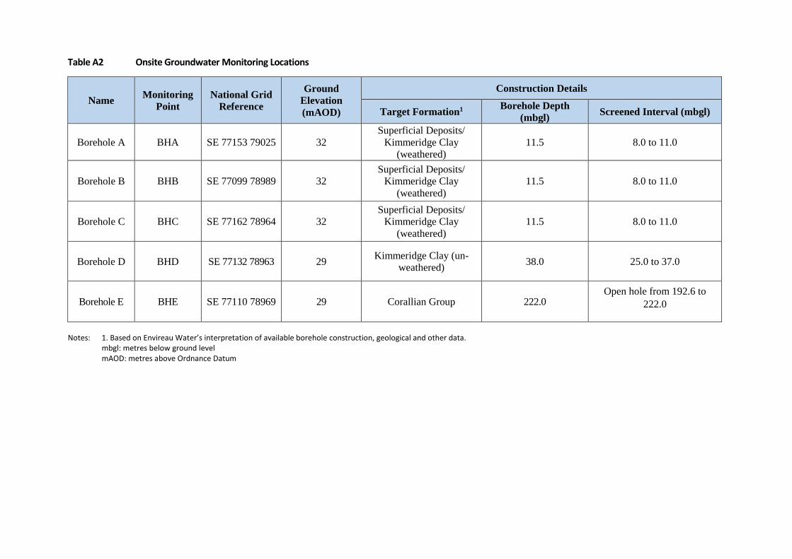
Table A2 Onsite Groundwater Monitoring Locations
Name Monitoring
Point
National Grid
Reference
Ground
Elevation
(mAOD)
Construction Details
Target Formation1 Borehole Depth
(mbgl) Screened Interval (mbgl)
Borehole A BHA SE 77153 79025 32
Superficial Deposits/
Kimmeridge Clay
(weathered)
11.5 8.0 to 11.0
Borehole B BHB SE 77099 78989 32
Superficial Deposits/
Kimmeridge Clay
(weathered)
11.5 8.0 to 11.0
Borehole C BHC SE 77162 78964 32
Superficial Deposits/
Kimmeridge Clay
(weathered)
11.5 8.0 to 11.0
Borehole D BHD SE 77132 78963 29 Kimmeridge Clay (un-
weathered) 38.0 25.0 to 37.0
Borehole E BHE SE 77110 78969 29 Corallian Group 222.0 Open hole from 192.6 to
222.0
Notes: 1. Based on Envireau Water’s interpretation of available borehole construction, geological and other data.
mbgl: metres below ground level mAOD: metres above Ordnance Datum

Envireau Water
Ref: P:\TE KMA Monitoring 2018 (2335)\40 - Reporting\Temp Suspen\Round 43 - 22_08_18\Tech note r2.docm Appendices
APPENDIX B
WEATHER OBSERVATIONS

Table B Weather Observations
Round Date Weather observations
Round 23 24/04/2017 Overcast but dry with sunny spells
25/04/2017 Overcast with sunny spells and short intense rainfall periods
Round 24 17/05/2017 Consistent light rain all day
18/05/2017 Sunny and dry
Round 25 14/06/2017 Sunny and dry, ~22°C
15/06/2017 Cloudy and dry, ~16°C
Round 26 06/09/2017 Sunny and dry in the morning with light rain in the afternoon
Round 27 18/10/2017 Sunny in the morning and cloudy in the afternoon, dry all day
Round 28 25/10/2017 Sunny in the morning and cloudy in the afternoon, dry all day
Round 29 31/10/2017 Rainfall in the morning with cold breeze, still cool but lighter rainfall in the afternoon
Round 30 06/11/2017 Dry and cold, ~8°C
07/11/2017 Overcast and cold in the morning, rain between 1300 - 1700 hours
Round 31 15/11/2017 Dry and sunny, ~8°C
Round 32 22/11/2017 Windy and raining all day, ~8°C
Round 33 29/11/2017 Heavy rainfall and hail, overcast all day, ~3°C
Round 34 05/12/2017 Dry, cool breeze, ~6°C
06/12/2017 Dry, cool breeze, ~6°C
Round 35 14/12/2017 Cold, -1 to 3. Dry in the morning with rainfall in the afternoon
Round 36 04/01/2018 Rainfall all day, ~8°C
05/01/2018 Dry all day, cold ~3°C
Round 37 13/02/2018 Rainfall all day, ~5°C
14/02/2018 Dry in the morning and light rain in the afternoon (ca. 14:00hrs) - cold ~3°C with wind gusts
Round 38 14/03/2018 Dry all day with sunny intervals, temperature ranged from 8 – 13°C with wind gusts
Round 39 10/04/2018 Rain in the morning with strong winds, cold and dry in the afternoon with temperatures
Round 40 15/05/2018 Sunny and dry all day, 16-22oC
Round 41 18/06/2018 Sunny intervals with cloud, temperature highs of 22oC
Round 42 25/07/2018 Dry, with sunny intervals. Temperature ranges 18 to 24°C
Round 43 22/08/2018 Dry, mostly cloudy with sunny intervals. Temperature ranges 20 to 25°C

0
10
20
30
40
50
60
70
80
90
10020
21
22
23
24
25
26
27
28
29
30
Date
Water Level in KMA Monitoring Boreholes vs Daily Rainfall
Manual BHA Manual BHB Manual BHC Manual BHD Manual BHE KMA Rainfall


![Deep Borehole Field Test Laboratory and Borehole Testing ... · The characterization borehole (CB) is the smaller-diameter borehole (i.e., 21.6 cm [8.5”] diameter at total depth),](https://static.fdocuments.in/doc/165x107/5ebe68817151f10bcd35645a/deep-borehole-field-test-laboratory-and-borehole-testing-the-characterization.jpg)