eZdia Overview: eZ Platform, eZ Workforce & eZ Project Management
Technical Appendix F.2 - Landscape and Visual Impact Assessment (LVIA) Methodology
This chapter of the ES will identify and assess the likely significance of and effects of change arising
from the development on both the landscape as an environmental resource in its own right and as a
separate topic views and visual amenity, as experienced by people. It will seek to identify the impact,
or action arising from the development proposals, and the likely effect, or change resulting from the
impact.
This assessment has been prepared using a methodology developed by Nicholas Pearson Associates,
and draws upon current best practice guidance including:
The Guidelines for Landscape and Visual Impact Assessment (GLVIA), Third Edition,
prepared by the Landscape Institute and Institute of Environmental Management and
Assessment (April 2013);
An approach to Landscape Character Assessment (October 2014) prepared by Natural
England ; and
The Landscape Institute (2011) Photography and photomontage in landscape and visual
impact assessment. Advice note 01/11.
Landscape and Visual Impact Assessment also addresses the effects of development on green
infrastructure and also the potential for enhancing it. LVIA can also make a contribution to
sustainable development including mitigation and adaption to climate change.
Professional Judgement is an important part of the process of determining the level of effects and
significance. The concluding level of landscape or visual effects or likely significance will be based on
combining judgements about the nature of the receptor (summarised as its sensitivity) and the nature
of effects (summarised as magnitude).
Narrative text is used to identify the main landscape and visual issues, in this instance and to explain
the reasoning behind the concluding judgements made regarding levels of effect.
An overview of the steps involved in the LVIA assessment process is illustrated in the following chart:
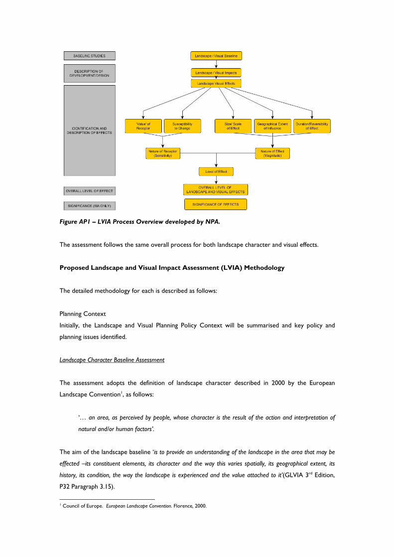
Figure AP1 – LVIA Process Overview developed by NPA.
The assessment follows the same overall process for both landscape character and visual effects.
Proposed Landscape and Visual Impact Assessment (LVIA) Methodology
The detailed methodology for each is described as follows:
Planning Context
Initially, the Landscape and Visual Planning Policy Context will be summarised and key policy and
planning issues identified.
Landscape Character Baseline Assessment
The assessment adopts the definition of landscape character described in 2000 by the European
Landscape Convention1, as follows:
‘… an area, as perceived by people, whose character is the result of the action and interpretation of
natural and/or human factors’.
The aim of the landscape baseline ‘is to provide an understanding of the landscape in the area that may be
effected –its constituent elements, its character and the way this varies spatially, its geographical extent, its
history, its condition, the way the landscape is experienced and the value attached to it’(GLVIA 3rd Edition,
P32 Paragraph 3.15).
1 Council of Europe. European Landscape Convention. Florence, 2000.
Landscape character is defined by the locality’s key characteristics. Taken together these components
form a collective landscape character area which can be used to define the locality. An evaluation of
these character areas is made to identify the qualities and sensitivities which could be potentially
affected by the proposed development. The anticipated trends for evolution and change in the
landscape, without the proposed scheme, will also be described.
An assessment of the site’s landscape character will be developed through a review of published
assessments and at a more detailed local level following field and desk study. Field studies notes will
be recorded on a pro forma study aid and together with the desk study will identify specific landscape
receptors which will comprise local landscape elements and features, and landscape character areas
(LCAs) defined as regions with similar landscape characteristics. Individual landscape character areas
and notable features will be mapped.
Once landscape character has been defined, classified and described, the landscape value (including
any recognized designated or non-designated status attached to different landscape by society and the
condition) and the susceptibility of the landscape to the type of change envisaged are assessed and
combined to establish the nature of the receptor (sensitivity) of the landscape. Note, ‘that the level of
sensitivity of the landscape receptors in LVIA ‘is specific to the particular project or development that
is being proposed and to the location in question’ (GLVIA 3rd Edition P88 Paragraph 5.39).
Landscape Value
Landscape value is’ the relative value that is attached to different landscapes by society (GLVIA, 3rd
Edition Glossary p 157)
In this assessment landscape value is established, after the preparation of the baseline, following
consideration of the following:
1. Designated and Non Designated Landscape including:
National/International - Designated landscapes which are nationally or internationally
designated for their landscape value – including National Parks, Areas of Outstanding Natural
Beauty, World Heritage Sites; Heritage Coasts and National Scenic Areas
Local - Locally or regionally designated landscapes (eg. Area of High Landscape Value,
Regional Scenic Areas); also areas where local evidence indicates more value than the
surrounding area.
Community –‘everyday’ landscape which is appreciated by the local community but has little
or no wider recognition of its value.
Despoiled or degraded landscape with little or no evidence of being valued by the community
Note: GLVIA 3rd Edition, also states on page 89, in Paragraph 5.45, that ‘the value of the landscape
receptors will to some degree reflect landscape designations and local importance, which they signify,
although there should not be over reliance on designations as the sole indicator of value’.
2. The Key Landscape Characteristics including consideration of their Condition
This concurs with the GLVIA 3rd Edition, P89, Para 5.44 which identifies that to establish
landscape value consideration should also be given to ‘the value of individual contributors to
landscape character, especially the key characteristics’.
Visual Context Baseline Assessment
The aim of the visual baseline is to ‘ establish the area in which the development may be visible, the
different groups of people who may experience views of the development, the places where they will be
affected and the nature of the views and visual amenity at those points’ (GLVIA 3rd Edition, P32 Paragraph
3.15). Also, where possible the approximate or relative number of different groups of people who will
be effected.
To begin the process of establishing the extent of the area that may be visible to and from a new
development, a Zone of Theoretical Visibility (ZTV) will initially be generated using digital terrain
mapping and knowledge of the anticipated size and form of the development proposals. This will be
verified through a combination of contour map analysis and field work to determine where built form
and vegetation may limit visibility. The ZTV will identify land that is theoretically visually connected
with the proposals and therefore where the people who will experience views of the development
(Visual Receptors) are likely to be. In this chapter, a more detailed ZTV has been created using a
5x5km digital surface model (DSM) with a resolution of 2m and a vertical error of ±25cm which
models the effects of existing vegetation and built features and this has enabled the extent of visibility
to be refined. All ZTV calculations were done within the QGIS geographical information system
environment and viewshed analysis software.
Within the ZTV, representative and any key viewpoints from publicly accessible land identified
through agreement with the competent authority. The selected viewpoints may be:
Representative of visual receptors;
Specific views, typically selected as examples of promoted noteworthy viewpoints or views
with cultural associations; or
Illustrative viewpoints, chosen to demonstrate a specific issue.
The reasons for any viewpoints or areas being scoped out or excluded from further assessment will
be explained in the text.
For each viewpoint a photographic image will be taken in accordance with guidance contained within
the Landscape Institute (LI) Advice Note 01/2011: Photography and photomontage in landscape and
visual impact assessment’ The advice note recognises that:
‘Two-dimensional photographic images and photomontages alone cannot capture or reflect the
complexity underlying the visual experience, and should therefore be considered an approximation of
the three-dimensional visual experiences that an observer would receive in the field;
‘As part of a technical process, impact assessment and considered judgements using photographs
and/or photomontages can only be reached by way of a visit to the location from which the
photographs were taken.’
Photographs and Visually Verified Montages
The specific procedures relating to the use of photography that have been followed in this chapter
and reflecting the guidelines within the Landscape Institute (LI) Advice Note 01/2011, are as follows:
Photography Nicholas Pearson Associates use Digital Single Lens Reflex cameras to ensure that the printed images
are of a size and resolution which best represents the chosen viewpoint. Occasionally, alternative
makes of Digital SLRs may be used; however this will be stated on the final documentation.
Equipment:
· Canon 5D full frame digital SLR camera · Canon 50mm f1.4 lens · Canon 28mm lens · Canon 24mm lens · Alternative lenses: hired upon requirement · Alternative cameras: Canon EOS 450D & 1000D · Tripod · NN4-D16-Nodal Ninja NN4 Panorama head with RD-16 rotator base
· NN-EZ-Nodal Ninja EZ Leveller MKII · Plumb bob · Compass
LVIA & VVM photographs are taken using the most appropriate combination of lens focal lengths to
ensure that the field of view covers the proposed scheme environment or landscape context.
Photographs are predominantly taken in landscape format unless circumstances dictate an alternative.
Using Ordnance Survey mapping or detailed topographic surveys, Cameras are located and mounted
on a tripod at height of 1.6m above existing ground level, which best represents the average human
eye level. A leveller is used to ensure that the camera is horizontal and a panoramic head is necessary
when capturing panoramas. A photograph of the tripod in situ is taken and a plumb bob is used to
accurately locate the camera on the ground if the location is to be surveyed.
Photographs are taken; preferably using an ISO of 100 with an aperture suitable to capture the
greatest depth of field the photographs are stored as a RAW format using manual settings to enable
the best quality results. The photographer will make note of the weather conditions and direction of
view. All other details relating to the photograph are stored in the image EXIF data. If necessary, the
original RAW file can be submitted as part of the verification process.
Suitable weather conditions are sought so that the proposals may be clearly visible in the context of
the view. It should be noted that taking photographs looking south during the winter, due to the low
angle of the sun can be problematic. Therefore we endeavour to take the photographs at the
appropriate time of day to reduce the chance of the site being in shadow or backlit. Each photograph,
or combinations of photographs, correctly portrays the view which is obtained at each representative
viewpoint whilst avoiding obvious obstructions. The location of each viewpoint is accurately located
on a survey.
Principle Viewing Distance:
For the representative panoramic views, a series of photographs were taken to the entire width of
view or a full 360° @ 15° intervals. A fixed 50mm focal length lens is used for this. For the Visually
Verified Montages, two sets of photographs were taken. One using a 24mm lens to be printed on A3
and viewed at 300mm, another using a standard 50mm lens to be printed on A3 and viewed at
500mm.
Reproduction and presentation material
Our chosen desktop publishing software is Adobe In-Design. All our VVM views are presented at
100%, suitable for A3 / A2 / A1 reproduction.
Our images have a target resolution of 300PPI; suitable for high quality printing when reproduced on
printers with resolutions of up to 2400DPI.
Each viewpoint within the document is supplied with the following information:
· Figure Number · Viewpoint Number · Viewpoint details · OS Coordinates (12 digit) · Direction of view · Date & Time · Principle Distance (Viewing distance) · Single Frame or Composite · Horizontal Field of View · Weather / Lighting conditions · Camera Type · Lens / Focal Length
• Nicholas Pearson Associates present all LVIA and VVM documents incorporating photographs and VVMs at A3 or A1.
• All must be reproduced at 100% of original print size unless otherwise stated. • Once an electronic document has been issued, Nicholas Pearson Associates accept no
responsibility for printing quality should the documents be printed on a third party printer
which does not meet the required standard.
Please Note: Also, see the separate Nicholas Pearson Methodology specifically covering the
process followed for Visually Verified Montage Preparation included at the back of this detailed LVIA
method statement.
As well as the technical information set out above, for each viewpoint a description will be provided
of the following:
Nature of the receptor – a description of who may experience the view;
Nature of the view – the direction, elevation, composition and characteristics of the view;
Duration of the view, whether the view is transient, part of a sequence or temporary or
permanent;
Importance of the view – taking into account highly valued or designated landscapes,
recognised viewpoints ;
Context – of the site within the view.
Using professional judgement, the interaction of these factors will enable the relative value of each of
the selected viewpoints to be established, as well as enabling the nature of the visual context of the
site to be described.
Description of the Development/ Design
A full description of the proposed development will be included elsewhere within the ES. However,
within this chapter, the development proposals will be described in summary where they relate
specifically to potential impacts on the existing landscape character and visual context. Descriptions

will be provided for the external realm design proposals as well as the built form, where information
has been provided by the design team.
Design, Mitigation and Enhancement Measures
The identification of the likely level of effects on the landscape as a resource and the visual context
has been used to help inform the design process and highlight where it may be important to
prevent/avoid, reduce and where possible remedy any adverse landscape and visual effect or provide
opportunities for enhancement. Key design measures which have been incorporated into the scheme
proposals in response to potential impacts identified within this chapter, will be summarised. Evidence
for the deliverability of mitigation will also be provided.
Identification of Potential Landscape Effects
Information about the development will be used to predict the likely impacts and effects on the
landscape, during the construction, operation stages of the scheme for each landscape receptor.
In order to focus the assessment on key landscape issues, any effects that have been ‘scoped out’,
because they have been judged to be insignificant or unlikely to occur, will be described. In addition,
other effects that have been addressed by amendments to the scheme design through the iterative
design/assessment process will also be identified.
The step process identified in the GLVIA 3rd edition, Chapter 3, will then be followed to explain
judgements about the nature of the landscape receptor (or its sensitivity) and the nature of the effect
on it (magnitude) and these will be combined to establish the level of the effect anticipated.
Step 1- Assess against agreed criteria
The Nature of the Receptor (or Sensitivity)
The initial step will be ‘to consider each receptor in terms of its sensitivity made up of judgements about:
the susceptibility of the receptor to the type of change arising from the specific proposal ; and
the value attached to the receptor;
The Nature of the Effect (or Magnitude)
and secondly its magnitude made up of judgements about :
the size and scale of the effect e.g. whether there is complete loss of a particular element of the
landscape or view or a minor change;
the geographical extent of the area that will be affected; and
the duration of the effect and its reversibility’.

The nature of the Landscape Receptor (Sensitivity)
Professional judgement will be used to define the sensitivity of the receiving landscape based on
combining judgements about the landscape value established in the baseline and the susceptibility of
the landscape to the development type envisaged. A narrative will be used to explain the concluding
nature of the receptor (sensitivity).
Landscape Susceptibility is ‘the ability of a defined landscape to accommodate the specific development
without undue negative consequences’ (GLVIA, 3rd Edition Glossary p 158)
It is important to also note, as stated in the GLVIA 3rd Edition p90 Paragraph 5.46,that ‘ there can be
complex relationships between the value attached to landscape receptors and their susceptibility to change
which are especially important when considering change within or close to designated landscapes. For
example:
An internationally nationally or locally valued landscape does not automatically, or by definition, have
high susceptibility to all types of change.
It is possible for internationally, nationally or locally important landscape to have relatively low
susceptibility to change resulting from a particular type of development in question, by virtue of both
the characteristics of the landscape and the nature of the proposal.
The particular type of change or development proposed may not compromise the specific basis for
the value attached to the landscape.’
In order to provide a measurement from which to evaluate the sensitivity of the landscape, criteria
have been devised and set out in a descriptive scale. The scale, which takes account of the local
context of the appraisal, is as follows:
Table LC.1 –The sensitivity of the landscape
Sensitivity Typical Descriptors and Examples
High Landscapes which by nature of their character would be unable to accommodate change of the type proposed. Typically these would be;
・ Of high quality with distinctive elements and
features making a positive contribution to character and sense of place.
・ Likely to be designated, but the aspects which
underpin such value may also be present outside designated areas, especially at the local scale.
・ Areas of special recognised value through use,
perception or historic and cultural associations.
・ Likely to contain features and elements that are
rare and could not be replaced. Medium Landscapes which by nature of their character
would be able to partly accommodate change of the type proposed. Typically these would be;
・ Comprised of commonplace elements and
features creating generally unremarkable
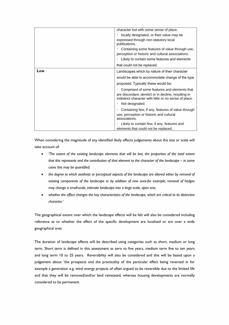
character but with some sense of place.
・ locally designated, or their value may be
expressed through non-statutory local publications.
・ Containing some features of value through use,
perception or historic and cultural associations.
・ Likely to contain some features and elements that could not be replaced.
Low Landscapes which by nature of their character would be able to accommodate change of the type proposed. Typically these would be; ・ Comprised of some features and elements that
are discordant, derelict or in decline, resulting in indistinct character with little or no sense of place.
・ Not designated.
・ Containing few, if any, features of value through
use, perception or historic and cultural associations.
・ Likely to contain few, if any, features and
elements that could not be replaced.
When considering the magnitude of any identified likely effects judgements about the size or scale will
take account of:
‘The extent of the existing landscape elements that will be lost, the proportion of the total extent
that this represents and the contribution of that element to the character of the landscape – in some
cases this may be quantified;
the degree to which aesthetic or perceptual aspects of the landscape are altered either by removal of
existing components of the landscape or by addition of new ones-for example, removal of hedges
may change a small-scale, intimate landscape into a large scale, open one;
whether the effect changes the key characteristics of the landscape, which are critical to its distinctive
character.’
The geographical extent over which the landscape effects will be felt will also be considered including
reference as to whether the effect of the specific development are localised or are over a wide
geographical area.
The duration of landscape effects will be described using categories such as short, medium or long
term. Short term is defined in this assessment as zero to five years, medium term five to ten years
and long term 10 to 25 years. Reversibility will also be considered and this will be based upon a
judgement about ‘the prospects and the practicality of the particular effect being reversed in for
example a generation e.g. wind energy projects of often argued to be reversible due to the limited life
and that they will be removed/and/or land reinstated, whereas housing developments are normally
considered to be permanent.
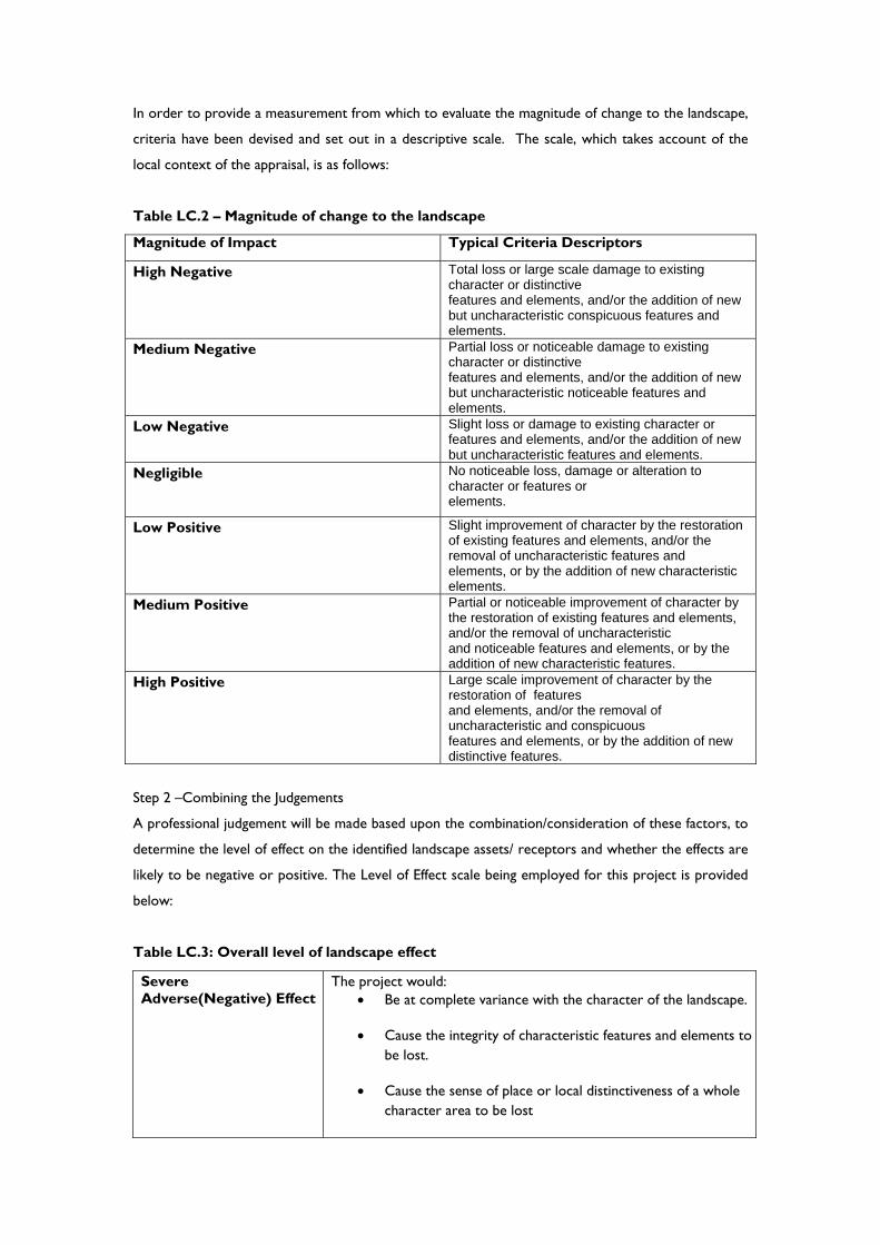
In order to provide a measurement from which to evaluate the magnitude of change to the landscape,
criteria have been devised and set out in a descriptive scale. The scale, which takes account of the
local context of the appraisal, is as follows:
Table LC.2 – Magnitude of change to the landscape
Magnitude of Impact Typical Criteria Descriptors
High Negative Total loss or large scale damage to existing character or distinctive features and elements, and/or the addition of new but uncharacteristic conspicuous features and elements.
Medium Negative Partial loss or noticeable damage to existing character or distinctive features and elements, and/or the addition of new but uncharacteristic noticeable features and elements.
Low Negative Slight loss or damage to existing character or features and elements, and/or the addition of new but uncharacteristic features and elements.
Negligible No noticeable loss, damage or alteration to character or features or elements.
Low Positive Slight improvement of character by the restoration of existing features and elements, and/or the removal of uncharacteristic features and elements, or by the addition of new characteristic elements.
Medium Positive Partial or noticeable improvement of character by the restoration of existing features and elements, and/or the removal of uncharacteristic and noticeable features and elements, or by the addition of new characteristic features.
High Positive Large scale improvement of character by the restoration of features and elements, and/or the removal of uncharacteristic and conspicuous features and elements, or by the addition of new distinctive features.
Step 2 –Combining the Judgements
A professional judgement will be made based upon the combination/consideration of these factors, to
determine the level of effect on the identified landscape assets/ receptors and whether the effects are
likely to be negative or positive. The Level of Effect scale being employed for this project is provided
below:
Table LC.3: Overall level of landscape effect
Severe Adverse(Negative) Effect
The project would: Be at complete variance with the character of the landscape.
Cause the integrity of characteristic features and elements to be lost.
Cause the sense of place or local distinctiveness of a whole character area to be lost
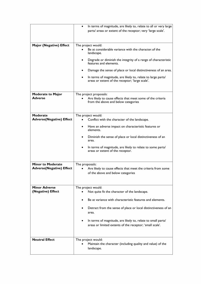
In terms of magnitude, are likely to, relate to all or very large parts/ areas or extent of the receptor; very ‘large scale’.
Major (Negative) Effect
The project would: Be at considerable variance with the character.of the
landscape.
Degrade or diminish the integrity of a range of characteristic features and elements.
Damage the sense of place or local distinctiveness of an area.
In terms of magnitude, are likely to, relate to large parts/ areas or extent of the receptor; ‘large scale’.
Moderate to Major Adverse
The project proposals: Are likely to cause effects that meet some of the criteria
from the above and below categories
Moderate Adverse(Negative) Effect
The project would: Conflict with the character of the landscape.
Have an adverse impact on characteristic features or elements.
Diminish the sense of place or local distinctiveness of an area.
In terms of magnitude, are likely to relate to some parts/ areas or extent of the receptor.
Minor to Moderate Adverse(Negative) Effect
The proposals: Are likely to cause effects that meet the criteria from some
of the above and below categories
Minor Adverse (Negative) Effect
The project would: Not quite fit the character of the landscape.
Be at variance with characteristic features and elements.
Detract from the sense of place or local distinctiveness of an area.
In terms of magnitude, are likely to, relate to small parts/ areas or limited extents of the receptor; ‘small scale’.
Neutral Effect
The project would: Maintain the character (including quality and value) of the
landscape.
Blend in with characteristic features and elements.
Enable a sense of place or local distinctiveness to be retained.
In terms of magnitude, are likely to, relate to very small parts/ areas or extent of the receptor; ‘very small scale’.
Or, a change which has positive and negative effects that balance each other out.
Minor Beneficial (Positive) Effect
The project would: Complement the character (including quality and value) of
the landscape.
Maintain or enhance characteristic features and elements.
Enable some sense of place or local distinctiveness to be restored.
Enable some (‘small scale’ in terms of magnitude) restoration of established characteristic features partially lost through other land uses.
Moderate Beneficial (Positive) Effect
The project would: Improve the character of the landscape.
Enable the creation, repair, conservation or restoration of characteristic features and elements partially lost or diminished as a result of
changes from inappropriate management or development. Enable a sense of place or local distinctiveness to be
restored.
Enable good creation, repair, conservation or restoration of valued characteristic features partially lost through other land uses.
Beneficial (Positive) Effect
The project would: Enhance the character of the landscape..
Enable the restoration of characteristic features and elements lost as a result of changes from inappropriate management or development.
Enable a sense of place or local distinctiveness to be enhanced.
Enable significant (‘large scale’ in terms of magnitude) creation, repair, conservation or restoration of valued characteristic features partially lost through other land uses.
Very Large Beneficial (Positive) Effect
The project would: Greatly enhance the character of the landscape.
Create an iconic high quality feature and/or series of
elements.
Enable a sense of place or local distinctiveness to be created or greatly enhanced across the whole of a character area.
Identification of Potential Visual Effects
An assessment of visual effects deals with the effects of change and development on views available to
people and their visual amenity’ (GLVIA 3rd Edition P98 para 6.1)
Information about the development will be used to identify the likely interactions between the
development and its visual receptors within the study area. The nature of effect during the
construction, operation and decommissioning stages of the scheme for each visual receptor will be
considered.
In order to focus the assessment on key visual issues, any effects that have been ‘scoped out’, because
they have been judged to be insignificant or unlikely to occur, will be described. In addition, other
effects that have been addressed by amendments to the scheme design through the iterative
design/assessment process will also be identified.
The step process identified in the GLVIA 3rd edition, Chapter 3, will then be followed to explain
judgements about the nature of the landscape receptor (or its sensitivity) and the nature of the effect
on it (magnitude) and these will be combined to establish the level of the effect anticipated.
Step 1- Assess against agreed criteria
The initial step will be ‘to consider each effect in terms of its sensitivity made up of judgements about:
the susceptibility of the receptor to the type of change arising from the specific proposal ; and
the value attached to the receptor;
and secondly its magnitude made up of judgements about :
the size and scale of the effect eg. whether there is complete loss of a particular element of the
landscape or view or a minor change;
the geographical extent of the area that will be affected; and
the duration of the effect and its reversibility’.
The assessment of visual sensitivity is dependent on a combined judgement based upon the location
and context of the viewpoint and the recognised importance of the view (value) and the expectations
and occupation/activity of the receptor, or susceptibility, to the development being proposed. The
most sensitive receptors may include users of casual outdoor recreational facilities such as public
footpaths, who are focused on the landscape; communities where the development results in changes
in the landscape setting or valued views; occupiers of residential properties whose views are affected
by the development. The least sensitive receptors are likely to be those at work or travelling through
a landscape by road or train particularly where seen from more distant views.
In order to provide a measurement from which to evaluate the sensitivity of visual receptors,, criteria
have been devised and set out in a descriptive scale. The scale, which takes account of the local
context of the appraisal, is as follows:
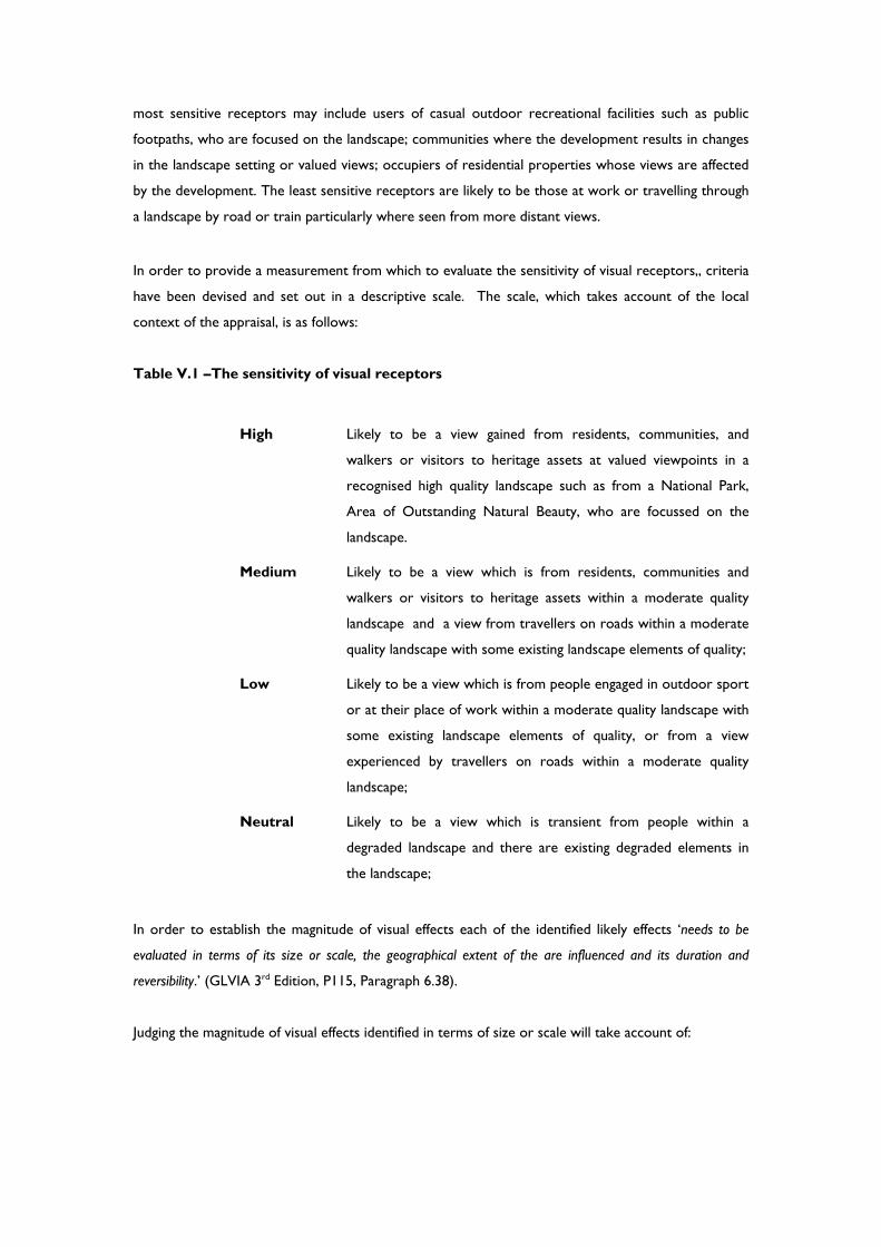
Table V.1 –The sensitivity of visual receptors
High Likely to be a view gained from residents, communities, and
walkers or visitors to heritage assets at valued viewpoints in a
recognised high quality landscape such as from a National Park,
Area of Outstanding Natural Beauty, who are focussed on the
landscape.
Medium Likely to be a view which is from residents, communities and
walkers or visitors to heritage assets within a moderate quality
landscape and a view from travellers on roads within a moderate
quality landscape with some existing landscape elements of quality;
Low Likely to be a view which is from people engaged in outdoor sport
or at their place of work within a moderate quality landscape with
some existing landscape elements of quality, or from a view
experienced by travellers on roads within a moderate quality
landscape;
Neutral Likely to be a view which is transient from people within a
degraded landscape and there are existing degraded elements in
the landscape;
In order to establish the magnitude of visual effects each of the identified likely effects ‘needs to be
evaluated in terms of its size or scale, the geographical extent of the are influenced and its duration and
reversibility.’ (GLVIA 3rd Edition, P115, Paragraph 6.38).
Judging the magnitude of visual effects identified in terms of size or scale will take account of:

‘The scale of the change in the view with respect to loss or addition of features in the view and
changes in its composition, including the proportion of the view occupied by the proposed
development;
The degree of contrast or integration of any of the new features or changes in the landscape with
the existing or remaining landscape elements and characteristics in terms of scale and mass, line,
height, colour and texture;
The nature of the proposed development, in terms of the relative amount of time over which it will
be experienced and whether views will be full partial or glimpses;’(GLVIA 3rd Edition, P115,
Paragraph 6.39).
Judgements regarding geographical extent of a visual effect will vary with different viewpoints and are
likely to reflect:
‘The angle of view in relation to the main activity of the receptor;
The distance of the viewpoint from the proposed development;
The extent of the area over which the changes would be visible’.(GLVIA 3rd Edition, P115,
Paragraph 6.40)
The duration of a visual effect will be described using categories such as short, medium or long term.
Short term is defined in this assessment as zero to five years, medium term five to ten years and long
term 10 to 25 years. Reversibility will also be considered and this will be based upon a judgement
about ‘the prospects and the practicality of the particular effect being reversed in for example a
generation eg. wind energy projects of often argued to be reversible due to the limited life and that
they will be removed/and/or land reinstated, whereas housing developments are normally considered
to be permanent.
In order to provide a measurement from which to evaluate the magnitude of change effecting visual
receptors, criteria (which can be positive or negative) have been devised and set out in a descriptive
scale. The scale, which takes account of the local context of the appraisal, is as follows:
Table V.2 –The magnitude of change effecting visual receptors
Magnitude of impact Typical criteria descriptors
High The project, or a part of it, would become the dominant feature or focal point of the view.
Medium The project, or a part of it, would form a noticeable feature or element of the view which is readily apparent to the receptor.
Low The project, or a part of it, would be perceptible but not alter the overall balance of features and elements that comprise the existing view.
Negligible No discernible change in the view
Step 2 –Combining the Judgements

A professional judgement will be made based upon the combination/consideration of these factors, to
determine the level of effect on the identified visual receptors and whether the effects are likely to be
negative or positive.. The Level of Effect scale being employed for this project is provided below:
Table V.3: The overall level of visual effect
Major Adverse(Negative) Effect
The proposals would typically: Cause a large deterioration in the existing views;
In terms of magnitude, would likely relate to the majority of views afforded by the receptor group and/ or to all or very large extents of each of those views;
In terms of sensitivity, would likely to affect views afforded by receptors which are deemed to be of higher value or to receptors and their views considered to be very susceptible to this form of development;
Effects are likely to be long term and may be permanent.
Moderate to Major Adverse(Negative) Effect
The proposals would typically:
Include some criteria from the above and below levels.
Moderate Adverse(Negative) Effect
The development would typically:
Cause a noticeable deterioration in the existing views;
In terms of magnitude, would likely relate to a moderate proportion of range of views afforded by the receptor group and/ or to a large proportion of each of those views – ‘medium scale’;
In terms of sensitivity, would likely to affect views afforded by receptors which are deemed to be of more moderate value or to receptors and their views considered to be have a medium level of susceptibility to this form of development;
Effects are likely to be long term but moderated by smaller scales of change or may be short term but with larger scales of change.
Minor to Moderate Adverse (Negative) Effect
The proposals would typically:
Include some criteria from the above and below levels.
Minor Adverse(Negative) Effect
The proposals would typically:
Cause a barely perceptible deterioration in the existing views;
In terms of magnitude, would likely relate to a small proportion of range of views afforded by the receptor
group and/ or to a small proportion of each of those views – ‘small scale’;
In terms of sensitivity, would likely to affect views afforded by receptors which are deemed to be of more lower value or to receptors and their views considered to be have a low level of susceptibility to this form of development;
Effects are likely to be long term but moderated by smaller scales of change or may be short term but with larger scales of change.
Effects may be long term but of negligible size/ scale or short term and of a larger scale of change.
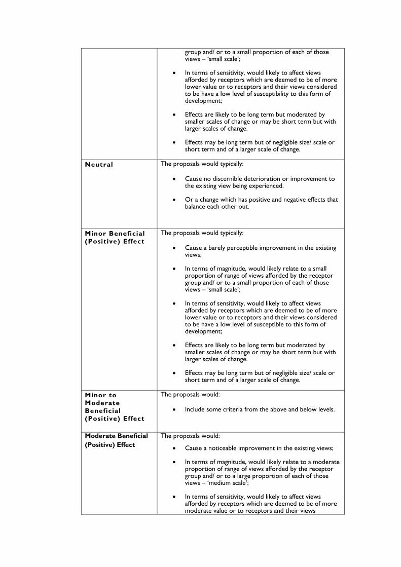
Neutral
The proposals would typically:
Cause no discernible deterioration or improvement to the existing view being experienced.
Or a change which has positive and negative effects that balance each other out.
Minor Beneficial (Positive) Effect
The proposals would typically:
Cause a barely perceptible improvement in the existing views;
In terms of magnitude, would likely relate to a small proportion of range of views afforded by the receptor group and/ or to a small proportion of each of those views – ‘small scale’;
In terms of sensitivity, would likely to affect views afforded by receptors which are deemed to be of more lower value or to receptors and their views considered to be have a low level of susceptible to this form of development;
Effects are likely to be long term but moderated by smaller scales of change or may be short term but with larger scales of change.
Effects may be long term but of negligible size/ scale or short term and of a larger scale of change.
Minor to Moderate Beneficial (Positive) Effect
The proposals would:
Include some criteria from the above and below levels.
Moderate Beneficial (Positive) Effect
The proposals would:
Cause a noticeable improvement in the existing views;
In terms of magnitude, would likely relate to a moderate proportion of range of views afforded by the receptor group and/ or to a large proportion of each of those views – ‘medium scale’;
In terms of sensitivity, would likely to affect views afforded by receptors which are deemed to be of more moderate value or to receptors and their views
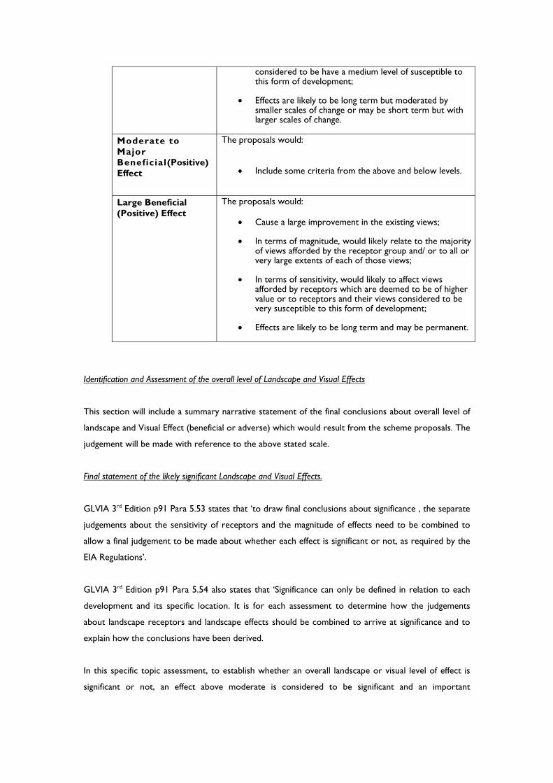
considered to be have a medium level of susceptible to this form of development;
Effects are likely to be long term but moderated by smaller scales of change or may be short term but with larger scales of change.
Moderate to Major Beneficial(Positive) Effect
The proposals would:
Include some criteria from the above and below levels.
Large Beneficial (Positive) Effect
The proposals would:
Cause a large improvement in the existing views;
In terms of magnitude, would likely relate to the majority of views afforded by the receptor group and/ or to all or very large extents of each of those views;
In terms of sensitivity, would likely to affect views afforded by receptors which are deemed to be of higher value or to receptors and their views considered to be very susceptible to this form of development;
Effects are likely to be long term and may be permanent.
Identification and Assessment of the overall level of Landscape and Visual Effects
This section will include a summary narrative statement of the final conclusions about overall level of
landscape and Visual Effect (beneficial or adverse) which would result from the scheme proposals. The
judgement will be made with reference to the above stated scale.
Final statement of the likely significant Landscape and Visual Effects.
GLVIA 3rd Edition p91 Para 5.53 states that ‘to draw final conclusions about significance , the separate
judgements about the sensitivity of receptors and the magnitude of effects need to be combined to
allow a final judgement to be made about whether each effect is significant or not, as required by the
EIA Regulations’.
GLVIA 3rd Edition p91 Para 5.54 also states that ‘Significance can only be defined in relation to each
development and its specific location. It is for each assessment to determine how the judgements
about landscape receptors and landscape effects should be combined to arrive at significance and to
explain how the conclusions have been derived.
In this specific topic assessment, to establish whether an overall landscape or visual level of effect is
significant or not, an effect above moderate is considered to be significant and an important
consideration at a local and district scale and if adverse, may become a key factor in the decision
making process. A narrative is used to explain the overall conclusions reached.
Glossary
The terms used within the Landscape and visual assessment reflect the definitions contained
within the Glossary from ‘The Guidelines for Landscape and Visual Impact Assessment
(GLVIA), Third Edition, prepared by the Landscape Institute and Institute of Environmental
Management and Assessment (April 2013)’ starting on page 155.
Cumulative Effects on Landscape Character and Visual Context
Cumulative effects are defined here as the combined effect of a set of developments taken together.
The scope of potential additional developments will be agreed with the Local Planning Authority but is
intended to be limited to developments which have an existing planning approval or which are due for
determination at the time of writing.
The study area for assessment of cumulative impacts geographic extent will be limited to the following
criteria:
Landscape Character – Limited to additional developments within the same locally
defined Landscape Character Area (LCA).
Visual Context – Limited to additional developments within the ZTV of the main
development.
Landscape and visual effects will be identified where the combined impact from the additional
developments with the main development are considered to be different to the effects of the main
development alone. In the case of visual effects, the nature of effect will also be described either as:
In combination, where more than one development is seen at one time within a single
view;
In succession, where more than one development is seen at one time from the same
viewpoint but at different orientations;
In sequence, where multiple developments can be seen along a route.
A summary of the Level of effects on landscape and visual receptors will be provided based on the
criteria, previously defined. Any opportunities for mitigation of cumulative impacts, such as
community compensation schemes or inter-developer partnerships will be identified and reviewed as
part of the iterative design process.
Appendix A - Nicholas Pearson Associates Visually Verifiable Montage Methodology
Introduction Nicholas Pearson Associates was established in 1982. The Company has a reputation within the
environmental and landscape consultancy field for quality of service, attention to detail and
achievement in terms of successful promotion of client’s aspirations.
The methodology used by Nicholas Pearson Associates accords with the Third Edition of the good
practice Guidelines for Landscape and Visual Impact Assessment 2013; produced by the Landscape
Institute and Institute of Environmental Management & Assessment and LI Advice Note 01/11. For
applications prepared for wind farms or similar, we adhere to the Scottish Natural Heritage, Visual
Representation of Wind Farms Version, 2.1 December 2014.
The purpose of a Visually Verifiable Montage (VVM) is to, impartially represent the case (for or
against); to show the proposed development, as it would appear in reality using a baseline of verifiable
visual data and information. A VVM combines photographic views with accurate CAD 3-D
representation of the proposals to an agreed level of detail. This verifiable image, using quantifiable
data, can then be used by others to scrutinise the work, if required, without its veracity being
questioned.
Nicholas Pearson Associates have produced numerous VVMs for urban and rural developments, and
have successfully presented these for expert witness evidence at public inquiry. We are not only
capable of undertaking VVMs but can also use our experience to assess, verify and challenge work by
others.
Specific project information Site Location: Dates of visit: General weather conditions: Equipment not identified in standard methodology: Photography Nicholas Pearson Associates use Digital Single Lens Reflex cameras to ensure that the printed images
are of a size and resolution which best represents the chosen viewpoint. Occasionally, alternative
makes of Digital SLRs may be used; however this will be stated on the final documentation.
Equipment:
Canon 5D full frame digital SLR camera Canon 50mm f1.4 lens Canon 28mm Alternative lenses: hired upon requirement Alternative cameras: Canon EOS 450D & 1000D Tripod NN4-D16-Nodal Ninja NN4 Panorama head with RD-16 rotator base NN-EZ-Nodal Ninja EZ Leveller MKII Plumb bob
Compass LVIA & VVM photographs are taken using the most appropriate combination of lens focal lengths to
ensure that the field of view covers the proposed scheme environment or landscape context.
Photographs are predominantly taken in landscape format unless circumstances dictate an alternative.
Using Ordnance Survey mapping or detailed topographic surveys, Cameras are located and mounted
on a tripod at height of 1.6m above existing ground level, which best represents the average human
eye level. A leveller is used to ensure that the camera is horizontal and a panoramic head is necessary
when capturing panoramas. A photograph of the tripod in situ is taken and a plumb bob is used to
accurately locate the camera on the ground if the location is to be surveyed.
Photographs are taken; preferably using an ISO of 100 with an aperture suitable to capture the
greatest depth of field the photographs are stored as a RAW format using manual settings to enable
the best quality results. The photographer will make note of the weather conditions and direction of
view. All other details relating to the photograph are stored in the image EXIF data. If necessary, the
original RAW file can be submitted as part of the verification process.
Suitable weather conditions are sought so that the proposals may be clearly visible in the context of
the view. It should be noted that taking photographs looking south during the winter, due to the low
angle of the sun can be problematic. Therefore we endeavour to take the photographs at the
appropriate time of day to reduce the chance of the site being in shadow or backlit. Each photograph,
or combinations of photographs, correctly portrays the view which is obtained at each representative
viewpoint whilst avoiding obvious obstructions. The location of each viewpoint is accurately located
on a survey.
Baseline data
Topographic site survey
Terrain 5 DTM –The increased quality and resolution of this data includes landform details not identified on standard 5m OS contours such as road and rail embankments.
OS Landform Panorama - Used for distant landforms
OS Mastermap – The 1:1250 data includes field boundaries, buildings, roads etc. All beneficial when aligning the 3D cameras. This data is superimposed onto the DTM.
Aerial Photography – Useful to help locate specific features not available on mapping data such as trees and lampposts etc.
Survey To assist in the verification process, the topographic survey is used to identify 3D point locations. In
many cases, these may include existing building ridgelines, tree canopies, lighting columns, or similar
such details. Further topographic surveys can be carried out during or after our site visit to ensure
we have as much detailed data as possible. Data can include Camera locations and specific 3D points
specified by us to assist in the camera matching process.
For more distant views, compass bearings to distinctive elements in the view will also be used to
assist with the alignment of the view. 12 figure OS grid reference coordinates, altitude Above
Ordnance Datum (m AOD) and GPS locations can also be recorded.
We also obtain site reference photographs of local building materials, landscape character as well as
capturing elements within the view which may be revealed or reflected by the proposed scheme
Post photographic Production The original Canon RAW files are processed in Adobe Photoshop to adjust White Balance, colour
accuracy, sharpness. The images undergo further correction procedure to ensure the horizon is
precisely horizontal and any barrel distortion is compensated for.
All final images are output as uncompressed Jpeg or Tiff files. The individual photographs are all
equally sized according to the preferred reproduction size. The corrected baseline image, which is
known as the background plate, is then ready for the visualisation work to begin.
3D Model & height verification The following software can be used for preparing the 3D Model data:
AutoCAD 2015
Autodesk Civil 3D
Sketch up 2014
Revit Architecture
LSS by McCarthy Taylor Systems
3D Studio MAX Design The appropriate software is used for the first stage of the model construction process prior to
constructing an existing base model using 3D Studio Max Design. Initially, the base model is
constructed of all the existing elements required to map the photographic viewpoints to the verified
view.
The architects / engineers and landscape proposals are all combined with the site survey and mapping
data, so that they correspond with each other. Any additional data can then be applied to the 3D
model at this stage to create a basic skeleton for the final solid rendered model. The co-ordinate
system is used when doing this, so that information regarding viewpoints can be accurately located
such as the viewpoint markers.
The heights and levels of the key features of the proposed scheme are then cross checked against the
design drawings and sections to check they correspond.
Camera Matching Irrespective of whether the final VVM is output as a single or composite panoramic image, each
Verified View is based upon a single photographic frame.

The viewpoint markers are used to tie the photograph to the CAD Camera view. These are usually
surveyed items such as lamp posts, walls, field boundaries and buildings; in essence, anything that has a
known location. At least six points are required to be as accurate as possible. Some of which should
be at a height above ground level i.e. tops of lampposts and buildings. The background plate
photograph is imported into 3D Studio Max, to verify the accuracy of the match.
In situations where there are no existing physical details to use, survey posts are located at varying
heights and distances within the view and then included into the digital topographic survey for use
later in the process.
The location and angle of view can also be checked by triangulating the position. This is a reliable
method successfully used for location finding in the field.
A wireframe model of the existing and proposed model is rendered, overlaid onto the photograph
and issued for approval. This is carried out so that the client and design team can confirm that they
are satisfied with the camera matching and mass/scale of the scheme before proceeding to the next
stage.
Texturing and Rendering 3D Studio Max Design is then used for applying the photorealistic surfaces and materials to the 3D
model. Once this is complete, the lighting can be added to create a realistic scene. The exact
reactions to sunlight can be calculated by using the software’s ability to place it in the direction
according to the time of day/month etc. Additional transparent lighting effects are also added to add
the final touches.
Rendering is the term used to describe the process of generating a two dimensional rendered bitmap
image from the 3D model.
Texturing is the application of photorealistic surfaces to the 3D model to reflect what the proposed
scheme would look like once constructed. Using information provided by the designers and
manufacturers plus samples (e.g. types of glass metal, brickworks etc) we produce the qualities and
appearance which most closely represents the real world materials.
Lighting and Sun direction is an important factor in representing the scheme proposals as they would
appear in the photograph. From the photograph META data and observations in the field; the sunlight
and daylight system in 3D Studio Max is used to accurately simulate the real world lighting as it was
when the photograph was taken. The Sunlight and Daylight System calculates the movement of the
sun over the earth at a given location. In addition, the software reproduces the ambient lighting,
shadows and reflections.
The exact resolution of the photograph is noted and used as the size for the final rendered output of
the 3D Model view so that the two overlay each other precisely.
Post Production
Adobe Photoshop CC is used to blend the modelled information with the existing base line / base
plate photograph. Various masks are created to position the development behind any existing details.
Colour correction is then applied if necessary to give it that “lived in look”. Finally, proposed
vegetation can be introduced along with the removal of any existing details on site that would be
removed during the development process.
The blending of any additional imagery and rendered models to provide context and realism is
undertaken before the final image is completed, to allow an accurate “before & after” comparison.
Reproduction and presentation material Our chosen desktop publishing software is Adobe In-Design. All our VVM views are presented at
100%, suitable for A3 / A2 / A1 reproduction.
Our images have a target resolution of 300PPI; suitable for high quality printing when reproduced on
printers with resolutions of up to 2400DPI.
• Nicholas Pearson Associates present all LVIA and VVM documents incorporating photographs and VVMs at A3 or A1.
• All must be reproduced at 100% of original print size unless otherwise stated. • Once an electronic document has been issued, Nicholas Pearson Associates accept no responsibility for
printing quality should the documents be printed on a third party printer which does not meet the required standard.
Each viewpoint is accompanied by a viewpoint location plan and, if requested, can be supplied with a
photograph of camera location.
Viewing procedure The purpose is to reproduce the represented view or VVM so that it “correctly reconstructs the perspective seen from the location from which the photograph was taken” For the majority of VVMs based upon a 28mm lens or 50mm lens, the images will be reproduced at A3 and suitable for viewing at between 300mm & 500mm. All VVMs will be reproduced with the recommended principle viewing distance noted. When viewing the represented views and VVMs, the viewer must keep their head motionless and fix their eyes on the centre of the view. When comparing the view in the field, the viewer must also keep the head motionless. This ensures that the represented view falls within the human field of view. It must be borne in mind that VVMs are not intended to replace the real-time visual experience and that a consensus can only be made by comparing the printed images in the field from the viewpoint whilst observing the correct viewing procedure. Glossary AOD: Above Ordnance Datum
AGL: Above ground level
FOV: Field of View

HFOV: Horizontal field of view
VFOV: Vertical field of view
VVM: Visually Verifiable Montage
CAD: Computer Aided Design
GPS: Global Positioning System
LVIA: Landscape and Visual Impact Assessment
EXIF: Exchangeable image file format
META Data: Provides detailed Image data
RAW: Uncompressed file format containing the highest quality image
Focal length: Distance between the lens and image sensor
ISO: Controls camera sensor sensitivity
Aperture: An opening through which light travels
Shutter speed: Exposure time