TEACHING PLAN :: for ACADEMIC YEAR- (Odd Semester) · (1) (2) (3) (4) (5) 503-1: Regional Geography...
29
TEACHING PLAN :: for ACADEMIC YEAR- (Odd Semester) Name: Minakshi Phookan Hazarika Department: Geography Semester: Odd Semester (July -December) Course: Degree Programme: Major Class Allotted : 13 Classes (per six day cycle) Paper-Unit: Theme (1) Course Content (2) Key Aspect (3) Teaching Method (4) Classes Required (5) 101-II Introduction to Geomorphology 1) Weathering & Mass Wasting Background of geography providing the basis for weathering, types, agents of weathering & Erosion. Oral & visual 4 2) Cycle of Erosion Concept, the process and the agents. 3 3) Davis & Penck Cycle of Erosion WM Davis & Walter Penck’s views on the cycle of erosion 3 102 Cartograhic Techniques Practical 4) Interpretation of Topographical Maps Interpretation of Mountains Difference of Contours & drainage distribution pattern in plain and mountain areas Transact Chart 4 4 3 303-I Environmental Geography 1) Meaning & Scope of Environmental Geography, Man – Eonvironment relationship in historical Perspective Meaning & Relevance of Environment in today’s world from the past. Presentation of Slides with OHP & LCD Oral & presentation of diagrams, Preparation of Charts and maps. (theoretical approach) 7 2) Env degradation, conservation – deforestation, desertification, and pollution World’s position in these aspects & how to balance between development and conservation 6 3) Env Impact Assessment and management, Approaches to Env management, Disaster & Disaster Management EIA Study, Approaches, & Disaster Management 5 4) Global & Regional Env Programmes, functions of UNEP & UNDP Global & Regional Env Programmes 6 (1) (2) (3) (4) (5)
Transcript of TEACHING PLAN :: for ACADEMIC YEAR- (Odd Semester) · (1) (2) (3) (4) (5) 503-1: Regional Geography...

TEACHING PLAN :: for ACADEMIC YEAR-
(Odd Semester)
Name: Minakshi Phookan Hazarika Department: Geography Semester:Odd Semester (July -December)
Course: Degree Programme: Major Class Allotted : 13 Classes (per six day cycle)
Paper-Unit: Theme
(1)
Course Content (2)
Key Aspect (3)
Teaching Method (4)
Classes Required (5)
101-II Introduction to Geomorphology
1) Weathering & Mass Wasting Background of geography providing the
basis for weathering, types, agents of
weathering & Erosion.
Oral & visual
4
2) Cycle of Erosion Concept, the process and the agents. 3
3) Davis & Penck Cycle of Erosion WM Davis & Walter Penck’s views on the
cycle of erosion 3
102 Cartograhic Techniques Practical
4) Interpretation of Topographical Maps Interpretation of Mountains
Difference of Contours & drainage
distribution pattern in plain and mountain
areas
Transact Chart
4 4 3
303-I Environmental Geography
1) Meaning & Scope of Environmental Geography, Man – Eonvironment relationship in historical Perspective
Meaning & Relevance of Environment in today’s world from the past.
Presentation of Slides with OHP & LCD Oral & presentation of diagrams, Preparation of Charts and maps. (theoretical approach)
7
2) Env degradation, conservation – deforestation, desertification, and pollution
World’s position in these aspects & how to balance between development and conservation
6
3) Env Impact Assessment and management, Approaches to Env management, Disaster & Disaster Management
EIA Study, Approaches, & Disaster Management
5
4) Global & Regional Env Programmes, functions of UNEP & UNDP
Global & Regional Env Programmes 6
(1) (2) (3) (4) (5)

507-1I: Regional Concept & Planning
1) Concept & Types of Regionas, Methods of Regionalization
Explanation of the concept of Region & Regionalization Methods
Oral 4 4
2) Concept of Regional Planning: Its Relevance, development & problems
Regional Planning Oral & Charts 4
3) Concept of Planning Regions with special reference to India
Planning Regions
Env Planning in India Sustainable Development
Charts OHP
Diagrams
4
4) Environmental Planning & Regional Issues 4
5) Regional Planning & Sustainable Development
3
Geographical aspects of planning in Japan Population, industry & national plans
Development in Japan Lecture cum demonstration
4
506-II: Practical
1. Map of Planning Regions of India
2. Sengupta’s Scheme
3. Land Use Map of Assam
Cartographic Tecnique 4
TEACHING PLAN :: for ACADEMIC YEAR-
Name: Minakshi Phookan Hazarika Department: Geography Semester: Even Semester (Jan-June )
Course: Degree Programme: Major Class Allotted: 1 4 Classes (per six day cycle) -
Paper-Unit: Theme(1)
Course Content (2)
Key Aspect (3)
Teaching Method (4)
Classes Required
(5)
201-II Human Geography
1. Global Population Study from Geographical Perspective.
Population Growth: Components & Determinants
Oral & Visual and use of OHP
5
Population Distribution 3
Demographic Transition Theory 3
Migration 3
2. Geography of Settlement Trend & Spatial pattern of Urbanization
3
202 Thematic Cartography Practical
1. Thematic Mapping Techniques Properties, uses and limitations of Thematic Mapping Choropheth Mapping of Aerial Data
5 4
403-II Industrial Geography
1. Classification of Industries Bases & classification accordingly Presentation of Slides with OHP & LCD Oral & presentation of diagrams,
4
2. Factors of Industrial Location Factors 3

3. Weber & Losch’s Theory Theories explaining industrial location
Preparation of Charts and maps. (theoretical approach)
6
5) Tourism as an Industry, Problems & Prospects of Tourism in India.
Problems 2
607-II: Population Geography
6) Introduction to Population Geography Oral 4 4
7) Population Growth, density, distribution in India & the states
Oral & Charts 4
8) Urbanization & Its trend in India Charts OHP
Diagrams
4
9) Urban settlement & types of towns & cities 4
10) Races & Tribes in India
11) Cultural Geography 3
Australia & New Zealand
1. Physiography, soil, climate. 2. Natual vegetation. 3. population & development
Lecture, OHP & LCD 4
Name: Minakshi Phookan Hazarika Department: Geography Semester: Annual (June - February )
Course: Higher Secondary Programme: Practical Class Allotted : 04 Classes (per six day cycle) Paper-Unit: Theme
(1)
Course Content (2)
Key Aspect (3)
Teaching Method (4)
Classes Required (5)
Paper II Practical Illustration on Board 2
HS Ist year History of Map making History, Directions How to Draw 3
Weather Map Interpretaion Data made available 3
Toposheet ,, Interpretation 3
Profile Drawing Using scale to draw With contours 2
Paper-Unit: Theme
(1)
Course Content (2)
Key Aspect (3)
Teaching Method (4)
Classes Required (5)
Paper II Practical Illustration on Board 2
HS IInd Year Simple Bar Diagram Importance, Directions How to Draw 3
Literacy Map by Shade Method Interpretaion Data made available 3
Mulitple Bar Diagram ,, Interpretation 3
Temperature & Rainfall Graphy Using scale to draw ,, 2

Paper-Unit: Theme(1)
Course Content (2)
Key Aspect (3)
Teaching Method (4)
Classes Required (5)
Paper 103 Environment Geography
1. Meaning & Scope of Env Geography Meaning….& its scope Lecture Need of Env awareness Slides presentation &
lecture
2
2. Environment Management: Its concept & necessity
Concept & Necessity 2
3. Approaches to Env Management & Env Imapct Assessment
Conservative & Preservative App & EIA
4
4. Global & Regional Env Programmes & Policies
Global & India;s env laws & Policies Slides presentation & lecture
5
Paper: 303 Special Paper: Regional Planning Part I Unit I Regional Concept in Geography
1. Conceptual & Theoretical framework of Region: Merits & Limitations for application to Regional Planning & development
Theoretical aspects of planning Types of Regions & methods of
reginalization Hierarchy
Lecture ,, ,,
4
2. Types of Regions & Regionalization 5
3. Regions in the Context of Planning & Hierarchy of Regions.
3
Unit III Methods & Techniques of Regional Planning
4. Methodology of Regional Planning Methods & Techniques Lecture & Illustration 2
5. Analytical Techniques of Reg Pl 8 Analytical Techniques ,, 4
6. Procedural ,, ,, ,, 4 Procedural ,,, ,, 3
Unit V Regions for Planning
7. Region and Its evolution History ,, 2
8. Planning Regions & Its Characteristics Characteristics of Planning Reg ,, 3
9. Planning Regions as proposed by TCPO, India TCPO ,, 2
Name: Minakshi Phookan Hazarika Department: Geography Semester: Odd Semester ( June-Feb) Course: PG Programme: MA/MSc. Class Allotted: 06 Classes (one hour each per six day circle)

Paper-Unit: Theme(1)
Course Content (2)
Key Aspect (3)
Teaching Method (4)
201 Unit V: Cultural Geography
1. Definition, scope and development of Cultural Geography
Meaning, scope & development Lecture & Demonstration ,,
,, & OHP
4
5. Themes & Concepts of Cultural geography, Cultural regions, cultural ecology, cultural integration, cultural landscape.
Themes – cultural diffusion, integration, 6
6. Man, society & cultura, Region as a cultural entity
4
403: Special Paper on Regional Planning Part II Unit I:Basis of Regionalization
1. Physcial, social & economic basis of regions of India
Basis of regions Lecture & Demonstration ,,
,, & OHP
6
2. Special Purpose regions – river valley and metropolitan regions
Special purpose regions Its need for such regions
4
3. Need of planning for special purpose regions
2
Unit II: Planning Processes
4. Sectoral, temporal, spatial dimensions of planning
Sectoral, temporal & spatial concepts Multi-regional planning, India
Indicators of development & their data sources
Lecture & Demonstration ,,
,, & OHP
6
5. Planning for a regions development and multi-regional planning in India
4
6. Indicators of development and their data sources, measuring levels of development and disparities in Indian context
4
Unit III: Regional development Strategies
7. Concentration vs dispersal Two opposite tendencies operating in space
Lecture & Demonstration ,,
,, & OHP
3
8. Plans of developed and developing countries
Netherlands, Israel & India plans 5
9. Regional plans of India Other regional plans of India 2
Name: Minakshi Phookan Hazarika Department: Geography Semester: Even Semester ( Jan-June) Course: PG Programme: MA/MSc. Class Allotted: 06 Classes (one hour each per six day circle)

Signature of Teacher Minakshi Phookan Hazarika
Department of Geography Dt: 04-08-2016
Paper VI Practical on Regional Planning UnitII: Preparation of a Field Study Report
10. Preparation of a Land Use Map of the Area surveyed
11. Preparation of a Blue Print of the Area to be developed
12. Preparation of a Survey Schedule for land use
To collect map from the study area To make blue print
How to prepare a schedule, data coding, analysis, tabulation and
interpreation and writing of report
Involves field work and several classroom discussions and
monitoring
16 classes and field work
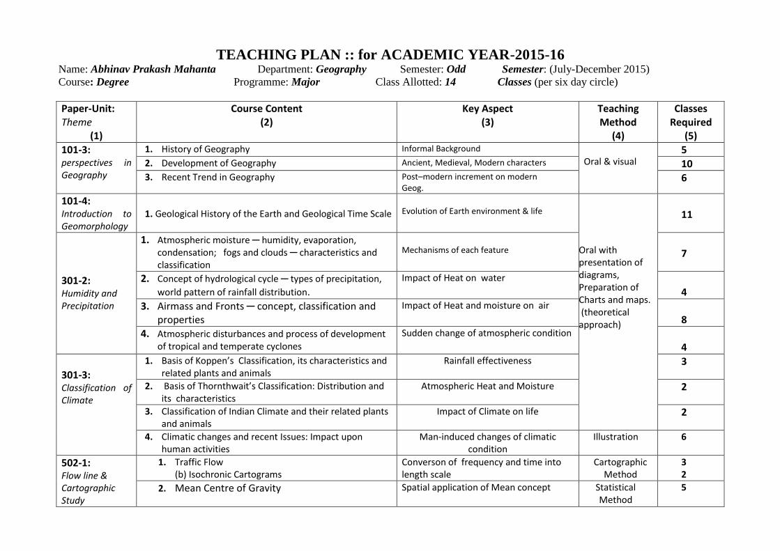
TEACHING PLAN :: for ACADEMIC YEAR-2015-16 Name: Abhinav Prakash Mahanta Department: Geography Semester: Odd Semester: (July-December 2015)
Course: Degree Programme: Major Class Allotted: 14 Classes (per six day circle)
Paper-Unit: Theme
(1)
Course Content (2)
Key Aspect (3)
Teaching Method
(4)
Classes Required
(5)
101-3: perspectives in Geography
1. History of Geography Informal Background Oral & visual
5 2. Development of Geography Ancient, Medieval, Modern characters 10 3. Recent Trend in Geography Post–modern increment on modern
Geog. 6
101-4: Introduction to Geomorphology
1. Geological History of the Earth and Geological Time Scale
Evolution of Earth environment & life
Oral with presentation of diagrams, Preparation of Charts and maps. (theoretical approach)
11
301-2: Humidity and Precipitation
1. Atmospheric moisture ─ humidity, evaporation, condensation; fogs and clouds ─ characteristics and classification
Mechanisms of each feature
7
2. Concept of hydrological cycle ─ types of precipitation,
world pattern of rainfall distribution.
Impact of Heat on water 4
3. Airmass and Fronts ─ concept, classification and properties
Impact of Heat and moisture on air 8
4. Atmospheric disturbances and process of development of tropical and temperate cyclones
Sudden change of atmospheric condition 4
301-3: Classification of Climate
1. Basis of Koppen’s Classification, its characteristics and related plants and animals
Rainfall effectiveness 3
2. Basis of Thornthwait’s Classification: Distribution and its characteristics
Atmospheric Heat and Moisture 2
3. Classification of Indian Climate and their related plants and animals
Impact of Climate on life 2
4. Climatic changes and recent Issues: Impact upon human activities
Man-induced changes of climatic condition
Illustration 6
502-1: Flow line & Cartographic Study
1. Traffic Flow (b) Isochronic Cartograms
Converson of frequency and time into length scale
Cartographic Method
3 2
2. Mean Centre of Gravity Spatial application of Mean concept Statistical Method
5
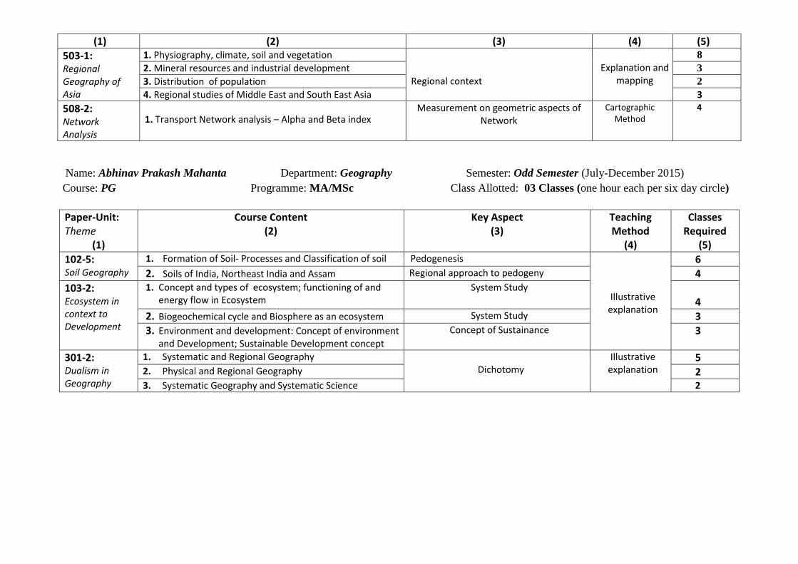
(1) (2) (3) (4) (5)
503-1: Regional Geography of Asia
1. Physiography, climate, soil and vegetation
Regional context
Explanation and
mapping
8
2. Mineral resources and industrial development 3
3. Distribution of population 2
4. Regional studies of Middle East and South East Asia 3
508-2: Network Analysis
1. Transport Network analysis – Alpha and Beta index Measurement on geometric aspects of
Network
Cartographic Method
4
Name: Abhinav Prakash Mahanta Department: Geography Semester: Odd Semester (July-December 2015)
Course: PG Programme: MA/MSc Class Allotted: 03 Classes (one hour each per six day circle)
Paper-Unit: Theme
(1)
Course Content (2)
Key Aspect (3)
Teaching Method
(4)
Classes Required
(5)
102-5: Soil Geography
1. Formation of Soil- Processes and Classification of soil Pedogenesis
Illustrative explanation
6 2. Soils of India, Northeast India and Assam Regional approach to pedogeny 4
103-2: Ecosystem in context to Development
1. Concept and types of ecosystem; functioning of and energy flow in Ecosystem
System Study
4
2. Biogeochemical cycle and Biosphere as an ecosystem System Study 3 3. Environment and development: Concept of environment
and Development; Sustainable Development concept Concept of Sustainance 3
301-2: Dualism in Geography
1. Systematic and Regional Geography Dichotomy
Illustrative explanation
5 2. Physical and Regional Geography 2 3. Systematic Geography and Systematic Science 2

Name: Abhinav Prakash Mahanta Department: Geography Semester: Even Semester (January-June2016)
Course: Degree Programme: Major Class Allotted: 18 Classes (per six day circle)
Paper-Unit: Theme (1)
Course Content (2) Key Aspect (3) Teaching Method (4)
Classes Required 5)
201-3: Biogeography
1. Definition, Scope and significance of Biogeography Organic components of soil
Explanation, Mapping and Diagramatic representation
4
2. World Distribution of plants and its relation to soil, climate and human activities
Causes of Spatial inequalities 9
3. World Distribution of animals plants and its relation to vegetation, climate and human activities
Causes of Spatial inequalities; Regionalization
7
4. Soil: Soil forming Processes, classification & distribution, Soil Horizon and profile; Soil Erosion and Conservation, Major Soil types of India and Assam.
1. Pedogeny 2. Soil productivity
10
402-2: Thematic mapping
1. Preparation of Maps showing geographical Themes: Soil, Industries, population, minerals, forest, agriculture etc. of India.
1. Concept of Thematic Map
2. Cartographic techniques
Cartographic
devices
8
2. Preparation of Maps showing geographical Themes: Soil, population, minerals, forest etc. of Assam.
4
403-3: Transport Geography
1. Transport as a factor of Resource Utilization, Environmental and socio-economic factors affecting transport growth
Transport as Infrastructure of development
Geographical Explanations with
Cartographic support
4
2. Means of transport: land, water and their relative importances under diferent geo-economic conditions.
Inharent Relative advantages of each transport Means
7
3. Coordination of Transport , 6
4. Network analysis Geometry and functionability 5
5. Major trade routes of the world Transcontinental trade 8
602-2: Map Projection
1. Cylindrical Projections : Simplecylindrical cylindrical, Cylindrical Equalarea, Gall’s, and Mercator’s.
Mathematical devices
Carographic
4+2
2. Conical Projection: with one and two Std. Parallels, Bonne’s, polyconic
4
606-2: Statistical Data Representation
1. Location Quotient Analysis 2. Lorenz curve
Spatial Statistics Inequality Measure
Cartographic 4 4
607-1: Geographic Thoughts
1. Development of Geography- Clasical, Medieval period. Components added in each age
Interpretation of effects of
Environment on Human activities
6
2. Age of Explorations and discovery. 6
3. Development of Modern Geography: contributions of Humboldt and Ritter
10
(1) (2) (3) (4) (5)
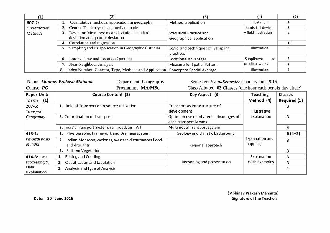
607-2: Quantitative Methods
1. Quantitative methods, application in geography Method, application Illustation 4
2. Central Tendency: mean, median, mode Statistical Practice and Geographical application
Statistical device + field illustration
8
3. Deviation Measures: mean deviation, standard
deviation and quartile deviation
4
4. Correlation and regression 10
5. Sampling and Its application in Geographical studies Logic and techniques of Sampling practices
Illustration 8
6. Lorenz curve and Location Quotient Locational advantage Suppliment to practical works
2
7. Near Neighbour Analysis Measure for Spatial Pattern 2
8. Index Number: Concept, Type, Methods and Application Concept of Spatial Average Illustration 2
Name: Abhinav Prakash Mahanta Department: Geography Semester: Even..Semester (January-June2016)
Course: PG Programme: MA/MSc Class Allotted: 03 Classes (one hour each per six day circle)
Paper-Unit: Theme (1)
Course Content (2) Key Aspect (3) Teaching Method (4)
Classes Required (5)
207-5: Transport Geography
1. Role of Transport on resource utilization Transport as Infrastructure of development
Illustrative
explanation
3
2. Co-ordination of Transport Optimum use of Inharent advantages of each transport Means
3
3. India’s Transport System; rail, road, air, IWT Multimodal Transport system 4
413-1: Physical Basis of India
1. Physiographic Framework and Drainage system Geology and climatic background Explanation and mapping
6 (4+2)
2. Indian Monsoon, cyclones, western disturbances flood and droughts
Regional approach
3
3. Soil and Vegetation 3
414-3: Data
Processing &
Data
Explanation
1. Editing and Coading Reasoning and presentation
Explanation With Examples
3 2. Classification and tabulation 3 3. Analysis and type of Analysis 4
( Abhinav Prakash Mahanta) Date: 30th June 2016 Signature of the Teacher:
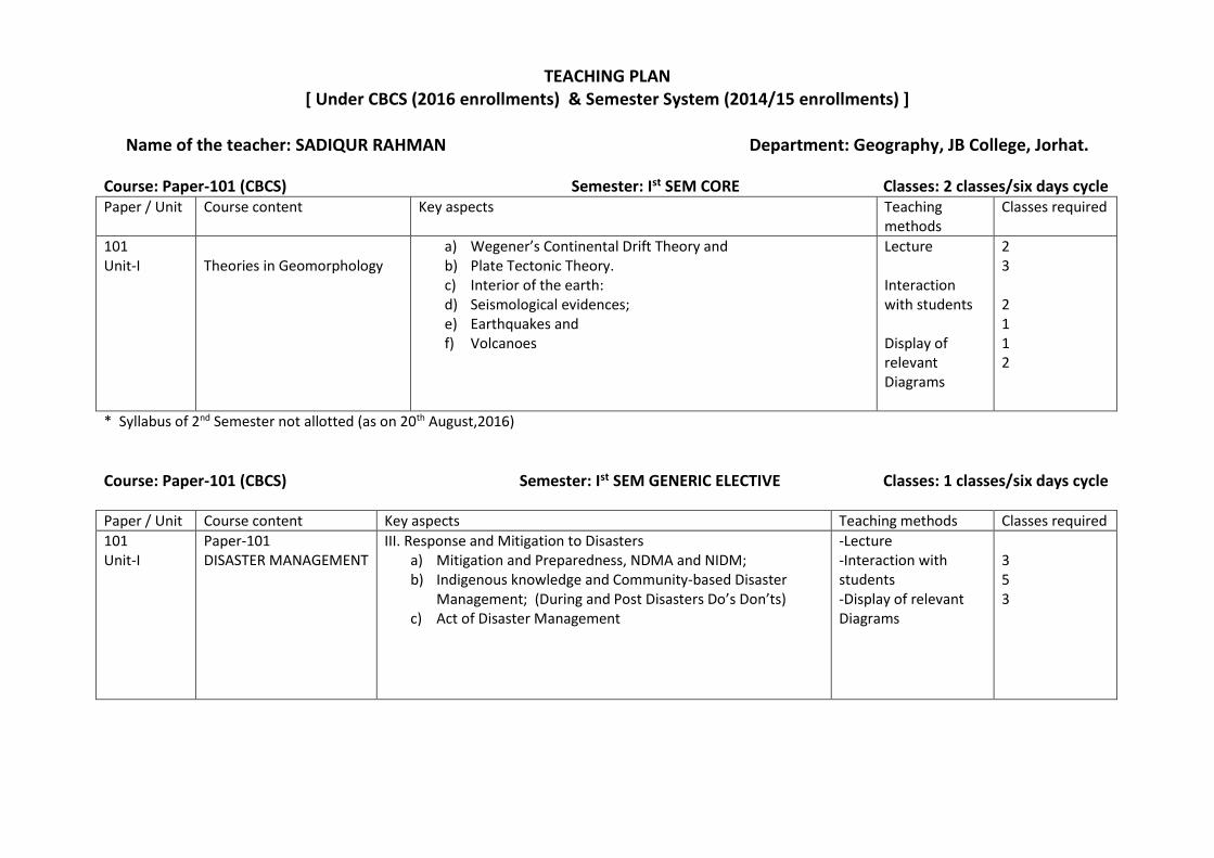
TEACHING PLAN [ Under CBCS (2016 enrollments) & Semester System (2014/15 enrollments) ]
Name of the teacher: SADIQUR RAHMAN Department: Geography, JB College, Jorhat.
Course: Paper-101 (CBCS) Semester: Ist SEM CORE Classes: 2 classes/six days cycle Paper / Unit Course content Key aspects Teaching
methods Classes required
101 Unit-I
Theories in Geomorphology
a) Wegener’s Continental Drift Theory and b) Plate Tectonic Theory. c) Interior of the earth: d) Seismological evidences; e) Earthquakes and f) Volcanoes
Lecture Interaction with students Display of relevant Diagrams
2 3 2 1 1 2
* Syllabus of 2nd Semester not allotted (as on 20th August,2016)
Course: Paper-101 (CBCS) Semester: Ist SEM GENERIC ELECTIVE Classes: 1 classes/six days cycle
Paper / Unit Course content Key aspects Teaching methods Classes required
101 Unit-I
Paper-101 DISASTER MANAGEMENT
III. Response and Mitigation to Disasters a) Mitigation and Preparedness, NDMA and NIDM; b) Indigenous knowledge and Community-based Disaster
Management; (During and Post Disasters Do’s Don’ts) c) Act of Disaster Management
-Lecture -Interaction with students -Display of relevant Diagrams
3 5 3

UNDER SEMESTER SYSTER (Non-CBCS) (2014 & 2015 enrollments)
MAJOR Stream Course: Major - 303 Semester: III Classes: 2 theory and 1 practical classes per six days cycle Paper / Unit Course content Key aspects Teaching
methods Classes required
GGRM-303 Unit-II Environmental Geography And Economic Geography (PART-I)
Ecology and Ecosystem
1. Meaning, scope and aims of ecology, type of ecology, ecological concepts and principles. 2. Ecosystem- types, structures, functioning, productivity and stability of ecosystem. 3. Concept of Biodiversity – threats to Biodiversity and Biodiversity preservation. 4. Conflict of environment vs. development (as problem): Sustainable development concept (as solution).
Lecture Interaction with students Display of relevant diagrams
4 3 3 2
Course: MAJOR - 401 Semester: IV Classes: 02 classes per six days cycle
Paper / Unit Course content Key aspects Teaching methods
Classes required
GGRM-401 HUMAN GEOGRAPHY
Unit-II Pattern of Human adaptation, mankind and Settlement
1.Human adaptation to various geographical conditions i)Plateaus–Gonds and Bhils of Central India, Khasis of Meghalaya Plateau ii) Nagas of the hills of North East India 2.Human adaptation in the floodplain regions with special reference to the Brahmaputra and the Ganga Plains 3.Human adaptation in cold region and hot regions 4.Human development–concept and measurement 5.Evolution of man–classification and spatial distribution of mankind and their physical and social profiles
Lecture Use of white board Interaction with students Use of PowerPoint
5 1 2 2 2

Course: Major - 505 Semester: V Classes: 2 theory and 2 practical classes per six days cycle
Paper / Unit Course content Key aspects Teaching methods Classes required
GGRM-505 POLITICAL GEOGRAPHY AND GEOPOLITICAL ISSUES
Unit-II Geopolitical Issues
Global strategic views–Mackinder, Global strategic views–Spykman and Global strategic views–Mahan Geopolitical settings of India: International boundaries of India and related issues: Geopolitics of Indian Ocean North-South dialogue: SAARC and ASEAN in the new international order Geopolitical situation of North east India
Lecture Use of white board Interaction with students
2 2 2 1 3 1 1 2 1
Course: Major – 506 (Practicals) Semester: VI
Paper / Unit Course content Key aspects Teaching methods Classes required
Unit-I Political geography
1.Shape Index of Different States 2. Maps of Global strategic Models a)Map of mackinder’s Heartland Theory b)Map of Spykman’s Rim Land Theory c)Map of ASEAN & SAARC d)Map, of india showing the international Boundaries
Lecture Display of photographs Interaction with students Visual presentation
4
Course: Major - 603 Semester: VI Classes: 2 theory classes per six days cycle
Paper / Unit Course content Key aspects Teaching methods Classes required
GGRM-603
REGIONAL GEOGRAPHY OF INDIA (PART-II) UNIT-I AGRICULTURE,
1.Agriculture: salient features of Indian agriculture: irrigation: sources–multipurpose river valley projects; major crops―rice, wheat, sugarcane, cotton, jute, tea and coffee―production and spatial distribution. Growth of agriculture during the plan
Lecture Interaction with students
2 3 4

INDUSTRIES AND TRANSPORT
periods ― Green Revolution, White Revolution and blue revolution 2.Industries: iron & steel, textiles and chemicals―their growth and development industrial regions of India. New industrial policy of India, industrial development during the five year plans; tourism industry
Display of relevant Maps
4
Course: Major - 605 Semester: VI Classes: 1 theory classes per six days cycle
Paper / Unit Course content Key aspects Teaching methods Classes required
GGRM-605
REGIONAL GEOGRAPHY OF
THE WORLD (PART-II)
Unit-I Africa
1. Physiography, climate, soil, vegetation
2. Natural resources of the continent
3. Spatial distribution of population
Lecture Interaction with students Display of relevant Maps
4
2
2
NON MAJOR Stream Course: Core - 201 Semester: III Classes: 3 theory and 2 practical classes per six days cycle
Paper / Unit Course content Key aspects Teaching methods
Classes required
GGRG 201
Unit - III: Bio-geography
a.Definition, scope and significance of bio-geography. b.Factors influencing world distribution of plants and animals. c.Major floristic regions of the world and their characteristics.
Lecture Interaction with students Display of relevant Maps
2 3 4

Course: Core - 301 Semester: III Classes: 3 theory and 2 practical classes per six days cycle
Paper / Unit Course content Key aspects Teaching methods Classes required
GGRG 301
Unit - I: Human Geography
a.Nature and Scope of Human Geography; man-environment relationship under different ecological settings. b. Classification and Spatial distribution of mankind and their physical and social profile including India. c.Population growth and distribution; Migration-causes and consequences. d.Origin and growth of human settlement, types of settlement and their characteristics; functional classification of towns.
Lecture Interaction with students Display of relevant Maps
2 3 4 4
Course: Core - 401 Semester: III Classes: 3 theory and 2 practical classes per six days cycle
Paper / Unit Course content Key aspects Teaching methods Classes required
Unit - II: North East India a) North east India-major physiographic regions, climate, soil and natural vegetation. b) Major mineral and power resources, transport and communication. c) Economic problems of north east India and Assam.
Lecture Interaction with students Display of relevant Maps
2 2 3 2
Course: Core - 501 Semester: V Classes: 1 No class allotted for this semester per week
Paper / Unit Course content Key aspects Teaching methods Classes required
Measures of Mean and Dispersion a)Measures of central tendency-Mean, median and mode; mean centre of population. b)Measures of dispersions-mean deviation and
Lecture White board and
2 2 2

GGRG 501
standard deviation. c)Measures of relationship-scattered diagram, coefficient of correlation and regression.
marker display Display of relevant Maps
3 4
Course: Core - 601 Semester: V Classes: No class allotted for this semester
Paper / Unit Course content Key aspects Teaching methods Classes required
Asia
a) Asia-Physical features, drainage, climate, soil and natural vegetation. b) Resource base-agriculture, mineral and power. c) Industries, trade and commerce. d) Population growth and distribution.
Lecture Interaction with students Display of relevant Maps
3 3 4 3
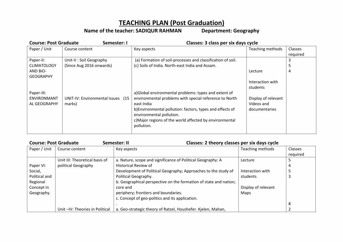
TEACHING PLAN (Post Graduation) Name of the teacher: SADIQUR RAHMAN Department: Geography
Course: Post Graduate Semester: I Classes: 3 class per six days cycle Paper / Unit Course content Key aspects Teaching methods Classes
required
Paper-II: CLIMATOLOGY AND BiO-GEOGRAPHY Paper-III: ENVIRONMANTAL GEOGRAPHY
Unit-V : Soil Geography (Since Aug 2016 onwards) UNIT-IV: Environmental Issues (15 marks)
(a) Formation of soil-processes and classification of soil. (c) Soils of India. North-east India and Assam. a)Global environmental problems: types and extent of environmental problems with special reference to North east India b)Environmental pollution: factors, types and effects of environmental pollution. c)Major regions of the world affected by environmental pollution.
Lecture Interaction with students Display of relevant Videos and documentaries
3 5 4
Course: Post Graduate Semester: II Classes: 2 theory classes per six days cycle Paper / Unit Course content Key aspects Teaching methods Classes
required
Paper VI: Social, Political and Regional Concept in Geography.
Unit III: Theoretical basis of political Geography Unit –IV: Theories in Political
a. Nature, scope and significance of Political Geography: A Historical Review of Development of Political Geography; Approaches to the study of Political Geography. b. Geographical perspective on the formation of state and nation; core and periphery; frontiers and boundaries. c. Concept of geo-politics and its application. . a. Geo-strategic theory of Ratzel, Houshefer. Kjelen, Mahan,
Lecture Interaction with students Display of relevant Maps
5 4 5 3 8 2

Geography Mackinder, Spykman and Cohen. b. Contemporary Reflections on theories. c. Geo-political problems of South Asia.
2
Course: Post Graduate Semester: III Classes: 1 theory classes per six days cycle
Paper / Unit Course content Key aspects Teaching methods
Classes required
Paper IX Unit V
Historical Development in Geography
1) Classification in Geography – Greeks, Romans contributions
2) Medieval Geography- Arabs and Prince Henry,Vasco da Gama, Columbus
3) Modern Geography – Humboldt and Ritter.
Lecture Interaction with students Display of relevant Maps
4 4 4
Course: Post Graduate Semester: III (Special Paper-Political Geography) Classes: 2 classes per six days cycle Paper / Unit Course content Key aspects Teaching
methods Classes required
Paper IX Unit IV Unit V
Colonialism,Federalism,Conflict and Cooperation Geography of Elections
a) Colonialism,decolonilization and neocolonialism b) Federalism and other forms of governments c) The changing patterns of world power
perspectives,conflicts and cooperation.
a) Place of Electoral studies in political geography b) Approaches to the study of geography of elections c) Geographical influences in voting behavior.
Lecture Interaction with students Display of relevant Maps
4 4 4 6 3

Course: Post Graduate Semester: IV Sem Classes: 01 theory classes per six days cycle Paper / Unit Course content Key aspects Teaching
methods Classes required
Paper XIII
Regional Geography of India
Resource base of the Country a) Mineral and Power resources b) Agricultural resources- problems and prospects. c) Transport and Communications.
Lecture Interaction with students Display of relevant Maps
3 3 3
Course: Post Graduate Semester: IV (Spl Ppr-Political Geography) Classes: 2 class per six days cycle Paper / Unit Course content Key aspects Teaching
methods Classes required
Paper XV
Political geography of India India-its internal problems and external relations
Political geography of India a) Historical evolution of Indian political structure b) Federal india – patterns of language and religion. c) Electoral studies of india-patterns of political parties and electoral
structures- lok sabha elections.
India-its internal problems and external relations a) Interstate issues – insurgency in border states and conflict resolution
b) India’s borders and associated problems.
c) India’s relations with the neighbours and the world.
Lecture Interaction with students Display of relevant Maps
4 3 5 5 4 5
( SADIQUR RAHMAN )

TEACHING PLAN (Under CBCS) 2016-17
Name of the teacher : GAURAB BORTHAKUR Department: Geography
Course: Major – 1st Semester CORE (Under CBCS) Paper: 101 Classes: 1 classes per six days cycle
Paper / Unit
Course content Key aspects Teaching methods
Classes required
GGRC-201 Unit-II
Theories and concepts in Geomorphology
Endogenic processes 1. Earth movement
2. Orogenic and Epeirogenic movement
3. Folding, Faulting and associated landforms
a) Lecture b) Interaction
with students
c) Display of relevant Diagrams
d) Assignment
10
Course: Major –1st Semester CORE - PRACTICAL (Under CBCS) Paper: 102 Classes: 1 classes per six days cycle
Paper / Unit
Course content Key aspects Teaching methods Classes req
GGRE-102 Unit-IV
Cartographic Techniques PRACTICAL
Interpretation of Topographical maps and Slope/Relief analysis :
1. Slope and Relief analysis 2. Wentworth’s Method 3. Smith’s Method
a) Lecture b) Interaction
with students c) Display of
relevant Maps and Instruments
d) Laboratory works
08

TEACHING PLAN ( Under Semester System)
Name of the teacher: GAURAB BORTHAKUR Department: GEOGRAPHY
PRACTICAL : Major-302 Semester- III
Paper / Unit
Course content Key aspects Teaching methods
Classes required
GGRM-302 Unit-I Practical
Toposheet study and profile drawing
1) Interpretation of Survey of India Toposheets: (a) Interpretation of toposheet covering a Hilly/Coastal and a Plain Area of India in respect of i) Relief ii) Drainage iii) Settlement iv) Vegetation v) Communication pattern
(b) Preparation of Transact Chart and its interpretation.
2) Drawing of Serial, Superimposed, Projected and Composite profiles and their interpretation.
Lecture Interaction with students Display of relevant Diagrams
6 4
Course: Major - 403 Semester: IV
Paper / Unit
Course content Key aspects Teaching methods
Classes required
:GGRM-403: Unit-II
ECONOMIC GEOGRAPHY (PART-II)
Unit-I Industrial Geography 2. Major industries of the world: Iron and steel, Cotton textile and Chemical group. 3. Industrial regions of the world: USA, Japan and India.
-Lecture -Interaction with students -Display of relevant diagrams. -Use of Powerpoint
4 4

Course: MAJOR - 501 Semester: V
Paper / Unit Course content Key aspects Teaching methods
Classes required
GGRM-501 REGIONAL GEOGRAPHY OF INDIA (PART-I)
Unit-I Physical Geography of India
1. India: Geological structure and Physiographic framework. 2. Climate and Drainage system. 3. Soil and vegetation – their types and spatial distribution.
Lecture Use of white board Interaction with students Use of PowerPoint
6 4 4
Course: Major ( PRACTICAL ) - 505 Semester: V
Paper / Unit
Course content Key aspects Teaching methods Classes required
:GGRM-504: PRACTICAL
(Slope Analysis and Block Diagrams)
Unit-I Slope Analysis 1. Went Worth’s method 2. Smith’s Method.
Lecture Use of Cartographic and Practicals Tools
4 4

Course: Major – 505 Semester: V
Paper / Unit Course content Key aspects Teaching methods Classes required
GGRM-505 POLITICAL GEOGRAPHY AND GEOPOLITICAL ISSUES
Unit-I Political Geography
1. Definition, nature, scope and subject matter–approaches to the study of political geography: Political Geography and Geopolitics 2. States–formation, location, shape and size: Nation–core areas, capitals 3. Boundaries and frontiers, borderlands, buffer states, landlocked states and shatter belts: Functions and classification of international boundaries: difference between boundaries and frontiers
- Lecture - Display of photographs -Chalk & Board -Visual presentation
4 4 3
Course: Major - 603 Semester: VI Classes: 2 theory classes per six days cycle
Paper / Unit Course content Key aspects Teaching methods Classes required
GGRM-603 REGIONAL GEOGRAPHY OF INDIA (PART-II)
Unit-I Agriculture, industries and transport
2.Industries: iron & steel, textiles and chemicals―their growth and development industrial regions of India. New industrial policy of India, industrial development during the five year plans; tourism industry
Lecture Interaction with students Display of relevant Maps
2 3 4 4
Course: Core - 101 Semesters: I
Paper / Unit
Course content Key aspects Teaching methods Classes required
GGRG-101:
PHYSICAL
GEOGRAPHY
(PART-I)
Unit-III Ocenography
1. Introduction to ocean floor topography
2. Salinity and composition of sea water
3. Ocean currents: Atlantic, Pacific and Indian Ocean
4. Ocean deposits
-Lecture -Interaction with students -Display of relevant Maps
3
2
3
2
Course: Core - 201 Semester: I
Paper / Unit
Course content Key aspects Teaching methods Classes required
GGRG-201 PHYSICAL GEOGRAPHY (PART-II)
Unit-IV Soil Study
1. Soil: Definition: soil forming processes 2. Classification and distribution of soil, soil erosion and conservation 3. Major soil types with special reference to India and Assam
-Lecture -nteraction with students -Display of relevant Maps
3 3 3
Course: Core - 301 Semester: III
Paper / Unit
Course content Key aspects Teaching methods
Classes required
:GGRG-301: HUMAN AND POPULATION
GEOGRAPHY
Unit-II Population Geography
3. Types of settlement: pattern of rural settlement; functional classification of towns.
-Lecture -Interaction with students -Display of relevant Maps
6

Course: Core - 401 Semester: III
Paper / Unit
Course content Key aspects Teaching methods
Classes required
GGRG-401 REGIONAL GEOGRAPHY OF INDIA
Unit-I Physical Framework
1. India: Introduction: Geology and Physical divisions 2. Drainage system and climate 3. Soil and Natural vegetation
-Lecture -Interaction with students -Display of relevant Maps
4 4 4
Course: Core - 501 Semester: III Classes: 3 theory and 2 practical classes per six days cycle
Paper / Unit
Course content Key aspects Teaching methods
Classes required
GGRG-501: ECONOMIC GEOGRAPHY
Unit-II Industry and Agriculture:
2. World distribution of rice, wheat, tea coffee, cotton, jute and rubber.
Lecture Interaction with students Display of relevant Maps
2 2 3 2
Course: Core - 602 Semester: VI
Paper / Unit
Course content Key aspects Teaching methods Classes required
:GGRG-602: PRACTICAL UNIT I & II
Thematic mapping & Field Report
Unit-I Thematic Map 1. Political Map of Asia ― South East Asia, Middle East, South Asia. 2. Thematic Map of India ― Map of India showing the International boundaries of neighbouring countries Unit-II Field Report
-Lecture -White board and marker display -Display of relevant Maps -Field Visit, Data -----Collection,Tabulation , Presentation in Report form.
4 4 2

TEACHING PLAN (Post Graduate Classes)
Name of the teacher: GAURAB BORTHAKUR Department: Geography
Course: Post Graduate Semester: I
Paper / Unit Course content Key aspects Teaching methods
Classes required
Paper-IV: PRACTICALS ON MORPHOMETRIC TECHNIQUES AND THEMATIC MAPPING
UNIT-I: Representation of relief and analysis
a)Profile drawing and interpretation b)Preparation and analysis of relative relief maps based on Smith’s method c)Preparation and analysis of slope map using Wentworth’s method d)Block diagram: one point and two point perspectives
Lecture Interaction with students Display of relevant Videos and documentaries
4 4 4 4
Course: Post Graduate Semester: II
Paper / Unit
Course content Key aspects Teaching methods Classes required
Paper VI: Social, Political and Regional Concept in Geography.
Unit III: Theoretical basis of political Geography
A) Nature, Scope and Significance of Political Geography: A historical review of Development of Political Geography: Approaches to the Study of Political geography. B) Geographical perspective on the formation of State and Nation: Core and Periphery: Frontiers and Boundaries C) Concepts of Geopolitics and its Application.
Lecture Interaction with students Display of relevant Maps
5 4 4

Course: Post Graduate Semester: II
Paper / Unit Course content Key aspects Teaching methods
Classes required
Paper VII GEOGRAPHY OF RESOURSES AND ECONOMIC DEVELOPMENT
UNIT-IV: Geography of Economic Activities
A) Agriculture-Place of Agriculture in global economy, agriculture system of the world. B) Manufacturing- Patterns and Problems of Manufacturing in the World. C) Industrial location theories- Weber, Hoover, and Losch.
Lecture Interaction with students Display of relevant Maps
4 3 4
Course: Post Graduate Semester: II
Paper / Unit
Course content Key aspects Teaching methods
Classes required
Paper VIII PRACTICAL ON SURVEYING AND SPATIAL PATTERNS
UNIT III FIELD SURVEY METHOD
A) Basic properties of Schedule and Questionnaires B) Preparation of Household Schedule for Socio-Economic survey C) Methods of Tabulation and organization of Data D) Methods of Interpretation of Data
Lecture Interaction with students Display of relevant Maps
3 4 4 3

Course: Post Graduate Semester: III
Paper / Unit Course content Key aspects Teaching methods Classes required
Paper - XI SPECIAL PAPER-POLITICAL GEOGRAPHY (PART -I)
SPECIAL PAPER- POLITICAL GEOGRAPHY (PART -I)
Unit -1 Conceptual Basis- 1) Nature. Scope and subject matter. 2) Recent development and approaches. 3) Major schools of thoughts. Unit-II Geographic Element and State A) Introduction B) Physical human and economic elements of state. C) Political geography and enviionment interface. -. Unit -III Themes in Political Geography A)State, nation, nation-state and nation-building. B)Frontiers, boundaries and borders zones. C)Core-periphery and capitals.
Lecture Interaction with students Display of relevant Maps
2 2 2 1 3 3 4 4 3
Paper XII
PROJECT & FIELD WORK
Field Visit, Data Collection,Tabulation & Presentation in Report form.
10 days

Course: Post Graduate Semester: IV (Spl Ppr-Political Geography) Classes: 2 class per six days cycle
Paper / Unit Course content Key aspects Teaching methods Classes required
Paper XV SPECIAL PAPER: POLITICAL GEOGRAPHY (PART-I
SPECIAL PAPER: POLITICAL GEOGRAPHY (PART-II)
Unit-IV: India: Its internal Problems and External Relations 1. Interstate Issues. Insurgency in Border States and conflict Resolution 2. India's Borders ( Land and Sea) and associated problems. 5. India's relations with its neighbors and the World. Unit V: Political Geography of North East India. 1. Politico-Geographic Evolution of North Eastern States.. 2. Ethnicity and Autonomy movements in North East India. 3. Problems of Migration. Insurgency and Border disputes in North
East India.
Lecture Interaction with students Display of relevant Maps
3 3 3 3 3 4
Paper XVI SPECIAL PAPER: POLITICAL GEOGRAPHY (PART-II)
PRACTICAL & PROJECT REPORT
1)a)Classification of States on the basis of area,Size, G-Scale) b) Comparison of Pre and Post Independents Map of india c) study of Core Area of India and its Expansion d) Ranking of states on the basis of some selected indicators like— Area, Population, Economic production and the strength of Armed forces 2) Project Report on Special Paper
Lecture Interation with student Laboratory work Field Visit, Data Collection,Tabulation & Presentation in Report form
3 3 3 10 days
(Gaurab Borthakur) Department of geography
J.B. College, Jorha