
Teacher’s Notes - 81west.com81west.com/curriculum/Grade 3/Social...
39
Teacher’s Notes
Transcript of Teacher’s Notes - 81west.com81west.com/curriculum/Grade 3/Social...

Teacher’s Notes

Ontario Social Studies Curriculum Grades 1 to 6, 1998Strand: Canada and World ConnectionsTopic: Urban and Rural CommunitiesGrade:3
© Social ButterfliesAll rights reservedDeveloped by T. TaskerMay be photocopied for classroom use. Further replication or commercial use is strictly prohibited.
Overall Expectations- identify distinguishing features of urban and rural communities- describe some possible relationships between communities and natural environments- demonstrate awareness of the possible similarities and differences among people, places and environments
* All specific expectations are covered by this unit and are mentioned at the end of each of the activities.
Materials box Suggested reading
- a large map of Canada (you could draw this or buya commercial one)- postcards from a variety of places in Canada (30are provided in the Teacher’s Notes)- a social studies library with a variety ofinformation books about Canada-poster board (or bristol board) for two differentactivities- pencil crayons- scissors- glue- a variety of simple maps (with and withoutlegends)- a variety of boxes, containers, tubes etc. fromrecycling bins (a request for these recycled items toparents is in the letter home)- information about your community and anothercommunity of your choice
M is for Maple by Mike Ulmer and Illustrated byMelanie Rose (ISBN 1-58536-051-1)Emma and the Silk Train by Julie Lawson and Illustratedby Paul Mombourquette (ISBN 1-55074-388-0)If You’re Not From the Prairie by David Bouchard andIllustrated by Henry Ripplinger (ISBN 1-895714-66-4)The Killick: a Newfoundland story by Geoff Butler(ISBN0-88776-336-7)Arctic Stories by Michael Arvaarluk Kusugak andIllustrated by Vladyana Langer Krykorka (ISBN 1-55037-452-4)Olden Day Coat by Margaret Laurence and Illustratedby Muriel Wood (no ISBN on cover)The Hockey Sweater by Roch Carrier and Illustrated bySheldon Cohen (ISBN 0-88776-174-7)Owls in the Family by Farley Mowat (ISBN 0-7710-6693-7)The Cremation of Sam McGee by Robert W. Serviceand Illustrated by Ted Harrison (ISBN 1-55074-606-5) Farmer Joe Goes to the City by Nancy Wilcox Richardsand Illustrated by Werner Zimmerman (ISBN 0-590-73361-3)Jonathan Cleaned Up - Then he Heard a Sound byRobert Munsch and Illustrated by Michael Martchenko(ISBN 0-920236-21-9)

Dear Parent or Guardian,
We are beginning our next Social Studies Unit, Canada and WorldConnections: Urban and Rural Communities. By the end of thisunit, your child will:- identify distinguishing features of urban and rural communities- describe some possible relationships between communities and naturalenvironments- demonstrate awareness of the possible similarities and differences among people,places and environmentsAs outlined in the Social Studies Curriculum, Ministry of Education,1998.
For our unit we will require a variety of boxes, tubes, plasticcontainers, etc. It would be appreciated if you would send in avariety of recycling materials to school.
Home Links:To help your child further their understanding of this social studiesunit, here are some fun activities for you and your family.
- visit a neighbouring community and discuss the similaritiesand differences.- visit an urban community one weekendand a rural community the next anddiscuss the differences.- visit provincial web sites.- spend time looking at maps anddiscussing what the various symbols mean.
Happy Adventures,
© Social Butterflies, 2002
|||||||||||||||||||||||||||||||||||||||||||||
Urban and Rural CommunitiesOur New Social Studies Words
Grade 3 CCglossary covers:CC5: use appropriate vocabulary (eg. urban, rural, city, town, village, environment, scale, north, south, east, west) to describe their inquiries andobservations© Social Butterflies, 2002

Urban and Rural CommunitiesO Canada
** Make or buy a commercial map of Canada and place it on a wall or bulletin board. You have twooptions for the post cards:1) You could mail the postcards to your students during the summer with a note asking them to findthe location on a map and to find out a little bit about the province and city and have them bring it onthe first day of school.2) You could distribute the post cards when you are ready to do this unit.**Postcards are available on the next several pages or you could find them at a local card shop. If youwould like your home town included in these postcards, please email a photo to [email protected]. Photos of landscapes only are preferred.**** Bring students to the map of Canada, and one at a time call a student up, ask them where theythink their postcard belongs, problem solve with the class and then when a consensus is made paste thepost card onto the map.**** Once all of the postcards are pasted to the map, go through all the provinces and territories ofCanada and the capitals.**
Today we looked at a map of Canada. To help us remember what we learned today let’s fillout the chart below and colour in our map of Canada. On your map remember to include thefollowing:1) your compass rose.2) the names of all the provinces and territories.3) the names and location of the capitals in the provinces and territories.Province Capital
Grade 3 CCactivity001 covers:CC12:identify the Canadian provinces, territories, and their capitals on a map.© Social Butterflies, 2002


Nor
th o
f Win
nipe
g, M
anito
ba
Churchill, Manitoba
Win
nipe
g, M
anito
ba
Que
bec,
Que
bec

Bak
er L
ake,
Nun
avut
Banff, Alberta
The Alberta Badlands, Dinosaur Provincial Park
Near Drumheller, Alberta
Stat
ue o
f Em
ily M
urph
y
Cal
gary
, Alb
erta

Fortress Louisbourg, Nova Scotia
Seal Island Bridge, Cape Breton, Nova Scotia
Ligh
thou
se p
oint
Loui
sbou
rg, N
ova
Scot
ia
Fisherman’s Cove, Cape Breton Highlands, Nova Scotia

Thunder Bay, OntarioPilot Whales along the Cape Breton Highlands National
Park coast, Nova Scotia
Toronto, Ontario Kak
abek
a Fa
ll, O
ntar
io

Niagara Falls, Ontario Kleinburg, Ontario
Vancouver, British Colombia Looking from Signal Hill, Newfoundland

Cape Spear, Newfoundland St. John’s, Newfoundland
Confederation Bridge between New Brunswick and PEIOttawa, Ontario

Along the Trans-Canada Highway at the Manitoba-Saskatchewan border.
Old Welland Canal, Ontario
African Lion Safari near Sheffield Ontario (justnorth of Hamilton)Montreal, Quebec

An old gristmill at Rockwood, Ontario St. Jacobs, Ontario
Charlevoix, Quebec
Gue
lph,
Ont
ario

Victoria, British Colombia Rankin Inlet, Nunavut
Har
tland
, New
Bru
nsw
ick
Fred
ricto
n, N
ew B
runs
wic
k

Mag
netic
Hill
, Mon
cton
, New
Bru
nsw
ick
Halifax, Nova Scotia
Pegg
y’s
Cov
e, N
ova
Scot
ia
Mahone’s Bay, Nova Scotia

Lunenburg, Nova Scotia Charlottetown, PEI
Ann
e of
Gre
en G
able
s,C
aven
dish
, PEI

Materials:1) jigsaw pieces2) pencil crayons3) glue4) poster board5) scissors
Urban and Rural CommunitiesOur Canadian Jigsaw
As a class let’s read M is for Maple by Mike Ulmer and Illustrated by Melanie Rose.
We are going to make a Canadian jigsaw. What do you think a jigsaw is?___________________________________________________________________________
Method:1) Take the next three pages out of your social studies book (the WHOLEpage).2) Colour the provinces and territories.3) Using a glue stick, put glue all over the back of the piece.4) Glue it onto the poster board.5) Cut the jigsaw piece out.6) HINT: if there are a lot of islands, draw a bubble around them and cutthem out as a group.7) Put your puzzle together.
Provincial Flag stickers for the Canadian Facts Chart


Canadian Facts Chart
Now that we have our Canadian Jigsaw, let’s find out more about each province and fill out thechart below.**Books are listed under certain provinces in the chart below. You may want to read one of these booksduring story time or at the beginning of the period throughout this unit.** **Ask the students to place their jigsaw on the table. As you discuss each province have them pick up theappropriate province. Ask them the following questions:1) What flag do you think belongs to this province?2) Estimate how big the area is in square kilometres. Write down the guesses and then give them thecorrect area (then have them use this area to estimate the others).3) Estimate the population.4) What industries do you think are important in this province (this information could come from the flagor they may have family in other provinces).
Province (in alphabetical order)
Area in km2 Population MajorIndustries
Web Page
Alberta 661 190 2 914 534 wheatcattleoilnatural gasmanufacturing
www.gov.ab.ca
British ColombiaEmma and the Silk Trainby Julie Lawson,Illustrated by PaulMombourquette
947 800 4 008 951 lumberpulp and papernewsprintshinglesshakestourismminingfishingagriculture
www.gov.bc.ca
ManitobaIf You’re Not From ThePrairie . . . by DavidBouchard, Illustrated byHenry Ripplinger
649 950 1 138 667 manufacturingwheatgrainscattlenickelcopperzinc
www.gov.mb.ca

New Brunswick 73 440 752 955 pulp and papermanufacturingminingtourismfishingagriculture
www.gov..nb.ca
Newfoundland / LabradorThe Killick: aNewfoundland story byGeoff Butler
405 720 534 829 fishingnickleoilnatural gasnewsprint
www.gov.nf.ca
Nova Scotia 55 490 934 237 manufacturingdairyfishingcoalship buildingtourism
www.gov.ns.ca
Northwest Territories 1 432 320 40 000 zincgolddiamondsoil and gasexplorationtourism
www.gov.nt.ca
NunavutArctic Stories by MichaelArvaarluk Kusugak,Illustrated by VladyanaLanger Krykorka
1 994 000 24 730 miningtourism
www.nunavut.com
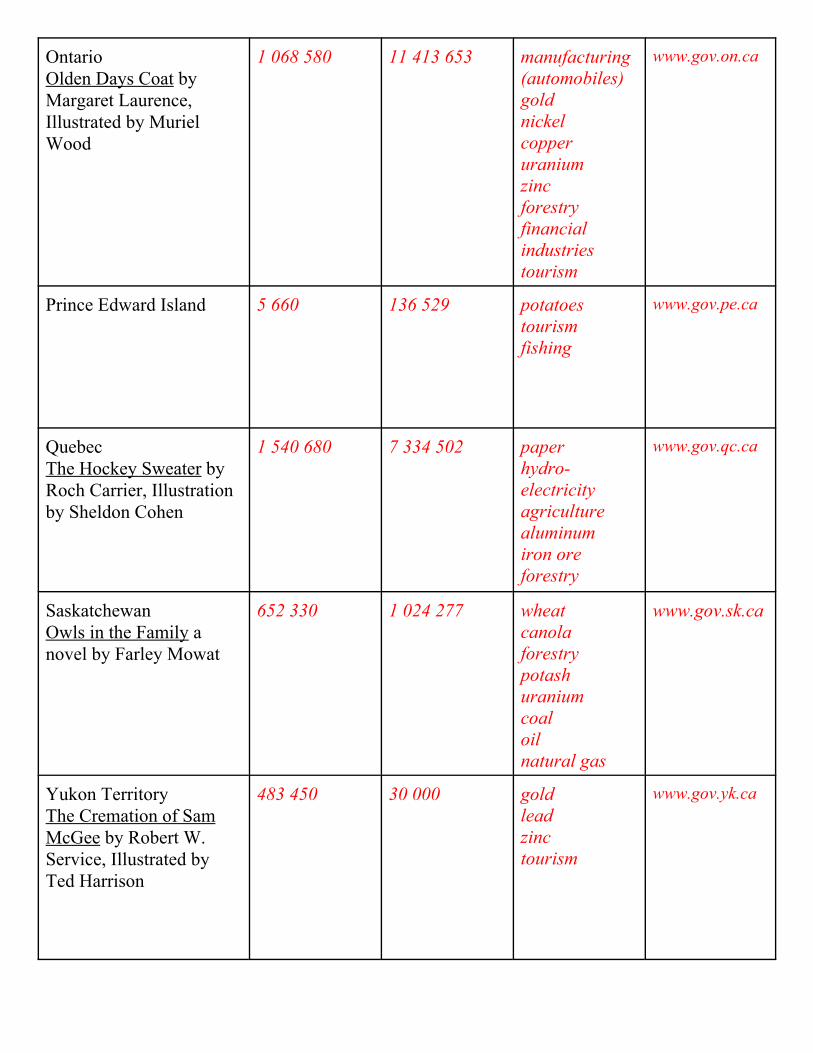
OntarioOlden Days Coat byMargaret Laurence,Illustrated by MurielWood
1 068 580 11 413 653 manufacturing(automobiles)goldnickelcopperuraniumzincforestryfinancialindustriestourism
www.gov.on.ca
Prince Edward Island 5 660 136 529 potatoestourismfishing
www.gov.pe.ca
QuebecThe Hockey Sweater byRoch Carrier, Illustrationby Sheldon Cohen
1 540 680 7 334 502 paperhydro-electricityagriculturealuminumiron oreforestry
www.gov.qc.ca
SaskatchewanOwls in the Family anovel by Farley Mowat
652 330 1 024 277 wheatcanolaforestrypotashuraniumcoaloilnatural gas
www.gov.sk.ca
Yukon TerritoryThe Cremation of SamMcGee by Robert W.Service, Illustrated byTed Harrison
483 450 30 000 goldleadzinctourism
www.gov.yk.ca

Area of Provinces and Territories in squared kilometers
05000001000000150000020000002500000
BC AB SA MA
ON
QU
PEI
NB
NS NF
NWT NT
YT
provinces and territories
km s
quar
ed
Series1
Graphs of Canada
What province or territory has the largest area? _________________________________________
What province or territory has the smallest area? _______________________________________
What else does the graph tell you?_____________________________________________________________________________________________________________________________________________________________________________________________________________________________________________

Population of Provinces and Territories
020000004000000600000080000001000000012000000
BC AB SA MA
ON
QU
PEI
NB
NS NF
NWT NT
YT
Provinces and Territories
Popu
latio
n
Series1
What province or territory has the largest population? ___________________________________
What province or territory has the smallest population? __________________________________
What else does the graph tell you?_____________________________________________________________________________________________________________________________________________________________________________________________________________________________________________
Grade 3 CCactivity002 covers:CC18:identify some products that Ontario sells to other provinces or territories (eg. nickle) and buys from them (eg. oil, wheat).© Social Butterflies, 2002

Urban and Rural CommunitiesMapping it Out!
** Collect a variety of simple maps without legends. You may want to give the maps aname or code.**
Our class has been hired to make legends for these maps. In small groups discusswhat the map is communicating and what the symbols might mean. Record yourwork in the form of a legend below.
Map:__________________________________
The LegendSymbol Meaning

Mapping our Community
** Have a large amount of floor space or a bulletin board put aside for this project. If you are usingthe floor, tape several white or light coloured poster boards together, if you are using the bulletinboard you may want to cover it with packing paper or light coloured paper.**** Have students collect or bring in milk cartons (the small 250 mL and 500 mL) as well as boxes (likethe small individual serving kind) and toilet paper rolls.**
We are going to create a three-dimensional map of our community! Let’s follow the stepsbelow:
Step 1: Let’s take a walk around our school neighbourhood.What kind of buildings do we see? ______________________________________What kind of roads do we see?__________________________________________What kind of signs do we see?__________________________________________What else do we see?______________________________________________________________________________________________________________________________________________________
Step 2: Let’s sketch out what we saw on our neighbourhood walk in the box below:

Step 3: Let’s divide our neighbourhood into sections and let’s divide our class into groups. Each group will be in charge of constructing a section.** Tape off areas on the floor or desks to indicate how much space they have.**Construct your section in your taped off area. Once you’ve finished we’ll put it together onour three-dimensional community map.
Step 4: Let’s reflect on our job . . .
What was your favourite part of this job?_________________________________________________________________________________________________________________________________________________________________________________________________________________________________
What was the hardest part of this job?_________________________________________________________________________________________________________________________________________________________________________________________________________________________________
What would you do differently next time?_________________________________________________________________________________________________________________________________________________________________________________________________________________________________Grade 3 CCactivity003 covers:CC11:make and use large maps of rural and urban communities, using familiar units of measure (eg. centimetre, metre, kilometre)CC13:consult map legends when looking for selected feature (eg. H/hospital)CC14:recognize that different colours on maps indicate different things (eg. different colours are used for different countries)© Social Butterflies, 2002

Urban and Rural CommunitiesDifferent Communities
Do you think all communities are the same? _______________________________
Communities are classified in different ways. One of the major classification iswhether the community is urban or rural.
** Let the students try to come up with their own definitions, and then as a class writedown an official one.**What does urban mean? Relating to or characteristic of a city or city life____________________________________________________________________________________________________________________________________
What does rural mean? Relating to or characteristic of the country____________________________________________________________________________________________________________________________________
As a class let’s read:Farmer Joe Goes to the City by Nancy Wilcox Richards and Illustrated by WernerZimmermann.
and
Jonathan Cleaned Up - Then He Heard A Sound by Robert Munsch and Illustratedby Michael Martchenko.** Other books may be substituted.**

Let’s compare urban and rural communities by filling out the chart below:Characteristic Urban Rural
What do they look like?(physical features)
What kind of buildingsdo they have?
What is land used for?
What kind oftransportation is there?
How many people livethere?(population)
What kind of jobs dopeople have?
What kind of community do we live in? __________________________________
How do you know?____________________________________________________________________________________________________________________________________
Grade 3 CCactivity004 covers:CC1: demonstrate an understanding of the characteristics (eg. with respect to land use, transportation, physical features, population, buildings) ofurban (industrial, residential, commercial) communitiesCC2: demonstrate an understanding of the characteristics (eg. with respect to land use, transportation, physical features, population, buildings) ofrural (fishing, farming, forestry, mining) communities© Social Butterflies, 2002

I need . . .__________________________________________________________________________________________________________________________________________________________________ to stay alive.
Urban and Rural CommunitiesOurselves and the Environment
As a class let’s make a list of what WE need to stay alive. Write the list down onyour special notepad below.
Where do we get the things on our list?______________________________________________________________________________________________________________________________________________________________________________________________________
How does the environment affect our community?______________________________________________________________________________________________________________________________________________________________________________________________________
What are some other ways we use the environment?______________________________________________________________________________________________________________________________________________________________________________________________________
Grade 3 CCactivity005 covers:CC3:describe the interaction between people and the environment (eg. dependence on nature for food, water, energy)CC6:ask questions and explore a variety of means to obtain information (eg. concerning relationships between the community and theenvironment)CC15:describe ways in which they and their families use the natural environment (eg. playing in the park, growing food)© Social Butterflies, 2002
Urban and Rural CommunitiesWhere do you Live?
People choose where they are going to live for many reasons. As a class let’s makea list of why people would choose an urban living or a rural living. Write the listin the chart below:
Reasons for living in an URBAN area
Reasons for living in a RURAL area
________________________________________________________________________________________________________________________________________________________________________________________________________________________________________________________
________________________________________________________________________________________________________________________________________________________________________________________________________________________________________________________
How would you decide where to live?__________________________________________________________________________________________________________________________________________________________________________________________________________________________________________________________________________________________________________________________________________Grade 3 CCactivity006 covers:CC4:demonstrate an understanding of why people live where they do (eg. because of family ties, occupations, amenities, schools)© Social Butterflies, 2002

Urban and Rural CommunitiesLet’s Travel!
We all like to go on vacations. What are some of the family vacations you’ve beenon so far?** Lets students share their family vacations orally.**
Describe your favourite vacation below:__________________________________________________________________________________________________________________________________________________________________________________________________________________________________________________________________________________________________________________________________________________________________________________________________________________________________________________________________________________________________________________________________________________________________________________________________________________
On some of our vacations we went to an urban area and on other vacations thedestination was a rural area. What are some other reasons for going to an urban orrural area?
Let’s fill out the chart below:
Reasons for going to an URBAN area
Reasons for going to a RURAL area
________________________________________________________________________________________________________________________________________________________________________________________________________________________________________________________
________________________________________________________________________________________________________________________________________________________________________________________________________________________________________________________
Grade 3 CCactivity007 covers:CC17:describe the ways in which people interact with other communities (eg. urban dwellers may travel to rural areas for recreational purposes;rural dwellers may make use of urban services such as hospitals)© Social Butterflies, 2002

Urban and Rural CommunitiesComparing Communities
The mayor wants a report comparing our community to another community. Let’s dosome research and fill out the chart below.** You will need to gather specific information about your community and thecommunity you are choosing to compare. You may want to use maps, touristbrochures, pictures that you took and books.**
Our Community:____________________
Another Community:____________________
Population
Number ofSchools
Hospitals
RecreationalActivities
Stores
Other___________
Other___________
Grade 3 CCactivity008 covers:CC16:compare the characteristics of their community to those of a different community (eg. with respect to density, services, recreation)© Social Butterflies, 2002

Urban and Rural Certificate
This certificate hereby certifies
______________________
as a Grade 3 Urban and Rural expert.
___________________ __________________Principal Teacher
Share your social studies booklet with at least one familymember at home. After you have shared complete thefollowing:
1) Cut out your Urban and Rural Certificate.2) Get the person you shared your social studies bookletwith to fill out the form below, detach it and bring it backto school.
C.................................................................................................
_______________________ shared their social studies bookletwith the following familymembers:
___________________Parent’s Signature© Social Butterflies, 2002

Urban and Rural CommunitiesHomework
Name:__________________DUE:___________________
Pick a community to research.I am going to pick the community of _________________________ to research.
PART 1 - Finding the FACTS
Use a variety of resources (internet, pamphlets, books, tourist brochures, maps orinterviews with family) in your research and answer the following questions:
1) Is the community an urban community or rural community? ________________
2) What is the population of the community? ______________________________
3) Who is the mayor of that community?__________________________________
4) What kind of schools does the community have?____________________________________________________________________________________________________________________________________
5) What kind of health services does the community have?____________________________________________________________________________________________________________________________________
6) What are some recreational activities you can do in the community?____________________________________________________________________________________________________________________________________
7) What stores are available in the community?____________________________________________________________________________________________________________________________________
8) What are some of the tourist attractions in that community?____________________________________________________________________________________________________________________________________

PART 2 - Advertising the Community
Prepare a short commercial advertising the community to others.My Commercial:________________________________________________________________________________________________________________________________________________________________________________________________________________________________________________________________________________________________________________________________________________________________________________________________________________________________________________________________________________________________________________________________________________________________________________________________________________________________________________________________________________________________________________________________________________________________________________________________________________________________________________________________________________________________________________________________
( Your commercial will be presented to the rest of the class.
PART 3 - Displaying the Community
Create a poster displaying the positive aspects of the community. You may include maps, pictures, caption, art work and word descriptions.
( Your poster will be put on display in our school hallways.

Your homework will be evaluated on the following criteria:Level 1 Level 2 Level 3 Level 4
Inquiry / Researchskills
- postercommunicatessimple ideas aboutthe community
- postercommunicates theattractions of thecommunity clearly
- postercommunicatesinformation aboutthe communityclearly- includes how thiscommunity wouldbe a great place tovisit
- postercommunicatesinformation aboutthe communityclearly andconcisely- illustratively theposter representssomething uniqueabout thecommunity- connections toother aspects oftourism included
Understanding ofconcepts
- limitedunderstanding ofthe community
- understood thebenefits andlimitations of thecommunity as atourist destination
- understood allaspects of thecommunity- made connectionsbetween thecommunity andtourism
- understood allaspects of thecommunity- extended theknowledge to whyvarious peoplewould enjoy thiscommunity as avacation spot
Communication ofknowledge
- key ideas werecommunicated
- clearlycommunicatedinformation- limited interactionwith audience
- clearlycommunicatedinformation- drew the audiencein with pizazz
- clearlycommunicatedinformation aboutthe community- presentationincluded pizazz andreferences to life inthe community- presented for anaudience oftravellers
Grade 3 CChomework covers:CC7:locate key information about urban and rural communities from primary sources (eg. surveys, interviews, and fieldwork) and secondarysources (eg. charts, graphs, maps, models, and CD-ROMs)CC8:sort and classify information about communities to identify issues, solve problems, and make connectionsCC9:construct and read graphs, charts, diagrams, maps, and models for specific purposes (eg. to describe a community and its environment)CC10:communicate information (eg. concerning the comparison of urban and rural communities), using media works, oral presentations, writtennotes and descriptions, drawings, tables, charts, maps, and graphs© Social Butterflies, 2002