TE TUMU STRATEGIC PLANNING STUDY AREA -...
116
REVIEW OF ARCHAEOLOGICAL SITE INFORMATION TE TUMU STRATEGIC PLANNING STUDY AREA PAPAMOA EAST,TAURANGA Prepared by KEN PHILLIPS (MA HONS) For TAURANGA CITY COUNCIL MAY 2016 ARCHAEOLOGY B.O.P. HERITAGE CONSULTANTS POBOX 68955 NEWTON AUCKLAND 1145 Mobile: 027 276 9919 Email: [email protected]
Transcript of TE TUMU STRATEGIC PLANNING STUDY AREA -...

REVIEW OF ARCHAEOLOGICAL SITEINFORMATION
TE TUMU STRATEGIC PLANNING STUDY AREA
PAPAMOA EAST, TAURANGA
Prepared by
KEN PHILLIPS (MA HONS)
For
TAURANGA CITY COUNCIL
MAY 2016
ARCHAEOLOGY B.O.P.HERITAGE CONSULTANTS
P O BOX 68955NEWTON
AUCKLAND 1145
Mobile: 027 276 9919Email: [email protected]

2
EXECUTIVE SUMMARY
This report was commissioned by Tauranga City Council (TCC) as a table top reviewof the 36 currently recorded archaeological sites within the Te Tumu StrategicPlanning Study Area.
The report reviews archaeological information provided in the ‘Papamoa LowlandsArchaeological Survey and Heritage Assessment’ produced by Gumbley & Phillips in2000 and subsequent archaeological and historic studies and mapping of thesefeatures through the use of geographical information systems. As a desk top reviewno field inspections of recorded archaeological sites were undertaken. Accurateassessment of the extent and significance of individual sites can, in most cases, onlybe achieved by additional fieldwork and investigation.
The current inventory of archaeological sites within the study area represents bothprehistoric and historic activity representing a diverse range of human activityspanning as much as 600 years.
While each archaeological site is itself separately identified, 4 different “complexes”(being similar site types focused on a defined topographical or geographical featureand being described as forming an archaeological landscape), the Fore dune sitecomplex, the Inland Site complex, the Kaituna River complex and the Back Dune SiteComplex have been identified within the Study Area.
Within the study area two archaeological site concentrations that may becontemporaneous and would clearly benefit from preservation within a single landparcel are the fore dune site complex and the concentration of river side sitesextending east from Paroa to Te Tumu.
Recommendations are provided for further field work to provide more accurate siteboundaries, interpretation and significance to assist in developing appropriatemanagement plans for archaeological resources within the study area.
It is noted that there are likely to be unrecorded archaeological sites within the studyarea additional to the current inventory of sites. Any development proposals withinland where no sites have been recorded should have in place a mitigation strategy toappropriately manage unrecorded subsurface archaeological sites if they areencountered during ground disturbance.
This report provides an assessment of archaeological values and does not include anassessment of Maori values. Consultation with tangata whenua is being carried outindependently of this report. An assessment of the cultural significance of an area canonly be competently made by the affected tangata whenua. It should be noted that anassessment of cultural significance might not necessarily correlate with an assessmentof archaeological significance.

3
INTRODUCTION
Project Background
This report was commissioned by Tauranga City Council (TCC) to updatearchaeological information within the Te Tumu Strategic Planning Study area. Thereare currently 36 recorded archaeological sites within the study area.
The quality of information regarding the nature, location, extent and significance ofeach recorded site is variable ranging from single point coordinates and a briefdescription to polygons defining the extent of complex sites with a detailed sitedescription.
The report reviews archaeological information provided in the ‘Papamoa LowlandsArchaeological Survey and Heritage Assessment’ produced by Gumbley & Phillips in2000 (the 2000 Report) and subsequent archaeological and historic studies andpresents an assessment of the current status of the archaeological sites within thestudy area. Recommendations for additional research and or field work to refinesignificance assessments are provided for specific sites.
In preparing this report archaeological data containing New Zealand ArchaeologicalAssociation (NZAA) site information was retrieved from the Tauranga City Councilin the form of GIS shapefiles. A high resolution aerial image was also obtained alongwith LiDAR data in the form of point cloud information and a digital elevation model(DEM) with a 1m spatial resolution. Geospatial processing was performed withinArcGIS 10.2, a Geographic Information System (GIS) from Environmental SystemsResearch Institute (ESRI).
A plan showing the approximate location and extent of recorded archaeological sitesestablished during the Gumbley & Phillips 2000 survey is presented in GIS format forcouncil applications (Appendix A). Appendix B provides an assessment of each siteusing the Bay of Plenty Regional Policy Statement assessment criteria and includesadditional descriptive and interpretative information for each site as well asbibliographies were applicable.
Recommendations are provided for further work required to provide more accuratesite boundaries, interpretation and significance to assist in developing appropriatemanagement plans for archaeological resources within the study area.
Constraints and Limitations
This is a desk top assessment and does not include field inspections of recordedarchaeological sites. While our understanding of sites within the study area hasimproved considerably from excavations of similar sites on the Papamoa Dune Plainaccurate assessment of the extent and significance of individual sites can, in mostcases, only be achieved by additional fieldwork and investigation.

4
This report provides an assessment of archaeological values and does not include anassessment of Maori values. Consultation with tangata whenua is being carried outindependently of this report. An assessment of the cultural significance of an area canonly be competently made by the affected tangata whenua. It should be noted that anassessment of cultural significance might not necessarily correlate with an assessmentof archaeological significance.
RELEVANT LEGISLATION
Heritage New Zealand Pouhere Taonga Act (2014)
An archaeological site, as defined by the Heritage New Zealand Pouhere Taonga Act2014 6(a), is any place in New Zealand, including any building or structure (or part ofa building or structure), that (i) was associated with human activity that occurredbefore 1900 or is the site of the wreck of any vessel where the wreck occurred before1900 and (ii) provides or may provide, through investigation by archaeologicalmethods, evidence relating to the history of New Zealand. Archaeological sites cannotbe modified or destroyed unless an authority is granted under section 48, 56(1) (b), or62 in respect of an archaeological site, no person may modify or destroy, or cause tobe modified or destroyed, the whole or any part of that site if that person knows, orought reasonably to have suspected, that the site is an archaeological site.
Resource Management Act (1991)
The RMA 1991 recognizes as matters of national importance: ‘the relationship ofMaori and their culture and traditions with their ancestral lands, water, sites, wahitapu, and other taonga’ (S6(e); and ‘the protection of historic heritage frominappropriate subdivision, use, and development’ (S6(f). Territorial authorities arerequired under Section 6 of the RMA to recognize and provide for these matters ofnational importance when ‘managing the use, development and protection of naturaland physical resources’.
Historic heritage is defined as ‘those natural and physical resources that contribute toan understanding and appreciation of New Zealand’s history and cultures, derivingfrom any of the following qualities: (i) archaeological; (ii) architectural; (iii) cultural;(iv) historic; (v) scientific; (vi) technological’. Historic heritage includes: ‘(i) historicsites, structures, places, and areas; (ii) archaeological sites; (iii) sites of significance toMaori, including wahi tapu; (iv) surroundings associated with the natural and physicalresources’.
Regional Policy Statement
The Bay of Plenty Regional Policy Statement provisions concerning archaeologicalresources are limited and are derived principally from section 6 of the ResourceManagement Act regarding matters of national importance i.e. ‘That historic heritageshould be protected from inappropriate subdivision, use and development’ (Objective18). Stated methods for achieving this are, however, passive and are largely limitedto management of selected heritage features via the district plan consenting process;encouraging agencies and landowners to protect ‘key’ sites and advocate to establishreserves encompassing sites.

5
Under the provision of the RMA, local authorities have the statutory responsibility toidentify significant heritage in district plans and to provide an appropriate level ofprotection and management of these resources through rules and regulations.However, archaeological sites are underrepresented in the Tauranga City Councilheritage provisions and the consenting process defers to the provisions of the HeritageNew Zealand Pouhere Taonga Act 2014 which is essentially a mechanism forobtaining consent to destroy archaeological sites that is external to district planningprocesses.
The Regional Policy Statement does, however, provide a thorough criteria (RPSAppendix F) for assessing significance of archaeological sites that encompasses allaspects of similar criteria provided by Heritage New Zealand. This criteria has beenapplied to all sites within the study area (see Appendix B of this report).Unfortunately this criteria is not supported by appropriate district plan objectives,policies, methods and rules.
METHODOLOGY
Review of Gumbley and Phillips 2000 Report
The Gumbley & Phillips 2000 Report (the 2000 Report) remains the mostauthoritative synthesis of the archaeological landscape within the study area, however,our understanding of this landscape will improve as further archaeologicalinvestigations and research is carried out.
Additional archaeological and historical information obtained since the 2000 Reportinclude archaeological monitoring and investigation of sites during the residentialdevelopment within the adjacent properties to the west of the study area, constructionof the Tauranga Eastern Link, construction of the Bell Road Storm water pipeline andarchaeological evidence presented during the 2014 Te Tumu Pa environment courthearing.
Minor refinements of the extent and significance of archaeological sites established inthe 2000 Report are provided where possible based on archival and or archaeologicalinformation obtained subsequent to the 2000 Report.
In addition, the identification of possible archaeological landscapes encompassingmultiple related sites are proffered.
Corrections to the 2000 Report
Several minor corrections to the 2000 Report are required. In Figure 3 of that reporttwo sites are incorrectly numbered. U14/3059 should read 3052 and 3058 should read3053.
In addition subsequent to the completion of the 2000 Report U14/221 was deletedfrom the NZAA file due to confusion over the location of Te Karaka Pa for which itwas designated. It should have been retained and simply renamed as the location ofPapanui. For the purpose of this report it has been retained and a corrected file will besubmitted to the NZAA file keeper.

6
Assessment of significance
An assessment of significance has been completed for each recorded archaeological site usingcriteria provided in the Bay of Plenty Regional Policy Statement (See Appendix B).
Recommendations are provided for further fieldwork to refine archaeologicalinformation and assist in more accurate significance assessments and future decisionsregarding their protection or preservation.
Polygons
During the Gumbley & Phillips 1999 - 2000 archaeological survey polygons wereestablished around sites using survey quality GPS. These polygons were necessarilysimple, many comprising little more than 6 points, however, they remain adequate forpreliminary assessment of sites and only minor refinements were made as part of thisupdate.
Lidar coverage of the study area was used to try and align polygons with topography.To aid in the identification of significant archaeological sites\areas a digital elevationmodel was hill shaded within ArcGIS and a shaded relief model of the LiDAR datacreated by considering the illumination source angle.
Archaeological sites\areas were defined according to five major categories;preservation, protection, archaeological landscape, historic unrecorded and lowarchaeological significance or destroyed. Sites within each category were thenmapped and labelled within ArcGIS before being added to the database as a newlayer.
The LiDAR coverage provided clear definition of dune formations and highlightedthe unrefined nature of the polygons established using minimal GPS points during the2000 archaeological survey (Figure 1).
All polygons will need to be refined following further fieldwork to better reflect thesite extent and topographic context and include appropriate buffer zones that willensure the integrity of each site is not compromised by future development.

7
Figure 1. LiDAR coverage of a section of the study showing high definition of dune formationsand highlights the unrefined nature of GPS derived polygons currently defining the location andextent of recorded archaeological sites.
Early Survey Plans
There are a number of early maps and survey plans that depict the lower KaitunaRiver and several provide place names and the location of pa along the lower leftbank. Some of these place names correspond with known archaeological sites,however, several pa identified on plans have no corresponding visible archaeologicalfeatures. Using early plans to help identify the location of archaeological sites can beproblematic as the location of a some place names change slightly from plan to planand in some cases it is not clear if they are located on the left or right bank.Consequently caution is required in interpreting site location based on early plansunless consistency is shown on two or more plans.
Georectification of historical maps and plans onto a modern aerial photo was carriedout to more accurately identify the location of illustrated historical features and placenames. This involved the identification of control points from cadastral boundary dataand key topographical features, in particular the distinctive ox-bows of the KaitunaRiver, many of which lie redundant but are still visible on the landscape today.
For geo-referencing purposes it is necessary to select points with known coordinates,recognisable on the image to rectify and still existing on current representations.Essentially the images are projected to the same coordinate system and algorithmsattempt to match each assigned control point from real-world coordinates to pixels onthe raster, the difference in spatial accuracy being represented by the residual error. Inthis case the historical maps were projected using the New Zealand Geodetic Datum2000 (NZGD2000) coordinate system and geo-referencing was achieved utilising afirst order polynomial transformation (Affine) with an accepted residual error (RMS)of no greater than 2.0.

8
One early survey plan attempts to provide a depiction of the location and extent of paalong the lower Kaituna River and at Maketu. Produced at the Native Land Court in1870 using information provided by Hamiora of Tapuika, ML 2046 (Figure 2) showswhat may reasonably be interpreted as an approximate outline of each pa along thelower Kaituna. Unfortunately, while the map includes some surveyed datum’s southof Te Kopua and east of the Kaituna River mouth, the intervening area has beensketched on and is difficult to reconcile with the modern landscape. It is however theonly plan we have that depicts the location and possibly the general shape and extentof known pa.
Survey Plan ML 3994 of the Kaituna Block was produced by Edgecumbe in 1877 andincludes the results of the first accurate survey of the lower left bank of the KaitunaRiver (Figure 2). The place name Te Tumu has been used on the map to label asurvey point at the apex of the river bend. Other coastal datums on the map have alsobeen given place names including Otumatawhero marking the north western corner ofthe Tumu Kaituna Block. Paroa also designates a major survey datum on a high duneto the north of the Flax Mill site. Notably the place name Te Kopua has been placedon the wrong side of the Kaituna River.
ML 3995 (Figure 3), presumably produced a short time after ML 3994 covers thesame area as ML 3994 corrects the location of place names on ML 3994 including TeKopua and Te Tumu, however Papanui is a notable omission.
Plan ML 1916 of the Tumu Kaituna Block produced in 1889 and updated in 1899 hasconsiderably more annotations and place names including Te Kopua, Te Karaka,Papanui (Rapanui?), Te Paroa, Whakarahue, Te Mamaku and Te Tumu (Figure 4).
Figure 2. Overlay of plans ML 2046 (black) and ML 3994 (coloured) showing the inaccuracy of theriver alignment depicted on the earlier plan.

9
Figure 3. Survey plan ML 3995 produced in 1877.
Figure 4. Survey Plan ML 1916

10
Historic features associated with the flax mills at Te Kopua and Te Paroa depicted onearly plans were overlaid onto modern aerial photos to provide more accurate locationinformation for the buildings and associated features. Survey Plan DP 16775 indicatesthe Te Kopua Flax Mill canal and store shed fall within the study area while DP10096 produced in 1913 show the Mill buildings and associated huts were locatedwithin a property immediately west of the study area (Figure 5).
Survey ML 11056 produced in 1918 show two houses and two whare on a raised duneto the north of the mill that may well have been associated with the mill (Figure 6).Several of these structures do not correspond with recorded archaeological sites,however, there may be subsurface archaeological remains associated with thestructures and further archaeological field assessment will be required in order tovalidate the accuracy of these features depicted on the early plan.
The inconsistencies of early survey plans is evident when comparing a plan of TeParoa flax mill produced in 1903 (SO13465) which shows one Mill building and agroup of 6 huts while SO 12541 produced a year earlier illustrates two mill buildings.
In summary, early survey plans are an invaluable source of information regarding thelocation of significant historic sites. However, caution must be used in derivingaccurate site location from these sources and they should be interpreted in conjunctionwith the archaeological evidence to establish site location.
Figure 5. Survey plans DP 16775 and DP 10096 overlaid onto a recent aerial showing theposition of the Mill canal and associated buildings.

11
Figure 6. Aerial photo with recorded archaeological sites and survey plan ML 11056 overlayshowing a correlation between houses and whares east of Te Kopua Mill present in 1918 andrecorded midden deposits indicted by red polygons.

12
RESULTS
Previous Archaeological Research
Archaeological sites were first recorded within the study area by Ken Moore in the1970s. Moore recorded sites based on archival information often comprising littlemore than place names on early survey plans (4 sites). Subsequent notablecontributions to the site inventory include the 1983 -1984 Historic Places TrustSurvey (12 sites) and the 1999 – 2000 archaeological survey completed by Gumbleyand Phillips for TCC during which a further 17 sites were recorded. There are now 36recorded archaeological sites within the study area of which seven are considereddestroyed or not relocated.
Archaeological Landscape
The current inventory of archaeological sites for the study area represents bothprehistoric and historic activity. The property encompasses a broad range ofarchaeological sites representing a diverse range of human activity spanning as muchas 600 years.
The 2000 archaeological survey report divides the archaeological resource within theTe Tumu Block into three site complexes comprising the Fore dune site complex, theInland site complex and the Kaituna River site complex (Figure 7).
All three site complexes are not confined to the Te Tumu Block and must beconsidered as part of a wider archaeological / cultural landscape that extends west toMauao in the case of the fore dune and inland site complexes and many kilometressouth along the banks of the Kaituna River.
In light of archaeological investigations carried on the dune plain subsequent to the2000 Report a fourth site complex may be emerging on the back dunes between theInland site complex and the inland extent of the dunes adjacent to the drainedwetlands (Figure 7).
(1) Fore dune Site ComplexThe fore dunes were probably used throughout the prehistoric and pre 1900historic period. Sites within this complex typically represent exploitation ofshoreline and off shore resources evidenced primarily by shell middens,however they also encompass, isolated burials and urupa as well as Te TumuPa built in the 1830s as a fighting pa and the scene of a famous battle in 1836.The fore dune site complex is poorly understood with only two archaeologicalinvestigations having been undertaken including Te Tumu Pa in 2015.

13
(2) Inland Site ComplexThe inland site complex was originally described in the 2000 report as beingconfined to a narrow 400m to 700m wide band spanning the Palaeo-channelalthough more recent archaeological work indicates it extends much furthersouth albeit with reduced site density. The inland complex appears toterminate in the western end of the Te Tumu Block. These southern sites arefocused on ponding swales andalong the northern edge of the wetlands atsouthern margin of the dune plain. The inland site complex is well understoodby virtue of many mitigation excavations carried out prior to Papamoaresidential developments.
The evidence from an increasing suite of archaeological reports indicate thatradiocarbon dates brackets the period of occupation within this complex tobetween 1400 A.D. and 1700 A.D. after which the area appears to have beenabandoned.
(3) Kaituna River Site ComplexThis site complex is situated on the lower left bank of the Kaituna River andcomprises at least five river side pa within the study area with associated pits,terraces, house floors and middens on a high dune immediately north of thepa. This site complex remains the most poorly understood archaeologicallybut potentially contains the most significant archaeological information of thefour site complexes.
(4) Back Dune Site ComplexThis site complex is situated on the subdued back dunes where occupationsand cultivation sites have been recorded on dunes adjacent to wetlands andponding swales. Evidence of this site complex has emerged fromarchaeological monitoring and investigations associated with residentialdevelopment at Golden Sands and construction of the Tauranga Eastern Link.

14
Figure 7. Plan showing archaeological site complexes on the Papamoa Dune Plain within and tothe west of the study area. 1 = Fore dune Site Complex, 2 = Inland Site Complex, 3 Kaituna RiverSite Complex, 4 = Back Dune Site Complex.
14
3
2
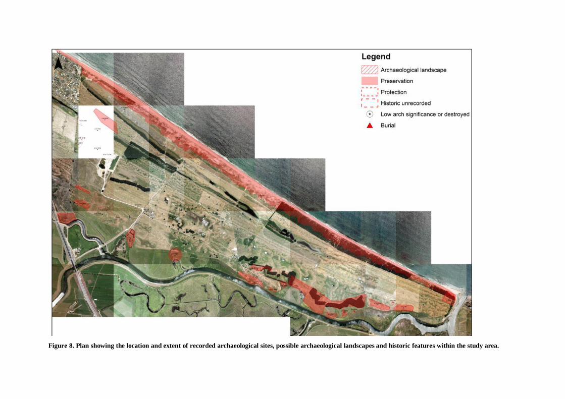
Figure 8. Plan showing the location and extent of recorded archaeological sites, possible archaeological landscapes and historic features within the study area.

RECORDED ARCHAEOLOGICAL SITES
In the Gumbley & Phillips 2000 report the inventory of 36 sites for the study area waspresented in the form of a spatial plan each site represented by a single point orpolygon. Seven sites were described as either destroyed or not relocated. There havebeen no additional sites recorded within the study area subsequent to the 2000 Report.
Polygons
As explained above, it was not possible to alter polygons without further field surveyand in some cases subsurface testing. As part of this review minor changes were madeto the southern boundary of U14/249 as it was the original intent to define theforedunes by their southern extent. The polygon for site U14/221 was moved slightlyto better reflect the location of Papanui as defined on early survey plans. The extent ofTe Kopua pa has also been enlarged and extended into the study area reflecting ourcurrent understanding of this site based on archaeological investigations carried outduring the Tauranga Eastern Link.
Archaeological Site Management
Plans presented in Appendix A show the location and extent of known archaeologicalsites within the study area. All sites are currently protected by the Heritage NewZealand Pouhere Taonga Act 2014 and section 6 of the Resource Management Act1991.
Land not within the boundaries of recorded archaeological sites can be considered ashaving no archaeological constraints for future development proposals, however,unrecorded archaeological sites within this area may be encountered during grounddisturbance at which time further archaeological assessment and mitigation strategieswill need to be established.
The 2000 Report categorised each archaeological site as either requiring preservationor protection. It should be noted that these recommendations were based onarchaeological information derived from a brief field survey and should be consideredprovisional.
Most sites within the study area will require further archaeological assessmentincluding subsurface testing in order to better assess the significance and appropriatemanagement strategies for each site.
Sites described as requiring protection are considered to have significantarchaeological value that may be recovered through archaeological investigationcarried out under the provisions of a Heritage New Zealand authority and ResourceConsent.

17
Sites described as requiring preservation are considered to have high archaeologicalvalues requiring preservation in perpetuity. They should be excluded from allproposals involving ground disturbance or activities that may potentially damage thearchaeological fabric of the site such as active recreation, planting of certainvegetation etc.
Table 1 presents a list of recorded sites within the study area including current statusand management requirements. Minor changes to the 2000 data include thecorrection of two place name based on subsequent archival research (U14/220 &U14/1738) Details regarding these changes are presented in Appendix B.
NZAA No. Site Type Name Site Status ManagementU14/220 Pa Te Kopua Damaged Preservation
Flax Mill Damaged PreservationU14/249 Midden PreservationU14/221 Pa ? Papanui No surface evidence PreservationU14/1735 Midden DestroyedU14/1736 Midden DestroyedU14/1737 Midden DestroyedU14/1738 Pa Te Karaka Damaged PreservationU14/1739 Midden ProtectionU14/1740 Pit / Terrace / Pa? PreservationU14/1741 Track DestroyedU14/1742 Burial Ground PreservationU14/1743 Pa Paroa Preservation
Flax Mill Paroa Existing buildings PreservationU14/1744 Midden / Oven DestroyedU14/1799 Find spot Not relocatedU14/1878 Hangi stones Paroa Part Paroa Pa PreservationU14/2848 Midden PreservationU14/2849 Midden PreservationU14/3038 Midden ProtectionU14/3039 Midden / Pa PreservationU14/3040 Midden / Pa PreservationU14/3041 Midden / Pa Whakarahue PreservationU14/3042 Terrace / Midden PreservationU14/3043 Plaggen Soil ProtectionU14/3045 Midden PreservationU14/3046 Midden ProtectionU14/3047 Midden Not relocated ProtectionU14/3048 Midden PreservationU14/3049 Midden PreservationU14/3050 Plaggen Soil PreservationU14/3051 Midden / Terraces PreservationU14/3052 Midden / Pa? PreservationU14/3053 Midden / Pa? PreservationU14/3358 Midden PreservationV14/40 Pa Te Tumu PreservationV14/185 Hangi stones PreservationV14/186 Midden PreservationTable 1. Inventory of known archaeological sites within the study area including status andmanagement recommendations.

18
Archaeological Landscapes
It should be recognised that many of the sites within the study area did not exist inisolation and groups of contemporaneous sites often formed components of a widerarchaeological landscape. However, identifying coherent archaeological landscapesand defining links between sites can often be problematic and may include moresubtle or diffuse intervening archaeological evidence such modified soils, or culturalspaces.
The four archaeological site complexes described above may be considered anarchaeological landscape being similar site types focused on a defined topographicalor geographical feature.
On a broader level archaeological landscapes may simply encompass groups ofsimilar archaeological sites that are best managed or preserved in a single land parcel.
In the 2000 Report groups of sites were identified as requiring preservation1 and whilethey were not described as constituting single archaeological landscapes it wasintended that they would be most effectively preserved within a single encompassingreserve. The archaeological landscape polygons presented in Appendix A arepresented as possible boundaries for heritage reserves, however, furtherarchaeological field work is required to identify and refine such landscapes.
Within the study area two archaeological site concentrations that may becontemporaneous and would clearly benefit from preservation within a single landparcel include the fore dune site complex (U14/249, 1742 & 3358) and theconcentration of river side sites extending east from Paroa to Te Tumu includingU14/1740, 1743, 1878, 3039, 3040, 3041, 3042, 3051, 3058, 3059, V14/185 andV14/186 (Figure 9). The sites within the latter group are often only separated by riverwetlands and short sections of dunes that may include subsurface archaeologicalfeatures not identified during the 2000 field survey.
1 Gumbley & Phillips 2000:48

19
Figure 9. Aerial photo showing the possible extent of an archaeological landscape (cross hatchedpolygon) encompassing the group of sites within the Kaituna River site complex.
REVIEW OF ARCHAEOLOGICAL SITE BY COMPLEX
Fore dune sites U14/249, U14/1742, U14/3358
Fore dune site U14/249 is currently defined by an extensive polygon but has not beensurveyed in detail. This polygon encompasses numerous midden deposits many ofwhich are deflated from wind erosion. With the exception of a small group at thewestern end of the study area (U14/3358) these middens have not been mappedindividually. In addition to the midden deposits, the polygon for U14/249 alsoencompasses the location of human remains which are occasionally exposed on thefore dunes with one notable concentration recorded as U14/1742. Furtherarchaeological survey may also identify sections of the fore dunes where siteconcentration is low or absent. Te Tumu pa (V14/40) is also located on the foredunes and is discussed in more detail in the section on Pa below.
Archaeological sites on the fore dunes are afforded additional protection by virtue oftheir location within coastal hazard zone reserve margins, however, understanding sitedistribution within the polygon may assist in identifying areas suitable for beachaccess or areas requiring fencing and stabilization.
Inland Dune Sites U14/1739, 3045, 3046, 3047, 3048, 3049, 3050
Sites recorded within the inland dune complex are considered the most wellunderstood archaeologically. Many more sites within this complex west of the studyarea have been excavated and a number of bee preserved within historic reserves.Consequently future management of sites described in the 2000 Report as requiringpreservation may need to be reviewed. Subsurface testing may confirm whether thesites warrants preservation or protection.

20
Recorded site U14/3045 is a relatively extensive site representing the eastern extent ofthe Inland Dune Complex and based on surface evidence appears to be worthy ofpreservation, however it still requires further subsurface testing to establish itssignificance based on our knowledge of similar sites to the west.
Kaituna River Site Complex U14/220, 221, 1738, 1740, 1743, 1878, 3039, 3040,3041, 3042, 3051, 3058, 3059, V14/185 and V14/186.
The Kaituna River site complex is in most need of further archaeological survey andinvestigation to determine antiquity, complexity, interrelationship and integrity inorder to more accurately assess significance of individual sites and possiblearchaeological landscapes.
U14/1740 & 3051 are both unique dune sites encompassing the only clearly definedearthwork features recorded on the Papamoa Dune Plain. They may form part of theriverbank pa of Te Paroa and Whakarahue in which case they should be included inan all-encompassing polygon. They are also the most threatened sites from farmactivity but primarily from pine plantations especially U14/1740. These sites arecurrently defined by a single polygon but both are in desperate need of more detailedsurvey of individual archaeological features. The effects of the harvest operationsneeds to be assessed to determine if these sites can be preserved during harvesting orif they need to be investigated before harvest. Obtaining radiocarbon dates from thesesites and the adjacent riverside pa may assist in determining relationships andcontemporaneity as well as significance and extent of the area requiring preservation.
U14/3039, 3040, 3041, 3052 & 3053 are all described as possible swamp pa.U14/3041 corresponds with the location of Whakarahue Pa and adjacent sitesU14/3039, 3040 may also be part of this pa complex. All five sites appear to havebeen affected by ploughing and further archaeological assessment involving testexcavation should be carried out to better determine their function and extent in orderto establish appropriate boundaries and future management strategies.
Back Dune Sites U14/1744, 2848, 2849, 3038, 3043
This group of sites on raised dunes north of Te Kopua comprise several smallscattered midden sites and culturally modified soils. Some of these sites may relate toprehistoric activity similar to the back dune sites investigated in adjacent properties tothe west. Some of these sites may also relate to post 1900 activity associated with theTe Kopua flax mill. All of these sites require further archaeological field work toestablish their antiquity and significance in order to determine whether they requireprotection or preservation.
REVIEW OF PA U14/220, 221, 1743, 3041, V14/40
There are five known pa within the study area including from west to east Te Kopua(U14/220), Te Karaka (U14/1738), Te Paroa (U14/1743), Whakarahue (U14/3041)and Te Tumu (V14/40). They appear on late 19th century survey plans ML 2046 andML 3995 and are generally thought to have been occupied in the 1830s with possibleearlier occupation episodes during the prehistoric period.
21
They were established or reoccupied by local Maori in response to a demand for flaxby European traders (specifically Hans Tapsell) and provided Maori with a means ofobtaining muskets. Te Arawa, having suffered attacks by Hongi Hika in 1823, alsosaw the potential of trading flax for muskets. In response Ngati He and Ngapotikiestablished themselves first at Te Paroa and Te Karaka Pa on the Kaituna River tokeep a presence in the area and then set up Te Tumu as a fighting pa.2 Occupation ofthese pa may have spanned a ten year period during the 1820s and 1830s but severalmay have been occupied during the prehistoric period and reoccupied following thebattle.
All five pa are situated on sections of the lower left bank where the river runs againsthard ground in an otherwise wetland riverine environment. They have often beenreferred to as swamp pa and as such there is little in the way of surface evidence toaccurately determine their locations and they are primarily identifiable by erodingsubsurface deposits such as shell midden, hangi stone and culturally modified soils.We do not know the physical extent of the five pa and it is possible that the terrace,pit and house floor features (U14/3051 & 1740) identified on the high duneimmediately north of Te Paroa and Whakarahue are in fact part of these pa.
Unfortunately all five pa have been damaged by 20th century earthwork includingriver diversion, stop bank construction, ploughing and general farm activity. TeKopua Pa and Te Karaka Pa have suffered significantly to the point where their exactlocation and extent is no longer known. Te Tumu pa was partly destroyed during theconstruction of the new Kaituna River mouth and consequent erosion. Paroa andWhakarahue pa are likely the most intact although both have suffered from ploughingand general farm activity while features on the high dune to the north (U14/1740,3051) have been damaged by pine plantations and will likely suffer severe damageduring ground based harvest operations.
In addition to the five known pa two further place names on early survey plans mayalso indicate the location of pa or settlement sites. These include Papanui locatedbetween Te Karaka and Te Paroa and Te Mamaku located between Te Whakarahueand Te Tumu pa. Papanui has been designated as archaeological site U14/221 and TeMamaku corresponds with recorded site V14/186.
Further details for each pa site are appended in the site assessment section of thisreport (Appendix B). Surviving archaeological evidence for these pa may potentiallyadd significantly to our understanding of these unique and rare examples of swamp paas well as the poorly understood early contact period consequently even the moreseverely damaged of the five sites have been assessed as having high archaeologicalvalues until proven otherwise by subsurface testing.
The five pa sites have been assessed as requiring preservation despite Te Kopua andTe Karaka having suffered extensive damage. They are also considered SignificantMaori Areas. Any future development should be sympathetic to the context of thesepa and appropriate buffer zones that where possible encompass the surroundingnatural landscape that defined there location and extent.
2 Kahotea 2014
22
REVIEW OF ARCHAEOLOGICAL SITES ASSOCIATED WITH THE FLAX INDUSTRYU14/220 & 1743
The study area encompasses a number of sites associated with the flax industryspanning over 100 years between the 1830s and 1940s and while U14/220 & 1743have been highlighted in this report other sites within the Back dune and KaitunaRiver site complexes may have associations with the 19th century flax trade and theearly 20th Century flax industry.
Maori had used flax fibre for hundreds of years extracting it from the leaf by scrapingwith a mussel shell or similar. Early european traders were quick to see the value inthe fibre and commencing in the 1820s trade in hand dressed fibre between Maori andEuropean resulted in considerable shift in Maori populations to access and control thenatural resource. Much of the early fibre trade went to rope makers in Australia andEngland until rope making ventures were established in New Zealand in the 1840s.
The five pa sites within the study area were likely established in the 1830s in responseto European demand for the fibre. Te Karaka and Te Paroa are mentioned in availablearchives as having been occupied or reoccupied at this time. These sites and otherspotentially contain archaeological evidence relating to the formative years ofcommercial flax harvesting and processing.
With the introduction of mechanised flax processing in the 1860s the industryflourished throughout the country. Mobile mechanised flax mills saw the rapiddepletion of natural flax and the establishment of flax plantations. Two largepermanent mills were established within or immediate adjacent to the study area at TeParoa in 1890 and Te Kopua around 1900. Te Paroa Mill is thought to have operatedoff and on for over 50 years depending on demand for flax. The archaeologicalsignificance of the two flax mills at Te Kopua and Te Paroa have been largelyoverlooked in NZAA records , Council SAA’s and the Gumbley & Phillips 2000report
The flax industry was an important contributor to the local economy for over 100years providing valuable trade commodity for local Maori resulting in a significantimpact on Maori population distribution particularly in the formative years. The largecommercial operations commencing in the 1890s utilised unique technology some ofwhich was developed in New Zealand. The industry resulted in a dramatic change tothe natural landscape with natural flax replaced by plantations and vegetation clearedfor many acres of drying fields.
Archaeology of the Flax Industry has gone largely unrecognised by heritage agenciesand gain only a cursory mention in the Gumbley & Phillips 2000 report by virtue ofthe later commercial mills occupying earlier pa sites.

23
Sites associated with the flax industry including both early c.1830s Maori settlementsinvolved in hand processing of flax for trade as well as the two commercial operationsat Te Kopua and Te Paroa should be treated as a discrete site complex within thestudy area all of which are assumed to have high archaeological values due to theirunique and rare status. While most are designated as deserving of preservation this islargely due to the fact that they fall within pa sites. Further research is required inorder to more accurately assess their historical and archaeological significance.Historic research has been carried out and is due to be presented in a publisheddocument.3 This document should provide the basis for further archaeologicalresearch. There is considerable scope for public presentation and interpretation ofthese sites within a wider heritage landscape or heritage trail.
The two extant mill buildings at Te Paroa should be assessed by a suitably qualifiedarchaeologist and or built heritage specialist to determine their age, significance andstructural integrity and built structure archaeological values. Buildings relating to theflax industry are rare and the Paroa examples, while simple in design, may assist inthe public interpretation of this unique historical industrial landscape of the lowerKaituna.
Figure 10. Oblique aerial view of Paroa Flax Mill in the 1920s. Photo: Tauranga Historical Society.
3 Hart, R. (ed) The Te Puke Flax Mills (in prep)

24
Figure 11. View of Te Kopua Flax Mill. Photo: Tauranga Historical Society.
UNRECORDED ARCHAEOLOGICAL SITES
There are likely to be unrecorded archaeological sites within the study area additionalto the inventory of sites presented in Table 1 and plans presented in Appendix A. It isextremely difficult to identify all sites within such a large study area using acceptedfield survey methodology. Any development proposals within land where no siteshave been recorded should have in place a mitigation strategy to appropriatelymanage unrecorded subsurface archaeological sites if they are encountered duringground disturbance.
SUMMARY
The Gumbley & Phillips 2000 Report presented the results of a field survey of thestudy area and provided a preliminary assessment of the significance of thearchaeological sites and the groups of sites. Our understanding of the site inventoryhas changed little over the intervening 15 years.
Minor additions have been made in this review primarily in regard to interpretation ofsites that have been the subject of recent archaeological investigations or additionalarchival research.
In order to advance our understanding of the archaeology within the study area to apoint where sound preservation and management strategies can be establishedadditional field work will be required including field survey and, in some cases,archaeological test excavations carried out under the provisions of a Heritage NewZealand authority.

25
RECOMMENDATIONS
Recommendations are provided for further work required to provide accurate siteboundaries, interpretation and significance to enable appropriate management ofarchaeological resources within the study area and with regard to proposed urbandevelopment.
Establishing site extent
· Subsurface testing should be carried out in order to more accurately determinethe extent of known archaeological sites within the study area.
o To be undertaken at Structure Plan Stage.
· Possible links between sites should be established by subsurface testingespecially within the Kaituna River site complex.
o To be undertaken at Structure Plan Stage.
· The revised extent of all sites should be defined by a polygon on Councilplanning maps.
o To be undertaken at Structure Plan Stage.
· Midden deposits and other archaeological features within the fore dune sitecomplex should be mapped in order to identify discrete concentrations.
o To be undertaken at the Subdivision Stage.
Establishing site location
· Sites that have been identified from archival sources but have no visiblearchaeological features should be investigated in order to better understandtheir location and extent.
o To be undertaken at Structure Plan Stage.
Establishing site significance (of thirty six recorded sites)
· Following further field survey and subsurface testing the significance ofarchaeological sites should be reassessed in order to determine if they shouldbe protected or preserved.
o To be undertaken at Structure Plan Stage.

26
Establishing archaeological landscapes (of thirty six recorded sites)
· Following further field survey and subsurface testing links betweenarchaeological sites that may indicate a relationship indicative of anarchaeological landscape should be established and appropriate polygonsestablished to encompass the landscape.
o To be undertaken at Structure Plan Stage.
Establishing appropriate management strategies
· Appropriate management strategies should be established for sites and groupsof sites within the study area that are to be preserved.
o To be undertaken at Structure Plan Stage.

INTRODUCTION
Appendix B provides additional information and a preliminary assessment of significance for
individual sites and groups of sites within the Te Tumu Strategic Planning Study area.
The Papamoa Lowlands Archaeological Survey and Heritage Assessment’ produced by
Gumbley & Phillips in 2000 provided a preliminary assessment of significance, however, the
subsequent production of the Bay of Plenty Regional Policy Statement (BOPRPS) includes a
more robust assessment criteria framework better suited to statutory requirements. Appendix
F of the BOPRPS provides criteria for assessing matters of national importance in the Bay of
Plenty including Historic Heritage (Set 5). The following assessments utilise Set 5 of the
BOPRPS framework. It should be noted that an assessment of cultural significance might not
necessarily correlate with an assessment of archaeological significance. An assessment of
Maori culture and traditions (Set 4) is this is strictly the domain of tangata whenua.
Significance levels are given as High, Medium or Low. These levels may be expanded once
further field assessments have been completed. For example the Auckland Unitary Plan
employs the significance levels: none, little, moderate, considerable, exceptional which may
be more accommodating for the variables encountered in the Te Tumu study area.
It should also be noted that the assessments in this appendix are necessarily preliminary as the
majority of sites have not been inspected since the 1999 – 2000 Gumbley and Phillips survey
and we still have little detailed information about the antiquity, extent and complexity of most
sites within the study area. Consequently the following significance assessments should not be
used to guide future management of archaeological resources or accompany applications to
Heritage New Zealand authority applications until further refinement is carried out.
New Zealand Archaeological Association site record forms for the sites within the study area
have not been included in the appendix as they a typically very brief. They can be viewed
online by registered users at www.archsite.org.nz.
RECOGNITION OR PROTECTION
All sites within the study area, with the exception of those sites described as destroyed, are
provided legal protection by the following legislation.
An archaeological site, as defined by the Heritage New Zealand Pouhere Taonga Act 2014
6(a), is any place in New Zealand, including any building or structure (or part of a building or
structure), that (i) was associated with human activity that occurred before 1900 or is the site
of the wreck of any vessel where the wreck occurred before 1900 and (ii) provides or may
provide, through investigation by archaeological methods, evidence relating to the history of
New Zealand. Archaeological sites cannot be modified or destroyed unless an authority is
granted under section 48, 56(1) (b), or 62 in respect of an archaeological site, no person may
modify or destroy, or cause to be modified or destroyed, the whole or any part of that site if
that person knows, or ought reasonably to have suspected, that the site is an archaeological site.
The RMA 1991 recognises as matters of national importance: ‘the protection of historic
heritage from inappropriate subdivision, use, and development’ (S6(f). Territorial authorities
are required under Section 6 of the RMA to recognise and provide for these matters of

national importance when ‘managing the use, development and protection of natural and
physical resources’. Historic heritage is defined as ‘those natural and physical resources that
contribute to an understanding and appreciation of New Zealand’s history and cultures,
deriving from any of the following qualities: (i) archaeological; (ii) architectural; (iii)
cultural; (iv) historic; (v) scientific; (vi) technological’. Historic heritage includes: ‘(i)
historic sites, structures, places, and areas; (ii) archaeological sites; (iii) sites of significance
to Maori, including wahi tapu; (iv) surroundings associated with the natural and physical
resources’.

U14/220 Te Kopua Pa
Background:
Te Kopua was first recorded as an archaeological site by Ken Moore in 1974. He writes that
the site was a pa and was occupied in the early 1830s, however, he does not reference the source
of his information. Moore did not visit or relocate the site at this time but probably determined
the general location of the site from survey plans ML 2046 and or ML 1916. The site is not
described as a pa on either plan.
The site is again referred to as a pa in a report prepared by Kahotea for the Tauranga Eastern
Arterial project (Kahotea 1999). Kahotea writes that ‘The cultural values for the site are as a
pa, Te Kopua, and as an important boundary location for Waitaha and it also has historic
significance as the site of a flax mill’.
In Percy Smiths account of the Battle of Te Tumu he writes that ‘The Te Arawa taua then
advanced by way of Kainga-pakura, near Papamoa hills, and so by the Tauranga or western
side of the pa. By sunset they had reached Te Kopua where the taua was aspersed with water
by the tohunga Te Kahawai…’
While the location of place names on survey plans are often indicative the majority of early
plans including ML 1916 and ML 3995 place Te Kopua to the west of the apex of the great
bend. This location is supported by Kahotea and subsequent archaeological assessments by
Phillips. The location of the Kopua Flax Mill is also well established in this location.
An early 20th century flax mill and associated huts were situated in the vicinity of Te Kopua
Pa and it is probable that a mill building was situated on the pa although no archival information
was found to support this claim. Several mill buildings are depicted on early survey plans and
buildings that may have been associated with the flax mill are visible on an aerial photo taken
in 1950.
Archaeological Site Description:
During his field examination of the site in 1998 Kahotea identified ‘exposed cultural layers
(30-50cm) in section containing charcoal, cultural soil layers, shell fragments, fire burnt stones
in drain walls following an old boundary from the river..
The site was inspected again in 2005 by Phillips. The cultural layers and machinery identified
by Kahotea in 1998 were not relocated at this time. Phillips carried out further analysis of
aerial photography indicating extensive modification had occurred in the vicinity of the
probable site of U14/220 as outlined by Kahotea. The most recent damage has occurred during
the construction of flood control banks and alterations to the surrounding drainage network.
In summary the location of U14/220 is not obvious on early aerial photos and post 1950
earthwork in the immediate vicinity has made identification of the exact location and extent of
the pa on the ground virtually impossible without extensive subsurface testing. The actual
location of Te Kopua Pa may be anywhere within the area identified as archaeologically
sensitive illustrated in Figure 1 below and while there remains a possibility that the pa has been
largely destroyed it is equally possible that significant subsurface archaeological features
associated with the pa survive in this area.

Recommendations:
That further subsurface archaeological investigation would be required to determine the
exact location and condition of Te Kopua Pa.
Any future development proposals should be sympathetic to the context of this pa and
appropriate buffer zones establish to encompass the surrounding natural landscape that
defined its location and extent.
References:
Kahotea, D
1999 Transit New Zealand Designation of State Highway 2 (Tauranga Eastern
Arterial) and Tauranga District Council Bell Road Interchange. Unpublished
report prepared by Bioresearches for Transit NZ & TDC.
Smith, S Percy
1923 The Fall of Te Tumu Pa, Near Maketu, Bay of Plenty. Journal of the
Polynesian Society. 32 (127): 121-130.
Phillips, K.J.S.
2008 Archaeological survey and assessment of effects , Proposed Bell Road Storm
Water Project, Papamoa. Unpublished report prepared for Tauranga City
Council.
Phillips, K.J.S.
2012 Preliminary Report – Archaeological monitoring and investigations, Areas A –
I Tauranga Eastern Link Construction corridor. Unpublished report prepared
for Beca.
Phillips, K.J.S.
2014 Preliminary Archaeological assessment, Section 10 SO 458365, Section 11 SO
458365, Lot 3 DP 10111, & Lot 1 DPS 66482, Bell Road, Tauranga.
Unpublished report prepared for NZ Transport Agency.

Figure 1. Aerial photo showing the probable location of U14/220 and surface shell scatters identified by
Phillips in 2005.
ASSESSMENT OF SIGNIFICANCE: U14/220
General Values Criteria.
Period: Medium
There is limited information regarding the occupants and events that took place at Te Kopua.
Available archives suggest that in 1836 the Te Arawa taua stopped and possibly spent the
night at Te Kopua before advancing to Te Tumu the next day. It is possible that Te Kopua
was established in the 1830s in response to the emerging flax industry.
Rarity: High
There are few surviving examples of river bank pa associated with the musket wars in the
Bay of Plenty and even fewer pa built on dune environments. Consequently any remains of
Te Kopua Pa would be considered very rare.
Integrity: Low
Earthworks associated with an horticultural venture in the 1980s and stop bank work along the
left bank of the Kaituna River has likely had a significant effect on the archaeological integrity
of Te Kopua Pa. There is little or no surface evidence to indicate its exact location and extent,
however subsurface features may survive.
U14/220
Te Kopua Pa
(Kahotea 1998)
Surface shell
scatters
Archaeologically
sensitive area

Representativeness: Low
There are few sites similar in age and geographic location to compare Te Kopua Pa with.
Context or Group Value: High
Te Kopua Pa is part of a network of settlement sites along the left bank of the Kaituna River
established as a result of the surrounding flax industry including Te Te Tumu, Te Karaka and
Paroa. It is also a significant component of the wider political landscape of the mid 1830s that
included Maketu pa and inland settlements of Te Arawa where war parties assembled before
the battle.
Diversity: High
Diversity is difficult to assess based on available information and should be considered high
until further investigation. It has diverse historical and cultural values however while the
geographic location is unique the diversity of the archaeological remains can only be
established by archaeological investigation.
Fragility and Vulnerability: High
Archaeological sites within dune environments are typically more susceptible to erosion. Te
Kopua Pa has already suffered significant damage from horticultural development and flood
bank construction.
Archaeological Qualities
Information: low
Information potential from the site is limited due to late 20th Century ground disturbance. Any
surviving archaeological evidence would, however, have the potential to add to our
understanding of prehistoric and early historic occupation on the river bank.
Research: Low
Research potential is likely to be limited due to the extensive damage to the site by late 20th
earthwork, however, subsurface investigation may prove otherwise.
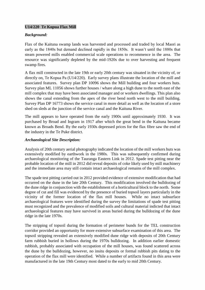
U14/220 Te Kopua Flax Mill
Background:
Flax of the Kaituna swamp lands was harvested and processed and traded by local Maori as
early as the 1840s but demand declined rapidly in the 1850s. It wasn’t until the 1880s that
steam powered mills enabled commercial scale operations to recommence in the area. The
resource was significantly depleted by the mid-1920s due to over harvesting and frequent
swamp fires.
A flax mill constructed in the late 19th or early 20th century was situated in the vicinity of, or
directly on, Te Kopua Pa (U14/220). Early survey plans illustrate the location of the mill and
associated features. Survey plan DP 10096 shows the Mill building and four workers huts.
Survey plan ML 11056 shows further houses / whare along a high dune to the north east of the
mill complex that may have been associated manager and or workers dwellings. This plan also
shows the canal extending from the apex of the river bend north west to the mill building.
Survey Plan DP 16773 shows the service canal in more detail as well as the location of a store
shed on sleds at the junction of the service canal and the Kaituna River.
The mill appears to have operated from the early 1900s until approximately 1930. It was
purchased by Broad and Ingram in 1917 after which the great bend in the Kaituna became
known as Broads Bend. By the early 1930s depressed prices for the flax fibre saw the end of
the industry in the Te Puke district.
Archaeological Site Description:
Analysis of 20th century aerial photography indicated the location of the mill workers huts was
extensively modified by earthwork in the 1980s. This was subsequently confirmed during
archaeological monitoring of the Tauranga Eastern Link in 2012. Spade test pitting near the
probable location of the mill in 2012 did reveal deposits of coke likely used by mill machinery
and the immediate area may still contain intact archaeological remains of the mill complex.
The spade test pitting carried out in 2012 provided evidence of extensive modification that had
occurred on the dune in the late 20th Century. This modification involved the bulldozing of
the dune ridge in conjunction with the establishment of a horticultural block to the north. Some
degree of cut and fill was evidenced by the presence of buried topsoil layers particularly in the
vicinity of the former location of the flax mill houses. While no intact subsurface
archaeological features were identified during the survey the limitations of spade test pitting
must recognized and the prevalence of modified soils and cultural material indicted that intact
archaeological features may have survived in areas buried during the bulldozing of the dune
ridge in the late 1970s.
The stripping of topsoil during the formation of perimeter bunds for the TEL construction
corridor provided an opportunity for more extensive subsurface examination of this area. The
topsoil stripping revealed an extensively modified dune ridge with deposits of 20th Century
farm rubbish buried in hollows during the 1970s bulldozing. In addition earlier domestic
rubbish, probably associated with occupation of the mill houses, was found scattered across
the dune by the bulldozing, however, no insitu deposits or formal rubbish pits dating to the
operation of the flax mill were identified. While a number of artifacts found in this area were
manufactured in the late 19th Century most dated to the early to mid 20th Century.

During archaeological monitoring for the Bell Road storm water project a component part of a
flax processing machine was recovered where the storm water pipe intersected with the Bell
Road Drain.
The houses and whare shown on survey plan ML 11056 produced in 1918 when the mill was
operating also correspond closely to a number of recorded midden sites
The Mill buildings and associated workers huts were located within Pt Section 1 Blk IV Te
Tumu SD outside of the study area, however, the canal and store shed were located within Lot
1 DPS 66482 and further houses and whare’s possibly associated with the mill were located
within Pt Tumu Kaituna 14 within the study area.
Further Information:
A history of the Flax Milling industry on the Kaituna is being prepared by Richard Hart
(Tauranga Historical Society) based on research carried out by the late Allister Matheson.
Zarah Burnett has recently competed an MA thesis on the flax industry in New Zealand
Between 1860 and 1939.
References:
Burnett, Z
2012 Men of Fibre: The New Zealand Flax Industry and its Workers 1860 – 1939.
MA (History) Thesis Auckland University.
Ford, G
2008 Lower Kaituna River and Te Tumu: The Ford Family History from 1907 – 2
008. Unpublished document.
Hart, R
2015 The Early Flax Industry on the Kaituna River. (in prep)
Kahotea, D
1999 Transit New Zealand Designation of State Highway 2 (Tauranga Eastern
Arterial) and Tauranga District Council Bell Road Interchange. Unpublished
report prepared by Bioresearches for Transit NZ & TDC.
Matheson, A.
2000 Early Maketu Storekeepers. Historical Review Volume 44 No. 2.
Phillips, K.J.S.
2008 Archaeological survey and assessment of effects , Proposed Bell Road Storm
Water Project, Papamoa. Unpublished report prepared for Tauranga City
Council.
Phillips, K.J.S.

2012 Preliminary Report – Archaeological monitoring and investigations, Areas A –
I Tauranga Eastern Link Construction corridor. Unpublished report prepared
for Beca.
Phillips, K.J.S.
2014 Preliminary Archaeological assessment, Section 10 SO 458365, Section 11 SO
458365, Lot 3 DP 10111, & Lot 1 DPS 66482, Bell Road, Tauranga.
Unpublished report prepared for NZ Transport Agency.
Smith, S Percy
1923 The Fall of Te Tumu Pa, Near Maketu, Bay of Plenty. Journal of the
Polynesian Society. 32 (127): 121-130.
Stokes, E.
1980 A History of Tauranga County. Dunmore Press, Palmerston North.
Figure 1. Part survey plan DP 10096 produced in 1914 showing the location of the Te Kopua Flaxmill and
associated workers huts.

Figure 2. View of Te Kopua Flax Mill. Photo: Tauranga Historical Society.
Figure 3. Survey Plan DP 16773 produced in 1923 showing TE Kopua Flax Mill canal and store shed.

Figure 4. Aerial photo with overlay of survey plan DP 16773 showing the location of the mill, mill canal
and huts.
Mill

Figure 5. Survey Plan ML 11056 showing houses and whare along raised dune east of Te Kopua Mill.
Figure 6. Aerial photo with recorded archaeological sites and survey plan ML 11056 georeferenced
overlays showing a correlation between houses and whares present in 1918 and recorded midden deposits
indicted by red polygons.

ASSESSMENT OF SIGNIFICANCE: U14/220
General Values Criteria.
Period: High
The establishment date for Te Kopua flax mill is unclear but likely commenced in the late
1890s. The early Te Kopua Pa may also have been established in the 1830s to accommodate
local Maori involved in the emerging flax trade. The site potentially contains archaeological
remains of the flax milling trade and industry spanning 100 years between 1830 and 1930.
Rarity: High
There are few surviving examples of flax mills nationally and few have been recorded as
archaeological sites. The Paroa and Te Kopua Mills are currently recorded by virtue of their
location on earlier pa sites. They are particularly rare as they potentially encompass
archaeological remains associated with the industry spanning 100 years.
Integrity: Low
The site has been extensively damaged by modern earthwork.
Representativeness: High
There are few early flax mill sites recorded as archaeological sites or Scheduled in Bay of
Plenty District or Regional Planning documents, however, based on our understanding of the
industry in the 19th and early twentieth century the Te Kopua Mill likely represents a typical
mill complex of the period situated adjacent to the natural flax resource and on a river bank
that provides water for processing and a ready means of transporting the products from the
mill.
Context or Group Value: High
The Paroa Mill is one of at least three mills that operated on the Kaituna River in the late 19th
and early 20th Century and forms part of a expansive historic industrial / commercial
landscape.
Diversity: High
Intra site diversity potentially includes many aspects of activity associated with a flax mill
complex including built structures, industrial archaeological remains and domestic
archaeological remains associated with management and worker dwellings. The Mill is also
the site of an earlier Maori settlement (Te Kopua Pa) that was established in the 1830s to
accommodate locals involved in harvesting flax from surrounding wetlands.
Fragility and Vulnerability: High
Archaeological sites within dune and wetland environments are typically more susceptible to
damage and erosion. Te Kopua has already suffered significant damage from modern
earthwork.
Archaeological Qualities
Information: medium

The extent to which archaeology relating to the flax mill has survived remains unknown
however any remains associated with the mill activity has the potential to address research
questions presented below.
Research: medium
Given the significant social and economic impact the flax mill industry had on local Maori
populations and the wider economy our understanding of the industry is surprisingly limited.
This is in part due to the mobile nature of flax milling plants which, during the formative period
of the industry, were moved frequently to be close to the natural flax resource leaving limited
archaeological footprints. Larger commercial operations in the late 1900s and early 20th
century were focused on flax planation’s resulting in larger more permanent mills with
associated workers accommodation as is the case with Te Kopua and Paroa mills on the
Kaituna.
The flax milling industry along the Kaituna changed the settlement distribution of Maori
populations and was a catalyst for intertribal conflict,
The research potential of the archaeology of these sites lies both in the little understood
technology employed in processing the flax and the conditions of workers employed at the
mill, many of whom were local Maori.
Flax processing machinery was initially imported and later developed for local conditions and
improved efficiency by local engineering firms. Few examples of this technology survive.
Power plants were reallocated to alternate industries following the demise of the flax milling
industry while specialised machinery was likely sold for scrap or dumped in the adjacent
wetlands and buildings used for other purposes, demolished or left to decay.
The archaeology of the workers dwelling at the Te Kopua mill were likely destroyed during
earthwork associated with horticultural development in the 1980s. The site of the mill proper,
while modified by mid to late 20th century drainage works may still have left significant
archaeological remains that may assist in answering technological, economic and social
questions about the late 19th and early 20th century flax milling industry on the Kaituna River.

U14/221 PAPANUI PA
Background:
The location of Papanui was first recorded as an archaeological site by Ken Moore in 1974.
Moore incorrectly identified the location as Te Karaka and this error was carried through by
Gumbley and Phillips 2000 and is now corrected in this report.
The location, on hard ground, next to a prominent bend in the river is typical of pa and
settlement sites along the lower left bank of the Kaituna River. Consequently it would not
surprising to find evidence of settlement at Papanui.
Archaeological Site Description:
No archaeological features have been identified at this location, however efforts to date have
been minimal and further investigation may indeed find tangible evidence of Papanui.
Recommendations:
That further subsurface archaeological investigation would be required to determine if
intact subsurface archaeological features are present at this location. It is currently not
possible to assess the significance of this site without further archaeological
investigation.
That further research is required in order to determine the nature of Papanui, i.e.
whether the name refers to a settlement, fishing spot, geographical feature etc.
Figure 7. Part Survey plan ML 1916 produced in 1889 showing the place name Papanui (Rapanui?) on
the apex of a prominent oxbow.

ASSESSMENT OF SIGNIFICANCE: U14/221
General Values Criteria.
Period: low
There is no information relating to the historical or archaeological significance of this site.
Rarity: low
It is not possible to establish rarity due to the lack of information for this site.
Integrity: Low
No archaeological features have been identified at this site.
Representativeness: Low
Not known.
Context or Group Value: High
Papanui may be part of a network of settlement sites along the left bank of the Kaituna River
established as a result of the surrounding flax industry including Te Te Tumu, Te Karaka and
Paroa.
Diversity: low
Diversity is difficult to assess based on available information
Fragility and Vulnerability: High
The site is located in an area affected by earthwork associated with drainage of surrounding
land.
Archaeological Qualities
Information: low
There are no known archaeological features at this site to assess archaeological qualities
however any surviving archaeological evidence would have the potential to add to our
understanding of prehistoric and early historic occupation on the river bank.
Recognition or Protection:
U14/221 currently has limited protection as the location of the site has not been established.

U14/249 & U14/3358 FORE DUNE MIDDENS
Background:
This site was originally recorded by Cathleen Fletcher in 1976 and was updated during the 1999 -
2000 Gumbley and Phillips field survey. More recently Lynda Walters has recorded specific shell
midden deposit (U14/3358) within and in the western end of U14/249. In addition a burial ground
U14/1742 is located within the Polygon defining the boundaries of U14/249.
Archaeological Site Description:
U14/249 is comprised of numerous middens located along the entire length of the fore dunes between
the end of Papamoa Beach Road and the Kaituna River mouth. The vast majority are deflated patches
of shell and hangi stones. A few patches of intact midden remain, but most are less than 3m2. However,
it is probable that buried middens and other occupation sites may remain intact within the dunes. In
2010 Lynda Walters recorded 9 midden sites on the fore dunes at the western end of the study area
during a fore dune conservation project. These middens fall within the U14/249 polygon but were given
a separate site record number (U143358). A burial ground located in the vicinity of the boundary of the
Te Tumu 7B and 14 blocks recorded as site U14/1742 is also located within the site extent of U14/249.
Recommendations
That the for dune midden sites are accurately mapped to assist in future management and conservation
of the fore dune environment.
ASSESSMENT OF SIGNIFICANCE: U14/249 & U14/3358
Note that the following assessment of significance refers only to the archaeological site and not the
burial ground (U14/1742) the significance of which can only be assessed by tangata whenua.
General Values Criteria.
Period: Medium
These sites have not been radiocarbon dated. However, on the basis of limited investigations it is
thought that the fore dunes were probably used throughout the duration of the prehistoric period.
Rarity: Low
Midden sites are the most common feature in the fore dune area.
Integrity: Low
The majority of middens that make up U14/249 are deflated with only a handful of sites with intact
deposits and these are typically less than 5 m². The integrity of the sites that comprise U14/249 is
therefore low.
Representativeness: High
The fore dune middens within the study area are typically of sites along the Papamoa fore dune and
similar to those found on Matakana island to the north
Context or Group Value: Medium
Middens of the fore dunes are a distinct components of the wider archaeological landscape
representing short term events carried out by adjacent populations within the Inland and Kaituna
River site complexes.

Diversity: Low
The fore dune middens are typically simple in composition with limited stratigraphy and content
Fragility and Vulnerability: High
The fore dune middens are predominantly deflated due to wind erosion and continue to be affected by
ongoing erosion particularly where coastal vegetation is limited.
Archaeological Qualities:
Information: Medium
While erosion damage to the fore dune sites has significantly affected there archaeological integrity
they retain import archaeological information that can be recovered using archaeological method of
site recording and investigation.
Research: Medium
There are a number of important research questions that the fore dune sites can potentially address.
These include site and species distribution and harvest strategies, shell fish processing strategy
variations and the nature and quantity introduced resources including hangi stones and hearth fuel.

U14/1735, 1736, 1737, 1741 & 1744 MIDDENS
Background
These four sites were recorded by Bristow and Wood in 1984 but have not subsequently been
relocated and are considered likely to be destroyed by sand quarrying or farm activity.
Consequently these sites cannot be assessed for archaeological significance.

U14/1738 TE KARAKA PA
Background
Te Karaka Pa is marked on a number of early survey plans most notably ML 2046 produced in
1870 which describes it as an ‘Old Pa’ and ML 3995 produced in 1889. It was first recorded
as an archaeological site by Wood and Bristow in 1983.
Te Karaka appears to have been a well-known location on the Kaituna River in prehistoric
times.1 It is situated on the apex of a sharp northern bend in the river at which point the dunes
provide one of the few solid landing areas in an otherwise riverine wetland where access to the
dunes and the beach to the north can be had. A well warn track extended north to the beach
(U14/1741) and a track accessing Te karaka from the west is noted a several early survey plans.
A whare, located a short distance to the west of Te Karaka, is marked on ML 11056 produced
in 1918.
Te Karaka Pa appears to have been established in the late 1820s or early 1830s by local Maori
in response to a demand for flax by European traders (specifically Hans Tapsell) that provided
a means for obtaining muskets. Te Arawa, having suffered under Hongi Hika in 1823, also
saw the potential of trading flax for muskets. In response Ngati He and Ngapotiki established
themselves first at Te Paroa and Te Karaka Pa on the Kaituna River to keep a presence in the
area and then set up Te Tumu as a fighting pa.2 Occupation of the pa may have spanned a ten
year period during the 1820s and 1830s but was likley a settlement in prehistoirc times.
Archaeological Site Description
When Wood and Bristow recorded Te Karaka Pa in 1983 bulldozing had occurred on the site
exposing a large midden deposit visible over a 200m² area. Charcoal stained soils and fire
cracked hangi stone were also noted along with a well warn track extending from Te Karaka
north to the beach (U14/1741). In 1999 Gumbley and Phillips described the site as a platform
by the river bank with a possible defensive ditch.
Site extent
The current polygon defining the boundary of U14/1738 includes an area of raised ground
immediately adjacent to the river bank. This polygon encompasses the location the shell
midden identified by Wood and Bristow and the raised platform described by Gumbley and
Phillips.
1 Tarakawa 1893:244 2 Kahotea 2014

References:
Kahotea, D.
2014 Te Tumu Pa Hearing – Evidence in Chief.
Tarakawa, T
1893 The Coming of Te Arawa and Tainui Canoes from Hawaiki to New Zealand.
Translated by S. Percy Smith. Journal of the Polynesian Society Vol 2.
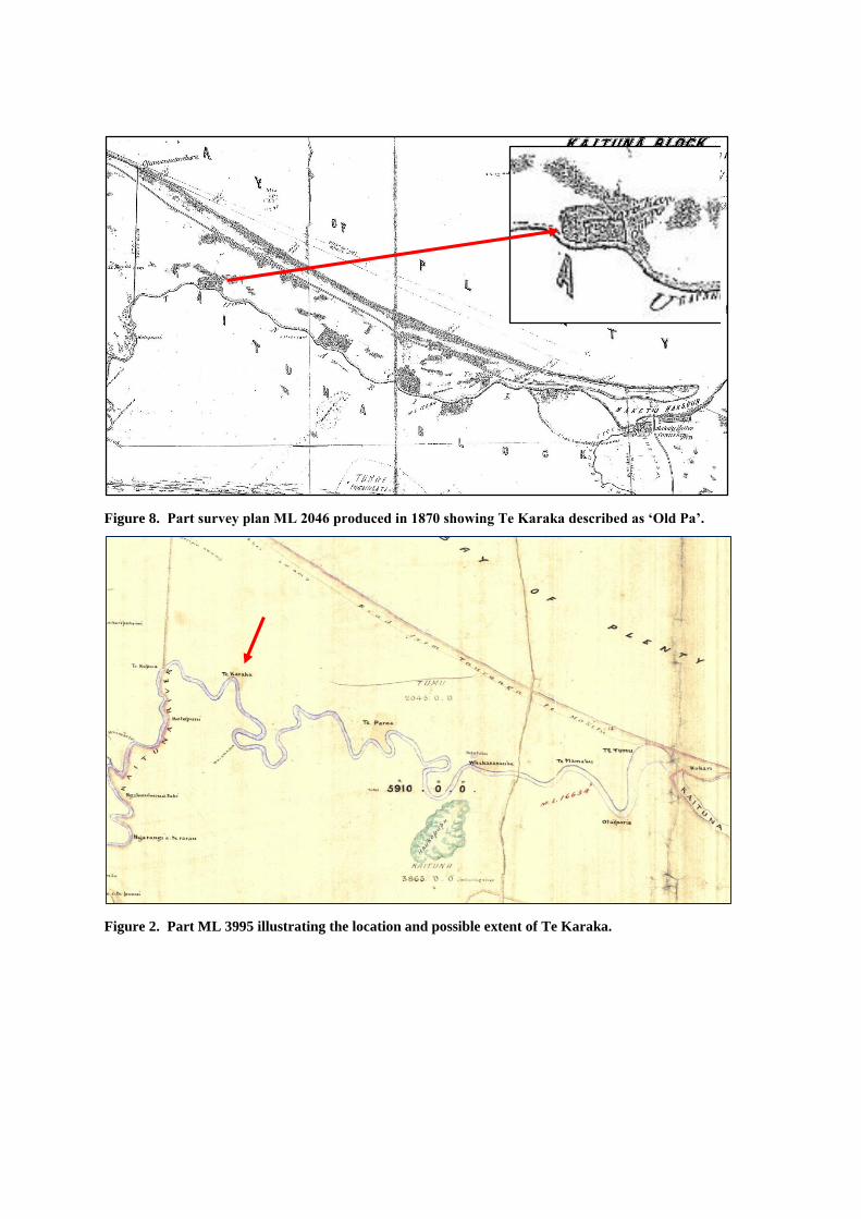
Figure 8. Part survey plan ML 2046 produced in 1870 showing Te Karaka described as ‘Old Pa’.
Figure 2. Part ML 3995 illustrating the location and possible extent of Te Karaka.

Figure 9. Aerial photo showing polygons currently defining extent of site U14/1738 on Tauranga City
Council GIS.
Te Karaka Pa
U14/1738

ASSESSMENT OF SIGNIFICANCE: U14/1738
General Values Criteria.
Period: High
Te Karaka Pa is one of a number of similar settlement sites along the lower left bank of the
Kaituna River. They are generally thought to have been established by local Maori to control
and or harvest local flax resources for trade in the 1830s. They represent a specific period in
the early historic period brought about the presence of a European trader at Maketu, the ability
of local Maori to trade flax for muskets and countered further invasions from northern iwi.
Rarity: High
Te Karaka Pa and associated pa on the lower left bank of the Kaituna River represent a unique
group of settlement sites established for very specific reasons and occupied for a relatively
short period in the early historic period. They are therefore extremely rare.
Integrity: High
The integrity of Te Karaka Pa can only be established by archaeological investigation. Features
and activities that may have affected the integrity of the pa include bulldozing of unknown
purpose on the pa in 1983.
Representativeness: High
Te Karaka Pa is unique and can only be compared to adjacent sites along the lower left bank
of the Kaituna River, however it must be considered representative of these pa.
Context or Group Value: High
Te Karaka Pa is an important component of the group of unique settlements along the lower
left bank of the Kaituna River.
Diversity: High
Intra site diversity potentially includes many aspects of activity associated with the 1830s
settlement as well as earlier prehistoric settlement.
Fragility and Vulnerability: High
Components of the site on the high dune to the north and on the river bank to the south have
likely suffered from erosion and the previously mentioned bulldozing. Further threats may
include intensification of land use on surrounding properties.
Archaeological Qualities
Information: High
Te Karaka Pa has high potential to provide archaeological information relating to the 1830s
settlement.
Research: High
Given the significant social and economic impact the flax mill industry had on local Maori and
the unique nature of the Kaituna River Pa research potential must be considered high.

Archaeological remains may provide information relating to the early contact period including
the impact European traders had had on material culture, the nature of settlement architecture
compared to similar prehistoric settlements, subsistence economies etc.

U14/1739 MIDDEN
Background:
This site was originally recorded in 1983 and was updated during the 2000 Gumbley and Phillips field
survey.
U14/1739 is characterised as an inland site, which along with several others represents a continuation
of the Papamoa Dune Plain settlement pattern of occupation, albeit the eastern extent of it. These sites
form a significant band of occupation sites approximately half a kilometre wide straddling the ancient
paleo-channel and about 300-400m inland of the shore. As the eastern extent of this group of sites,
the site density is lower and the sites themselves are more discreet than they are to the west.
Archaeological Site Description
U14/1739 is a midden site located immediately south of the seaward inter-dune channel at the top of
the slope approximately 1.6km east of the end of Papamoa Beach Road. The site is situated partly
within pine plantation and is exposed in bank of an old farm track and around a barn. The midden
deposit comprises predominately tuatua with some ostrich foot.
ASSESSMENT OF SIGNIFICANCE: U14/1739
General Values Criteria.
Period: Medium
This site has not been radiocarbon dated, however, research has determined that inland sites on the
Papamoa dune plain typically date to between 1400- 1700.
Rarity: Medium
Midden sites are the most common features within the inland site complex, however many have been
destroyed by residential development to the west of the study area.
Integrity: Low
Midden site U14/1739 has been historically modified by the paleo channel track a barn and planation
forestry. More recently, the site has been further modified by the formation of a new access road to
the Te Tumu 7B and Ford Blocks. The integrity of site U14/1739 is therefore low.
Representativeness: High
U14/1739 is typical of sites within the inland site complex.
Context or Group Value: High
The site is part of the extensive settlement and activity sites on the Papamoa Dune Plain.
Diversity: Medium
Sites within the eastern extent of the Inland Site Complex are well understood and typical comprise
occupation, food processing and cultivation areas.
Fragility and Vulnerability: High

Components of the site on the high dune to the north and on the river bank to the south have likely
suffered from erosion and the previously mentioned bulldozing. Further threats include residential
development.
Archaeological Qualities
Information: Medium
Sites within the eastern extent of the Inland Site Complex are well understood, however, sites at the
eastern extent may still provide new information about this activity zone.
Research: Medium
The site retains archaeological research values particularly with regard to reasons why the Inland site
complex concluded at this point.
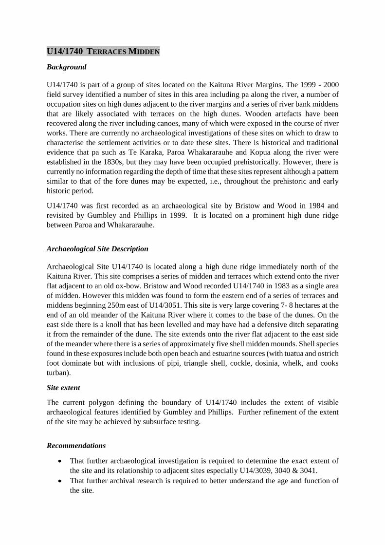
U14/1740 TERRACES MIDDEN
Background
U14/1740 is part of a group of sites located on the Kaituna River Margins. The 1999 - 2000
field survey identified a number of sites in this area including pa along the river, a number of
occupation sites on high dunes adjacent to the river margins and a series of river bank middens
that are likely associated with terraces on the high dunes. Wooden artefacts have been
recovered along the river including canoes, many of which were exposed in the course of river
works. There are currently no archaeological investigations of these sites on which to draw to
characterise the settlement activities or to date these sites. There is historical and traditional
evidence that pa such as Te Karaka, Paroa Whakararauhe and Kopua along the river were
established in the 1830s, but they may have been occupied prehistorically. However, there is
currently no information regarding the depth of time that these sites represent although a pattern
similar to that of the fore dunes may be expected, i.e., throughout the prehistoric and early
historic period.
U14/1740 was first recorded as an archaeological site by Bristow and Wood in 1984 and
revisited by Gumbley and Phillips in 1999. It is located on a prominent high dune ridge
between Paroa and Whakararauhe.
Archaeological Site Description
Archaeological Site U14/1740 is located along a high dune ridge immediately north of the
Kaituna River. This site comprises a series of midden and terraces which extend onto the river
flat adjacent to an old ox-bow. Bristow and Wood recorded U14/1740 in 1983 as a single area
of midden. However this midden was found to form the eastern end of a series of terraces and
middens beginning 250m east of U14/3051. This site is very large covering 7- 8 hectares at the
end of an old meander of the Kaituna River where it comes to the base of the dunes. On the
east side there is a knoll that has been levelled and may have had a defensive ditch separating
it from the remainder of the dune. The site extends onto the river flat adjacent to the east side
of the meander where there is a series of approximately five shell midden mounds. Shell species
found in these exposures include both open beach and estuarine sources (with tuatua and ostrich
foot dominate but with inclusions of pipi, triangle shell, cockle, dosinia, whelk, and cooks
turban).
Site extent
The current polygon defining the boundary of U14/1740 includes the extent of visible
archaeological features identified by Gumbley and Phillips. Further refinement of the extent
of the site may be achieved by subsurface testing.
Recommendations
That further archaeological investigation is required to determine the exact extent of
the site and its relationship to adjacent sites especially U14/3039, 3040 & 3041.
That further archival research is required to better understand the age and function of
the site.

Figure 1. Aerial photo showing polygons currently defining extent of site U14/1740 and adjacent sites
that may have formed a single occupation area. (Tauranga City Council GIS).

ASSESSMENT OF SIGNIFICANCE: U14/1740
General Values Criteria.
Period: High
U14/1740 is one of a number of similar sites along the lower left bank of the Kaituna River.
The site has not been radiocarbon dated, however, it is likely that the Kaituna River sites
were occupied throughout the prehistoric and early historic period.
Rarity: High
U14/1740 and neighbouring sites represent a unique group of settlement sites established on
the lower left bank of the Kaituna River. They may have been established for very specific
reasons and occupied for a relatively short period in the early historic period. They may have
also been occupied in the prehistoric period and are considered a very rare site type.
Integrity: High
The integrity of U14/1740 can only be established by archaeological investigation. Activities
that may have affected the integrity of the site include erosion and farm activities as well as
future pine harvest.
Representativeness: High
U14/1740 can only be compared to adjacent sites along the lower left bank of the Kaituna
River, however, it must be considered representative of these sites.
Context or Group Value: High
U14/1740 is an important component of the group of unique settlements and activity areas
along the lower left bank of the Kaituna River.
Diversity: High
Intra site diversity can only be established by subsurface archaeological investigation but may
potentially include aspects of activity associated with the 1830s settlement as well as earlier
prehistoric settlement.
Fragility and Vulnerability: High
Components of the site on the river bank have likely suffered from erosion and farm activity.
Further threats include intensification of land use.
Archaeological Qualities
Information: High
U14/1740 has potential to provide archaeological information relating to prehistoric and early
historic occupation and activity on the lower Kaituna River environment.

Research: High
Archaeological remains associated with U14/1740 may provide information relating to the
early contact period including the impact European traders had on material culture, the nature
of settlement architecture compared to similar prehistoric and early historic settlements,
subsistence economies etc.

U14/1743 PAROA FLAX MILL
Background
Flax of the Kaituna swamp lands was harvested and processed on a commercial scale by local
Maori as early as the 1840s but demand declined rapidly in the 1850s. It wasn’t until the 1880s
that steam powered mills enabled extensive operations to recommence in the area. The
resource was significantly depleted by the mid 1920s due to over harvest and frequent swamp
fires.3
A flax mill constructed in the late 19th century was situated in the vicinity of, or directly on, a
former pa site known as Paroa. Early survey plans illustrate the location of the mill and
associated features.
A detailed history of the Paroa Mill is yet to be compiled. It appears to have operated from
1890 and changed hands several times before closing around 1930. Notable owners or lessee’s
included William Rogers who leased the mill from 1892. A descendant of Tamatekapua he
was a leading chief of the Arawa tribe who married a granddaughter of Te Waharoa. Rogers
also owned stores at Maketu and Te Puke and built and ran for a time the Geyser Hotel at
Whakarewarewa, Rotorua. The Mill was later purchased by E.L. Broad in 1920 who also
owned the Te Kopua Mill to the west. By the early 1930s depressed prices for the flax fibre
saw the end of the industry in the Te Puke district.
Archaeological Site Description
Early survey plans and photographs indicate the Paroa Mill comprised a complex of buildings
including two mill buildings, managers’ house and workers huts. Some of these structures may
date to the establishment of the Mill in 1890 while others may relate to later expansion. Both
extant Mill buildings were likely constructed in the 1890s and are depicted on survey plans
produced in 1902 and 1903. According to Geoffrey Ford other buildings included a Managers
House and Foreman’s House, storage sheds and drying racks.4 The completed Mill complex
is depicted in an oblique aerial probably taken in the 1920s. In addition to buildings facility’s
comprising a loading platform on the river bank likely serviced the various vessels used for
delivering supplies and transporting the processed flax.
The Mill complex including extant buildings and subsurface remains constitutes an
archaeological site under the definition provided by both the RMA and the HNZPA. The
subsurface and built structure archaeological resource at Paroa has the potential to add
significantly to our understanding of the early flax industry on the Kaituna River.
Site extent
The current polygons defining the boundary of U14/1743 include a single point with a 50m
radius buffer and a polygon defined by Gumbley and Phillips in 2000. The 50m radius should
be removed from planning maps, however, the single point should be retained as it defines the
3 Stokes 1980:260 4 Ford 2008:8

New Zealand Archaeological Association grid coordinate for the site. The polygon defined in
2000 requires correcting to better include the historic Flax Mill complex in its entirety.
Further Information:
A history of the Flax Milling industry on the Kaituna is being prepared by Richard Hart
(Tauranga Historical Society) based on research carried out by the late Allister Matheson.
Zarah Burnett has recently competed an MA thesis on the flax industry in New Zealand
Between 1860 and 1939.
Recommendations:
That the extent of the site is established by subsurface testing
That the extant buildings are assessed and recorded using built heritage criteria.
References:
Burnett, Z
2012 Men of Fibre: The New Zealand Flax Industry and its Workers 1860 – 1939.
MA (History) Thesis Auckland University.
Ford, G
2008 Lower Kaituna River and Te Tumu: The Ford Family History from 1907 – 2
008. Unpublished document.
Hart, R
2015 The Early Flax Industry on the Kaituna River. (in prep)
Matheson, A.
2000 Early Maketu Storekeepers. Historical Review Volume 44 No. 2.

Figure 10. The ketch Victory at the Paroa flaxmill c. 1910. Photo: Whakatane Museum.
Figure 2. Oblique aerial view of Paroa Flax Mill in the 1920s. Photo: Tauranga Historical Society.

Figure 3. One of the original Paroa Flax Mill buildings still standing.
Figure 4. Survey plan SO 13465 produced in 1903 superimposed onto a modern aerial showing the location
of Paroa Mill buildings including workers huts. Note the second extant building to the west is not depicted
however it does appear on SO 12541A produce din 1902 indicating both extant buildings had been erected
by this time.

Figure 11. Aerial photo showing polygons currently defining extent of site U14/1743 on Tauranga City
Council GIS.

ASSESSMENT OF SIGNIFICANCE: U14/1743 PAROA FLAX MILL
General Values Criteria.
Period: High
The flax milling industry commenced on the Kaituna River as early as the 1830s. The Paroa
Mill site encompasses part of an early Maori settlement involved in flax harvesting in the
1830s as well as the Mill complex associated with the final industrial scale exploitation of the
flax resource involving new technologies designed to improve production. The site
potentially contains archaeological remains of the flax milling industry spanning 100 years
between 1830 and 1930.
Rarity: High
There are few surviving examples of Flax mills nationally and few have been recorded as
archaeological sites. The Paroa and Te Kopua Mills are currently recorded by virtue of their
location on earlier pa sites. The Paroa Mill is particularly rare as it potentially encompasses
archaeological remains spanning 100 years.
Integrity: High
The Paroa Flax Mill has relatively high integrity compared to other similar sites by virtue of
the surviving mill buildings and the relatively unmodified condition of land surrounding the
mill property where associated buildings and activity areas were once located. The site also
likely contains subsurface archaeological remains of the earlier 1830s settlement known as
Paroa Pa.
Representativeness: High
There are few recorded flax mill sites recorded as archaeological sites or Scheduled in Bay of
Plenty District or Regional Planning documents, however, based on our understanding of the
industry in the 19th and early twentieth century the Paroa Mill likely represents a typical mill
complex of the period situated adjacent to the natural flax resource and on a river bank that
provides water for processing and a ready means of transporting the products from the mill.
Context or Group Value: High
The Paroa Mill is one of at least three mills that operated on the Kaituna River in the late 19th
and early 20th Century.
Diversity: High
Intra site diversity potentially includes many aspects of activity associated with a flax mill
complex including built structures, industrial archaeological remains and domestic
archaeological remains associated with management and worker dwellings. The Mill is also
the site of an earlier Maori settlement (Paroa Pa) that was established in the 1830s or earlier to
accommodate locals involved in harvesting flax from surrounding wetlands.

Fragility and Vulnerability: High
The Paroa Flax Mill buildings and archaeological site are currently relatively stable however
the extant buildings are dilapidated and the archaeological resource is threatened by current
farm activity and future residential subdivision proposals.
Archaeological Qualities
Information: High
The Paroa Flax mill site has high potential to provide archaeological information relating to
the flax mill industry on the Kaituna River. The extent of the subsurface archaeological
component can only be established by excavation, however, the site is largely unmodified and
consequently there is reasonable cause to suspect that archaeology relating to the 1890 – 1930
mill complex survives. The extant buildings associated with the mill provide additional
architectural and built structure archaeological information than may enhance our
understanding of the technology employed.
Research: High
Given the significant social and economic impact the flax mill industry had on local Maori
populations and the wider economy our understanding of the industry is surprisingly limited.
This is in part due to the mobile nature of flax milling plants which, during the formative period
of the industry, were moved frequently to be close to the natural flax resource leaving limited
archaeological footprints. The industry was also susceptible to boom and bust periods during
which mills and machinery were abandoned or moved. Larger commercial operations in the
late 1900s and early 20th century were focused on flax planation’s resulting in larger more
permanent mills with associated workers accommodation as is the case with Te Kopua and
Paroa mills on the Kaituna.
The flax milling industry along the Kaituna changed the settlement distribution of Maori
populations, was the catalyst for intertribal conflict in the 1930s and influenced land values and
ownership for land otherwise considered unsuitable for traditional European agricultural
ventures. This was often incongruous with traditional Maori values for riverine and wetland
environments.
The research potential of the archaeology of these sites lies both in the little understood
technology employed in processing the flax and the conditions of workers employed at the
mill, many of whom were local Maori.
Flax processing machinery was initially imported and later developed for local conditions and
improved efficiency by local engineering firms. Few examples of this technology survive.
Power plants were reallocated to alternate industries following the demise of the flax milling
industry while specialised machinery was likely sold for scrap or dumped in adjacent wetlands
and buildings used for other purposes, demolished or left to decay.
Archaeology analysis of the pre 1900 extant mill buildings at Paroa provides a unique
opportunity to may assist in answering technological, economic and social questions about
late 19th and early 29th century flax milling industry on the Kaituna River.

U14/1743 PAROA PA
Background:
Paroa Pa was first recorded as an archaeological site by Ken Moore in 1974. Moore did not
visit the site but appears to have based his assessment on early survey plans. Paroa Pa is marked
on a number of survey plans most notably ML 2046 produced in 1870, ML 1916 produced in
1889 and ML 3995 also produced in 1889.
Paroa Pa appears to have been established in the late 1820s or early 1830s by local Maori in
response to a demand for flax by European traders (specifically Hans Tapsell) that provided a
means for obtaining muskets. Te Arawa, having suffered under Hongi Hika in 1823, also saw
the potential of trading flax for muskets. In response Ngati He and Ngapotiki established
themselves first at Te Paroa and Te Karaka Pa on the Kaituna River to keep a presence in the
area and then set up Te Tumu as a fighting pa.5 Occupation of the pa may have spanned a ten
year period during the 1820s and 1830s and was later reoccupied in the 1890s when a
commercial flax milling operation began at Te Paroa that would last 40 years.
In 1831 the missionary H. Williams visted Te Paroa pa and commented that it was a beautiful
spot and extenisve view.6 We may cautiously infer from this statement that part of the pa was
elevated which would suggest the the high dune to the north formed part of Te Paroa Pa where
terrace and pit features were identified during the 2000 archaeological survey (U14/3051).
This would signifcantly enlarge the current GIS polygon defining the site, however further
research and archaeological investigation is required to determine the actual location and extent
of the pa.
Archaeological Site Description
Visible features associated with Paroa Pa include shell midden exposed in the river bank near
the flax mill buildings. In 1983 Wood and Bristow identified a 40cm deep shell midden eroding
from the river bank. The midden included hangi stone, fish bone and shell dominated by
Tuatua. They speculated that the site covered approximate 4000m² and may have been
defended by a ditch and bank. One artefact comprising a wooden paddle was also found at the
site. The terrace and pit features on the high dune to the north (U14/3051) may also relate
specifically to occupation of Paroa Pa.
Site extent
The current polygons defining the boundary of U14/1743 include an area of raised ground
immediately adjacent to the river bank. This polygon encompasses the location the shell
midden identified by Wood and Bristow as well as the extant buildings associated with the
Paroa Flax Mill. Further analysis of U14/3051 may require an expansion of the U14/1743
polygon to encompass part of the high dune to the north.
5 Kahotea 2014 6 Williams H. 1961

References:
Kahotea, D.
2014 Te Tumu Pa Hearing – Evidence in Chief.
Williams, H.
1961 The Early Journals of Henry Williams, Pegusus Press, Christchurch.
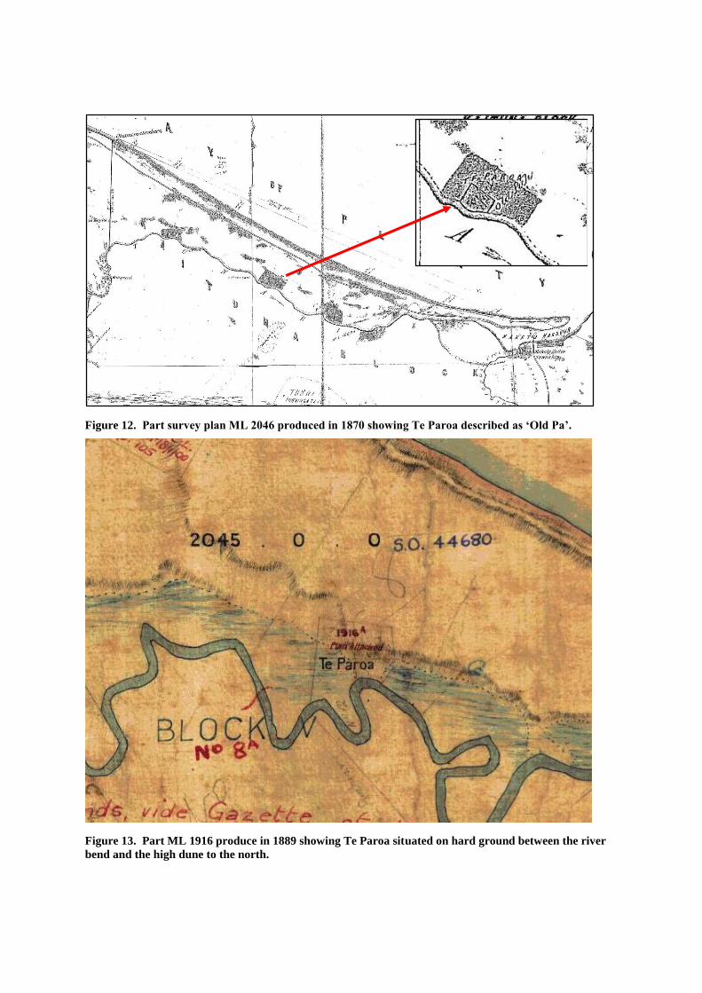
Figure 12. Part survey plan ML 2046 produced in 1870 showing Te Paroa described as ‘Old Pa’.
Figure 13. Part ML 1916 produce in 1889 showing Te Paroa situated on hard ground between the river
bend and the high dune to the north.

Figure 14. Part ML 3995 illustrating the location and possible extent of Te Paroa.
Figure 15. Aerial photo showing polygons currently defining extent of site U14/1743 on Tauranga City
Council GIS. The circle is an arbitrary 50m radius buffer surrounding the shell midden identified in
1983 and does not reflect the true extent of the site.

ASSESSMENT OF SIGNIFICANCE: U14/1743
General Values Criteria.
Period: High
Paroa Pa is one of a number of similar settlement sites along the lower left bank of the
Kaituna River. They are generally thought to have been established by local Maori to control
and or harvest local flax resources for trade in the 1830s. They represent a specific period in
the early historic period brought about by the presence of a European trader at Maketu and
the ability of local Maori to trade flax for muskets to countered further invasions from
northern iwi.
Rarity: High
Paroa Pa and associated pa on the lower left bank of the Kaituna River represent a unique group
of settlement sites established for very specific reasons and occupied for a relatively short
period in the early historic period. They are therefore extremely rare.
Integrity: High
The integrity of Paroa Pa can only be established by archaeological investigation, however,
there is reasonable cause to suspect that subsurface archaeological features survive in the area.
Features and activities that may have affected the integrity of the pa include the establishment
of Paroa Flax Mill that operated on the site between 1890 and 1930. More significantly the
pine plantation on the high dune that may be a part of the pa may significantly damage this
land form during future harvest activity.
Representativeness: High
Paroa Pa is unique and can only be compared to adjacent sites along the lower left bank of the
Kaituna River, however Paroa Pa must be considered representative of these pa.
Context or Group Value: High
Paroa Pa is an important component of the group of unique settlements along the lower left
bank of the Kaituna River.
Diversity: High
Intra site diversity potentially includes many aspects of activity associated with the 1830s
settlement and subsequent flax milling activity.
Fragility and Vulnerability: High
Components of the site on the high dune to the north and on the river bank to the south have
likely suffered from erosion. Further threats include residential development and pine
planation harvesting.

Archaeological Qualities
Information: High
Paroa Pa has high potential to provide archaeological information relating to the 1830s
settlement.
Research: High
Given the significant social and economic impact the flax mill industry had on local Maori
and the unique nature of the Kaituna River Pa research potential must be considered high.
Archaeological remains may provide information relating to the early contact period
including the impact European traders had had on material culture, the nature of settlement
architecture compared to similar prehistoric settlements, subsistence economies etc.

U14/2848, 2849, 3045, 3048, 3049 & 3050 MIDDENS / CULTURAL SOILS
Background:
These six sites fall within the inland dune complex and the emerging southern dune complex
and form a continuation of the Papamoa Dune Plain settlement pattern of occupation, albeit
the eastern extent of it. These sites form a significant band of occupation sites approximately
half a kilometre wide straddling the ancient paleochanel and about 300-400m inland of the
shore. As the eastern extent of this group of sites, the site density is lower and the sites
themselves are more discreet than they are to the west.
Archaeological Site Description:
These site are characterised by shell midden deposits in association with areas of cultural soil
indicative of prehistoric cultivations.
Recommendations:
That further subsurface archaeological investigation would be required to determine the
extent, complexity and integrity of these sites.
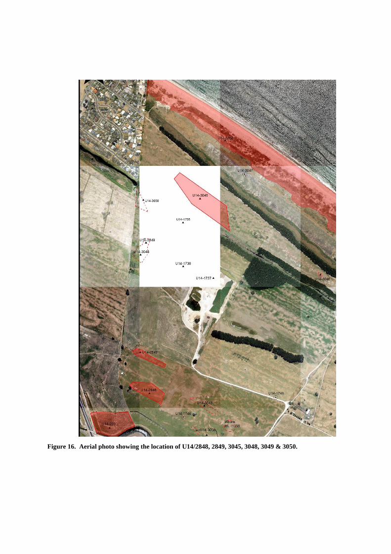
Figure 16. Aerial photo showing the location of U14/2848, 2849, 3045, 3048, 3049 & 3050.

ASSESSMENT OF SIGNIFICANCE: U14/2848, 2849, 3045, 3048, 3049 & 3050
General Values Criteria.
Period: Medium
The inland site complex typically dates to between 1400 and 1700 AD after which the greater
part of this area appears to have been abandoned.
Rarity: low
Numerous examples of this site type have been recorded across the dune plain west to
Domain Road. However, residential development has seen most of these sites destroyed and
few remain intact.
Integrity: medium
The inland sites appear to be in relatively good condition although some have been damaged
by ploughing and farm activity.
Representativeness: high
These six sites are typical of the inland dune complex.
Context or Group Value: High
These sites form the eastern extent of the inland dune complex.
Diversity: High
Diversity is difficult to assess based on available information and should be considered high
until further investigation.
Fragility and Vulnerability: High
Archaeological sites within dune environments are typically more susceptible to erosion.
Archaeological Qualities
Information: medium
While we have gathered significant archaeological information from the investigation of
similar site to the west the inland sites within the Te Tumu block may shed light on the
apparent eastern conclusion of this site complex.

U14/ 3038 MIDDEN
Archaeological Site Description:
Archaeological Site Description U14/3038 comprises several midden deposits located on the
ends of two dune tongues extending into the flat north of the old loop of the Kaituna River and
immediately west of the stop bank. This site appears to be the remnants of a much larger site
that was probably damaged during construction of the stop bank in the 1980s. U14/3038 is
located in close proximity to U14/3043 (occupation/cultivated soils) and may form part of the
same site.
Survey plan ML 11056 produced in the early 20th century illustrates several were in close
proximity to these middens and it is possible that the middens relate to activity associated with
the Te Kopua Flax Mill however they may equally relate to prehistoric or early historic
settlement in this area.
Recommendations
Further archaeological investigation is required in order to determine the extent, antiquity and
significance of this site.

Figure 1. Survey Plan ML 11056 showing houses and whare along raised dune immediately adjacent to
middens recorded as U14/3038.
Figure 2. Aerial photo with recorded archaeological sites and survey plan ML 11056 georeferenced
overlays showing a correlation between houses and whares present in 1918 and recorded midden deposits
indicted by red polygons.

ASSESSMENT OF SIGNIFICANCE: U14/3038
General Values Criteria.
Period: Medium
This site may relate to prehistoric settlement or possibly post 1900 activity associated with
the Te Kopua flax mill.
Rarity: medium
Further archaeological investigation is required in order to establish rarity however it is likely
similar to the many middens found on the eastern end of the dune plain. If it was formed during
occupation of adjacent mill house it would be considered rare.
Integrity: Low
The site has been damaged by earthwork associated with the formation of stop banks and it is
unclear if intact subsurface features survive.
Representativeness: ?
It is not possible to establish the representativeness of the site until further archaeological
investigations have been completed.
Context or Group Value: ?
If the site is part of the Te Kopua Mill archaeological landscape it will have high group value
however without further archaeological investigations it is not possible to assess.
Diversity: ?
It is not possible to establish the representativeness of the site until further archaeological
investigations have been completed.
Fragility and Vulnerability: High
The site has been significantly damaged by stop bank earthwork.
Archaeological Qualities
Information: medium
The extent to which archaeology relating to the flax mill appears to be limited and remains
associated with the mill activity has the potential to address research questions presented
below.
Research: medium
Given the significant social and economic impact the flax mill industry had on local Maori
populations and the wider economy our understanding of the industry is surprisingly limited.
This is in part due to the mobile nature of flax milling plants which, during the formative period
of the industry, were moved frequently to be close to the natural flax resource leaving limited
archaeological footprints. Larger commercial operations in the late 1900s and early 20th

century were focused on flax planation’s resulting in larger more permanent mills with
associated workers accommodation as is the case with Te Kopua and Paroa mills on the
Kaituna.
The flax milling industry along the Kaituna changed the settlement distribution of Maori
populations and was a catalyst for intertribal conflict,
The research potential of the archaeology of these sites lies both in the little understood
technology employed in processing the flax and the conditions of workers employed at the
mill, many of whom were local Maori.
The archaeology of most of the workers dwelling to the west of Te Kopua mill were likely
destroyed during earthwork associated with horticultural development in the 1980s. Whare /
house sites to the east may retain some archaeological integrity.

U14/3039 MIDDEN
Background
This site was first recorded as an archaeological site U14/3039 by Gumbley and Phillips in
1999. It is located immediately east of the probable location of Te Whakararauhe Pa
(U14/3041) and may form part of the settlement of Whakararauhe.
U14/3039 is situated on a solid landing area in an otherwise riverine wetland where access to
the dunes and the beach to the north can be had. It may have been occupied in the late 1820s
or early 1830s by local Maori involved in flax harvesting.
Archaeological Site Description
The site is defined by an area of raised land surrounded by scarps and associated midden
deposits adjacent to the Kaituna River. The scraps may suggest the site was defended or fenced.
Site extent
The current polygon defining the boundary of U14/3039 includes an area of raised ground
immediately adjacent to the river bank. This polygon encompasses the location the shell
midden identified by Gumbley and Phillips.
Recommendations
That further archaeological investigation is required to determine the physical and
temporal relationship between U14/3039, 3040, 3041 & 1740.
That further archival research is required to better understand the age and function of
the site.
References:
Percy Smith, S.
1893 The Fall of Te Tumu Pa, near Maketu, Bay of Plenty New Zealand. In JPS
Vol.32, No.127, pages 121 – 130.
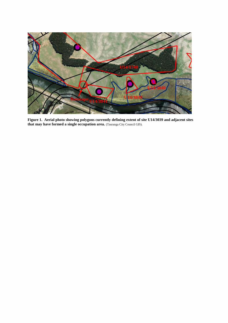
Figure 1. Aerial photo showing polygons currently defining extent of site U14/3039 and adjacent sites
that may have formed a single occupation area. (Tauranga City Council GIS).
U14/3041 U14/3039
U14/3040
U14/1740
Rototapu

ASSESSMENT OF SIGNIFICANCE: U14/3039
General Values Criteria.
Period: High
U14/3039 is one of a number of similar settlement sites along the lower left bank of the
Kaituna River. They are generally thought to have been established by local Maori to control
and or harvest local flax resources for trade in the 1830s. They represent a specific episode of
activity in the early historic period associated with the harvesting of surrounding resources.
The site may also have been occupied in the prehistoric period.
Rarity: High
U14/3039 and neighbouring sites represent a unique group of settlement sites established on
the lower left bank of the Kaituna River. They may have been established for very specific
reasons and occupied for a relatively short period in the early historic period. They may have
also been occupied in the prehistoric period and are considered a very rare site type.
Integrity: High
The integrity of U14/3039 can only be established by archaeological investigation. Activities
that may have affected the integrity of the pa include recent ploughing of the river flats in the
immediate vicinity.
Representativeness: High
U14/3039 is unique and can only be compared to adjacent sites along the lower left bank of
the Kaituna River, however it must be considered representative of these sites.
Context or Group Value: High
U14/3039 is an important component of the group of unique settlements along the lower left
bank of the Kaituna River.
Diversity: High
Intra site diversity potentially includes many aspects of activity associated with the 1830s
settlement as well as earlier prehistoric settlement.
Fragility and Vulnerability: High
Components of the site on the river bank have likely suffered from erosion and farm activity.
Further threats include intensification of land use.
Archaeological Qualities
Information: High
U14/3039 has high potential to provide archaeological information relating to prehistoric and
early historic occupation and activity on the lower Kaituna River environment.

Research: High
Archaeological remains associated with U14/3039 may provide information relating to the
early contact period including the impact European traders had on material culture, the nature
of settlement architecture compared to similar prehistoric settlements, subsistence economies
etc.

U14/3040 MIDDEN
Background
This site was first recorded as an archaeological site U14/3040 by Gumbley and Phillips in
1999. It is located immediately east of the probable location of Te Whakararauhe Pa
(U14/3041) and may form part of the settlement of Whakararauhe.
U14/3040 is situated on a solid landing area in an otherwise riverine wetland where access to
the dunes and the beach to the north can be had. It may have been occupied in the late 1820s
or early 1830s by local Maori involved in flax harvesting.
Archaeological Site Description
The site is defined by 20m x 10m area of raised land with associated Ostrich Foot shell midden
deposits adjacent to the Kaituna River. The raised area may have been defended or fenced at
some point during its occupation.
Site extent
The current polygon defining the boundary of U14/3040 includes an area of raised ground
immediately adjacent to the river bank. This polygon encompasses the location the shell
midden identified by Gumbley and Phillips.
Recommendations
That further archaeological investigation is required to determine the physical and
temporal relationship between U14/3039, 3040, 3041 & 1740.
That further archival research is required to better understand the age and function of
the site.
Figure 1. Aerial photo showing polygons currently defining extent of site U14/3040 and adjacent sites
that may have formed a single occupation area. (Tauranga City Council GIS).
U14/3041 U14/3039
U14/3040
U14/1740
Rototapu

ASSESSMENT OF SIGNIFICANCE: U14/3040
General Values Criteria.
Period: High
U14/3040 is one of a number of similar settlement sites along the lower left bank of the
Kaituna River. They represent a specific episode of activity in the early historic period
associated with the harvesting of surrounding resources. The site may also have been
occupied in the prehistoric period.
Rarity: High
U14/3040 and neighbouring sites represent a unique group of settlement sites established on
the lower left bank of the Kaituna River. They may have been established for very specific
reasons and occupied for a relatively short period in the early historic period. They may have
also been occupied in the prehistoric period and are considered a very rare site type.
Integrity: High
The integrity of U14/3040 can only be established by archaeological investigation. Activities
that may have affected the integrity of the pa include recent ploughing of the river flats in the
immediate vicinity.
Representativeness: High
U14/3040 is unique and can only be compared to adjacent sites along the lower left bank of
the Kaituna River, however it must be considered representative of these sites.
Context or Group Value: High
U14/3040 is an important component of the group of unique settlements along the lower left
bank of the Kaituna River.
Diversity: High
Intra site diversity potentially includes many aspects of activity associated with the 1830s
settlement as well as earlier prehistoric settlement.
Fragility and Vulnerability: High
Components of the site on the river bank have likely suffered from erosion and farm activity.
Further threats include intensification of land use.
Archaeological Qualities
Information: High
U14/3040 has high potential to provide archaeological information relating to prehistoric and
early historic occupation and activity on the lower Kaituna River environment.

Research: High
Archaeological remains associated with U14/3040 may provide information relating to the
early contact period including the impact European traders had on material culture, the nature
of settlement architecture compared to similar prehistoric and early historic settlements,
subsistence economies etc.

U14/3041 WHAKARARAUHE (WHAKARAHUE) PA
Background
Te Whakararauhe Pa is marked on a number of early survey plans most notably ML 2046
produced in 1870 which describes it as an ‘Old Pa’ on ML 3995 produced in 1889. The latter
plan also identifies Rototapu, a small lakelet, immediately adjacent to the pa. It was first
recorded as an archaeological site U14/3041 by Gumbley and Phillips in 1999.
There is little information on Whakararauhe and Rototapu in available archives. The only
identified published reference comes from Smith who writes that during the lead up to the
battle of Te Tumu ‘the Arawa taua advanced from Te Kopua to Te Whakararauhe (about 30
chains from the Te Tumu Pa), and there the forces separated to the sides assigned to them at
the three different points of assault.’7
Te Whakararauhe is situated on a solid landing area in an otherwise riverine wetland where
access to the dunes and the beach to the north can be had. It may have been established in the
late 1820s or early 1830s by local Maori in response to a demand for flax by European traders
(specifically Hans Tapsell) that provided a means for obtaining muskets. Occupation of the pa
may have spanned a ten year period during the 1820s and 1830s but may have been a settlement
in prehistoric times.
Archaeological Site Description
The site is defined by an area of raised land adjacent to the Kaituna River with areas of exposed
shell midden in the river bank.
Site extent
The current polygon defining the boundary of U14/3041 includes an area of raised ground
immediately adjacent to the river bank. This polygon encompasses the location the shell
midden identified by Gumbley and Phillips.
Recommendations
That further archaeological investigation is required to determine the physical and
temporal relationship between U14/3039, 3040, 3041 & 1740.
That further archival research is required to better understand the age and function of
the site.
References:
Percy Smith, S.
1893 The Fall of Te Tumu Pa, near Maketu, Bay of Plenty New Zealand. In JPS
Vol.32, No.127, pages 121 – 130.
7 Smith 1893:125

Figure 17. Part survey plan ML 2046 produced in 1870 showing Whakararauhe described as ‘Old Pa’.
Figure 2. Part ML 3995 illustrating the location and possible extent of Whakararauhe. This plan also
illustrates Rototapu immediately north of Whakararauhe.
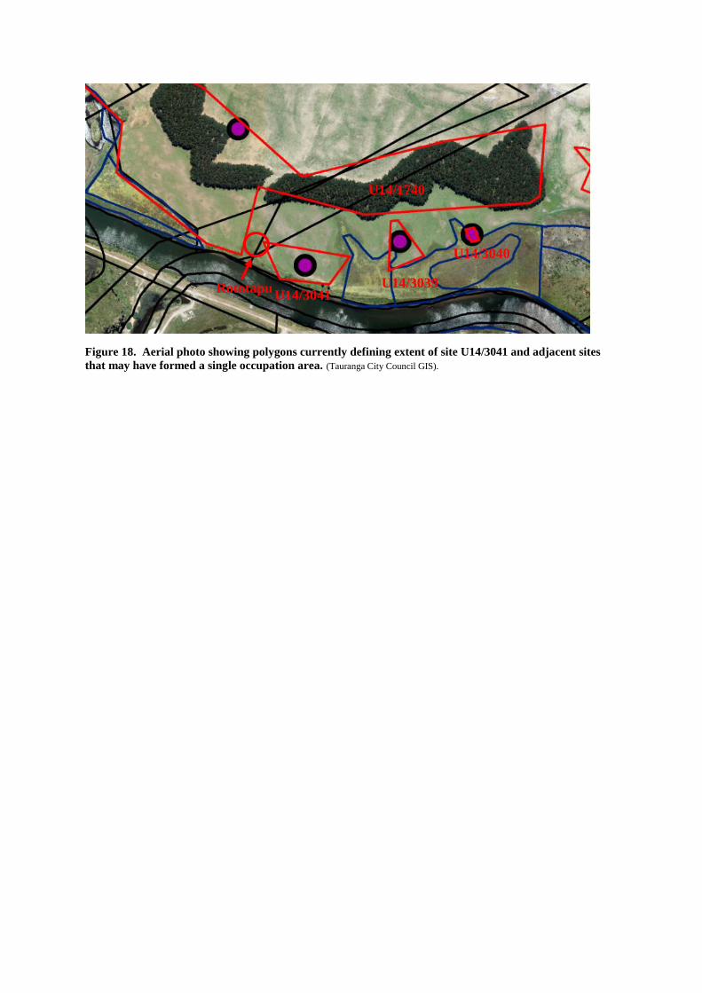
Figure 18. Aerial photo showing polygons currently defining extent of site U14/3041 and adjacent sites
that may have formed a single occupation area. (Tauranga City Council GIS).
U14/3041 U14/3039
U14/3040
U14/1740
Rototapu

ASSESSMENT OF SIGNIFICANCE: U14/3041
General Values Criteria.
Period: High
Te Whakarahue Pa is one of a number of similar settlement sites along the lower left bank of
the Kaituna River. They are generally thought to have been established by local Maori to
control and or harvest local flax resources for trade in the 1830s. They represent a specific
period in the early historic period brought about the presence of a European trader at Maketu,
the ability of local Maori to trade flax for muskets and countered further invasions from
northern iwi.
Rarity: High
Te Whakaraue Pa and associated pa on the lower left bank of the Kaituna River represent a
unique group of settlement sites established for very specific reasons and occupied for a
relatively short period in the early historic period. They are therefore extremely rare.
Integrity: High
The integrity of Te Whakarauhe Pa can only be established by archaeological investigation.
Activities that may have affected the integrity of the pa include recent ploughing of the river
flats in the immediate vicinity of the pa.
Representativeness: High
Te Whakarahue Pa is unique and can only be compared to adjacent sites along the lower left
bank of the Kaituna River, however it must be considered representative of these pa.
Context or Group Value: High
Te Karaka Pa is an important component of the group of unique settlements along the lower
left bank of the Kaituna River.
Diversity: High
Intra site diversity potentially includes many aspects of activity associated with the 1830s
settlement as well as earlier prehistoric settlement.
Fragility and Vulnerability: High
Components of the site on the high dune to the north and on the river bank to the south have
likely suffered from erosion and the previously mentioned bulldozing. Further threats
include residential development.
Archaeological Qualities
Information: High
Te Karaka Pa has high potential to provide archaeological information relating to the 1830s
settlement.

Research: High
Given the significant social and economic impact the flax mill industry had on local Maori
and the unique nature of the Kaituna River Pa research potential must be considered high.
Archaeological remains may provide information relating to the early contact period
including the impact European traders had had on material culture, the nature of settlement
architecture compared to similar prehistoric settlements, subsistence economies etc.

U14/3042 TERRACES MIDDEN
Background
U14/3042 is part of a group of sites located on the Kaituna River Margins. The 1999 - 2000
field survey identified a number of sites in this area including pa along the river, a number of
occupation sites on high dunes adjacent to the river margins and a series of river bank middens
that are likely associated with terraces on the high dunes. Wooden artefacts have been
recovered along the river including canoes, many of which were exposed in the course of river
works. There are currently no archaeological investigations of these sites on which to draw to
characterise the settlement activities or to date these sites. There is historical and traditional
evidence that pa such as Te Karaka, Te Paroa Whakararauhe and Te Kopua along the river
were established in the 1830s, but they may have been occupied prehistorically. However, there
is currently no information regarding the depth of time that these sites represent although a
pattern similar to that of the fore dunes may be expected, i.e., throughout the prehistoric and
early historic period.
U14/3042 was first recorded as an archaeological site by Gumbley and Phillips in 1999. It is
located on elevated dunes adjacent to the lower left bank of the Kaituna River.
Archaeological Site Description
Archaeological Site U14/3042 is located immediately adjacent to the swampy margins of the
Kaituna River and extends for approximately 300m along the dune ridge. In addition to the
midden deposits and flattened terrace areas, this site includes buried cultural soils mixed with
shell and hangi stones evident in an erosion scar at the western extent of the site. At the eastern
end of the site on a low flattened area there is a concentrated mound of ostrich foot and tuatua
midden , with a concentrated charcoal rich soil layer apparent in the adjacent swale . It seems
likely that U14/3042, V14/186 and V14/185 are associated and further investigation will likely
demonstrate them to be parts of a single site that is larger than the area identified.
Site extent
The current polygon defining the boundary of U14/3042 includes the extent of visible
archaeological features identified by Gumbley and Phillips, however, the site may encompass
adjacent archaeological features recorded as V14/185 and V14/186.
Recommendations
That further archaeological investigation is required to determine the physical and
temporal relationship between U14/3042, V14/185 & V14/186.
That further archival research is required to better understand the age and function of
the site.

Figure 1. Aerial photo showing polygons currently defining extent of site U14/3042 and adjacent sites
that may have formed a single occupation area. (Tauranga City Council GIS).

ASSESSMENT OF SIGNIFICANCE: U14/3042
General Values Criteria.
Period: High
U14/3042 is one of a number of similar sites along the lower left bank of the Kaituna River.
The site has not been radiocarbon dated, however, it is likely that the Kaituna River sites
were occupied throughout the prehistoric and early historic period.
Rarity: High
U14/3042 and neighbouring sites represent a unique group of settlement sites established on
the lower left bank of the Kaituna River. They may have been established for very specific
reasons and occupied for a relatively short period in the early historic period. They may have
also been occupied in the prehistoric period and are considered a very rare site type.
Integrity: High
The integrity of U14/3042 can only be established by archaeological investigation. Activities
that may have affected the integrity of the site erosion and farm activities.
Representativeness: High
U14/3042 can only be compared to adjacent sites along the lower left bank of the Kaituna
River, however, it must be considered representative of these sites.
Context or Group Value: High
U14/3042 is an important component of the group of unique settlements and activity areas
along the lower left bank of the Kaituna River.
Diversity: High
Intra site diversity can only be established by subsurface archaeological investigation but may
potentially include aspects of activity associated with the 1830s settlement as well as earlier
prehistoric settlement.
Fragility and Vulnerability: High
Components of the site on the river bank have likely suffered from erosion and farm activity.
Further threats include intensification of land use.
Archaeological Qualities
Information: High
U14/3042 has potential to provide archaeological information relating to prehistoric and early
historic occupation and activity on the lower Kaituna River environment.
Research: High
Archaeological remains associated with U14/3042 may provide information relating to the
early contact period including the impact European traders had on material culture, the nature
of settlement architecture compared to similar prehistoric and early historic settlements,
subsistence economies etc.

U14/ 3043 MIDDEN, CULTURAL SOILS
Archaeological Site Description:
Archaeological Site Description U14/3043 comprises several midden deposits and associated
cultural soils indicative of prehistoric cultivations. It is located on a low dune ridge adjacent to
an historic trail and in close proximity to several whare indicted on early 20th survey plans ML
11056).
Recommendations:
Further archaeological investigation is required in order to determine the extent, antiquity and
significance of this site.
Figure 1. Survey Plan ML 11056 showing houses and whare along raised dune immediately adjacent to
middens recorded as U14/3043.

Figure 2. Aerial photo with recorded archaeological sites and survey plan ML 11056 georeferenced
overlays showing a correlation between houses and whares present in 1918 and recorded midden deposits
indicted by red polygons.

ASSESSMENT OF SIGNIFICANCE: U14/3043
General Values Criteria.
Period: Medium
This site may relate to prehistoric settlement or possibly post 1900 activity associated with
the Te Kopua flax mill. The modified soils are however more indicative of prehistoric
cultivation. The site has not been radiocarbon dated.
Rarity: medium
Further archaeological investigation is required in order to establish rarity however it is likely
similar to the many middens found on the eastern end of the dune plain. If it was formed during
occupation of adjacent mill house it would be considered rare.
Integrity: high
The site was in relatively unmodified condition during the 1999 - 2000 archaeological survey,
however some earthwork associated with flood protection gad occurred in the immediate area.
.
Representativeness: ?
It is not possible to establish the representativeness of the site until further archaeological
investigations have been completed.
Context or Group Value: ?
If the site is part of the Te Kopua Mill archaeological landscape it will have high group value
however without further archaeological investigations it is not possible to assess.
Diversity: ?
It is not possible to establish the representativeness of the site until further archaeological
investigations have been completed.
Fragility and Vulnerability: High
The site has been significantly damaged by stop bank earthwork.
Archaeological Qualities
Archaeological qualities can only be established following further archaeological assessment.
U14/3051 TERRACES MIDDEN
Background
U14/3051 is part of a group of sites located on the Kaituna River Margins. The 1999 - 2000
field survey identified a number of sites in this area including pa along the river, a number of
occupation sites on high dunes adjacent to the river margins and a series of river bank middens
that are likely associated with terraces on the high dunes. Wooden artefacts have been
recovered along the river including canoes, many of which were exposed in the course of river
works. There are currently no archaeological investigations of these sites on which to draw to
characterise the settlement activities or to date these sites. There is historical and traditional
evidence that pa such as Te Karaka, Paroa Whakararauhe and Kopua along the river were
established in the 1830s, but they may have been occupied prehistorically. However, there is
currently no information regarding the depth of time that these sites represent although a pattern
similar to that of the fore dunes may be expected, i.e., throughout the prehistoric and early
historic period.
U14/3051 was first recorded as an archaeological site by Gumbley and Phillips in 1999. It is
located on elevated dunes immediately north of Te Paroa Pa (U14/1743) and may form part of
the settlement of Paroa.
Archaeological Site Description
Archaeological Site U14/3051 is located along the crest of the high dune immediately north of
the Kaituna River and Te Paroa Pa. It comprises a series of terraces on or close to the crest of
the dune. The western end of the site features a large well preserved house terrace measuring
approximately 7x9m located on the north east side of the dune crest.
Site extent
The current polygon defining the boundary of U14/3051 includes the extent of visible
archaeological features identified by Gumbley and Phillips.
Recommendations
That further archaeological investigation is required to determine the physical and
temporal relationship between U14/3051, 3052, 3053 & 1743.
That further archival research is required to better understand the age and function of
the site.

Figure 1. Aerial photo showing polygons currently defining extent of site U14/3053 and adjacent sites
that may have formed a single occupation area. (Tauranga City Council GIS).

ASSESSMENT OF SIGNIFICANCE: U14/3051
General Values Criteria.
Period: High
U14/3051 is one of a number of similar sites along the lower left bank of the Kaituna River.
The site has not been radiocarbon dated, however, it is likely that the Kaituna River sites
were occupied throughout the prehistoric and early historic period.
Rarity: High
U14/3051 and neighbouring sites represent a unique group of settlement sites established on
the lower left bank of the Kaituna River. They may have been established for very specific
reasons and occupied for a relatively short period in the early historic period. They may have
also been occupied in the prehistoric period and are considered a very rare site type.
Integrity: High
The integrity of U14/3051 can only be established by archaeological investigation. Activities
that may have affected the integrity of the site erosion and farm activities.
Representativeness: High
U14/3051 can only be compared to adjacent sites along the lower left bank of the Kaituna
River, however, it must be considered representative of these sites.
Context or Group Value: High
U14/3051 is an important component of the group of unique settlements and activity areas
along the lower left bank of the Kaituna River.
Diversity: High
Intra site diversity can only be established by subsurface archaeological investigation but may
potentially include aspects of activity associated with the 1830s settlement as well as earlier
prehistoric settlement.
Fragility and Vulnerability: High
Components of the site on the river bank have likely suffered from erosion and farm activity.
Further threats include intensification of land use.
Archaeological Qualities
Information: High
U14/3051 has potential to provide archaeological information relating to prehistoric and early
historic occupation and activity on the lower Kaituna River environment.
Research: High
Archaeological remains associated with U14/3051 may provide information relating to the
early contact period including the impact European traders had on material culture, the nature

of settlement architecture compared to similar prehistoric and early historic settlements,
subsistence economies etc.

U14/3052 MIDDEN
Background
This site was first recorded as an archaeological site U14/3052 by Gumbley and Phillips in
1999. It is located immediately east of Te Paroa Pa (U14/1743) and may form part of the
settlement of Paroa.
U14/3052 is situated on a low tongue of land extending into the riverside wetlands. It may have
been occupied in the late 1820s or early 1830s by local Maori involved in flax harvesting.
Archaeological Site Description
The site comprises shell midden on the raised area adjacent to the swamp.
Site extent
The current polygon defining the boundary of U14/3052 includes the area of raised ground and
the shell midden identified by Gumbley and Phillips.
Recommendations
That further archaeological investigation is required to determine the physical and
temporal relationship between U14/3051, 3052 & 1743.
That further archival research is required to better understand the age and function of
the site.
Figure 1. Aerial photo showing polygons currently defining extent of site U14/3052 and adjacent sites
that may have formed a single occupation area. (Tauranga City Council GIS).

ASSESSMENT OF SIGNIFICANCE: U14/3052
General Values Criteria.
Period: High
U14/3052 is one of a number of similar sites along the lower left bank of the Kaituna River.
They may represent a specific episode of activity in the early historic period associated with
the harvesting of surrounding resources. The site may also have been occupied in the
prehistoric period.
Rarity: High
U14/3052 and neighbouring sites represent a unique group of settlement sites established on
the lower left bank of the Kaituna River. They may have been established for very specific
reasons and occupied for a relatively short period in the early historic period. They may have
also been occupied in the prehistoric period and are considered a very rare site type.
Integrity: High
The integrity of U14/3052 can only be established by archaeological investigation. Activities
that may have affected the integrity of the site erosion and farm activities.
Representativeness: High
U14/3052 can only be compared to adjacent sites along the lower left bank of the Kaituna
River, however, it must be considered representative of these sites.
Context or Group Value: High
U14/3052 is an important component of the group of unique settlements and activity areas
along the lower left bank of the Kaituna River.
Diversity: High
Intra site diversity can only be established by subsurface archaeological investigation but may
potentially includes aspects of activity associated with the 1830s settlement as well as earlier
prehistoric settlement.
Fragility and Vulnerability: High
Components of the site on the river bank have likely suffered from erosion and farm activity.
Further threats include intensification of land use.
Archaeological Qualities
Information: High
U14/3052 has potential to provide archaeological information relating to prehistoric and early
historic occupation and activity on the lower Kaituna River environment.

Research: High
Archaeological remains associated with U14/3052 may provide information relating to the
early contact period including the impact European traders had on material culture, the nature
of settlement architecture compared to similar prehistoric and early historic settlements,
subsistence economies etc.

U14/3053 MIDDEN
Background
This site was first recorded as an archaeological site U14/3053 by Gumbley and Phillips in
1999. It is located immediately east of Te Paroa Pa (U14/1743) and may form part of the
settlement of Paroa.
U14/3053 is situated on a low tongue of land extending into the riverside wetlands. It may have
been occupied in the late 1820s or early 1830s by local Maori involved in flax harvesting.
Archaeological Site Description
The site comprises shell midden on the raised area adjacent to the swamp.
Site extent
The current polygon defining the boundary of U14/3053 includes the area of raised ground and
the shell midden identified by Gumbley and Phillips.
Recommendations
That further archaeological investigation is required to determine the physical and
temporal relationship between U14/3051, 3052, 3053 & 1743.
That further archival research is required to better understand the age and function of
the site.
Figure 1. Aerial photo showing polygons currently defining extent of site U14/3053 and adjacent sites
that may have formed a single occupation area. (Tauranga City Council GIS).

ASSESSMENT OF SIGNIFICANCE: U14/3053
General Values Criteria.
Period: High
U14/3053 is one of a number of similar sites along the lower left bank of the Kaituna River.
They may represent a specific episode of activity in the early historic period associated with
the harvesting of surrounding resources. The site may also have been occupied in the
prehistoric period.
Rarity: High
U14/3053 and neighbouring sites represent a unique group of settlement sites established on
the lower left bank of the Kaituna River. They may have been established for very specific
reasons and occupied for a relatively short period in the early historic period. They may have
also been occupied in the prehistoric period and are considered a very rare site type.
Integrity: High
The integrity of U14/3053 can only be established by archaeological investigation. Activities
that may have affected the integrity of the site erosion and farm activities.
Representativeness: High
U14/3053 can only be compared to adjacent sites along the lower left bank of the Kaituna
River, however, it must be considered representative of these sites.
Context or Group Value: High
U14/3053 is an important component of the group of unique settlements and activity areas
along the lower left bank of the Kaituna River.
Diversity: High
Intra site diversity can only be established by subsurface archaeological investigation but may
potentially includes aspects of activity associated with the 1830s settlement as well as earlier
prehistoric settlement.
Fragility and Vulnerability: High
Components of the site on the river bank have likely suffered from erosion and farm activity.
Further threats include intensification of land use.
Archaeological Qualities
Information: High
U14/3053 has potential to provide archaeological information relating to prehistoric and early
historic occupation and activity on the lower Kaituna River environment.

Research: High
Archaeological remains associated with U14/3053 may provide information relating to the
early contact period including the impact European traders had on material culture, the nature
of settlement architecture compared to similar prehistoric and early historic settlements,
subsistence economies etc.

V14/40 TE TUMU PA
Background Te Tumu pa was first recorded as an archaeological site by Cecil Watt in 1970. Site
information has subsequently been updated by Gumbley and Phillips in 2000 and Campbell
in 2013. In 2013 Matthew Campbell carried out an exploratory archaeological investigation
in an attempt to determine the extent of the site. Following this investigation an Environment
Court decision determined a boundary and buffer zone around the likely extent of the pa. The
site extent is shown as M81 on Planning Map R100 in the proposed Tauranga City Plan.
Archaeological Site Description A detailed description of surface and known subsurface archaeology associated with the site is
presented in Campbell’s 2014 report.
Further Information There is considerable traditional and archival information relating to the history, location and
extent of V14/40 (Te Tumu Pa). Much of this information was presented and interpreted by
expert witnesses during a recent environment court hearing specifically focused on the
identification of the actual location and extent of Te Tumu pa. For an understanding of the
history, location and extent of Te Tumu Pa, evidence presented in the hearing should be
reviewed especially the evidence and rebuttals of Phillips, Kahotea and Campbell as well as
the Summary Judgment (Decision No. [2014] NZEnvC 38) which provides a revised TTAMA
boundary and scheduled TTSMA.
Site Extent
The extent of V14/40 is presented in the environment court decision No. [2014] NZEnvC 38,
however this must be considered provisional and the true extent of the site still requires
clarification by further archaeological investigations.
Recommendations:
That Te Tumu Pa is preserved within a designated reserve.
That any earthwork / ground disturbance proposed in the immediate area surrounding
the pa is carried out under the provisions of an HNZ authority. Conditions of such an
authority should include monitoring of ground disturbance by a suitably qualified
archaeologist.
References:
Campbell, M.
2013 Section 18 investigation of Site V14/40, Te Tumu, Bay of Plenty.
Unpublished report prepared for The New Zealand Historic Places Trust.
Kahotea , D.
2014 Evidence in chief and rebuttal - (Decision No. [2014] NZEnvC 38)
Phillips, K.J.S.
2014 Evidence in chief and rebuttal - (Decision No. [2014] NZEnvC 38)

Figure 19. Plan showing archaeological features exposed in test trenches during the Section 18
investigation of V14/40. Campbell 2013:Figure 13
Figure 20. Extent of site including buffer provided in Environment Court Decision No. [2014] NZEnvC
38 Annexure C.

ASSESSMENT OF SIGNIFICANCE: V14/40
General Values Criteria.
Period: High
There is extensive archival information regarding events that occurred at Te Tumu pa before,
during and after the Battle of Te Tumu in 1836. The Battle at Te Tumu was a significant
event in the history of the Tauranga District.
Rarity: High
There are few surviving examples of defended pa associated with the musket wars in the Bay
of Plenty and even fewer pa built on the coastal dunes. Consequently Te Tumu Pa is
considered very rare.
Integrity: Medium
Information presented during the Environment court hearing (esp. Phillips, Kahotea and
Campbell) would suggest that part of the pa was destroyed during the construction of the
Kaituna River outlet in the 1950s. However, an archaeological investigation carried out by
Campbell revealed extensive subsurface archaeological information relating to prehistoric
activity at the site.
Representativeness: High
There are few sites similar in age, type and geographic location to compare Te Tumu Pa with,
consequently Te Tumu Pa must be considered very representative of its type albeit poorly
understood given the significant damage and the largely subsurface nature of the site.
Context or Group Value: High
Te Tumu Pa is part of a network of settlement sites along the left bank of the Kaituna River
established partly as a result of the surrounding flax industry. Other settlements in the
immediate vicinity include Te Kopua, Te Karaka and Paroa pa. Te Tumu is also a significant
component of the wider political landscape of the mid 1830s that included Maketu pa and
inland settlements of Te Arawa where war parties assembled before the Te Tumu battle in
1836.
Diversity: High
Diversity is difficult to assess based on available information. It has diverse historical and
cultural values, however, while the geographic location is unique the diversity of the
archaeological remains can only be established by archaeological investigation.
Fragility and Vulnerability:
Archaeological sites within dune environments can be more susceptible to erosion. Te Tumu
Pa has already suffered significant damage from the Kaituna River realignment and
subsequent fore dune erosion. Vegetation covering the site, including young pines, will cause
ongoing damage to the subsurface archaeological resource.

Archaeological Qualities
Information: High
Information potential was unclear due to the subsurface nature of the resource and previous
damage to the site however, the investigation carried out by Dr Campbell in 2014 has indicated
relatively high information potential. The investigation provided one of the earliest radiocarbon
dates yet obtained from a site on the Papamoa dune plain which indicates that early occupation
occurred on the fore dunes prior to the construction of Te Tumu pa. Any surviving
archaeological evidence of the gun fighter defences and occupancy of the pa leading up to the
battle would have high information and research potential.
Research: High
Based on the results of the archaeological investigation carried out by Dr Campbell the site has
the potential to add to our understanding of early prehistoric settlement on the dunes and early
historic occupation associated with the flax industry and possibly the nature of gun fighter pa
built on a sand dune environment.

V14/185 OVEN STONES
Background
V14/185 is part of a group of sites located on the Kaituna River Margins. The 1999 - 2000 field
survey identified a number of sites in this area including pa along the river, a number of
occupation sites on high dunes adjacent to the river margins and a series of river bank middens
that are likely associated with terraces on the high dunes. Wooden artefacts have been
recovered along the river including canoes, many of which were exposed in the course of river
works. There are currently no archaeological investigations of these sites on which to draw to
characterise the settlement activities or to date these sites. There is historical and traditional
evidence that pa such as Te Karaka, Te Paroa Whakararauhe and Te Kopua along the river
were established in the 1830s, but they may have been occupied prehistorically. However, there
is currently no information regarding the depth of time that these sites represent although a
pattern similar to that of the fore dunes may be expected, i.e., throughout the prehistoric and
early historic period.
V14/185 was first recorded as an archaeological site by Gumbley and Phillips in 1999. It is
located on elevated dunes adjacent to the lower left bank of the Kaituna River.
Archaeological Site Description
Archaeological Site V14/185 is located on the dune c100m north of the swampy margins of
the Kaituna River. The site comprises a small group of Hangi stone. It seems likely that
U14/3042 and V14/186 and V14/185 are associated and further investigation will likely
demonstrate them to be parts of a single site that is larger than the area identified.
Site extent:
The current polygon defining the boundary of V14/185 includes the extent of visible
archaeological features identified by Gumbley and Phillips, however, the site may encompass
adjacent archaeological features recorded as U14/3042, V14/185 and V14/186.
Recommendations
That further archaeological investigation is required to determine the physical and
temporal relationship between U14/3042, V14/185 & V14/186.
That further archival research is required to better understand the age and function of
the site.

Figure 1. Aerial photo showing polygons currently defining extent of site V14/185 and adjacent sites that
may have formed a single occupation area. (Tauranga City Council GIS).

ASSESSMENT OF SIGNIFICANCE: V14/185
General Values Criteria.
Period: High
U14/3042 is one of a number of similar sites along the lower left bank of the Kaituna River.
The site has not been radiocarbon dated, however, it is likely that the Kaituna River sites
were occupied throughout the prehistoric and early historic period.
Rarity: Low
While V14/185 and neighbouring sites represent a unique group of settlement sites established
on the lower left bank of the Kaituna River, however, the hangi stones recorded as V14/185
represent an individual feature that is likely repeated throughout the site complex.
Integrity: Medium
The integrity of V14/185 can only be established by archaeological investigation. Activities
that may have affected the integrity of the site erosion and farm activities.
Representativeness: High
V14/185 can only be compared to adjacent sites along the lower left bank of the Kaituna
River, however, it must be considered representative of these sites.
Context or Group Value: Low
V14/185 is a small component of the group of unique settlements and activity areas along the
lower left bank of the Kaituna River, however it represents an individual feature that is likely
repeated throughout the site complex.
Diversity: Low
Intra site diversity can only be established by subsurface archaeological investigation but may
potentially include aspects of activity associated with the 1830s settlement as well as earlier
prehistoric settlement.
Fragility and Vulnerability: medium
The site on the river bank have likely suffered from erosion and farm activity. Further threats
include intensification of land use.
Archaeological Qualities
Information: low
V14/185 is a common site type along the lower Kaituna and elsewhere on the dune plain.
Research: low
V14/185 is a common site type along the lower Kaituna and elsewhere on the dune plain.

V14/186 MIDDENS
Background
V14/186 is part of a group of sites located on the Kaituna River Margins. The 1999 - 2000 field
survey identified a number of sites in this area including pa along the river, a number of
occupation sites on high dunes adjacent to the river margins and a series of river bank middens
that are likely associated with terraces on the high dunes. Wooden artefacts have been
recovered along the river including canoes, many of which were exposed in the course of river
works. There are currently no archaeological investigations of these sites on which to draw to
characterise the settlement activities or to date these sites. There is historical and traditional
evidence that pa such as Te Karaka, Te Paroa Whakararauhe and Te Kopua along the river
were established in the 1830s, but they may have been occupied prehistorically. However, there
is currently no information regarding the depth of time that these sites represent although a
pattern similar to that of the fore dunes may be expected, i.e., throughout the prehistoric and
early historic period.
V14/186 was first recorded as an archaeological site by Gumbley and Phillips in 1999. It is
located on elevated dunes adjacent to the lower left bank of the Kaituna River.
Archaeological Site Description
Archaeological Site V14/186 is located on the dune ridge immediately adjacent to the swampy
margins of the Kaituna River. The site comprises a series of tuatua and ostrich foot middens,
including a midden mound and a series of hangi stones. It seems likely that U14/3042 and
V14/186 and V14/185 are associated and further investigation will likely demonstrate them to
be parts of a single site that is larger than the area identified.
Site extent
The current polygon defining the boundary of V14/186 includes the extent of visible
archaeological features identified by Gumbley and Phillips, however, the site may encompass
adjacent archaeological features recorded as U14/3042, V14/185 and V14/186.
Recommendations
That further archaeological investigation is required to determine the physical and
temporal relationship between U14/3042, V14/185 & V14/186.
That further archival research is required to better understand the age and function of
the site.

Figure 1. Aerial photo showing polygons currently defining extent of site V14/186 and adjacent sites that
may have formed a single occupation area. (Tauranga City Council GIS).

ASSESSMENT OF SIGNIFICANCE: V14/186
General Values Criteria.
Period: High
V14/186 is one of a number of similar sites along the lower left bank of the Kaituna River.
The site has not been radiocarbon dated, however, it is likely that the Kaituna River sites
were occupied throughout the prehistoric and early historic period.
Rarity: High
V14/186 and neighbouring sites represent a unique group of settlement sites established on the
lower left bank of the Kaituna River. They may have been established for very specific reasons
and occupied for a relatively short period in the early historic period. They may have also been
occupied in the prehistoric period and are considered a very rare site type.
Integrity: High
The integrity of V14/186 can only be established by archaeological investigation. Activities
that may have affected the integrity of the site erosion and farm activities.
Representativeness: High
V14/186 can only be compared to adjacent sites along the lower left bank of the Kaituna
River, however, it must be considered representative of these sites.
Context or Group Value: High
V14/186 is an important component of the group of unique settlements and activity areas
along the lower left bank of the Kaituna River.
Diversity: High
Intra site diversity can only be established by subsurface archaeological investigation but may
potentially include aspects of activity associated with the 1830s settlement as well as earlier
prehistoric settlement.
Fragility and Vulnerability: High
Components of the site on the river bank have likely suffered from erosion and farm activity.
Further threats include intensification of land use.
Archaeological Qualities
Information: High
V14/186 has potential to provide archaeological information relating to prehistoric and early
historic occupation and activity on the lower Kaituna River environment.
Research: High
Archaeological remains associated with V14/186 may provide information relating to the
early contact period including the impact European traders had on material culture, the nature

of settlement architecture compared to similar prehistoric and early historic settlements,
subsistence economies etc.