
Surveying I. Lecture 9. Plane surveying. Fundamental tasks of surveying. Intersections. Orientation.

Technical English - I
5th week
SURVEYING AND MAPPING

surveying / position / natural / man made / feature / equipment / mapping
What is surveying?What is surveying?
It is the art of defining the positions of natural It is the art of defining the positions of natural
and manand man--made features on the Earth’s surface. made features on the Earth’s surface.
Basic Tasks and Features in SurveyingBasic Tasks and Features in Surveying::
�� MeasurementsMeasurements
�� Surveying tools and equipmentSurveying tools and equipment
�� Evaluation of survey data Evaluation of survey data
�� Mapping Mapping

distance / elevation / angle / coordinates
Basic Engineering measurements:Basic Engineering measurements:�� DistanceDistance
�� ElevationElevation
�� AngleAngle
�� Coordinates (X/Y or Lat/Long etc.)Coordinates (X/Y or Lat/Long etc.)
distancedistance ≈
intervalinterval
lengthlength
spacespace
Elevation (vertical Elevation (vertical
position) is the height position) is the height
of a point relative to of a point relative to
some reference pointsome reference point

Today’s Engineering Survey TasksToday’s Engineering Survey Tasks
� Cadastral surveying
� Area calculations
� Complex volume calculations
� Stockpile surveys
� Cut / excavation / fill calculations (Surveying for landfill sites)
� Slope measurements
� Cross and long sections
� Aerial photography surveying (photogrammetric survey)
� Surveying for 3D model generation
Building Measurements and Structural Monitoring Building Measurements and Structural Monitoring
� Setting out of buildings (building footprint)
� Facade measurements
� Deformation / settlement monitoring, inspection measurements
� Underground utility mapping survey
cadastral / stockpile / excavation / photogrammetry / generation / facade / utility/ building setting out / footprint / deformation / monitoring / settlement / inspection

surveying tools / equipment / device / traditional / contemporary / state-of-the-art
Traditional and contemporary (stateTraditional and contemporary (state--ofof--
thethe--art electronic devices) surveying toolsart electronic devices) surveying tools

steel tape / chaining pins / spring tension / compass / optical square / ranging rodsflag-pole / staff / theodolite / transit / total station / level / tripod
steel tapes steel tapes
spring tensionspring tension
theodolitetheodolite
compasscompass
ranging rods & flagranging rods & flag--polepole
optical squareoptical square
chaining pinschaining pins
tripodtripod
staffstaff
levellevel
Tripods are used for Tripods are used for
several surveying several surveying
instruments, such instruments, such
asas theodolitestheodolites, total , total
stations,stations, levelslevels or or
transits.transits.

transittransit
They are the same thing. Europeans tend to say They are the same thing. Europeans tend to say
""theodolitetheodolite", which is the older term. Americans tend to ", which is the older term. Americans tend to
say "transit."say "transit." BothBoth theodolitestheodolites and transits are and transits are
instruments used by surveyors to measure horizontal instruments used by surveyors to measure horizontal
and vertical angles, measure distances and determine and vertical angles, measure distances and determine
elevations. Generally aelevations. Generally a theodolitetheodolite is moreis more precise in precise in
point of point of verniervernier increments and optical systems. It increments and optical systems. It
hashas more more incrementationsincrementations on the circle. on the circle.
theodolitetheodolite
verniervernier increments increments
theodolite / transit / total station / instrument / precise / vernier / optics
What is the difference between a What is the difference between a theodolitetheodolite
and a transit?and a transit?

The original The original theodolitetheodolite was a was a
purely optical instrument, but purely optical instrument, but
nowadays most nowadays most theodolitestheodolites
come with an electronic come with an electronic
distancedistance--measuring attachment measuring attachment
called as total station. Total called as total station. Total
stations possess automatic stations possess automatic
angle and distance readout angle and distance readout
capabilities.capabilities.
What is the difference between a What is the difference between a theodolitetheodolite and a total station?and a total station?
TheodoliteTheodolite Total station is a instrument havingTotal station is a instrument having
theodolite / total station / instrument / attachment / installation / readout
�� Manual Manual
installation installation
�� Manual Manual
readingreading of of
scalesscales
�� Automatic readoutAutomatic readout capabilitiescapabilities
�� Simple andSimple and quick installationquick installation on on
any groundany ground
�� Fast & easyFast & easy data transfer data transfer
toto tablet PC or notebook tablet PC or notebook

TheodolitesTheodolites can measure:can measure:
�� Horizontal anglesHorizontal angles
�� Vertical anglesVertical angles
�� DistancesDistances
�� ElevationsElevations
LevelsLevels can measure:can measure:
�� Horizontal anglesHorizontal angles
�� DistancesDistances
�� ElevationsElevations
MeasurementMeasurement accuracyaccuracy depends on manydepends on many factors.factors.
�� Instrument error (Model and type of instrument)Instrument error (Model and type of instrument)
�� Human error (Surveyors’ skill)Human error (Surveyors’ skill)
�� Natural error (Atmospheric conditions, wind speed, air Natural error (Atmospheric conditions, wind speed, air
temperature, atmospheric pressure, humidity, etc) temperature, atmospheric pressure, humidity, etc)
axis / measurement accuracy / error / skill / atmospheric condition / wind / humidity
What is the difference between a What is the difference between a theodolitetheodolite and a level?and a level?

What is the difference What is the difference
between a between a theodolitetheodolite
and a level?and a level?
leveling / control point / backsight reading / foresight reading

The bubble tubeThe bubble tube
Leveling with three foot screwsLeveling with three foot screws
leveling / line of sight / horizontal / bubble tube / vial screw / lever / clamp / tribrach
How to set How to set the line of sight (line of the line of sight (line of
vision ) to vision ) to be be exactly horizontalexactly horizontal??

high-tech / EDM / GPS / DGPS / global positioning system / differential / drone
�� EDM EDM (Electronic Distance Measurement system)(Electronic Distance Measurement system)
�� Total station Total station equipped with EDMequipped with EDM
�� GPSGPS (Global Positioning System)(Global Positioning System)
�� DGPS DGPS (Differential Global Positioning System) (Differential Global Positioning System)
�� DronesDrones for surveyingfor surveying
EDMEDM
Total StationTotal Station
Ordinary Ordinary
GPSGPS
DGPSDGPS
DroneDrone

EDM / transmitter / receiver / wave / retroprism /reflector
EDM EDM (Electronic Distance Measurement system)(Electronic Distance Measurement system)
Principle of EDMPrinciple of EDM

EDM / total station / equipped / capability
Total station Total station equipped with equipped with EDMEDM
(Optical and electronic measurement capabilities)(Optical and electronic measurement capabilities)
EDMEDM
Total StationTotal Station

GPS / satellite / space / maintain / transmission / signal / embedded/ position
GPSGPS (Global Positioning System)(Global Positioning System)
Regular Regular
GPSGPS
�� 24 Satellites in space, maintained 24 Satellites in space, maintained by US Militaryby US Military
�� Each satellite transmits a signal Each satellite transmits a signal with embedded timewith embedded time
�� GPS Unit receives signal and GPS Unit receives signal and records timerecords time
�� Position is calculated using Position is calculated using triangulation by determining how triangulation by determining how long each signal took to leave long each signal took to leave satellite and to then be received by satellite and to then be received by the GPS unitthe GPS unit
Regular GPS Regular GPS
receiverreceiver

CORS-TR
(Continuously Operating
Reference Stations)
PROJECT
CORS-
TR® PROJECT
ESTABLISHMENT OF
NATIONAL CORS
SYSTEM AND DETERMINATION
OF DATUM
TRANSFORMATION
PARAMETERS
establishment / national / datum / continuously / operating / reference / station

DGPS / principle / accuracy / correction / unknown / approximation / position
DGPSDGPS (Differential GPS)(Differential GPS)
Regular GPS Regular GPS
receiverreceiver
Standard GPS AccuracyStandard GPS Accuracy
�� Old was 100m accuracyOld was 100m accuracy
�� New is 15mNew is 15m
�� WAAS technology is less than WAAS technology is less than 3m3m
The basic principle of DGPS is to remove these errors The basic principle of DGPS is to remove these errors
by determining the difference between the measured by determining the difference between the measured
distance at an unknown pointdistance at an unknown point
whose position is to be fixed whose position is to be fixed
and an approximation of the and an approximation of the
true distance as calculated by true distance as calculated by
a receiver at a known position.a receiver at a known position.
DGPS UnitsDGPS Units

drone / airborne / image / model / generation / software
DronesDrones for surveying and 3D model generationfor surveying and 3D model generation
Everyday new software has been specifically created and Everyday new software has been specifically created and
released for generating 3D maps from drone images.released for generating 3D maps from drone images.
DroneDrone

topographic maps / marine works / bathymetric maps / seafloor map / sonar system
�� “Land surveying” for “Land surveying” for
“Topographic maps" “Topographic maps"
�� “Marine surveying” for “Marine surveying” for
“Bathymetric maps”“Bathymetric maps”
DroneDrone
Bathymetric Sonar SystemBathymetric Sonar System
Marine works: Marine works:
�� Costal protectionCostal protection
�� Ports and marinasPorts and marinas
�� Offshore structuresOffshore structures

density / salinity / conductivity / tide / current / wave / wave gage / buoy
�� Physical oceanographic parameters (Density, salinity, etc)Physical oceanographic parameters (Density, salinity, etc)
�� CTD (Conductivity, Temperature and Depth) CTD (Conductivity, Temperature and Depth)
�� Sea level variationsSea level variations
�� Current velocityCurrent velocity
�� Wave heightsWave heights
DroneDrone
Short and long term measurementsShort and long term measurements
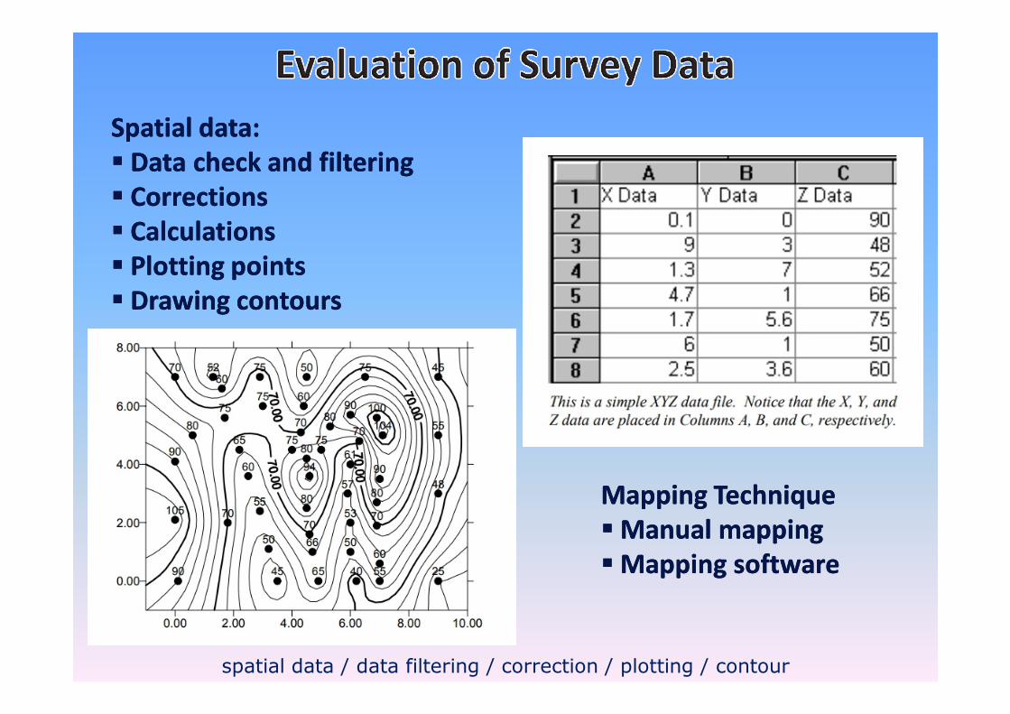
Spatial data:Spatial data:
�� Data check and filtering Data check and filtering
�� CorrectionsCorrections
�� CalculationsCalculations
�� Plotting pointsPlotting points
�� Drawing contoursDrawing contours
spatial data / data filtering / correction / plotting / contour
Mapping TechniqueMapping Technique
�� Manual mappingManual mapping
�� Mapping softwareMapping software

Mapping TechniqueMapping Technique
�� Manual mappingManual mapping
�� Mapping softwareMapping software
Spatial data:Spatial data:
�� X,Y,ZX,Y,Z
�� Lat, Long, height (or Lat, Long, height (or
depth)depth) Mapping software such as Surfer, Mapping software such as Surfer, GrapherGrapher, MapInfo etc., MapInfo etc.
spatial data / latitude / longitude / contour map / terrain map / surface map

How do you measure approximately “How do you measure approximately “the height of a buildingthe height of a building” ”
withoutwithout any surveying tool?any surveying tool?


![[PPT]Chapter #1: Basics of Surveying - Faculty Personal ...faculty.kfupm.edu.sa/CE/kaluwfi/Surveying/CE260 CH 1.ppt · Web viewChapter #1: Basics of Surveying 1.1 Surveying Defined](https://static.fdocuments.in/doc/165x107/5abdf95a7f8b9aa3088c4dc9/pptchapter-1-basics-of-surveying-faculty-personal-ch-1pptweb-viewchapter.jpg)


