TATE OF DELAWARE EXECUTIVE DEPARTMENT OFFICE OF...
15
STATE OF DELAWARE EXECUTIVE DEPARTMENT OFFICE OF STATE PLANNING COORDINATION 122 Martin Luther King Blvd. South ⋅ Dover, DE 19901 Phone (302)739-3090 ⋅ Fax (302) 739-5661 ⋅ www. stateplanning.delaware.gov August 18, 2015 Response Dated: September 10, 2015 Mr. Mark Davidson Pennoni 18072 Davidson Drive Milton, DE 19968 RE: PLUS review 2015-07-06; Beach Walk Dear Mark, Thank you for meeting with State agency planners on July 22, 2015 to discuss the proposed plans for the Beach Walk project. According to the information received, you are seeking review of a site plan for 64 residential units on 7.83 acres along Rt. 1 in Sussex County. Please note that changes to the plan, other than those suggested in this letter, could result in additional comments from the State. Additionally, these comments reflect only issues that are the responsibility of the agencies represented at the meeting. The developers will also need to comply with any Federal, State and local regulations regarding this property. We also note that as Sussex County is the governing authority over this land, the developers will need to comply with any and all regulations/restrictions set forth by the County. Strategies for State Policies and Spending • This project is located in Investment Level 1 according to the Strategies for State Policies and Spending. Investment Level 1 reflects areas that are already developed in an urban or suburban fashion, where infrastructure is existing or readily available, and where future redevelopment or infill projects are expected and encouraged by State policy. Code Requirements/Agency Permitting Requirements Department of Transportation – Contact Bill Brockenbrough 760-2109 • Per Section 2.2.2.1 of the Development Coordination Manual, Traffic Impact Studies (TIS) are warranted for developments generating more than 500 vehicle trip ends per day or 50 vehicle trip ends per hour in any hour of the day. From the plan accompanying the PLUS application, we estimate that the development would generate 436 vehicle trip ends per day on a typical weekday. For the weekday morning and evening peak hours, we calculate 36 and 42 vehicles per hour, respectively. Based on any of these three volumes, this project would not warrant a TIS.
Transcript of TATE OF DELAWARE EXECUTIVE DEPARTMENT OFFICE OF...

STATE OF DELAWARE
EXECUTIVE DEPARTMENT
OFFICE OF STATE PLANNING COORDINATION
122 Martin Luther King Blvd. South ⋅⋅⋅⋅ Dover, DE 19901
Phone (302)739-3090 ⋅ Fax (302) 739-5661 ⋅ www. stateplanning.delaware.gov
August 18, 2015
Response Dated: September 10, 2015
Mr. Mark Davidson
Pennoni
18072 Davidson Drive
Milton, DE 19968
RE: PLUS review 2015-07-06; Beach Walk
Dear Mark,
Thank you for meeting with State agency planners on July 22, 2015 to discuss the proposed plans for the
Beach Walk project. According to the information received, you are seeking review of a site plan for 64
residential units on 7.83 acres along Rt. 1 in Sussex County.
Please note that changes to the plan, other than those suggested in this letter, could result in additional
comments from the State. Additionally, these comments reflect only issues that are the responsibility of
the agencies represented at the meeting. The developers will also need to comply with any Federal,
State and local regulations regarding this property. We also note that as Sussex County is the
governing authority over this land, the developers will need to comply with any and all
regulations/restrictions set forth by the County.
Strategies for State Policies and Spending
• This project is located in Investment Level 1 according to the Strategies for State Policies and
Spending. Investment Level 1 reflects areas that are already developed in an urban or suburban
fashion, where infrastructure is existing or readily available, and where future redevelopment or infill
projects are expected and encouraged by State policy.
Code Requirements/Agency Permitting Requirements
Department of Transportation – Contact Bill Brockenbrough 760-2109
• Per Section 2.2.2.1 of the Development Coordination Manual, Traffic Impact Studies (TIS) are
warranted for developments generating more than 500 vehicle trip ends per day or 50 vehicle trip
ends per hour in any hour of the day. From the plan accompanying the PLUS application, we
estimate that the development would generate 436 vehicle trip ends per day on a typical weekday.
For the weekday morning and evening peak hours, we calculate 36 and 42 vehicles per hour,
respectively. Based on any of these three volumes, this project would not warrant a TIS.

PLUS review – 2015-07-06
Page 2 of 13
We would also like to note that the proposed project will generate less Traffic (5,160 ADT less than the
present use) with a 89% decrease and therefore will provide for less traffic volume to the adjacent
roadways, such as Terrace Road and Delaware Route One.
• The site access on Route 1 must be designed in accordance with DelDOT’s Development
Coordination Manual (formerly the Standards and Regulations for Subdivision Streets and State
Highway Access), which is available at
http://www.deldot.gov/information/business/subdivisions/changes/index.shtml. Terrace Road is a
City-maintained street so the design of the entrance there is under City jurisdiction.
The applicant and Engineer have met with Del DOT in Dover and in the field and have discussed and
prepared the upgrades to the Delaware Route One Entrance.
Terrace Road is NOT a City Maintained Road and is currently a State Maintained Road. The applicant
and the engineer have met with DelDOT in Dover and in the field and have prepared and submitted the
upgrades to a portion of Terrace road presented in the submitted plans.
• The site plan for this development is currently being reviewed by DelDOT for issuance of a Letter of
No Objection to Recordation (LONOR) in accordance with Chapter 3 of the Development
Coordination Manual.
NOTED.
• Referring to Section 4.3 of the Development Coordination Manual, the Construction Stage review
fee shall be assessed to this project.
NOTED AND PAID.
• Referring to Section 4.3 of the Development Coordination Manual, an entrance plan shall be
prepared prior to issuing entrance approval. The following information will be required for Entrance
Plan review:
o Copy of the Construction Stage Fee Calculation Form
o Copy of the Construction Review Fee
o Gate-Keeping Checklist – Entrance Plan
o Entrance Plan Review Checklist
o Entrance Design Checklist
o Application for Commercial Entrance Permit
o Pipe/Angle Spreadsheet (if applicable)
o Entrance Photo
o Entrance Plan
o SWM Report, Calculations and DA Maps
o Sediment & Stormwater Management Project Design & Review Checklist
NOTED, SUBMITTED AND PAID.

PLUS review – 2015-07-06
Page 3 of 13
Department of Natural Resources and Environmental Control – Michael Tholstrup 735-3352
TMDLs
• The project is located in the low nutrient reduction zone of the greater Inland Bays watershed. In
this watershed, Total Maximum Daily Load (TMDL) pollutant reduction targets have been
developed by the State of Delaware (under the auspices of Section 303(d) of the 1972 Federal
Clean Water Act) for nutrients (e.g., nitrogen, phosphorus), and bacteria. A TMDL is the
maximum level of pollution allowed for a given pollutant below which a “water quality limited
waterbody” can assimilate and still meet State water quality standards (e.g., dissolved oxygen,
nutrients, and bacteria; State of Delaware Surface Water Quality Standards, as amended July 11,
2004) to the extent necessary to support use goals such as, swimming, fishing, drinking water and
shell fish harvesting. The TMDL for the low reduction zone of the Inland Bays watershed calls
for 40 percent reduction in nitrogen and phosphorus from baseline conditions. The TMDL also
calls for a 40 percent reduction (17 percent for marine waters) in bacteria from baseline
conditions. Please view the following web link for further information on the regulatory
requirements and technical analysis involved in the development of the specific TMDLs:
http://www.dnrec.delaware.gov/swc/wa/Pages/WatershedAssessmentTMDLs.aspx
The Inland Bays Pollution Control Strategy (PCS) and the accompanying regulations were
finalized by order of the DNREC Secretary on October 2008. The PCS regulations can be
reviewed at http://regulations.delaware.gov/documents/November2008c.pdf. Background
information about the PCS with guidance documents and mapping tools can be retrieved from
http://www.dnrec.state.de.us/water2000/Sections/Watershed/ws/ib_pcs.htm
At present, the site drains, un-treated, into Silver Lake and to the DelDOT closed drainage system along
Delaware Route One. This project will provide for additional open space as well as a stormwater
management treatment system that will provide the state required water quality measures prior to existing
the property.
Water Supply
• The project information sheets state water will be provided to the project by the City of Rehoboth
Beach via a central water system. DNREC records indicate that the project is located within the
public water service area granted to the City of Rehoboth Beach under Certificate of Public
Convenience and Necessity 99-CPCN-04.
• Should dewatering points be needed during any phase of construction, a dewatering well
construction permit must be obtained from the Water Supply Section prior to construction of the
well points. In addition, a water allocation permit will be needed if the pumping rate will exceed
50,000 gallons per day at any time during operation.
• All well permit applications must be prepared and signed by licensed water well contractors, and
only licensed well drillers may construct the wells. Please factor in the necessary time for
processing the well permit applications into the construction schedule. Dewatering well permit
applications typically take approximately four weeks to process, which allows the necessary time
for technical review and advertising.
NOTED.
PLUS review – 2015-07-06
Page 4 of 13
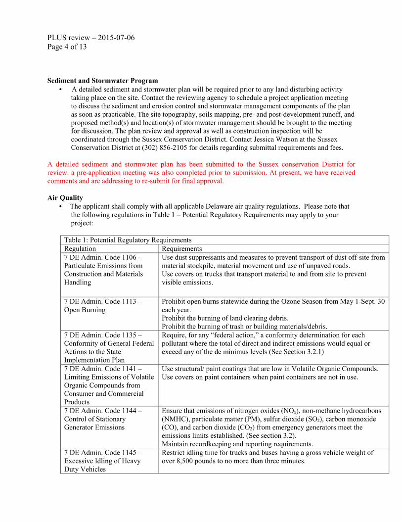
Sediment and Stormwater Program
• A detailed sediment and stormwater plan will be required prior to any land disturbing activity
taking place on the site. Contact the reviewing agency to schedule a project application meeting
to discuss the sediment and erosion control and stormwater management components of the plan
as soon as practicable. The site topography, soils mapping, pre- and post-development runoff, and
proposed method(s) and location(s) of stormwater management should be brought to the meeting
for discussion. The plan review and approval as well as construction inspection will be
coordinated through the Sussex Conservation District. Contact Jessica Watson at the Sussex
Conservation District at (302) 856-2105 for details regarding submittal requirements and fees.
A detailed sediment and stormwater plan has been submitted to the Sussex conservation District for
review. a pre-application meeting was also completed prior to submission. At present, we have received
comments and are addressing to re-submit for final approval.
Air Quality
• The applicant shall comply with all applicable Delaware air quality regulations. Please note that
the following regulations in Table 1 – Potential Regulatory Requirements may apply to your
project:
Table 1: Potential Regulatory Requirements
Regulation Requirements
7 DE Admin. Code 1106 -
Particulate Emissions from
Construction and Materials
Handling
Use dust suppressants and measures to prevent transport of dust off-site from
material stockpile, material movement and use of unpaved roads.
Use covers on trucks that transport material to and from site to prevent
visible emissions.
7 DE Admin. Code 1113 –
Open Burning
Prohibit open burns statewide during the Ozone Season from May 1-Sept. 30
each year.
Prohibit the burning of land clearing debris.
Prohibit the burning of trash or building materials/debris.
7 DE Admin. Code 1135 –
Conformity of General Federal
Actions to the State
Implementation Plan
Require, for any “federal action,” a conformity determination for each
pollutant where the total of direct and indirect emissions would equal or
exceed any of the de minimus levels (See Section 3.2.1)
7 DE Admin. Code 1141 –
Limiting Emissions of Volatile
Organic Compounds from
Consumer and Commercial
Products
Use structural/ paint coatings that are low in Volatile Organic Compounds.
Use covers on paint containers when paint containers are not in use.
7 DE Admin. Code 1144 –
Control of Stationary
Generator Emissions
Ensure that emissions of nitrogen oxides (NOx), non-methane hydrocarbons
(NMHC), particulate matter (PM), sulfur dioxide (SO2), carbon monoxide
(CO), and carbon dioxide (CO2) from emergency generators meet the
emissions limits established. (See section 3.2).
Maintain recordkeeping and reporting requirements.
7 DE Admin. Code 1145 –
Excessive Idling of Heavy
Duty Vehicles
Restrict idling time for trucks and buses having a gross vehicle weight of
over 8,500 pounds to no more than three minutes.

PLUS review – 2015-07-06
Page 5 of 13
Regulation 21 Section 10 –
Emission Standards for
Hazardous Air Pollutants,
Asbestos
Ensure no visible residue of asbestos materials remains in the work area after
all asbestos materials are removed in accordance with NESHAP.
Display DANGER signs whenever airborne asbestos may be present in
accordance with NESHAP and OSHA
Use wet removal techniques.
Dispose of all asbestos containing waste in clearly labeled sealed containers
and store in a secure location awaiting transport to an authorized disposal
facility, not to exceed a period of 45 days.
For a complete listing of all Delaware applicable regulations, please look at our website:
http://www.awm.delaware.gov/AQM/Pages/AirRegulations.aspx.
NOTED. In addition we are providing significant amount of new vegetation in the form of open lawns
and landscaping of plants, flowers and trees. All of this together and in combination with new home
construction, and the reduction in vehicles for the site will help in mitigating air quality regulations for the
State of Delaware.
Delaware State Fire Marshall’s Office – Contact Duane Fox 739-4394
At the time of formal submittal, the applicant shall provide; completed application, fee, and three sets of
plans depicting the following in accordance with the Delaware State Fire Prevention Regulation:
Fire Protection Water Requirements:
• Where a water distribution system is proposed for single-family and two-family dwellings it shall
be capable of delivering at least 500 gpm for 1-hour duration, at 20-psi residual pressure. Fire
hydrants with 1000 feet spacing on centers are required.
• The infrastructure for fire protection water shall be provided, including the size of water mains.
Accessibility:
• All premises, which the fire department may be called upon to protect in case of fire, and which
are not readily accessible from public roads, shall be provided with suitable gates and access
roads, and fire lanes so that all buildings on the premises are accessible to fire apparatus.
• Fire department access shall be provided in such a manner so that fire apparatus will be able to
locate within 100 ft. of the front door.
• The use of speed bumps or other methods of traffic speed reduction must be in accordance with
Department of Transportation requirements.
• The local Fire Chief, prior to any submission to our Agency, shall approve in writing the use of
gates that limit fire department access into and out of the development or property.
Gas Piping and System Information:
• Provide type of fuel proposed, and show locations of bulk containers on plan
Required Notes:
• Provide a note on the final plans submitted for review to read “ All fire lanes, fire hydrants, and
fire department connections shall be marked in accordance with the Delaware State Fire
Prevention Regulations”

PLUS review – 2015-07-06
Page 6 of 13
• Name of Water Supplier
• Proposed Use
• National Fire Protection Association (NFPA) Construction Type
• Details for the required 2-hr separation wall between dwellings on the Two-Family
dwelling units shall be shown on site plans
• Maximum Height of Buildings (including number of stories)
• Provide Road Names, even for County Roads
NOTED and Completed as required. We have met with the fire marshal’s office to review the project and
have submitted the plans for their review, comment and/or approval.
State Historic Preservation Office – Contact Terrence Burns 736-7404
• There are no known archaeological sites or National Register-listed property on this parcel.
However, if there will any development, on this parcel, the developer should still be aware of the
Unmarked Human Burials and Human Skeletal Remains Law of 1987 (Delaware Code: Title 7,
Chapter 54), which pertains to the discovery and disposition process of such remains.
Abandoned or unmarked family cemeteries are very common in the State of Delaware. They are
usually in rural or open space areas, and sometimes near or within the boundary of an historic
farm site. Even a marked cemetery can frequently have unmarked graves or burials outside of the
known boundary line or limit. Disturbing unmarked graves or burials triggers the Delaware’s
Unmarked Human Burials and Human Skeletal Remains Law (7 Del. C. Ch. 54), and such
remains or discoveries can result in substantial delays while the procedures required under this
law are carried out. If there is a discovery of any unmarked graves, burials or a cemetery, it is
very costly to have them archaeologically excavated and the burials moved. The Division of
Historical & Cultural Affairs recommends that owners and/or developers have a qualified
archaeological consultant investigate their project area, to the full extent, to see if there is any
unmarked cemetery, graves, or burial sites. In the event of such a discovery, the Division of
Historical & Cultural Affairs also recommends that the plans be re-drawn to leave the full extent
of the cemeteries or any burials on its own parcel or in the open space area of the development,
with the responsibility for its maintenance lying with the landowner association or development.
If you would like to know more information pertaining to unmarked human remains or
cemeteries, please check the following websites for additional information:
www.history.delaware.gov/preservation/umhr.shtml and
www.history.delaware.gov/preservation/cemeteries.shtml.
Therefore, prior to any demolition or ground-disturbing activities, the developer may want to hire
an archaeological consultant to examine the parcel for any potential archaeological site or
archaeological resources, such as cemetery, burial site, or unmarked human remains.
NOTED.
Recommendations/Additional Information
Department of Transportation – Contact Bill Brockenbrough 760-2109
• Part of the basis for installing the signal at the present shopping center access was the traffic
volumes associated with that shopping center. With the change from a shopping center to a
building of five residential condominiums, those volumes will be greatly reduced. Therefore the
PLUS review – 2015-07-06
Page 7 of 13
developer should be aware that DelDOT may remove their signalized access, leaving the building
with right-turn only access opposite a signalized T intersection.
There are still several commercial properties to the south connected to the entrance that is a part of
the BeachWalk redevelopment project. These properties connect through a shared access across
properties and have the potential to use the signal to go southbound on Route One.
During several meetings with DelDOT in Dover and at the site; it was noted that the signal serves a
broader purpose than just the shopping center. It is a means of safer turning movements for the
Spring Lake Residential property across the highway. There is potential in the future for the vacant
land in front of Spring Lake to be developed either with more residential units or possible as
commercial. Also, Spring Lake connects to the adjacent road way system that could allow for other
developments and area traffic to access northbound Route One safely from the signal intersection.
• Please be advised that as of August 1, 2015, all new plan submittals and re-submittals, including
major, minor and commercial plans, shall be uploaded via the PDCA (Planning Development
Coordination Application) with any review fee paid online via credit card or electronic check.
Guidance on how to do this is available on our website at
http://www.deldot.gov/information/business/subdivisions/.
NOTED.
Department of Natural Resources and Environmental Control – Michael Tholstrup 735-3352
Soils Assessment.
• The soil mapping units mapped on subject parcel is Greenwich-Urban land complex. Greenwich-
Urban land complex is a well-drained soil mapping unit that, generally, has few limitations for
development (Figure 1).
As a part of the stormwater design for the project, soil boring tests were performed and have been
submitted along with the stormwater design to the Sussex Conservation District.

PLUS review – 2015-07-06
Page 8 of 13
Additional information on TMDLs and water quality.
• Compliance with the specified TMDL nutrient and bacterial reduction requirements specified for
the Inland Bays watershed can be facilitated by adherence to the strategies and requirements
described in the Inland Bays PCS, and the implementation of the following recommended best
management practices (BMPs):
o Maintain as much of the existing open space as possible. We further suggest additional native
tree and native herbaceous plantings - wherever possible – to create additional
environmentally-friendly open space.
There is little to no open space presently on the property. This is an existing shopping center that
will be redeveloped as a residential project as a matter of right under the Rehoboth Zoning Code.
This redevelopment will allow for additional open space that calculates to approximately 1.7-
acres.
o Use green-technology storm water management and rain gardens (in lieu of open-water
management structures) as BMPs to mitigate or reduce nutrient and bacterial pollutant runoff
increases that often track post-development increases in surface imperviousness. Please
PLUS review – 2015-07-06
Page 9 of 13
contact Lara Allison at (302) 739-9939 for further information about the possibility for
installing a rain garden(s) on this parcel.
With the redevelopment of the property stormwater quality will now be handled onsite prior to
being conveyed through the existing closed system for the property.
o Calculate post-construction surface imperviousness with all forms of created (or constructed)
surface imperviousness (e.g., rooftops, driveways, parking lots, sidewalks, open-water storm
water management structures, ponds, and roads) included in the calculation. Omission of any
of the above-stated forms of surface imperviousness will result in an underestimate of the
actual post-development surface imperviousness and associated environmental impacts.
o Since this project will create additional surface imperviousness that will increase the
probability for increased flooding and increased pollutant load runoff impacts to adjoining
streams and wetlands in the greater Inland Bays watershed - we strongly encourage the
applicant mitigate these said impacts through the employ of pervious paving materials –
wherever practicable - instead of conventional asphalt and concrete. We particularly
recommend the applicant consider pervious paving materials for all designated parking areas.
The project will NOT create additional surface imperviousness. The impervious surfaces will be
decreased by 10% over what is currently on the property. The redevelopment of this property to
residential does mitigate impacts to the downstream conveyance systems.
o Assess nutrient and bacterial pollutant loading at the preliminary project design phase. To this
end, the Watershed Assessment Section has developed a methodology known as the “Nutrient
Load Assessment protocol.” The protocol is a tool used to assess changes in nutrient loading
(e.g., nitrogen and phosphorus) resulting from the conversion of individual or combined land
parcels to a changed land use(s); thus providing applicants and governmental entities with
quantitative information about the project’s impact(s) on baseline water quality. We strongly
encourage the applicant/developer use this protocol to help them design and implement the
most effective BMPs.
NOTED and described above.
Additional information on air quality.
• According to the application, an undetermined amount of “open space,” will remain after the
project is complete. However, the DNREC Division of Air Quality (DAQ) notes that the site plan
appears to show no set aside for this use. The property appears to be fully pervious with the
exception of each home’s allotted yard space.
• The existing property has access to well-connected sidewalks and bike lanes along DE Route 1.
These provisions extend well into Rehoboth, both north and south. However, there are no such
provisions on Terrace Road, where a main entrance is planned for this project. The applicant
notes that neither sidewalks nor bike paths will be added as part of this project. DNREC reminds
the applicant that City of Rehoboth Beach code requires property frontages to include sidewalks
at a minimum of 5 feet wide.

PLUS review – 2015-07-06
Page 10 of 13
• DNREC encourages developers and builders to consider all sustainable growth practices in their
design, and we believe that the air quality impacts associated with the project should be
completely considered. New homes may emit, or cause to be emitted, additional air contaminants
into Delaware’s air, which will negatively impact public health, safety and welfare. These
negative impacts are attributable to:
o Emissions that form ozone and fine particulate matter; Delaware currently violates federal
health-based air quality standards for ozone.
o The emission of greenhouse gases which are associated with climate change, and
o The emission of air toxics.
• Air emissions generated from new homes include emissions from the following activities:
o Area sources such as painting, maintenance equipment and the use of consumer products
like roof coatings and roof primers.
o The generation of electricity, and
o All transportation activity.
• Based on the information provided, the three air emissions components (i.e., area, electric power
generation, and mobile sources) were quantified. Table 2 – Projected Air Quality Emissions
represents the actual impact BeachWalk may have on air quality.
Table 2: Projected Air Quality Emissions for BeachWalk
Emissions
Attributable
to
BeachWalk
(Tons per
Year)
Volatile
Organic
Compounds
(VOC)
Nitrogen
Oxides
(NOx)
Sulfur
Dioxide
(SO2)
Fine
Particulate
Matter
(PM2.5)
Carbon
Dioxide
(CO2)
Area source
emissions 2.0 0.2 0.2 0.2 7.9
Power
emissions * 0.8 2.7 * 396.5
Mobile
emissions 2.9 3.0 0.1 * 1862.0
Total
emissions 4.9 4.0 5.0 0.2 2266.4
(*) Indicates data is not available.
Note that emissions associated with the actual construction of the residential community, including
automobile and truck traffic from working in, or delivering products to the site, as well as site
preparation, earth moving activities, road paving and other miscellaneous air emissions, are not
reflected in the table above.

PLUS review – 2015-07-06
Page 11 of 13
• DNREC encourages sustainable growth practices that:
o Control sprawl;
o Preserve rural and forested areas;
o Identify conflicting land use priorities;
o Encourage growth on previously developed sites and denser communities while at the same time
protect our diminishing land base;
o Coordinate transportation, environment, and climate protection plans with land use plans; and
o Demonstrate that communities can achieve the qualities of privacy, community, and contact with
nature without degrading the natural environment or generating unacceptable environmental
costs in terms of congestion, use of natural resources, or pollution.
• Additional measures may be taken to substantially reduce the air emissions identified above.
These measures include:
o Constructing with only energy efficient products. Energy Star qualified products are up to
30% more energy efficient. Savings come from building envelope upgrades, high
performance windows, controlled air infiltration, upgraded heating and air conditioning
systems, tight duct systems and upgraded water-heating equipment. Every percentage of
energy efficiency translates into a percent reduction in pollution. The Energy Star Program is
an excellent way to save on energy costs and reduce air pollution.
o Offering geothermal and/or photo voltaic energy options. These systems can significantly
reduce emissions from electrical generation and from the use of oil or gas heating equipment.
o Constructing with high albedo, high solar reflectance materials. This includes roofing and
hardscape. These materials help to reduce heat island impacts and, by extension, help to
minimize the potential for localized ground-level ozone formation. These materials also help
reduce demands on air conditioning systems and save on energy costs.
o Providing shade for parking areas. Approaches may include architectural devices,
vegetation, or solar panels. Providing shade for parking areas helps to reduce heat island
impacts, and, by extension, helps to minimize the potential for localized ground-level ozone
formation. Such measures can also have the additional benefit of channeling or infiltrating
stormwater.
o Providing charging stations for plug-in electric vehicles. This measure helps to reduce
localized air pollution by supporting the use of non-gasoline powered vehicles. Please refer
to the US Department of Energy’s website for electric vehicle readiness information:
http://www1.eere.energy.gov/cleancities/electric_vehicle_projects.html. Several charging
stations already exist in Rehoboth Beach and nearby Lewes.
o Encouraging the use of safe multimodal transportation. This measure can significantly
reduce mobile source emissions. For every vehicle trip that is replaced by the use of a
sidewalk or bike path, 7 pounds of VOC and 11.5 pounds of NOx are reduced each year.
o Using retrofitted diesel engines during construction. This includes equipment that is on-
site as well as equipment used to transport materials to and from site.
PLUS review – 2015-07-06
Page 12 of 13
o Using pre-painted/pre-coated flooring, cabinets, fencing, etc. These measures can
significantly reduce the emission of VOCs from typical architectural coating operations.
o Planting trees in vegetative buffer areas, particularly those between the site and nearby
residential areas. Native trees reduce emissions by trapping dust particles and replenishing
oxygen. Trees also reduce energy emissions by cooling during the summer and by providing
wind breaks in the winter, whereby reducing air conditioning needs by up to 30 percent and
saving 20 to 50 percent on fuel costs.
The BeachWalk project proposes to plant 240 new tress; 32 Shrubs and over 1000 Flowering Perennials
as shown on submitted plans to the City of Rehoboth and to State Planning Office.
This is a partial list, and there are additional things that can be done to reduce the impact of the
development. The applicant should submit a plan to the DNREC DAQ which address the above listed
measures, and that details all of the specific emission mitigation measures that will be incorporated
into the BeachWalk project. The Division of Air Quality point of contact is Rachel Yocum, and she
may be reached at (302) 739-9402 or [email protected].
Delaware State Fire Marshall’s Office – Contact Duane Fox 739-4394
• Preliminary meetings with fire protection specialists are encouraged prior to formal submittal.
Please call for appointment. Applications and brochures can be downloaded from our website:
www.statefiremarshal.delaware.gov, technical services link, plan review, applications or brochures.
As noted above, a preliminary meeting has already taken place with Duane Fox and plans have been
submitted for approval.
Sussex County – Contact: Janelle Cornwell 855-7878
• A portion of the property is located within Sussex County. At the PLUS meeting it was
suggested that the applicant talk to the City of Rehoboth and consider annexation to reduce any
potential conflicts of having the property located between two jurisdictions.
As with most municipalities, there are scattered parcels contiguous with municipal boundaries
similar to this that are only used for access to in-town sites. This parcel has been used solely for
the purpose of access to the proposed development site and no change in its use is requested or
contemplated. The applicant will consider annexation if a change in use makes annexation
appropriate.
• Sewer and water service is provided to the parcel by the City of Rehoboth Beach. Contact the
City of Rehoboth Beach for information regarding sewer and water service. For questions
regarding these comments, contact Rob Davis, Sussex County Engineering Department at (302)
855-7820.
We have met with the City of Rehoboth about the water and sewer and are addressing their comments for
the project.

PLUS review – 2015-07-06
Page 13 of 13
• In addition to these comments, a letter from Brandy Nauman, Sussex County Housing Coordinator
& Fair Housing Compliance Officer is attached to this letter.
Noted.
Following receipt of this letter and upon filing of an application with the local jurisdiction, the
applicant shall provide to the local jurisdiction and the Office of State Planning Coordination a
written response to comments received as a result of the PLUS process, noting whether comments
were incorporated into the project design or not and the reason therefore.
Thank you for the opportunity to review this project. If you have any questions, please contact me at 302-
739-3090.
Sincerely,
Constance C. Holland, AICP
Director, Office of State Planning Coordination
CC: Sussex County
Attachment
Thank you for your comments regarding this proposed application for residential condominium
development of this single commercially-zoned lot. We believe that our responses above in “RED”
provides the necessary clarification to the agency comments as well as to the comments received from
those present at the July 22, 2015 PLUS meeting. No significant changes to the plans have been made at
this time except for some minor amendments that addressed brief comments from the City of Rehoboth. I
have attached a copy of the amended cover sheet and Sheet CS1001 for your records.
Respectfully Submitted,
PENNONI ASSOCIATES INC.
Mark H. Davidson, AVP
Principal Land Planner
Enclosures:
Pc: City of Rehoboth Beach
D.K. Monigle – Applicant
Dennis L. Schrader, Esquire – Morris James Wilson Halbrook & Bayard
Carlton Savage, PE – Pennoni
George Cardwell, AICP – Pennoni
Peter Stone, RLA - Pennoni

BeachWalkRESIDENTIAL CONDOMINIUM DEVELOPMENT
SITE PLAN
TERRACE ROADD
ELA
WA
RE
RO
UT
E 1
(CO
AS
TA
L H
IGH
WA
Y)
SITE
*
SITE
CITY OF REHOBOTH BEACH
SUSSEX COUNTY
CITY OF REHOBOTH BEACH
SUSSEX COUNTY
100YEAR
FLOOD ZONE
WETLANDS LINE
CITY OF REHOBOTH BEACHSUSSEX COUNTY
SU
SS
EX
CO
UN
TY
CIT
Y O
F R
EH
OB
OT
H B
EA
CH
A
B
C

6
6' F
EN
CE
/ W
ALL
POOL
GR
ILL
RE
STR
OO
MS
GARAGE
HCS
TOR
AG
E
GARAGE
GARAGE
GARAGE
GARAGE
GA
RA
GE
GA
RA
GE
GA
RA
GE
GA
RA
GE
GA
RA
GE
GA
RA
GE
GA
RA
GE
GAR
AGE
GAR
AGE
GAR
AGEGAR
AGE
GAR
AGE
GAR
AGE
GAR
AGE
GAR
AGE
RAMPS
GARAGE
GARAGE
GARAGEUNIT 1
2222
1
6
6
RAMP RAMPGARAGEUNIT 2
GARAGEUNIT 4
GARAGEUNIT 5
GA
RA
GE
UN
IT 3
MECH.24' OPENING
UNIT3
312
2
2
2
2
2
2
2
2
2
2
2
2
2
22
2 2
22
22
2
22
22
4
5
2
2
2
2222222 22
2 2 2 2 2 22 2
2
22
2
22
221
1
1
1
111 11 1 1
1
11
11
11
1
1
2
ELEV.
6' F
EN
CE
/ W
ALL
2
TERRACE ROAD
S
C
A
R
B
O
R
O
U
G
H
A
V
E
N
U
E
DE
LAW
AR
E R
OU
TE 1
(CO
AS
TAL
HIG
HW
AY
) (10
0' R
OW
)
++
++
+
++
++
+
++
++
+
++
++
+
1
0
' W
ID
E
A
L
L
E
Y
P
E
R
D
E
E
D
B
O
O
K
3
1
0
, P
A
G
E
5
3
0
1
2
' W
ID
E
R
/W
E
A
S
E
M
E
N
T
F
O
R
IN
G
R
E
S
S
&
E
G
R
E
S
S
T
O
L
O
T
4
P
E
R
D
E
E
D
B
O
O
K
9
7
3
, P
A
G
E
1
2
7
2
5
' W
ID
E
U
N
D
E
R
G
R
O
U
N
D
U
T
IL
IT
Y
E
A
S
E
M
E
N
T
F
O
R
O
C
E
A
N
B
A
Y
M
A
R
T
IN
C
.
P
E
R
D
E
E
D
B
O
O
K
3
0
0
7
P
A
G
E
7
8
(A
R
E
A
=
4
,0
3
9
s
q
.ft.)
EXIST. ROW LINE
EXIST. ROW LINE
EXIS
T. R
OW
LIN
E
+
++
++
++
++
++
++
+
1
5
' T
O
2
5
' W
ID
E
U
N
D
E
R
G
R
O
U
N
D
U
T
IL
IT
Y
E
A
S
E
M
E
N
T
F
O
R
O
C
E
A
N
B
A
Y
M
A
R
T
IN
C
.
A
N
D
T
O
L
O
T
5
P
E
R
D
E
E
D
B
O
O
K
7
3
9
P
A
G
E
2
8
8
(A
R
E
A
=
4
,8
9
1
s
q
.ft.)
2
5
'
1
5
'
EXISTING ENTRANCETO BE IMPROVED
EXISTING ENTRANCEOUTSIDE OFPROJECT LIMITS
EXISTING ENTRANCE TOBE IMPROVED
CONNECTION TO EXISTINGOUTFALL PIPE
EXISTING ROADWAYTO BE IMPROVED
EXISTING ONE WAY TRAFFIC SIGNLIMITS OF ONE WAY TRAFFIC
34'
62'
48'
36'
34'34'
34'34'
34'34'
34'
48'
36'
34'34'
36'
48'
34' 34'
62'
34'
62'
34'
62'
34'
62'
34'62'
34'
62'
34'
62'
34'
62'
34'
62'
62'
45'
34'
45'
45'
34'
48'
34'
48'
32'
34'
34'
34'
34'
58'
34'
45'
32'32'
32'32'
32'
58'
32'
34'
34'
45'
36'
62'
48'
114'
58'
47'
15.6'
20'
24'
20'
20'
24'
24'
PROPOSED 2.5 STORY5 UNIT RESIDENTIAL
21,736 S.F. TOTAL
PROPOSED CLUBHOUSE(PRIVATE CLUB)
(2 STORY)7,200 S.F. TOTAL
10' P
ER
MA
NE
NT
EA
SE
ME
NT
5.5'
DE
DIC
ATI
ON
10' P
ER
MA
NE
NT
EA
SE
ME
NT
5.5'
DE
DIC
ATI
ON
58' 58' 58' 58' 58' 58' 58' 58' 58' 58' 58' 58'
48'
32'
48'
32'
48'
32'
45'
34'
42'
36'
45'34'
42'
36'
58'
58'
58'
58'
58'
48' 24'
34'
24'
48'
24'
42'
36'
45'
34'
48'
34'
48'
34'
48'
34'
76'
32'
50'
30'
36'
62'
36'
62'
36'
62'
36'
62'
125'
45'
20'
20'
FUTURECONNECTION
A 50-FOOT WIDECROSS ACCESSEASEMENT
50.0
0'
50.00'
#
NOTES:1. PERIMETER FENCE SCREENING PURPOSES. INTERIOR FENCES MAY BE ADDED AT
THE TIME OF BUILDING PERMIT APPLICATION WITH APPROVAL FROM THE CITY OFREHOBOTH.
2. ALL AREAS MARKED LANDSCAPING WILL BE LIT.