tardir/mig/a346578 - apps.dtic.mil · JPRS 83612 6 June 1983 USSR REPORT SPACE No, 22 CONTENTS...
104
r JPRS 83612 6 June 1983 USSR Report SPACE No. 22 19980609 152 DISTH1BÜTION STATEMENT A ApfHWsd few paMs r®l«ae«j Dtaäbattas Usüäraitod FBIS FOREIGN BROADCAST INFORMATION SERVICE REPRODUCED BY NATIONAL TECHNICAL INFORMATION SERVICE U.S. DEPARTMENT OF COMMERCE ' SPRINGFIELD, VA. 22161 \bH
Transcript of tardir/mig/a346578 - apps.dtic.mil · JPRS 83612 6 June 1983 USSR REPORT SPACE No, 22 CONTENTS...

r JPRS 83612
6 June 1983
USSR Report
SPACE
No. 22
19980609 152 DISTH1BÜTION STATEMENT A
ApfHWsd few paMs r®l«ae«j Dtaäbattas Usüäraitod
FBIS FOREIGN BROADCAST INFORMATION SERVICE
REPRODUCED BY
NATIONAL TECHNICAL INFORMATION SERVICE
U.S. DEPARTMENT OF COMMERCE ' SPRINGFIELD, VA. 22161 ■
\bH

NOTE
JPRS publications contain information primarily from foreign newspapers, periodicals and books, but also from news agency transmissions and broad- casts. Materials from foreign-language sources are translated; those from English-language sources are transcribed or reprinted, with the original phrasing and other characteristics retained.
Headlines, editorial reports, and material enclosed in brackets [] are supplied by JPRS„ Processing indicators such as [Text] or [Excerpt] in the first line of each item, or following the last line of a brief, indicate how the original information was processed. Where no processing indicator is given, the information was summarized or extracted,
Unfamiliar names rendered phonetically or transliterated are enclosed in parentheses. Words or names preceded by a question mark and enclosed in parentheses were not clear in the original but have been supplied as appropriate in context. Other unattributed parenthetical notes within the body of an item originate with the source. Times within items are as given by source.
The contents of this publication in no way represent the policies, views or attitudes of the U.S. Government,
PROCUREMENT OF PUBLICATIONS
JPRS publications may be ordered from the National Technical Information Service (NTIS), Springfield, Virginia 22161. In ordering, it is recom- mended that the JPRS number, title, date and author, if applicable, of publication be cited.
Current JPRS publications are announced in Government Reports Announcements issued semimonthly by the NTIS, and are listed in the Monthly Catalog of U.S. Government Publications issued by the Superintendent of Documents, U.S. Government Printing Office, Washington, D.C 20402.
Correspondence pertaining to matters other than procurement may be addressed to Joint Publications Research Service, 1000 North Glebe Road, Arlington, Virginia 22201.
Soviet books and journal articles displaying a copyright notice are reproduced and sold by NTIS with permission of the copyright agency of the Soviet Union. Permission for further reproduction must be obtained from copyright owner.

-JPRS REPORTS-
Japan Report Korean Affairs Report Southeast Asia Report Mongolia Report
Near East/South Asia Report Sub-Saharan Africa Report West Europe Report West Europe Report: Science and Technology
Latin America Report
USSR
Political and Sociological Affairs Problems of the Far East Science and Technology Policy Sociological Studies Translations from KOMMUNIST USA: Economics, Politics, Ideology World Economy and International Relations Agriculture Construction and Related Industries Consumer Goods and Domestic Trade Economic Affairs Energy Human Resources International Economic Relations Transportation
Physics and Mathmetids Space Space Biology and Aerospace Medicine Military Affairs Chemistry Cybernetics, Computers and Automation Technology Earth Sciences Electronics and Electrical Engineering Engineering and Equipment Machine Tools and Metal-Working Equipment Life Sciences: Biomedical and Behavioral Sciences Life Sciences: Effects of Nonionizing Electromagnetic Radiation Materials Science and Metallurgy Meteorology and Hydrology
EASTERN EUROPE
Political, Sociological and Military Affairs Scientific Affairs
Economic and Industrial Affairs
Political, Sociological and Military Affairs Economic Affairs Science and Technology
Telecommunications Policy, Research and Development
Nuclear Development and Proliferation
CHINA
RED FLAG Agriculture Plant and Installation Data
WORLDWIDE'
Environmental Quality Epidemiology
-FBIS DAILY REPORT-
China Soviet Union South Asia Asia and Pacific
Eastern Europe Western Europe Latin America Middle East and Africa
To order, see inside front cover

JPRS 83612
6 June 1983
USSR REPORT
SPACE
No, 22
CONTENTS
MANNED MISSION HIGHLIGHTS
TASS Announces Launching of 'Cosmos-1443' Satellite (PRAVDA, 3 Mar 83) 1
TASS Announces Docking of 'Cosmos-1443' With 'Salyut-7' (PRAVDA, 11 Mar 83) 2
Comment on Docking of 'Cosmos-1443' (LD112349 Moscow Domestic Service, 11 Mar 83) 3
TASS Announces Launching of 'Soyuz T-8' (PRAVDA, 21 Apr 83) 4
TASS Announces 'Soyuz T-8' Rendezvous Failure, Return of Cosmonauts
(PRAVDA, 23 Apr 83) ... 5
TASS Announces 'Salyut-7' Station Passes on Year in Orbit Mark (PRAVDA, 30 Apr 83) 6
Post-Flight Interview With Berezevoy and Lebedev (Anatoliy Berezovoy, Valentin Lebedev Interview; SOTSIALISTICHESKAYA INDUSTRIYA, 26 Dec 82) 7
Optical Orientation in Space (V. Savinykh; AVIATSIYA I KOSMONAVTIKA, Jan 83) 13
SPACE SCIENCES
TASS Announces Launching of 'Astron' Satellite (PRAVDA, 24 Mar 83) 17
- a - [III - USSR - 21L S&T]

New High-Altitude Observatory in Kazakhstan (D. Gutenev; KAZAKHSTANSKAYA PRAVDA, 6 Feb 83) 18
New 1.5-Meter Telescope With Glass Ceramic Mirror (TASS, 27 Dec 82) 20
Checking Type II-III Secondary Mirror of Ratah-600 "V".. Telescope
(V. M. Belyakov, et al.; GEODEZIYA I KARTOGRAFIYA, Jul 82) 21
Diffraction on Segmented Telescope Mirror (A. V. Lenskiy; ASTRONOMICHESKIY ZHURNAL, Nov-Dec 82) 21
Improving Method for Satellite Observations Using AFU-75 Camera (I. N. Kunovskiy; GEODEZIYA I KARTOGRAFIYA, Jul 82) 22
Effect of Faculae on Variation in Stream of Solar Radiation (E. V. Kononovich, I.V. Mironova; PIS'MA V ASTRONOMICHESKIY ZHURNAL, Dec 82) 22
Cosmic Ray Pulsations Prior to Solar Proton Flares, Based on Data From Terrestrial Observations
(S. A. Starodubtsev, et al.; ASTRONOMICHESKIY ZHURNAL, Nov-Dec 82) 23
Nontraditional Method for Determining Elements of Orbits of Unknown Cosmic Objects From Data Obtained by Computer Processing of Review Photographs
(V. I. Kuryshev, N. I. Perov; ASTRONOMICHESKIY ZHURNAL, Nov-Dec 82) 24
Friction Mechanism for Particle Acceleration in Interplanetary Space
(Ye. G. Berezhko; PIS'MA V ASTRONOMICHESKIY ZHURNAL, Dec 82) 24
INTERPLANETARY SCIENCES
Robots on Venus (V. G. Perminov, 0. S. Fedorov; ZEMLYA I VSELENNAYA, Jan-Feb 83) 25
Spectrophotometric Experiment on Board 'Venera-13', 'Venera-14' Descent Vehicles
(V. I. Moroz, et al.; PIS'MA V ASTRONOMICHESKIY ZHURNAL, Jul 82) 33
- b -

Measurement of Water Vapor Content of Venus's Atmosphere by 'Venera-13', 'Venera-14' Automatic Interplanetary Stations
(Yu. A. Surkov, et al.; PIS'MA V ASTRONOMICHESKIY ZHURNAL, Jul 82) 34
Evaluations of Wind Velocity Based on Doppler Measurements Made by 'Venera-13,' 'Venera-14' Automatic Interplanetary Stations: First Results
(V. V. Kerzhanovich, et al.; PIS'MA V ASTRONOMICHESKIY ZHURNAL, Jul 82) 34
Wind Velocity at Landing Points of 'Venera-13,1 'Venera-14,' Based on Acoustic Measurements
(L. V. Ksanfomaliti, et al.; PIS'MA. V ASTRONOMICHESKIY ZHURNAL, Jul 82) 35
Low-Frequency Electromagnetic Field in Venus's Atmosphere, Based on Data From 'Venera-13,' 'Venera-14'
(L. V. Ksanfomaliti, et al.; PIS'MA V ASTRONOMICHESKIY ZHURNAL, Jul 82) . 35
Analysis of Panoramas of 'Venera-13,' 'Venera-14' Landing Sites
(K. P. Florenskiy, et al.; PIS'MA V ASTRONOMICHESKIY ZHURNAL, Jul 82) 36
Dynamics of Images Transmitted From 'Venera-13' Station (A. S. Selivanov, et al.; PIS'MA V ASTRONOMICHESKIY ZHURNAL, Jul 82) 36
Preliminary Results of Determination of Element Composition of Rocks on Venus by 'Venera-13,' 'Venera-14' Automatic Interplanetary Stations
(Yu. A. Surkov, et al.; PIS'MA V ASTRONOMICHESKIY ZHURNAL, Jul 82) 37
Microseisms at 'Venera-13,' 'Venera-14' Landing Sites (L. V. Ksanfomaliti, et al.; PIS'MA V ASTRONOMICHESKIY ZHURNAL, Jul 82) 38
Panoramas of 'Venera-13,' 'Venera-14' Landing Sites (Preliminary Analysis)
(K. P. Florenskiy, et al.; ASTRONOMICHESKIY VESTNIK, Jul-Sep 82) 38
Investigation of Venus by 'Venera-13,' 'Venera-14' Automatic Interplanetary Stations: First Data on Rock Composition
(Yu. A. Surkov, et al.; ASTRONOMICHESKIY VESTNIK, Jul-Sep 82) 39
- c -

Nocturnal Glow at 5577 A and Electron Flows in Nocturnal Atmosphere of Venus
(V. A. Krasnopol'skiy; KOSMICHESKIYE ISSLEDOVANIYA, Sep-Oct 82) 39
New Data on Aerosol of Venusian Cloud Layer (Preliminary Results of Investigations Carried Out With 'Venera-14' Space Probe )
(Yu. A. Surkov, et al.; PIS'MA V ASTRONOMICHESKIY ZHURNAL, Nov 82) 40
Some Results of Study of Gravitational Field, Shape and Internal Structure of Mars
(G. A. Meshcheryakov, A. L. Tserklevich; ASTRONOMICHESKIY VESTNIK, Jul-Sep 82) 40
Origin of Saturn's Rings and Nature of Cassini Division (V. D. Davydov; KOSMICHESKIYE ISSLEDOVANIYA, Sep-Oct 82). 41
Distribution of Sizes of Particles Formed During Modeling of Ablation of Meteoritic Matter
(V. N. Zelenin, et al. ; ASTRONOMICHESKIY VESTNIK, Jul-Sep 82) . 41
SPACE ENGINEERING
Beregovoy on Future Construction in Space (Georgly Timpfeyevich Beregovoy Interview; STROITEL'NAYA GAZETA, 29 Dec 82) 43
Remote Control of On-Board Satellite Systems (V. Olimpov, G. Irinin; AVIATSIYA I KOSMONAVTIKA, Jun 82) 47
Effect of Atmospheric Resistance on Uniaxial Gravitational Orientation of Artificial Satellite
(V. A. Sarychev, V. V. Sazonov; KOSMICHESKIYE ISSLEDOVANIYA, Sep-Oct 82) 51
Oscillations of Satellite With Compensating Devices in Elliptical Orbit
(I. P. Polyanskaya; KOSMICHESKIYE ISSLEDOVANIYA, Sep-Oct 82) 51
Matched Optimum Filters for Plotting Local Vertical (N. A. Dolinin; KOSMICHESKIYE ISSLEDOVANIYA, Sep-Oct 82). 52
Evaluation of Error in Measuring Strength of Permanent Electrical Field by Langmuir Double-Probe Method
(V. Ye. Korepanov; KOSMICHESKIYE ISSLEDOVANIYA, Sep-Oct 82) 52
d -

SPACE APPLICATIONS
Dynamics of Ocean and Atmosphere on Basis of Observations From 'Salyut-6'
(B. A. Nelepo, et al.; ZEMLYA I VSELENNAYA, Jan-Feb 83).. 53
Further Development of 'Kospas-Sarsat' System CB. Konovalov; IZVESTIYA, 1 Apr 83)...... 61
Technique for Quantitative Processing of Results of Interpretation of Space Photographs for Solution of Geological Prospecting Problems
(0. G. Sheremet, et al.; ISSLEDOVANIYE ZEMLI IZ KOSMOSA, Sep-Oct 82) 65
Accuracy of Component Analysis During Space Investigations of Environment
(B. B. Serapinas; ISSLEDOVANIYE ZEMLI IZ KOSMOSA, Sep-Oct 82) 65
Remote Measurement of Phytomass (B. V. Vinogradov; ISSLEDOVANIYE ZEMLI IZ KOSMOSA, Sep-Oct 82) 66
Identification of Forest Fire Spreading Rates From Infrared Photographs
(E. N. Valendik, et al.; ISSLEDOVANIYE ZEMLI IZ KOSMOSA, Sep-Oct 82) , 67
Possibility of Determining Moisture Content of Upper Layers of Atmosphere by Radiometrie Method
(K. P. Gaykovich, Sh. D. Kitay; ISSLEDOVANIYE ZEMLI IZ KOSMOSA, Sep-Oct 82) 67
Interpretation of Gravimetric and Magnetic Anomalies on Basis of Interpretation of Space Photographs
(Ye. N. Isayev, I. V. Isayeva; ISSLEDOVANIYE ZEMLI IZ KOSMOSA, Sep-Oct 82) 68
Possibility of Detecting Humus in Soils From Spectral Measurement Data
(P. P. Fedchenko; ISSLEDOVANIYE ZEMLI IZ KOSMOSA, Sep-Oct 82) 68
Digital Processing Method for Outline-Type Video Information (R. I. El'man; ISSLEDOVANIYE ZEMLI IZ KOSMOSA, Sep-Oct 82) 69
Operational Planning of Process of Surveying Earth's Surface With Automatic Artificial Earth Satellites
(V. V. Malyshev, D. V. Moiseyev; ISSLEDOVANIYE ZEMLI IZ KOSMOSA, Sep-Oct 82) 69
- e -

Possibilities for Using Space Surveying Materials in Transport Construction
(V. V. Kosmin, A. M. Kozlov; ISSLEDOVANIYE ZEMLI IZ KOSMOSA, Sep-Oct 82) 70
Space Photograph Interpretation of Deep Platform Structures Promising for Oil and Gas
(A. N. Lastochkin; SOVETSKAYA GEOLOGIYA, Dec 82) 70
Prospects for Using Air and Space Research in Dnepr-Donets Depression
(V. B. Porfir'yev, et al.; DOKLADY AKADEMII NAUK UKRAINSKOY SSR, SERIYA B: GEOLOGICHESKIYE, KHIMICHESKIYE I BIOLOGICHESKIYE NAUKI, May 82)..., 71
Geodynamic Approach to Interpretation of Space Photographs in Solving Problems in Petroleum-Gas Geology
(L. N. Rozanov; GEOLOGIYA NEFTI I GAZA, Jun 82) 71
Investigation of Possibility of Compiling Land Use Map of Cuba From Space Photographs
(L. Fernandez; ISSLEDOVANIYE ZEMLI IZ KOSMOSA, Sep-Oct 82) 72
Lineaments and Ring Formations in Territory of Polish People's Republic
(Yu. Bazhin'skiy, et al.; ISSLEDOVANIYE ZEMLI IZ KOSMOSA, Sep-Oct 82) 73
SPACE POLICY AND ADMINISTRATION
Space Flight With Indian Cosmonaut Planned (AFP, 6 Jan 83) ;:. .-.;.. .;.V.. 74
USSR-India Cooperative Space Programs (Yu. Zaytsev; SOVETSKAYA ESTONIYA, 26 Jan 83) 75
Contribution of Space Program to National Economy (EKONOMICHESKAYA GAZETA, No 12, Mar 83) 78
Legal Delimitation of 'Airspace' (A. Terekhov; AVIATSIYA I KOSMONAVTIKA, Jan 83) 85
Soviet Paper Hits U.S. 'Militarization of Space' (Yu. Shvetsov; SOVETSKAYA ROSSIYA, 29 Jan 83) 88
'KRASNAYA ZVEZDA' on U.S. Military Space Communications Systems (A. Zhovanik; KRASNAYA ZVEZDA, 1 Dec 82) 91
LAUNCH TABLE
List of Recent Soviet Space Launches (TASS, various dates) . 94
- f -

MANNED MISSION HIGHLIGHTS
TASS ANNOUNCES LAUNCHING OF 'COSMOS-1443' SATELLITE
Moscow PRAVDA in Russian 3 Mar 83 p 2
[TASS Report: "Satellites Launched"]
[Text] In accordance with the program for space research, on 2 March 1983 the "Cosmos-1443" artificial earth satellite was launched in the Soviet Union.
The aim of the launch is to test on-board systems, equipment and design elements of the satellite in various flight regimes, including a joint flight with the "Salyut-7" station.
"Cosmos-1443" is analogous in design to the "Cosmos-1267" satellite which was tested in 1981-82 in autonomous flight and in joint flight with the "Salyut-6" orbital station.
Orbital parameters of the satellite are: apogee, 269 kilometers; perigee, 199 kilometers; period of revolution, 88.9 minutes; inclination, 51.6 degrees,
According to telemetry information the on-board systems of "Cosmos-1443" are functioning normally.
CSO: 1866/102-P

TASS ANNOUNCES DOCKING OF 'COSMOS-1443' WITH 'SALYUT-7'
Moscow PRAVDA in Russian 11 Mar 83 p 1
[TASS Report: "Docking in Orbit"]
[Text] On 10 March 1983 at 1220 hours Moscow time the docking of the "Cosmos-1443" satellite with the "Salyut-7" scientific station occurred. The "Salyut-7"—"Cosmos-1443" orbital complex began functioning in near-
earth space.
The program for the joint flight of the "Salyut-7" station and the "Cosmos- 1443" satellite includes further tests of on-board systems, equipment and design elements of prospective space apparatus and the development of con- trol methods for orbital complexes of large dimensions and mass.
The "Cosmos-1443" satellite delivered equipment, apparatus and various cargo necessary for the further functioning of the "Salyut-7" station and for performing scientific research aboard the station by crews of cosmonauts.
According to trajectory measurements, the orbital parameters of the "Salyut- 7»__»Cosmos-1443" complex are: apogee, 345 kilometers; perigee, 325 kilometers; period of revolution, 91 minutes; inclination, 51.6 degrees.
The on-board systems of the orbital complex are functioning normally. Information coming in to the Flight Control Center is being processed and
studied.
CSO: 1866/103-P

COMMENT ON DOCKING OF 'COSMOS-1443'
LD112349 Moscow Domestic Service in Russian 1900 GMT 11 Mar 83
[Comment by unidentified 'specialist']
[Text] The Cosmos-1443 satellite which docked with the station yesterday was launched from Baykonur on 2 March. For the Soyuz spacecraft the trip to the station takes 24 hours. For a Progress automatic cargo craft it takes twice that time. The Cosmos-1443 took longer to reach Salyut-7. This was as planned in the program. Along the way onboard systems and units were tested and a control plan was worked out.
A similar heavy satellite had already docked with the Salyut-6 orbital station 1 1/2 years ago. At that time, for the station to be able to receive the new craft one of its docking ports had to be filled with a special transfer hatch (perekhodnik). The docking port has been modified on the Salyut-7 and this has made it possible for the docking to be accomplished without additional attachments.
Information coming into the control center from tracking stations on earth and from the ships Akademik Sergey Korolev and Kosmonavt Georgiy Dobrovolskiy which are on duty in the Atlantic shows that all systems on the new orbital complex are working normally.
The Cosmos-1443 satellite is a little bigger than its predecessors, the Soyuz and Progress spacecraft. It weighs almost as much as the Salyut station itself—around 20 tons, and already on this trip has taken into orbit a large quantity of cargo essential for future cosmonaut crews working on the station. Among these cargoes are equipment and apparatus for conducting scientific research, food products and instruments.
The successful docking of the heavy satellite with the orbiting station and the creation of the Salyut-7—Cosmos-1443 scientific complex show that Soviet space research is moving systematically toward creating larger-scale orbital complexes. Ahead lie the testing of onboard systems, units and construction components of possible future spacecraft and the development of control methods for orbital complexes large in size and mass.
CSO: 1866/82

TASS ANNOUNCES LAUNCHING OF 'SOYUZ T-8'
Moscow PRAVDA in Russian 21 Apr 83 p 1
[Text] In accordance with the program for space research, on 20 April 1983 at 1711 hours Moscow time the "Soyuz T-8" spacecraft was launched in the Soviet Union. The crew consists of ship commander Lieutenant-Colonel Vladimir Georgiyevich Titov; flight-engineer, Hero of the Soviet Union, USSR Pilot-Cosmonaut Gennadiy Mikhaylovich Strekalov and cosmonaut- researcher, Hero of the Soviet Union Aleksandr Aleksandrovich Serebrov.
The flight program calls for docking of the "Soyuz T-8" with the orbital complex "Salyut-7"~"Cosmos-1443". The crew will perform scientific- technical and medical-biological experiments aboard the manned complex.
Cosmonauts Titov, Strekalov and Serebrov are feeling well. The on-board systems of the "Soyuz T-8" ship are operating normally.
CSO: 1866/134-P
TASS ANNOUNCES 'SOYUZ T-8' RENDEZVOUS FAILURE, RETURN OF COSMONAUTS
Moscow PRAVDA in Russian 23 Apr 83 p 3
[Text] The second working day for cosmonauts Titov, Strekalov and Serebrov began at 0900 hours Moscow time on 21 April. In accordance with the flight program, orbital corrections of the ship were carried out in order to rendezvous with the station. Function checks of the ship's on-board systems were also performed. Due to a deviation from the planned rendezvous procedure the docking of the "Soyuz T-8" ship with the "Salyut-7" station was canceled. The cosmonauts have begun preparations for return to earth.
Cosmonauts Titov, Strekalov and Serebrov have returned to earth. At 1729 hours Moscow time on 22 April the "Soyuz T-8" descent craft landed in the planned region of the Soviet Union sixty kilometers northeast of the city of Arkalyk.
Before the descent the cosmonauts oriented the ship, after which the orbital module was separated, the descent engine was activated and the descent craft was separated from the instrument module.
After a controlled descent in the atmosphere the parachute system was deployed. Just before touch-down, the soft-landing engines operated and the descent craft landed smoothly.
Cosmonauts Titov, Strekalov and Serebrov are in good health.
CSO: 1866/136-P

TASS ANNOUNCES 'SALYUT-71 STATION PASSES ON YEAR IN ORBIT MARK
Moscow PRAVDA in Russian 30 Apr 83 p 1
[Text] The "Salyut-7" orbital scientific station has been functioning in near-earth space for over a year. At the present time the station is continuing in flight in autonomous mode with the "Cosmos-1443" satellite which docked with the station on 10 March 1983. Further tests are being performed with the on-board systems, units and structural elements of both spacecraft and control methods for large-dimension orbital complexes are beting developed.
On 28 April the engine of "Cosmos-1443" was used to perform a trajectory correction for the complex. Following this correction the orbital parameters are: apogee, 347 kilometers; perigee, 291 kilometers; period of revolution, 90.7 minutes; inclination, 51.6 degrees.
The on-board systems of the "Salyut-7"—"Cosmos-1443 orbital complex are operating normally. Information coming into the Flight Control Center is being processed and studied.
CSO: 1866/137-P

POST-FLIGHT INTERVIEW WITH BEREZEVOY AND LEBEDEV
Moscow SOTSIALISTICHESKAYA INDUSTRIYA in Russian 26 Dec 82 p 4
[Post-flight interview with cosmonauts Anatoliy Berezovoy and Valentin Lebedev by V. Zubkov: "I and My Comrade"; date and place not specified]
[Text] No matter how psychologists select crews for long-term flights, no matter how hard the cosmonauts themselves strive to create a solid, integral collective, each person still retains his own habits and characteristics. He remains an individual entity in any large collective. What then can you say about a small one, consisting entirely of two people? Each reacts differently to the same events, each evaluates a situation his own way. The cosmo- nauts talk about this in our interview.
[Question] "Two hundred eleven days is a long time. What qualities of.Valentin Le- bedev enabled you to successfully handle such an extended project? And what quali- ties of.your own did you have to mobilize?
[Berezovoy] I was especially impressed by how charged up Valentin always was for working, by his striving to do more every day than what was planned for each experi- ment. This constant busyness enabled us to maintain an overall "tune" during the entire flight.
I learned from the fellows who had been on long-term flights before us that certain critical moments arise during orbital flight when one must "soundly dress himself down," not allow himself to "slide," so that work goes on as scheduled. My own or- bital flight experience convinced me that patience and a genuine striving to under- stand the person who is working and living alongside you often simplifies things.
[Question] You completed about 300 experiments. Could we say that there were some among them you felt were particularly interesting?
[Berezovoy] I especially liked doing the visual observations in support of.agricul- tural needs and the astrophysical research. The latter involved a hobby Valentin and I share to some extent. In looking for good shots of.solar phenomena, Valentin even got burned sitting by the viewport--just like at the beach. But we didn't get to work with the sun as much as we wanted. It was necessary to maneuver the sta- tion, and therefore expend fuel, in order to find a suitable observation position—

and fuel must be conserved in space at least as much as on earth. In addition, it requires more time--time we didn't have.
[Question] Prior to the flight you showed an interest in working a bit more with the agriculture-related projects. What was behind that?
[Berezovoy] I'm a native of Krasnodarskiy Kray. There's a certain scientific organ- ization there which is very interested in questions relating to use of.space technol- ogy to meet agricultural needs. When I went back home on leave, organization employ- ees presented their ideas to me. After all was said and done, their proposals were accepted for inclusion in the flight program.
[Question] Over the course of.seven months, you undoubtedly got to see--in addition to Kuban'--some of.your favorite places on earth?
[Berezovoy] Sure. Baykal was a particularly delightful sight. The lakes of.Africa are also pretty. South America has two jasper-colored lakes in the 40-degree lati- tude area. That was interesting, certainly, but there's nothing better than Baykal. It's different every time--but always pretty.
It is important to understand in general that, for us in orbit, visual observation replaced theater and movies. It provided the opportunity to take a breather from our other work and relate one-on-one with the earth.
[Question] But you did have your own "movies."
[Berezovoy] Right--the Niva video equipment complex. One of.the video cassettes we were sent showed my daughter's birthday celebration, a presentation from our comrade, Yura Malyshev, and some of:the other guys who prepared us for the flight. It also included some familiar Moscow scenes. We couldn't wait to get that video tape. I would put it on when I felt particularly homesick. You watch, get engrossed in it, and it seems like you're with your family.
[Question] Did such a lengthy flight cause any changes in your character?
[Berezovoy] Space flight is not only technological in nature. It's a great psycho- logical experiment as well--which, by the way, has yielded its share of.discoveries. In particular, I found out that I had a great deal of.patience. The flight taught me to be very attentive in dealing with other people's particular traits, and to be more demanding in my selfrcontrol. I believe that, in purely human terms, the flight did quite a bit both for my way of life on earth and for my future prospects as well. I certainly hope this flight isn't my last.
[Question] Speaking of future flights, what advice would you give those who will be going up after you?
[Berezovoy] Longer flights will be possible in the future. But I think the orbital station will be different too, and will afford other opportunities. I'd say the crews will be larger. Quite soon it will consist of. three people — then more. And there's the possibility of.a mixed crew.

Such a situation, however, might not only present greater possibilities, but new problems as well, related to the fact that a three-person crew is psychologically less stable and a situation may arise where two are pitted against one. The psychol- ogists have their work cut out for them here.
Valentin and I underwent a short, highly intensive preparation period. There were certain human-interrelationship questions, therefore, we were unable to resolve con- clusively on earth. They accompanied us into space, and there we handled them. It'd be better if.our successors need not do this.
In my opinion, the overall approach for crew selection has been correct. Crews should be packaged so that the merits of.each person are mutually supportive and de- ficiencies are smoothed out. Then it will be a strong crew, capable of going further than we did.
[Question] Anatoliy, did any problems arise in handling the equipment that you were unable to manage at first?
[Berezovoy] Certainly. I'll give you just one example. An electrophotographic lens apparatus (EPL) manufactured by our Czech colleagues was mounted on board the sta- tion. We used it to study the condition of,the upper atmosphere layers with the help of twinkling stars, whose light passes through the earth's horizon. Although we un- derwent thorough preparation with respect to operating this instrument, so many ques- tions arose on board the station that a great deal of.time and effort on the part of. our people on the ground was required to resolve them.
Here's one aspect of the problem, for example. We could never understand why, when extracting information, we kept getting an unsteady telemetric signal. We sought ex- pert advice and were told that shouldn't happen. The instrument was being operated properly and everything was in good working order. Yet here was a phenomenon we couldn't understand and which wouldn't go away.
There is an instrument on the station control console that indicates voltage of. on- board systems. Although it has nothing to do with the EPL, it was this voltmeter which led us to a solution to the problem. I noticed that the voltmeter glass was not rigidly secured and was "drifting" slightly. The thought came to me that the EPL light filter glass might also be affixed improperly. Such a barely noticeable vibration could be causing the telemetry data to fluctuate. This turned out to be the case.
[Question] What was the French cosmonaut's performance like overall?
[Berezovoy] I liked Jean's work. He was "occupied" with all the basic experiments. But he was used particularly extensively in the medical experiments. We assembled all the medical apparatus in the work compartment. Whenever you'd look in there, you'd see Jean, all red in the face, doing research on his veins, heart, and so on. All of this was recorded on video tape.
Undoubtedly you noticed how much television coverage there was. Naturally, Jean was a constant participant. Animated and spontaneous, he really livened up the transmis- sions. But he would "complain" at times that he was never able to see France because
there wäre so jöiany TV reports tö^Sö." By that time we were already quite, accustomed to working with "Delta" and'couicTforewarn him when we were about to'overfly his .... native land. ..He would grab his camera and rush to the Viewport. How happy he was to see his native" Bretagne and Paris!
This visiting crew helped us overall. Prior to their arrival Sasha Ivanchenkov had spent 140 days on board the station--more than we had at the time. He remembered nuances in the earth's surface quite well, set up excursions for us and taught us how to observe various phenomena in the sky. He showed us zodiacal light and taught us how to see the break-up of.the second emissive layer. We observed the Aurora Boreal- is for the first time with them.
Jean Loup expressed a lively interest in all this. But he found the dynamics of.the space station especially intriguing. Volodya Dzhanibekov and Valya Lebedev told him quite a lot about this. One day he and I oriented the station manually—he got a big kick out of it.
[Question] Valentin! Anatoliy has already answered this one—now it's your turn. What qualities in Anatoliy helped you endure this flight? And what about you your- self: in this regard?
[Lebedev] I think an understanding of.the seriousness of.the mission and a sober disposition for dealing with difficulties helped us both.
I wrote myself-some instructions prior to the flight, covering about 10 points. This was a kind of promise to myself.in which I determined how I should act under a vari- ety of.adverse situations. This kind of "tuning" helped me. After all, we are human. I understood that when certain critical conditions arose related to the planning, documentation or staging of.experiments, small conflicts might arise. Whether these conflicts blossomed or dampened depended to a great extent on us.
Now about my partner.
His orderliness, his penchant for housekeeping really impressed me. It might seem a trifling matter to put things in their place and secure them properly. But this kind of.thing is no longer trifling under conditions of:weightlessness, and can cause pure waste of:time. Tolya proved to have a rare ability in this regard. He is also very neat with documentation, a fact which not only eliminates errors but also avoids the need to over-insure. He is very careful in his interpersonal relationships as well.
[Question] In all likelihood there were difficulties, critical situations, that came up in over seven months of space flight?
[Lebedev] We had those, certainly. But nowhere near the amount it might seem.
I remember when Lesha Popov arrived as part of.a visiting expedition. He shared some of his 185-day flight experience with us and said there were times when he was over- come with depression. We had already been up three months at that time and had not experienced any such critical situation. I don't even think we had any afterwards.
[Question] Did the visiting expeditions infuse you with fresh spirit?
10

[Lebedev] Our attitude towards the visiting expeditions is complicated. On one hand I associate their arrival with a lot of:commotion. We had to tidy up the station, ready apparatus, documentation and the working and sleeping sections, then feed ev- eryone. Well--you know what it's like receiving guests. On the other hand, you wait for them like brothers and the joy of personal contact makes up for the difficulties.
I remember once we had some kind of malfunction. As a result, an astrophysical ex- periment was in danger of.falling through. It became a face-saving matter to "pull out" the experiment, and we began flitting like bats from viewport to viewport in the darkness, searching for the necessary stars. And when we'd done all the work and gathered around the table, as was the custom, Jean said: "I never expected Soviet cosmonauts to fight so hard in conducting French experiments."
You receive great emotional support, of course, during the visiting expeditions, but get very tired as well. We slept an entire two days after they left. The Soviet- French effort tired us out so much, we almost slept through separation. It's a good thing our people on the ground sent an audible signal. That worked.
[Question] Well, an international crew on board the space station isn't the ordinary situation, is it?
[Lebedev] In a certain sense this is true. And perhaps we all felt somewhat con- strained for that reason. But when Lesha Popov, Svetlana Savitskaya and Sasha Sere- brov arrived, everything was quite gay and simple, as if.it were our own brothers and sister who had dropped in to see us. There was no end to the jokes and laughs.
For some reason they decided to put one over on me. I was concerned about how they were getting ready to conduct the astrophysical experiments. After all, that's my hobby! Well--one time they forgot to remove the lens cover. I figured I wouldn't say anything the first time. But apparently they noticed my frustration. After fin- ishing the second series, Svetlana came up to me and said in an angelic voice: "You know, Valentin, we forgot to uncover the lens again." "Again?" "Yes..." I looked at them and gave a confused smile. But what should I do? "Okay...I guess we might as well complete the entire program with lens cap on," I said. "Hey, we were putting you on," she laughed. "Just wanted to test your self-control." They laughed. But I was thinking to myself--just you wait! I'll show you what it is to fool around with an old-timer.
We finished the next project and it was up to me to give the order for shutting down the routine. I did everything as expected, then turned away from the console as if. gathering up the telemetry schematic. Svetlana comes up to me and says very softly: "Valentin--an accident!" "Where?" She points to the status board. A special dis- play is lit up indicating that an accident has occurred and that the entire guidance circuitry is non-operational. Here I go into genuine hysterics--"We've all burned up!" I say. "The station is devoid of life." I clutch at my head. And they believe it. They've begun to calm one another and follow me in single file. Svetlana offers consolation. Then I say: "Right, we can calm down now--now that the station is no longer functional! We'll have to abandon it." Then I see things have taken too se- rious a turn and confess to having played a trick. We laughed about that all eve- ning. Actually I was able to lead them on because they didn't know the entirety of. the capabilities of.our on-board Delta computer. Later on they stated flatly during a communications period: "We're studying the Delta. We won't be fooled again."
11

[Question] And how did you spend your spare time?
[Lebedev] As you know, we had a television monitor and video cassette recorder. Programs were regularly transmitted for our entertainment. The most enjoyable were the encounters with our families. You talk with your wife and can guess from her in- tonation and intervals between words a lot more than what she's actually saying.
I spent some of.my relaxation time working with the biological experiments also. Back on earth I had never loved tinkering in the garden. But on board the space sta- tion it was as if,I woke up all of a sudden to the Oasis apparatus. A tiny leaf opened up and it seemed to fling open a bright window out into the world. A pea rod stirs, draws out its tendrils. And you're familiar with literally every little leaf. This was the first time I had felt a fascination in contact with plants. You sit down in your free time and watch them--they appear to be growing in front of your
very eyes. They shoot up.
Future long-term space flights will have to include greenhouses. It is natural for man to busy himself.with living things, and necessary for him to follow up his ef-
forts.
[Question] Did this flight help you in your further development as a person?
[Lebedev] That's hard to say. I don't think so. As far as character and the devel- opment of:personal orientation are concerned, it probably didn't give me anything. But with regard to experience, flexibility, the ability to shift from one emotional state to another and manage oneself—certainly I picked up these kinds of things dur-
ing the flight.
[Question] What new questions arose during the flight that require answers?
[Lebedev] There are a great many unresolved matters. I'll just mention one or two. Prior to the flight there were experts who doubted that plants would be able to bear fruit in space. What happened with us is that some bore fruit, others did not. So we seemed to get an answer, but so many questions still remain.
Here's another example. Not long before our flight terminated we began conducting experiments with the "Kristall" technical apparatus. At first it was rigidly at- tached to the space station. Then we had it hanging out at a distance. The results were different. The reason seemed to be clear—fewer micro-accelerations were being transmitted to the apparatus from the station. But we shouldn't rush to conclusions.
[Question] Which experiments were the most enjoyable?
[Lebedev] As I said before, the astrophysics part—my hobby. I simply loved study- ing the heavens, especially since I knew that earth was "out of.the game" and I was left in a one-on-one relationship with the heavens.
[Question] What would you wish others who are sent into orbit after you?
[Lebedev] I would want them to prepare for every experiment, every effort, not as operators, but as engineers—using creativity. And they should work on cultivating in themselves still greater patience. Then, in order to feel more at ease during long-term flights, they must find their passion and live it in space.
9768 CSO: 1866/74 12

OPTICAL ORIENTATION IN SPACE
Moscow AVIATSIYA I KOSMONAVTIKA in Russian No 1, Jan 83 pp 42-43
[Article by V. Savinykh, Hero of the Soviet Union, pilot-cosmonaut of the USSR: "Experiments with Optical Instruments"]
[Text] During the quarter century of the space age, improved control systems have been developed for satellites, vehicles and orbiting stations. In both unmanned and manned apparatuses all the main control modes are insured by automatic systems.
However, no matter how reliable and perfect the automatic systems and computer complexes may be, the cosmonaut should know how the processes of control for vehicle orientation are proceeding. The reliability of any automatic system is never absolute, and during crucial operations connected with crew safety, the commander always monitors the correctness of execution in given modes (vehicle orientation, rendezvous with an orbiting station, and the descent). This kind of operation will also be carried out in the future, the increasing reliability of automatic systems notwithstanding.
On the "Vostok" vehicle, Yu. Gagarin monitored orientation before the descent to Earth with the aid of the "Vzor" orientation device. The instrument was made up of two spherical mirror reflectors, light filters and a matte' screen with a grid. Light coming from the Earth's horizon passed through the first reflector and via an illuminator to the second reflector, and then onto the matte screen. When the "Vostok" was in the correct orientation relative to Earth, its horizon was projected onto the screen in the form of a clsoed ring, and the cosmonaut was able to look at the portion of the Earth's surface beneath him through the central part of the orientation device. The position of the longitudinal axis of the vehicle relative to the direction of flight was determined from the "run" of local landmarks in the orientation device's central field of view. As in an aircraft, in order to determine the direction of the vehicle in a geographical system of coordinates, the cosmonaut could use the "run" of local landmarks in the orientation device's field of view. Anglular velocity of movement on the surface below at the nadir of flight at 350 km is equal to 1.5 degrees per second. A similar picture can be observed from a Tu-154 at an altitude of 10 km.
The "Vzor" instrument made it possible to monitor only the orientation of the vehicle, and only in one, so-called zero-indication, mode. The growing
13

complexity of flight programs dicated the need to develop a new optical orientation device device for the "Soyuz." This enables monitoring not only of the orientation across a broad range of angles of misalignment, but also docking.
The "Soyuz" docking assembly is located in the orbital module. Therefore, to monitor docking the crew, who are in the descent apparatus, must have a periscope instrument. The direction of its line of sight can be altered in space by turning a main prism. The orientation device has two fields of view, peripheral and central. The former makes it possible to monitor orientation of the vehicle from the local vertical, and the former from course. Through the central field of view (with an angle of 15°) the cosmonaut can also observe the orbital station on the approach. In this case, the line of sight is moved into a direction parallel to the longitudinal axis of the vehicle by turning the prism.
The sighting instrument has undergone many tests aboard the "Soyuz" and has highly recommended itself. Vladimir Kovalenok and I were entrusted with a special series of experiments involving documentation of known defects in the instrument with the aid of photography in order to eliminate these defects. Before flight preparation I had to study similar sighting instruments and learn about their strong and weak points. Naturally, I wanted to compare findings from experiments on Earth with data from an actual flight. I also had to analyze the constraints in monitoring orientation in the region of the terminator, associated with the design elements and the port. This is especially important for those cases where the vehicle is in "solar orbit."
Operations in this orbit are a serious test for cosmonauts. The Sun does not dip below the terrestrial horizon and it illuminates it with oblique rays at low angles. We flew above predetermined regions of the Earth at the same time, when on Earth it was either morning or evening, and observed the haze and long shadows. Under these conditions we also photographed the screen of the orientation device. The pictures showed highlights in the central field of view. They occurred because the fields of view for the peripheral and central systems operated through the same port. The Sun was in one of the orientation device's peripheral windows. A light filter was fitted for observations of the Sun and the Earth's horizon in the peripheral window. Analysis of the reasons for the appearance of the highlights made it possible to eliminate them and extend the zone of reliable monitoring of orientation.
One interesting method for enhancing contrast in the surface below is to use the ability of the atmosphere to polarize solar rays. By selecting a definite position for the polaroid it is possible to substantially reduce scattered light in the atmosphere and improve the accuracy of observations from the "run" of local landmarks. Data obtained during the "Soyuz T" flight confirm that monitoring of orientation by using polaroids can push the shadow line back another 500 km.
In order to increase orientation monitoring accuracy along course, use was made of an attachment that makes it possible to add additional magnification in the sighting device and thus determine more accurately the alignment of
14

actual course angle for the space vehicle relative to set course angle. It was proven that in the case of a regular, quite monotonous surface below, accuracy is increased by a factor of 1.5-2.
During the flight, statistcial data were obtained for orientation monitoring above monotonous surface(deserts,:cloudless sky, dense cloud). These kinds of situations are particularly unpleasant if orientation must be monitored during this time., as for example before the descent. Sometimes the "run" of landmarks disappears for several dozen seconds; almost all crews have noted this.
With the aid of the orientation device it is possible to monitor orbital orientation on the vertical during the nighttime part of a flight and to use a lens screen for. atmospheric emissive luminescence at a height of about 100 kilometers. However, course orientation from the "run" of local landmarks on moonless nights and in the absence of lights on the Earth in flight over monotonous surfaces is very difficult. In these conditions the cosmonaut can monitor the correctness of orientation from the movement of the stars via the side ports on the vehicle. The constellations Auriga, Perseus and Andromeda can be recognized without difficulty. And through the other port the bright stars Antares, alpha-Centauri and beta-Centauri and Canopus can be seen.
During the docking of the "Soyuz T-4" with the orbital station the crew monitored the approach with the aid of an onboard display unit, television camera and sighting device. From a distance of about 5 km the station was visible through the orientation device in the form of a bright spot. It gradually increased in size and from a distance of 500 meters the structural elements could be seen. Having closed to a distance of 200 meters the vehicle hovered. We continued to monitor its angular position relative to the station from its configuration and markers. We came alongside in shadow. Monitoring continued from an illuminated marker mounted on the side of the "Soyuz T-4." The sighting device made it possible to monitor the approach and was completely reliable in the correctness of everything taking place.
We completed monitoring of the predecsent orientation without special difficulty, although by the end of the flight some dirt we had not calculated on had got onto the sighting device.
It was important not only to evaluate the correctness of operation for the automatic orientation system but also to establish the limits.of practical accuracy in orientation in any given conditions. Leonid Popov and Valeriy Ryumin checked the maximum accuracy in orientation from the Sun, using a manual control system and the station's actuating motors, taking into account the nonrigid construction. Together with the expedition visiting aboard the "Soyuz-40" we conducted a final series of experiments on the accuracy of the orientation in these conditions. Using an instrument with a focal distance of 60 meters, on a screen mounted on the ceiling we obtained images of the Sun larger than 0.5 of a meter. Then we determined actual error in station orientation with an accuracy of 10 seconds of arc. For a prolonged, _ period, using only manual orientation we maintained the image of the Sun on
15

the screen with an error rate of less than 20 seconds of arc. The entire process of orientation was recorded on film, and this enabled specialists to analyze the features of these conditions of orientation and take them into account when conducting further experiments aboard the "Salyut."
In this article we have talked about only two experiments out of several dozen conducted with optical instruments aboard the "Salyut-6" and the "Soyuz T-4" during our 75-day mission.
COPYRIGHT: "Aviatsiya i kosmonavtika", 1983.
9642 CSO: 1866/94
16

SPACE SCIENCES
TASS ANNOUNCES LAUNCHING OF 'ASTRON' SATELLITE
Moscow PRAVDA in Russian 24 Mar 83 p 1
[TASS Report: "The 'Astron' Automatic Station Is in Flight"]
[Text] In accordance with the program for space research, on 23 March 1983 the "Astron" automatic station was launched in the Soviet Union.
The "Astron" station is intended to conduct astrophysical research on galactic and extra-galactic sources of space radiation. For this purpose it carries an ultraviolet telescope and a complex of X-ray spectrometers.
In accordance with the Soviet-French program for cooperation in the study of space for peaceful purposes, French specialists participated in the creation of the apparatus for the ultraviolet telescope.
The station was inserted into a highly elliptical earth satellite orbit with the following parameters: apogee, 200,000 kilometers; perigee, 2,000 kilometers; inclination, 51.5 degrees; period of revolution, 98 hours.
In addition to the scientific apparatus the station carries an autonomous control system, a radio system for precise measurement of orbital elements and a radio telemetry system for transmitting scientific information to earth.
The apparatus installed on the station is operating normally. Ground points in the command-measurement complex of the Soviet Union are receiving the in- coming information.
CS0: 1866/105-P
17

NEW HIGH-ALTITUDE OBSERVATORY IN KAZAKHSTAN
Alma-Ata KAZAKHSTANSKAYA PRAVDA in Russian 6 Feb 83 p 4
[Article "Telescope Above the Clouds" by KAZAKHSTANSKAYA PRAVDA correspondent D. Gutenev]
[Text] As it debouches from the gorge in the Turgenskiy cliffs, Belo Doroga points to the east. It climbs like a black serpent up the hilly slope.
At the summit, against a background of snow-covered crests there is a silver dome. But despite the newness of this detail of the landscape here, the picture stirs with antiquity. It stirs with the snows and the stars that light up the darkness with their bright fires. They are so bright that they seem to be right there in the mountains, accessible in the clear, trasnparent air. Because of this clear atmosphere, scientists at the Kazakh SSR Academy of Sciences Astrophysics Institute selected the Assy-Turgenskoye Plateau 100 kilometers from Alma-Ata at an altitude of 2,750 meters, as the site for their new observatory. It will be country's highest high-altitude observatory. The air here, not filled with the dust particles and reflected lights of the city, makes it possible to take pictures of amazing purity.
The astrophysicists of Kazakhstan have already notched up many successes. They have done calculations showing the unsoundness of the Jeans hypothesis about the origin of the planetary system from streams of material ejected by the Sun during the close passage of another star. They have investigated the structure and dynamics of star systems. They have made extensive studies of the optical properties and the structure of the atmosphere on the giant planets of Saturn, Uranus and Jupiter. The scientists have published the "Atlas of Gas and Dust Nebulae" and the "Catalogue of Reflecting Nebulae." Their aktiv has many other achievements to its credit. The new observatory will help to delve more deeply into the secrets of distant stars, nebulae and galaxies.
Even in these winter days, all is bustle at the construction site. Alongside the small tower above which a 1-meter reflector made in the GDR is mounted, another tower is being constructed for a second telescope. The mirror of the 1.5-meter telescope will be mounted 26 meters above its pedestal. It was developed by the Leningrad0pT£ical-Mechahi"cal Association.
18

"The problem is" says the curator, senior institute engineer N. Kostrigin, "how to bring up our fragile apparatus; some of it weighs 20 tons. We need a good road. It is under construction now. Then we shall build a mockup of the telescope, the same size and weight as the original. We shall take this up the track first, and then, taking account of all the notes made, the real apparatus. Specialists from the 'Kazmontazhproyekt' institute have started to work on a method for lifting the telescope onto the tower."
Meanwhile, construction workers from the "Selezashchita" APMK [expansion unknow] are erecting auxiliary and domestic premises and a hostel. In the future as many as 100 people will be working in the astronomies center. A water pipeline from a spring has been set up 250 meters above the construction platform. And all this has been done in a short period of time.
And it is not simple to work here. Not everyone can withstand the altitude. But experienced people have been selected. Bulldozer operator Gennadiy Stolbovoy has worked with the "Kazglavselezachchita" for 7 years, laying the road to Mynzhelki and the Bolshoye Alma-Atinskoye lake, pouring the protective dam at Medeo, and constructing the BAK [expansion unknown]. And now he has been here for several months. Aleksandr Neverov and Nikolay Luk'yanov are a match for him. And at this altitude, so the vehicle operators say, equipment starts to give trouble. There is insufficient oxygen for it. The tractors and cars produce only one-fourth of their power. If you accelerate there is a lag: the engine starts to die, and you are close to an emergency.
The installation workers also have their problems. Team leader Ya. Linyucheva from the Central Asian "Spetszhelezobetonstroy" trust is building the monolithic tower using tube formwork. When it is built, installation of a third telescope with a 2.6-meter-diameter reflector will commence. It is still being designed in Leningrad, but the first 1-meter reflector is already taking pictures. It was decided to develop a laser location-finding system to monitor the status of the Earth's atmosphere, on the basis of this reflector. This system will enhance the reliability of results from spectral and polarization studies of objects in space and will also help seismologists to predict earthquakes.
9642 CSO: 1866/80
19

NEW 1.5-METER TELESCOPE WITH GLASS CERAMIC MIRROR
Moscow TASS in English 1500 GMT 27 Dec 82
[Excerpt] The Leningrad-based optico-mechanical association "Lomo" has manufactured a multipurpose telescope, called "Universal" which can be used to conduct all kinds of observations and register celestial bodies. The telescope, ordered by the Academy of Sciences of Kazakhstan, will be installed at a high-altitude astronomical observatory in the Tien Shan mountains. For the first time ever, the telescope's 1.5-metre main mirror was made not from optical glass, but from heat-resistant glass ceramic, which will rule out even the slightest deformation on its surface under the impact of sharp temperature fluctuations in the mountains. The mirror's surface was polished so well that the concentration of the light energy from celestial bodies in its focus is a mere one or two percent off the theoretically possible values. The 12-ton telescope and the shutters of the accompanying photographic cameras and spectrographs will be controlled by a computer which will also be used to promptly interpret or code the obtained data.
CSO: 1866/67-F
20
UDC 528.489: [522.59: 621.396]
CHECKING TYPE II-III SECONDARY MIRROR OF RATAN-600 TELESCOPE
Moscow GEODEZIYA I KARTOGRAFIYA in Russian No 7, Jul 82 pp 21-24
BELYAKOV, V. M., GLUMOV, A. P., GOLOSOVA, S. Ya. and ZVEREV, Yu. K.
[Abstract] Following calibration of the type II-III secondary mirror on the Ratan-600 telescope in 1975, a deterioration of radioastronimical observations noted in mirror No 2 (of three) during 1980-81 prompted a further check to determine and correct the fault. The mirror was placed on a calibration stand and a determination was made of the coordinates for the reference points using a PZL-360 instrument. The layout for the calibra- tion stand is illustrated. The procedures used to determine the fault (sloping of the mirror) and the steps taken to correct it are fully described. Since the surface of this mirror is made up of a series of panels it was necessary to determine the position of the panels relative to the cross braces stretched between the reference points. Details of this operation are shown. The calibration and correction methods used provide the necessary accuracy for this kind of correction. After the calibration the operation of the mirror was satisfactory. It is concluded that the deviations occurred because of improper operation of the mirror causing deviations at isolated points on its surface. Figures 5; references: 5 Russian. [91-9642]
UDC 520.2
DIFFRACTION ON SEGMENTED TELESCOPE MIRROR
Moscow ASTRONOMICHESKIY ZHURNAL in Russian Vol 59, No 6, Nov-Dec 82 (manuscript received 8 Dec 81) pp 1225-1228
LENSKIY, A. V., Kiev State University
[Abstract] The author discusses segmented mirrors for telescopes and their functioning as a reflective echelon. Because of the extremely stringent
21

requirements for accuracy in placing and keeping the mirror segments in position, he feels that such an instrument is more suitable for the infrared and submillimeter bands than the visible band. Figures 2; references 4: 3 Russian, 1 Western. [63-11746]
UDC 528.28: [629.783: 525]
IMPROVING METHOD FOR SATELLITE OBSERVATIONS USING AFU-75 CAMERA
Moscow GEODEZIYA I KARTOGRAFIYA in Russian No 7, Jul 82 pp 32-34
KUNOVSKIY, I. N.
[Abstract] Tracking observations of satellites using the AFU-75 camera must include accurate measurement and recording of time; however, because of poor image quality for the time labels, accuracy in coordinate determina- tion is lower than the satellite coordinates. Another inherent fault of the AFU-75 is that its timing sequence is based on the reception of one-second timing signals in the shortwave range; this leads to considerable error (up to millisecond) when the camera timer is linked to the reference time scale. In order to resolve these difficulties the author has developed a more accurate method for determining time corrections and recording the moment of exposure. The solution is based on a modification of the Askorekord E2 instrument, already used to determine the mutual position of satellite images against background references stars. The proposed modifica- tions enable time accuracy to be increased to +10 microseconds and exposure moment to be determined with an accuracy of +0.0001; linking the moments of range measurement using a laser range finder can be done with an accuracy of + 10 microseconds, and the measurement coordinates are automatically recorded. Circuit diagrams of the modifications are shown. Changes are also suggested in the timing of photography, and image enhancement methods are discussed. Figures 2; references: 6 Russian. [91-9642]
UDC 523.94
EFFECT OF FACULAE ON VARIATION IN STREAM OF SOLAR RADIATION
Moscow PIS'MA V ASTRONOMICHESKIY ZHURNAL in Russian Vol 8, No 12, Dec 82 (manuscript received 25 May 82) pp 740-742
K0N0N0VICH, E. V. and MIRONOVA, I. V., State Institute of Astronomy imeni P. K. Shternberg, Moscow
[Abstract] The measurements of solar constant variations done in 1981 by Wilson et al using the SMM satellite are analyzed. The 0.001% accuracy of
22

these measurements enable comparison of variation in the solar constant with individual active areas on the Sun, based on the assumption that spots at the center of the solar disk decrease solar radiation, while faculae at the edge of the solar disk increase it. The authors find a strong correlation between variations in solar radiation and sunspots (0.77); incorporation of faculae data in the calculation increases the correlation to 0.83. The role of faculae is discussed as a function of their area, with consideration of 7 ; their fine structure. The authors' findings are not in agreement with the results shown by Foukal and Vernazza (1979), indicating a lapse of approxi- mately 1 day in the appearance of active areas following variation in solar flux. Figures 1; references 8: 2 Russian, 6 Western. [89-9642]
UDC 523.7+551.521.67
COSMIC RAY PULSATIONS PRIOR TO SOLAR PROTON FLARES, BASED ON DATA FROM TERRESTRIAL OBSERVATIONS
Moscow ASTRONOMICHESKIY ZHURNAL in Russian Vol 59, No 6, Nov-Dec 82 (manuscript received 12 Jan 82) pp 1229-1230
STARODUBTSEV, S. A., FILIPPOV, A. T. and CHIRKOV, N. P., Institute of Space Research and Aeronomy, Yakutsk Branch, Siberian Department, USSR Academy of Sciences
[Abstract] Based on previous work that indicates the existence of a high degree of correlation between preflare fluctuations in the Sun's radio- frequency emissions and fluctuations in the Earth's magnetosphere, the authors attempt to find in this preflare activity has any effect on cosmic rays. They analyze data from 11 flares that occurred between 1967 and 1981 and generated relativistic protons and found that in the 24-hour period before the protons were detected on Earth, there were pulsations in the cosmic ray spectrum with periods of 30-40, 60-90 and (rarely) 120-160 minuntes. Because of a lack of data, no cross-correlation analysis of the fluctuations in the Sun's radio-frequency emissions and the Earth's magnetosphere and the spectrum of cosmic ray fluctuations were performed. Figures 1; references 3. [63-11746]
23

UDC 521.31
NONTRADITIONAL METHOD FOR DETERMINING ELEMENTS OF ORBITS OF UNKNOWN COSMIC OBJECTS FROM DATA OBTAINED BY COMPUTER PROCESSING OF REVIEW PHOTOGRAPHS
Moscow ASTRONOMICHESKIY ZHURNAL in Russian Vol 59, No 6, Nov-Dec 82 (manuscript received 20 Nov 81) pp 1212-1217
KURYSHEV, V. I. and PEROV, N. I., State Pedagogical Institute, Ryazan
[Abstract] The authors propose a method for determining elements of the orbits of cosmic objects that is based on the following initial data: the known geocentric equatorial coordinates of the observation point at five moments of time and the observed topoceritric equatorial coordinates of the object at those moments. Given this information, they set up geometric relationships that make it possible to determine the following Keppler ele- ments: longitude of the ascending node of the object's orbit, angle of inclination of the orbital plane to the plane of the equator, the argument of the perigee, a parameter, eccentricity and the moment of passage of the object through the perigee. The main advantage of this method is that it does not contain any segments of infinite series in its formulas, since it stays within the framework of analytical geometry. Figures 2; references 2. [63-11746]
UDC 523.6
FRICTION MECHANISM FOR PARTICLE ACCELERATION IN INTERPLANETARY SPACE
Moscow PIS'MA V ASTRONOMICHESKIY ZHURNAL in Russian Vol 8, No 12, Dec 82 (manuscript received 8 Feb 82) pp 747-750
BEREZHKO, Ye. G., Institute of Space Physics Research and Aeronomy, Yakutsk Branch, Siberian Department of USSR Academy of Sciences
[Abstract] A friction mechanism is proposed for the acceleration of particles in interplanetary space. The process of friction acceleration for non- relativistic particles is described by the Berezhko-Krymskiy formula (1981) for the case of a two-dimensional shifting plasma stream and the case of diffuse propagation. The process of friction acceleration of charged particles in a shortening field of reaction is considered; this occurrs when fast and slow streams of solar wind interact in interplanetary space; the spatial distribution and energy range of these particles are calculated and their intensities estimated. This model enables an explanation of the pre- dominance of heavier particles, in particular alpha-particles over proton streams. The author's calculations are discussed in the light of earlier ideas about continuous particle acceleration, and areas of disagreement are pointed out. References 12: 4 Russian, 8 Western. [89-9642]
24
INTERPLANETARY SCIENCES
ROBOTS ON VENUS
Moscow ZEMLYA I VSELENNAYA in Russian No 1, Jan-Feb 83 pp 32-36
[Article by V.G. Perminov and O.S. Fedorov]
[Text] Each new flight of the "Venera" automatic interplanetary stations presents their designers with complicated assignments. A number of problems also arose during the planning of the "Venera-13" and "Venera-14" stations.
Step by Step
On 18 October 1967 the Soviet "Venera-4" automatic interplanetary station made di- rect measurements in the atmosphere of Venus. It ceased existing at an altitude of 22 km above the surface, where the pressure had reached 18 atm and the temperature was 270°C. For an hour and a half the Earth received unique information from the mystery planet. The 90-minute session of data transmission from the parachute sec- tion of the "Venera-14" station brought us information that, as far as its signifi- cance was concerned, exceeded all the information about Venus that mankind had accu- mulated throughout history. For the first time, there were direct measurements of the temperature, pressure, density and chemical composition of Venus's atmosphere.
In 1970, "Venera-7" made a soft landing on the planet's surface and reported to Earth that the pressure at the surface is 100 atm and that the temperature reaches 480°C. Step by step, Soviet automatic stations have revealed Venus's mysteries. The "Venera-8" station (1972) established that despite the thick cloud cover, the amount of light on Venus's surface is sufficient for television pictures, and "Venera-9" and "Venera-10" (1975) transmitted to Earth the first photographs, the contents of which were completely at odds with the scientists' ideas about the plan- et's surface. The "Venera-11" and "Venera-12" stations (1978) carried out a de- tailed investigation of the cloud layer and the planet's atmosphere. An anomalous amount of argon isotopes was found in the atmosphere.
With each flight of the "Venera" stations our knowledge about the planet increased substantially, but new questions were also raised.
One of the most effective methods for investigating the nature of a planet and its satellites is to study the chemical composition and physicomechanical properties of the soils that make up its surface. This method was used for the first time to study the nature and origin of the Moon, the Earth's natural satellite. American
25

scientists used the manned flights of the "Apollo" spacecraft to deliver samples of lunar soil to Earth. A different method was proposed and realized by Soviet scien- tists. In 1970 the "Luna-16" automatic interplanetary sample delivered the first core samples of lunar soil to Earth, and in 1976 the "Luna-24" station delivered lunar soil core samples from a depth of 1.5 m, having preserved the natural alterna- tion of soil layers along the sample. The method of automatic collection and deliv- ery to Earth of lunar soil samples, as tested by Soviet scientists and engineers, received widespread recognition. This same method is most attractive for the deliv- ery of soil from Mars to the Earth but, unfortunately, it is not suitable for Venus. The large mass of the planet, the extreme pressure and the high temperature require the creation of a return rocket with a mass of thousands of tons, which is not pos- sible at the present level of development of science and technology. Besides this, this method is also not justified from the economic viewpoint. Consequently, for Venus it was necessary to develop new methods for studying soil oriented on direct investigation of the soil on the planet's surface. In connection with this it had to be taken into consideration that for a more reliable interpretation of the data obtained, it is necessary to make simultaneous measurements of the physicochemical processes taking place in the atmosphere in addition to obtaining a panoramic image of the surface at the automatic stations' landing sites. The solution of these problems became the basic goal of the flight of the Soviet "Venera-13" and "Venera-14" automatic stations.
(3 )cnycKA£MbiH AnnAPAT^
( 4 )0PEHTAJIbHbU1 AfHlAPAT
(6 5PaflnaTop-ox/iaA«Te)ibv
n(8) ■ -■ ■ HaHBJIb COJIHtHHO» GaTapeH
HayHHaa annapaiyp»
Diagrammatic representation of Key: 1. Outer thermal insulation 2. Local heater 3. Descent module 4. Orbital module 5. High-directional antenna 6. Radiator-cooler
HapyxHaa Ten/!on30.i;iana (1)
JloKa/ibKbiü Harpcear*jib( 2)
UctpoHanpacjiCHHaa anreHHa( 5)
B/iOK npneaaoa / n i \ acipoopn8HTau:in I -1--1-1
flp«6opHWH KOHTeiixep (12)
"Venera-13" and "Venera-14" space stations.
7. Orientation system jets 8. Solar battery panel 9. Radiator-heater
10.. Scientific equipment 11. Astro-orientation instrument unit 12. Instrument container
Design of the New Stations
The "Venera-13" and "Venera-14" automatic interplanetary stations consist of two in- dependent units: the orbital and descent modules. The orbital module delivers the
26

•■*t**-ij»< ■■•<#»!» I
"Venera-13" ("Venera-14") space station.
descent module to Venus and is used for an integrated study of space along the flight track and the retransmission of scientific information.
The injection of interplanetary stations into a flight trajectory to Venus has been carried out from an intermediate artificial Earth satellite orbit. Immediately af- ter separation from the launch vehicle's boost unit, the solar battery panels and antennas unfold and orientation of the interplanetary station relative to the Sun, the Earth and reference stars takes place. If deviation of the actual trajectory parameters from the calculated ones is detected on the basis of radio-trajectory measurements, the station is oriented in a rigorously defined position relative to reference stars in the sky, after which the propulsion system is turned on precisely at the time required to impart a velocity sufficient to place the station on its calculated trajectory.
Communication sessions with Earth are rare. The station can encounter many un- expected situations on its flight through space, but in all cases it must find the best way out by itself. Sensitive instruments follow the operation of the station's on-board systems, its temperature conditions and its orientation in space. In case of the appearance of an irregularity or disruption in the operation of any instru- ment, on-board automatic equipment analyzes the situation that has arisen and gives the command to turn on the back-up instrument or change the flight conditions.
27

OTCTPBJI KpuuiKH.BBOA BUTimcHoro BUTJUICHO» napauiiOT (2) (5) napaumia M napaimoTa yBOAa \^—^^o
\.4) (lapaiuKiT yBOAa j%?^ ^^SSa^
(7)TopM03BOä
Pa3AeJieH»e cnycuaeMoro » op6«Ta/ibHOro annaoaTO» 3a £Boe cyioK W noAJi^a
— ^ (3) x m SjÜ? BXOA B aTMOC«epv. V-1-'
fianMCTKHecKKit cnycx Q3EMflfl(12)
,„UA„v, „ y» 06onoH«H.BB0A top«o3Horo napawja <^
(6)
Orcipeji H»*HeS (8) Te(\no3aiu»iHoS OBOJHMKK
\\\ "
\W •>\
OpenTa^tHuS annapaT CT3HUK«.
Fa6oTaK)iu»H «a« perpaMC/iiiTOp
OTCTpenTOPM03Horonapau.Kna(9)
Diagram of landing of descent space stations.
Key: 1. Separation of descent and orbital
modules 2 days before arrival 2. Pilot parachute 3. Entry into atmosphere, ballistic
descent 4. Drag parachute 5. Hatch jettisoned, pilot and drag
parachutes deployed
modules of "Venera-13" and "Venera-14"
6. Upper heat shielding shell jettisoned, braking parachute deployed
7. Braking parachute 8. Lower heat shielding shell jettisoned 9. Braking parachute jettisoned
10. Landing 11. Orbital module functioning as relay
station 12. Earth
The descent vehicle's power is turned off as it flies along its interplanetary path, as if it were saving its strength for the main and decisive section, when it will have to operate under conditions where mercury boils and evaporates and tin, lead and zinc melt, and the enormous pressure can be compared to that exerted by water at a depth of 1 km. However, this is still ahead, and during the flight stage the temperature conditions required by the descent module are provided by the orbital module's systems. When the interplanetary station approaches Venus, the descent module is prepared for the final stage of its work: its battery is charged and the automatic monitoring and control systems are turned on. In order to increase its time of active existence on Venus's surface, the descent module is cooled to -10°C. Two days before arrival at the planet the descent module is separated from the orbi- tal one and continues its flight in an independent mode. With the help of its pro- pulsion system the orbital module moves into a fly-by trajectory, the parameters of
28

which are synchronized with the descent module's flight trajectory. Two days later, at precisely the given time, the orbital module must be in the descent module's radiovisibility zone and its on-board system must be ready to receive and relay sci- entific information to Earth. The need for rigid synchronization of the parameters relative to the motion of the orbital and descent modules is explained by the fact that the landing site selected is on the illuminated side of the planet, but is not visible from Earth. Therefore, the relay mode is a unique method for transmitting information from the descent module as it descends in the atmosphere and after it has landed on the surface.
For 2 days Earth does not receive any information about the status of the descent module's on-board systems: it is operating in an independent mode. Then, however, the time of its encounter with the planet arrives. Venus greets Earth's envoy rather coldly, in the figurative sense only. Because of the braking in the atmos- phere, the layer of gas ahead of the heat shielding shell heats up to 10,000°C and the overloads increase abruptly, reaching a maximum value that is hundreds of times greater than terrestrial gravitation. Finally, the overload affecting the module drop to a level of several units, which indicates that the descent module's speed has dropped from 11.2 km/s to close to the speed of sound. The parachute system, which insures the module's smooth descent through the planet's cloud layer, is triggered at just this speed. An explosion! And out over Venus, trailing a small parachute behind it, flies the parachute compartment's hatch. After this, the drag parachute of the heat shielding shell's upper hemisphere appears. Another explo- sion! The spherical heat shield splits in half. Its upper part is jettisoned and drags the braking parachute out. Again there is an explosion—the lower hemisphere is jettisoned—and the station slowly passes through the cloud layer.
What is it made up of, this mysterious cloud layer? Information from an entire com- plex of scientific instruments is used to answer this question. A mass spectrometer and a gas Chromatograph analyze the first samples of the Venusian atmosphere and de- termine its chemical composition. Another instrument—a nephelometer—determines the number and size of the solid particles contained in the cloud layer, and their chemical composition is investigated by an X-ray fluorescence analyzer. A spectro- photometer continuously transmits information about the absorption of light rays in different spectral bands. The "Groza" instrument listens attentively to the peals of Venusian thunder. Thunderclaps were first detected during the flights of the "Venera-11" and "Venera-12" interplanetary stations. The instrument's new assign- ment is to define more precisely the nature of their origin. During previous flights it was established that the Venusian atmosphere's water vapor content does not exceed 1 percent. Does not exceed...but what is it, more precisely? A special instrument—a moisture meter—answers this question. The instruments work together, and the results of their measurements reach the terrestrial scientific information processing centers in a dense flow.
The cloud layer now lies behind. The pressure and temperature are increasing. Now it is necessary to reach the surface as soon as possible, while the temperature of the on-board instruments does not exceed the permissible limits. So the braking parachute is jettisoned and the station completes its descent on an aerodynamic pan- el. The station's rate of descent first increases slightly and then, as the atmos- phere thickens, decreases. From the viewpoint of aerodynamics the station's out- lines are not ideal, as a result of which it has a tendency to "roll." In order to eliminate this, special vortex_generators~a "toothed crown"--Rave been installed on the landing unit's toroidal shell.
29

&MC^M^}:.
Diagram of soil-sampling device: 1. instrument container of "Venera-13" ("Venera-14") station; 2. sealed container of fluorescence analyzer; 3. vacuum chamber for relieving receiving chamber of pressure of Venus's at- mosphere; 4. soil-sampling unit; 5. drilling tool; 6. tube for transfer of soil sample into receiving chamber; 7. actuating mechanism of unit for transferring soil into receiving chamber; 8. pyrotechnical devices unit; 9. receiving chamber; 10. cup of X-ray fluorescence analyzer; 11. fluo- rescence analyzer.
On the Planet's Surface
At the moment it reaches the surface, the station's velocity does not exceed 8 m/s. However, the mechanical properties of the soil at the landing site and its slope and microrelief are unknown. Therefore, the designers made sure that the station's landing unit provides stability under extreme combinations of landing site slope an- gles and characteristics of the soil constituting its surface.
The station finally comes to rest on the planet's surface. A new phase of the in- vestigation of Venus is beginning. The main assignment now is to carry out a chemi- cal analysis of the soil on the planet's surface. The instruments that will help solve this problem are capable of operating only under normal temperature conditions and under pressure that is close to a vacuum. Therefore, it is necessary to place them inside the station's sealed compartment, where the appropriate temperature con- ditions are maintained and the pressure does not exceed the values that are optimal for the functioning of the instruments. But what about the ground-sampling device? It cannot be placed inside the station, but must function under the extremely poor conditions of the Venusian atmosphere.
The basis of the ground-sampling device is a drilling unit. It consists of the same elements as a standard electric drill: motor, reduction gear, bit and so on. Under
30

terrestrial conditions, in order to insure normal operation of a drill the electric motor is cooled by a flow of air from a special fan, the reduction gear is flooded with lubricant and the cutting edge of the bit is made of a special hard alloy. Try to drill through a concrete wall with such a drill. In a minute the bit gets hot and is put out of commission. The "Venusian drill" must operate at a temperature of 500°C and crumble any rock, including basalt, which is tens of times stronger than concrete. In addition, the reduction gear cannot be flooded with lubricant, since any of the known heat-resistant oils turns to coke under the conditions of Venus's at- mosphere. Now it is clear to the reader what complicated problems the creators of the Venusian soil-sampling devices had to solve. During their development new grades of high-temperature steel were produced, along with heat-resistant bearings and wire, high-strength steels for the drilling tool and electric motors capable of operating in a very hot atmosphere. A no less complicated problem was the creation of the complex of instruments for the X-ray fluorescence analysis of the soil's ele- ment composition on board the station.
Right now on Earth, robots and various automatic devices that perform the most tire- some and labor-intensive operations in the production process, in addition to re- placing man in hazardous work, are becoming more and more common.
The Venusian stations are robots, too, but they are used to investigate another planet. The direct participation of man in the experiments would undoubtedly make it possible to enlarge the range of these investigations considerably. At the pres- ent time, however, this is not realistic. This is why man sends robots to Venus.
A robot on Venus. What can it do?
Immediately after landing, the protective covers of the television camera hatches are dropped and the soil-sampling device is turned on. The drilling unit is lowered to the ground and the drilling tool gnaws into the rock. Sand, tuff, granite, ba- salt—no material frightens it. But now the drilling is completed. The pyro- technical devices are set off and the rock, under the pressure of the Venusian at- mosphere, is moved into a special ampule. However, the pressure in the receiving chamber equals the outside pressure, but under the conditions for conducting the experiment it is necessary that it does not exceed 55 mm Hg, which is lower by a factor of almost 2,000. A new explosive charge is detonated and the gas is ejected from the receiving chamber into a special container located on the landing unit. The last pyrosystems are triggered at almost the same time and the ampule, falling into a sealed container, scatters the soil in an even layer in the cup of.the X-ray fluorescence analyzer. Meanwhile, the station's other instruments continue to do their own work. A pole holding an instrument to investigate the soil's electric conductivity and physicomechanical properties is revealed; color tests begin; the television cameras are turned on; the "Groza" instrument listens sensitively to the planet's seismic pulse. Point by point the television cameras survey the area sur- rounding the station. In connection with this, a light flux proportional to the brightness of each point passes through the camera's optical systems into a light- sensitive receiver, where it is transformed into an electrical signal. The signal is then sent to a radio transmitter and on to the ground video information recep- tion and processing points. There the individual points of the image are put to- gether into vertical lines, and they are used to compose an entire panorama consist- ing of 1,000 lines. Black-and-white panoramas were first sent to Earth, then pano- ramas taken consecutively through red, green and blue light filters. By comparing
31

the obtained video information with the color tests, these three panoramas are used to synthesize a single color picture on Earth.
There is no doubt that the results of the scheduled flight of the "Venera-13" and "Venera-14" Soviet automatic interplanetary stations have made an important contri- bution not only to the development of our knowledge of Venus, but also to our under- standing of the history of the Earth.
COPYRIGHT: Izdatel'stvo "Nauka" "Zemlya i Vselennaya", 1983
11746 CSO: 1866/61
32
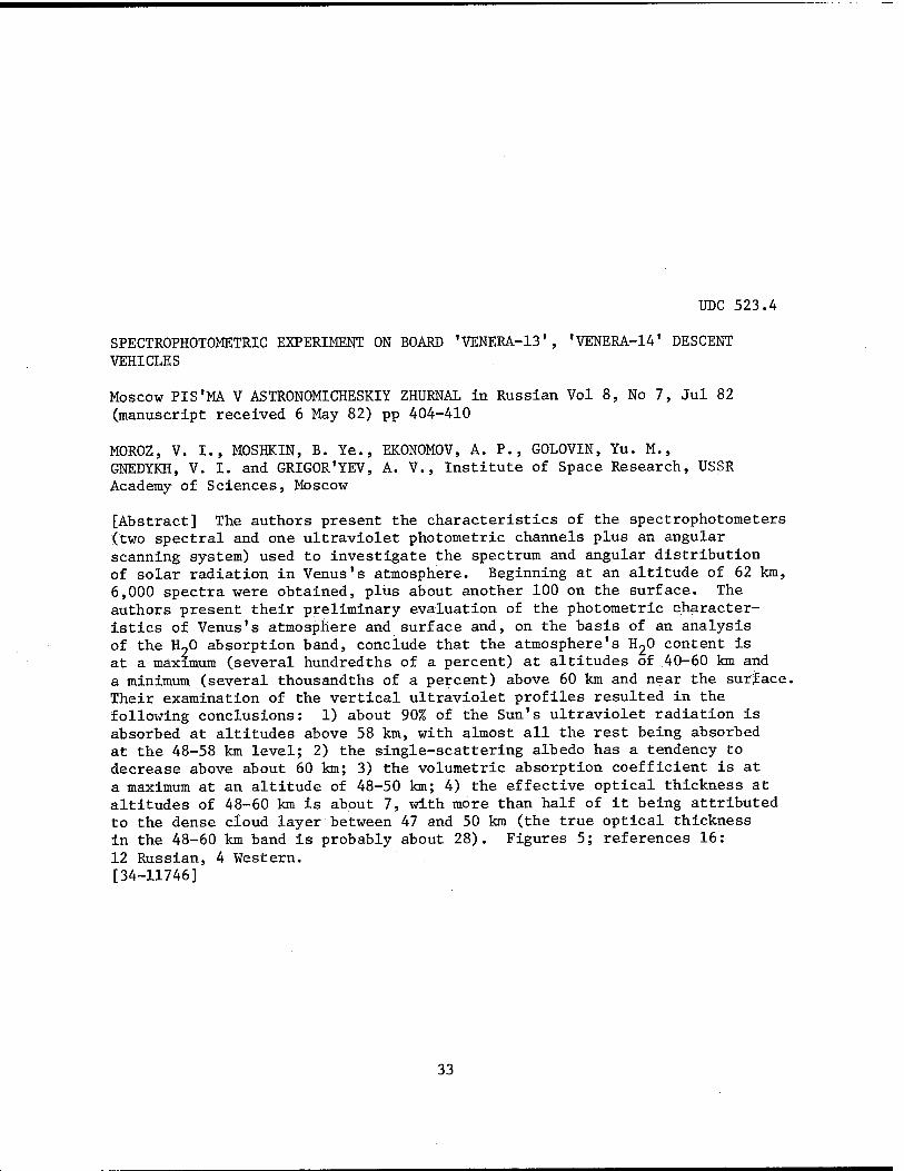
UDC 523.4
SPECTROPHOTOMETRIC EXPERIMENT ON BOARD 'VENERA-13', 'VENERA-14' DESCENT VEHICLES
Moscow PIS'MA V ASTRONOMICHESKIY ZHURNAL in Russian Vol 8, No 7, Jul 82 (manuscript received 6 May 82) pp 404-410
MOROZ, V. I., MOSHKIN, B. Ye., EKONOMOV, A. P., GOLOVIN, Yu. M., GNEDYKH, V. I. and GRIGOR'YEV, A. V., Institute of Space Research, USSR Academy of Sciences, Moscow
[Abstract] The authors present the characteristics of the spectrophotometers (two spectral and one ultraviolet photometric channels plus an angular scanning system) used to investigate the spectrum and angular distribution of solar radiation in Venus's atmosphere. Beginning at an altitude of 62 km, 6,000 spectra were obtained, plus about another 100 on the surface. The authors present their preliminary evaluation of the photometric character- istics of Venus's atmosphere and surface and, on the basis of an analysis of the H20 absorption band, conclude that the atmosphere's H^O content is at a maximum (several hundredths of a percent) at altitudes of 40-60 km and a minimum (several thousandths of a percent) above 60 km and near the surface. Their examination of the vertical ultraviolet profiles resulted in the following conclusions: 1) about 90% of the Sun's ultraviolet radiation is absorbed at altitudes above 58 km, with almost all the rest being absorbed at the 48-58 km level; 2) the single-scattering albedo has a tendency to decrease above about 60 km; 3) the volumetric absorption coefficient is at a maximum at an altitude of 48-50 km; 4) the effective optical thickness at altitudes of 48-60 km is about 7, with more than half of it being attributed to the dense cloud layer between 47 and 50 km (the true optical thickness in the 48-60 km band is probably about 28). Figures 5; references 16: 12 Russian, 4 Western. [34-11746]
33

UDC 523.4
MEASUREMENT OF WATER VAPOR CONTENT OF VENUS'S ATMOSPHERE BY 'VENERA.-13', 'VENERA-14* AUTOMATIC INTERPLANETARY STATIONS
Moscow PIS'MA V ASTRONOMICHESKIY ZHURNAL in Russian Vol 8, No 7, Jul 82 (manuscript received 6 May 82) pp 411-413
SURKOV, Yu. A., IVANOVA, V. F., PUDOV, A. N., PAVLENKO, V. A., DAVYDOV, N. A. and SHEYNIN, D. M., Institute of Geochemistry and Analytical Chemistry imeni V. I. Vernadskiy, USSR Academy of Sciences, Moscow; Scientific and Technical Association, USSR Academy of Sciences, Leningrad
[Abstract] VM-3R moisture analyzers were installed in the "Venera-13" and "Venera-14" descent modules in an attempt to refine previous evaluations of the water vapor content of Venus's atmosphere. The authors describe the instrument and its operating principle, then present the preliminary results of the experiment. The analyzers operated from an altitude of about 62 km down to about 46 km, with the main finding being that the water vapor content in the layer of atmosphere between altitudes of 46 and 50 km is 0.2+0.04 vol. %. Figures 1; references 7: 4 Russian, 3 Western. [34-11746]
UDC 523.4
EVALUATIONS OF WIND VELOCITY BASED ON DOPPLER MEASUREMENTS MADE BY 'VENERA-13,' 'VENERA-14' AUTOMATIC INTERPLANETARY STATIONS: FIRST RESULTS
Moscow PIS'MA V ASTRONOMICHESKIY ZHURNAL in Russian Vol 8, No 7, Jul 82 (manuscript received 11 May 82) pp 414-418
KERZHANOVICH, V. V., MAKAROV, Yu. F., M0L0T0V, Ye. P., SOROKIN, V. P., SUKHANOV, K. G., ANTSIBOR, N. M. , KUSTODIYEV, V. D., MATSYGORIN, I. A. and TIKHONOV, V. F.
[Abstract] By studying the Doppler shift of a radio signal from the descent module to the fly-by module (which was then transmitted to Earth), the authors attempt to obtain an altitudinal profile of the wind velocity in Venus's atmosphere. In a period of about 6.5 hours, 20,600 readings were obtained from the 2 descent modules, of which only those from the "Venera-13" have been partially processed, since the procedure used involves a large number of factors. The authors' main conclusions are: 1) there is wind moving toward the west at all altitudes; 2) the wind velocity is low in the lower troposphere and does not exceed 1-2 m/s at the surface; 3) the wind shift in the lower troposphere begins at an altitude of about 10 km; 4) the wind velocity in the main mass of the atmosphere is about 50 m/s; 5) there is atmospheric turbulence in the cloud layer at altitudes of 50-60 km. Figures 4; references 4: 3 Russian, 1 Western. [34-11746]
34
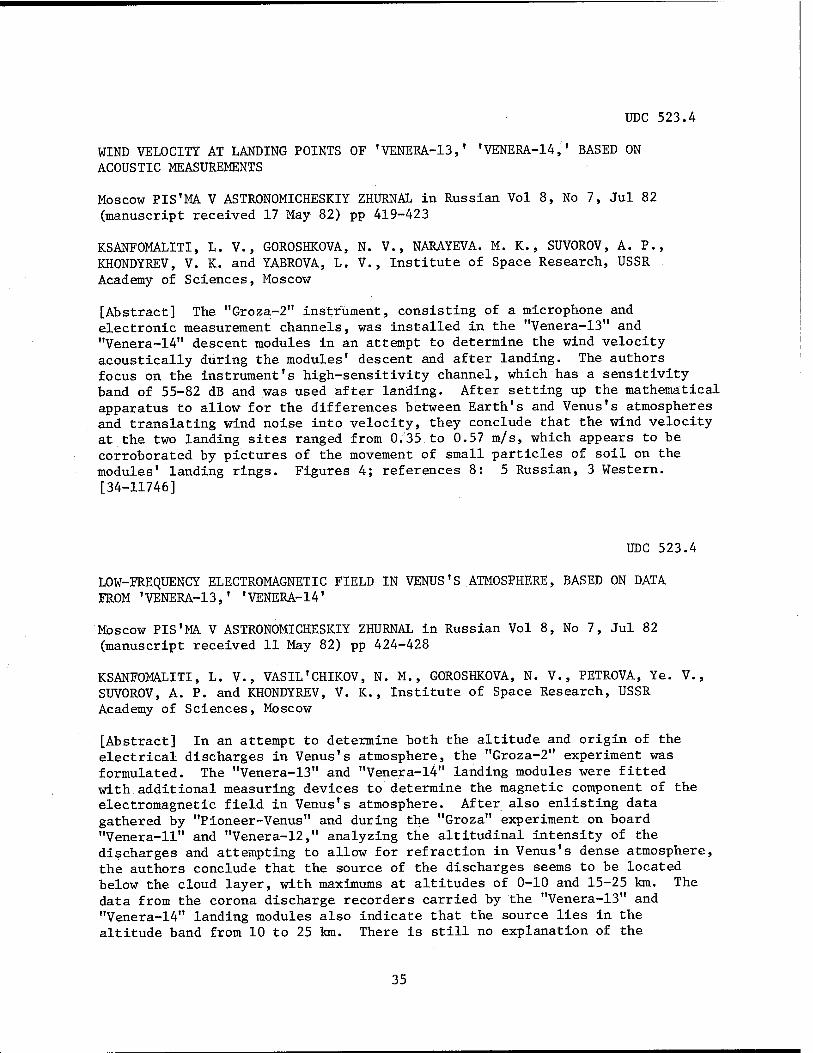
UDC 523.4
WIND VELOCITY AT LANDING POINTS OF 'VENERA-13,' 'VENERA-14,' BASED ON ACOUSTIC MEASUREMENTS
Moscow PIS'MA V ASTRONOMICHESKIY ZHURNAL in Russian Vol 8, No 7, Jul 82 (manuscript received 17 May 82) pp 419-423
KSANFOMALITI, L. V., GOROSHKOVA, N. V. , NARAYEVA. M. K., SUVOROV, A. P., KHONDYREV, V. K. and YABROVA, L. V., Institute of Space Research, USSR Academy of Sciences, Moscow
[Abstract] The "Groza-2" instrument, consisting of a microphone and electronic measurement channels, was installed in the "Venera-13" and "Venera-14" descent modules in an attempt to determine the wind velocity acoustically during the modules' descent and after landing. The authors focus on the instrument's high-sensitivity channel, which has a sensitivity band of 55-82 dB and was used after landing. After setting up the mathematical apparatus to allow for the differences between Earth's and Venus's atmospheres and translating wind noise into velocity, they conclude that the wind velocity at the two landing sites ranged from 0,35 to 0.57 m/s, which appears to be corroborated by pictures of the movement of small particles of soil on the modules' landing rings. Figures 4; references 8: 5 Russian, 3 Western. [34-11746]
UDC 523.4
LOW-FREQUENCY ELECTROMAGNETIC FIELD IN VENUS'S ATMOSPHERE, BASED ON DATA FROM 'VENERA-13,' 'VENERA-14'
Moscow PIS'MA. V ASTRONOMICHESKIY ZHURNAL in Russian Vol 8, No 7, Jul 82 (manuscript received 11 May 82) pp 424-428
KSANFOMALITI, L. V., VASIL'CHIKOV, N. M., GOROSHKOVA, N. V., PETROVA, Ye. V., SUVOROV, A. P. and KHONDYREV, V. K., Institute of Space Research, USSR Academy of Sciences, Moscow
[Abstract] In an attempt to determine both the altitude and origin of the electrical discharges in Venus's atmosphere, the "Groza-2" experiment was formulated. The "Venera-13" and "Venera-l4" landing modules were fitted with additional measuring devices to determine the magnetic component of the electromagnetic field in Venus's atmosphere. After also enlisting data gathered by "Pioneer-Venus" and during the "Groza" experiment on board "Venera-11" and "Venera-12," analyzing the altitudinal intensity of the discharges and attempting to allow for refraction in Venus's dense atmosphere, the authors conclude that the source of the discharges seems to be located below the cloud layer, with maximums at altitudes of 0-10 and 15-25 km. The data from the corona discharge recorders carried by the "Venera-13" and "Venera-14" landing modules also indicate that the source lies in the altitude band from 10 to 25 km. There is still no explanation of the
35

origin of these electrical discharges. Figures 4; references 9: 3 Russian, 6 Western. [34-11746]
UDC 523.4
ANALYSIS OF PANORAMAS OF 'VENERA-13,' fVENERA-14' LANDING SITES
Moscow PIS'MA V ASTRONOMICHESKIY ZHURNAL in Russian Vol 8, No 7, Jul 82 (manuscript received 6 May 82) pp 429-432
FLORENSKIY, K. P. (deceased), BAZILEVSKIY, A. T., KRYUCHKOV, V. P., KUZ'MIN, R. 0., NIKOLAYEVA, 0. V., PRONIN, A. A., CHERNAYA, I. M., SELIVANOV, A. S., NARAYEVA, M. K. and TYUFLIN, Yu. S., Institute of Geochemistry and Analytical Chemistry imeni V. I. Vernadskiy, USSR Academy of Sciences, Moscow; State Scientific Research Institute for the Study of Natural Resources, Moscow; Central Scientific Research Institute of Geodesy, Aerial Photography and Cartography, Moscow
[Abstract] The authors' preliminary analysis of the landing site panoramas photographed by the pair of cameras carried by the "Venera-13" landing module leads them to conclude that the module landed on a sloping, undulating plain, the surface of which is covered with horizontally layered rocks, with the depressions in the microrelief between them being filled with a thin layer of loose soil. The "Venera-14" landing module landed in a somewhat flatter location and very few indications of soil can be seen in the panoramas; however, the horizontal layering of the rocks is the same. Soil samples subjected to X-ray fluorescence analysis revealed that the "Venera-13" landed in an area where rock is close in composition to alkaline basalt, whereas for "Venera-14" the rock resembles tholeiitic basalt. Using additional data from "Venera-9" and "Venera-10," the authors formulate the hypothesis that the rock in all four landing areas was formed by sedi- mentation of fine particles of volcanic origin. Figures 4; references 5. [34-11746]
UDC 523.4
DYNAMICS OF IMAGES TRANSMITTED FROM 'VENERA-13' STATION
Moscow PIS'MA V ASTRONOMICHESKIY ZHURNAL in Russian Vol 8, No 7, Jul 82 (manuscript received 17 May 82) pp 433-436
SELIVANOV, A. S., GEKTIN, Yu. M., NARAYEVA, M. K., PANFILOV, A. S. and FOKIN, A. B.
[Abstract] The authors present a very brief description of the sequences of photographs (11 surface panoramas covering a 170° angle and 10 fragments
36

covering a 60° angle) taken during the 127 minutes of the "Venera-13" landing module's operation. There was possibly a change in the landing module's position 50 minutes after it began operating, which might make it possible to obtain stereoscopic images, but this remains to be determined. There was some movement of loose soil (probably caused by the wind) from the landing module's platform onto Venus's surface and, possibly, from the surface to the platform. The changing contrasts of the module's parts in the sequence of pictures is probably the result of the movement of cloud formations. Figures 4; references 4. [34-11746]
UDC 523.4
PRELIMINARY RESULTS OF DETERMINATION OF ELEMENT COMPOSITION OF ROCKS ON VENUS BY 'VENERA-13,' 'VENERA-14' AUTOMATIC INTERPLANETARY STATIONS
Moscow PIS'MA V ASTRONOMICHESKIY ZHURNAL in Russian Vol 8, No 7, Jul 82 (manuscript received 6 May 82) pp 437-443
SURKOV, Yu. A., MOSKALEVA, L. P., SHCHEGLOV, 0. P., KHARYUKOVA, V. P., MANVELYAN, 0. S. and SMIRNOV, G. G., Institute of Geochemistry and Analytical Chemistry imeni V. I. Vernadskiy, USSR Academy of Sciences, Moscow
[Abstract] The "Venera-13" and "Venera-14" descent vehicles' landing sites were chosen so as to be as representative as possible of the planet as a whole: a hilly upland and a low-flying flat area, respectively, the two of which are typical of more than 80 % of Venus's surface. The authors describe in detail the X-ray fluorescence spectrometer carried by the two descent vehicles, as well as its operating principle and measurement technique. The result of the analysis were as follows, for "Venera-13" and "Venera-14," respectively (in weight percents) : MgO—11.+6.2, 8.1+3.3; AloO,—15.8+3.0, 17.9+2.6; Si02—45.1+3.0, 48.7+3.6; K20—4.0+0.63, 0.2+0.07; CaO--7.1+0.96, 10.3+1.2; Ti02—1.59+0.45, 1.25+0.41; MnO—0.2+0.1, 0.16+0.08; FeO—9.3+2.2, 8.8+1.8. Figures 6; references 4: 3 Russian, 1 Western. [34-1174"6]
37

UDC 523.4
MICROSEISMS AT 'VENERA-13,' 'VENERA-14' LANDING SITES
Moscow PIS'MA. V ASTRONOMICHESKIY ZHURNAL in Russian Vol 8, No 7, Jul 82 (manuscript received 11 May 82) pp 444-447
KSANFOMALITI, L. V., ZUBKOVA, V. M., MOROZOV, N. A. and PETROVA, Ye. V., Institute of Space Research, USSR Academy of Sciences, Moscow
[Abstract] The "Venera-13" and "Venera-14" landing modules both carried uniaxial seismometers of the high-frequency type (with a resonance of about 26 Hz) that, because of the way they were mounted, could measure only the vertical component of ground displacement. The instruments had low- and high-sensitivity channels (15*10-6 and 0.5*10-6 cm, respectively), but the authors discuss only the results obtained with the high-sensitivity channel. Readings were taken in 8 s "cuts" separated by alternating intervals of 200 and 392 s. No microseisms were registered by the "Venera-13" seismometer. "Venera-14" registered two events: 1) a vertical impulse with an amplitude of slightly more than 80"10-6 cm that occurred no later than 950 s after landing; 2) the second, with amplitude of less than 80-10-6 cm, between 1,361 and 1,417 s after landing. The authors rule out wind, the operation of the module Itself and impacts from wind-carried particles as the cause of these shocks. Figures 2; references 3: 2 Russian, 1 Western. [34-11746]
UDC 523.42
PANORAMAS OF 'VENERA-13,' 'VENERA-14' LANDING SITES (PRELIMINARY ANALYSIS)
Moscow ASTRONOMICHESKIY VESTNIK in Russian Vol 16, No 3, Jul-Sep 82 (manuscript received 15 Apr 82) pp 131-138
FLORENSKIY, K. P. (deceased), BAZILEVSKIY, A. T. and SELIVANOV, A. S., Institute of Geochemistry and Analytical Chemistry imeni V. I. Vernadskiy, USSR Academy of Sciences; State Scientific Research Institute for the Study of Natural Resources
[Abstract] The authors present the preliminary results of analysis of two almost circular pairs of panoramas photographed by pairs of cameras on the "Venera-13" (1 mar 82, 7°30' S. Lat., 303° Long.) and "Venera-14" (5 Mar 82, 13°15' S. Lat., 310°9' Long.) landing vehicles. After listing the visible reference points (parts of the landing vehicle) in order to give scale, they present a minutely detailed description of the Venusian surface features that can be seen. In their analysis they make the following points: 1) the fine horizontal stratification of the rocks (as seen previously at the "Venera-9" and "Venera-10" landing sites) now appears to be caused by sedimentation of fine-grained matter from volcanoes; 2) the rocks are being worn away, but the products of that wear are being removed by some process. Figures 4; references 14: 9 Russian, 5 Western. [33-117 6]
38

UDC 523.42
INVESTIGATION OF VENUS BY 'VENERA-13,' 'VENERA-14' AUTOMATIC INTERPLANETARY STATIONS: FIRST DATA ON ROCK COMPOSITION
Moscow ASTRONOMICHESKIY VESTNIK in Russian Vol 16, No 3, Jul-Sep 82 (manuscript received 11 May 82) pp 139-152
SURKOV, Yu. A., SHCHEGLOV, 0. P., MOSKALEVA, L. P., KHARYUKOVA, V. P., MANVELYAN, 0. S., KIRICHENKO, V. S. and DUDIN, A. D., Institute of Geo- chemistry and Analytical Chemistry imeni V. I. Vernadskiy
[Abstract] The authors discuss what is known about Venus's soil, then describe in detail the X-ray fluorescence spectrometer used to study the soil samples gathered by the ground-sampling devices carried by the "Venera-13" and "Venera-14" landing vehicles, as well as the spectrometer's measurement technique and calibration method. The rock analyzed by "Venera-13" is close in composition to the potassium alkaline basalt of the Earth's crust, with those analyzed at both landing sites being magmatic rocks of the basaltoid series. Figures 14; references 14: 8 Russian, 6 Western. [33-11746]
UDC 523.33:523.42
NOCTURNAL GLOW AT 5577 A AND ELECTRON FLOWS IN NOCTURNAL ATMOSPHERE OF VENUS
Moscow KOSMICHESKIYE ISSLEDOVANIYA in Russian Vol 20, No 5, Sep-Oct 82 (manuscript received 25 Feb 82) pp 742-747
KRASN0P0L'SKIY, V. A.
[Abstract] The author uses new data to update his 1979 article on the nocturnal ionosphere of Venus. He recalculates the intensity of the glow on the 5577 Ä line, with emphasis on the excitation of 0(1S) because of electron impact and recombination of ol. He then discusses the role of electron flows in maintaining the nocturnal ionosphere and tries to reconcile the considerable discrepancies in the experimental data that have been ob- tained and the results derived from them. The author concludes that: 1) the data on the nocturnal atmosphere at the ionospheric maximum agree with the presence of a magnetic field with an inclination of no more than 18°; 2) the evaluation of ionization by electrons and its role in maintaining the nocturnal atmosphere depends essentially on the assumptions made about the nature of the spectrum of electrons with energy levels above 50 eV; 3) the electron flow figures obtained by direct measurement and by radio transillumination agree only for a magnetic field with an inclination of no more than 5°. Figures 1; references 22: 6 Russian, 16 Western. [16-11746]
39

UDC 523.4
NEW DATA ON AEROSOL OF VENUSIAN CLOUD LAYER (PRELIMINARY RESULTS OF INVESTIGATIONS CARRIED OUT WITH 'VENERA-14' SPACE PROBE)
Moscow PIS'MA V ASTRONOMICHESKIY ZHURNAL in Russian Vol 8, No 11, Nov 82 (manuscript received 7 Jul 82) pp 700-704
SURKOV, Yu. A., KIRNOZOV, F. F., GLAZOV, V. N., DUNCHENKO, A. G. and ATRASHKEVICH, V. V., Institute of Geochemistry and Analytical Chemistry imeni V. I. Vernadskiy, USSR Academy of Sciences, Moscow
[Abstract] The Venusian cloud cover was further investigated by the "Venera-14," which made a descent into the planetary atmosphere in March 1982. The probe carried instrumentation for analyzing the elemental composition of aerosol and determining the density and vertical structure of the cloud layer. The elemental composition was determined by the X-ray radiometric method. The vertical structure of the cloud layer was determined from the density of the flux of fluorescent emission of aerosol registered during descent. The aerosol analyzer consisted of two parts: detection block and electronics block. Figure 2 is a diagram of the latter, with 7 components identified. The electronics block is a multichannel analyzer of pulse amplitudes; this amplitude analyzer has 256 channels, the capacity of each being 2^6 pulses. The analyzer memory is divided into two parts with 128 channels each. The instrument has the following parameters: weight 10 kg; detection block dimensions 478 x 225 x 145 mm; electronics block dimensions 216 x 142 x 128 mm; energy range of registered emission 1.1-8 KeV. The instrument underwent laboratory calibration using sulfur and chlorine. The instrument was activated at an altitude of about 63 km above the Venusian surface, collecting and analyzing aerosol for 9 minutes, and was then cut out. These data revealed that in the altitude range 63-47 km the principal aerosol components are compounds containing sulfur and chlorine. The Venusian cloud cover is stratified, the greatest aerosol concentration being at altitudes from 47 to 56 km. The total density of cloud aerosol at altitudes from 53 to 47 km is about 4 mg/m3. Figures 3, tables 1; references 3: 2 Russian, 1 Western. [60-5303]
UDC 523.43:521.14
SOME RESULTS OF STUDY OF GRAVITATIONAL FIELD, SHAPE AND INTERNAL STRUCTURE OF MARS
Moscow ASTRONOMICHESKIY VESTNIK in Russian Vol 16, No 3, Jul-Sep 82 (manuscript received 24 Mar 81) pp 166-173
MESHCHERYAKOV, G. A. and TSERKLEVICH, A. L., Lvov Polytechnic Institute imeni Leninskiy Komsomol
[Abstract] The authors consider the 1979 Christensen-Balmino model of Mars's gravitational field to be the best one yet developed. Correlating
40

what has been learned about Mars's shape, they conclude that it is a triaxial ellipsoid that is primarily isostatic equilibrium, although in certain regions that were tectonically active in the past, isostasy is disrupted. In addition, the greatest undulations in the areoid are caused primarily by density irregularities in the manfile. As far as Mars's internal structure density leads them to conclude that the mantle is of an olivine composition and that the core consists of a eutectic mixture of Fe and FeS. Figures 4; references 25: 19 Russian, 6 Western. [33-11746]
UDC 629.765:523.46
ORIGIN OF SATURN'S RINGS AND NATURE OF CASSINI DIVISION
Moscow KOSMICHESKIYE ISSLEDOVANIYA in Russian Vol 20, No 5, Sep-Oct 82 (manuscript received 12 Apr 82) pp 748-759
DAVYDOV, V. D.
[Abstract] The author formulates a general hypothesis that covers both the origin of Saturn's rings and the reason for the width of the Cassini division, then examines each of the subjects in detail, bringing in any additional information that appears to shed light on the subject. For the rings, he postulates the existence of a satellite (Ix) that, as the result of evolution of Saturn'"s internal structure that led to enlargement of its zone of apsidal resonance, was drawn down into the tidal destruction zone, after which it broke up and became the primary component of the A and B rings, with some finer particles being swept out into the C ring because of radiation braking. As far as the Cassini division is concerned, the author concludes that it is the result of a decrease in Saturn's moments of inertia after the formation of the rings and the movement of its zone of resonance with Iapetus in the direction of the planet. Figures 1; references 29: 7 Russian, 22 Western. [16-11746]
UDC 536.421:523.53
DISTRIBUTION OF SIZES OF PARTICLES FORMED DURING MODELING OF ABLATION OF METEORITIC MATTER
Moscow ASTRONOMICHESKIY VESTNIK in Russian Vol 16, No 3, Jul-Sep 82 (manuscript received 22 May 81; after revision 4 Mar 82) pp 174-181
ZELENIN, V. N., KONSTANTINOV, I. Ye., MIKHEYENKO, S. G. and SALIMOV, 0. N., Moscow Engineering Physics Institute
[Abstract] The authors describe a series of experiments involving electric- arc heating of iron, basalt and ceramic test pieces in order to determine the
41

spectrum of sizes of particles formed by a process of the vaporization- condensation type when a meteor encounters the atmosphere. They describe the electric-arc plasmotron and the experimental conditions. After analyzing the results of the experiments, they conclude that the mass distribution of the sizes of the particles is governed by a logarithmically normal distribution law. Figures 3; references 14. [33-11746]
42

SPACE ENGINEERING
BEREGOVOY ON FUTURE CONSTRUCTION IN SPACE
Moscow STROITEL'NAYA GAZETA in Russian 29 Dec 82 p 4
[Interview with USSR Pilot-Cosmonaut Georgiy Timofeyevich Beregovoy, twice Hero of the Soviet Union, by V. Skuratnik; date and place not given: "Cities in Space"]
[Text] [Question] Although this conversation has barely begun, I now realize that in order to look 40 years into the future and see cities in orbit, we should first look at little more than 60 years into the past.
The year is 1920. Eduard Konstantinovich Tsiolkovskiy's book "Beyond the Earth"-has been published in Kaluga. It is set in the 21st Century: on 1 January 2017, a spaceship takes off from Earth. Its crew consists of 20 men, 4 of whom are scien- tists, the rest being "masters of the specialties most important for the flight." They investigate near space, then invite the people of Earth to conquer that area, build "settlements in the ether," and populate them.
A few years later, in 2022—the period of interest to us—those who responded to this summons "were already living a family life, thoroughly and truly."
[Answer] You know what? Since more than half of the 100 years covered by that great scientist's prophecy have passed, let's reread his story and compare his dreams with today's reality. It seems to me that this would be a good basis for our own predictions. And so...
[Question] "When I wandered in the emptiness surrounding the rocket, I was really astonished...by the amount of fruitlessly wasted solar energy...Who is preventing people from building greenhouses and palaces there and living in clover?" These are the words of the story's hero, who was the first man to walk in open space. And the first thing that the travelers set up on board their ship was a greenhouse...
[Answer] In connection with this I recall an episode that caused some amusement at the Flight Control Center. The "Photons," V. Kovalenok and A. Ivanchenkov, were working in the "Salyut-6." Earth called A. Ivanchenkov one day: "'Photon-2,1 a bi- ologist wants to talk to you." He didn't answer. V. Kovalenok explained the si- lence of his comrade by saying, "'Photon-2' went for a walk in the mushrooms."
Later on this successful joke was heard quite frequently in space. At the same time, however, it contained a large amount of truth. The fact of the matter was that a mushroom plantation had been set up on board and a cosmonaut had to exercise
43

the function of monitoring, as the expression goes, the course of the experiment. Projects for growing various plants in space have been carried out practically con- tinuously by all the expeditions that have replaced each other on board the "Salyut" stations.
Under the guidance of scientists, the cosmonauts are solving the same problems about which Tsiolkovskiy wrote: supplying the inhabitants of future orbital cities and members of extended space expeditions with food and oxygen. However, there is also another aspect to these experiments: the emotional side, I guess you would call it. Man does not conceive of himself outside of his earthly environment. So, the plants to which we have become accustomed in orbit are. more or less a thread connecting us to our home planet.
I remember how upset V. Lyakhov was when a tulip sent from Earth not only did not blossom in space, as the scientists had assumed it would, but died the day after it arrived at the orbital station. "Judging by everything, no one can live in space!" he spat out in a fit of temper after he had returned to Earth. "Aside from cosmo- nauts, of course," smilingly added V. Ryumin, his comrade on the expedition. "It means that we have to fly so that people other than cosmonauts can live there." And as to how happy Svetlana Savitskaya was with the bouquet grown on board the "Salyut-7" that was given to her by V. Berezovoy and V.- Lebedev, our long-term dwell- ers in space, only she can tell you.
[Question] So, orbital greenhouses—or more accurately, their prototypes—actually exist. Cosmonauts have already breathed oxygen generated by Chlorella on board the station...
But what about the "amount of fruitlessly wasted solar energy" about which Tsiolkovskiy's hero spoke?
[Answer] Orbital stations are equipped with solar batteries. All the energy needed for extended life support on board the "Salyut" stations is provided by our own day- time star.
[Question] But this, as you know, is considerably less than a drop in an ocean...
[Answer] Yes, it is. That is why there already exist plants for orbital solar electric power stations that in the future will be able to supply our home planet with energy. Considering the limited nature of Earth's fuel reserves and the danger involved in polluting the environment by thermal electric power stations, this prob- lem is becoming more and more urgent.
[Question] What will a solar electric power station in a stationary near-Earth or- bit be like? How large will it be and how much power is it supposed to generate?
[Answer] It will consist of devices for collecting solar energy and, consequently, facilities for orienting them. Then there will be converters to transform the solar energy into electricity and the electricity into radiation in the microwave band, which is convenient for transmission to Earth over a radio channel, with the help of a high-directional antenna. The station's capacity must be in the millions of kilo- watts; otherwise, as they say, there's no need to mess around with it. According to the estimates of the specialists, its weight, unfortunately—given the existing
44

technology and the materials now available—is extremely impressive: on the order of a hundred thousand tons, and the diameter of the transmitting antenna is about a kilometer.
[Question] Nevertheless, its construction is practicable?
[Answer] Practicable, yes, but in all likelihood not before the year 2000. The next generation of transport ships will most likely be used to deliver it into or- bit, because the cost of delivering each kilogram of construction material for the future orbital solar electric power station must be reduced by a factor of 10-20 in comparison with what we can now provide. Once in orbit, by the time it is ready to start functioning there must be production and residential complexes where people can live and relax, as well as assembly buildings and specialized plants...
[Question] "Rockets...they flew from Earth by the thousands... at first they carried only scientists, technicians, engineers and experts: people in perfect health who were young and energetic—builders all." That's from Tsiolkovskiy's book.
[Answer] I remember. I think that, in actuality, the first profession to be seen in space in large numbers will be that of the builder. It's no accident that the equipment for cosmonauts now includes a set of excellent special tools created by VNIISMI (Ail-Union Scientific Research Institute of Construction Tools and Finishing Machines]. Also noteworthy is the fact that the creators of these tools include not only professional builders (workers in the VNIISMI department headed by M. Gel'fand), but also the tester 0. Tsygankov.
[Question] In addition to everything else, are the cosmonauts already quite well acquainted with assembly operations?
[Answer] Yes. I was fortunate enough to begin with those who have been called the pioneers in the practical conquest of space, and as both a cosmonaut and the head of the Cosmonaut Training Center imeni Yu.A. Gagarin I am quite familiar with all the stages we have gone through, from "Vostok-1" to "Salyut-7," from the 108-minute flight around the planet to the 211-day working trip in orbit. And I can say this: today many assembly, disassembly and repair operations are an integral part of a cosmonaut's professional training.
[Question] Judging by how the cosmonauts who have to live and work in them describe them, today's orbital stations are extremely comfortable. Nevertheless, Cosmonaut A. Serebrov called the "Salyut" the first tent peg in the vast expanses of virgin space. How, then, can there be a city there?
[Answer] Have you had occasion to visit Komsomol'sk-na-Amure? If so, you certainly saw the granite tent that is a monument to the first builders of that legendary city of youth. So compare this tent (not of granite, of course) with the modern blocks of multistoried buildings. What we have achieved injspace is only the prolog to our future great deeds.
[Question] "The builders joined several greenhouses, in the form of a star and oth- er figures and caused them to revolve slowly..." That is how Tsiolkovskiy presented the orbital cities' buildings. And how do they look to you?
45

[Answer] I cannot talk about anything but my own work. But I am certain that cit- ies in orbit are a future reality. As for what they will be like, I assume that our architects are already thinking about that.
11746 CSO: 1866/69
46

REMOTE CONTROL OF ON-BOARD SATELLITE SYSTEMS
Moscow AVIATSIYA I KOSMONAVTIKA in Russian No 6, Jun 82 pp 44-45
[Article by V. Olimpov and G. Irinin, candidates of technical sciences: "Control-
ling Satellites"]
[Text] When we talk about controlling spacecraft, the main thing we normally have in mind is dynamic operations: injection of a "Salyut" orbital station into assem- bly orbit, rendezvousing and docking, the descent of a transport ship. However, there is another, no less important, aspect of this question, which is control of the operation of on-board systems: turning equipment on and off, maintaining the required working conditions for instruments and assemblies. It is this latter as pect that is decisive for satellite communications, navigation and the study of the Earth's environment and natural resources.
As a rule, a command from the Flight Control Center (TsUP) passes over a communica- tion link to a measuring point, from which direct control of a satellite is exer- cised. Each radio command station has a command output console, a program timing unit, information encoding equipment, a radio transmitter and an antenna.
The principles of space radio communications were discussed in the article "Space Antennas" (AVIATSIYA I KOSMONAVTIKA, No 3, 1982). Let us recall here that they are stable only within the limits of direct visibility. This means that satellites in low, near-Earth orbits, where radio visibility is limited to just a few minutes, are quite difficult-and in some cases impossible—to control. How, for example, do we control the operation of a meteorological satellite's equipment with commands when the satellite is over the world ocean, where there are no measurement points, but where such control is vitally necessary? This is why program control is used m conjunction with commands.
A program is a set of words, each of which consists of a command and a time that de- termines the moment of its execution. There are both rigid and flexible programs. The former is usually placed in .an on-board program timing unit when a satellite is being prepared for launching. The radio link is used for the transmission of only a single command, which starts the running of the program. This control method is the simplest and most reliable one. However, a rigid program cannot react to a change in the situation and cannot be corrected after the satellite is launched. A rigid program can be compared to a record player, where the melody cannot be changed with- out changing the record. "Changing the melody" on board a satellite with rigid pro- gram control is even more complicated, since the satellite cannot return to Earth so the change can be made.
47
The use of a flexible program to control a satellite is a better method, since the program can be changed either partially or completely during a radio communication session. Here, also, we have an analogy similar to the one presented above. A flexible program is comparable to a recording on magnetic tape, which can be changed either partially or completely, as one wishes, without removing the tape from the recorder-player. In a flexible program, the commands and the time of their execu- tion can be calculated during the satellite's flight and entered in the on-board program timing unit via a radio link. In this case, naturally, there is an increase in the complexity of the program timing unit (PVU) and a lowering of its reliabili- ty, but extensive possibilities for controlling on-board systems are realized and the efficiency of the utilization of space equipment is improved.
The program timing units used in space technology are quite variegated. They can be mechanical, electrical, or electronic. The first two are used for the realization of rigid programs, whereas the last one, which is more accurate and compact, is used for flexible programs. The simplest electrical PVU consists of a clock and a fre- quency splitter. The clock can be (for example) a crystal pulse generator and the frequency splitter can be a counter (or a splitter of the frequency of the pulses being generated).
The operating principle of such a device is as follows. The frequency generator is generating pulses constantly, but they can enter the counter only after the radio command "Start program" is received on board. At this moment the electrical circuit connecting the clock to the command distributor is closed. Then, depending on the program that has been set up, at the required moments the distributor issues the command signals to the satellite's on-board systems. As is well known, during flight it is possible for a satellite to deviate from its calculated path. In con- nection with this, the command distributor is provided with a capability for chang- ing (within small limits) the pulse counter's splitting factor. Its value is given by the radio command "Program correction." Depending on the need for changing the time of the beginning of operation of one on-board system or another, there can be several such commands.
A more complex PVU is needed in order to realize a flexible program. Before dis- cussing its operation, however, let us examine the basic principles of information transmission and reception. Commands received from the TsUP at a measurement point are transmitted to a satellite in the form of a code, which is a set of possible signals or, as they are frequently called, code combinations. For example, having designated frequencies F-^ F2 and F3 by the digits 0, 1 and 2, we obtain code combi- nations with from one to N elements. Of course, this matchup is established ahead of time and entered in the circuits of the on-board and ground encoding and decoding units. But how many code combinations and commands corresponding to them can be ob- tained in the example presented above? Let us mention here that the set of elemen- tary signals used to construct them is called the code's alphabet (base). In our case there are three frequencies. Consequently, the code base is three. The analo- gy with the idea of the standard alphabet is not accidental. The elements of the code combinations are the letters and the combinations themselves are the words. The analogy can be extended even further. Just as normal words consist of letters, so do code combinations have the meaning of a code. In our case, single-letter words are obtained when only one code character is used, and their number equals the base (0, 1, 2). For a two-part code (n = 2) using a second code character, we now have nine commands (m2). Continuing this reasoning, we arrive at the answer to the question that was asked: this code contains N = mn commands.
48

Diagram of electronic PVU: 1. radio command "Record program"; 2. program words; 3. radio command "Start program"; 4. command part of word; 5. temporal part of word; 6. on-board clock time mark; 7. command codes for on-board systems I-V; 8. command signals for on-board systems I-V. Key: 1. Register 3. On-board clock
2. Memory 4. Command distributor
The elements forming the code alphabet can be differentiated not only by frequency, but also by phase and amplitude. In this respect a "radio alphabet" gives us some- what greater opportunities than a standard one. In real radio links, binary codes are the ones most widely used. The primary reason for this is that controlling the flights of satellites would be unthinkable without the use of computer technology, and it—as is well known—utilizes binary codes. Therefore, for radio control in a system consisting of a computer, a command source and a link for command transmis- sion, it is obvious most convenient to use a single code. Besides this, during the transmission of commands it is usually necessary to use different counters, frequen- cy splitters and memories, which are possible to realize most simply if a binary code is used.
How does an on-board electronic program timing unit work? Everything begins with the arrival of the command "Record program." The reception, recording and storage of the information are accompanied by certain measures to preserve the reliability of the program being received. The recording is completed by the single command "Start program," which causes the memory to change over immediately into the program execution mode: the code combination containing the first (in time of execution) command and its time code is sent into the register. Here, the current time and the temporal part of the word stored in it are compared. At the moment when they coin- cide, the command part of the word is sent into the command distributor, the next word is sent into the register from the memory, and the process is repeated. Com- mand codes and second-marking pulses entering the distributor tune it so that the signals needed to control the on-board systems are generated at its output. This can be (for example) a binary sequential or parallel code or voltage for closing the contacts of a relay.
49

The principles of program control, as used in program timing units, are not the pri- vate property of space technology. They are used extensively in the national econo- my. Cosmonautics has absorbed and will continue to absorb the technical experience of allied areas of technology. In turn, many solutions that were first approved and used in space technology have become the property of other branches of the national economy.
COPYRIGHT: "Aviatsiya i kosmonavtika", 1982.
11746 CSO: 1866/107
50

UDC 531.38
EFFECT OF ATMOSPHERIC RESISTANCE ON UNIAXIAL GRAVITATIONAL ORIENTATION OF ARTIFICIAL SATELLITE
Moscow KOSMICHESKIYE ISSLEDOVANIYA in Russian Vol 20, No 5, Sep-Oct 82 (manuscript received 17 Sep 81) pp 659-673
SARYCHEV, V. A. and SAZONOV, V. V.
[Abstract] The authors use the small-parameter method to construct a formal, two-dimensional, integral surface of the equations of motion of a space station that describes it's slow oscillations and rotation around its long axis, which is pointed approximately along the local vertical. After setting up the equations of motion, using two right Cartesian systems of coordinates, they construct the integral surface of the slow motions by two different methods, then study the perturbed motion that results from a station's not having any special damping devices. Figures 11; references 5. [16-11746]
UDC 629.195
OSCILLATIONS OF SATELLITE WITH COMPENSATING DEVICES IN ELLIPTICAL ORBIT
Moscow KOSMICHESKIYE ISSLEDOVANIYA in Russian Vol 20, No 5, Sep-Oct 82 (manuscript received 18 Jun 81) pp 674-681
POLYANSKAYA, I. P.
[Abstract] The author proposes a method for compensating for eccentric oscillations of a satellite in an elliptical orbit by using a) the kinetic moment of an active flywheel and b) variable moments of inertia, for which the satellite is designed in the form of a basic body with two protruding rods. After deriving the satellite's equations of motion in a right orthogonal system of coordinates into those in the plane of the orbit and three-dimensional ones. Using different equations of motion for the second case, she finds the area of stability of the satellite's equilibrium position. Figures 6; references 6: 5 Russian, 1 Western. [16-11746]
51
UDC 629.193.3
MATCHED OPTIMUM FILTERS FOR PLOTTING LOCAL VERTICAL
Moscow KOSMICHESKIYE ISSLEDOVANIYA in Russian Vol 20, No 5, Sep-Oct 82 (manuscript received 20 Jan 81) pp 682-689
DOLININ, N. A.
[Abstract] The author discusses the questions of synthesizing a matched filter and a filter with an optimum weight characteristic that are to be used to build a local vertical plotting device. The filters he synthesizes localize the main maximum of a signal and evaluate the angular position of the center of the Earth efficiently and are also simpler than those now in existence, but are no less accurate. Figures 3; references 5. [16-11746]
UDC 550.370
EVALUATION OF ERROR IN MEASURING STRENGTH OF PERMANENT ELECTRICAL FIELD BY LANGMUIR DOUBLE-PROBE METHOD
Moscow KOSMICHESKIYE ISSLEDOVANIYA in Russian Vol 20, No 5, Sep-Oct 82 (manuscript received 16 Mar 81) pp 690-699
KOREPANOV, V. Ye.
[Abstract] The author attempts to make a unified metrological approach to the analysis of the error in the measurement of quasistatic electrical fields in space plasma by the Langmuir double-probe method, for the purpose of developing recommendations for minimizing the error or allowing for its separate components correctly. He constructs an equivalent circuit that takes into consideration all the significant variables, then analyzes the importance of errors in measuring them In the final result. He finds that the most important components of the overall measurement error are photo- electric current and induction electromotive force, and that minimization of the former and better accuracy in computing the latter can result in absolute measurement accuracy that approaches 2-3 mV/m in the best case. Figures 3; references 16: 3 Russian, 13 Western. [16-11746]
52

SPACE APPLICATIONS
DYNAMICS OF OCEAN AND ATMOSPHERE ON BASIS OF OBSERVATIONS FROM 'SALYUT-6'
Moscow ZEMLYA I VSELENNAYA in Russian No 1, Jan-Feb 83 pp 41-45
[Article by B.A. Nelepo, academician, Ukrainian SSR Academy of Sciences, V.V. Kovalenok, USSR pilot-cosmonaut, G.K. Korotayev, doctor of physical and mathematical sciences, and G.A. Grishin, candidate of physical and mathematical sciences]
[Text] The "Salyut-6" station functioned excellently in orbit for al- most 5 years. The most variegated scientific and applied research was performed in it. In particular, there were studies of the processes taking place in the ocean and the atmosphere and their effect on weather and climate, which were complex and important assignments for
applied cosmonautics.
Among the urgent problems of modern physical oceanography and meteorology, special places are occupied by the problems of the spatial and temporal variability of oceanic and atmospheric circulation and the long-term prediction of the Earth's weather and fluctuations in its climate. However, in order to understand and util- ize in the national economy the numerous relationships that have been built up be- tween the ocean and the atmosphere, it is necessary to measure a large number of hydrometeorological parameters, such as the water temperature in the depths and on the surface of the ocean, the distribution of air temperature and humidity, sea cur- rent and wind speeds and cloud cover. This can be done only with the help of satel- lites, which make it possible to obtain complete information about the entire sur-
face of the Earth in the shortest possible amount of time.
Great value is attached to the observations of the ocean in the visible and near-^ infrared bands of the spectrum that have been and are being made from the "Salyut" manned orbital stations, the "Meteor" automatic meteorological satellites and the specialized "Cosmos" and "Intercosmos" satellites. Test ranges equipped with sta- tionary and mobile facilities for taking measurements, as well as the ground infor- mation reception and processing network, are also parts of the space system for
studying Earth's natural resources.
Among the various methods for investigating the ocean, photographing and surveying the sea surface with scanning complexes have come into widespread use. The MKF-6M space camera and the KATE-140 topographic camera, which were standard scientific equipment on the "Salyut-6" manned orbital station, are the primary instruments used for photographic surveying in the automatic mode. Multiband scanning devices (MSU) are used to observe the Earth's surface from automatic artificial Earth satellites.
53

Fragment of photographic survey of the South Atlantic in the area of the Falkland (Malvina) Islands.
When photography is used, an optical image of an object is registered directly on black-and-white or color film, and when scanning is used an image is formed, stored and transmitted to Earth with the help of opticoelectronic systems of the television
type.
Synoptic Vortices in the Ocean
The variability of vortices in the ocean needs to be studied in order to determine the forms of energy exchange between oceanic vortices and atmospheric processes of synoptic scales; in connection with this, special emphasis is given to heat exchange between them. This is important for the development of theoretical models of the large-scale interaction of the ocean with the atmosphere, since—according to modern scientific ideas—when the transfer of heat by vortex structures in the Atlantic Ocean is taken into consideration, it is possible to find a 30-40 percent change in the evaluation of the total balance of the meridional flow of heat to the north, which, in the end, determines the weather and climate for a significant portion of
Europe.
In many space photographs of the sea surface, color contrasts can be used to detect quite distinctly large-scale vortices of the frontal type (formed in the area of in- tensive jet flows). One of the first series of space photographs of vortex forma- tions 50-100 km in diameter was taken by G.M. Grechko in the area of the Falkland
(Malvina) Islands.
54

Formation of vortex at confluence of warm Gulf Stream (dark tone) and cold Labrador Current (light tone) in the area of Flemish Cap Bank.
This region is interesting for the fact that a branch of the West Winds Current, which deviates to the north after passing Cape Horn and flows around the extensive Burdwood Bank and the islands, moves far to the north, where it encounters the water masses of the Brazil Current. The interface of these currents, which is clearly distinguishable from great altitudes, can frequently be traced for a distance of about 1,000 km. On the basis of observations made from the "Skylab" orbital station in December 1974, the frontal zone between the Brazil and Falkland Currents was fol- lowed visually, in the form of a thin, serpentine band, for more than 3,500 km with- out a break at any point. However, a series of photographs taken from "Salyut-6" in 1978 showed the instability of the system of currents as a whole and the formation of a series of large-scale vortices.
On the preceding page we present a fragment of a space survey of the ocean area to the southeast of the Falkland (Malvina) Islands. The path of the East Falkland Cur- rent, which for all practical purposes repeats the isoline of the bottom topography, is quite visible. In the center of the photograph, an almost completely formed large-scale cyclonic vortex can be seen. The vortices are about 50 km across and the distance between them is almost 200 km.
55

The formation of an oceanic vortex and a hydrological front at the confluence of one of the branches of the Gulf Stream (the dark tone in the photograph) with the cold Labrador Current at Flemish Cap Bank near Newfoundland is notable in the next photo- graph. According to data from satellite observations, most vortices of this type in this region form inside a narrow band of latitudes in the region between 35° and 39° North Latitude and 60° and 70° West Longitude. They drift primarily to the west and the period of their existence ranges from 6 months to 2-3 years, although some esti- mates give them a lifetime of up to 5 years, after which some of them again merge with the Gulf Stream, whereas others disintegrate completely into small-scale ir- regularities.
It is necessary to emphasize that we have not yet made so many measurements that it is possible to distinguish with confidence those regions of the world ocean where there is increased vortex activity. For example, only three or four such regions are known to exist in the North Atlantic: those ocean sections adjacent to the northwestern tip of Africa and the Azores Islands; the Gulf Stream area; the region of the equatorial and trade currents. At the same time, individual large-scale vor- tices of frontal origin have been observed along the coast of Southwest Africa, in the regions of the Somali and Brazil Currents, in the equatorial areas of the Pacific and Indian Oceans and in the Arctic Ocean and the Mediterranean Sea. How- ever, there are still no statistically reliable data on the distribution of vortices in these regions of the world ocean, the special features of their thermal and dy- namic conditions and the conditions of their cyclogenesis. There are only episodic estimates of the amount of heat transferred in the meridional direction by them. It is not clear how vortices affect atmospheric processes (or vice versa), although in- dividual visual observations from the "Salyut-6" confirm the existence of relation- ships between vortex fields in the ocean and cyclones in the atmosphere. Many sci- entists think that their interaction largely determines the nature of the overall atmospheric circulation, which plays an important role in the formation of the Earth's weather and climate.
Large-Scale Atmospheric Phenomena
In investigations of weather and climate, a key role is given to the study of thermohydrodynamic processes in the tropical zone of the ocean. This region is a gigantic accumulator of thermal energy. For example, up to 50 percent of the vapor formed from sea water enters the atmosphere between 30° North and 30° South Lati- tude. On the other hand, a large part of the energy is released in the equatorial zone through the condensation of water vapor. In connection with this, gigantic cumulonimbus clouds form, reaching altitudes of 10-15 km. This narrow band of dense cloudiness girdles almost the entire globe above the oceans and is quite visible in satellite photographs and television pictures.
The tropical zone of the ocean also serves as a cell for the generation of cyclones, which under favorable (but as yet little studied) conditions can develop into power- ful hurricanes and typhoons. The typical size of a medium-scale tropical cyclone is 1,000 km and it has a forward motion of 10-50 km/h, depending on the region in which it forms.
From the "Salyut-6" station cosmonauts repeatedly observed the development of tropi- cal cyclones and typhoons, which have a substantial effect on the thermal structure of the ocean's upper layer. Receiving the thermal energy accumulated in the water
56

Atmospheric instability in the form of "cat's eyes."
layer, they leave behind themselves a heavily cooled track in the surface layer. The horizontal dimension of such a track is measured in hundreds of kilometers and the cooling penetrates to a depth of 100-150 m, with the temperature gradient in comparison with unperturbed waters reaching 5-6°C. A hurricane's track can be pre- served and followed, on the basis of the decreased temperature in the surface layer, for up to 10 days.
Weather anomalies, as is well known, owe their existence to a large degree to in- stability of the atmospheric circulation. In this connection, the photograph above,
57

which was taken above the Atlantic from on board the "Salyut-6" station, calls at- tention to itself. The development of a special type of instability first described by W. Thomson (Kelvin), in 1880, can be seen in this photograph. Thomson showed that the field of the flow lines changes substantially at some altitude where the wind's velocity equals the velocity of the wave perturbations. In this area the mo- tion is of a unique type. Such a field is called a system of "cat's eyes." In 1968 it was demonstrated experimentally that instability of this type also exists under the water's surface, but is extremely difficult to observe in nature. Most works devoted to this problem are concerned with either only the mathematical aspects of the theory or numerical analysis of hypothetical models. From this viewpoint, the photograph of one of the regions of the Atlantic about which we spoke can be called unique.
In many cases, the characteristic structure of cloud formations observed from arti- ficial Earth satellites can serve as an indicator of anomalous behavior of the ocean surface's temperature. According to calculations made by Academician G.I. Marchuk, those regions of the ocean with anomalous water temperatures that exert the greatest effect on climate include the zones of formation of such powerful and intense cur- rents as the Gulf Stream in the Atlantic and the Kurosio Current in the Pacific Ocean, the polar sections of the ocean, and those areas of the ocean where the rise of deep waters to the surface is seen.
Therefore, the bands of cloudiness that are 100-1,000 km wide and stretch from the Antarctic and Arctic toward the equator in an almost meridional direction are of in- terest. (They were observed particularly well from the "Salyut-6.") According to calculations of the total radiation, on the surface of the North Atlantic (on the basis of data gathered by the "Cosmos-1151" artificial earth satellite) it is possi- ble to distinguish a wave-shaped structure of radiation flows that, in principle, can be related to the large-scale periodic structure of the cloud fields. The phys- ical nature of their existence is not yet clear, but it is obvious that they can have a substantial effect on weather formation over the continents, including the European part of the USSR. Thus, visual observations of cloudiness from an orbital station make it possible to interpret more accurately the data from remote measure- ments of atmospheric parameters in order to make better weather forecasts.
Internal Tfaves
An important area for the investigation of ocean dynamics from space is the study of internal waves, which form in the depths of the sea on the interface between lay- ers of relatively light and heavy water. This is analogous to how surface waves form at the atmosphere-ocean interface.
The great interest in observations of internal waves from space is caused primari- ly by the possibility of determining the spatial spectrum of internal wave action and its temporal variability. In addition, there are grounds for assuming that in waters with relatively high transparency in the upper quasihomogeneous layers, ob- servations of internal waves in the visible band are possible not only on the ba- sis of their surface manifestations, but also by the contrasts in brightness of the layer of reduced transparency; that is, at depths of tens of meters in the open ocean.
In the fall of 1978, the scientific research ship "Akademik Vernadskiy" conducted an experiment to the northwest of England. Success was achieved in distinguishing
58

oscillations of the water layers with daily and inertial (about 17 hours) periods. On the average, the amplitude of the short-period internal waves' oscillations was 15-20 m. At the same time, at a depth of about 400 m the full scope of the oscilla- tions was 200-250 m.
It is interesting that despite the large amplitudes in the depths of the ocean, in- ternal, waves manifest themselves on the ocean's surface only under certain condi- tions. When internal waves break through to the surface they are easily identi- fied as dark and light bands of smooth and ripple-covered water moving along the surface at a speed of 10-100 cm/s. One of the possible explanations for this inter- esting phenomenon is that during the horizontal movement of internal waves surface-active substances are concentrated in the troughs, damping the short-period waves, thus forming the bands of smooth water called "slicks." The presence of slicks on the ocean's surface results in local changes in the coefficient of bright- ness of the outgoing radiative emissions registered by remote sensors. An analysis of aerospace pictures of the sea's surface shows that the width of bands of slicks can reach hundreds of meters and that they can be tens of kilometers long.
If we again look at the photograph of the region of the Falkland (Mälvinas) Islands, we can see that in the coastal part of East Falkland Island there are short-period wavelike disturbances, which have been identified with manifestations of internal waves on the surface in the form of a striated periodic structure. They are 1-2 km long and moving horizontally at a speed of about 30 cm/s. The period of these waves corresponds most closely to an internal tide in this area, from which it is possi- ble to conclude that the waves being investigated arise from where the edge of the island shelf disperses the energy of the tide, with the waves continuing to move to- ward the shore.
The interesting nature of internal wave action can be seen in the space photograph of the Black Sea basin in the area of the Crimean Peninsula that is presented on the next page. The length of the wave disturbances in the narrow sector on the sea side of Cape Sarych changes from 0.5 km in the shallow water area to 1.5 km in the deep water. Their speed in the coastal zone is 40 cm/s, which corresponds to the data of direct measurements made beneath the satellite.
A detailed examination of the peculiarities of the circulation of the surface waters in this region shows that the internal waves observed in the photograph were gen- erated at an abrupt depth gradient in the vicinity of Cape Sarych. These waves propagate toward the open sea and their length increases gradually.
Let us mention here that, on the basis of cosmonaut observations from manned orbital stations and the results of measurements made by automatic Earth satellites, the structure characteristic of a field of internal waves has been seen repeatedly, both on continental shelves and in the open ocean. Thus, on the basis of the re- sults of satellite observations of the sea's surface, even at the present time it is possible to evaluate the speed, direct of propagation and length of internal waves. The particular value of these observations is that from the known parameters of internal waves/from space it is possible to determine the thermal reserve of the ocean's upper homogeneous layer, which is the most important characteristic of the thermal balance of the ocean-atmosphere system.
Nevertheless, why is it still important to investigate synoptic vortices and in- ternal waves from space? The fact of the matter is that both types of oceanic
59
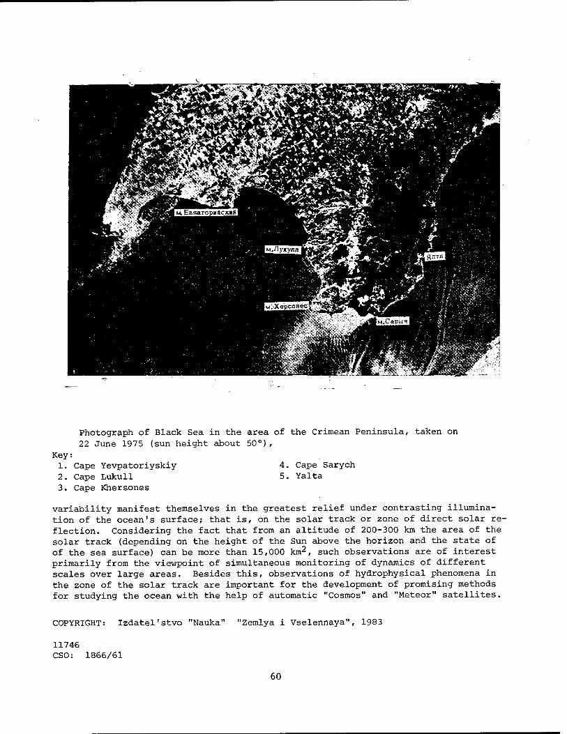
Photograph of Black Sea in the area of the Crimean Peninsula, taken on 22 June 1975 (sun height about 50°),
Key: 1. Cape Yevpatoriyskiy 4. Cape Sarych 2. Cape Lukull 5. Yalta 3. Cape Khersones
variability manifest themselves in the greatest relief under contrasting illumina- tion of the ocean's surface; that is, on the solar track or zone of direct solar re- flection. Considering the fact that from an altitude of 200-300 km the area of the solar track (depending on the height of the Sun above the horizon and the state of of the sea surface) can be more than 15,000 km2, such observations are of interest primarily from the viewpoint of simultaneous monitoring of dynamics of different scales over large areas. Besides this, observations of hydrophysical phenomena in the zone of the solar track are important for the development of promising methods for studying the ocean with the help of automatic "Cosmos" and "Meteor" satellites.
COPYRIGHT: Izdatel'stvo "Nauka" "Zemlya i Vselennaya", 1983
11746 CSO: 1866/61
60

FURTHER DEVELOPMENT OF 'KOSPAS-SARSAT' SYSTEM
Moscow IZVESTIYA in Russian 1 Apr 83 p 3
[Article by scientific reviewer B. Konovalov: "Space Helps Seamen"]
[Text] Three rescue satellites above the planet. Coastal station providing satellite communication with seagoing vessels being readied for operation near Odessa. Inter- national space cooperation saves human lives.
The shipwreck was stunningly unexciting. A small cone-shaped emergency buoy sat "in state" on an ordinary office chair beside a happily gurgling spring stream. A cable extended from the buoy to one of the windows of a yellow single-story cottage. Every 50 seconds invisible radio waves carried a desperate appeal into the sky: "SOS Shipwreck Shipwreck " And not far away the roar of rushing traffic made known the presence of one of the busiest thoroughfares of Moscow-'-Profsoyuznaya Street, which merges with the ring road half a kilometer from here to communicate with the Kaluga Highway.
"What's the matter, don't you think it resembles a shipwreck?" my thoughts were deduced by engineer Eduard Aliyevich Goncharov. "Of course, this is only a laboratory simulation. We're now testing different types of sea and airplane buoys. In case of an accident they are supposed to transmit a disaster signal to satellites of the 'Kospas-Sarsat' system, which was developed through the joint efforts of the USSR, the USA, France and Canada. Kospas is the Soviet part of the system. The name means: rSpace system for searching for ships (and airplanes) in distress.' Sarsat, meanwhile, is the acronym for the foreign part of the project, 'search and rescue by satellite detection.' Last year and at the beginning of this year, all four countries participating the inter- national project perfected the system using the Soviet satellite ' Cosmos-1383. ' Another of our satellites, 'Cosmos-1447,' was added to the system on 24 March. And on 28 March the first American satellite was placed into orbit. In about a month it should be ready to support the work of all participants of the project. A large number of Soviet and foreign control buoys are now being used in the system's debugging phase« We also have our own stationary and mobile buoys. As an example we are tracking buoys being carried by the ships 'Professor Vize' now near Antarctica and 'Admiral Vladimirskiy' performing an Antarctic circumnavigation."
61

The satellite was somewhere over two and a half thousand kilometers from Moscow when a small parabolic antenna elevated by a metallic girder over the meadows of Teplyy Stan picked up its signals. Both of our rescue satellites are moving in an almost circular orbit with an average distance of about a thousand kilometers from earth. The tilt of the orbit is 83°, such that the satellite could also receive disaster signals from polar regions. Che orbit lasts 105minutes, during the which the satellite collects data on the entire globe, subjects them to preliminary processing and then transmits them to ground data reception stations belonging to the countries participating in the project, both in real time and from a memory. Our Moscow station is completely fitted out with Soviet equipment, and it can receive information from satellites within a zone having a radius of two and a half thousand kilometers. Immediately after com- pletion of a communication session, a computer processes the information trans- mitted by the satellite and prints out, on a wide tape, data from all buoys that had sent a distress signal. With time, all ships and airplanes of our planet are to be outfitted with emergency buoys. Figuratively speaking, every buoy is to have its own first, middle and last name. A digital code contained in its signal informs us of the country of ownership, the port of registry and the the name of the ship or the identification number of the airplane. If the crew has enough time during an emergency, it can introduce data on the nature of the emergency, and the radio waves will carry information on what had happened: a fire, a collision, a shipwreck or a ship run aground. If time is lacking, the buoy is simply jettisoned into the water by the pressing of a button on the bridge (or it is tossed overboard by hand), and on surfacing, it begins transmitting a signal from the location of the accident. The station that receives the information from the satellite pro- cesses the distress signal and communicates the data by a direct line to the Main Computer Center of the USSR Ministry of Maritime Fleet. There, the coordinates of the disaster site are determined and transmitted to search and rescue services.
Once long ago, at the present location of the Moscow rescue satellite infor- mation reception station, the Papanin expedition prepared for an entire year for its legendary voyage on drifting ice. They lived here in Teplyy Stan in winter in a tent. All that remains from the times of those trials is a small log cabin, a monument to the place of origin of a great work. With time, we can be sure that the present satellite communications station will become a museum as well. But for the moment it is a functioning station. The principles of the space rescue service, which is to have enormous significance, are being developed here. Each year, after all, about 350 vessels perish in the World Ocean in our times, according to "Lloyd's Register." Many are even unable to transmit a distress signal, and are lost without a trace. This is why a satellite rescue system is being created. In our country, the Moscow data reception station will be joined by one in Arkhangelsk in May. A station in Vladivostok is to become operational at the end of the year. There are plans for creating yet another one in Novosibirsk, so that all of Soviet territory would be covered by zones of direct radio visibility.
Real assistance has already been provided in many cases to airplanes and vessels suffering disaster during the debugging of the system using the "Cosmos- 1383" satellite. Sixteen human lives have been saved. The rescue satellites
62

operate at two frequencies—121.5 megahertz, at which data is gathered from airplane buoys (there are now about 200,000 of them), and 406.1 megahertz, allocated to sea buoys. Tests of the buoys at the 121.5 megahertz frequency showed that a satellite can determine the coordinates of a disaster site with an accuracy fully acceptable to existing search and rescue services. At the 406.1 megahertz frequency the location of a disaster site can be determined with an accuracy of 2-3 kilometers. But there are various regions of the globe where radio interference blocks out emergency signals transmitted at this frequency. The experiments are now being widened. England and Norway are now in the process of joining the international "Kospas-Sarsat" system, and Bulgaria and Japan are making preparations to join the effort.
In fall of last year I was given the opportunity to interview Professor Zhan- Klod Yusson [transliteration], director of the Toulouse Space Center. He was extremely pleased with the work of the Soviet rescue satellite.
"Cooperation in space is extremely important in this area," said Professor Yusson. "We have all saved a great deal of time and money by creating an international system with coordinated technical parameters right away. As a consequence the efforts of different countries have meshed well together. Unification of efforts in the use of space is in the interests of all people on earth, and we are pleased that effective, business-like cooperation has now been established between the East and the .West."
The demonstration and evaluation phase of the "Kospas-Sarsat" satellite system should be concluded in 1983, at which time the most effective emergency buoys will be selected for mass production. And apparently the satellite rescue system will then be operated within the framework of the International Organization of Marine Satellite Communication—INMARSAT.
"This organization unites 38 states," said Yuriy Sergeyevich Atserov, chief of the All-Union "Morsvyaz'sputnik" Association of the USSR Ministry of Maritime Fleet. "The countries in INMARSAT possess 85 percent of the world's shipping tonnage. The satellite rescue system could become an organic part of this international organization, in the work of which our association takes an active part as a representative of the USSR."
A station supporting communication with seagoing:' vessels via satellites be- longing to INMARSAT has now been created on the shore of the Khadzhibeyevskiy Estuary, 20 kilometers from Odessa. The apparatus of this station is presently undergoing official transfer to representatives of this international organi- zation prior to the initiation of its commercial operation. One of the 13-meter parabolic antennas of the Odessa station will be aimed at the satellite Marex A, located over the equatorial zone of the Atlantic Ocean at 26° West Longitude. The dish of the second antenna will watch the satellite Intelsat V hovering over the Indian Ocean at 63° East Longitude. Two-way telephone, telegraph, phototelegraph and telex ship-to-shore communication will be supported by these satellites. The Odessa station is connected to Soviet and international land communication lines. It will go into operation in May.
A second station having a similar purpose is now under construction in Nakhodka. It is to become operational next year. One of its antennas will be aimed at a
63

satellite located above the Pacific Ocean at 177.5° East Longitude. The second will work with a satellite over the Indian Ocean, overlapping the communication zone of the Odessa station. This will insure worldwide communi- cation for all of our country's large vessels. Soviet industry is to provide these vessels with the "Volna S" apparatus, which includes an antenna with a 1.2 meter diameter intended for satellite communication. In the future a small and cheaper apparatus will be developed for small vessels, primarily of the fishing fleet. Satellites will become dependable helpers of seamen at any point on the World Ocean.
"The main motive of my life is to do something useful for people, to live my life with a purpose, to cause mankind to progress at least a little," wrote Konstantin Eduardovich Tsiolkovskiy. Today many of the "seeds" sown by the father of cosmonautics are producing an extremely rich harvest. Each year the sphere of application of space technology is widening, and its significance to people and to development of civilization on our planet is becoming in- creasingly more tangible.
11004 CSO: 1866/106
64

UDC 528.71:518
TECHNIQUE FOR QUANTITATIVE PROCESSING OF RESULTS OF INTERPRETATION OF SPACE PHOTOGRAPHS FOR SOLUTION OF GEOLOGICAL PROSPECTING PROBLEMS
Moscow ISSLEDOVANIYE ZEMLI IZ KOSMOSA in Russian No 5, Sep-Oct 82 (manuscript received 26 Feb 82) pp 12-19
SHEREMET, 0. G., MORALEV, V. M., PERFIL'YEV, Yu. S. and REYTLINGER, A. S., Institute of the Lithosphere, USSR Academy of Sciences, Moscow, and "Aerogeologiya" Geological Production Association, Moscow
[Abstract] The authors propose a technique for interpreting space photo- graphs for geological purposes that goes beyond the standard compilation of lineament and ring structure maps, with its final goal being the effective prediction of areas where ore deposits of the endogenous type can be found. The realization of the technique involves the solution of four interrelated problems: 1) formalizing the structural lines and standard objects of ore manifestations; 2) selecting the optimum size of the averaging surveyor's table for the extraction of initial information from space photographs; 3) searching for informative features and interpreting them geologically; 4) predicting and checking the numerical solutions. The authors discuss the solution of each of these problems in detail, then apply the technique to a section of the Okhotsk-Chukotsk volcanic belt with good results. Figures 5;
references 4. [26-11746]
UDC 681.3:528.72
ACCURACY OF COMPONENT ANALYSIS DURING SPACE INVESTIGATIONS OF ENVIRONMENT
Moscow ISSLEDOVANIYE ZEMLI IZ KOSMOSA in Russian No 5, Sep-Oct 82 (manuscript received 4 Nov 81) pp 23-28
SERAPINAS, B. B., Geography Department, Moscow State University imeni M. V. Lomonosov
[Abstract] The author attempts to apply component analysis to the problem of interpreting multiband aerospace information on natural resources,
65

thereby limiting the number of factors that must be taken into consideration when classifying objects. Using photographs of plowed fields and cotton fields, he sets up a correlation matrix and works toward the goal of finding two main components so that the classification of an area can be reduced to a two-dimensional map. He finds that this can be done if the error in the^ determination of the brightness characteristics is no more than about 2.5 % and concludes that his apparatus can be used to determine the required accuracy in the original data when component analysis is to be used. Figures 1; references 4. [26-11746]
UDC 574.9:654.949
REMOTE MEASUREMENT OF PHYTOMASS
Moscow ISSLEDOVANIYE ZEMLI IZ KOSMOSA in Russian No 5, Sep-Oct 82 (manuscript received 1 Dec 81) pp 36-45
VINOGRADOV, B. V., Leningrad Branch, Institute of Oceanology imeni P.P. Shirshov, USSR Academy of Sciences, and Institute of Evolutional Morphology and Ecology of Animals imeni A. N. Severtsov, Moscow
[Abstract] The author finds that an exponential approach is the best founda- tion for functions that best describe the relationship between optical and phytocenometric characteristics when making remote measurements of phytomass using simple indicators. More complex methods involve mathematical relation- ships among the following indicators: coefficient of brightness in the red and near-infrared bands of the spectrum and coefficients of soil and vege- tation brightness in the same bands. The author discusses these relation- ships in detail and concludes that a satisfactory determination of green phytomass can be made when the mass's density is below 300 g/m2, a moderately accurate determination for densities between 300 and 500 g/m2, and a poor one for masses greater than 600 g/m2. In addition, the calibrating equation relating the coefficient of spectral brightness and the phytomass must be formulated for the different types of soil and vegetation, atmospheric condi- tions and spectral intervals involved. Figures 3; references 23: 10 Russian, 13 Western. [26-11746]
66
UDC 551.5:629.78
IDENTIFICATION OF FOREST FIRE SPREADING RATES FROM INFRARED PHOTOGRAPHS
Moscow ISSLEDOVANIYE ZEMLI IZ KOSMOSA in Russian No 5, Sep-Oct 82 (manuscript received 29 Oct 81) pp 46-53
VALENDIK, E. N., DORRER, G. A., KALININA, N. A., SUKHININ, A. I. and KHREBTOV, B. A., Institute of Forestry and Wood imeni V. N. Sukachev, Siberian Department, USSR Academy of Sciences, Krasnoyarsk, and Siberian Technological Institute, Krasnoyarsk
[Abstract] The authors1 technique is based on a geometric model of a forest fire's shape that utilizes the concept of the indicatrix of the normal spreading rate. Assuming that an infrared photograph of a fire, taken from an airplane or artificial Earth satellite, has been converted into digital form, the technique makes it possible to determine the value of the greatest rate of spread of a fire, the angle determining the wind direction at a given moment and the indicatrix of the normal rate of spread. The authors discuss the data needed for proper application of the technique, as well as the problems involved in correlating a photograph geographically and give an example of the technique's utilization. Figures 4; references 6. [26-11746]
UDC 551.46.0:629.78
POSSIBILITY OF DETERMINING MOISTURE CONTENT OF UPPER LAYERS OF ATMOSPHERE BY RADIOMETRIC METHOD
Moscow ISSLEDOVANIYE ZEMLI IZ KOSMOSA in Russian No 5, Sep-Oct 82 (manuscript received 26 Jan 82) pp 54-58
GAYKOVICH, K. P. and KITAY, Sh. D., Scientific Research Institute of Radiophysics, Gorkiy
[Abstract] Since the moisture content of the stratosphere is an unanswered question, the authors formulate a method for determining it with the help of space measurements of thermal radio-frequency emissions, since ground measurements cannot be used satisfactorily (the much larger contribution of the lower layers must be subtracted, which is extremely difficult if not im- possible). The recommended frequencies are 22.23508 and 183.31009 GHz, which are resonances of the frequency for the microwave absorption of water. The authors conclude that their method can be used with existing equipment to determine the altitudinal distribution of water vapor in the stratosphere up to the mesosphere. Figures 3; references 10: 5 Russian, 5 Western. [26-11746]
67

UDC (528.27+550.389):629.78
INTERPRETATION OF GRAVIMETRIC AND MAGNETIC ANOMALIES ON BASIS OF INTERPRETATION OF SPACE PHOTOGRAPHS
Moscow ISSLEDOVANIYE ZEMLI IZ KOSMOSA in Russian No 5, Sep-Oct 82 (manuscript received 8 Jun 81) pp 59-71
ISAYEV, Ye. N. and ISAYEVA, I. V., "Zarubezhgeologiya" Association, Moscow
[Abstract] The authors explain how space photographs can be used in conjunction with geological and geophysical data to identify gravimetric and magnetic anomalies that would otherwise be difficult to detect. Using the Red Sea Hills on the north-eastern coast of Africa as an example, they explain the procedures that must be used in the step-by-step integration and interpretation of the available data. One new feature of the combination of space and ground materials is that by constructing horizontal cross-sections of anomalies, it is possible to determine their vertical orientation. The authors conclude that their method can be used to study both regional structures and individual objects. Figures 8; references 10. [26-11746]
UDC 631.4:629.78
POSSIBILITY OF DETECTING HUMUS IN SOILS FROM SPECTRAL MEASUREMENT DATA
Moscow ISSLEDOVANIYE ZEMLI IZ KOSMOSA in Russian No 5, Sep-Oct 82 (manuscript received 9 Feb 82) pp 72-79
FEDCHENKO, P. P., All-Union Scientific Research Institute of Agricultural Meteorology, Obninsk
[Abstract] Based on the fact that there is a reliable correlation between soil's spectral reflectivity and its humus content, the author develops a method to take the utilization of optical techniques to determine humus content beyond the laboratory research stage. Analyzing what has been done in this field, he concludes that no single wavelength can be used to determine humus content accurately, but that the entire curve of soil's spectral reflectivity in the visible band should be used, with subsequent normalization of the data obtained on the spectral composition of the incident radiation. After setting up the mathematical apparatus to accomplish this, he then presents and compares the results of laboratory, ground and airborne experiments performed to confirm the validity of his hypothesis. The work culminated in the compilation of a humus content map for the Ukraine and Moldavia. Figures 4; references 18. [26-11746]
68

UDC 528.7:681.3
DIGITAL PROCESSING METHOD FOR OUTLINE-TYPE VIDEO INFORMATION
Moscow ISSLEDOVANIYE ZEMLI IZ KOSMOSA in Russian No 5, Sep-Oct 82 (manuscript received 9 Feb 82) pp 87-95
EL'MAN, R. I., "Lesproyekt" Ail-Union Aerial Photography Forest Organization Association, Moscow
[Abstract] The author constructs an algorithm (KONTUROKHOD) for the digital processing of outline-type video images. After pointing out the general features of outline-type images that must be handled, defining the necessary concepts and discussing the basis of the method used (which he calls "digital sensing"), he gives a detailed description of the functioning of the algorithm. He then presents a second algorithm (GRYZUN) that is a simpler version of KONTUROKHOD and presents an example utilizing both of them. Figures 5. [26-11746]
UDC 629.783:778.39
OPERATIONAL PLANNING OF PROCESS OF SURVEYING EARTH'S SURFACE WITH AUTOMATIC ARTIFICIAL EARTH SATELLITES
Moscow ISSLEDOVANIYE ZEMLI IZ KOSMOSA in Russian No 5, Sep-Oct 82 (manuscript received 16 Dec 81) pp 104-109
MALYSHEV, V. V. and MOISEYEV, D. V.
[Abstract] Since cloud cover and illumination are the most important factors in planning the efficient use of observation satellites and the former can only be predicted a few hours in advance, planning for survey- ing work should be done on a timely basis. After listing the various elements (surveying instruments, the on-board computer's memory capacity, transmitting equipment capabilities and so on) that must be taken into consideration, the authors set up the mathematical apparatus that enables planning to be done quickly, using the amount of useful information collected as the criterion of a satellite's operational efficiency. They also give a brief hypothetical example of the application of their method. Figures 1; references 5. [26-11746]
69

UDC 528.91:625.11
POSSIBILITIES FOR USING SPACE SURVEYING MATERIALS IN TRANSPORT CONSTRUCTION
Moscow ISSLEDOVANIYE ZEMLI IZ KOSMOSA in Russian No 5, Sep-Oct 82
(manuscript received 16 Nov 81) pp 116-118
KOSMIN, V. V. and KOZLOV, A. M., All-Union Scientific Research Institute
of Transport Construction, Moscow
[Abstract] The authors advocate the use of space surveying materials in planning transportation network construction because they enable large areas to be studied synchronously and at different times of the year, thereby shortening the duration of the planning process. Areas in which such materials can be useful include planning sites for bridges and tunnels and^ temporary and permanent settlements, laying out railway lines, and evaluating the ecological situation in an area and the changes in it caused by construction work. References 1. [26-11746]
UDC: 550.814.1:551.24:553.98
SPACE PHOTOGRAPH INTERPRETATION OF DEEP PLATFORM STRUCTURES PROMISING FOR
OIL AND GAS
Moscow SOVETSKAYA GEOLOGIYA in Russian No 12, Dec 82 pp 116-121
LASTOCHKIN, A. N., Ail-Union Scientific Research Institute of Geological
Prospecting
[Abstract] Space photographs contain summary information on many components of the geographic crust. Generally, the age and developmental specifics of dislocations determine the heredity of recent movements. Technically active structures are traced throughout the entire sedimentary cover. In the geology of open platform areas, the upper structural stage is most easily seen in space photographs. The lithologic-genetic differences in quaternary deposits are distributed according to terrestrial surface forms. Though buried, geomorphologically obscure dislocations can be seen in space photographs. They thus contain information on neotectonic movements and morphostructure necessary but insufficient for prediction of deep structures beneath the relief. The desired photographic information on neotectonically inactive structures in the sedimentary cover bypasses the relief-forming components and processes and is reflected directly in the photographic tone on space photographs resulting in platform plains primarily from the moisture content of rock protruding to the surface and the soil and plant cover. Both in- herited and autonomous neotectonic movements determine the delivery of fluids to the surface, which may be reflected in background changes in tone corre- sponding to desired features. Space photographs thus act as X-rays through
70

the surface relief reflecting the deeper structures. This principle can be utilized in practice by determining photographic anomalies which do not agree with the isohypses and orohydrographic lines, by comparing photo- graphic and topographic materials in the same scale. Anomalies can be mostly seen by superimposing topographic maps and photometric maps produced by measuring optical densities on space photographs with microdensitometers. Figures 1; references 14 (Russian). [93-6508]
UDC: 553.982.061.33
PROSPECTS FOR USING AIR AND SPACE RESEARCH IN DNEPR-DONETS DEPRESSION
Kiev DOKLADY AKADEMII NAUK UKRAINSKOY SSR, SERIYA B: GEOLOGICHESKIYE, KHIMICHESKIYE I BIOLOGICHESKIYE NAUKI in Russian No 5, May 82 (manuscript received 11 Feb 82) pp 24-27
PORFIR'YEV, V. B., deceased, GRIDIN, V. I., ZHILOVSKIY, N. I., KLOCHKO, V. P. and KRAYUSHKIN, V. A., Institute of Geologic Sciences, Ukrainian SSR Academy of Sciences
[Abstract] A history of the development of the oil and gas industry in the Dnepr-Donets depression is presented. Air and space geologic investigations are reported to be effective in revealing local and regional fractures. Areas of particular interest in the depression are noted and a map is presented. Interpretation of air and space photographs makes the location of local and regional faults limiting large blocks and individual stages of the basement relatively easy. The results of remote studies can there- fore be successfully used in selecting areas for planned drilling for oil and gas in the crystalline basement. It is noted that other works have presented the theoretical basis for structural interpretation of air and space photographs for oil and gas prospecting purposes. Figure 1; references 6 (Russian). [90-6508]
UDC 528.77
GEODYNAMIC APPROACH TO INTERPRETATION OF SPACE PHOTOGRAPHS IN SOLVING PROBLEMS IN PETROLEUM-GAS GEOLOGY
Moscow GEOLOGIYA NEFTI I GAZA in Russian No 6, Jun 82 (manuscript received 5 Oct 81) pp 39-42
ROZANOV, L. N., All-Union Scientific Research Institute of Geological Prospecting
[Abstract] The landscape approach is commonly applied in the geological interpretation of space photographs but this approach is encumbered by many
71

shortcomings. In this article it is emphasized that space photographs^ best show geological structures associated with the most recent tectonic activation. This is particularly significant because the most recent tectonic deformations exert an influence on the formation of distribution of petroleum and gas deposits. The indicators of tectonic dislocations on space photographs represent primarily the nature of dynamic stresses related to the intensity and direction of the latest tectonic deformations. Ac- cordingly, it is possible to define a new approach to geological interpre- tation based on recognition of the leading role of the most recent tectonic activation in the formation of phototone and pattern on space photographs. Also stressed is the importance of moistening of the earth's surface. In this approach it is assumed that space photographs depict only the most recent crustal dynamicsaand the landscape reflects the most recent tectonic dynamics. The use of photographs in different spectral ranges lessens the influence of the landscape component. The main thrust of the article is that the space photographs do not represent a static structure of the crust, but instead the most recent dynamics of tectonic movements. The author suggests that this can be called the "geodynamic approach." References 14 (Russian). [92-5303]
UDC 681.3:518
INVESTIGATION OF POSSIBILITY OF COMPILING LAND USE MAP OF CUBA FROM SPACE PHOTOGRAPHS
Moscow ISSLEDOVANIYE ZEMLI IZ KOSMOSA in Russian No 5, Sep-Oct 82 (manuscript received 23 Mar 82) pp 29-35
FERNANDEZ, L., Geography Department, Moscow State University imeni M. V. Lomonosov
[Abstract] Because of the amount of time required to compile land use maps by traditional methods an attempt was made to use aerospace photographs for that purpose for an area in Granma Province in eastern Cuba. In accord- ance with internationally accepted cartographic principles, six main land categories (populated points and mining operations, agricultural lands, forested land, swamp and mangrove areas, water areas and barren and unused lands) were distinguished and broken down into 24 different types of land use. The author describes the materials used and the identifying features of each type of land use. Figures 1. [26-11746]
72

UDC (551.25+551.243.13):629.78(438)
LINEAMENTS AND RING FORMATIONS IN TERRITORY OF POLISH PEOPLE'S REPUBLIC
Moscow ISSLEDOVANIYE ZEMLI IZ KOSMOSA in Russian No 5, Sep-Oct 82 (manuscript received 22 Jun 81) pp 20-22
BAZHIN'SKIY, Yu., DANEL'-DANEL'SKAYA, B., GRANICHNYY, M. and VIL' CHIN' SRTY, M. Geological Institute, Polish Academy of Sciences, Warsaw
[Abstract] Using photographs produced by "Landsat" and Meteor" artificial Earth satellites before February 1980, the authors have compiled a cosmo- tectonic map of Poland that shows photolineaments, ring structures related to both salt domes and the deep-lying foundation, the boundaries of river valley blocks, the northern boundary of the Carpathian thrusts, overthrust sheets and the boundaries of tectonic areas. They discuss the quality of the photographs that were used and the uses to which the map can be put (studying known disjunctions and detecting unknown rupture dislocations, planning and conducting detailed surveying and prospecting work). Figures 1. [26-11746]
73

SPACE POLICY AND ADMINISTRATION
SPACE FLIGHT WITH INDIAN COSMONAUT PLANNED
NC062010 Paris AFP in English 1945 GMT 6 Jan 83
[Text] Moscow, Jan 6 (AFP)—A joint Soviet-Indian space shot is scheduled for the first half of 1984. It was announced here today by the official in charge of training cosmonauts, General Vladimir Shatalov.
At a press conference, the general said that Indian cosmonauts, Lieutenant- Colonel Malhotra and Major R. Sharma, who are undergoing training at the Star City Center near here, had cleared the first stage of their program and had also learned enough Russian to be able to do without interpreters at training sessions.
One of the two Indians will participate in the joint space shot.
CSO: 1866/65-F
74
USSR-INDIA COOPERATIVE SPACE PROGRAMS
Tallinn SOVETSKAYA ESTONIYA in Russian 26 Jan 83 p 4
[Article by Yu. Zaytsev, department chief, Institute of Space Research, USSR Academy of Sciences: "USSR-India: Cooperation in the Exploration of Space"]
[Text] One very special data in the Indian calendar is 26 Jan. On this day 32 years ago, the first constitution of a free and sovereign India went into effect. During its years of independence, the repub- lic has followed the long and difficult path from the agrarian appen- dage of a colonial empire to an industrially developed state. India and the USSR have been coupled by bonds of friendship for a long time. One of the areas of fruitful, mutually profitable collaboration be- tween our countries has become the cooperation of Soviet scientists with their Indian colleagues in the conquest of space.
Soviet-Indian cooperation in space has a rich history. Twenty years ago, in 1962, Soviet specialists visited India for the purpose of helping in the construction of that country's first rocket testing range in Thumba. It was intended to be used for the launching of meteorological rockets. To this day, both Soviet- and Indian- produced rockets are launched regularly from there into the upper layers of the at- mosphere, thereby helping meteorologists to compile weather forecasts. Joint re- search in gamma-ray astronomy, using balloons, is also conducted. In May 1972, the Indian space research organization and the USSR Academy of Sciences reached an agreement on collaboration in the creation and launching of the first Indian artifi- cial satellite, using a Soviet launch vehicle. In the same year the Soviet nation gave Indian scientists part of the samples of lunar soil delivered to Earth by "Luna-16" and "Luna-20."
Each of these stages was a new step in the realization of India's space program.
At one time many people assumed that space research was the province of only highly developed states, such as the USSR and the United States, whereas for the developing countries it was a matter for the distant future. That was a grave error. Space research and social progress cannot be in opposition. Both one and the other are necessary. For a developing country with a population of 650 million, which India is, the practical yield of space research is extraordinarily important. Indian sci- entists hoped to receive the greatest benefit from the use of space technology for observations of the Earth, in meteorology and communications, for the operational prevention of approaching natural disasters and in the interests of the national economy.
75

Any technical achievement requires the appropriate scientific and technical level in a country. It is necessary to have good mathematicians who are able to use modern computation methods, as well as scientists, physicists and engineers who are spe- cialists in mechanics, thermal engineering, communications electronics and technolo- gy. Space technology is not the result of the efforts of individuals, but is creat- ed by collectives. A country creating such a technology must also have talented scientist-organizers.
At the end of the 1960's India was already capable of beginning space research. There were highly qualified scientific specialists at the scientific centers in Ahmadabad, Trivandrum, Bangalore and Bombay, but they had to be made aware of the fine points of space technology. A satellite is a complex that requires industrial efficiency and a high level of development in various branches of industry. The on- ly way for developing countries to use space technology is cooperation with the de- veloped countries.
The United States of America offered India both a rocket and a satellite. There was only one condition: money. However, India needed to gain its own experience in working on space objects, and it was important not simply to launch a satellite, but to create in that country the scientific and industrial branches that could work at the modern level of space research. Only the Soviet Union was able to offer such assistance.
As long ago as those years when India was under the colonial yoke, the following lines were written in Ahmadnagar Prison: "The study of Marx and Lenin had a huge effect on my consciousness and helped me see history and modern life in a new light...I have no doubts that the Soviet revolution advanced human society greatly and lit a bright flame that_.it is impossible to extinguish."
Those were the words of Jawaharlal Nehru. He saw the nation of the Great October Revolution as a friend and ally.
Many dozens of enterprises in India, including the giant metallurgical plants in Bhilai and Bokaro, were built with the technical and economic participation of the Soviet Union.
The behests of Jawaharlal Nehru were not forgotten. India went into space from a Soviet cosmodrome. This was only the logical continuation of joint efforts on Earth.
The first Indian satellite, which was launched in April 1975 and bore the name of an Indian scientist from the 5th century, the astronomer and mathematician Aryabhata, laid the foundation for practical Indian cosmonautics. Although it was initially intended to function for only 1 year, it lasted until the end of 1981. This indi- cated that the technical decisions made during the creation of the satellite, as well as their engineering realization, met the highest contemporary requirements. Almost 6 years of continuous operation under the rigorous conditions of space became incontestable evidence of the professional maturity of the Indian workers, engineers and scientists. In the opinion of specialists, the satellite's long operating life was also explained by the high quality of the Soviet solar batteries, which supplied its equipment with energy uninterruptedly.
76

The second Soviet-Indian project—the creation of the experimental *'Bkb_askara" nat- ural resources satellite—was realized no less successfully. It was lifted into orbit by a Soviet launch vehicle in June 1979. It functioned in space for almost 2 and 1/2 years and sent back about 800 pictures of the Earth's surface during this peri- od.
That was followed by the launching of the "Bkhaskara-2," which carried two television cameras. One of them was for work in the visible band, the other for the infrared band. This equipment will make it possible to determine the nature of the tempera- ture in forest masses and in irrigated and unirrigated zones; in short, with its help Indian scientists intend to produce a complete catalog of the natural forma- tions inside their country's boundaries. In addition to the cameras, the satellite is also carrying to microwave radiometers with 1° resolution. They are an addition- al and extremely important source of information about the state of the forests, steppe cover and soil moisture.
A number of the service systems for the "Bkhaskara-2" were manufactured in our coun- try; in particular, this means the solar panels, chemical batteries, stabilization system, on-board tape recorders and heat-resistant coatings.
Indian cosmonautics is gradually gathering its forces. Besides the three satellites described above, two small Rohini satellites were launched into space by Indian-produced rockets and yet another experimental communications satellite was placed in a geostationary orbit with the collaboration of the European Space Agency. Thus, India's assets now include six satellites. It has been announced officially that by 1988 India will launch a communications satellite in order to improve its telecommunication system. Further, plans are being made to use satellites for geo- logical, geophysical, navigational and other research of economic value.
The path normally followed is from the simple to the complex. India's space program is being developed differently: complex problems in modern cosmonautics are being tackled immediately. Right now the Indian scientists are preparing for the first flight of a citizen of their country on board the Soviet "Salyut-Soyuz" orbital com- plex. The scientific program for the flight is being worked out and the equipment is being prepared. Indian citizens Ravish Malhotra and Rakesh Sharma arrived in the USSR on 15 September 1982 and went into training at Zvezdnyy Gorodok imeni L.I. Brezhnev. The flight is being planned for 1984.
The results of the space research being done jointly by Soviet and Indian scientists are clear evidence of the effectiveness and strength of the friendly and cooperative relationships between our countries and a bright example of our common wish that mankind live in peace and harmony.
11746 CSO: 1866/66
77

CONTRIBUTION OF SPACE PROGRAM TO NATIONAL ECONOMY
Moscow EKONOMICHESKAYA GAZETA in Russian No 12, Mar 83 (signed to press 14 Mar 83) p 2
[Article, prepared by the Department for Problems of the Atmosphere and the World Ocean, of the USSR State Committee for Science and Technology: "Space for the National Economy"]
[Text] The real, practical contribution made by space science to our country's economy is becoming increasingly tangible. Among the very important problems upon the resolution of which it is necessary to concentrate our efforts, the 26th CPSU Congress defined the further study and mastery of outer space in the interests of developing science, technology, and the national economy.
According to preliminary estimates, the economic effectiveness of the use of data provided by remote sensing of the earth from outer space in agriculture and forest management, geology and the prospecting of mineral resources, hydrology and water management, meteorology and the control of the environment, oceanography and the evaluation of marine resources, and geography and cartography can amount to 500-600 million rubles a year. The bulk of the work is carried out with the aid of piloted Salyut stations, Meteor and Cosmos satellites, and aircraft laboratories.
How This Is Done
The space research of earth which is being carried out by our country is sub- divided into two subsystems — the photographic and operational subsystems.
The photographic subsystem is intended for the study of the slowly evolving processes and the stable formations on the surface of the earth. For this purpose, special photographic apparatus has been created. This apparatus possesses high resolution and geometric precision of the image.
The regular reception of information is provided by various space cameras that are equipped with complexes that enable one to obtain an image of the surface of the earth in various zones of the spectrum, including the infra-red range. The interbranch processing of the photographs for the various branches of the USSR national economy and for international cooperation, as well as the
78

dissemination of that information, are carried out by the Priroda State Scientific-Research and Production Center.
The ■Qpejat'i'önal subsystem serves to study the characteristics: of rapidly changing components of the natural environment. The devices employed here are optical-mechanical scanning devices with high and medium resolution, with a survey band of 180-200 and 500-700 kilometers.
At the present time an operational experimemtal^operational subsystem that is based on a Meteor-Priroda satellite is in orbit. The equipment functioning on board the satellite is:
experimental on-board information complex, BIK-E, made up of a multizonal scanning device with medium resolution, MSU-SK, with conical optical-mechanical scanning of the image; a high-resolution multizonal scanning device with electronic scanning, MSU-E, which is constructed on the basis of charge-coupled devices; and a digital radio system;
the Fragment experimental multizonal high-resolution system, con- sisting of an optical-mechanical scanning device; a system for encoding and processing information; and a digital radio system;
an operational RTVK radio-television complex consisting of a backup set of multizone optical-mechanical scanning devices with small resolution (MSU-M) and medium resolution (MSU-S); memory units; and two standard radio systems in the metric and decimetric bands.
The information is transmitted to receiving points in Moscow, Novosibirsk, Khabarovsk, Obninsk, and, from the Fragment complex, is transmitted over a digital radio line to the reception point at the Moscow Power-Engineering Institute, where it is recorded onto magnetic tape. The further processing of the data and the visualization of the Images are carried out with the aid of specialized computer equipment at the Institute of Space Research of the USSR Academy of Sciences, and the State Scientific-Research Center for the Study of Natural Resources (GösNITsIPR), which also carries out the inter- branch processing and dissemination of the information.
For the purpose of providing instantaneous information about the WOrld ocean, the USSR carries out launches of experimental satellites in the Cosmos series. A large volume of information has been obtained about the characteristics of the surface of the ocean and their connection with the processes occurring in the depths of the ocean.
The basic crews and'visiting expeditions, which operate on piloted orbital Salyut-6 and Salyut-7 stations, in addition to the resolution of many tasks, executed a vast complex of experimental and experimental-production operations involving remote sensing of the earth, and the use of the on-board measurement and photographic-survey apparatus. Many of the experiments that were executed by the cosmonauts became the basis for the development of
79

the specifications for new apparatus, for the methodology of taking the photographic surveys, and for determining new areas of national-economic use of space technology.
The tremendous flow of Information arriving from the space equipment posed the problem of improving the existing means for coping with that flow, and of creating new means.
In the development of remote sensing of the earth, an important role belongs to the USSR Academy of Sciences, which carries out a broad spec- trum of research dealing with all questions of obtaining, processing, and using air and space information.
Terrestrial Professions
Onthe basis of space information, we have introduced into practice a methodology for the regional geological study of vast territories of our country, with the preparation of specialized space-photographic geological maps. Those maps reflect the major geological structures, a considerable number of which were previously unknown.
These maps serve geologists as the basis for studying the natural laws underlying the distribution of the deposits of minerals and for ascertaining the promising areas that might contain petroleum and gas, or minerals. They help people to choose the first-priority areas for detailed geological surveying and prospecting operations. Dozens of new deposits have already been discovered by this method.
The Siberian Branch of the USSR Academy of Sciences, as is well known, has developed a long-term program for the comprehensive study and scientific substantiation of the use of the natural resources of Siberia in connection with the designing and creation there of a number of large-scale territorial-production complexes. Space information serves as a guide in the search for promising petroleum- and gas-bearing structures, for ascertaining the role of faults in the distribution of the ores, and in determining the latest tectonic movements and seismic activity, especially in the BAM [Baykal-Amur Mainline] zone.
The projects that have been carried out in our country have shown that space information makes it possible effectively, at a new qualitative level, to administer our country's timber resources.
For example, the method of inventorying and mapping of forests is based on the use of the materials provided by multizonal photographing from space in combination with selective large-scale aerial photographic surveying. The introduction of this method has made it possible to reduce the expenditure of labor and funds to one-fifth. The innovation is especially valuable for the reserve forests of Siberia and the Far East, where the traditional methods of forest management, because of their labor-intensity, do not provide up-to-date information.
80

The method of evaluating the condition of the forests that have been damaged by fires and natural calamities makes it possible to evaluate the losses correctly, to observe the dynamics in the change of the condition of the damaged areas, to forecast and prevent the conversion of the burnt areas into centers of forest pathology, to plan measures to assure the economic assimilation of the areas that have suffered from the forest fires, and to plan measures to restore the forests. For this purpose, use is made of the information that arrives on an operational basis from the satellites and orbital stations.
USSR Ministry of Agriculture is creating a branch experimental automated infor- mation and administration system for the comprehensive processing of aerospace and ground information. Its functions include the forecasting of the harvest yield of the basic agricultural crops; supervision over the increase in the sowings, dates, and quality of carrying out agrotechnical and other measures; the obtaining of data concerning the condition, use, and preservation of the land; and the preparation of alternative resolutions for the time-responsive administration of agricultural production.
The experience of the experimental use for these purposes of the materials provided by aerospace surveys has made it possible, for example, for Krasnodar Kray to evaluate more objectively:
— the condition of the plantings of winter grain crops on the basis of the degree to which they are damaged by pests and diseases;
— the dynamics of the bringing in of the harvest of the winter grain crops;
— the phytosanitary condition of plantings of rice;
— the degree of thinning out of corn, sunflowers, and sugar beets.
Similar technological schemes for evaluation are being introduced in Stavropol Kray, Mordovia, Uzbekistan, and Moldavia.
In the area of hydrometeorology, on the basis of the use of operational space information from Meteor experimental satellites, the following methodolo- gies have been developed and introduced into operational practice:
— methodology for evaluating the ice situation in^support of Arctic navigation;
— methodology for evaluating the state of desert-pasture vegetation in parts of Central Asia and Kazakhstan;
— methodology for determining the location of major centers of forest and tundra fires;
— methodology for determining the condition of the snow cover in mountainous areas.
81

The introduction of these methodologies into the practice of hydrometeorological support of the country's national economy provides a considerable economic benefit.
As for cartography, photographic surveys from space are being used successfully and effectively when resolving the following tasks:
— the creation of new topographic maps in medium and small scale;
— the updating of the previously created topographic maps in various scales;
— the creation of fundamentally new types of cartographic output (space-photographic schemes, space-photographic plans, space- photographic maps);
— the creation of new and enrichment of the content of the previously created specialized maps in medium and small scale (local, regional, global);
— comprehensive cartographic inventorying of natural resources for the purposes of the cartographic support of the planning of their efficient use, restoration, and preservation);
— the enrichment of the content of general geographic, educational, and tourists' maps and atlases;
— the cartographic study of the shelf.
Already more than 700 organizations in 22 of the country's ministries and departments are using materials from space photographic surveys in combination with the traditional geographic maps when studying the mineral resources and projects in agriculture and in forest and water management, when carrying out land-reclamation operations, and other operations.
The type of map-making which is most promising in this area is the comprehensive map-making for individual regions, the issuance of a series of interrelated specialized maps. They are created to support the target programs for branch and territorial planning, for the economic assimilation of new territories, for the designing and construction, and efficient use of resources and of measures to protect the environment, and for forecasting changes in the environment as a result of economic activity. It is planned to carry out a cartographic inventory-of the country's natural resources. The materials thus produced will serve as an objective, most highly reliable, and documentary scientific basis for the efficient use of the earth's riches.
It should be noted that the comprehensive study of the natural and economic factors on the territories of the large-scale regions, administrative units, and TPK [territorial-production complexes], and the planned nature of the organization of the operations, represent a profitable feature of the Soviet program of research on the earth from space.
82

It has been established that space information about the state of the environ- ment and the biological productivity of the world ocean is an important link in the overall system of exploratory operations in open waters.
A large amount of work will have to be executed by the organizations of the USSR Ministry of Water Management in the use of the data provided by remote sensing of the earth from space in the interests of that branch.
Orbits of Cooperation
In the area of the practical use of the materials from the remote sensing, the Soviet Union is carrying out broad international cooperation both on a multilateral basis (within the'framework of the Intercosmos Program, and on a bilateral basis. Agreements have been concluded with all the countries in the socialist community. Scientific-methodological questions involving the use of materials from remote sensing are being resolved .jointly, and technical means to obtain them are being created.
The flight programs of Soviet satellites include the regular surveying of the territory of a number of socialist countries on the basis of their work requests.
The organizing and conducting of scientific-technical cooperation with the CEMA member countries in the area of the remote sensing of the earth provide for:
— within the framework of the socialist economic integration, the execution of joint developments and the creation of individual types of precision technical means for the remote sensing of the earth, and for the recording, multiple copying, and use of the data;
— the granting of the opportunity to the appropriate organizations in the CEMA member countries to use the survey materials that are obi tained from Soviet space cameras, for practical use in branches of the national economy;
— the unification of the efforts of the scientific-research organiza- tions in the CEMA member countries for the joint development of a number of scientific and methodological principles for the creation of promising technical means for remote sensing, as well as the processing and use of the data.
Tangible results have been achieved, for example, in the cooperation with the German Democratic Republic. ;Ihe...MJQ?-6 .multizonal space camera and its aircraft version are being series-produced in the GDR, as well as the MSP-4 multispectrum projector for the obtaining of synthesized images from photographs produced in four different zones of the spectrum; and the PKA precision copier, which makes it possible to copy (produce multiple copies! of) original photographic negatives. Other types of equipment have been developed which either do not have any analogues, or are on a par with the best worldwide models.
83

The joint development of the technical means for the machine processing of the materials produced by the space surveys is being carried out with a considera- tion of the specific orientation in the instrument-building industry of the CEMA member countries.
For example, Bulgaria is cooperating in the construction of large-capacity memory devices based on magnetic carriers and devices for translating the video Images Into a digital form, as well as multichannel spectrometers for space and aircraft measurements. Hungary is creating display systems; spectrum processors for the machine processing of the data obtained from remote measurements on a real-time scale; systems for the television reading of photographic and cartographic images and for inputting them into electronic computers; as well as radio-relay systems for transmitting the data from the remote sensing of the earth within ground networks.
Czechoslovakia is cooperating in the study of the possibilities of high-speed graphic plotters of the plotting-board and roller types for the automated output of the results of the machine processing of the data from remote ....... sensing in a graphic form; and in the creation of digital readers that are connected to the ES EVM [Unified System of Electronic Computers]. Agreements with Mongolia, Cuba, Vietnam, and Romania provide for the development, on the basis of surveys from Soviet space vehicles, of a methodology for the applica- tion of the obtained materials in branches of the national economy and for scientific purposes, as well as the use of the experience of Soviet organiza- tions in the resolution of these questions.
There has been a constant expansion of the range of the ground professions in Soviet space technology. Lying ahead are new discoveries that are aimed at reinforcing the might of our Motherland and the countries in the socialist community.
5075 CSO: 1866/98
84

LEGAL DELIMITATION OF 'AIRSPACE'
Moscow AVIATSIYA I KOSMONAVTIKA in Russian No 1, Jan 83 pp 46-47
[Article by A. Terekhov: "Where Is the Shore of the 'Sixth Ocean'?"]
[Text] Space. This word is now firmly entrenched in the vocabulary. We have become accustomed to flights into the universe and the scientific research and experiments conducted there, radio communications via space and many other kinds of human activities in the "sixth ocean." More than 100 emissaries from our planet have now been in circumterrestrial orbit. But, where is space? This question will obviously make many people smile: it is up there, where the satellites fly, where space vehicles dock, where cosmonauts work for many months at a time.
This is all correct. But let us put the question another way: at what height does airspace end and outer space begin? This is in no way a facile question. In accordance with the generally recognized standards of international law, a state possesses full sovereignty over the airspace located above its territory. In other words, flight in the airspace, or any other kind of activity in it, can take place only with the agreement of the state above which a given space is located.
And what is the situation with outer space? A quarter century ago the Soviet Union put an artificial satellite into circumterrestrial orbit for the first time in man's history. On those October days the whole world applauded this triumph by our scientists and specialists, and no state protested or voiced dissatisfaction with the passage of the satellite over their territory. For, indeed, the satellite flew repeatedly over dozens of countries. Thus, in international law this was the start of a standard that has taken shape on the legality of launches into space and space flights round the Earth. In 1967 this standard was developed and reinforced in the Treaty on Principles Governing the Activities of States in the Exploration and Use of Outer Space Including the Moon and Other Celestial Bodies. In accordance with this treaty, outer space is not subject to national appropriation and is open for study and use by all states without any kind of discrimination.
Thus, airspace and outer space have quite different statuses. The former as it were lies within the national borders of the state located beneath it,
85

while the latter is open to all countries. In respect of the former, national law operates, particularly that relating to national sovereignty, while in the latter, the standards of international law prevail, providing for the free study and use of outer space by all states.
And so, at what point is the border passed? Scientists engaged in the study of outer space are unable to give an unambiguous answer to this question. Results from research show that the gases of the atmosphere can be encountered at heights above 100 kilometers, that is, rather higher than the orbits of many artifical satellites. It is quite obvious that it would be senseless to establish a border between airspace and outer space, since in this event many satellites would for periods of many years circling around our planet be violators of the sovereignty of the states above which they were flying.
Because of the impossibility of resolving the problem of delimitation on the basis of a precise, physically sound criterion, it has been taken up by the jurists. In 1967 the agenda for the Judicial Subcommittee of the UN Committee on the Study and Use of Outer Space for Peaceful Purposes included the point "Determination and/or delimitation of outer space."
It should be noted that in general for a number of years the question had been regarded passively. This was because no practical complications had occurred in connection with the absence of any agreed border betwen airspace and outer space. And it was also clear that an aircraft stays in the air by using the lift of its wings, while a satellite moves in its orbit as the result of the interaction of the forces of gravitation and inertia.
With time, the rapid development of space technology forced the problem of delimitation to be looked at in a new way. Descent apparatuses and manned space vehicles were developed, possessing a range of characteristic features, primarily their ability to land on Earth. Moreover, the apparatuses of the next generation were able to make "dives" to much lower altitudes and then return to circumterrestrial orbit. Naturally, these kinds of unsanctioned flights into the airspace of sovereign states would be unlawful. But what height should be considered the limit for lawful flight?
In accordance with international law, it is forbidden to emplace weapons of mass destruction in outer space. But beginning at what height would such emplacement be unlawful? A similar question arose in connection with the Soviet proposal in 1981 to conclude an international treaty to ban the emplacement of weapons of any kind in outer space.
As is known, the minimum height for the flight of a satellite is now in the region of 100 kilometers. At lower heights the density of the atmosphere exerts such an effect that the satellite starts to lose altitude rapidly and burns up in the dense layers. Does this mean that the border between the ground layer of air and outer space should be established at a height of 100 kilometers? Such a decision, however, would not take into account the prospects for the development of space technology.
In 1979 the Soviet Union introduced a proposal for consideration by the Judicial Subcommittee of the UN Committee on the Study and Use of Outer Space
86

for Peaceful Purposes, providing for the stage-by-stage solution of the problem of delimitation between airspace and outer space. In accordance with this initiative, it was proposed as a first step to agree that space above 100- 110 kilometers above sea level is outer space, while retaining the right of free flight by space objects above the territory of foreign states at heights below 100 kilometers if this were necessary during injection into orbit or when landing on Earth.
The need for such a right is explained by the fact that the launching of a space object and the landing of a descent apparatus are accomplished not on the vertical but along a parabola, and therefore states, particularly those with a small territory, would inevitably need to violate foreign airspace during launches and landings. The Soviet proposal of.1979 provides for further negotiations on this matter until it is finally resolved and reinforced by treaty.
The USSR's approach to the problem of delimitation of airspace and outer space is receiving support from a large number of states.
At the Second UN Conference on the Study and Use of Outer Space for Peaceful Purposes in August 1982, the representatives of many countries spoke out in favor of a solution as soon as possible to the problem of delimitation of airspace and outer space and referred positively to the Soviet proposal. There are grounds for hoping that in the near future the states will be able to reach agreement on where the shore of the "sixth ocean" is located.
COPYRIGHT: "Aviatsiya i kosmonavtika", 1983.
9642 CSO: 1866/94
87

SOVIET PAPER HITS U.S. »MILITARIZATION OF SPACE'
Moscow SOVETSKAYA ROSSIYA in Russian 29 Jan 83 p 3
[Article by Yu. Shvetsov: "The Target—Space"]
[Text] The U.S. Association of Arms Control Supporters recently reported that Washington intends to increase direct spending on military preparations in space to $11 billion by 1987. That is just one of the convincing facts attesting to U.S. attempts to alter the balance of forces in its favor and achieve military superiority.
The attempts of Washington ruling circles to justify their militarist course by alleging a "disruption" of the balance of forces in the Soviet Union's favor do not withstand criticism and are refuted by the facts. One such fact is the U.S. formulation of far-reaching plans for the militarization of space.
For many Americans, space has become an obsessive and agonizing nightmare. Increasingly often, people look up at the sky with apprehension and suffer sleepless nights.
For decades man has feared nuclear war. The specter of war in space has now been added to that. Dealers in mass culture have long been successfully tapping this "vein of gold." Indeed, how could they miss an opportunity to earn their living from fear. Ordinary Americans have been showered with a whole torrent of movies, shows, books and radio programs where, in the best traditions of the horror movie industry, sinister "strangers" and aggressors in craft marked with "red stars" land on earth.
The winner äs always in such cases is the Pentagon: the more frightened and misinformed the man in the street is, the easier it is to convince him that if he wants to be saved he must pay for it. And for the militarization of space, which contains not a fictitious but a very real threat to mankind, he must pay a lot.
Experts have estimated that the 5-year program for "rearming" America pro- claimed by R. Reagan will cost taxpayers $20,000 each. Each hour the mili- tary^ bottomless pocket will be taking $38 million from the state budget. A large proportion of those resources will be spent on the military space
88

budget. The press has cited some very illustrative figures on this score quoted from E. Alridge, U.S. undersecretary for the Air Force, and R. Cooper, director of the Pentagon's long-term scientific research agency. It is clear that, within an annual 7-percent increase in military spending, the Reagan administration has programmed for a 3-year increase of 20 percent for appropriations for military aims in space.
The American "brasshats" are planning to put the best, fundamentally new and therefore extremely dangerous types of military hardware into space. In I9y0 It is hoped to have laser stations in space. You can imagine the astronomical sums involved if, as former Pentagon chief H. Brown calculated, the creation of antimissile laser systems alone will cost $100 billion. The information provided by U.S. Defense Secretary C. Weinberger, the Pentagon's present leader, is also interesting. In an interview for the propaganda film "Countdown to Survival" he said that in the future the task will be to equip U.S. satellites with combat missiles. Even now, as R. Cooper admits, satellites are being launched with a view to the feasibility of using them for the guidance of nuclear missiles deployed on submarines. By the way, in 1987 the Pentagon is preparing to arm itself with the first "killer satellites."
An antisatellite system was created in.the United States as long ago as 1960. At that time it was based on the use of rocket-launched nuclear warheads. Now a different solution is proposed. On 1 September last, the U.S. Air Force Space Command came into operation. One of its leaders, deputy commander Lt Gen R. Henry, formulated its adopted doctrine in these terms: "For us, space is primarily a theater of military operations." An ominous statement, especially since this command will soon be in control of all launches of a military nature including those conducted by the Army and the Navy. And a special test range and military flight control center is going to be com- missioned at the Petersen Air Force Base in Colorado. The apogee of the ambitious space plans is the long-term "High Frontier" project, which en- visages building 432 "space freighters" to carry over 21,000 interceptors. The project's approximate cost will be $350 billion.
Much has been written lately of the feasibility of the military use of space, especially in connection with the space shuttle program of manned flights using Colombia spacecraft. The fourth ship in this series will be leaving the plant in 1984. The space shuttle is perhaps the only U.S. NASA project whose appropriations have not been cut. The secret is not hard to find. The Colombia, the pride of U.S. astronautics, has, metaphorically speaking, been drafted. It is common knowledge that at least one-third of the 68 planned "space shuttle" flights will be carried out in the Pentagon's interests.
Over 100 U.S. military installations are stationed in space. By means of the space shuttle that number could be doubled in 10 years and a system of military orbiting stations containing crews of 10-14 men could also be de- ployed. And the shuttles themselves could become carriers of laser weapons, for example. New experts have also appeared among U.S. astronauts. AP bluntly calls R. Rippen a "military astronaut."
89

The U.S. press admits that the Pentagon is preparing to place 125 special Minuteman-2 ICBM's with nuclear warheads in orbit at a height of up to 200 miles.
In the context of general U.S. militarization this has inspired the hawks in the U.S. corridors of power so much that Republican Congressman K. Kramer, an advocate of achieving military superiority via space, has even proposed that the Air Force be renamed the "American Space Force."
Of course, it is not a question of names but of the stage by stage imple- mentation of extremely dangerous military-political doctrines on a par with the theories of "limited," "long-term" and other nuclear wars.
There is a growing realization in the world that it is possible to stop man- kind's slide to the brink of nuclear catastrophe. A wealth of experience of space cooperation has been built up. The Soviet Union's unilateral com- mitment not to be first to use nuclear weapons has created the most favor- able atmosphere for talks and the adoption of measures to curb the arms race.
Unfortunately, the captains of U.S. military policy are acting differently. They are setting their sights on the whole globe. This policy is as danger- ous as it is hopeless. As Soviet leaders have repeatedly stressed, it has always been decisively rebuffed.
We believe that space can and must not be a "theater of military operations" but an arena of effective and fruitful international cooperation. And not just space.
CSO: 1866/68
90

'KRASNAYA ZVEZDA' ON U.S. MILITARY SPACE COMMUNICATIONS SYSTEMS
PM241241 Moscow KRASNAYA ZVEZDA in Russian 1 Dec 82 p 3
["Military-Technical Review" by Candidate of Technical Sciences Col Eng A. Zhovanik: "Space Communications Systems"]
[Text] The Pentagon strategists' plans devote considerable attention to the development and improvement of space global communications systems. "We have created a worldwide communications system using artificial earth satellites," was once admitted by John Foster (he was for a long time director of the U.S. Defense Department Office of Research and Engineer- ing) , "with mobile transceiver stations which can be dispatched to any region of the globe with our front-line forces, so that the Pentagon and the White House can maintain continuous confidential communications with the commanders on the spot. In addition, artificial satellites are now being used for transmitting within a few minutes high-quality intelligence photographs to Washington."
Space communications systems have also been adopted by the "top secret oval room of the U.S. Air Force command center" hidden beneath the Maryland hills close to the American capital. There, beneath clocks showing the time in all the world's time zones, officers are on continuous duty coordi- nating the flights of all U.S. Air Force planes, including those carrying nuclear weapons. According to the magazine AVIATION WEEK AND SPACE TECH- NOLOGY, at the end of 1980, 70 percent of all information intended for troops located in overseas territories was transmitted through space.
The creation of new military satellite communications systems is an avenue of research which occupies a large number of people and in which the Penta- gon is investing vast resources. The last 18 months, U.S. Under Secretary of Defense Richard Delauer stated recently, have been spent in joint work with the participation of all branches of the armed services and interested departments to develop a new structure for the Milsatcom system. This structure coordinates communication requirements between combat units and auxiliary subunits. Its central component is a new satellite system called Milstar which, as foreign specialists note, has increased survivability and resistance to jamming.
91

The Mllstar system will include five geostationary satellites (four in operation and one reserve) and also three satellites in polar orbits. This "family of seven" is intended to ensure communications with all regions of the globe, with the exception of the South Pole. Information can be exchanged via the satellites both by subscribers using stationary space communication stations and by operational groups on planes, ships, submarines and armored vehicles equipped with the necessary technical facilities.
The developers of the Milstar system are trying to introduce into the satellites' design various mechanisms increasing their "physical and elec- tronic" survivability and also to protect them from "antisatellite weapons."
Such are the long-term plans, as the journal AVIATION WEEK AND SPACE TECH- NOLOGY called them. As for the immediate plans, they envisage acquiring another three satellites for the navy's Fleetsatcom space communications system. All ships now are equipped with apparatus to receive information by this system and over 340 combat units also have transmitting apparatus.
The U.S. Defense Department has concluded a contract for the lease of Leasat satellites which are to ensure communications between tactical and general mobile units. It is planned to have four of these satellites to ensure global communications in the UHF range.
The foreign press notes that the Leasat satellites are inferior in many respects to those used in the Fleetsatcom system. However, their simplicity of design and ease of production, the magazine INTERAVIA writes, make it possible to hope that they will begin operation in 1984.
The Avsatcom system is yet another currently operating space communica- tions system for the needs of the Air Force. This system is for use in commanding and controlling nuclear forces. Its space component includes multichannel Fleetsat and SDS relay satellites and transceivers mounted on satellites in polar orbits and which are part of space data transmission systems.
The Avsatcom system as a whole uses 12-channel relays mounted on geo- stationary (Fleetsat) and highly elliptical (SDS) communication satellites, single-channel transceivers on artificial earth satellites used for other purposes and also ground stations operating through them located at the various Air Force supreme headquarters, at air command centers and on board nuclear weapon carriers. Teletype information, transmitted at a speed of 100 wpm, is received by all subscribers to the Avsatcom system. This comparatively low efficiency of radio exchange is, in the opinion of the Air Force leadership, acceptable since exchanges between subscribers to this system are conducted chiefly using short standardized reports.
And finally, the Pentagon has its own strategic system of satellite com- munication (DSCS) which has a considerable capacity and which operates in the UHF range. It is designed for the exchange of large flows of
92

information between the Defense Department and the main staffs of the U.S. armed forces.
The "Transactions of the Institute of Electronic and Radio-Electronic Engineers" (United States) set out the general requirements for satellites for military communications systems. They must have a long active life span (not less than 7 years), have relays with increased carrying capacity, be less vulnerable to deliberate jamming and also be more flexible from the viewpoint of satellite-borne systems control.
In order to increase the active life span it is necessary to improve the performance of the satellite-borne power unit, primarily solar batteries, and to use better quality batteries. Foreign specialists propose increas- ing the relays' carrying capacity by means of specially designed multipath antennae, increasing the power emitted by them and using new frequency ranges.
In order to increase the satellites' protection from jamming it is planned to process signals with the aid of computers. Better flexibility in the use of satellite-borne antennae and transceivers will be achieved, in the designers' opinion, by means of a special adaptive (self-adjusting) auto- matic control system operated by commands from earth or by a program in the satellite-borne computer memory.
As part of a joint program, the Defense Department Advanced Research Projects Agency and the Navy are devising technical facilities for main- taining communications with submarines by means of lasers. These communi- cations are to be made from space with missile-carrying submarines at normal working depth.
By creating and improving space' communications systems on the basis of using various military satellites, aggressive U.S. circles are striving to ensure superiority in the control of the armed forces in a future war.
CSO: 1866/57
93

LAUNCH TABLE
LIST OF RECENT SOVIET SPACE LAUNCHES
Moscow TASS in English or Russian various dates
[SummaryJ
Date Designation Orbital Parameters
Apogee Perigee Period Inclination
2 Mar 83
2 Mar 83
11 Mar 83
12 Mar 83
16 Mar 83
16 Mar 83
16 Mar 83
Cosmos-1443
Cosmos-1444
Molniya-3
Ekran
Cosmos-1445
Cosmos-1446
Molniya-1
269 km 199 km 88.9 min 51.6C
(Analogous in design to Cosmos-1267; intended to test systems, equipment and structural ele- ments of the satellite in various flight modes, including a joint flight with "Salyut-7")
413 km 203 km 90.3 min
40,773 km 474 km 12 hrs 15 min
72.9°
62.8°
(Communications satellite for long-range telephone and telegraph communication and TV broadcast in the "brbita" network)
35,619 km 23 hrs 48 min 0.1e
(TV communications satellite operating in decimeter band; near-stationary circular orbit; international registration index: "Statsionar-T")
(No orbital parameters reported; launch announcement includes statement: "scientific research envisaged by the program has been completed")
368 km 237 km 90.3 min 70e
40,821 km 488 km 12 hrs 17 min 62.8°
(Communications satellite for long-range telephone and telegraph communication and transmission of USSR Central Television programs to stations in the "Orbita" network)
94

Date Designation Orbital Parameters
Apogee Perigee Period Inclination
23 Mar 83
25 Mar 83
30 Mar 83
31 Mar 83
2 Apr 83
6 Apr 83
8 Apr 83
Astron 200,000 km 2,000 km 98 hrs 51.5C
(Orbiting astrophysical observatory; carries a UV telescope developed jointly with France and X-ray spectrometers)
Cosmos-1447
Cosmos-1448
Cosmos-1449
Molniya-1
Cosmos-1450
Raduga
CSO: 1866/138-P
1,025 km 975 km 104.9 min 83c
(Carries equipment for locating ships and aircraft in distress; part of KOSPAS-SARSAT system)
1,017km 977km 104.9min
402 km 207 km 90.3 min
39,023 km 483 km 11 hrs 40 min
83°
72.9°
62.9°
(Communications satellite for long-range telephone and telegraph communication and transmission of USSR Central Television programs to stations in the "Orbita" network)
515 km 474 km 94.7 min
35,870 km — 24 hrs 00 min
65.9°
1.3°
(Communications satellite for relay of telephone, telegraph and TV programs; near-stationary circular orbit)
8 Apr 83 Cosmos-1451 264 km 194 km 88.7 min 82.3°
12 Apr 83 Cosmos-1452 826. km 786 km 100.8 min 74°
19 Apr 83 Cosmos-1453 520 km 473 km 94.5 min 74°
22 Apr 83 Cosmos-1454 374 km 181 km 89.7 min 67.2°
23 Apr 83 Cosmos-1455 676 km 648 km 97.8 min 82.5°
25 Apr 83 Cosmos-1456 39,343 km 613 km 11 hrs 49 min 62.8°
26 Apr 83 Cosmos-1457 376 km 180 km 89.8 min 70.4°
28 Apr 83 Cosmos-1458 275 km 200 km 89.1 min 82.3°
(Carries instruments for earth resource studies; data being processed at "Priroda" State Scientific Research and Production Center)
- END -
95