Tarangire Conservation Area Eneo la Hifadhi la Tarangire
81
Tarangire Conservation Area Eneo la Hifadhi la Tarangire Management Plan Revised October 2009
Transcript of Tarangire Conservation Area Eneo la Hifadhi la Tarangire

Tarangire Conservation Area
Management Plan
Tarangire Conservation Area
Eneo la Hifadhi la Tarangire
Management Plan Revised October 2009

2
Tarangire Conservation Area
Management Plan

3
Tarangire Conservation Area
Management Plan
TARANGIRE CONSERVATION AREA
Eneo la Hifadhi la Tarangire
MANAGEMENT PLAN
Copyright c 2009 Simon J. King

4
Tarangire Conservation Area
Management Plan

5
Tarangire Conservation Area
Management Plan
A large poster of completed achievements is displayed on the wall of the Lolkisale Council
offices, which not only speaks of the achievements of the local village council, but also has a
quote from the village chairman.
” Our people are working to ensure the survival of our Masai culture, but we must embrace
the benefits that wildlife and tourism brings, this is also our future”.
(Mzee Julius Muhale, June 2004).
As Tanzanians strive to find a balance between the nomadic farming culture of the Masai,
and a modern, sustainable conservation model, the partnership between the people of
Lolkisale and its private sector partners, is today fittingly described by the local Kiswahili
saying, Maziwa ya Tembo that, “ milk will come from the elephants”.
VISION

6
Tarangire Conservation Area
Management Plan

7
Tarangire Conservation Area
Management Plan
List of Contents
Statement of Significance/Maelezo Maalum 9
1.0 Introduction/Utangulizi 11
1.1 Introduction to the Conservation Area 11
1.1.1 Naitolia Concession Area 12
1.1.2 Makuyuni Elephant Dispersal Area 12
1.1.3 Lolkisale Conservation Area 12
1.1.4 Lolkisale Livestock and Wildlife Zone 12
1.2 Location 14
1.3 Access/ 14
1.4 Existing Infrastructure 15
1.5 Visitors‟ Experience 16
1.6 Establishment History 17
1.7 Plan Development 18
2.0 Basis/Msingi 20
2.0 Conservation Area Purposes and Objectives 20
2.1 Purposes 20
2.2 Objectives 21
2.3 Evidence of Past Use 21
2.4 Scaled Conservation Values of the Tarangire Ecosystem 22
2.5 Conservation Values Specific to the Tarangire Conservation Area 23
3.0 Strategic Directions /Mielekeo ya Kimkakati 24
3.1 Vision 24
3.2 Zoning 24
3.3 Management Directions 28
4.0 Strategies for Natural Values Conservation/Mikakati ya Thamani za Asili za Hifadhi 30
4.1 Geological and Geo-morphological Features 30
4.1.1 Geology, Rock and Soil 30
4.1.2 Hydrology 30
4.1.3 Physical Characteristics 31
4.2 Catchment and Water Conservation 32
4.2.1 Climate 32
4.2.2 Rainfall Pattern and distribution 33
4.2.3 Water Sources 34
4.2.4 Catchment Area 34
4.3 Range of Wildlife, Distribution and Habitat 35
4.3.1 Vegetation 36
4.3.1.1 Bio-geographic Classification 36
4.3.1.2 Vegetation Types 36
4.3.2 Wildlife 41
4.3.3 Landscapes 48
5.0 Strategies for Cultural Values Conservation/Mikakati ya Hifadhi ya Thamani za Asili 51
5.1 Indigenous cultural heritage 51
5.2 Historical heritage 55
6.0 Strategies for Visitors/ Mikakati ya Wageni 57
6.1 Information and interpretation 57
6.1.1 Signage 57
6.1.2 Visitor‟s centre 57

8
Tarangire Conservation Area
Management Plan
List of Contents (cont.)
6.1.3 Tourist Facilities 58
6.1.4 Limits of Acceptable Use 60
7.0 Strategies for Community Awareness and Administration/ 63
Mikakati ya Utambuzi na Utawala wa jamii
7.1 Community Awareness 63
7.2 Stakeholder partnerships 64
7.3 Administration and organization 65
7.3.1 Management 65
7.3.2 Financial Administration 67
List of Figures
Figure 1: Tarangire Conservation Area 13
Figure 2: Tarangire Conservation Area Management Zones 26
Figure 3: Proposed permanent road system and roads to be closed 32
Figure 4: Water sources within the TCA 37
Figure 5: Vegetation Types within TCA 40
Figure 6: Elephant distribution during the wet season 42
Figure 7: Zebra migration at the start of the short rains 44
Figure 8: Wildebeest migration at the start of the short rains 46
Figure 9: Proposed rangers post, entrance gates and visitors centre 50
Figure 10: Lake Babati Locality Map 53
Figure 11: Kondoa-Irangi Rock Paintings 54
Figure 12: Existing and proposed tourist facilities 62
Figure 13: Potential financial structure 70
Appendices
Appendix 1: Signage
Appendix 2: Visitors‟ centre visual display example
Appendix 3: TCA reptile checklist
Appendix 4: Proposed entrance and transit fees
Appendix 5: Minimum Anticipated Revenue for TCA
Appendix 6: Typical Steps in creation of Environment Trust Fund
References

9
Tarangire Conservation Area
Management Plan
STATEMENT OF SIGNIFICANCE
MAELEZO MAALUM
The Tarangire Conservation Area (585 sq km) like its
neighbour Tarangire National Park (2,597 sq km) is
part of a far greater ecosystem that encompasses ap-
proximately 35,000 sq km of the Maasai Steppe. The
ecosystem extends over five districts and contains a
series of protected areas which include the Manyara
National Park, Lake Natron and Mto Wa Mbu Game
Controlled Area in the north, the Lolkisale and Siman-
jiro Game Controlled Area in the east, the Mkugunero
Game Controlled Area in the south, the Kwakuchinja
Open Area in the west, together with the Tarangire
National Park in the centre. The significance of the
Tarangire Conservation Area can only be realized in
its entirety by examining it from the ecosystem per-
spective.
The Tarangire ecosystem is part of the Somali-Maasai
bio-geographic regional centre of endemism and is
characterized by a large mammal community that in-
cludes 58 species typical of the East African savannah.
The ecosystem supports a large mammal migration
driven by a dry season river system and hosts the big-
gest population of elephant in northern Tanzania.
Tarangire National Park, a protected area where natu-
ral resources are fully protected, occupies only 8% of
the entire ecosystem and encompasses critical dry sea-
son wetlands and the Tarangire River system. Outside
of the Tarangire and Manyara National Parks, despite
the protected area status of a large proportion of the
ecosystem, there are no protective mechanisms for
habitat and few for wildlife resources. Growing human
and livestock populations together with unregulated
agricultural expansion are encroaching into critical
wildlife migration and dispersal areas contributing to
the increasing isolation of Tarangire National Park.
Unchecked, these trends threaten to significantly per-
turb the Tarangire ecosystem directly endangering the
long term survival of migratory species which include
zebra, wildebeest, elephant, buffalo, eland and oryx
together with the predatory „follower‟ species that prey
upon them. The Tarangire ecosystem is one of consid-
erable global and national significance but, without
deliberate and qualified management interventions at
the ecosystem level, its natural resource values and
functions will continue to be steadily and irrevocably
degraded.
Lolkisale community land, as with other village lands
peripheral to Tarangire National Park, has significant
natural resources from both an economic and conser-
vation perspective. At the community level the eco-
nomic and conservation aspects of these natural re-
sources are intertwined, villagers relying on the natural
resources for their economic survival. Currently com-
munity economic reliance is upon the primary eco-
nomic activities of livestock herding, agriculture and
Eneo la Hifadhi la Tarangire (lenye ukubwa wa
kilomita za mraba 585) kama jirani yake Eneo la Hi-
fadhi ya Taifa la Tarangire (ambalo lina ukubwa wa
kilomita za mraba 2,597), ni sehemu katika mfumo wa
wanyama mkubwa zaidi ambao una ukubwa wa kama
kilomita za mraba 35,000 za Mbuga ya Maasai.
Mfumo wa wanyama unatanda kwenye wilaya tano na
pia unajumuisha mwandamano wa maeneo ya hifadhi
ambayo ni pamoja na Hifadhi ya Taifa ya Manyara,
Mto Natron na Eneo la Mamlaka ya Wanyamapori la
Mto Wa Mbu upande wa kaskazini, na maeneo ya
Mamlaka ya Wanyamapori la Lolkisale na Simanjiro
yalioko mashariki, Eneo la Mamlaka ya Wanyamapori
la Mkugunero lililoko kusini, Eneo Wazi Kwa kuchinja
upande wa magharibi, pamoja na Hifadhi ya Taifa ya
Tarangire sehemu ya katikati. Umuhimu wa Eneo la
Hifadhi la Tarangire unaweza kutambuliwa kikamilifu
baada ya uchunguzi wa kutumia mtazamo wa mfumo
wa wanyama (elimu ya jinsia viumbe na mazingira
vinavyotegemeana kwa uhai wao).
Mfumo wa wanyama wa Tarangire ni sehemu ya eneo
la kijografia la Somali – Maasai lenye uhai mkubwa
na linalojulikana kuwa na jamii kubwa ya wanyama
ambao ni pamoja na aina 58 tofauti ambazo zinapati-
kana kwenye uwanda wa Afrika ya Mashariki tu.
Mfumo huu unahimili kuhamahama kwa wanyamapori
kunakosababishwa na mfumo wa ukaukaji wa mito, na
unalea idadi kubwa sana ya tembo walioko kaskazini
mwa Tanzania. Hifadhi ya Taifa ya Tarangire, am-
bamo rasilimali za asili zinatunzwa kikamilifu, lina
ukubwa wa asilimia 8% tu ya eneo mfumo mzima wa
wanyama mzima na lina maeneo ya majimaji ya
misimu ya ukame na mfumo wa Mto Tarangire. Nje ya
Hifadhi za Taifa za Tarangire na Manyara, pamoja na
kuwa na hadhi ya utunzaji mkubwa wa eneo la kubwa
la wanyama hakuna taratibu za utunzaji wa mazingira
na wa rasilimali za wanyamapori. Ukuaji wa ongezeko
la binadamu na mifugo pamoja na ukuaji wa kilimo
wa kiholela unaingilia uhamaji na utawanyikaji wa
wanyama na hivyo kuchangia kwenye sababu za ku-
tengwa kwa Hifadhi ya Taifa ya Tarangire. Bila ya
kuzuiwa, mitindo hii itatishia kuathiri mfumo wa wan-
yama wa Tarangire na hivyo kusababisha kuhatarisha
uhai wa viumbe vinavyohamahama ambavyo ni kama
punda milia, kongoni, tembo, nyati, pofu na choroa
pamoja na viumbe “fuatizi” vinavyowawinda. Mfumo
wa wanyama wa Tarangire ni wenye umuhimu
mkubwa duniani na kitaifa lakini, bila ya usimamizi
wa uangalifu wa kitaalamu, thamani zake na mchango
wake wa kiasili utaendelea kumong‟onyoka.
Kutokana na mtazamo wa kiuchumi na wa hifadhi,
eneo la jamii ya Lolkisale kama vijiji vingine ambavyo
viko kandokando ya Hifadhi ya Taifa ya Tarangire,
lina rasilimali za asili za kutosha. Kwa kiwango cha
10
Tarangire Conservation Area
Management Plan
charcoal production for which is required a narrow
band of the available spectrum of resources. Agricul-
ture in particular, which for the majority of the arid
and semi-arid rangelands is a marginal pursuit, clears
natural habitat, fundamentally interfering with natural
resource processes and patterns.
The Tarangire Conservation Area has notable natural
resource values in its own right. However, it also
represents a repository of critical ecosystem wide re-
source values which are safeguarded by its security of
habitat. It is a recognized dispersal area for a sub
population of elephant from outside of the National
Park as well as a dispersal area for buffalo. It is tran-
sited as a migration route for zebra and wildebeest
following migratory patterns to and from calving areas
outside the National Park. One of these calving areas,
Enguisero Oldupai pastures, is within the Lolkisale
Livestock and Wildlife Zone, while the other is on the
Simanjiro Plains.
The Gosuwa Swamp is a critical water source and pro-
vides forage into the dry season for wildlife and live-
stock, as well as providing habitat for a wide variety of
avifauna. The highland area of the Tarangire Conser-
vation Area is the most important catchment area for
the Tarangire River in the north of the park. The high-
lands also provide an aspect of a varied vegetation and
landscape mosaic with spectacular views and scenery.
This variable geographic and floral environment sup-
ports an abundance of a wide diversity of fauna and
avifauna, many of which are endangered, threatened,
endemic and rare species of exceptional value.
kijamii, vipengele vya kiuchumi na vya hifadhi vinahu-
siana, wanakijiji wanategemea rasilimali za asili kwa
kujikimu kiuchumi. Hali ilivyo hivi sasa, wanajamii
wanategemea shughuli za kiuchumi za ufugaji, kilimo
na uokaji mkaa, shughuli ambazo zinategemea rasili-
mali zilizopo. Kilimo hasa, ambacho hufanyika kwen-
ye maeneo ya ukame na yale yasiyo ya ukame, husaba-
bisha mabadiliko ya mazingira ya asili na hivyo kuin-
gilia mifumo na taratibu za rasilimali ya asili.
Eneo la Hifadhi la Tarangire lina thamani zake maa-
lum za kiasili. Pia, lina hazina ya rasilimali za thama-
ni nyingi ambazo hutunzwa na hali ya usalama wa
eneo hilo. Ni sehemu inayotambulika ya utawanyisho
wa tembo wanaotoka nje ya Hifadhi ya Taifa, pamoja
na nyati. Ni njia ya punda milia na kongoni wakipita
kwenye njia zilizopo kwenda kwenye sehemu zao za
kuzalia zilizopo nje ya Eneo la Hifadhi. Sehemu moja-
wapo ya kuzalia ni kwenye eneo la malisho ya Engui-
sero Oldupai, ambayo yako ndani ya Ukanda wa Mifu-
go na Wanyama Pori wa Lolkisale, na nyingine iko
kwenye uwanda wa Simanjiro.
Kinamasi la Gosuwa ni chanzo muhimu cha maji na
cha malisho kwa wanyamapori na mifugo hasa kipindi
cha kiangazi, na ni sehemu yenye makazi ya aina nyin-
gi na tofauti za fauna (mkusanyiko wa wanyama katika
mazingira fulani). Nyanda za juu za Eneo la Hifadhi la
Tarangire ni sehemu ya muhimu sana ya ukingaji wa
maji ya Mto Tarangire kwa upande wa kaskazini wa
mbuga. Nyanda za juu hizo pia ni kipengele cha uoto
na mandhari yenye mpangilio wa aina tofauti na hivyo
kuvutia machoni. Mazingira haya ya kijografia na
mimea tofauti yanayobadilikabadilika, yanahimili
uwingi mkubwa wa anuwai ya mimea na wanyama.
Wengi kati yao wako hatarini, wanaelekea kutoweka,
wanapatikana sehemu hiyo tu na ni adimu na hivyo
wana thamani bora sana isiyo ya kawaida.

11
Tarangire Conservation Area
Management Plan
1.0: Introduction
This Tarangire Conservation Area Draft Management
Plan represents a significant step toward the goal of
deriving an appropriate management planning scenario
for land set aside by the communities of Lolkisale,
Mswakini Juu, Naitolia and Makuyuni; specifically for
conservation purposes. While the concept of commu-
nity-based conservation in Tanzania is not a new one,
the establishment of a conservation area on community
owned land, which is actively managed by that com-
munity, is. In addition, the joint venture partnership
between the Lolkisale Community and private sector
stakeholders to establish and manage a quality tourist
product based within the conservation area introduces
an exciting opportunity to generate income sufficient
to fund the recurrent costs of conservation area man-
agement as well the provision of revenues to stimulate
community development activities. An appropriate
balance of natural resource and business management
will provide a platform for the generation of reliable
recurrent revenues, whilst also protecting and nurtur-
ing an area of high quality bio-diversity which, in it-
self, is also part of a nationally important larger eco-
system, the Tarangire ecosystem.
As this endeavour is the first of its kind in Tanzania it
will have, as with any pioneering project, many chal-
lenges to confront in the establishment of a manage-
ment scenario appropriate to this unique situation. The
vision of the project, while community centred and
driven, also acknowledges the fact that it is but one
facet of many within the Tarangire ecosystem and that,
to be successful, the roles of other stakeholders have to
be embraced.
1.1: Introduction to the Conservation Area
The Tarangire Conservation Area (TCA) occupies an
area of over 585 sq km on the north eastern border of
Tarangire National Park. The TCA comprises four
distinct areas, the Lolkisale Conservation Area (LCA),
the Naitolia Concession Area (NCA), the Makuyuni
Elephant Dispersal Area (MEDA) and the Lolkisale
Livestock and Wildlife Zone (LLWZ).
The Tarangire Conservation Area is an attempt to pro-
tect the important habitats outside the Tarangire Na-
tional Park as well as providing an opportunity for the
local communities to be involved in the management
of the Conservation Area and the revenue generated
through various low impact tourism ventures.
Tarangire National Park occupies an area of nearly
2,600 sq km in an ecosystem of nearly 8,358 sq km.
The park was established to protect the dry season
1.0: Utangulizi
Mswadajaribio wa Muundo huu wa Usimamizi wa
Eneo la Hifadhi la Tarangire unawakilisha hatua
maalum itakayoelekea kwenye lengo la upatikanaji wa
mpangilio / utaratibu wa usimamizi utakaofaa wa
ardhi itakayotengwa na jamii za Lolkisale, Mswakini
Juu, Naitolia na Makuyuni; hasa kwa madhumuni ya
hifadhi. Wakati usimamizi wa hifadhi ya mazingira
wa jamii si dhana ngeni nchini Tanzania, uundaji wa
eneo la hifadhi kwenye ardhi inayomilikiwa na jamii,
ambayo inasimamiwa kikamilifu na jamii, ni. Zaidi ya
hapo, ubia kati ya Jamii ya Lolkisale na wadau wa
kutoka sekta binafsi kwenye uundaji na usimamiaji wa
bidhaa bora ya kuvutia watalii itakayokuwa ndani ya
eneo la hifadhi italeta fursa ya kusisimua ya kuzalisha
kipato cha kugharamia matumizi ya kawaida ya usi-
mamizi wa eneo la hifadhi pamoja na kutoa mapato
kwa madhumuni ya kuchangamsha shughuli nyingine
za maendeleo katika jamii. Uwiano mahususi kati ya
rasilimali ya asili na usimamizi wa biashara utatoa
jukwaa la uzalishaji wa mapato ya kawaida endelevu,
na hapo hapo kulitunza na kulilea eneo la mfumo wa
wanyaama la Tarangire liwe lenye ubora wa hali ya
juu, na ambalo ni sehemu ya mfumo wa wanyama la
taifa muhimu.
Kwa vile shughuli hii ni ya pekee nchini Tanzania ita-
toa, kama miradi mingine tangulizi, changamoto nyin-
gi katika upambanaji wa kuunda usimamizi wa mazin-
gira utakaofaa kufuatwa kwenye hali maalum kama
hii. Dhamira ya mradi ambao ni wa kijamii na utaen-
deshwa na jamii yenyewe, pia unatambua ya kwamba
ili kuhakikisha mafanikio ya mradi kuna umuhimu
mkubwa wa kushirikisha mchango wa wadau wengine.
1.1: Utambulisho wa Eneo la Hifadhi
Eneo la Hifadhi la Tarangire (TCA) limetanda juu ya
lenye zaidi ya kilomita za mraba 585 juu mpaka wa
kaskazini mashariki wa Mbuga ya Taifa ya Tarangire.
TCA inajumuisha maeneo rasmi manne ambayo ni;
Eneo la Hifadhi la Lolkisale (LCA), Eneo la Milki la
Naitolia (NCA), Eneo Tawanyishi la Tembo la Maku-
yuni (MEDA) na Ukanda wa Mifugo na Wanyamapori
wa Lolkisale (LLWZ).
Eneo la Hifadhi la Tarangire ni jitihada ya kulinda na
kutunza mazingira muhimu ambayo yako nje ya
Hifadhi ya Taifa ya Tarangire pamoja na kutoa fursa
kwa jamii za kienyeji kuhusika na usimamizi wa eneo
husika na mapato yatokanayo na shughuli tofauti za
kitalii ambazo hazitaharibu mazingira.
Hifadhi ya Taifa la Tarangire imetanda ya eneo lenye
ukubwa wa karibu kilomita za mraba 2,600 kwenye
1.0 Introduction
Utangulizi

12
Tarangire Conservation Area
Management Plan
refuge surrounding the Tarangire River. During the
wet season from mid November to end of May, eighty
percent of all wildlife departs from the National Park
and head into the village lands adjacent to the park.
The establishment of the TCA is an attempt to not only
protect the adjacent village lands for wildlife preserva-
tion but an attempt to involve the local communities in
the management of their lands for community benefit.
Without a concerted effort to protect the village lands
surrounding Tarangire National Park, the very future
of the park itself will be in jeopardy.
1.1.1: Naitolia Concession Area
The Naitolia Concession Area is approximately 55 sq
km, within the village lands of Mswakini Juu and Ma-
kuyuni. The Concession Area protects the northern
migration routes from Tarangire National Park to Lake
Manyara and the Natron areas of the Tarangire Eco-
system. Within the Concession Area is the northern
extent of the Lemiyon Plains and the Naitolia flood-
plains, both of very high importance in the Tarangire
Ecosystem. Within the Concession Area is the small
eight bed Naitolia camp, which is the only tourist fa-
cility in the area.
1.1.2: Makuyuni Elephant Dispersal Area
The Makuyuni Elephant Dispersal Area is approxi-
mately 38 sq km, within the village of Makuyuni. This
area represents a critical dispersal area for the northern
sub-population of elephants in Tarangire National Park
and is used mainly from December through to early
June.
1.1.3: Lolkisale Conservation Area
The Lolkisale Conservation Area is the core preserva-
tion area within the Tarangire Conservation Area.
Over 164 sq kilometres in size the LCA encompasses
the main watershed for the Tarangire River in the
north; the migration routes for wildebeest and zebras
towards the calving areas near Lolkisale Mountain;
and the important wetlands surrounding Gosuwa
Swamp. There are two tourist facilities within the
LCA, Tarangire Tree Tops with 40 beds and Boundary
Hill Lodge with 16 beds. The LCA has been estab-
lished by Lolkisale Village.
1.1.4: Lolkisale Livestock and Wildlife Zone
The LLWZ was established to provide a buffer zone
from agricultural activities around Lolkisale Mountain
to the east, and to preserve an area for traditional pas-
toralist‟s activities such as the grazing of cattle and
goats, firewood collection and bee keeping, whilst
mfumo wa ekosistim ya wastani kilomita za mraba
8,358. Mbuga hiyo iliundwa kwa madhumuni ya kulin-
da kimbilio la majira ya kiangazi linalozunguka Mto
wa Tarangire. Wakati wa kipindi cha mvua kinacho-
anza katikati ya mwezi Novemba hadi mwisho wa
mwezi Mei, asilimia themanini (80%) ya wanyamapori
wote huhama na kuelekea kwenye ardhi za vijiji zina-
zopakana na Mbuga ya Hifadhi. Uundaji wa TCA ni
jitihada ambayo haitalinda ardhi za vijiji jirani kwa
madhumuni ya kutunza wanyamapori tu, lakini pia ni
juhudi ya kuhusisha jamii za kienyeji kwenye usimami-
zi wa ardhi zao na kwa manufaa yao.
Bila ya jitihada za pamoja za kulinda ardhi ya vijiji
vinavyozunguka Eneo la Hifadhi ya Taifa la Tarangi-
re, hali ya mbuga yenyewe kwa siku za baadaye itaku-
wa hatarini.
1.1.1: Eneo la Milki la Naitolia
Eneo la Milki la Naitolia lina takriban kilomita za
mraba 55, ndani ya ardhi za vijiji vya Mswakini Juu
na Makuyuni. Eneo la Milki hiyo linalinda njia za uha-
maji za kaskazini zitokazo Mbuga ya Hifadhi ya Taifa
ya Tarangire kuelekea Ziwa la Manyara na la Natron,
ambako ni maeneo ya mfumo wa wanyama la Tarangi-
re. Ndani ya Eneo la Milki kuna kilele cha kaskazini
cha Uwanda wa Lemiyon na tambarare inayofurika ya
Naitolia, sehemu zote hizi zina umuhimu wa hali ya
juu kwenye mfumo wa wanyama ya Tarangire. Ndani
ya Eneo la Milki kuna kambi ndogo ya Naitolia yenye
vitanda vinane. Hii ni sehemu pekee ya kitalii kwenye
eneo hili.
1.1.2: Eneo Tawanyishi la Tembo la Makuyuni
Eneo Tawanyishi la Tembo la Makuyuni lina ukubwa
wa takriban kilomita za mraba 38, ndani ya kijiji cha
Makuyuni. Eneo hili linawakilisha sehemu nyeti ya
kutawanyika kundi dogo la tembo wa kaskazini walio-
po ndani ya Mbuga ya Taifa ya Tarangire na hutumika
haswa kuanzia mwezi Desemba hadi mwanzo wa mwe-
zi Juni.
1.1.3: Eneo la Hifadhi la Lolkisale
Eneo la Hifadhi la Lolkisale ni kiini cha hifadhi ndani
ya Eneo la Hifadhi la Tarangire. Likiwa na ukubwa
wa zaidi ya kilomita za mraba 164, eneo la LCA lina-
jumuisha eneo kuu la mwinuko linalogawia maji Mto
Tarangire upande wa kaskazini; njia za uhamaji za
kongoni na punda milia wakielekea kwenye sehemu za
kuzalia ndama wao karibu na Mlima wa Lolkisale; na
maeneo muhimu ya maji maji yanayozunguka Kinama-
si ya Gosuwa. Kuna sehemu mbili za kitalii ndani ya
LCA; Tarangire Tree Tops yenye vitanda 40 na Boun-
dary Hill Lodge ambayo ina vitanda 16. LCA imeund-

13
Tarangire Conservation Area
Management Plan
Figure 1: Tarangire Conservation Area
Kielelezo cha 1 : Eneo la Hifadhi la Tarangire

14
Tarangire Conservation Area
Management Plan
also preserving the wet season migration routes and
breeding grounds. The LLWZ is approximately 328 sq
km and lies within Lolkisale village lands.
1.2: Location
The Tarangire Conservation Area is located between 3
deg 35 min to 3 deg 53 min south and 36 deg 05 min
to 36 deg 38 min east at an elevation of between 1,100
and 1,400 meters above sea level. It lies 118 km south-
west of Arusha, east of the Arusha-Dodoma road and
within the administrative district of Monduli.
wa na Kijiji cha Lolkisale.
1.1.4: Ukanda wa Mifugo na Wanyamapori wa Lol-
kisale
Ukanda wa LLWZ uliundwa kama kinga dhidi ya
shughuli za kilimo upande wa mashariki mwa Mlima
Lolkisale, na kulitunza eneo kwa madhumuni ya shug-
huli za kijadi za wafugaji kama malisho ya ng‟ombe
na mbuzi, uokotaji wa kuni na ufugaji wa nyuki, na pia
kuzitunza njia za uhamaji kipindi cha mvua na zile
zinazoelekea kwenye viwanja vya kuzalia. Ukanda wa
LLWZ ni takriban ukubwa wa kilomita za mraba 328
na umo ndani ya ardhi za vijiji vya Lolkisale.
1.2: Sehemu iliyopo
Eneo la Hifadhi la Tarangire liko kati ya nyuzi 3 daki-
ka 35 kuelekea kwenye nyuzi 3 dakika 53 kusini na
nyuzi 36 dakika 05 kuelekea nyuzi 36 dakika 38 mas-
hariki kwenye mwinuko wa kati ya mita 1,100 na 1,400
usawa wa bahari. Eneo liko kilomita 18 kusini mag-
haribi ya Arusha, mashariki ya barabara ya Arusha -
Dodoma na ndani ya mamlaka ya wilaya ya Monduli.
1.3: Access/ Jinsi ya kulifikia eneo
The Tarangire Conservation Area is within the Tanza-
nian northern tourist circuit and is accessible from the
north east by vehicle from the Great North Road
(Arusha to Dodoma) 90 kilometres from Arusha using
a dirt road 10 kilometres west of Makuyuni Village.
This road is also an access road for the villages of
Mswakini Juu and Naitolia, and a transit road for those
travelling to Lolkisale Village, Lolkisale sub villages
and points south. Alternate access to the conservation
area can be made from the north and east using dirt
roads originating in Lolkisale Village and sub-villages.
These roads are passable in the dry season only. There
is also access from the south by dirt roads originating
in Loiborsoit village. Access can also be made through
the Tarangire National Park by using the Boundary
Hill Gate exit to the south of the Tarangire Conserva-
tion Area.
The nearest airstrip to the Conservation Area is a bush
strip 8 kilometres away in Tarangire National Park.
The nearest village is Naitolia, 5 kilometres from the
nearest Conservation boundary to the north. Lolkisale
village is 22 kilometres away from the nearest eastern
boundary of the Tarangire Conservation Area.
1.3: Jinsi ya kulifikia eneo
Eneo la Hifadhi la Tarangire liko ndani ya mzunguko
wa kitalii wa kaskazini na linafikika kwa kupitia
kaskazini mashariki kwa gari kutokea barabara kuu ya
kaskazini (Arusha hadi Dodoma) yenye kilomita 90
kutoka Arusha kwa kutumia barabara ya udongo
kilomita 10 magharibi mwa Kijiji cha Makuyuni.
Barabara hii pia hutumika kufikia kwenye vijiji vya
Mswakini Juu na Naitolia, na inatumika na watu
wanaoenda Kijiji cha Lolkisale, vitongoji vya Lolkis-
ale kuelekea kusini. Njia nyingine ya kufika kwenye
eneo la hifadhi ni kutoka kaskazini na mashariki kwa
kutumia barabara za udongo zinazoanza Kijiji cha
Lolkisale na vitongoji vyake. Barabara hizi zinapitika
nyakati za ukame tu. Pia kuna njia nyingine itokayo
kusini kwa kutumia barabara za udongo zinazoanza
Kijiji cha Loiborsoit. Njia nyingine pia inawezekana
kwa kukatiza Mbuga ya Taifa ya Hifadhi ya Tarangire
na kutokea lango kubwa la Boundary Hill linalofun-
guka kusini mwa Eneo la Hifadhi la Tarangire.
Kiwanja cha ndege kilicho karibu na Eneo la Hifadhi
ni kishoroba cha pori kilicho na umbali wa kilomita 8
ndani ya Mbuga ya Taifa ya Tarangire.
Kijiji cha karibu ni cha Naitolia, chenye umbali wa
kilomita 5 kutoka mpaka wa karibu wa Eneo la
Hifadhi kwa upande wa kaskazini. Kijiji cha Lolkisale
kina umbali wa kilomita 22 kutoka mpaka wa mashari-
ki wa Eneo la Hifadhi la Tarangire.

15
Tarangire Conservation Area
Management Plan
1.4: Miundo Mbinu iliyopo
Vituo vya Wahifadhi: Kuna muundo mbinu wa
Kituo cha Wahifadhi kilichopo Kilima cha Radilen
ndani ya TCA. Hapa ndiyo lango kuu la Eneo la
Hifadhi la Tarangire, katikati ya mpaka wa LCA na
Eneo la Milki la Naitolia. Karibu na lango hili kutaku-
wa na kituo cha taarifa cha wageni.
Huduma za Wageni: Kuna vituo vya kudumu
vya wageni vitatu ndani ya Eneo la Hifadhi la Taran-
gire, kambi moja ya kudumu na nyingine maalu.
1.4: Existing Infrastructure
Rangers Posts: There is the infrastructure for a
Rangers Post in the TCA located at Radilen Hill.
This will also be the main entrance gate for the
Tarangire Conservation Area, midway between the
border of the LCA and the Naitolia Concession
Area. This gate will also have a visitors information
centre nearby.
Visitor facilities: There are three permanent visi-
tor facilities within the Tarangire Conservation
Area, one permanent camp and one special camp-
site.
Number of beds Jumla ya vitanda
Tarangire Tree Tops
40
Boundary Hill Lodge
16
Naitolia Camp
10
Sidai Camp
8
Sand River campsite
16
Total
90
In Tarangire National Park, there are 758 beds for a
total area of 2,649 sq km at 0.29 beds per sq km,
compared with the Tarangire Conservation Area of
76 beds for a total area of 585 sq km at 0.15 beds per
sq km. However the effective area within the park is
only 1,382 sq km being the top half of the park
where all the facilities are located and all the game
routes are located at a rate of 0.54 beds per sq km.
The effective area in the Tarangire Conservation
Area is 257 sq km, not including the LLWZ at a rate
of 0.35 beds per sq km, just over 50% of that of the
National Park.
Signage: Signage in the Conservation Area is at
present limited to directions to the various visitor
facilities. There are no signs with interpretive infor-
mation such as type of activities permitted, habitat,
flora and fauna.
Picnic Site and observation points: There is only
one observation site at present located in the Conser-
vation Area near the top of Radilen Hill. This site is
used late in the evening for sundowners.
Ndani ya Mbuga ya Taifa ya Tarangire, kuna jumla
ya vitanda 758 kwa eneo la kilomita za mraba 2,649
ambayo ni sawasawa na vitanda 0.29 kwa kila kilo-
mita ya mraba, ukilinganisha na Eneo la Hifadhi ya
Tarangire lenye jumla ya vitanda 76 kwa jumla ya
eneo la kilomita za mraba 585 ambayo ni sawasawa
na vitanda 0.15 kwa kila kilomita ya mraba. Lakini
eneo linalofaa ndani ya mbuga ni kilomita za mraba
1,382 tu ambazo ziko kwenye eneo la nusu ya juu ya
mbuga ambako ndiko zilizoko huduma zote na njia
zote za porini zinapewa kiwango cha vitanda 0.54
kwa kila kilomita ya mraba. Eneo linalofaa ndani ya
Eneo la Hifadhi la Tarangire ni kilomita za mraba
257, bila ya kujumlisha LLWZ ambalo lina vitanda
0.35 kwa kila kilomita ya mraba, ambayo ni zaidi ya
asilimia 50 ya eneo zima la Mbuga ya Taifa.
Vibao: Vibao vilivyopo ndani ya Eneo la Hifadhi
vinaonyesha jinsi ya kufika kwenye sehemu za kuhu-
dumia wageni tu. Hakuna vibao vinavyotoa maelezo
ya aina ya shughuli zinazoruhusiwa, aina ya mazin-
gira, mimea na wanyama.
Maeneo ya mandari na vituo vya uchunguzi: Kuna
kituo cha uchunguzi kimoja tu kilichomo ndani ya
Eneo la Hifadhi karibu na kilele cha Kilima cha
Radilen. Kituo hiki hutumika wakati wa jioni na
watu wanaopenda kupumzika nje wakati huo.

16
Tarangire Conservation Area
Management Plan
Roads: The Conservation Area is crisscrossed
by a variety of tracks made mainly by hunters in the
past. The main access and transit roads transect the
northern section of the Conservation Area and,
where these roads cross swampy areas‟, a braided
road system has been created where vehicles have
left the road for firmer ground during the rainy sea-
sons. Movement south requires crossing the
Tarangire River, a sand river during the dry season,
at one of two points. Continuous work is involved in
identifying roads for closure, upgrading and main-
taining main roads and providing drainage.
1.5: Visitors’ Experience
Visitor use activities are all designed to be low im-
pact and to offer a variety of experiences that are not
available in the Tanzanian National Parks. This in-
cludes:
Night game driving which provides an oppor-
tunity to view nocturnal species.
Walking safaris which provide an opportu-
nity to view wildlife from a different perspec-
tive and look more closely at the often missed
details of African flora and fauna.
Fly camping which provides an opportunity
to walk from camp to camp without the intru-
sions imposed on a visitor safaris experience by
logistics of hauling baggage and camping
equipment.
The exclusivity of experience offered to visitors in
the Conservation Area is in direct contrast to the
experience they will enjoy in the Tarangire National
Park but will complement what is offered in the
park. Tarangire National Park will remain an impor-
tant destination for visitors to the conservation area
for their daily game driving experience and it is an-
ticipated that the proximity of the park will facilitate
ready access for fee paying visitors.
Barabara: Eneo la Hifadhi lina vijinjia vingi ilivyo-
tengenezwa na wawindaji wa zamani. Kuna njia
kubwa zinapitika upande wa kaskazini wa Eneo la
Hifadhi na, na pale ambapo barabara hizi zinavuka
maeneo ya kinamasi, msokoto wa mfumo wa bara-
bara umeundwa na magari ambayo yanakwepa ma-
tope na kupita juu ya sehemu zilizo ngumu na imara
nyakati za mvua. Kwenda kusini kunahitaji kuvuka
Mto Tarangire, ambao unajaa mchanga wakati wa
kiangazi, ingalau kwenye sehemu mbili. Kazi inaen-
delea kuzitambua barabara za zinazohitaji kufung-
wa, kuendeleza na kutengeneza barabara kuu ikiwa
ni pamoja na kuzitengenezea mifereji.
1.5: Wanachopitia Wageni
Shughuli za wageni zimeundwa zisiwe na athari
kwenye mazingira na zitoe tajriba nyingi ambazo
hazipatikani kwenye Mbuga za Hifadhi za Kitanza-
nia. Nazo ni pamoja na:
Safari za usiku zinatoa fursa ya kuona aina
za wanyamapori wa usiku.
Safari za mwendo wa kutembea kwa miguu,
ambazo zinatoa fursa za kuona wanyamapori
kwenye mtazamo wa tofauti na kuwaona kwa
karibu zaidi ili kuweza kuona na kuchunguza
kwa utondoti mimea na wanyamapori wa bara
la Afrika
Upigaji kambi ndani ya mahema ambako
kunatoa fursa ya kutembea kutoka kambi hadi
kambi bila ya bughudha za kuhanagaika na
ubebaji wa mizigo na vifaa vya kupiga kambi.
Shughuli hizi maalum wanazopatiwa wageni ndani
ya Eneo la Hifadhi ni tofauti na zile zinazotolewa
kwenye Mbuga ya Taifa ya Tarangire ingawa zita-
shamirishana. Mbuga ya Taifa ya Tarangire itabaki
kuwa kikomo maalum cha wageni wa eneo la hifadhi
kwa safari zao za kawaida za kuona wanyama na
inadhaniwa ya kwamba ukaribu wa mbuga utarahi-
sisha kupata wageni wanaolipa ada.
Walking safari, Naitolia.
Safari za mwendo wa kutembea kwa miguu,
Naitolia

17
Tarangire Conservation Area
Management Plan
1.6: Establishment History
The Conservation Area had no permanent human
settlement and was not used for livestock grazing
due to the high concentration of tsetse flies found in
the area. Only during severe droughts when all the
surrounding grazing lands were overgrazed would
the Maasai pastoralist be forced to use the Conserva-
tion Area for cattle grazing.
Large scale farming was started on the peripherals of
the Conservation Area during the late seventies and
early eighties. „The Steins Lease‟ in the Lolkisale
area was a farm of 381,000 acres (the Laigwanan
(Olgoro) Farm) that was leased to one Herman
Stein. Irregularities with this lease led to it being
withdrawn in 1981and Stein being compensated for
development costs.
In the late eighties other smaller farms where cleared
in areas to be found to the north on the eastern
boundary of the Naitolia Concession Area and iso-
lated farms near the Engorika Hills. It was only after
farming was encouraged during the early nineties for
economic reasons that some of these areas were
opened up to large scale farming.
The Lolkisale Conservation Area was a joint pro-
posal between a private sector group which had
farming interests in the area and Lolkisale Village in
1994. It has been increased to the size it is now over
the following years to incorporate areas of signifi-
cance.
The Lolkisale Conservation Area was set aside by
the Lolkisale Village Government with the full
knowledge and agreement of the people of the eight
sub-villages that comprise Lolkisale Village after
extensive meetings were held to explain the concept
and potential benefits of the LCA. These meetings
were all documented. A meeting of the Ward Devel-
opment Council was held on 20th December 2001,
which acknowledged and agreed to the LCA man-
agement and zoning outline plan in recognition of
the significant benefits that the LCA will bring to
the Lolkisale community financially, developmen-
tally and in terms of improved environmental man-
agement. A Management Plan for the Lolkisale Con-
servation Area was completed in June of 2001. On
1st February 2002 the Environment Committee and
the Finance Committee of the Monduli District
Council (MDC) approved the LCA Management and
Zoning Plan and gave their authority for implemen-
tation of the activities outlined in the document.
1.6: Historia
Eneo la Hifadhi lilikuwa halina makazi ya kudumu
ya binadamu na lilikuwa halitumiki kulisha mifugo
kwa sababu ya uwingi wa ndorobo zilizojaa kwenye
sehemu hiyo. Ni wakati wa vipindi vya kiangazi wa-
kati maeneo yote ya malisho yaliyopo jirani yana-
kuwa yamefurika na mifugo ndiyo wafugaji wa Ki-
Maasai walilazimika kulitumia Eneo la Hifadhi
kulishia ng‟ombe wao.
Kilimo cha biashara kilianza jirani na Eneo la
Hifadhi kipindi cha miaka ya sabini na mwanzoni
wa miaka ya themanini. „Mkataba wa Steins‟ uliyo-
kuwepo kwenye eneo la Lolkisale ulikuwa wa sham-
ba lenye eneo la eka 381,000 [Shamba la Laigwa-
nan (Olgoro)] ambalo lilipangishiwa kwa mtu ali-
yeitwa Herman Stein. Kanuni zilikuwa hazikufuatwa
kwenye mkataba huu na hivyo ulifunjwa mwaka
1981 na Stein alifidiwa gharama zake za uendeleza-
ji.
Mwishoni mwa miaka ya themanini mashamba ma-
dogo madogo yalitayarishwa kwenye maeneo ya
kaskazini mwa mpaka wa mashariki wa Eneo la
Milki la Naitolia na mashamba yaliyokuwa kando
karibu na Vilima vya Engorika. Ni baada tu ya kuti-
lia mkazo kilimo mwanzoni wa miaka ya tisini, kwa
sababu ya masuala ya kiuchumi ndiyo maeneo haya
yakafunguliwa kutumika kwa kilimo cha biashara.
Eneo la Hifadhi la Lolkisale lilikuwa ni ubia kati ya
kikundi cha watu kutoka sekta binafsi ambacho kili-
kuwa na shughuli za kilimo kwenye eneo hilo na
Kijiji cha Lolkisale mwaka 1994. Limeongezeka
kufikia ukubwa uliopo sasa hivi na umaarufu kuto-
kana na shughuli zake miaka yote hii.
Eneo la Hifadhi la Lolkisale lilitengwa na Mamlaka
ya Serikali ya Kijiji cha Lolkisale baada ya ufahamu
kamili na maafikiano ya wakazi wote wa vitongoji
vinane vinavyounda Kijiji cha Lolkisale. Na hii ni
baada ya mikutano mingi iliyofanyika kwa mad-
humuni ya kuelezea dhana na faida za LCA. Mikuta-
no yote hii ilithibitishwa kwa maandishi. Mkutano
wa Halmashauri ya Maendeleo ya Kata uliofanyika
tarehe 20 Desemba 2001, ulithibitisha na kukubali
Mpango wa Usimamizi na Ugawanyaji wa LCA
baada ya kutambua faida za kifedha, za kimaendeleo
na za kuendeleza usimamizi wa mazingira zitakazo-
fikia jamii ya Lolkisale. Mpango wa usimamizi wa
Eneo la Hifadhi la Lolkisale ulikamilika mwezi Juni
2001. Tarehe 1 mwezi Februari Kamati ya Mazingi-
ra na Kamati ya Fedha za Halmashauri ya Wilaya
ya Monduli (MDC) zilipitisha Mpango wa Usimami-
zi na Ugawanywaji wa LCA na kutoa idhini yao kwa
utekelezaji wa shughuli zilizotajwa ndani ya maan-
dishi.

18
Tarangire Conservation Area
Management Plan
The Naitolia Concession Area was established in
1996 with Makuyuni and Mswakini villages and a
private sector partner. It was established to set up a
community based conservation area; to provide an
exclusive use area for Naitolia Camp; and to protect
the Lemiyon plains and Naitolia floodplains.
The Makuyuni Elephant Dispersal Area was a direct
response from a request from the Tarangire Elephant
Project in 2001 to protect a wet season dispersal area
for the northern sub population of the Tarangire ele-
phants.
The Lolkisale Livestock and Wildlife Zone was
identified in 2001 by the joint venture partners to
provide a buffer zone for the Lolkisale Conservation
Area and to set aside an area for traditional pastoral-
ist activities without having constant threats from
large scale land clearing and farming.
The Tarangire Conservation Area received endorse-
ment from the office of the Vice President of Tanza-
nia on the 30th August 2000.
Eneo la Milki ya Naitolia liliundwa mwaka 1996 na
vijiji vya Makuyuni na Mswakini pamoja na mbia
wa kutoka sekta binafsi. Liliundwa kwa madhumuni
ya kuanzisha eneo la hifadhi litakalohusisha jamii;
kutoa eneo maalum litakalotumika kama Kambi ya
Naitolia; na kulinda kutunza uwanda wa Lemiyon
na tambarare la Naitolia.
Eneo Tawanyishi la Tembo la Makuyuni limeitikia
wito wa Mradi wa Tembo wa Tarangire wa mwaka
2001 wa kutunza eneo la kutawanyika kundi dogo la
tembo wa kaskazini ya Tarangire nyakati za mvua.
Ukanda wa Mifugo na Wanyamapori wa Lolkisale
uliundwa mwaka 2001 na wabia kwa madhumuni ya
kuwa na ukanda wa kinga wa Eneo la Hifadhi la
Lolkisale na kutenga sehemu ambayo shughuli za
kijadi za wafugaji zitaendelea bila ya usumbufu uto-
kanao na taratibu za mashamba makubwa ya bias-
hara.
Eneo la Hifadhi la Tarangire liliidhinishwa na ofisi
ya Makamu wa Raisi wa Tanzania tarehe 30 Agosti
2000.
Foundation meeting between Lolkisale Village Council,
African Project Development Facility and private investors, 1996.
1.7: Plan Development
This Draft Management Plan was prepared by the
Management Steering Committee of the Lolkisale
Conservation Area with input from stakeholders and
consultants, and takes into account existing informa-
tion, reports and research findings that relate to the
planning area. The local communities of Lolkisale,
Makuyuni, Mswakini Juu and Naitolia are all in-
volved with meetings held on a regular basis.
The strategies in the plan are guided by the Lolkisale
Conservation Area Management and Zoning Plan,
June 2001, and the Lolkisale Conservation Area
Integrated Conservation Management Plan of Febru-
ary 2002.
1.7: Maendeleo ya Mpango
Mswadajaribio wa Muundo wa Usimamizi ulitayar-
ishwa na Kamati ya Uendeshaji ya Eneo la Hifadhi
la Lolkisale pamoja na mchango mkubwa kutoka
kwa wadau na wataalamu, na ukizingatia taarifa
zilizopo, ripoti na matokeo ya tafiti yanayohusu eneo
la mradi. Kila wakati jamii za Lolkisale, Makuyuni,
Mswakini Juu na Naitolia zilihusishwa kwenye mi-
kutano iliyofanyika.
Mikakati ya mpango inaongozwa na Mpango wa
Usimamizi na Ugawanyaji wa LCA wa mwaka Juni
2001, na Mpango wa Usimamizi wa Eneo la Hifadhi
Lolkisale wa Februari 2002.

19
Tarangire Conservation Area
Management Plan
Taarifa za mfumo wa mipango zilienezwa kwa kupitia
mpangilio wa mifumo ikiwa ni pamoja na mikutano ya
jamii, na wadau. Pamoja na mikutano ya jamii, maho-
jiano na mikutano ilifanywa na makundi yanayohu-
sika, mashirika ya serikali na mamlaka serikali za
mitaa.
Ikiwa ni waraka wa umma, mpango huu unaonyesha
mwongozo wa mkakati wa usimamizi wa baadaye wa
Eneo la Hifadhi la Tarangire. Unaonyesha jinsi
maadili ya asilia na ya kijadi yatakavyolindwa na
kuelezea huduma na vituo kwa madhumuni ya buru-
dani ya wageni, kuthamini na kuelewa maadili hayo
kulingana na hifadhi. Mpango huu pia utatoa taarifa
na kuhamasisha usimamizi wa ardhi wa ushirikiano na
ushirikishwaji kwenye miradi ya kijamii itakayoundwa
na wadau na wasimamizi kwenye maeneo ya jirani.
Uchapishaji wa mswadajaribio wa mpango huu una-
toa fursa kwa jamii kushiriki zaidi kwenye upangaji
wa usimamizi wa baadaye wa maeneo haya. Mare-
jesho yote ya mswadajaribio yataangaliwa vizuri na
kuzingatiwa kwenye utayarishaji na mpango wa usi-
mamizi wa mwisho. Itakapobidi, mahojiano yanaweza
kuendelea zaidi na wadau.
Baada ya kupitishwa na mamlaka za mitaa na za
wilaya, mpango wa usimamizi wa mwisho utaelekeza
usimamizi wa baadaye wa Eneo la Hifadhi la
Tarangire.
Information on the planning process was distributed
through arrange of processes including community and
stakeholder meetings. In addition to community meet-
ings, interviews and meetings were held with a range
of interest groups, government agencies and local gov-
ernment.
As a public document, the plan establishes a strategic
guide for the future management of the Tarangire
Conservation Area. It establishes how the Area‟s natu-
ral and cultural values will be protected and describes
the services and facilities that will be provided to help
visitors to enjoy, appreciate and understand them in
ways that are consistent with this protection. The plan
also serves to inform and encourage cooperative land
management and participation in community based
programs between stakeholders and managers of adja-
cent areas.
The publication of this draft plan offers the community
an opportunity for further involvement in planning the
future management of these important areas. All sub-
missions on the draft plan will be carefully considered
and taken into account in preparing the final manage-
ment plan. Where appropriate, comments may be dis-
cussed further with stakeholders.
When approved by the local and district governments,
the final management plan will guide future manage-
ment of the Tarangire Conservation Area.

20
Tarangire Conservation Area
Management Plan
2.0 Basis
Msingi
2.0: Conservation Area Purpose and Objectives
The overall vision for the Tarangire Conservation Area
is to develop a criterion for conservation and sustain-
able use practices where communities and the private
sector are engaged in a joint venture partnership. This
project has the potential to directly and positively ad-
dress the recognized issues of biodiversity conserva-
tion, poverty alleviation and sustainable development,
all at the community level.
The project has provided an opportunity to develop a
model for private sector and community engagement
that closely follows policy level initiatives made by
the Tanzanian Government. These initiatives recog-
nize the need for greater engagement at the community
level as custodians of their country‟s natural resource
wealth.
2.1: Purpose
The area bounded by the Tarangire Conservation Area
is comprised of a variety of habitats of significant im-
portance to the greater Tarangire ecosystem. Tarangire
National Park itself represents only 13% of this eco-
system, with 80% of the large mammal population
leaving its environs for six months of the year.
It is recognized that the health of the greater Tarangire
ecosystem is vital to the long term survival of
Tarangire National Park.
The Tarangire Conservation Area contains large wet-
land habitats that are utilized by a significant number
of the Tarangire National Parks 2,800 strong elephant
population during the rainy season. In addition, other
mammal populations, such as wildebeest, zebra and
buffalo, also transit the Conservation Area on a sea-
sonal basis.
The Conservation Area also protects the main water-
shed for the Tarangire River system in the northern
part of the park.
The purpose of the Conservation Area is to actively
protect these important habitats otherwise threatened
by farming and other intrusive activities performed by
members of local communities pursuing the limited
revenue choices previously available to them.
2.0: Madhumuni na Malengo ya Eneo la Hifadhi
Dhamira ya jumla ya Eneo la Hifadhi la Tarangire ni
kuendeleza vigezo vya hifadhi na kutumia mbinu ende-
levu ambazo jamii na sekta ya binafsi ziweze kuwa na
ubia wa kufanya shughuli pamoja. Mradi huu una
uelekeo wa kujishughulisha na masuala yanayotambu-
lika ya hifadhi ya anuwai ya viumbe hai, upunguzaji
umasikini na maendeleo endelevu, vyote hivi vitafanyi-
ka kwenye kiwango cha jamii.
Mradi umetoa fursa ya kuunda mfano wa shughuli za
sekta binafsi na jamii kufuatana na ari za sera zili-
zoundwa na serikali ya Tanzania. Ari hizi zinatambua
haja ya kuhusisha wanajamii wakiwa ndiyo watunzaji
wa hazina ya rasilimali ya asili ya nchi yao.
2.1: Madhumuni
Eneo linalozunguka Eneo la Hifadhi ya Tarangire linaju-
muisha makazi tofauti yenye umuhimu mkubwa kwenye
mfumo wa ekosistim ya Tarangire Kuu. Mbuga ya Taifa ya Tarangire yenyewe inawakilisha asilimia 13% tu ya mfumo
wa ekosistim hii, pamoja na asilimia 80% ya idadi kubwa ya
wanyama wakubwa wanaohama kutoka kwenye mazingira
yake kwa kipindi cha miezi sita kila mwaka.
Inatambulika ya kwamba afya njema ya mfumo wa
wanyama ya Tarangire Kuu ni muhimu kwa ustawi
endelevu / wa muda mrefu wa Mbuga ya Taifa ya Ta-
rangire.
Eneo la Hifadhi la Tarangire lina sehemu nyingi na
kubwa zenye majimaji ambazo hutumika na idadi ya
tembo wapatao 2,800 wa Mbuga za Taifa za Tarangire
wakati wa majira ya mvua. Zaidi ya hapo, kwenye
majira fulani wanyama wengine kama kongoni, punda
milia na nyati pia hupita kwenye eneo la hifadhi.
Eneo la Hifadhi pia linalinda mwinuko wa kumwaga
maji kwenye mfumo wa Mto Tarangire upande wa
kaskazini wa mbuga.
Madhumuni ya Eneo la Hifadhi ni kulinda sehemu hizi
maalum la sivyo zitaathiriwa na shughuli za kilimo
pamoja na nyingine zinazofanywa na wanavijiji wa-
naosaka njia za kujipatia riziki walizokuwa wamezizo-
ea huko awali.

21
Tarangire Conservation Area
Management Plan
2.2: Objectives
Community based natural resource management has
been a Tanzanian Government policy level objective
for several years. The Mswakini, Makuyuni, Naitolia
and Lolkisale communities have set aside areas adja-
cent to Tarangire National Park for conservation. The
Tarangire Conservation Area objectives are to actively
increase community involvement in the management
of natural resources and to establish an economically
viable enterprise generating revenues for the support
of village level development activities. These objec-
tives run parallel to and in harmony with the goal to
develop a sustainable management scenario ensuring
the preservation of the wet season habitats crucial to
the greater Tarangire ecosystem.
2.3: Evidence of Past Use
Prior to the 1950s, the Tarangire area had limited hu-
man settlement due to the high concentration of tsetse
flies. The Maasai are the predominant tribe, although
evidence would suggest that their presence in the
Tarangire area was from the late 18th century or early
19th century. The Maasai southward migration in Tan-
zania was halted by the Wahehe in about 1830.
The Barbaig, nomadic pastoralists and Mbugwe, tradi-
tionally hunters and agro-pastoralists are thought to
have been in the area before the migration south of the
Maasai. Evidence of traditional honey gatherers exist
in the many wooden pegs found in the larger baobabs
in the Tarangire Conservation Area. The pegs are
driven into the soft bark of the baobabs in order for the
honey gatherers to climb the tree when gathering
honey from the bee‟s nest. Before climbing the tree the
bees are sedated by lighting a fire on the ground below
the nest and letting the smoke engulf it.
2.2: Malengo
Usimamizi wa rasilimali ya asili na jamii umekuwa
lengo la kiwango cha sera ya serikali ya Tanzania kwa
muda wa miaka mingi. Jamii za Mswakini, Makuyuni,
Naitolia na Lolkisale zimetenga kando maeneo jirani
na Mbuga ya Taifa ya Hifadhi Tarangire, kwa mad-
humuni ya masuala ya hifadhi. Malengo ya Eneo la
Hifadhi la Tarangire ni kuongeza kiwango cha ushiri-
kishwaji wa jamii kwenye usimamizi wa rasilimali ya
asili na kuanzisha shughuli zitakazojitegemea na kuwa
chanzo cha mapato yatakayohimili shughuli za maen-
deleo ya vijiji. Malengo haya yanaenda sambamba na
lengo la kuendeleza usimamizi endelevu wa kuhaki-
kisha hifadhi ya sehemu / makazi ya maji maji ya msi-
mu ambayo ni muhimu kwa mfumo wa wanyama ya
Tarangire Kuu.
2.3: Ushahidi wa Matumizi ya Zamani
Kabla ya miaka ya 1950, eneo la Tarangire lilikuwa
na makazi machache ya binadamu kutokana na uwingi
wa ndorobo. WaMaasai ndiyo kabila kuu, ingawa us-
hahidi unaonyesha ya kwamba kuwepo kwao kwenye
eneo la Tarangire kulianza mwishoni mwa karne ya 18
au mwanzoni mwa ya 19. Uhamiaji wa Wamaasai
kuelekea kusini ulisimamishwa na Wahehe mnamo
mwaka 1830.
Wabarbaig, wafugaji wanaohamahama na WaMbug-
we, wenye asili ya kuwinda, kulima na kufuga inafiki-
riwa ya kwamba walikuwa kwenye eneo hilo kabla ya
uhamiaji kuelekea kusini wa WaMaasai. Ushahidi wa
wakusanyaji wa asali wa jadi unaonekana kwenye
vigingi vya mbao vilivyopigiliwa kwenye miti ya mi-
buyu iliyomo ndani ya Eneo la Hifadhi la Tarangire.
Vigingi viligongomewa kwenye magamba laini ya mi-
buyu kwa madhumuni ya kupanda miti wakati wa uku-
sanyaji wa asali kutoka kwenye mizinga ya nyuki. Ka-
bla ya kupanda miti nyuki walitulizwa kwa kuwasha
moto chini ya mzinga na kuachia moshi uuzingire.

22
Tarangire Conservation Area
Management Plan
2.4 Scaled Conservation Values of the Tarangire Ecosystem
Vipimo vya Thamani umuhimu wa Ekosistim ya Tarangire
No.
Na.
Value Category
Aina ya Thamani
Value Constituents
Thamani moja moja
1 Global/
Ya jumla
3,000 Elephant, 4,500 buffalo, 10,000 (est.) wildebeest and 25,000 (est.) zebra as mam-
mal species;
Tembo 3,000, Nyati 4,500, (inakisiwa) Kongoni 10,000 na (inakisiwa) punda milia 25,000;
Lesser Kestrel & Taita falcon as species listed as „vulnerable‟ under the category of
globally threatened bird species;
Ndege wa Lesser Kestrel & Taita falcon wameorodheshwa kuwa „siyo salama‟ chini ya
fungu la aina ya ndege walio hatarini;
Riverine woodlands, acacia tortilis parklands, wetland and seasonal flood plains, acacia-
commiphora woodlands, riverine grasslands, combretum-dalbergia woodlands, acacia
drepanolobium woodlands, rocky hilltop vegetation, deep gully vegetation and grass-lands with scattered baobabs as communities/systems;
Sehemu misitu iliyoko kandokando ya mito, misitu ya miti ya acacia tortilis,maeneo ya
maji maji na tambarare zinazofurika nyakati za misimu, misitu ya acacia-commiphora,
majani yaotayo kandokando ya mito, misitu ya combretum-dalbergia, misitu ya acacia
drepanolobium, uoto wa juu ya vilima kwenye mawe, uoto wa kwenye makorongo na
ukanda wa mbuga pamoja na mtawanyiko wa mibuyu ikiwa kama jamii / mifumo;
Wide habitat variety supporting diverse species range, including endangered, threatened,
endemic and rare species of exceptional value; Sehemu kubwa inayohimili aina nyingi na tofauti, pamoja na zilizokuwa hatarini, zilizo-
athirika, zenye magonjwa na aina za pekee zenye thamani maalum;
16 acacia species in acacia habitat - unusually high when compared to other African
acacia habitats;
Aina 16 ya miti ya acacia kwenye sehemu ya acacia tu – siyo kawaida ukilinganisha na
sehemu nyingine za acacia za Kiafrika;
Seasonal large mammal migration driven by dry season river system as ecosystem type;
Uhamaji wa wanyama wakubwa unaosababishwa na ukaukaji wa msimu wa mfumo wa mito;
Population of African Hunting Dogs;
Idadi ya mbwa wa kuwinda wa Kiafrika;
Historical resource use pattern – Maasai pastoralism - as an existing but threatened sus-
tainable use.
Utaratibu wa matumizi ya rasilimali wa kihistoria – ufugaji wa WaMaasai – ndiyo
unaotumika lakini uendelevu wake uko hatarini.
2 National
Kitaifa
Second only to the Serengeti ecosystem for the highest dry season concentrations of
wildlife in any area of Tanzania;
Ya pili tu kutoka mfumo wa wanyama ya Serengeti kuwa na idadi kubwa za wanya-mapori nyakati za ukame ukilinganisha na sehemu yeyote ile nchini Tanzania;
Biggest population of elephant in northern Tanzania;
Idadi kubwa kabisa ya tembo kaskazini mwa Tanzania;
15 species of antelopes and second only to Serengeti for antelope conservation;
Aina 15 za paa na ya pili tu kutoka Serengeti kwa kutunza / kuhifadhi paa;
Species diversity consequent to being southern extremity of the distribution of many
East African mammal species e.g. gerenuk, lesser kudu & oryx;
Tofauti ya aina kutokana na kuwa kusini kabisa mwa utawanyisho wa aina nyingi za wanyama wa Afrika Mashariki k.m. gerenuk, lesser kudu & oryx;
Highest recorded variety of breeding bird species in Tanzania;
Aina kubwa ya ndege tofauti wanaozaliana iliyorekodiwa nchini Tanzania;
Only known breeding location for Taita Falcon in Tanzania;
Sehemu pekee Tanzania inayojulikana ya kuzaliana aina ya ndege Taita Falcon;
Significant wetland & hydrological regime supporting variety and abundance of flora,
fauna and avifauna;
Maeneo ya maji maji ya maana na mifumo ya maji inayohimili aina tofauti na nyingi za mimea, wanyama na avifauna;
Unique character ecosystem from the mosaic of habitats and land forms;
Sifa pekee ya mfumo wa wanyama kutokana na mifumo ya makazi na ardhi;
3 Regional
Kimkoa
Resource source for regional towns – charcoal, livestock, agricultural produce;
Vyanzo vya rasilimali zitumikazo mijini – mkaa, mifugo, mazao ya kilimo;
Recreational value to regional and urban centres; Thamani ya burudani kwa vituo vya mkoa na mijini;
Economic value to tourist industry;
Thamani ya kiuchumi kwa biashara ya utalii;
4 Local
Eneo la Hifadhi
Agriculture; Fuel wood; Charcoal; Bush meat; Water; Livestock Grazing; Medicinal
plants; Building materials; Honey; Fish;
Kilimo; kuni; mkaa; nyama ya pori; maji; malisho ya mifugo; mimea ya dawa; vifaa vya ujenzi; asali; samaki;

23
Tarangire Conservation Area
Management Plan
2.5: Conservation Values Specific to the
Tarangire Conservation Area
Dispersal area for significant sub population of
elephant.
Dispersal area for significant population of buf-
falo.
Seasonal migration corridor for zebra moving
north and west towards Manyara and Natron, and for
zebra and wildebeest moving from and to the two
main focal grazing and breeding areas (Enguisero Old-
upai and Simanjiro).
Seasonal migration route and potential breeding
area for African Hunting dog.
Wetland area (Gosuwa Swamp) providing im-
portant habitat and extensive source of water into the
dry season.
Important catchment area for the Tarangire
River.
Abundance of a wide diversity of flora, fauna
and avifauna, many endangered, threatened, endemic
and rare species of exceptional value, within high di-
versity habitat.
Varied vegetation mosaic together with spec-
tacular views and scenery.
Recreation and education values.
Emergency water and grazing resource for live-
stock.
2.5: Thamani za Hifadhi maalum kwa Eneo la
Hifadhi la Tarangire.
Eneo tawanyishi la idadi kubwa ya tembo,
Eneo tawanyishi la idadi kubwa ya nyati,
Ushoroba wa msimu wa uhamaji wa punda
milia wanaohama kutoka kaskazini na magharibi kue-
lekea Manyara na Natron, na kwa punda milia na kon-
goni wanaohama kati ya maeneo makubwa mawili ya
malisho na ya kuzalia (Enguisero Oldupai na Simanji-
ro),
Njia ya uhamaji ya msimu na ya kuzalia ya
mbwa wa uwindaji wa Kiafrika,
Sehemu ya maji maji (Kinamasi la Gosuwa)
ambalo ni sehemu muhimu ya makazi na chanzo cha
upatikanaji wa maji wakati wa kiangazi,
Sehemu maalum ya kukinga maji ya mto Taran-
gire,
Wingi wa maua tofauti, mimea tofauti na avi-
fauna tofauti, nyingi ambazo ziko hatarini, zinaathiri-
ka, zina magonjwa na ni haba zenye thamani ya pekee,
ndani ya makazi yenye viumbe tofauti,
Uoto wa aina mbalimbali uliyokuwa na mpan-
gilio unaoleta mandhari na sehemu za kustaajabisha,
Thamani za burudani na za elimu,
Rasilimali ya dharura ya maji na malisho ya
mifugo.
Baobab (adansonia digitata) with epiphytic leopard orchid
(ansellia africanus) on the northern Naitolia floodplains.
Mbuyu (adansonia digitata) na epiphytic leopard orchid
(ansellia africanus) upande wa tambarare ya kaskazini ya
Naitolia.

24
Tarangire Conservation Area
Management Plan
3.1: Vision
A future visitor to the Tarangire Conservation Area
finds examples of intricate and diverse East African
ecosystems, free from significant human impacts.
The Conservation Area provides a variety of visitor
experiences, enabling the future sustainability of the
Conservation Area, complimenting the traditional
game viewing aspects within the adjacent park.
The Conservation Area is well protected through man-
agement which is strongly supported by the local
communities, and provides a model for adjacent and
neighbouring communities for replication over the
broader Tarangire ecosystem.
The Conservation Area provides a revenue path for the
surrounding communities as an alternative to more
invasive and non sustainable options.
Programs are developed with the local communities to
further broaden the visitor experience utilizing cultural
and historical aspects of the broader community lands.
Ongoing research programs and monitoring continue
to make new discoveries and establish a scientific ba-
sis for management.
3.2: Zoning
A management zoning scheme is used to define areas
where various types and levels of use are appropriate.
The management zoning system was determined with
respect to the following points:
Environmental boundaries, constraints imposed by
the landscape, physical features and ecological fac-tors.
Provision of a diverse range of appropriate visitor
experiences and visitor use levels.
Defining the type of activities, kind and type of de-
velopment in each zone.
Identification of important dispersal areas and wild-
life movement corridors.
View scapes from lodges.
Buffer and border areas.
Infrastructure such as Rangers posts, roads and fly
camp areas.
Elimination of uses and activities that damage the
LCA resources.
3.1: Dhamira
Mgeni wa baadaye wa Eneo la Hifadhi la Tarangire
atakuta mifano ya wanyama Afrika ya Mashariki inay-
otatanisha na iliyotofauti, na ambayo haina athari
kubwa za binadamu
Eneo la Hifadhi linampa mgeni fursa ya kuona na
kupitia mambo mengi, na hivyo kuwezesha uendelevu
wa baadaye wa hilo Eneo, pamoja na kushamirisha
jadi ya uangaliaji wa wanyamapori kwenye mbuga ya
jirani.
Eneo la Hifadhi linatunzwa na kulindwa vizuri kuto-
kana na usimamizi ambao unamilikiwa na jamii za
kienyeji, na kuwa mfano wa kuiga kwa jamii nyingine
ziishizo jirani ndani ya mfumo mkuu wa wanyama ya
Tarangire.
Eneo la Hifadhi linatoa njia nyingine ya mapato kwa
jamii wanaolizunguka badala ya kufanya shughuli
nyingine vamizi na zisizo endelelevu.
Miradi inaundwa pamoja na jamii za kienyeji kuende-
lea kupanua tajriba ya mgeni kwa kutumia vigezo za
kijadi na vya kihistoria ya sehemu hizo.
Miradi ya utafiti inaendelea na ufuatiliaji pia kuwa
madhumuni ya kugundua vitu vipya na kuunda usima-
mizi wenye msingi wa kisayansi.
3.2: Ugawanyaji wa Maeneo
Utaratibu wa usimamizi wa ugawanyaji unatumika
katika uwekaji wa mipaka kwenye maeneo kutokana
na aina na viwango tofauti vinavyofaa.
Utaratibu wa usimamizi wa ugawanyaji umefanyika
kwa kutumia vigezo vifuatavyo:
Mipaka ya mazingira, vikwazo ni kutokana na mand-
hari, maumbile ya ardhi na vipengele vya kiikolojia
(uhusiano wa viumbe na mazingira).
Utoaji tajriba za aina nyingi zinazofaa na usimamizi
wa viwango vya matumizi kwa wageni.
Kuelezea aina ya shughuli, na jinsi ya kuendeleza
kila mradi iliyomo kwenye kila sehemu iliyogawiwa.
Utambuzi wa maeneo tawanyishi na mishoroba ya
mwendo ya wanyamapori
Mandhari kutokana kwenye nyumba za kupanga
wageni
BMaeneo ya kinga na mipaka,
Maeneo yaliyotengwa kwa kupita.
Miundo mbinu kama vituo vya wahifadhi, barabara
na maeneo ya kambi za mahema ya maturubai.
Uachaji wa matumizi na shughuli zinazoharibu rasi-
limali za LCA.
3.0: Strategic Directions
Mielekeo ya Kimkakati

25
Tarangire Conservation Area
Management Plan
The draft zoning plan has been prepared using satellite
imagery, the Survey Ordinance 1: 50000 scale maps,
wildlife distribution, wetlands and floodplains, migra-
tion corridors and field reconnaissance. See figure 2.
Whilst planning the zoning system a number of factors
are considered such as Limits of Acceptable Use,
infrastructure and facilities, accommodation type and
number and permitted activities.
Category 1: General Access Zone
This zone will accommodate the all weather road and
river crossing infrastructure that is to provide access to
Boundary Hill Lodge and Tarangire Treetops, as well
as transit traffic through to Lolkisale, Mswakini and
Loiborsoit villages.
The zone will extend for 500 metres on either side
from the centre point of the road, and no off-road driv-
ing will be permitted. Within this zone will also be
located the ranger posts, entrance gates, visitor centre
and all directional signage.
Category 2: Tourist Facilities Exclusive Use Zones
Tarangire Treetops
This zone has been identified for exclusive use of visi-
tors utilizing Tarangire Treetops for night drives,
walking safaris and game viewing. The area encom-
passes a range of habitats from riverine forest, dry
evergreen forest, low woodland and grasslands ensur-
ing a diverse range of visitor experience. Utilizing
satellite images and field investigations a conceptual
plan has been designed of the road infrastructure
which has been proposed by the steering committee in
the TT Exclusive Use Zone, with night drives and
game viewing in two locations to ensure that Limits of
Acceptable Use are observed. The actual road place-
ment will take into consideration local ecological af-
fects such as contours, seasonal swamps and water
courses at a local level.
An observation and picnic point has been identified at
Poachers Hill just to the east of Tarangire Treetops
overlooking the conservation area to the north towards
Kilimanjaro and Mt Meru.
Mswadajaribio wa mpango wa ugawanyaji umetaya-
rishwa kwa kutumia picha za setilaiti, Sheria ya Upi-
maji wa Ardhi, ramani za vipimo 1: 50000, mgao wa
wanyamapori, maeneo ya maji maji na tambarare za
mafuriko, mishorobo ya uhamaji na ukaguzi wa mbu-
ga. Angalia Kielelezo cha 2.
Wakati wa kupanga mfumo wa ugawanyaji, vigezo
vingi vinaangaliwa kama Viwango vya Kukubalika vya
Matumizi, miundo mbinu na huduma, aina na idadi ya
sehemu za kupangisha na shughuli zinazokubalika.
Aina ya 1: Kanda ya kuingia wote
Kanda hii itakuwa na miundo mbinu wa barabara za
majira ya hewa za aina yote na uvukaji wa mito am-
bao utawafikisha watu kwenye nyumba za wageni za
Boundary Hill na Tarangire Treetops, pamoja na
kuhudumia msururu utakaopita kuelekea vijiji vya
Lolkisale, Mswakini na Loiborsoit.
Kanda hii itatanda juu ya mita 500 kila upande kutoka
ncha ya katikati ya barabara. Kuendesha magari nje
ya sehemu ya barabara hakutaruhusiwa. Ndani ya
kanda hii kutakuwa na vituo vya wahifadhi, milango
mikuu ya kuingilia, kituo cha wageni na vibao vyenye
alama za maelekezo.
Aina ya Pili: Kanda zilizotengwa kwa Huduma
za Watalii tu
Tarangire Treetops
Kanda hii imetengwa kwa matumizi ya pekee ya
wageni watakaokuwa Tarangire Treetops kwa madhu-
muni ya safari zao za usiku, safari za kutembea kwa
miguu na kwa kuangalia wanyamapori. Eneo hili lina-
jumuisha makazi mengi na tofauti kuanzia pori ambalo
liko kando kando ya mto, pori kavu lisilokauka, pori la
sehemu tambarare na ukanda wa mbuga ulifunikwa na
nyasi. Na hii ni kwa madhumuni ya kuhakikisha tajri-
ba pana ya wageni. Kwa kutumia picha za setilaiti na
uchunguzi wa mbuga mpango kabambe umeundwa wa
miundo mbinu wa barabara ambao umependekezwa
kwa kamati kuu inayohusu Matumizi ya Pekee ya Kan-
da ya TT, pamoja na safari za usiku na uangaliaji wa
wanyamapori kutoka sehemu mbili kufuatana na Vi-
wango vya Matumizi Vinavyokubalika. Ujenzi wa ba-
rabara utaweka maanani hali ya halisi ya maeneo
kama vile kontua, vinamasi vya misimu na njia za maji
zilizopo.
Sehemu ya uchunguzi na mandari imetengwa kwenye
kilima cha Poachers mashariki ya Tarangire Treetops
ambako pia milima Kilimanjaro na Meru inaonekana
kutoka kaskazini ya eneo la hifadhi

26
Tarangire Conservation Area
Management Plan
Figure 2: Tarangire Conservation Area Management Zones
Kielelezo cha 2: Kanda za usimamizi za Eneo la Hifadhi la Tarangire

27
Tarangire Conservation Area
Management Plan
Boundary Hill/Sand River Exclusive Use Zone
The Boundary Hill/Sand River Exclusive Use Zone
has tentatively been designated north along the Bound-
ary Hill ridge and encompassing the dry woodland and
evergreen forest extending to the Gosuwa swamp in
the east, and towards the Sand River in the west with
the south east boundary being the Tarangire National
Park buffer zone.
Naitolia Exclusive Use Zone
The Naitolia Exclusive Use Zone is bounded to the
west by the Naitolia Concession Area eastern bound-
ary; extends to the east to the approximate ridge zone
running north - south and south towards the end of the
Naitolia Floodplains.
MEDA & Mswakini Exclusive Use Zones
These two zones have been tentatively designated to
allow for the development of two small semi perma-
nent facilities in each of area to meet demands from
villages to ensure equitable sharing of stakeholder
revenue.
Category 3: Buffer Zone
One area has been identified as a buffer zone within
the TCA.
The Tarangire National Park Buffer zone located south
of the Sand River and provides protection for the Na-
tional Park boundary along its entire length where it is
shared with the TCA and is approximately one kilome-
tre wide. This area takes in the most western tributary
of the Tarangire River and undulating woodland habi-
tat which makes up most of this zone. This area will
need to be patrolled by rangers and the possibility of
utilizing the area along the river courses for wilderness
experiences such as walking and fly camping still
needs to be addressed as well as road infrastructure
required for fire management and ranger patrols.
Category 4: Wilderness Zones
A number of areas have been identified as walking and
fly camping zones. These areas have been chosen ei-
ther to protect sensitive habitats such as the Lemiyon
plains around Radilen Hill or as buffer zones adjacent
to community lands.
Category 5: Lodge 100 acres Lease Zone
Tarangire Treetops and Boundary Hill Lodge are built
within 100 acre plots leased to each respective com-
pany specifically for the placement and construction of
lodges and associated support services. These plots are
independent of the TCA Zone plan in the fact that they
are bound by specific contractual obligations outlined
in the lease documentation.
Ukanda wa Matumizi ya Pekee wa Boundary Hill /
Sand River
Ukanda wa Matumizi ya Pekee ya Boundary Hill /
Sand River umepangwa kuwa kaskazini mwa mgongo
wa Boundary Hill na ujumuishe pori kavu na lile lisi-
lokauka linalotanda hadi Kinamasi cha Gosuwa
upande wa mashariki, na kuelekea Sand River upande
wa magharibi na mpaka wa kusini mashariki ni
ukanda wa kingo ya Mbuga ya Taifa ya Tarangire.
Ukanda wa Matumizi ya Pekee ya Naitolia
Ukanda wa Matumizi ya Pekee ya Naitolia umepakana
na mpaka wa mashariki wa Eneo la Milki ya Naitolia;
unatanda mashariki hadi ukanda wa mgongo wa kas-
kazini hadi kusini kuelekea mwisho wa tambarare ya
mafuriko ya Naitolia
Ukanda wa Matumizi ya Pekee ya MEDA &
Mswakini Hizi kanda mbili zimepangwa kuruhusu maendeleo ya
huduma ndogo mbili zisizo za kudumu kwenye kila
eneo kwa madhumuni ya kukidhi mahitaji ya kutoka
vijijini ili kuhakikisha ugawanaji sawa wa mapato ya
wadau.
Aina ya 3: Ukanda wa Kinga
Sehemu moja imetambulika kama ukanda wa kinga
ndani ya TCA.
Ukanda wa kinga wa Mbuga ya Taifa ya Tarangire
uko kusini mwa Mto wa Sand na unatoa ulinzi kwa
mpaka mzima wa Mbuga ya Taifa ambako unashiri-
kiana na TCA na una upana wa takriban kilimita mo-
ja. Sehemu kubwa ya eneo hili ni ingilio la magharibi
la Mto wa Tarangire na pori lenye umbo miinuko na
makorongo. Eneo hili litahitaji kulindwa na wahifadhi.
Uwezekano wa kutumia mto na maeneo yake kwa
madhumuni ya tajriba kama za kutembea na kupiga
kambi za maturubai bado utahitaji kuangaliwa zaidi
ikiwa ni pamoja na miundo mbinu ya barabara itaka-
yohitajika kwa usimamizi wa moto na ulinzi wa doria.
Aina ya 4: Kanda za Pori / Nyika
Sehemu nyingi zimetambulika kama kanda za kutem-
bea na za kupiga kambi. Maeneo haya yamechaguliwa
ama kulinda makazi yanayoweza kuathirika upesi ka-
ma yale ya uwanda wa Lemiyon plains kandokando ya
Kilima cha Radilen au kuwa kanda za kingo jirani na
ardhi ya jamii.
Aina ya 5: Kanda ya ekari 100 za Kukodisha
Huduma za Tarangire Treetops na Boundary Hill zi-
mejengwa juu ya viwanja vyenye ekari 100 vilivyopan-
gishwa / kodishwa kwa kila kampuni kwa madhumuni
ya ujenzi wa huduma za hoteli na huduma nyingine
zinazohusiana. Viwanja hivi havihusiani na mpango
wa Kanda wa TCA Zone kwa sababu vina mikataba
maalum ambayo imeandikwa kwenye hati za upangis-
haji.

28
Tarangire Conservation Area
Management Plan
3.3: Management directions
Major management directions for the Conservation
Area are outlined below:
Natural values conservation.
Natural processes, including competition, pre-
dation, recruitment and disturbance, will be
protected to maximise overall benefit to biodi-
versity of the Tarangire ecosystem in the con-
servation area.
Identified threats to the conservation area will
be minimised through addressing the outcomes
of ongoing monitoring and risk assessment,
and, where feasible, complementary adjacent
community lands.
Hunting, illegal charcoal cutting and poaching
within the Conservation Area to be rigorously
controlled by well trained and motivated village
game scouts and rangers.
Research and monitoring to improve the scien-
tific basis for management, including baseline
data collection, ecosystem habitat mapping and
threat assessment, will be undertaken through
collaborative research links.
The landscape values of the Tarangire Conser-
vation Area will be protected from inappropri-
ate development and other threats.
Adopt and enforce a policy of Environmental
Impact Statements on all existing and future
tourist developments, lodges and camps.
Cultural values conservation
The strong cultural connections between the Tarangire
environment and the local communities will be re-
spected and maintained.
The traditional owners‟ cultural rights in the
land and water will be reflected in the manage-
ment of the conservation area, specifically graz-
ing and water rights during dry seasons.
Encouragement of a cultural and historical tour-
ism program in the villages surrounding the
conservation area.
Research into the indigenous and historic cul-
tural heritage of the planning area will be en-
couraged and supported as appropriate. Estab-
lishing if any sites of cultural significance exist
in or near the conservation area of the tradi-
tional communities, the Maasai, Barbaig and
3.3: Mielekeo ya Usimamizi:
Mielekeo mikubwa ya usimamizi wa Eneo la Hifadhi
imeorodheshwa hapo chini:
Thamani za kiasili za hifadhi
Mifumo ya kiasili, ikiwa ni pamoja na ushin-
dani, uwindaji, uandikishaji na usumbufu, ita-
lindwa kwa madhumuni ya faida ya hali ya juu
ya uhusiano wa viumbe na mazingira wa
mfumo wa wanyama ya Tarangire ndani ya
eneo la hifadhi.
Athari zitakazogundulika dhidi ya eneo la hi-
fadhi zitapunguzwa kwa kupitia matokeo ya
usimamizi / ufuatiliaji na tathmini ya hatari, na
inapobidi kushamirisha ardhi za jamii jirani.
Uwindaji, uokaji wa mkaa na ujangili usio ha-
lali ndani ya Eneo la Hifadhi utadhibitiwa ki-
kamilifu kwa kutumia wahifadhi na maskauti
wa vijiji waliosomea kazi zao na wenye motisha
wa kazi.
Utafiti na ufuatiliaji wa kuboresha msingi wa
kisayansi wa usimamizi, pamoja na ukusanyaji
wa taarifa, uwekaji kwenye ramani makazi ya
mfumo wa wanyama na tathmini ya hatari, vi-
tafanyika kwa ushirikiano wa sehemu tofauti.
Thamani ya mandhari ya Eneo la Hifadhi la
Tarangire italindwa / itatunzwa kikamilifu dhi-
di ya maendeleo yasiyofaa na hatari nyingine.
Kukubali na kutekeleza sera ya Maelezo ya
Athari za Kimazingira kwenye maendeleo yote
ya utalii, hoteli na kambi, yaliyopo na ya baa-
daye.
Thamani za Kitamaduni za Hifadhi
Mahusiano imara yaliyopo kati ya mazingira ya Ta-
rangire na jamii yataheshimiwa na kuendelezwa.
Haki za kitamaduni juu ya ardhi na maji zita-
zingatiwa kwa makini kwenye usimamizi wa
eneo la hifadhi, hasa kwenye masuala ya ma-
lisho na maji wakati wa majira ya kiangazi
Uhamasishaji wa mradi wa kitamaduni na
kihistoria kwenye vijiji vinavyozunguka eneo la
hifadhi.
Masuala ya utafiti wa urithi wa kitamaduni wa
kienyeji na wa kihistoria wa eneo la mradi uta-
hamasishwa na kumilikiwa kama ipasavyo.
Kutunza na kuendeleza sehemu zilizo na umaa-
rufu wa kitamaduni kwa jamii za kitamaduni

29
Tarangire Conservation Area
Management Plan
Mbugwe and to ensure their protection.
Historic places within the conservation area and
adjacent lands will be conserved by protecting
them from damaging or inappropriate activities.
The conservation area visitor
Visitors understanding and appreciation of the
natural and cultural values of the conservation
area and the adjacent community lands will be
enhanced by a range of information services
and interpretative information within the Con-
servation Area and other appropriate locations.
Visitors‟ enjoyment will be enhanced by offer-
ing a range of activities unique to the area such
as night drives, birding safaris and walking sa-
faris.
Visitors and operators will be encouraged to
adopt minimum impact techniques.
Visitors will have access to a range of lodges,
permanent camps and fly camps, lookouts and
walking opportunities to view the Tarangire
Conservation Area.
Community awareness and involvement
An awareness and understanding of the conser-
vation area and its management, and a sense of
custodianship, will be encouraged among local
communities and visitors.
Relationships will be further developed and
maintained with people, groups and communi-
ties with strong connections with or interests in
the park and sanctuary, as a basis for encourag-
ing their appropriate participation in the plan-
ning area‟s management.
Collaborative partnerships will be developed
with relevant agencies to ensure ongoing com-
pliance and future protection of the conserva-
tion area.
A management strategy will be developed to
ensure equitable distribution and accountability
of revenue collected from tourist facilities
amongst the communities with interests within
the conservation area and with those on adja-
cent lands.
kama Wamaasai, Wabarbaig na Wambugwe
zilizopo ndani au karibu ya eneo la hifadhi.
Sehemu za kihistoria ndani ya eneo la hifadhi
na zilizopo kwenye ardhi za jirani zitahifadhiwa
dhidi ya shughuli haribifu au zisizofaa.
Mgeni wa eneo la hifadhi
Uwezo wa wageni kuelewa / kufahamu na
kuthamini thamani za kiasili na za kitamaduni
za eneo la hifadhi na ardhi za jamii jirani
utaongezeka kutokana na anuwai ya huduma za
taarifa na maelezo yatakayopatikana ndani ya
Eneo la Hifadhi na sehemu nyingine.
Burudani ya wageni itaongezeka kuwa kuwapa-
tia aina tofauti za shughuli maalum kama vile
safari za usiku, safari za kuangalia ndege na
safari za kutembea kwa miguu.
Wageni na waongoza safari za wageni wataha-
masishwa kutumia mbinu ambazo hazitaharibu
mazingira.
Wageni wataweza kutumia aina tofauti ya
huduma za mahoteli, kambi za kudumu na za
kupiga maturubai, wataweza kuwa na sehemu
za kulinda na fursa za kutembea kwa miguu
kuliangalia Eneo la Hifadhi la Tarangire.
Kutambua na Kuhusisha Jamii
Hali ya kulitambua na kulifahamu eneo la hi-
fadhi na usimamizi wake na hali ya kuwa
watunzaji, itahamasishwa kwa jamii na wageni.
Mahusiano yataendelea kuundwa na
kuendelezwa na watu, vikundi na jamii zenye
mahusiano imara na / au yanayohusu masuala
ya mbuga na hifadhi, ikiwa kama msingi wa
kuhamasisha ushirikishwaji wao kwenye ku-
panga jinsi ya kusimamia eneo.
Ubia shirikishi utaundwa na mawakala husika
ili kuhakikisha ufuatiliaji wa makubaliano na
ulinzi wa baadaye wa eneo la hifadhi
Mkakati wa usimamizi utaundwa kuhakikisha
ugawaji ulio sawa kuzingatia mapato yatakayo-
kusanywa kutoka kwenye huduma za kitalii
miongoni mwa jamii zinazohusika ndani ya
eneo la hifadhi na zile zilizoko kwenye ardhi za
jirani.

30
Tarangire Conservation Area
Management Plan
4.0 Strategies for Natural Values Conservation
Mikakati ya Thamani za Asili za Hifadhi
4.1: Geological and Geo-morphological Features
4.1.1 Geology, Rock and Soil
The Tarangire Conservation Area lies within the east-
ern portion of the East African Rift Valley. The TCA
is underlain by pre Cambrian gneiss and crystalline
rocks which, as a consequence of their different weath-
ering characteristics, gave rise to prominent outcrops
such as Radilen Kopje and Boundary Hill, as well as
being the source of the sands, clays, silts gravel and
pebbles that characterize this area.
The major soil types are well-drained loams that vary
in structure dependent upon their location, alluvial on
ridges and along river valleys and colluvial on hill
slopes where, because of a lack of depth, they become
increasingly stony. 250,000 years ago Lake Manyara
was considerably bigger than it is today and extended
out to cover plains that are now in the north of the
TCA. This resulted in lake deposits and sediments of
sand and clays in this area, which are normally saline.
The third soil type comprises of alluvial deposits, pre-
dominately vertisols, otherwise known as black-cotton
soils. These fine particle clay soils are poorly drained
becoming waterlogged in the wet season while, during
the dry season, they harden, expand and crack.
4.1.2: Hydrology
The geologic sub-strata of fractured pre Cambrian
rocks provide considerable aquifer water storage in the
higher areas of the TCA. This stored water is slowly
released underground to discharge into the swamps of
Gosuwa to the east and Silale to the west, both acting
as water retaining sumps well into the dry season. The
Silale Swamp drains into the Tarangire River and sub-
sequently empties into Lake Burungi. The Tarangire
River is also fed by wet season run off from the
Boundary Hill and central highland area of the TCA
flowing both west directly into the Tarangire River
and east into the Gosuwa swamp. The Gosuwa Swamp
drains through the main sand river characterizing the
riverine aspect of the TCA, through the Lemiyon
plains, to the Tarangire River.
4.1: Sura za Kijiolojia na za maumbile ya dunia
4.1.1 Jiolojia, Mawe na Ardhi
Eneo la Hifadhi la Tarangire lipo sehemu ya mashari-
ki ya Bonde la Ufa la Afrika Mashariki. Eneo hili liko
juu mawe ya aina ya pre Cambrian gneiss na mawe
maangavu yanayofanana na madini ya fuwele. Hali ya
uchakavu unaotofautiana, kumesababisha kuzuka
miamba nundu maarufu kama vilima vya Radilen na
Boundary, na pia chanzo cha michanga, udongo,
mchangatope, changarawe na mawe madogo madogo
ambayo hupatikana kwenye eneo hili.
Sehemu kuu ya udongo ni tifutifu na kavu ambayo
hutofautiana kiumbile kutegemea na sehemu. Tope la
kwenye sehemu zilizopo kando kando mwa mabonde
ya mito na tope kwenye miteremko ya milima ambayo
kwa sababu ya kutokuwepo na kina kirefu, yanaende-
lea kuwa mgumu kama jiwe. Miaka 250,000 iliyopita,
Ziwa la Manyara lilikuwa kubwa kuliko lilivyo hivi
sasa na lilitanda kufunika uwanda ambao sasa hivi
uko kaskazini mwa TCA. Hali hii imesababisha kuwe-
po kwa mashapo / tope la ziwa na chenga za mchanga
na udongo wenye chumvichumvi. Aina ya tatu ya
udongo imetokana na udongo ulioachwa na maji, am-
bao hujulikana kama udongo wa mfinyanzi. Udongo
huu wenye chembechembe nyororo haupitishi maji
vizuri na hivyo hujaa maji wakati wa majira ya mvua,
na kipindi cha ukame hugeuka kuwa mgumu na hivyo
hupanuka na kupasuka.
4.1.2: Hali ya Maji
Umbile la miamba ya pre Cambrian iliyopasuka ndiyo
inayohifadhi maji kwenye sehemu za juu za TCA. Maji
haya yaliyohifadhiwa yanatoka taratibu chini ya ardhi
na kumwagika kwenye vinamasi vya Gosuwa upande
wa mashariki na Silale upande wa magharibi, sehemu
zote zikiwa kama sampu / mashimo ya kuhifadhi maji
mpaka vipindi vya ukame. Kinamasi cha Silale kinati-
ririsha maji kwenye Mto Tarangire ambayo hatimaye
humwagika kwenye Ziwa la Burungi. Mto Tarangire
nao unanywishwa kipindi cha mvua kwa maji yatokayo
kwenye kilima cha Boundary na eneo la kanda za juu
za kusini za TCA moja kwa moja upande wa maghari-
bi na kwa upande wa mashariki hadi kwenye Kinamasi
la Gosuwa. Kinamasi la Gosuwa linatiririka kupitia
Mto Sand unaotoa sifa ya hali ya kuwepo kwa mito,
kupita kwenye tambarare za Lemiyon na moja kwa
moja kwenye Mto wa Tarangire.

31
Tarangire Conservation Area
Management Plan
4.1.3: Physical Characteristics
The physical characteristics are dominated by the
highlands of Boundary Hill to the south and the central
highlands culminating in the Poachers Hill viewpoint.
Other topographic features include the Naitolia flood-
plains, the Lemiyon Plains, the Tarangire „Sand‟ River
together with its tributaries and the Gosuwa Swamps.
The altitude ranges between 1,400 m (4,600 ft) and
1,150 m (3,800 ft). The ridge running between the
Boundary and Mapo Hills is a watershed offering ex-
ceptional views both east and west. Numerous drain-
age courses drain west into the Tarangire River and
east into the Gosuwa Swamp during the rainy season
providing interesting topography and niche riverine
habitats. The majority of the TCA, except for the Go-
suwa Swamp, is a rolling landscape dotted with rocky
outcrops to the east, and savannah, plains and baobab
acacia mosaic to the west. To the north the TCA en-
compasses another hilly area named „Three Hills‟
which descends south toward the Lemiyon Plains, an
important dispersal area for several large mammal
species such as elephant, buffalo, wildebeest and ze-
bra.
Aim
Protect significant and fragile geological and
natural features in the conservation area and
adjacent lands.
Management Strategies
Through the zoning system protect sensitive
habitats, such as the Lemiyon Plains and Go-
suwa Swamp by restricting vehicular access
and development; through non-destructive ac-
tivities such as walking safaris; by maintaining
all weather access roads and closure of roads
through fragile environments. See figure 3,
Roads closures and Permanent road system.
4.1.3: Sifa Umbile
Sifa umbile zimetawaliwa na miinuko ya Kilima cha
Boundary upande wa kusini na ya katikati inayoishia
kwenye kituo cha uchunguzi cha Kilima cha Poachers.
Sura nyingine za maelezo ya mandhari (topografia) ni
pamoja na tambarare za mafuriko za Naitolia, nyanda
za Lemiyon, Mto wa „Sand‟ wa Tarangire pamoja na
maingilio ya mito mengine na Kinamasi la Gosuwa.
Safu ya mwinuko ni kati ya mita 1,400 (futi 4,600) na
mita 1,150 (futi 3,800). Mwinuko unaopita katikati ya
vilima vya Boundary na Mapo ni eneo linalogawa
maji na hivyo kutoa mandhari ya ajabu kutoka pande
zote za mashariki na magharibi. Njia za mitiririko
mingi zinaelekea magharibi kwenye Mto Tarangire na
mashariki kwenye Kinamasi la Gosuwa kipindi cha
mvua na hivyo kusababisha makazi ya mandhari
(topografia) na ya kandokando ya mito ya kustaja-
bisha. Eneo kubwa la TCA, ispokuwa Kinamasi la
Gosuwa, ni mandhari inayobiringika iliyotapakaa /
tawanyika miamba nundu kwa upande wa mashariki,
na uwanda mpana wa savana, mpangilio wa mibuyu
na miti ya acacia upande wa magharibi. Upande wa
kaskazini wa TCA unajumuisha eneo lingine la vilima
liitwalo „Three Hills‟ ambalo linashuka kusini kuele-
kea kwenye nyanda za Lemiyon, ambako ni eneo muhi-
mu la utawanyishi wa wanyamapori wakubwa kama
vile tembo, nyati, kongoni na punda milia.
Lengo
Kulinda sura za kijiolojikia na za asili ambazo
ni muhimu na dhaifu zilizomo ndani ya eneo la
hifadhi na kwenye ardhi za jirani.
Mikakati ya Usimamizi
Kwa kutumia mfumo wa ugawanyaji wa makazi
yenye uwezo wa kuathirika haraka, kama
nyanda za Lemiyon na Kinamasi la Gosuwa
kwa kuzuia kupitapita kwa magari na
uendelezaji; kuendeleza kwa kujihusisha na
zisizokuwa na athari haribifu kama safari za
matembez ya miguui; kutunza barabara za
misimu yote na ufungaji wa barabara zipitazo
kwenye mazingira yanayohitaji uangalifu maa-
lum; Angalia Kielelezo cha 3, Ufungaji wa
Barabara na Mfumo wa barabara za kudumu.
Photographs showing erosion occurring during the rainy
season on old roads with “dams” built of timber and brush
to slow the water flow and enable settling of suspended sand and dirt, and the final result with the backfill behind
the dams. The timber and brush eventually rots away
within two seasons, leaving re-growth areas.

32
Tarangire Conservation Area
Management Plan
Figure 3: Proposed permanent road system and roads to be closed.
Kielelezo cha 3: Pendekezo la Mfumo wa barabara za kudumu na barabara za kufungwa
4.2: Catchment and water conservation
4.2.1: Climate
The Tarangire Region has a semi arid climate with a
pronounced dry season and is classified as eco-
climatic zone V; arid rangeland. Rainfall is the most
important factor determining climate and is concen-
trated into a period between December and early May,
averaging about 650 mm per annum but varying
widely from year to year. The dry season commences
in May, followed by a brief cool season before gradu-
ally warming towards November.
4.2: neo la chanzo cha maji na hifadhi ya maji
4.2.1: Tabia ya hali ya hewa
Sehemu ya Tarangire ina hali ya hewa iliyo nusu –
kame na ina majira ya kiangazi sana na imeainishwa
kuwa ukanda wenye tabia ya hali ya hewa „V‟; sehemu
kame. Mvua ndiyo kigezo kikubwa cha kudhihirisha
tabia ya hali ya hewa na hunyesha kipindi cha kati ya
Desemba na mwanzoni wa Mei, ikinyesha wastani wa
milimita 650 mm kwa mwaka lakini hutofautiana
mwaka hadi mwaka. Majira ya kiangazi huanza Mei,
yakifuatiwa na majira ya baridi kidogo kabla ya ku-
fuatiwa na majira ya joto kuelekea Novemba.

33
Tarangire Conservation Area
Management Plan
4.2.2: Rainfall pattern and distribution
Rainfall and other climatic records for the Tarangire
area are fragmentary making it difficult to perform any
valid analysis of climatic variation over time. Rainfall
at Tarangire is, on average, low but varies widely from
year to year. The average rainfall is 658 mm with a
standard deviation of 203.3 mm. The growing season
varies from 38 to 200 days, with an average of 144.1
days. The average start of the growing season is Janu-
ary 15th, varying from November 7th to April 13th. The
average end of season date is May 29th varying from
May 5th to June 19th (TANAPA/AWF 1991).
Tarangire rainfall is low in amount and high in vari-
ability. In an average year there are 7 rain events of
140 mm of rain, each lasting a few days. The rainfall
pattern follows that of short rains, followed by a dry
spell, followed by long rains. The short rains are unre-
liable with large spatial variation. The late rains are
more reliable. Exceptional climatic events such as the
El Nino rains 1997/1998 increased the average annual
rainfall between 1995 & 1999 to 900 mm (TANAPA
2002) but this should be recognised as unusual.
4.2.2: Mfumo wa mvua na ugawanyikaji
Mvua na kumbukumbu nyingine za tabia ya hali ya
hewa za eneo la Tarangire hazijakamilika na hivyo
kuleta ugumu kwenye upembuzi yakinifu wa halali wa
kiwango cha mageuzo / mabadiliko ya tabia ya hali ya
hewa wakati maalum. Mvua kwenye sehemu ya Ta-
rangire kwa wastani ni ndogo lakini hubadilika sana
mwaka hadi mwaka. Kipimo cha mvua kwa wastani ni
mililita 658 ikiwa na mchepuko kutoka kiwango cha
mililita 203.3. Majira ya ukuaji unatofautiana kutoka
siku 38 hadi 200, kukiwa na wastani wa siku 144.1.
Majira ya ukuaji kwa wastani huanza Januari 15, ya-
kibadilika kutoka Novemba 7 hadi Aprili 13. Tarehe ya
mwisho wa majira ya wastani ni Mei 29 ikitofautiana
kuanzia Mei 5 hadi Juni 19 (TANAPA/AWF 1991).
Mvua ya Tarangire ni ndogo kwa kiasi na ina tabia ya
ubadilikajibadilikaji wa hali ya juu. Kwenye kipindi
cha wastani cha mwaka kuna matukio 7 ya mvua yen-
ye milimiea 140 ya mvua na kila moja hunyesha kwa
siku kadhaa. Mfumo wa mvua hufuata ule wa vuli,
ukifuatiwa na kipindi cha kiangazi, na baadaye mvua
za masika. Mvua za vuli haziaminiki na hubadilika
kutokana na masuala ya anga. Mvua za vuli zina uha-
kika zaidi. Matukio ya ajabu kama yale ya mvua za el
Nino za 1997/1998, yaliongeza kiwango cha wastani
cha mvua kati ya 1995 na 1999 kufikia mililita 900
(TANAPA 2002). Lakini itambulike kuwa hali hii siyo
ya kawaida.

34
Tarangire Conservation Area
Management Plan
4.2.3: Water Sources
Apart from the water tanks at Boundary Hill Lodge
with a capacity for collecting 350,000 litres of rain
water, all other water sources within the TCA are natu-
ral and consist of rivers, streams, marshes, swamps
and seasonal floodplains. Apart from Boundary Hill
Lodge, all other tourist facilities cart water from the
community borehole at Makuyuni village. All natural
water sources in the TCA are highly variable and the
majority of them dry up over the dry season. Some
water is available in the lower reaches of the TCA
Sand River if holes are dug in the riverbed – an activ-
ity regularly performed by elephants. As water is such
an important driver for animal movement into and
through the TCA, as well as also being critical to live-
stock movement and impacts, more information is
required relating to water availability on a seasonal
basis.
Water sources in the Tarangire Conservation Area
have been designated as five types as shown in
Figure 4:
Natural seasonal waterhole formed by ground
water rising to the surface.
Hand dug Maasai wells for livestock purposes,
shared also with wildlife.
Surface water remaining in swamp areas.
Shallow wells dug by elephants in dry sand
river beds.
Boreholes for livestock or tourist facilities.
4.2.4: Catchment area
The Tarangire Conservation Area forms one of the
major catchment areas for the Tarangire River, and as
such is extremely important to the health and viability
of the Tarangire National Park.
The highlands from Boundary Hill north to Poachers
Hill is and important catchment area feeding into the
Tarangire River on the eastern slopes and into Gosuwa
Swamp on the western slope then north into the Sand
River (Tarangire River) within the conservation area.
4.2.3: Vyanzo vya Maji
Mbali na mapipa ya maji ya hoteli ya Boundary Hill
yenye ukubwa wa kukusanya lita 350,000 za maji ya
mvua, vyanzo vingine vya maji ndani ya TCA ni vya
asili vinavyounda mito, vijito, maziwa yenye matope,
vinamasi, na mafuriko ya msimu. Mbali na hoteli ya
Boundary Hill, sehemu zote za utalii nyingine zinabe-
ba maji kutoka kisima cha jamii cha Kijiji cha Maku-
yuni. Hali ya vyanzo vyote vya maji ya asili ndani ya
TCA hubadilikabadilika na vingi kati yao hukauka
wakati wa kiangazi. Kuna maji kiasi yanayoweza ku-
patikana kutoka sehemu za chini za Mto wa Sand wa
TCA iwapo visima vitachimbwa kwenye mto – jambo
ambalo hufanywa mara kwa mara na tembo. Kwa vile
maji ni suala lenye umuhimu mkubwa kwa uhamaji wa
wanyamapori kuingia na kutoka TCA, na pia kwa uha-
maji na athari juu ya mifugo, taarifa ya ziada itaka-
yohusiana na upatikanaji wa maji kufuatia misimu
inahitajika.
Vyanzo vya maji kwenye Eneo la Hifadhi la Tarangire
vimeotajwa kuwa vya aina tano kama ilivyoonyeshwa
kwenye Kielelezo cha 4:
Mashimo / madimbwi ya msimu yanayoundwa
na maji ya ardhini kupanda juu;
Visima vya KiMaasai vinavyochimbwa kwa
mikono kwa madhumuni ya mifugo, na kuchan-
giwa na wanyamapori pia;
Maji ya juu yanayobakia kwenye maeneo ya
vinamasi;
Visima vifupi vinavyochimbwa na tembo kwen-
ye sehemu za chini za mito ya mchanga iliyo-
kauka;
Visima virefu vilivyochimbwa kwa madhumuni
ya mifugo au huduma za watalii.
4.2.4: Eneo kingaji
Eneo la Hifadhi la Tarangire ni moja ya meneo kingaji
makuu ya Mto Tarangire, na kutokana na hali hiyo ni
muhimu sana kwa afya na kwa uwezo wa kujitegemea
wa Mbuga ya Taifa ya Tarangire.
Miinuko ya kutoka Kilima cha Boundary kwa kaskazi-
ni hadi Kilima cha Poachers ni muhimu na ni eneo
kingaji muhimu linalonywesha Mto wa Tarangire kwa
upande wa miteremko ya mashariki na kuingia kwenye
Kinamasi la Gosuwa upande wa miteremko ya mag-
haribi iingiayo Mto wa Sand (Mto Tarangire) ndani ya
eneo la hifadhi.

35
Tarangire Conservation Area
Management Plan
Further to the west in the Mapo hills in adjacent com-
munity lands and to the north into the Lolkisale Live-
stock and Wildlife Zone, catchment runoff also finds
its way into the Tarangire River through the Gosuwa
Swamp and Sand River northern branches.
The Gosuwa swamp also provides an extremely im-
portant dry season forage and water source for com-
munity livestock.
Aim:
Maintain water quality in the conservation area
and adjacent lands.
Prevent and minimise the degradation of water
sources in the conservation area and park
through intrusive farming methods, runoff and
saltation.
Management Strategies
Existing sources should be surveyed and coor-
dinates should be obtained by GPS.
Records should be kept on an annual basis of
the duration during the dry season when surface
water is available.
No infrastructure should be developed within
one (1) kilometre of any water source.
Encourage, where possible, water collection
systems in the major tourist facilities to reduce
the impact on ecosystem resources..
Ensure that waste water from tourist facilities is
removed and handled in a responsible manner.
No boreholes should be developed in the con-
servation area without Environmental Impact
Statement.
4.3: Range of Wildlife, Distribution and Habitat
In 1935, Mary Leakey travelled with her husband
Louis Leakey southwards from Olduvai Gorge along
the Great Northern road towards the pictographs at
Kisesse and Kolo, only 40 kilometres south of
Tarangire National Park. This followed Louis
Leakey‟s earlier visit through the area in 1929 when
the plains had been rich in game including giraffe,
eland, antelope, kudu and zebra. On their trip just six
Mbali zaidi, upande wa magharibi ya vilima vya Mapo
kwenye ardhi ya jamii jirani na kaskazini kuelekea
kwenye Ukanda wa Mifugo na Wanyamapori wa Lol-
kisale, michuruzu ya kutoka kwenye eneo kingaji pia
inapata njia inayoishia kwenye Mto wa Tarangire kwa
kupitia Kinamasi la Gosuwa na matawi ya kaskazini
ya Mto wa Sand.
Kinamasi la Gosuwa pia linatoa sehemu ya kutafuta
chakula kipindi cha ukame na chanzo cha maji kwa
mifugo ya jamii.
Lengo:
Kutunza maji safi ndani ya eneo la hifadhi na
kwenye ardhi jirani.
Kuzuia na kupunguza uharibifu wa vyanzo vya
maji vilivyomo ndani ya eneo la hifadhi na
mbugani kwa kutumia mbinu haribifu za kilimo.
Mikakati ya Usimamizi
Vyanzo vilivyopo vipimwe na alama zitolewe na
GPS.
Kumbukumbu za mwaka ziwekwe kipindi cha
majira ya kiangazi wakati maji ya juujuu yanapati-
kana.
Kusijengwe aina yeyote ya miundo mbinu kilo-
mita moja (1) kutoka chanzo chochote cha maji.
Hamasisha, inapowezekana, mifumo ya ukinga-
ji maji kwenye sehemu za kuhudumia watalii ili kupun-
guza athari juu ya rasilimali za ekosistim.
Hakikisha maji machafu kutoka kwenye sehemu
za kuhumia watalii yanaondolewa na kushughulikiwa
vyema.
Visima virefu visijengwe kwenye eneo la
hifadhi bila ya Maelezo ya Athari ya Mazingira.
4.3: Aina za Wanyamapori, Ugawaji na Makazi
Mwaka 1935, Mary Leakey alisafiri na mumewe Louis
Leakey kuelekea kusini mwa Korongo la Olduvai kan-
dokando mwa barabara kuu ya Kaskazini kuelekea
kwenye taswira za Kisesse na Kolo, kilomita 40 tu
kusini mwa Mbuga ya Taifa ya Tarangire. Safari hii
ilifuatilia nyingine ya Louis Leakey aliyoifanya mwaka
1929 wakati nyanda zilikuwa zimejaa wanyamapori
kama twiga, pofu, paa, kudu na punda milia. Kwenye

36
Tarangire Conservation Area
Management Plan
years later, virtually all the game had vanished on ac-
count of the British Administration‟s wholesale de-
struction of wildlife, the bush and the forest in an anti-
tsetse fly campaign. How much of the Tarangire eco-
system was affected by this program is unknown, but
testimony to the resilience of the bush is how, until the
park was gazetted in 1957; 22 years after the mass
destruction, the area was well known as an exception-
ally good hunting area.
Whether the ecosystem could recover from a similar
phase now is unlikely, with permanent farms scattered
to the north and east of Lolkisale Mountain and to the
east of the park around Makuyuni and Mswakini Juu.
Protection of the habitat only is not sufficient to ensure
survival of species. In the 1950s when the park was
gazetted as a reserve, oryx were migrating over 130
kilometres from the Maasai steppes to the permanent
waters around Tarangire. However with the opening of
large scale farms around Lolkisale during the early
eighties, many species have been threatened with ex-
tinction in the area, most notably the rhinoceros which
is now no longer found in the Tarangire ecosystem,
where once it was on the front cover of the first
Tarangire National Park guidebook. Oryx, which were
once seen every year in the Lemiyon Plains area of the
conservation area during the mid to late nineties dur-
ing the rainy season, are now uncommon, and no re-
cent sightings have occurred. The cause of this must
be the unrestricted loss of habitat far from the park,
and uncontrolled hunting. Any strategy to preserve
species must also include areas which are quite distant
from the core preservation areas.
4.3.1: Vegetation
4.3.1.1:Bio-geographic Classification
The Tarangire Conservation Area, located in the
Maasai Steppes, forms part of the Somali-Maasai bio-
geographic region of Africa and is classified as arid
rangeland by Pratt and Gwynne (1977).
4.3.1.2:Vegetation Types
The Tarangire Conservation Area is an extension of
the habitat types comprising the Tarangire National
Park. Preliminary aspects of the vegetative compo-
nents of the Tarangire National Park have been ana-
lysed in a recent assessment of the biodiversity of
Tarangire National Park (Moehlman et al. 1995). The
study identified eight major vegetation types of which
at least six are to be found in the Tarangire Conserva-
tion Area. These are outlined in the Table below. A
thorough natural resource inventory is required to fully
categorise the vegetation types to be found in the
TCA.
safari yao iliyofanyika miaka sita tu baadaye, wanya-
mapori wote walikuwa wametoweka kutokana na uha-
ribifu wa jumla wa wanyamapori, mbuga na pori uli-
yofanyika na Utawala wa Kiingereza kwa sababu ya
kampeni dhidi ya dorobo. Ni kiasi gani ekosistim ya
Tarangire iliathiriwa na mradi huu haijulikani, lakini
ushahidi wa jinsi hali ya mbuga ilivyo sasa hivi ni
kigezo mojawapo, hadi mbuga ilivyosajiliwa / chapish-
wa mwaka wa 1957; miaka 22 baada ya tukio haribifu
la jumla, ndio eneo likajulikana kuwa na eneo la uwin-
daji lenye uzuri wa pekee.
Iwapo mfumowa wanyama unaweza kupona kutokana
na madhara yanayofanana kwa siku hizi ni jambo lisi-
loyamkinika, kukiwa na mashamba ya kudumu yaliyo-
tawanyika upande wa kaskazini na wa mashariki wa
Mlima wa Lolkisale na kwa upande wa mashariki wa
mbuga kuzunguka Makuyuni na Mswakini Juu.
Utunzaji wa makazi peke yake hautoshi katika ari ya
kuhakikisha kuendelea kuishi kwa spishi tofauti. Miaka
ya 1950 wakati mbuga ilipoandikishwa kuwa hifadhi,
choroa walikuwa wanatembea zaidi ya kilomita 130
wakitokea nyika za Maasai kuelekea kwenye maji ya
kudumu yaliyozunguka Tarangire. Lakini uanzishaji
wa mashamba makubwa mwanzoni mwa miaka ya
themanini kwenye sehemu inayozunguka Lolkisale,
aina nyingi za wanyamapori zimetishia kutoweka
kabisa kwenye eneo, hasa vifaru ambao sasa hivi ha-
wapatikani kwenye mfumo wa wanyama wa Tarangire.
Wakati fulani picha yao ilikuwa kwenye ganda la juu
la kitabu cha maelekezo cha kwanza cha Mbuga ya
Taifa ya Tarangire. Choroa, ambao walikuwa wakio-
nekana mara moja kila mwaka kwenye nyanda za Le-
miyon Lemiyon, ndani ya eneo la hifadhi nyakati za
msimu wa mvua miaka ya katikati tisini hadi mwis-
honi, sasa hivi ni ajabu, na hawajaonekana muda mre-
fu. Sababu ya hali hii itakuwa kupotea kusikodhibitiwa
kwa makazi yaliyo mbali na mbuga na uwindaji wa
kiholela. Mkakati wowote wa kutunza aina za wanya-
mapori lazima uzingatie meneo yalioko mbali na mae-
neo maalum ya utunzaji.
4.3.1: Uoto
4.3.1.1:Uainishaji wa ki-jiografia inayohusu uhai
Eneo la Hifadhi la Tarangire, liko kwenye Nyika za
Maasai, ni mfumo wa kanda ya ki-jiografia inayohusu
uhai ya Somali-Maasai ya bara la Afrika na limeai-
nishwa na Pratt na Gwynne (1977) kuwa eneo la uka-
me.
4.3.1.2:Aina za Uoto
Eneo la Hifadhi la Tarangire ni nyongeza ya aina ya
makazi yaliyomo ndani ya Mbuga ya Hifadhi ya Tai-
fa. Uchunguzi wa mwanzo wa sehemu za uoto za

37
Tarangire Conservation Area
Management Plan
Figure 4: Water sources within the TCA
Kielelezo cha 4: Vyanzo vya maji ndani ya TCA

38
Tarangire Conservation Area
Management Plan
The most important vegetation types comprise of a
combination of the following (see figure 5).
Riperine woodland and riverine forest such as that
found on the sand river and its tributaries which is
characterised by species such as ficus sp, kigekai afri-
cana, acacia siberiana, salvadora persica and cordia
ovalis. Mbuga, such as the Gosuwa swamp complex, is
dominated by cyperus sp., elephant grass and other
water specific species. The margins of the swamp are
dotted with large, mature baobab trees, which also
make their mark in the more heavily wooded areas of
the TCA. seasonal floodplains, such as the Lemiyon
plains, which are open grasslands on „black cotton‟
soils, sport a mosaic of combretum dalbergia wood-
land on the better drained soils.
Acacia tortilis parkland and acacia-commiphora
woodland form the more extensive woodlands. Around
the lodge sites the species mix change to include adan-
sonia digitata, alanites aegypticum, acacia mellifera,
commiphora africana and terminalia brownii. The
rocky, hill vegetation such as that found at Boundary
Hill is dominated by tall hyparhennia species together
with the tree species of terminalia brownii and com-
bretun zeyheri and the shrub species of commiphora
africana and grewia Sp.
Aims
To protect natural habitats, ecological commu-
nities and indigenous flora in the conservation
area and adjacent community lands.
Improve knowledge of the conservation area,
including habitats, indigenous species and
threatening process.
Identify areas within the broader ecosystem
with significant local values which will assist in
preserving the greater ecological base of the
ecosystem.
Mbuga ya Taifa ya Tarangire vimepembuliwa yakinifu
kwenye tathmini ya hivi karibuni ya aina tofauti za
uhai (biodiversity) ndani ya Mbuga ya Taifa ya Taran-
gire (Moehlman et al. 1995). Uchunguzi ulidhihirisha
aina nane kuu za uoto ambazo ingalau sita zinapatika
Eneo la Hifadhi la Tarangire. Hizi zimetajwa kwenye
jedwali lifuatalo. Orodha kamili ya rasilimali ya asili
inahitajika kwa madhumuni ya kuainisha aina za uoto
zinazopatikana ndani ya TCA.
Aina za muhimu sana za uoto zimo ndani ya mchan-
ganyiko ufuatao (angalia Kielelezo cha 5)
Misitu na mbuga ziliyokandokando ya mto wa Sand
pamoja na vijito vyake, zinajulikana kwa spishi zake
za kama ficus sp, kigekai africana, acacia siberiana,
salvadora persica na cordia ovalis. Mbuga, kama ile
ya changamano la Kinamasi la Gosuwa, imetawaliwa
na mivinje, majani ya tembo na spishi nyingine za ma-
jini. Kwenye ukingo wa kinamasi, mibuyu iliyokomaa
imesambaa, na pia inaonekana kwenye maeneo ya
misitu minene ya TCA. Tambarare za mafuriko ya
msimu kama zile za Lemiyon, zina mbuga za wazi juu
ya udongo wa aina ya „black cotton‟, na pia mpangilio
wa msitu wa combretum dalbergia juu ya udongo
unaopitisha maji vizuri zaidi.
Mbuga za acacia tortillas na misitu ya acacia-
commiphora ni sehemu ya mbuga kubwa zaidi. Karibu
na maeneo ya hoteli za utalii, spishi zinabadilika kuwa
za adansonia, alanites aegyticum, acacia mellifera,
commiphora africana na terminalia brownii. Uoto wa
juu ya mawe kama ule unaopatikana kwenye kilima
cha Boundary umetawaliwa na spishi za miti mirefu ya
hyparhennia pamoja na za terminalia brownii na com-
bretun zeyheri na spishi za vichaka vya commiphora
africana na grewia Sp.
Malengo
Kutunza makazi ya asili, jamii za ki-ikolojia na
mimea ya kienyeji iliyopo ndani ya eneo la
hifadhi na ardhi za jamii za jirani.
Boresha ujuzi juu ya eneo la hifadhi, pamoja na
makazi, spishi za kienyeji na mfumo unaotishia.
Tambua maeneo ndani ya ekosistim kubwa yen-
ye thamani za kienyeji za maana ambazo zita-
saidia kwenye utunzaji wa mfumo wa wanyama
kufuatana na msingi wa ki-ikolojia.
Grassland and riverina forest, Gosuwa swamp
looking east.
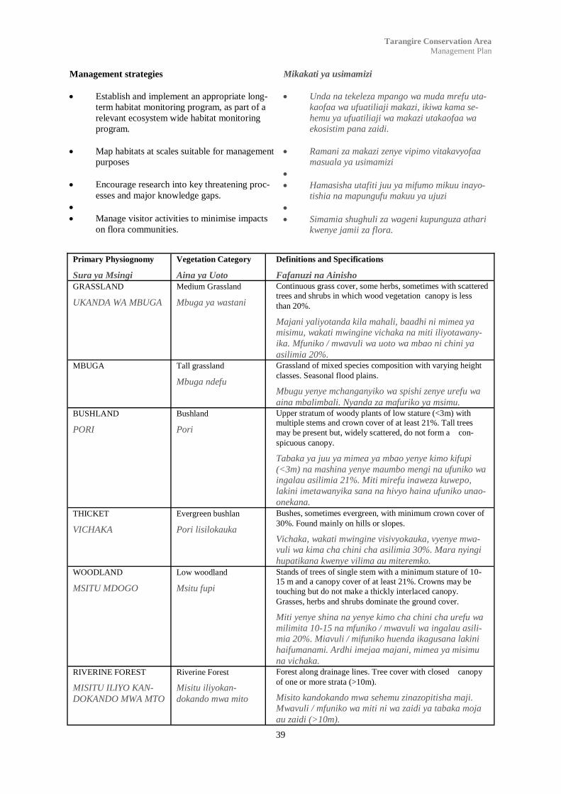
39
Tarangire Conservation Area
Management Plan
Management strategies
Establish and implement an appropriate long-
term habitat monitoring program, as part of a
relevant ecosystem wide habitat monitoring
program.
Map habitats at scales suitable for management
purposes
Encourage research into key threatening proc-
esses and major knowledge gaps.
Manage visitor activities to minimise impacts
on flora communities.
Mikakati ya usimamizi
Unda na tekeleza mpango wa muda mrefu uta-
kaofaa wa ufuatiliaji makazi, ikiwa kama se-
hemu ya ufuatiliaji wa makazi utakaofaa wa
ekosistim pana zaidi.
Ramani za makazi zenye vipimo vitakavyofaa
masuala ya usimamizi
Hamasisha utafiti juu ya mifumo mikuu inayo-
tishia na mapungufu makuu ya ujuzi
Simamia shughuli za wageni kupunguza athari
kwenye jamii za flora.
Primary Physiognomy
Sura ya Msingi
Vegetation Category
Aina ya Uoto
Definitions and Specifications
Fafanuzi na Ainisho GRASSLAND
UKANDA WA MBUGA
Medium Grassland
Mbuga ya wastani
Continuous grass cover, some herbs, sometimes with scattered trees and shrubs in which wood vegetation canopy is less
than 20%.
Majani yaliyotanda kila mahali, baadhi ni mimea ya
misimu, wakati mwingine vichaka na miti iliyotawany-
ika. Mfuniko / mwavuli wa uoto wa mbao ni chini ya
asilimia 20%. MBUGA Tall grassland
Mbuga ndefu
Grassland of mixed species composition with varying height
classes. Seasonal flood plains.
Mbugu yenye mchanganyiko wa spishi zenye urefu wa
aina mbalimbali. Nyanda za mafuriko ya msimu. BUSHLAND
PORI
Bushland
Pori
Upper stratum of woody plants of low stature (<3m) with multiple stems and crown cover of at least 21%. Tall trees
may be present but, widely scattered, do not form a con-
spicuous canopy.
Tabaka ya juu ya mimea ya mbao yenye kimo kifupi
(<3m) na mashina yenye maumbo mengi na ufuniko wa
ingalau asilimia 21%. Miti mirefu inaweza kuwepo,
lakini imetawanyika sana na hivyo haina ufuniko unao-
onekana. THICKET
VICHAKA
Evergreen bushlan
Pori lisilokauka
Bushes, sometimes evergreen, with minimum crown cover of
30%. Found mainly on hills or slopes.
Vichaka, wakati mwingine visivyokauka, vyenye mwa-
vuli wa kima cha chini cha asilimia 30%. Mara nyingi
hupatikana kwenye vilima au miteremko. WOODLAND
MSITU MDOGO
Low woodland
Msitu fupi
Stands of trees of single stem with a minimum stature of 10-15 m and a canopy cover of at least 21%. Crowns may be
touching but do not make a thickly interlaced canopy.
Grasses, herbs and shrubs dominate the ground cover.
Miti yenye shina na yenye kimo cha chini cha urefu wa
milimita 10-15 na mfuniko / mwavuli wa ingalau asili-
mia 20%. Miavuli / mifuniko huenda ikagusana lakini
haifumanami. Ardhi imejaa majani, mimea ya misimu
na vichaka. RIVERINE FOREST
MISITU ILIYO KAN-
DOKANDO MWA MTO
Riverine Forest
Misitu iliyokan-
dokando mwa mito
Forest along drainage lines. Tree cover with closed canopy
of one or more strata (>10m).
Misito kandokando mwa sehemu zinazopitisha maji.
Mwavuli / mfuniko wa miti ni wa zaidi ya tabaka moja
au zaidi (>10m).

40
Tarangire Conservation Area
Management Plan
Figure 5: Vegetation Types within TCA
Kielelezo cha 5: Aina za Uoto ndani ya TCA

41
Tarangire Conservation Area
Management Plan
4.3.2 Wildlife
Wildlife resources are outlined below making refer-
ence to Figures 6, 7 and 8. Currently insufficient data
is available to make informed comment on inverte-
brate populations, microhabitats and niche specialisa-
tion within the Tarangire Conservation Area, although
the varied topography provides for a variety of niche
habitats.
Tarangire River Corridor: During the rainy season
elephants exit the Tarangire National Park along the
Tarangire River watercourse of the Tarangire Conser-
vation Area before leaving to go out into the Lemiyon
Plains on course for the Naitolia floodplains. Once in
the Naitolia floodplain they remain for approximately
two months of the rainy season before returning to
Tarangire National Park, although resident groups can
be found throughout the year.
Specific research was performed on the Tarangire ele-
phant population (TCP, 1995 – 1998) using Global
Positioning System (GPS) collars to track individual
elephants from different subpopulations on a regular
basis. This data showed there to be at least three dis-
tinct sub-populations in the Tarangire National Park,
one of which utilised the Tarangire Conservation Area
and the identified zones of influence during the wetter
times of year. Other information, gathered at the com-
munity level, provides elephant distribution values
from the community perspective. This elephant distri-
bution data is shown in Figure 6. This use of the TCA
and peripheral areas by a keystone species such as the
elephant clearly illustrates the critical conservation
values of this area. This also clearly shows the limita-
tions of range due to farming activities such as those to
the north and west of the conservation areas bounda-
ries.
Boundary Hill Corridor: During the rainy season
both elephant and buffalo exit the Tarangire National
Park in the vicinity of Boundary Hill and enter the
TCA to spend two months in and around Gosuwa
Swamp before returning to Tarangire National Park.
Other data from the elephant research programme
(TCP, 1995) and data from ongoing elephant research
in the Tarangire National Park indicates the same sub-
population of elephant also enter the southern parts of
the TCA. Resident herds of elephant spend the dry
season around Boundary Hill and north towards the
Bundu waterhole and Gosuwa swamp waterhole.
4.3.2 Wanyamapori
Rasilimali za wanyamapori zimeorodheshwa chini na
kuhusishwa na Vielelezo 6, 7 na 8. Kwa sasa hivi,
taarifa za takwimu zilizopo hazitoshi kufanya fasiri ya
uhakika kuhusu idadi za wanyamapori wasio na mi-
gongo, vimakazi vidogo na sehemu maalum ndani ya
eneo la Hifadhi la Tarangire, ingawa utofauti wa to-
pografia unadhihirisha makazi maalum mbalimbali.
Ushoroba wa Mto Tarangire: Nyakati za mvua, tembo
huondoka kutoka Mbuga ya Taifa ya Tarangire na
hutembea kandokando ya mkondo wa maji wa Mto
Tarangire kwenye Eneo la Hifadhi la Tarangire kabla
ya kwenda kwenye nyanda za Lemiyon wakielekea
kwenye tambarare za mafuriko za Naitolia. Wan-
apofika kwenye tambarare za Naitolia wanabakia
huko kwa takriban miezi miwili ya msimu wa mvua,
kabla ya kurudi kwenye Mbuga ya Taifa ya Tarangire,
ingawa makundi makazi hupatikana kipindi cha
mwaka mzima.
Utafiti maalum ulifanyika juu ya idadi ya tembo wa
Tarangire (TCP, 1995 – 1998) kwa kutumia Mfumo
wa Upangaji wa Dunia (GPS) kufuatilia kwa utaratibu
tembo mmojammoja waliotoka kwenye makundi mado-
go tofauti. Takwimu hizi zilionyesha kwamba kuna
ingalau makundi madogo matatu ndani ya Mbuga ya
Taifa ya Tarangire, moja ambalo linatumia Eneo la
Hifadhi la Tarangire na kanda za miliki zilizotambuli-
ka nyakati za majimaji / mvua katika mwaka. Taarifa
nyingine, zilizokusanywa katika kiwango cha jamii, ni
za kuhusu thamani za mgawanyo wa tembo kutokana
na msimamo wa jamii. Takwimu za mgawanyo za tem-
bo zinaonekana kwenye Kielelezo cha 6. Utumiaji wa
aina hii wa TCA na maeneo ya jirani, wa spishi maa-
lum kama ya tembo unadhihirisha wazi umuhimu wa
thamani za hifadhi za eneo hili. Hii pia inadhihirisha
mipaka ya nafasi kutokana na shughuli za kilimo kama
zile za kaskazini na magharibi mwa mipaka ya maeneo
ya hifadhi.
Ushoroba wa Kilima cha Boundary: Nyakti za mvua
tembo na nyati huondoka kutoka Mbuga ya Hifadhi ya
Taifa ya Tarangire karibu na Kilima cha Boundary na
kuingia ndani ya TCA na kukaa humo kwa miezi miwi-
li kwenye na kandokando ya Kinamasi ya Gosuwa
kabla ya kurudi kwenye Mbuga ya Hifadhi ya Taifa ya
Tarangire. Takwimu nyingine kutoka kwenye mradi wa
utafiti wa tembo (TCP, 1995) na takwimu zinazotoka
kwenye utafiti unaoendelea wa tembo ndani ya Mbuga
ya Taifa ya Tarangire zinadhihirisha ya kuwa kundi
dogo la tembo haohao pia linaingia pande za kusini za
TCA. Kipindi cha kiangazi, makundi makazi ya tembo
yanakaa kandokando mwa Kilima cha Boundary na
kaskazini kuelekea dimbwi la maji la Bundu na la Ki-
namasi la Gosuwa.

42
Tarangire Conservation Area
Management Plan
Figure 6: Elephant distribution during the wet season
Kielelezo cha 6: Mgawanyo wa Tembo nyakati za mvua
Central Corridor – After the short rains in Novem-
ber/December several thousand Wildebeest and Zebra
transit the central woodlands and swamps of the TCA
from Tarangire National Park to areas of more nutri-
tious (phosphate rich) graze and, eventually, their calv-
ing grounds. This migration can occur overnight, and
in some seasons after overnight rains, the Lemiyon
plains around Radilen Hill are dotted with wildebeest
who may stay in the area into late January and Febru-
ary depending on local rainfall. After the long rains, in
June and July, they return spending up to two months
in the hills to the west of the Gosuwa Swamp. Once all
sources of standing water dry up they then disperse
back to Tarangire National Park and the permanent
water of the Tarangire River. Zebra tend to disperse
on a wider basis and head further to the north through
the conservation area into Naitolia and Mbyuni village
lands. This data is corroborated at the community level
(See Figure 7) and by data collected by TCP (TCP,
1995). Zebra also tend to stay in the conservation area
for much longer periods into the dry season with scat-
tered populations being found around Naitolia well
into the drier months of October. Wildebeest popula-
tions tend to spend less time in the conservation area
Ushoroba wa Kati – Baada ya mvua za vuli za Novem-
ba / Desemba maelfu ya kongoni na punda milia huvu-
ka pori la kati na vinamasi vya TCA kutoka Mbuga ya
Taifa ya Tarangire kuelekea kwenye maeneo ya ma-
lisho yenye rutuba (yaliyojaa madini ya fosfati) amba-
ko wanakula majani, na baadaye, kuzaa huko. Uhama-
ji huu unaweza kufanyika usiku kucha, na nyakati
nyingine baada ya mvua za usiku. Nyanda za Lemiyon
kuzunguka Kilima cha Radilen kumetapakaa kongoni
ambao wanaweza kukaa kwenye eneo mpaka kipindi
cha mwishoni wa Januari na Februari kutegemeana
na mvua zilizopo. Baada ya mvua za masika, kipindi
cha mwezi Juni hadi Julai, hurudi na kukaa hadi miezi
miwili kwenye vilima upande wa magharibi wa Kina-
masi la Gosuwa. Mara tu vyanzo vyote vya maji yali-
yosimama vitakavyokauka, wanatawanyika kurudi
kwenye Mbuga ya Taifa ya Tarangire na eneo la maji
ya kudumu la Mto wa Tarangire. Punda milia wana
elekea kutawanyika kwa mapana na mbali zaidi kuele-
kea kaskazini kupitia eneo la hifadhi kuingia Naitolia
na ardhi za kijiji cha Mbyuni. Takwimu hii inathibi-
tishwa kwenye kiwango cha jamii (angalia Kielelezo
cha 7) na kutokana na takwimu zilizokusanywa na
TCP (TCP, 1995). Punda milia hubakia ndani ya eneo
43
Tarangire Conservation Area
Management Plan
and migrate more to the south east to the Simanjiro
Plains and towards the calving grounds in the Lolkis-
ale Livestock and Wildlife Zone, although in lesser
numbers. See Figure 8. This migration pattern is quite
different to that of 40 years ago where large numbers
exited the park to the north towards Manyara, Natron
and West Kilimanjaro. This can be directly attributed
to the increase in human activity to the north of the
park.
African Hunting Dogs – Small groups of African
hunting dogs transit the TCA from north to south at
different times of year. In March and April dogs have
been seen transiting from the northwest heading south
and east. They are thought to den in the woodlands to
the north of Naitolia, preying on the large numbers of
impala, wildebeest and zebra often found in the area
at this time. In May, June and July they return from the
east and south, transiting the TCA heading northwest
and into the Manyara area.
Oryx and Eland - During the nineties, small groups
of oryx (30–40) and eland (40–50) have been seen on
the Lemiyon plains every year between the months of
March and June. These animals do not appear to origi-
nate from the Tarangire National Park and it is sus-
pected that they may be part of a population occupying
the area between Tarangire and Lake Natron or from
further north east of Lolkisale Mountain. Even with a
reduction of negative human interference on these
populations in the TCA and the appropriate manage-
ment of plains and swamp habitats, there are fewer
sightings in recent years. This can be attributed to hu-
man interference on a wider scale in the Tarangire
ecosystem, the increase in the number of cleared areas
for large scale farms north of Lolkisale and the in-
crease in resident hunting and shooting of animals
under crop protection. It is unlikely that these popula-
tions will increase without a concerted effort to edu-
cate and inform those on adjacent community and pri-
vate lands.
Resident Wildlife – Herds of up to 800 buffalo have
been seen at all times of year in the TCA on the
wooded ridge separating the Tarangire National Park
from Gosuwa swamp, and also to the north of Radilen
Hill on the Naitolia floodplains during the rainy sea-
son. Buffalo are also regularly found in the riverine
forests of the Tarangire River and its tributaries in the
centre of the TCA.
There are also at least two resident groups of elephant,
numbering 20–30, which circulate between the swamp
environs to the east of the Boundary Hill Lodge Site
and the forested slopes between Boundary Hill Lodge
and Tarangire Treetops Lodge, as well as a smaller
group near Naitolia. It is to be noted that, over the
eight years that this project has been in the making, the
population structure of these resident elephant has
changed, there now being noticeably more young ele-
phant in the family groups.
la hifadhi, kwenye eneo linalozunguka Naitolia, kwa
muda mrefu zaidi kuelekea kwenye kipindi cha kianga-
zi cha mwezi wa Oktoba, wakiwa kwenye makundi
yaliyotawanyikatawanyika. Makundi ya nyumbui hutu-
mia muda mfupi ndani ya eneo la hifadhi na huhamia
kusini mashariki zaidi upande wa Nyanda za Simanji-
ro kuelekea kwenye maeneo ya kuzalia kwenye Nyanda
za Mifugo na Wanyamapori za Lolkisale, ingawa
kwenye idadi chache. Angalia Kielelezo cha 8. Mfumo
huu wa uhamaji ni tofauti na ule wa miaka 40 iliyopita
wakati makundi makubwa yalihama kutoka kwenye
mbuga kupitia kaskazini kuelekea Manyara, Natron na
Kilimanjaro Magharibi. Hali hii inadhaniwa kusaba-
bishwa na shughuli za binadamu upande wa kaskazini
wa mbuga.
Mbwa mwitu – Makundi madogo ya mbwa mwitu
huvuka TCA kutokea kaskazini kuelekea kusini nyakati
tofautitofauti za mwaka. Mnamo Machi na Aprili
mbwa hawa huonekana wakivuka kutokea kaskazini
magharibi kuelekea kusini na mashariki. Wanadhani-
wa kupiga pango kwenye msitu upande wa kaskazini
ya Naitolia, wakiwinda makundi makubwa ya paa,
kongoni na punda milia ambao mara nyingi hupatika-
na kwenye eneo hili kipindi hiki. Mnamo mwezi Mei,
Juni na Julai wanarudi kutoka mashariki na kusini,
wakipita TCA kuelekea kaskazini magharibi na kuin-
gia eneo la Manyara.
Choroa na Pofu – Miaka ya tisini, makundi madogo
ya choroa (30–40) na pofu (40–50) yalikuwa yakione-
kana kwenye nyanda za Lemiyon kila mwaka kati ya
miezi ya Machi na Juni. Wanyama hawa hawakuele-
kea kutokea Mbuga ya Taifa ya Tarangire na inahisi-
wa ya kwamba walikuwa sehemu ya idadi inayokaa
kwenye eneo kati ya Tarangire na Ziwa la Natron au
kutoka kaskazini mashariki ya Mlima Lolkisale. Pamo-
ja na upunguzaji uliyosababishwa na uingiliaji hasi
wa binadamu kwenye hizi idadi ndani ya TCA na usi-
mamizi unaofaa wa makazi ya nyanda na vinamasi,
wanyama hawa huonekana kwa nadra miaka ya kari-
buni. Hali hii inawezekana kutokana na uingiliaji wa
binadamu kwa kiwango kikubwa kwenye ekosistim ya
Tarangire, ongezeko la maeneo yanayotayarishwa
kwa madhumuni ya mashamba makubwa ya biashara
kaskazini mwa Lolkisale na kuongezeka kwa uwindaji
na upigaji wa wanyama kwa kisingizio cha ulindaji wa
mazao. Haielekei kama idadi hizi zitaongezeka bila ya
juhudi za pamoja kuelimisha na kutaarifu wale walio
jirani na kwenye ardhi za binafsi.
Wanyamapori Wakazi – Makundi ya nyati hadi 800
huonekana kila kipindi katika mwaka kwenye TCA
upande wa msitu kwenye mgongo unaotofautisha
Mbuga ya Taifa ya Tarangire kutoka Kinamasi la Go-
suwa, na pia kaskazini mwa Kilima cha Radilen kwen-
ye tambarare za Naitolia nyakati za mvua. Nyati pia
huonekana mara kwa mara kwenye misitu iliyo kando-
kando mwa Mto wa Tarangire na vijitawi vyake kati-
kati ya TCA.

44
Tarangire Conservation Area
Management Plan
Pia kuna ingalau makundi makazi mawili ya tembo,
ambao wako kama 20–30, ambao huzunguka kati ya
maeneo ya kinamasi upande wa mashariki wa eneo la
hoteli ya Boundary Hill na misitu iliyo kwenye mite-
remko kati ya hoteli za Boundary Hill na Tarangire
Treetops, pamoja na kundi dogo lililopo karibu na
Naitolia. Ikumbukwe kwamba, zaidi ya miaka nane ya
mradi huu, muundo wa idadi ya hawa tembo wakazi
umebadilika, sasa hivi wanaonekana ndama wengi
kwenye makundi ya familia.
Kuna makundi ya simba wakazi mawili yanayojulika-
na kwenye TCA. Moja linamiliki eneo la mashariki ya
eneo la hoteli ya Boundary Hill wakati lingine liko
kandokando mwa Mto wa Tarangire upande wa mag-
haribi wa hoteli ya Tarangire Treetops. Idadi ya simba
awali imesumbuliwa na athari ya uwindaji wa watalii,
hasa kwa simba wanaume, na hivyo kusababisha vija-
na kuchukua majukumu wangali wadogo. Hali hii ili-
gunduliwa na Lamprey mwaka 1963.
Kuonekana kwa spishi makazi nyingine za aina ya
paka kama vile chui, ngawa, caracal, na duma ni ka-
waida kwenye maeneo ya pori la wastani jirani na
nyanda za wazi.
There are two identified resident prides of lion in the
TCA. One occupies a territory to the east of the
Boundary Hill Lodge site while the other has a terri-
tory along the Tarangire River to the west of Tarangire
Treetops Lodge. Lion populations have been previ-
ously perturbed by the impacts of tourist hunting, with
the greatest impact on male lions, with juvenile males
taking on more responsibility at younger ages. This
was first noted by Lamprey in 1963.
Sightings of other resident cat species such as leopard,
serval, caracal, and cheetah are common in lightly
wooded areas on the periphery of open grasslands.
Figure 7: Zebra migration at the start of the short rains.
Kielelezo cha 7: Uhamaji wa Punda milia mwanzoni mwa mvua za vuli.

45
Tarangire Conservation Area
Management Plan
Tandala ambaye hajaonekena TCA miaka nane sasa,
siku hizi wanaonekana mara kwa mara kaskazini mwa
kambi ya Naitolia huko porini. Inadhaniwa ya kwam-
ba kupungua kwa uwindaji na mashinikizo mengine ya
binadamu juu ya eneo la Naitolia kwa kipindi cha mia-
ka 10 iliyopita ndio sababu ya kurudi kwa spishi hii na
mikakati ya uhakika zaidi ya usimamizi itakayolenga
kuondoa athari hasi inasababisha ongezeko la ziada la
idadi za wanyamapori kwenye maeneo mengine ya
TCA.
Inaelekea kwamba aina ya wanyamapori wa Gerenuk,
ambao walikuwa wanaonekana mara moja moja kati-
ka miaka saba iliyopita, wamepotea kabisa kutoka
kwenye eneo hili. Kwa mara ingine tena, athari za
binadamu zinadhaniwa kuwa sababu kuu ya kupotea
huko na haielekei kama spishi hii itatokea tena bila ya
mradi kambabe wa kuwaanzisha tena.
Hakuna ufafanuzi wa orodha ya kupima Eneo la
Hifadhi la Tarangire. Atlasi ya Tanzania ina takwimu
za spishi 486 kutoka Mbuga ya Taifa ya Tarangire,
iliyo jirani na TCA, na jumla kuu inaweza kuzidi 500.
Aina tatu ya spishi wanaopatikana Tanzania, yaani:
Yellow-collared Lovebird, Ashy Starling na Rufus-
tailed Weaver wana idadi kubwa ndani ya eneo la
mbuga na aina ya nne, Fischer‟s Lovebird, hufikia
kilele chake cha mashariki ndani ya Tarangire. Wa-
naosababisha shauku ni idadi kubwa ya Little Tawny
Pipit, spishi ya kienyeji na isiyo ya kawaida Afrika ya
Mashariki. Aina ya Saddle-billed Stork, kwa kawaida
hupatikana Tarangire, huonekana kwenye maeneo ya
majimaji kama Kinamasi la Gosuwa.
Lengo:
Kulinda fauna wa kienyeji ndani ya eneo la
hifadhi na kwenye ardhi za jirani.
Boresha ujuzi juu ya eneo la hifadhi, pamoja na
idadi za wanyamapori, njia za uhamaji, na mfu-
mo wa kutishia.
Mikakati ya Usimamizi:
Kutambua maeneo ya ardhi ya jamii jirani am-
bazo zina umuhimu wa muda mrefu kuhusiana
na uendelevu wa ekosistim kuhusu idadi za
wanyamapori na taratibu za kusaidia kwenye
kuhifadhi hizo thamani.
Kuunda na kutekeleza mpango wa ufuatiliaji
wanyamapori wa muda mrefu utakaofaa, ikiwa
kama sehemu pana zaidi ya ekosistim ya
ufuatiliaji utakaofaa.
Onyesha uhamaji na idadi za wanyamapori
wanaopita eneo la hifadhi na kukusanya tak-
wimu kama msingi wa mikakati ya usimamizi
wa baadaye.
Kudu, which were not seen at all in the TCA eight
years ago, are now seen relatively regularly north of
Naitolia Camp in bush land. It is suspected that the
reduction of the hunting and other human impact
pressures in the Naitolia area over the last 10 years is
directly responsible for the return of this species and
further positive management strategies to remove
negative impacts should see further population in-
creases in the future in other areas of the TCA.
Gerenuk, which were seen irregularly seven years ago
appear to have completely disappeared from this area.
Again, human impact is suspected to be the main rea-
son for this decline and it is unlikely that this species
will reappear without an active programme of re-
introduction.
Avifauna: There is no annotated checklist for the
Tarangire Conservation Area. The Tanzania Atlas
database holds records of 486 species from the
Tarangire National Park, immediately adjacent to the
TCA, and the total is likely to exceed 500. Three Tan-
zanian endemics, Yellow-collared Lovebird, Ashy
Starling and Rufus-tailed Weaver have substantial
populations within the park and a fourth, Fischer’s
Lovebird, reaches its eastern limit in Tarangire. Of
special interest is the relatively high numbers of Little
Tawny Pipit, a local and rare species in East Africa.
The Saddle-billed Stork, a reasonably common bird
in Tarangire, is to be found in wetland areas such as
the Gosuwa Swamp.
Aim:
Protect indigenous fauna within the conserva-
tion area and adjacent lands.
Improve knowledge of the conservation area,
including wildlife populations, migration
routes, and threatening process.
Management Strategies:
Identify areas in adjacent community lands of
significant importance to the long term viabil-
ity of the ecosystems wildlife populations and
methods to assist in conserving those values.
Establish and implement an appropriate long-
term wildlife monitoring program, as part of a
relevant ecosystem wide monitoring program.
Map wildlife movements and number through
the conservation area and assemble a database
as a basis for further management strategies
Establish ranger posts in areas of access and
centrally with regular patrols, ensuring ade-
quate coverage of the conservation area, anti-

46
Tarangire Conservation Area
Management Plan
Figure 8: Wildebeest migration at the start of the short rains.
Kielelezo cha 8: Uhamaji wa Kongoni mwanzoni mwa mvua za vuli.
poaching patrols, charcoal management. See
Figure 9.
Create a strategy whereby the local communi-
ties, conservation area management and park
authorities are involved in the setting of hunting
quotas for areas adjacent to but outside the
conservation area but within community part-
ners village lands.
.
Kuunda vituo vya wahifadhi kwenye maeneo
yanayofikika kirahisi na yaliyo katikati, na usi-
mamizi wa doria ya kila mara, kuhakikisha
ulinzi wa eneo la kutosha la hifadhi, doria dhidi
ya majangili wanaowinda visivyo halali, usi-
mamizi wa mkaa. Angalia Kielelezo cha 9.
Kuunda mkakati ambao jamii za kienyeji, mam-
laka ya usimamizi wa eneo la hifadhi na mbuga
watashughulika kwenye kupanga sehemu za
kuwinda kwenye maeneo ya jirani lakini nje ya
eneo la hifadhi lakini ndani ya ardhi za jamii
wabia.

47
Tarangire Conservation Area
Management Plan
Avifauna Category 1: Globally threatened species
Aina ya 1 : Spishi ambazo zinatishiwa kwa jumla
Vulnerable
Ambazo ziko hatarini
Lesser Kestrel Flocks of hundreds recently recorded during April when the Park pro-
vides abundant invertebrate food (following the beginning of the rains)
and secure roost sites.
Makundi ya mamia karibuni yalirekodiwa kipindi cha Aprili wakati Mbu-
ga ilikuwa na chakula kingi, wadudu, (kufuatia mwanzo wa mvua) na
vituo salama vya viota vya ndege.
Karamoja Apalis A single record in July 1998 (P. Oliver pers. comm.) may represent an
extension of range (especially when considering recent records from
Maswa G.R. and Serengeti N.P.)
Kumbukumbu moja iliyofanyika Julai 1998 (P. Oliver pers. comm.) ina-
weza kuwakilisha upanuzi wa sehemu wapatikanayo (has wakati wa kufi-
kiria kumbukumbu za hivi karibuni zinazotoka Maswa G.R. na Serengeti
N.P.)
Near-threatened
Ambazo zinakaribia kuwa hatarini
Fischer‟s Lovebird An uncommon but regular visitor to Tarangire.
Siyo wa kawaida lakini hutembelea Tarangire mara kwa mara.
Red-throated Tit This East African endemic is a low density breeding species in the south-
east of the park. Tarangire forms the western limit for the Maasai Steppe
population.
Aina hii ipatikanyao Afrika Mashariki tu ni spishi yenye msongamano wa
kuzaliana wa kiwango cha chini kusini mashariki mwa mbuga ambayo
huunda mpaka wa magharibi wa idadi ya Nyika ya Maasai.
Category 2 - restricted range species
Aina ya : Spishi zilizowekewa vikwazo
Endemic Bird Area 108 - Serengeti Plains
Eneno la Ndege la 108 – Nyanda za Serengeti
Fischer‟s Lovebird See near-threatened category above.
Angalia aina zinazokaribia kuwa hatarini hapo juu.
Karamoja Apalis See vulnerable category above.
Angalia aina ya zilizo hatarini hapo juu.
Rufous-tailed Weaver Locally common especially in the northern sector of the Park.
Huonekana mara nyingi hasa upande wa kaskazini wa Mbuga.
Category 3 - biome restricted assemblages
Aina ya 3 – wale waliozuiliwa kwenye mazingira maalum
Somali-Masai 43 species (56%) out of a country total of 77.
spishi 43 (56%) kutoka jumla ya 77 ya nchi
Category 4.i. - 1% or more of biogeographical population
Aina ya 4.i. - 1% au zaidi ya idadi ya ki-biogeografia
Marabou Stork 10,000 Feb. 1992. I. Robertson in Baker 1997. A:1,000
Common Pratincole 2,000 no date P. Oliver pers. comm. C: 1,600

48
Tarangire Conservation Area
Management Plan
4.3.3 Landscapes
The spectacular landscape values of the Tarangire
Conservation Area provides an important part of the
visitors overall Tarangire experience. The grassland
plains, the Gosuwa and Silale swamps from the high-
lands, the baobab/acacia mosaic, rift valley and Kili-
manjaro/Meru views are all key elements of the land-
scape.
Key visual experiences include:
The sweeping grassland plains dotted with ma-
jestic baobab trees.
Sunset and sunrise views from high points such
at Radilen Hill, Poachers Hill and Boundary
Hill.
Large herds of elephants and buffalo in the Go-
suwa swamp.
Impressive Sand River vistas with large fig
trees overhanging the banks and the prints of a
myriad of wildlife etched in the sand.
Vistas north towards snow-capped Kilimanjaro
and Mt Meru.
The appeal of many of these experiences is the ab-
sence of human development. Unmodified landscapes
give a sense of remoteness and are an important ex-
perience and retreat for many visitors.
Aims
Protect landscape values.
Minimise the visual impact of signs, infrastruc-
ture and management activities associated with
the conservation area.
Management Strategies
Ensure that all future development is carried
out within guidelines protecting landscape val-
ues.
4.3.3 Mandhari
Thamani za mandhari za kustaajabisha ndani ya Eneo
la Hifadhi la Tarangire zinatoa sehemu muhimu ya
tajriba ya jumla ya Tarangire. Nyanda za mbuga, vi-
namasi vya Gosuwa na Silale kutoka kwenye miinuko,
mpangilio wa mibuyu / acacia, bonde la ufa na mand-
hari za Kilimanjaro / Meru zote ni sifa muhimu za
mandhari.
Tajriba kuu za kuona ni pamoja na:
Mbuga ya nyanda kwa jumla iliyojaa mibuyu
ya adhima.
Mandhari za magharibi na za machweo kutoka
vilele vya juu vya kama vilima vya Radilen,
Poachers na Boundary.
Makundi makubwa ya tembo na nyati kwenye
Kinamasi la Gosuwa.
Mandhari ya Mto wa Sand zinazovutia pamoja
na miti mikubwa ya tini inayoning‟inia kwenye
kingo, na alama za nyayo za idadi kubwa za
wanyamapori zinazoonekana juu ya mchanga.
Mandhari ya kaskazini kuelekea kwenye taji za
theluji za milima ya Kilimanjaro na Meru.
Kivutio cha wingi wa tajriba hizi ni kutokuwepo kwa
maendeleo ya binadamu. Mandhari ambazo hazijaba-
dilishwa zinatoa hisia ya umbali / ukale hivyo ni tajri-
ba muhimu na kimbilio kwa wageni.
Malengo
Thamani za utunzaji wa mandhari.
Kupunguza athari za kuwepo kwa alama, miundo mbi-
nu na shughuli za usimamizi zinazohusiana na eneo la
hifadhi.
Mikakati ya Usimamizi
Kuhakikisha kwamba maendeleo yote ya
baadaye yatafanyika kufuatana na miongozo ya
kulinda thamani za mandhari.
Kuhakikisha kwamba Viwango Vinavyoku-
balika kwa Matumizi vinafuatwa kwa madhu-
muni ya kuendeleza dhana kuu ya kuona na
hisia ya umbali / ukale.
Kuhakikisha kwamba alama na mipaka
inawekwa kwa njia ya kuleta athari ndogo juu
ya thamani za mandhari, mandhari muhimu na
tajriba maalum za kuona.

49
Tarangire Conservation Area
Management Plan
Ensure that Levels of Acceptable Use are
adopted to maintain key visual and sense of
remoteness.
Ensure that signs and boundary makers have
minimal impact on landscape values, key views
and special visual experiences.
Identify landscape elements of special impor-
tance to the visitors experience and ensure pro-
tection strategy is in place through zoning
system and Environmental Impact Assessments
of development.
Kutambua mandhari zenye umuhimu maalum
kwa tajriba ya wageni na kuhakikisha mkakati
wa ulinzi upo kwenye mfumo wa ugawanyaji na
maendeleo ya Tathmini za Athari za Mazingira.
Sunset over the rift valley and Lake Manyara from Radilen Hill.
Bonde la Ufa na Ziwa Manyara kutoka Kilima cha Radilen wakati wa machweo ya jua

50
Tarangire Conservation Area
Management Plan
Figure 9: Proposed Rangers Post, entrance gates and visitors centre
Kielelezo cha 9: Mapendekezo ya kituo cha wahifadhi, milango mikuu na kituo cha wageni

51
Tarangire Conservation Area
Management Plan
5.1: Indigenous cultural heritage
The area around Tarangire has a long history of human
settlement. The pictographs only 40 kilometres to the
south of the park at Kolo, Pahi and Kisesse date back
more than 9,000 years and show a rich history, not
only of human cultural evolution but also of the vari-
ety and concentration of wildlife that has been found
in the Tarangire area over the millenniums, depicting
giraffe, rhinoceros, antelope, elephant, zebra and os-
trich, to name a few.
Evidence suggests that at least seven different groups
of people surrounded the reserve when it was gazetted
in 1957, the four main ethnic groups in the Tarangire
area being, the Maasai, Waarusha, Barbaig and
Mbugwe. Even though most of these groups claims to
have used and/or settled within the area that became
Tarangire Game Reserve, the area was seen by admin-
istrators as having little or no population (past and
present) due to its high concentration of tsetse flies.
However the present of iron age settlement sites, vis-
ual remnants of hunting and gathering (such as dug
out animal traps and honey hunting „ladders‟ in bao-
bab trees), and more importantly, the memory of peo-
ple contradicts the tsetse fly narrative.
The Maasai are the most widely known and are readily
identified of these groups. They have in the past prac-
ticed a nomadic livestock management system which
is compatible with the wildlife and preservation of
habitat. However with changing populations and mi-
gration of other ethnic groups into traditional Maasai
areas, this pastoral existence has been changed to a
more agro-pastoralist community.
The Barbaig also practice a nomadic pastoral system
which is under threat from immigration and competi-
tion for resources, as with the Maasai.
The Waarusha are a sub tribe of the Maasai originally
from the foothills of Mt Meru. Due to high land costs
they have been forced into areas near Tarangire. They
tend to have larger land holdings under cultivation
with greater emphasis on cash crops.
The Mbugwe are traditionally hunters and agro-
pastoralist who keep livestock as well as cultivating
sorghum and millet for subsistence use. Being reliant
on subsistence hunting has bought the Mbugwe into
conflict situations with the wildlife authorities.
5.1: Urithi wa utamaduni wa kienyeji
Eneo linalozunguka Tarangire lina historia ndefu ya
makazi ya binadamu. Taswira zilizopo kilomita 40 tu
upande wa kusini wa mbuga sehemu za Kolo, Pahi na
Kisesse zina zaidi ya miaka 9,000 na zinaonyesha his-
toria yenye mambo mengi, siyo tu yanayohusu maba-
diliko ya utamaduni wa binadamu lakini pia aina nyin-
gi na mkusanyo wa wanyamapori ambao wamepatika-
na kwenye eneo la Tarangire muda wa miaka mingi,
maelfu na maelfu. Zinazoonyesha twiga, vifaru, paa,
tembo, punda milia na mbuni, katika kuwataja wanya-
mapori wachache.
Ushahidi unaonyesha kwamba kulikuwa na ingalau
makundi saba tofauti ya watu walioishi kuzunguka
eneo la hifadhi wakati liliposajiliwa mwaka 1957, ma-
kundi manne makuu ndani ya eneo la Tarangire waki-
wa WaMaasai, WaArusha, WaBarbaig na WaMbug-
we. Ingawa wengi kati ya haya makundi wanadai ku-
wa walitumia na / au kuishi ndani ya eneo ambalo
likawa Hifadhi ya Wanyamapori ya Tarangire, eneo
linadhaniwa na watawala kwamba lilikuwa na idadi
ndogo au kulikuwa hakuna watu (zamani na sasa hivi)
kutokana na kuwepo kwa ndorobo wengi. Lakini se-
hemu za sasa hivi zinazoonyesha makazi ya watu wa-
liotumia chuma, mabaki / dalili za picha za uwindaji
na ukusanyaji (kama mitego ya wanyama iliyofukuliwa
na ngazi za kupanda kwenye mibuyu wakati wa uwin-
daji wa asali), na muhimu ya yote, kumbukumbu za
watu zinapinga hadithi ya ndorobo.
WaMaasai ndiyo wanaojulikana sana na wanaotam-
bulika kirahisi katika makundi haya. Huko nyuma wa-
litumia muundo wa kuhamahama na mifugo ambao
kwa wakati ule, uliendana na wanyamapori na utunza-
ji wa mazingira. Lakini kutokana na mabadiliko ya
idadi za watu na uhamiaji wa wenyeji wengine kwenye
maeneo ya kijadi ya KiMaasai, mtindo huu wa ufugaji
umewabadilisha kuwa jamii ya wakulima wenye mifu-
go.
Kama WaMaasai, WaBarbaig pia walitumia muundo
wa kuhamahama na mifugo. Mtindo ambao unaathiri-
ka na tishio la uhamiaji na ushindani juu ya rasilimali
WaArusha ambao ni kabila dogo la WaMaasai wana-
tokea kwenye safu ya Mlima Meru. Kutokana na bei
kubwa za ardhi wamelazimika kuishi kwenye maeneo
yaliyo karibu na Tarangire. Huwa wana tabia ya kuwa
na mashamba makubwa wanayoyatumia zaidi kwa
kulima mazao ya biashara.
5.0 Strategies for Cultural Values Conservation
Mikakati ya Hifadhi ya Thamani za Asili

52
Tarangire Conservation Area
Management Plan
The Kolo pictographs can provide a rewarding aspect
to the resources available for visitors in the conserva-
tion area and national park. Along with a cultural tour-
ism program in neighbouring villages and Lake
Babati, this cannot only add to the visitors experience
but provide an insight into the relationship between the
land, the wildlife and the local communities over mil-
lenniums. As well as providing another revenue stream
for the local communities these cultural resources can
encourage visitors to spend longer in and around the
park.
Aims
To promote a greater understanding of the local
communities and their place in the land they
live on.
To identify and conserve historical and cultural
resources within the areas adjacent to the con-
servation area.
Management Strategies
To encourage the development of cultural tour-
ism programs with community partners in vil-
lages adjacent to the conservation area .
To promote and identify cultural sites, such as
and including Kolo and Lake Babati, to
broaden the overall experience of the visitor to
the Tarangire ecosystem.
WaMbugwe wana asili ya uwindaji na kulima na kuwa
na mifugo. Walikuwa na mifugo na pia walilima mta-
ma na mtama kwa matumizi ya chakula. Utegemezi
wao juu ya uwindaji kwa madhumuni ya chakula kuli-
sababisha kujikuta kwenye hali ya ugomvi na mamlaka
ya wanyamapori.
Taswira za Kolo zinaweza kutoa kiangazo macho kwa
rasilimali zilizokuwepo kwa wageni ndani ya eneo la
hifadhi na mbuga ya taifa. Pamoja na mpango wa
utalii wa kitamaduni kwenye vijiji jirani na Babati
taswira hizi haziongezi tajriba ya wageni tu bali pia
zinatoa nafasi ya kupata ujuzi kuhusu uhusiano uliyo-
kuwepo kati ya ardhi, wanyamapori na jamii za kien-
yeji maelfu ya miaka iliyopita. Pamoja na kuwa chan-
zo kingine cha mapato kwa jamii za kienyeji, hizi rasi-
limali za kitamaduni zinahamasisha wageni kukaa kwa
muda mrefu ndani na kuzunguka mbuga.
Malengo
Kukuza uelewa mkubwa zaidi wa jamii za kienyeji na
sehemu yao ndani ya ardhi yanayoishi
Kuzitambua na kuzihifadhi rasilimali za kihistoria na
za kitamaduni ndani ya maeneo yaliyo jirani na eneo
la hifadhi.
Mikakati ya Usimamizi
Kuhamasisha maendeleo ya mipango ya utalii wa ki-
tamaduni pamoja na wabia wa jamii kwenye vijiji
jirani na eneo la hifadhi.
Kukuza na kutambua sehemu za kitamaduni, kama zile
na pamoja na Kolo na Lake Babati, kupanua tajriba
ya jumla ya mgeni wa ekosistim ya Tarangire.
Pictographs located at Kolo south of Tarangire
Taswira zilizopo Kolo kusini mwa Tarangire
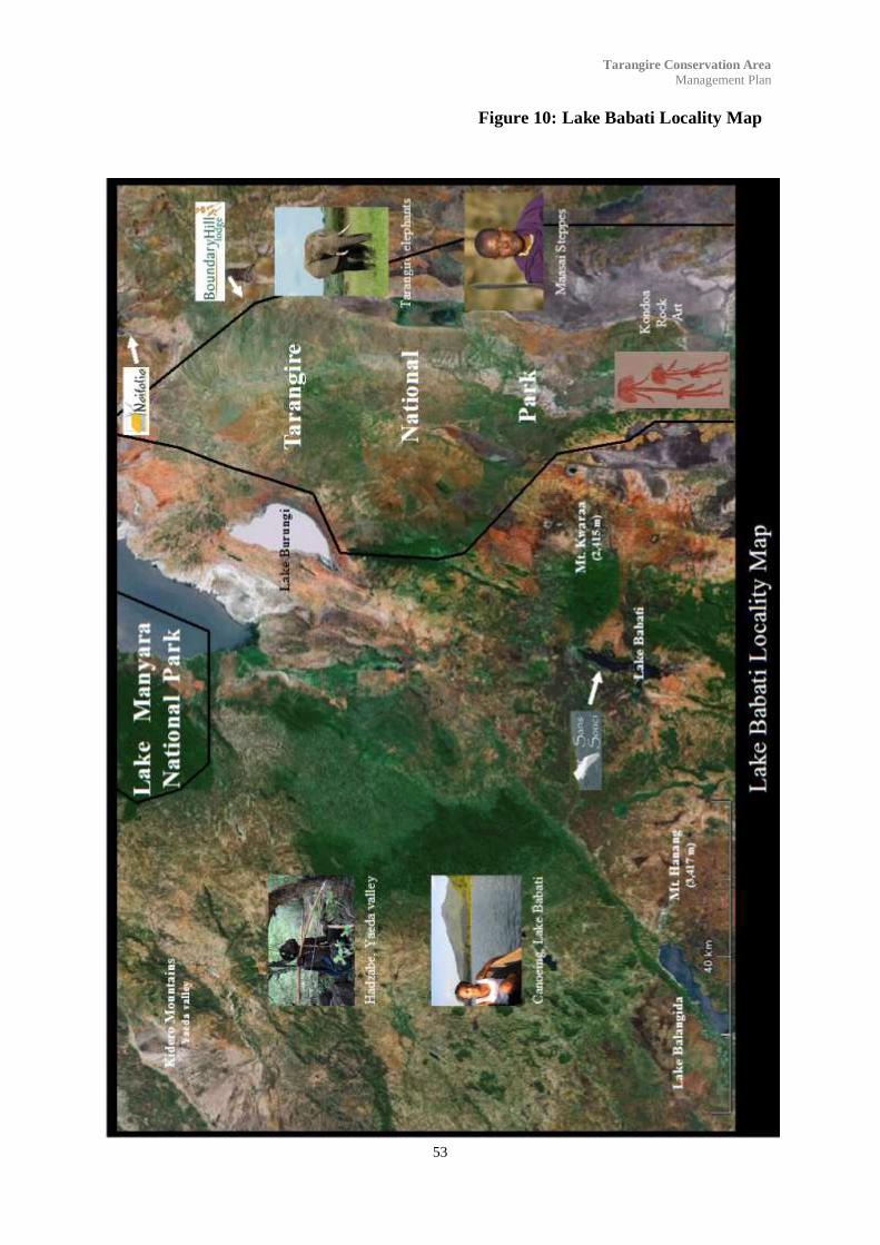
53
Tarangire Conservation Area
Management Plan
Figure 10: Lake Babati Locality Map

54
Tarangire Conservation Area
Management Plan
Figure 11: Kondoa-Irangi Rock Paintings

55
Tarangire Conservation Area
Management Plan
5.2: Historical heritage
The First World War began in East Africa in 1914 and
did not end until 13th November 1918. Four empires
and their subject peoples were engaged in a conflict
which raged from modern Kenya in the north and into
northern Mozambique in the south. Much of this con-
flict was fought in what was German East Africa and
is now Tanzanian. Although known as “the forgotten
front” or popularised as “the Germans who Never
Lost”, the conflict was one of terrible human suffering
set in some of the most tiring terrain in the world.
In chasing the Germans south towards the Central rail-
way, the South African troops moving from Arusha to
Kondoa had their first action at a rocky elevation
known as Lolkisale. Lolkisale is a steep rocky moun-
tain densely covered in thick bush. This action was to
take place in early April during the height of the rainy
season, but Lolkisale commanded the only water
springs in the area, and by now despite the rains, the
horses of the mounted brigade where suffering from
thirst.
Lolkisale was eventually taken and is known as the
first real defeat of the Germans in East Africa. How-
ever a number of askaris managed to escape down the
southern slope and retreated towards Kondoa through
Ufiomi near Babati. The South African troops gave
chase towards Kondoa. At night lions roared around
their camp; lions where indeed so plentiful in the area
that some of the troops scarcely troubled to look at
them when they where sighted nearby. The brigades
original strength of over twelve hundred troops was
halved by malaria, dysentery and death. Eighty percent
of the supply columns mules and horses died in the
tsetse infected area.
Some of the march south was through what we now
know as the black cotton soils of the Gosuwa and Si-
lale swamps during the height of the long rains. Con-
temporary photographs show tents pitched on fields of
mud, which can only have been the Silale area. The
official map of the campaign shows the retreat from
Lolkisale south between Boundary Hill and Kikoti Hill
into what is now the park and towards a stop called
Tarangire near the present Kuro Rangers post.
Although in East Africa little is know about the First
World War, in South Africa there is a thriving small
industry involving Boer War and First World War
sites in Namibia.
5.2: Urithi wa kihistoria
Vita vya Kwanza vya Dunia vilianza Afrika Mashariki
mwaka 1914 na havikumalizika mpaka tarehe 13 No-
vemba 1918. Milki nne na watu wake walijihusisha na
vita ambayo ilipigwa kuanzia Kenya ya leo kwa
upande wa kaskazini hadi kaskazini ya Msumbiji kwa
upande wa kusini. Sehemu kubwa ya vita hii ilipigwa
kwenye eneo ambalo lililojulikana kama Afrika
Mashariki ya Ujerumani ambayo ndiyo Tanzania ya
leo. Ingawa ilijulikana kama “upande wa mbele ulio-
sahaulika” au kusifika kama “Wajerumani ambao
hawakushindwa”, vita hii ni moja ya mateso makuu ya
binadamu yaliyofanyika kwenye mojawapo ya mand-
hari za kuchosha hapa duniani.
Katika kuwafukuza Wajerumani kusini kuelekea reli ya
Kati, majeshi ya Afrika ya Kusini yaliosafiri kutoka
Arusha hadi Kondoa walipigana vita yao ya kwanza
kwenye mwinuko wa mawe ulioitwa Lolkisale. Lolkis-
ale ni mlima mkali wa mawe uliyofunikwa na pori
nene. Vita hivi vilipigwa mwanzoni mwa Aprili wakati
wa kilele cha kipindi cha mvua, lakini chemchem za
maji za eneo hili zilikuwa Lolkisale tu, na pamoja na
kuwa na mvua, farasi wa kikosi hiki walikuwa wanate-
seka na kiu.
Baadaye Lolkisale ilitekwa na ikajulikana kuwa an-
gamizo la kwanza na wa kweli kwa Wajerumani
kwenye eneo la Afrika Mashariki. Lakini askari wengi
waliweza kutoroka kupitia mteremko wa kusini na
kukimbia kuelekea Kondoa na Ufiomi karibu na Ba-
bati. Majeshi ya Afrika ya Kusini yaliwakimbiza hadi
Kondoa. Usiku simba walinguruma kuzunguka kambi
yao; kwa kweli simba walikuwa wengi kwenye eneo
hilo mpaka baadhi ya majeshi waliogopa walipoone-
kana karibu nao. Kikosi cha zaidi ya askari elfu moja
na mia mbili, kilipoteza nusu ya askari kwa sababu ya
malaria, kuharisha damu na kifo. Asilimia themanini
ya nyumbu na farasi walikufa kwenye eneo lililojaa
ndorobo.
Baadhi ya matembezi ya kuelekea kusini yalikuwa
kupita kwenye sehemu ambayo sasa hivi tunajua ina
udongo wa aina ya “black cotton” wa vinamasi vya
Gosuwa na Silale nyakati za kilele cha mvua za ma-
sika. Picha za wakati ule zinaonyesha mahema yaliyo-
kuwa yamepigwa kwenye eneo ya matope, ambazo
zinaelekea kuwa eneo la Silale tu. Ramani rasmi ya
vita hiyo inaonyesha kimbilio la kutoka Lolkisale kus-
ini mwa Kilima cha Boundary na Kilima cha Kikoti
kuelekea kwenye mbuga ya siku hizi, na kuelekea
kwenye kituo kilichoitwa Tarangire karibu na kituo
cha wahifadhi cha Kuro cha sasa hivi.
Kwa upande wa Afrika Mashariki ni machache
yanayojulikana kuhusu Vita vya Kwanza vya Dunia.
Afrika Kusini kuna biashara ndogo iliyostawi nchini
Namibia kuhusu sehemu za Vita vya Makaburu na Vita
vya Kwanza vya Dunia.
Sunrise over Lolkisale Mountain as seen from Boundary
Hill Lodge.

56
Tarangire Conservation Area
Management Plan
Aim
To broaden the diversity in the Tarangire
area by incorporating historical sites in
visitor experience.
Management Strategy
To identify an organization which can pro-
mote and encourage historical cultural pro-
grams within the Tarangire Area utilizing
community guides.
Lengo
Kupanua uanuwai wa eneo la Tarangire
kwa kuingiza sehemu za historia kwenye
tajriba ya wageni.
Management Strategy/ Mikakati wa usimamizi
Kutambua / kuchagua shirika ambalo li-
taweza kukuza na kuhamasisha miradi ya
historia ya kitamaduni ndani ya eneo la
Tarangire Area kwa kutumia viongizi wa
jamii.
Belgian troops entering Tabora, September 1918.

57
Tarangire Conservation Area
Management Plan
6.1 Information and interpretation
Providing information, interpretation and education
can help orientate and inform visitors, increase visitor
enjoyment and satisfaction, foster an understanding
and appreciation of the special natural and cultural
values of the conservation area and park, build under-
standing of management activities, and help visitors to
experience the area in a safe and responsible manner.
The Management of the Conservation Area delivers
information, interpretation and education to visitors by
various means, including its website
(tarangireconservation.com), ranger patrols, signage,
tourism brochures and other publications, information
and visitors centre and through local tour operators.
6.1.1: Signage
The development of a uniform design and build crite-
ria for all signage is particularly relevant. Signage
should, while remaining subtle and unimposing, have a
repeated theme that marks an association with the
Conservation Area. Additionally signage should be of
a sufficient build quality that it does not rapidly de-
grade or be overly susceptible to vandalism.
Signage should not be limited to directions and dis-
tances but should also show interpretative information
such as type of activities permitted, habitat, flora and
fauna to be encountered and major features.
See Appendix 1.
Aims
To ensure that signage in the conservation area
does not intrude on the landscape values of the
conservation area.
To develop signage to assist in the visitors ex-
perience within the conservation area.
Management Strategies
Develop a standard criteria for design of sign-
age..
Maintain visitor signage and interpretative ma-
terial and educational material appropriate for
the conservation area in accordance with Ap-
pendix 1/ Kuendeleza alama.
6.1 Taarifa na Tasfiri
Utoaji maelezo, tafsiri na elimu kunaweza kusaidia
kuelewesha na kutaarifu wageni, kuongeza raha na
ridhaa yao, kukuza kuelewa na kuthamini thamani
maalum za kitamaduni na kiasili za eneo na mbuga ya
hifadhi, kujenga uelewa wa shughuli za usimamizi, na
kusaidia wageni kuzoea eneo katika hali ya usalama
na ya kuwajibika.
Menejimenti ya Eneo la Hifadhi linatoa maelezo, taf-
siri na elimu kwa wageni kwa kutumia njia nyingi,
ambazo ni pamoja na kuwa na website
(tarangireconservation.com), doria za wahifadhi,
vibao vya alama, maganda ya utalii na chapisho ny-
ingine, kituo cha maelezo na cha wageni na kupitia
waendesha safari za watalii.
6.1.1: Alama
Kuunda kwa ubunifu unaofanana na ujenzi wa vibao
vya alama ni kazi yenye umuhimu rasmi. Wakati ni
muhimu kwa alama / ishara kuwa pambanuzi na zisizo
za kuvutia sana, zinatakiwa hasa kuwa na dhamira
itakayorudia mara kwa mara kuonyesha uhusiano
uliopo na Eneo la Hifadhi. Pia vibao vya alama viwe
na ubora ambao hautasababisha uchakavu au kuweza
kuharibiwa kirahisi.
Vibao vya alama visiwe vya kuonyesha ishara na um-
bali tu bali viwe na taarifa iliyotafsiriwa kama aina za
shughuli zinazoruhusiwa, makazi, mimea na fauna
waliopo na sehemu muhimu.
Angalia Kiambatisho cha 1.
Malengo
Kuhakikisha ya kwamba vibao vya alama ndani
ya eneo la hifadhi havitaingilia thamani za eneo la
hifadhi.
Kuunda vibao vya alama vitakavyosaidia / on-
geza tajriba ya wageni ndani ya eneo la hifadhi.
Mikakati ya usimamizi
Kuunda viwango vya vigezo vya kubuni alama.
Kuendeleza alama / ishara za wageni taarifa
zenye tafsiri na elimu inayofaa kwenye eneo la
hifadhi kufuatana na Kiambatisho cha 1.
6.0 Strategies for Visitors
Mikakati ya Wageni

58
Tarangire Conservation Area
Management Plan
6.1.2: Visitors’ centre
An interpretative centre which showcases the natural
and heritage values of the Tarangire Conservation
Area and broader Tarangire ecosystem is identified as
a priority. The location of this visitors‟ centre will be
approximately one kilometre to the north of the
Radilen Rangers post located on the slope of a small
hill. This site was chosen as being in an area of perma-
nent access and hidden from any other tourist facili-
ties. This should be a simple structure with a number
of vertical visual displays as shown in Appendix 2.
This visitors‟ centre will also be the main entrance
gate where visitor and transit fees are collected, and
where rangers and guides are available for interpreting
information for visitors.
Aims
Promote and encourage visitors to discover,
enjoy and appreciate the Conservation Area and
ecosystem natural and cultural values in a safe
and appropriate manner through information,
interpretation and education.
Encourage community support for conservation
area management practices.
Management Strategies
Target visitors across a range of user groups through a
range of tourism, information, interpretation and edu-
cation media, for example mammal, bird and reptile
checklists (see Appendix 3), walking guides, informa-
tion displays, maps.
Deliver messages to visitors about the following
values and themes:
habitats associated with the conservation area
and Tarangire ecosystem;
relationships between the Tarangire Conserva-
tion Area and the local communities;
the importance of the cultural and historical
heritage and development of the Tarangire area;
flora and fauna interactions within the conser-
vation area, particular the elephant populations, the
zebra and wildebeest migrations, baobab and acacia
mosaic, and varied birdlife;
Appropriate behaviours, including minimal
impact techniques and adherence to codes of conduct
appropriate to visitor activities, to protect conservation
values and maximise visitor safety;
6.1.2: Kituo cha Wageni
Kuwepo kwa kituo cha maelezo ambacho kitaonyesha
thamani za asili na za urithi za eneo la hifadhi la
Tarangire na ekosistim yake kwa mapana zaidi ndiyo
kipau mbele. Kituo hiki kitakuwa kama kilomita moja
upande wa kaskazini wa kituo cha wahidhafi cha
Radilen kilichopo kwenye mteremko wa kilima kidogo.
Eneo hili limechaguliwa kuwa kwenye eneo li-
nalofikika kiurahisi na limejificha kutoka sehemu ny-
ingine za huduma ya watalii. Liwe na umbo la
kawaida bila ya madoido na liwe na maonyesho mengi
ya wima kama inavyoonekana kwenye Kiambatisho
cha 2.
Kituo hiki pia kitakuwa lango kuu la kuingilia ambapo
ada za wageni na za kupita zitakusanywa, na ambapo
wahifadhi na viongozi watapatikana kwa madhumuni
ya kufasiri maelezo kwa wageni.
Malengo
Kukuza na kuhamasisha wageni kugundua,
kufaidi na kuthamini Eneo la Hifadhi na tha-
mani za asili na za kitamaduni za ekosistim
kwenye hali ya usalama na inayofaa kwa kupi-
tia maelezo, fasiri na elimu.
Kuhamasisha jamii kuhimili taratibu za usima-
miaji wa hifadhi.
Mikakati ya usimamizi
Kulenga wageni walio kwenye makundi ya watumiaji
kwa kupitia njia za utalii, maelezo, tafsiri na za elimu,
kwa mfano orodha kaguzi za mamalia, ndege na wa-
tambaazi (angalia Kiambatisho cha 3), viongozi
kwenye safari za kutembea, maonyesho yenye maelezo,
ramani.
Toa maelezo kwa wageni kuhusu thamani na
dhamira zifuatazo:
Makazi yanayohusiana na eneo la hifadhi na
ekosistim ya Tarangire;
Uhusiano kati ya Eneo la Hifadhi la Tarangi-
rena jamii za kienyeji;
Umuhimu wa urithi wa kitamaduni na kihisto-
ria na maendeleo ya eneo la Tarangire;
Jinsi mimea na fauna vinavyoathiriana ndani
ya eneo la hifadhi, hasa jamii za tembo, uhamaji wa
punda milia na kongoni, mipangilio ya mibuyu na aca-
cia, na maisha ya ndege mbalimbali;
Tabia zinazofaa, pamoja na mitindo ya athari

59
Tarangire Conservation Area
Management Plan
Regularly evaluate information and interpreta-
tive programs related to the conservation area;
In partnership with local schools, develop and
integrate conservation themes into a range of subjects
as well as specialised educational resources about the
conservation area.
6.1.3: Tourist facilities
The provision of tourist facilities within the conserva-
tion area and neighbouring community lands should
provide a wide variety of different perspectives as well
as providing a revenue resource for each of the vil-
lages participating in the conservation area manage-
ment. At present there are four permanent facilities
within the conservation area as shown in the following
table.
ndogo na kushikilia kanuni za maadili mema zinazofaa
kwa shughuli za wageni, kulinda thamani za hifadhi na
hakikisha usalama wa hali ya juu wa mgeni.
Mara kwa mara tathmini mipango ya habari na
tafsiri inayohusiana na eneo la hifadhi.
Kwa ushirikiano na shule za jamii jirani, unda
na unganisha dhamira za hifadhi kwenye masomo yao
na pia rasilimali za elimu maalum zitakazohusiana na
eneo la hifadhi.
6.1.3: Huduma za watalii
Utoaji wa huduma za watalii ndani ya eneo la hifadhi
na ardhi ya jamii jirani kutaleta aina nyingi ya mita-
zamo pamoja na kuleta rasilimali ya kipato kwa kila
kijiji kitakachoshiriki kwenye usimamizi wa eneo la
hifadhi. Kwa sasa hivi kuna sehemu za huduma za
kudumu nne ndani ya eneo la hifadhi kama ilivyoonye-
shwa kwenye jedwali lifuatalo.
Facility
Huduma
Size
Ukubwa
Description
Maelezo
Villages
Vijiji
Management
Usimamizi
Naitolia Camp
8 beds
Rustic permanent camp made of local
materials comprising three huts and one
tree house.
Naitolia, Mswakini and
Makuyuni. The East African Safari and
Touring Company.
Tarangire Tree Tops 40 beds Permanent lodge built around baobab
tree with some rooms built as tree
houses. Swimming pool.
Lolkisale. Elewana Africa.
Boundary Hill
Lodge 16 beds Permanent lodge built in and amongst
rocks on a high ridge. Swimming pool. Lolkisale. Boundary Hill Lodge, with
Lolkisale Village owning
50%.
Sidai Camp. 4 beds Semi permanent tented camp. Lolkisale Boundary Hill Lodge.
For the conservation area to be successful amongst the
local community‟s there must be an equitable sharing
of revenue from the conservation area and identifica-
tion by the communities with the tourist facilities.
Lolkisale village has a strong affiliation with the con-
servation area since they strongly identify with Bound-
ary Hill Lodge and Tarangire Treetops. This relation-
ship has not been as strong in the Naitolia Concession
Area, with conflict arising at various stages over the
last 10 years over the revenue stream from Naitolia
Camp, mainly due to there being three villages and
also that the camp is small in comparison to Treetops
and Boundary Hill. By establishing two additional
small tourist facilities in the Naitolia Concession Area
and in the Makuyuni Elephant Dispersal Area each
community will have a facility which they can readily
identify with.
The revenue streams must also be modified so that
although the majority of community fees go towards
Ili eneo la hifadhi liwe na mafanikio miongoni mwa
jamii ya kienyeji, ni lazima kuwe na ugawanyaji wa
haki wa mapato yanayotoka kwenye eneo la hifadhi na
kujihusisha kwa jamii zenye huduma za watalii. Kijiji
cha Lolkisale kina ushirikiano mkubwa na eneo la
hifadhi kwa vile wanajihusisha sana na hoteli za
Boundary Hill na Tarangire Treetops. Uhusiano wa
aina huu haukuwepo kwenye Eneo la Milki la Naitolia,
ambako kulikuwa na mafarakano ya mara kwa mara
katika miaka 10 iliyopita kutokana na mapato yaliyo-
kuwa yanatoka Kambi ya Naitolia, hasa kwa vile kuna
vijiji vitatu na pia kambi husika ni ndogo ikilingan-
ishwa na hoteli za Treetops na Boundary Hill. Kwa
kuwa na sehemu ndogo mbili za ziada ndani ya Eneo
la Miliki la Naitolia na ndani ya Eneo Tawanyishi la
Tembo Makuyuni, kila jamii itakuwa na huduma yake
ambayo itaweza kujihusisha nayo kirahisi.
Mitiririko ya mapato lazima ibadilishwe ili ingawa
sehemu kubwa ya ada za jamii zinaenda kwenye
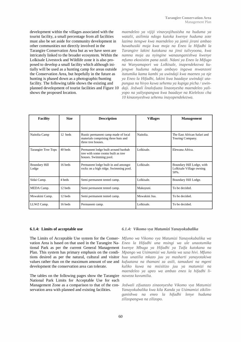
60
Tarangire Conservation Area
Management Plan
development within the villages associated with the
tourist facility, a small percentage from all facilities
must also be set aside for community development in
other communities not directly involved in the
Tarangire Conservation Area but as we have seen are
intricately linked to the broader ecosystem. Within the
Lolkisale Livestock and Wildlife zone it is also pro-
posed to develop a small facility which although ini-
tially will be used as a hunting camp for areas outside
the Conservation Area, but hopefully in the future as
hunting is phased down as a photographic/hunting
facility. The following table shows the existing and
planned development of tourist facilities and Figure 10
shows the proposed location.
maendeleo ya vijiji vinavyojihusisha na huduma ya
watalii, asilimia ndogo kutoka kwenye huduma zote
lazima itengwe kwa maendeleo ya jamii jirani ambao
hawahusiki moja kwa moja na Eneo la Hifadhi la
Tarangire lakini kutokana na jinsi tulivyoona, kwa
namna moja au nyingine wanaunganishwa kwenye
mfumo ekosistim pana zaidi. Ndani ya Eneo la Mifugo
na Wanyamapori wa Lolkisale, inapendekezwa ku-
jengwe huduma ndogo ambayo ingawa mwanzoni
itatumika kama kambi ya uwindaji kwa maeneo ya nje
ya Eneo la Hifadhi, lakini kwa baadaye uwindaji uta-
pungua na hivyo kuwa sehemu ya kupiga picha / uwin-
daji. Jedwali linalofuata linaonyesha maendeleo yali-
yopo na yaliyopangwa kwa baadaye na Kielelezo cha
10 kinaonyeshwa sehemu inayopendekezwa.
Facility Size Description Villages Management
Naitolia Camp 12 beds Rustic permanent camp made of local
materials comprising three huts and
three tree houses.
Naitolia. The East African Safari and
Touring Company.
Tarangire Tree Tops 40 beds Permanent lodge built around baobab
tree with some rooms built as tree
houses. Swimming pool.
Lolkisale. Elewana Africa.
Boundary Hill
Lodge 16 beds Permanent lodge built in and amongst
rocks on a high ridge. Swimming pool. Lolkisale. Boundary Hill Lodge, with
Lolkisale Village owning
50%.
Sidai Camp. 4 beds Semi permanent tented camp. Lolkisale. Boundary Hill Lodge.
MEDA Camp. 12 beds Semi permanent tented camp. Makuyuni. To be decided.
Mswakini Camp. 12 beds Semi permanent tented camp. Mswakini Juu. To be decided.
LLWZ Camp. 16 beds Permanent camp. Lolkisale. To be decided.
6.1.4: Limits of acceptable use
The Limits of Acceptable Use system for the Conser-
vation Area is based on that used in the Tarangire Na-
tional Park as per the current General Management
Plan. This system has primary emphasis on the condi-
tions desired as per the natural, cultural and visitor
values rather than on the maximum amount of use and
development the conservation area can tolerate.
The tables on the following pages show the Tarangire
National Park Limits for Acceptable Use for each
Management Zone as a comparison to that of the con-
servation area with planned and existing facilities.
6.1.4: Vikomo vya Matumizi Yanayokubalika
Mfumo wa Vikomo vya Matumizi Yanayokubalika wa
Eneo la Hifadhi una msingi wa ule unaotumika
kwenye Mbuga ya Hifadhi ya Taifa kutokana na
Mpango wa Usimamizi wa Jumla wa sasa hivi. Mfumo
huu unatilia mkazo juu ya masharti yanayotakiwa
kufuatana na thamani za asili, tamaduni na mgeni
kuliko kuwa na msisitizo juu ya matumizi na
maendeleo ya upeo wa ambao eneo la hifadhi li-
naweza kuvumilia.
Jedwali zifuatazo zinaonyesha Vikomo vya Matumizi
Yanayokubalika kwa kila Kanda ya Usimamizi zikilin-
ganishwa na eneo la hifadhi lenye huduma
zilizopangwa na zilizopo.
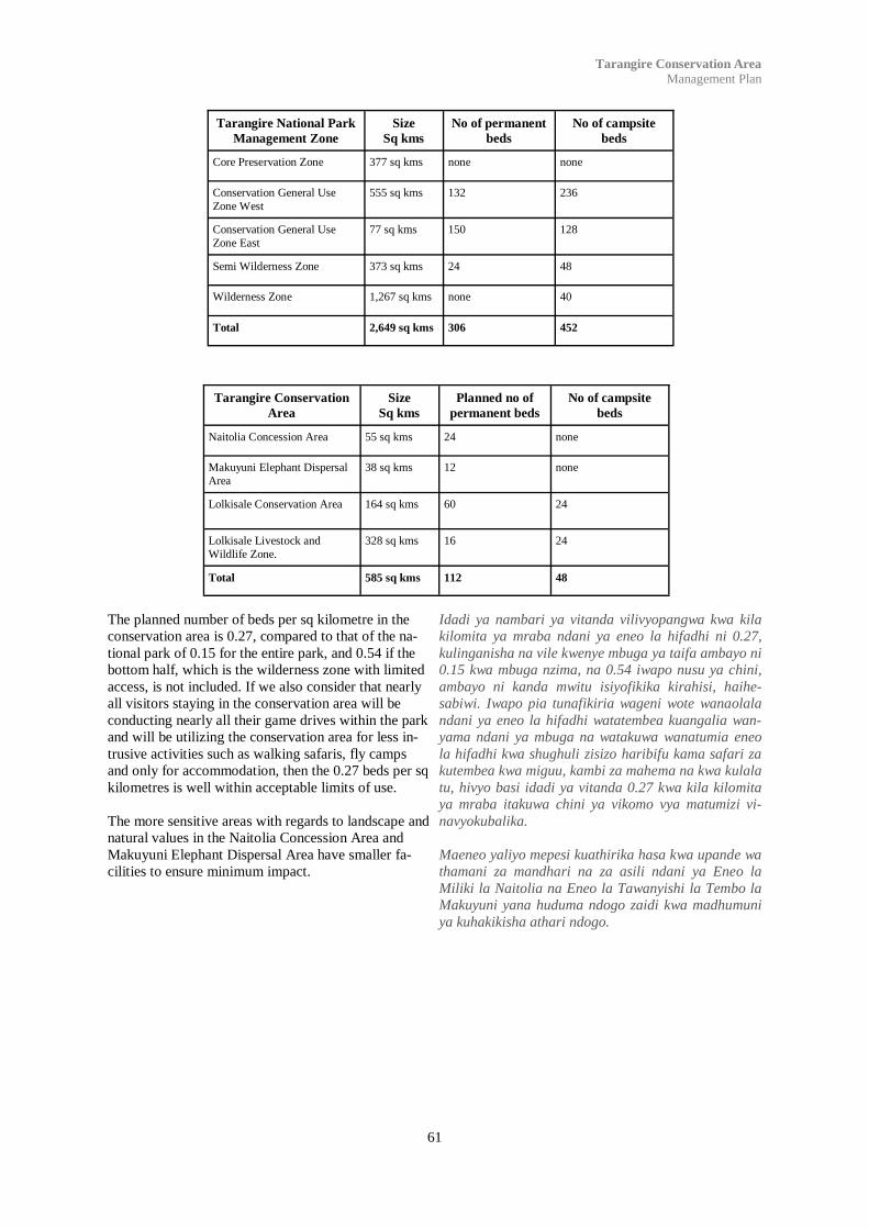
61
Tarangire Conservation Area
Management Plan
The planned number of beds per sq kilometre in the
conservation area is 0.27, compared to that of the na-
tional park of 0.15 for the entire park, and 0.54 if the
bottom half, which is the wilderness zone with limited
access, is not included. If we also consider that nearly
all visitors staying in the conservation area will be
conducting nearly all their game drives within the park
and will be utilizing the conservation area for less in-
trusive activities such as walking safaris, fly camps
and only for accommodation, then the 0.27 beds per sq
kilometres is well within acceptable limits of use.
The more sensitive areas with regards to landscape and
natural values in the Naitolia Concession Area and
Makuyuni Elephant Dispersal Area have smaller fa-
cilities to ensure minimum impact.
Idadi ya nambari ya vitanda vilivyopangwa kwa kila
kilomita ya mraba ndani ya eneo la hifadhi ni 0.27,
kulinganisha na vile kwenye mbuga ya taifa ambayo ni
0.15 kwa mbuga nzima, na 0.54 iwapo nusu ya chini,
ambayo ni kanda mwitu isiyofikika kirahisi, haihe-
sabiwi. Iwapo pia tunafikiria wageni wote wanaolala
ndani ya eneo la hifadhi watatembea kuangalia wan-
yama ndani ya mbuga na watakuwa wanatumia eneo
la hifadhi kwa shughuli zisizo haribifu kama safari za
kutembea kwa miguu, kambi za mahema na kwa kulala
tu, hivyo basi idadi ya vitanda 0.27 kwa kila kilomita
ya mraba itakuwa chini ya vikomo vya matumizi vi-
navyokubalika.
Maeneo yaliyo mepesi kuathirika hasa kwa upande wa
thamani za mandhari na za asili ndani ya Eneo la
Miliki la Naitolia na Eneo la Tawanyishi la Tembo la
Makuyuni yana huduma ndogo zaidi kwa madhumuni
ya kuhakikisha athari ndogo.
Tarangire National Park
Management Zone Size
Sq kms No of permanent
beds No of campsite
beds
Core Preservation Zone 377 sq kms none none
Conservation General Use
Zone West 555 sq kms 132 236
Conservation General Use
Zone East 77 sq kms 150 128
Semi Wilderness Zone 373 sq kms 24 48
Wilderness Zone 1,267 sq kms none 40
Total 2,649 sq kms 306 452
Tarangire Conservation
Area Size
Sq kms Planned no of
permanent beds No of campsite
beds
Naitolia Concession Area 55 sq kms 24 none
Makuyuni Elephant Dispersal
Area 38 sq kms 12 none
Lolkisale Conservation Area 164 sq kms 60 24
Lolkisale Livestock and
Wildlife Zone. 328 sq kms 16 24
Total 585 sq kms 112 48

62
Tarangire Conservation Area
Management Plan
Figure 12: Existing and Proposed Tourist Facilities.
Kielelezo cha 10: Huduma za Watalii zilizopo na zinazopendekezwa
Aims
To ensure that a variety of tourist facilities are
available to enhance the visitors experience.
To develop facilities to encourage all partner
communities to partake in the conservation
area.
Management Strategies
Develop additional tourist facilities in line with
acceptable use limits and natural and landscape
values.
Malengo
Kuhakikisha ya kwamba huduma mbali mbali
za watalii zitakuwepo kwa madhumuni ya kuon-
geza tajriba ya wageni.
Kuunda huduma za kuhamasisha jamii wabia
wote kushiriki kwenye eneo la hifadhi.
Mikakati ya Usimamizi
Kuendeleza huduma za watalii za ziada kufua-
tana na vikomo vya matumizi yaliyokubalika na
thamani za asili na za mandhari.
63
Tarangire Conservation Area
Management Plan
7.1 Community Awareness
Raising the community‟s awareness of the values of
the conservation area is an essential step in developing
people‟s sense of custodianship of it, and their engage-
ment in the management of the area. People are more
likely to develop a sense of custodianship for the con-
servation area if their views and values are respected.
A strong connection with the conservation area among
visitors and the local and broader community assists in
broader public education, raising awareness and reach-
ing others in the community.
Education and interpretation programs play an impor-
tant role in raising the awareness of the conservation
area in the wider community. Already community
awareness has increased through a number of public
meetings and development projects in surrounding
communities.
Aims
Increase the community‟s awareness and under-
standing of the conservation area‟s values and
management activities in the area.
Build a sense of shared ownership and custodi-
anship for the conservation area among com-
munity groups and individuals.
Management Strategies
Investigate opportunities to develop offsite in-
terpretative facilities to increase awareness of
the conservation area within collaborating vil-
lage communities.
Develop broader community awareness of the
opportunities to make a difference to the man-
agement of the conservation area through tak-
ing shared responsibility and becoming directly
involved in it.
Increase public awareness and understanding of
significant conservation area values and man-
agement activities through local media, schools
and communities.
7.1 Utambuzi wa Jamii
Kupandisha kiwango cha utambuzi wa jamii juu ya
thamani za eneo la hifadhi ni hatua muhimu kwenye
kuendeleza hisia za kulielewa eneo, na kujihusisha
kwenye usimamizi wake. Watu wana uwezo mkubwa
kupata hisia ya ulezi wa eneo la hifadhi iwapo maoni
yao na thamani zao zinaheshimiwa. Uhusiano mkubwa
na eneo miongoni mwa wageni na jamii za kienyeji na
nyinginezo zitasaidia kwenye elimu ya umma, uon-
gezaji elimu na ufikiaji kwa wengine katika jamii.
Mipango ya elimu na tafsiri ina nafasi kubwa kwenye
uongezaji wa utambuzi ya eneo la hifadhi kwa jamii
kwa ujumla. Tayari utambuzi wa jamii umeongezeka
kutokana na mlolongo wa mikutano ya hadhara na
miradi ya maendeleo kwenye jamii jirani.
Malengo
Kuongeza utambuzi na uelewa wa jamii juu ya
thamani za eneo la Hifadhi na shughuli za usi-
mamizi kwenye eneo.
Kujenga hisia ya umilikaji wa pamoja na uleaji
wa eneo la hifadhi miongoni mwa makundi ya
jamii na watu binafsi.
Mikakati ya Usimamizi
Chunguza fursa za kuendeleza huduma za
maelezo kwa madhumuni ya kuongeza utambuzi
wa eneo la hifadhi ndani ya jamii za vijijij vi-
navyojihusisha.
Chunguza fursa za kuendeleza huduma za
maelezo kwa madhumuni ya kuongeza utambuzi
wa eneo la hifadhi ndani ya jamii za vijijij vi-
navyojihusisha.
Kuongeza utambuzi wa umma na uelewaji wa
thamani maalum za hifadhi na shughuli za usi-
mamizi kupitia vyombo vya habari, mashule na
jamii.
7.0 Strategies for Community Awareness and Administration Mikakati ya Utambuzi na Utawala wa jamii

64
Tarangire Conservation Area
Management Plan
7.2 Stakeholder partnerships
Although the Tarangire Conservation Area is managed
on behalf of the local communities; agencies and gov-
ernment departments such at the Wildlife Division and
TANAPA are important and necessary stakeholders in
the area. In the planning of the Tarangire Conservation
Area Management Plan and initial work on the LCA
Management Plan have benefited from the ongoing
research and monitoring work of several institutions in
the Tarangire region. The data made available by
these institutions will also provide a valuable baseline
for future monitoring activities by the project. These
institutions include:
Istituto Oikos. The Tanzania branch of the Istituto
Oikos, together with the Varese branch of the Univer-
sity of Insubria (Italy) and in cooperation with
TANAPA, manages the Tarangire Manyara Conserva-
tion Project (TCP) which has been studying a large
range of natural resource values in the Tarangire eco-
system. Particularly valuable data from this project
include a participatory land use survey, performed by
Oikos, in Lolkisale village, and data on large mammal
movements through the LCA and peripheral areas.
Oikos have expressed a firm interest in developing a
monitoring program for the TCA, utilizing village
game scouts to produce data sets comparable to those
being produced by TANAPA for TNP.
Conservation Information and Monitoring Unit
(CIMU). Under the Tanzania Wildlife Research Insti-
tute, the CIMU program conducts aerial wildlife sur-
veys and aerial total counts of buffalo and elephant in
the Tarangire ecosystem every few years. The LBCSP
area is included in these surveys and will benefit from
the information generated on the large mammal popu-
lation sizes and distributions.
The Tarangire Elephant Project (TEP). The TEP is
studying the long-term effects of poaching on
Tarangire elephants and is monitoring the demo-
graphic changes in the population. The TEP is also
assisting in the protection of key elephant dispersal
areas outside the national park and has already pro-
vided valuable help in the identification of the MEDA.
It is important to also recognize the need to support
community projects in surrounding villages which
although have the natural resources may not have the
financial resources to promote ecotourism in their
communities.
Aims/ Malengo
Enhance management of the conservation area by
collaborating with government and non government
agencies to ensure that they give appropriate consid-
eration to park and sanctuary values in planning and
implementing activities that relate to the planning area.
7.2 Ubia wa wadau
Ingawa Eneo la Hifadhi la Tarangire linasimamiwa
kwa niaba ya jamii za kienyeji; mashirika na idara za
serikali kama Idara ya Wanyamapori na TANAPA ni
wadau wa muhimu na wa lazima kwenye eneo hili.
Kwenye kupanga Mpango wa Usimamizi wa Eneo la
Hifadhi la Tarangire na kazi ya mwanzo ya Mpango
wa Usimamizi wa LCA, yote hii imefaidika kutokana
na utafiti na ufuatiliaji unaoendelea wa mashirika
mengi kwenye sehemu ya Tarangire. Takwimu zina-
zotolewa na haya mashirika pia zitatoa msingi wa
thamani wa shughuli za ufuatiliaji za baadaye.
Mashirika hayo ni pamoja na:
Istituto Oikos. Tawi la Istituto Oikos lililopo Tanza-
nia, pamoja na tawi la Varese la Chuo Kikuu cha In-
subria (Italia), wakishirikiana na TANAPA wanasima-
mia Mradi wa Hifadhi wa Tarangire Manyara (TCP)
ambao umekuwa unaangalia thamani za rasilimali ya
asili nyingi ndani ya mfumo wa ekosistim ya
Tarangire. Takwimu za thamani zinazotokana na
mradi huu ni pamoja na uchunguzi juu ya matumizi ya
ardhi shirikishwaji, uliyofanyika na Oikos, kwenye
Kijiji cha Lolkisale, na takwimu juu ya miendo ya
mamalia wakubwa kupita LCA na maeneo ya jirani.
Oikos wameonyesha shauku kubwa ya kuendeleza
mpango wa ufuatiliaji wa TCA, kwa kutumia askari wa
vijiji kutoa seti za takwimu zitakazolingana na zile
zinazotolewa na TANAPA kwa TNP.
Kitengo cha Maelezo ya Hifadhi na Ufuatiliaji
(CIMU): Chini ya Chuo cha Utafiti wa Wanyamapori
cha Tanzania, mpango wa CIMU utaendesha ukaguzi
wa wanyamapori kutoka angani na kuhesabu kutoka
angani idadi za nyati na tembo waliopo ndani ya
mfumo wa wanyama ya Tarangire baada ya kila mi-
aka michache. Eneo la LBCSP limeunganishwa
kwenye kaguzi hizi na litafaidika na taarifa zitaka-
zotoka juu ya ukubwa na ugawanyikaji wa idadi za
mamalia wakubwa.
Mradi wa Tembo wa Tarangire (TEP). TEP in-
achunguza athari za muda mrefu za ujangili dhidi ya
tembo wa Tarangire na unafuatilia mabadiliko ya
kidemografia ya idadi zao. TEP pia inasaidia katika
utunzaji wa maeneo muhimu ya utawanyikaji wa
tembo yaliyo nje ya mbuga ya taifa na tayari wametoa
msaada mkubwa katika kusaidia kwenye funganisha
ya MEDA.
Ni muhimu pia kutambua haja ya kuhimili miradi ya
jamii kwenye vijiiji vya jirani ambavyo pamoja na
kwamba vina rasilimali za asili, jamii husika zinaweza
zisiwe na rasilimali ya fedha inazohitajika kukuza bi-
ashara ya utalii wa mazingira (mfumo wa wanyama)
kwenye jamii zao.

65
Tarangire Conservation Area
Management Plan
Management Strategies
Work collaboratively with all agencies to implement
the plan vision and directions. In particular work with:
Wildlife Department in relationship to hunting
both professional and resident in the surrounding ar-
eas .
Tarangire National Park Authorities.
Dorobo and Partners Village Ecotourism Develop-
ment which is assisting Terat village in protecting wil-
debeest calving grounds in Simanjiro.
Monduli District Council and village councils
respectively.
Tarangire Elephant Project in developing a moni-
toring and evaluation process.
7.3 Administration and organization
The Conservation Area is administered by a Manage-
ment Steering Committee made up from members of
the local communities and private sector partners. The
financial management has been in the hands of Bound-
ary Hill Lodge Limited but a formal managing entity
with clear financial management mandates needs to be
implemented.
7.3.1 Management
There will be a requirement for conservation area man-
agement staff with levels of professional competence
sufficient to carry out planned management activities
under the custodianship of the Steering Committee.
This includes managerial, administrative, and technical
and support staff as outlined on the following page:
Malengo
Kuongeza usimamizi kwenye eneo la hifadhi kwa
kushirikiana na serikali pamoja na mashirika yasiyo
ya serikali ili kuhakikisha kwamba yanazingatia ki-
kamilifu thamani za mbuga na za hifadhi kwenye ku-
panga na kutekeleza shughuli zinazohusiana na eneo
la mipango.
Mikakati ya Usimamizi
Kushirikiana na mashirika yote kwenye utekelezaji wa
Mtazamo na Mielekeo. Yafutatayo ni mashirika / idara
za kufanya nao kazi:
Idara ya Wanyamapori kuhusiana na uwindaji wa
kitaalam na wa wakazi wa maeneo yanayozunguka
eneo la hifadhi.
Mamlaka ya Mbuga ya Taifa ya Tarangire .
Maendeleo ya Ekotourism ya Vijiji ya Dorobo na
Wabia ambalo linasaidia Kijiji cha Terat kulinda mae-
neo ya kuzalia kongoni Simanjiro.
Halmashauri ya Wilaya ya Monduli na mamlaka
za vijiji.
Mradi wa Kulinda Tembo wa Tarangire kwenye
uundaji wa mfumo wa ufuatiliaji na wa tathmini.
7.3 Utawala na Muundo
Eneo la Hifadhi linasimamiwa na Kamati ya Uende-
shaji iliyoundwa na wawakilishi wa kutoka jamii za
wenyeji na sekta binafsi. Usimamizi wa fedha ume-
kuwa mikononi mwa kampuni ya Boundary Hill Lodge
Limited lakini kuna haja ya kuunda chombo maalum
chenye mamlaka juu ya usimamizi wa fedha.
7.3.1 Usimamizi
Kutahitajika wafanyakazi wa kusimamia eneo la hi-
fadhi wenye viwango vya ujuzi wa kitaalam uta-
kaowazesha kuendesha shughuli za usimamizi
zilizopangwa chini ya uongozi wa Kamati ya Uende-
shaji. Hii itakuwa pamoja na uongozi, utawala, na
ufundi na wasaidizi kama ilivyo hapo chini:

66
Tarangire Conservation Area
Management Plan
TCA Manager/ Meneja wa TCA: Responsible for establishing and executing annual work plans based
on the management plan, responsible for supervising, monitoring
and disciplining TCA staff, responsible for budgetary and associated
recurrent expenditure overview. Atakuwa na jukumu la kuunda na
kutekeleza mipango ya kazi ya mwaka kufuatana na mpango wa
usimamizi, atakuwa na jukumu la kusimamia, kufuatia na kudhibiti
nidhamu ya wafanyakazi wa TCA, atakuwa na jukumu juu ya bajeti
na matumizi ya kawaida yanayohusiana.
Community Liaison Officer/
Afisa Ushirikiano wa Jamii: Responsible for ensuring clear lines of communication between the
community, the TCA project and other stakeholders. Provides regu-
lar feedback both ways providing a solid base for any potential con-
flict resolution. Atakuwa na jukumu la kusimamia msingi dhabiti wa
mawasiliano kati ya jamii, mradi wa TCA na wabia wengine. Atatoa
na kurudisha taarifa pande zote ili kujenga msingi mzuri wa kusu-
hulisha migongano yeyote ambayo inaweza kutokea.
TCA Accountant/ Mhasibu wa TCA: Responsible for fiscal accountability, clarity and financial overview.
Reports to the LCA Manager. Atakuwa na jukumu juu ya masuala ya
fedha, kuweka wazi masuala ya fedha. Ataripoti kwa Meneja wa
LCA
TCA Administrative Assistant: Provides administrative backstopping for the TCA Manager, Com-
munity Liaison Officer and accountant. Reports to the TCA Manager
TCA Assistant/Workshop Manager: Provides a supporting role to the TCA Manager and manages work-
shop activities. Reports to the TCA Manager. Atamsaidia Meneja wa
TCA kwenye masuala ya utawala, Afisa Ushirikiano wa Jamii na
Mhasibu. Ataripoti kwa Meneja wa TCA
TCA Workshop Administrator: Provides administrative backstopping for the TCA Assistant/
Workshop manager, potential to manage and provisionally analyze
field-monitoring data. Reports to the TCA Assistant/Workshop man-
ager. Atamsaidia Meneja wa TCA na kusimamia shughuli za kara-
kana. Ataripoti kwa Meneja wa TCA
TCA Mechanic: Provide technical mechanical support to maintain and repair TCA
assets. Reports to the TCA Assistant/Workshop manager. Atatoa
msaada wa kiufundi ili kutunza na kutengeneza mali ya TCA. Atari-
poti kwa Msaidizi wa TCA/Meneja Karakana
Anti-Poaching & Security: Two village game scouts per gate, by 5 gates. Three village scouts at
Radilen and nine village game scouts assigned to field duties. Askari
wawili wa kijiji kwa kila lango kuu, kwenye milango mikuu 5. Askari
watatu wa vijiji watakuwa Radilen na tisa watapangiwa kwenye
shughuli za mbugani.
Driver: Driver for Management and Administration vehicle. Reports to the
TCA Manager. Dereva wa gari la Usimamizi na Utawala. Ataripoti
kwa Meneja TCA
Security and housekeeping personnel: Provide security and domestic support for administration and staff
housing units. Report to TCA Manager. Watasaidia kwenye masua-
la ya usalama na uhudumiaji wa usafi wa majengo ya utawala na
nyumba za wafanyakazi. Wataripoti kwa Meneja wa TCA

67
Tarangire Conservation Area
Management Plan
7.3.2 Financial Administration
Within the Conservation Area, revenue can be gener-
ated through four different sources as discussed below.
To manage these funds to ensure an equitable distribu-
tion amongst the local communities involved in the
project and the neighbouring communities whose vil-
lage lands hold natural values which are integral to the
ecosystem, the preferred option is for a Trust Fund
(TF) to be established.
The procedure for the formation of the Trust includes
as a minimum:
1. Preparation of the Trust Deed.
2. Continuing discussions with Community Leaders
and interested stakeholders.
3. Nomination and Signing by the Trustees.
4. Registration of Trust Deed.
5. Draft Constitution based on community expecta-
tions and inputs.
6. Communication of the decision to community and
other non-signatory stakeholders.
7. Open bank account.
8. Build Trustee Capacity related to responsibilities
and participatory decision-making.
The TF represents a cooperative strategy. This type of
arrangement recognizes the need of different stake-
holders to share risks, different funding limitations,
management skill levels, economies of scale for labor
and land, tax implications and the desire to gain mar-
ket access.
Conservation area entry and transit fees.
This fund-raising idea simply means charging
admission fees to access the resource. An ex-
panded use of the mechanism might include
things like trophy fees, and hunting licenses, etc
for adjacent lands to the Conservation Area.
These are most commonly used in protected
area management so as to diversify balance
sheets of the managing organization. The pro-
posed entry and transit fees are discussed in
Appendix 4. Not only would this provide direct
revenue to the TF for operational expenditure
such as the maintenance and construction of
roads, entrance gates, rangers posts but also the
payment of employees of the TCA, equipment
purchases such as anti-poaching vehicles and
bicycles, and also radio communications. Mon-
duli Council would also be able receive a per-
centage of this income in the form of levies.
Client bed night fees. Each tourist facility
existing in the conservation area has been es-
tablished through formal agreements with the
local communities directly involved with the
7.3.2 Usimamizi wa Fedha
Ndani ya Eneo la Hifadhi, mapato yanaweza kuten-
genezwa kwa kupitia njia nne tofauti zifuatazo. Kusi-
mamia fedha hizi ili kuhakikisha ugawanaji wa haki
kati ya jamii za kienyeji zinazohusika na mradi na
jamii jirani ambao ardhi yao ina thamani za asili am-
bazo ni sehemu ya mfumo wa wanyama kuna haja ya
kuanzisha Mfuko wa Dhamana (MD).
Utaratibu wa kuunda Mfuko wa Dhamana ni kama
ifuatavyo:
1. Utayarishaji wa Hati ya Mfuko.
2. Uendelezaji wa mahojiano na viongozi wa jamii
na wadau wanaotaka.
3. Uchaguzi wa / na kusainisha Wadhamini.
4. Usajili wa Hati ya Mfuko.
5. Mswadajaribio wa Katiba kufuatana na matege-
meo na michango ya jamii.
6. Mawasiliano ya maamuzi kwa jamii na wadau
wengine ambao siyo waweka saini.
7. Ufunguzi wa akaunti ya benki.
8. Kujenga uwezo wa wadhamini kwenye masuala
yanayohusiana na majukumu na ufanya maamuzi
shirikishwaji.
MD inawakilisha mkakati wa ushirikiano. Mpango wa
aina hii unatambua haja ya wadau tofauti kugawana
hatari, vikwazo vya fedha vinavyotofautiana, viwango
vya ustadi wa usimamizi, uzalishaji mkubwa wa kazi
na ardhi, masuala yanayohusiana na kodi na tamaa ya
kupata masoko.
Kiingilio na ada ya kupita kwenye Eneo la
Hifadhi. Wazo hili la kuzalisha fedha lina-
maanisha kutoza ada ya kuingia kwenye rasili-
mali. Matumizi mengine ya utaratibu huu
yanaweza kuhusisha vitu kama ada ya nyara,
na leseni za uwindaji, n.k. kwa maeneo yaliyo
jirani na Eneo la Hifadhi. Vitu hivi hutumika
mara nyingi kwenye usimamizi wa eneo linalo-
lindwa kwa madhumuni ya kutofautisha miza-
nia ya shirika simamizi. Ada za kiingilio na za
kupita zinazopendekezwa zimeongelewa kwenye
Kiambatisho cha 4. Siyo tu kwamba hizi zitatoa
mapato ya moja kwa moja kwa MD kwa ma-
tumizi ya kawaida kama matengenezo na ujenzi
wa barabara, milango mikuu ya kuingilia, vituo
vya wahifadhi bali pia zitalipa wafanyakazi wa
TCA, zitanunua vifaa kama magari na baisikeli
za kufuatilia majangili, na pia mawasiliano ya
mitambo ya redio. Halmashauri ya Monduli pia
itaweza kupata asilimia ya mapato haya kwa
njia ya kodi.
Ada watakayotozwa wageni watakaolala.
Kila huduma ya watalii iliyomo ndani ya
68
Tarangire Conservation Area
Management Plan
land on which the facility has been developed.
As an integral part of the agreement the opera-
tor of the tourist facility pays the village a bed
night fee based on the number of clients staying
at the facility. The current situation is that this
revenue is used solely by that particular village
for community development projects such as
water reticulation, school infrastructure and
medical facilities to name a few. Since this
would be the main source of revenue within the
conservation area (see Appendix 4) it is pro-
posed that all funds are paid to the trust fund
with 80% of revenue returning to each respec-
tive village for development projects and 20%
of these funds channeled into development
funds within communities who, although have
no physical presence within the conservation
area, are an integral part of the overall ecosys-
tems well being and future sustainability.
Donors. Most fundraising strategies also in-
clude efforts to generate voluntary contribu-
tions from private sector companies, non gov-
ernment organizations such and individual citi-
zens. Although there are avenues for grants
from non government organizations for specific
projects, private sector companies and individu-
als, while a useful activity, may not generate as
much money in Tanzania as fund-raisers might
hope for, since the economic and institutional
incentives for such voluntary giving are still
weak or non-existent, and a prosperous middle-
class with a tradition of charitable giving is
small or absent.
Others: Although not fully explored, this
may include a variety of sources such as:
1. Conservation enterprises. This includes eve-
rything from licensing products and animal
logos to sustainable harvesting of forest re-
sources such as honey and butterflies. The diffi-
culties here are mostly associated with obtain-
ing seed capital and finding entrepreneurial
initiative to manage such enterprises without
constant subsidy from the public sector.
2. Concessions. A typical way to generate funds
for protected area management is to organize
contracts with private sector firms granting
them temporary rights to operate tourist conces-
sions such as camel rides, balloon safaris or
mountain bike trips. These operations would
utilize the areas existing and planned facilities
without requiring any additional development.
It may be difficult for a single organization to afford a
person who can explore all the potential fund-raising
options on a full-time basis. It may be more useful to
support such a person who operates full or part-time
over several years.
eneo la hifadhi imeundwa kwa mapatano
na jamii za kienyeji zinazohusika moja
kwa moja na ardhi ambapo huduma hiyo
imejengwa. Ikiwa kama sehemu ya
mkataba, mwendesha wa huduma ya
watalii analipa kijiji ada ya kitanda kuto-
kana na idadi ya wateja wanaolala
kwenye huduma hiyo. Hali ilivyo sasa
hivi ni kwamba mapato haya yanatumika
na kijiji kimoja tu kwa miradi ya
maendeleo ya jamii kama usambazaji wa
maji, miundo mbinu ya shule na za-
hanati, kwa kutaja mambo machache.
Kwa vile hii ndiyo itakuwa chanzo kikuu
cha mapato ndani ya eneo la hifadhi
(angalia Kiambatisho cha 4)
inashauriwa fedha zote zilipwe kwenye
Mfuko wa Dhamana na asilimia 80% ya
mapato irudi kwenye kila kijiji kwa mad-
humuni ya miradi ya maendeleo, na asili-
mia 20% iliyobaki itaenda kama fedha za
maendeleo kwa jamii ambazo, ingawa
hazihusiki moja kwa moja ndani ya eneo
la hifadhi, kwa namna moja au nyingine
ni zinahusika ndani ya mfumo mzima wa
utunzaji na uendelezaji wa baadaye wa
mfumo wa wanyama.
Wafadhili. Mikakati mingi ya kuchang-
isha pesa pia huunganisha juhudi za
michango ya hiari kutoka makampuni ya
sekta ya binafsi, mashirika yasiyo ya kis-
erikali na wananchi mmoja mmoja. In-
gawa kuna njia za kupata misaada ku-
toka mashirika yasiyo ya kiserikali kwa
miradi maalum, makampuni ya sekta
binafsi na watu mmoja mmoja, ingawa ni
shughuli ya manufaa, inaweza isizalishe
pesa nyingi kama wachangisha pesa wa
Tanzania watakavyotarajia, kwa vile
motisha / vichocheo vya kiuchumi na vya
kishirika kwa michango ya hiari ya aina
hii bado ni hafifu au haipo kabisa, na
tabaka la kati lililoneemaka na lenye
tabia ya kutoa misaada ni dogo au halipo
kabisa.
Wengine: Ingawa hawajapelelezwa
kikamilifu, hawa wanaweza kuunganisha
vyanzo vya aina tofautitofauti kama:
1. Shughuli za Hifadhi: Hii ni pamoja na kila
kitu kutoka utozaji leseni wa bidhaa na nembo
za wanyama hadi kwenye uvunaji endelevu wa
rasilimali za porini kama asali na vipepeo.
Ugumu hapa unahusiana na upatikanaji wa
mtaji wa kuanzia na kutafuta ari ya kuanzisha
shughuli za kusimamia shughuli za aina hii
bila ya ruzuku ya siku zote kutoka sekta ya
biashara.

69
Tarangire Conservation Area
Management Plan
2. Miliki: Njia nyingine ya kuzalisha pesa kwa
usimamizi wa maeneo ya hifadhi ni kuandaa
mikataba na makampuni ya sekta binafsi ya
kuwapatia haki za muda mfupi kuendesha
shughuli za kitalii kama upandaji wa ngamia,
safari za maputo makubwa au safari za ku-
panda baiskeli za milima. Shughuli hizi zinge-
weza kufanyika kwenye maeneo yaliyopo na
sehemu za huduma zilizopangwa bila ya kuhi-
taji uendelezaji / ujenzi mwingine.
Inaweza iwe vigumu kwa shirika moja kumudu kulipa
mtu wa kudumu mwenye uwezo wa kutafuta njia za
kuchangisha / kupata fedha. Italeta maana zaidi kum-
himili mtu wa aina hiyo atakayeshughulika muda wote
au kwa muda maalum kwa kipindi cha miaka mingi.
Muundo wa MD ufikirie mipaka ya kisiasa inayoun-
ganisha wilaya kwa vile hii itaathiri mahojiano na
uhusishaji wa wadau tofauti kwenye kamati ndogo za
kiwango cha kijiji. Pia itaruhusu maandalizi ya tawala
tofauti kwa rasilimali ambazo zingetoka kwenye
wilaya tofauti, haki na majukumu ya wadau tofauti,
ruhusu haki za uanachama juu maeneo ya kijiografia
yatakayolengwa na kutambua viwango tofauti vya
uwezo kwenye maeneo tofauti ya maeneo yanayozun-
guka. Hatua husika kwenye uundaji wa Mfuko wa
Dhamana ya Mazingira zimeonyeshwa kwenye Kiam-
batisho cha 5.
Malengo
Kuhakikisha mfumo wa usimamizi wenye hak-
sawa ambao pia utahusika na ukusanyaji na ugawaji
wa mapato kwa wabia wa jamii, serikali mitaa na kwa
jamii zilizo kwenye maeneo ya jirani.
Mikakati ya Usimamizi
Kuunda Mfuko wa Dhamana ya Mazingira utaka-
okuwa na wanachama wa bodi watakaofaa na wenye
malengo kamilifu ya usimamizi na masuala ya fedha.
Angalia Kielelezo cha 11
The design of the structure of the TF should factor in
the political boundaries involving districts as this will
impact negotiations and different stakeholder involve-
ment in sub-committees at the village level. It will
also allow for different administrative arrangements
for the resources that could be generated in different
districts, rights and responsibilities of the different
stakeholders, allow for membership rights on specifi-
cally focused geographical areas and recognize the
different levels of competencies in different parts of
the surrounding areas. The steps involved in establish-
ing an Environmental Trust Fund are shown in Appen-
dix 5.
Aims
To ensure an equitable management system which
also involves revenue collection and distribution to
community partners, local government and commu-
nity‟s in adjacent areas.
Management Strategies
To establish an Environmental Trust Fund with
suitable board members with clear management and
financial goals. See Figure 11.
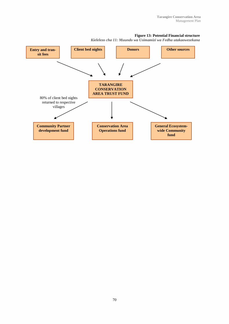
70
Tarangire Conservation Area
Management Plan
Client bed nights
80% of client bed nights
returned to respective
villages
Figure 13: Potential Financial structure
Kielelezo cha 11: Muundo wa Usimamizi wa Fedha utakaowezekana
Entry and tran-
sit fees
Donors Other sources
TARANGIRE
CONSERVATION
AREA TRUST FUND
Community Partner
development fund
Conservation Area
Operations fund
General Ecosystem-
wide Community
fund

71
Tarangire Conservation Area
Management Plan
Appendix 1: Signage
The development of a uniform design and build criteria for all signage is particularly relevant. Signage should,
while remaining subtle and unimposing, have a repeated theme that marks an association with the Conservation
Area. Additionally signage should be of a sufficient build quality that it does not rapidly degrade or be overly
susceptible to vandalism.
Signage should not be limited to directions and distances but should also show interpretative information such
as type of activities permitted, habitat, flora and fauna to be encountered and major features.
i: Construction
The signage to be used will be of stone cairns, of similar design to boundary markers with embedded informa-
tion plaques. Each plaque will be made of colour bond steel sheeting, non reflective and of a uniform size. The
colour combination should be aesthetically as well as environmentally pleasing.
The cairns should have a base of 140 cm square and skewed pyramid in shape to a height of approximately 150
cm. The face with the embedded sign should be at no less than 75 degrees from the horizontal.
The plaque should be fixed by either rivets or bolts to four metal anchors of no less than 10 cm in length ce-
mented into the cairn. Plaques should be approximately A1 in size.
The area surrounding the sign to a radius of 2.5 meters should be kept clear of long grass and other obstruc-
tions.
ii: Types of Signage
Category A: Boundary markers and boundary signs.
Boundary cairns of no less than 150 cm in height should be place no less than 250 meters apart or
closer in areas where the physical environment dictates. One in every four boundary markers should
also be embedded with signage identifying the area as well as notifying of access and non-permitted
NO HUNTING
NO CAMPING
NO UNAUTHORISED ACCESS
Tarangire Conservation Area Box 1, Monduli
Category B: Access Signage.
Access signs should be placed at major junction points between LCA roads, district roads and any
other point of access into the Conservation Area. These signs should designate the directions to the
lodges and camps within the Conservation area and in some cases also the distances to each facility.
Of particular importance is the placement of signage at these points:
Junction with the Great Uhuru Road and the Makuyuni-Naitolia road showing directions and
distances.

72
Tarangire Conservation Area
Management Plan
Junction with the Naitolia School road showing directions.
Access road at the Boundary Hill rangers post showing distances.
At the entrance gate and information centre between Silalu Hill and Radilen Kopje showing.
At the junction between the Naitolia camp road and the through road to Tarangire Treetops and
Boundary Hill showing directions.
At the junction between the Tarangire Treetops road and the through road to Boundary Hill show-
ing directions.
Other access signs maybe appropriate once all the roads and zones have been finalized.
Tarangire Conservation Area Box 1, Monduli
NAITOLIA CAMP
TARANGIRE TREETOPS
SIDAI CAMP
BOUNDARY HILL LODGE
Category C: Informative signage.
Information signage should be used in areas of particular significance detailing the type of habitat and
common wildlife found in the area. These signs are of particular benefit to visitors and are important
in establishing an identity with the environment. In particular the areas which should be covered are as
follows:
The Lemiyon Plains feature, an area of Nbuga grasslands of mixed species and heights which is
also a seasonal floodplain.
The Naitolia floodplains, an area of grasslands with medium height grasses, some herbs and many
flowering plants after the short rains. This area is also characterized on the border margins by
bush land of short acacia trees dotted with baobab and larger acacia species.
The Sand River area which is classically Riverine forest and an important watering hole for ele-
phants during the dry seasons.
The Gosuwa swamp area, an important permanent swamp area with sedges and grasses as well as
Nbuga grasslands to the east.
The Boundary Hill area, the highest feature in the ecosystem with a number of sand rivers feeding
the Tarangire River and Gosuwa Swamp from the Boundary Hill ridgeline.
Tarangire Conservation Area Box 1, Monduli
The Lemiyon Plains form one of the main migration routes for the wildebeest and zebra which leave the park in large numbers after the short rains in
November heading north east towards the plains east of Manyara. Depending on the rains the herds stay in the area till late February feeding on the fresh
grass shoots. The area is characterized by open Mbuga grasslands on “black cotton” soil (a fine dark volcanic soil) and after the long rains in March and
April, the area is covered by tall grasses of mixed species. Much of the area is impassable for several days after heavy rain and is an area where buffalo
and elephant are often found. Many species of birds including ostriches, ground hornbills and secretary birds can be found foraging on the ground on
the plains during the dry season.
LEMIYON PLAINS
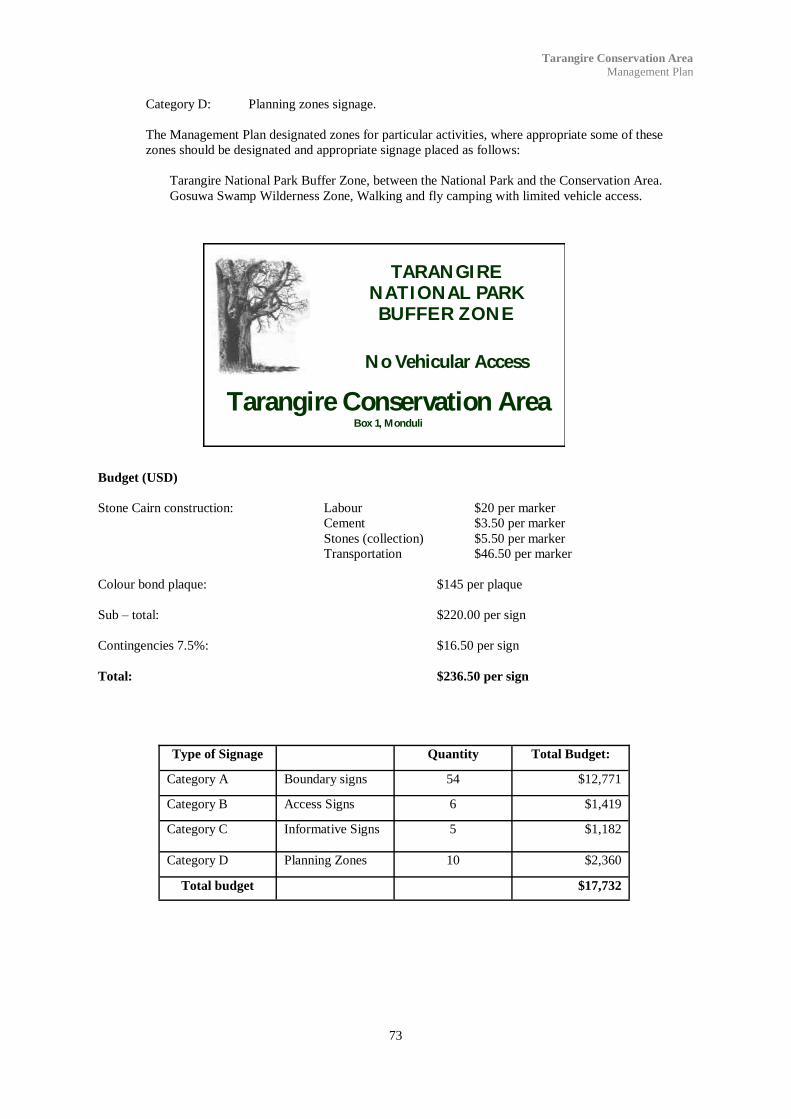
73
Tarangire Conservation Area
Management Plan
Category D: Planning zones signage.
The Management Plan designated zones for particular activities, where appropriate some of these
zones should be designated and appropriate signage placed as follows:
Tarangire National Park Buffer Zone, between the National Park and the Conservation Area.
Gosuwa Swamp Wilderness Zone, Walking and fly camping with limited vehicle access.
Tarangire Conservation Area Box 1, Monduli
TARANGIRE NATIONAL PARK BUFFER ZONE
No Vehicular Access
Budget (USD)
Stone Cairn construction: Labour $20 per marker
Cement $3.50 per marker
Stones (collection) $5.50 per marker
Transportation $46.50 per marker
Colour bond plaque: $145 per plaque
Sub – total: $220.00 per sign
Contingencies 7.5%: $16.50 per sign
Total: $236.50 per sign
Type of Signage Quantity Total Budget:
Category A Boundary signs 54 $12,771
Category B Access Signs 6 $1,419
Category C Informative Signs 5 $1,182
Category D Planning Zones 10 $2,360
Total budget $17,732

74
Tarangire Conservation Area
Management Plan
Appendix 2: Visitors centre display
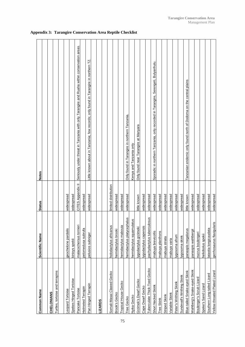
75
Tarangire Conservation Area
Management Plan
Appendix 3: Tarangire Conservation Area Reptile Checklist
Co
mm
on
Nam
e
Scie
nti
fic N
am
e
Sta
tus
No
tes
CH
EL
ON
IAN
S
Turt
les,
tort
ois
e a
nd
terr
ap
ins
Leopa
rd T
ort
ois
e
geoche
lone p
ard
alis
w
ide
spre
ad
Spekes H
inged T
ort
ois
e
kin
ixys s
pekii
wid
espre
ad
Pancake T
ort
ois
e
mala
coche
rsus to
rnie
ri
CIT
ES
Appe
nd
ix I
I S
erio
usly
und
er
thre
at
in T
anza
nia
with o
nly
Tara
ng
ire a
nd R
ua
ha w
ithin
co
nse
rvatio
n a
rea
s.
Helm
ete
d T
err
ap
in
pelo
med
usa s
ubru
fa
wid
espre
ad
Pan H
inged T
err
ap
in
pelu
sio
s s
ub
nig
er
wid
espre
ad
Little
know
n a
bo
ut
in T
anza
nia
; fe
w r
ecord
s;
only
fo
und in T
ara
ng
ire in n
ort
hern
TZ
.
LIZ
AR
DS
Som
ali-
Ma
sa
i C
law
ed G
ecko
ho
lodacty
lus a
fric
anus
limite
d d
istr
ibutio
n
Bro
ok's
Gecko
hem
idacty
lus b
rooki
wid
espre
ad
Tro
pic
al H
ouse G
ecko
hem
idacty
lus m
abo
uia
w
ide
spre
ad
Tre
e G
ecko
hem
idacty
lus p
laty
ce
pha
lus
wid
espre
ad
Only
fo
und
in T
ara
ngire in n
ort
hern
Ta
nza
nia
.
Nyik
a G
ecko
hem
idacty
lus s
quam
ula
tus
K
enya
and T
anza
nia
only
Grz
imek's
Dw
arf
Gecko
ly
go
dacty
lus g
rzim
eki
little k
now
n
Only
fo
und
nea
r T
ara
ng
ire a
t M
anyara
Cape D
warf
Gecko
ly
go
dacty
lus c
ape
nsis
w
ide
spre
ad
Tuberc
ula
te T
hic
k-T
oed
Gecko
pachydacty
lus t
ube
rculo
sus
wid
espre
ad
Short
Necked S
kin
k
mabuya b
revic
olli
s
wid
espre
ad
Spora
dic
in n
ort
hern
Ta
nza
nia
, o
nly
reco
rded
in T
ara
ngir
e, S
ere
ng
eti, B
uly
anhulu
.
Tre
e S
kin
k
mabuya p
lanifro
ns
wid
espre
ad
Str
ipe
d S
kin
k
mabuya s
tria
ta
wid
espre
ad
Varia
ble
Skin
k
mabuya v
aria
wid
espre
ad
Pete
r's W
rith
ing S
kin
k
lygo
som
a a
frum
w
ide
spre
ad
Sund
eva
ll's W
rith
ing S
kin
k
lygo
som
a s
kin
k
wid
espre
ad
Blu
e-t
aile
d S
nake
-eye
d S
kin
k
pa
na
sp
is m
ega
luru
s
little k
now
n
Ta
nza
nia
n e
ndem
ic o
nly
found n
ort
h o
f D
odom
a o
n t
he c
entr
al p
lain
s
Wahlb
erg
's S
nake
-eyed
Skin
k
pa
na
sp
is w
ahlb
erg
ii w
ide
spre
ad
Boule
nger's S
cru
b L
izard
nucru
s b
oule
ngeri
wid
espre
ad
Speke's
Sa
nd L
izard
he
liobo
lus s
pekii
wid
espre
ad
South
ern
Lo
ng
-ta
iled
Liz
ard
la
tastia lo
ng
ica
udata
w
ide
spre
ad
Ye
llow
-thro
ate
d P
late
d L
izard
gerr
ho
sa
uru
s f
lavig
ula
ris
wid
espre
ad

76
Tarangire Conservation Area
Management Plan
Co
mm
on
Nam
e
Scie
nti
fic N
am
e
Sta
tus
No
tes
Liz
ard
s (
co
nti
nu
ed
)
Gre
at P
late
d L
izard
gerr
ho
sa
uru
s m
ajo
r w
ide
spre
ad
Bla
ck-l
ine
d P
late
d L
izard
gerr
ho
sa
uru
s n
igro
lineatu
s
wid
espre
ad
Red-h
ea
ded R
ock A
gam
a
agam
a a
gam
a
wid
espre
ad
Tro
pic
al S
pin
y A
gam
a
agam
a a
rmata
w
ide
spre
ad
Fla
p-n
ecked C
ham
ele
on
cham
ae
leo d
ilep
is
wid
espre
ad
Kenya
Pygm
y C
ham
ele
on
rham
pho
leo
n k
ers
tenii
R
ecord
ed
in T
ara
ngire a
nd M
kom
azi.
White-t
hro
ate
d S
ava
nna M
onitor
va
ranus a
lbig
ula
ris
wid
espre
ad
Nile
Mo
nitor
va
ranus n
iloticus
wid
espre
ad
Sn
akes
Lin
eo
late
Blin
d S
nake
ty
phlo
ps lin
eola
tus
wid
espre
ad
Pete
r's w
orm
Snake
le
pto
typ
hlo
ps s
cutifr
ons
wid
espre
ad
South
ern
Afr
ica
n R
ock P
yth
on
pyth
on n
ata
lensis
C
ite
s A
pp
end
ix I
I
Centr
al A
fric
an R
ock p
yth
on
pyth
on s
ebae
Cite
s A
pp
end
ix I
I
Kenya
Sa
nd B
oa
ery
x c
olu
bri
nus
Cite
s A
pp
end
ix I
I S
pora
dic
in n
ort
hern
TZ
, b
ut fo
und a
t T
ara
ngire.
Bro
wn H
ouse S
nake
la
mpro
phis
fulig
ino
sus
wid
espre
ad
Cape W
olf S
nake
ly
cop
hid
ion c
ape
nse
wid
espre
ad
Fla
t-sno
ute
d W
olf S
nake
ly
cop
hid
ion d
epre
siro
str
e
wid
espre
ad
Sem
i-orn
ate
Snake
meiz
odo
n s
em
iorn
atu
s
wid
espre
ad
East A
fric
an S
ho
ve
l S
no
ut
pro
sym
na s
tuhlm
anni
wid
espre
ad
Spotted B
ush s
nake
philo
tham
nus s
em
ivarieg
atu
s
uncom
mon
Tig
er
Snake
tele
scop
us s
em
iannula
tus
wid
espre
ad
White L
ipped
Snake
cro
tap
hope
ltis
hota
mbooe
ia
wid
espre
ad
Boom
sla
ng
dis
pho
lidus t
yp
us
wid
espre
ad
Rufo
us B
eake
d S
nake
rh
am
pio
phis
ro
str
atu
s
wid
espre
ad

77
Tarangire Conservation Area
Management Plan
Co
mm
on
Nam
e
Scie
nti
fic N
am
e
Sta
tus
No
tes
Sn
akes (
co
nti
nu
ed
)
Dw
arf
Sand S
nake
psam
mop
his
ango
lensis
w
ide
spre
ad
Oliv
e S
and S
nake
psam
mop
his
mossam
bic
us
wid
espre
ad
Nort
hern
Str
ipe
-be
llied S
and S
nake
psam
mop
his
sud
ane
nsis
w
ide
spre
ad
Com
mon E
gg
-eate
r dasype
ltis
scab
ra
wid
espre
ad
Dese
rt B
lack-H
ea
ded S
nake
mic
rela
ps b
oettg
eri
scatt
ere
d
poorl
y k
now
n
Bib
ron's
Burr
ow
ing
Asp
atr
acta
spis
bib
roni
wid
espre
ad
Egyptia
n c
ob
ra
Naja
haje
scatt
ere
d
Bla
ck n
ecked s
pitting c
ob
ra
naja
nig
ricolli
s
wid
espre
ad
Bla
ck M
am
ba
de
ndro
asp
is p
oly
ep
is
wid
espre
ad
Puff
Adder
bitis
arie
nta
ns
wid
espre
ad

78
Tarangire Conservation Area
Management Plan
Appendix 4: Proposed Entrance and transit fees
Schedule 1:
Fees for clients and vehicles staying at the tourist lodges or camps within the Tarangire Conservation
Area.
Vehicles up to 1 tonne:
Fee per vehicle for 48 hour stay: $20 USD
Multiple entry
Vehicles over 1 tonne belonging to tourist lodges or camps within the Tarangire Conservation Area
No fees apply
Schedule 2:
Fees for clients and vehicles only visiting or in transit through the Tarangire Conservation Area.
Non-resident clients: $10 USD per day, single entry.
Residents: 5,000 TSH per day, single entry.
TZ citizens 1,000 TSH per day, single entry.
School children no fee
Vehicles up to 1 tonne:
Fee per vehicle: 10,000 TSH per day, single entry.
Vehicles over 1 tonne:
Fee per vehicle: 50,000 TSH per day, single entry.

79
Tarangire Conservation Area
Management Plan
Appendix 5: Minimum Anticipated Revenue for Tarangire Conservation Area, first year.
Client Night fees Bed night fees Total available
Beds
Annual fees
Boundary Hill Lodge
Tarangire Treetops
Based on 20% occupancy $15 per night 60 $65,700 USD
Naitolia, MEDA, Mswakini,
Sand River, LLWZ Camps.
Based on 15% occupancy $20 per night 100 $109,500 USD
Total $175,200 USD
Village development: 80% $140,160
Trust Fund: 20% $35,040
Client Vehicle Entry fees
Average 2.3 clients per vehicle and
average 1.6 night stay.
$20 1,190vehicles $23,800 USD
Vehicle transit fees
Average 2 vehicles per day $6,403 USD
Client transit fees
Average 1.5 clients per day $5,475 USD
Sub-Total $35,678 USD
Total (Trust fund) $70,718 USD
NOTES:
1) This is based on all tourist facilities being completed and is initial year only.
2) For Tarangire Treetops and Boundary Hill Lodge a conservative approach has been taken with regards
to occupancy rates.
3) Transit fees are estimated on the low side, as it is anticipated that these fees act as a deterrent to casual
visitors, and not as a revenue stream.
4) No other revenue source such as concession fees or donors have been included.

80
Tarangire Conservation Area
Management Plan
Appendix 6: Typical steps in the creation of a Environment Trust fund.
1. Define general vision – who and what the trust fund will support, and why. This is usually done in a consul-
tative process in which the proponents of the fund convene a series of meetings with potential stakeholders and
stakeholder groups.
2. Organize a steering committee - It needs to include both “workers” – people who have the expertise and time
to work out the detailed design, and people with clout, who can secure the necessary high-level agreements and
meetings (government ministries, international donors, etc.). The committee should also be representative of
stakeholders.
3. Develop a list of potential donors and begin meetings – they should be approached by
government, together with influential members of steering committee.
4. Secure financial support for planning/development phase – usually this is at least $100,000 not counting the
time of people on the steering committee. Expenses generally include consultant and legal fees, meeting ex-
penses, and travel for fundraising and other purposes.
Develop a more specific vision and strategy – this should be done by the steering committee in an open process
that stakeholders can participate in.
Questions to address:
Role of the trust fund in the national context – relation to national plans and strategies,
government, private sector, etc.
Legal structure of the fund (trust, foundation, etc.).
Governance (structure and composition of governing body).
Focus of grant making program – purpose, objectives, who is eligible to receive
grants, criteria for selecting them. Obviously this will change and develop over time
but a well-developed starting point is essential.
Financial projections – how much money will the fund need? What percentage will be
endowment, what percentage long-term sinking or replenishing funds? This should be
commensurate with the objectives of the grant making program – enough to achieve a
reasonable percentage of the objectives. If that calculation runs into an impossible
figure, narrow the objectives.
6. After thorough discussion of the above points, draft conclusions into a proposal for the
establishment of the fund. Consultations with donors should have been ongoing through the process. The com-
mittee is now ready to present the proposal to them. This may involve meetings with in-country officials as
well as at the donor‟s own national or international headquarters.
7. AFTER there is reasonable expectation of a donation (it‟s in process with the donor) hire a lawyer to draft
papers of incorporation and statutes or by-laws. These will define the processes for electing the governing
body.
8. Incorporate the fund and elect the governing body (which should include mostly people who have served on
the steering committee).
9. Receive initial funding, hire staff, open office, initiate grant program. If there is a delay between steps 8
and 9, and if there is sufficient start-up money, this period can be spent developing the board, preparing the
operating manuals, drafting the terms of the first call for proposals, developing application forms, etc. Public
meetings for interested parties and potential recipients explaining what the fund is all about should also be on-
going during this period.

81
Tarangire Conservation Area
Management Plan
References
Akunaay, Mustapha, Nelson, Fred and Singleton, Elizabeth: Community Based Tourism in Tanzania:
Potential and Perils in Practice, 2003.
Anderson, Ross: The Forgotten Front, The East African Campaign, 2004.
Arlin, Camilla: Queries into the severed and new entanglements of Tarangire, Tanzania, 2002.
Boner, Markus: The Increasing Isolation of Tarangire National Park, Oryx Vol 19, No. 2, 1985
Baines et al, Queens University: Investigations into establishment of a trust fund for Lolkisale Village, 2005.
Gardner, Brian: On to Kilimanjaro, The bizarre story of the First World War in East Africa, 1963.
Horden, Charles: Military Operations in East Africa, 1941.
Hoyt, Edwin: Guerilla, Colonel Von Lettow-Vorbecks and Germany‟s East African Empire, 1981.
Jones, Clive: Lolkisale Conservation Area, Management and Zoning Plan, June 2001.
Jones, Clive: Lolkisale Conservation Area, Integrated Conservation Management Plan, An Outline,
February 2002.
Lamprey, H.F: The Tarangire Game Reserve, Tanganyika Notes and Records, March 1963.
Leakey, Mary: Africa‟s Vanishing Art, The Rock Paintings of Tanzania, 1983.
Kahurananga, James and Silkiluwasha, Frank: The migration of zebra and wildebeest between Tarangire
National Park and Simanjiro Plains, northern Tanzania, in 1972 and recent trends, 1997.
Kangawana Kadzo and Ole Mako Rafael: The Impact of Community Conservation Initiatives Around
Tarangire National Park, 1997.
Miller, Charles: Battle for the Bundu, 1974.
Nshala, Rugemeleza: Granting Hunting Blocks in Tanzania, The need for reform, 1999.
Spawls, Stephen et al: A Field Guide to the Reptiles of East Africa, 2002.
TANAPA, illustrated Phillippa Parker: Tarangire National Park, A Guide, 1970
TANAPA and SEMP: Land Use Conflict in the Tarangire-Simanjiro Area, Land Use Report and Action
Proposal, December 1988.
TANAPA: Tarangire National Park Management Zone Plan, 1994
TANAPA: Tarangire National Park General Management Plan/Environmental Impact Assessment,
2001.
TANAPA: Tarangire, 2002.
TANAPA/AWF, illustrated Jonathan Scott: Tarangire National Park, 1986.
The Times History and Encyclopaedia of the War: The Campaign in German East Africa, December
1916.
WWF: Final Technical Progress Report for WWF Tarangire Project, 2003.