Tanner & Lucas 2010 - Le Moyne College
12
Deposition and deformation of fluvial–lacustrine sediments of the Upper Triassic–Lower Jurassic Whitmore Point Member, Moenave Formation, northern Arizona Lawrence H. Tanner a, ⁎, Spencer G. Lucas b a Department of Biology, Le Moyne College, 1419 Salt Springs Road, Syracuse, New York 13214, USA b New Mexico Museum of Natural History, 1801 Mountain Road, N.W., Albuquerque, New Mexico 87104, USA abstract article info Article history: Received 3 September 2009 Received in revised form 15 November 2009 Accepted 21 November 2009 Keywords: Soft-sediment deformation Fluidization Dewatering pipes Liquefaction Meromictic The stratigraphic section of the Upper Triassic–Lower Jurassic Whitmore Point Member of the Moenave Formation at Potter Canyon, Arizona, comprises c. 26 m of gray to black shales and red mudstones interbedded with mainly sheet-like siltstones and sandstones. These strata represent deposition from suspension and sheetflow processes in shallow, perennial meromictic to ephemeral lakes, and on dry mudflats of the terminal floodout of the northward-flowing Moenave stream system. The lakes were small, as indicated by the lack of shoreline features and limited evidence for deltas. Changes in base level, likely forced by climate change, drove the variations between mudflat and perennial lacustrine conditions. Lenticular sandstones that occur across the outcrop face in the same stratigraphic interval in the lower part of the sequence represent the bedload fill of channels incised into a coarsening-upward lacustrine sequence following a fall in base level. These sandstones are distinctive for the common presence of over-steepened bedding, dewatering structures, and less commonly, folding. Deformation of these sandstones is interpreted as aseismic due to the lack of features typically associated with seismicity, such as fault-graded bedding, diapirs, brecciated fabrics and clastic dikes. Rapid deposition of the sands on a fluid-rich substrate produced a reverse density gradient that destabilized, and potentially fluidized the underlying, finer-grained sediments. This destabilization allowed synsedimentary subsidence of most of the channel sands, accompanied by longitudinal rotation and/or ductile deformation of the sand bodies. © 2009 Elsevier B.V. All rights reserved. 1. Introduction Soft-sediment deformation features are known from a wide variety of depositional environments, both terrestrial and marine, but they are particularly well-reported from lacustrine and lacus- trine–deltaic depositional environments (e.g., Sims, 1973, 1975; Hesse and Reading, 1978; Seilacher, 1984; Plint, 1985; Van Loon et al., 1995; Rodrìguez Pascua et al., 2000; Rossetti and Góes, 2000; Gibert et al., 2005; Neuwerth et al., 2006; Moretti and Sabato, 2007; Singh and Jain, 2007). In most cases, however, their origins are attributed to seismic activity. One notable exception is the deforma- tion of deltaic sandstones on a Gilbert-type delta in the (Eocene) Laney Member of the Green River Formation reported by Stanley and Surdam (1978). In particular, these authors described kidney-shaped sandstone pillows formed by the (aseismic) foundering of delta-front sands into the finer-grained prodelta muds. The authors found that the axial plane of the pillows was oriented consistently perpendicular to the paleoslope direction, with the plane inclined downslope, although Potter and Pettijohn (1963) had discounted the value of such features as paleoslope indicators. On the southern Colorado Plateau of southern Utah–northern Arizona, the Whitmore Point Member of the Moenave Formation has been interpreted previously as the lacustrine-dominated portion of the mosaic of terrestrial subenvironments that comprise the upper- most Triassic to Lower Jurassic Moenave Formation (Wilson, 1967; Kirkland and Milner, 2006; Tanner and Lucas, 2007, 2009). Deposition took place in ephemeral and shallow perennial lakes on the terminal floodplain, or floodout, of the Moenave stream system. This paper examines the sedimentology of the Whitmore Point Member at Potter Canyon in northern Arizona, a location that is unique (within this formation) for the presence of soft-sediment deformation features in the lacustrine sequence. 2. Regional setting During the Early Mesozoic (Late Triassic through Early Jurassic) the Colorado Plateau was located at near-equatorial latitudes (5 ° to 15 ° N) (Scotese, 1994; Molina-Garza et al., 1995, Kent and Olsen, 1997) within a retro-arc basin on the western edge of the North American craton. The basin, the continental portion of which extended from southwestern Texas to northern Wyoming, formed Sedimentary Geology 223 (2010) 180–191 ⁎ Corresponding author. Tel.: +1 3154454537; fax +1 3154454127. E-mail address: [email protected] (L.H. Tanner). 0037-0738/$ – see front matter © 2009 Elsevier B.V. All rights reserved. doi:10.1016/j.sedgeo.2009.11.010 Contents lists available at ScienceDirect Sedimentary Geology journal homepage: www.elsevier.com/locate/sedgeo
Transcript of Tanner & Lucas 2010 - Le Moyne College

Sedimentary Geology 223 (2010) 180–191
Contents lists available at ScienceDirect
Sedimentary Geology
j ourna l homepage: www.e lsev ie r.com/ locate /sedgeo
Deposition and deformation offluvial–lacustrine sediments of theUpper Triassic–LowerJurassic Whitmore Point Member, Moenave Formation, northern Arizona
Lawrence H. Tanner a,⁎, Spencer G. Lucas b
a Department of Biology, Le Moyne College, 1419 Salt Springs Road, Syracuse, New York 13214, USAb New Mexico Museum of Natural History, 1801 Mountain Road, N.W., Albuquerque, New Mexico 87104, USA
⁎ Corresponding author. Tel.: +1 3154454537; fax +E-mail address: [email protected] (L.H. Tanner
0037-0738/$ – see front matter © 2009 Elsevier B.V. Adoi:10.1016/j.sedgeo.2009.11.010
a b s t r a c t
a r t i c l e i n f oArticle history:Received 3 September 2009Received in revised form 15 November 2009Accepted 21 November 2009
Keywords:Soft-sediment deformationFluidizationDewatering pipesLiquefactionMeromictic
The stratigraphic section of the Upper Triassic–Lower Jurassic Whitmore Point Member of the MoenaveFormation at Potter Canyon, Arizona, comprises c. 26 m of gray to black shales and red mudstonesinterbedded with mainly sheet-like siltstones and sandstones. These strata represent deposition fromsuspension and sheetflow processes in shallow, perennial meromictic to ephemeral lakes, and on drymudflats of the terminal floodout of the northward-flowing Moenave stream system. The lakes were small,as indicated by the lack of shoreline features and limited evidence for deltas. Changes in base level, likelyforced by climate change, drove the variations between mudflat and perennial lacustrine conditions.Lenticular sandstones that occur across the outcrop face in the same stratigraphic interval in the lower partof the sequence represent the bedload fill of channels incised into a coarsening-upward lacustrine sequencefollowing a fall in base level. These sandstones are distinctive for the common presence of over-steepenedbedding, dewatering structures, and less commonly, folding. Deformation of these sandstones is interpretedas aseismic due to the lack of features typically associated with seismicity, such as fault-graded bedding,diapirs, brecciated fabrics and clastic dikes. Rapid deposition of the sands on a fluid-rich substrate produced areverse density gradient that destabilized, and potentially fluidized the underlying, finer-grained sediments.This destabilization allowed synsedimentary subsidence of most of the channel sands, accompanied bylongitudinal rotation and/or ductile deformation of the sand bodies.
1 3154454127.).
ll rights reserved.
© 2009 Elsevier B.V. All rights reserved.
1. Introduction
Soft-sediment deformation features are known from a widevariety of depositional environments, both terrestrial and marine,but they are particularly well-reported from lacustrine and lacus-trine–deltaic depositional environments (e.g., Sims, 1973, 1975;Hesse and Reading, 1978; Seilacher, 1984; Plint, 1985; Van Loon etal., 1995; Rodrìguez Pascua et al., 2000; Rossetti and Góes, 2000;Gibert et al., 2005; Neuwerth et al., 2006; Moretti and Sabato, 2007;Singh and Jain, 2007). In most cases, however, their origins areattributed to seismic activity. One notable exception is the deforma-tion of deltaic sandstones on a Gilbert-type delta in the (Eocene)Laney Member of the Green River Formation reported by Stanley andSurdam (1978). In particular, these authors described kidney-shapedsandstone pillows formed by the (aseismic) foundering of delta-frontsands into the finer-grained prodelta muds. The authors found thatthe axial plane of the pillows was oriented consistently perpendicularto the paleoslope direction, with the plane inclined downslope,
although Potter and Pettijohn (1963) had discounted the value ofsuch features as paleoslope indicators.
On the southern Colorado Plateau of southern Utah–northernArizona, the Whitmore Point Member of the Moenave Formation hasbeen interpreted previously as the lacustrine-dominated portion ofthe mosaic of terrestrial subenvironments that comprise the upper-most Triassic to Lower Jurassic Moenave Formation (Wilson, 1967;Kirkland andMilner, 2006; Tanner and Lucas, 2007, 2009). Depositiontook place in ephemeral and shallow perennial lakes on the terminalfloodplain, or floodout, of the Moenave stream system. This paperexamines the sedimentology of theWhitmore Point Member at PotterCanyon in northern Arizona, a location that is unique (within thisformation) for the presence of soft-sediment deformation features inthe lacustrine sequence.
2. Regional setting
During the Early Mesozoic (Late Triassic through Early Jurassic)the Colorado Plateau was located at near-equatorial latitudes (5° to15° N) (Scotese, 1994; Molina-Garza et al., 1995, Kent and Olsen,1997) within a retro-arc basin on the western edge of the NorthAmerican craton. The basin, the continental portion of whichextended from southwestern Texas to northern Wyoming, formed

181L.H. Tanner, S.G. Lucas / Sedimentary Geology 223 (2010) 180–191
as a consequence of the initial growth of the Cordilleran magmatic arc(Dickinson, 1981; Lucas et al., 1997). Deposition of the MoenaveFormation took place during the Late Triassic to Early Jurassic across abroad, low-gradient alluvial plain (Blakey and Gubitosa, 1983;Clemmensen et al., 1989; Tanner and Lucas, 2007, 2009). Sedimen-tationwas controlled primarily by streams flowing north to northwestfrom highland source areas located approximately 500 km to thesouth and southwest, and (to a lesser extent) 200 to 300 km to theeast and northeast (Blakey and Gubitosa, 1983; Marzolf, 1994).
Basal Moenave strata were deposited unconformably on the mainlyalluvial strata of the Upper Triassic (Carnian to Rhaetian) Chinle Groupfollowing an interval of lowered base level and incision that may havecoincided with tectonic reorganization of the basin and fore-bulgemigration (Tanner, 2003a). The unconformity that separates basalMoenave strata from the Owl Rock Formation of the Chinle Group hasbeen termed the J-0 unconformity and classically has been considered tocoincide with the Triassic–Jurassic boundary (e.g., Pipiringos andO'Sullivan, 1978). However, as discussed by Lucas et al. (1997),Molina-Garza et al. (2003) and Tanner and Lucas (2007), thisunconformity is correlative with the Tr-5 unconformity that underliesthe Rock Point Formation of the Chinle Group to the east. Furthermore,as the strata both below and above this unconformity are demonstrablyTriassic in age (discussedbelow), the term J-0 is superfluous.Uppermoststrata of the Moenave Formation — of the upper Dinosaur CanyonMember and the laterally equivalent Whitmore Point Member — areoverlain disconformably by the Kayenta Formation of the Glen CanyonGroup. In the outcrop area of the Whitmore Point Member, the basalKayenta Formation consists of the locally conglomeratic, medium to
Fig. 1. Location of the study area. A) Regional setting of the study area, with outcrop limits ofsouthern flank of the Vermillion Cliffs in northernmost Arizona. PC=location of Potter CanWhitmore Point. C) Detail of B) showing location where section was measured (MS). FB=bodies marked by x. A) adapted from Biek et al. (2007) and Tanner and Lucas (2009). B) an
coarse-grained sandstones of the Springdale SandstoneMember (Lucasand Tanner, 2006).
3. Stratigraphy and age
Red beds of the Moenave Formation crop out mainly in northernArizona and southern Utah exposed prominently in the Echo Cliffs,Ward Terrace and Vermillion Cliffs, and extend westward intoeasternmost Nevada (Fig. 1; Harshbarger et al., 1957; Clemmensenet al., 1989; Irby, 1996a; Lucas and Heckert, 2001; Biek et al., 2007;Tanner and Lucas, 2007). To the south and east, the MoenaveFormation interfingers with the eolian dune sandstones and inter-dune mudstones of the Wingate Sandstone (Fig. 2), which isconsidered a partial correlative (Harshbarger et al., 1957; Clemmen-sen et al., 1989; Marzolf, 1993; Tanner and Lucas, 2007). TheMoenaveFormation forms the base of the Glen Canyon Group and consists of, inascending order, the Dinosaur Canyon andWhitmore Point Members.The Dinosaur Canyon Member comprises reddish-orange to lightbrown siltstones and sandstones of inferred fluvial and eolian origin,in varying proportions (Harshbarger et al., 1957; Clemmensen et al.,1989; Tanner and Lucas, 2007). The Dinosaur Canyon Memberoverlies the calcrete-bearing mudstones of the Owl Rock Formationof the Chinle Group with pronounced unconformity over most of theMoenave outcrop belt (Lucas 1993; Lucas et al., 1997).
The Whitmore Point Member was established by Wilson (1967) todifferentiate the purple and gray laminatedmudstones and shales in theupper part of theMoenave Formation from the orange to red sandstonesand mudstones of the underlying Dinosaur Canyon Member. Wilson
the Moenave Formation shaded (adapted from Tanner and Lucas, 2009). B) View of theyon section described herein. SG=St. George, Utah. WP=location of type section atlocation of foreset bedding shown in Fig. 6. Location of individual lenticular sandstoned C) adapted from GoogleEarth®.
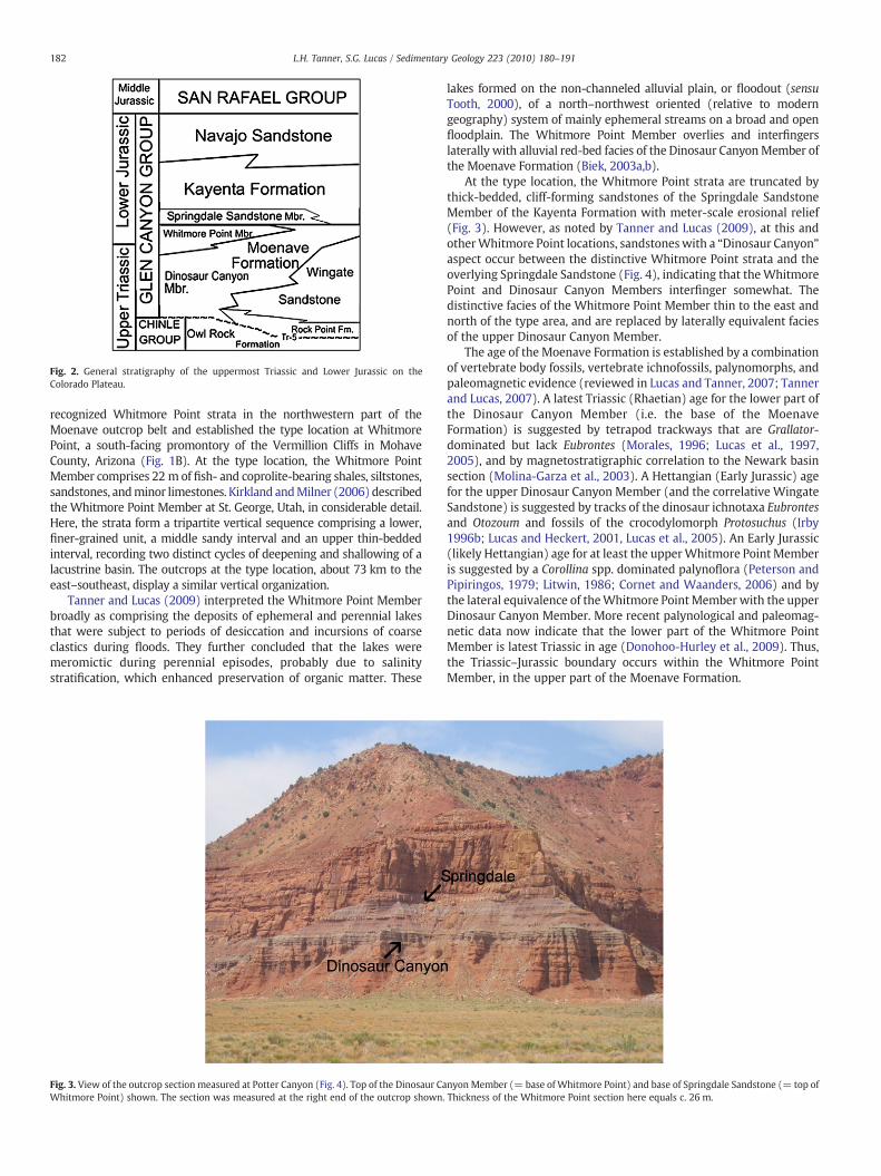
Fig. 2. General stratigraphy of the uppermost Triassic and Lower Jurassic on theColorado Plateau.
182 L.H. Tanner, S.G. Lucas / Sedimentary Geology 223 (2010) 180–191
recognized Whitmore Point strata in the northwestern part of theMoenave outcrop belt and established the type location at WhitmorePoint, a south-facing promontory of the Vermillion Cliffs in MohaveCounty, Arizona (Fig. 1B). At the type location, the Whitmore PointMember comprises 22 m of fish- and coprolite-bearing shales, siltstones,sandstones, andminor limestones. Kirkland andMilner (2006) describedthe Whitmore Point Member at St. George, Utah, in considerable detail.Here, the strata form a tripartite vertical sequence comprising a lower,finer-grained unit, a middle sandy interval and an upper thin-beddedinterval, recording two distinct cycles of deepening and shallowing of alacustrine basin. The outcrops at the type location, about 73 km to theeast–southeast, display a similar vertical organization.
Tanner and Lucas (2009) interpreted the Whitmore Point Memberbroadly as comprising the deposits of ephemeral and perennial lakesthat were subject to periods of desiccation and incursions of coarseclastics during floods. They further concluded that the lakes weremeromictic during perennial episodes, probably due to salinitystratification, which enhanced preservation of organic matter. These
Fig. 3. View of the outcrop section measured at Potter Canyon (Fig. 4). Top of the Dinosaur CaWhitmore Point) shown. The section was measured at the right end of the outcrop shown.
lakes formed on the non-channeled alluvial plain, or floodout (sensuTooth, 2000), of a north–northwest oriented (relative to moderngeography) system of mainly ephemeral streams on a broad and openfloodplain. The Whitmore Point Member overlies and interfingerslaterally with alluvial red-bed facies of the Dinosaur CanyonMember ofthe Moenave Formation (Biek, 2003a,b).
At the type location, the Whitmore Point strata are truncated bythick-bedded, cliff-forming sandstones of the Springdale SandstoneMember of the Kayenta Formation with meter-scale erosional relief(Fig. 3). However, as noted by Tanner and Lucas (2009), at this andotherWhitmore Point locations, sandstoneswith a “Dinosaur Canyon”aspect occur between the distinctive Whitmore Point strata and theoverlying Springdale Sandstone (Fig. 4), indicating that theWhitmorePoint and Dinosaur Canyon Members interfinger somewhat. Thedistinctive facies of the Whitmore Point Member thin to the east andnorth of the type area, and are replaced by laterally equivalent faciesof the upper Dinosaur Canyon Member.
The age of the Moenave Formation is established by a combinationof vertebrate body fossils, vertebrate ichnofossils, palynomorphs, andpaleomagnetic evidence (reviewed in Lucas and Tanner, 2007; Tannerand Lucas, 2007). A latest Triassic (Rhaetian) age for the lower part ofthe Dinosaur Canyon Member (i.e. the base of the MoenaveFormation) is suggested by tetrapod trackways that are Grallator-dominated but lack Eubrontes (Morales, 1996; Lucas et al., 1997,2005), and by magnetostratigraphic correlation to the Newark basinsection (Molina-Garza et al., 2003). A Hettangian (Early Jurassic) agefor the upper Dinosaur Canyon Member (and the correlative WingateSandstone) is suggested by tracks of the dinosaur ichnotaxa Eubrontesand Otozoum and fossils of the crocodylomorph Protosuchus (Irby1996b; Lucas and Heckert, 2001, Lucas et al., 2005). An Early Jurassic(likely Hettangian) age for at least the upperWhitmore Point Memberis suggested by a Corollina spp. dominated palynoflora (Peterson andPipiringos, 1979; Litwin, 1986; Cornet and Waanders, 2006) and bythe lateral equivalence of theWhitmore Point Member with the upperDinosaur Canyon Member. More recent palynological and paleomag-netic data now indicate that the lower part of the Whitmore PointMember is latest Triassic in age (Donohoo-Hurley et al., 2009). Thus,the Triassic–Jurassic boundary occurs within the Whitmore PointMember, in the upper part of the Moenave Formation.
nyon Member (= base of Whitmore Point) and base of Springdale Sandstone (= top ofThickness of the Whitmore Point section here equals c. 26 m.

Fig. 4. Section of Whitmore Point Member of Moenave Formation section measured at location in Fig. 3. Lithologies are indicated by the grain-size scale at the base of the figure.
183L.H. Tanner, S.G. Lucas / Sedimentary Geology 223 (2010) 180–191
4. Potter Canyon section
4.1. Lithostratigraphy
This paper examines the sedimentologic features of the WhitmorePoint Member on the cliffs immediately to the west of Potter Canyon,which is located to the west of Whitmore Point. Although similarlithologically to the section at the type location (at Whitmore Point),
the thickness and vertical arrangement of these facies at PotterCanyon differs somewhat. Themeasured section for Potter Canyon is asouth-facing promontory in Mohave County in northern Arizona at36° 52.872′ N, 112° 52.083′ W, about 3.9 km WNW of the WhitmorePoint type location (Tanner and Lucas, 2009). The boundary betweenthe Whitmore Point Member and underlying Dinosaur CanyonMember at Potter Canyon is demarcated by a distinct change incolor of the rocks, from orange-reddish mudstone and very fine-

184 L.H. Tanner, S.G. Lucas / Sedimentary Geology 223 (2010) 180–191
grained sandstone (of the Dinosaur Canyon Member) to grayish andpurple red hues, and by an increased proportion of mudstone (in theWhitmore Point Member) (Figs. 3 and 4). Most distinctive in theWhitmore Point Member are beds of dark gray to black mudstone andshale that do not occur in the Dinosaur Canyon Member.
At Potter Canyon, the uppermost strata of the Dinosaur CanyonMember consist of red mudstones and very fine-grained sandstonesdisplaying small-scale trough cross-beds and ripple lamination. Theoverlying Whitmore Point Member consists of 26.2 m of gray, purple,reddish-brown and ochre-hued shale, siltstone and sandstone (Fig. 3).The section is capped by 1.8 m of lenticular bodies of fine-grainedsandstone displaying trough cross-bedding and containing discontin-uous (laterally truncated) lenses of mudstone. These uppermostsandstones strongly resemble sandstones that occur in the underlyingDinosaur Canyon Member, and they contrast with the coarse-grainedsandstones and intraformational conglomerates that occur immedi-ately above. The latter we assign to the Springdale Sandstone Memberof the Kayenta Formation, while the former we tentatively assign tothe Dinosaur Canyon Member.
In the Whitmore Point Member, individual shale, mudstone andsiltstone beds are decimeters to meters thick and exhibit lateralcontinuity on outcrop scale (up to hundreds of meters). Shale beds are30 cm to 2.6 m thick, purple to black, and contain conchostracans, fishscales and coprolites. Mudstones are 20 cm to 1.7 m thick, reddish-brown to gray to purple, and commonly contain thin (cm-thick)interbedded laminae of rippled, very fine-grained sandstone orsiltstone. Siltstone beds are up to 1.8 m thick, brown to gray toochre-hued and blocky to ripple-laminated. The sandstone beds are30 cm to 1.8 thick, but more variable in thickness than the finer-grained lithologies, with individual beds varying from meter-scale tocentimeter-scale thickness, or pinching out altogether across thevisible outcrop face (Fig. 5). Most sandstone beds exhibit an even,tabular geometry, but several display pronounced thickness changesover distances of a few tens of meters and have a flat-based, convexgeometry (Fig. 5). Sandstone beds are typically very fine-grained andmostly display ripple lamination or horizontal lamination gradingupward to ripple lamination, and in some instances, climbing ripples.Desiccation cracks, typically less than a few centimeters wide,penetrate from the bases of sandstone beds through mudstone orsiltstone beds to a depth of 10 to 20 cm (Fig. 5). Lenticular sandstonebodies with meter-scale thickness but limited lateral extent occur at asingle horizon at about 9.0 m above the base of the member in themeasured section (Figs. 4 and 6). These sandstone bodies, most of
Fig. 5. Detail of Fig. 3 illustrating general sheet-like geometry of tabular sandstones(lower) and laminated mudstones (above). Arrow indicates point of sandstone lateralpinchout and convex bedding. Desiccation cracks (dc) occur in the lower part of thesection.
which display evidence of soft-sediment deformation, are describedbelow.
The contact between the sandstones and finer-grained beds istypically sharp and non-erosive, with the exception of the lenticularsandstones described above. For the most part, sandstone beds areflat-lying and conformable with the finer-grained surrounding beds;discordance in bedding angles (beds dipping at a significant angle toregional dip) occurs in the lower part of the section (between 7.6 mand 9.0 m in themeasured section), but is visible only in some outcropfaces oriented in a north to northeasterly direction. In some outcropviews, interbedded siltstone–sandstone units, 1.0 to 1.5 m thick, dipto the northeast at angles of 15° to 20° (Fig. 6). The lenticularsandstones described below occur within a single horizon immedi-ately above these dipping beds.
Although the vertical changes in grain size between individualbeds typically is very abrupt, more gradual changes among groups ofbeds (i.e. fining-upward and coarsening-upward sequences) areevident. For example, a pronounced fining-upward trend, fromripple-laminated sandstone to shale, is displayed between 2.5 m and7.5 m in the measured section (Fig. 4), and again between 24.7 m and26.2 m at the very top of the Whitmore Point Member. Only onecoarsening-upward sequence is evident in the measured section;shale at 7.0 m coarsens upward to ripple-laminated sandstone at9.0 m.
4.2. Deformed sandstones
The most unusual feature of the sedimentary section at PotterCanyon is the presence of a horizon of lenticular sandstone bodies,most displaying over-steepened, folded and/or disturbed bedding.Locations where we observed these sandstones are marked on Fig. 1C.The thickness of the sandstone bodies is variable, ranging from 2.0 mto 6.2 m, but the tops appear to share a common stratigraphic horizon.Although these sandstones are not present at the location measuredfor the section in Figs. 3 and 4, this horizon correlates toapproximately 9 m above the base of the Whitmore Point Member,which places it above the black shale at 5.0 m to 7.6 m in themeasured section and above the northeastward dipping strata inFig. 6. The widths of the outcrop exposures of the sandstones varyfrom 4.4 m to 30 m. The axis of elongation of these sandstone bodies isin a general N–S direction, with the orientation of the axis forindividual sandstones varying from N15°W to N40°E.
Not all of these lenticular sandstones are deformed. Fig. 7A, forexample, is a view to the northwest of a 6-m thick sandstone body.Bedding within this sandstone is dominated by horizontal lamination.Most of the lenticular sandstone bodies in which bedding is preservedcomprise predominantly horizontally laminated sandstone andtrough cross-bedded sandstone, with sets of trough cross-beds10 cm to 40 cm thick (Fig. 7B), and subordinate planar cross-beds.
However, most of the sandstone bodies at this stratigraphic leveldisplay some evidence of deformation, either through rotation,vertical transposition, folding, or some combination thereof. Themost common style of deformation of the lenticular sandstones islongitudinal rotation, i.e., rotation of the sandstone body around anaxis parallel to the direction of elongation, associated with downwardmovement. Fig. 8A–C are views of lenticular sandstones elongated tothe northwest (outcrop orientation: north–northeast is to the right inthese views). Each of these sandstones has undergone rotation with aclockwise sense (relative to the view), resulting in inclination of thebedding to the northeast. The result for the sandstones in Fig. 8A and Bis the formation of a pillow shape and over-steepening of the bedding.The sandstones in Fig. 8A–D also share the characteristic that theydisplay a fanning geometry of the bedding; i.e. the angle of inclinationof the bedding decreases systematically from left to right. This effect ismost pronounced in Fig. 8A and B, where the bedding on the leftmargin is near vertical (in Fig. 8A) to slightly overturned (in Fig. 8B),

Fig. 6. View of cliff face immediately to the east of the measured section (at the location marked fb on Fig. 1C). The dipping beds to the left are interpreted as delta foreset beds (fb).Two lenticular sandstone bodies (ls) exhibiting over-steepened bedding are to the right of the dipping beds. The interpreted foresets and the lenticular sandstones occur above thelowest black shale at 5.0 m to 7.5 m in the measured section (Fig. 4).
185L.H. Tanner, S.G. Lucas / Sedimentary Geology 223 (2010) 180–191
and decreases to as little as 30° (in 8A) at the right margin. Fig. 8Cdemonstrates the variability of the direction of rotation; this is a viewof a northeastward-oriented lenticular sandstone (south is to the rightin the photograph). The bedding top is away from the viewer in this
Fig. 7. Undeformed lenticular sandstones in lower part of Whitmore Point Member.A) View of sandstone body about 6 m thick and 30 m wide that lacks features ofdeformation. B) Trough cross-bedding occurs at the tops of many of the lenticularsandstones (staff is 1.5 m).
example, indicating the sandstone has rotated to the northwest. InFig. 8D, it is clear that the rotation occurred by vertical slip along aplanar surface on the right (northeast) margin of the sandstone.
Over-steepened bedding (Fig. 9A–B), in which beds in the lowerpart of the body attain dips of 50° to 60°, is a common feature of manyof the sandstones. The direction of dip appears bimodal; in somesandstones the beds dip nearly due east, as in Fig. 9A and B, but othersdip nearly due west. We did not observe northerly or southerly dips,however. Notably, the over-steepened bedding is overlain in manyinstances by undeformed bedding, apparently disconformably. Thebedding at the base of these sandstones commonly displays somedegree of disruption, such as pseudoanticlines and pseudosynclines(Fig. 9C).
In some instances, the sandstone bodies display plastic deformation,or folding involving the entire body of narrow sandstones, or partialfolding of wider sandstone bodies (Fig. 9D–F). Folding of narrowsandstone bodies may be expressed by simple synclinal deformation.Fig. 9D illustrates a sandstone that has folded asymmetrically; the axis offolding parallels the axis of elongation of the sandstone body (N15°E)and is inclined to the southeast, suggesting longitudinal rotation of theentire body with a northwesterly sense. This particular sandstone bodyalso is notable for the presence of a pair of near-horizontal joint surfacesthat appear unrelated to exhumation and modern slope instability.Fig. 9E and F illustrate the folding of one side of a wider sandstone body.In these figures (the view is to the north–northwest) the entiresandstone body appears rotated to the west, and the eastern margin ofthe sandstone (to the right in Fig. 9E) is folded to the west, as clearlyillustrated in Fig. 9F. Significantly, the bedding of the strata underlyingthis sandstone exhibits similar deformation, wrapping around theeastern margin of the sandstone body. Many of the deformedsandstones described above also contain evidence of rapid dewatering;in particular, dewatering pipes are prominent in folded and over-steepened strata (Fig. 10A,B). These are cyclindrical features, 3 cm to5 cm wide and 20 cm to 40 cm long, oriented perpendicular to theoriginal bedding attitude.
5. Interpretation
5.1. Sedimentology of the Potter Canyon section
Tanner and Lucas (2007, 2009) interpreted the laterally continu-ous shales, mudstones and siltstones of the Whitmore Point Member

Fig. 8. Sandstone bodies in Whitmore Point Member of Moenave Formation displaying evidence of rotation. A–B) Sandstone pillows exhibiting bedding over-steepened to right(northeast) due to clockwise rotation. C) Lenticular sandstone in which direction of rotation is to the west (bedding top is away from viewer). D) The rotation of this sandstone bodyappears to have taken place along a planar slip surface (ss) on the right. The top of the black shale (bs) unit is visible just below the sandstone.
186 L.H. Tanner, S.G. Lucas / Sedimentary Geology 223 (2010) 180–191
as the deposits of mostly shallow, ephemeral to perennial, clastic-dominated lakes of varying size. These lakes formed downstream ofthe Dinosaur Canyon dryland stream system on open floodplains, orfloodouts (Tooth, 2000; Fisher et al., 2007; Nichols and Fisher, 2007;Tanner and Lucas, 2009). Rising base level during the late part of theinterval of Moenave deposition caused partial inundation of thefloodout and formed numerous broad but shallow lakes. Thus, theWhitmore Point strata were deposited on the terminal floodplain ofthe Moenave (Dinosaur Canyon) alluvial system, during an interval ofhigh base level that allowed the water table to intersect thetopographic surface episodically. The general correlation of thegray-black shale intervals between the Potter Canyon and WhitmorePoint locations supports the interpretation that, at least locally, lakedepth was controlled by changes in base level.
The Whitmore Point lakes hosted a fauna consisting primarily ofabundant and diverse semionotid fish, hybodont sharks, lungfish andsizable (1 to 2 m long) coelacanths (Milner and Kirkland, 2006). Theinvertebrate fauna included conchostracans and various invertebrateburrowers. Shales were deposited from suspension during lakehighstands in a water body with a non-vegetated bottom. The darkgray to black shale at 5.0 m to 7.6 m in the measured section indicatesdeposition during lake highstand in a stratified water column withdysaerobic bottom conditions that prevented aerobic decompositionor development of a benthic infaunal community. This particular bedis unique in the section for its high organic content, although othershale beds in the section are gray to grayish purple. Periodicshallowing of the lakes, culminating in evaporation and desiccationof these water bodies, is evidenced by the occurrence of sand-filleddesiccation cracks at the bases of some sandstones (Fig. 5).
Themiddle portion of theWhitmore PointMember comprises thinlyinterbedded red mudstones, siltstones and sandstones. These weredeposited in shallow, ephemeral lakes to drymudflats duringan intervalof overall lowbase level. Deposition tookplace byunconfined sheetflow,when the mudflat was emergent, and a combination of suspension totraction currents when it was inundated. During episodes of lower baselevel, sheetflood events deposited tabular sheets of mostly non-gradedsand across a broad alluvial mudflat (Talbot et al., 1994). On someoccasions, the sheetflow produced convex-shaped bar forms on theplaya (Olsen, 1989). During episodeswhen themudflatwas submerged,or when it became inundated during flood events, sheetflow built sheetdeltas, i.e. tabular sheets of graded sandandmud thatweredeposited bywaning flow in standing water (Smoot and Lowenstein, 1991).
The size and depth of theWhitmore Point lakes are not immediatelyobvious. Lateral continuity of individual beds is exhibited on the outcropscale for tens to hundreds of meters, but does not extend to outcropsseparated by several kilometers, i.e. between Potter Canyon andWhitmore Point. Therefore, we interpret the individual lakes as bodiesof limited lateral extent, with surface areas that likely did not exceedseveral tens of km2 to at most 100 km2. Despite the occurrence oforganic-rich facies, we interpret the lakes as shallow, even duringhighstands. Consequently, the abrupt changes in lithologies, e.g., graymudstone to red mudstone or sandstone, reflect, in many instances,similarly abrupt changes between perennial and ephemeral lacustrineor playa mudflat conditions that produced no record of shorelineprogradation (Bohacs et al., 2000). The single identifiable coarsening-upward sequence in the Potter Canyon section contains packages ofnortheast-dipping siltstone–sandstone beds that we interpret as theforesets of a small Gilbert-type delta (Fig. 6) that prograded

Fig. 9. Features of sandstone deformation. A–B) Views of sandstone bodies with over-steepened bedding overlain disconformably by undeformed trough cross-bedded sandstone(arrows). C) Disrupted bedding at base of sandstone with over-steepened bedding. Disruption consists of pseudoanticline (up arrow) and pseudosyncline (down arrow).D) Lenticular sandstone exhibiting gentle synclinal folding. Planar cross-bedding (Sp) is visible in the upper part of the sandstone, but the lower part of the unit is massive (Sm).Near-horizontal joints (js) truncate the bedding on the left side. E) Lenticular sandstone body displaying general counter-clockwise rotation and folding of the eastern flank of thebody. Note that the underlying, finer-grained strata are folded parallel to the edge of the sandstone. F) Detail of folded flank of sandstone in E) illustrating the ductile behavior of thesandstone.
187L.H. Tanner, S.G. Lucas / Sedimentary Geology 223 (2010) 180–191
northeastward into the Whitmore Point lake when it was at maximumhighstand, as suggested by the black shales underlying these foresets.The limited thickness of these foreset beds, however, when adjusted forsediment compaction, suggests that the water depth into which thedelta prograded was on the order of 5 to 10 m.
As discussed in Tanner and Lucas (2009), neither size nor depthwasa prerequisite for high organic accumulation in the Whitmore Pointlakes. For example, Turcq et al. (2002) described a number of small (b10 km2) tropical lakes in Brazil, located in a strongly seasonal climate,and found very highorganicflux rates that correlated primarilywith the
watershed area. Such a climate would have prevailed on the ColoradoPlateau during the Late Triassic to Early Jurassic (Parrish, 1993; Tanner,2000, 2003b; Tanner and Lucas, 2007). Small, meromictic lakes also areprone to salinity stratification, which promotes dysaerobic bottomconditions, even at shallow depth, and further enhances organicpreservation, as demonstrated by Last et al. (2002). Bohacs et al.(2000) described evaporative lakes (those in underfilled basins) ascharacterized by thin (decimeter-scale) depositional sequences,marked by highly contrasting, laterally persistent facies boundaries,similar to the Whitmore Point facies. The Wilkins Peak Member of the

Fig. 10. Dewatering features of the deformed sandstones. A) Dewatering pipes orientedperpendicular to bedding in over-steepened sandstone. B) Oblique view of dewateringpipes in over-steepened sandstone.
188 L.H. Tanner, S.G. Lucas / Sedimentary Geology 223 (2010) 180–191
(Eocene) Green River Formation provides an example of a lake inwhichorganic productivity was promoted by the evaporatively enhancedalkalinity of the lake waters, and organic preservation facilitated byrapid burial (Bohacs et al., 2000; Pietras and Carroll, 2006).
Most of the Whitmore Point Member consists of reddish-brown toreddish-purple mudstones interbedded with decimeter-scale flat bedsof reddish to ochre-hued siltstones and sandstones. The thinness of thebedding, color and the abundance of desiccation cracks in theselithologies provide ample evidence for deposition under oxidizingconditions in shallow to ephemeralwater bodieswith the coarser clasticsediments provided by episodes of rapid sheetflow. As these lakesformed on a broad, alluvial floodout without effective impoundment,water depth was controlled entirely by base-level change, and typicallywas shallow to ephemeral (Carroll and Bohacs, 1999). In this setting, theseasonal, semi-arid climate caused evaporative concentration of thewater ponded in depressions on the floodout, resulting in salinitystratification of the water column and meromictic conditions. Short-term changes in base level probably reflected climatic variations, whilelonger-termchanges (i.e. shifts between alluvial and lacustrine systems)may have resulted from eustasy, although paleogeographic reconstruc-tion which place the study area c. 300 km from the paleoshoreline(Scotese, 1994) make eustatic controls somewhat problematic.
5.2. Lenticular sandstone bodies
The elongate geometry of the lenticular sandstones that occur about9 m above the base of theWhitmore Point Member indicates that thesewere the bedload fill of alluvial channels. The bedforms within thesechannels (where recognizable) consist predominantly of horizontal
lamination and trough cross-bedding, and minor planar cross-bedding,which suggest that the channel-fill sedimentation was controlledmainly by flashy stream discharge, as is common in dryland riversystems (Tunbridge, 1981; Sneh, 1983; Olsen, 1989; Tooth, 2000; Fisheret al., 2007). This interpretation is broadly consistentwith that of Tannerand Lucas (2007) for the Dinosaur Canyon stream system. Rather thanflowing across an alluvial plain, however, these channels were incisedinto the coarsening-upward sedimentary sequence, consisting in part ofa Gilbert delta, thatwas deposited in theWhitmore Point lake followingbase-level highstand. This episode of alluvial incision likely recordedfalling base level, as the overlying 10 m of strata consist entirely ofreddish muds and ripple-laminated to sheet-like siltstones andsandstones, with abundant desiccation cracks. The change in baselevel was temporary, as highstand conditions returned later duringWhitmore Point deposition, and so was likely driven by climate change(aridification). Fisher et al. (2007) remarked on the potential forclimatically driven base-level changes to force cycling betweenlacustrine and alluvial systems within a basin.
Deformation of the channel sands appears primarily to haveinvolved subsidence of the semi-coherent sand bodies into a soft,fluid-rich substrate. In some instances, the subsidence was contempo-raneous with channel sedimentation, as indicated by the occurrence ofundeformed channel sandstones that cap sandstone sequences withover-steepened bedding. Other sand bodies experienced penecontem-poraneous subsidence and rotation, with rotation in the directiontowards one of the channelmargins. This rotation resulted fromunevensubsidence of the channel; i.e. one side of the channel rotated fartherthan the other, causing the channel to rotate about its longitudinal axis.In several cases, the subsidence generated shear stress that causedductile deformation of one or both of the channel margins, creatingbroad syncline-like folds. Concomitant deformation of the underlying,finer-grained strata from the pressure of the subsiding sand body isevidencedby folding of these strata parallel to the base of the sandbody.This evidence for plasticity and the general (but not complete) lack ofevidence for brittle deformation is consistent with the presence ofdewatering structures. Although liquefaction didnot producegrainflowin these sands, e.g. clastic dikes, it did reduce the grain-contact strengthsufficiently to allow ductile behavior. These features also demonstratethat subsidence occurred before significant lithification of the sands.One exception to this is shown in Fig. 9D, where horizontal joints in thesandstonemay indicate a zone of strain accommodation to the stress offolding, demonstrating partial brittle behavior of the sandstone body.
In the Whitmore Point sand bodies, there are no clear examples offlame structures, as are produced by fluidization and upward injectionof the underlying sediments. For the most part, however, weatheringof the finer-grained sediments that underlie and surround thesandstone bodies has obscured the nature of the bedding in thesestrata. In some cases, it is clear that the underlying strata weredeformed in response to the loading produced by subsidence, but thetrue extent of fluidization of the fine-grained sediments beneath thechannels is unknown. The record for the channel sands is muchclearer; these experienced rapid water loss, recorded by thedewatering pipes. The preservation of bedding features and sedimen-tary structures in most of these sandstones demonstrates that thesands did not experience turbulence and grain flow during liquefac-tion, but instead remained coherent to semi-coherent. Conversely, thedeformational processes associated with these sandstones did notinvolve significant brittle failure of bedding. Although most of thesandstone bodies display some jointing, for the most part, theseappear to be either weathering-enhanced bedding surfaces or cross-cutting fractures that have been created by modern slope instability.
6. Discussion
Soft-sediment features in continental sediments commonly areattributed to seismic activity. There exists an extensive literature

189L.H. Tanner, S.G. Lucas / Sedimentary Geology 223 (2010) 180–191
devoted to the recognition of ancient seismites, with field examplesranging in age from Ordovician to Holocene (e.g., Seilacher, 1969,1984; Vittori et al., 1991; Johnston and Schweig, 1996; Obermeier,1996; Pope et al., 1997; Obermeier, 1998; Ettensohn et al., 2002;Merriam and Förster, 2002; Mariotti et al., 2002; Wheeler, 2002). Theinterpretation of seismites in the stratigraphic record typically isbased on the recognition of such features as clastic dikes and sandblows (Talwani and Cox, 1985; Obermeier et al., 1990; Obermeier,1996), formed by rapid liquefaction of buried sediment beds with ahigh pore pressure. Numerous other structures may be formed byseismic disturbance of sedimentary bedding; these include: fault-graded bedding, ball and pillow structures, flame structures, diapirs,wash-basin structures, boudins, and brecciated fabrics (Seilacher,1969, 1984; Scott and Price, 1988; Dugué, 1995; Jones and Omoto,2000; McGlaughlin and Brett, 2004). Many of these features resultfrom thixotropic movements of destabilized, fine-grained sediment–water mixtures.
A list of criteria for recognizing seismites was presented by Sims(1975) and subsequently revised by Wheeler (2002); deformationfeatures with a seismic origin should 1) display evidence of suddenformation, 2) display evidence of synchroneity, 3) exhibit a zoneddistribution (amplitude decreasing outward), 4) exhibit an amplitudecommensurate with a seismic origin, 5) occur in a tectonic settingwhere seismic activity is likely, and 6) occur in a depositional settingwhere seismic shaking is likely to cause sediment deformation. Theoccurrence of all of the lenticular sandstone bodies at Potter Canyon ata common stratigraphic horizon demonstrates at least approximatesynchroneity of their formation (criterion 2), and the abundance ofdewatering structures provides evidence of suddenness of formation(criterion 1). The extent of deformation observed at Potter Canyon islimited, however. We note that deformation in the sandstone bodiesconsists solely of over-steepened and rotated bedding, minor foldingand water escape structures. Features of more severe deformation,such as extensively convoluted bedding, bed brecciation, microfault-ing, shear planes, clastic dikes and sand volcanoes, all commonlyassociated with deformation by seismic shock (Seilacher, 1969, 1984;Scott and Price, 1988; Obermeier et al., 1990; Dugué, 1995;Obermeier, 1996; Jones and Omoto, 2000; McGlaughlin and Brett,2004; Koç Taşgin and Türkmen, 2009) are absent in this section.Additionally, the limited lateral distribution of the deformationfeatures at Potter Canyon, combinedwith the total lack of deformationof some lenticular sandstones in the same horizon as those that aredeformed, or of the strata adjacent to the deformed beds, suggeststhat these features did not result from a seismic event.
Rather, the evidence indicates that deformation was aseismic.Various aseismic mechanisms have been proposed to account for thenumerous morphologies of soft-sediment deformation structures,including slope collapse, unevenly distributed surface load, deposi-tional gradient, tangential shearing and inverted density gradients(see review in Owen, 1996). Some of the Whitmore Point sandstonebodies resemble in size and shape the sandstone pillows in the LaneyMember of the Green River Formation, as described by Stanley andSurdam (1978). These authors ascribed destabilization of thesediments to the depositional gradient on the front of a Gilbert-typedelta. However, we find no evidence for such a depositional gradientat the horizon in which the Whitmore Point sandstone bodies occur.
Both field observations and experimentation have confirmed theimportance of reverse density gradient in particular in creatinggravitational instability in sediments (Blatt et al., 1972; Lowe, 1975;Allen, 1982; Owen, 1987; Selker, 1993; Owen, 1996; Rossetti, 1999;Jones and Omoto, 2000; Owen, 2003). The resultant loss of shearstrength and fluidization is recorded by various types of load casts,ball and pillow structures and dewatering structures (Lowe andLoPiccolo, 1974; Lowe, 1975; Mills, 1983; Maltman, 1994; Moretti etal., 2002; Maltman and Bolton, 2003; Neuwerth et al., 2006; KoçTaşgin and Türkmen, 2009). The fluid mechanics of load cast
formation by reverse density gradients were examined by Selker(1993), who found that the simultaneous descent of the overlyingdenser layer and the ascent of the underlying less dense layer requiresthat fluidization takes place in both. Notably, this author found thatonly small (b 10 cm) structures are formed if Newtonian fluidproperties are assumed; higher sediment–mixture viscosities resultin larger load structures.
Initiation of the deformation requires some trigger that decreasessediment strength, such as an increase in pore pressure caused byloading (Jones and Omoto, 2000; Oliveira et al., 2009). Although thereis a lack of direct evidence for fluidization, i.e. flame structures are notobserved in the section, we conclude that deformation of theWhitmore Point channel sands was a synsedimentary response torapid sediment loading and instability resulting from the superposi-tion of more dense sediment (sand) over less dense sediment (mud)and the consequent increase in pore pressure. Not all of the channelsands need to have subsided at exactly the same time. More likely,foundering of the channels occurred on an individual basis soon afterdeposition.
7. Conclusions
Detailed field observations of the Whitmore Point Member atPotter Canyon support earlier interpretations of the general sedimen-tology of these strata from other locations. The organic-rich shales,mudstones, siltstones and sandstones were deposited in shallow,perennial meromictic to ephemeral lakes and on dry mudflats on theterminal floodout of the northward-flowing Moenave stream system.The lakes were small, as indicated by the limited evidence of shorelinefeatures and for the growth of deltas, but high productivity andpossibly salinity stratification allowed preservation of organic-richfacies during highstand intervals. Changes in base level, likely forcedby climate change, forced the variations between mudflat andlacustrine conditions.
Lenticular sandstones at the top of a coarsening-upward sequencerepresent the bedload fill of channels incised into the top of thelacustrine-fill sequence following a fall in base level. Rapid depositionof the sands produced a reverse density gradient that destabilized,and possibly fluidized, the underlying, finer-grained sediments. Thisdestabilization caused synsedimentary subsidence of most of thechannel sands, accompanied by longitudinal rotation that causedover-steepening and/or ductile deformation of the sand bodies.
Acknowledgments
Publication of this manuscript was facilitated by the kind editorialassistance of B. Jones and the insightful reviews provided by W. Lastand R. Biek.
References
Allen, J.R.L., 1982. Sedimentary structures: their character and physical basis.Developments in Sedimentology, vol. 30. Elsevier, Amsterdam. 663 pp.
Biek, R.F., 2003a. Geologic map of the Harrisburg Junction quadrangle, WashingtonCounty, Utah. Utah Geological Survey Map 191, 42 p., 2 plates, scale 1:24,000.
Biek, R.F., 2003b. Geologic map of the Hurricane quadrangle, Washington County, Utah.Utah Geological Survey Map 187, 61 p., 2 plates, scale 1:24,000.
Biek, R.F., Rowley, P.D., Hacker, D.B., Hayden, J.M., Willis, G.C., Hintze, L.F., Anderson, R.E.,Brown,K.D., 2007. Interimgeologicmapof theSt. George30′x60′quadrangle andeastpart of the Clover Mountains 30′×60′ quadrangle, Washington and Iron Counties,Utah: Utah Geological Survey Map, 2 plates, scale 1:100,000.
Blakey, R.C., Gubitosa, R., 1983. Late Triassic paleogeography and depositional history ofthe Chinle Formation, southern Utah and northern Arizona. In: Reynolds, M.W.,Dolly, E.D. (Eds.), Mesozoic Paleogeography of the West- Central United States.Rocky Mountain Section SEPM, Denver, pp. 57–76.
Blatt, H., Middleton, G., Murray, R., 1972. Origin of Sedimentary Rocks. Prentice-Hall,Inc, Englewood Cliffs, New Jersey. 634 pp.
Bohacs, K.M., Carroll, A.R., Neal, J.E., Mankiewicz, P.J., 2000. Lake basin type, sourcepotential and hydrocarbon character: an integrated sequence–stratigraphic–geochemical framework. In: Gierlowski-Kordesch, E.H., Kelts, K.R. (Eds.), Lake

190 L.H. Tanner, S.G. Lucas / Sedimentary Geology 223 (2010) 180–191
Basins Through Space and Time: American Association of Petroleum GeologistsStudies in Geology, vol. 46, pp. 3–34.
Carroll, A.R., Bohacs, K.M., 1999. Stratigraphic classification of ancient lakes; balancingtectonics and climatic controls. Geology 27, 99–102.
Clemmensen, L.R., Olsen, H., Blakey, R.L., 1989. Erg-margin deposits in the LowerJurassic Moenave Formation and Wingate Sandstone, southern Utah. GeologicalSociety of America Bulletin 101, 759–773.
Cornet, B., Waanders, G., 2006. Palynomorphs indicate Hettangian (Early Jurassic) agefor the middle Whitmore Point Member of the Moenave Formation, Utah andArizona. NewMexico Museum of Natural History and Science Bulletin 37, 390–406.
Dickinson, W.R., 1981. Plate tectonic evolution of the southern Cordillera. ArizonaGeological Society Digest 14, 113–135.
Donohoo-Hurley, L.L., Geissman, J.W., Lucas, S.G., Kuerschner,W., 2009. The Triassic/Jurassicboundary, ColoradoPlateauarea, USA:magnetostratigraphic correlationof theMoenaveFormationwith the strata from the St. Audrie's Bay, UK,Morocco, and Newark/Hartfordbasins. Geological Society of America Abstracts with Programs 41 (7), 182.
Dugué, O., 1995. Séismites dans le Jurassique supérieur du Bassin anglo-parisien(Normandie, Oxfordien supérieur, Calcaire gréseux de Hennequeville). Sedimen-tary Geology 99, 73–93.
Ettensohn, F.R., Kulp, M.A., Rast, N., 2002. Interpreting ancient marine seismites andapparent epicentral areas for paleo-earthquakes, Middle Ordovician LexingtonLimestone, central Kentucky. In: Ettensohn, F.R., Rast, N., Brett, C.E. (Eds.), AncientSeismites: Geological Society of America Special Paper, vol. 359, pp. 177–190.
Fisher, J.A., Nichols, G.J., Waltham, D.A., 2007. Unconfined flow deposits in distal sectorsof fluvial distributary systems: examples from the Miocene Luna and HuescaSystems, northern Spain. Sedimentary Geology 195, 55–73.
Gibert, L., Sanz de Galdeano, C., Alfaro, P., Scott, G., López Garrido, A.C., 2005. Seismic-induced slump in Early Pleistocene deltaic deposits of the Baza Basin (SE Spain).Sedimentary Geology 179, 279–294.
Harshbarger, J.W., Repenning, C.A., Irwin, J.H., 1957. Stratigraphy of the uppermostTriassic and the Jurassic rocks of the Navajo Country. U.S. Geological SurveyProfessional Paper 291, 12–26.
Hesse, R., Reading, H.G., 1978. Subaqueous clastic fissure eruption and other examplesof sedimentary transposition in the lacustrine Horton Bluff Formation (Mississip-pian), Nova Scotia. Canadian Specialist Publications International Associations ofSedimentologists 2, 241–257.
Irby, G.V., 1996a. Synopsis of the Moenave Formation. In: Morales, M. (Ed.), Guidebookfor the Geological Excursion of the Continental Jurassic Symposium. Museum ofNorthern Arizona, Flagstaff, pp. 3–14.
Irby, G.V., 1996b. Paleoichnology of the Cameron dinosaur tracksite, Lower JurassicMoenave Formation, northeastern Arizona. In: Morales, M. (Ed.), The ContinentalJurassic: Museum of Northern Arizona Bulletin, vol. 60, pp. 147–166.
Johnston, A.C., Schweig, E.S., 1996. The enigma of the NewMadrid earthquakes of 1811–1812. Annual Review of Earth and Planetary Sciences 24, 39–384.
Jones, A.P., Omoto, K., 2000. Towards establishing criteria for indentifying triggermechanisms for soft-sediment deformation: a case study of Late Pleistocenelacustrine sands and clays, Onkobe and Nakayamadaira Basins, northeastern Japan.Sedimentology 47, 1211–1226.
Kent, D.V., Olsen, P.E., 1997. Magnetostratigraphy and paleopoles from the Late TriassicDan River–Danville basin: interbasin correlation of continental sediments and atest of the tectonic coherence of the Newark rift basins in eastern North America.Geological Society of America Bulletin 109, 366–379.
Kirkland, J.I., Milner, A.R.C., 2006. The Moenave Formation at the St. George DinosaurDiscovery Site at Johnson Farm. New Mexico Museum of Natural History andScience Bulletin 37, 289–309.
Koç Taşgin, C., Türkmen, I., 2009. Analysis of soft-sediment deformation structures inNeogene fluvio-lacustrine deposits of Çaybağı Formation, Eastern Turkey. Sedi-mentary Geology 218, 16–30.
Last, W.M., Deleqiat, J., Greengrass, K., Sukhan, S., 2002. Re-examination of the recenthistory of meromictic Waldesa Lake, Saskatchewan, Canada. In: Tiercelin, J.-J. (Ed.),Lacustrine Depositional Systems: Sedimentary Geology, vol. 148, pp. 147–160.
Litwin, R.J., 1986. The palynostratigraphy and age of the Chinle and Moenave formations,southwestern USA [Ph.D. dissertation]. The Pennsylvania State University, CollegePark, 265 pp.
Lowe, D.R., 1975.Water escape structures in coarse-grained sediments. Sedimentology 22,157–204.
Lowe, D.R., LoPiccolo, R.D., 1974. The characteristics and origins of dish and pillarstructures. Journal of Sedimentary Petrology 44, 484–501.
Lucas, S.G., 1993. The Chinle Group: revised stratigraphy and chronology of UpperTriassic nonmarine strata in the western United States. Museum of NorthernArizona Bulletin 59, 27–50.
Lucas, S.G., Heckert, A.B., 2001. Theropod dinosaurs and the Early Jurassic age of theMoenave Formation, Arizona–Utah, USA. Neues Jahrbuch fuer Geologie undPalaeontologie, Monatshefte 7, 435–448.
Lucas, S.G., Tanner, L.H., 2006. The Springdale Member of the Kayenta Formation, LowerJurassic of Utah–Arizona. New Mexico Museum of Natural History and ScienceBulletin 37, 71–76.
Lucas, S.G., Tanner, L.H., 2007. Tetrapod biostratigraphy and biochronology of theTriassic–Jurassic transition on the southern Colorado Plateau, USA. Palaeogeogra-phy, Palaeoclimatology, Palaeoecology 244, 242–256.
Lucas, S.G., Heckert, A.B., Estep, J.W., Anderson,O.J., 1997. Stratigraphy of theUpper TriassicChinle Group, Four Corners region. Mesozoic Geology and Paleontology of the FourCorners Region: New Mexico Geological Society Guidebook, vol. 48, pp. 81–108.
Lucas, S.G., Tanner, L.H., Heckert, A.B., 2005. Tetrapod biostratigraphy and biochronol-ogy across the Triassic–Jurassic boundary in northeastern Arizona. New MexicoMuseum of Natural History and Science Bulletin 29, 84–94.
Maltman, A., 1994. Introduction and overview. In: Maltman, A. (Ed.), The GeologicalDeformation of Sediments. Chapman and Hall, London, pp. 1–35.
Maltman, A., Bolton, A., 2003. In: Van Rensbergen, P., Maltman, R.R., Morley, C.K. (Eds.),How sediments become mobilized. Subsurface Sediment Mobilization, vol. 216.Geological Society Special Publication, London, pp. 9–20.
Mariotti, G., Corda, L., Brandano, M., Civitelli, G., 2002. Indicators of paleoseismicity inthe lower to middle Miocene Guadagnolo Formation, central Apennines, Italy. In:Ettensohn, F.R., Rast, N., Brett, C.E. (Eds.), Ancient Seismites: Geological Society ofAmerica Special Paper, vol. 359, pp. 87–97.
Marzolf, J.E., 1993. Palinspastic reconstruction of early Mesozoic sedimentary basinsnear the latitude of Las Vegas; implications for the early Mesozoic Cordillerancratonal margin. In: Dunne, G.C., McDougal, K.A. (Eds.), Mesozoic Paleogeographyof the Western United States: Field Trip Guidebook – Pacific Section SEPM, vol. 71,pp. 433–462.
Marzolf, J.E., 1994. Reconstruction of the early Mesozoic Cordilleran cratonic marginadjacent to the Colorado Plateau. In: Caputo, M.V., Peterson, J.A., Franczyk, K.J.(Eds.), Mesozoic Systems of the Rocky Mountain Region, USA. Rocky MountainSection SEPM, Denver, pp. 181–215.
McGlaughlin, P.I., Brett, C.E., 2004. Eustatic and tectonic control on the distribution ofmarine seismites: examples from the Upper Ordovician of Kentucky, USA.Sedimentary Geology 168, 165–192.
Merriam, D.F., Förster, A., 2002. Stratigraphic and sedimentologic evidence for latePaleozoic earthquakes and recurrent structural movement in the U.S. Midconti-nent. In: Ettensohn, F.R., Rast, N., Brett, C.E. (Eds.), Ancient Seismites: GeologicalSociety of America Special Paper, vol. 359, pp. 99–107.
Mills, P.C., 1983. Genesis and diagnostic value of soft-sediment deformation structures— areview. Sedimentary Geology 35, 83–104.
Milner, A.R.C., Kirkland, J.I., 2006. Preliminary review of the Early Jurassic (Hettangian)freshwater Lake Dixie fish fauna in the Whitmore Point Member, MoenaveFormation in southwest Utah. NewMexico Museum of Natural History and ScienceBulletin 37, 510–521.
Molina-Garza, R.S., Geissman, J.W., Van der Voo, R., 1995. Paleomagnetism of theDockum Group (Upper Triassic), northwest Texas: further evidence for the J-1 cuspin the North American apparent polar wander path and implications for theapparent polar wander and Colorado Plateau migration. Tectonics 14, 979–993.
Molina-Garza, R.S., Geissman, J.W., Lucas, S.G., 2003. Paleomagnetism and magnetos-tratigraphy of the lower Glen Canyon and upper Chinle Groups, Jurassic–Triassic ofnorthern Arizona and northeast Utah. Journal of Geophysical Research 108 (B4),2181. doi:10.1029/2002JB001909.
Morales, M., 1996. Brief report on theropod trackways in the Wingate Sandstone ofWard Terrace, Arizona. In: Morales, M. (Ed.), The Continental Jurassic: Museum ofNorthern Arizona Bulletin, vol. 60, pp. 169–171.
Moretti, M., Sabato, L., 2007. Recognition of trigger mechanisms for soft-sedimentdeformation in the Pleistocene lacustrine deposits of the Sant 'Arcangelo Basin(Southern Italy): seismic shock vs. overloading. Sedimentary Geology 196, 31–45.
Moretti, M., Pieri, P., Tropeano, M., 2002. Late Pleistocene soft-sediment deformationstructures interpreted as seismites in paralic deposits in the city of Bari (Apulianforeland, southern Italy). In: Ettensohn, F.R., Rast, N., Brett, C.E. (Eds.), AncientSeismites: Geological Society of America Special Paper, vol. 359, pp. 75–85.
Neuwerth, R., Suter, F., Guzman, C.A., Gorin, G.E., 2006. Soft-sediment deformation in atectonically active area: the Plio-Pleistocene Zarzal Formation in the Cauca Valley(Western Colombia). Sedimentary Geology 186, 67–88.
Nichols, G.J., Fisher, J.A., 2007. Processes, facies and architecture of fluvial distributarysystem deposits. Sedimentary Geology 195, 75–90.
Obermeier, S.F., 1996. Use of liquefaction-induced features for paleoseismic analysis —an overview of how seismic liquefaction features can be distinguished from otherfeatures and how their regional distribution and properties of source sediment canbe used to infer the location and strength of Holocene paleo-earthquakes.Engineering Geology 44, 1–76.
Obermeier, S.F., 1998. Liquefaction evidence for strong earthquakes of Holocene andlatest Pleistocene ages in the states of Indiana and Illinois, USA. EngineeringGeology 50, 227–254.
Obermeier, S.F., Jacobson, R.B., Smoot, J.P., Weems, R.E., Gohion, G.S., Monroe, J.E.,Powars, D.S., 1990. Earthquake-induced liquefaction features in the coastal settingof South Carolina and in the fluvial setting of the NewMadrid seismic zone. UnitedStates Geological Survey Professional Paper 1504, 44 pp.
Oliveira, C.M., Hodgson, D.M., Flint, S.S., 2009. Aseismic controls on in situ soft-sediment deformation processes and products in submarine slope deposits of theKaroo Basin, South Africa. Sedimentology 56, 1201–1225.
Olsen, H., 1989. Sandstone-body structures and ephemeral stream processes in theDinosaur Canyon Member, Moenave Formation (Lower Jurassic), Utah, U.S.A.Sedimentary Geology 61, 207–221.
Owen, G., 1987. Deformation processes in unconsolidated sands. In: Jones, M.E.,Preston, R.M.F. (Eds.), Deformation of Sediments and Sedimentary Rocks:Geological Society (London) Special Publication, vol. 29, pp. 11–24.
Owen, G., 1996. Experimental soft-sediment deformation: structures formed by theliquefaction of unconsolidated sands and some ancient examples. Sedimentology43, 279–293.
Owen, G., 2003. Load structures: gravity-driven sediment mobilization in the shallowsubsurface. In: Van Rensebergen, P., Hillis, R.R., Maltman, A.J., Morley, C.K. (Eds.),Subsurface Sediment Mobilization: Geological Society (London) Special Publica-tion, vol. 216, pp. 21–34.
Parrish, J.T., 1993. Climate of the supercontinent Pangea. Journal of Geology 101, 215–253.Peterson, F., Pipiringos, G.N., 1979. Stratigraphic relations of the Navajo Sandstone to
Middle Jurassic formations, southern Utah and northern Arizona. U.S. GeologicalSurvey Professional Paper 1035-B.

191L.H. Tanner, S.G. Lucas / Sedimentary Geology 223 (2010) 180–191
Pietras, J.T., Carroll, A.R., 2006. High resolution stratigraphy of an underfilled lake basin;Wilkins Peak member, Eocene Green River Formation, Wyoming, U.S.A. Journal ofSedimentary Research 76, 1197–1214.
Pipiringos, G.N., O'Sullivan, R.N., 1978. Principal unconformities in Triassic and Jurassicrocks, western interior United States — a preliminary survey. United StatesGeological Survey Professional Paper 1035-A, 1–29.
Plint, A.G., 1985. Possible earthquake-induced soft-sediment faulting and remobiliza-tion in Pennsylvanian alluvial strata, southern New Brunswick, Canada. CanadianJournal of Earth Science 22, 907–912.
Pope, M.C., Read, J.F., Bambach, R.K., Hofmann, H.J., 1997. LateMiddle to Late Ordovicianseismites of Kentucky, southwest Ohio and Virginia: sedimentary recorders ofearthquakes in the Appalachian basin. Geological Society of America Bulletin 109,489–503.
Potter, P.W., Pettijohn, F.J., 1963. Paleocurrents and Basin Analysis. Academic Press Inc.,New York. 296 pp.
Rodrìguez Pascua, M.A., Calvo, J.P., De Vicente, G., Gomez Gras, D., 2000. Seismites inlacustrine sediments of the Prebetic Zone, SE Spain, and their use as indicators ofearthquake magnitudes during the Late Miocene. Sedimentary Geology 135,117–135.
Rossetti, D.F., 1999. Soft-sediment deformation structures in late Albian to Cenomaniandeposits, Sao Luis Basin, northern Brazil: evidence for palaeoseismicity. Sedimen-tology 46, 1065–1081.
Rossetti, D.F., Góes, A.M., 2000. Deciphering the sedimentological imprint ofpaleoseismic events: an example from the Aptian Codó Formation, northern Brazil.Sedimentary Geology 135, 137–156.
Scotese, C.R., 1994. Late Triassic paleogeographic map. In: Klein, G.D. (Ed.), Pangea:Paleoclimate, Tectonics, and Sedimentation During Accretion, Zenith, and Breakupof a Supercontinent: Geological Society of America Special Paper, vol. 288, p. 7.
Scott, B., Price, S., 1988. Earthquake-induced structure in young sediments. Tectono-physics 147, 165–170.
Seilacher, A., 1969. Fault-graded beds interpreted as seismites. Sedimentology 13,155–159.
Seilacher, A., 1984. Sedimentary structures tentatively attributed to seismic events.Marine Geology 55, 1–12.
Selker, J.S., 1993. Expressions for the formation of load casts in soft sediment. Journal ofSedimentary Petrology 63, 1149–1151.
Sims, J.D., 1973. Earthquake-induced structures in sediments of Van Norman Lake, SanFernando, California. Science 182, 161–163.
Sims, J.D., 1975. Determining earthquake recurrence intervals from deformationalstructures in young lacustrine sediments. Tectonophysics 29, 141–152.
Singh, S., Jain, A.K., 2007. Liquefaction and fluidization of lacustrine deposits fromLahaul-Spiti and Ladakh Himalaya: geological evidences of paleoseismicity alongactive fault zone. Sedimentary Geology 196, 47–57.
Smoot, J.P., Lowenstein, T.K., 1991. Depositional environments of non-marineevaporites. In: Melvin, J.L. (Ed.), Evaporites, Petroleum and Mineral Resources.Developments in Sedimentology, vol. 50. Elsevier, New York, pp. 189–347.
Sneh, A., 1983. Desert stream sequences in the Sinai Peninsula. Journal of SedimentaryPetrology 53, 2171–2180.
Stanley, K.O., Surdam, R.C., 1978. Sedimentation on the front of Eocene Gilbert-typedeltas, Washakie Basin, Wyoming. Journal of Sedimentary Petrology 48, 557–573.
Talbot, M.R., Holm, K., Williams, M.A.J., 1994. Sedimentation in low gradient desertmargin systems; a comparison of the Late Triassic of northwest Sommerset(England) and the Late Quaternary of east-central Australia. In: Rosen, M.R. (Ed.),Palaeoclimate and Basin Evolution of Playa Systems: Geological Society of AmericaSpecial Paper, vol. 289, pp. 97–117.
Talwani, P., Cox, J., 1985. Paleoseismic evidence for recurrence of earthquakes nearCharleston, South Carolina. Science 229, 379–381.
Tanner, L.H., 2000. Palustrine–lacustrine and alluvial facies of the (Norian) Owl RockFormation (Chinle Group), Four Corners Region, southwestern U.S.A.: implicationsfor Late Triassic paleoclimate. Journal of Sedimentary Research 70, 1280–1289.
Tanner, L.H., 2003a. Possible tectonic controls on Late Triassic sedimentation in theChinle basin, Colorado Plateau. NewMexico Geologic Society Guidebook, 54th FieldConference, pp. 261–267.
Tanner, L.H., 2003b. Pedogenic record of paleoclimate and basin evolution in theTriassic–Jurassic Fundy rift basin, eastern Canada. In: LeTourneau, P.M., Olsen, P.E.(Eds.), The Great Rift Valleys of Pangea in Eastern North America. ColumbiaUniversity Press, New York, pp. 108–122.
Tanner, L.H., Lucas, S.G., 2007. The Moenave Formation: sedimentologic and stratigraphiccontext of the Triassic–Jurassic boundary in theFourCorners area, southwesternU.S.A.Palaeogeography, Palaeoecology, Palaeoclimatology 244, 111–125.
Tanner, L.H., Lucas, S.G., 2009. TheWhitmore Point Member of the Moenave Formation:Early Jurassic dryland lakes on the Colorado Plateau, Southwestern USA. VoluminaJurassica 6, 11–21.
Tooth, S., 2000. Downstream changes in dryland river channels: the northern plains ofarid central Australia. Geomorphology 34, 33–54.
Tunbridge, I.P., 1981. Sandy high-energy flood sedimentation — some criteria forrecognition, with an example from the Devonian of S.W. England. SedimentaryGeology 28, 79–95.
Turcq, B., Albuquerque, A.L.S., Cordeiro, R.C., Sifeddine, A., Simoes Filho, F.F.L., Souza, A.G.,Abrao, J.J., Oliveira, F.B.L., Silva, A.O., Capitaneo, J., 2002. Accumulation of organiccarbon in five Brazilian lakes during the Holocene. In: Tiercelin, J.-J. (Ed.), LacustrineDepositional Systems: Sedimentary Geology, vol. 148, pp. 319–342.
Van Loon, A.J., Brodzikowski, K., Zielinski, 1995. Shock-induced resuspension depositsfrom a Pleistocene proglacial lake (Kleszców Graben, central Poland). Journal ofSedimentary Research A65 (2), 417–422.
Vittori, E., Labini, S.S., Serva, L., 1991. Palaeoseismology; review of the state-of-the-art.Tectonophysics 193, 9–32.
Wheeler, R.L., 2002. Distinguishing seismic from nonseismic soft-sediment structures:criteria from seismic-hazard analysis. In: Ettensohn, F.R., Rast, N., Brett, C.E. (Eds.),Ancient Seismites: Geological Society of America Special Paper, vol. 359, pp. 1–11.
Wilson, R.F., 1967. Whitmore Point, a new member of the Moenave Formation in Utahand Arizona. Plateau 40, 29–40.


![[Coleman Barks, John Moyne] the Essential Rumi(Bokos-Z1)](https://static.fdocuments.in/doc/165x107/55cf85d4550346484b91d193/coleman-barks-john-moyne-the-essential-rumibokos-z1.jpg)