Tana River Delta LUP 2012 - The RSPB€¦ · Tana River Delta Land Use Plan Framework, 2012 iii...
26
Transcript of Tana River Delta LUP 2012 - The RSPB€¦ · Tana River Delta Land Use Plan Framework, 2012 iii...


Tana River Delta Land Use Plan Framework, 2012 i
Tana River Delta Land Use Plan Framework 2012
Compiled by: Peter Odhengo , Paul Matiku, Patrick Waweru, Dan Guda, Tom Kinara, Sammy Kathike,
Eugene Mmyamwezi, Serah Munguti, and George Koyier
Edited by: Fleur Ng’weno, Peter Odhengo, Patrick Waweru, Paul Matiku, Serah Munguti and
Robert Mounde
Lead institutions:Offi ce of the Prime Minister; Ministry of Lands and Nature Kenya
Design & layout by: Ernest Mwongela
Collaborating Institutions:Ministry of Water & Irrigation; Ministry of Agriculture; Ministry of Environment and
Mineral Resources; Ministry of Information and Communication; Ministry of Fisheries Development; Ministry of Livestock Development; Ministry of State for Planning, National
Development and Vision 2030; Ministry of Lands; Ministry of Forestry and Wildlife; Ministry of Finance; Ministry of State for Provincial Administration and Internal Security;
Ministry of Regional Development Authorities; Ministry of Tourism; Ministry of Local Government; Ministry of Energy; Government Agencies: Kenya Forest Service; National Environment Management Authority; National Museums of Kenya; Tana and Athi Rivers Development Authority; Imarisha Naivasha Board; and Civil Society: Nature Kenya - The East Africa Natural History Society; Royal Society for the Protection of Birds and World
Wide Fund for Nature
Technical Advisor: Peter NelsonGIS Expert: Dickens OdenyExternal Advisor: Netherlands Commission for Environmental Assessment
The EcosystemAlliance:

Tana River Delta Land Use Plan Framework, 2012ii
Copyright© Government of Kenya, 2012Recommended citation: Odhengo P., Matiku P., Waweru P., Guda D., Kinara T., Kathike S., Mmyamwezi E., Munguti S., Nelson P., and Koyier G. (2012). Tana River Delta Land Use Plan Framework. Published by the Ministry of Lands, Physical Planning DepartmentP.O. Box 30450 GPO, Nairobi 00100, KenyaPhone (+254) (0) 20 2718050/2716822Fax (+ 254) (0) 20 2721248E-mail: [email protected]
Members of the Inter-Ministerial Technical Committee on Sustainable Management of Deltas in Kenya
NO. NAME ORGANIZATION
1. Anderson Koyo Imarisha Board - Naivasha
2. Paul Matiku Nature Kenya
3. Robert Ndetei World Wide Fund for Nature
4. Kenneth Waithiru Ministry of Finance
5. Benard Opaa National Environment Management Authority
6. Fred Omego Kenya Wildlife Service
7. Judith Nyunja Kenya Wildlife Service
8. John Nyangena Ministry of State for Planning, National Development &Vision 2030
9. Joan Gichuki Nature Kenya
10. Richard Fox Imarisha Board - Naivasha
11. Samuel Gitonga Tana and Athi Rivers Development Authority
12. Naftali Abuya Ministry of Regional Development Authorities
13. Patrick Adolwa Ministry of Local Government
14. Patrick Waweru Ministry of Lands
15. Brian Waswala Kenya Wildlife Service
16. Daniel M. Mbithi Kenya Forest Service
17. Ernest Mwongela Nature Kenya
18. Serah Munguti Nature Kenya
19. Zephania O. Ouma National Environment Management Authority
20. George A. Koyier Ministry of Water and Irrigation
21. Verity Mghanga Offi ce of the Prime Minister
22. Emily Boro Offi ce of the Prime Minister
23. Dan O. Oguda Ministry of Agriculture
24. King’uru Wahome Ministry of Environment and Mineral Resources
25. Dickson O. Nyandiga Ministry of Information and Communication
26. Dr. K. I. Ondimu National Environment Management Authority
27. Robert Mounde Offi ce of the Prime Minister
28. Peter Odhengo Offi ce of the Prime Minister
29. Bahati Mwita Offi ce of the Prime Minister
30. Eugene Mnyamwezi Ministry of Water and Irrigation
31. Sammy Kathike Ministry of Lands
32. Jane Kibwage Ministry of Fisheries Development
33. Dickens Odeny National Museums of Kenya
34. Benjamin Tuikong Ministry of Information and Communication
35. Sam Kosgei Ministry of Energy
36. Patrick Oloo Ministry of Water and Irrigation
37. David Gitonga Ministry of Tourism

Tana River Delta Land Use Plan Framework, 2012 iii
Foreword
It is widely recognized that land use planning is an integral part of sustainable development, where all land uses in an area are considered at an equal level. The Land Use Plan Framework for the Tana River Delta hinges on the
Constitution of Kenya, 2010 among other laws. It also borrows from international best practice. In the past, most of land use planning in Kenya was done for towns and urban centers. In this respect this Land Use Planning Framework is a fi rst step in a ground breaking process in that will introduce sweeping changes in the way land is managed in Kenya.
Over the past decade, confl icts have been increasing in the Tana River Delta as a result of increasing population, competition for land and land-based resources and encroachment into fragile ecosystems. These confl icts are compounded by lack of a general framework to guide decision-making on development of the Delta. This has compromised natural resource conservation efforts and community
interests. The challenges facing the Delta require a coordinated approach to planning and management of the resources in the Delta. Only land use planning can provide that opportunity, as sectoral planning tends to be single-resource focused. In July 2011, the Offi ce of the Prime Minister (OPM) established an Inter-Ministerial Technical Committee composed of 18 ministries to coordinate the sustainable management of Deltas in Kenya, starting with the Tana Delta. In September 2011, the Government, through the Ministry of Lands and with involvement of other agencies coordinated by the OPM, started preparing a Land Use Plan (LUP) for the Tana River Delta to guide policy formulation and decision-making on future development of the Delta. The LUP will signifi cantly infl uence the way land is allocated to various users and interest groups.
The Tana River Delta Land Use Planning Framework lays the building blocks for the development of a Land Use Plan (LUP) for the Delta. The Tana River Delta LUP will be informed by a Strategic Environmental Assessment (SEA). As far as we know it is the fi rst time in Kenya and in Africa that a Land Use Plan is informed by a SEA in a fully integrated process where the two processes run concurrently. The growing human population and competition for diminishing natural resources, compounded by the effects of climate change, have necessitated a drastic change in the way we do things. Fortunately the Constitution of Kenya, 2010, provides a very enabling policy environment for innovations to tackle the over arching challenges facing our generation.
This LUP Framework explores the breadth and depth of the subsequent Land Use Plan for the Tana River Delta. The government of Kenya through 18 ministries and agencies, civil society, researchers and local communities were involved in consultative meetings that informed the contents of this LUP Framework.
A LUP Framework provides a vehicle to harmonize competing and sometimes confl icting land uses in the Tana River Delta. The envisaged development of land use plans for the other fi ve major river deltas in the country will immensely benefi t from this Framework.
Planners, educators, environmentalists, developers, decision-makers and others are encouraged to use this report as a hallmark of true innovation in land use planning for sustainable development.
SignedDr. Isahakia Mohamed, CBSPermanent SecretaryOffi ce of the Prime Minister
Dr. Isahakia Mohamed, CBS Permanent Secretary, Offi ce of the Prime Minister
ii d

Tana River Delta Land Use Plan Framework, 2012iv
Acknowledgements
The Tana River Delta Land Use Plan (LUP) Framework/road map was formulated under the aegis of the Inter-ministerial Technical Committee (IMTC) on the Sustainable Management of Deltas
in Kenya. The coordination and production of LUP Framework was undertaken by the LUP Secretariat located in the Offi ce of the Prime Minister (OPM). The LUP team consisted of: Peter Odhengo (OPM), Paul Matiku (Nature Kenya), Patrick Waweru (Ministry of Lands), Dan Guda (Ministry of Agriculture), Sammy Kathike (Ministry of Lands), Tom Kinara (Ministry of Livestock Development), Eugene Mmyamwezi (Ministry of Water and Irrigation), SerahMunguti (Nature Kenya), George Koyier (Ministry of Water and Irrigation) and Dickens Odeny (National Museums of Kenya). The LUP team was responsible for compiling this report. The Tana Planning Advisory Committee (TPAC), composed of representatives of key stakeholders at the local level, was instrumental in providing information for this report as well as in creating awareness among the communities by organizing and participating in village consultations.
Peter O. OdhengoDeltas Secretariat Team Leader, Offi ce of the Prime Minister
Peter Nelson of Planning Green futures (PGF) provided consultancy services throughout the process. To all these we would like to express our deep appreciation.
We are also grateful to Nature Kenya for mobilizing funding from DFID, Royal Society for the Protection of Birds, US Fish and Wildlife Service, Ecosystem Alliance (IUCN Netherlands, Wetlands International and Both ENDS) and World Bank to support this activity, providing logistical support, and availing personnel at the local level during community consultations.
Sincere thanks go to the Government of Kenya through Ministries, Agencies and non government institutions which provided technical staff to the IMTC: Ministry of Water & Irrigation, Ministry of Agriculture, Ministry of Environment and Mineral Resources, Ministry of Information and Communication, Ministry of Fisheries Development, Ministry of Livestock Development, Ministry of State for Planning, National Development and Vision 2030, Ministry of Lands, Ministry of Forestry and Wildlife, Ministry of Finance, Ministry of State for Provincial Administration and Internal Security, Ministry of Regional Development Authorities, Government Agencies: Kenya Forest Service, National Environment Management Authority, National Museums of Kenya, Tana and Athi Rivers Development Authority, Imarisha Naivasha Board, and Civil Society: Nature Kenya- The East Africa Natural History Society; Royal Society for the Protection of Birds and World Wide Fund for Nature.
Peter O. OdhengoDeltas Secretariat Team LeaderOffi ce of the Prime Minister

Tana River Delta Land Use Plan Framework, 2012 v
Executive summary
This report is a road map for the preparation of Tana Delta integrated land use plan. Among the issues contained in the report include inter alia: background, scope (issues and extent) of the plan, stakeholders
and mechanisms of engagement and expected outputs and outcomes. Tana delta is one of the largest wetlands in Kenya, rich in biodiversity, home to pastoralists, farmers and fi shermen, source of livelihoods to many within and without and lately attracting large scale investments/developments.
Over the last decade, resource use confl icts in the delta have escalated to deadly levels with disastrous consequences as demand for competing land uses, natural resources, nature conservation and community interests have intensifi ed. The confl icts- human versus wildlife, pastoralists versus farmers, local pastoralists versus pastoralists from outside, large scale developers versus community and conservationists- are likely to increase as demands on river Tana for power generation, irrigation farming and water
Dorothy N. Angote-Muya, CBSPermanent Secretary, Ministry of Lands
for domestic and industrial use in Nairobi city, Lamu port and other settlements along river Tana increase. The impacts of climate change and absence of land use framework compound the escalating confl icts.
Tana Delta integrated land use plan will be a negotiated and agreed policy document that will guide future development in the delta. The preparation of the plan is divided into three phases; baseline survey, formulation and evaluation of alternative land use options and draft plan. The plan will be prepared through extensive and intensive consultations among the stakeholders at national and local levels. Indeed multi-sectoral and multi-disciplinary approach will be the hallmark of the plan preparation process. Genuine and sincere negotiations build trust and consensus around issues of mutual interest/benefi t. Science as well as indigenous knowledge will inform the planning process.
The integrated land use plan will provide direction toward a desired future in the delta. It will facilitate consistent and predictable decision making on the future development in the delta. It will designate areas where development will be permitted and areas where development will be not be permitted. It will contain regulations to facilitate resource management. An implementation framework for implementing the plan will also be formulated. Finally a mechanism of monitoring and evaluation of the plan will be prepared.
The integrated land use plan which is a public policy document for posterity and prosperity will guide public and private investments and contribute to reduced confl icts in the delta. The plan will lead to sustainable livelihoods of the communities living in the delta. Moreover the plan will contribute to conservation of rich biodiversity in the delta. Consistent and predictable decisions on land use and development will protect investments and assure potential investors. Improved investment climate will catalyze more private investments thus boosting employment opportunities and incomes to ever increasing population and reducing widespread poverty in the area.Signed
Dorothy N. Angote-Muya, CBSPermanent SecretaryMinistry of Lands

Tana River Delta Land Use Plan Framework, 2012vi
Acronyms/ AbbreviationsEMCA Environmental Management and Coordination Act
IBA Important Bird Area
KBA Kenya Biodiversity Area
KNBS Kenya National Bureau of Statistics
MDGs Millennium Development Goals
NLP National Land Policy
NSP National Spatial Plan
OPM Offi ce of Prime Minister
RAMSAR City in Iran, where convention on wetlands was agreed in 1971
TARDA Tana and Athi rivers Development Authority
AEZ Agro-ecological zone
EIA Environment Impact Assessment
GIS Geographic Information System
Ha hectares
IMTC Inter-Ministerial Technical Committee
Km kilometres
Km2 kilometres squared
KWS Kenya Wildlife Service
LAPSSET Lamu Port-Southern Sudan-Ethiopia Transport corridor
LUP Land Use Plan
LUP/SEA Land Use Plan/Strategic Environment Assessment
Mt. Mount
NEMA National Environment Management Authority
OPM Offi ce of the Prime Minister
PAC Planning Advisory Committee

Tana River Delta Land Use Plan Framework, 2012 1
Table of contentsFOREWORD ACKNOWLEDGEMENTS EXECUTIVE SUMMARY ACRONYMSTABLE OF CONTENTS CHAPTER ONE: INTRODUCTION 1.1 Statement of problem 1.2 Goals and Objectives 1.2.1 Overall Goal 1.2.2 Objectives 1.3 Justifi cation CHAPTER TWO: METHODOLOGY 2.1 Approach 2.2 Process 2.3 Guiding Principles 2.4 Strategies for land use planning 2.5 Scope 2.6 Benchmarking 2.6.1 Botswana 2.6.2 Scotland 2.6.3 Netherlands 2.6.4 South Africa 2.7. Planning context 2.7.1. Legal context 2.7.2. Policy framework 2.7.3. Institutional framework CHAPTER THREE: OUTPUTS AND OUTCOMES CHAPTER FOUR: IMPLEMENTATION FRAMEWORK REFERENCES
iiiivv
vi1247777888
101010111111121213131415161718
Tana River Delta Land Use Plan Framework, 20122
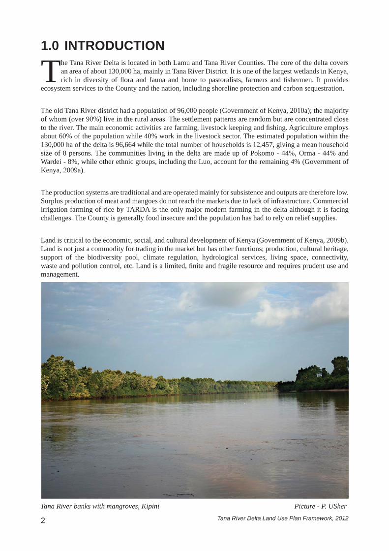
The Tana River Delta is located in both Lamu and Tana River Counties. The core of the delta covers an area of about 130,000 ha, mainly in Tana River District. It is one of the largest wetlands in Kenya, rich in diversity of fl ora and fauna and home to pastoralists, farmers and fi shermen. It provides
ecosystem services to the County and the nation, including shoreline protection and carbon sequestration.
The old Tana River district had a population of 96,000 people (Government of Kenya, 2010a); the majority of whom (over 90%) live in the rural areas. The settlement patterns are random but are concentrated close to the river. The main economic activities are farming, livestock keeping and fi shing. Agriculture employs about 60% of the population while 40% work in the livestock sector. The estimated population within the 130,000 ha of the delta is 96,664 while the total number of households is 12,457, giving a mean household size of 8 persons. The communities living in the delta are made up of Pokomo - 44%, Orma - 44% and Wardei - 8%, while other ethnic groups, including the Luo, account for the remaining 4% (Government of Kenya, 2009a).
The production systems are traditional and are operated mainly for subsistence and outputs are therefore low. Surplus production of meat and mangoes do not reach the markets due to lack of infrastructure. Commercial irrigation farming of rice by TARDA is the only major modern farming in the delta although it is facing challenges. The County is generally food insecure and the population has had to rely on relief supplies.
Land is critical to the economic, social, and cultural development of Kenya (Government of Kenya, 2009b). Land is not just a commodity for trading in the market but has other functions; production, cultural heritage, support of the biodiversity pool, climate regulation, hydrological services, living space, connectivity, waste and pollution control, etc. Land is a limited, fi nite and fragile resource and requires prudent use and management.
1.0 INTRODUCTION
Tana River banks with mangroves, Kipini Picture - P. USher

Tana River Delta Land Use Plan Framework, 2012 3
The Tana Delta Integrated Land Use Plan is a long term plan that will provide increased certainty about how the area can be expected to transform over time. It will also provide a clear indication and direction of the type of development which is suitable in different parts of the delta. Decisions on land development as well as resource use will be based on a sound policy framework. This will boost investor confi dence, attract sound investments in the area and lead to increased employment and more income to local communities.
Land use planning is a public policy exercise that designates and regulates the use of land in order to improve the community’s economic and social wellbeing whilemaintaining ecological integrity (FAO, 1992).The process entails a systematic assessment of land and water potential, alternatives for land use, and a review of economic and social conditions in order to select and adopt the best land use options. It is multi-disciplinary and multi-sectoral in approach bringing together government, public, land users and civil society as single resource planning is ineffective. Therefore land use planning has an integrative function.However sustainable land use planning requires recognition of limitations of the biosphere and the need for a balance of social, cultural, and economic uses within these limitations (Government of Kenya, 2007).
The development of a land use framework is a culmination of efforts by the government, land users, and civil society to comprehensively address the challenges facing the Tana Delta – competition for the land resources, incompatible land uses, loss of biodiversity, degradation of the environment, rising poverty, climate change, etc. The process will involve extensive and intensive consultations among the stakeholders – government, decision makers, land users, civil society, big investors, and conservationists.
Cattle grazing at the Tana Delta wetland Picture - Jill Retief

Tana River Delta Land Use Plan Framework, 20124
1.1 Statement of problemTana River delta is one of the most important wetlands in Africa and the largest freshwater wetland system in Kenya. The Delta is located in Tana River and Lamu Counties and covers a core area of about 130,000 ha. It is rich in biodiversity, supporting diverse species of fl ora and fauna. It is internationally important for the survival of no less than 22 species of birds “…making the delta one of the key sites in the country for water bird conservation” (Bennun & Njoroge, 1999). Other common wildlife found within the Delta includes hippo, lion, elephant, buffalo, endangered and endemic amphibians and breeding sites for valuable edible fi sh and shellfi sh.
The Delta is home to diverse human settlements ranging from nucleated to sparse settlements. According to the 2009 census, the population of the Tana delta district was 96,664, made up of the Wardei, Orma, Pokomo, Luo, Luhya, Bajuni and other, minority communities. The communities derive their livelihoods from land and land-based resources through livestock, crop farming and fi shing. The Delta also supports commercial irrigation farming of rice and other grains. It is a dry season grazing area for livestock emanating from other Counties. Fuel wood is derived from forests and woodlands located in the delta. Other products include medicinal herbs, honey and eco-tourism, including several lodges and a wildlife conservancy.
Currently, the existing human settlement and land use is based on a pattern of over 100 villages within the Delta. These comprise: Pastoralists or livestock herders, namely the Orma, Wardei and Somali migrants; Farming communities, namely the Pokomo and Mijikenda; Fishing communities, including the Malakote, Bajuni, Luo and Luhya; Hunters and gatherers, including the Waata and Boni. More than 300,000 livestock use the fl ooded grassland for dry season grazing and drought refuge( Government of Kenya, 2009a). There is no equivalent grazing area to which these cattle can be relocated.
The delta is also a refuge for wildlife of all kinds, ranging from endangered primates to hippos, crocodiles, elephants, buffaloes, fi sh, amphibians and huge congregations of birds that make the delta to qualify as an Important Bird Area (IBA) and Key Biodiversity Area (KBA) on a global scale. There is no formally designated conservation area for wildlife and tourism in the delta, although the core area has been proposed for designation as a Ramsar site.
Heavily grazed land at the Tana River Delta Picture - P. USher

Tana River Delta Land Use Plan Framework, 2012 5
Over the past decade, confl icts have been increasing in the Delta as a result of increasing population, competition for land and land-based resources and encroachment into fragile ecosystems. These confl icts are compounded by lack of a general framework to guide decision-making on development of the Delta. This has compromised natural resource conservation efforts and community interests. These confl icts are bound to intensify with the proposed developments of the Lamu Port (Government of Kenya, 2007), damming in the upstream parts of Tana River and increasing global markets for food and bio-fuels. Climate change is likely to exacerbate these confl icts.
Map by D. Odeny
Figure 1: The Tana Delta Planning Area. Source: Planning Team
Tana River Delta Land Use Plan Framework, 20126
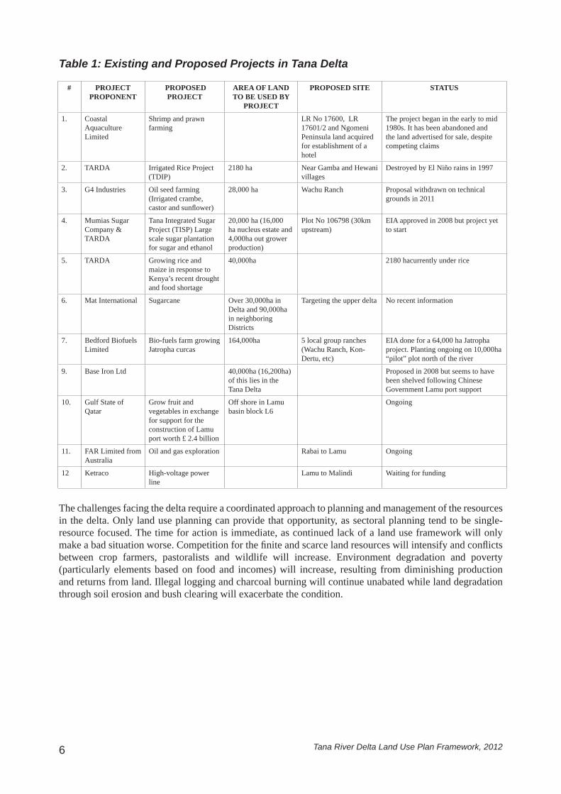
Table 1: Existing and Proposed Projects in Tana Delta
# PROJECT PROPONENT
PROPOSED PROJECT
AREA OF LAND TO BE USED BY
PROJECT
PROPOSED SITE STATUS
1. Coastal Aquaculture Limited
Shrimp and prawn farming
LR No 17600, LR 17601/2 and Ngomeni Peninsula land acquired for establishment of a hotel
The project began in the early to mid 1980s. It has been abandoned and the land advertised for sale, despite competing claims
2. TARDA Irrigated Rice Project (TDIP)
2180 ha Near Gamba and Hewani villages
Destroyed by El Niño rains in 1997
3. G4 Industries Oil seed farming (Irrigated crambe, castor and sunfl ower)
28,000 ha Wachu Ranch Proposal withdrawn on technical grounds in 2011
4. Mumias Sugar Company & TARDA
Tana Integrated Sugar Project (TISP) Large scale sugar plantation for sugar and ethanol
20,000 ha (16,000 ha nucleus estate and 4,000ha out grower production)
Plot No 106798 (30km upstream)
EIA approved in 2008 but project yet to start
5. TARDA Growing rice and maize in response to Kenya’s recent drought and food shortage
40,000ha 2180 hacurrently under rice
6. Mat International Sugarcane Over 30,000ha in Delta and 90,000ha in neighboring Districts
Targeting the upper delta No recent information
7. Bedford Biofuels Limited
Bio-fuels farm growing Jatropha curcas
164,000ha 5 local group ranches (Wachu Ranch, Kon-Dertu, etc)
EIA done for a 64,000 ha Jatropha project. Planting ongoing on 10,000ha “pilot” plot north of the river
9. Base Iron Ltd 40,000ha (16,200ha) of this lies in the Tana Delta
Proposed in 2008 but seems to have been shelved following Chinese Government Lamu port support
10. Gulf State of Qatar
Grow fruit and vegetables in exchange for support for the construction of Lamu port worth £ 2.4 billion
Off shore in Lamu basin block L6
Ongoing
11. FAR Limited from Australia
Oil and gas exploration Rabai to Lamu Ongoing
12 Ketraco High-voltage power line
Lamu to Malindi Waiting for funding
The challenges facing the delta require a coordinated approach to planning and management of the resources in the delta. Only land use planning can provide that opportunity, as sectoral planning tend to be single-resource focused. The time for action is immediate, as continued lack of a land use framework will only make a bad situation worse. Competition for the fi nite and scarce land resources will intensify and confl icts between crop farmers, pastoralists and wildlife will increase. Environment degradation and poverty (particularly elements based on food and incomes) will increase, resulting from diminishing production and returns from land. Illegal logging and charcoal burning will continue unabated while land degradation through soil erosion and bush clearing will exacerbate the condition.

Tana River Delta Land Use Plan Framework, 2012 7
The development of the Tana Delta Integrated land use plan will be guided by ‘a shared, over-arching, values-based vision for land use in the delta.’ The vision will focus on sustainable development and will be adopted in consultative forum attended by all stakeholders –government, land users, civil society, other decision makers, etc.
1.2 Goals and Objectives
The overall goal of the plan is to facilitate allocation of land to uses that provide the greatest sustainable benefi ts and provide the transition to a sustainable and integrated management of land resources.
1.2.1 Overall Goal
The objectives include:Provide a spatially explicit integrated plan that addresses growth for multiple land uses in a sustainable i. manner.Identify appropriate land use zoning that addresses strategic issues, environmental protection and ii. development requirements.Propose sustainable development guidelines and identifying action plans for the land use types iii. identifi ed.Propose institutional arrangements to ensure sustainable development and improve land use decisions.iv.
1.2.2 Objectives
The Constitution of Kenya provides that every citizen has a right to a clean and healthy environment. Moreover the Constitution provides that land in Kenya shall be held, used and managed in a manner that is effi cient, productive, and sustainable and in accordance with the principles of the land policy. It (Government of Kenya, 2010b) also allows the state to regulate the use of any land, or any interest in, or right over land, in the interest of land use planning among other public interests.
Transformation of Kenya into a newly industrialized middle income is hinged on social, economic and political pillars (Government of Kenya, 2007). Land is critical to the economic, social and cultural development of Kenya (Government of Kenya, 2009b). Indeed, sustainable management of land is critical to the security and stability of Kenya. To boost food security the government intends to put more land under irrigation agriculture (Government of Kenya, 2007). Rain fed agriculture can no longer be relied on to feed the increasing population.
The achievement of Millennium Development Goals (MDGs)especially on poverty and extreme hunger eradication and environmental protection will remain a mirage unless efforts are made to encourage and promote wise use of natural resources. This will depend on management measures put in place. Land use planning is a vital tool for management of land resources.
Land is a limited and fi nite resource, but population growth is rapidly increasing. Confl icts over land resources are inevitable as development pressure for arable land, grazing, forestry, wildlife, tourism, infrastructure and human settlements increases. The land use plan will balance environmental, social and economic interests to ensure prosperity and insure posterity.
The development of Lamu port will increase pressure on the Tana Delta. Water for both domestic and industrial use in the port will come from river Tana. Increase in population due to migration will raise demand for food, meaning more land is put under commercial irrigation agriculture to feed the population. The population therefore will increase pressure on limited natural resources in the delta.
1.3 Justifi cation

Tana River Delta Land Use Plan Framework, 20128
This chapter deals with how the plan will be delivered. Stakeholder participation and use of science and local indigenous knowledge are key elements. Meaningful participation ensures ownership of land use decisions as well as legitimacy of actions therefore enhancing success of the plan. Sincere
negotiations lead to prompt consensus and resolution of confl icts ensuring the plan is prepared and approved within reasonable timelines. Stakeholder participation is also a statutory requirement (Government of Kenya, 2006 and Government of Kenya, 1999). The planning process will be done in three phases: baseline studies, scenario building and development of alternative land use options and fi nally the preparation of draft and fi nal plan.
2.0 METHODOLOGY
2.1 Approach
2.2 Process
Land use planning is inter-disciplinary and multi-sectoral in nature. A multi-sectoral, multi-disciplinary approach that emphasizes on extensive and intensive stakeholder consultations will be adopted to prepare the integrated land use plan. This will also involve:
Review of relevant Statutory and Policy instruments to inform the plan preparation1. Stakeholder mapping to assist in identifi cation of stakeholders and formulate mechanism of 2. engagement.Formulation of Guiding principles3. Benchmarking to compare with other countries- Botswana, Scotland, Netherlands and South Africa 4.
The process will be iterative but cyclical and will entail:Visioning, Goal(s) and Objectives setting• Data collection and analysis and preparation of baseline report.• Scenario building, Development of alternative land use options and evaluation of the options against set • criteria –economic, social, and environmental.Selection of a preferred land use option and preparation of an integrated land use plan and implementation • strategy.Plan approval and implementation.• Monitoring, evaluation and review.•
Stakeholders’ meeting at the Tana River Delta Picture - M. Kachimba

Tana River Delta Land Use Plan Framework, 2012 9
Figure 2: Planning Process
Source: Inspired by Lash, Harry. Planning the Human Way: Design by Andrew Matheson, 2009

Tana River Delta Land Use Plan Framework, 201210
The formulation of the land use plan will be guided by following principles;Effi ciency• Stewardship• Accountability and responsibility• Equitable, fair and timely• Cooperation and collaboration• Integration• Knowledge-based science, evidence and experience• Responsive to changing circumstances – economic, social, cultural, political and environmental• Respect for private property rights•
2.3 Guiding Principles
Three general strategies will be developed and assessed:Conservation-orientated strategy:1. This strategy will work with the existing degraded environment and pattern of economic land uses within the Delta to secure major conservation gains. The process will examine where and what form of conservation or protection is required, where development should be avoided and what mitigation is required if development occursDevelopment strategy: 2. A conceptual model that accepts that all current land allocations – including those that are controversial and heavily disputed by sections of the local community – will eventually be allowed to proceed. This approach will consider what type, amount, form and location of development might be appropriate in the absence of environmental constraints.Community-focused hybrid strategy:3. This strategy contains elements of both the conservation and development strategies. This alternative will consider the infl uence of governance, laws, policies, institutional arrangements and capacity, human resource requirements and sustainable concerns to promote public dialogue. As part of the preparatory work, the project team will assess how institutions carry out their mandate; how they relate to each other and how they work for and with the communities. The team will also investigate the ways in which decisions are made and the scope for improving on existing procedures. This approach recognizes that plans will remain unimplemented, without authority, and unfulfi lled if there is no effective governance.
These initial alternatives will be examined in a consistent manner in order to encourage the development of a consensus view on the ideal plan.
2.4 Strategies for land use planning
The Integrated Land Use Plan will be a long term plan, for 20 years. The plan will cover the area of the Delta and will take cognizance of the complex linkages tying the delta to the entire Tana River County and parts of Witu division in Lamu County; an area covering slightly over 2,000 km2. The plan will cover issues such as agricultural land (rain fed and irrigation ), population dynamics, settlement patterns, grazing and pasture, environmental issues (access to water, climate change, biodiversity loss, gene banks, etc.), governance, land use confl icts, heritage conservation, transportation and transport facilities, fi shing and marine resources, land suitability for various land use options, etc.
2.5 Scope

Tana River Delta Land Use Plan Framework, 2012 11
In order to inform the planning process in the Tana Delta, the study team has examined other examples of land use planning systems both in Africa and Europe. This should help to ensure that best practice is followed and potential administrative pitfalls are avoided.
2.6 Benchmarking
Land use planning institutions in Botswana consist of a multiplicity of agencies characterized by three levels - national, sub-national and local/community levels. At the national level several ministries and departments are involved in land use planning and/or implementation. At sub-national level, institutions involved in land use planning and/or implementation include some line departments (e.g. Town and Regional Planning, District Administration – District Land Use Planning Unit, and Wildlife), land boards, city, and town and district councils. At local levels, private sector plus weak local communities and non-governmental institutions are involved in land use planning (www.sarpn.org).
The land use planning processes and types of plans prepared are designed to emphasize sector interests. The Department of Town and Regional Planning in the Ministry of Lands, Housing and Environment prepares several physical plans. In addition to preparing the National Settlement Policy (NSP) which covers the whole country, the department makes Regional Master Plans, District Settlement Strategies, Village/town/city Development Plans and detailed layout plans. It has proposals for a National Physical Development plan for implementing the NSP.
District Administrations, under the Ministry of Local Government, make District LandUse Plans. Other departments make sector plans too - e.g. Wildlife Management Area plans.Several ministries (e.g. Ministry of Agriculture, and the Ministry of Energy and Water Affairs) have national sector master plans such as the National Water Master Plan and Arable Agriculture and Dairy Development plan.
The land policy issues that are related to this arrangement include:Higher level institutions which wield and exercise undue control and power on lower level agencies;• Planning decisions and appeals which are based more on political considerations than professional • merits;Constraints on lower level institutions which are generally indecisive as they depend on higher levels • for decision making which causes delays even on simple issues;Sub-national agencies report to different ministries resulting in poor co-ordination and undue delays in • the planning, servicing, delivery, and development of land;The multiplicity of agencies and their location in different ministries compounded by the top heavy • structures has contributed to unsatisfactory vertical and horizontal communication - which, in turn, contribute to long delays in land delivery and development processes as well as dispute resolution;
2.6.1 Botswana
In Scotland, planning deals with land use and land development. The National Planning Framework and the Land Use Strategy of Scotland, together provide the strategic policy framework for sustainable land use that optimizes economic, environmental and social returns. Planning decisions are made at local/council level. Development plans consist of fi rstly the structural plans and then the local plans. The plans contain policies and use of land in an area (Government of Scotland, 2006).
The structure plan takes a long term view over the development of a council area. Each council can prepare their structure plans independently or in consultation with neighbouring councils. Once there has been wide consultation with the general population and other interested parties, the council submits the structure plans to the national government for approval.
2.6.2 Scotland

Tana River Delta Land Use Plan Framework, 201212
The Netherlands is a unitary state with three tiers of government: National, Provincial and Local (municipalities). Planning systems are embedded in historical traditions and the distribution of powers and responsibilities between different levels of government.Generally the national government sets the overall policy that is prescriptive and enacts legislation while the lower governments develop the detailed land use plans-regional and municipal structure plans (Marjolein Spans and Hermande Wolf, 2005).
The period up to June,2008, the national government made key planning decisions that lower level governments had to adhere to. The provincial governments prepare provincial plans covering broad regions. The local governments(municipalities) prepared structural plans covering their areas of jurisdiction. The municipal plans required approval from provincial government to be implemented. The land use plan is a legal document that is binding and permits for development can only be granted if proposed development conforms to the land use plan.
The period after June, 2008, plans prepared by municipalities do not require approval of provincial governments. However the national and provincial governments are entitled to give directions to municipalities and produce land use plans-when they consider themselves responsible for development of the area. The strategic policy documents at different levels were replaced by structure visions that form the basis for the land use plans. The structure visions, related to strategic policies, set forth the basic principles of spatial policies as well as the mode of execution of policies. The national and provincial structural visions are internal guidelines and are not binding on lower levels of governments.
In conclusion the Netherlands planning system certainty is provided through legally binding land use plans and development decisions are based on compliance with the plans. It is an integrated environmental planning system with strong ethos of environmental protection and land conservation.
2.6.3 Netherlands
South Africa is a republic with three ties of government: National, Provincial and local/Municipal. Each government has spatial planning roles and obligations and respective functions are complementary but not subservient. The subsidiary principle is highly regarded.The planning system rotates around key principles, norms and policies that form the basis for preparation of appropriate spatial frameworks. The planning frameworks give content to the principles, norms and policies and are strategic (Republic of South Africa, 2012).
The National government is responsible for overall policy direction. This policy is contained in the National spatial framework. This framework informs the preparation of the other frameworks.
The provincial government is responsible for preparation of provincial spatial frameworks that are approved and adopted by the provincial parliament. The approved framework is legally binding and could be used to guide preparation of local plans.
The local/municipal government is responsible for preparation of local spatial frameworks that form the basis for land use and land development regulation. Stakeholder participation is a key ingredient of the planning process
2.6.4 South Africa
Local plans usually cover a smaller area. After considering all views and objections, suitable changes may be made and the council will adopt the local plan using it for decision making for the area. The local plans must run in line with the approved structure plans.

Tana River Delta Land Use Plan Framework, 2012 13
Preparation of the Land use plan is guided and informed by the existing Institutional, legal and policy frameworks.
2.7. Planning context
The Constitution of Kenya is the supreme law of the land. The right to life guaranteed by theConstitution can be interpreted to include the right to a clean and healthy environment. Article 60 of the constitution sets up the principles on which land shall be held, used and managed. Article 66 (1) empowers the state to regulate the use of land in public interest. Moreover, under Article 69 the state has power to ensure sustainable exploitation, utilization and management of natural resources.
Land use management is elaborately covered in a number of Acts of parliament such as the Agriculture Act (CAP 318), Physical Planning Act (CAP 286), EMCA of 1999, Water Act of 2002, Wildlife Act, Forests Act, Fisheries Act, Local Government Act, etc.
The Environmental Management and Coordination Act of 1999 (EMCA) provides an appropriate legal and institutional framework for the management of the environmental issues and seeks to integrate environmental issues in national economic and social development goals.
The Physical Planning (PPA) Act makes provision for preparation, approval and implementation of physical development plans. The Act mandates Local Authorities (LA) to regulate development within their areas of jurisdiction to foster orderly and sustainable development.
Other relevant legislations that will be cross referenced in the process of plan preparation include inter alia, the Land Act, Land Commission Act, Land Registration Act, Trust Land Act, Fisheries Act, Livestock Act, Irrigation Act, Tana and Athi Rivers Development Act and the Registration of Titles Act.
2.7.1. Legal context
Gamba Manyatta village at the Tana River Delta submerged after heavy rainfall Picture - F. Kagema

Tana River Delta Land Use Plan Framework, 201214
The Tana Delta integrated Land Use Plan will be prepared in line with existing National Policies and international treaties which are relevant to land use and environmental management.
The Kenya Vision 2030 is the development blue print that seeks to transform the country to a middle income and newly industrialized country by the year 2030. The vision is anchored on 3 pillars namely political, economic and social pillars. A number of fl agship projects were identifi ed to be rolled out in order to realize the vision 2030. Some of these projects include preparation of the National spatial plan (NSP), development of Lamu port and transport corridor, Resort Cities (Lamu, Isiolo and Turkana), increasing area under irrigation to boost food production and enhance food security and increasing energy production.
The National Land Policy (NLP) provides an overall guide towards effi cient, sustainable and equitable use of land for prosperity and posterity. It deals with issues of access to land, land tenure, land administration, land use management and land information management.
The Water Policy provides for the sustainable management of water resources in the country. It also addresses supply and distribution of water resources throughout the country. It also provides for conservation and protection of water resources and catchment areas.
The Forest Policy - (Sessional paper No.1 of 1968) provides for the protection of catchment areas and plantation forests to provide nation’s demand of forest products. It was reviewed in 2003 to provide a framework for community participation in forestry management.Other policies that will guide the plan preparation process include inter alia, the National Food Policy, National Regional Development Policy and National Irrigation Policy. Sectoral policies and other relevant sectoral documents will also be cross referenced. These include inter alia,National Water master Plan, Strategy for Revitalization of Agriculture, National forest Master plan, Five year District development Plans and Integrated regional Development Plans.
The LUP will also take into account International Conventions and treaties to which Kenya is a signatory and will consider how they will be integrated within the framework of the land use plan.The Millennium Development Goals (MDGs) have an implication on the management of Tana Delta. Two goals are critical to land use planning: Goal 1; which aims at eradication of extreme hunger and poverty and Goal 7; which aims at ensuring environmental sustainability.
Kenya ratifi ed the Convention on Biological Diversity (CBD) and prepared National Biodiversity Strategy and Action Plan covering conservation of biodiversity, sustainable utilization and equitable benefi t sharing.
The Ramsar Convention on wetlands to which Kenya is a signatory calls for wise use of resources within wetlands. In Kenya wetlands include inshore marine waters, coral reefs, estuaries, mangroves and coastal forests. There are four Ramsar sites in Kenya and Tana Delta is proposed as the fi fth site.
Other international Treaties that will inform the planning process include: Convention on International Trade in Endangered Species of Wild Fauna and Flora (CITES), Rio declaration on the Environment and development (Agenda 21) and the United Nations Framework Convention on Climate Change (UNFCCC).
2.7.2. Policy framework

Tana River Delta Land Use Plan Framework, 2012 15
The preparation of the plan involves partnership, cooperation and collaboration between and among government agencies, NGOs, Civil society, local community, etc. The Physical Planning Department in the Ministry of Lands has the legal mandate to prepare the plan. Therefore the department will provide leadership in order to ensure statutory compliance of the fi nal product.
The County Councils of Tana River and Lamu have jurisdiction over the project area. They are important players in the preparation and implementation of the plan. The two councils are critical players in plan preparation and implementation and their support and participation will lead to greater grassroots support and legitimacy of land use decisions.
The Inter-Ministerial Technical Committee (IMTC) on the Sustainable Management of Kenya Deltas provides policy and technical guidance.The Offi ce of Prime Minister will provide coordination. A Deltas Secretariat will be in charge of daily running of the project. At the grassroots level, a Tana Planning Advisory Committee (TPAC) will act as a link to the local community to ensure the community is fully consulted and involved in the planning process.
The National Environment Management Authority (NEMA) has statutory mandate to protect the environment through regulation of activities. It also has mandate to ensure environmental considerations are incorporated in the nation’s overall social and economic development policies, plans, programs and projects. It is within this context the plan formulated will be subjected to Strategic Environmental Assessment (SEA).
2.7.3. Institutional framework
Inter Ministerial Technical Committee (IMTC) for the Sustainable Management of Kenya’s Deltas at the Offi ce of the Prime Minister Picture - E. Mwongela

Tana River Delta Land Use Plan Framework, 201216
3.0 OUTPUTS AND OUTCOMESThe planning process will result in the following deliverables:
A set of planning policies for guiding all land use decisions, based on the National policies but adjusted i. to meet local conditionsA Land Use Plan composed of map(s) and statementsii. Land use zoning plans (maps)iii. Land use guidelines and regulationsiv. An Implementation strategyv. Action plansvi.
The following outcomes are anticipated after implementation of the land use plan:Secure and diversifi ed livelihoods in a clean and secure environment1. Healthy ecosystems continuously supplying ecological goods and services2. Positive development of a green economy providing employment and greater income for all within the 3. Delta
A fi sherman at the Tana River Picture - P. USher

Tana River Delta Land Use Plan Framework, 2012 17
4.0 IMPLEMENTATION FRAMEWORKThe major activities leading to draft plan include:
Baseline study leading to situation/baseline report.• Scenario building, formulation and assessment of land use options leading to preferred land use • optionPreparation of the integrated land use plan, policy statement(s) and maps, land development guidelines • and regulations and zoning maps, and an implementation strategy
Each of these activities/actions will be accompanied by a corresponding Strategic Environmental Assessment (SEA) outputs that will inform the planning process.
Action Timeline OutputBaseline study By end of June,2012 Existing situation reportScenario building, formulation and assessment of alternative land use options and selection of preferred alternative
By end of November,2012 Scenarios reportPreferred land use option
Preparation of land use plan and implementation strategy
End of January,2013 Integrated land use planLand use guidelines and regulationsZoning plans(maps)Action plans

Tana River Delta Land Use Plan Framework, 201218
REFERENCES:Bennun L., & Njoroge P. (1999). Important Bird Areas in Kenya. The East Africa Natural
History Society.
Food and Agriculture Organization (FAO). (1992). Guidelines for land use planning.
Government of Kenya. (1996). The Physical Planning Act Cap 28. Government Printer, Nairobi.
Government of Kenya. (1999). The Environmental Management and Coordination Act.
Government Printer, Nairobi.
Government of Kenya. (2007). Kenya Vision 2030. Government Printer, Nairobi.
Government of Kenya. (2009a). Tana Delta District Development Plan 2008-2012. Government
Printer, Nairobi
Government of Kenya. (2009b). Sessional Paper No 9 on National Land Policy. Government
Printer, Nairobi.
Government of Kenya. (2010a). National Population and Housing Census, Government Printer.
Nairobi.
Government of Kenya. (2010b). The Constitution of Kenya, Government Printer, Nairobi.
Government of Scotland. (2006). Scottish Planning Act, Scottish Government.
Marjolein, S., & Herman de Wolf., 2005. Changing Spatial systems and the role of Regional
government; comparing the Netherlands, Flauders and England, Delft University of Technology,
Netherlands.
Republic of South Africa. (2012). Spatial Planning and Land use management Bill. Government
of South Africa.
www.sarpn.org Land use planning issues: Botswana Land policy Review