
Taming Natural Disasters
104
2010 Update of 2005 Plan Multi-Jurisdictional Local Hazard Mitigation Plan for the San Francisco Bay Area Association of Bay Area Governments Taming Natural Disasters Taming Natural Disasters
Transcript of Taming Natural Disasters
2010 Updateof 2005 Plan
Multi-Jurisdictional Local Hazard Mitigation Plan for
the San Francisco Bay Area
Association of Bay Area Governments
TamingNaturalDisasters
TamingNaturalDisasters
Taming Natural Disasters
Multi-Jurisdictional Local Hazard Mitigation Plan
for the San Francisco Bay Area
2010 Update of 2005 Plan
Association of Bay Area Governments
2010 Update ii Multi-Jurisdictional Local Hazard Mitigation Plan
Credits
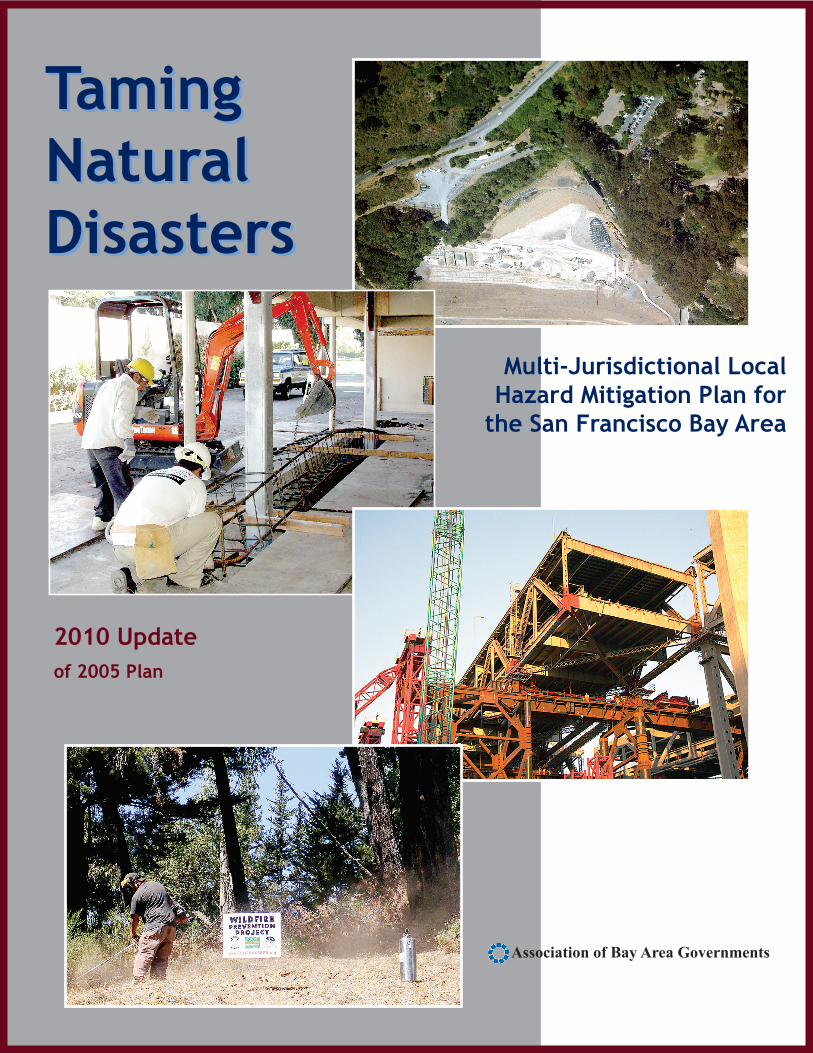
Principal Plan Authors Jeanne B. Perkins – Consultant, Earthquake and Hazards Program, ABAG Danielle Hutchings – Earthquake and Hazards Specialist, ABAG ABAG Staff Support Michael Smith – GIS Manager Brandon Soublet – Management Intern Brian Kirking – Information Services Manager Jonathan Strunin – Regional Planner (through 2006) ABAG Management Henry Gardner – Executive Director Kenneth Kirkey – Planning Director Cover Design Vicki Rutherford - ABAG Communications Assistant Cover Photos Top right: San Pablo Dam Seismic Reconstruction Project. Courtesy of East Bay Municipal
Utility District, 2009 Middle left: Seismic Retrofit of three story residential building. Courtesy of Anderson-
Niswander Construction, Inc., 2009 Middle right: Construction of Bay Bridge bypass on east span. Courtesy of MTC and Caltrans,
2009 Bottom left: Vegetation clearance. Courtesy of Hills Emergency Forum, 2009 The writing and production of this report was funded by the Association of Bay Area Governments and, through in-kind services, the local governments of the Bay Area.
NOTE: This report will be adopted by ABAG’s Executive Board, as well as the participating local governments, pending FEMA approval. Specific mitigation strategies proposed for adoption, as well as a digital version of this document, are available at http://quake.abag.ca.gov/mitigation.
ABAG Publication Number: P09001EQK Available online at quake.abag.ca.gov/mitigation
2010 Update iii Multi-Jurisdictional Local Hazard Mitigation Plan
Actively Participating Jurisdictions The following is a list of jurisdictions that have participated in the development of this plan and have submitted a letter of commitment indicating that they are full participants in the plan. Documentation of how each jurisdiction was involved can be found in Appendix H, as well as in the individual Annex of the jurisdiction. A list of jurisdictions that participated in 2005, but chose not to participate this time, can also be found in Appendix H.
ALAMEDA COUNTY –––––––––––––––––––––––––––––––––––––––––––––––––––––––Alameda County Hayward Pleasanton Alameda Livermore San Leandro Albany Newark Union City Dublin Oakland Fremont Piedmont
CONTRA COSTA COUNTY ––––––––––––––––––––––––––––––––––––––––––––––––––Brentwood Hercules Moraga Clayton Lafayette Orinda Concord Martinez San Pablo
MARIN COUNTY ––––––––––––––––––––––––––––––––––––––––––––––––––––––––– Marin County Fairfax Tiburon Belvedere San Anselmo Corte Madera San Rafael
SAN MATEO COUNTY ––––––––––––––––––––––––––––––––––––––––––––––––––––– San Mateo County East Palo Alto Portola Valley Atherton Foster City San Bruno Belmont Half Moon Bay San Carlos Brisbane Hillsborough San Mateo Burlingame Menlo Park South San Francisco Colma Millbrae Woodside Daly City Pacifica
SANTA CLARA COUNTY ––––––––––––––––––––––––––––––––––––––––––––––––––– Santa Clara County Los Gatos San Jose Campbell Milpitas Santa Clara Cupertino Monte Sereno Saratoga Gilroy Morgan Hill Sunnyvale Los Altos Mountain View Los Altos Hills Palo Alto
SOLANO COUNTY –––––––––––––––––––––––––––––––––––––––––––––––––––––––– Solano County Fairfield Vallejo Benicia Rio Vista Dixon Vacaville
SONOMA COUNTY ––––––––––––––––––––––––––––––––––––––––––––––––––––––––Cloverdale Petaluma Sebastopol Cotati Rohnert Park Sonoma Healdsburg Santa Rosa Windsor
2010 Update iv Multi-Jurisdictional Local Hazard Mitigation Plan
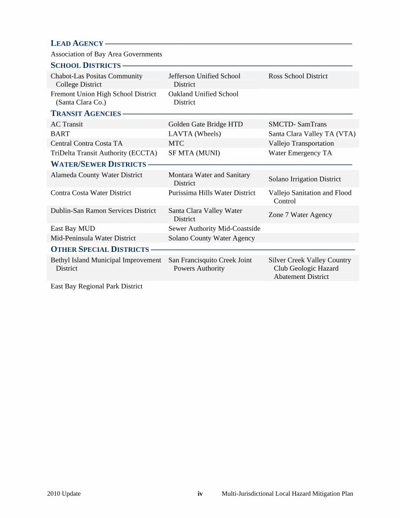
LEAD AGENCY –––––––––––––––––––––––––––––––––––––––––––––––––––––––––– Association of Bay Area Governments SCHOOL DISTRICTS –––––––––––––––––––––––––––––––––––––––––––––––––––––– Chabot-Las Positas Community
College District Jefferson Unified School
District Ross School District
Fremont Union High School District (Santa Clara Co.)
Oakland Unified School District
TRANSIT AGENCIES –––––––––––––––––––––––––––––––––––––––––––––––––––––– AC Transit Golden Gate Bridge HTD SMCTD- SamTrans BART LAVTA (Wheels) Santa Clara Valley TA (VTA)Central Contra Costa TA MTC Vallejo Transportation TriDelta Transit Authority (ECCTA) SF MTA (MUNI) Water Emergency TA
WATER/SEWER DISTRICTS –––––––––––––––––––––––––––––––––––––––––––––––– Alameda County Water District Montara Water and Sanitary
District Solano Irrigation District
Contra Costa Water District Purissima Hills Water District Vallejo Sanitation and Flood Control
Dublin-San Ramon Services District Santa Clara Valley Water District
Zone 7 Water Agency
East Bay MUD Sewer Authority Mid-Coastside Mid-Peninsula Water District Solano County Water Agency
OTHER SPECIAL DISTRICTS –––––––––––––––––––––––––––––––––––––––––––––––– Bethyl Island Municipal Improvement
District San Francisquito Creek Joint
Powers Authority Silver Creek Valley Country
Club Geologic Hazard Abatement District
East Bay Regional Park District
2010 Update v Multi-Jurisdictional Local Hazard Mitigation Plan
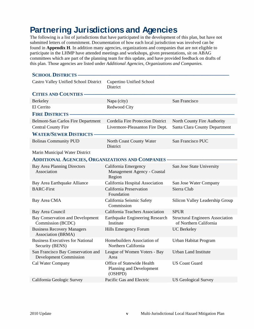
Partnering Jurisdictions and Agencies The following is a list of jurisdictions that have participated in the development of this plan, but have not submitted letters of commitment. Documentation of how each local jurisdiction was involved can be found in Appendix H. In addition many agencies, organizations and companies that are not eligible to participate in the LHMP have attended meetings and workshops, given presentations, sit on ABAG committees which are part of the planning team for this update, and have provided feedback on drafts of this plan. Those agencies are listed under Additional Agencies, Organizations and Companies.
SCHOOL DISTRICTS –––––––––––––––––––––––––––––––––––––––––––––––––––––––– Castro Valley Unified School District Cupertino Unified School
District
CITIES AND COUNTIES ––––––––––––––––––––––––––––––––––––––––––––––––––––––––Berkeley Napa (city) San Francisco El Cerrito Redwood City
FIRE DISTRICTS ––––––––––––––––––––––––––––––––––––––––––––––––––––––––––––– Belmont-San Carlos Fire Department Cordelia Fire Protection District North County Fire Authority Central County Fire Livermore-Pleasanton Fire Dept. Santa Clara County Department
WATER/SEWER DISTRICTS –––––––––––––––––––––––––––––––––––––––––––––––––––– Bolinas Community PUD North Coast County Water
District San Francisco PUC
Marin Municipal Water District
ADDITIONAL AGENCIES, ORGANIZATIONS AND COMPANIES –––––––––––––––––––––––––– Bay Area Planning Directors
Association California Emergency
Management Agency - Coastal Region
San Jose State University
Bay Area Earthquake Alliance California Hospital Association San Jose Water Company BARC-First California Preservation
Foundation Sierra Club
Bay Area CMA California Seismic Safety Commission
Silicon Valley Leadership Group
Bay Area Council California Teachers Association SPUR Bay Conservation and Development
Commission (BCDC) Earthquake Engineering Research
Institute Structural Engineers Association
of Northern California Business Recovery Managers
Association (BRMA) Hills Emergency Forum UC Berkeley
Business Executives for National Security (BENS)
Homebuilders Association of Northern California
Urban Habitat Program
San Francisco Bay Conservation and Development Commission
League of Women Voters - Bay Area
Urban Land Institute
Cal Water Company Office of Statewide Health Planning and Development (OSHPD)
US Coast Guard
California Geologic Survey Pacific Gas and Electric US Geological Survey
2010 Update vi Multi-Jurisdictional Local Hazard Mitigation Plan
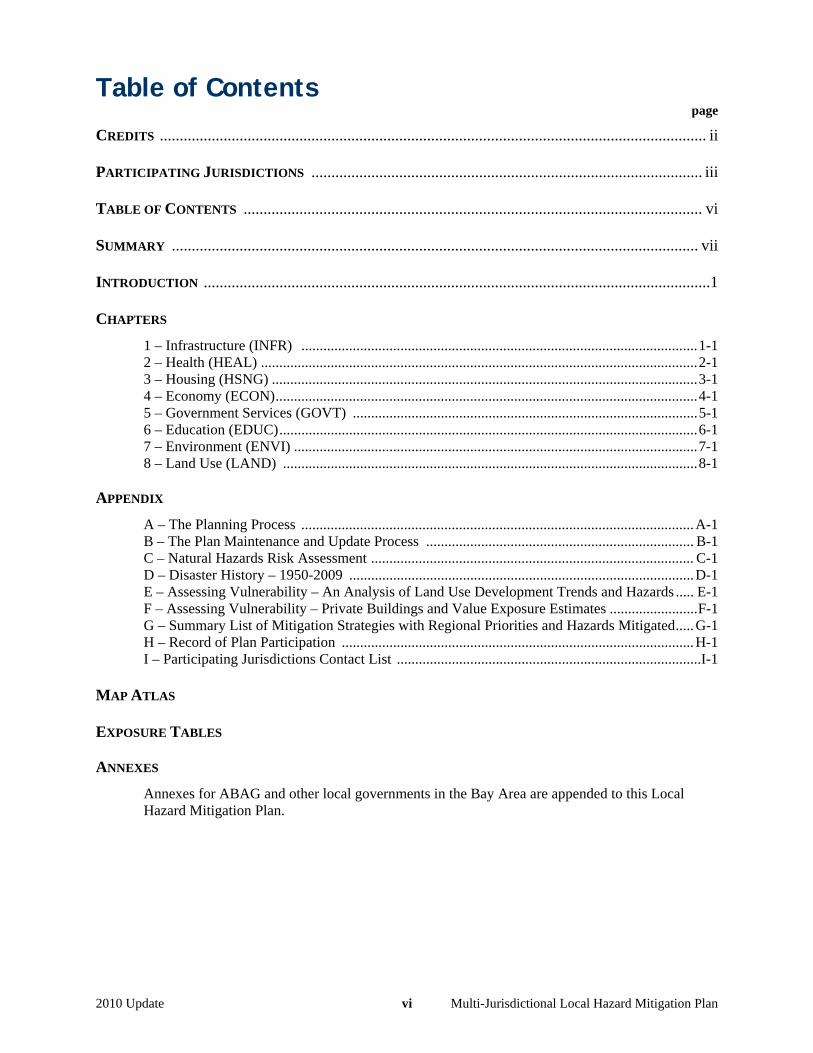
Table of Contents page
CREDITS ......................................................................................................................................... ii PARTICIPATING JURISDICTIONS .................................................................................................. iii TABLE OF CONTENTS ................................................................................................................... vi SUMMARY .................................................................................................................................... vii INTRODUCTION ...............................................................................................................................1
CHAPTERS
1 – Infrastructure (INFR) ............................................................................................................1-1 2 – Health (HEAL) .......................................................................................................................2-1 3 – Housing (HSNG) ....................................................................................................................3-1 4 – Economy (ECON)...................................................................................................................4-1 5 – Government Services (GOVT) ..............................................................................................5-1 6 – Education (EDUC)..................................................................................................................6-1 7 – Environment (ENVI) ..............................................................................................................7-1 8 – Land Use (LAND) .................................................................................................................8-1
APPENDIX
A – The Planning Process ...........................................................................................................A-1 B – The Plan Maintenance and Update Process ......................................................................... B-1 C – Natural Hazards Risk Assessment ........................................................................................ C-1 D – Disaster History – 1950-2009 ..............................................................................................D-1 E – Assessing Vulnerability – An Analysis of Land Use Development Trends and Hazards ..... E-1 F – Assessing Vulnerability – Private Buildings and Value Exposure Estimates ........................F-1 G – Summary List of Mitigation Strategies with Regional Priorities and Hazards Mitigated.....G-1 H – Record of Plan Participation ................................................................................................H-1 I – Participating Jurisdictions Contact List ...................................................................................I-1
MAP ATLAS EXPOSURE TABLES
ANNEXES
Annexes for ABAG and other local governments in the Bay Area are appended to this Local Hazard Mitigation Plan.
2010 Update vii Multi-Jurisdictional Local Hazard Mitigation Plan
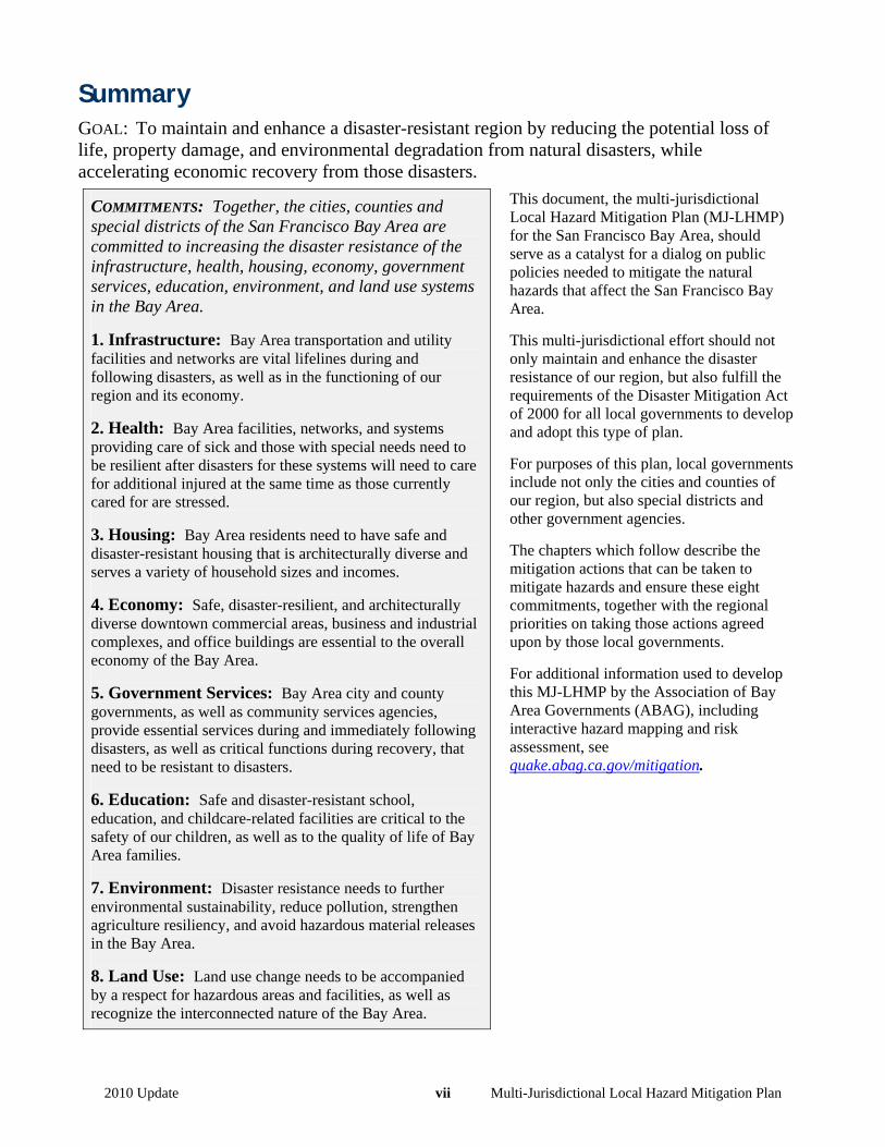
Summary GOAL: To maintain and enhance a disaster-resistant region by reducing the potential loss of life, property damage, and environmental degradation from natural disasters, while accelerating economic recovery from those disasters.
COMMITMENTS: Together, the cities, counties and special districts of the San Francisco Bay Area are committed to increasing the disaster resistance of the infrastructure, health, housing, economy, government services, education, environment, and land use systems in the Bay Area.
1. Infrastructure: Bay Area transportation and utility facilities and networks are vital lifelines during and following disasters, as well as in the functioning of our region and its economy.
2. Health: Bay Area facilities, networks, and systems providing care of sick and those with special needs need to be resilient after disasters for these systems will need to care for additional injured at the same time as those currently cared for are stressed.
3. Housing: Bay Area residents need to have safe and disaster-resistant housing that is architecturally diverse and serves a variety of household sizes and incomes.
4. Economy: Safe, disaster-resilient, and architecturally diverse downtown commercial areas, business and industrial complexes, and office buildings are essential to the overall economy of the Bay Area.
5. Government Services: Bay Area city and county governments, as well as community services agencies, provide essential services during and immediately following disasters, as well as critical functions during recovery, that need to be resistant to disasters.
6. Education: Safe and disaster-resistant school, education, and childcare-related facilities are critical to the safety of our children, as well as to the quality of life of Bay Area families.
7. Environment: Disaster resistance needs to further environmental sustainability, reduce pollution, strengthen agriculture resiliency, and avoid hazardous material releases in the Bay Area.
8. Land Use: Land use change needs to be accompanied by a respect for hazardous areas and facilities, as well as recognize the interconnected nature of the Bay Area.
This document, the multi-jurisdictional Local Hazard Mitigation Plan (MJ-LHMP) for the San Francisco Bay Area, should serve as a catalyst for a dialog on public policies needed to mitigate the natural hazards that affect the San Francisco Bay Area.
This multi-jurisdictional effort should not only maintain and enhance the disaster resistance of our region, but also fulfill the requirements of the Disaster Mitigation Act of 2000 for all local governments to develop and adopt this type of plan.
For purposes of this plan, local governments include not only the cities and counties of our region, but also special districts and other government agencies.
The chapters which follow describe the mitigation actions that can be taken to mitigate hazards and ensure these eight commitments, together with the regional priorities on taking those actions agreed upon by those local governments.
For additional information used to develop this MJ-LHMP by the Association of Bay Area Governments (ABAG), including interactive hazard mapping and risk assessment, see quake.abag.ca.gov/mitigation.
2010 Update 1 Multi-Jurisdictional Local Hazard Mitigation Plan
Introduction Bay Area Region Overview
The San Francisco Bay Area, located in Northern California, is home to more than 7 million people. The area consists of nine counties, 101 cities. All of the region’s nine counties touch the San Francisco Bay1.
The Bay Area has a land area of 4.4 million acres (excluding bay waters and large lakes). The major type of land use varies strongly by county, from completely urbanized San Francisco County to Napa County, which has only a few medium-sized towns and one small city. Contra Costa, Alameda, and Santa Clara Counties all are highly urbanized along the Bay shore, with varying degrees of development further inland. San Francisco County is by far the most urbanized county in the region, with virtually all of its land characterized as urban in 2005.
Like many urban areas, the Bay Area will continue to grow in the foreseeable futures. An estimated additional 1.7 million people will live here and over 1.6 million new jobs will be created by 2030, attracting an additional 850,000 residents to the region. An additional 600,000 homes will be built. This region faces the challenges of serving this growth with efficient transportation, housing, and infrastructure, while balancing it with the natural disasters that threaten our region and economy.
The economy of the Bay Area is diverse and dynamic. Major industries include high tech and information, professional services, financial, education and health services, agricultural, tourism, manufacturing and wholesale, construction and transportation. The high tech industry drives employment in the South Bay, while the University of California and two national laboratories drive employment in the East Bay. In the North Bay, tourism, agriculture, and distribution and manufacturing dominate employment. The Peninsula receives spillover from San Francisco and the South Bay. Its economy is largely high tech and biotech. Major employers on the Peninsula include Oracle, Stanford University, and United Airlines (due to San Francisco International Airport).
Natural Hazards, Geography and Climate
The San Francisco Bay Area is in a spectacular region with valleys and ridges, views and access to rivers, the ocean, and the Bay, and a mild climate.
But many of those ridges and valleys have been formed by active earthquake faults that can generate devastating shaking and ground failures. The typically mild climate is subject to occasional severe winter and spring storms leading to landslides in the hills and flooding of the valleys. During the fire season, typically from May through November, the region is subject to periods of Diablo Winds bringing high temperatures, gusting winds, and low humidity. Tinder-dry trees, brush, and grasslands are subject to fires that can become catastrophic on the edges of urban development. Given an increasingly mobile population, our citizens and crops are subject to disease epidemics. Natural disasters can lead to secondary events that are disasters in of themselves, including hazmat releases and dam failures. During the period from 1950 – 2009, all or part of the Bay Area was subjected to 59 disasters, or about a third of over 200 disasters occurring in the entire State of California during that 60-year period2.
The nine most significant of hazards affecting the Bay Area, based on our past history, as well as on the State Hazard Mitigation Plan, are related to:
earthquakes (surface faulting, ground shaking, liquefaction, landslides, and tsunamis), or weather (flooding, landslides, wildfires, drought, and climate change).
The focus of this effort is on natural hazards, that is, natural occurrences that can pose a risk of injury, loss of life, or damage to property. Other hazards relate to man-made conditions, including releases of hazardous materials, dam failures, energy shortages, and weapons of mass destruction. These other hazards are only 1 Fassinger and others, 2003 – ABAG’s Projections 2007 and 2009. Economy is based on annual Gross Regional Product (GRP). 2 California Governor’s Office of Emergency Services database of disasters and major states of emergencies.
2010 Update 2 Multi-Jurisdictional Local Hazard Mitigation Plan
addressed in this plan as they relate to earthquake and weather-related hazards. The only one of these additional hazards that is readily mapped and analyzed is dam failure.
Finally, people and the food they eat are subject to disease. These concerns are also not addressed in great detail, except as they relate to earthquake and weather-related hazards.
As part of the hazard identification process, ABAG has created a web site with access to 53 hazard maps. These maps are referenced to the “hard copy” maps in this document. However, these maps can be interactively zoomed by address, zip code, city, county, school district, fire jurisdiction, and water district for use in the preparation of local Annexes to this plan. They also are all publicly accessible on the web at http://quake.abag.ca.gov/mitigation/.
What are Disasters and How are They Related to Hazard Mitigation?
A disaster is a natural or man-made emergency whose response needs exceed available resources. When local government resources are exceeded, the California Governor’s Office of Emergency Services (State OES) is contacted and the Governor is requested to declare a State Disaster. When State resources are exceeded, State OES contacts the U.S. Department of Homeland Security’s Federal Emergency Management Agency (FEMA) and the President is requested to declare a National Disaster. This Presidential Declaration triggers funding resources for the public, the state, and local governments to use for clean-up, repair, recovery, and mitigation.
There are two ways to deal with disasters. 1. We can increase emergency response capability. Thus, more damage needs to occur for those capabilities
to be exceeded. Large incidents become manageable emergencies. 2. Projects can be undertaken to prevent or lessen the impacts of future incidents, reducing the need for
larger and larger response capability. Homes can be moved from areas suffering repeated floods. Buildings and infrastructure can be built to reduce expected damage in earthquakes. Wood shakes on homes in woodland areas can be replaced with asphalt shingles or tile. These actions are called mitigation.
More specifically, the Stafford Act defines mitigation as “any sustained action taken to reduce or eliminate the long-term risk to human life and property from hazards.”3 As mitigation activities are undertaken, the risks associated with disasters decrease.
Goal
To maintain and enhance a disaster-resistant region by reducing the potential loss of life, property damage, and environmental degradation from natural disasters, while accelerating economic recovery from those disasters.
We need to continue to work to reduce and avoid risks from natural hazards to protect lives, property, the environment, and our economy.
This natural hazard mitigation plan is a joint effort by the cities, counties, and special districts in the Bay Area to build a more disaster-resistant region. We recognize that disasters do not respect the boundaries between our individual jurisdictions and have worked together to identify our hazards, assess our risks, and develop this goal, eight commitments, and a comprehensive list of strategies (or actions) to mitigate the identified risks.
We view this plan as a shared mental model of our overall goal, commitments, and mitigation actions. We can no longer afford random acts of preparedness and mitigation. Commitments
The overall goal is being addressed by asking all local governments in the Bay Area to adopt formal resolutions in support of the following eight commitments areas. These commitments are not organized by hazard, but by the 3 Source – 44 CFR Section 201.2 pertaining to Section 322 of the Stafford Act, 42 U.S.C. 5165.
2010 Update 3 Multi-Jurisdictional Local Hazard Mitigation Plan
types of services supplied either directly, or indirectly, by local governments. Chapters accompany each of the commitment areas, outlining the problem and highlighting mitigation activities that are currently taking place to address the problem. With this organization, each of the Bay Area’s cities and counties should find ways to address these major commitments by reducing identified risks. In addition, the Bay Area’s special districts can address many of these commitments, depending on the role and responsibilities of that district. Together, we are committed to increasing the disaster resistance of the infrastructure, health, housing, economy, government services, education, environment, and land use systems in the Bay Area.
1. Infrastructure Bay Area transportation and utility facilities and networks are vital lifelines during and following disasters, as well as in the functioning of our region and its economy.
2. Health Bay Area facilities, networks, and systems providing care of sick and those with special needs need to be resilient after disasters for these systems will need to care for additional injured at the same time as those currently cared for are stressed.
3. Housing Bay Area residents need to have safe and disaster-resistant housing that is architecturally diverse and serves a variety of household sizes and incomes.
4. Economy Safe, disaster-resilient, and architecturally diverse downtown commercial areas, business and industrial complexes, and office buildings are essential to the overall economy of the Bay Area.
5. Government Services Bay Area city and county governments, as well as community services agencies, provide essential services during and immediately following disasters, as well as critical functions during recovery, that need to be resistant to disasters.
6. Education Safe and disaster-resistant school, education, and childcare-related facilities are critical to the safety of our children, as well as to the quality of life of Bay Area families.
7. Environment Disaster resistance needs to further environmental sustainability, reduce pollution, strengthen agriculture resiliency, and avoid hazardous material releases in the Bay Area.
8. Land Use Land use change needs to be accompanied by a respect for hazardous areas and facilities, as well as recognize the interconnected nature of the Bay Area.
Implementation Strategies for Mitigation
Background on Implementation Strategy Organization The implementation strategies, or action items, are listed under the eight major commitments identified on the previous page, rather than by hazard. Within each commitment area, the strategies are grouped by topic and each group is addressed individually in the chapter text. The accompanying text helps put the strategies into a larger context and provides some additional information about many of the problem areas. As stated in the previous section, with this organization, each of the Bay Area’s cities and counties should find ways to address these major commitments by reducing identified risks. In addition, the Bay Area’s special districts can address many of these commitments, depending on the role and responsibilities of that district.
Any scheme to identify a comprehensive list of potential strategies is bound to have some overlaps. This list is no exception. Because those ideas listed under housing and economy have, at their core the relationship, between
2010 Update 4 Multi-Jurisdictional Local Hazard Mitigation Plan
government and the people who live and work in their jurisdictions, there is overlap. City and counties, as well as special districts handling lifelines and schools, have buildings that are critical to their functioning, so there is duplication in the discussion of these issues.
Most of the strategies listed are clearly within the definition of “hazard mitigation,” that is, “any action taken to reduce or eliminate the long-term risk to human life and property from natural hazards.”4 The strategies address all of the hazards identified when performing the risk assessment work described in Appendix C. In addition, there are four notable areas where we have “pushed” this definition.
The first is in the area of public education. Author Stephen Flynn notes in his 2004 book5 in a plea for greater public education following 9/11 that federal “security officials often act as though members of the American public are either potential recruits for an easily panicked mob or a passive part of a haystack that must constantly be sifted through to find terrorist needles.” The Bay Area learned this lesson twelve years earlier in 1989 as a result of the Loma Prieta earthquake. People who live and work in our region also need to understand our hazards so that they can take appropriate mitigation measures in their homes, schools, and work places.
Second, we have included under Government Services several ideas to “Maintain and Enhance Local Government’s Emergency Response and Recovery Capacity.” These ideas have been included because we believe that many go well beyond the traditional response activities of city and county police and fire services.
Several strategies are drafted so that they apply to natural – and security – hazards, such as the mitigation of disasters resulting from weapons of mass destruction. Hazmat releases and dam failures due to flooding, earthquakes, or terrorism have some similar impacts and therefore some similar mitigation strategies. Some methods of combating “common” crime and violence may deter major terrorist actions.
Finally, the strategies dealing with health, both under the Health commitment, as well as sprinkled elsewhere in this document, have traditionally been funded by the Centers for Disease Control and Prevention (CDC), rather than FEMA. They also may involve the use of the National Disaster Medical System under U.S. Health and Human Services (including both uniformed and non-uniformed medical personnel under the U.S. Surgeon General). We view this Local Hazard Mitigation Plan, while a requirement of the Disaster Mitigation Act of 2000 being administered by FEMA, as an opportunity to build administrative bridges in the public health field. For example, local government actions to deal with managing “natural” deadly pathogens such as SARS, AIDS, West Nile, and mad cow disease in an increasingly mobile world can also assist in the response to bioterrorism.
Status and Priorities
For each of the following potential mitigation strategies, local governments have been asked to choose their own priority for this strategy. The priorities in each of these local government Annexes were selected based on:
the level of hazards identified in Appendix C, the Bay Area preliminary risk assessment conducted and described in Appendix C, supplementary hazard and risk assessment information developed by ABAG for each local government
on the interactive internet site http://quake.abag.ca.gov/mitigation, and any specific studies conducted by the local government and included in that local government’s Annex
to this plan.
4 Stafford Act (44 CFR 206:401) 5 Flynn, Stephen. 2004. America the Vulnerable: How Our Government Is Failing to Protect Us from Terrorism. HarperCollins Publishers, New York, page 160.
2010 Update 5 Multi-Jurisdictional Local Hazard Mitigation Plan
The priorities for each local government participating in this multi-jurisdictional plan are in that local government’s Annex to this plan. Priorities are defined as follows. The annexes provide additional information on the activities as noted after each priority.
Existing program Responsible agency or department Provide ordinance or resolution number, if applicable
Existing program, underfunded (new priority added to reflect the current economic climate of recession) Responsible agency or department Provide ordinance or resolution number, if applicable
Very High priority – to be adopted by local government immediately Responsible agency or department
High priority – to be adopted by local government as soon as funding and resources allow Agency responsible for seeking and administering funding Sources of potential funding Estimated amount of funding needed
Moderate priority – will be adopted by local government as funding and resources allow Under study
Responsible agency or department Provide estimated date of completion
Not applicable, not appropriate, or not cost effective Not yet considered
This list is a “work in progress”. It will expand and change over time, hopefully becoming as dynamic as the restless earth whose hazards demand our attention. It is not meant to discourage local experimentation with alternative strategies. Rather, it is meant to be a list of both common and innovative practices. In addition, local governments choosing to reword specific strategies to meet their local needs, or to be more specific in their strategies, are encouraged to do so.
Some of the strategies will not be appropriate for some jurisdictions, but all jurisdictions should be able to address the general commitments with identifiable actions. Valid risk management requires a careful weighing of the advantages and disadvantages of action. While some strategies may be appropriate for some jurisdictions, those same strategies may not be appropriate or may not be cost effective for others. Over time, we are committed to developing better hazard and risk information to use in making those trade-offs. We are not trying to create a disaster-proof region, but a disaster-resistant one. Finally, the cost of strategies varies greatly. Some of the most cost-effective relate to building and maintaining partnerships, not buildings.
Following approval of this plan by FEMA, ABAG will include the comprehensive strategies identified by all of these local governments Annexes as an interactive searchable database on that same internet site at http://quake.abag.ca.gov/mitigation. This interactive capability should begin to assist the California Office of Emergency Services in its efforts to monitor the effectiveness of this Local Hazard Mitigation Plan. For example, since this list of strategies has been conceived as a comprehensive list of “best practices,” strategies given relatively lower priorities by most local governments might be viewed as a multi-jurisdictional weakness, while those utilized and given a relatively high priority by most local governments might be viewed as a multi-jurisdictional strength.
Decisions on those strategies utilized and given a relatively high priority have been based on a variety of criteria, not simply on an economic cost-benefit analysis. These criteria include being technically and administratively feasible, politically acceptable, socially appropriate, legal, economically sound, and not harmful to the environment or our heritage.
2010 Update 6 Multi-Jurisdictional Local Hazard Mitigation Plan
Scope of Mitigation Strategies - New and Existing Development
Not only are the mitigation strategies designed to cover all of the hazards identified during the development of the natural hazard risk assessment for the plan as described in Appendix C, but the strategies also are designed to apply to existing development, new development, and even land use planning. For example, many of the strategies in infrastructure, housing, and economy focus on existing buildings, while many of those in land use focus on new development and general land use planning.
Highlighted Mitigation Activities in the Region
The hazards the Bay Area faces are not new, and neither are the risks to lives, property, the environment, and our economy. The knowledge that an earthquake will strike the region in the near future drives Bay Area local governments, together with private utilities and various State of California agencies, have created programs and regulations that are as creative and comprehensive as any region in the world.
Major mitigation projects are currently underway in the Bay Area. The San Francisco-Oakland Bay Bridge, which partially collapsed in the 1989 Loma Prieta earthquake, is undergoing replacement of its east span and retrofit of the west span. Retrofit of the BART Transbay Tube, which carries passengers underneath the Bay for 3.6 miles from Oakland to San Francisco, is ongoing, as is strengthening of the elevated portions of the BART track. Many other transportation retrofit projects have been completed all over the Bay Area to protect our transportation system from damage in an earthquake.
Most cities near faults have retrofitted their own city halls and major government buildings. Oakland and San Francisco city halls were both damaged in the Loma Prieta Earthquake. These historic buildings were repaired and put on base isolators to protect them from future damage. Hayward, due its proximity to the Hayward fault and major structural deficiencies in its city hall, replaced that building. Many other local governments have undertaken similar measures for their own government facilities. Examples of these can be found in the individual jurisdictions’ annexes.
Soft-story multi-family residential buildings have become a major concern to local cities since the 2005 plan due to the large number of people residing in these buildings and their likelihood to collapse in an earthquake. San Francisco, Oakland, Fremont, Berkeley, Alameda, Santa Clara County, and all the cities in Santa Clara County have inventoried their buildings (or are in the process of doing so) and are developing programs to retrofit these buildings. A major challenge for these cities is that in the current economic climate of recession, mandatory retrofits programs are not feasible, and money to provide incentives to building owners is not available.
Chapter 1 – Infrastructure (INFR) COMMITMENT: Bay Area transportation and utility facilities and networks are vital lifelines during and following disasters, as well as in the functioning of our region and its economy. Damage to infrastructure in a disaster can lead to damage to other systems and delayed recovery.
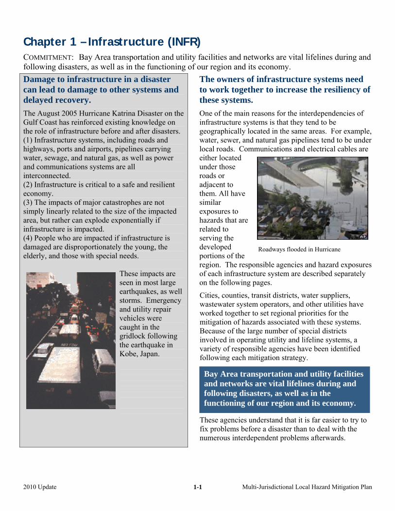
The August 2005 Hurricane Katrina Disaster on the Gulf Coast has reinforced existing knowledge on the role of infrastructure before and after disasters. (1) Infrastructure systems, including roads and highways, ports and airports, pipelines carrying water, sewage, and natural gas, as well as power and communications systems are all interconnected. (2) Infrastructure is critical to a safe and resilient economy. (3) The impacts of major catastrophes are not simply linearly related to the size of the impacted area, but rather can explode exponentially if infrastructure is impacted. (4) People who are impacted if infrastructure is damaged are disproportionately the young, the elderly, and those with special needs.
These impacts are seen in most large earthquakes, as well storms. Emergency and utility repair vehicles were caught in the gridlock following the earthquake in Kobe, Japan.
The owners of infrastructure systems need to work together to increase the resiliency of these systems.
One of the main reasons for the interdependencies of infrastructure systems is that they tend to be geographically located in the same areas. For example, water, sewer, and natural gas pipelines tend to be under local roads. Communications and electrical cables are either located under those roads or adjacent to them. All have similar exposures to hazards that are related to serving the developed portions of the region. The responof each infrastructuon the following pa
Cities, counties, trawastewater systemworked together tomitigation of hazarBecause of the larginvolved in operativariety of responsibfollowing each mit
These agencies undfix problems beforenumerous interdepe
Bay Area transand networks afollowing disastfunctioning of o
2010 Update Multi-
1-1
Roadways flooded in Hurricane
sible agencies and hazard exposures re system are described separately ges.
nsit districts, water suppliers, operators, and other utilities have set regional priorities for the ds associated with these systems. e number of special districts ng utility and lifeline systems, a le agencies have been identified
igation strategy.
erstand that it is far easier to try to a disaster than to deal with the ndent problems afterwards.
portation and utility facilities re vital lifelines during and ers, as well as in the ur region and its economy.
Jurisdictional Local Hazard Mitigation Plan
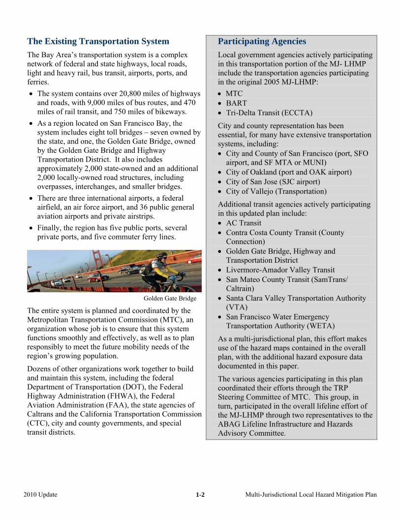
The Existing Transportation System
The Bay Area’s transportation system is a complex network of federal and state highways, local roads, light and heavy rail, bus transit, airports, ports, and ferries. • The system contains over 20,800 miles of highways
and roads, with 9,000 miles of bus routes, and 470 miles of rail transit, and 750 miles of bikeways.
• As a region located on San Francisco Bay, the system includes eight toll bridges – seven owned by the state, and one, the Golden Gate Bridge, owned by the Golden Gate Bridge and Highway Transportation District. It also includes approximately 2,000 state-owned and an additional 2,000 locally-owned road structures, including overpasses, interchanges, and smaller bridges.
• There are three international airports, a federal airfield, an air force airport, and 36 public general aviation airports and private airstrips.
• Finally, the region has five public ports, several private ports, and five commuter ferry lines.
Golden Gate Bridge
The entire system is planned and coordinated by the Metropolitan Transportation Commission (MTC), an organization whose job is to ensure that this system functions smoothly and effectively, as well as to plan responsibly to meet the future mobility needs of the region’s growing population.
Dozens of other organizations work together to build and maintain this system, including the federal Department of Transportation (DOT), the Federal Highway Administration (FHWA), the Federal Aviation Administration (FAA), the state agencies of Caltrans and the California Transportation Commission (CTC), city and county governments, and special transit districts.
Participating Agencies
Local government agencies actively participating in this transportation portion of the MJ- LHMP include the transportation agencies participating in the original 2005 MJ-LHMP: • MTC • BART • Tri-Delta Transit (ECCTA)
City and county representation has been essential, for many have extensive transportation systems, including: • City and County of San Francisco (port, SFO
airport, and SF MTA or MUNI) • City of Oakland (port and OAK airport) • City of San Jose (SJC airport) • City of Vallejo (Transportation)
Additional transit agencies actively participating in this updated plan include: • AC Transit • Contra Costa County Transit (County
Connection) • Golden Gate Bridge, Highway and
Transportation District • Livermore-Amador Valley Transit • San Mateo County Transit (SamTrans/
Caltrain) • Santa Clara Valley Transportation Authority
(VTA) • San Francisco Water Emergency
Transportation Authority (WETA)
As a multi-jurisdictional plan, this effort makes use of the hazard maps contained in the overall plan, with the additional hazard exposure data documented in this paper.
The various agencies participating in this plan coordinated their efforts through the TRP Steering Committee of MTC. This group, in turn, participated in the overall lifeline effort of the MJ-LHMP through two representatives to the ABAG Lifeline Infrastructure and Hazards Advisory Committee.
2010 Update Multi-Jurisdictional Local Hazard Mitigation Plan
1-2
Earthquake Hazards and the Bay Area Transportation System
The largest hazard to which the transportation system is exposed is earthquake-generated ground shaking. The western U.S. is one of the most seismically active areas of the country, and the Bay Area is one of the West’s most active seismic areas.
For transportation systems, 94.3% of local and state bridges and interchanges are exposed to high shaking levels (peak accelerations of greater than 40% of gravity [g] with a 10% chance of being exceeded in the next 50 years), and 65.2% exposed to extremely high shaking levels (60% g). In addition, 92.2% of roads and highways are exposed to high shaking levels (peak accelerations of greater than 40% g with a 10% chance of being exceeded in the next 50 years), and 58% are exposed to extremely high shaking levels (60% g).
The percentage of rail and fixed transit systems in these hazard levels is similar, with 92.6% of rail, 85.5% of ACE, 84.8% of Amtrak, 97% of BART, 100% of Caltrain, 100% of SF MTA (MUNI), and 100% of the VTA lines in the high or extremely high shaking areas. The most vulnerable portions of these networks to shaking are bridges, interchanges, and the elevated portions of rail and fixed transit lines. Facilities at the three international airports and the major ports are also in vulnerable locations. The functioning of all of these systems is critical during emergency response to and recovery from an earthquake. Thus, most of the hazard mitigation strategies that follow deal with this earthquake shaking hazard.
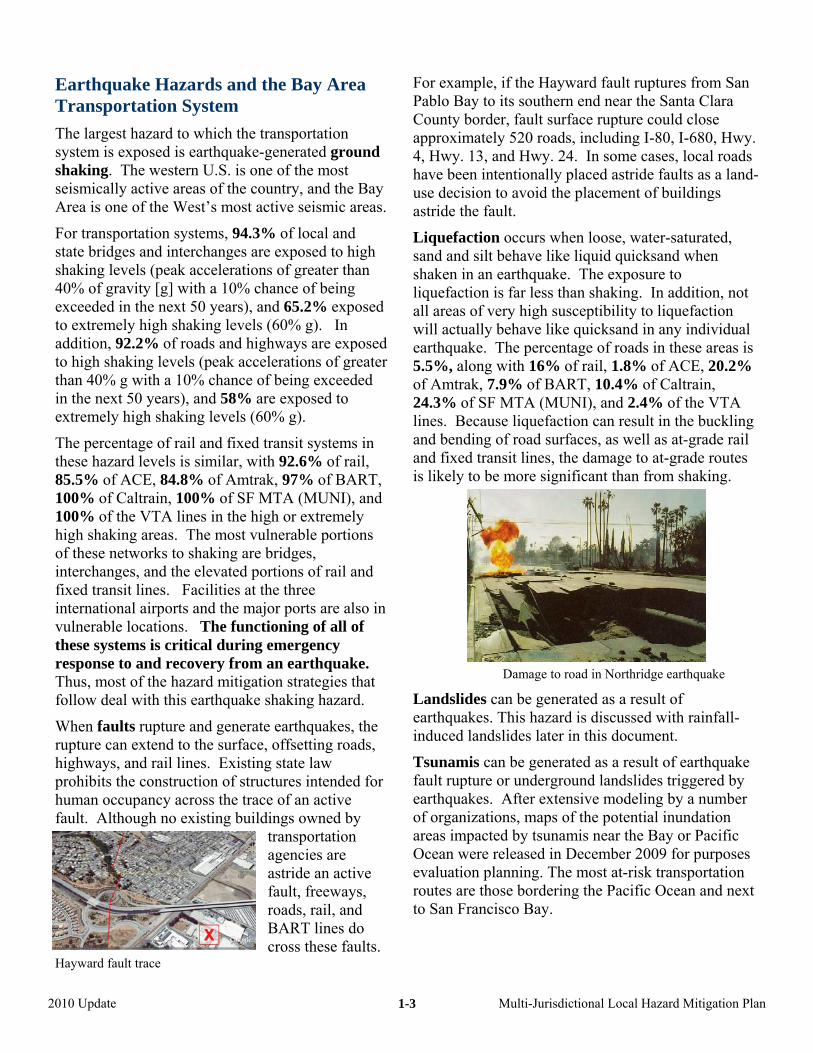
When faults rupture and generate earthquakes, the rupture can extend to the surface, offsetting roads, highways, and rail lines. Existing state law prohibits the construction of structures intended for human occupancy across the trace of an active fault. Although no existing buildings owned by
transportation agencies are astride an active fault, freeways, roads, rail, and BART lines do cross these faults.
Hayward fault trace
For example, if the Hayward fault ruptures from San Pablo Bay to its southern end near the Santa Clara County border, fault surface rupture could close approximately 520 roads, including I-80, I-680, Hwy. 4, Hwy. 13, and Hwy. 24. In some cases, local roads have been intentionally placed astride faults as a land-use decision to avoid the placement of buildings astride the fault.
Liquefaction occurs when loose, water-saturated, sand and silt behave like liquid quicksand when shaken in an earthquake. The exposure to liquefaction is far less than shaking. In addition, not all areas of very high susceptibility to liquefaction will actually behave like quicksand in any individual earthquake. The percentage of roads in these areas is 5.5%, along with 16% of rail, 1.8% of ACE, 20.2% of Amtrak, 7.9% of BART, 10.4% of Caltrain, 24.3% of SF MTA (MUNI), and 2.4% of the VTA lines. Because liquefaction can result in the buckling and bending of road surfaces, as well as at-grade rail and fixed transit lines, the damage to at-grade routes is likely to be more significant than from shaking.
Damage to road in Northridge earthquake
Landslides can be generated as a result of earthquakes. This hazard is discussed with rainfall-induced landslides later in this document.
Tsunamis can be generated as a result of earthquake fault rupture or underground landslides triggered by earthquakes. After extensive modeling by a number of organizations, maps of the potential inundation areas impacted by tsunamis near the Bay or Pacific Ocean were released in December 2009 for purposes evaluation planning. The most at-risk transportation routes are those bordering the Pacific Ocean and next to San Francisco Bay.
2010 Update Multi-Jurisdictional Local Hazard Mitigation Plan
1-3
Current Earthquake Hazard Transportation Mitigation Highlights
The amount of effort and money currently being spent on the mitigation of earthquake impacts is higher than any of the other natural hazards.
State and federal agencies, local governments, and all transit agencies routinely take into account predicted earthquake forces in the design of new structures, including office and operations buildings, bridges, and interchanges. BART and Caltrans have even helped to fund the development of innovative new technologies to make transportation networks and structures even more resistant to shaking and liquefaction.
MTC, as the Bay Area Toll Authority, is directing the $8.5 billion program to make the region’s state-owned toll bridges more resistant to earthquake shaking and potential problems of liquefaction.
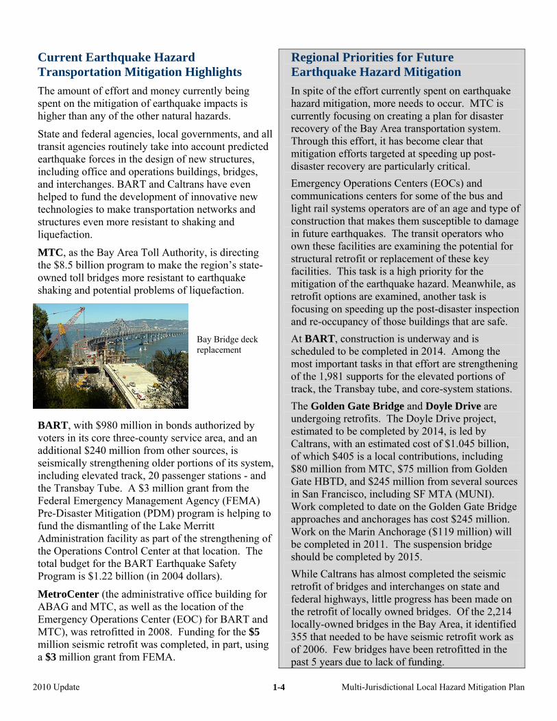
Bay Bridge deck replacement
BART, with $980 million in bonds authorized by voters in its core three-county service area, and an additional $240 million from other sources, is seismically strengthening older portions of its system, including elevated track, 20 passenger stations - and the Transbay Tube. A $3 million grant from the Federal Emergency Management Agency (FEMA) Pre-Disaster Mitigation (PDM) program is helping to fund the dismantling of the Lake Merritt Administration facility as part of the strengthening of the Operations Control Center at that location. The total budget for the BART Earthquake Safety Program is $1.22 billion (in 2004 dollars).
MetroCenter (the administrative office building for ABAG and MTC, as well as the location of the Emergency Operations Center (EOC) for BART and MTC), was retrofitted in 2008. Funding for the $5 million seismic retrofit was completed, in part, using a $3 million grant from FEMA.
Regional Priorities for Future Earthquake Hazard Mitigation
In spite of the effort currently spent on earthquake hazard mitigation, more needs to occur. MTC is currently focusing on creating a plan for disaster recovery of the Bay Area transportation system. Through this effort, it has become clear that mitigation efforts targeted at speeding up post-disaster recovery are particularly critical. Emergency Operations Centers (EOCs) and communications centers for some of the bus and light rail systems operators are of an age and type of construction that makes them susceptible to damage in future earthquakes. The transit operators who own these facilities are examining the potential for structural retrofit or replacement of these key facilities. This task is a high priority for the mitigation of the earthquake hazard. Meanwhile, as retrofit options are examined, another task is focusing on speeding up the post-disaster inspection and re-occupancy of those buildings that are safe. At BART, construction is underway and is scheduled to be completed in 2014. Among the most important tasks in that effort are strengthening of the 1,981 supports for the elevated portions of track, the Transbay tube, and core-system stations. The Golden Gate Bridge and Doyle Drive are undergoing retrofits. The Doyle Drive project, estimated to be completed by 2014, is led by Caltrans, with an estimated cost of $1.045 billion, of which $405 is a local contributions, including $80 million from MTC, $75 million from Golden Gate HBTD, and $245 million from several sources in San Francisco, including SF MTA (MUNI). Work completed to date on the Golden Gate Bridge approaches and anchorages has cost $245 million. Work on the Marin Anchorage ($119 million) will be completed in 2011. The suspension bridge should be completed by 2015. While Caltrans has almost completed the seismic retrofit of bridges and interchanges on state and federal highways, little progress has been made on the retrofit of locally owned bridges. Of the 2,214 locally-owned bridges in the Bay Area, it identified 355 that needed to be have seismic retrofit work as of 2006. Few bridges have been retrofitted in the past 5 years due to lack of funding.
2010 Update Multi-Jurisdictional Local Hazard Mitigation Plan
1-4
Weather-Related Hazards and the Bay Area Transportation System
The Bay Area has historically had a mild Mediterranean climate characterized by mild rainy winters and dry summers. Flooding and landsliding occurred during the wet season, while wildfires and drought occurred in the dry season.
Climate change has been shown to exacerbate all of these hazards. Thus, the region can expect more flooding and landsliding due to a more abrupt runoff in the spring, as well as increased potential for wildfires any time of year and multi-year drought conditions. The various port facilities, as well as both the Oakland and San Francisco International Airports, are subject to the threat of sea level rise.
Flooding can occur when occasional intense winter storms result in local stream flooding, as well as when particularly warm rains in the Sierras can also result in sudden snow melting. Occasionally strong winter storms can close roads in the Bay Area. However, flooding is a lesser hazard than earthquakes to the region’s transportation system. Only 5.2% of the roads (versus 58% in extremely high ground shaking areas) are in 100-year flood zones. The percentage of rail in these hazard areas is 15.9%, along with 14.5% of ACE, 21% of Amtrak, 2% of BART, 6.5% of Caltrain, none of SF MTA (MUNI), and 4.8% of the VTA lines.
Flooding of road due to Jones Tract levee failure just east of Bay Area
In addition to these traditionally flood-prone areas, some portions of the region, particularly in the Bay-Delta, are actually below sea level.
Of particular concern, mu
ural areas.
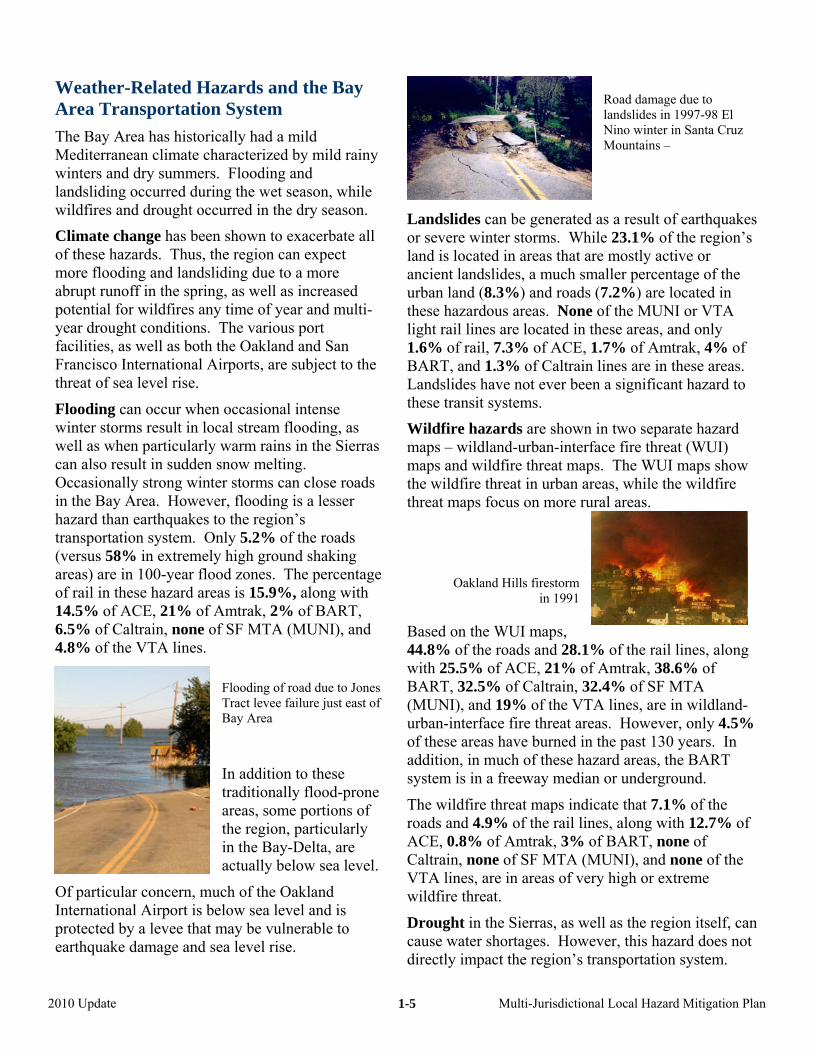
Oakland Hills firestorm
UI maps, ng
-
eat maps indicate that 7.1% of the
f the
ierras, as well as the region itself, can
ch of the Oakland International Airport is below sea level and is protected by a levee that may be vulnerable to earthquake damage and sea level rise.
Road damage due to landslides in 1997-98 El Nino winter in Santa Cruz Mountains –
Landslides can be generated as a result of earthquakes or severe winter storms. While 23.1% of the region’s land is located in areas that are mostly active or ancient landslides, a much smaller percentage of the urban land (8.3%) and roads (7.2%) are located in these hazardous areas. None of the MUNI or VTA light rail lines are located in these areas, and only 1.6% of rail, 7.3% of ACE, 1.7% of Amtrak, 4% of BART, and 1.3% of Caltrain lines are in these areas. Landslides have not ever been a significant hazard to these transit systems.
Wildfire hazards are shown in two separate hazard maps – wildland-urban-interface fire threat (WUI) maps and wildfire threat maps. The WUI maps show the wildfire threat in urban areas, while the wildfire threat maps focus on more r
in 1991
Based on the W44.8% of the roads and 28.1% of the rail lines, alowith 25.5% of ACE, 21% of Amtrak, 38.6% of BART, 32.5% of Caltrain, 32.4% of SF MTA (MUNI), and 19% of the VTA lines, are in wildlandurban-interface fire threat areas. However, only 4.5% of these areas have burned in the past 130 years. In addition, in much of these hazard areas, the BART system is in a freeway median or underground.
The wildfire thrroads and 4.9% of the rail lines, along with 12.7% ofACE, 0.8% of Amtrak, 3% of BART, none of Caltrain, none of SF MTA (MUNI), and none oVTA lines, are in areas of very high or extreme wildfire threat.
Drought in the Scause water shortages. However, this hazard does not directly impact the region’s transportation system.
2010 Update Multi-Jurisdictional Local Hazard Mitigation Plan
1-5
Current Weather-Related Hazard Mitigation Highlights
The amount of effort and money currently being spent on the mitigation of weather-related hazards is far lower than for earthquake-related hazards. Reasons for this difference include (1) infrastructure facilities, roads, and rail systems have a much lower exposure to these hazards and (2) potential weather-related disasters are less regional in scope, making the functioning of transportation systems less critical.
VTA’s headquarters buildings are in a flood plain. Due to the efforts of the Santa Clara Valley Flood Control and Water District, the drainage and flooding problems at this facility have been reasonably mitigated.
Landslides are not a major concern to the regional transit systems, rail lines, port, or airport systems. Roads built in landslide hazard areas are currently designed to minimize the likelihood of damage and tend to be less exposed to this hazard than the overall urban areas that they serve. One exception is Highway 1 along the San Mateo and Marin County coastlines. Caltrans worked with local governments to better design roadway alignments. For example, in San Mateo County, bridges and a tunnel are being built to bypass Devil’s Slide between Pacifica and Half Moon Bay. The project will be completed in 2011.
Wildfire is a concern in the areas served by the transportation system. However, there is no well-established way to mitigate any hazards associated with the transportation system itself.
Local governments can adapt to climate change by mitigation of sea level rise, flooding, drought, and wildfire hazards. However, climate change itself can be mitigated through efforts at direct control of greenhouse gases and carbon emissions. Fully one half of the Bay Area’s greenhouse gas emissions are the result of transportation sources, particularly on-road private vehicles. Efforts to develop greener transportation have been initiated by various transit and transportation agencies in the region.
In particular, MTC is emphasizing transit investments and maintenance of existing infrastructure seeking to moderate growth of private vehicle usage. Other programs encourage increased transit ridership and more walking and biking for short trips. MTC’s congestion management and intelligent transportation system programs seek to reduce emissions through smoother, more efficient traffic flow.
Regional Priorities for Future Weather-Related Hazard Mitigation
Additional ways are available to mitigate the impacts of weather-related hazards.
The bus yards of AC Transit and, to a lesser extent, SamTrans that are located near the Bay have experienced flooding and may need redesigned drainage systems to better mitigate the problem. (Flooding has not impacted the buildings.)
MTC, ABAG, the Bay Area Air Quality Management District (BAAQMD), and the Bay Conservation and Development Commission (BCDC) have initiated a Joint Policy Committee that has mitigation and adaptation to climate change as a principal focus. One of the main goals of this regional group is reduce carbon emissions through a variety of innovative programs, including encouraging smart growth, initiation of congestion pricing schemes, and other pilot projects.
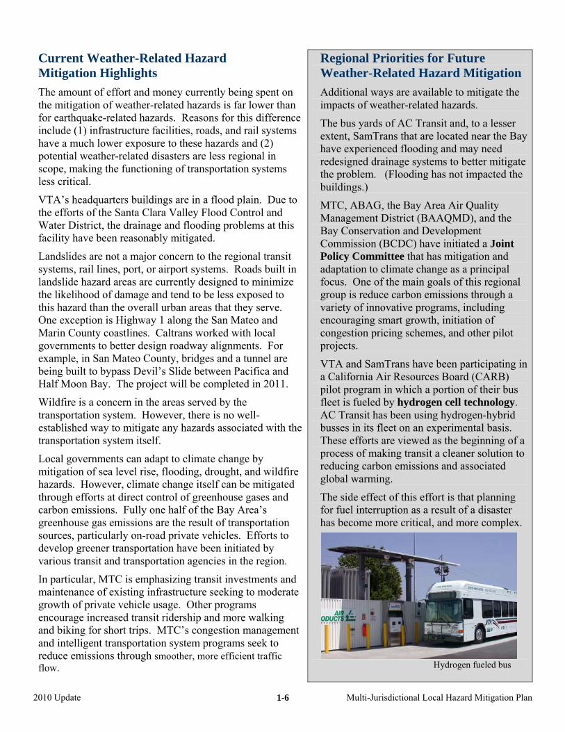
VTA and SamTrans have been participating in a California Air Resources Board (CARB) pilot program in which a portion of their bus fleet is fueled by hydrogen cell technology. AC Transit has been using hydrogen-hybrid busses in its fleet on an experimental basis. These efforts are viewed as the beginning of a process of making transit a cleaner solution to reducing carbon emissions and associated global warming.
The side effect of this effort is that planning for fuel interruption as a result of a disaster has become more critical, and more complex.
Hydrogen fueled bus
2010 Update Multi-Jurisdictional Local Hazard Mitigation Plan
1-6
Bay Area Commercial and General Aviation Airports The Bay Area airports are managed independently by the individual cities that own and operate them. However, the Regional Airport Planning Committee (RAPC) is an organization set up by, and operated by, the staff of three regional agencies: the Metropolitan Transportation Commission (MTC), the Association of Bay Area Governments (ABAG) and the Bay Conservation and Development Commission (BCDC).
For purposes of this multi-jurisdictional plan, the discussion of the hazards, risks, and applicable mitigation efforts has been overseen by these three regional agencies on behalf of RAPC, and in turn
by the various airports themselves (as owned and operated by the cities). The Ba l y Area is home to three international commerciaairports: San Francisco International (SFO); San Jose International (SJC); and Oakland International (OAK).
In addition, there are over 30 general aviation airports serving the Bay Area.
RAPC tives from all of these key has representaconstituencies.
While the following discussion focuses on the three internat ssues at ional airports, it also describes related igeneral aviation airports and other airports.
Hazard and Risk Assessment
Earthquake: In 2000, with a grant from FAA through MTC, ABAG performed a hazard and risk assessment of the three major international airports, and a preliminary evaluation of the general aviation airports. Based on past experience in California and other recent earthquakes, the threats to Bay Area airport operations following future earthquakes fall into four general categories: • liquefaction damage to airport runways,
particularly at Oakland, San Francisco, and,
accdOd
aviation airports are in thin
Tre
perhaps, Moffett Federal Airfield (given thaliquefaction mitigation occurred to the runwayat SJC);
• shaking damage to air con
also t
s
trol and terminal e
ess tisasterAK a at o not m
Howev
cludin ple, Buchanan and Palo Alto.
sunamleased
Bay, OMoffett
is e
Landslaviation
dfir ect igh % of airport land is in a
ldlan
Hazard gnificoodin
and earthqua reat not significant due to proximity to the Bay.
facilities, particularly older facilities that may bpresent at Oakland, Moffett, Hayward, San Francisco, Half Moon Bay, Buchanan, and Livermore airports;
• power and communications disruptions; and • disruptions to the transportation systems serving
the airports. Flooding: None of the three international airports are in the 100-year floodplain. However, SJC is surrounded by this floodplain, which may hamper
Wilto hwi
sifl
is
o and use of the facility in a flood-related . In addition, large portions of the runways of re below sea level, protected only by levees th
eet current engineering design levels. er, overall, 15% of the land used for general
e 100-year floodplain, g, for exam
is: The tsunami evacuation planning maps in December 2009 indicate that, within the
AK would be impacted, but not SFO, SJC, or Field. A portion of the Half Moon Bay airportxpected to be impacted.
iding: None of these international OR general facilities are in an area of existing landslides.
e: None of these facilities are in an area subjwildfire threat, but 27d-urban interface (WUI) threat area.
Conclusion and Risk Assessment: The twoant threats to the international airports are g (particularly levee failure and sea level rise)
kes (shaking and liquefaction). WUI th
Existing Mitigation Programs
Earthquake: SJC has had an extensive program to effectively “bridge” ancient stream channels that lie under its runways and are the source of the liquefaction hazard for that airport. OAK and SFO are currently investigating the options for decreasing the liquefaction risk to their runways.
The planned program to tackle this issue as part of runway expansion efforts is on indefinite hold.
Flooding: OAK is upgrading its runway levee as it adds facilities to account for sea level rise and levee failure. It has not been successful in getting the necessary funds to improve the entire levee system at this time.
2010 Update Multi-Jurisdictional Local Hazard Mitigation Plan
1-7
Bay Area Commercial and General Aviation Airports (continued)
ly d Travis
Bay;
w runways also ith the
to
ual a pplan s of tran d emergency planning is essential. MTC is starting t Response Plan (TRP) for earthquakes. The Regional Airp this issu ing.
ify alternate locations capable of handling after an
ommercial airports nsportation system
ergency nt
ravis AFB as the primary er.
n rs should not believe that Travis has additional
or ting
us cities which own
F th ettis a nd K d arCA. eq
Priorities for Future Mitigation Programs
1. Focus on better understanding and mitigationof the liquefaction hazard to runways. We need to expand on the liquefaction analysis conducted for the runways at the three major airports (OAK, SFO,and SJC) to (a) gain further information on the vulnerability of other major airports, particularMoffett Federal Airfield on the Peninsula anAir Force Base in Solano County, and, if feasible, Buchanan, Hayward, and Livermore in the East and (b) incorporate more recent geotechnical information becoming available for OAK, SJC andSFO.
2. Ensure that the design of nemitigates liquefaction hazards associated wconnections to the existing runway system. Anyrunway expansions at SFO and OAK that tie into sections of existing runways which are vulnerable liquefaction will make the expansions vulnerable aswell. Runway work at SJC has been designed tominimize the liquefaction hazard.
3 m. I prove emergency planning at individir orts and to better coordinate emergency
ning among airports and with other formsportation. Airport participation in coordinate
his planning as part of the integrated Trans
ort Planning Committee has also discussede, particularly as it relates to potential fund
4. Identlarge commercial and cargo jetsearthquake should Bay Area close capacity due to road tradisruptions, runway damage, or structural damage. Travis AFB will have increased air and vehicle traffic during the post-earthquake emresponse phase because the federal governmeplans on using Tmobilization center for their response to the disastWith the normal operations that Travis has in addition to this major role, emergency plan e
capacity for other commercial or cargo needs. Options include neighboring commercial airports (Sacramento, Stockton, Monterey, etc.), as well as larger general aviation airports.
5. Identify funding mechanisms for the retrofitreplacement of critical levee systems protecthe runway at OAK. The levee system at this airport is currently vulnerable to both earthquake damage and damage due to sea level rise.
Other mitigation activities related to the airports and their facilities are covered in the individual mitigation strategies of the varioand manage the airports in the Bay Area.
ur er airport information: Perkins, J., with William LDon’t Wing It: Airports and Bay Ar
nd Associates (WLA) (Bachhuber, J., Baldwin, J., anu sen, K.), 2000. ea E
Excerpts are available online at thquakes: Association of Bay Area Governments, Oakland, trans/eqtrans.htmlhttp://quake.abag.ca.gov/ .
2010 Update Multi-Jurisdictional Local Hazard Mitigation Plan
1-8
Th stem Th s are managed by a network of ents, and private co esBa enby aest e
So eir urband e wanin pnu atewa i(in to, San JEe roU.S. Bureau of Reclamation Central Valley Project are larof
Th pSa istrthe eyanreg uim s dam ter suBa t obtain all or part ofeit he SaJoa elta.
Thare fSo gin adec to cope wint nce, cones of dep istry, which in tur ty. Groundwater
gnificant storage sites for some Bay Ar
Cof its potential are provided in the State of California Water Plan and in
a range of Urban Water Management Plans in the Bay Region. The State’s Recycled Water Task Force recently estimated that building additional water recycling plants could meet 30 percent of the region’s water needs by 2030. Recycled water in the region is used in a wide range of applications, including landscape irrigation, industrial cooling, and agricultural needs, as well as an environmental water source for wetlands restoration. The Department of Water Resources estimates that close to 50 million gallons per day (GPD) of recycled water is produced here, and planned projects have the potential to double this amount in ten years.
e Existing Water and Wastewater Sye regional water and wastewater systempublic special districts, city and county departmmpanies. There are over 100 water retailers and wholy Area. While most wastewater collection and treatm cities and counties, some special districts treat wastewimates that there are 32,000 miles each of water and s
me communities within the Bay region derive th rural water supplies from groundwater and surface-county region (Napa River, Russian River, Guadalu
merous creeks and springs). Others rely on groundwters that are imported from watersheds and basins outscluding the Tuolumne, Mokelumne, Sacramenl River watersheds). The State of California Water P
alers in the t is handled ter. ABAG
wer pipes.
an, suburban ters within the e River, r and surface de the region oaquin and ject and the ge suppliers
ortion of the ibuted from ces within the al supply is
water to the Bay region.
e Bay Area contains over 400 watersheds, including a cramento/San Joaquin watershed system. Water is dse watersheds via a series of open and closed convion, and inter-regionally. A significant amount of annpounded in 260 major reservoirs and behind numerou
s scattered throughout the region. 75% of the way Area are from water agencies tha
small check pplies for the their water cramento-San
her (1) from aqueducts or canals passing through tquin Delta or (2) by extracting water from that D
e Bay Area also contains a series of dedicated groundwas where groundwater can accumulate for current andme groundwater recharge areas are employed to beline of groundwater levels in some basins, or
rusion. These declines can, and do, lead to land subsideression, damaged infrastructure, and altered soil chem
n can affect the region’s groundwater carrying capaci
ater recharge uture use. rresting the ith salt water
Participating Agencies Special-purpose agencies directly participating in this water supply and wastewater portion of the MJ- LHMP include several special districts: • Alameda County Water District • Contra Costa Water District • Dublin-San Ramon Services
District • East Bay Municipal Utility Dist. • Mid-Peninsula Water District • Montara Water & Sanitary Dist. • Purissima Hills Water Dist. • Santa Clara Valley Water Dist. • Sewer Authority Mid-Coastside • Solano Co. Water Agency • Solano Irrigation District • Vallejo Sanitation & Flood
Control District • Zone 7 Water Agency
City and county water departments are represented on the committee overseeing this process by the San Francisco Public Utility District which operates the Hetch-Hetchy system.
Private companies partnering in this updated plan include: • San Jose Water Company • Cal Water
As a multi-jurisdictional plan, this basins outside the region act as sieffort makes use of the hazard maps contained in the overall plan, with
ea water needs during dry years.
nserved and recycled water is another source of water and estimates o
the additional hazard exposure data documented in this chapter. The various agencies participating in this plan coordinated their efforts through the overall lifeline effort of the MJ-LHMP through representatives to the ABAG Lifeline Infrastructure and Hazards Advisory Committee.
2010 Update Multi-Jurisdictional Local Hazard Mitigation Plan
1-9
Earthquake Hazards and the Bay Area Water and Wastewater Systems Examining the locations of dams, water and wastewater treatment facilities, and pipeline networks that make up the water supply and wastewater collection system, shows earthquakes to be the greatest hazard. Because these systems have to be located in urban areas to serve
Liquefactionsand and silshaken in an is far less thavery high suscbehave like quthose communities, their general hazard exposure is
similar to that of the areas they serve.
While 93.4% of critical water system facilities and 88.8% of critical wastewater system facilities are exposed to high ground shaking levels (peak accelerations of greater than 40% of gravity [g] with a 10% chance of being exceeded in the next 50 years), 68.1% of critical water system facilities and 67.5% of critical wastewater system facilities are exposed to extremely high shaking level
A much highethan water (5.4%hazard caresults in buckpipelines can bpipe distributhey tend to
An ABAG ans (60% g). In addition,
an occupancy
oct beh
eart n shaking. In addition, not all areas of
epick nr p e
a t tegories for rd. As liquefaction
lin ne
tion eserv e
aly othe 1989 Loma P t
eas bolen r t
ro nA be,
6,00 - eaks or n r fault
0dv
Reservoir
can earthquakes. Th
lid b
e or us. Af
ns,ted b
le r evaluation he m ing
and 16% of water facilities are in these areas.
95.2% of pipelines are estimated to be exposed to high shaking levels (peak accelerations of greater than 40% g with a 10% chance of being exceeded in the next 50 years), and 62.8% are exposed to extremely high shaking levels (60% g). Thus, most of the mitigation strategies that follow deal with this hazard. While shaking will not damage pipelines in the same manner as buildings, the ground waves associated with shaking will damage those pipelines.
pipelines in arexposed to vilikely to have bearthquake. ABfor example,major leaks in a(compared to 5Rapid repair anessential to reco
The ability of the levees in the Sacramento-San Joaquin Delta to withstand strong shaking is being studied, as discussed in the box on the following page. The hazards associated with failure of these levees, both directly and indirectly, on the region’s water supply could be catastrophic.
When faults rupture and generate earthquakes, that rupture can extend to the surface, rupturing aqueducts and pipelines. Existing state law prohibits the construction of structures intended for hum
Landslides
across the trace of an active fault. However, water aqueducts and pipelines cross these faults. For example, if the Hayward fault ruptures from San Pablo Bay to its southern end near the Santa Clara County border, fault surface rupture could severely damage the Hetch-Hetchy aqueducts, the EBMUD aqueducts, the South Bay aqueduct, and numerous local pipelines. Some dams are also on or near faults. In some cases, local roads have been intentionally placed astride faults as a land-use decision to avoid the placement of buildings astride the fault. When this occurs, the water and sewer pipelines are placed in this same alignment.
induced landsTsunamis canfault rupturearthquakeof organizatioareas impacOcean were replanning. Tthe Pacific Oceaestimated 1.7%critical waste
curs when loose, water-saturated, ave like liquid quicksand when hquake. The exposure to liquefaction
iltib ity to liquefaction will actually . sa d in any individual earthquake
erc ntage of wastewater (35.8%) ) f cilities are located in the highes
this hazag a d bending of the ground, damaged. While the percentage of lin s in these areas is only 5.9%, e th largest population centers.
sis f damaged pipelines following rie a earthquake indicated that su ject to liquefaction AND t g ound shaking were the moske or leaked as a result of that G has estimated that there could0 10,000 water pipeline br ea thquake on the Hayward
7 in the Loma Prieta earthquake). replacement of these pipelines is ery from an earthquake.
San Pablo Dam and
Upgrade
be generated as a result of is hazard is discussed with rainfall-es later in this document. e generated as a result of earthquake nderground landslides triggered by ter extensive modeling by a number maps of the potential inundation y tsunamis near the Bay or Pacific ased in December 2009 foost at-risk areas are those bordern and next to San Francisco Bay. An of critical water facilities
2010 Update Multi-Jurisdictional Local Hazard Mitigation Plan
1-10
Current Earthquake Hazard Water-Wastewater Mitigation Highlights
f
es
to d
d s
r
ts,
Francisco PUC ated total
t
s in e faults. These valves, installed on
ater
plan for
ewater
er
s roject.
The amount of effort and money currently being spent onthe mitigation of earthquake impacts is higher than any othe other natural hazards.
All water and wastewater special districts, as well as citiand counties, routinely take account of predicted earthquake forces in the design of new structures, including office and operations buildings, as well as wastewater and water treatment plants and conveyance networks.
Bay Area residents have funded major improvementsthe San Francisco PUC Hetch-Hetchy, EBMUD, anContra Costa Water District (CCWD) systems, particularly related to storage tanks, treatment plants, anfault crossings. However, with these major systems, awell as with smaller agencies, the capital improvements budgets are limited. These financial issues are have beenexacerbated by the 2008-09 recession.
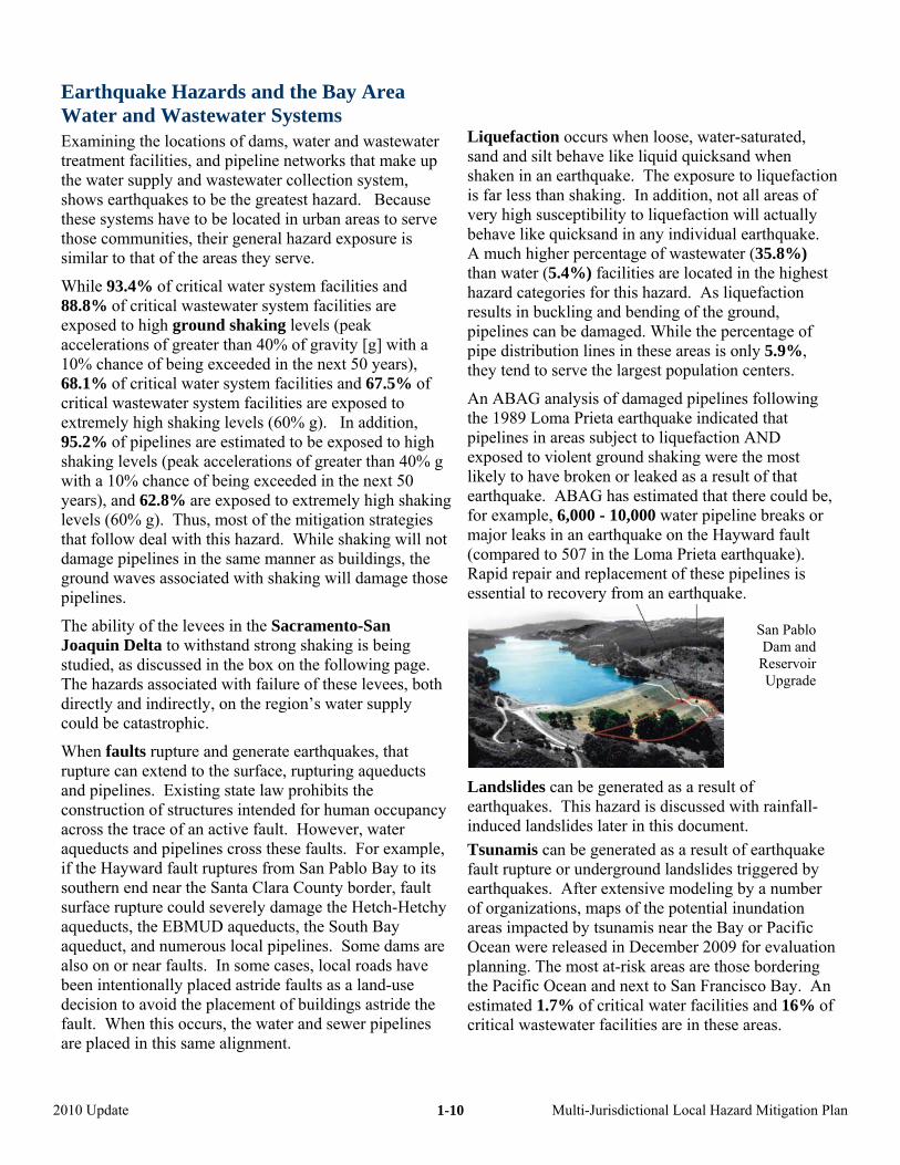
Dam owners and operators, under the regulation of the State Division of Safety of Dams, routinely inspect theifacilities and reevaluate their safety in light of current engineering and seismology. Based on these assessmenEBMUD is retrofitting San Pablo Dam and Reservoir at a cost of $75
Future Regional Mitigation Priorities Related to the Delta
The levee failures resulting from Hurricane Katrina, combined with the Jones Tract levee failures in the Sacramento-San Joaquin Delta, have led to an evaluation of the potential impact of a major earthquake or flood on that Delta system. As previously stated, 75% of the water supplies for the region are from water agencies that obtain all or part of their water from the Delta or have conveyances that pass through it. The State of California has conducted a Delta Risk Management Study (DRMS) that has explained the problem and associated risks. The State, the water agencies, and other organizations are currently working to identify mitigation options that would protect the water supply and environmental quality of the Delta. At this point, various strategies are being reviewed. While the Governor’s administration favors a canal bypass, this option would partially protect Southern California water interests, but, as currently envisioned, would not protect the water supply of the Bay Area. The cities, counties, and special districts in th Bay emillion dollars. The San Area are, and will continue to be, involved in Calaveras Dam Replacement Project has an estim
cost of $409 million dollars.
EBMUD, CCWD, and Santa Clara Valley Water Districhave installed, and SFPUC and Alameda County Water District are in the process of installing, shut-off valvepipelines that cross activeach side of the fault, enable above-ground potable wbypass lines to be rapidly installed.
Water and wastewater agencies have started to speeding the repair and functional restoration of water andwastewater systems through joining the Water/WastAgency Response Network (WARN). The plan is to stockpile shoring materials, temporary pumps, surface pipelines, portable hydrants, and other supplies. Some water suppliers have also purchased equipment to bag emergency drinking water for customers.
ABAG’s Sewer Smart Program, with water and wastewatdistricts, has developed innovative materials to help thepublic cope with disrupted storm drains, sewer lines, andwastewater treatment. This program grew out of the exposure of the wastewater system to earthquake hazardand the information gap identified as part of this p
this multi-billion dollar discussion. From the standpoint of risk, damage to the Delta levees from a major earthquake that would also cripple portions of the urban Bay Area (such as one on the Hayward fault) is more problematic than damage from a Delta-area fault because the region’s resources would be more heavily impacted. Thus, a disaster mitigation effort for the Delta that incorporates recovery goals is essential.
Future Regional Mitigation Priorities Related to Pipelines
The pipeline distribution systems for water and sewer lines typically have not been replaced since they were originally installed, in some cases almost 100 years ago. These pipelines will break and leak. Ways to mitigate this damage through repair and replacement of the most susceptible lines has started, but will not be completed for several years.
2010 Update Multi-Jurisdictional Local Hazard Mitigation Plan
1-11
y s
of
g, as well as increased potential for
Laneart of the actiperc d wastheswas % of tHowstorrese
Wiltwowildthrewildmapurba cus on mor
Baswatrea s
and Whin thload
herit
was igh, andthe
Dro Sierras, as well as the region itself, candep
Weather-Related Hazards and the BaArea Water and Wastewater System
The Bay Area has historically had a mild Mediterranean climate characterized by mild rainy winters and dry summers. Flooding and landsliding occurred during the wet season, while wildfires and drought occurred in the dry season.
Climate change has been shown to exacerbate all these hazards. Thus, the region can expect more flooding and landsliding due to a more abrupt runoff in the sprinwildfires any time of year and multi-year drought conditions. Some wastewater treatment facilities may be subject to the threat of sea level rise.
Flooding can occur when occasional intense winter storms result in local stream flooding, as well as when particularly warm rains in the Sierras result in sudden snow melting. Flooding is a lesser hazard than earthquakes to the region’s water and wastewater systems. A significant 11.5% of the wastewater and 3.8% water critical facilities in the region are in the 100-year flood plain. While an estimated 3.7% of pipelines are in these areas, flooding of areas above pipelines is not a significant hazard because areas are not expected to be flooded for weeks at a time.
a
Occasionally strong winter storms can close roads in the Bay Area.
Finally, warm storms in the Sierras can cause rapid snow melt, which can lead to high water levels that can damage levees in the Sacramento-San Joaquin
Tc
Delta. Delta islands can also be flooded due to damage not associated with storms because of the poor quality of some Delta levees. In addition to these traditionally flood-prone areas, some portions of the region, particularly in the Bay-Delta, are actually below sea level and other areas are subject tosea level rise.
dslides can be generated as a result of hquakes or severe winter storms. While 23.1%region’s land is located in areas that are mostly ve or ancient landslides, a much smaller entage of the urban land (8.3%) and water antewater system pipelines (3.9%) are located in e hazardous areas. While 0.6% of the major tewater facilities are located in these areas, 11he water facilities are located in these areas.
ever, erosion and siltation can also impact the age capacity of critical rvoirs.
dfire hazards are shown in separate hazard maps – the land-urban-interface fire at (WUI) maps and the fire threat maps. The WUI s show the wildfire threat in n areas, while the wildfire threat maps foe rural areas.
ed on the WUI maps, an estimated 51.1% of the er and wastewater pipelines are in fire hazard s, as well as 66.8% of the critical water facilitie44.4% of the critical wastewater facilities.
ile only 4.5% of these areas have actually burned e past 130 years, this indicates a build-up in fuel s.
wildfire threat maps indicate that 14.7% of the ical water facilities and only 1.5% of the critical tewater facilities are in areas of high, very h extremely high wildfire threat, as well as 6% of pipelines.
ught in the cause water shortages because of the large endency of the Bay Area on imported water.
2010 Update Multi-Jurisdictional Local Hazard Mitigation Plan
1-12
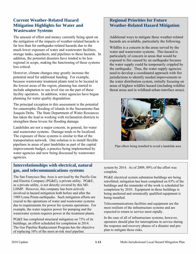
Current Weather-Related Hazard Mitigation Highlights for Water and Wastewater Systems
The amount of effort and money currently being spentthe mitigation of the impacts of weather-related hazardsfar less than for earthquake-related hazards due to the much lower exposure of water and was
on is
tewater facilities, In
s
d in d to
begun
ntial
rces s to
r
One solution is to install flexible
d now being discussed by wastewater
storage tanks, aqueducts, and pipelines to these hazards.addition, the potential disasters have tended to be less regional in scope, making the functioning of these systemless critical.
However, climate changes may greatly increase the potential need for additional funding. For example, because wastewater treatment plants tend to be locat
gion, planning has starte
Regional Priorities for Future Weather-Related Hazard Mitigation
Additional ways to mitigate these weather-related hazards are available, particularly the following.
Wildfire is a concern in the areas served by the water and wastewater systems. This hazard is particularly of concern in areas that would be exposed to fire caused by an earthquake because the water supply could be temporarily crippled by the earthquake. Thus, the water supply agencies need to develop a coordinated approach with fire jurisdictions to identify needed improvements to the water distribution system, initially focusing on areas of highest wildfire hazard (including wildfire threat areas and in wildland-u
ethe lowest areas of the reinclude adaptation to sea level rise on the part of these facility operators. In addition, water agencies have planning for water quality degradation.
The principal exception to this assessment is the potefor catastrophic flooding of islands in the Sacramento-San Joaquin Delta. The State Department of Water Resouhas taken the lead in working with reclamation districtstrengthen those levees for flooding damage.
Landslides are not a major concern, in general, for wateand wastewater systems. Damage tends to be localized.The exposure of these systems is similar to that of the transportation network. pipelines in areas of past landslides as part of the capitalimprovements budget, a practice being implemented by
ater agencies anwagencies.
rban-interface areas).
Pipe elbow being installed to avoid a landslide area
Interrelationships with electrical, natural gas, and telecommunications systems The San Francisco Bay Area is serviced by the Pacific Gas and Electric Company (PG&E), a private utility. PG&E, as a private utility, is not directly covered by this MJ-LHMP. However, this company has been actively involved in hazard mitigation both before and after the 1989 Loma Prieta earthquake. Such mitigation efforts are crucial to the operations of water and wastewater systems due to requirements for power for systems operations. For example, the water requires power for pumping and the wastewater system requires power at the treatment plants.
PG&E has completed structural mitigation on 73% of its buildings, an effort scheduled for completion in 2014. The Gas Pipeline Replacement Program has the objective of replacing 10% of the most at-risk steel pipeline
system by 2014. As of 2009, 89% of the effort was complete.
PG&E electrical system substation buildings are being retrofitted; mitigation has been completed on 83% of the buildings and the remainder of the work is scheduled for completion by 2010. Equipment in those buildings is being anchored and seismically qualified equipment is being installed.
Telecommunications facilities and equipment are the most resilient of the infrastructure systems and are expected to return to service most rapidly.
In the case of all of infrastructure systems, however, operators should plan for interruptions in service during the response and recovery phases of a disaster and pre-plan to mitigate those risks.
2010 Update Multi-Jurisdictional Local Hazard Mitigation Plan
1-13
L d Disaster Re
A r the i ucture systems is that they tFteahp
However, in addition to geographic interdependencies, l . Et
chemiterm relatively inflexible use of the electric power system
uch iaddress the length of time reservic
cove ses the im
isrupthe disrecovesysteminfrastinterd
T and o
W( om water by transportation) ◄ es beneath roads ◄ ons for repairing pipelines ◄ facility crews to-and-from their homes ◄ acilities ◄◄ tomers at emergency distribution points ►
W( eded from◄ lines beneath roads with cable and underground wiring; a s pipeline corridors)
ted systems and process control equipment for treatment and operations ◄ s ◄ intena◄ operation► s
W syste( eeded fro◄ nd somp ◄ enan◄ mer t◄ plan
ifeline System Interdependencies an covery
cals to a water treatment facility and the short-s mentioned earlier, one of the main reasons fonterdependencies of infrastrend to be geographically located in the same areas. or example, water, sewer, and natural gas pipelines
end to be under local roads. Communications and lectrical cables are either located under those roads or djacent to them. All have similar exposures to azards that are related to serving the developed ortions of the region.
S
re
d
ifeline systems also have system interdependenciesxamples include the relatively flexible use of the
ransportation system to deliver water treatment
he following linkages between the water supply systems
ater ◄-► Transportation –
to run pumps at that water treatment facility. nterdependent analyses therefore need to
quired to restore various es or interdependences to a level adequate for ry. The length of time of a disruption increapacts. However, typically, doubling the time oftion more than doubles the impacts. In addition, ruption of one infrastructure system delays the ry of other systems because the infrastructure s are not available. Thus, speeding recovery of ructure systems and focusing on ependencies of those systems is critical.1
ther infrastructure lifeline systems are critical:
◄ = needed by water from transportation; ►= needed fr-► Co-location hazard exposure of distribution pipelin Transport of repair and maintenance vehicles to locati Transport of repair, customer service, and operations Delivery of chemicals to water treatment f Delivery of fuel to run critical facilities Delivery of emergency drinking water in bags to cus Water for concrete construction and dust control
ater ◄-► Telecommunications – ◄ = needed by water from telecommunications; ►= ne
-► Co-location hazard exposure of distribution pipebove ground networks also aligned with roads (and thu
Automa
water by telecom)
◄ Communication with repair and maintenance crew Communication with customers for repair and ma Emergency communications with emergency
nce requests s centers
Water for communication equipment cooling system
ater ◄-► Petroleum, natural gas, and electrical◄ = needed by water from energy systems; ►= n
-► Co-location hazard exposure of natural gas aower lines both beneath and adjacent to road corridors Gasoline and lubricants for use in repair and maint Gasoline and lubricants for vehicles of repair, custo
heir homes Electric power for pump and lift stations, treatment
ms – m water by energy systems) e other fuel lines beneath roads, as well as electric
ce vehicles repairing pipelines service, and operations facility crews to-and-from
t operations, and control systems
1 R., 2001.I on MC
See, for example, Peerenboom, J., Fisher, R., and Whitfield, nfrastructures” presented at the CRIS/DRM/IIIT/NSF Workshopatastrophic Failures” Lyceum, Alexandria, Virginia.
“Recovering from Disruptions of Interdependent Critical itigating the Vulnerability of Critical Infrastructures to
2010 Update Multi-Jurisdictional Local Hazard Mitigation Plan
1-14
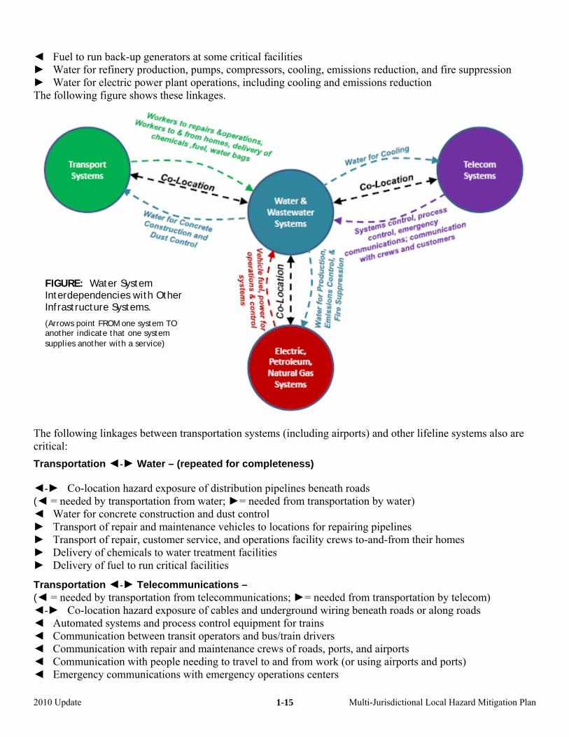
◄ Fuel to run back-up generators at some critical facilities ► Water for refinery production, pumps, compressors, cooling, em► Water for electric power plant operations, includingThe following figure shows these linkages.
issions reduction, and fire suppression cooling and emissions reduction
FIGURE: Water System Interdependencies with Other Infrastructure Systems.
(Arrows point FROM one system TO another indicate that one system supplies another with a service)
The following linkages between transportation systems (including airports) and other lifeline systems also are critical: Transportation ◄-► Water – (repeated for completeness) ◄-► Co-location hazard exposure of distribution pipelines beneath roads
tation by water)
pairing pipelines homes
cation hazard exposure of cables and underground wiring beneath roads or along roads
◄ Communication between transit operators and bus/train drivers
y operations centers
(◄ = needed by transportation from water; ►= needed from transpor◄ Water for concrete construction and dust control ► Transport of repair and maintenance vehicles to locations for re► Transport of repair, customer service, and operations facility crews to-and-from their► Delivery of chemicals to water treatment facilities ► Delivery of fuel to run critical facilities
Transportation ◄-► Telecommunications – (◄ = needed by transportation from telecommunications; ►= needed from transportation by telecom) ◄-► Co-lo◄ Automated systems and process control equipment for trains
◄ Communication with repair and maintenance crews of roads, ports, and airports ◄ Communication with people needing to travel to and from work (or using airports and ports) ◄ Emergency communications with emergenc
2010 Update Multi-Jurisdictional Local Hazard Mitigation Plan
1-15
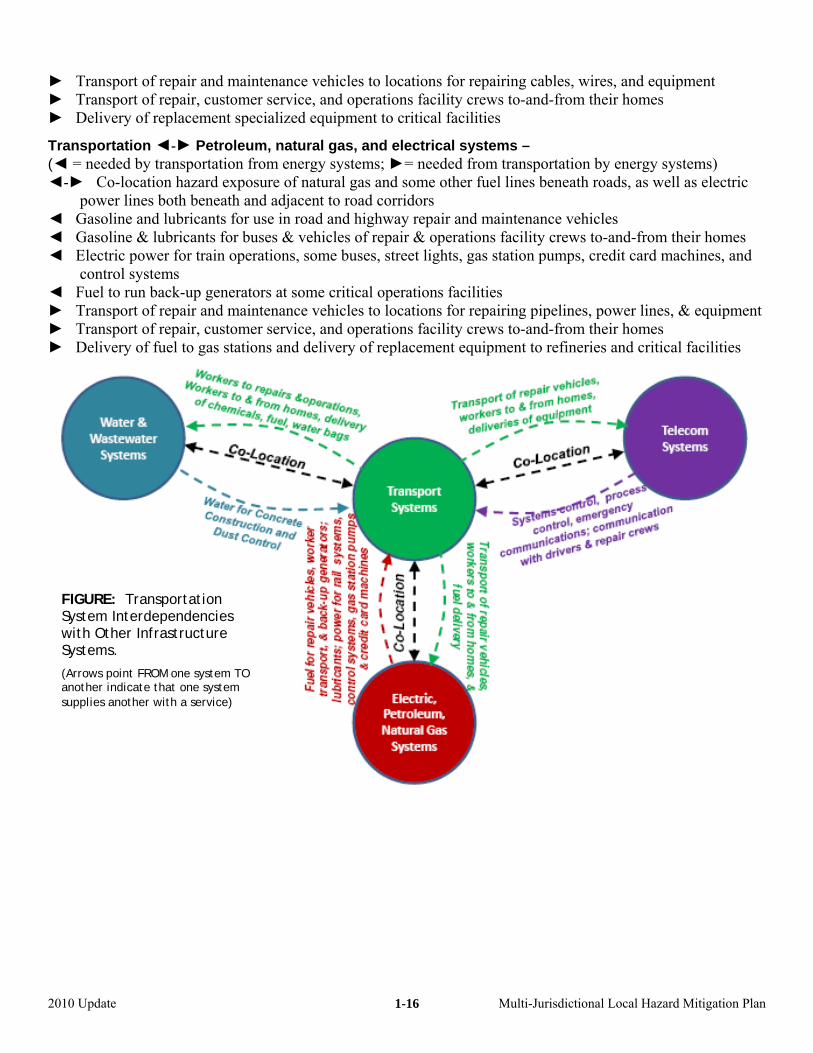
► Transport of repair and maintenance vehicles to locations for repairing cables, wires, and equipment
as, and electrical systems – (◄ = needed by transportation from energy systems; ►= needed from transportation by energy systems) ◄-► Co-location hazard exposure of natural gas and some other fuel lines beneath roads, as well as electric power lines both beneath and adjacent to road corridors ◄ Gasoline and lubricants for use in road and highway repair and maintenance vehicles ◄ Gasoline & lubricants for buses & vehicles of repair & operations facility crews to-and-from their homes ◄ Electric power for train operations, some buses, street lights, gas station pumps, credit card machines, and control systems ◄ Fuel to run back-up generators at some critical operations facilities ► Transport of repair and maintenance vehicles to locations for repairing pipelines, power lines, & equipment ► Transport of repair, customer service, and operations facility crews to-and-from their homes ► Delivery of fuel to gas stations and delivery of replacement equipment to refineries and critical facilities
► Transport of repair, customer service, and operations facility crews to-and-from their homes ► Delivery of replacement specialized equipment to critical facilities
Transportation ◄-► Petroleum, natural g
FIGURE: Transportation
ther Infrastructure System Interdependencies with OSystems.
(Arrows point FROM one system TO another indicate that one system supplies another with a service)
2010 Update Multi-Jurisdictional Local Hazard Mitigation Plan
1-16
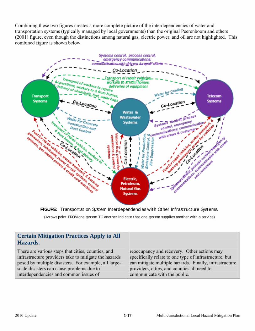
Combining these two figures creates a more complete picture of the interdependencies of water and transportation systems (typically managed by local governments) than the original Peerenboom and others
ower, and oil are not highlighted. This (2001) figure, even though the distinctions among natural gas, electric pcombined figure is shown below.
Certain Mitigation Practices Apply to All Hazards.
There are various steps that cities, counties, and infrastructure providers take to mitigate the hazards posed by multiple disasters. For example, all large-scale disasters can cause problems due to interdependencies and common issues of
reoccupancy and recovery. Other actions may specifically relate to one type of infrastructure, but can mitigate multiple hazards. Finally, infrastructure providers, cities, and counties all need to communicate with the public.
FIGURE: Transportati
(Arrows point FROM
on System Interdependencies with Other Infrastructure Systems.
one system TO another indicate that one system supplies another with a service)
2010 Update Multi-Jurisdictional Local Hazard Mitigation Plan
1-17
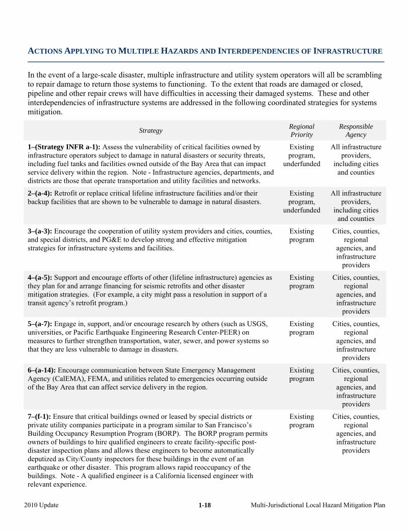
ACTIONS APPLYING TO MULTIPLE HAZARDS AND INTERDEPENDENCIES OF INFRASTRUCTU
–––––––––––––––––––––––––––––––––––––––––––––––––––––––––––––––––––––––––––––––
In the event of a large-scale disaster
RE
, multiple infrastructure and utility system operators will all be scrambling to repair damage to return those systems to functioning. To the extent that roads are damaged or closed, pipeline and other repair crews will have difficulties in accessing their damaged systems. These and other interdependencies of infrastructure systems are addressed in the following coordinated strategies for systems mitigation.
Strategy Regional Priority
Responsible Agency
1–(Strategy INFR a-1): Assess the vulnerability of critical facilities owned by infrastructure operators subject to damage in natural disasters or security threats, including fuel tanks and facilities owned outside of the Bay Area that can impact service delivery within the region. Note - Infrastructure agencies, departments, and districts are those that operate transportation and utility facilities and networks.
Existing program,
underfunded
All infrastructure providers,
including cities and counties
2–(a-4): Retrofit or replace critical lifeline infrastructure facilities and/or their backup facilities that are shown to be vulnerable to damage in natural disasters.
Existing program,
underfunded
All infrastructure providers,
including cities and counties
3–(a-3): Encourage the cooperation of utility system providers and cities, counties, and special districts, and PG&E to develop strong and effective mitigation strategies for infrastructure systems and facilities.
Existing program
Cities, counties, regional
agencies, and infrastructure
providers
4–(a-5): Support and encourage efforts of other (lifeline infrastructure) agencies as they plan for and arrange financing for seismic retrofits and other disaster mitigation strategies. (For example, a city might pass a resolution in support of a transit agency’s retrofit program.)
Existing program
Cities, counties, regional
agencies, and infrastructure
providers
5–(a-7): Engage in, support, and/or encourage research by others (such as USGS, universities,measures to further strengthen transportthat they are le
Existing Cities, counties, onal
structure providers
or Pacific Earthquake Engineering Research Center-PEER) on ation, water, sewer, and power systems so
program regiagencies, and
ss vulnerable to damage in disasters. infra
Existing program
Cities, counties, regional
agencies, and
6–(a-14): Encourage communication between State Emergency Management Agency (CalEMA), FEMA, and utilities related to emergenc s occurring outside ieof the Bay Area that can affect service delivery in the region.
infrastructure provid
cial districts or an Francisco’s RP program permits ity-specific post-
Existing program
Cities, counties, regional
ag
ers
spe to S
RP). The BO to create facil
disaster inspection plans and allows these engineers to become automatically deputized as City/County inspectors for these buildings in the event of an earthquake or other disaster. This program allows rapid reoccupancy of the buildings. Note - A qualified engineer is a California licensed engineer with relevant experience.
encies, and infrastructure
providers
7–(f-1): Ensure that critical buildings owned or leased by private utility companies participate in a program similarBuilding Occupancy Resumption Program (BOowners of buildings to hire qualified engineers
2010 Update Multi-Jurisdictional Local Hazard Mitigation Plan
1-18
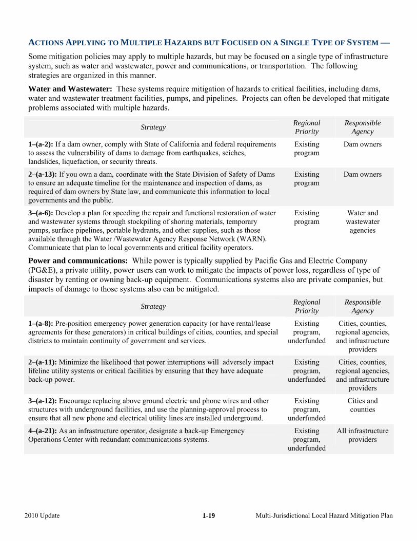
ACTIONS APPLYING TO MULTIPLE HAZARDS BUT FOCUSED ON A SINGLE TYPE OF SYSTEM ––
,
Some mitigation policies may apply to multiple hazards, but may be focused on a single type of infrastructure system, such as water and wastewater, power and communications, or transportation. The following strategies are organized in this manner.
Water and Wastewater: These systems require mitigation of hazards to critical facilities, including damswater and wastewater treatment facilities, pumps, and pipelines. Projects can often be developed that mitigateproblems associated with multiple hazards.
Strategy Regional Priority
Responsible Agency
1–(a-2): If a dam owner, comply with State of California and federal requiremento assess the vulnerability of dams to damage from earthquakes, seiches, landslides, liquefaction, or security threats.
ts Existing program
Dam owners
2–(a-13): If you own a dam, coordinate with the State Division of Safety of Dams to ensure an adequate timeline for the maintenance and inspection of dams, as required of dam owners by State law, and communicate this information to local governments and the public.
Existing program
Dam owners
3–(a-6): Develop a plan for speeding the repair and functional restoration of water and wastewater systems through stockpiling of shoring materials, temporary program
Power and communications: While power is typically supplied by Pacific Gas and Electric C(PG&E), a private utility, power users can work to mitigate the impacts of power loss, regardless
also te c
pumps, surface pipelines, portable hydrants, and other supplies, such as those available through the Water /Wastewater Agency Response Network (WARN). Communicate that plan to local governments and critical facility operators.
Existing Water and wastewater
agencies
ompany of type of
disaster by renting or owning back-up equipment. Communications systems impacts of damage to those systems also can be mitigated.
are priva ompanies, but
Strategy Regional Priority
Responsible Agency
1–(a-8): Pre-position emergency power generation capacity (or have rental/lease l
Existing
un
Cities, counties, regional agencies, and infrastructure
agreements for these generators) in critical buildings of cities, counties, and speciadistricts to maintain continuity of government and services.
program, derfunded
providers
2–(a-11): Minimize the likelihood that power interruptions will adversely Existing program,
un
impact lifeline utility systems or critical facilities by ensuring that they have adequate back-up power. derfunded
Cities, counties, regional agencies, and infrastructure
providers
structures with underground facilities, and use the planning-approval process to ensure that all new phone and electrical utility lines are installed underground.
Existing program,
underfunded
3–(a-12): Encourage replacing above ground electric and phone wires and other Cities and counties
4–(a-21): As an infrastructure operator, designate a back-up Emergency Operations Center with redundant communications systems.
Existing program,
underfunded
All infrastructure providers
2010 Update Multi-Jurisdictional Local Hazard Mitigation Plan
1-19
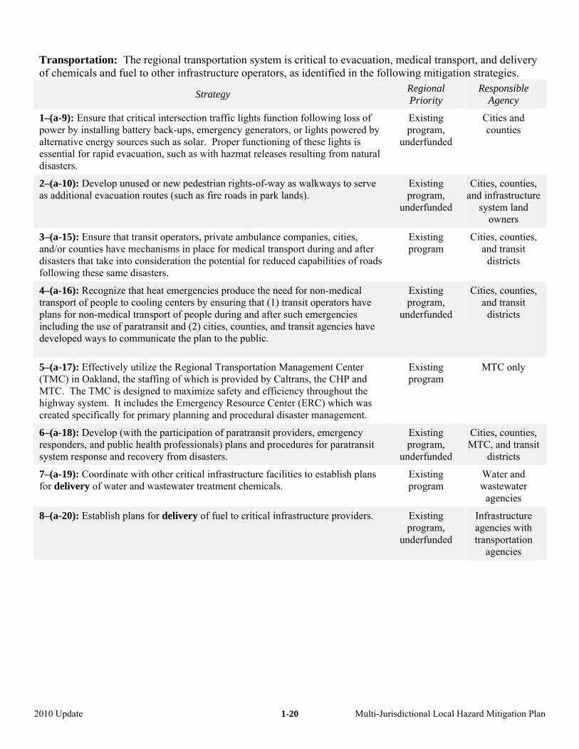
Transportation: The regional transportation system is critical to evacuation, medical transport, and delivery of chemicals and fuel to other infrastructure operators, as identified in the following mitigation strategies.
Strategy Regional Priority
Responsible Agency
1–(a-9): Ensure that critical intersection traffic lights function following loss of power by installing battery back-ups, emergency generators, or lights powered by alternative energy sources such as solar. Proper functioning of these lights is essential for rapid evacuation, such as with hazma
Existing program,
underfunded
Cities and counties
t releases resulting from natural disasters.
2–(a-10): Develop unused or new pedestrian rights-of-way as walkways to serve as additional evacuation routes (such as fire roads in park lands).
Existing program,
Cities, counties, and infrastructure
un derfunded system land owners
Cities, counties,
districts
3–(a-15): Ensure that transit operators, private ambulance companies, cities, and/or counties have mechanisms in place for medical transport during and after disasters that take into consideration the potential for reduced capabilities of roadsfollowing these same disasters.
Existing program and transit
4–(a-16): Recognize that heat emergencies produce the need for non-medical transport of people to cooling centers by ensuring that (1) transit operators have plans for non-medical transport of people during and after such emergencies including the use of paratransit and (2) cities, counties, and transit agencies have developed ways to communicate the plan to the public.
Existing program,
Cities, counties,
underfunded and transit
districts
5–(a-17): Effectively utilize the Regional Transportation Management Center (TMC) in Oakland, the staffing of which is provided by Caltrans, the CHP and MTC. The TMC is designed to maximize safety and efficiency throughout the highway system. It includes the Emergency Resource Center (ERC
Existing program
MTC only
) which was created specifically for primary planning management. and procedural disaster
6–(a-18): Develop (with the participation of ders, emergency paratransit proviresponders, and public health professionals) plans and procedures for paratransit system response and recovery from disasters.
Existing program,
Cities, counties,
u nderfundedMTC, and transit
districts
Water and astewater
7–(a-19): Coordinate with other critical infrastructure facilities to establish plans for delivery of water and wastewater treatment chemicals. program w
Existing
agencies
8–(a-20): Establish plans for delivery of fuel to critical infrastructure providers. Existing program,
underfunded
Infrastructure agencies with transportation
agencies
2010 Update Multi-Jurisdictional Local Hazard Mitigation Plan
1-20
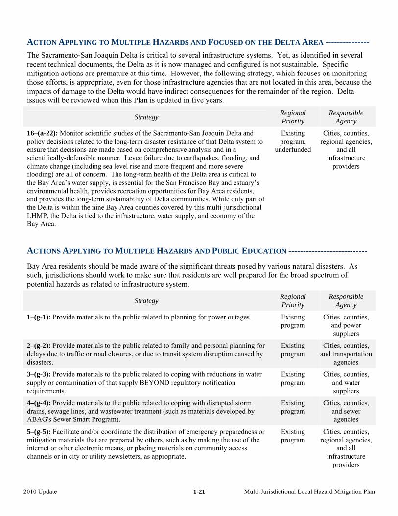
ACTION APPLYING TO MULTIPLE HAZARDS AND FOCUSED ON THE DELTA AREA ---------------
The Sacramento-San Joaquin Delta is critical to several infrastructure systems. Yet, as identified in several recent technical documents, the Delta as it is now managed and configured is no le. Spmitigation actions are premature at this time. However, the following strategy, w uses on m g
not loc is area he main region.
t sustainabhich foc
ecific onitorin
those efforts, is appropriate, even for those infrastructure agencies that areimpacts of damage to the Delta would have indirect consequences for the reissues will be reviewed when this Plan is updated in five years.
ated in thder of the
, because t Delta
Strategy Regional Responsible Priority Agency
Cities, counties,
and all
16–(a-22): Monitor scientific studies of the Sacramento-San Joaquin Delta and policy decisions related to the long-term disaster resistance of that Delta system to ensure that decisions are made based on comprehensive analysis and in a
ecreation opportunities for Bay Area residents, rt of
l e
underfunded regional agencies,
UCATIO ------- -
by various natural disasters. As ed for the broad spectrum of
scientifically-defensible manner. Levee failure due to earthquakes, flooding, andclimate change (including sea level rise and more frequent and more severe flooding) are all of concern. The long-term health of the Delta area is critical to the Bay Area’s water supply, is essential for the San Francisco Bay and estuary’s environmental health, provides rand provides the long-term sustainability of Delta communities. While only pathe Delta is within the nine Bay Area counties covered by this multi-jurisdictionaLHMP, the Delta is tied to the infrastructure, water supply, and economy of thBay Area.
Existing program,
infrastructure providers
ACTIONS APPLYING TO MULTIPLE HAZARDS AND PUBLIC ED
Bay Area residents should be made aware of the significant threats posedsuch, jurisdictions should work to make sure that residents are well preparpotential hazards as related to infrastructure system.
N ------- ------------
Strategy Regional Priority
Responsible Agency
1–(g-1): Provide materials to the public related to planning for power outages. Cities, counties, Existing program and power
suppliers
2–(g-2): Provide materials to the public related to family and personal planning for delays due to traffic or road closures, or due to transit system disruption caused by disasters.
Existing Cities, counties, an n program d transportatio
agencies
and water 3–(g-3): Provide materials to the public related to coping with reductions in water supply or contamination of that supply BEYOND regulatory notification requirements.
program Cities, counties,
suppliers
Existing
4–(g-4): Provide materials to the public related to coping with disrupted storm drains, sewage lines, and wastewater treatment (such as materials developed by ABAG's Sewer Smart Program).
Existing program
Cities, counties, and sewer agencies
5–(g-5): Facilitate and/or coordinate the distribution of emergency preparedness or mitigation materials that are prepared by others, such as by making the use of the internet or other electronic means, or placing materials on community access channels or in city or utility newsletters, as appropriate.
Existing program
Cities, counties, regional agencies,
and all infrastructure
providers
2010 Update Multi-Jurisdictional Local Hazard Mitigation Plan
1-21
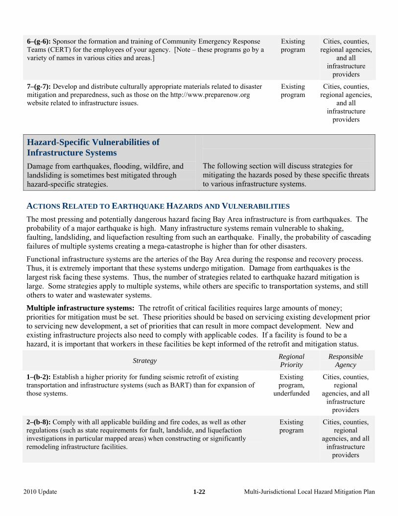
6–(g-6): Sponsor the formation and training of Community Emergency Response Teams (CERT) for the employees of your agency. [Note – these programs go by a variety of names in various cities and areas.]
Existing program
Cities, counties, regional agencies,
and all infrastructure
providers
7–(g-7): Develop and distribute culturally appropriate materials related to disaster mitigation and preparedness, such as those on the http://www.preparenow.org website related to infrastructure issues.
Existing program
Cities, counties, regional agencies,
and all
providers
infrastructure
Hazard-Specific Vulnerabilities of Infrastructure Systems
Damage from earthquakes, flooding, wildfire, and landsliding is sometimes best mitigated through hazard-specific strategies.
The following section will discuss strategies for mitigating the hazards posed by these specific threats to various infrastructure systems.
LITIES
structure is from earthquakes. The f a major earthquake is high. Many infrastructure systems remain vulnerable to shaking,
dsliding, and liquefaction resulting from such an earthquake. Finally, the probability of cascading
Functional infrastructure systems are the arteries of the Bay Area during the response and recovery process.
is e others are specific to transportation systems, and still
others to water and wastewater system
Multiple infrastructure systems: The retrofit of critical facilities requires large of moneservicing existing dev
to servicing new development, a set of priorities that can result in more compact development. Nexisting infrastructure projects also need to comply with applicable codes. If a facility is found to
retr itig
ACTIONS RELATED TO EARTHQUAKE HAZARDS AND VULNERABI
The most pressing and potentially dangerous hazard facing Bay Area infraprobability ofaulting, lanfailures of multiple systems creating a mega-catastrophe is higher than for other disasters.
Thus, it is extremely important that these systems undergo mitigation. Damage from earthquakes is the largest risk facing these systems. Thus, the number of strategies related to earthquake hazard mitigationlarge. Some strategies apply to multiple systems, whil
s.
amounts y; priorities for mitigation must be set. These priorities should be based on elopment prior
ew and be a
hazard, it is important that workers in these facilities be kept informed of the ofit and m ation status.
Strategy Regional Priority
Responsible Agency
1–(b-2): Establish a higher priority for funding seismic retrofit of existing transportation and infrastructure systems (such as BART) than for expansithose systems.
on of punderfunded agencies, and all
Existing rogram,
Cities, counties, regional
infrastructure providers
2–(b-8): Comply with all applicable building and fire codes, as well as other regulations (such as state requirements for fault, landslide, and liquefaction investigations in particular mapped areas) when constructing or significantly remodeling infrastructure facilities.
Existing Cities, counties, program regional
agencies, and all infrastructure
providers
2010 Update Multi-Jurisdictional Local Hazard Mitigation Plan
1-22
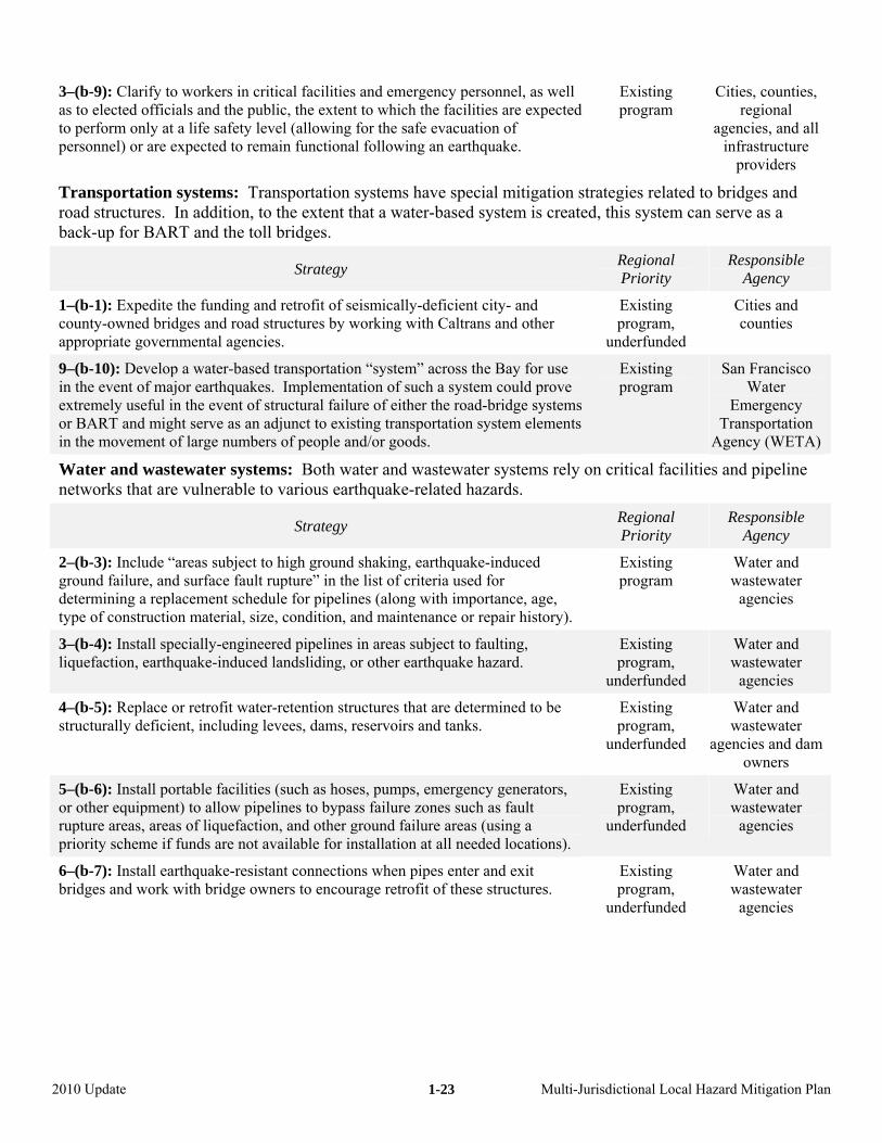
3–(b-9): Clarify to workers in critical facilities and emergency personnel, as well as to elected officials and the public, the extent to which the facilities are expected to perform only at a life safety level (allowing for the safe evacuation of personnel) or are expected to remain functional following an earthquake.
agencies, and all
rateg d toeated, th can
s.
Existing program
Cities, counties, regional
infrastructure providers
Transportation systems: Transportation systems have special mitigation stroad structures. In addition, to the extent that a water-based system is crback-up for BART and the toll bridge
ies relateis system
bridges and serve as a
Strategy Regional Priority
Responsible Agency
1–(b-1): Expedite the funding and retrofit of seicounty-owned bridges and road structures by woappropriate governmental agenci
smically-deficient city- and rking with Caltrans and other
es.
Existing program,
underfunded
Cities and counties
9–(b-10): Develop a water-based transportation “system” across the Bay for use in the event of major earthquakes. Implementation of such a system could prove extremely useful in the event of structural failure of either the road-bridge systems
Existing program
San Francisco Water
Emergency Transportation
Agency (WETA)
facilities and pipeline
or BART and might serve as an adjunct to existing transportation system elements in the movement of large num goods. bers of people and/or
Water and wastewater systems: Both water and wastewater systems rely on criticalnetworks that are vulnerable to various earthquake-related hazards.
Strategy Regional Priority
Responsible Agency
2–(b-3): Include “areas subject to high ground shaking, earthquake-induced ground failure, and surface fault rupture” in the list of criteria used for determining a replacement schedule for pipelines (along with importance, age, type of construction material, size, condition, and maintenance or repair history).
Existing program
Water and wastewater
agencies
3–(b-4): Install specially-engineered pipelines in areas subject to faulting, liquefaction, earthquake-induced landsliding, or other earthquake hazard.
Existing program,
underfunded
Water and wastewater
agen
4–(b-5): Replace or retrofit water-retention structures that are determined to be structurally deficient, including levees, dams, reservoirs and tanks.
Existing program,
underfunded
Water and wastewat
agencies aowners
cies
er nd dam
5–(b-6): Install portable facilities (su s, pumps, emergency generators, ch as hoseor other equipment) to allow pipeline s failure zones such as fault s to bypasrupture areas, areas of liquefaction, and other ground failure areas (using a priority scheme if funds are not available for installation at all needed locations).
Existing program,
un d derfunde
Water and w r astewate
agencies
Water and wastewater
agencies
6–(b-7): Install earthquake-resistant connections when pipes enter and exit bridges and work with bridge owners to encourage retrofit of these structures. program,
underfunded
Existing
2010 Update Multi-Jurisdictional Local Hazard Mitigation Plan
1-23
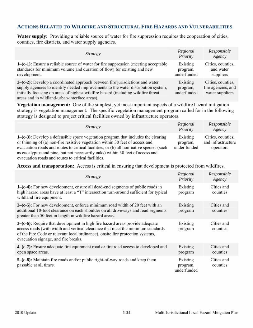
RDS LNE
ssion requires the cooperat
ACTIONS RELATED TO WILDFIRE AND STRUCTURAL FIRE HAZA
Water supply: Providing a reliable source of water for fire supprecounties, fire districts, and water supply agencies.
AND VU RABILITIES
ion of cities,
Strategy Regional Priority
Responsible Agency
1–(c-1): Ensure a reliable source of water for fire suppression (meeting acceptable standards for minimum volume and duration
Existing Cities, counof flow) for existing and new
development. program,
u d
ties, and water
nderfunde suppliers
2–(c-2): Develop a coordinated approach between fire jurisdictions and water supply agencies to identify needed improvements to the water distribution system, initially focusing on areas of highest wildfire hazard (including wildfire threat areas and in wildland-urban-interface areas).
Existing program,
Cities, counties, fire nd agencies, a
u d nderfunde water suppliers
s of a azardrogra for in the ing
tors.
Vegetation management: One of the simplest, yet most important aspectstrategy is vegetation management. The specific vegetation management pstrategy is designed to project critical facilities owned by infrastructure opera
wildfire hm called
mitigation follow
Strategy Regional Priority
Responsible Agency
1–(c-3): Develop a defensible space vegetation program that includes the clearing or thinning of (a) non-fire resistive vegetation within 30 feet of access and
Existing Cities, counties,
evacuation roads and routes to critical faas eucalyptus and pine, but not neces s) within 30 feet of access and
program, u d
and infrastructure
velopment is p from w
cilities, or (b) all non-native species (such sarily oak
evacuation roads and routes to critical facilities.
Access and transportation: Access is critical in ensuring that de
nder funde operators
rotected ildfires.
Strategy Regional Priority
Responsible Agency
s in typical
wildland fire equipment.
1–(c-4): For new development, ensure all dead-end segments of public roadhigh hazard areas have at least a “T” intersection turn-around sufficient for
Existing program
Cities and counties
2–(c-5): For new development, enforce minimum road width of 20 feet with an additional 10-foot clearance on each shoulder on all driveways and road segments greater than 50 feet in length in wildfire hazard areas.
Existing program
Cities and counties
3–(c-6): Require that development in high fire hazard areas provide adequate access roads (with width and vertical clearance that meet the minimum standardsof the Fire Code or relevant local ordinance), onsite fire protection systems,evacuation signage, and fire breaks.
Existing program
Cities and counties
4–(c-7): Ensure adequate fire equipment road or fire road access to developed and open space areas.
Existing program
Cities and counties
5–(c-8): Maintain fire roads and/or public right-of-way roads and keep them passable at all times. program,
underfunded
Cities and counties
Existing
2010 Update Multi-Jurisdictional Local Hazard Mitigation Plan
1-24
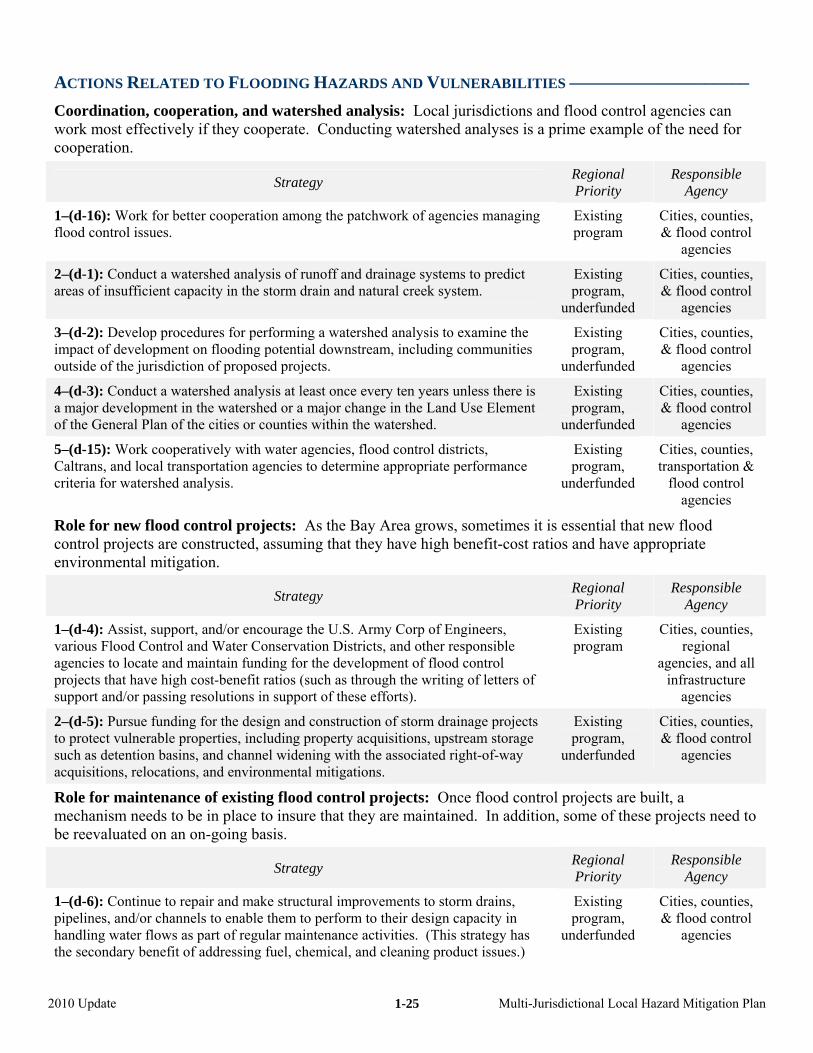
ACTIONS RELATED TO FLOODING HAZARDS AND VULNERABILITIES ––––––––––––––––––––
Coordination, cooperation, and watershed analysis: Local jurisdictions and flood control agencies can work most effectively if they cooperate. Conducting watershed analyses is a prime example of the need for cooperation.
Strategy Regional Priority
Responsible Agency
1–(d-16): Work for better cooperation among the patchwork of agencies managing flood control issues.
Existing program
Cities, counties, flood controagencies
& l
2–(d-1): Conduct a watershed analysis of runoff and drainage systems to predict areas of insufficient capacity in the storm drain and natural creek system.
Existing program,
underfunded
Cities, counties, & flood control
agencies
3–(d-2): Develop procedures for performing a watershed analysis to examine the impact of development on flooding potential downstream, including communities outside of the jurisdiction of proposed projects.
Existing program,
underfunded
Cities, countie& flood control
agencies
s,
4–(d-3): Conduct a watershed analysis at least once every ten years unless there is a major development in the watershed ge in the Land Use Element or a major chanof the General Plan of the cities or counties within the watershed.
Cities, counties, & l
Existing program,
un d derfunde flood contro
agencies
5–(d-15): Work cooperatively with water agencies, flood control districts, Caltrans, and local transportation agencies to determine appropriate performance criteria for watershed analysis.
Existing program,
underfunded
Cities, counties, transportation &
ood controfl l agencies
environmental mitigation.
Role for new flood control projects: As the Bay Area grows, sometimes it is essential that new flood control projects are constructed, assuming that they have high benefit-cost ratios and have appropriate
Strategy Regional Responsible Priority Agency
1–(d-4): Assist, support, and/or encourage the U.S. Army Corp of Engineers,
fforts).
Existing Cities, counties,
agencies, and all infrastructure
agencies
various Flood Control and Water Conservation Districts, and other responsible agencies to locate and maintain funding for the development of flood control projects that have high cost-benefit ratios (such as through the writing of letters of support and/or passing resolutions in support of these e
program regional
2–(d-5): Pursue funding for the design and construction of storm drainage projects to protect vulnerable properties, including property acquisitions, upstream storage such as detention basins, and channel widening with the associated right-of-way acquisitions, relocations, and environmental mitigations.
Existing program,
underfunded
Cities, counties, & flood control
agencies
ol p e built, to be in place to insure that they are maintained. In addition, s ese proj to
Role for maintenance of existing flood control projects: Once flood contrmechanism needs
rojects arome of th
a ects need
be reevaluated on an on-going basis.
Strategy Regional Priority
Responsible Agency
Continue to repair and make structural improvements to storm drains, to perform to their design capacity in
rt of regular maintenance activities. (This strategy has ical, and cleaning product issues.)
Existing program,
underfunded
Cities, counties, & flood control
agencies
1–(d-6): pipelines, and/or channels to enable themhandling water flows as pathe secondary benefit of addressing fuel, chem
2010 Update Multi-Jurisdictional Local Hazard Mitigation Plan
1-25
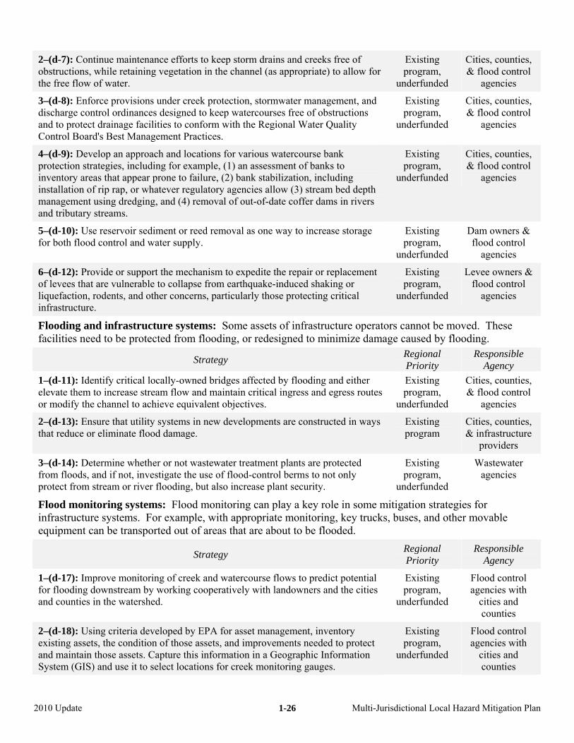
2–(d-7): Continue maintenance efforts to keep storm drains and creeks free of obstructions, while retaining vegetation in the channel (as appropriate) to allow for the free flow of water.
Existing program,
underfunded
Cities, counties, & flood control
agencies
3–(d-8): Enforcedischarge control ordinances designed to
provisions under creek protection, stormwater management, and keep watercourses free of obstructions
and to protect drainage facilities to co th the Regional Water Quality Control Board's Best Management Pra
Existing program,
u
Cities, counties, & flood control
nform wictices.
nderfunded agencies
4–(d-9): Develop an approach and locations for various watercourse bank protection strategies, including for example, (1) an assessment of banks to inventory areas that appear prone to failure, (2) bank stabilization, including installation of rip rap, or whatever regulatory agencies allow (3) stream bed depth management using dredging, and (4) removal of out-of-date coffer dams in rivers and tributary streams.
Existing program,
underfunded
Cities, counties, & flood control
agencies
5–(d-10): Use reservoir sediment or reed removal as one way to increase storage for both flood control and water supply.
Existing program,
underfunded
Dam owners & flood control
agencies
6–(d-12): Provide or support the mechanism to expedite the repair or replacement of levees that are vulnerable to collapse from earthquake-induced shaking or liquefaction, rodents, and other concerns, particularly those protecting critical infrastructure.
Existing program,
underfunded
Levee owners & flood control
agencies
Flooding and infrastructure systems: Some assets of infrastructure operafacilities need to be protected f
tors movrom flooding, or redesigned to minimize damag ood
cannot be e caused by fl
ed. These ing.
Strategy Regional Responsible Priority Agenc
1–(d-11): Identify critical locally-owned bridges affected by flooding and either elevate them to increase stream flow and maintain critical ingress and egress routes or modify the channel to achiev
Existing program,
Cities, co& flood contr
y
e equivalent objectives. underfunded
unties, ol
agencies
2–(d-13): Ensure that utility systems in new developments are constructed in ways that reduce or eliminate flood damage.
Cities, counties, & infrastructure
Existing program
providers
Wastewater agencies
3–(d-14): Determine whether or not wastewater treatment plants are protected from floods, and if not, investigate the use of flood-control berms to not only protect from stream or river flooding, but also increase plant security.
Existing program,
underfunded
itig tegies, bu ther
Flood monitoring systems: Flood monitoring can play a key role in some minfrastructure systems. For example, with appropriate monitoring, key truckequipment can be transported out of areas that are about to be flooded.
ation strases, and o
s for movable
Strategy Regional Responsible Priority A
1–(d-17): Improve monitoring of creek and watercourse flows to predict potential for flooding downstream by working coop
Existing Flood control
gency
eratively with landowners and the cities and counties in the watershed.
program, u
agencies with nderfunded cities and
counties
2–(d-18): Using criteria developed by EPA for asset management, inventory existing assets, the condition of those assets, and improvements needed to protect and maintain those assets. Capture this information in a Geographic Information System (GIS) and use it to select locations for creek monitoring gauges.
Existing program,
underfunded
Flood control agencies with
cities and counties
2010 Update Multi-Jurisdictional Local Hazard Mitigation Plan
1-26
ACTIONS RELATED TO LANDSLIDE HAZARDS AND VULNERABILI
The following two stra
TIES –––
tegies concerning landslides relate specifically to infrast s.
––––––
ructure system
––––––––––
Strategy Regional Priority
Responsible Agency
1–(e-1): Include “areas subject to ground failure” in the list of criteria used for determining a replacement schedule (along with importance, age, type of construction material, size, condition, and maintenance or repair history) fopipelines.
r
Water and Existing program wastewater
agencies
2–(e-2): Establish requirements in zoning ordinances to address hillside development constraints in areas of steep slopes that are likely to lead to excessive road maintenance or where roads will be difficult to maintain during winter storms due to landsliding.
Existing program
Cities and counties
S page 1 LibrC . Baum), page 1-6 VTA, pages 10 & 13 EBMU IRE
ources: page 1-2 MTC, page 1-3-USGS and Google Earth, page 1-4 MTC (Noah Berger),ounty Office of Emergency Services, USGS (R
-5 StocktonD, page 12 CalF
ary, Monterey .
2010 Update Multi-Jurisdictional Local Hazard Mitigation Plan
1-27
Chapter 2 – Health Care (HEAL)
COMMITMENT: Bay Area facilities, networks, and systems providing care of sick and those with special needs need to be resilient after disasters for these systems will need to care for additional injured at the same time as those currently cared for are stressed.
The Problem Is…
In one scenario, if the 1868 Hayward earthquake (which occurs about once every 140 years on the southern Hayward fault) were to happen today, it could result in thousands of serious injuries. This example is not the worst case, but since it has been 141 years since this earthquake, this is a likely scenario.
Damage to hospital in 1971 San Fernando Earthquake
At the same time, our health care delivery system is undergoing major changes that make many of our hospitals outdated. Finally, more procedures are occurring in out-patient clinics and in medical offices.
Hospitals no longer have medical supplies for weeks stored on site. As with manufacturing facilities, these facilities are working under “just-in-time” supply strategies. Supplies are delivered from outside of the Bay Area and are pre-ordered for normal operation, not for disaster situations.
While the Bay Area may pride itself in being more prepared for a disaster than Louisiana or Mississippi in Hurricane Katrina, we are unprepared to manage long-term recovery of health care delivery, due, in part, to an emphasis on hospitals rather than a comprehensive view of all services. We also need to ensure the delivery of adequate mental health services following disasters.
Background and History
In 1973, as a direct result of the devastation caused by the 1971 Sylmar quake (65 deaths and a hospital collapse), the Legislature passed the Alfred E. Alquist Hospital Seismic Safety Act. The act requires that acute care hospitals be designed and constructed to withstand a major earthquake and remain operational immediately after the quake. Further modifications of the Act occurred following the Northridge earthquake, with the passage of SB 1953 in 1994.
SB 1953 requires that all hospitals use standards developed by the California Office of Statewide Health Planning and Development (OSHPD) to measure the ability of these buildings to withstand a major earthquake. In 2001, plans submitted by the hospital owners determined that 37% of California’s hospitals are subject to collapse. OSHPD is focusing on monitoring the billions of dollars needed to retrofit or replace the region’s hospitals.
OSHPD noted that, in 2008, the average age of the dangerous hospital buildings was from 45-49 years – and that the average useful life of a hospital is typically only 40-50 years. Thus, some of the billions of dollars being attributed to seismic safety upgrades are actually being driven by the upgrading of outdated buildings.
Additional planning is needed at the city and county levels to identify and work with the ancillary health facilities in the region, including pharmacies, doctor and dentist offices, offices that sell hearing aids and eye glasses, dialysis centers, and emergency clinics. Currently there is NO state law that states that the buildings these facilities are located in must be structurally sound or that they have business continuity plans.
While hospitals are licensed by the State, ancillary facilities obtain their building permits and business licenses from cities and counties, ensuring that this effort remains local. There is a critical need for coordination of business recovery planning between local governments, facility operators and owners.
2010 Update 2-1 Multi-Jurisdictional Local Hazard Mitigation Plan
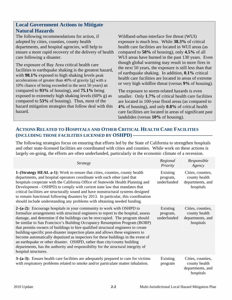
Local Government Actions to Mitigate Natural Hazards
The following recommendations for action, if adopted by cities, counties, county health departments, and hospital agencies, will help to ensure a more rapid recovery of the delivery of health care following a disaster.
The exposure of Bay Area critical health care facilities to earthquake shaking is the greatest hazard, with 98.1% exposed to high shaking levels peak accelerations of greater than 40% of gravity [g] with a 10% chance of being exceeded in the next 50 years) as compared to 93% of housing), and 75.1% being exposed to extremely high shaking levels (60% g) as compared to 53% of housing). Thus, most of the hazard mitigation strategies that follow deal with this hazard.
Wildland-urban-interface fire threat (WUI) exposure is much less. While 38.3% of critical health care facilities are located in WUI areas (as compared to 58% of housing), only 4.5% of all WUI areas have burned in the past 130 years. Even though global warming may result in more fires in the next 50 years, the exposure is still less than that of earthquake shaking. In addition, 0.1% critical health care facilities are located in areas of extreme or very high wildfire threat (versus 9% of housing).
The exposure to storm-related hazards is even smaller. Only 1.7% of critical health care facilities are located in 100-year flood areas (as compared to 4% of housing), and only 0.8% of critical health care facilities are located in areas of significant past landslides (versus 10% of housing).
ACTIONS RELATED TO HOSPITALS AND OTHER CRITICAL HEALTH CARE FACILITIES
(INCLUDING THOSE FACILITIES LICENSED BY OSHPD) –––––––––––––––––––––––––––––––
The following strategies focus on ensuring that efforts led by the State of California to strengthen hospitals and other state-licensed facilities are coordinated with cities and counties. While work on these actions is largely on-going, the efforts are often underfunded, particularly in the economic climate of a recession.
Strategy Regional Priority
Responsible Agency
1–(Strategy HEAL a-1): Work to ensure that cities, counties, county health departments, and hospital operators coordinate with each other (and that hospitals cooperate with the California Office of Statewide Health Planning and Development - OSHPD) to comply with current state law that mandates that critical facilities are structurally sound and have nonstructural systems designed to remain functional following disasters by 2013. In particular, this coordination should include understanding any problems with obtaining needed funding.
Existing program,
underfunded
Cities, counties, county health
departments, and hospitals
2–(a-2): Encourage hospitals in your community to work with OSHPD to formalize arrangements with structural engineers to report to the hospital, assess damage, and determine if the buildings can be reoccupied. The program should be similar to San Francisco’s Building Occupancy Resumption Program (BORP) that permits owners of buildings to hire qualified structural engineers to create building-specific post-disaster inspection plans and allows these engineers to become automatically deputized as inspectors for these buildings in the event of an earthquake or other disaster. OSHPD, rather than city/county building departments, has the authority and responsibility for the structural integrity of hospital structures.
Existing program,
underfunded
Cities, counties, county health
departments, and hospitals
3–(a-3): Ensure health care facilities are adequately prepared to care for victims with respiratory problems related to smoke and/or particulate matter inhalation.
Existing program
Cities, counties, county health
departments, and hospitals
2010 Update 2-2 Multi-Jurisdictional Local Hazard Mitigation Plan
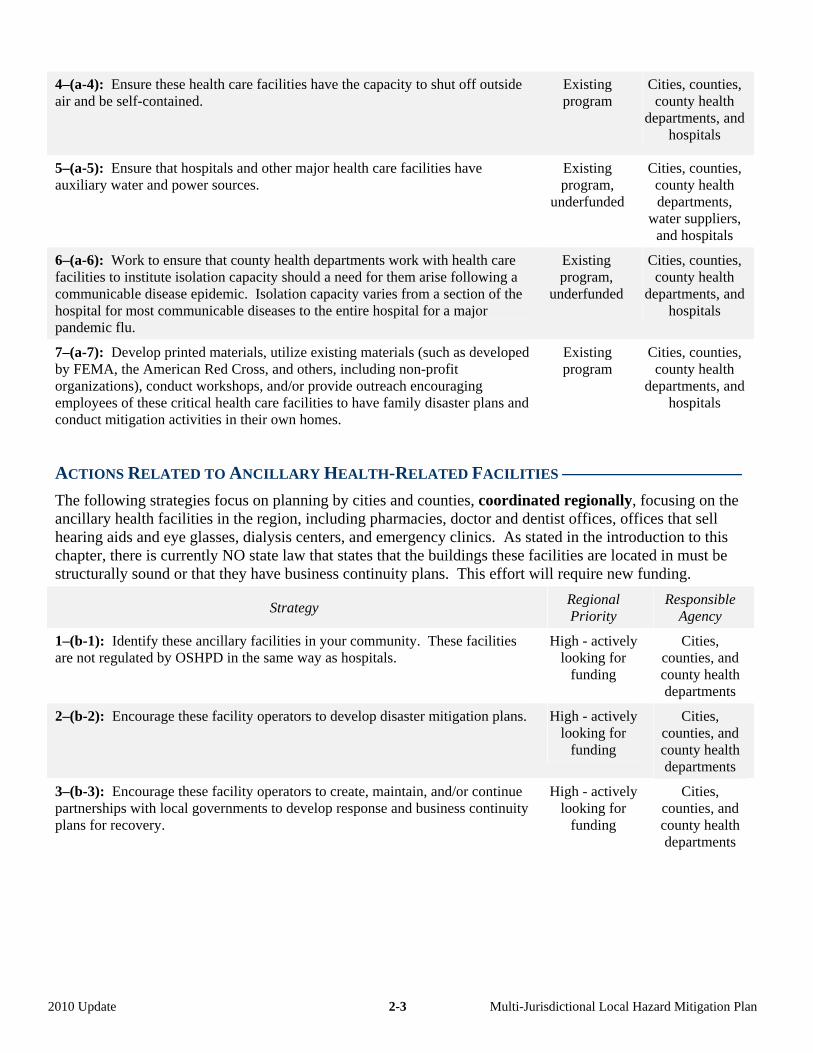
4–(a-4): Ensure these health care facilities have the capacity to shut off outside air and be self-contained.
Existing program
Cities, counties, county health
departments, and hospitals
5–(a-5): Ensure that hospitals and other major health care facilities have auxiliary water and power sources.
Existing program,
underfunded
Cities, counties, county health departments,
water suppliers, and hospitals
6–(a-6): Work to ensure that county health departments work with health care facilities to institute isolation capacity should a need for them arise following a communicable disease epidemic. Isolation capacity varies from a section of the hospital for most communicable diseases to the entire hospital for a major pandemic flu.
Existing program,
underfunded
Cities, counties, county health
departments, and hospitals
7–(a-7): Develop printed materials, utilize existing materials (such as developed by FEMA, the American Red Cross, and others, including non-profit organizations), conduct workshops, and/or provide outreach encouraging employees of these critical health care facilities to have family disaster plans and conduct mitigation activities in their own homes.
Existing program
Cities, counties, county health
departments, and hospitals
ACTIONS RELATED TO ANCILLARY HEALTH-RELATED FACILITIES ––––––––––––––––––––
The following strategies focus on planning by cities and counties, coordinated regionally, focusing on the ancillary health facilities in the region, including pharmacies, doctor and dentist offices, offices that sell hearing aids and eye glasses, dialysis centers, and emergency clinics. As stated in the introduction to this chapter, there is currently NO state law that states that the buildings these facilities are located in must be structurally sound or that they have business continuity plans. This effort will require new funding.
Strategy Regional Priority
Responsible Agency
1–(b-1): Identify these ancillary facilities in your community. These facilities are not regulated by OSHPD in the same way as hospitals.
High - actively looking for
funding
Cities, counties, and county health departments
2–(b-2): Encourage these facility operators to develop disaster mitigation plans. High - actively looking for
funding
Cities, counties, and county health departments
3–(b-3): Encourage these facility operators to create, maintain, and/or continue partnerships with local governments to develop response and business continuity plans for recovery.
High - actively looking for
funding
Cities, counties, and county health departments
2010 Update 2-3 Multi-Jurisdictional Local Hazard Mitigation Plan
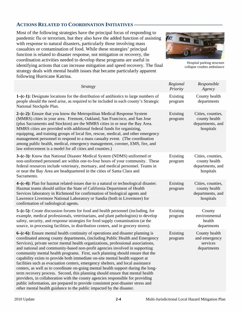
ACTIONS RELATED TO COORDINATION INITIATIVES –––––––––––––––––––––––––––––––––
Most of the following strategies have the principal focus of responding to pandemic flu or terrorism, but they also have the added function of assisting with response to natural disasters, particularly those involving mass casualties or contamination of food. While these strategies’ principal function is related to disaster response, not mitigation or recovery, the coordination activities needed to develop these programs are useful in identifying actions that can increase mitigation and speed recovery. The final strategy deals with mental health issues that became particularly apparent following Hurricane Katrina.
Strategy RegionalPriority
1–(c-1): Designate locations for the distribution of antibiotics to large numbers of people should the need arise, as required to be included in each county’s Strategic National Stockpile Plan.
Existing program
2–(c-2): Ensure that you know the Metropolitan Medical Response System (MMRS) cities in your area. Fremont, Oakland, San Francisco, and San Jose (plus Sacramento and Stockton) are the MMRS cities in or near the Bay Area. MMRS cities are provided with additional federal funds for organizing, equipping, and training groups of local fire, rescue, medical, and other emergency management personnel to respond to a mass casualty event. (The coordination among public health, medical, emergency management, coroner, EMS, fire, and law enforcement is a model for all cities and counties.)
Existing program
3–(c-3): Know that National Disaster Medical System (NDMS) uniformed or non-uniformed personnel are within one-to-four hours of your community. These federal resources include veterinary, mortuary, and medical personnel. Teams in or near the Bay Area are headquartered in the cities of Santa Clara and Sacramento.
Existing program
4–(c-4): Plan for hazmat related-issues due to a natural or technological disaster. Hazmat teams should utilize the State of California Department of Health Services laboratory in Richmond for confirmation of biological agents and Lawrence Livermore National Laboratory or Sandia (both in Livermore) for confirmation of radiological agents.
Existing program
5–(c-5): Create discussion forums for food and health personnel (including, for example, medical professionals, veterinarians, and plant pathologists) to develop safety, security, and response strategies for food supply contamination (at the source, in processing facilities, in distribution centers, and in grocery stores).
Existing program
6–(c-6): Ensure mental health continuity of operations and disaster planning is coordinated among county departments, (including Public Health and Emergency Services), private sector mental health organizations, professional associations, and national and community-based non-profit agencies involved in supporting community mental health programs. First, such planning should ensure that the capability exists to provide both immediate on-site mental health support at facilities such as evacuation centers, emergency shelters, and local assistance centers, as well as to coordinate on-going mental health support during the long-term recovery process. Second, this planning should ensure that mental health providers, in collaboration with the county agencies responsible for providing public information, are prepared to provide consistent post-disaster stress and other mental health guidance to the public impacted by the disaster.
Existing program
2010 Update 2-4 Multi-Jurisdictional Loc
Hospital parking structure collapse crushes ambulance
Responsible Agency
County health departments
Cities, counties, county health
departments, and hospitals
Cities, counties, county health
departments, and hospitals
Cities, counties, county health
departments, and hospitals
County environmental
health departments
County health and emergency
services departments
al Hazard Mitigation Plan
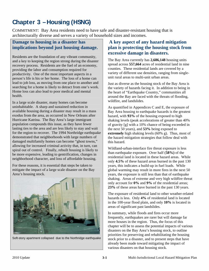
Chapter 3 – Housing (HSNG) COMMITMENT: Bay Area residents need to have safe and disaster-resistant housing that is architecturally diverse and serves a variety of household sizes and incomes.
Damage to housing in a disaster has implications beyond just housing damage.
Residents are the foundation of any vibrant community, and a key to keeping the region strong during the disaster recovery process. Residents are the fuel of an economy, providing the labor and consumption required for productivity. One of the most important aspects in a person’s life is his or her home. The loss of a home can lead to job loss, as moving from one place to another and searching for a home is likely to detract from one’s work. Home loss can also lead to poor medical and mental health.
In a large scale disaster, many homes can become uninhabitable. A sharp and sustained reduction in available housing during a disaster may result in a mass exodus from the area, as occurred in New Orleans after Hurricane Katrina. The Bay Area’s large immigrant population compounds this issue, as they have fewer lasting ties to the area and are less likely to stay and wait for the region to recover. The 1994 Northridge earthquake demonstrated that neighborhoods with large numbers of damaged multifamily homes can become “ghost towns,” allowing for increased criminal activity that, in turn, can spiral out of control. Finally, rebuilt housing is likely to be more expensive, leading to gentrification, changes in neighborhood character, and loss of affordable housing.
For these reasons, it is essential that steps be taken to mitigate the impact of a large scale disaster on the Bay Area’s housing stock.
Soft-story apartment collapsed due to the Northridge earthquake
A key aspect of any hazard mitigation plan is protecting the housing stock from excessive damage in disasters. The Bay Area currently has 2,686,148 housing units spread across 557,664 acres of residential land in nine counties. These residential lands are covered by a variety of different use densities, ranging from single-unit rural areas to multi-unit urban areas.
Just as diverse as the housing stock of the Bay Area is the variety of hazards facing it. In addition to being in the heart of “Earthquake Country,” communities all around the Bay are faced with the threats of flooding, wildfire, and landslides.
As quantified in Appendices C and E, the exposure of Bay Area housing to earthquake hazards is the greatest hazard, with 93% of the housing exposed to high shaking levels (peak accelerations of greater than 40% of gravity [g] with a 10% chance of being exceeded in the next 50 years), and 53% being exposed to extremely high shaking levels (60% g). Thus, most of the hazard mitigation strategies that follow deal with this hazard.
Wildland-urban-interface fire threat exposure is less than earthquake exposure. Over half (58%) of the residential land is located in these hazard areas. While only 4.5% of these hazard areas burned in the past 130 years, this indicates a build-up in fuel loads. While global warming may result in more fires in the next 50 years, the exposure is still less than that of earthquake shaking. Areas of extreme and very high wildfire threat only account for 0% and 9% of the residential areas; 23% of these areas have burned in the past 130 years.
The exposure of residential land to other weather-related hazards is less. Only 4% of residential land is located in the 100-year flood plain, and only 10% is located in areas of significant past landslides.
In summary, while floods and fires occur more frequently, earthquakes are rarer but will damage far more houses in the region. Thus, the focus of this chapter will be to assess the potential impacts of various disasters on the Bay Area’s housing stock, to outline priorities for preserving and rehabilitating the housing stock prior to a disaster, and to present steps that have already been made toward mitigating the impact of various disasters on that housing stock.
2010 Update Multi-Jurisdictional Local Hazard Mitigation Plan 3-1
Certain Mitigation Strategies Apply to All Hazards
There are various steps that local jurisdictions can take to mitigate the hazards posed by multiple disasters. For example, all large-scale disasters pose a risk to home occupancy, so plans for interim sheltering and re-occupancy must be developed.
Similarly, public education on the general importance of hazard mitigation is not specific to one particular disaster, and a hazard mitigation plan regarding public education can and should include general hazard mitigation strategies.
ACTIONS APPLYING TO MULTIPLE HAZARDS AND PUBLIC EDUCATION –––––––––––––––––––
Bay Area residents should be made aware of the significant threats posed by various natural disasters. As such, jurisdictions should work to make sure that residents are well-prepared for the broad spectrum of potential hazards. Preparation for hazards includes full disclosure to residents in hazard-prone areas such as flood plains and fire-susceptible areas, as well as education of proper hazard mitigation and disaster preparedness. Public education and disclosure strategies are essential.
Strategy Regional Priority
Responsible Agency
1–(Strategy HSNG a-1): Assist in ensuring adequate hazard disclosure by working with real estate agents to improve enforcement of real estate disclosure requirements for residential properties with regard to seven official natural hazard zones: 1) Special Flood Hazard Areas (designated by FEMA), 2) Areas of Potential Flooding from dam failure inundation, 3) Very High Fire Hazard Severity Zones, 4) Wildland Fire Zones, 5) Earthquake Fault Zones (designated under the Alquist-Priolo Earthquake Fault Zoning Act), and the 6) Liquefaction and Landslide Hazard Zones (designated under the Seismic Hazard Mapping Act).
Existing program
Cities and counties
2–(k-1): Provide information to residents of your community on the availability of interactive hazard maps showing your community on ABAG’s web site.
Existing program
Cities and counties
3–(k-2): Develop printed materials, utilize existing materials (such as developed by FEMA and the American Red Cross), conduct workshops, and/or provide outreach encouraging residents to have family disaster plans that include drop-cover-hold earthquake drills, fire and storm evacuation procedures, and shelter-in-place emergency guidelines.
Existing program,
underfunded
Cities and counties
4–(k-3): Inform residents of comprehensive mitigation activities, including elevation of appliances above expected flood levels, use of fire-resistant roofing and defensible space in high wildfire threat and wildfire-urban-interface areas, structural retrofitting techniques for older homes, and use of intelligent grading practices through workshops, publications, and media announcements and events.
Existing program,
underfunded
Cities and counties
5–(k-4): Develop a public education campaign on the cost, risk, and benefits of earthquake, flood, and other hazard insurance as compared to mitigation.
Not yet considered
Cities and counties
6–(k-5): Use disaster anniversaries, such as April (the 1906 earthquake), September (9/11), and October (Loma Prieta earthquake and Oakland Hills fire), to remind the public of safety and security mitigation activities.
Existing program
Cities and counties
7–(k-6): Sponsor the formation and training of Community Emergency Response Teams (CERT) for residents in your community. [Note – these programs go by a variety of names in various cities and areas.]
Existing program,
underfunded
Cities and counties
2010 Update Multi-Jurisdictional Local Hazard Mitigation Plan 3-2
8–(k-8): Institute the neighborhood watch block captain and team programs outlined in the Citizen Corps program guide.
Existing program,
underfunded
Cities and counties
9–(k-10): Train homeowners to locate and shut off gas valves if they smell or hear gas leaking.
Existing program
Cities and counties
10–(k-16): Distribute appropriate materials related to disaster mitigation and preparedness to residents. Appropriate materials are (1) culturally appropriate and (2) suitable for special needs populations. For example, such materials are available on the http://www.preparenow.org website and from non-governmental organizations that work with these communities on an on-going basis.
Existing program
Cities and counties
ACTIONS APPLYING TO MULTIPLE HAZARDS AND REOCCUPANCY –––––––––––––––––––––––
In the event of a large-scale disaster, hundreds or even thousands of Bay Area housing units will become uninhabitable. Should this occur, jurisdictions must have a plan for temporarily housing displaced residents. Some will only need shelter for a short period as their homes are prepared for reoccupancy. Others will have longer-term interim shelter needs, especially those in larger-scale apartment complexes and soft-story buildings. Once temporary shelter needs are met, cities and counties must have plans in place to expedite the repair of damaged homes for reoccupancy. A longer reoccupancy process means longer interim housing needs, which place a significant burden on local jurisdictions. The following strategies are related to interim sheltering and speeding reoccupancy.
Strategy Regional Priority
Responsible Agency
1–(a-2): Create incentives for private owners of historic or architecturally significant residential buildings to undertake mitigation to levels that will minimize the likelihood that these buildings will need to be demolished after a disaster, particularly if those alterations conform to the federal Secretary of the Interior’s Guidelines for Rehabilitation.
Existing program,
underfunded
Cities and counties
2–(a-3): Develop a plan for short-term sheltering of residents of your community in conjunction with the American Red Cross.
Existing program
Cities and counties
3–(a-4): Develop a plan for interim housing for those displaced by working with the Regional Catastrophic Planning Grant Program (CPGP) that funded this effort in 2009. (Estimated completion is 2011.)
Under Study Major cities in conjunction with
the UASI program
4–(j-1): Develop and enforce a repair and reconstruction ordinance to ensure that damaged buildings are repaired in an appropriate and timely manner and retrofitted concurrently. This repair and reconstruction ordinance should apply to all public and private buildings, and also apply to repair of all damage, regardless of cause. See http://quake.abag.ca.gov/recovery/info-repair-ord.html.
Existing program
Cities and counties
5–(j-2): Establish preservation-sensitive measures for the repair and reoccupancy of historically significant privately-owned structures, including requirements for temporary shoring or stabilization where needed, arrangements for consulting with preservationists, and expedited permit procedures for suitable repair or rebuilding of historically or architecturally valuable structures.
Existing program,
underfunded
Cities and counties
2010 Update Multi-Jurisdictional Local Hazard Mitigation Plan 3-3
Living in Earthquake Country The most pressing and potentially dangerous hazard facing the Bay Area is the constant threat of earthquakes. With many area faults overdue for major seismic activity, it is essential that the potential impact of a major earthquake on the region’s housing stock be emphasized.
Structural damage to housing is most commonly caused by ground shaking. Although ground shaking can be felt for as many as hundreds of miles away in a major earthquake, shaking is most violent near fault segments that moved, causing the earthquake, as well as on soils that can amplify that shaking and make the shaking last longer.
For example, the Hayward fault has experienced major earthquakes, on average, every 140 years. As of 2009, it has been 141 years since the 1868 Hayward earthquake on the southern segment of the Hayward fault. Because this fault runs through one of the densest part of the Bay Area, and the housing in this area is older, ABAG has estimated that such an earthquake would create over 150,000 uninhabitable housing units.
The amount of damage to housing varies greatly across building construction types and building age. Two adjacent buildings can suffer dramatically different amounts of damage due to shaking. Buildings with “soft stories” (multi-story buildings with open or mostly open lower floors with parking or commercial space built prior to about 1990), unreinforced masonry buildings (built before the building code changed in 1933), and older single-family homes (typically built before about 1970) are extremely susceptible to severe shaking damage. In addition to sustaining substantial property damage, these buildings are more likely to be uninhabitable after earthquakes, resulting in large numbers of displaced residents.
In addition to shaking, earthquakes also can cause soil liquefaction, landslides, and surface rupture. However, these related hazards are typically handled through land use controls on new development described in Chapter 8.
The following section will discuss strategies for mitigating the hazards posed by earthquake shaking to various housing types.
ACTIONS APPLYING TO EXISTING SINGLE-FAMILY HOMES VULNERABLE TO EARTHQUAKES Single-family homes are the cornerstone of most Bay Area communities. Over half (54%) of the Bay Area housing stock is in single-family homes. As such, it is essential that damage to these homes be minimized to the greatest extent possible. Structural damage is the largest earthquake-related risk facing single-family homes. The amount and type of potential structural damage that a home faces depends upon the type of construction, its age and condition, and its location. The highest risk homes include unretrofitted homes built before 1978 (prior to the adoption of the most important earthquake-resistant building code changes), homes on hillsides, and homes with living space above a garage (these are subject to collapse due to structural weaknesses due to the garage door openings), but all homes are at risk. Conducting a proper retrofit using a standard plan set: For a typical older house with a crawl space underneath the home, a retrofit consists of no less than three separate actions.
(1) The base of the house (mudsill) is secured to the foundation using bolts to prevent the house from slipping off of the foundation.
(2) If the house has a cripple wall (which forms the perimeter of the crawl space below the first floor), it is strengthened by adding plywood panels (shear walls) along the interior surface of all perimeter walls. Unbraced crawl space walls are the most likely part of the home to collapse in an earthquake.
(3) The floor framing is secured to theses walls to prevent the floor from slipping off them. (If the home does not have cripple walls, then the floor framing is secured directly to the mudsills.)
If any one of these actions does not occur, then there remains a large risk that the house will still suffer significant structural damage.
Unfortunately, just because a house has been retrofitted does not necessarily mean that it has been retrofitted properly or that all three actions have been taken. In a 1999 survey of 341 homes, ABAG found that anywhere from 1/3 to 2/3 of retrofitted homes were not adequately prepared for a future quake (the percentage varied by city). In a 2006 survey of 35 homes published in the Contra Costa Times on March 5, 2006, 2/3 of retrofitted homes were not adequately retrofitted to prevent collapse and limit damage.
2010 Update Multi-Jurisdictional Local Hazard Mitigation Plan 3-4
Anecdotal evidence suggests that there are two primary reasons for this problem: lack of knowledge and lack of funds. Doing something is not always better than doing nothing.
Contractors may be untrained in retrofits and may therefore be unaware of proper retrofit procedure. The work they do may therefore be inadequate (for example, they may only add bolts to the foundation and not perform the other two actions). In addition, some unscrupulous contractors may intentionally deceive clients even if they are aware of proper retrofit procedure, as few homeowners would know how to inspect the work.
Home inspectors may be untrained in retrofits and therefore unable to judge whether the contractor has performed a proper retrofit. In addition home inspectors may be unable to judge whether a home needs a retrofit in the first place.
Licensed professionals (engineers or architects with seismic retrofit experience) are required for homes on hillsides or with living spaces above garages. If these professionals are not included in the design process when retrofitting these homes, it is unlikely that the home will be protected against collapse. A retrofit standard clearly establishes the requirements for a retrofit, and gives local governments the power to enforce the standard. The standard applies not only to what is done in the retrofit, but also who is involved in the retrofit. Local governments can also require that engineers be involved in complex retrofits of homes on hillsides or on split-level homes with living spaces above a garage.
In order to simplify and make more uniform retrofit standards, ABAG, three chapters of the International Code Council (ICC), the California Building Officials (CALBO), the Structural Engineers Association of Northern California (EERI-NC), the Northern California Chapter of the Earthquake Engineering Research Institute, and retrofit contractors jointly developed a standard plan set to cover one type of single-family home. This standard “Plan Set A” applies to 1- or 2-family light construction wood-frame homes that are two stories or less in height, have a continuous perimeter concrete foundation, and crawl space walls no higher than four feet. This plan set greatly simplifies the retrofit process, as homeowners do not have to hire engineers to design retrofit plans, and city building departments do not have to individually review custom plans for each home.
Strategy Regional Priority
Responsible Agency
1–(b-1): Utilize or recommend adoption of a retrofit standard that includes standard plan sets and construction details for voluntary bolting of homes to their foundations and bracing of outside walls of crawl spaces (“cripple” walls), such as Plan Set A developed by a committee representing the East Bay-Peninsula-Monterey Chapters of the International Code Council (ICC), California Building Officials (CALBO), the Structural Engineers Association of Northern California (SEAONC), the Northern California Chapter of the Earthquake Engineering Research Institute (EERI-NC), and ABAG’s Earthquake Program.
Existing program,
underfunded
City and county building
departments
2–(b-4): Encourage local government building inspectors to take classes on a periodic basis (such as the FEMA-developed training classes offered by ABAG) on retrofitting of single-family homes, including application of Plan Set A.
Existing program
City and county building
departments
3–(b-5): Encourage private retrofit contractors and home inspectors doing work in your area to take retrofit classes on a periodic basis (such as the FEMA-developed training classes offered by ABAG or additional classes that might be offered by the CALBO Training Institute) on retrofitting of single-family homes.
Existing program
City and county building
departments
4–(b-9): Provide financial incentives to owners of single-family homes to retrofit if those retrofits comply with Plan Set A or IEBC 2006 in addition to that provided by existing State law that makes such retrofits exempt from increases in property taxes.
Existing program,
underfunded
Cities and counties
2010 Update Multi-Jurisdictional Local Hazard Mitigation Plan 3-5
Retrofitting homes not covered by a standard plan set: Unfortunately, not all homes can be covered by one standard plan set. These homes include those more than two stories in height, homes on hillsides, homes with living spaces over garages, split-level homes, crawl space walls over four feet, and other common single-family home types. Although ABAG and the other organizations involved in the development of Plan Set A are looking into developing more standard plan sets to apply to a wider range of homes, local jurisdictions can and should still take steps to encourage proper retrofits of these homes.
Strategy Regional Priority
Responsible Agency
1–(b-2): Require engineered plan sets for seismic retrofitting of heavy two-story homes with living areas over garages, as well as for split level homes (that is, homes not covered by Plan Set A), until standard plan sets and construction details become available.
Existing program
City and county building
departments
2–(b-3): Require engineered plan sets for seismic retrofitting of homes on steep hillsides (because these homes are not covered by Plan Set A).
Existing program
City and county building
departments
Public education related to retrofitting homes: Although most residents are aware that both structural and non-structural earthquake damage can be severe, many are unaware of specific measures that should be taken to mitigate the impact to their homes. Local jurisdictions should develop a comprehensive plan to inform residents of specific mitigation procedures that can and should be undertaken.
Strategy Regional Priority
Responsible Agency
1–(b-6): Conduct demonstration projects on common existing housing types demonstrating structural and nonstructural mitigation techniques as community models for earthquake mitigation.
Moderate City and county building
departments
2–(b-7): Provide retrofit classes or workshops for homeowners in your community, or help promote utilization of sub regional workshops in the South Bay, East Bay, Peninsula, and North Bay as such workshops become available through outreach using existing community education programs.
Existing program,
underfunded
City and county building
departments
3–(b-8): Establish tool-lending libraries with common tools needed for retrofitting for use by homeowners with appropriate training.
Moderate City and county building
departments
4–(g-18): Create a mechanism to require the bracing of water heaters and flexible couplings on gas appliances, and/or (as specified under “b. Single-family homes vulnerable to earthquakes” above) the bolting of homes to their foundations and strengthening of cripple walls to reduce fire ignitions due to earthquakes.
Existing program
City and county building
departments
5–(k-12): Make use of the materials on the ABAG web site at http://quake.abag.ca.gov/fixit and other web sites to increase residential mitigation activities related to earthquakes. (ABAG plans to continue to improve the quality of those materials over time.)
Existing program
Cities and counties
ACTIONS APPLYING TO EXISTING SOFT-STORY MULTIFAMILY RESIDENTIAL BUILDINGS
VULNERABLE TO EARTHQUAKES ––––––––––––––––––––––––––––––––––––––––––––––––––
Some of the most susceptible structures to shaking damage are “soft-story” apartments and condominiums. A soft story residential building is one that has open parking or commercial space on the first floor and housing on higher floors built prior to modern codes. In an earthquake, ground shaking causes such structures to sway and sometimes collapse.
A soft-story collapse can have particularly disastrous consequences considering that they can crush cars and kill people
2010 Update Multi-Jurisdictional Local Hazard Mitigation Plan 3-6
occupying the open areas.
A large portion of the Bay Area housing stock is in soft-story multifamily residences. A magnitude 7 earthquake on the Hayward fault could cause as many as 26,000 housing units in the City of Oakland alone to become uninhabitable, and over half of those failures would be of soft-story buildings. In addition to the obvious risk of shaking creating uninhabitable homes, soft-story buildings can also suffer gas main breaks, which can cause fires that will be particularly difficult to fight due to the other damage in an earthquake disaster.
Historically, multi-family housing is particularly slow to rebuild, as is low-income housing. Thus, the most vulnerable populations and the most vulnerable housing types are hit hardest and longest.
Conducting an inventory of soft-story buildings: An initial step to developing a soft-story earthquake hazard mitigation plan is to conduct an inventory of soft-story buildings. Without a comprehensive list, mitigating the hazards posed by soft-story buildings in an earthquake becomes difficult.
While potential soft-story multifamily residential buildings occur throughout the Bay Area, they predominate in areas where densities make parking within a building more common. For example, as housing densities increase and apartments replace single-family homes, these initial multifamily residential buildings constructed tend to have parking external to the building (in carports or in separate structures). But as housing densities continue to increase, that parking tends to be located within the building.
San Francisco itself has the largest number of soft-story buildings in the Bay Area. The San Francisco Department of Building Inspection for San Francisco worked with volunteers to inventory multifamily buildings containing 5 or more units, with three or more stories, and built prior to 1973. It identified approximately 4,400 buildings with parking or commercial on the first floor, of which about 2,800 buildings (containing 29,000 housing units), had openings spanning 80% of one side or 50% or more of two or more sides of that first floor. San Francisco has also estimated that there are an additional 4,600 4-unit buildings and 3,400 3-unit buildings in the City three stories or taller (Applied Technology Council, 2009).
However, the East Bay cities of Oakland, Berkeley, Alameda, Fremont, and San Leandro also have a significant number of potential soft-story buildings. In Oakland alone there are 1,479 potential soft-story multifamily buildings containing 24,273 housing units based on an inventory conducted by ABAG. This inventory defines such a building as having 2 or more stories, containing 5 or more units, and built prior to 1990. ABAG also has estimated, based on a statistical sample, that there are about 1,060 4-unit buildings and 370 3-unit buildings with parking on the first floor that were built prior to 1990 in Oakland (Perkins and others, 2009). Berkeley inventoried multifamily buildings containing 5 or more units, with 2 or more stories, and built prior to 1995. The City identified approximately 400 buildings containing about 5,000 units (D. Lambert, City of Berkeley, personal communication, 2009).
San Jose has the largest number of potential soft-story buildings in the South Bay, accounting for 10,923 units in 1,093 buildings (as compared to a total of 33,119 units in 2,630 potential soft-story buildings in that county). This inventory defines a multifamily building as one containing 4 or more units (Selvaduray and others, 2003).
Cities on the San Francisco Bay side of the Peninsula between San Francisco and San Jose also tend to have large number of these buildings. However, no specific numbers are available. Finally, these buildings are more common in the denser portions of Marin County than in the other North Bay counties. Again, no specific numbers are available.
An inventory can be expensive and time consuming. The effort by ABAG in the City of Oakland has worked to develop techniques that can be used to simplify and speed up the inventory process in other vulnerable Bay Area cities.
Once an inventory has been conducted, it can be used to develop and enforce retrofit programs and notify residents and landlords of the dangers of shaking damage to soft-story buildings. Although development of a comprehensive strategy for soft-story retrofits may take time, these inventories can be used immediately to inform residents that their homes are structurally suspect.
The process of conducting a soft-story inventory and disclosing information to the public about soft-story buildings is captured by the following strategies. While they focus on privately-owned buildings rather than government-owned office space (covered in Chapter 5-Government), it is not the intent of these strategies to ignore housing owned by city housing authorities and non-profit groups.
2010 Update Multi-Jurisdictional Local Hazard Mitigation Plan 3-7
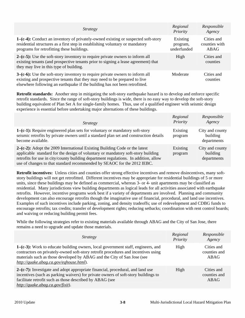
Strategy Regional Priority
Responsible Agency
1–(c-4): Conduct an inventory of privately-owned existing or suspected soft-story residential structures as a first step in establishing voluntary or mandatory programs for retrofitting these buildings.
Existing program,
underfunded
Cities and counties with
ABAG
2–(c-5): Use the soft-story inventory to require private owners to inform all existing tenants (and prospective tenants prior to signing a lease agreement) that they may live in this type of building.
High Cities and counties
3–(c-6): Use the soft-story inventory to require private owners to inform all existing and prospective tenants that they may need to be prepared to live elsewhere following an earthquake if the building has not been retrofitted.
Moderate Cities and counties
Retrofit standards: Another step in mitigating the soft-story earthquake hazard is to develop and enforce specific retrofit standards. Since the range of soft-story buildings is wide, there is no easy way to develop the soft-story building equivalent of Plan Set A for single-family homes. Thus, use of a qualified engineer with seismic design experience is essential before undertaking major alternations of these buildings.
Strategy
Regional Priority
Responsible Agency
1–(c-1): Require engineered plan sets for voluntary or mandatory soft-story seismic retrofits by private owners until a standard plan set and construction details become available.
Existing program
City and county building
departments
2–(c-2): Adopt the 2009 International Existing Building Code or the latest applicable standard for the design of voluntary or mandatory soft-story building retrofits for use in city/county building department regulations. In addition, allow use of changes to that standard recommended by SEAOC for the 2012 IEBC.
Existing program
City and county building
departments
Retrofit incentives: Unless cities and counties offer strong effective incentives and remove disincentives, many soft-story buildings will not get retrofitted. Different incentives may be appropriate for residential buildings of 5 or more units, since these buildings may be defined as commercial, whereas 3- or 4- unit apartments may be classified as residential. Many jurisdictions view building departments as logical leads for all activities associated with earthquake retrofits. However, incentive programs work best if a variety of departments are involved. Planning and community development can also encourage retrofits though the imaginative use of financial, procedural, and land use incentives. Examples of such incentives include parking, zoning, and density tradeoffs; use of redevelopment and CDBG funds to encourage retrofits; tax credits; transfer of development rights; reducing setbacks; coordination with rent control boards; and waiving or reducing building permit fees.
While the following strategies refer to existing materials available through ABAG and the City of San Jose, there remains a need to upgrade and update those materials.
Strategy Regional Priority
Responsible Agency
1–(c-3): Work to educate building owners, local government staff, engineers, and contractors on privately-owned soft-story retrofit procedures and incentives using materials such as those developed by ABAG and the City of San Jose (see http://quake.abag.ca.gov/eqhouse.html).
High Cities and counties and
ABAG
2–(c-7): Investigate and adopt appropriate financial, procedural, and land use incentives (such as parking waivers) for private owners of soft-story buildings to facilitate retrofit such as those described by ABAG (see http://quake.abag.ca.gov/fixit).
High Cities and counties and
ABAG
2010 Update Multi-Jurisdictional Local Hazard Mitigation Plan 3-8
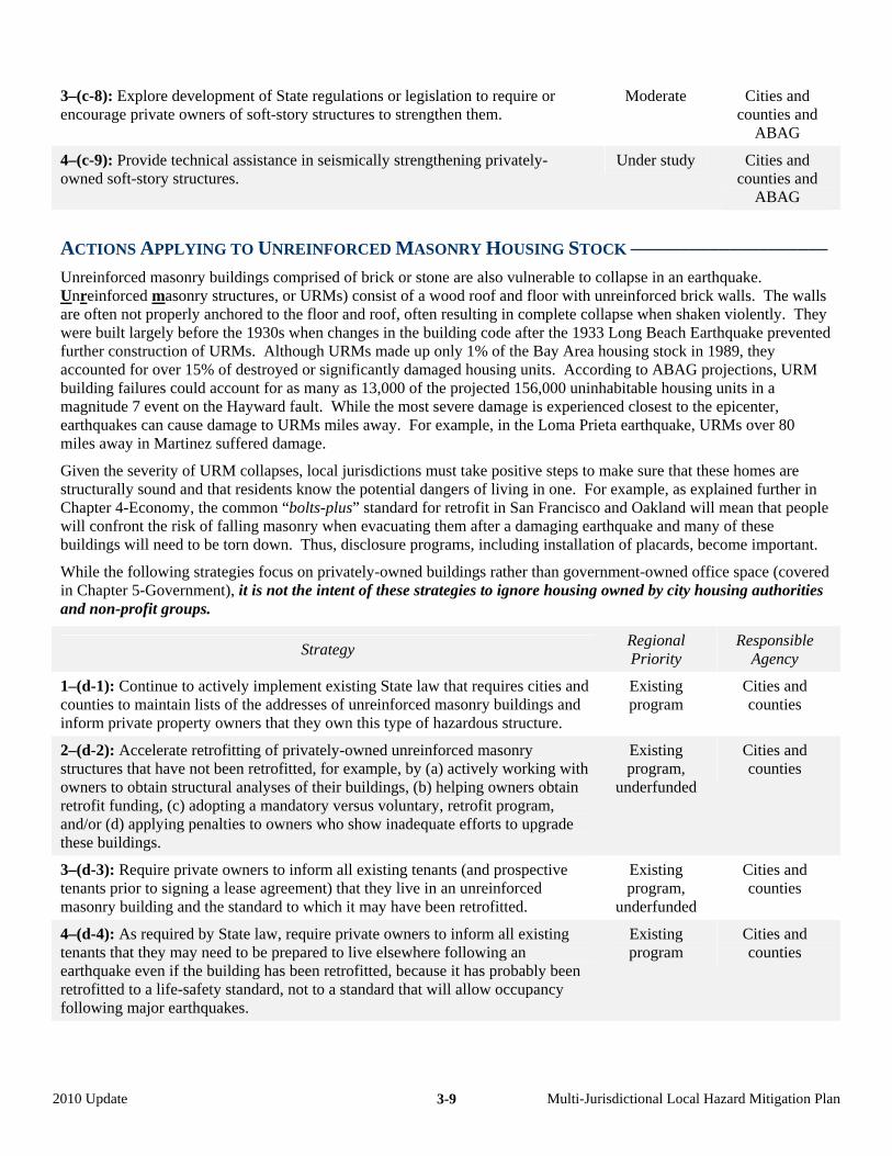
3–(c-8): Explore development of State regulations or legislation to require or encourage private owners of soft-story structures to strengthen them.
Moderate Cities and counties and
ABAG
4–(c-9): Provide technical assistance in seismically strengthening privately-owned soft-story structures.
Under study Cities and counties and
ABAG
ACTIONS APPLYING TO UNREINFORCED MASONRY HOUSING STOCK ––––––––––––––––––––
Unreinforced masonry buildings comprised of brick or stone are also vulnerable to collapse in an earthquake. Unreinforced masonry structures, or URMs) consist of a wood roof and floor with unreinforced brick walls. The walls are often not properly anchored to the floor and roof, often resulting in complete collapse when shaken violently. They were built largely before the 1930s when changes in the building code after the 1933 Long Beach Earthquake prevented further construction of URMs. Although URMs made up only 1% of the Bay Area housing stock in 1989, they accounted for over 15% of destroyed or significantly damaged housing units. According to ABAG projections, URM building failures could account for as many as 13,000 of the projected 156,000 uninhabitable housing units in a magnitude 7 event on the Hayward fault. While the most severe damage is experienced closest to the epicenter, earthquakes can cause damage to URMs miles away. For example, in the Loma Prieta earthquake, URMs over 80 miles away in Martinez suffered damage.
Given the severity of URM collapses, local jurisdictions must take positive steps to make sure that these homes are structurally sound and that residents know the potential dangers of living in one. For example, as explained further in Chapter 4-Economy, the common “bolts-plus” standard for retrofit in San Francisco and Oakland will mean that people will confront the risk of falling masonry when evacuating them after a damaging earthquake and many of these buildings will need to be torn down. Thus, disclosure programs, including installation of placards, become important.
While the following strategies focus on privately-owned buildings rather than government-owned office space (covered in Chapter 5-Government), it is not the intent of these strategies to ignore housing owned by city housing authorities and non-profit groups.
Strategy Regional Priority
Responsible Agency
1–(d-1): Continue to actively implement existing State law that requires cities and counties to maintain lists of the addresses of unreinforced masonry buildings and inform private property owners that they own this type of hazardous structure.
Existing program
Cities and counties
2–(d-2): Accelerate retrofitting of privately-owned unreinforced masonry structures that have not been retrofitted, for example, by (a) actively working with owners to obtain structural analyses of their buildings, (b) helping owners obtain retrofit funding, (c) adopting a mandatory versus voluntary, retrofit program, and/or (d) applying penalties to owners who show inadequate efforts to upgrade these buildings.
Existing program,
underfunded
Cities and counties
3–(d-3): Require private owners to inform all existing tenants (and prospective tenants prior to signing a lease agreement) that they live in an unreinforced masonry building and the standard to which it may have been retrofitted.
Existing program,
underfunded
Cities and counties
4–(d-4): As required by State law, require private owners to inform all existing tenants that they may need to be prepared to live elsewhere following an earthquake even if the building has been retrofitted, because it has probably been retrofitted to a life-safety standard, not to a standard that will allow occupancy following major earthquakes.
Existing program
Cities and counties
2010 Update Multi-Jurisdictional Local Hazard Mitigation Plan 3-9
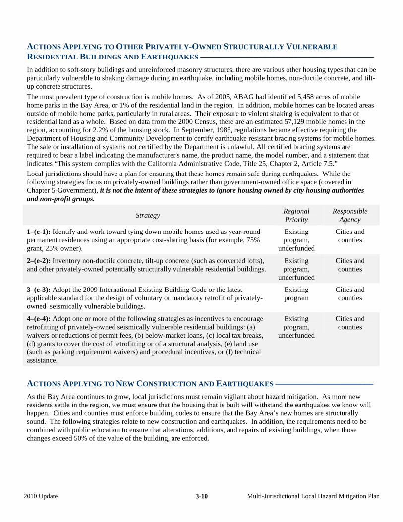
ACTIONS APPLYING TO OTHER PRIVATELY-OWNED STRUCTURALLY VULNERABLE
RESIDENTIAL BUILDINGS AND EARTHQUAKES –––––––––––––––––––––––––––––––––––––––
In addition to soft-story buildings and unreinforced masonry structures, there are various other housing types that can be particularly vulnerable to shaking damage during an earthquake, including mobile homes, non-ductile concrete, and tilt-up concrete structures.
The most prevalent type of construction is mobile homes. As of 2005, ABAG had identified 5,458 acres of mobile home parks in the Bay Area, or 1% of the residential land in the region. In addition, mobile homes can be located areas outside of mobile home parks, particularly in rural areas. Their exposure to violent shaking is equivalent to that of residential land as a whole. Based on data from the 2000 Census, there are an estimated 57,129 mobile homes in the region, accounting for 2.2% of the housing stock. In September, 1985, regulations became effective requiring the Department of Housing and Community Development to certify earthquake resistant bracing systems for mobile homes. The sale or installation of systems not certified by the Department is unlawful. All certified bracing systems are required to bear a label indicating the manufacturer's name, the product name, the model number, and a statement that indicates “This system complies with the California Administrative Code, Title 25, Chapter 2, Article 7.5.”
Local jurisdictions should have a plan for ensuring that these homes remain safe during earthquakes. While the following strategies focus on privately-owned buildings rather than government-owned office space (covered in Chapter 5-Government), it is not the intent of these strategies to ignore housing owned by city housing authorities and non-profit groups.
Strategy Regional Priority
Responsible Agency
1–(e-1): Identify and work toward tying down mobile homes used as year-round permanent residences using an appropriate cost-sharing basis (for example, 75% grant, 25% owner).
Existing program,
underfunded
Cities and counties
2–(e-2): Inventory non-ductile concrete, tilt-up concrete (such as converted lofts), and other privately-owned potentially structurally vulnerable residential buildings.
Existing program,
underfunded
Cities and counties
3–(e-3): Adopt the 2009 International Existing Building Code or the latest applicable standard for the design of voluntary or mandatory retrofit of privately-owned seismically vulnerable buildings.
Existing program
Cities and counties
4–(e-4): Adopt one or more of the following strategies as incentives to encourage retrofitting of privately-owned seismically vulnerable residential buildings: (a) waivers or reductions of permit fees, (b) below-market loans, (c) local tax breaks, (d) grants to cover the cost of retrofitting or of a structural analysis, (e) land use (such as parking requirement waivers) and procedural incentives, or (f) technical assistance.
Existing program,
underfunded
Cities and counties
ACTIONS APPLYING TO NEW CONSTRUCTION AND EARTHQUAKES ––––––––––––––––––––––
As the Bay Area continues to grow, local jurisdictions must remain vigilant about hazard mitigation. As more new residents settle in the region, we must ensure that the housing that is built will withstand the earthquakes we know will happen. Cities and counties must enforce building codes to ensure that the Bay Area’s new homes are structurally sound. The following strategies relate to new construction and earthquakes. In addition, the requirements need to be combined with public education to ensure that alterations, additions, and repairs of existing buildings, when those changes exceed 50% of the value of the building, are enforced.
2010 Update Multi-Jurisdictional Local Hazard Mitigation Plan 3-10
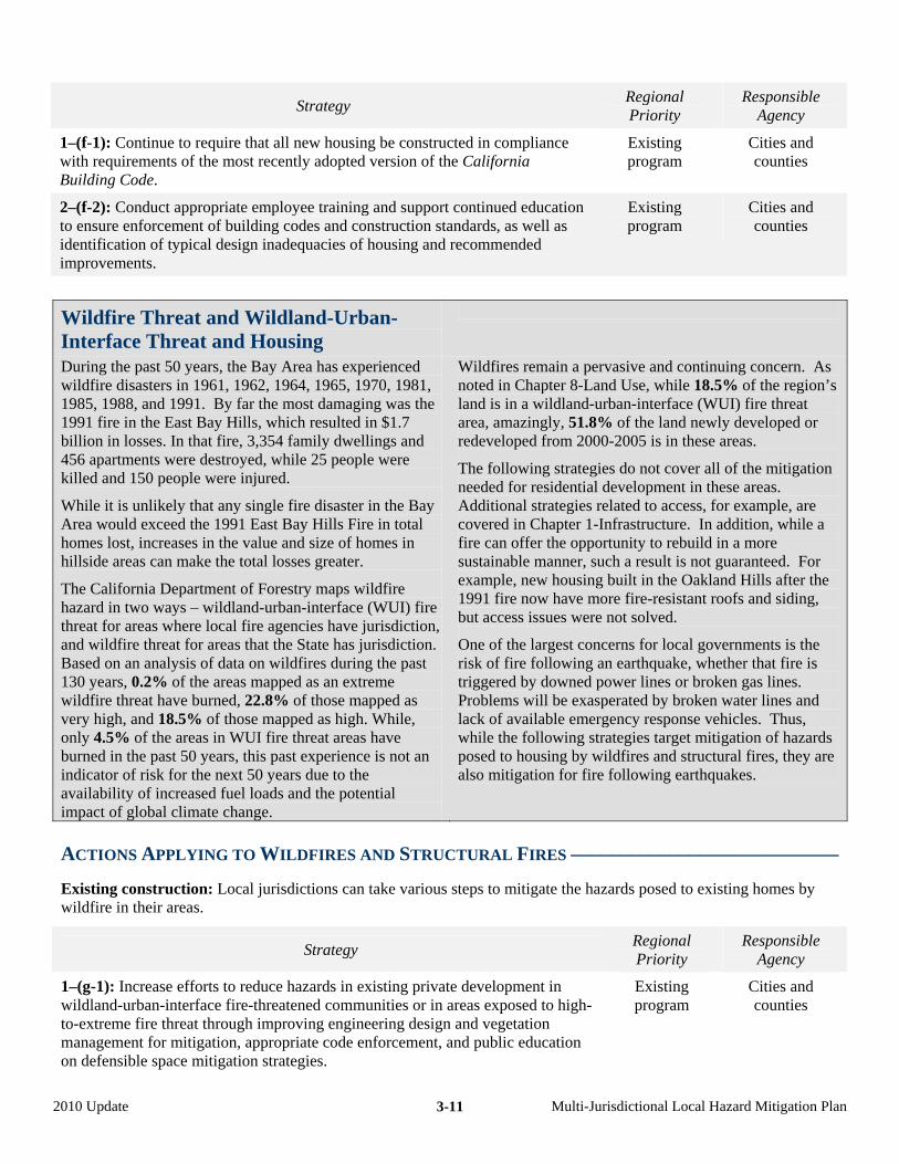
Strategy Regional Priority
Responsible Agency
1–(f-1): Continue to require that all new housing be constructed in compliance with requirements of the most recently adopted version of the California Building Code.
Existing program
Cities and counties
2–(f-2): Conduct appropriate employee training and support continued education to ensure enforcement of building codes and construction standards, as well as identification of typical design inadequacies of housing and recommended improvements.
Existing program
Cities and counties
Wildfire Threat and Wildland-Urban-Interface Threat and Housing
During the past 50 years, the Bay Area has experienced wildfire disasters in 1961, 1962, 1964, 1965, 1970, 1981, 1985, 1988, and 1991. By far the most damaging was the 1991 fire in the East Bay Hills, which resulted in $1.7 billion in losses. In that fire, 3,354 family dwellings and 456 apartments were destroyed, while 25 people were killed and 150 people were injured.
While it is unlikely that any single fire disaster in the Bay Area would exceed the 1991 East Bay Hills Fire in total homes lost, increases in the value and size of homes in hillside areas can make the total losses greater.
The California Department of Forestry maps wildfire hazard in two ways – wildland-urban-interface (WUI) fire threat for areas where local fire agencies have jurisdiction, and wildfire threat for areas that the State has jurisdiction. Based on an analysis of data on wildfires during the past 130 years, 0.2% of the areas mapped as an extreme wildfire threat have burned, 22.8% of those mapped as very high, and 18.5% of those mapped as high. While, only 4.5% of the areas in WUI fire threat areas have burned in the past 50 years, this past experience is not an indicator of risk for the next 50 years due to the availability of increased fuel loads and the potential impact of global climate change.
Wildfires remain a pervasive and continuing concern. As noted in Chapter 8-Land Use, while 18.5% of the region’s land is in a wildland-urban-interface (WUI) fire threat area, amazingly, 51.8% of the land newly developed or redeveloped from 2000-2005 is in these areas.
The following strategies do not cover all of the mitigation needed for residential development in these areas. Additional strategies related to access, for example, are covered in Chapter 1-Infrastructure. In addition, while a fire can offer the opportunity to rebuild in a more sustainable manner, such a result is not guaranteed. For example, new housing built in the Oakland Hills after the 1991 fire now have more fire-resistant roofs and siding, but access issues were not solved.
One of the largest concerns for local governments is the risk of fire following an earthquake, whether that fire is triggered by downed power lines or broken gas lines. Problems will be exasperated by broken water lines and lack of available emergency response vehicles. Thus, while the following strategies target mitigation of hazards posed to housing by wildfires and structural fires, they are also mitigation for fire following earthquakes.
ACTIONS APPLYING TO WILDFIRES AND STRUCTURAL FIRES –––––––––––––––––––––––––––
Existing construction: Local jurisdictions can take various steps to mitigate the hazards posed to existing homes by wildfire in their areas.
Strategy Regional Priority
Responsible Agency
1–(g-1): Increase efforts to reduce hazards in existing private development in wildland-urban-interface fire-threatened communities or in areas exposed to high-to-extreme fire threat through improving engineering design and vegetation management for mitigation, appropriate code enforcement, and public education on defensible space mitigation strategies.
Existing program
Cities and counties
2010 Update Multi-Jurisdictional Local Hazard Mitigation Plan 3-11
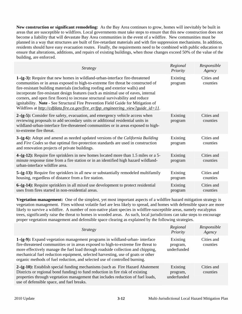
New construction or significant remodeling: As the Bay Area continues to grow, homes will inevitably be built in areas that are susceptible to wildfires. Local governments must take steps to ensure that this new construction does not become a liability that will devastate Bay Area communities in the event of a wildfire. New communities must be planned in a way that structures are built of fire-retardant materials and with fire suppression mechanisms. In addition, residents should have easy evacuation routes. Finally, the requirements need to be combined with public education to ensure that alterations, additions, and repairs of existing buildings, when those changes exceed 50% of the value of the building, are enforced.
Strategy Regional Priority
Responsible Agency
1–(g-3): Require that new homes in wildland-urban-interface fire-threatened communities or in areas exposed to high-to-extreme fire threat be constructed of fire-resistant building materials (including roofing and exterior walls) and incorporate fire-resistant design features (such as minimal use of eaves, internal corners, and open first floors) to increase structural survivability and reduce ignitability. Note - See Structural Fire Prevention Field Guide for Mitigation of Wildfires at http://cdfdata.fire.ca.gov/fire_er/fpp_engineering_view?guide_id=11.
Existing program
Cities and counties
2–(g-5): Consider fire safety, evacuation, and emergency vehicle access when reviewing proposals to add secondary units or additional residential units in wildland-urban-interface fire-threatened communities or in areas exposed to high-to-extreme fire threat.
Existing program
Cities and counties
3–(g-6): Adopt and amend as needed updated versions of the California Building and Fire Codes so that optimal fire-protection standards are used in construction and renovation projects of private buildings.
Existing program
Cities and counties
4–(g-12): Require fire sprinklers in new homes located more than 1.5 miles or a 5-minute response time from a fire station or in an identified high hazard wildland-urban-interface wildfire area.
Existing program
Cities and counties
5–(g-13): Require fire sprinklers in all new or substantially remodeled multifamily housing, regardless of distance from a fire station.
Existing program
Cities and counties
6–(g-14): Require sprinklers in all mixed use development to protect residential uses from fires started in non-residential areas.
Existing program
Cities and counties
Vegetation management: One of the simplest, yet most important aspects of a wildfire hazard mitigation strategy is vegetation management. Fires without volatile fuel are less likely to spread, and homes with defensible space are more likely to survive a wildfire. A number of non-native plant species in wildfire-susceptible areas, namely eucalyptus trees, significantly raise the threat to homes in wooded areas. As such, local jurisdictions can take steps to encourage proper vegetation management and defensible space clearing as explained by the following strategies.
Strategy Regional Priority
Responsible Agency
1–(g-9): Expand vegetation management programs in wildland-urban- interface fire-threatened communities or in areas exposed to high-to-extreme fire threat to more effectively manage the fuel load through roadside collection and chipping, mechanical fuel reduction equipment, selected harvesting, use of goats or other organic methods of fuel reduction, and selected use of controlled burning.
Existing program,
underfunded
Cities and counties
2–(g-10): Establish special funding mechanisms (such as Fire Hazard Abatement Districts or regional bond funding) to fund reduction in fire risk of existing properties through vegetation management that includes reduction of fuel loads, use of defensible space, and fuel breaks.
Existing program,
underfunded
Cities and counties
2010 Update Multi-Jurisdictional Local Hazard Mitigation Plan 3-12
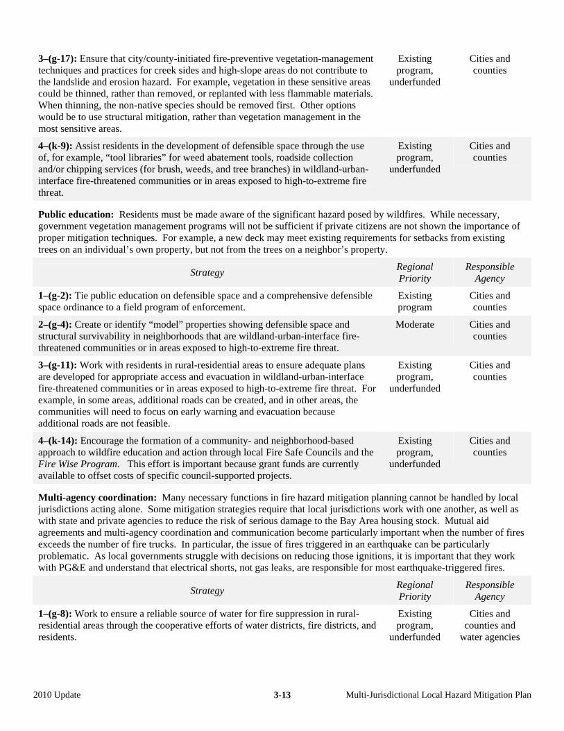
3–(g-17): Ensure that city/county-initiated fire-preventive vegetation-management techniques and practices for creek sides and high-slope areas do not contribute to the landslide and erosion hazard. For example, vegetation in these sensitive areas could be thinned, rather than removed, or replanted with less flammable materials. When thinning, the non-native species should be removed first. Other options would be to use structural mitigation, rather than vegetation management in the most sensitive areas.
Existing program,
underfunded
Cities and counties
4–(k-9): Assist residents in the development of defensible space through the use of, for example, “tool libraries” for weed abatement tools, roadside collection and/or chipping services (for brush, weeds, and tree branches) in wildland-urban-interface fire-threatened communities or in areas exposed to high-to-extreme fire threat.
Existing program,
underfunded
Cities and counties
Public education: Residents must be made aware of the significant hazard posed by wildfires. While necessary, government vegetation management programs will not be sufficient if private citizens are not shown the importance of proper mitigation techniques. For example, a new deck may meet existing requirements for setbacks from existing trees on an individual’s own property, but not from the trees on a neighbor’s property.
Strategy Regional Priority
Responsible Agency
1–(g-2): Tie public education on defensible space and a comprehensive defensible space ordinance to a field program of enforcement.
Existing program
Cities and counties
2–(g-4): Create or identify “model” properties showing defensible space and structural survivability in neighborhoods that are wildland-urban-interface fire-threatened communities or in areas exposed to high-to-extreme fire threat.
Moderate Cities and counties
3–(g-11): Work with residents in rural-residential areas to ensure adequate plans are developed for appropriate access and evacuation in wildland-urban-interface fire-threatened communities or in areas exposed to high-to-extreme fire threat. For example, in some areas, additional roads can be created, and in other areas, the communities will need to focus on early warning and evacuation because additional roads are not feasible.
Existing program,
underfunded
Cities and counties
4–(k-14): Encourage the formation of a community- and neighborhood-based approach to wildfire education and action through local Fire Safe Councils and the Fire Wise Program. This effort is important because grant funds are currently available to offset costs of specific council-supported projects.
Existing program,
underfunded
Cities and counties
Multi-agency coordination: Many necessary functions in fire hazard mitigation planning cannot be handled by local jurisdictions acting alone. Some mitigation strategies require that local jurisdictions work with one another, as well as with state and private agencies to reduce the risk of serious damage to the Bay Area housing stock. Mutual aid agreements and multi-agency coordination and communication become particularly important when the number of fires exceeds the number of fire trucks. In particular, the issue of fires triggered in an earthquake can be particularly problematic. As local governments struggle with decisions on reducing those ignitions, it is important that they work with PG&E and understand that electrical shorts, not gas leaks, are responsible for most earthquake-triggered fires.
Strategy Regional Priority
Responsible Agency
1–(g-8): Work to ensure a reliable source of water for fire suppression in rural-residential areas through the cooperative efforts of water districts, fire districts, and residents.
Existing program,
underfunded
Cities and counties and
water agencies
2010 Update Multi-Jurisdictional Local Hazard Mitigation Plan 3-13
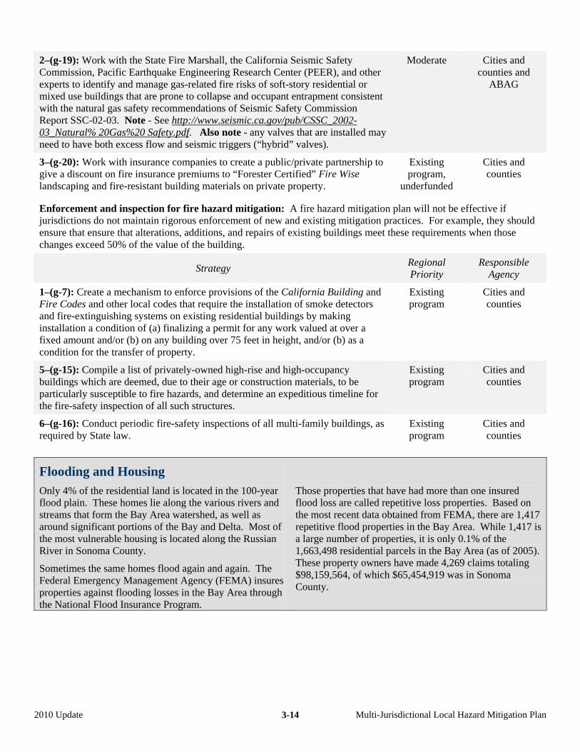
2–(g-19): Work with the State Fire Marshall, the California Seismic Safety Commission, Pacific Earthquake Engineering Research Center (PEER), and other experts to identify and manage gas-related fire risks of soft-story residential or mixed use buildings that are prone to collapse and occupant entrapment consistent with the natural gas safety recommendations of Seismic Safety Commission Report SSC-02-03. Note - See http://www.seismic.ca.gov/pub/CSSC_2002-03_Natural% 20Gas%20 Safety.pdf. Also note - any valves that are installed may need to have both excess flow and seismic triggers (“hybrid” valves).
Moderate Cities and counties and
ABAG
3–(g-20): Work with insurance companies to create a public/private partnership to give a discount on fire insurance premiums to “Forester Certified” Fire Wise landscaping and fire-resistant building materials on private property.
Existing program,
underfunded
Cities and counties
Enforcement and inspection for fire hazard mitigation: A fire hazard mitigation plan will not be effective if jurisdictions do not maintain rigorous enforcement of new and existing mitigation practices. For example, they should ensure that ensure that alterations, additions, and repairs of existing buildings meet these requirements when those changes exceed 50% of the value of the building.
Strategy Regional Priority
Responsible Agency
1–(g-7): Create a mechanism to enforce provisions of the California Building and Fire Codes and other local codes that require the installation of smoke detectors and fire-extinguishing systems on existing residential buildings by making installation a condition of (a) finalizing a permit for any work valued at over a fixed amount and/or (b) on any building over 75 feet in height, and/or (b) as a condition for the transfer of property.
Existing program
Cities and counties
5–(g-15): Compile a list of privately-owned high-rise and high-occupancy buildings which are deemed, due to their age or construction materials, to be particularly susceptible to fire hazards, and determine an expeditious timeline for the fire-safety inspection of all such structures.
Existing program
Cities and counties
6–(g-16): Conduct periodic fire-safety inspections of all multi-family buildings, as required by State law.
Existing program
Cities and counties
Flooding and Housing
Only 4% of the residential land is located in the 100-year flood plain. These homes lie along the various rivers and streams that form the Bay Area watershed, as well as around significant portions of the Bay and Delta. Most of the most vulnerable housing is located along the Russian River in Sonoma County.
Sometimes the same homes flood again and again. The Federal Emergency Management Agency (FEMA) insures properties against flooding losses in the Bay Area through the National Flood Insurance Program.
Those properties that have had more than one insured flood loss are called repetitive loss properties. Based on the most recent data obtained from FEMA, there are 1,417 repetitive flood properties in the Bay Area. While 1,417 is a large number of properties, it is only 0.1% of the 1,663,498 residential parcels in the Bay Area (as of 2005). These property owners have made 4,269 claims totaling $98,159,564, of which $65,454,919 was in Sonoma County.
2010 Update Multi-Jurisdictional Local Hazard Mitigation Plan 3-14
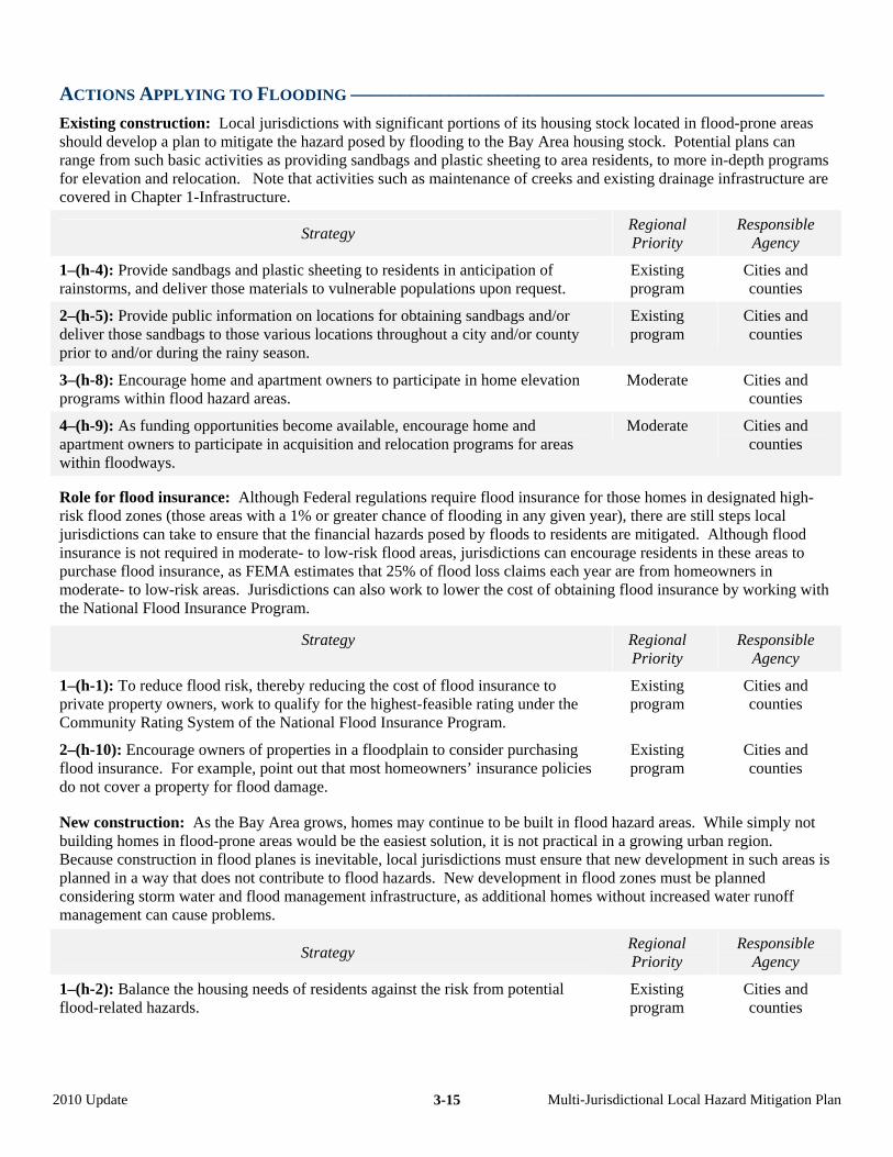
ACTIONS APPLYING TO FLOODING ––––––––––––––––––––––––––––––––––––––––––––––––
Existing construction: Local jurisdictions with significant portions of its housing stock located in flood-prone areas should develop a plan to mitigate the hazard posed by flooding to the Bay Area housing stock. Potential plans can range from such basic activities as providing sandbags and plastic sheeting to area residents, to more in-depth programs for elevation and relocation. Note that activities such as maintenance of creeks and existing drainage infrastructure are covered in Chapter 1-Infrastructure.
Strategy Regional Priority
Responsible Agency
1–(h-4): Provide sandbags and plastic sheeting to residents in anticipation of rainstorms, and deliver those materials to vulnerable populations upon request.
Existing program
Cities and counties
2–(h-5): Provide public information on locations for obtaining sandbags and/or deliver those sandbags to those various locations throughout a city and/or county prior to and/or during the rainy season.
Existing program
Cities and counties
3–(h-8): Encourage home and apartment owners to participate in home elevation programs within flood hazard areas.
Moderate Cities and counties
4–(h-9): As funding opportunities become available, encourage home and apartment owners to participate in acquisition and relocation programs for areas within floodways.
Moderate Cities and counties
Role for flood insurance: Although Federal regulations require flood insurance for those homes in designated high-risk flood zones (those areas with a 1% or greater chance of flooding in any given year), there are still steps local jurisdictions can take to ensure that the financial hazards posed by floods to residents are mitigated. Although flood insurance is not required in moderate- to low-risk flood areas, jurisdictions can encourage residents in these areas to purchase flood insurance, as FEMA estimates that 25% of flood loss claims each year are from homeowners in moderate- to low-risk areas. Jurisdictions can also work to lower the cost of obtaining flood insurance by working with the National Flood Insurance Program.
Strategy Regional Priority
Responsible Agency
1–(h-1): To reduce flood risk, thereby reducing the cost of flood insurance to private property owners, work to qualify for the highest-feasible rating under the Community Rating System of the National Flood Insurance Program.
Existing program
Cities and counties
2–(h-10): Encourage owners of properties in a floodplain to consider purchasing flood insurance. For example, point out that most homeowners’ insurance policies do not cover a property for flood damage.
Existing program
Cities and counties
New construction: As the Bay Area grows, homes may continue to be built in flood hazard areas. While simply not building homes in flood-prone areas would be the easiest solution, it is not practical in a growing urban region. Because construction in flood planes is inevitable, local jurisdictions must ensure that new development in such areas is planned in a way that does not contribute to flood hazards. New development in flood zones must be planned considering storm water and flood management infrastructure, as additional homes without increased water runoff management can cause problems.
Strategy Regional Priority
Responsible Agency
1–(h-2): Balance the housing needs of residents against the risk from potential flood-related hazards.
Existing program
Cities and counties
2010 Update Multi-Jurisdictional Local Hazard Mitigation Plan 3-15
2–(h-3): Ensure that new private development pays its fair share of improvements to the storm drainage system necessary to accommodate increased flows from the development, or does not increase runoff by draining water to pervious areas or detention facilities.
Existing program
Cities and counties
3–(h-6): Apply floodplain management regulations for private development in the floodplain and floodway.
Existing program
Cities and counties
4–(h-7): Ensure that new subdivisions are designed to reduce or eliminate flood damage by requiring lots and rights-of-way be laid out for the provision of approved sewer and drainage facilities, providing on-site detention facilities whenever practicable.
Existing program
Cities and counties
Public education: Local jurisdictions can play a key role in informing residents of flood hazards. They can emphasize the importance of proper storm water runoff management, and provide resources to residents regarding flood preparation and notification.
Strategy Regional Priority
Responsible Agency
1–(k-7): Include flood fighting technique session based on California Department of Water Resources training to the list of available public training classes offered by CERT.
Existing program,
underfunded
Cities and counties
2–(k-11): Develop a program to provide at-cost NOAA weather radios to residents of flood hazard areas that request them, with priority to neighborhood watch captains and others trained in their use.
Moderate Cities and counties
3–(k-13): Develop a “Maintain-a-Drain” campaign, similar to that of the City of Oakland, encouraging private businesses and residents to keep storm drains in their neighborhood free of debris.
Existing program
Cities and counties
4–(k-15): Inform shoreline-property owners of the possible long-term economic threat posed by rising sea levels.
Under study Cities and counties and
ABAG
Housing, Landslides, and Erosion
Only 10% of the Bay Area housing stock is located in areas that are exposed to very high risk of future landslides (because they are in areas where many landslides have occurred in the past. However, when a landslide occurs, it can be just as devastating and dangerous as the various other hazards facing the Bay Area housing stock, but to smaller geographic areas.
Intense storms in January of 1982 caused over 18,000 separate landslides in the Bay Area, destroying over 100 homes and causing 25 fatalities. In all, the slides resulted in $66 million in damage. The hazard posed by landslides is increased when soil becomes eroded.
2010 Update Multi-Jurisdictional Local Hazard Mitigation Plan 3-16
ACTIONS APPLYING TO LANDSLIDES AND EROSION –––––––––––––––––––––––––––––––––––
The following strategies on landslides and erosion relate specifically to housing. However, additional strategies related to landslides are listed in Chapter 8-Land Use, and a discussion of erosion during vegetation management is included above as Strategy g-17. In addition, appropriate vegetation management practices listed in the wildfire section above can also reduce the risk of erosion and shallow landslides. Education of owners is also critical.
Strategy Regional Priority
Responsible Agency
1–(i-1): Increase efforts to reduce landslides and erosion in existing and future development by improving appropriate code enforcement and use of applicable standards for private property, such as those appearing in the California Building Code, California Geological Survey Special Report 117 – Guidelines for Evaluating and Mitigating Seismic Hazards in California, American Society of Civil Engineers (ASCE) report Recommended Procedures for Implementation of DMG Special Publication 117: Guidelines for Analyzing and Mitigating Landslide Hazards in California, and the California Board for Geologists and Geophysicists Guidelines for Engineering Geologic Reports. Such standards should cover excavation, fill placement, cut-fill transitions, slope stability, drainage and erosion control, slope setbacks, expansive soils, collapsible soils, environmental issues, geological and geotechnical investigations, grading plans and specifications, protection of adjacent properties, and review and permit issuance.
Existing program
Cities and counties
2–(i-2): Increase efforts to reduce landslides and erosion in existing and future private development through continuing education of design professionals on mitigation strategies.
Existing program,
underfunded
Cities and counties
2010 Update Multi-Jurisdictional Local Hazard Mitigation Plan 3-17
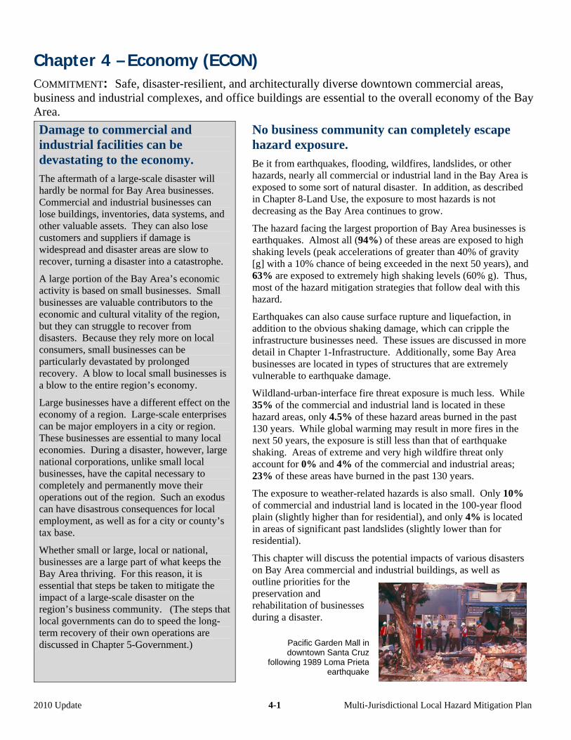
Chapter 4 – Economy (ECON) COMMITMENT: Safe, disaster-resilient, and architecturally diverse downtown commercial areas, business and industrial complexes, and office buildings are essential to the overall economy of the Bay Area.
Damage to commercial and industrial facilities can be devastating to the economy. The aftermath of a large-scale disaster will hardly be normal for Bay Area businesses. Commercial and industrial businesses can lose buildings, inventories, data systems, and other valuable assets. They can also lose customers and suppliers if damage is widespread and disaster areas are slow to recover, turning a disaster into a catastrophe.
A large portion of the Bay Area’s economic activity is based on small businesses. Small businesses are valuable contributors to the economic and cultural vitality of the region, but they can struggle to recover from disasters. Because they rely more on local consumers, small businesses can be particularly devastated by prolonged recovery. A blow to local small businesses is a blow to the entire region’s economy.
Large businesses have a different effect on the economy of a region. Large-scale enterprises can be major employers in a city or region. These businesses are essential to many local economies. During a disaster, however, large national corporations, unlike small local businesses, have the capital necessary to completely and permanently move their operations out of the region. Such an exodus can have disastrous consequences for local employment, as well as for a city or county’s tax base.
Whether small or large, local or national, businesses are a large part of what keeps the Bay Area thriving. For this reason, it is essential that steps be taken to mitigate the impact of a large-scale disaster on the region’s business community. (The steps that local governments can do to speed the long-term recovery of their own operations are discussed in Chapter 5-Government.)
No business community can completely escape hazard exposure. Be it from earthquakes, flooding, wildfires, landslides, or other hazards, nearly all commercial or industrial land in the Bay Area is exposed to some sort of natural disaster. In addition, as described in Chapter 8-Land Use, the exposure to most hazards is not decreasing as the Bay Area continues to grow.
The hazard facing the largest proportion of Bay Area businesses is earthquakes. Almost all (94%) of these areas are exposed to high shaking levels (peak accelerations of greater than 40% of gravity [g] with a 10% chance of being exceeded in the next 50 years), and 63% are exposed to extremely high shaking levels (60% g). Thus, most of the hazard mitigation strategies that follow deal with this hazard.
Earthquakes can also cause surface rupture and liquefaction, in addition to the obvious shaking damage, which can cripple the infrastructure businesses need. These issues are discussed in more detail in Chapter 1-Infrastructure. Additionally, some Bay Area businesses are located in types of structures that are extremely vulnerable to earthquake damage.
Wildland-urban-interface fire threat exposure is much less. While 35% of the commercial and industrial land is located in these hazard areas, only 4.5% of these hazard areas burned in the past 130 years. While global warming may result in more fires in the next 50 years, the exposure is still less than that of earthquake shaking. Areas of extreme and very high wildfire threat only account for 0% and 4% of the commercial and industrial areas; 23% of these areas have burned in the past 130 years.
The exposure to weather-related hazards is also small. Only 10% of commercial and industrial land is located in the 100-year flood plain (slightly higher than for residential), and only 4% is located in areas of significant past landslides (slightly lower than for residential).
This chapter will discuss the potential impacts of various disasters on Bay Area commercial and industrial buildings, as well as outline priorities for the preservation and rehabilitation of businesses during a disaster.
Pacific Garden Mall in downtown Santa Cruz
following 1989 Loma Prieta earthquake
2010 Update 4-1 Multi-Jurisdictional Local Hazard Mitigation Plan
Certain Mitigation Practices Apply to All Hazards
Though the hazards facing Bay Area businesses are serious and diverse, certain steps can be taken to ensure proper preparation and quick recovery. Local jurisdictions can ensure that damage to commercial buildings is minimized through comprehensive public education campaigns for business owners.
They can also work with structural engineers and the local business community to ensure that all parties are adequately prepared to assess and repair damage done to commercial buildings, no matter what sort of disaster may occur.
ACTIONS APPLYING TO MULTIPLE HAZARDS AND PUBLIC EDUCATION ––––––––––––––––––
Local business and commercial property owners must be made aware of the natural hazards facing the Bay Area, both as a region and for the neighborhoods in which there businesses are located. In addition to earthquakes, Bay Area businesses can be subject to tsunamis, wildfires, flooding, landslides, and sea-level rise. While each of these hazards has its own set of mitigation strategies, without proper information and guidance about the hazards and risks, the business community is unlikely to be fully prepared for a disaster. As such, local jurisdictions can take steps to improve disclosure of hazards, and increase awareness among local businesses and business districts on mitigation practices. Public information programs can also explain the importance of obtaining a building permit when altering, repairing, or adding onto existing construction.
Strategy Regional Priority
Responsible Agency
1–(a-1): Assist in ensuring adequate hazard disclosure by working with real estate agents to improve enforcement of real estate disclosure requirements for commercial and industrial properties with regard to seven official natural hazard zones: 1) Special Flood Hazard Areas (designated by FEMA), 2) Areas of Potential Flooding from dam failure inundation, 3) Very High Fire Hazard Severity Zones, 4) Wildland Fire Zones, 5) Earthquake Fault Zones (designated under the Alquist-Priolo Earthquake Fault Zoning Act), and the 6) Liquefaction and Landslide Hazard Zones (designated under the Seismic Hazard Mapping Act).
Existing program
Cities and counties
2–(j-1): Provide information to private business owners and their employees on the availability of interactive hazard maps on ABAG’s web site.
Existing program
Cities and counties
3–(j-2): Develop printed materials, utilize existing materials (such as developed by FEMA and the American Red Cross), conduct workshops, and/or provide outreach encouraging private businesses’ employees to have family disaster plans that include drop-cover-hold earthquake drills, fire and storm evacuation procedures, and shelter-in-place emergency guidelines.
Existing program,
underfunded
Cities and counties
4–(j-3): Develop and print materials, conduct workshops, and provide outreach to Bay Area private businesses focusing on business continuity planning.
Existing program,
underfunded
Cities and counties
5–(j-4): Inform Bay Area private business owners of mitigation activities, including elevation of appliances above expected flood levels, use of fire-resistant roofing and defensible space in wildland-urban-interface fire-threatened communities or in areas exposed to high-to-extreme fire threat, structural retrofitting techniques for older buildings, and use of intelligent grading practices through workshops, publications, and media announcements and events.
Existing program,
underfunded
Cities and counties
6–(j-5): Sponsor the formation and training of Community Emergency Response Teams (CERT) training for other than your own employees through partnerships with local private businesses. [Note – these programs go by a variety of names in various cities and areas.]
Existing program,
underfunded
Cities and counties
2010 Update 4-2 Multi-Jurisdictional Local Hazard Mitigation Plan
7–(j-13): Distribute appropriate materials related to disaster mitigation and preparedness to private business owners. Appropriate materials are (1) culturally appropriate and (2) suitable for special needs populations. For example, such materials are available on the http://www.preparenow.org website and from non-governmental organizations that work with these communities on an on-going basis.
Existing program,
underfunded
Cities and counties
ACTIONS APPLYING TO MULTIPLE HAZARDS AND REOCCUPANCY ––––––––––––––––––––––
After a disaster, many Bay Area businesses will be unable to operate because their buildings are damaged. Getting these businesses up and running again will be a key part of restoring the region’s economy to its full potential. Buildings evacuated in a disaster will need to be inspected for structural stability before they can be reoccupied.
Full economic recovery requires a more strategic and concerted effort than housing recovery. Whereas a residential neighborhood with a handful of occupied homes can mean a return to normal life for a few families after a disaster, the same is not necessarily true for a devastated business district. Since so many of the region’s businesses are dependent on one another for goods, services, and customers, piecemeal efforts to get a small number of businesses operating after a disaster will not be effective in softening the blow to the area’s economy.
Local jurisdictions can take a variety of steps in order to mitigate the impact of a slow disaster recovery on the Bay Area economy. Creating incentives for private owners to comply with the federal Secretary of the Interior’s Standards for the Treatment of Historic Properties with Guidelines for Preserving, Rehabilitating, Restoring, and Reconstructing Historic Buildings (from an aesthetic perspective) need to be coupled with compliance with safety regulations, such as the California 2007 Historical Building Code. Programs like San Francisco’s Building Occupancy Resumption Program (BORP) are meant to expedite the recovery and reoccupancy processes by creating plans before a disaster occurs. Such efforts are key to ensuring rapid recovery. BORP has the added benefit of creating a process where owners, including owners of historic buildings, can work together with engineers to develop ways to engage in pre-disaster mitigation. Engineers with a pre-existing knowledge of buildings are also most effective in post-earthquake structural evaluations.
Strategy Regional Priority
Responsible Agency
1–(a-2): Create incentives for private owners of historic or architecturally significant commercial and industrial buildings to undertake mitigation to levels that will minimize the likelihood that these buildings will need to be demolished after a disaster, particularly if those alterations conform to the federal Secretary of the Interior’s Guidelines for Rehabilitation.
Existing program,
underfunded
Cities and counties
2–(i-1): Institute a program to encourage owners of private buildings to participate in a program similar to San Francisco’s Building Occupancy Resumption Program (BORP). This program permits owners of private buildings to hire qualified structural engineers to create building-specific post-disaster inspection plans and allows these engineers to become automatically deputized as City/County inspectors for these buildings in the event of an earthquake or other disaster.
Existing program,
underfunded
Cities and counties
3–(i-2): Actively notify private owners of historic or architecturally significant buildings of the availability of the local BORP-type program and encourage them to participate to ensure that appropriately qualified structural engineers are inspecting their buildings, thus reducing the likelihood that the buildings will be inappropriately evaluated following a disaster.
Existing program,
underfunded
Cities and counties
4–(i-3): Actively notify owners of educational facility buildings of the availability of the local BORP-type program and encourage them to participate to ensure that appropriately qualified structural engineers are inspecting their buildings, thus reducing the likelihood that the buildings will be inappropriately evaluated following a disaster.
Existing program,
underfunded
Cities and counties
2010 Update 4-3 Multi-Jurisdictional Local Hazard Mitigation Plan
5–(i-4): Allow private building owners to participate in a BORP-type program as described above, but not actively encourage them to do so.
Existing program,
underfunded
Cities and counties
6–(i-5): Develop and enforce a repair and reconstruction ordinance to ensure that damaged buildings are repaired in an appropriate and timely manner and retrofitted concurrently. This repair and reconstruction ordinance should apply to all public and private buildings, and also apply to repair of all damage, regardless of cause. See http://quake.abag.ca.gov/recovery/info-repair-ord.html.
Existing program
Cities and counties
7–(i-6): Establish preservation-sensitive measures for the repair and reoccupancy of historically significant privately-owned structures, including requirements for temporary shoring or stabilization where needed, arrangements for consulting with preservationists, and expedited permit procedures for suitable repair or rebuilding of historically or architecturally valuable structures.
Existing program,
underfunded
Cities and counties
Earthquakes and the Economy
Of the natural disasters covered in this plan, the one affecting the largest number of Bay Area businesses is earthquakes. Whereas other disasters like wildfires and flooding are more localized, an earthquake can strike a substantial portion of Bay Area commercial buildings in a less than a minute.
This fact can be extremely problematic considering that commercial districts tend to have larger buildings and have denser zoning than residential areas.
Such business districts are also more likely to contain vulnerable structural types: unreinforced masonry buildings, non-ductile concrete buildings, and tilt-ups. While most of these building types are not used for housing, they are still present in many Bay Area commercial settings.
The following section will discuss strategies for mitigating the hazards posed by earthquake shaking to various commercial business types.
ACTIONS RELATED TO EARTHQUAKES AND EXISTING CONSTRUCTION –––––––––––––––––––
Existing construction poses more of a problem for hazard mitigation than new construction. While new buildings can be constructed to safe seismic codes, existing commercial buildings in the Bay Area have been built over decades to various standards. Furthermore, lack of maintenance and non-code-compliant alterations can compromise earthquake resistance in existing buildings. The following two strategies for existing commercial and industrial areas apply regardless of construction type. These strategies are often implemented through the buildings departments. If other local government departments work with these owners, they can refer them to the building department, and, at the same time, explain the importance of obtaining a building permit when altering, repairing, or adding onto existing construction, particularly for earthquake mitigation.
Strategy Regional Priority
Responsible Agency
1–(h-3): Work with private building owners to help them recognize that many strategies that increase earthquake resistance also decrease damage in an explosion. In addition, recognize that ventilation systems can be designed to contain airborne biological agents.
Existing program,
underfunded
Cities and counties
2–(j-7): Make use of the materials developed by others (such as found on ABAG’s web site at http://quake.abag.ca.gov/business) to increase mitigation activities related to earthquakes by groups other than your own agency. ABAG plans to continue to improve the quality of those materials over time.
Existing program
Cities and counties
2010 Update 4-4 Multi-Jurisdictional Local Hazard Mitigation Plan
ACTIONS RELATED TO EXISTING SOFT-STORY COMMERCIAL BUILDINGS ––––––––––––––––
As discussed earlier in Chapter 3-Housing, soft-story buildings are some of the most susceptible structures to earthquake damage. Some of the Bay Area’s soft-story residential buildings have businesses on the first floor in addition to, or instead of, parking. Most of the soft-story structures that contain commercial use are in San Francisco. In addition, some downtown commercial areas have buildings that are soft-story commercial structures with offices, rather than housing, on upper floors. Although the greatest impact in past earthquakes has been on housing, the damage caused by earthquake shaking to soft-story structures in commercial areas should not be overlooked by local governments as they work toward a more resilient business community.
Soft-story hazard mitigation for commercial buildings follows the same main themes as for housing: conducting an inventory, developing retrofit standards, and creating incentives for owners to retrofit. In particular, use of a qualified engineer with seismic design experience is essential before undertaking major alterations. For a more in-depth discussion of the specific hazards and mitigation practices relating to soft-story buildings, see Chapter 3-Housing.
Conducting an Inventory:
Strategy Regional Priority
Responsible Agency
1–(b-4): Conduct an inventory of privately-owned existing or suspected soft-story commercial or industrial structures as a first step in establishing voluntary or mandatory programs for retrofitting these buildings.
High Cities and counties with
ABAG
2–(b-5): Use the soft-story inventory to require private owners to inform all existing tenants (and prospective tenants prior to signing a lease agreement) that they may work in this type of building.
High Cities and counties
3–(b-6): Use the soft-story inventory to require private owners to inform all existing and prospective tenants that they may need to be prepared to work elsewhere following an earthquake if the building has not been retrofitted.
Moderate Cities and counties
Retrofit Standards:
Strategy Regional Priority
Responsible Agency
1(b-1): Require engineered plan sets for voluntary or mandatory soft-story seismic retrofits by private owners until a standard plan set and construction details become available.
Existing program
City and county building
departments
2–(b-2): Adopt the 2009 International Existing Building Code or the latest applicable standard for the design of voluntary or mandatory soft-story building retrofits for use in city/county building department regulations. In addition, allow use of changes to that standard recommended by SEAOC for the 2012 IEBC.
Existing program
City and county building
departments
Retrofit Incentives:
Strategy Regional Priority
Responsible Agency
1–(b-3): Work to educate building owners, local government staff, engineers, and contractors on privately-owned soft-story retrofit procedures and incentives using materials such as those developed by ABAG and the City of San Jose (see http://quake.abag.ca.gov/eqhouse.html).
Moderate Cities and counties with
ABAG
2–(b-7): Investigate and adopt appropriate financial, procedural, and land use incentives (such as parking waivers) for private owners of soft-story buildings to facilitate retrofit such as those described by ABAG (see http://quake.abag.ca.gov/fixit).
High Cities and counties with
ABAG
2010 Update 4-5 Multi-Jurisdictional Local Hazard Mitigation Plan

3–(b-8): Explore development of State regulations or legislation to require or encourage private owners of soft-story structures to strengthen them.
Moderate Cities and counties with
ABAG
4–(b-9): Provide technical assistance in seismically strengthening privately owned soft-story structures.
Under study Cities and counties with
ABAG
ACTIONS RELATED TO EXISTING UNREINFORCED MASONRY BUILDINGS –––––––––––––––––
Unreinforced masonry buildings (URMs), comprised of brick or stone, are extremely susceptible to shaking damage. These buildings are the structures that have been responsible for deaths and injuries in many past earthquakes, including the 1989 Loma Prieta earthquake. In addition, the impact of URM damage on the local economy can be much larger than that on housing. This disproportional impact is because most of the Bay Area’s URMs tend to be in older downtown areas where commercial uses dominate. In the 1989 Loma Prieta event, a major part of the business district in Santa Cruz was decimated due, in large part, to the presence of a significant number of unreinforced masonry buildings.
Because URM damage will likely have such a disproportionate impact on commercial buildings, jurisdictions with this type of structure should develop comprehensive plans to mitigate the impact of URM failures on their local economies. This plan should include complete adherence to state laws requiring lists of URMs, disclosure of the dangers URM failures, and promotion of URM retrofit programs, whether mandatory or voluntary.
One of the prevalent myths is that common URM retrofits will ensure the continued habitability of these structures. Most current ordinances have an earthquake performance objective of improving the buildings to a considerably lower standard than ensuring life safety. The objective is to allow occupants to leave the building when the shaking stops, assuming that the building will then be torn down. Such low retrofit standards make older downtown areas, even when the buildings have been retrofitted, economically vulnerable and slow to recover.
Based on tracking of local inventories of these buildings by the State Seismic Safety Commission, the Bay Area has 6,576 URMs, as shown in the table below. The cities with the largest number of these structures (that is, greater than 500) include San Francisco (1,984), Oakland (1,612), and Berkeley (587). Almost all of the buildings in these three cities have been retrofitted. Those remaining are largely vacant. However, the common “bolts-plus” standard for retrofit in San Francisco and Oakland will mean that people will confront the risk of falling masonry when evacuating them after a damaging earthquake and many of these buildings will need to be torn down. Additional cities with over 100 such buildings include Emeryville (101) and San Jose (146). San Jose has fewer buildings than might be expected (since it is the largest city in the Bay Area) because many were torn down during redevelopment. San Jose has had an aggressive and successful program for retrofitting the remaining buildings.
County Alameda Contra Costa
Marin Napa San
Mateo Santa Clara
Solano Sonoma San
FranciscoTotal
Number of URMS
2,601 424 124 122 167 384 174 596 1,984 6,576
Number retrofitted to city standard or demolished
1,030 101 53 53 123 289 16 215 1,713 3,583
Remaining number vulnerable (incl. vacant buildings)
1,571 323 71 69 44 95 158 381 271 2,983
2010 Update 4-6 Multi-Jurisdictional Local Hazard Mitigation Plan

Strategy Regional Priority
Responsible Agency
1–(c-1): Continue to actively implement existing State law that requires cities and counties to maintain lists of the addresses of unreinforced masonry buildings and inform private property owners that they own this type of hazardous structure.
Existing program
Cities and counties
2–(c-2): Accelerate retrofitting of privately-owned unreinforced masonry structures that have not been retrofitted, for example, by (a) actively working with owners to obtain structural analyses of their buildings, (b) helping owners obtain retrofit funding, (c) adopting a mandatory (rather than voluntary) retrofit program, and/or (d) applying penalties to owners who show inadequate efforts to upgrade these buildings.
Existing program,
underfunded
Cities and counties
3–(c-3): Require private owners to inform all existing tenants (and prospective tenants prior to signing a lease agreement) that they work in an unreinforced masonry building and the standard to which it may have been retrofitted.
Existing program,
underfunded
Cities and counties
4–(c-4): As required by State law, require private owners to inform all existing tenants that they may need to be prepared to work elsewhere following an earthquake even if the building has been retrofitted, because it has probably been retrofitted to a life-safety standard, not to a standard that will allow occupancy following major earthquakes.
Existing program
Cities and counties
ACTIONS RELATED TO OTHER PRIVATELY-OWNED STRUCTURALLY VULNERABLE
BUILDINGS ––––––––––––––––––––––––––––––––––––––––––––––––––––––––––––––––––––
In addition to soft-story and unreinforced masonry buildings, there are many other types of structures that are extremely susceptible to earthquake damage. One such type is non-ductile concrete. These buildings were constructed largely before the code changes following the 1971 San Fernando earthquake and perform poorly in earthquakes due to the lack of reinforcing steel and brittleness of concrete. Although there are relatively few non-ductile concrete buildings in the Bay Area, they are disproportionately institutional and high-occupancy structures. Local jurisdictions can take steps to ensure that they are properly retrofitted to better withstand a large earthquake. These efforts, as explained in Chapter 5-Government, should apply to buildings owned by cities and counties, as well. An effort led by the Concrete Coalition is in the process of estimating the number of pre-1980 concrete buildings in several California cities, as shown in the table below. Because this survey is being conducted by volunteers and has not included all Bay Area cities (such as San Jose), no “total” is provided.
City
Estimated Number Pre-
1980 Concrete Buildings
City
Estimated Number Pre-
1980 Concrete Buildings
Emeryville 44 San Rafael 53 Fairfax 18 Alameda 140-160 Piedmont 8 Napa 14 Mill Valley 13 San Leandro 40 Albany 36 Daly City 30 Millbrae 52 Berkeley 275 El Cerrito 22 Santa Rosa 55 Burlingame 240 Oakland 1,300 Novato 18 San Francisco 3,100
2010 Update 4-7 Multi-Jurisdictional Local Hazard Mitigation Plan
A more prevalent vulnerable type is the “tilt-up.” For this type of structure, a floor slab is cast, and then used as a base for forming exterior walls. The concrete exterior walls are constructed on top of the floor slab, and then tilted up vertically. The walls are then bolted to the roof. When the tilt-up method was first widely used in the 1950s, its main application was to warehouses. Now, more commercial building types are constructed in this fashion, especially low-rise structures in suburban business parks. The Silicon Valley area has a substantial number of tilt-up office buildings. Although standards for tilt-ups have been improved over the decades, the City of Los Angeles estimates that nearly 400 of the 1200 tilt-ups in the San Fernando Valley suffered at least a partial collapse during the 1994 Northridge event. As such, Bay Area jurisdictions should take steps to ensure that these, and other structurally vulnerable structures, are earthquake-resistant.
Strategy Regional Priority
Responsible Agency
1–(d-1): Inventory non-ductile concrete, tilt-up concrete, and other privately-owned structurally vulnerable buildings.
Existing program,
underfunded
Cities and counties
2–(d-2): Adopt the 2009 International Existing Building Code or the latest applicable standard for the design of voluntary or mandatory retrofit of privately-owned seismically vulnerable buildings.
Existing program
Cities and counties
3–(d-3): Adopt one or more of the following strategies as incentives to encourage retrofitting of privately-owned seismically vulnerable commercial and industrial buildings: (a) waivers or reductions of permit fees, (b) below-market loans, (c) local tax breaks, (d) grants to cover the cost of retrofitting or of a structural analysis, (e) land use (such as parking requirement waivers) and procedural incentives, or (f) technical assistance.
Existing program,
underfunded
Cities and counties
ACTIONS RELATED TO EARTHQUAKES AND NEW CONSTRUCTION ––––––––––––––––––––––– As the Bay Area grows, so will its number of commercial buildings susceptible to earthquake hazards. Fortunately, California’s history of devastating earthquakes has led to the development of strict standards for new construction. The California Building Code ensures that new construction is as safe and disaster resistant as possible. This code, however, cannot protect the region’s commercial buildings if it is not rigorously enforced. Local jurisdictions must ensure that the inspectors in their building departments are properly and continuously trained in the requirements and enforcement of the most up-to-date version of building codes. In addition, the requirements need to be combined with public education to ensure that alterations, additions, and repairs of existing buildings, when those changes exceed 50% of the value of the building, are enforced.
Strategy Regional Priority
Responsible Agency
1–(h-1): Continue to require that all new privately-owned commercial and industrial buildings be constructed in compliance with requirements of the most recently adopted version of the California Building Code.
Existing program
Cities and counties
2–(h-2): Conduct appropriate employee training and support continued education to ensure enforcement of construction standards for private development.
Existing program
Cities and counties
2010 Update 4-8 Multi-Jurisdictional Local Hazard Mitigation Plan
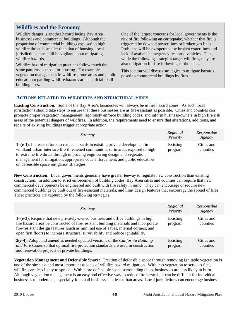
Wildfires and the Economy
Wildfire danger is another hazard facing Bay Area businesses and commercial buildings. Although the proportion of commercial buildings exposed to high wildfire threat is smaller than that of housing, local jurisdictions must still be vigilant about mitigating wildfire hazards.
Wildfire hazard mitigation practices follow much the same patterns as those for housing. For example, vegetation management in wildfire-prone areas and public education regarding wildfire hazards are beneficial to all building uses.
One of the largest concerns for local governments is the risk of fire following an earthquake, whether that fire is triggered by downed power lines or broken gas lines. Problems will be exasperated by broken water lines and lack of available emergency response vehicles. Thus, while the following strategies target wildfires, they are also mitigation for fire following earthquakes.
This section will discuss strategies to mitigate hazards posed to commercial buildings by fires.
ACTIONS RELATED TO WILDFIRES AND STRUCTURAL FIRES –––––––––––––––––––––––––––
Existing Construction: Some of the Bay Area’s businesses will always be in fire hazard zones. As such local jurisdictions should take steps to ensure that these businesses are as fire-resistant as possible. Cities and counties can promote proper vegetation management, rigorously enforce building codes, and inform business-owners in high fire risk areas of the potential dangers of wildfires. In addition, the requirements need to ensure that alterations, additions, and repairs of existing buildings trigger appropriate action.
Strategy Regional Priority
Responsible Agency
1–(e-1): Increase efforts to reduce hazards in existing private development in wildland-urban-interface fire-threatened communities or in areas exposed to high-to-extreme fire threat through improving engineering design and vegetation management for mitigation, appropriate code enforcement, and public education on defensible space mitigation strategies.
Existing program
Cities and counties
New Construction: Local governments generally have greater leeway to regulate new construction than existing construction. In addition to strict enforcement of building codes, Bay Area cities and counties can require that new commercial developments be engineered and built with fire safety in mind. They can encourage or require new commercial buildings be built out of fire-resistant materials, and limit design features that encourage the spread of fires. These practices are captured by the following strategies.
Strategy Regional Priority
Responsible Agency
1–(e-3): Require that new privately-owned business and office buildings in high fire hazard areas be constructed of fire-resistant building materials and incorporate fire-resistant design features (such as minimal use of eaves, internal corners, and open first floors) to increase structural survivability and reduce ignitability.
Existing program
Cities and counties
2(e-4): Adopt and amend as needed updated versions of the California Building and Fire Codes so that optimal fire-protection standards are used in construction and renovation projects of private buildings.
Existing program
Cities and counties
Vegetation Management and Defensible Space: Creation of defensible space through removing ignitable vegetation is one of the simplest and most important aspects of wildfire hazard mitigation. With less vegetation to serve as fuel, wildfires are less likely to spread. With more defensible space surrounding them, businesses are less likely to burn. Although vegetation management is an easy and effective way to reduce fire hazards, it can be difficult for individual businesses to undertake, especially for small businesses in less urban areas. Local jurisdictions can encourage business-
2010 Update 4-9 Multi-Jurisdictional Local Hazard Mitigation Plan
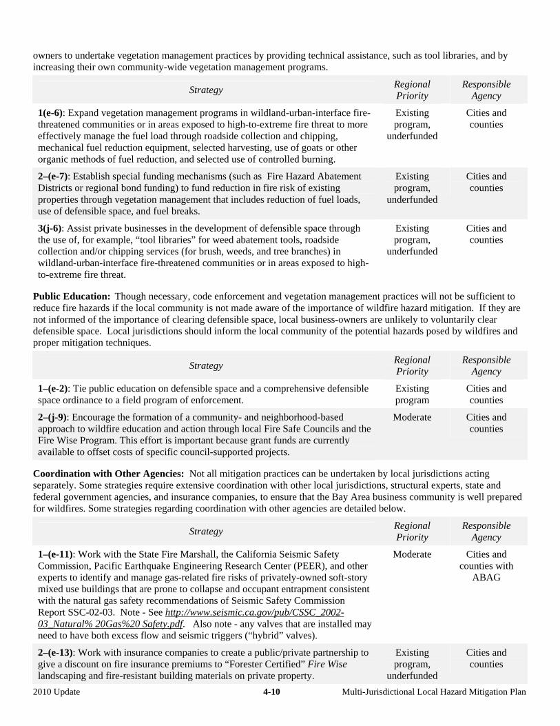
owners to undertake vegetation management practices by providing technical assistance, such as tool libraries, and by increasing their own community-wide vegetation management programs.
Strategy Regional Priority
Responsible Agency
1(e-6): Expand vegetation management programs in wildland-urban-interface fire-threatened communities or in areas exposed to high-to-extreme fire threat to more effectively manage the fuel load through roadside collection and chipping, mechanical fuel reduction equipment, selected harvesting, use of goats or other organic methods of fuel reduction, and selected use of controlled burning.
Existing program,
underfunded
Cities and counties
2–(e-7): Establish special funding mechanisms (such as Fire Hazard Abatement Districts or regional bond funding) to fund reduction in fire risk of existing properties through vegetation management that includes reduction of fuel loads, use of defensible space, and fuel breaks.
Existing program,
underfunded
Cities and counties
3(j-6): Assist private businesses in the development of defensible space through the use of, for example, “tool libraries” for weed abatement tools, roadside collection and/or chipping services (for brush, weeds, and tree branches) in wildland-urban-interface fire-threatened communities or in areas exposed to high-to-extreme fire threat.
Existing program,
underfunded
Cities and counties
Public Education: Though necessary, code enforcement and vegetation management practices will not be sufficient to reduce fire hazards if the local community is not made aware of the importance of wildfire hazard mitigation. If they are not informed of the importance of clearing defensible space, local business-owners are unlikely to voluntarily clear defensible space. Local jurisdictions should inform the local community of the potential hazards posed by wildfires and proper mitigation techniques.
Strategy Regional Priority
Responsible Agency
1–(e-2): Tie public education on defensible space and a comprehensive defensible space ordinance to a field program of enforcement.
Existing program
Cities and counties
2–(j-9): Encourage the formation of a community- and neighborhood-based approach to wildfire education and action through local Fire Safe Councils and the Fire Wise Program. This effort is important because grant funds are currently available to offset costs of specific council-supported projects.
Moderate Cities and counties
Coordination with Other Agencies: Not all mitigation practices can be undertaken by local jurisdictions acting separately. Some strategies require extensive coordination with other local jurisdictions, structural experts, state and federal government agencies, and insurance companies, to ensure that the Bay Area business community is well prepared for wildfires. Some strategies regarding coordination with other agencies are detailed below.
Strategy Regional Priority
Responsible Agency
1–(e-11): Work with the State Fire Marshall, the California Seismic Safety Commission, Pacific Earthquake Engineering Research Center (PEER), and other experts to identify and manage gas-related fire risks of privately-owned soft-story mixed use buildings that are prone to collapse and occupant entrapment consistent with the natural gas safety recommendations of Seismic Safety Commission Report SSC-02-03. Note - See http://www.seismic.ca.gov/pub/CSSC_2002-03_Natural% 20Gas%20 Safety.pdf. Also note - any valves that are installed may need to have both excess flow and seismic triggers (“hybrid” valves).
Moderate Cities and counties with
ABAG
2–(e-13): Work with insurance companies to create a public/private partnership to give a discount on fire insurance premiums to “Forester Certified” Fire Wise landscaping and fire-resistant building materials on private property.
Existing program,
underfunded
Cities and counties
2010 Update 4-10 Multi-Jurisdictional Local Hazard Mitigation Plan
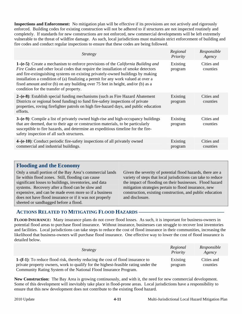
Inspections and Enforcement: No mitigation plan will be effective if its provisions are not actively and rigorously enforced. Building codes for existing construction will not be adhered to if structures are not inspected routinely and completely. If standards for new constructions are not enforced, new commercial developments will be left extremely vulnerable to the threat of wildfire damage. As such, local jurisdictions must maintain strict enforcement of building and fire codes and conduct regular inspections to ensure that these codes are being followed.
Strategy Regional Priority
Responsible Agency
1–(e-5): Create a mechanism to enforce provisions of the California Building and Fire Codes and other local codes that require the installation of smoke detectors and fire-extinguishing systems on existing privately-owned buildings by making installation a condition of (a) finalizing a permit for any work valued at over a fixed amount and/or (b) on any building over 75 feet in height, and/or (b) as a condition for the transfer of property.
Existing program
Cities and counties
2–(e-8): Establish special funding mechanisms (such as Fire Hazard Abatement Districts or regional bond funding) to fund fire-safety inspections of private properties, roving firefighter patrols on high fire-hazard days, and public education efforts.
Existing program
Cities and counties
3–(e-9): Compile a list of privately owned high-rise and high-occupancy buildings that are deemed, due to their age or construction materials, to be particularly susceptible to fire hazards, and determine an expeditious timeline for the fire-safety inspection of all such structures.
Existing program
Cities and counties
4–(e-10): Conduct periodic fire-safety inspections of all privately owned commercial and industrial buildings.
Existing program
Cities and counties
Flooding and the Economy
Only a small portion of the Bay Area’s commercial lands lie within flood zones. Still, flooding can cause significant losses to buildings, inventories, and data systems. Recovery after a flood can be slow and expensive, and can be made even more so if a business does not have flood insurance or if it was not properly sheeted or sandbagged before a flood.
Given the severity of potential flood hazards, there are a variety of steps that local jurisdictions can take to reduce the impact of flooding on their businesses. Flood hazard mitigation strategies pertain to flood insurance, new construction, existing construction, and public education and disclosure.
ACTIONS RELATED TO MITIGATING FLOOD HAZARDS ––––––––––––––––––––––––––––––––
FLOOD INSURANCE: Many insurance plans do not cover flood losses. As such, it is important for business-owners in potential flood areas to purchase flood insurance. Without insurance, businesses can struggle to recover lost inventories and facilities. Local jurisdictions can take steps to reduce the cost of flood insurance in their communities, increasing the likelihood that business-owners will purchase flood insurance. One effective way to lower the cost of flood insurance is detailed below.
Strategy Regional Priority
Responsible Agency
1–(f-1): To reduce flood risk, thereby reducing the cost of flood insurance to private property owners, work to qualify for the highest-feasible rating under the Community Rating System of the National Flood Insurance Program.
Existing program
Cities and counties
New Construction: The Bay Area is growing continuously, and with it, the need for new commercial development. Some of this development will inevitably take place in flood-prone areas. Local jurisdictions have a responsibility to ensure that this new development does not contribute to the existing flood hazard.
2010 Update 4-11 Multi-Jurisdictional Local Hazard Mitigation Plan
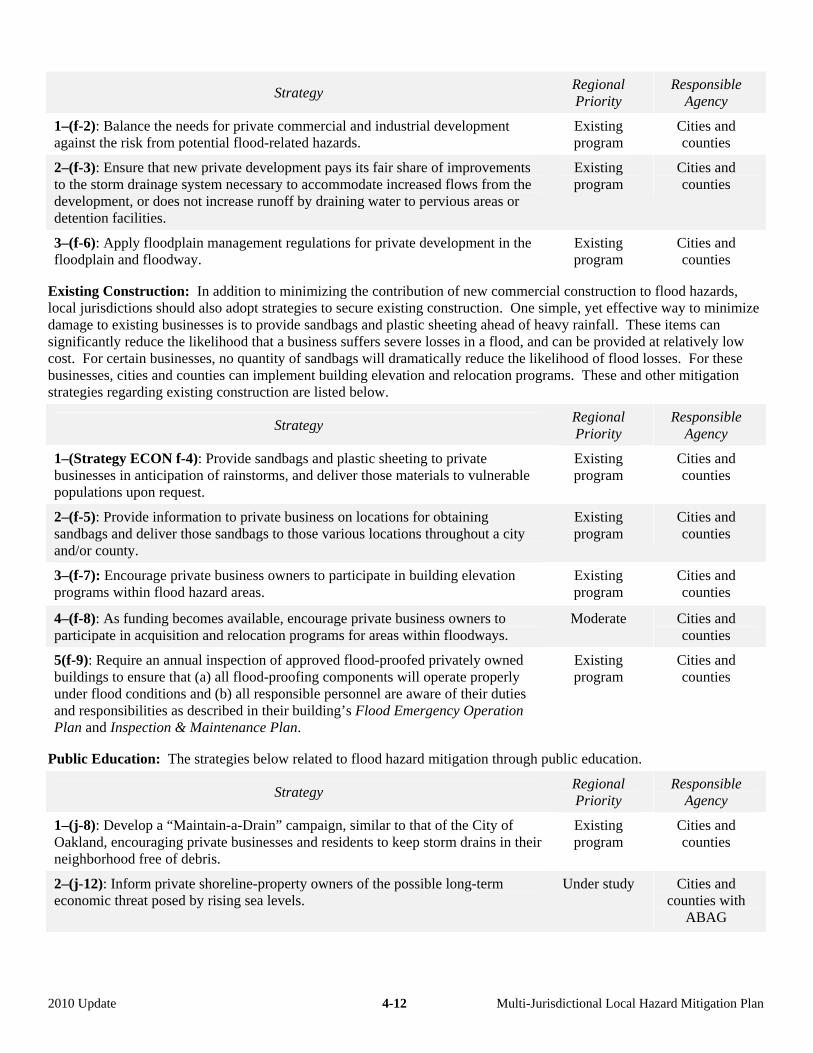
Strategy Regional Priority
Responsible Agency
1–(f-2): Balance the needs for private commercial and industrial development against the risk from potential flood-related hazards.
Existing program
Cities and counties
2–(f-3): Ensure that new private development pays its fair share of improvements to the storm drainage system necessary to accommodate increased flows from the development, or does not increase runoff by draining water to pervious areas or detention facilities.
Existing program
Cities and counties
3–(f-6): Apply floodplain management regulations for private development in the floodplain and floodway.
Existing program
Cities and counties
Existing Construction: In addition to minimizing the contribution of new commercial construction to flood hazards, local jurisdictions should also adopt strategies to secure existing construction. One simple, yet effective way to minimize damage to existing businesses is to provide sandbags and plastic sheeting ahead of heavy rainfall. These items can significantly reduce the likelihood that a business suffers severe losses in a flood, and can be provided at relatively low cost. For certain businesses, no quantity of sandbags will dramatically reduce the likelihood of flood losses. For these businesses, cities and counties can implement building elevation and relocation programs. These and other mitigation strategies regarding existing construction are listed below.
Strategy Regional Priority
Responsible Agency
1–(Strategy ECON f-4): Provide sandbags and plastic sheeting to private businesses in anticipation of rainstorms, and deliver those materials to vulnerable populations upon request.
Existing program
Cities and counties
2–(f-5): Provide information to private business on locations for obtaining sandbags and deliver those sandbags to those various locations throughout a city and/or county.
Existing program
Cities and counties
3–(f-7): Encourage private business owners to participate in building elevation programs within flood hazard areas.
Existing program
Cities and counties
4–(f-8): As funding becomes available, encourage private business owners to participate in acquisition and relocation programs for areas within floodways.
Moderate Cities and counties
5(f-9): Require an annual inspection of approved flood-proofed privately owned buildings to ensure that (a) all flood-proofing components will operate properly under flood conditions and (b) all responsible personnel are aware of their duties and responsibilities as described in their building’s Flood Emergency Operation Plan and Inspection & Maintenance Plan.
Existing program
Cities and counties
Public Education: The strategies below related to flood hazard mitigation through public education.
Strategy Regional Priority
Responsible Agency
1–(j-8): Develop a “Maintain-a-Drain” campaign, similar to that of the City of Oakland, encouraging private businesses and residents to keep storm drains in their neighborhood free of debris.
Existing program
Cities and counties
2–(j-12): Inform private shoreline-property owners of the possible long-term economic threat posed by rising sea levels.
Under study Cities and counties with
ABAG
2010 Update 4-12 Multi-Jurisdictional Local Hazard Mitigation Plan

Landslides, Erosion, and the Economy
Another hazard facing the region’s economy is landslides. Relative to housing, landslides threaten only a small portion of the Bay Area’s commercial buildings. Still, the damage to businesses can be significant. The following
three strategies regarding landslides and erosion are specific to commercial developments. For more general landslide-prevention strategies, see Chapter 8 – Land Use.
ACTIONS RELATED TO MITIGATING LANDSLIDE AND EROSION HAZARDS ––––––––––––––––
Strategy Regional Priority
Responsible Agency
1–(Strategy ECON g-1): Increase efforts to reduce landslides and erosion in existing and future development by improving appropriate code enforcement and use of applicable standards for private property, such as those appearing in the California Building Code, California Geological Survey Special Report 117 – Guidelines for Evaluating and Mitigating Seismic Hazards in California, American Society of Civil Engineers (ASCE) report Recommended Procedures for Implementation of DMG Special Publication 117: Guidelines for Analyzing and Mitigating Landslide Hazards in California, and the California Board for Geologists and Geophysicists Guidelines for Engineering Geologic Reports. Such standards should cover excavation, fill placement, cut-fill transitions, slope stability, drainage and erosion control, slope setbacks, expansive soils, collapsible soils, environmental issues, geological and geotechnical investigations, grading plans and specifications, protection of adjacent properties, and review and permit issuance.
Existing program
Cities and counties
2–(g-2): Increase efforts to reduce landslides and erosion in existing and future private development through continuing education of design professionals on mitigation strategies.
Existing program,
underfunded
Cities and counties
3–(e-12): Ensure that city/county-initiated fire-preventive vegetation-management techniques and practices for creek sides and high-slope areas do not contribute to the landslide and erosion hazard.
Existing program,
underfunded
Cities and counties
Security and Hazardous Materials Facilities
Some Bay Area businesses work with hazardous materials, including those that are flammable, corrosive, irritating, oxidizing, explosive, radioactive, infectious, thermally unstable or reactive, or poisonous. In past disasters, releases have occurred due to building structural failures, asbestos problems, pipeline breaks, tank failures (both structural failures and due to sloshing), valves, falling containers or shelves, sliding and overturning of industrial equipment, transportation accidents, and special response problems.
To prevent hazardous material releases as a secondary impact of a natural disaster, it is important to enforce the plans and procedures instituted to prevent such releases during normal operations.
In this regard, fire departments and others can work with companies to encourage some of the structural and non-structural measures discussed earlier in this chapter.
Most hazardous materials releases in past earthquakes have occurred in smaller companies, rather than in major petro-chemical installations. Interviews conducted by ABAG and others following the Loma Prieta, Northridge, and other recent earthquakes shown that earthquakes have generated the same number of hazmat releases that have occurred in the entire year before the earthquake – except these releases have occurred during a few seconds. It is also essential to keep these materials safe and secure at all times.
2010 Update 4-13 Multi-Jurisdictional Local Hazard Mitigation Plan
ACTIONS RELATED TO MITIGATING RELEASES OF HAZARDOUS MATERIALS ––––––––––––––
The local jurisdictions that are home to businesses handling hazardous materials should work with the business community to ensure that proper measures are being taken to reduce the chance that dangerous materials do not become a safety and health hazard. Mitigation strategies pertaining to hazardous materials facilities are outlined below.
Strategy Regional Priority
Responsible Agency
1–(Strategy j-10): Encourage private businesses and laboratories handling hazardous materials or pathogens increase security to a level high enough to create a deterrent to crime and terrorism, including active implementation of cradle-to-grave tracking systems.
Existing program,
underfunded
Cities and counties with
hazardous material facilities
2–(j-12): Encourage joint meetings of security and operations personnel at major private employers to develop innovative ways for these personnel to work together to increase safety and security.
Existing program,
underfunded
Cities and counties with
hazardous material facilities
2010 Update 4-14 Multi-Jurisdictional Local Hazard Mitigation Plan
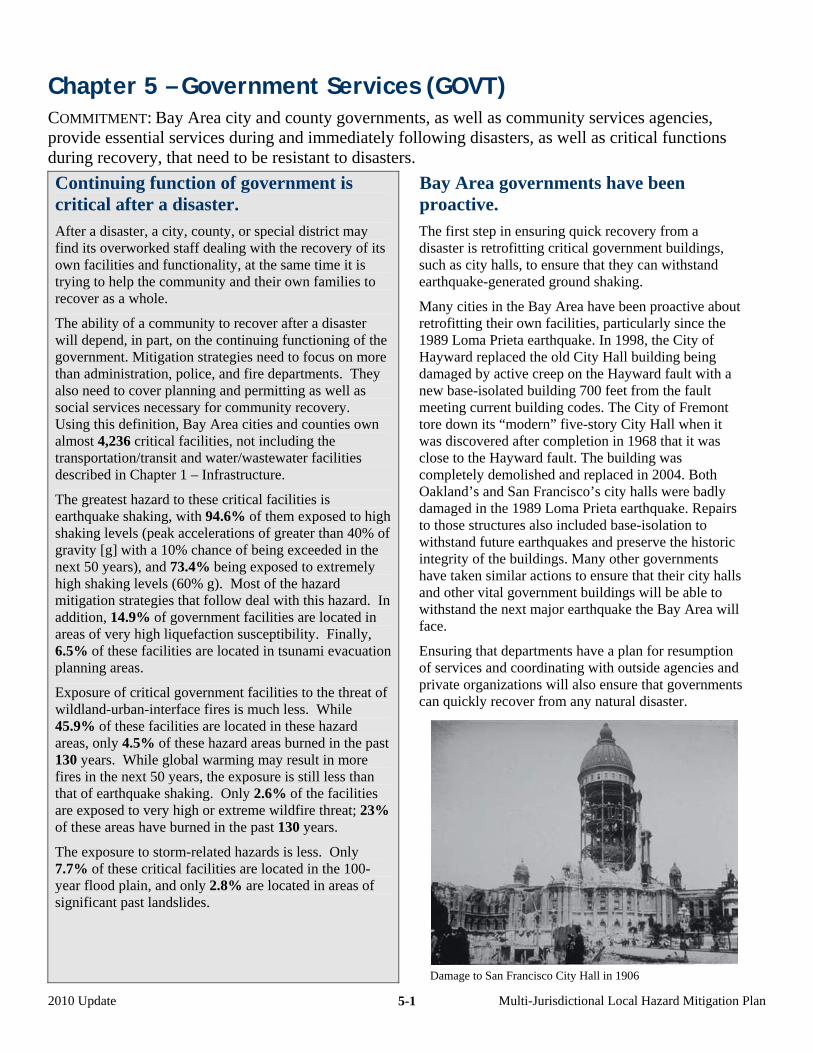
Chapter 5 – Government Services (GOVT) COMMITMENT: Bay Area city and county governments, as well as community services agencies, provide essential services during and immediately following disasters, as well as critical functions during recovery, that need to be resistant to disasters.
Continuing function of government is critical after a disaster. After a disaster, a city, county, or special district may find its overworked staff dealing with the recovery of its own facilities and functionality, at the same time it is trying to help the community and their own families to recover as a whole.
The ability of a community to recover after a disaster will depend, in part, on the continuing functioning of the government. Mitigation strategies need to focus on more than administration, police, and fire departments. They also need to cover planning and permitting as well as social services necessary for community recovery. Using this definition, Bay Area cities and counties own almost 4,236 critical facilities, not including the transportation/transit and water/wastewater facilities described in Chapter 1 – Infrastructure.
The greatest hazard to these critical facilities is earthquake shaking, with 94.6% of them exposed to high shaking levels (peak accelerations of greater than 40% of gravity [g] with a 10% chance of being exceeded in the next 50 years), and 73.4% being exposed to extremely high shaking levels (60% g). Most of the hazard mitigation strategies that follow deal with this hazard. In addition, 14.9% of government facilities are located in areas of very high liquefaction susceptibility. Finally, 6.5% of these facilities are located in tsunami evacuation planning areas.
Exposure of critical government facilities to the threat of wildland-urban-interface fires is much less. While 45.9% of these facilities are located in these hazard areas, only 4.5% of these hazard areas burned in the past 130 years. While global warming may result in more fires in the next 50 years, the exposure is still less than that of earthquake shaking. Only 2.6% of the facilities are exposed to very high or extreme wildfire threat; 23% of these areas have burned in the past 130 years.
The exposure to storm-related hazards is less. Only 7.7% of these critical facilities are located in the 100-year flood plain, and only 2.8% are located in areas of significant past landslides.
Bay Area governments have been proactive. The first step in ensuring quick recovery from a disaster is retrofitting critical government buildings, such as city halls, to ensure that they can withstand earthquake-generated ground shaking.
Many cities in the Bay Area have been proactive about retrofitting their own facilities, particularly since the 1989 Loma Prieta earthquake. In 1998, the City of Hayward replaced the old City Hall building being damaged by active creep on the Hayward fault with a new base-isolated building 700 feet from the fault meeting current building codes. The City of Fremont tore down its “modern” five-story City Hall when it was discovered after completion in 1968 that it was close to the Hayward fault. The building was completely demolished and replaced in 2004. Both Oakland’s and San Francisco’s city halls were badly damaged in the 1989 Loma Prieta earthquake. Repairs to those structures also included base-isolation to withstand future earthquakes and preserve the historic integrity of the buildings. Many other governments have taken similar actions to ensure that their city halls and other vital government buildings will be able to withstand the next major earthquake the Bay Area will face.
Ensuring that departments have a plan for resumption of services and coordinating with outside agencies and private organizations will also ensure that governments can quickly recover from any natural disaster.
Damage to San Francisco City Hall in 1906
2010 Update Multi-Jurisdictional Local Hazard Mitigation Plan 5-1
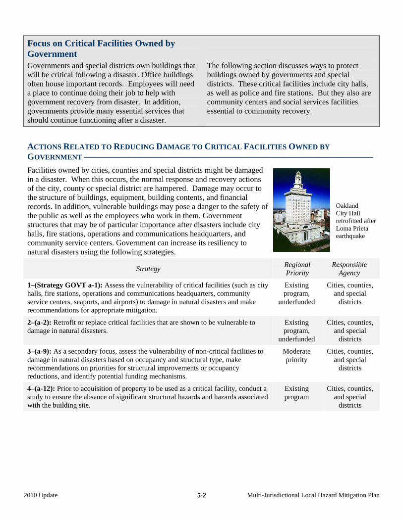
2010 Update Multi-Jurisdictional Local Hazard Mitigation Plan 5-2
Focus on Critical Facilities Owned by Government
Governments and special districts own buildings that will be critical following a disaster. Office buildings often house important records. Employees will need a place to continue doing their job to help with government recovery from disaster. In addition, governments provide many essential services that should continue functioning after a disaster.
The following section discusses ways to protect buildings owned by governments and special districts. These critical facilities include city halls, as well as police and fire stations. But they also are community centers and social services facilities essential to community recovery.
ACTIONS RELATED TO REDUCING DAMAGE TO CRITICAL FACILITIES OWNED BY
GOVERNMENT –––––––––––––––––––––––––––––––––––––––––––––––––––––––––––––––––
Facilities owned by cities, counties and special districts might be damaged in a disaster. When this occurs, the normal response and recovery actions of the city, county or special district are hampered. Damage may occur to the structure of buildings, equipment, building contents, and financial records. In addition, vulnerable buildings may pose a danger to the safety of the public as well as the employees who work in them. Government structures that may be of particular importance after disasters include city halls, fire stations, operations and communications headquarters, and community service centers. Government can increase its resiliency to natural disasters using the following strategies.
Oakland City Hall retrofitted after Loma Prieta earthquake
Strategy Regional Priority
Responsible Agency
1–(Strategy GOVT a-1): Assess the vulnerability of critical facilities (such as city halls, fire stations, operations and communications headquarters, community service centers, seaports, and airports) to damage in natural disasters and make recommendations for appropriate mitigation.
Existing program,
underfunded
Cities, counties, and special
districts
2–(a-2): Retrofit or replace critical facilities that are shown to be vulnerable to damage in natural disasters.
Existing program,
underfunded
Cities, counties, and special
districts
3–(a-9): As a secondary focus, assess the vulnerability of non-critical facilities to damage in natural disasters based on occupancy and structural type, make recommendations on priorities for structural improvements or occupancy reductions, and identify potential funding mechanisms.
Moderate priority
Cities, counties, and special
districts
4–(a-12): Prior to acquisition of property to be used as a critical facility, conduct a study to ensure the absence of significant structural hazards and hazards associated with the building site.
Existing program
Cities, counties, and special
districts
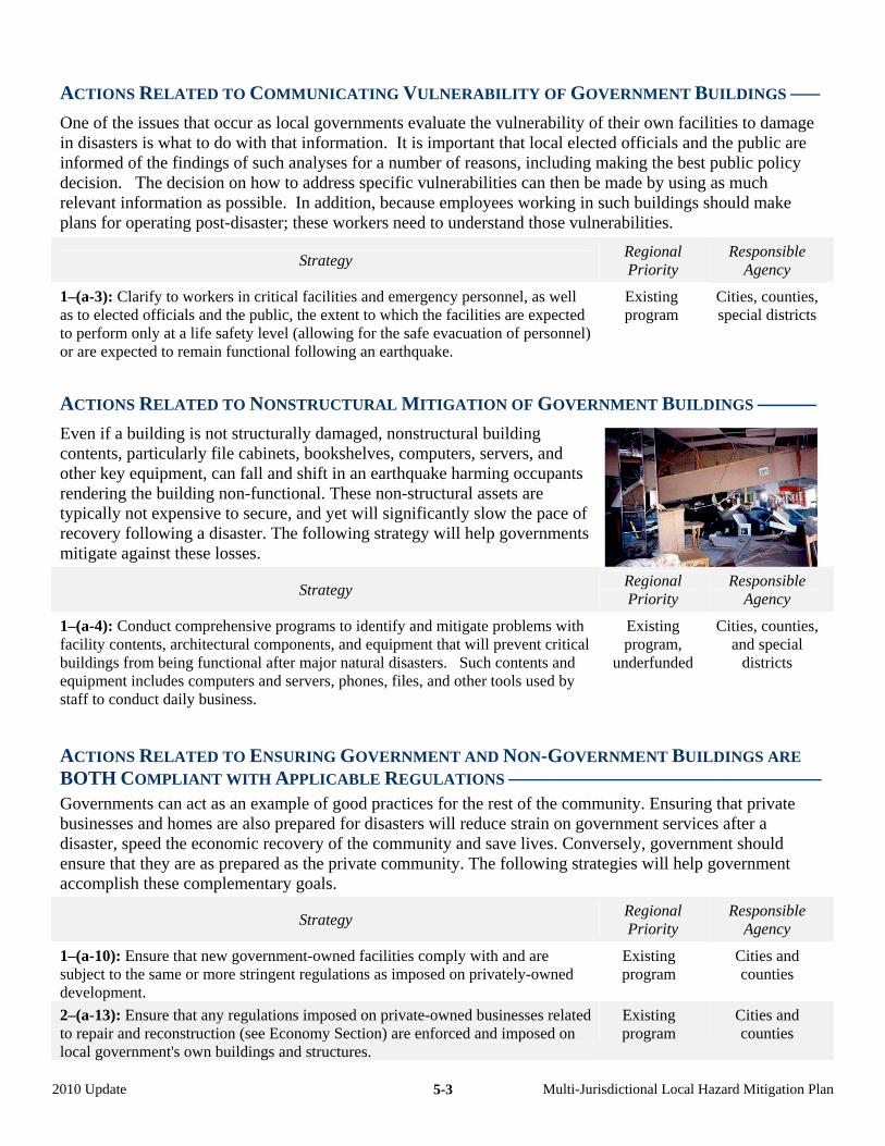
ACTIONS RELATED TO COMMUNICATING VULNERABILITY OF GOVERNMENT BUILDINGS –––
One of the issues that occur as local governments evaluate the vulnerability of their own facilities to damage in disasters is what to do with that information. It is important that local elected officials and the public are informed of the findings of such analyses for a number of reasons, including making the best public policy decision. The decision on how to address specific vulnerabilities can then be made by using as much relevant information as possible. In addition, because employees working in such buildings should make plans for operating post-disaster; these workers need to understand those vulnerabilities.
Strategy Regional Priority
Responsible Agency
1–(a-3): Clarify to workers in critical facilities and emergency personnel, as well as to elected officials and the public, the extent to which the facilities are expected to perform only at a life safety level (allowing for the safe evacuation of personnel) or are expected to remain functional following an earthquake.
Existing program
Cities, counties, special districts
ACTIONS RELATED TO NONSTRUCTURAL MITIGATION OF GOVERNMENT BUILDINGS ––––––
Even if a building is not structurally damaged, nonstructural building contents, particularly file cabinets, bookshelves, computers, servers, and other key equipment, can fall and shift in an earthquake harming occupants rendering the building non-functional. These non-structural assets are typically not expensive to secure, and yet will significantly slow the pace of recovery following a disaster. The following strategy will help governments mitigate against these losses.
Strategy Regional Priority
Responsible Agency
1–(a-4): Conduct comprehensive programs to identify and mitigate problems with facility contents, architectural components, and equipment that will prevent critical buildings from being functional after major natural disasters. Such contents and equipment includes computers and servers, phones, files, and other tools used by staff to conduct daily business.
Existing program,
underfunded
Cities, counties, and special
districts
ACTIONS RELATED TO ENSURING GOVERNMENT AND NON-GOVERNMENT BUILDINGS ARE
BOTH COMPLIANT WITH APPLICABLE REGULATIONS ––––––––––––––––––––––––––––––––
Governments can act as an example of good practices for the rest of the community. Ensuring that private businesses and homes are also prepared for disasters will reduce strain on government services after a disaster, speed the economic recovery of the community and save lives. Conversely, government should ensure that they are as prepared as the private community. The following strategies will help government accomplish these complementary goals.
Strategy Regional Priority
Responsible Agency
1–(a-10): Ensure that new government-owned facilities comply with and are subject to the same or more stringent regulations as imposed on privately-owned development.
Existing program
Cities and counties
2–(a-13): Ensure that any regulations imposed on private-owned businesses related to repair and reconstruction (see Economy Section) are enforced and imposed on local government's own buildings and structures.
Existing program
Cities and counties
2010 Update Multi-Jurisdictional Local Hazard Mitigation Plan 5-3
2010 Update Multi-Jurisdictional Local Hazard Mitigation Plan 5-4
3–(a-11): Comply with all applicable building and fire codes, as well as other regulations (such as state requirements for fault, landslide, and liquefaction investigations in particular mapped areas) when constructing or significantly remodeling government-owned facilities.
Existing program
Cities, counties, and special
districts
ACTIONS RELATED TO IMPROVING SECURITY –––––––––––––––––––––––––––––––––––––––
Some measures undertaken by governments to improve security of their buildings and critical infrastructure can serve the secondary function of helping to mitigate against natural hazards. The following strategies improve security while mitigating hazards.
Strategy Regional Priority
Responsible Agency
1–(a-5): Encourage joint meetings of security and operations personnel at critical facilities to develop innovative ways for these personnel to work together to increase safety and security.
Existing program
Cities, counties, and special
districts
2–(a-6): When installing micro and/or surveillance cameras around critical public assets tied to web-based software, develop a surveillance protocol to monitor these cameras, and investigate the possibility of using the cameras for the secondary purpose of post-disaster damage assessment.
Moderate Cities, counties, and special
districts
3–(a-7): Identify and undertake cost-effective retrofit measures related to security on critical facilities (such as moving and redesigning air intake vents and installing blast-resistant features) when these buildings undergo major renovations related to other natural hazards.
Moderate Cities, counties, and special
districts
Focus on Efforts to Identify and Mitigate Hazards
Many organizations within the State and Federal governments, as well as research institutions and professional organizations study natural hazards and disaster mitigation techniques. Local governments can benefit from participating in and encouraging these efforts. Continued research on the hazards our region faces will
improve our ability to plan and prepare for them. In addition, many hazards affect more than one local government or jurisdiction simultaneously. To the extent that mitigation strategies can be coordinated among various agencies, the Bay Area will be better prepared for disasters.
ACTIONS RELATED TO COORDINATION AMONG LOCAL GOVERNMENTS –––––––––––––––––
The following strategies are available to local governments to encourage information sharing and coordinated planning among various local agencies.
Strategy Regional Priority
Responsible Agency
1–(d-1): Promote information sharing among overlapping and neighboring local governments, including cities, counties, and special districts, as well as utilities.
Existing program
Cities, counties, and special
districts
2–(d-2): Recognize that emergency services is more than the coordination of police and fire response; it also includes planning activities with providers of water, food, energy, transportation, financial, information, and public health services.
Existing program
Cities, counties, and special
districts
2010 Update Multi-Jurisdictional Local Hazard Mitigation Plan 5-5
3–(d-3): Recognize that a multi-agency approach is needed to mitigate flooding by having flood control districts, cities, counties, and utilities meet at least annually to jointly discuss their capital improvement programs for most effectively reducing the threat of flooding. Work toward making this process more formal to insure that flooding is considered at existing joint-agency meetings.
Very high Cities, counties, and special
districts
4–(d-6): Participate in multi-agency efforts to mitigate fire threat, such as the Hills Emergency Forum (in the East Bay), various FireSafe Council programs, and city-utility task forces. Such participation increases a jurisdiction’s competitiveness in obtaining grants.
Existing program,
underfunded
Cities, counties, and special
districts
5–(d-7): Work with major employers and agencies that handle hazardous materials to coordinate mitigation efforts for the possible release of these materials due to a natural disaster such as an earthquake, flood, fire, or landslide.
Existing program
Cities, counties, and special
districts
ACTIONS RELATED TO COORDINATION WITH FEDERAL GOVERNMENT ––––––––––––––––––
The following strategies are available to local governments to participate in hazard mitigation programs led by the federal government.
Strategy Regional Priority
Responsible Agency
1–(d-4): As new flood-control projects are completed, request that FEMA revise its flood-insurance rate maps and digital Geographic Information System (GIS) data to reflect flood risks as accurately as possible.
Existing program
Cities, counties, and special
districts
2–(d-5): Participate in FEMA’s National Flood Insurance Program. Existing program
Cities, counties
ACTIONS RELATED TO PARTICIPATION IN HAZARD RESEARCH AND EDUCATION ––––––––––
The following strategies are available to local governments to encourage research by others on hazards that affect their region as well as to encourage their own employees to learn about the hazards their jurisdiction faces.
Strategy Regional Priority
Responsible Agency
1–(d-8): Encourage staff to participate in efforts by professional organizations to mitigate earthquake and landslide disaster losses, such as the efforts of the Northern California Chapter of the Earthquake Engineering Research Institute, the East Bay-Peninsula Chapter of the International Code Council, the Structural Engineers Association of Northern California, and the American Society of Grading Officials.
Existing program
Cities, counties, and special
districts
2–(d-9): Conduct and/or promote attendance at local or regional hazard conferences and workshops for elected officials and staff to educate them on the critical need for programs in mitigating earthquake, wildfire, flood, and landslide hazards.
Existing program,
underfunded
Cities, counties, and special
districts
3–(d-10): Cooperate with researchers working on government-funded projects to refine information on hazards, for example, by expediting the permit and approval process for installation of seismic arrays, gravity survey instruments, borehole drilling, fault trenching, landslide mapping, flood modeling, and/or damage data collection.
Existing program
Cities, counties, and special
districts
2010 Update Multi-Jurisdictional Local Hazard Mitigation Plan 5-6
Focus on Government Emergency Response Capability
Governments provide emergency services such as fire and police that will be essential immediately following a disaster. The ability of these departments to respond will depend on having the right equipment and communications. In addition, a particular disaster will affect many jurisdictions at once and may overwhelm the capacity of any one emergency response department. For this reason, the ability
to share resources and communicate with other departments is essential. In addition, it is essential that city employees are able to return to work quickly after a disaster, which means that their families need to be sheltered so they don’t leave the region to stay with family and friends. The following section focuses on the ability of governments to respond to disasters.
ACTIONS RELATED TO EMPLOYEE PREPAREDNESS –––––––––––––––––––––––––––––––––––
The primary function of local government immediately after a disaster will be emergency response. Government employees are a major asset of any local government and their ability to report to work after a disaster will greatly affect the ability of a local government to respond to a disaster. The following strategies will help governments protect their employees.
Strategy Regional Priority
Responsible Agency
1–(c-1): Develop a plan for short-term and intermediate-term sheltering of your employees.
Existing program
Cities, counties, and special
districts
2–(c-2): Encourage your employees to have a family disaster plan. Existing program
Cities, counties, and special
districts
3–(c-3): Offer CERT/NERT-type training to your employees.
Existing program,
underfunded
Cities, counties, and special
districts
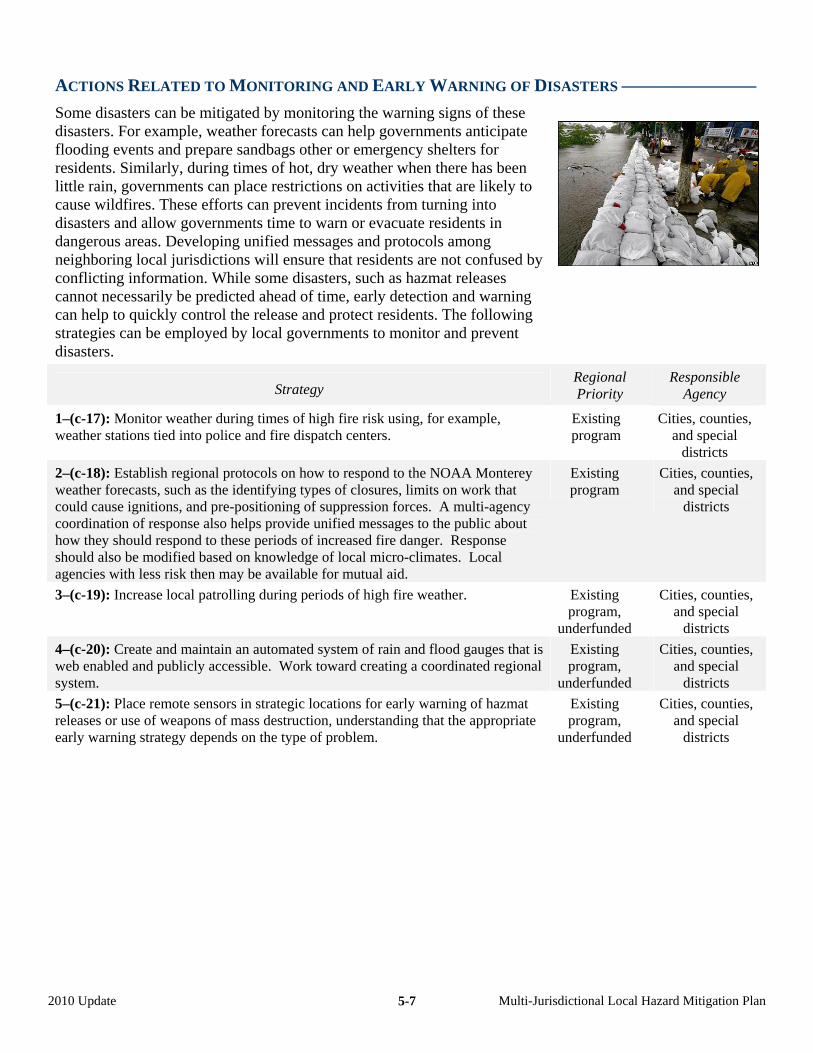
ACTIONS RELATED TO MONITORING AND EARLY WARNING OF DISASTERS –––––––––––––––
Some disasters can be mitigated by monitoring the warning signs of these disasters. For example, weather forecasts can help governments anticipate flooding events and prepare sandbags other or emergency shelters for residents. Similarly, during times of hot, dry weather when there has been little rain, governments can place restrictions on activities that are likely to cause wildfires. These efforts can prevent incidents from turning into disasters and allow governments time to warn or evacuate residents in dangerous areas. Developing unified messages and protocols among neighboring local jurisdictions will ensure that residents are not confused by conflicting information. While some disasters, such as hazmat releases cannot necessarily be predicted ahead of time, early detection and warning can help to quickly control the release and protect residents. The following strategies can be employed by local governments to monitor and prevent disasters.
Strategy Regional Priority
Responsible Agency
1–(c-17): Monitor weather during times of high fire risk using, for example, weather stations tied into police and fire dispatch centers.
Existing program
Cities, counties, and special
districts
2–(c-18): Establish regional protocols on how to respond to the NOAA Monterey weather forecasts, such as the identifying types of closures, limits on work that could cause ignitions, and pre-positioning of suppression forces. A multi-agency coordination of response also helps provide unified messages to the public about how they should respond to these periods of increased fire danger. Response should also be modified based on knowledge of local micro-climates. Local agencies with less risk then may be available for mutual aid.
Existing program
Cities, counties, and special
districts
3–(c-19): Increase local patrolling during periods of high fire weather.
Existing program,
underfunded
Cities, counties, and special
districts
4–(c-20): Create and maintain an automated system of rain and flood gauges that is web enabled and publicly accessible. Work toward creating a coordinated regional system.
Existing program,
underfunded
Cities, counties, and special
districts
5–(c-21): Place remote sensors in strategic locations for early warning of hazmat releases or use of weapons of mass destruction, understanding that the appropriate early warning strategy depends on the type of problem.
Existing program,
underfunded
Cities, counties, and special
districts
2010 Update Multi-Jurisdictional Local Hazard Mitigation Plan 5-7
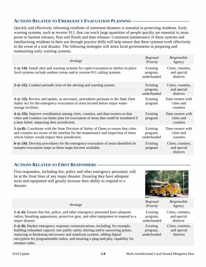
ACTIONS RELATED TO EMERGENCY EVACUATION PLANNING –––––––––––––––––––––––––
Quickly and effectively informing residents of imminent disasters is essential in protecting residents. Early warning systems, such as reverse 911, that can reach large quantities of people quickly are essential in areas prone to hazmat releases, fires and floods and dam releases. Continued maintenance of these systems and familiarizing residents in their use through practice drills will help ensure that these systems work effectively in the event of a real disaster. The following strategies will assist local governments in preparing and maintaining early warning systems.
Strategy Regional Priority
Responsible Agency
1–(c-14): Install alert and warning systems for rapid evacuation or shelter-in-place. Such systems include outdoor sirens and/or reverse-911 calling systems.
Existing program,
underfunded
Cities, counties, and special
districts
2–(c-15): Conduct periodic tests of the alerting and warning system.
Existing program,
underfunded
Cities, counties, and special
districts
3–(c-22): Review and update, as necessary, procedures pursuant to the State Dam Safety Act for the emergency evacuation of areas located below major water-storage facilities.
Existing program
Dam owners with cities and counties
4–(c-23): Improve coordination among cities, counties, and dam owners so that cities and counties can better plan for evacuation of areas that could be inundated if a dam failed, impacting their jurisdiction.
Existing program
Dam owners with cities and counties
5–(a-8): Coordinate with the State Division of Safety of Dams to ensure that cities and counties are aware of the timeline for the maintenance and inspection of dams whose failure would impact their jurisdiction.
Existing program,
underfunded
Dam owners with cities and counties
6–(c-24): Develop procedures for the emergency evacuation of areas identified on tsunami evacuation maps as these maps become available.
Existing program
Cities, counties, and special
districts
ACTIONS RELATED TO FIRST RESPONDERS –––––––––––––––––––––––––––––––––––––––––
First responders, including fire, police and other emergency personnel, will be at the front lines of any major disaster. Ensuring they have adequate tools and equipment will greatly increase their ability to respond to a disaster.
Strategy Regional Priority
Responsible Agency
1–(c-6): Ensure that fire, police, and other emergency personnel have adequate radios, breathing apparatuses, protective gear, and other equipment to respond to a major disaster.
Existing program,
underfunded
Cities, counties, and special
districts
2–(c-8): Harden emergency response communications, including, for example, building redundant capacity into public safety alerting and/or answering points, replacing or hardening microwave and simulcast systems, adding digital encryption for programmable radios, and ensuring a plug-and-play capability for amateur radio.
Existing program,
underfunded
Cities, counties, and special
districts
2010 Update Multi-Jurisdictional Local Hazard Mitigation Plan 5-8
2010 Update Multi-Jurisdictional Local Hazard Mitigation Plan 5-9
3–(c-9): Purchase command vehicles for use as mobile command/EOC vehicles if current vehicles are unsuitable or inadequate.
Existing program,
underfunded
Cities, counties, and special
districts
4–(c-10): Maintain the local government’s emergency operations center in a fully functional state of readiness.
Existing program,
underfunded
Cities, counties, and special
districts
5–(c-16): Regulate and enforce the location and design of street-address numbers on buildings and minimize the naming of short streets (that are actually driveways) to single homes.
Existing program
Cities, counties
ACTIONS RELATED TO COORDINATION AND COMMUNICATIONS ––––––––––––––––––––––
The Bay Area typically has several special districts operating within one city or county. Local governments are skilled at including various special districts and major employers in emergency planning efforts. Additional funding could help these local governments expand the reach of their efforts and ensure interoperability of equipment and communications between jurisdictions. The following strategies support efforts being undertaken by local governments to coordinate with emergency response planning efforts with other jurisdictions.
Strategy Regional Priority
Responsible Agency
1–(c-7): Participate in developing and maintaining a system of interoperable communications for first responders from cities, counties, special districts, state, and federal agencies.
Existing program,
underfunded
Cities, counties, and fire districts
2–(c-11): Expand or participate in expanding traditional disaster exercises involving city and county emergency personnel to include airport and port personnel, transit and infrastructure providers, hospitals, schools, park districts, and major employers.
Existing program,
underfunded
Cities, counties, and special
districts
3–(c-13): Continue to participate not only in general mutual-aid agreements, but also in agreements with adjoining jurisdictions for cooperative response to fires, floods, earthquakes, and other disasters.
Existing program
Cities and counties
4–(c-25): Support and encourage planning and identification of facilities for the coordination of distribution of water, food, blankets, and other supplies, coordinating this effort with the American Red Cross.
Existing program,
underfunded
Cities, counties, and special
districts
ACTIONS RELATED TO EMERGENCY RESPONSE PLAN MAINTENANCE ––––––––––––––––––
As the needs and demands of the community change over time due to increased population or ageing infrastructure, emergency response plans should adapt to these changes. The following strategies focus on ways that governments can keep their emergency response plan up to date.
Strategy Regional Priority
Responsible Agency
1–(c-4): Periodically assess the need for new or relocated fire or police stations and other emergency facilities.
Existing program
Cities, counties, and fire districts
2–(c-5): Periodically assess the need for changes in staffing levels, as well as for additional or updated supplies, equipment, technologies, and in-service training classes.
Existing program
Cities, counties, and special
districts
2010 Update Multi-Jurisdictional Local Hazard Mitigation Plan 5-10
3–(c-12): Maintain and update as necessary the local government’s Standardized Emergency Management System (SEMS) Plan and the National Incident Management System (NIMS) Plan, and submit an appropriate NIMSCAST report.
Existing program
Cities and counties
Focus on Maintaining and Enhancing Local Government’s Disaster Recovery Planning
After a disaster, many government buildings may no longer be safe for occupation. Plans should be made for the emergency relocation of local government facilities critical in emergency response, as well as any government facilities with known structural deficiencies or in hazardous areas. Such plans should include ways to work with local telephone companies to set up phone systems that either preserve pre-disaster phone numbers, or
include call forwarding provisions. In addition, these plans should include public outreach and education on the new locations of these facilities. The relocation plan should include access to back-ups of key records and other documents from alternate locations. Finally, local governments should have plans and back-up procedures to enable them to pay employees, social service recipients, and vendors if normal finance department operations are disrupted.
ACTIONS RELATED TO DISASTER RECOVERY ––––––––––––––––––––––––––––––––––––––––
The following strategies are available to local governments to ensure that they are able to recover more quickly from disasters.
Strategy Regional Priority
Responsible Agency
1–(b-1): Establish a framework and process for pre-event planning for post-event recovery that specifies roles, priorities, and responsibilities of various departments within the local government organization, and that outlines a structure and process for policy-making involving elected officials and appointed advisory committees.
Existing program
Cities, counties, and special
districts
2–(b-2): Prepare a basic Recovery Plan that outlines the major issues and tasks that are likely to be the key elements of community recovery, as well as integrate this planning into response planning (such as with continuity of operations plans).
Existing program,
underfunded
Cities, counties, and special
districts
3–(b-3): Establish a goal for the resumption of local government services that may vary from function to function.
Existing program
Cities, counties, and special
districts
4–(b-4): Develop a continuity of operations plan that includes back-up storage of vital records, such as plans and back-up procedures to pay employees and vendors if normal finance department operations are disrupted, as well as other essential electronic files.
Existing program,
underfunded
Cities, counties, and special
districts
5–(b-5): Plan for the emergency relocation of government-owned facilities critical to recovery, as well as any facilities with known structural deficiencies or in hazardous areas.
Existing program,
underfunded
Cities, counties, and special
districts
2010 Update Multi-Jurisdictional Local Hazard Mitigation Plan 5-11
Taking a Regional Leadership Role
ABAG is the regional planning agency for the Bay Area, representing all 101 cities and 9 counties in the region. Through its earthquake and hazards program, natural disasters that affect the region as a whole are studied from a regional context and regional solutions to mitigation. ABAG also models predicted losses develops risk assessments. In this role, ABAG has taken the lead in coordinating the development of the
local hazard mitigation plan with approximately 100 cities, counties and special districts in the region. Developing a comprehensive plan in this matter ensures that regional hazards are dealt with in a unified manner throughout the region and that local governments can coordinate their activities with neighboring jurisdictions.
ACTIONS RELATED TO TAKING A LEAD IN LOSS AND RISK ASSESSMENT ACTIVITIES –––––––
The following mitigation strategies will ensure that ABAG will continue to take a regional leadership role in understanding, characterizing and planning for natural disasters.
Strategy Regional Priority
Responsible Agency
1–(e-1): Work with the cities, counties, and special districts in the Bay Area to encourage them to adopt a Local Hazard Mitigation Plan and to assist them in integrating it into their overall planning process.
Existing program,
underfunded
ABAG only
2–(e-2): Improve the risk assessment and loss estimation work in the Taming Natural Disasters report and multi-jurisdictional plan related to natural disasters.
Existing program,
underfunded
ABAG only
PHOTO CREDITS – MCEER–page 5-2; ATC–page 5-3; Moraga-Orinda Fire District–page 5-5; BBC News–page 5-7
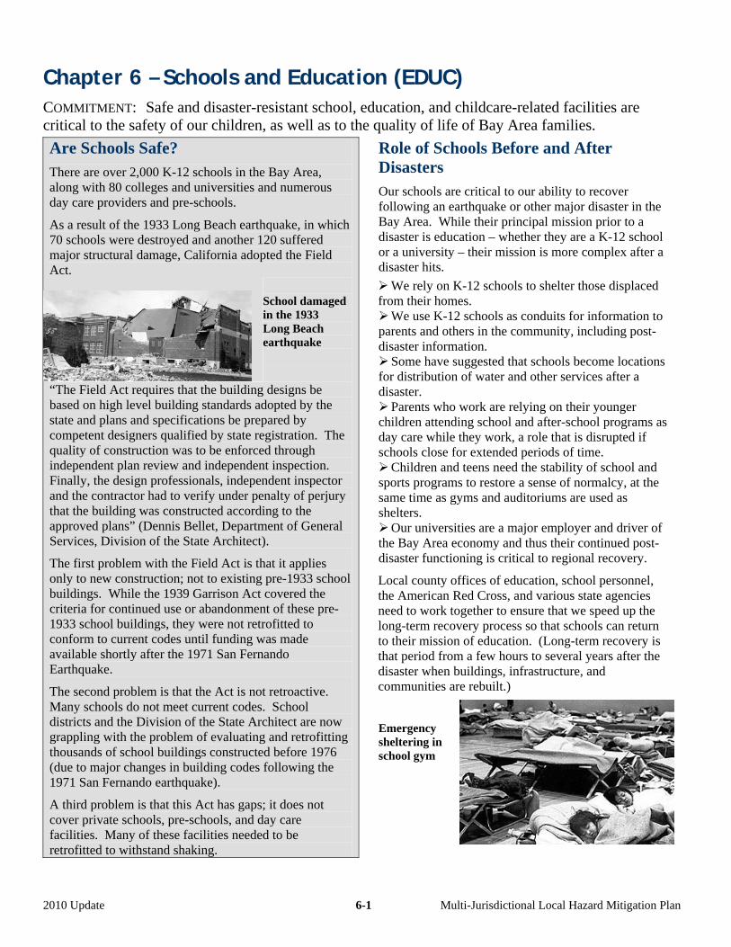
Chapter 6 – Schools and Education (EDUC)
COMMITMENT: Safe and disaster-resistant school, education, and childcare-related facilities are critical to the safety of our children, as well as to the quality of life of Bay Area families.
Are Schools Safe? There are over 2,000 K-12 schools in the Bay Area, along with 80 colleges and universities and numerous day care providers and pre-schools.
As a result of the 1933 Long Beach earthquake, in which 70 schools were destroyed and another 120 suffered major structural damage, California adopted the Field Act.
School damaged in the 1933 Long Beach earthquake
“The Field Act requires that the building designs be based on high level building standards adopted by the state and plans and specifications be prepared by competent designers qualified by state registration. The quality of construction was to be enforced through independent plan review and independent inspection. Finally, the design professionals, independent inspector and the contractor had to verify under penalty of perjury that the building was constructed according to the approved plans” (Dennis Bellet, Department of General Services, Division of the State Architect).
The first problem with the Field Act is that li it app es only to new construction; not to existing pre-1933 school buildings. While the 1939 Garrison Act covered the criteria for continued use or abandonment of these pre-1933 school buildings, they were not retrofitted to conform to current codes until funding was made available shortly after the 1971 San Fernando Earthquake.
The second problem is that the Act is not retroactive. Many schools do not meet current codes. School districts and the Division of the State Architect are now grappling with the problem of evaluating and retrofitting thousands of school buildings constructed before 1976 (due to major changes in building codes following the 1971 San Fernando earthquake).
A third problem is that this Act has gaps; it does not cover private schools, pre-schools, and day care facilities. Many of these facilities needed to be retrofitted to withstand shaking.
Role of Schools Before and After Disasters Our schools are critical to our ability to recover following an earthquake or other major disaster in the Bay Area. While their principal mission prior to a disaster is education – whether they are a K-12 school or a university – their mission is more complex after a disaster hits.
We rely on K-12 schools to shelter those displaced from their homes.
We use K-12 schools as conduits for information to parents and others in the community, including post-disaster information.
Some have suggested that schools become locations for distribution of water and other services after a disaster.
Parents who work are relying on their younger children attending school and after-school programs as day care while they work, a role that is disrupted if schools close for extended periods of time.
Children and teens need the stability of school and sports programs to restore a sense of normalcy, at the same time as gyms and auditoriums are used as shelters.
Our universities are a major employer and driver of the Bay Area economy and thus their continued post-disaster functioning is critical to regional recovery.
Local county offices of education, school personnel, the American Red Cross, and various state agencies need to work together to ensure that we speed up the long-term recovery process so that schools can return to their mission of education. (Long-term recovery is that period from a few hours to several years after the disaster when buildings, infrastructure, and communities are rebuilt.)
Emergency sheltering in school gym
2010 Update 6-1 Multi-Jurisdictional Local Hazard Mitigation Plan
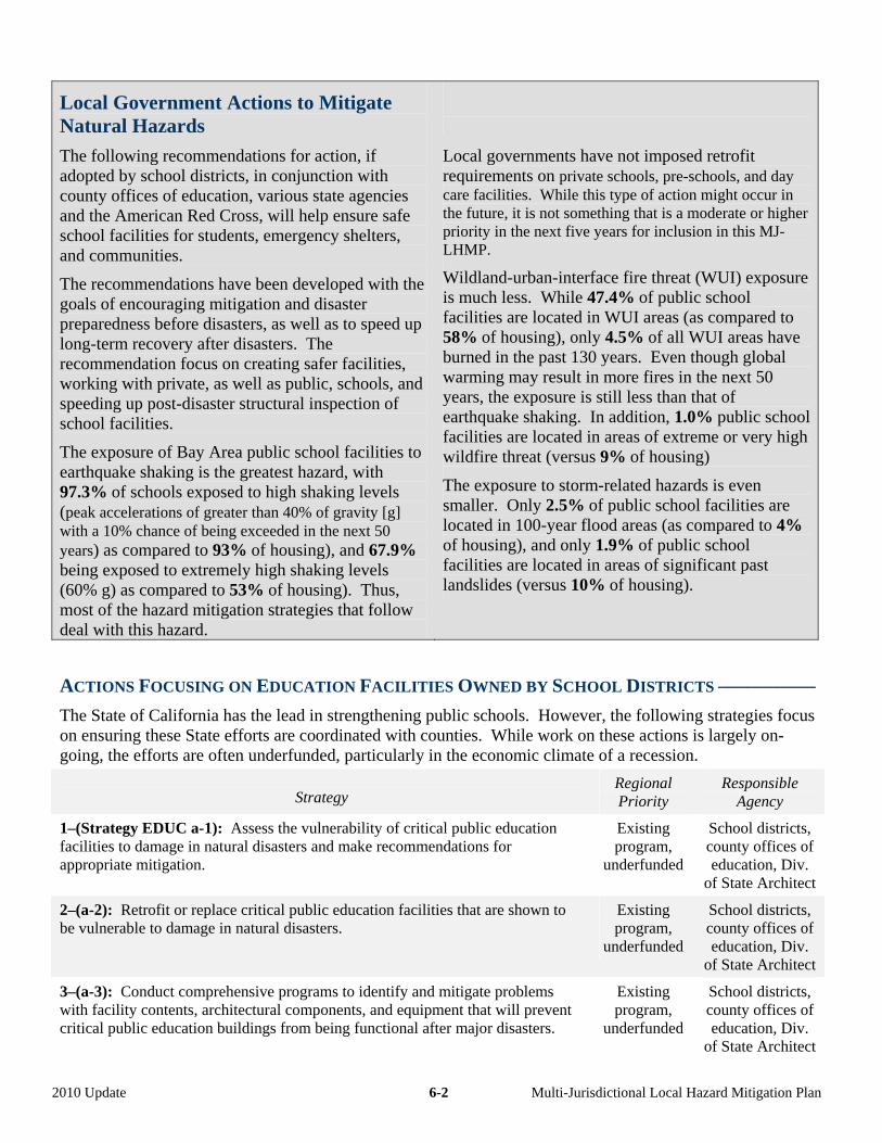
Local Government Actions to Mitigate Natural Hazards
The following recommendations for action, if adopted by school districts, in conjunction with county offices of education, various state agencies and the American Red Cross, will help ensure safe school facilities for students, emergency shelters, and communities.
The recommendations have been developed with the goals of encouraging mitigation and disaster preparedness before disasters, as well as to speed up long-term recovery after disasters. The recommendation focus on creating safer facilities, working with private, as well as public, schools, and speeding up post-disaster structural inspection of school facilities.
The exposure of Bay Area public school facilities to earthquake shaking is the greatest hazard, with 97.3% of schools exposed to high shaking levels (peak accelerations of greater than 40% of gravity [g] with a 10% chance of being exceeded in the next 50 years) as compared to 93% of housing), and 67.9% being exposed to extremely high shaking levels (60% g) as compared to 53% of housing). Thus, most of the hazard mitigation strategies that follow deal with this hazard.
Local governments have not imposed retrofit requirements on private schools, pre-schools, and day care facilities. While this type of action might occur in the future, it is not something that is a moderate or higher priority in the next five years for inclusion in this MJ-LHMP.
Wildland-urban-interface fire threat (WUI) exposure is much less. While 47.4% of public school facilities are located in WUI areas (as compared to 58% of housing), only 4.5% of all WUI areas have burned in the past 130 years. Even though global warming may result in more fires in the next 50 years, the exposure is still less than that of earthquake shaking. In addition, 1.0% public school facilities are located in areas of extreme or very high wildfire threat (versus 9% of housing)
The exposure to storm-related hazards is even smaller. Only 2.5% of public school facilities are located in 100-year flood areas (as compared to 4% of housing), and only 1.9% of public school facilities are located in areas of significant past landslides (versus 10% of housing).
ACTIONS FOCUSING ON EDUCATION FACILITIES OWNED BY SCHOOL DISTRICTS ––––––––––
The State of California has the lead in strengthening public schools. However, the following strategies focus on ensuring these State efforts are coordinated with counties. While work on these actions is largely on-going, the efforts are often underfunded, particularly in the economic climate of a recession.
Strategy Regional Priority
Responsible Agency
1–(Strategy EDUC a-1): Assess the vulnerability of critical public education facilities to damage in natural disasters and make recommendations for appropriate mitigation.
Existing program,
underfunded
School districts, county offices of education, Div.
of State Architect
2–(a-2): Retrofit or replace critical public education facilities that are shown to be vulnerable to damage in natural disasters.
Existing program,
underfunded
School districts, county offices of education, Div.
of State Architect
3–(a-3): Conduct comprehensive programs to identify and mitigate problems with facility contents, architectural components, and equipment that will prevent critical public education buildings from being functional after major disasters.
Existing program,
underfunded
School districts, county offices of education, Div.
of State Architect
2010 Update 6-2 Multi-Jurisdictional Local Hazard Mitigation Plan
4–(a-4): As a secondary focus, assess the vulnerability of non-critical educational facilities (that is, those that do not house students) to damage in natural disasters based on occupancy and structural type, make recommendations on priorities for structural improvements or occupancy reductions, and identify potential funding mechanisms.
Moderate School districts, county offices of
education
5–(a-5): Assess the vulnerability of critical private education, pre-school, and day care facilities to damage in natural disasters and make recommendations for appropriate mitigation.
Moderate County offices of education
6–(a-6): Work with CalEMA and the Division of the State Architect to ensure that there will be an adequate group of Safety Assessment Program (SAP) inspectors trained and deployed by CalEMA to schools for post-disaster inspection. In addition, if a school district is uncomfortable with delays in inspection due to too few SAP inspectors available in catastrophic disasters, formalized arrangements can also be created with those inspectors certified by the Division of the State Architect as construction inspectors to report to the district, assess damage, and determine if the buildings can be reoccupied.
Existing program,
underfunded
School districts, county offices of education, Div.
of State Architect, CalEMA
USE OF EDUCATIONAL FACILITIES AS EMERGENCY SHELTERS –––––––––––––––––––––––––
As noted, schools have the additional function following a disaster of serving as emergency shelters. The following mitigation strategies focus on ensuring that they are available for that role.
Strategy Regional Priority
Responsible Agency
1–(b-1): Work cooperatively with the American Red Cross, cities, counties, and non-profits to set up memoranda of understanding for use of education facilities as emergency shelters following disasters.
Existing program
School districts, county offices of
education
2–(b-2): Work cooperatively to ensure that school district personnel and relevant staff understand and are trained that being designated by the American Red Cross or others as a potential emergency shelter does NOT mean that the school has had a hazard or structural evaluation to ensure that it can be used as a shelter following any specific disaster.
Existing program
School districts, county offices of
education
3–(b-3): Work cooperatively to ensure that school district personnel understand and are trained that they are designated as disaster service workers and must remain at the school until released.
Existing program
School districts, county offices of
education
ACTIONS RELATED TO DISASTER PREPAREDNESS AND RECOVERY PLANNING ––––––––––––
School districts cannot mitigate hazards, respond to disasters, or recover except as part of a larger community. The following strategies relate to the unique role of schools in the community.
Strategy Regional Priority
Responsible Agency
1–(c-1): Encourage employees of schools to have family disaster plans and conduct mitigation activities in their own homes.
Existing program
School districts, county offices of
education
2010 Update 6-3 Multi-Jurisdictional Local Hazard Mitigation Plan
2–(c-2): Develop plans, in conjunction with fire jurisdictions, for evacuation or sheltering in place of school children during periods of high fire danger, thereby recognizing that overloading of streets near schools by parents attempting to pick up their children during these periods can restrict access by fire personnel and equipment.
Existing program
School districts, county offices of
education
3–(c-3): Offer the 20-hour basic CERT training to teachers and after-school personnel.
Existing program,
underfunded
School districts, county offices of
education
4–(c-4): Offer the 20-hour basic Student Emergency Response Training (SERT, rather than CERT) training to middle school and/or high school students as a part of the basic science or civics curriculum, as an after school club, or as a way to earn public service hours.
Existing program,
underfunded
K-12 school districts, county
offices of education
5–(c-5): Offer the 20-hour basic CERT training course through the Adult School system and/or through the Community College system (either using instructors with teaching credentials or by making facilities available for classes not run by school personnel themselves).
Existing program,
underfunded
Community college school
districts, county offices of education
6–(c-6): Develop and maintain the capacity for schools to take care of the students for the first 48 hours after a disaster, and notify parents that this capacity exists.
Existing program
School districts, county offices of
education
7–(c-7): Develop a continuity of operations and disaster recovery plan using models such as that developed by the University of California Berkeley. (The American Red Cross has a role in promoting this activity, as well, in schools that they plan to use as shelters.)
High priority, actively
looking for funding
School districts, county offices of
education
ACTIONS RELATED TO SCHOOLS AS CONDUITS FOR INFORMATION TO FAMILIES ABOUT
EMERGENCIES ––––––––––––––––––––––––––––––––––––––––––––––––––––––––––––––––
School districts have a role in assisting with the preparedness and recovery of that larger community. The following strategies relate to the unique role of schools in the community.
Strategy Regional Priority
Responsible Agency
1–(d-1): Utilize the unique ability of schools to reach families through educational materials on hazards, mitigation, and preparedness, particularly after disasters and at the beginning of the school year. These efforts will not only make the entire community more disaster-resistant, but speed the return of schools from use as shelters to use as teaching facilities, particularly if coordinated with cities, counties, the American Red Cross and others.
Very high priority,
unofficial program
School districts, county offices of
education
2–(d-2): Develop and distribute culturally appropriate materials related to disaster mitigation and preparedness, such as those on the http://www.preparenow.org website.
Existing program
School districts, county offices of
education
2010 Update 6-4 Multi-Jurisdictional Local Hazard Mitigation Plan
Chapter 7 – Environment (ENVI) COMMITMENT: Disaster resistance needs to further environmental sustainability, reduce pollution, strengthen agriculture resiliency, and avoid hazardous material releases in the Bay Area.
Ways to Incorporate Environmental Goals into Hazard Mitigation Policy
The following strategies relate to three ways in which environmental goals mesh with natural hazard mitigation:
• enforcing environmental quality laws and regulations
• initiating climate change strategies • developing and maintaining resilient
agriculture and aquaculture.
Environmental Sustainability and Safety: It is essential that local governments effectively balance the dual goals of environmental protection and hazard mitigation. For example, local governments must continue to enforce State-mandated requirements, such as the California Environmental Quality Act. In addition, they need to work together to develop and implement a comprehensive program for watershed management. Finally, ecosystem preservation is consistent with the preservation of riverine habitats, which is also consistent with preserving areas that may be more likely to be subject to liquefaction in an earthquake and with preserving trees that contribute to reductions in erosion.
Climate Change: The Bay Area is one small part of the Earth. However, by being a leader in striving for reducing hydrocarbon emissions, it can set an example for other regions in the country, as well as contribute directly to emission reductions. Thus, one set of mitigation strategies that follow deal with mitigation of these impacts. (The adaptation strategies for climate change are incorporated into the weather-related strategies discussed in other chapters of this Plan.)
Agricultural Resiliency: Finally, while the Bay Area is often viewed as an urban area, it is also still a vibrant agricultural area. One of the keys to continuing that vibrancy is to improve agricultural resiliency. Such efforts should improve the likelihood that agricultural pests are contained and that early warnings for food contamination are reduced.
2010 Update Multi-Jurisdictional Local Hazard Mitigation Plan 7-1
Combining Environmental Sustainability and Hazard Mitigation
Creating a region that is both environmentally sustainable and in which significant natural hazards are mitigated will improve the quality of life and the economic resilience of the Bay Area.
Thus, far from being contradictory goals, these two objectives should be viewed as complementary.
It is essential that actions taken to mitigate natural hazards not contribute significantly to environmental degradation. In fact, the most innovative and comprehensive mitigation activities can also create a cleaner, greener, and more sustainable environment. The following strategies seek to ensure these outcomes.
ACTIONS RELATED TO ENVIRONMENTAL SUSTAINABILITY AND POLLUTION REDUCTION ––––
Strategy Regional Priority
Responsible Agency
1–(Strategy ENVI a-1): Continue to enforce State-mandated requirements, such as the California Environmental Quality Act, to ensure that mitigation activities for hazards, such as seismic retrofits and vegetation clearance programs for fire threat, are conducted in a way that reduces environmental degradation such as air quality impacts, noise during construction, and loss of sensitive habitats and species, while respecting the community value of historic preservation.
Existing program
Cities and counties
2–(a-3): Continue to enforce and/or comply with State-mandated requirements, such as the California Environmental Quality Act and environmental regulations to ensure that urban development is conducted in a way to minimize air pollution. For example, air pollution levels can lead to global warming, and then to drought, increased vegetation susceptibility to disease (such as pine bark beetle infestations), and associated increased fire hazard.
Existing program
Cities and counties
3–(a-4): Develop and implement a comprehensive program for watershed management optimizing ecosystem health with water yield to balance water supply, flooding, fire, and erosion concerns.
Under study Cities, counties, and flood control
districts
4–(a-6): Comply with applicable performance standards of any National Pollutant Discharge Elimination System municipal stormwater permit that seeks to manage increases in stormwater run-off flows from new development and redevelopment construction projects.
Existing program
Cities, counties, and flood control
districts
5–(a-7): Enforce and/or comply with the grading, erosion, and sedimentation requirements by prohibiting the discharge of concentrated stormwater flows by other than approved methods that seek to minimize associated pollution.
Existing program
Cities, counties, and flood control
districts
6–(a-8): Explore ways to require that hazardous materials stored in the flood zone be elevated or otherwise protected from flood waters.
Existing program
Cities and counties
7–(a-9): Enforce and/or comply with the hazardous materials requirements of the State of California Certified Unified Program Agency (CUPA).
Existing program
Cities and counties
8–(a-10): Provide information on hazardous waste disposal and/or drop off locations.
Existing program
Cities and counties
2010 Update Multi-Jurisdictional Local Hazard Mitigation Plan 7-2
ACTIONS RELATED TO ENVIRONMENTAL SUSTAINABILITY AND HABITAT PRESERVATION –––
Strategy Regional Priority
Responsible Agency
1–(a-5): Balance the need for the smooth flow of storm waters versus the need to maintain wildlife habitat by developing and implementing a comprehensive Streambed Vegetation Management Plan that ensures the efficacy of flood control efforts, mitigates wildfires and maintains the viability of living rivers.
Existing program
Cities, counties, and flood control
districts
2–(a-12): Develop and implement a program to control invasive and exotic species that contribute to fire and flooding hazards (such as eucalyptus, cattails, and cordgrass). This program could include vegetation removal, thinning, or replacement in hazard areas where there is a direct threat to structures.
Existing program,
underfunded
Cities, counties, and flood control
districts
3–(a-13): Enforce provisions under creek protection, stormwater management, and discharge control ordinances designed to keep watercourses free of obstructions and to protect drainage facilities to conform with the Regional Water Quality Control Board's Best Management Practices.
Existing program,
underfunded
Cities, counties, and flood control
districts
ACTIONS RELATED TO ENVIRONMENTAL SAFETY –––––––––––––––––––––––––––––––––––––
Strategy Regional Priority
Responsible Agency
1–(a-2): Encourage regulatory agencies to work collaboratively with safety professionals to develop creative mitigation strategies that effectively balance environmental and safety needs, particularly to meet critical wildfire, flood, and earthquake safety levels.
Existing program
Cities and counties
2–(a-11): When remodeling existing government and infrastructure buildings and facilities, remove asbestos to speed up clean up of buildings so that they can be reoccupied more quickly.
Under study Cities, counties, regional agencies
and special districts
2010 Update Multi-Jurisdictional Local Hazard Mitigation Plan 7-3
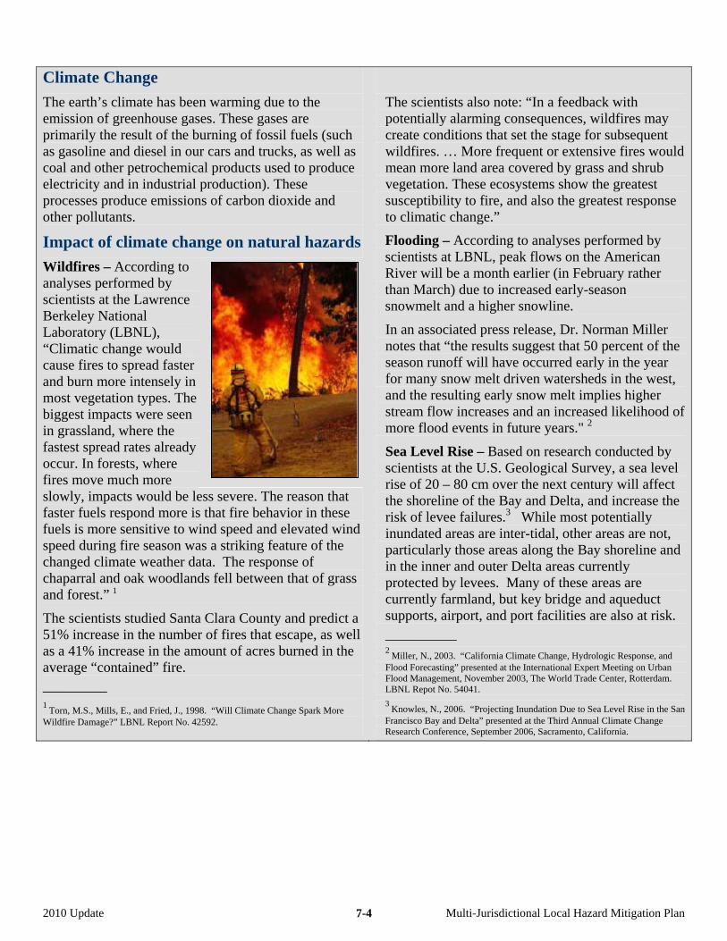
Climate Change
The earth’s climate has been warming due to the emission of greenhouse gases. These gases are primarily the result of the burning of fossil fuels (such as gasoline and diesel in our cars and trucks, as well as coal and other petrochemical products used to produce electricity and in industrial production). These processes produce emissions of carbon dioxide and other pollutants.
Impact of climate change on natural hazards
Wildfires – According to analyses performed by scientists at the Lawrence Berkeley National Laboratory (LBNL), “Climatic change would cause fires to spread faster and burn more intensely in most vegetation types. The biggest impacts were seen in grassland, where the fastest spread rates already occur. In forests, where fires move much more slowly, impacts would be less severe. The reason that faster fuels respond more is that fire behavior in these fuels is more sensitive to wind speed and elevated wind speed during fire season was a striking feature of the changed climate weather data. The response of chaparral and oak woodlands fell between that of grass and forest.” 1
The scientists studied Santa Clara County and predict a 51% increase in the number of fires that escape, as well as a 41% increase in the amount of acres burned in the average “contained” fire.
–––––––––
1 Torn, M.S., Mills, E., and Fried, J., 1998. “Will Climate Change Spark More
Wildfire Damage?” LBNL Report No. 42592.
The scientists also note: “In a feedback with potentially alarming consequences, wildfires may create conditions that set the stage for subsequent wildfires. … More frequent or extensive fires would mean more land area covered by grass and shrub vegetation. These ecosystems show the greatest susceptibility to fire, and also the greatest response to climatic change.”
Flooding – According to analyses performed by scientists at LBNL, peak flows on the American River will be a month earlier (in February rather than March) due to increased early-season snowmelt and a higher snowline.
In an associated press release, Dr. Norman Miller notes that “the results suggest that 50 percent of the season runoff will have occurred early in the year for many snow melt driven watersheds in the west, and the resulting early snow melt implies higher stream flow increases and an increased likelihood of more flood events in future years." 2
Sea Level Rise – Based on research conducted by scientists at the U.S. Geological Survey, a sea level rise of 20 – 80 cm over the next century will affect the shoreline of the Bay and Delta, and increase the risk of levee failures.3 While most potentially inundated areas are inter-tidal, other areas are not, particularly those areas along the Bay shoreline and in the inner and outer Delta areas currently protected by levees. Many of these areas are currently farmland, but key bridge and aqueduct supports, airport, and port facilities are also at risk.
–––––––––– 2
Miller, N., 2003. “California Climate Change, Hydrologic Response, and Flood Forecasting” presented at the International Expert Meeting on Urban Flood Management, November 2003, The World Trade Center, Rotterdam. LBNL Repot No. 54041.
3 Knowles, N., 2006. “Projecting Inundation Due to Sea Level Rise in the San
Francisco Bay and Delta” presented at the Third Annual Climate Change Research Conference, September 2006, Sacramento, California.
2010 Update Multi-Jurisdictional Local Hazard Mitigation Plan 7-4

ACTIONS APPLYING TO CLIMATE CHANGE
In the 2005 version of this multi-jurisdictional Local Hazard Mitigation Plan, the conclusion was that climate change should be studied and monitored, but that no specific actions related to climate change should occur at that time. In this version of the MJ-LHMP, the original strategy related to keeping informed has been retained. However, twelve specific strategies have been added. They are identical to those of the U.S. Conference of Mayors’ Climate Protection Agreement and are intended as a commitment of cities and other local governments to strive to meet or exceed Kyoto Protocol targets for reducing global warming pollution by taking actions in their own operations and communities.
Strategy Regional Priority
Responsible Agency
1–(b-1): Stay informed of scientific information compiled by regional and state sources on the subject of rising sea levels and global warming, especially on additional actions that local governments can take to mitigate this hazard including special design and engineering of government-owned facilities in low-lying areas, such as wastewater treatment plants, ports, and airports.
Existing program
Cities, counties, regional
agencies and special districts
2–(b-2): Inventory global warming emissions in your own local government's operations and in the community, set reduction targets and create an action plan.
Existing program
Cities, counties, regional
agencies and special districts
3–(b-3): Adopt and enforce land-use policies that reduce sprawl, preserve open space, and create compact, walkable urban communities.
Existing program,
underfunded
Cities, counties, and regional
agencies
4–(b-4): Promote transportation options such as bicycle trails, commute trip reduction programs, incentives for car pooling and public transit.
Existing program,
underfunded
Cities, counties, and regional
agencies
5–(b-5): Increase the use of clean, alternative energy by, for example, investing in “green tags”, advocating for the development of renewable energy resources, recovering landfill methane for energy production, and supporting the use of waste to energy technology.
Existing program,
underfunded
Cities and counties
6–(b-6): Make energy efficiency a priority through building code improvements, retrofitting city facilities with energy efficient lighting and urging employees to conserve energy and save money.
Existing program,
underfunded
Cities, counties, regional
agencies and special districts
7–(b-7): Purchase only Energy Star equipment and appliances for local government use.
Existing program,
underfunded
Cities, counties, regional
agencies and special districts
8–(b-8): Practice and promote sustainable building practices using the U.S. Green Building Council's LEED program or a similar system.
Existing program,
underfunded
Cities, counties, regional
agencies and special districts
9–(b-9): Increase the average fuel efficiency of municipal fleet vehicles; reduce the number of vehicles; launch an employee education program including anti-idling messages; convert diesel vehicles to bio-diesel.
Existing program,
underfunded
Cities, counties, regional
agencies and special districts
2010 Update Multi-Jurisdictional Local Hazard Mitigation Plan 7-5

10–(b-10): Evaluate opportunities to increase pump efficiency in water and wastewater systems; recover wastewater treatment methane for energy production.
Existing program,
underfunded
Cities, counties, water and
wastewater agencies
11–(b-11): Increase recycling rates in local government operations and in the community.
Existing program,
underfunded
Cities and counties
12–(b-12): Maintain healthy urban forests; promote tree planting to increase shading and to absorb CO2.
Existing program,
underfunded
Cities and counties
13–(b-13): Help educate the public, schools, other jurisdictions, professional associations, business and industry about reducing global warming pollution.
Existing program,
underfunded
Cities and counties
Agricultural and Aquaculture Resilience
Several of the disasters in the Bay Area in the last few decades are related to heat and insect infestation, particularly as they relate to agricultural production. When there is an agricultural emergency, it remains necessary to comply with CEQA. In addition, the State may issue special regulations for local governments.
Policies related to agriculture and aquaculture instituted by county offices of the Agricultural Commissioner and county health departments do have a role to play, as identified in the following three strategies
ACTIONS RELATED TO CROP DIVERSITY AND RESILIENCY
Strategy Regional Priority
Responsible Agency
1–(c-1): Maintain a variety of crops in rural areas of the region to increase agricultural diversity and crop resiliency.
Moderate priority
County Offices of the Agricultural Commissioner.
2–(c-2): Promote and maintain the public-private partnerships dedicated to preventing the introduction of agricultural pests into regionally-significant crops, such as the glassy-winged sharpshooter into vineyards.
Existing program
County Offices of the Agricultural Commissioner.
3–(c-3): Encourage livestock operators to develop an early-warning system to detect animals with communicable diseases (due to natural causes or bioterrorism).
Existing program
County Health Department and
Office of the County
Agricultural Commissioner.
2010 Update Multi-Jurisdictional Local Hazard Mitigation Plan 7-6
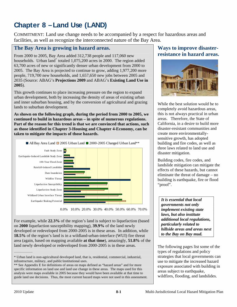
Chapter 8 – Land Use (LAND) COMMITMENT: Land use change needs to be accompanied by a respect for hazardous areas and facilities, as well as recognize the interconnected nature of the Bay Area.
The Bay Area is growing in hazard areas. From 2000 to 2005, Bay Area added 312,738 people and 117,060 new households. Urban land* totaled 1,075,200 acres in 2000. The region added 63,700 acres of new or significantly denser urban development from 2000 to 2005. The Bay Area is projected to continue to grow, adding 1,977,200 more people, 719,700 new households, and 1,657,650 new jobs between 2005 and 2035 (Source: ABAG’s Projections 2009 and ABAG’s Existing Land Use in 2005).
This growth continues to place increasing pressure on the region to expand urban development, both by increasing the density of areas of existing urban and inner suburban housing, and by the conversion of agricultural and grazing lands to suburban development.
As shown on the following graph, during the period from 2000 to 2005, we continued to build in hazardous areas – in spite of numerous regulations. Part of the reason for this trend is that we are convinced that actions, such as those identified in Chapter 3-Housing and Chapter 4-Economy, can be taken to mitigate the impacts of those hazards.
All Bay Area Land 2005 Urban Land 2000-2005 Changed Urban Land**
0.0% 10.0% 20.0% 30.0% 40.0% 50.0% 60.0% 70.0%
Earthquake Shaking Potential
Wildland Urban Interface Threat
Liquefaction Study Zone
Liquefaction Susceptibility
Wildfire Threat
Dam Inundation
Rainfall-Induced Landslides
100-Year Flood Zone
Earthquake-Induced Landslide Study Zone
Fault Study Zone
For example, while 22.3% of the region’s land is subject to liquefaction (based on 2000 liquefaction susceptibility mapping), 39.9% of the land newly developed or redeveloped from 2000-2005 is in these areas. In addition, while 18.5% of the region’s land is in a wildland-urban-interface (WUI) fire threat area (again, based on mapping available at that time), amazingly, 51.8% of the land newly developed or redeveloped from 2000-2005 is in these areas. ________________
* Urban land is non-agricultural developed land, that is, residential, commercial, industrial, infrastructure, military, and public/institutional uses. ** See Appendix E for definitions of areas on maps defined as “hazard areas” and for more specific information on land use and land use change in these areas. The maps used for this analysis were maps available in 2005 because they would have been available at that time to guide land use decisions. Thus, the most current hazard maps were not used in this assessment.
Ways to improve disaster-resistance in hazard areas.
While the best solution would be to completely avoid hazardous areas, this is not always practical in urban areas. Therefore, the State of California, in a desire to build more disaster-resistant communities and create more environmentally-sensitive growth, has adopted building and fire codes, as well as three laws related to land use and disaster mitigation.
Building codes, fire codes, and landslide mitigation can mitigate the effects of these hazards, but cannot eliminate the threat of damage – no building is earthquake, fire or flood “proof”.
It is essential that local governments not only implement existing state laws, but also institute additional local regulations, particularly related to hillside areas and areas next to the Bay on Bay mud.
The following pages list some of the types of regulations and policy strategies that local governments can use to mitigate the increased hazard exposure associated with building in areas subject to earthquake, wildfires, flooding, and landslides.
2010 Update Multi-Jurisdictional Local Hazard Mitigation Plan 8-1
Certain Mitigation Practices Apply to All Hazards
Land use planning can effectively mitigate the risks from multiple hazards simultaneously. For example, limiting growth in outlying areas is a useful tool for promoting sustainable practices as well as reducing risk to wildfire, landslides and flooding.
Similarly, zoning laws to limit development on hillsides has the dual benefits of reducing risks from landslides and wildfires. Funding of hazard mitigation efforts for any natural hazard can be taken on by a local community or neighborhood collectively.
ACTIONS RELATED TO SMART GROWTH ––––––––––––––––––––––––––––––––––––––––––––
Smart Growth programs are intended to revitalize urban areas and promote sustainability as an alternative to developing in outlying and hazard-prone areas. ABAG and the other regional agencies in the region, including the Metropolitan Transportation Commission (MTC) and the Bay Area Air Quality Management District, have adopted polices to promote Smart Growth. In addition, boards of supervisors of all nine Bay Area counties and city councils of 66 of the regions cities have taken action in support of the objectives of the Bay Area Alliance for Sustainable Communities, is a multi-stakeholder coalition established in 1997 to develop and implement an action plan that will lead to a more sustainable region. The following strategies meld Smart Growth and sustainability concepts with hazard mitigation.
Strategy Regional Priority
Responsible Agency
1–(Strategy LAND f-1): Prioritize retrofit of infrastructure that serves urban areas (or urban services areas) over constructing new infrastructure to serve outlying areas.
Existing program
Cities, counties, transit districts
with fixed lines, and water/sewer
agencies
2–(f-2): Work to retrofit homes in older urban neighborhoods to provide safe housing close to job centers.
Existing program,
underfunded
Cities and counties
3–(f-3): Work to retrofit older downtown areas and redevelopment districts to protect architectural diversity and promote disaster-resistance.
Existing program,
underfunded
Cities and counties
4–(f-4): Work with non-profits and through other mechanisms to protect as open space those areas susceptible to extreme hazards (such as through land acquisition, zoning, and designation as priority conservation areas).
Existing program,
underfunded
Cities and counties
5–(f-5): Strive to provide and preserve existing buffers between development and existing users of large amounts of hazardous materials, such as major industry, due to the potential for catastrophic releases or fires due to an earthquake, accident, or terrorism. (Flooding might also result in release or spread of these materials; however, it is unlikely.) In areas where buffers do not exist or cannot be created, provide alternative mitigation.
Under study Cities and counties
2010 Update Multi-Jurisdictional Local Hazard Mitigation Plan 8-2
ACTIONS RELATED TO HILLSIDE DEVELOPMENT ––––––––––––––––––––––––––––––––––––––
Hillside development can be problematic due to the potential hazards of wildfire and landsliding. However, the pressure to convert hillside areas to urban uses is great in inner suburban communities that have no remaining non-urban land, as well as in communities actively preserving agricultural land (particularly in the North Bay where vineyards are prevalent). The following tools to mitigate risks are available to local governments.
Strategy Regional Priority
Responsible Agency
1–(e-1): For new development, require a buffer zone between residential properties and landslide or wildfire hazard areas.
Existing program
Cities and counties
2–(e-2): Discourage, add additional mitigation strategies, or prevent new construction or major remodels on slopes greater than a set percentage, such as 15%, due to landslide or wildfire hazard concerns.
Existing program
Cities and counties
ACTIONS RELATED TO HAZARD ABATEMENT FUNDING ––––––––––––––––––––––––––––––––
Mitigating hazards through land use changes is a process that can take time and money. Often, the hazard is not limited to one governmental jurisdiction. On a smaller scale neighbors may want to pool resources to implement and enforce mitigation techniques for common hazards. This mechanism can allow high risk areas to develop reserve funds to mitigate their hazards at no cost to the city or county. Use of Geologic Hazard Abatement Districts also allows the sale of public bonds to mitigate hazards on private property (such as: construct a retaining wall on private property for public good without purchasing property), all other assessment districts cannot use their funds in this way. The use of abatement districts is currently limited in the Bay Area, but more widespread use could be a very effective way to mitigate locally significant hazards. The following strategy provides a funding mechanism for mitigating hazards at a local level.
Strategy Regional Priority
Responsible Agency
1–(g-1): Use hazard abatement districts as a funding mechanism to ensure that mitigation strategies are implemented and enforced over time.
Under study Cities and counties
2010 Update Multi-Jurisdictional Local Hazard Mitigation Plan 8-3
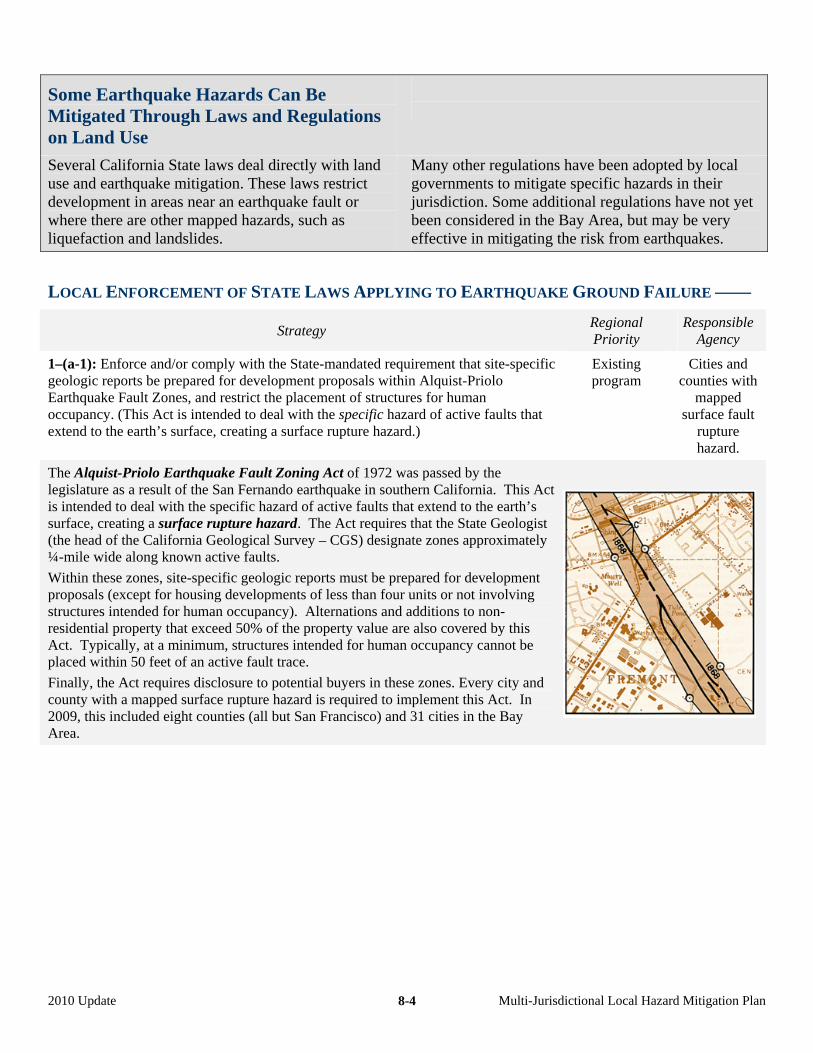
Some Earthquake Hazards Can Be Mitigated Through Laws and Regulations on Land Use
Several California State laws deal directly with land use and earthquake mitigation. These laws restrict development in areas near an earthquake fault or where there are other mapped hazards, such as liquefaction and landslides.
Many other regulations have been adopted by local governments to mitigate specific hazards in their jurisdiction. Some additional regulations have not yet been considered in the Bay Area, but may be very effective in mitigating the risk from earthquakes.
LOCAL ENFORCEMENT OF STATE LAWS APPLYING TO EARTHQUAKE GROUND FAILURE ––––
Strategy Regional Priority
Responsible Agency
1–(a-1): Enforce and/or comply with the State-mandated requirement that site-specific geologic reports be prepared for development proposals within Alquist-Priolo Earthquake Fault Zones, and restrict the placement of structures for human occupancy. (This Act is intended to deal with the specific hazard of active faults that extend to the earth’s surface, creating a surface rupture hazard.)
Existing program
Cities and counties with
mapped surface fault
rupture hazard.
The Alquist-Priolo Earthquake Fault Zoning Act of 1972 was passed by the legislature as a result of the San Fernando earthquake in southern California. This Act is intended to deal with the specific hazard of active faults that extend to the earth’s surface, creating a surface rupture hazard. The Act requires that the State Geologist (the head of the California Geological Survey – CGS) designate zones approximately ¼-mile wide along known active faults.
Within these zones, site-specific geologic reports must be prepared for development proposals (except for housing developments of less than four units or not involving structures intended for human occupancy). Alternations and additions to non-residential property that exceed 50% of the property value are also covered by this Act. Typically, at a minimum, structures intended for human occupancy cannot be placed within 50 feet of an active fault trace.
Finally, the Act requires disclosure to potential buyers in these zones. Every city and county with a mapped surface rupture hazard is required to implement this Act. In 2009, this included eight counties (all but San Francisco) and 31 cities in the Bay Area.
2010 Update Multi-Jurisdictional Local Hazard Mitigation Plan 8-4
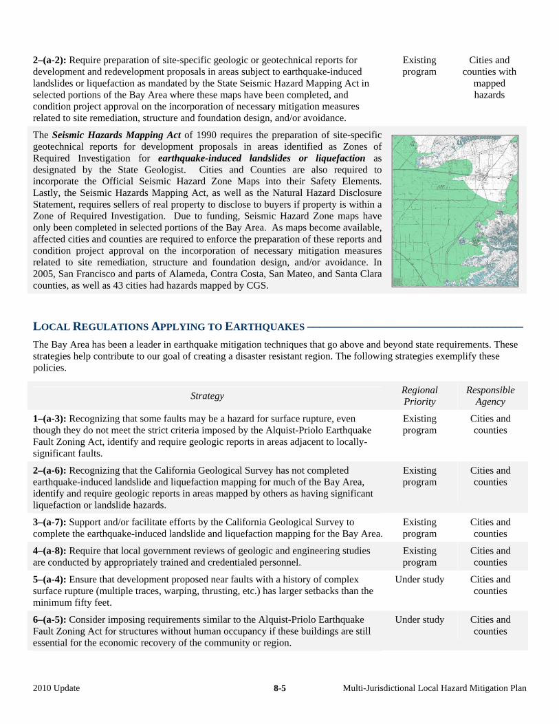
2–(a-2): Require preparation of site-specific geologic or geotechnical reports for development and redevelopment proposals in areas subject to earthquake-induced landslides or liquefaction as mandated by the State Seismic Hazard Mapping Act in selected portions of the Bay Area where these maps have been completed, and condition project approval on the incorporation of necessary mitigation measures related to site remediation, structure and foundation design, and/or avoidance.
Existing program
Cities and counties with
mapped hazards
The Seismic Hazards Mapping Act of 1990 requires the preparation of site-specific geotechnical reports for development proposals in areas identified as Zones of Required Investigation for earthquake-induced landslides or liquefaction as designated by the State Geologist. Cities and Counties are also required to incorporate the Official Seismic Hazard Zone Maps into their Safety Elements. Lastly, the Seismic Hazards Mapping Act, as well as the Natural Hazard Disclosure Statement, requires sellers of real property to disclose to buyers if property is within a Zone of Required Investigation. Due to funding, Seismic Hazard Zone maps have only been completed in selected portions of the Bay Area. As maps become available, affected cities and counties are required to enforce the preparation of these reports and condition project approval on the incorporation of necessary mitigation measures related to site remediation, structure and foundation design, and/or avoidance. In 2005, San Francisco and parts of Alameda, Contra Costa, San Mateo, and Santa Clara counties, as well as 43 cities had hazards mapped by CGS.
LOCAL REGULATIONS APPLYING TO EARTHQUAKES –––––––––––––––––––––––––––––––––––
The Bay Area has been a leader in earthquake mitigation techniques that go above and beyond state requirements. These strategies help contribute to our goal of creating a disaster resistant region. The following strategies exemplify these policies.
Strategy Regional Priority
Responsible Agency
1–(a-3): Recognizing that some faults may be a hazard for surface rupture, even though they do not meet the strict criteria imposed by the Alquist-Priolo Earthquake Fault Zoning Act, identify and require geologic reports in areas adjacent to locally-significant faults.
Existing program
Cities and counties
2–(a-6): Recognizing that the California Geological Survey has not completed earthquake-induced landslide and liquefaction mapping for much of the Bay Area, identify and require geologic reports in areas mapped by others as having significant liquefaction or landslide hazards.
Existing program
Cities and counties
3–(a-7): Support and/or facilitate efforts by the California Geological Survey to complete the earthquake-induced landslide and liquefaction mapping for the Bay Area.
Existing program
Cities and counties
4–(a-8): Require that local government reviews of geologic and engineering studies are conducted by appropriately trained and credentialed personnel.
Existing program
Cities and counties
5–(a-4): Ensure that development proposed near faults with a history of complex surface rupture (multiple traces, warping, thrusting, etc.) has larger setbacks than the minimum fifty feet.
Under study Cities and counties
6–(a-5): Consider imposing requirements similar to the Alquist-Priolo Earthquake Fault Zoning Act for structures without human occupancy if these buildings are still essential for the economic recovery of the community or region.
Under study
Cities and counties
2010 Update Multi-Jurisdictional Local Hazard Mitigation Plan 8-5
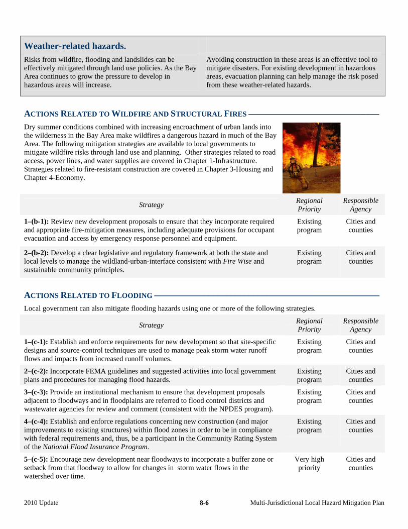
Weather-related hazards.
Risks from wildfire, flooding and landslides can be effectively mitigated through land use policies. As the Bay Area continues to grow the pressure to develop in hazardous areas will increase.
Avoiding construction in these areas is an effective tool to mitigate disasters. For existing development in hazardous areas, evacuation planning can help manage the risk posed from these weather-related hazards.
ACTIONS RELATED TO WILDFIRE AND STRUCTURAL FIRES –––––––––––––––––––––––––––––
Dry summer conditions combined with increasing encroachment of urban lands into the wilderness in the Bay Area make wildfires a dangerous hazard in much of the Bay Area. The following mitigation strategies are available to local governments to mitigate wildfire risks through land use and planning. Other strategies related to road access, power lines, and water supplies are covered in Chapter 1-Infrastructure. Strategies related to fire-resistant construction are covered in Chapter 3-Housing and Chapter 4-Economy.
Strategy Regional Priority
Responsible Agency
1–(b-1): Review new development proposals to ensure that they incorporate required and appropriate fire-mitigation measures, including adequate provisions for occupant evacuation and access by emergency response personnel and equipment.
Existing program
Cities and counties
2–(b-2): Develop a clear legislative and regulatory framework at both the state and local levels to manage the wildland-urban-interface consistent with Fire Wise and sustainable community principles.
Existing program
Cities and counties
ACTIONS RELATED TO FLOODING ––––––––––––––––––––––––––––––––––––––––––––––––––
Local government can also mitigate flooding hazards using one or more of the following strategies.
Strategy Regional Priority
Responsible Agency
1–(c-1): Establish and enforce requirements for new development so that site-specific designs and source-control techniques are used to manage peak storm water runoff flows and impacts from increased runoff volumes.
Existing program
Cities and counties
2–(c-2): Incorporate FEMA guidelines and suggested activities into local government plans and procedures for managing flood hazards.
Existing program
Cities and counties
3–(c-3): Provide an institutional mechanism to ensure that development proposals adjacent to floodways and in floodplains are referred to flood control districts and wastewater agencies for review and comment (consistent with the NPDES program).
Existing program
Cities and counties
4–(c-4): Establish and enforce regulations concerning new construction (and major improvements to existing structures) within flood zones in order to be in compliance with federal requirements and, thus, be a participant in the Community Rating System of the National Flood Insurance Program.
Existing program
Cities and counties
5–(c-5): Encourage new development near floodways to incorporate a buffer zone or setback from that floodway to allow for changes in storm water flows in the watershed over time.
Very high priority
Cities and counties
2010 Update Multi-Jurisdictional Local Hazard Mitigation Plan 8-6
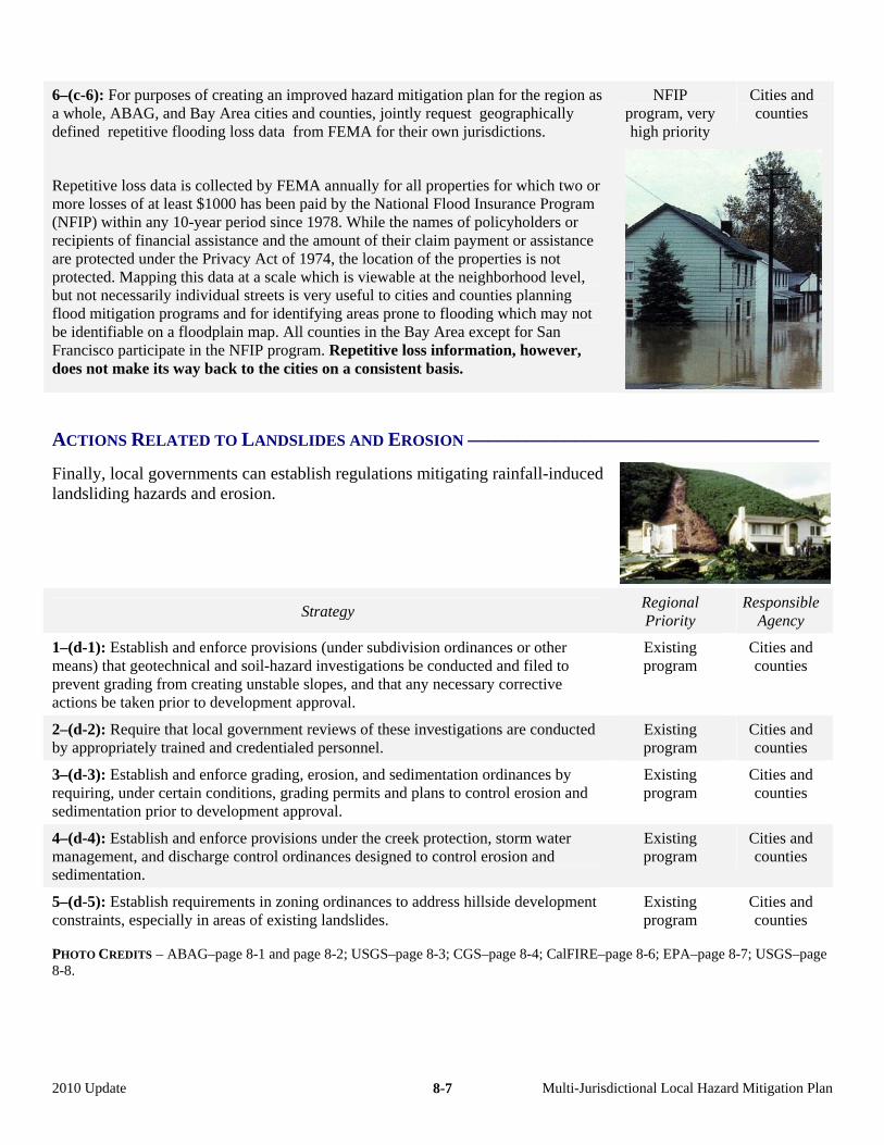
NFIP program, very high priority
Cities and counties
6–(c-6): For purposes of creating an improved hazard mitigation plan for the region as a whole, ABAG, and Bay Area cities and counties, jointly request geographically defined repetitive flooding loss data from FEMA for their own jurisdictions.
Repetitive loss data is collected by FEMA annually for all properties for which two or more losses of at least $1000 has been paid by the National Flood Insurance Program (NFIP) within any 10-year period since 1978. While the names of policyholders or recipients of financial assistance and the amount of their claim payment or assistance are protected under the Privacy Act of 1974, the location of the properties is not protected. Mapping this data at a scale which is viewable at the neighborhood level, but not necessarily individual streets is very useful to cities and counties planning flood mitigation programs and for identifying areas prone to flooding which may not be identifiable on a floodplain map. All counties in the Bay Area except for San Francisco participate in the NFIP program. Repetitive loss information, however, does not make its way back to the cities on a consistent basis.
ACTIONS RELATED TO LANDSLIDES AND EROSION ––––––––––––––––––––––––––––––––––––
Finally, local governments can establish regulations mitigating rainfall-induced landsliding hazards and erosion.
Strategy Regional Priority
Responsible Agency
1–(d-1): Establish and enforce provisions (under subdivision ordinances or other means) that geotechnical and soil-hazard investigations be conducted and filed to prevent grading from creating unstable slopes, and that any necessary corrective actions be taken prior to development approval.
Existing program
Cities and counties
2–(d-2): Require that local government reviews of these investigations are conducted by appropriately trained and credentialed personnel.
Existing program
Cities and counties
3–(d-3): Establish and enforce grading, erosion, and sedimentation ordinances by requiring, under certain conditions, grading permits and plans to control erosion and sedimentation prior to development approval.
Existing program
Cities and counties
4–(d-4): Establish and enforce provisions under the creek protection, storm water management, and discharge control ordinances designed to control erosion and sedimentation.
Existing program
Cities and counties
5–(d-5): Establish requirements in zoning ordinances to address hillside development constraints, especially in areas of existing landslides.
Existing program
Cities and counties
PHOTO CREDITS – ABAG–page 8-1 and page 8-2; USGS–page 8-3; CGS–page 8-4; CalFIRE–page 8-6; EPA–page 8-7; USGS–page 8-8.
2010 Update Multi-Jurisdictional Local Hazard Mitigation Plan 8-7