Ekman Veering, Internal Waves, and Turbulence Observed under ...

976 BULLETIN OF THE BUREAU OF FISHERIES
slope the year round, veering through west to southwest across the basin towardthe offing of Massachusetts Bay; and though variations in salinity and temperatureprove this drift intermittent, its stream track seems comparatively constant fromseason to season during its periods of activity.
The correspondence between the dominant circulation of the gulf, as establishedby direct evidence, and the dynamic gradient is close enough to show that theformer is essentially dynamic, set in motion by the regional inequalities in density,but given its eddylike character by the confining effect of the bottom contour ofGeorges Bank to the south.
• Deflection of the horizontal tidal oscillations by the rotation of the earth similarly tends to produce an anticlockwise movement around the basin of the gulf, andwith the effect of the wind consistent with this, the several motive forces are parallelin effect.
The westerly drift of slope water along the slope of the continent is also dynamicin source, and available evidence suggests the same motive power for the II GulfSt.ream" drift abreast of the gulf.
TABLES OF TEMPERATURE, SALINITY, AND DENSITY
Temperature is in degrees Centigrade, salinity in parts per mille, and density isat the temperature in situ but without correction for compression. The tables onpage 977, summarized from Ekman's (1910) tables 2,4, and 5, give a close enoughapproximation to the latter for general purposes in depths as small as those of theGulf of Maine. For computations involving the specific volume, Smith's (1926, p.19) simplification of Hesselberg and Sverdrup's (1915) tables are to be preferred.
STANDARDS OF ACCURACY
The old type reversing thermometers used in 1912 and 1913 were accurate onlyto within about ±0.15° C., but with the instruments used subsequently for thesubsurface readings the probable error in temperature determination is less than0.05° C. As the surface readings have often been taken under difficulties and byvarious persons, accuracy is not claimed for them beyond about ± 0.3° C.
All the determinations of salinity, except some for the winter of 1925 (notedbelow under the respective stations), have been by titration. So far as personaland instrumental errors are concerned, the results are reliable considerably withinthe requirements of the International Committee for the Exploration of the Seaprobably to ±0.03 per mille of salinity. However, as Giral (1926) has recentlyemphasized, regional or seasonal variations in the relative proportions of the varioussolutes in sea water, such as are known to occur, introduce another source of error,which makes it unsafe to claim accuracy closer than about 0.05 per mille even forwaters as nearly uniform in their saline content as the Gulf of Maine probably is.
The accuracy of the calculated densities depends, of course, on that of the determinations of temperature and salinity on which they are based; and while errors inthese two may partially offset each other, they may, on the contrary, be cumulative.Allowing as the probable range of error 0.05° and ±O.3 per mille, the probable error

PHYSICAL OCEANOGRAPHY OF THE GULF OF MAINE 977
for the densities will average less than ±0.04 units when the salinity has been determined by titration. In the case of hydrometer readings, the probable error of thedensities will be about ±O.1 unit. .
All depths, whether originally recorded in meters or fathoms, are given in metersin these tables. Tables 1, 2, and 3 show the compression of sea water as condensedfrom Ekman's (1910) tables 2, 4, and 5. 99
TABLE I.-Correction of density for depth-water 0° and 28 in density (sp. gr. 1.028)
. -
IIncrease Increase 'Increase IncreaseDepth, meters in Depth, meters in Depth, meters in Depth, meters in
density density density density--_.
10._u.__"." _._. ___ 0.05 80___• _. __••••__00 __ 0.38 200______ ' __n_n_._ 0.07 700_•••••__00 ____ ••u 3.3520•• __•••__00_.__•• _. .10
00. ___• ____...______ .43 250_0.00_____ • ____ ._ 1.20 800n___ •• _______ •• __ 3.8330. __._..__u •• n_•• _. .14 100__0..__• _. __• u __ .48 3000. ____ •__•__• __ ._ 1.42 900•••__• __.0. 00_ ,_" 4.3040•. _._._u •• __oo__._ .10 120_.__u _•• ________ .57 400____ 00', ____ • __._ 1.93 1,000._ •• u.___._ •• __ 4.7850_.______•••••__._._ .24 140._0.00•• _______ 0. .67 500___ •_____ 00n __._ 2.40 1,100___ .00 __ • _______ 5.2560_. ___________ u __._ .20 160. ___• __••• _0. ___• .76 600_00 ---.---. -. _"'1 2.88 1,200.__._._••••••__• 5.7270_. ___• ___n ••• -._oo .33 180__•• ___•• ___ ,_00, .S7
TABLE 2.-Additional corrections for compression at other temperatures
-IAdd Subtract
Depth_1° 1° 2° 3° 4° 5° 6° 7° 8° 0° 10° 11° 12° 13° 14° 15° 16° 17° 18°
------------ --------------------------50 ",_",__" __,,,,__.00' ----- ..-- .. - ..---- ----- O:Or o:oi'
0.01 0.01 0.01 0.01 0.01 0.01 0.01 0.01 0.01 0.01 0.01 0.02 0.02100 __•••u •• __•••••••••u
o:iii-.01 .02 .02 .02 .02 .02 .02 .02 .02 .02 .02 .02 .02
200 ____.n__.n•• _._.__oo 0.01 0.01 0.02 .02 .03 .03 .04 .04 .05 .05 .05 .06 .06 .07 .07 .07 .08 .08300 u •••u •••u_•• _______ .01 .01 .02 .02 .03 .04 .05 .06 .06 .07 .08 .08 .00 .00 .10 .10 --_ ..------ ---- ..400 •__••••___._._____•• __ .01 .01 .02 .03 . 04 .05 .06 .07 .08 .00 .10 .11 .12 .12 .13 .14 ----- ... ---- ...........500 •••n •• _.u•••__••• __ • .01 .01 :03 .04 .05 .07 .08 .00 .10 .11 .12 .14 .15 .15 .16 _...... --..-----_ ..-----..600 .h_._____._.. u •••n_ .02 .02 .03 . 05 .07 .08 .10 .11 .12 .14 .15 .16 .16 .IS --- ..--- .... - ..__ ..- .._--- -----700 _. __•• u •• __••• _•••••• .02 .02 .04 .06 .08 .10 .11 .13 .14 .16 .17 .10 .20 ---- .. ---_ .. -- ..-- ----- ....--- -----800 __•• __• __n ___oo._u __ .02 .02 .05 .07 .09 .11 .13 .15 .16 .IS .20 ----- -......------ ----- ~---- -..._-- ..---_. -----000 •__•••00 ••00.___ •••• __ .03 .03 .05 .07 .10 .12 .14 .16 .18 .20 .22 ----- ----- ._-_..--- .... -- .. _- -.. _-- ....--- ..----1,000'•• 00_•••••••00_0000 .03 .03 .06 .08 .11 .13 .16 .18 .20 .23 .25 ---- .. -...--- ---_ .. ...._-- ...... _- -_ ...... --_ ..-----..1,100 -'. __•• _00_•••••••00. .03 .03 .06 . 09 .12 .15 .17 .20 .22 ----- _.._-- ----- -.._-- ---_ .. _.... _- -.. _-- -....._- .. __ ..-.._---1,200 •••• n ••n_._n••__ • .03 .03 .07 .10 .13 .16 .10 .22 .24 _.... _- ........--- ..-- -._--- _.... _.. --- ..------ -.. _.... .._--- --......
TABLE 3.-Additional corrections for compression at other densities
Density-
IDepth Subtract Add
22 23 24 25 26 27 20 30
---------------------100. __•• _........._.••• - •... --..---- ----_... -...-- 0.01 0.01 ·--·-i>:Oi" _.._------- -- .. __.... _-- _........._--- ..-_ .... _--....200___•• 00 __ ._••• _. ___ • ____ 00 ______ -'-"- - ••• - .01 .01 0.01 ""'ii:oi- ......-.._--_ .. ........---_. -- ·---··ii:iii300.........._. 00. __ ._._. _._ •• _ ._•• ___ 'n_.'-- .02 .02 .01 .01 -_ ..__ ........... ......... -... _-_.400•••••• ___ • 00•• _ ••• __ • __ • 00" • ____ ._n. -•• -- .02 . 02 .02 .01 .01 _...._------ .._....-......--- .01500____••••••••••__••••••__._. _" '00'_ .---.-.- .03 .02 .02 .02 .01
·-·--o~iii· --·--ii~iii-.01
600••••••••• ______ • _•• , h •• __ • __ ._. -- ••• - -'-'- .04 .03 .03 .02 .01 .01700. __••••••_•• _•••_. ________ • ____ •• 00. __ .n__ .04 .04 .03 .02 .01 .01 .01 .01800_. ___nn.__• ___•on" •••••• _. -. - - ••.•• - --.- .05 .04 .03 .03 .02
I.01 .01 .02
000•• _•••••••••.•_. "00 n •••_•••••••n' -- -"-' .06 .05 .04 .03 .02 .01 • 01 .021,000._•••__•• _•••__••••_•__••••_••••••• ,- .-., .06 .05 .04 .03 .02 .01 .01 .021,100 •••••___._ •••••_... - ..._. _____ •• - ••• -•• -- .07 .06 .05 .04 .02 .01 .01 .021, 200•••__.... '_"00' " •• __ ._,_.,.__ •••_.00•• _ .08 . 06 .05 . 04 .03 I .01 .01 .03
I
II CondensatIon at the tables entails employing an average relationship between meters and deelbers. Consequently, theyare accurate only to ±2 in the last decimal place. This, however, talis within the accuracy 01 observation and will sumce for theconstruction or all ordinary projections or density In water so shoal.
978 BULLETIN OF THE BUREAU OF FISHERIES
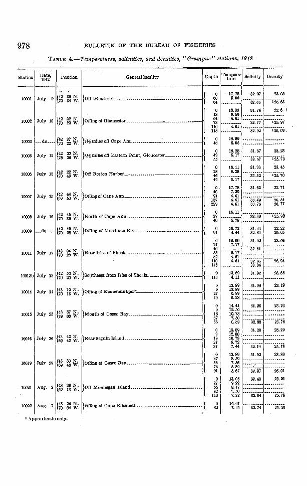
TABLE 4.-Temperatures, salinities, and densities, "Grampus" stations, 191~
8
47
5
ii
o
9
25
4
9.
3
ii5
o
Station Date, Position General locality Depth Tempera· Salinity Density1912 ture
--- ------. I
{42 30 N. }OII Gloucester ••••••.•__••.•__.......................... {0 17.78 32.07 23.0
10001 July 9 70 34 W. 60 5.00 ----32.·65· ""i25~864 ----- ....- ....
}omn, or010000'", • u ___ u ••uu••• u •••••••••u. u •••• 10 18.33 31.74 22.6
18 9.56 ........_- ....... - ----_. ---10002 July 10 e2 32 N. 64 4.61 ·...i25~ii70 23 W. 73 ---------- 32.77
110 4.61 ..··i26~ii·118 ..--------- 32.92
10003 • __ do ....e2 37 N. }7J.-2 miles oil Cape Ann ............ ~............. __...... { 0 18.89 ---------- --...---....... -70 22 W. 46 5.05 --- ........_-- .........-----
{42 32 N. }3~ miles oil Eastern Point, Gloucester__................ {0 16.28 31.67 23.2
10005 July 12 76 36 W. 49 5.17""i25~755 .,---..- .._..- 32.57
}OII Boston Harbor__............................__•••••• {0 16.11 31.96 23.4
10006 July 13 {42 22 N. 18 6.28 .-•.32~52' ....i25~7·70 43 W. 4649 5.17 - ...... - ..- ....- ------ ... ---
}ofllng of Cape Ann.................................., ... /
0 17.78 31.62 22.7
{42 44 N. 46 7.39 ....._-----------------10007 July 15 69 50 W. 91 4.61
····iiii~4ii·137 4.61 26.5229 4.61 33.78 26.7
{42 45 N. }North of Cape Ann........................__........... {0 16.11
""i25~7'10008 July 16 70 39 W. 37"'''5~78'
32.3940 --..------- ........_--....-
10009 ...do .... {42 49 N. }ofllng of Merrimac River •••• __.•••• __.................. { 0 19.72 31. 44 22.270 28 W. 91 4.44 32.84 26.0
}NOM Isles of Shoals u·.· u ____•••• ••••••••••••••u •••• 10 15.00 31. 92 23.6
27 7.17 ...._--- ..........
e3 04 N. 46 32.61 ____ - .... 00-
10011 Jul,. 17 70 20 W. 55 5.17 -.._------ .. ----------82 4.61 ·... ·26~ii4110 4.61 32.85
\ 146 ................._- 33.04 ......--- ......-10012b July 23 {42 53 N. }Southeast from Isles of Shoals••••••••••• , ............... { 0 13.89 31.92 23.85
70 20 W. 146 4.11 ... _--- ..--- .__._-- ... ---
}ofllng of Kennebunkport................................ {0 13.89 31.08 23.1
10014 July 24 {43 19 N. 9 12.89 ..--------- ----------70 13 W. 27 6.89 ------.....- .. ----------
46 6.28 ---------- ---- ._-_ ..-
}Mouth of Casco Bay••••__•••_~..............___........ /
0 14.44 31.26 23.23
{43 37 N. 9 12.50 ---------- -_._-------10015 July 25 7\1 00 W. 18 10.78 -- ............... - ..- ..............
37 7.50 ---------- ···-·25~7-55 6.89 32.88
}Near Seguin Island.••••••__.........................__•• j 0 13.89 31. 20 23.29
26 {43 42 N. 9 12.00 - .....------- ----------10016 July 69 42 W. 18 10.78 .._---------------..--
I 27 8.72 ....·25~i337 7.44 32.14
}Ofllng of Casco Bay.__•• ___........___•••••••_•• ___...._/
0 13.89 31. 92 23.89
{43 30 N. 37 8.50 ......... ----- .. ----- ..........10019 July 29 69 48 W. 55 7.56 _.._..-_ ..,--- ----------
73 5.89""'2ii~oi91 5.67 32.97
i~~. }OII Monhegan Island.................._____............ /
0 13.05 32.43 23.21
e3 27 9.22 -------_ .... ........------10021 Aug. 2 69
55 8.17 ....__ ..----- ............... ---82 7.50 ··..;;:;;r···,."
100221 Aug. ~~ ~·.1}0f1lngof Cape EIIzabeth.........___................_••.){ 11:1
7.22
7 e3 16.67'·"ii2~74· ----·25~5370 82 7.95
I Approximate only.

PHYSICAL OCEANOGRAPHY OF THE GULF OF MAINE 979
TABLE 4.-Temperatures, salinities, and densities, "Grampus" stations, 1912-Continued
2
o
9
29
1\
598
66
:300
98
tatlon Date, Position Oenerallocality Depth 'I'empera- Salinity Density11112 ture
------Q r
}Platts Bank •••• ____ •• __••• __ •••• _.__......__••. u ... " ••• \
0 17.78 32.52 23.4
{43 10 N. 27 8.61 ...._.. ~----- ........ - ....- ....10023 Aug. 7 69 40 W. 46 7.33 ..-_ ..---..-~ -----....--
64 5.6182 4.89 33.30 26.3
•)om" or PM',",", no,.....______....m..m.m..:.. j
0 13.33 32.34 24.218 9.56 --...... - .. --- ...--------
10025 Aug. 8 {43 26 N. 37 9.56 --........... _-- ...-------68 49 W. 55 9.11 --..-- ...._-- ..... ----..--
73 8.22101 7.89 33.22 25.9
10026 __ .do •••• {43 40 N. }••• '.dO •••.••• __........~-- ••• -- ......................... { 0 13.89 ------_ ..--""'25~869 02 W. 118 7.67 33.13
}South or Mount Desert Island ____•••••••• __ •••••••• _... \
0 15.00 32.66 24.2
{43 26 N. 46 7.78""33~ii4"10027 Aug. 14 91 7.22 26.3
68 06 W. 137 6.28''''33~8ii'183 6.00 26.6
0 15.00 32. 75 24.218 10.39 ---... O' ......... _..-.. -- ..--37 8.72 ...._--- ...._- ........-----..
10028 ...do •••• {43 26 N. }East side of basln••• __................................... 5p 7.56 -- ............... ..- ..--.......-67 20 W. Hi1 7.39 ...._-,........... --_ ... -.---
146 7.39 ..- .... -- ..-_.. .._---- ..--183 7.39
-'--34~54' -·--·27:0219 7.39
}Oerman Bank ....__.........· ....· •••••••••• ·• •••• •••..·1 0 10.44 32.70 25.1
e3 26 N.18 9.83 ------ .... -- -_ .._~----
10029 _.• do ••••66 25 W. 37 9.67 - ..---- .....-- ..---- .... ' ..
55 \l.67 ----------"'''2.~~464 9.61 32.92
}West of Lurcher ShoaL................__ •__ ••••••.••••• j 0 13.33 32.84 24.6
{43 45 N. 37 11.50 - ......-- ....-- --_....----10031 Aug. 15 66 55 W. 73 10.22 .....---_.-..-- ..-_ ..........-
110 8.17--"'26~4137 7.67 33.82
10032 Aug. 16 {43 56 N. }Near Mount Desert Rock•••• __ ................._••••••• { 0 13.89 32.51 24.367 58 W. 165 ..-- .........._.. 34.13 ..- .._......_...
}O.tl'MaChias, Me ............................._••••••••••! 0 10.6 32.68 25.0
{44 25 N. 9 10.4 ......---_.._- .._-_ .... - ......10033 •••do •••• 67 30 W. 27 9. 83 - ...-_ .._---- ----~ ... __..
46 \l.6764 9.61 32.68 25.2
}Orand Manan Channel, 01I Campobello.......nn.- ....l 0 10.00 - ...._----_.. .......- ......_..
{44 50 N.18 9.83 - .._....... __ . ......_~_ .._-
10034 Aug. 17 66 53 W. 46 9.83 ...._-... __ .... a .... _ .. ____
73 9.61101 9.56 32.68 ··---25~2
0 10.06 32.57 25.18 9.78 .._-------- ......_..- .._- ..
10031\ Aug. {44 36 N. }O.tl' Cutler, Me••••••.•, un•••• h ............... , •••••••
37 9.78 ............ __ .... ....... _-_ .._-19 67 11 W. 55 9.78 ---"'_.---- ._ ........ a_ ......
73 9.72··--32~65· ---"2~i82 -_..._--- ..--
}orn., or Machias, MLu...um.m....m...u.mu. j 0 11.39 32.75 24.
{44 16 N.37 9.06 ----_ .......-- -... --_ ...- ..
10036 Aug. 20 110 8.22 .......-_ ........ _- ........ -_ ... --67 23 W. 146 7.61 - ..._..... _-_ ...- .._-- ........-
183 7.44 34.31 26.8
{44 17 N. lOtI Frenchmans Bay •••• n ........__ ••••••••••• _ ........ {
0 12.78 .._-_ ...._-_ .. ------_.....10037 Aug. 21 18 10.50 ................. -- ...... _- ...
68 05 W. 37 9.89 ..._----_ .._- ......_-- ..- ..
}Offing of Penobscot Bay............. __ n .......... " ..... j 0 13.05 32.32 24.3
N.37 9.95 ---- - ... _-_ .. ....._------
10038 ..•do ••.• {43 51 55 9.28 - ..-- ._ ........ ..... __ ....- ..68 33 W. 73 \l.05 .._.... - ... _.._.. .... _-_oo_ .....
91 \l.05 32. 95 25.1\
li {;.Il..ud' m.mm.m..u...mu.u...mu...mm····ll 3~ I 1& 33\.....--••r---....9.44 •••__..... "._•• ' ••10039 Aug. 22 {43 73 8. 89 ..._"n" .........
69 1101 8.33 ' ..n ••••• ,,,,_.,,,
146 I 7. 11 33. 37 26. 1
s

980 BULLETIN OF THE BUREAU OF FISHERIES
TABLE 4.-Temperatures, salinities, and densities, "Grampus "stations, 191£-Continued
l'2
9
B8
24
14o6o5
688
yStation Date, Position General locality Depth Tempera- Salinity Denslt
1912 ture
--- ------0 I
10041 Aug. 24 {43 06 N. }Ofi Isles or Shoals._n_nn__.n.n_._________nn_______ { 0 16.11 32.07 23.
70 12 W. 146 4.61~~-------- --_ ...-----
lom.. '" northern C.,. Cod ---: -- - -u ____ u_----- ------I0 15.56 32.39 23.8
37 10.50 --nai-is- -n--25~ii
10043 Aug. 29 {42 11 N. 73 8. 0569 '53 W. 110 5.56 ---_.---_... --- ..-----'
146 5.17----a3~6i)174 5.17 26.
{0 14.44 32.03 23.8
10044 Aug. 31 {42 09 N. }Massachusetts Bay, north of Cape Cod____ •___ •____ n ___ 18 11.50 --------_.. -----..... --70 22 W. 37 7.72
55 6.83 32.52 n-'-25~4
}Mouth of Massachusetts Bay____._.nn.n_.___ .nn.-- {0 16.11 31. 92 23.4
10045 ___do ._n {42 20 N. 37 8.72 ---------- ---_..- ---70 36 W. 55 7.17 ...- .... --_ ...
73 6.17 32.89 25.
10046___do __ 00 {42 30 N. }M8SSachusetts Bay olf Gloucester__ •_____n_.______...n { 0 16.11 31. 67 23.2
70 39 W. 55 6.83 32.56 25.5•{42 27 N. }7 miles south (true) from Gloucester harbor mouth ___ •__ {
0 9.17 32.57 25.2
10047' Nov. 20 46 9.00 32.57 25.270 40 W. 62 9.00 32.66 25.3
{42 26 N. }____do n_nn._n___n.n__un_u __nn_.____.n...____ {0 8.11 32.56 25.3
100482 Dec. 4 46 7.83 32.56 25.470 40 W. 70 7.83 32.61 25.4
(42 26 N. }___.do ____.._.n_._n_.u. __ •_____._···__nn__•••.----- {0 6.95 32.74 25.6
100492 Dec. 23 \70 40 W.42 6.95 32.75 25.670 6. ~5 32.75 26.6
, Stations occupied by steamer Bluewing
TABLE 5.-Temperatures and salinities, Massachusetts Bay to Georges Bank, April, 1913
==
Date Latitude Longt- Depth, 'I'amper- ISalinitytude meters ature
----0 I 0 ,
Apr. 11_'00___••________._ n _____ ._.__ •___ • __•__________00_._._n __n _____ 00_ 41 47 67 18 0 ---- ii~7-'33.22
14_.____•___00_.00 ________• __00_____• ____, __, ___n_-. ___ -. __ -. -_.---.--- 41 37 67 18 { 0 } 33.2146 6.115__00u __,n__n_ •• ________ •___ •_____.._______..____n __ n ___U.____u _ 41 52 66 45 0 --------..- 33.33
15_____n_. ________•____n. _. __ • ___ ._. ____ • ____00______._n___n. ___ .--_ 42 03 67 01 0 --------.. 33.221500_____lo________-.- ________ n ______ , ______ -- .--- _ ----. _ 00__-. __n,_00, 42 08 67 12 0 33.3815_.._._ ._ •• ______ ••n __ ,_._.__n _____...____•• __._·___••••____•• _____e. 42 14 67 28 { 0 ----T~~-I}--·------12826_. 00_____n _______________ .n..____•____ n 00_' n_n_..__ •• n __ .... _'00 42 20 70 45 0 ____._.n. 31. 5126_. ________,_, _. __••____n _______ •_____ ---. --____ •___ •___ -___ --.- -----. 42 08 70 10 0 __ n ____ .. 32.2927____•__n_o. _______ • n __o. ..._________00__________________ -- __•_______
41 48 69 21 0 ________ ._1 33.1327___••_____a. ___________..__•__ •_________ ._.._.--___________________•__41 34 68 45 0 •• m ____ • 33.25
27_. __•__• __n _________ •____________•__..._,__ , ___ .n_•• ________•__.._.._41 27 68 20 { 0 7.8 33.16
64 6.7 33.21
TABLE 6.-0bservations by W. W. Welsh, April and May, 1913
se- Date Position General locality Temper-tton Depth ature Salinity Density
- ----------0 ,
1 Mar. 19 {42 31 N. }Olf Gloucester ___n ____n __ u _______ u ___ u _______n _______ { 0 3.00 33.01 26.2370 29 W. 88 3.90 33.17 26.36
2 ___do ____ {42 35 N. }__ ••do _______• ______ •_____ •__n ______ 00_._••___________',__._ { 0 3.95 32.84 26.1070 28 W. 119 3.78 33.17 26.37
4 Mar. 27 {42 51 N. }Olf Merrimac River___u.______n_.____•______.... ________ 170 20 W. 0 4.00 32.61 25.91

PHYSICAL OOEANOGRAPHY OF THE GULF OF MAINE 981
TABLE 6.-0bservations by W. W. Welsh, April and May, tOtS-Continued
Date Position General locality Depth Tempera- Salinity Densityture
---------.0 I
{43 12 N. }Near Boon Island••.__.• _.••__h ••••• __••• __....h ••••••••• {
0 3.50 32.45 25.83Mar. 29 31 3.72 32.83 26.1170 25 W. 64 3.83 32.99 26.23
Apr. 4 {43 13 N. }.__ .do .••••• __ ••••__................__ •••• __••••• __•••••••• 0 3.90 32.77 26.0470 24 W.
} ••__do ..................................h •••••••••• _ ••••~•• {
0 3.00 32.74 26.02Apr. 5 {43 10 N. 26 • 3.78 32.81 26.09
70 23 W. 51 3.90 33.04 26.2659 ..._~------ 33.04 26.26
{43 24 N. }OlI Wood Island................__• ____ .................... {0 3.83 211.57 23.46
Apr. 9 70 20 W. 16 3.95 30.711 24.4633 4.05 31.00 24.63
{43 23 N. } ••••do ... h ........~ •••••• __.........__.........__ •••••••__ • {
0 3.44 26.74 21.30Apr. 10 70 21 W. 18 4.05 31.80 25.20
38 4.00 32.52 25.84
{42 57 N. }Near Isles of Shoals.......__............_................__• {0 4.50 31.56 25.03
Apr. 13 70 311 W. 18 4.11 32.43 25.7637 4.05 32.66 25.114
{43 18 N. }OlI Cape Porpoise ...............__............ _•••__••••••. {0 4.56 211.13 23.09
Apr. 14 18 4.17 31.112 25.3570 26 W. 37 3.00 32.47 25.81
{42 55 N. }Near Isles of Shoals................................ __ ........ {0 5.05 30.66 24.26
Apr. 16 70 41 W. 20 4.67 31.47 24.11555 4.05 32.52 25.83
{42 50 N. }OlI Merrimac River......................................... {0 5.00 30.79 24.37
Apr. 18 70 41 W. 18 4.72 30.117 24.5344 4.05 32.47 25.79
Apr. 20 {42 55 N. }Off Hampton............_........__..............____•••__• 0 4.67 31.1170 45 W. -- .......-.---
{42 55 N. }Near Isles of Shoals • ____.............__•••~•.. _•.•••••__•__•• {0 4.83 31.43 24.89
Apr. 22 18 4.44 31.71 25.1670 37 W. 46 4.05 32.80 26.06
{42 59 N. }•• __.do•••__....................... __0"_ ••••••••• __ • __...... {
0 5.11 30.93 24.47Apr. 23 11 4.67 31.63 24.9870 39 W. 27 4.05 32.56 25.86
{43 12 N. }Near BoonIsland ............__....... __•••••••••••••••••••• {0 6.67 31.76 24.94
Apr. 25 27 4.05 32.46 25.7870 27 W. 55 4.06 32.65 25.114
{43 00 N. }Near Isles of Shoals .••••_. _..__••••__........__............. {0 7.95 30.03 23.40
Apr. 26 27 4.00 32.45 25,7870 35 W. 64 4.00 32.74 26.01
{43 02 N. } •••••do........__ •••••__....____•• __........__................ {0 7.11 31.51 24.69
Apr. 29 27 4.05 32.33 25.6870 35 W. 64 4.00 32.72 26.00
May 1 {42 57 N. } .....do........n.·,' ... __.....__........................., •• {0 6. 56 30.66 24.08
70 38 W· 48 4.05 32.48 25.80
May 2 {42 57 N. }•••••do ...................., .••, •••••• , ••••• '" .............. 0 7.22 30.64 23.0070 40W.
N. }Off Hampton••••_.__•• -- .....__•••_.........._n" ......., •• {
0 8.11 29.92 23.31May 3 {42 54 20 6.00 31.56 24.87
70 42 W. 46 4.05 32.49 25.80
54 N. }._•• .do .... , •••• . '''' .....-..........._.....-............-..{ 0 11.06 29.54 22.87May 5 {42 22 5.17 31.95 25.27
70 42 W. 48 4.11 32.50 26.81
May {42 06 N. } ••_•• do••_............__.• __ ••••_............__••••••••••__••• { 0 11.78 29.60 22.806 70 41 W. 46 4.11 32.52 26.83
}•• _~_dO. __................... --••. -.............................. {
0 8.22 29.93 23.29May {42 56 N. 9 7.33 .......... -- ..- .. --_ ........-- ..8 70 41W. 18 5.44
44 4.17 32.30• ••• 0 25:65
6
8
II
10
21
23
22
20
15
11
26
18
24
17
13
19
16
25
12
Ststloll

982 BULLETIN OF THE BUREAU OF FISHERIES
TABLE 5.-0bservations by W. W. Welsh, April and May, 1913-Continued
6
9
8
6
5
s892
56
-Sta· Date Position Oenerallocality Depth Tempera. Salinity Densitytlon ture
- ------0
.I
23.7{42 56 N. }Off Hampton.............. __..............................._{
0 7.56 30.4427 May to 70 44 W. 20 5.56 - ..----....-. ·.. ··25:740 4.1l 32.46
{42 56 N. } •••••do...................................................... {0 7.17 30.73 24.0
28 May 12 70 44 W. 18 5.67 ---------- - ..._.-..--37 --_ ..------ 32.18 e ____ ~ ___
e2 56 N. } .....do....................................................... {0 7.28 30.88 24.1
29 May 13 70 44 W. 22 5.33 ---------- '''''25:644 4.22 32.33
{42 58 N. }Near Isles of Shoals ...__..................................... {0 8.11 30.50 23.7
30 May 14 70 35 W. 27 5.28 32.62 ""'25:'53 4.39 ---- ...... ---
31 May 16 e2 56 N. }Off Hampton.........._..................................... { 0 8.17 30.94 24.070 42W. 48 ---------- 32.39 25.5
32 May 17 e2 32 N. }North side, Massachussetts Bay, off Bakers Island .......... { 0 8.50 30.95 24.070 44 W. 16 7.28 31.25 24.4
I -TABLE 7.-" Grampus" stations, 1913
4
o
2
9
9o8
Q9
8
399
9
Statlon Date Position General locality Depth 'I'emper- Salinity Densityature
------ ------0 I " 25.91
{42 26 00 N. }7 mlles sonth (true) from Gloucester Harbor mouth. {0 5.39 32.81
100501 Jan. 16 70 40 00 W. 46 5.28 32.86 25.970 5.61 32.94 25.
{42 33 00 N. }4 miles south (true) from Gloucester Harbor mouth. {0 4.72 32.56 25.7
100511 Jan. 30 70 41 00 W. 18 4.83 - ....... -_ ...._- _.._---_ .. -35 5.39 32.82 25.9
e2 43 00 N. }IpswlCh Bay ......._................................ {0 4.61 32.20 25.5
100521 .••do •••• 70 39 00 W. 15 4.83 ---------- ....... __ ....---33 5.33 32.90 25.9
{~37 00 N. }4 miles south, 70 0 east, from Cape Ann ............. {
0 2.83 32.83 26.1100531 Feb. 13 46 2.78 32.83 26.230 00 W. 82 3.11 32.84 26.1
4 {42 33 30 N. }6 miles south, 32 0 east, from Thatchers Island...... {0 2.89 32.85 26.2
100641 Mar. 46 3.05 32.96 26.2/70 30 00 W. 82 3.61 33.04 26.2
}--..".......................--................·...··10 4.05 32.32 25.6
IS 4.05 ..--_ .._-_ .... ----------100551 Apr. 3 {~
33 00 N. 37 4.05 ---------- .._------_ ..30 00 W. 46 33.03 26.2
55 "'''4:00'---------~ "'--26:3277 3.95 33.12
100561 Apr. 14 {42 33 00 N. }2 miles south from Gloucester Harbor mouth ........ { 0 5.56 31.11 24.6670 39 30 W. 46 4.11 32.79 26.05
}Off northern Cape Cod ...........................m 10 16.11 31.90 23.43
(42 06 00 N. 18 in.as 31.97 24.5510057 July 8 69 56 00 W. 37 5.89 32.48 25.59
55 32.70 ...• '25:8473 5.11 32.68
}Offing of southern Cape Cod _....................... {0 17.22 32.40 23.52
10058 •••do .... {41 47 00 N. 55 5.05 33.10 26.1869 10 00 W. 110 4. 78 33.35 26.4
165 5.17 33.36 26.38
9 {~ 06 00 N. }Northwest part of Georges Bank•••••••••••••••••••• {0 13.33 33.06 24.93
10059 July 42 00 W. 27 12.61 33.07 24.9955 12.61 33.13 25.04
eo 41 gg ~. }5 miles northeast of Nantucket Lightship............. {0 16.11 32.63 23.94
10060 ...do •••• 18 14.11 32.68 24.4069 33 46 10.17 33.04 25.41
I Statlons occupied by steamer Bluewlng.

PHYSICAL OCEANOGRAPHY OF THE GULF OF MAINE 983
TABLE 7.-" Grampus" stations, iBiS-Continued
5
3
69
2
8
5
6
589
9
88
6
88
6
6
20
50
tation Date Position Gensral Ioeallty Depth Tempera· Sallnity Densityture---------
0 , "}Contlnentaledge S. 80 E. Nantucket Shoals Lightship. {
20.00 33.41 23.55{40 00 00 N. 0
10061 July 10 69 29 00 W. 46 8.83 33.51 26.0091 8.50 33.62 26.14
{40 29 00 N. }Offing of Marthas VlneYard.u_._unn•• _•• _.n~_._. { 0 19.44 32.86 23.410062 .ndo "" 70 29 00 W. 37 7.89 33.04 25.77
73 6.44 33.44 26.2
{41 39 00 N. }Off Chatham, Cape Cod. __••••••00 ••__ ••• __ ••••••___ {
0 17.50 32.05 23.110085 Aug. 4 69 42 00 W. 18 6.44 32.47 25.51
48 5.83 32.56 25.6
Same locality as No. 10057u 10 l7.11 32.09 23.3
{42 06 00 N. }Off northern Cape Cod.18 u.zs 32.23 24.51
10086 Aug. 5 70 00 00 W. 37 6.56 32.52 25.5455 6.28 32.52 25.73 6.22 32.52 25.5
}"""." Massaebusett B". ott O."."'..m ...! 0 16.67 32.09 23.4118 10.78 ._....-- .....- ..
10087 i\ug. 9 {42 31 00 N. 37 ._----..- ... - 32.68 ---.._-----70 21 00 W. 46 6.05
91 5.17 32.77 25.9128 5.17 32.75 25.00
}Basin in olfln~of Cape Ann ____ •____ u __ •___________ 1 0 19.17 32.21 22.91
{42 33 00 N. 46 7.7210088 _••do '00' 91 5.17 33.17 26.~.
69 33 00 W. 183 6.28 33.87 26.64274 6.33 34.27 26.9
}52 miles southeasterlv from Cape Elizabeth...n. ___ • (
0 16.39 32.52 23.
{43 02 00 N. 18 12.0510089 Aug. 10 69 19 00 W. 46 6.67 32.95 25.8
91 6.67 33.26 26.10183 5.12 33.46 26.4
}Near Cashes Ledge. moon .m_.m.__ ._•• _ ••• _._._.! 0 16.11 32.56 23.91
{42 51 00 N. 18 11.17 -----25:·8·10000 u.do __••68 25 00 W. 46 6.78 32.92
91 6.39 a3.21 26.11183 6.61 33.84 26.57
}Olflng of Penobscot Bay.• _.__n. __ ··.u____ •· •. _____1 0 16.11 32.47 23.84
43 24 00 N. 18 14.50 32.57 24.2210091 Aug. 11 68 49 00 W. 46 8.61 .._-_ ... _-- .... ---..------
91 6.72llO ..------_.... ·-··j&40· n-'iiiiC-
0 16.67 32.59 24.0518 { 11.44 }_____ n._
9.22 ----_......._-10092 __ .do _'00 e3 27 00 N. }BllSlnIn offing of Mount Desert Rock .. ____ h •••• n ••• 46 6.22 33.10 26.04
67 55 00 W. 73-82 5.5691 5.83 33.28 26.23
183 6.11 33.91 26.70238 6.05 34.14 26.81
}EM' side or basi••• German n............'."" ..10 15.83 32.61 23.9
18 14.50 ---_ .._---- - ..- .... - ... ---37 10.67.
10093 Aug. 12 {43 24 00 N. 55 n--T56 32.95 ._-..-_ ...._..67 12 00 W. 91
llO-----5~8ii·
--·-a3~58- ---';ii6~"
137219 5.89 34.10 26.86
}w."",.Iopo.,O.=M Ban '.mmm............10 So 89 32.75 25.46
18 8. 33""33~oi'
{~25 00 N.
37--"'8~33-
25.610094 n.dO "" 46
43 00 W. 73 33.24 '25.91 ·--··8~i7·
n"j3~62'lI3 7.17 26.32
._.do ' ___I{:~ }Oerman Bank.n••• _.-.n__•__•• _.____ ••_n_ •••n ___• {0 8.89 32.75 25.43
10095 20 00 N. 9 8.78• m 32.'ii2' -----25~5-27 00 W. 18 8.67
55 8.56 32.94 25.5
a
, Approxlmately
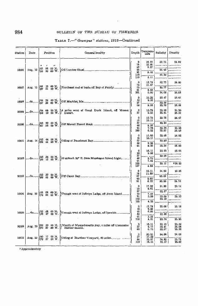
984 BULLETIN OF THE BUREAU OF FISHERIES
TABLE 7.-" Grampus" stations, 1913-Continued
Station Date Position Oenerallocality Depth Tempera· Salinity Densit)·ture
--- ---------
}on Lureher Shoa!. _____nn__n____n_mnm___m_\0 12.22 32.75 24.8\}
0 , rr 18 10.\}5 ---_ ... - ..-- ~---------
{43 56 00 N. 46 l}. 67---·33~42·
... .......-_..._..10006 Aug. 12 66 50 00 W. 55
"---S~44'--- ..------
III •.. ·33~39· ----------110 ----------11\} 6.11 --------_.. - ..--------
}Northeast end of basin 011 Bay 01FUndYh'~""""'\0 12.78 32.75 24.80
{44 13 00 N. 18 11.67''''32~77'
----_ .._---1oo\}7 Aug. 13
67 21 00 W. 55 '---'S:OO' ....--- ....---\}1
201 6.00 .. ··34:09· .. ···20~85
{.0 10.28 32.47 25.01
10008 ••.do..... e4 24 00 N. }Oll Machias, Me......................... '" ......... 18 \}, 56 --------..-67 2ll 00 W. 27 32. 59
68 ·· .. ·9:ii5· 32.70 ""'25~64
1ooo\} •••do..... {~08 00 N. }4 mUes west 01 Great Duck Island, 011 Mount { 0 12.78 32.38 24.3910 00 W. Desert. 37 \}.33 32.61 25.33
}OftM.~. D.~••oek. _mn_n __nnnnmmm!0 12.78 32.75 24.67
18 10.11 "--32:95' --_..------10100 ••.do••.•• {43 52 00 N. 37 ·"·'s.·5ii' --_..---_..-
67 58 00 W. 4691 7.78 ....33:28· ·....25.·9S
183 6.22 33.87 26.65
}Offinll' of Penobscot Bay............................. \
0 11.115 32.68 24.83
{g 44 00 N. 18 10.11 ....32:92· -------- .....10101 Aug. 14 44 00 W. 37 .. ···9~28· _..--------
46 "--33:20' ----_..-- ..-91 8.50 25.86
}" milesS. "'. E. 'rom MooheganhJ;"" L,gh,------l0 16.11 32.23 23.65
18 9.56····32~66·
......... -- ....... -
{43 34 00 N. 37 •••.. ii~72· ....-- ----_ ...10102 ••• do..... 69 13 00 W. 46 ....- ..------ .._--------
91 7.44
I128 ""'5:S9'
""33:17' "";26:20137 -- ..------- .......... _--- ....
}01f Casco Bay............. n ........................ \
0 16.11 31.83 23.35
{43 32 00 N. 18 11.39 ....32:63· ....---_ ..---10103 ...do..... 69 55 00 W. 37 ••·.. S~05· ....... - _....--
4691 6.72 ""32:83' •••• ·25.·7ii
}T~" west or''''"'''"'''''' oft Eo" """'d-----.l0 17.22 31.85 23.14
18 9.61 ····32.·67· ....------....{43 08 00 N. 37 .. ·..7:33· _..---_ ..---
10104 Aug. 15 70 06 00 W. 46 ....33~oii· ·····26~io91 5.50146 ····Ti3· 33.10 - ....-----_.155 ......... ----- . ..- ....- ..----
}T"""" west or ''''rn" Ledge, .., Ips wicb. -- ---- - ---I0 17.78 32.011 23.18
18 0.83 --_..------ -----_..---10105 ... do.... {42 .48 00 N. 46 6.89 ·•..32~iiii· ----------
70 27 00 W. 55 .. ·..5.·33· _..- ..------91
""32:74' "'--25:95110 4.61
e2 2\} 00 N. }Mouth of Massachusetts Bay, 6 miles off Gloucester { 0 16.11 32.16 23.5910106 Aug. 20 27 \}. 17 32.41 25.0870 37 00 W. Harbor mouth. 69 6.72 32.57 25.56
}Offing 01 Marthas Vineyard, 60 mUes.. _.......... __ • {0 20.83 34.00 24.02
19112 Aug. 22 {40 17 00 N. 37 17.22 ....34~83· •··..25:ii70 57 00 W. 64 15.67110 15.44 35.17 26.02
2 Approximately

PHYSICAL OCEANOGRAPHY OF THE GULF OF MAINE
TABLE 8.-" Grampus" stations, 1914
985
Station Date PosItion General loeallty Depth Tempera· Salinity Densityture- --- ---------0 ,
}oe Northern COO' CoO.UU••m......mu..muu...10 16.83 31.17 22.6
20 9.0610213 July 19 e2 11 N. 40 5.38 '---32:34'
---'-26~ii569 59 W. 100 3.97 32.74120 32.95 . -- ..._---- ..130 4.41 ... _-------.. ----------
}'~I" ,tt Chatham, C,,, Cod••u..u.m...m...:.ml0 17.5 31.80 23.12
20 15.75 ------_..- .. ----------10214 __ .do ____ {41 49 N. 40 7.25 32.25 25.24
69 21 W. 100 4.221 32.92 26.13150 5.12 33.28190 5.53 33.49 26.44
}Northwest part, Georges Bank ______________ •___________ {0 16.68 32.09 23.53
10215 July 20 {~19 N. 20 12.24
-----25~i942 W. 40 10.43 32.8170 9.62 32.88 25.38
}Southwest part, Georges Bank_____ •______________ ~ _____ {0 IS: 60 33.10 23.87
, 10216 __ .do ____{~
,38 N. 20 13.00----33~58-20 W. 40 13.04 25.30
70 10.64 34.88 26.76
}Southwest slope, Georges Bank.. __________________ ------j0 17.3 32.74 23.82
{~20 N. 20 10.64
'---33~60-10217 July 21 13 W. 40 9.15 26.01100 11.80150 10.63 35.23 27.04
0 20.48 34.42 24.3740 17.70 36.04 26.16
{40 06 N. }Contlnental slope, southwest of Georges Bank___•.. _____100 14.87 35.82 26.65
10218 ___do ____68 06 W. 200 10.85 35.32 -----27:07300 9.46 35.14
400 -'---5:25- 34.96500 34.90 27.59
}Southern slope of Georges Punk ___________ ~ _____________ {0 18.90 33.55 23.68
10219 ___do ____ {40 39 N. 20 17.33 .---..- ......... ----------67 28 W. 40 16.00
90 10.28 34.65 -----2ii~ii5
}C~II'~"hl'", soutl ieast or 0 eorges Bankm..u....(0 19.98 33.82 23.94
40 15.35 34.97 25.89
{40 54 N. 100 11.20 35.23 26.9310220 July 22 66 13 W. 200 8.18 35.01 27.27
300 6.90 34.94 27.41400 5.65 34.87 27.52500 5. 02 34.87 27.59
}Southeast slope of Georges Bank ___________ •______ ,_____ {0 16.50 32.74 24.05
10221 •• .do ____ {41 07 N. 40 16.18 34.78 25.5266 20 W. 100 12.00 35.16 ,26.74
160 10.78 35.25 27.03
10222 .. .do ____ {41 20 N. }Southeast edge of Georges Bank __._n_._________.__.....{ 0 14.67 32.48 24.2866 19 W. 90 8.98 34.18 26.50
}Soutbeast part of Georges Bank. _________ •__...._.__ ..... {0 13.33 32.59 24.57
10223 July 23 {41 35 N. 20 10.86 32.63 24.9766 37 W. 40 8.90 32.78 25.41
75 7.92 33.03 25.76
e2 08 N. }Nortbeast part of Georges Dank________•••._.. _____ • ____ { 0 11.11 32.47 24.8410224 •__do ..__
66 57 W. 30 10.76 32.54 24.9255 10.78 32.61 24.97
}'~Ih"" part 01 bW>O north ol 0 eorges D~k.m•• mu I0 15.28 32.16 23.81
40 10.00 33.17 25.5410225 ___do ____ {42 22 N. 100 9.53 34.69 26.80
67 11 W. 150 9.33 35.05 27.12200 8.40 35.08 27.29250 7.93 35.08 27.36
{42 08 N. }Northeastodge of Georges Bank_____ ...,.• __ ._. _____ , ____0 15.28 32.25 23.88
10226 July 24 40 12.60 32.34 24.4366 14 W. 85 6.60 33.03 25.94

986 BULLETIN OF THE BUREAU OF FISHERIES
TABLE 8.-" Grampue" station», 1914--Continued
06
90o
{
Station Date Position General locality Depth Tempera' Salinity Densityture
--- --------_.0 15.11 32.47 24.
\0 , 40 9.30 33.04 2.1.55
10227 July 24 {42 19 N. }Eastem Channel between Georges and Drowns Danks..80 8.91 34.18 26.
66 02 W. 130 8.80 34.78 27.0170 7.15 34.99 27.41220 6.95 35.03 27.47
{42 34 N. }Drowns Bank........................................... {- 0 14.72 32.20 23.9010228 ...do .... 65 51 W.
40 8.35 33.40 25.9985 8.50 34.25 26.63
July 25 {42 55 N. }Northern Channel ...........__......................... {0 11.44 32.01 24.39
10229 41 W.40 6.17 32.38 25.48
1
65 100 5.96 32.92 25.93
19 N • }offing ot Cape Sable..................................... {0 10.28 31.47 24.17
10230 •• •do ___• {~~ 23 W.30 3.03 32.07 25.5650 3.14 32.34 25.77
{43 37 N. }Proflle otI Shelburne, Nova Scotia ...................•..• {0 6.62 31.62 24.85
10231 July 27 64 57 W.30 1.81 31.98 25.59
50 { 1.91 }1.97 32.20 25.71
}.m.'.......___........___.___ --.... ---... _..-----------! 0 15.00 31.26 32.1240 4.38 31.74 25.23
10232 July 28 {~12 N. 100
i2.88 t 32.88
27 W. 3.45 -_.._- .........
140 5.55 33.64 26.545.76
}--_.eo------------------ ------------ ---._---- -- --- ------ (
0 16.95 31.22 22.8540 7.34 32.96 25.80
{~41 N.
100 7.59 34.16 26.6910233 •••do •••• 58 W.
200 7.74""34~9ii' ..·..27~3i300 7.62
400 5.30 34.92 27.59500 4.98 34.83 27.57
{43 18 N. }Offing ot Cape Sable.................................... {0 13.61 31.67 23.72
10243 Aug. 11 65 27 W.30 7.47 31.67 24.7555 3.51 31.98 25.45
{~22 N. }German Bank..................................__....... {
0 10.00 32.84 25.2810244 Aug. 12 26 W.
30 9.64 32.86 25.3655 9.60 32.90 25.39
}west ot Lurcher SboaL•••••__......................... {
0 14.44 32.52 24.20
10245 ...do .... {~49 N. 40 9.44 33.42 25.8351 W. 80 8.75 33.87 26.29
120 8.54 34.11 26.51
}Dasln Iu offing ot Machias, Me.......................... j. 0 14.44 33.06 24.61
{44 15 N.40 8.35 33.35 25.95
10246 •••do •••• 67 23 W.100 6.28 33.57 26.41150 7.58 34.05 26.68190 8.17 34.47 26.85
{~21 N. }OtI Machias, Me ........................................ {
0 10.44 32.52 24.9610247 •••do .... 28 W.
30 8.97""32~8r '---'25~4760 8.88
}OtI Mount Desert ROCk___••••___....................... j 0 13.33 32.6Ii 24.52
{43 46 N.40 8.45 32.97 25.63
10248 Aug. 13 67 58 W.100 7.18 33.51 26.24150 0.04 33.64 26.49190 8.34 34.49 26.84
}Eastern part ot basin.......___.......................... j 0 17.50 31.91 23.06
{~17 N.
40 6.38 32.74 25.7410249 ...do .... 40 W. 100 5.31 33.06 26.12
150 604 33.55 26.41220 5.83 33.48 26.41
0 13.05 32.52 24.48
10250 Aug. 14 {~39 N. }offing ot Penobscot Bay................................
40 8.59 32.92 25.5749 W. 100 7.04 33.24 26.04
145 6.26 33.39 26.27

PHYSICAL OCEANOGRAPHY OF THE GULF OF MAINE 987
TABLE 8.-" Grampus" stations, 1914-Continued
73
28581
57
SO9
97o7
37
762
27755
63o8
M
48
66
66
528
83
882
45
o53
4341
18
ation Date Position General locality Depth 'I'empera- Salinity Densityture------
0 /
}Offing of Casco Bay_____•••.••__.••. _.u __._._ ...••••__{0 16.56 31. 92 23.
10251 Aug. 14 {43 27 N. 40 5.65 32.38 25.569 39 W. 100 4.41 32.70 25.9
145 4.93 33.24 26.3
}01f Isles of Shoals •• ______ .n____ ._..__ .. _._.__ . ___ ._.__ . {0 16.22 31. 64 23.1
10252 Aug. 15 e2 57 N. 40 7.80 32.39 25.270 18 W. 90 4.64 32.56 25.
130 3.66 32.79 26.0
}Offing of Gloucester •. __••. __ . __ .••• _____ ._. __ u ____•••. {0 18. 89 31. 29 22.1
10253 Aug. 22 {42 29 N. 40 6.47 32.29 25.370 18 W. 100 4.64 32.43 25.7
140 4.49 32.50 25.7
}B"~ _. of C.", .......______.______...___u ______ 10 20.00 31.55 22.1
40 5.75 32.43 25.510254 _••do •___ e2 37 N. 100 4.36 _u·33:42·69 38 W. 150 5.51 26.3
200 6.80 34.11 26.5260 7.09 34.23 26.8
}central part of basin ____ •__n •• __ • __ .·U.__ .h.•...h __1 0 19.17 31.89 22.6
{~27 N.
40 7.81 32.52 25.310255 Aug. 23 100 3.95 32.81 26.0
30 W. 150 5.13 33.33 26.3175 6.24 33.87 26.6
}Southwest part of basin, offing of Cape COd--------.---l
0 19.56 31.80 22. 4
10256 {41 55 N. 40 6.57 32.38 25.4•••do •___ 100 4.24 32.88 26.1
69 25 W. 150 5.38 33.51 26.4ISO 5.68 33.64 26.
10257 Aug. 24 el 39 N. }01f Chatham, Cape Cod ••••__ •• _._. __••••.• ____ •••••___ { 0 20.00 32.05 22.569 49 W. 25 6.80 32.09 25.1
10258 {41 03 N. }on profile running southward from Marthas Vlneyard._ {0 111.72 32.16 22.7
Aug. 25 70 51 W. 15 14.29 32.43 24.130 12.09 32.52 24.
10259 eo 34 N. } ••••do •••___• __ •• __ .n._••••••••• ___.•______•••_._ •• _____ {0 21.95 33.69 23.2
••• do •__•70 46 W. 25 14.83 33.53 24.1
55 9.67 33.60 25.9
} ....do ..._._•• __•• __ ~.__--•••----------••._•• __ •••• _.__•• {0 22. 89 33.78 23.0
10260 Aug. 26 {40 03 N. 40 13.67 34.09 25.570 41 W. 100 11.63 35. 23 26.
140 11.45 35.41 27.0
}•• __do..-.--- ••••-- -- •• -' .-.----- ___un.•_______...- •• __1 0 23.50 34.11 23.1
10261 {39 MN, 100 13.06 35.46 26.7•• .do _•• , 200 11.99
70 43 W. 300 9.91 ----35:i6· "'--27:i450 7.26 35.16 27.
} •• __do......... ____•••___ •••• ______................ -"'-- {0 21.89 33.64 23.2
10262 -••do .,__{40 02 N. 40 13.07 33.89 25.570 26 W. 100 11.34 35.14 26.8
lSO 10.35 35.26 27.1
10263 Aug. 27 e1 12 N. }._••do. __•• , ___ •• _. -...---•••_.._••_._._ •• -••••---.--- •• _. { 0 17.89 32.12 23.170 57 W. 17 13.30 32.45 24.3
{~09 N. }Olt northern Cape Cod. ______ ••••_. __ ._._.._••• ___•__•• _. {
0 16.67---"25~O0264 Aug. 28 30 7.34 32.05
00 W. SO 5.65 32.48 25.6
at
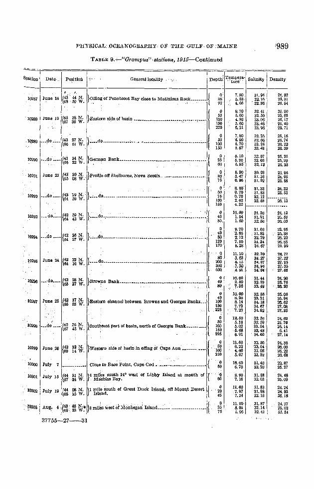
--TABLE. 9.-Grampus stations, 1915
=====c===;====;===================;====r===p===r====o
10266 May 4 {~~ ~g~. }Offing of Gloueester;...... ._.__ ••• _••••__•• __ {
10267 May 5 {~~ ~~~. }B!lSln. offing of Cape Ann.. •• _•• m _.m._.•._. {
o50
130
o50
130260
6.11 32.323.55 32. 683.55 32.81
6.10 33.035.00 33.154.69 33.176.59 34.02
25.4426.0126.11
26.0026.2326.2726.72

988 BULLETIN OF THE BUREAU OF FISHERIES
TABLE 9.-Grampus stations, 1B15-Continued
7062
00
82982046
78931319
29531246
424443
475570
5480123448
r
176775
087076
00920319
558498
7513
242124
07579613
26
-8778
34.48.67
.76
.14
.51
.62
StatIon Date Position Oenerallocallty Depth 'I'empera- Salinity Densitture--- ------
0 ,}center of gulf near Cashes Ledge ______ •___________ ..____ {
0 6.10 32.79 25.10268 May 5 {42 51 N. 50 4.78 32.81 25.
68 43 W. 100 4.47 33.04 26.190 5.60 33.53 26.
}central part of basin___• ______________ •_________________ {0 4.40 32.50 25.
10269 May 6 {43 04 N. 50 4.28 32.68 25.67 56 W. 100 4.44 32.95 26.
185 5.82 33.22 26.
}East side of basln ____________ ..____ ._.._______ . ____ ..____ {0 3.60 31.78 25.
10270 _•• do ___• {43 14 N. 50 3.04 32.03 25.67 07 W. 100 3.90 32.86 26.
190 5.95 33.58 26.
e3 26 N. }oerman Bank__• ______________.. _.__• ___ •____•• _____ • ___ { 0 3.00 31.89 25.10271 May 7 66 28 W. 35 3.24 31.94 25.
70 3.27 31.94 25.
e3 52 N. }Near Lurcher Shoa1...._____• ____ •__• ___ •__•• _. __....___ {0 3.90 32.05 25.
10272 May 10 66 41 W. 50 3.42 32.09 25.90 3.60 32.30 25.
}Northeast part of basin, ofllngof FrenchmansBay ______.! 0 4.70 32.23 25.{44 05 N. 50 4.81 32.57 25.
10273 •__do •• __67 32 W. 100 5.10 33.03 26.
150 4.98 33.28 26.225 6.28 33.66 26.
{44 13 N. }1O miles off Petit Manan Island. __•••_......_... __••• ___ {0 4.20
--"i25~10274 ___do ____67 51 W. 40 ..-- ... ----_. 32.20
80 3.97 32.23 25.
10275 May 11{~
09 N. }5 miles east of Great Duck Island. __._u.______ . ____ •___ 0 4.40 31.51 25.09 W.
{43 44 N. }Offin g of Penobscot Bay, close to MatinIcus Rock._•••__{0 5.00 31.80 25.
10276 May 12 68 50 W. 40 4.22 32.34 25.80 4.22 32.43 25.
e3 32 N. }Offing of Casco Bay •• ----_. _______• ____ •__•__•• u __..... { 0 7.80 29.58 23.10277 May 13 69 46W. 50 4.18 32.38 25.95 4.15 32.45 25.
}TrOugh between Isles of Shoals and Jeffreys Ledge __ •••• {0 7.80 32.03 25.
10278 May 14 {43 00 N. 50 4.04 32.63 25.70 12 W. 100 3.45 32.70 26.
175 3.70 32.114 26.
{42 17 N. }Mouth of Massachusetts Day, off northern Cape Cod •__{0 10.00 31. 89 24.10279 May 26 70 07 W. 40 5.20 32.68 25.
70 3.82 32.68 25.
10280 May.31 {43 45 N. }a miles off Pemaquid Pclntc, , __ ._••__• ______ •___._._____ { 0 6.90 31. 56 24.69 32 W. 25 5.56 31.83 25.
{~48 N. }Orand Manan Channe1.. __u __•.. __•••______________..._{ 0 4.40 31.82 25.
10281 June 4 55 W. 40 4.63 31.82 25.80 4.58 31.83 25.
0 6.40 31.89 25.10282 June 10 {44 25 N. }Day of Fundy Deep between Orand Manan and Drier { 50 5.71 32.41 25.
66 32 W. Island. 100 5.20 32.83 25.180 5.25 33.06 26.
}Northcast part of basin In offing of Machias, Me ...._____ {0 5.40 31.98 25.
10283 ._.do • ___ e4 15 N. 50 5.27 ---------- -----25.67 23 W. 100 5.00 32.70180 3.54 33.00 20.
{44 09 N.}12 miles off Petit Manan Island _.__u._ .•• ~--..--- ..---.- {
0 5.40 32.07 25.10284 June 11 07 54 W. 40 5.11 32.21 2580 5.14 32.45 25
10285 June 14 e4 09 N. }5 miles east of Great Duck Island, olfMount Desert Island. 0 8.00 31.70 2468 09 W.
{43 59 N. }OtI Mount Desert Island.-----.- •• _. ________ u ..__ u ____ t{ 0 7.50 32.10 2510286 __.do • __ •08 15 W. 40 5.44 32.30 25! 80 5.18 32.41 25
I Approximate.
PHYSICAL' .oOEi<\NOGRAPHYOF THE OULF: OF .,MAINE \989
T ABLE 9:+-"Gram.PU8"'8tation~,·191§~Continued
270254
214
0057
401
64
229
593
65
68
253
3
33
03
582
8599
7522
55
6lI
206
20
06946208
[;
264
4114
360022sa8727
4809
249318
--IiUon Date" Position ", Generall9ClIllty .. Depth: TemJera. Salinity IDensity"'t e"
----I. I
}?JllngOf Penobscot Bay close to Matinicus Ro~k_...._.~ {0 7.80 31. 94 24.9
10287 June. 14 e3 44 N. 35 ,.U~ 32.16 25.368 50 W. 70 320'86 25.6
}Eastern side of basin --...---- •• --- •• --...--~t.-~...r--.-l0 9. 70 32.41 25.
{~3 28 N. 50 5.60 32.50 25.6Q2ll8 JUlie 19 100 4.86 33.06 26.167 30 W. 150 5.60 3:1•.46 26.
220 6.21 33.95 26.7
}____dOn_._.__• ___cc .. ,_ .••_c.c ••__......~".,,_._•..• ___~__ {0 7.80 32.25 25.1
1Q289 •• ~~o _~•• {g 27 N. 50 5.90 32. 66 25.751 W. 100 5.70 33.24 26.
150 5.87 33.48 I 26.3
{43 24 N. }Germ~n Bank_____•••_•• _____ •____....._. __• ____••.__•__{ 0 6.10 32.07 25.210290 ._.do ..._ 25 5.90 32.09 25.266 22 W. , , 60 5.85' 32.12 25.3
{43 2oN. }protlle off Shelburne, Nova Scotia f 0 8.90 30.93 23.910291 Juno 23 30 3.47 31.36 24.965 08 W.
. __....._.n__._.____. l75 0.96 31.92 25.
}.c__dOn._....._......;___.._. 'm._n_... __......_.....'_j0 8.60 31.83 24.3
19 N.50 0.70 31. 83 25.
10292 ___do __._{~ 75 0.70 32.1259 W. 100 2.02 32.68 26.1
150 4.32 ..--- ~-_ ... _- ._--_ .........
... do,.___ 59 N . }_._.d().;.~ .... .;___............___"_ •• __...____•••.,__~_~ { ,0 10.00 31. 36 24.1
10293 {42 40 1.54 31. 91 25.564 43 W. 85, 1.60 32.50 26.
F...do.v., •• --.-.•.- ___. ___ •• _.____._u.______..._. __.... \;0 9.70 31. 06 23.9
{42 36 N. 40 2.85 31.83 25.310294 ...do .... 80 2.12 32.79 20.264 27 W. 120 7.50 34.34 26.
170 8. 28 84.67 26.
}..-. do.; n·_ -----.---..-- .- ...-.....----.------••-.------.10 11.10 32.39 24.
{42 22 N. SO 3.63 84.27 :17.10295 Junll 24 200 8.15 34.97 27.264 16 W. 300 ,7.30 34.94 27.3
500 4.91 .. 34.114' 27.
{~28 N. }Browrs Bank•• _... __..._._........_u.._..~---...-~-.-.- { 0 10.00 31.44 24.
10296 •• ~do.._. 40 2.80. 32.29 25. 737 W. SO "'.30 33.49 .26-'I
}.~ ehannel".-.'row", and G~~~""••l 0 10.00 82. 56 25.
{42 17 N. 40 8.20 33.31 25.10297 June 25 100 8.14 34.18 26.66 03 W. 150 7.72 34.67 27•
. 223 7.2Q 34.92 27.3
"
}.,,,"'.... part of basin, north ,f Georges Bank••••••_ ••! 0 12.50 32.56 24. 6___do ____ 50 IU8 32.59 25.7
10298 {42 26 N. 100 5.02 33.04 26. 167 45 W. 150 5.68 33,48 6-- .. 225 6.91 34.60 27.
}Western srde of basin in oillng of 'Cape Ann _. __~_______ {0 13.60 32.50 24.
10299 June 26 {42 32 N. 50 0.22 33.04' 26.69 14 W. 100 4.60 33.08 26.
210 5.67 33.82 26.
Close to Race Point, Cape Cod _. ___._._______ •___•_____ {"
10300 July 7 0 16.60 3'1.40 22.---_ .... ~-_ ..-- 50 6.70 32.20 25.
10301 July 15 {44 31 N. }4 miles south 24° west of Libby IsIBlld at mouth of { Q 8.00 31. 58 24.67 24 W. . Machias Bay. 60 7.16 32.03 25.
08 N. }1 mile south of Groat Duck Island, oft Mount .Desert { 0 11.60 31. 83 24.10302 July 19 1144 20 7.97 31.98 24.
\68 15 W. Island. 45 7.24 32.16 25.
}a miles westo! M:onhegari Islaud L;......._. ______ .:. __ {, 0 11.60 31.87 24.~0303 Aug,' 4 {43.· 40N.• 35 S.01 32.14 25.69 23 W. 75 5.96 32.11 55.
Bt
37755-27--31

990 BULLETIN OF THE BUREAU OF FISHERIES
TABLE 9.-"Grcimpus" stations, 1915'-Continued
IDepth Te~:ra. Salinity DensityGeneral localityPosItionStation Data
-===;====;====;=============;====;=====j'===;===-
-----1----1-----------------1.--------
10.a05 II Aug.18 {44 08 N. }I mile south of Great Dnck Island, off Mount Desert {, 2g68 15 W. Island. 50
10306 Aug.. 31 {~~ ~~~. }Mount of Massachusetts Bay. off Gloucester.....- .•-.-- { l~g140
10320 Sept. 29 {43 25 N. }MaSSlichusetts Bay, 11 miles off Gloucester Barbor {,70 33 W. mouth.
o " j10304 Aug.6-7 {~~ ~~~. }Eastem side of basin ......m.u ... m ...... __ ..... •
""" .. .co "n' {:: :: \:;. )B.....m., .W""A""'n n n n n\
10308 Sept.' I {:~ ~~. }NearCashes"": - --.- {
I
10309 •••"do ••• {~~ g~~. }centralPart of basin ~ m :.-• ._I
10310 Sept. 2 {~~ M~. }Eastern side ot basln _ : {
10311 ...do - ••• {~~ i?~. }German BanL...__ __ _•. _m __ •• {
10312 __.do , {~~ ~~~. }9 mUes off Cape Sable _ _. {
10313 Sept. 6 {~~ •.~~~. }11 miles off Cape Roseway, Nova Scotia _._ {
24.8925.4226.0626.7127.15
24.4524.7725.09
22.8925.35-25.6025.68
23.3925.6126.2026.3226.6226.92
23.8825.2525.9726.58
23.9925.2326.1126.5026.47
24.4225.76
'26.2526.110
24.9524.9525.05
23.6424.5125.02
22.6824.4725.6225.92
23.0824.8225.7526.1226.2626.42
24.9325.3525.74
24.8224.97
24.7424.88
24.2024.sa25.28
32.5232.5933.0333.69
32.4732.6633.1033.6033.60
32.4132.8833.2634.3:1
32.2332.4732.50
31. 4931.7332.00
30.7030.73:12.1632.43
31.2231. 8232.3433.0133.1233.40
32.883.'l.1933.42
32.3032.43
32.5032.52 I
32.3032.2732.56
32.6332. 6733.1233.7334.16
31. 9432.0532.34
31. 2432.3932.5032.57
32.4732.8133.1233.2833.7534.23
.. ~ ·~nrl-····~f~31. 91 24.48
; :~: I ~t:t
11.408.266.224. 786.89
10.809;378.79
16.10,7.245.975.78
17.607.775.015.105.706.36
15.809.026.36
,5.63
15.509.445.725.775.98 .
13.307.055.567.10
9.4010.2810.10
13.309.407.38
15.003.383.332.22
i5.007.893.304.955.005.05
12.2011.2010.00
10.289.95
11.6010.95
13.60110.10
8.61
15.5010.508.50
10.50110.70
7.00
oso
100150200
o50
100150200235
o4090
165
o50
100150210
o50
100100
o3065
o2550
o205070
o255075
100150
o5000
o60
o28
o3570
o'25
50
o3570
j" miles•• Cape no s,N:" 800..n 1
_ ,\~. d'l ' . t,'
}NearLurcher Shoal _•• _... _..._....._••._.. ......n_•• {
}2 miles south of Libby Island at themouth of Machias {
Bay.
}3 miles south of Swans Island. Malne..._•• : ..... {, '. -. (
}4 miles southeast of Monhegan Island •.;.••_.. _. {
}3 miles off Wood IsJand.Malne __...... __.... ~ ••. , __ :. { ,
49 N.44 W.
32 N.22 W.
05 N.26 W.
28 N.16 W.
43 N.·17 W.
{~
{4467
{~
Sept. 161{~~
Sept. 20 H~
10318
10317 Sept. 15
10316 Sept. II
10315 Sept. 7
10319
..10314 •••do _... {~ ~g~.
I Approxlmato only.

PHYSICAL OCEANOGRAPIIY, O:&' THE GULF OF MAINE
TABLE 9.-"Grampus" ,stations, 19~o;-Continued
Station I Date Position General lOCl/llty ,
._----------,---------- ---
25.32
,,25.24
25.0025.0225.46
24,'4524.6626.03
.24.75
25.4525.5025.62
32.75327432.77 '''''25:2632.66 25.2432.7032.79
32.4732.5632.84
32.0732.2533.06
32.2132.2532.5032.5732.60
32,65 24.5332.74 24.6232.9733.68 """2[iii
33.86 25.00
31.38 23.5431.60 23.80
32. JO 23.8832.14 23.89
32.32 21.1632.4532.92 24.78
32.21 24.5332.39 25.31i32.81 25.7933.22 26,26
32.41 24.6332.00 25.70
~~: ~ ''''~2~:45
;:, 1:':1
31.80 24.25
31.73 24.1931,83 ±24. 1lI
32.0024.5532.0332.41 24.76
.31. 89 '24.3631.9,132.14 24.68
31.82 24.3232.20 24.89
31.91 24.4382.2032.43 ..•..26:38
.32.09 206
11.00 .9.40,
10.80
7,28
15.50
.11.'JO,
,J3. 00'
. 10.50•• ~' .. _':' ...... .L.
9.39
11.40
11.22
13.4012.95
: 11.40
u,::~,~.117.206.78
11.607.336.400. 28
11.907.61
'-h'5:~ii~
o
o3570
o ll.40
o40
o 114.4030 14.50
0' ,:'13.902550 13.10
o 13.3025 13.200080 'n.ss
}Mou th of Massachusetts Bay, 8 miles oft' Race Point, {
Cape Co(l. , , "
}Olose to Race Point, Cape Ood •• •__••• • ._. __ {
}Ofting,Of Penobscot Bay, close to Matinicus Ro('k __• {
}2mile~ eastward or Eaitern Point, OlouOO8te~.n .
}on profile off west end of Marthas Vineyard n • {
}Pll pr6file off west end of Martbas Vineyard ••••• ~ ••••_. {
{42 04 N.70 16 W.
{42 g4 N.
1~ 70.37 W.
22 {41' 19, N.70,.55 W.
Sept.29 {42 10 N.70 22W.
, '
{42 17 N. }' • ,,{
...do •••• ":" W'I MOO,""M.~_",Bay, ,ff C'" c .
... do ._._ {i~ t~ ~'. }Mout~ of Massachusetts Bay, elf Gloucester _••• m __ ._.!
10328 ...do •••• {~ n~.. }3 ¥~i~~~d~outh of Great Duck Island, oly Mount Desert, i
10333
°2040
o25
o4080
'04080
120150
{43 00 N. } { 5g10325 Oct. 4 70 12 W. Trough between Isles of Shoals and Jeffreys Ledge, ---... 100175
1'5gl10326 __ .do -•• _m' ~i~: }17 miles off Cape Ellzabcth..._. m_....m.:~: ...,-.{ ~~g
1,0327 a 9 {H 32 N. }2 mUes south of Libbey Island, at the mouth of Machias {ct. ' 67 20 W. Bay, .
II' 'p'
10324
10323
10322 Oct.
, . {40 51 N10332 _••l1p,.,, __ 70 55 W·.
10321
10331 Oct.
,10334 do , •• _ {~f:gg ~. }e_•• .do,__._ .. __...._.. - - ...- """"" •. - ••• , .••• -•.••--.
!{41" 26 N }" " ,,' ; ,10335 Oct. 25 '70' 17W. ~mey~rd Bound •••• ..... _•• _ .• -- .. __.• h_•• _ •••••~.n :
10~36 Oct. 261m- ~~ ~. }About3 miles eft' Chatham, Cape oou., ..... _':'__ " __ ' {{', ~g
10337 {42 05 N }MOUth of Massachusetts' Bny, 8 miles off. Race Point, 3°0
•••do --·-1 70 18 W. Calle Cod. 00 '-~'iq:W
,10338 0 t 27 {42 19 N. }Mouth of' Massachusetts' Bay, midway between Oapc {c . 70, ',30 W. Cod and Gloucester.
{
10g30 Oct., "
l Approximate only.

992
0 16.96 32.47 23.6150 4.86 33.08 26.19
100 _ 7.65 34..36 26.86200 7.65 34.92 27.23300 6.76 34.87 27.61400 6.15 34.87 27.67600 4.,10 I 34.00 27.76
0 16.00 .._---_....- .., ,
0 13.61 32.27 24.1830, 8.71 32.63 26.3370 6.07 32.86 25.88
0 11.95 31.73 24.0830 10.97 32.14 . 24.57
0 16.11 31. 78 23.2930 .12.,14, 32.14 24.36
0 17.78 30.00 22.1925 14.28 31.68 23.52
'0 16.95 31.27 22.7020 7.89 31.89 24.9743 4. 91 32.06 26.57
0 10.00' ' 31.71 24.4130 9.18 31.91 24.6960 6.43 32.41 25.4700 6.43 32.56 25.71
120 5.23 I 32.59 25. 76
}~•••do', .......~ •• ~_ _-r->-__~'.' __...__••••• __••• " •• {
__ .do {~ :g '~" }~ dO~- ••• --.--- •••_, •••••.•••••••••., {
{40" s7 N }' : {July 26 70. 18 vi. ~._.dO•• __ •• __ __ ••• __ ••••m.__ ~_ __•••••
_•• do .;__ {~~ .U~. }....dO,_m.m _m_••• _.__ .._m._. __._.:.m_m~_ •• .,{10357
10356
10355
.:'l.I1'. j!>OOll;'.,", slopesouth""." Georges Dank ••••• ..•..·110353 July .:25. {~, M,~, }J;>roflle running southeasterly from Marthas Vlneyar<i. __
i}0362 __ .do ~•.• {~
statl6Ii' :,Data
; -:General localitY Tempera~: Salinity' IDensityPosition Depth
ture I------ ._---- --- ---,---~-----
. 1 . ~ '. I
{42 32N. }Mouth of Massachusetts Bay, 3 miles off mouth of { 0 11.1151 ' 310 18' 23.6610340 'July 19 78 38 W. Gloucester Harbor. 25 6.49 310 87 25.04
50 5.19 32.00 25.29
{0 16.39 30.48 22.22
, '10341 __ .do •••• {42 18 N. }Mouth of Massachusetts Bay. midway between 25 5.08 32.03 25.3370 27W. •Gloucester and Cape Cod. 50 3.00 32.20 25.59
80 3.67 ---------- ---- -- ..---
e2 07N. }Mouth' of Massachusetts Bay, 4 miles off Race PoInt, { 0 17.22 30.61 22.1310342 __ .do •••• 70 17 W. 30 7.73 31.58 24.65
Cape,Cod. 60 6.14 310 87 25.08
, { 0 15.83 30.75 22.55
10344 July' 22 {~OiN. }omng of northern Cape Cod ...._.........., ___ ." ....__ 25 4.91 32.10 25.4159 W. 50 4.07 32.20 25.58
. I 80 4.19 32.38 25.71
}omng;of Chatham, Cape Cod ••• ___.__• __•• '.mmm•• {0 10.00 31.53 24.27
10345 _••do ....e1 52 N. 50 4.17 32.25 25.6169 40 W. 100 3.85 32.66 25.96
150 4.06. 32.86 26.10
{41 27 N. }Ollin~'Of southern angle or Cape Cod.. _..... _____•• __ ._. {0 7.22 32.03 25.07
10346 __ .do __..69 22 W. 30 6.41 32.07 25.21
60 4.47 32.38 25.68, ,
'10347 {~{)6 N. }~orth~est side of Georges Benk•• _........:.... ____ m .•• {
0 11.39 32.54 24.81July 23 51 W. 30 10.91 ....32~ir "'--24~8i60 9.61
{~4Q.N. }west side Georges Bank.......__......__._........m ••• {
.0 11.67 '32.54 '24.7510348 _..do .... 21 W.
25 11.34 ....................- •••.. 24~8650 11.26 32.67:.
~""""'"'' Georges Bank.......................: {
0 17.60 32.47 23.49
{4O 16 N. 30 10.36 133.8610349 Ju!y 24 68, 06 W. SO, 7.16, 132.47
"'''27~iii180: 6.75 ,34.42'ISO ' 6.72 34.83 27.34
}....do.:.........:...............................:...I 0 16.66 32.47 23.93
{~06'N. 80 10.66 --..33~42· .....--------
,103.61 ...do .... 67 W. SO 4.82m_'26~g5130 5.88 34.20
ISO 7.13 34.'72 '27.20
-, 10398 Aug. 29 {~~ ~~~. }Offnorthem Cape CoL......m ....m ••• _••••••m {
_ 0"." {;ll1l1'}M'","" Massachueetts Do,. ,ft Gloucester..• ... ·.....lI These two water samples probably were transposed,
PHYSICAL OCEANOGRA,PHYOF THE GULF.O;F MAINE 993
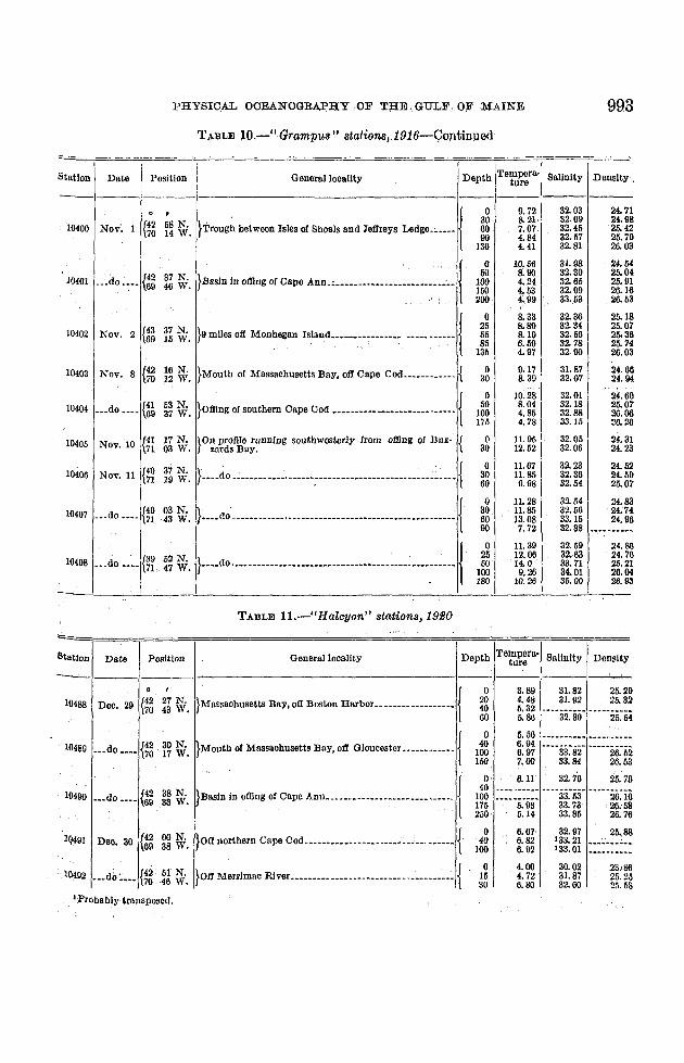
TABLE 10.-" Grampus" euuione, 1916-Contirmed
8661
0493
18293
44
63
87643
64
o7
066
13
297
8346
- ~~_.
atlon Date Position Oeneralloeallty Depth 'I'empera- Salinity Densityture
------- ._-----0 ,
}Trough between Isles of Shoals and Jeffreys Ledge.; ••• ~I 0 9.72 82.03 24.7
{42 68 N. 80 S.21· 32.09 24.910400 Nov'. 1 60 7.07. 82.46 25.470 14 W. 90 4.84 32.67 26.7
130 4.41 32.81 26.0
}BGSln In offing of Cape Ann_~•• n"U__'U_"'h.n••:."'{
0 10.66 31.98 24.5
{42 37 N. 60 . 8.90 32.30 26.010401 __ .do •••• 100 4.24 32. 65 25.9169 46 W. 160 4.63 32.99 26.1
200 4.99 33-.63 26.6
}9 miles off Monhegan Island ••• __......... -"" ••••••10 8. 33 32.36 26.1
{43 37 N. 26 8.89 82.84 25.010402 Nov. 2 56 8.19 32.56 20. 369 16 W. 85 6.59 82.78 25.7
186 4.97 32.90 26.0
0403 Nov. 8 {42 16 N. }Mouth of Massachusetts Bay, oil Cape Cod•••• ______ ._ { 0 9.17 31. 87 24.670 12 W. 30 S. 39 32.07 24.9
}offing of southern Cape Ood ......................_•• __• {0 10.28 32.01 24.6
0404 _udo •• _. {41 63 N. 50 8. 04 32.18 25.069 37 W. 100 4,86 32.88 26.
175 4.78 33.15 26.2
0405 Nov. 10 {41 17 N. }On profile runnIng southwesterly from offing of Buz- { 0 11.95 32.06 24.871 03 W. zards Bay. 30 12.62 82.06 24.2
{40 37 N. }~...dO u ••••••••••__•••••: ••••n .....................~ __ • {0 11.67 32.23 24.5
0406 Nov. 11 80 11.85 32.36 24.671 19 W. 60 9.98 82.54 25.0
}....dO·._u ......n ....u ...___•__n •• _u ................. {0 11.28 32.04 24.
0407 ___ do •• _. {40 03 N. 30 ·11.85 32.66 24;771 ·43 W. 60 13.08 33.16 24.9
90 7.72 32.88 ........ - ......._...
}:...do .•n.u................ u ........n ...........__ ~... j 0 n.39 32.69 24.
e9 52 N. 25 12.06 32.63 24.70408 ••• do •• _. 71 47 W. 50 14.0 33.71 26.2
100 9.26 34.01 26.180 10.26 35.00 26.
--
St
TABLE ll.-"Halcyon" stations, 19£0
tlon Date Position General locality Depth Tempera' Salinity Densityture
---------.-0 ,
}MaSSGChusetts Bay, oil Boston Harbor............_..... {0 3.89 31. 82 26.29
0488 Dec. 29 {42 27 N. 20 4.48 31. 92 25.3270 43 W. 40 6.32
60 5.86 32.30 26.04
}Mouth of Massachusetts Bay, oil Gloucester ............ {0 5.56 --_............... ............ ---..
0489 ••• do .... {42 30 N. 40 6.94""33~ii2'70 17 W. 100 6.97 26.62
... 160 7.00 33.84 26.63
}Basin In offing of Oape Ann....................... """ j 0 6.11 32.76 25.76
(42 38 N. 40 ---... --- ..-""33~53' -----26~i60490 ••• do .... 100
69 33 W. 176 .....5:93· 33.73 26.68250 6.14 33.86 26.76
Deo•. 30{~ 00 N. }OtI northern Cape Cod .• _••• _......._.....~.c.,......... {0 6.67. 32.97 26•.88
Q491 40 6.82 133.21 ".,. ,
38 W. 100 6.92 133.01 .......................
{42 51 N. }Off Merrimac River ......................... _........... {0 4.00 30.02 23.86
0492 .._do~... 16 4.72 31. 87 25.2570 46 W. 30 6.80 32.60 2,1.58
. 1
Bta
=
. 1
--
.'':PrObBblytransposed.

994 BULLETIN OF THE BUREAU O}' FISHERIES
TABLE 11.-" Halcyon" stations; 1920-Continued
24.7925.6925.66
25. it25.7725.80
31. 4132.6:;32.79
32. so32.7432.7i
5.836.116.11
5.566.237.31-
o4075
o4075
_· h_._.._{
.. ~ ...-------_. -~.- -~-_._----_.-{
Staiionll~~~~I_~os~t~o:_:_ General locality Depth Te~:ir~ra'l~alinitY Density
0' i { 0 5:83 32.60 25.7
10493 iDee. 30 {i~rg ~'. !}'rrOUg~l between Islesot Shoals and Jeffreys Ledge • I~ ~: ~~ --~-ii2'-8ii- -----25'-78i i 150 6.95 32.87 25.78i I
10494 I, do m~~~. :I}?II Wbod Island, Me ~ -----
f r _ I
104'" I Dec' 31 {4:J 39 N. '}Otl S . I I duo • 6936 W. i egum san --------I ,--!
TABLE 12-"IIalcyon" stations, 1921
=r==-----------
25.6325. eO25.96
16506 .__~o;_._ {42 '52 N.70 ,47 W.
10507 ___ do ____ {43 22 N.70 08 W.
10508 __ do ___ ._ /43 39 N.\69 38 W.
" {42 44 N.v 69 55 W.
3.33 --_._-. __ . ----------3. .52 ---- ----- .---------3.63 _.._-- ---- ----- -----
, 2.22 32.18 25.722.37 ----25.-862.55 32.39
I. 67 31. .54 2.5.241. 81 32.08 25.66
2.20 32.35 25.863.01 32.47 25.883.12 32.47 25.87
1. 67 32.32 25.862. ·12 32.80 25.802.52 32.41 25.88
10503
10504
10505
Jan.
{42
Feb. 9/ 70
{42
Mar. 4 70,
}n"," in offing or 00," A""..mm 1
_~~ ~'. }H~ miles oil Eastern Point, Gloucester. __ • {
27 N. } {44 W. Northside, Massachusetts Bay. off Bakers Island.. _
}Off Merrimac River, __ .. ..., .. _.__ • • {
}OII Cape Porpoise, Me .. .~ .. . {
}Off Seguin Island ._ . •__ .. {
o40
100150200
o2040
o2040
o25
o40
100
o3060
5.565.796.537.5,'5.29
32.5132.7032.93:l3.7533.95
24.8124.8524.87
25.4225.3625.(;826.1226.61
25. (,825.7925.8626.3626.83

PHYSICAL OCEANOGBAPHY O;F THE GULF OF MAINE 995
TABLE 12-"Halcyon" stations,1921:--Continued
1 {42 42 N.0510 do ---- 60 45 W.
10509 Mar. 5 {~~ ~g~.
10511 ._ .do m, {~~ 1~ ~;.
~ L _
_.--- - -- - --,-_. ---~-_. -- -----.- -- •. - --
I .General locality Depth Tempera-I Salinity Densityture .
----~ -------
}Trough between Isles of Shoals and Jeffreys Ledge______ I{0 3. \lO 32.85 25.79
40 4.10 32.79 25.73100 4.32 32.86 26.07175 4.38 32.99 20.17
. 110 3.60 32.49 25.8.~
40 3.00 32.47 25.84. . I100 4.10 32.65 25.93
}nasin in offing of Cape Ann __ u _______________________ "_, 150 5.50 33.12 26.15175 6.50 ....-.... ~ ....-..- .. -~ .... ... ..--225 5.50
-"--26~9:i250 4.63 33.99
}Mouth of Massachusetts Bay, oII Gloucester----------..l{0 3.61 32.64 25.97
40 3.84 32.70 26.00100 3.85 32.76 26.04
I '. I 150 3.86 32.70 26.00._-
PositionStation Date
TABLE 13.-" Halcyon" stations in Massachusetts Bay, August, 1922
Ii7
92
15o6
595e
on l Date Position General locality Depth 'Tempera- Salinity Densityture----------------------
0 ," 17.80
{42 06 00 N. }2~ miles oft Race Point, Cape Cod________ •___ -.--- { 0 31.20 22.521 Aug. 22 70 17 00 W.
18 13.00 31.61 23.764 6.20 32.18 25.3
,
{0 18.00 31.21 22.3
{42 22 00 N. }Stellwagen Bank, midway between Cape Cod and 18 9.20 31. 86 24.62 ._.de •__ •
70 26 00 W. Gloucester. 27 7.70 31. 98 24.973 4.50 3,2. 37. .25.6
{0 18.70 30.99 22.0.
{42 32 00 N. }Mouth of Massachusetts Bay. 4 miles off Eastern 9 18.60 31. 00 22. 03 .• .do __ .~ 27 8.40 3I. 96 24.8
70 35 00 W. Point. Gloueester. 55 5.40 32.23 2b.4
6 Aug. 24 {42 30 00 N. }Near Halfw~~ Rock, oft Marblehead. ___ •___________ { 0 15.80 31.09 22.8170 46 00 W. 11 11.30 31.53 24.0
27 7.00 31.99 25.0
7 _._do •___ {42 26 30 N. }Near Egg Rock, elI Nahant. ______ •____ .--- "_",_n __ {0 15.30 _ ... __ r ____ w _________
70 53 30 W. 18 9;80 - ...._-- .._-- - ..........._-_ ..
8 e2 23 00 N. }Oft Boston Harbor______ •__ n. ____________ • _________ { 0 17.50 30. 9.~ 22.33j'
..--- 70 48 00 W. 27 8.80 31.87 24.73
9 _._do ••• _{42 16 30 N. }Off Minots Light_______•__________________ ._•. _.___ { 0 16.,00 31. 02 22.5070 47 00 W. 15 13.90 31.20 23.30
{42 16 30 N. }Oft Scltuate_n__ .. __________ , __• :. _________ n _____~. {0 18.40 31.04 22.15
Q ._.do __.. 15 16.10 31.35 22.8870 35 00 W. 51 5,60 ~2.25 25.45
1 ...do .n_ {42 07 00 N. }Oft Brant Rock____________ . ______________ •____ •___ • { 0 17.80 31.04 22.3170 38 00 W. 15 10.30 ----_ .....-- ~-------- ..
2 ___ do ,_._ {41 56 30.N. }Oft Manomet____________________________ n _________ { 0 16.10 31.10 22.7670 32 00 W. 18 13.20 -- ..--_ ...._- -----............
3 _._do on. el 40 30 N. }cape Cod Bay, oft Sandwich __ n ______.._n _______ • {0 17.80 30.97 22.26
70 26 30 W. 15 12.10 31.38 23.80
4 ...do ..._{~& 46 00 N. }cape Cod Bay, olf Barnstable Harbor. ______ •_______ { 0 18.30 30.91 22.1110 30 W. 13 17.90 --.... ------ -..--------
___do "'J~A liS 00 N. }Mldwa y between Provincetown and Plymouth __n_l{0 18.10 31.00 22.26
5 13 17.9021 00 W. 42 7.20 31.95 ---·-25~ii2
1064
1063
106.~
H)ea
1064
1064
1064
1063
1064
1063
1064
1063
,1063
Stat!

996 BULLETIN OF, THE BUREAU' OF FISHERIES
TABLE 14.-" Halcyon" stations, 19139-19134
Station Date Position' General locality
-------------1------
10646 Apr. IB, 1923 {i~ ~~ ~.~. }Mouth ofMassaehusetts Bay•••••m •• m.m•••••m ••• __•__'.__ •• _{
10647 •••~.dO•• m ... {~~ ~g ~~. i}OffNauset, Cape Cod m.m•••• __._•••• m •• m •• __••••• m {
10647 Apr. 27,1923 ' Rose and Crown Shoal _ __ ••• ~. .I
0 2.8037 1.6080 .32
0 2.8027 2.0064 2.20
0 3.30
0 11.7027 7.4455 6.88
0 12.8037 7.5891 4.40
128 4.7B165 5.36
0 16.1027 9.8646 6.85
0 18.10 .37 4.2873 3.55
118 3.45
0 17.2046 4.9982 3.09
118 2.90155 2.97
0 2.2018 1. 8037 1.7973 1.77
0 10.6018 6.2537 3.5855 3.1373 3.13
0 16.7018 6.8037 4.6073 3.84
0 10.00\I 10.50
18 10.5027 10.40
0 10.8018 7.4337 6.9155 6.1791 5.57
0 15.6018 12.5046 5.4873 3.98
0 15.6018 12.3237 6.4573 4;34
0 14.4055 7.05
0 11.1024 10.65
0 10.8018 9.8037 8.7055 8.9891 8.1B
) .do n -- j} ,do •••••_••••..••••••••••__ _•• __ __ •• {
~ ~" )Off Bakers Island, near Mount Desert ••_._•••••• _n•••• {
~ ~_ ~oa Mount Desert ..,.---n----_-----------------_---nn---un--l
gg ~. i}WhfStleBuoy, off Cape Elizabeth,•• m ••m._••••••_.n.. . __ m •. {
~~.1}25 miles off Cape Elizabeth. •__• ••• m .... {
\':: ~_ !)oa moo~t~n-------------n---------:---n-------------n-----l
}8 miles off Eastern Point, Gloucester .... ~.....~._. ......... __ •••. {
gg ~'. }Nantucket Shoals•••••_ _.•• _•• __ __ ••• __.•• {
n~. }7 miles off Great Duck Island, Mount Desert ••• _ j~g ~i. }8 miles off Eastern Point, G1oucester .; __ •••• , __ {
~~. }m.dO. .....__,.m~ .•.m •••••-- ••• - ••• ~•••••••••••••••mm~.:{
}JeffreyS Le"dge,., _,.".'.'••• ".'••".''''''''.''•• ''_.' {." }
..............,. {1~ miles east-southeest (mag.) from White Island off Boothbay {'garbor, Me.
{~ ~ gg~. }7 miles off Great Duck Island, off Mount Desert.. •• j
Aug. 7, 1923 fig ~i
{42 30Aug. 9, 1923 70 17
I
.....do {~Z ~
IAug., 5, 1923
I Aug. 6, 1923 {43 5267 54
10652 Mar. 19, 1924 {42 27 00 N.70 36 00 W.
10653 June 6, 1924 {42 27 00 N.70 36 00 W.
10654 July 12, 1924 {fa 26 30 N.37 OOW
10655 July 15, 192~ {41 2269 32
10656 Aug. 5,1924{~ 04
07
10657 Aug. 23,1924 {42 2670 36
10664 Sept. 6,1924 f42 2670 37
10667 Sept. 29, 1924
I
'10665 sept. 18, 1924 H~ ~~ ~~.I
10666 ' Sept. 24, 1924

PHYSICAL OCEANOGRAPHY OF TI:t:g Gth.F OF MAINE 997
TABLE 14.---"H at&yo~1l 'stations,1923'-1924'~Continued
o8
oo86
StatIon Date Position General locall ty Depth Temperature
---0 , "
'10668 Oct. 3,1924 {~ mile northeast (mag.) from Little Duck Island, ot! Mount Desert, { 0 11.7- ....... _---_....... -......Me., " " 27 10.0
}8 miles south (rnag.) from Eastern Point. G1oucester.......______ •• _ {0 11.7
10669 oct. 15,1924 {42 26 30,N. 18 11.470 37 00 W. 37 10.0
73 6.7--~.._---_._-~----- -_._.- -_._- -- .. -
TABLE 15.-Ice Patrol stations, 1919 (from Coast Guard Bulletin No. 11,1924)
Sta· Date Position General locality Depth Temper. Salinity Densitytton ature
-~ ----------0 ,
}Otllng of northern Cape Cod ____ ------ ._.________________ ~--I0 4.50 32.43 25.71
e2 06 N. 27 3.65 32.29 25.681 Mar. ,28 69 52 W. 55 2.90 32.48 25.90
77 3.75 32.61 25.93101 3.80 32.66 25.97
10 4.70 32.72 25.92
{42 23 N. }_•• _. do __~___•• __.. ____ •• _______,_,_._..____ , __• ___••_.~ -...-.40 3.90 32.68 25.98
2 Mar. 29 69 03 W. 80 3.05 32.66 26.03121 4.45 32.77 26.00161 5.25 33.46 26.45
}East-central part of gull ---. __• ______________• ___.._.._____1 0 0.00 31.87 25.60
{42 51 N. 55 3.70 32.62 25.953 ___ do,', ..
67 32 W.110 4.75 33.58 26.60165 4.75 33.84 26.80216 4. 75 ............._....... --..------ ..
}Otll:I!g of northern Cape Cod._m..__•___•__m ..___• __m.__{0 4.70 31. 29 24.79
19 Apr1128 e2 06 N. 27 5,15 31.71 25.0769 52,W. 64 3.75 31. 76 25.26
101 3.75 32.09 25.52;. .
r'0 ·4.90 (I) .....................
{~23 N. }_.__ .do, ____•__ •• __ •____________...__ •______...----•• --' -..-. 37 4.85 --_ ...... _- .... -- ....------
20 ___do __..03 W. 1
73 4.85 -_ ..-- .......... - ..----.........110 4.80
: ' . 146 4. 35ro-- ............ - -- ..~--_ ......
.. ...- ..------
" 0 4. 60 31.98 25.35;!t· e2 51 N. }Ess.t:cent~al part of gulf m __m_n_'__ ---m----m---·;,~---l 55 3.65 32.38 25.7621 ___ do _•••
67 32 W.110 4.45 32.~, 26.11
. , 165, 4.40' ......._-- ........ -_.........- ....220 ---------- ---- ._---~ -_ ......-----
}Ge~an Bank..._______• _____•• ____m_.____.___.__.__ .m__{ 0 2.70 31. 71 25.30
22 ___dO·_··I{~~ 17 N. 18 2.90 31.71 25.2920 W. 37 2.70
55 2.75, 31. 71 -....25.·30
10m., of nortbern 0.,. 0.'---------------..---------------110 9.30 31. 53 21.37
{42 06N.35 6.05 31.80 25.05
35 May 29 69 52 W. 70 4.30 82.02 25.41" 104 4.00 32.48 25.80
139 4. 05 32.68 25.96
. . .1 0, 0.00 31;SO 24.63. r{42 23 N. }_...do..-..--.- .------- ---- -.---- .-----.----.-----...---- ----I 55 4.60 33.16 26. 2836 u_do .... 110 4.75 33.16 26.27
69 03'W. 165 5.40 33.48 26.44220 5.60 33.91 26.76
,
110 7.80 31. 96 24.94
ez 51 N.' I 60 4. 30 32.49 25.78
37 u_do _•• _ }East-CODtfal part of bssln.; ....._.______..__._. __________ ...-; 121 4.95' 33.50 26.5167 82 W. 181 6.06 34.29 27.01
, I242 6.15
--~----- ..--- ..-~--- ...-0 4.20 31. 67 25.14
38 May '3,0 {43 17 N. }German Bank__•____ ••••__._ :..___________._ .....---....----!{ '27 4.20 31. 71 25.1766 20W. 55 4.20 31. 76 25.21
82 ------ .._-- 31.80(.~,~.~-""I f';' ..-
I Salinities for this station are omitted because Irregular. They are given In U. S. Coast Guard Bulletin 11, 1924, p. 104.
37755-27-32

998 BULLETIN OF THE BUREAU OF FISHERIES
TABLE 16.-" Albatro8s" station8, 1920
Generul localltyStation Dato I Position Depth 'r:~~~:r- Salinity Density
---'--11---1------------1----.-----0 4.44 -'--34:45' ·--·-2ii:iii50 9.76
100 12.39 35.18 26.67
20044 Feb. 22 {40 07 N. }Continental slope southwest of Georges Bank _n ____•___ 200 12.39 35.27 26.7368 03 W. 300 10.91 35.32 27.06
I 500 7.24 35.00 27.411000 4.21' 34.90 27.70
I 1400 3.112 34.112 27.75
I1800 3.62 34. 90 27.77
}Southwestem slope of Georges Bank _n'___._n_______ .\0 5.00 32.34 25.511
20045 __.do ____ I{~g 18 N. 20 4.511 32. 92 26.0909 W. 50 9.40 34.42 26.61
100 12.35 35.34 26.79
___do ---1:l150 11.55 35.25 26.89
}soutbwestern part of Georges Bank. _n _____ n__..______ \0 5.00 32.34 25.59
20046 38 N. 10 3.37 32.38 25.7821 W. 40 4.50 32.77 25.98
le~50 7.11 .._--_. ---- --..--_ .......-70 8.03 .. _--~----- -----._ ...--
20047 08 N.}Western part, Georges Bank ------------------.n-------i{ 01 4.44 32.39 25.69
i Fnb. 23[68 35 W.~g I:::::~::::
32.38 ... ....--......--32.47 ,---- ---.--
I I)""OWM' part or 00"'. 'MOb " "'M," Boo. ---------1
0 3.33 32.47 25.86
20t>48 41 N. 20 3.48 32.47 25.85ImdO ----1m 49 W. 50 3.49 32.47 25.88
75 3.55 32.43 25.81
I 100 3.54 32.49 25.86
I150 4.87 32.97 26.10
}B,,'. ,n .,,;,~, or C'PO A"___nn ---- nnn _____ un_unI 0 3.33 32.52 25.93I 20 2. 79 32.61 25.94
20049 1-··dO ---. e2 30 N. ,0;0 2.79 32.62 25.9669 35 W.100 I 3.04 32.54 25.94
I 150 5.66 33.40 26.37
\
200 5. 63 ,33. 78 26.611
,
}M"lh or .......use.. Boy "" 01,.,ester__ n ___ n ____ \
0 2.50 32.35 25.83I e2 30 N. 20 1.95 32.34 25.87
'lOO50 : Mar. 1 70 18 W. 40 1.89 32.36 25.89! 100 1.62 32. 34 25.90
! 150 1.68 :32.39 25.94
10';;1 IMar: 1-2 e2 31 N. }Mouth of Massachusetts Bay......__n___ nn_n..____.n (1) -- ........- ......70 09 W. .""_.._----- ---_ ..- .....-
}N ea Casbes Ledge ____n --- --- - ----- - n --- n - _n n ------10 2.62 32.49 25.94
20 2.24 32.52 26.0020052 Mar. 2 {42 43 ~ 40 2.48 32.52 25.98
68 41 , 100 2.47 32.52 25.98150 3.60 32.66 25.97200 5.24 33.44 26. 43
)s,.,heas """ o basin --- ------------ -- ---- --- n - n -----I0 2.78 32.04. 25.97
20 2.20 32.59 26.0620053 Mar. 3 e2 45 N. 40 2.34 32.57 26.02
67 28 W. 100 2.28 32.61 26.05150 4.90 33.87 26.81225 5.39 34.36 27.15
}B_ ID ,m"" Mount Desert Book__ n ______ n ___ ----I0 2.50 32.41 25.88
20 1.84 32.39 25.92200M ...do'.___{43 15 N. 40 1.84 32. 39 25. 92
67 45 W. 100 1.77 32.41 25.94175 5.40 33.75 26.67250 ,5.48 34.00 26.82
}to mlles ,ft Moo.' Desert Rock, n_ - -- --- n _m - - _n ----I0 2,50 32.38 25.86
20 1.85 32.39 25.92,2<\055 •• "do '_" {43 42 N. 40 1.82 32.41 25.93
67 MW. 100 4.39 33.16 26.30150 5.46 33.77 26.64220 5. 59 33.91 26.74
}6 miles 011 Great DUc~ Island, off Mount Desert Island, {0 1.15 32.21 25.82
20066 ___do •••• {44 05 N.~I
0.60 32.29 25.9168 08 W. 0.49 32.23 25.87
100 1.95 32.48 25.97
1 Current stattou, see U. S. Bureau or Fisheries, 1921, p. 166.

PHYSICAL OOEANOGRAPHYOF THE l,jULFOF MAINE 999TABLE 16..:» Albatrqss," stations, ,19.eO",-CoJ,ltinued
Station Date Position General locality . Depth Tef.Fr:m• Salinity Density
0 2.22 32.39 25.8920 1.91 32. 40 26. 9340 1.91 , 32.41 25.9375 t89 32.41 25.93
1,25 2.00 32..43 ,25.94
0 1.39 31.31 25.0915 0.68 32.00 25.6745 1.43 32. 34 26. 90
0 1.11 32.09 25.7220 0.47 32.10 25.7740· . fll1 '--'32.'32'90 .33 25.83
0 1.39 32.28 25.3620 1.25 32.27 25.8640 1.28 32.30 25.8800 1.15, 32.30 25.89
0 1. 30 32.2-----25~8020 .851 32.1740 1.33 32.34 25. 91
100U~ ....~~~~~_ 25. 92
165175 4.26 32. 91 , 26.12
0 .78 32.14 25.7820 .65 ""a2."i6· ""'25:'8250: .33
0 1.10 32. 00 25.65
0 ~.2O: 32.43 26.92
0 2. 20 32. 65 26.10
jg ~:~~, '32.61 26.'9532.59 25. 95
35 3.09 32.66 26.0395 3.05 32. 63 26.02
140 4.30 33.16 26.31100 4.63 34.61 27.44,
0 8:50 32.84 '26.,1420 2.80 32.83 26.2040 2.73 32.84 26.26
100 3.18 32.95 26.26150 4.26 33.66 26.71200 4.32 34.69 27.52265 4.24 34.76 27.60330 4;.02. ' 34.78 27.63
0 3.61 32.63 25.9720 2.97 32. 66 26.0440 2.95 32.65 26.0380 2. 73 32. 69 26.20
0 3;33\ ' 32. 57 25.9420 2.78.: 32.'61' :26. OS40 2.73 32.61 26.0270 2.53 32.69 26.02
0 3. 05 32.68 26. 0620 3.07, 32.68 26.0640 2.83 32.75 ·26.1400 2.80 32.79 26.17
0 3.33 32.65 26.0020 2.00 32.06 26.0540 2.92 32•.66 26.05
100 11.56, , 82. 83 26.13150 4.40 33.86 26.87100 4.92 , 34.23 27.09
} ',' _ -..'..--..} __ ._. __.n•• '. __••• n ••• _ h __ "._••__•••••
17 N.07 W.
12 N.06 W.
.••do •• -- m__ .do . __ • {~~
20057 Mar.. ,4 {t~ ~~.~. }OIDng or Penobscot Bay.m__ .m._.m.m•.•m ••••m {
20058 •••do •••• {~~ . ~~~. }Near Seguin Island••••• m .•.m m .. __ • __ • • •m •• {
20059 •••do ~••• {~g i~~. }6 miles.off Wood Isl~nd. Me • .•••~ {
20060 ._.do •__ • Hg g~~. }10 miles off mouth or PortsmouthHarbor, N., H __ •• __ {
soeei M". • {~ Ti \:i. }T'OO", 001weenr.;~ ot Bhoals and Jeffrey "'''m.mI20002 ._.do . H~ ~~~. }Mllssachusctts B,ay, off Boston HarbOl;~••••-.-:" ••••'".••;~. {.
?iar. 10 {~~ ~ ~'. }centrnl part, Massecbusetts Bay ._ _•. _ .
_I M". U {:i ~ \1;. },.,,,iern old." busln ..m m m .
I
~641 .••d'O '.'" {~~ i~~. }~~utheastpart of basin north or Georges Bank ••n __._•••
. I .
{41 02 N.
20068 •••do .... 66 20 W.
20067 Mar. 12 {~~, ~~ ~'. }S?utheast part, Georges nall~""'-'__-~"7h-"-""".' {
}Sou"~01 ""PO .J G,"~. B,,'..'.,~, ..'"" .,•...... ,1
20065 ••.do.:._. {~~ ~g ~;. }Northeast part, Georges nank.. h .. __ {
" .
. 20066 ••••••.,•• {~~ ~~~. }East part, Geol'~es Bank. __~·~~_·~~.~~ •. •• ~._ {

100b BULLETn,r 'OF 'tHE BUREAU OF' FISHERIES
TAi3im ,16.l-t1 Albatro'ss" stations, 1920-Col1tinued
3.33-m32~7ii' -·-·-2ii~i43.11
. 7.09 33.86 26.527.01 34.63 27.155.92 34.67 27.324.73 34.67 27.464.32 34.71 27.544.26 34.81 27.623.77 34.92 27.71
3.05 32.66 26.042.78 32.67 26..062.74 32.66 26.062.59 32.70 26.10
3.33 32.81 26.132.90 32.83 26.183.15 32.86 26.196.48 34.29 26.956.85 34.42 27.006.84 34.70 27.23
1.95 32.32 25:861;88 32.34 25.872.14 32.57 26.043.40 33.02 26.29
2.22 32.44 25.922.10, 32.43 25;932.10 32.48 25.97
, 2•.52 32.71 26.12
1.39 32.09 25.701.24 32.07 25.711•.10 32.07 25.712.80 32.94 26.264.68. 33.69 26.70'
0.56 31.80 25.530.27 31.83 25.560.45 31.82 25.543.76 33.21 26.40
1.28 32.06 25:690.99 32.08 25.701.20 32.20 25.817.39 ----34;34- .m-2ii~7i8.616.20 34.70 26.915.40, 34.65 27.32
I: 67 32.16 25.751.29 32.19 25.795.82 33.78 26.527.89 34.85 27.206.32 34.85 27.384.23 34.83 27.423.90 34.88 27.72
1.95 32.45 25.951.82 32.45 25.952.12 32.43 2/i.932.67 32.72 . 26.114.59' 33.58 26.62
2.50 32.56 26.002.l4. 32.54 26.012.17 82.53 26.012.55 32.70 26.103.82 33.01 26.294.29 33.81 26.44
1.89. 32.05 25.671.26 32.16 25.771.43 32.25 25.83
1.95 32.32 25.851.76 32.32 25.871.63 32.36 25.002.26 32.59 26.055.07 33.67 26.635.39 33.84 26.73
o20'40
100150215
o204070
0'2040
100150
o204090,
o2040
100150200250
Depth Te'ftfr~ra' Salinity Density'General locality
, I J}•. . . . . ~~gC.onttriental slope southeast of Georges Bank .••n_t 200
, ' , ~gg, '500
1,000
HIT~rtheast edge Georges Hank__n.__.. 00 { .~~90
,:" , I 040. 100
}Contibental slope in offing of Shelburne, N.O.va Scotla•• _. 200, 300
500, ',' 1,000
I0
{42 i:58 N. }Northern Channel between Browns Bank and Cape 20Mar; 20 4065:>48 W. ,Sable. 100
135
f"''''', Doop between Grand " anan and Brier ~l'''''.-I0
2021 N. 4037 W. 100'
150200
21 N. [IL miles east 01 Petit Manan Island.,___................ {0
3037 W. 60
}N"'''''' part o! besln, In .m" ot P,ll' Man an--------10
20
Mar.{~ 44 08 N. 4067 26 W. 100
150200
~78
20081
20072.•~.do~n.{~~g ~'. }Brow~s Bank•••mn•• _.....__• n .......__• ._ ..__C' ~
20070 Mad3 {~~
;~0069 Mar. 12 {~
,0·.; .,'
};,-.do,-- •• -•••__c.-- -.-----.--.---.- c. --------.-----1
St'ation D~te'
'2007'3" M' "7" {43 :'30 N. lOcn profile running southeasterly froin the offin'" ofShel· {ar. 1 65 06 W. r"burne, Nova Scotia. e
<.; .i
'...", ",,"" m~l \:I. }- d. -•••••••••••••••••••••----.-._ •• - ••••••••••--••••-1
; 20075 -.A().;~ .. {~;" ,~~ ~. }~,-.d()-n•••• ---m.--.--- ------m----..-mn.m-- {
-------1-----'

PHYS~CAL OCEANOGRA,PJtY, ,OF THE" ~:H!:r.,.FqI!' ;MAINE
T4BJ.r: '16.-"Albatross ',: stations" ) 920:-Con~in.ued
.
Station Date Position aenerallocalltY Depth Tempera· Salinity Density.ture "------ - ---------
0 , 0 2.67 32.59 26.0220082 Mar. 23 {43 54 N. }Off Lutcher sboal.,..............................__ •__ •• {, 20 2.35 32.61 26. 05
66 53 W. , 1j0 2. 52 32.72 .26. 13, . 120, 3.35 :33.15 '26.40
lOft Yarmouth, Nova Scotia __ """"" __ "" __"::':" {0 1. 95 32.17 25.73
20083 ...do 'h. {43 41 N. 20 1.54 32.18 25.7766 21 W. 40 1.54 32.22 25.79
65 2,04 32.54 26.02". ' . ,.-.-,
e3 18 N. } . . J 0' 2.11 32.16 25.7I20084 ...do .h. 20 1.74 32.16 25.7466 09 W. Off Cape Sable, Seal Island, Nova Scotia •• n •••••••• __•• t
50 1. 81 32.23 25.80
{~17 N. }aerman Bank.........................................c.c.{
0 2.50, "--32.'63' ·... ;26~o;20085 .•.do "n 33 W. ,30 2.4070 2.43 32.63 26.06
0~: ~& /··..83.·10·e3 11 N. }East side of basin ..........................__....... __ •. j 20 26.35
20086 .•.do .c •• 67 12 W. 40 3.39 33.10 26.35100, 4.29 33.63 t , 2(l..69. ' . ", .,. '170' 5;III 34:00 26.00
0 3.05 32.49 25.9020 2.74 32.56 25.98
{42 .37 N. }~cst side of basin, In offing of Cape Ann •. n •••nh "'.__
40 2.74 32.54 25.9620087 Mar. 24 69 27 W. 100 2.80 32.63 26.04
. 150 ., 5.37 33.53 f.49200 5.39 34.05 .00250 5.06 34.22 27.05
"}:Off northern Cape COd...... m ........... _ ....c.•• , .••• j 0 2.50 32.36 25.85
e2 15 N. 20 2.20 32. 39 25.902OQ88 .••do •••• 69 54 W. 40 2.20 32.44 ·25.93
100 3.61 32.92 26.19180 4.97 33.58 26.58
}.Mass~chusetts Bay, off Boston Barhor •.•..•.. ____ .. __ c.,{0 3.05 31. 25 24.92
20089 Apr. 6 {42 26 N. 10 ' 2.39 31. 26 24:9770 '43 W. 25 ' 2.31' ' 31.30 25.02
60 1. 49 32.31 20.08
}MOllth of Massachusetts Bay, alI Gloucester ••• __ • __ ..._! 0 3.33 32.36 ·2,~.:76
{42 30 N. 10, 2.50 32.34 25.8320090 Apr, 9 70 19 W. 30 2.42 32.34 25.83
00 2.34 32.47 25.96120 2.25 32.48 25.91
i
~~91 I...do.•.. {42 43 N. }JetJreY5Ledge, off Cape ADD................. __ .;- ...... 11 0 3.33 31.'97 25.4670 22 W. 20 2.48 32.08 25.60
60 2.50 32.45 25.91
" lOft ,.'<rim" '''''000Om ..moO 0 Om m 0"mom 0 c.. II 0 3.05 81. 01 I 24. ;220092 •••do-••••e2 49 N. 20 !n94 .., .... 0.:.............. ..~_~~ ..i~:.:h
70 87 W. 40' .45 ................... ....................80 2.35 - ........ - ..- ...... _oo ......... ----
}WesterDslope of Jeffreys Ledge............... __ .•••-- •..110 3.05 31.112 25.45
{42 57 N. 20 2.42 32.02 25.5820093 ___do ....
70. 07 W. 40 2.26 .32..85 • 25..85100 3.59 32.81 26.10' I 160 4.29 33.10 26.25
0 2.78 32.16 25.66200114 Apr. 10 {43 08 N. }Platts Ballk.__•__•• ___ ..... _h"hn•••• _ •••__.,••,, __ ., {
20 2.34 32.17 25.7660 40 W. 40 2. 46 32.41 25.89
so 2:82 82.56 25.97
..i~ ~'1}7 mil: off Wood Island, Me, ..........~................. {
0 3.05 30,07 23. G720090 ••do •••• {43 20 2.71
''''32~~r'- -25~ii770 40 2.25'\lO 2.22 ,;....... - ..---- ..~-- ..-..-_..
..(43 ~~ ~. i}Near Seguin ISland ............................... __ .... {
0 2.78 29. 941 23. 892()()OO ••do •••• 69 20 2.02 31.60 25.28, , CO 2.39 32. 41 2;).89

1002 BULLETIN OF THE BUREAU OF FISHERIES
TABLE 16:_" Albatross;' stations, 1920-Continued
Station Date 'Position General locality Depth Tefu~:ra. Salinity Density
II \:i. jom.;. Penobscot n.,uommnm.:.::m uom.···ll
.:i \:i )0' Moo.' Desert noo'nmnuon;u.nuomm!lI
20099iApr. 12 m~g~. }OtI Petit Manan Island•• _••••••••_.••.•.••••• _._•.• -··I{
, ' I .. {44 09 N. } Ir20100 1--' do ..,,_ 67 '26 W. Northeast part of basin, in offing of Petit Manan Island "1
I
20101 • __do·,_ •• {~ ~~. }OtI Lurcher ShoaL•••..•m •••• m """'--""---~"ll
,." {4342 N. } . {20102 A~r. 13 66, 21 W. OII Yarmouth, Nova Scotia.__. __ .. .••__: .•••.••: ••
0,2040'
100125
o2040
100150210
o~I
7: I153595
11.5191;225
o20,40
100110
o20'4060
3. 33 32. 43 25. 832. 40 '32.43 25. 902:13 ... __.• ,_. ",,_,,__,
~: i~ -"'33,'26' .•.. -20'-37
3.O.~ (32. 39 I 25. 83
~:~! I::::~~:~~:!:::::~~:~;4.01 33. S9 I 26. 845. 28 . 34.22 27.05
3.61 31. 46 I 25.032.23 31.90 I 25.502. 34 32. 38 I' 25. 862. 60 32. 56 25. 9U
3. S9 32. 49 I 25. 82~: g~ 32. 59 I 25. 9S
4. 50 ~~: ~~ i ~g: ~~5. 06 33. 98 ! 26. 895. 12 34.061 26.955. 14 34.09 26.00
4.28 32.891 ·26-,103. 39 32. 94 26. 22
~:g~ :__ ..::~~~...n.:~~:~4.71 33.78
1
26.77
3. 89, 32. 36 25. 72ng n--32.-56- "'··25~iiil2. 83 32. 56 25. 97
3.89 32.74 26.02a.35 32.72 26.003.44 32.79 26.113,46 32.79 26.11
3.05 32.32 25.772.80 32.34 25.802.83 ·32.38 ; 25.82
3.61 32.43 25. SO3.61 32.42 25.803.11 :l2. 77 26.123.16 32.83 26.16'3.: 15' 32. S4 26.17
3.61 32.72 26.03
3.40 I 32.74 26.063.35 32.73 26.003.32 32.75 26.09
3.33 32.34 25.753.lO! 32.34 25.77a.21 I 32.56 25.945.RIj'1 33. S6 26. fJ87.45 ! 34.59 27.0li6.07 I 34.69 27.32
i
4.17
132.5S 25.87
3.62 32.59 25;943. OS 32.60 25.98
3.1fJ I 33.05 26.29
4.17 32.65 20.923.63 I 32.M 25.98
3.54
132.65 25.1l9
4.22 33,46 26,566.47 34.52 27.13
3.S9
1 32. 67 1 25.973.54 32.70 26.023.42 32. 69 1 26.033.59 32.70 26. ell
o204080'
o204090
o15
,45
o2035951~5'\
'~~ ~. }Browns Bank.••.• . __•.•__, •• .•••••••••••• -» {20106
I0
2020107 ... do...... {~~, ~~~. }Ellstcrn Chanuol, between Browns and Georges Banks.•,' Ifill
I 170" 240
20108 .:.do ••• , {~~g~ ~. }Easte~n edge or Georges Hank...•.•.•. _. . ._ •• ,JI'{ ?,glao
2010~ ••:do •••, {~~ "~ ~'I}southellst slope ,.f Oeorges BlInk ...• _...'.. ._. .... lll'J~]50
. 20110 I·..do •.•. {~~ ~~ ~ I}Eastern part or Georges Bank:...•_. .. m ... _ ••••• {" ~~ I~ .Ii.80;
,20103 Apr. 15 {~, ~g~. }Oerman Bank ••• •__.•_ __ • •. ,__ _•• {
'20104 __.do m_ {~~ ~~~. }South or monde Rock, off Cape Sable.•.__.m. m'_'m {
20105 ...do '_" {4652
li8 N. }Northern Channel, between Cape Sable and Browns !58 W. Bank.
" ,
J

PHYSICAL OCEANOGRAPHY OF THE GULF OF MAINE 1003
TABLE' 16.-" Albatross" stations, IBSO-Continued
--_._- ._---_._-~==--=---_._-_._--------
Station T'empera- .',
Date PosItion Gcnerallocallty Depth tnre Salinity Density
- ---_. ---------------
}Ea~tcrn part of Georges Dank .•n .........·.............. {0 4.17 32.60 25.88
20111 Apr. 17 {41 09N. 20 3.02 32.01 25.11406 43W. 40 3.76 32.61 25.93
70 3.75 32.04 25.95
}SOO,"_'= part ol basin, north 0< 0"".. n"k..; u __ j0 -'3.61 :J2.54 25.89
20' 3.39 32 52 25.90
{42 :l:!.N. 40 3.26 32 ~o 25.9420112 n.do •••• 67 02 W. lOO 3.15 32 80 20.18
175 5.22 34.5U 27.33225 4.00 34.70 27.50290 4.71 34.70 27.50
, 'I0 3.33 32. 50 25.88
20 2.88 32.47 25.9020113 ...do •••• {42 53 N. }Central part of busln.............................. ~ .....1
40 2.93 32.48 25.9067 37 W. 100 4.32 33. 51 26.59
165 5.16 34.23 27.07230 5.16 34.43 27.23
I 0 3.33 32.41 25.81
{~41 N. }Near Cashes Ledge.................................... ..r! 20 3.28 32.45 25.85
20114 .••do .... 40'1'1'. 40 2. 91 32.43 25.87. ! 100 4.12 33.19 26.36
I 175 4.00 34.18 27. 05I
Ij0 3.61 32.45 25.81
20 3.33 32.48 25.8737 N.
. I 40 3.20 32.47 25.8720115 Apr. 18 {42 }Western side of basin, in offing of Cape Ann'~""''''''''1 100 3.02 32.80 26.1569 33 W. 150 5.38 33.69 26.62
200 6.30 33.93 26.68290 4.9:.1 34.34 27.19
I
{42 03 N • }Off C.,. Coo ","M" u_u_ u - --- --- -- u u u u ---- - - -II 0 3.61 82,14 25.5720116. .••do .... \69 38 W. 20 3.60 32.14 25.57
40 3.13 32.16 25.63tOO 3.42 32.79 26.11195 4.25 33.91 26.91
I.. 1 0 3.61 31.87 25.3620U7 ...do 'n. {42 09 N. }Off northern Cap" Cod .. n .............................. r
20 3.13 31.86 25. 4069 58 W. 40 3.00 32.08 25.58
I R.~ 3.:.14 32.78 26.12
e 61 N. }Cape Cod Day ••.nn......___ ...... n .................. !{ 0 4.44 31.55 25.0220118 Apr. 20 70 18 W. 15 3.76 31. 52 25.01
28 3.46 31.50 25.08
..18 N. {
0 3.61 31.43 25.0120119 ...do .... {42 }Massachnsetts Bay, mid WilY between Cape Cod and 20 2.87 31. 66 25.18
70 28. w.. Gloucester. 40 1.58 32.03 25.6590 I. 78 32.29 25.84
0 6.39 29.16. 22.935 6.12 29.11 22.93
21 N. }Moutli of Massachusetts Bay, off Gloucester............10 5.88 29.17 23.00
20120 Muy '4 e 15 5.110 20.18 :.13.0070 25 W. 20 4.67 29.55 23.42
30 4.52 31.13 24.6950 3.96 31.36 24.93
............................. _..... \{70 2.72 ~_.- ..-.....----_.-----
{42 27 N. }.~•• do.......... -- ....0 5.66 29.08 22.96
20121 •.•do : ••. 30 3.92 30.99 24.11270 25 W. 60 2.39 32.24 25.76
If 0 7.22 28.26 22.1~
5 6.54 28.45 22.35
I 10 5.61 30.59 24.14
{42 49 N. 15 4.42 31. 17 24.7220122 May7-8 }Ol'! Merrimac Rlver................ _ •.• _............... [ 20 4.18 31.24 24.8170 37 W. 35 3.10 ··..az,·i7· -- .._------
I50 8.·13 25.6365 2.43 32.25 25.7685 2.30 32.38 25.86
e2 ~~ ~. !}MassaChusetts Bay. of! Boston Harbor .• n ..............i{0 8.89 29.94 23.20
20123 May 16 7020 4.83 30.72 24.3055 2.35 32.18 25.73

1004 BULLETIN.. OF THE BUREAU OF FIS:B;ERIES
TA.BLE ~6,~" Albatross" stations, 19BO-Continued
ID~Pth Tempera] Salinity
~
~-
Station Date Position General locality Densityture------ .. 1-0---------
0 I 9.72 29.87 23.0220124 May 16 {42 28 N.
}Mouth ~f Massachusetts Bay, oII Gloucester -- .-- ·-----I{ 1~ 5.12 30.77 24.3370 18 W. 2. 89 32.07 25.58
2.65 32.45 25.00
}OlI Cape Cod hlghlands....._________ •____________ •___._!0 9.17 30.25 23.40
{42 00 N. 20 5.73 32.07 25.3020125 ••• do ____
69 41 W. 40 3.78 32.34 25.71100 .3.58 32.92 26.20140 4.04 33.21. 26.38
}Olllng of southern Cape Cod 00"-----•.---------.---.-.--10 8.33 31. 53 24.52
e1 39 N. 20 5.00 32.16 25.35!Ol26 May 17 69 22 W. 40 4.30 32.54 25.82
100 3.60 32.81 26.10160 4.10 33.49 26.60
}BaSin east of Nantucket... ____ oo.___.. ______ .• -- ---··... 10 7'22 31.89 24.93
{41 ,20 N. 20 5 '75 32.24 25.4620127 •• .do "n 40 4.1069 06 W. 100 3.80 "0032.'88' n-0026~i4
145 3.80 32.98 26.24
M~. r}33 miles eastward from Nantucket Shoals Lightship__ •___ {0 7.78 32.48 25.35
20128 ...do .... {~20 5.55 '32.47 25.6340 5.40 32.47 25.66
g: \11. ~"''''''~ ta edge oa Nan""" Shoals n ................ j70 5.04 32. 50 25.71
0 7.78 32.61 25.45
eo 10 7.50 32.61 25.4820129 ••.do _.n
69 30 .5.30 32.7-/. 25.8790 7.32 33.84 26.48
160 8.24 34.72 26.96
TABLE 17,--,,11 Fish Hawk" stations in Massachusetts and I pswichBays, December, 1924., to June, 192.5, . [For key chart, see Bigelow, 1926,1Ig.9J
Sta·tion
2
3
- - - ~ . -Tem. Salin· Den·Position General locality Cruise Date Depth pera-ture: Ity slty
------ ---0 6.75 -_ ..._.._-- ...-- ..----
2 Dec. ~1, 1924 33 6.79 ..- .............66 6.85 - ..........-- _... __ ....--0 5.95 -------- ......__ ......
3 Dec. 16,1924 28 5.97 -----_ .... ..-- .... _..-56 5.95 ---.._--- --------0 4. ::g .............- -- ..........
4 Dec. 22,1924 33 4.6 ..-- .._..-.. ......._----0 I II 64 4.00 --- ..._..-- ..- ..........-
{42 12 00 N. }Mouth oUhe bay, 10 miles oII Race Point, Cape 0 4.05 -------- --_..----70 23 30 W. Cod. 5 Jan. 6,1925 32 4.01 -------- ........... __ ..
64 4.15-i32~il7- "'26~290 2.00
6 Feb. 6, ~925 32 1.81 132.00 26.3263 3.10 132.83 26.18
j0 2.10 132.75 26.19
7 Feb. 24,1925 32 1.83 132.71 26.2864 1.00 133.07 26.460 2.40 132.94 26.32
8 Mar. 10,1925 33 2.14 132.98 26.3865 2.05 133.12 26.50
1
0 6.50 ............-- -_ ....... -_ ..2 J Dec. 11,1924 13 7.50 ................. -- ----_.
26 6.55 -------- - .... -----0 4.10 -------- ......__ ......
11 Apr. 7,1925 30 4.08 .------ .. - ..............60 3.40
'i3i~7i' -'-25~oii0 5.50{42 09 30 N. }Mouth of the bay, 7 miles oII Race Point, Cape 12 Apr. 22,1925 17 5.49 131.62 24.9770 19 30 W. Cod. 33 3.79 132.50 25.83
0 8.50 131.47 24.4313 May 21,1925 15 8.14 131.36 24.42
30 5.15 13l.69 24.940 12.13 32.38 24.57
I 14 June 17,1925 10 12.05 32.38 24.5620 9.23 32.52 25.0330 5.06 33.17 26.13
'From hydrometsr reading.

PHYSICAL OCEANO(>BAp,HY 9:F THE GULF. OF MAIKE 1005TABLE 17.-:-" Fish Hawk" stations in Massachusetts and Ipswich, Bays, December, 192.kto .rune,
1925-Continued .
---------------_.__..__._------'--===~~~~=.,=--=.._=;===;-'==
Station POsition General locality Oruise
TernDepth pera
tureSalin- Den-
Ity" slty
--1------1------- -----------------...------- [-----[--------- ---r 0 6.70 ... __ ............ ------ ...-
2 Dec. 11,1924
{31 6.42 -- ..----- ....---..-~62 6.00 ~---- .. _.. -- ..- ....-0 3.65 ----- ...... -_ ..- .......
5 Jan. 6,1925 29 3.87 ............... ..-....... _--58 4.05 -- ..----- ..... ------0 0.60 132.51 26. 09
6 Feb. 6,1925 30 0.60 132.61 26.1760 1.00 132.74 26.250 4.40 .._------ -_-- .... _00
4 {42 05 . 30 N. } 3 miles~off;Race Point, Cape Cod .• ____________ 11 Apr. 7,1925 30 4.20 -_ .._- ...... ....---_ ....70 17. 00 W. 60 3.58
-i'3i~87--- -----~
0 6.00 25.1112 Apr. 22,1925 27 5.20 131. 76 25.14
55 4.18 132.32 25.680 9.80 131,58 24.33
13 May 21,1925 30 3.83 132.36 25.7360 3.20 132.35 25.77
I01 14.79 I 32.30 23.95
10 14.35 32.30 24.0514 June 17,1025 20 7.47 32.81 25.65
40 3.75 33.24 26.4360 3.74 33.24 26.43
r 0 5.30 ... --_ ..... _- --------2 Dec. 11,1924 20 5.43 -_oo_-_ .. - -----_....
40 5.30 ---..- ....- -- ......- ... -0 4.60 -------- - ... ---_ ....
Dec. 16,1024 21 4.93 .._-_ ...... - .......-----'42 ' , ,4~:25 ....--.._-- ..... _- ..---
{42 00 45 N. }Close to Wood End, CapeCod_______ •____ . ____0 2.80 ......... ---- -----_..-5 70 11 50 W. 5 Jan. 6,1925 19 2.85 ............_-- --------
39 2.800 0.60 -i'32.·43- ..--- .......-
6,1025 I-_.......- ..-
6 Feb. 20 0.14 ..........._..... -- ..- ..........39 0.10 -i'32:29- ---25~ii4{ 0 2.30
7 Feb. 24,1025 22 1.88 132.01 26.0943 2.34 132.00 26.37
{ 0 5.20 ----~--- ---_ .........Dec. 11,11124 13 5.34 .._- ..---- ................ -
26 4.70 -------- --------0 4.90 - ............... - ...............
4 Dec. 22,1924 14 4.55 -------- ... ---...- .....28 4.80 -------- ------..-0 2.45 --- .......... -_ ..__......
"
Jan. 6,1925 12 2.48 -------- ....._.......--24 2.70
a9 N. }Capc Cod;Bay, otT Wellfleet __• __........_ ---- __0 0.20 -i'32~25' ---25~iio
6 {41 55 6 Feb. 6,1925 18 0.81 132.29 25.8970 00 30 W. 16 0.00 132.57 26.16
0 4.90 _'"_''' ..__ ............11 Apr. 8,1925 13 4.86\____ .m
26 5.14 ________---25~i20 6.80 132.01
12 •Apr. ~, ,"U I) 15 4. 63 •_______30 3.79 132.21 25.620 10.20 131.63 24.31
13 May 20, 1925 15 9.05 131.65 24.3630 9.88 131.78 24.48
0 -0.60 132.62 26.216 Feb. 6; 1925 17 -1.55 132;45 26.12
34 -0.40 132.74 26.320 4.75 131.80 25.34
11 Apr. 8, 1925 22 4.40 "'32:30- ---25:7745 2.86
{41 56 00 N. }central part, Cape Cod Bay___________..__• ____ 0 6.60 131.76 24.946A 70 18 30 W. 12 Apr. 22, 1025 17 5.77 131.43 (?)
35 4.08 131.71 25.000 10.20 131.73 24.39
13 May 20, 1925 17 131.44"--25~i~34 4.62 131.89
0 15.01 31.80 23.5314 June 16, 1925 10 14.91 32.01 23.71
20 8.47 32.38 25.7134 4.66 32.45 25.18
1From hydrometer reading.

1006 BULLETIN OF THE BUREAU OF FISHERIES
TABLE 17.-" Fish Hawk" stations in Massachusetts and Ipswich Bays, December, 1924, to June,1925-Continued
StB'tion Position General locality CruIse Date
TernDepth pera
tureBalin
ityDen'sity
-- ·-----------1----------------1---·1-----1--'--- ------
"
-i:i2.-io· .0.26'-2132.78 26.3133.19 26.6
---. -.-. i""-.-
6.856.80
6.936.406.306.736.104.004.934.404.804.834.802.152.202.151.000.590.70
•6. 74 ...u. __ ••uu_
6.80 _.n_.u .,u _6. \lO ,_ •• _•• , •• __n_6.93 ••••• •• 00. __7.10 • ._u ._n._.5.405.475.904.604.634.802.2&2.47
i: ~g ·i32.-ii· "-26'-3&O.87 132.62 26. 21O. 80 132. 70 26. 301.10 __• __._. __0.0._
1. 43 _' __•• n _._. _
~: 68 'iii2.-ii6· ·--2ii.-i21. 63 132. 61 26. 112.17 132.52 26.004.10 131. 18 .24.774.59 ' "_' ••_n_.2. 46 i 132. 26 25. 765. 60 ' 1:n. 60 24. 935.54 " •• _. •• n __
4. 87 '31. 66 I 25. 0
o23
o33o
1428o
1734o
1734o
1632o
15~9
o33o
1836o
1836o
1937o
1937o
1835o
1936o
1733o
20
48 I22 I44 I
o 6.30 • __ •• __•__•6 6.32 _. __•• 0. •• _ •• _._
12 6.30 . . ... _
~ ~: ~3 ::::::::1::::::::14 4.35 • •••• _""_"o 0.306 0.37 ::::=:::C:::::
13 0.25 _"U ...I_'h""o -0. 70 132.35 26.026 -0.41 132.47 26.11
11 -0.60 132.66 26.23o 1. 60 132.25 25.826 1. 48 132.35 25. 911~ Ug 132.341 25.00
1~ Ug ~~~~~~~~I~~~~~~~:Ig 6.48 :::::::: :::::::o 11.00 •• _.1_ ••• _
1~ ~g:: -00--.--\-- '-00'o 15.23 --32'-23- .0.23'-81
10 15. 20 32. 38 23.92
7 Feb. 24, 1925
2 Dec. 9, 1924
31 Dec. 11, 1924
s Jan. 7, 192&
2 Dec. 9, 1924
5 Jan. 7, 1925
4 Dec. 22,1924
6 Feb. 6, 1925
4 Dec. 22,1924
2 Dec. 9,1924
6 Feb. 6,192&
5 Jan.
6 Feb. 7,1925
3 Dec. 17,1924
3 Dec. 16,1924
7 Feb. 28,1925
1 Dec. 3,1924
8 Mar. 10,192&
1 Dec. 3,1924
12 Apr. 23, 192&
11 Apr. 8,192&
13 May 20, 1925
14 June 16, 1925 {
1 Dec. 3, 1924 {
11 Apr. 8,1925
12 Apr. 23,1925
~. }soutb side, Cape Cod BBY.u._._. ....1
II
~. }CaPIl Cod Bay, oil sandwlch..••_.. ..._•• __ 1
I
,
~ M~. }West side, Cape Cod Bay.u ._•. _
:58 00 N·}O'" M - t PI th M I'30' 15 W. u, auomet, yrnou, ass...._.. u . _.. __ •. /
0/"
7 {41 4\1 3070 11 15
Iolm
II
,
iIi
10 1{41!70
I From hydrometer reading.

PHYSICAL OCEANOGRAPHY OF THE GULF OF MAINE 1007
TABtE 17.-" Fish Hiubk " statio'ns in Massaclmsetts and Tpsunch. Bays, December, 1924. to June,1926-'--Continued
24.6224.9025.3723.9324.3125.8']25.99
,-------. --------
,... - ---- -~, ",--- ~- ~-
-------.. --------________ 1 - _
.------.1••..•.•.132.07 1 26.19132. 9.7j 26. 44I 32. 92 26. 39
]. 101. 011. 20
6.516.400.006.425.605.626.05
5.835.805.855.735.505.805.835.052.504.544.502.001.001.00
1.201.101.101.2\1. 131. 211. 701.041. 455.404.633.8\
5.1:J4.905.005.875.804.604.514.20
---rtf ::::::::1::::::::2.15 ••••••__, ._._1.67 _"_' __' n_...__1.55 __._ ... __
o1734o
102038
o35u
1836o
1830o
1835o
18:J5
o1836
o
~~ I1~20o
1631o
I:J26
o20o
1734o
1224o
1325o
1321;
o1632o
15
3g I1325o
1224
o18o
1326o
1122
DepthDate
0 Feb. 7,1025
Feb. 28,1925
8 Mar. 10,1925
11 Apr. 8,1925
1 Dec. 3,192'1
12l'Dec. 9,1921
3 I Dec. 17,1921
Dec. 17, 1024 I4 Dec. 23,1924\
I
Jon. 7, 19251
6 Feb. 7, 1925 {
Dec. 3,1924 {
2 Dec. 9,1924 {
3 Dec. 17,1924 {
4 Dcc. 23'1924
1
j5 Jon. 7'19251
:I:: :::: [I3 ! Dec. 17, 1924 I{4 Dec. 23, 11)24 {
5 Jon. 7, 1925 {
13 May 20,1925 {
14 June 16, 1925 I{
Doc. 3, 1921
2 Dec. 9,1921
CruiseGeneral locality
IlOtI Green Habor •••__•• _. __.•••• __._ •.
I
}...;, do -',"" --'- -. ~- ~ ••••.•• -...-- •• ----•••• '1i
, .
.'
05 00 N.35 00 W.
g~ a&~. } do _.•_. •• _. . n ••• •• __ •
Position
J{42170
I
131{~~ g~ :gg~; }OlI Guniet PolnL_..._.• m ••__ •• _m. m •••
>1laA'.I'{~102 . 02 30 N.31"00 W.
I
J{12\70
I
Station
1'I'em- Salin- 'I Den-~~~~- ity slty
-- ------ --- ------------ - -.---- ----,. - -i----Ii 9. 00 131. 76 'I:
" {5.J4 '31. 56 I. 10 {~a ~~ n\t.II}'Off ~anomet, Plymouth, Mass. .....n_· · 1~: ~~ 1~U~ i
12. 8.~ 32.23,5.08 :J2.81 I
i ' 5.69 32.05 (
I 6.84 --------' •• ------
I6.85 -- •. ---- ------_., 6.80 n. . . _6.82 " __' '••• ..
.'. 1 Ug ~::::::: ::::::::. 11 {~a '~~ ,~g ~.I}Off Plymouth IIarboL .. __••• _••• _ 5.0:J m
.1
' 6.10 •• .'n..._..4.50 __•• •. __4.0:J __•• __
I
4.60 -.------ -•• ---.-2.00 .• __
i:n.__ ._._.'_mm_
llA H~ ~ .~~ ~.I}·_~·dO _. .m._m__ ......· •· ....· __ m _
I
1 From hydrometer reading.

1008 , BULLETIN OF THE BUREAU OF EISHERIES
TABLE 17.-" Fish Hasol:" stations in Massachusetts and Ipswich Bays, December, 19241 to June,1925-Continued
2
o22
iioo92
45
jj
a
543
4007
- - --- --.- .."~ -st3-1
Tem- Salin- Den-Position General locality Cruise Date Depth pera-
tion I ture ity sity
--! - ------(
j0I 4;50 ...._----~ _...-.....~..
I 4 Dec. 23, 1924 8 2.56 .........--- ....- ........16 3.90 ....-..---- ----......
I 0 2.15 ......_---- ...._-_ ....5 Jan. 7,1925 13 2. z.~ ----..--- ---......-
I25 2.05 732.-72- --·26:i
j0 -0.10
6 Feb. 7,1925 11 -0.20 '32.98 --'i6:a0 ," 22 0.20 '32.78
J4 {42 05 00 N. }Off Green Harbor ___ 0 5.10 ....__ ..- ....---- ......70 35 00 W. •...,._ ..-.-..--_......_-- ----...--- 11 Apr. 8,1925 10 5.22 ..- ..- ..--- .---_..-
20 4.65 --arii'- ........ __ ..-
{ 0 5.30 ----_ ....12 Apr. 23,1\125 10 5.10 31. 7 -_ ..........
20 4.60 31.7 ---in
j0 8.80 '31.85
13 May 20,1925 10 8.84 'iai:s7- ---i5T20 4.690 15.21 32.09 23.7
14 June 16,1925 10 10.66 32.38 24.720 7.56 32.66 25.5
1 Dec. 3,1924 { 0 4.82 ..-- ...... _- -- ..........20 4.80 .............-- ----_..--0 4.95 ..------- ..---.........
2 Dec. 9,1924 12 4.93 ...........--- ..-- .........24 4.90 ... ------.. ..--- .......-0 4.25 ..----- .... --- ......-
3 Dec. 17, 1924 10 4.25 --.._---.. -----_ ....20 4.25 - ..... _--- .. ... ---_ ..-0 3.50 ..-- ....--- ................
}Ofi Marshtl~Jd4 Dec. 23, 1924 12 4.04 -------- ................
15 {42 09 30 N; 24 3.00 ............... ........_.--70 38 15W. - ._-- ........ ~. --_. _....__ ... ~-~ ....-.- .... _- 0 2.05 ....-..- ...... . .. - ....... - ....
5 Jan. 7,1925 10 2.47 ..- .............. ..............20 2.95
-;32~ii7- ·--iii~:i"0 0.00.. 6 Feb. 7,1925 12 -0.50 '32.63 26.2
23 2.03 132.91 26.30 1.21 ......_........ ................
7 Feb. 28,1925 12 1.21 ..... _......... _...........--22 1.30 ";32.-4a- ---i5:9"
{ 0 2.008 Mar. 10, 1925 11 1.67 '32.47 26.
21 1.95 132.58 26.0
1 Dec. 3,1924 I0 5.62 ..--_ ........ ......_.......
24 5.80 ........_.... - ...........-...0 5.65 ...........- .. ..............-
2 Dec. 9,1924 12 5.62 ..-......-.... ...._-_.......24 6.10 ... - .._--_ .. _....- .......
{ 0 3.80 ........_....-.................3 Dec. 17,1924 13 4.50 ..- .... - ...... ..- ............
26 4.80 ................. .................
j0 4.50 ................ ....-........
4 Dec. 23,1924 13 4.54 ..............-25 4.50 ......_........ ................0 2.70 ................. ............- ...
16 {42 14 00 N. }Off Scituate . ____•• _____ •__••• _.____ ._ •••__••• ___ 5 Jan. 7,1925 10 2.70 ................... ..._..............70 41 00 W. 20 2. 70 -iai:54" --'i6:i'0 0.00
6 Feb. ;,1925 12 -0.10 '32.92 26. 424 0.50 132.95 26.450 5.05 .................. .................
11 Apr. 8,1920 15 4.93 .................... ..............- ..30 3.52
-iiii~55' ---i4:870 5.7012 Apr. 23,1925 12 5.10 '31. 62 20.0
24 4.58 '31.66 25.110 15.17 32.09 23.7
14 June 16,1925 10 15.14 32.09 23. ;
IDec.
26 6.76 32.66 25.6
I1 3,1924
1
0 6.83 ................. .......... - ......
17 1{42
38 6.90 ......- ........... ..- ..........0 6.50 ........_.._.. ... --_ .........
18 15N. }Off Mlnots Llght._••• -- •••••--..............---J 2 Dec. 9,1924 18 6.42 ..... _--_ ..- ..--...... - ..I 70 44 00 W. 36 6.50 .... __ ........ - ......._........
I I0 5.15 .....- ..... --.. ......-.. ~ ....
3 Dce.16, 1924 16 5.34 ....-- ..-- ....- ........--32 6.20 ................ ..-.............
, From hydrometer reading.

PHYSICAL OCEANOGRAPHY OF THE GULF OF MAINE r009TAllLE 17...:...." Fi~h Ha'wk" stations in lv.t'a8sach'U,setts "and. I pilwich' Bays; Decembei; 1924',10 Jund,
1925~Continued
=--_.._.. --
Sta·1Tern· Salin- Den-
tion Position General locality Orulse Date Depth pera- Ity sltyture---------
1
0 4.00 ............-- ............---4 Dec. 22, 1024 19 4.63 .._- .......... ........ _---
36 4.60-i:ii~60' "'24:950 6.60
.," 12 Apr. 23,1925 17 5.13 131.70 25.09
{42 18 15 N. }Olf Minots Light......n _______ m __ ._. __ •••_h
' . 35 4.60 131.60 25.0217 I 70 44 00 W.
1
0 8.70 131.60 24.5313 May 20,1925 16 5.00 131.96 25.30
32 3.68 132.20 26.460 15.00 32.23 23.86
14 June 16,1925 10 14.32 32.16 23.9420 7.27 32.66 25.5637 4.65 32.95 26.11
0 5.40 .._-_ .......................-
181{~~ }C~"" port or Massachusetts n"•••m-...m!3 Dec. 16, 1924 30 6.49 ::::::::i::::::::60 5.45
30 N. 0 4.5015 4 Dec. 22, 1924 32 5.03 ::::::::I::::::::32 30 W.
Jan. 6,19251
64 4.500 3.50 ::::::::C:::::
5 32 3.57 .._-"' ........ "'\---.......63 4.35 .._-- ..--... ....-- ........0 2.00 133.01 26.40
6 Feb. 6,1925 34 1.85 133.08 26.4868 2.00 -i:i:i:i4' ---2ii.-si0 2.00
7 Feb. 24,1925 35 1.70 132.51 26.1270 2.20 133.10 26.450 1.00 132.90 26.32
8 Mar. 10,1925 38 1.88 132.91 26.3376 1.85 133.01 26.41
18A {42 17 00 N. } •___ .do ",_., ________ n ____•• _ ••••••____...____ • 0 6.40 131.86 25.0570 30 30 W. 12 Apr. 23,1925 35 4.00 132.00 25.33
70 2.88 132.48 25.920 8.15 131.50 24.63
13 May 20,1025 40 3.71 132.29 25.6880 3.08 132.38 25.810 15.22 032.33
.,10 13.88 '032.16"'2rii414 June '16, 1926 20 6:11 32.95
40 3.56 33.39 26.6779 3.23 33.24 20.48
j0 3.95 ---.......... ....-- .......-
}Off Boston Harbor.............____._._. ___ • ___• {5 Jan. 6,1925 29 3.97 .............-- ....._---_..
19 e2 22 00 N. 58 4.10'i:i:i:i:i'70 38 00 W. 0 2.60 26.44
6 Feb. 6,1025 35 2.06 133.26 26.6070 2.60 133.18 26.66
{42 44 00 N.' }Ipswich Bay_•_____ •___•• ______•• ______ •• __•• __ { 0 3. eo 131.47 25.0720 70 36 45 W. 9 Mar. 12,1925 32 2.60 132.94 26.31
,64 2.70 ,133.11 26.42
0 3.60 130.71 24.44
}.-...d' ••.•.•, .••. .;.•, .••-.-.._._•••• -.•.••.•. j0 •••__do ___ •••_ 21 2.81 133.08 26.39
41 2.46 133.10 26.60
{42 46 00 N. 0 3.80 --_.......-- ............--21 70 40 00 W. 10 Mar. 25, 1925 32 2.71
64 2.82 :~~~;Ef:~~~;~0 4.0011 Apr.7-8,1925 20 2.62
39 2.61 'i3i~iiii- ---25:38
j0 3.80 132.41 25.77
}.___.do __• ____•• ___ •_______•___•_________•• _. ___ {9 Mar. '12, 1925 15 2.46 132.86 26.25
,22 {42 47 45 N. 30 2..44 132.94 26.3170 43 30W. 0 3.60 ..-_ ...... - .. ............-...
10 Mar. 25,1925 20 2.72 ---_ ......... .... -_ ....._-30 2.48 ................. ................
.~~;:~~.:= 10 3.70 ............... _................
}.....do_,_.•. 'U_.' ~•• ____•• _____ ••_ ••__ • ____..__ {
10 40 "-2:89- ......... _....- .....- .............23 {42 :49
gg~.79
70 ,40 0 4.60 --_ ... __ ..... ..._.............11 37 2.43 .......- ......- ..... __ ........-
75 2.48 .... __ e .. __ ..... _ ..........
I From hydrometer reading. 'These water samples probably were transposed.

1010 BUu...J<~TIN OF THE BUREAU OF FISHERIES
TABLE 17.-" Fish Hawk" stations in Massachusetts and Ipswich Bays, December, 1924, to June,192i1-Continued .
11 Apr. 7, 1925 ~ 5~
{
t 11~
12 Apr. 22. 192" 4284
13 MaY 21, 19251 8?W2
11 June 17, 192., 1 ~4094
'Probably transposed,
··'2.j~iU24.3024.3726.00
131. 03 24.08132.81 26.22132. 94 26. 32
~-_ ...._.. ~ .......-_ .....
I 32. 10 25. 59\ 32. 70 26. 10I as, 21 26. 52
129. 02 -"2~~ii4
1 33. 15 m2ii~47
-iiii:iu' "'2[,:201:\2.38 I 25· 751 a2. 82 20. 17131.11 24.05132.21 25.65132.21 25.0032.38 24.3132.66 24.7832.95 25.9133.24 26.3833.24 26.40
132. 02 25. 45
'iii2:iiu- --'2ii~oo131.se 24.83132.47 26. 92\ a2: 81 26.24131.27 24.17
132. 59 --'2[,~U832.66 24.6132.74 25.3533. 10· 26. 1438.17 26.3533.24 26.49
-iiii:iii- -'-24~72
132.00 m2[,~4i131.44'32 ~1
'32.4232.01132.09:12.0032.88
........... _- .._--_ ..--
4.552.832.814.204.233.567.103.38a.21
12.III12.2411.87fl,19
4.303.133.114.003.422.929. 403.513.30
13.3312.08
O.SO4.234.04
4.052.862.904.402.632.709.403.123.10
12.949.115.454.00 .3.47
3.702.302.403.403,272.04
3.352. ea2.8.,
3.102. <:02.60
'3.602.832.51l4.202.572.61
o2243o
1837o
2651
o2039o
2244o
3204o
102018
o1284o
~I2550o
10204075
Date
11 Apr. 8, 1925
11 Apr. 8, 1925
11 Apr. 7-8,1925
13 May 22, 1925
12 .Apr.22, 1925
14 June 17, 1925 {
j
j
13 May 21,1925
12 Apr. 22,1925
IDeptb
1
io M~ as.,,,11 l!9 Mar. 12, 1925 \{ ~~
10 Mar. 25, 1925!{ 3~75
11 Apr. 7-8, 1925;{ 3g
I I 65
!l Mar. 12, 1925 \11~I 33
10 Mar. 25, 192511 1~
I24
10 •__ ._do __ u { 3g70
14 June 17, 1925
:: \:0. } do ------ -- --- -- - ------- j
29 {42 38 00 N.· }70 33 3OW. Off Thatcher's Island .. __ -v-»- • u -- ... -- .--
r----_m------mm--1
J From hydrometer reading.
30 H5 ~: 88~. }otllng of CapL\nn•. . uu_m_ .u.l
31 m;g 88~. }on Une Cape Ann-Cape Co<L_uu. u._m_
Sta·tion

PHYSICAL OCEANOGRAPHY OF THE GULF OF MAINE 1011
TABI,E 17,-"Fish Hawk" stations in Massachusetts and Ipswich Bays, December, 1924, to June,1925-Continued
4~564.945.305.984.794.9(l5.304.245.41
4~275.085.225.85
enty
4.985.105.844.505.775.954.615.166.476. 535.00
6. 465.395.876.014.685.545.914.564.656.226.34.~. 39
6.0.~
5.265.446.224.485.625.774.724.n6.066.294.815.145.344.545.48
26.064.134.274.504.705.065.125.154.995.785.824.164.M4.816.06
5.085. 165.ss4.60
-: m -, _.... -----_. .. ' .. u ___• ... - -"- .. ....- . ~
I 'I'em-Sta- Balln- Dtion Position Generalloeality Cruise Date Depth pera- Ity stture--------- --- ~_._,-----_.---- ._- --- ---- --
{ 0 4.40 ---~_ ....-----11 Apr. i,1925 30 3.33 ..... _----- ----
60 2.72
1
0 4.30 '31. 47 20 , . 12 Apr, 22,1925 25 4. 11 131.66 2
32 e2 23 00 N. }Mldway between Cape Cod and Cape AnIL .... 50 3.00 '32.41, 270 15 00 W. 0 0.20 '31.66 2
13 May 21,1925 35 3.40 '32.41 270 3.00 '32.56 2
{0 12.43 32. S2 2
14 June 17,1925 10 9:62 32.59 220 4.56 3:l.39 2so 3.97 33.17 2
I 0 4.60 131. 91 2I 11 Apr. 7,1925 40 3.69 ---...I 80 2.91 'i:i:i:is- 2I 0 4.40 132.00 2I 12 Apr. 22,1925 32 4.18 '32.5i 2
33 {42 15 00 N. }North of Cape Cod ____ •__....... __........ _..... 64 3.06 '32.65 270 10 00 W. 0 8.30 '31.74 2
13 May 21,1925 25 5.04 '32.26 250 3.28 132.52 2
{0 12.94 32.59 2
14 June 17,1925 10 11. SI 32.45 2
~~ I5.20 33,17 24. 09 33. Ii 2
{ 4.40 '32.01 211 Apr. i,1921; 22 2.94 'i:ii:6S' .....
44 3.12 2
~0 4.50 131. 86 2
12 Apr. 22,1925 25 4.02 '32.01 234 {42 08 00 N. }Off Cape Cod. ' ••••m "" ..._m.~~.~.. :. ___... 50 3.48 132.91 2
70 06 00 W. { 0 9.00 131.59 213 May 21,1925 28 4.30 132.20 2
56 3.31 132.36 2
{0 12. 11 32.50 2
14 June 17,1925 10 11.06 32. as 220 5.56 33.03 250 3.91 33.10 2
j0 4.40 131.26 2
12 Apr. 21,1925 22 4.23 131. t.l 244 3.66 131, ~b 2
{42 34 30 N.}Off Eastern Point, OIoueester~... -- .. -.---:-- •• -
0 8.001
31•471
235 70 38 00 W. 13 May 22,1925 22 3.78 132.05 2
44 3.31 132.74
{0 13.16 32.09 2
14 June 117,1925 10 ,12.72 32;16 I 220 12.03 :l2.30 2
121 Apr. 23,1925
40 6.14 :l2.66 2
{ 0 5.20 131.50 222 4.83 131.70 244 3.95 '31. 70 2
{ 0 6.95 131.87 2
36 {'12 30 15 N.' }North side of Msssachusetts Bay, off Bakers 13 May 22,1925 23 3.99 132.51 270 43 15 W. Island. 40 :l.72 132.47 2
{0 13.53 32.23 2
14 June 17,1925 10 12.15 32.38 220 12.06 32.60 244 4.61 :l2.88 2
j0 4.20 131. 59 2
" 12 April 23,1925 19 4.83 ':11.75 238 4.60 132.00 2
{42 2S eox, }OII Marblehead.... __......._•• _•• _.__.... _"".'0 8.72 131.71 2
37 70 48 eow. 13 May 22, 1925 20 4.39 ...... - ....... - __w_89 3.69
{0 12.16 ":ii~:i8' 2
14 June 17,1925 10 10.24 32.45 220 9.08 32.66 242 5.30 32.88 2
{ 0 6.00 131. 47 212 April 23,1925 13 4.57 131.40 2
26 4.75 132.09 2
{42 24 15 N. }Off Nahant. _.• ___ . _.•_•• __ •• _..... _____ n_ ..... { 0 9.25 131.35 238 13 May 22,1925 15 4.33 132.02 2
70 52 15 W. 30 3.86 ..---..--- --~-
{0 12.76 32.16 2
14 June 17,1925 10 9.75 32.52 220 8.93 32.52 228 5.92 32.81 2----I From hydrometer reading.

1012 BULLETIN' OF THE BUREAU OF FISHERIES
TABLE IS.-Temperatures taken 'from the ,It Halcyon" in tOle5, stations 'not numbered. , " ".' '. '
5090
40oo58o7
00o
50ooo4
o6
o4
o5
o6
90oo2
o908
o2
48
oo
96
606oo
58o
6050ooo
406
008
o2
8025
o6
- . . -- . .. - -- -----. _.--- -- • ___ n __ - m ~
ate Latitude Longitude General localtty " Depth Temper·ature
---0
.. ," 0 ,
"r.17 42 41 30 70 28 30 4 miles northeast (mag.) from Cape Ann whistling buoy ________ u .. _ ••_._ {
0 5.48 2.
18 43 40 00 611 47 00 At Seguin Island whistling buoy.......__••••••• __.......__....-- .......... { 0 4.20 2.4
i miles off Great Duck Island, off Mountain Desert Island._...____••••__.1 0 3.118 3.0
19 44 04 00 68 08 00 37 2.955 2.891 2.8
10 10.
18 5.8ne 4 43 08 00 69 40 00 Platts Bank••• __..................__• __••••••_.........__•••••.__.n..... 36 4.
55 4.273 4.1
7 41 42 00 611 48 00 6 m:!es east of Chatham•••••__••. __•__•___ •• . ••••••---•••••••• -•••••-----.I{ 0 12.742 6.5
0 8.37 41 25 45 69 42 00 1 mile soutb-southeast from Round Shoal whistling buoy..........__••.•__ { 29 8.3
11 41 28 30 69 34 00 7 miles east from Round Shoal whistling buoy.... _____ •••••••__•__•••••__• { 0 11.637 6.3
Iy 9 44 10 15 68 16 30 1 mile west from Little Duck Island, Me ••• ____.......___ m ••••____ ••••• {0 8.8
29 7.8
13 44' 20 45 67 56 30 3Y2 miles west from Petit Manan Llghthouse_______.............~~.--•• -- { 0 10.537 7.7
15 44 13 15 68 14 30 2y' ml1e~ north-nortbeast from Little Duck Island __•••••_....__•• __••••_•• { 0 11.21 8.7
18 ~ mile northeast from White Island, Me ••_••••••••••••____......... ____ ._ { 0 13.3.-.. -- ..- ..... _. ----- ------'" 42 6.7
Platts Bank. _____ •___••.• ____ •__.• n •••__ .... _ • ___ •• __ ...._____ • ____ •• _ ••• {
0 18.820 43 P8 30 69 40 30 37 7.
80 4.4
, . { 0 14.422 43 35 00 70 07 00 Cod Ledges (off Portland, Me.) ____.....'__••••••••••••••_..__..__~........
20 8-5
23 43 07 45 70 25 40 Between BooneIsland Lighthouse and whistling buoy _..•__......._...... 44 5.
Yo mile northeast from Little Duck Island.,.....__••• _.__......______••• __ {0 11.1
g. 7 44 11 15 68 14 25 9 9.127 8.
Round Shoal whistling buoy•• ____~-.--.".- ..-.............~....--,-r ~.-.--. {0 11.
20 41 27 00 69 4300 13 11.3: 22 11.2
1 mile eaatrrom Round Shoal whistling buoy n __ • ___._••• ____ ......____•• {
0 11.621 41 27 00 69 "41 15 \I 11.
20 11.6
20 I2 miles east-northeest from Round Shoal whistling buoy. 00.____.. ____.n. {
0 11.21 41 28 20 69 40 15 11.
26 11.7
. . . "{ 0 13.321 41 25 30 69 41 20 172miles south-southeast from Round Shoal whistling buoy___ ............ 24 13.2
23 41 21 00, 69 42 50 1 mile northeast from Rose and Crown buoy ___............... "_. __.....__{ 0 16.22 15.5
I21 41 2& SO 69 42 20 I 1 mile south of Round Shoal buoy__ •____ •••__•• _.__............_.......__ • { 0 15.
I . 26 13.1
23 41 07 15 69 42 45 Great Rip whistling buoy, Mass __•__...u. __ • __________•• __....__........ {0 14. I
22 14.4
45 ..... _do- --- •• -- ........__•__..__...__ •• __•• __..... _____............___....__• {0 13.
24 41 07 ~5 69 42 13 14.2
00 14 miles east from Great Rip whistling buoy•______....____ ----..__......... {
24 14.2
24 41 08 00 69 37 0 13.815 14.0
D
Iu
Iu
Au
Ap
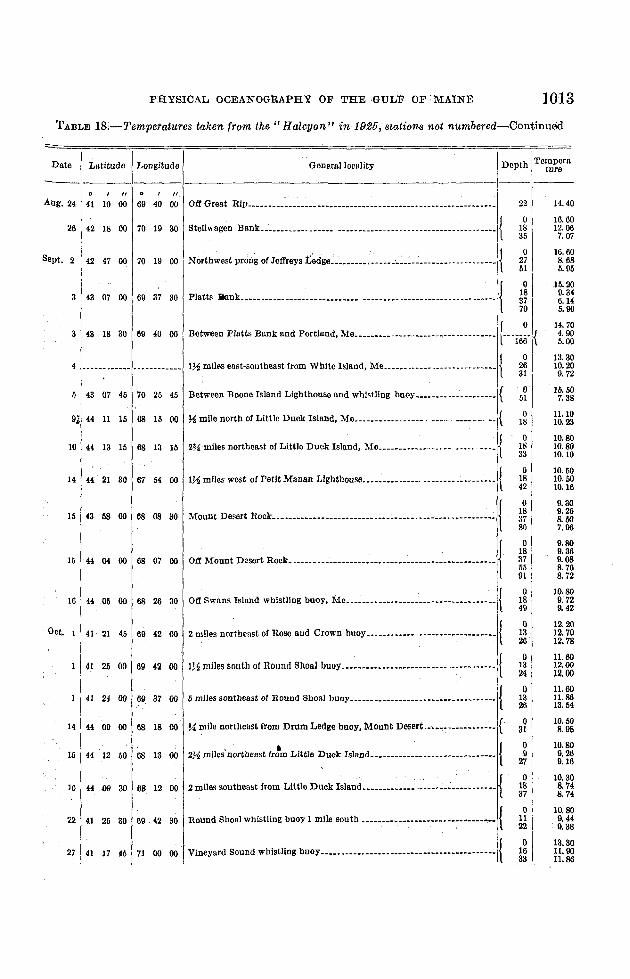
PHYSICAL OCEANOGRAPHY OF THE GULF OF 'MAINE 1013
TABLE 18.-Temperatures taken from the" Halcyon" in 1925, stations not numbered-Continued
I 0Between Platts Bank and Portland, Menn••••• •..•••• __ • •• _•• l---i6iic {
14.40
16.6012.067.07
10.608.685.95
15.209.346.145.00
14.704.905.00
13.3010.209.72
15.507.38
11.1010.23
10.8010.8010.10
10.5010.5010.16
9.309.268.507.96
9.809.369.088. 768.72
10.809. 729. 42
12.2012.7012.78
11.6012.0012.00
11.6011.8613.54
10.508. 98
10.809.269.16
10.308.748. 74
10.809.449.38
13.3011.0011.86
22
o1835
o2751
o183770
o2631
o51
o18
o1833
o1842
o183780
o18375591
o1849
o1326
o1324
o1326
o31
o9
27
o1837
o1122
o1633
General locality
Off Great Rip 00•• __ •••00 ",,_00. '00'0000 "00 •••••00._•••••••••_."'.
Btellwagen BilDk.n.n._.n. _._•••.__ •••• •• 00 __ •• __ • ••• _. •••• {
Nortbwest prong '" ,,,,,,,. too" h_h__ hw~:_:hm __w-n-_ ------11Platts ]jank.••n •••.• ._.__ •__•__00.__••_ •• _ •••• 00 __ • __ • • __ •••• {
4 __un _.__ •__•• __.______ 1~ miles east-southeast from White Island, Me. ••.• •. • '" {
5 43 07 45 70 25 45 Between Boone Island Lighthouse and whistling buoy •• n_. __ .•• __.•••.•• {
9j 44 11 15 68 15 00 %mile north of Little Duck Island, Me .......__ ..... _.___ ••••• m •• {
10 44 13 15 68 13 15 2% miles northeast of Little Duck Island, Me. ••• n ••.. • __,., __.' {
14 44 21 30 67 54 00 1~ miles west of Petit Manan Llghthousa., ••• _....._._ n_n.n ... __ .n•• {
15 43 58 00 68 08 30 Mount Desert Rock.n ••_ __ __•.•••. __•__.n_.__ •• n ••• {
15 4404 00 68 07 00 Off Mount Desert Rock. n •••••••••••n_ ••• __••••••••••••• •• n •••• __•• jOil Swans Island whistling buoy, Me. ._••• ._ ••••_••.• {
2 miles nO;lheast of Rose and Crown buoy•• .n•••• "--"'--""""'" {
1~ miles south of Round Shoal buoy . __ {
5 rolles southeast 01Round Shoal buoy. ••••_••••• •••••_••• •• __ • {
% mile northeast from Drum Ledge buoy/Mount Desert ....".•.•••••••••·•• {'
. '. {272 miles northeast ttota LIttle Duok Island__••• _.__n.__.n •__•• _•••••\
2 miles southeast from Little Duck Island 00 •••••••••••• __ • __ {
Round Shoal Whistling buoy 1 mlle south " {
27 41 17 45 71 00 00 Vineyard Sound whistling buoy •• __ {
16 4405 00 6ll 26 30
Dot. 1 41 21 45 69 42 00
1 41 25 00 611 42 00
41 24 00 611 37 00
14 44 09 00 68 18 00
15 44 12 50 68 13 00
16 44 09 30 68 12 00
22 41 25 30 09 42 30
-Date
ILatitude Longitude
"Aug. 24 41 10 00 69 40 00
26 42 18 00 70 19 30
Sept. 2 42 47 00 70 19 00
3 43 07 00 69 37 30
3 43 18 30 69 40 00

1014 BULLE'rIN. OF THE BUREAU OF FISHERIES
TABI,E 18.-7'emperatures taken from the" Halcyon" in 1925, stations not numbered-Continued
iDate ! Latitude L
. Iongttude Generallocallty Depth Te~¥:ra.
----1.----- ----.-
27 ! 4°1 11 00 71 ;8 ~ 21 miles east of Block Island; •• _•• ._.__•••.• _. __ .n h_n_n••• n {
! I28 ; 41 11 40 70 51 151
.l1l mile west of No Mans Land gas and whistling buoy, •• ._, : {
13.0011. 1811.72
13.3012.10
TABLE 19.-"Albatross II" stations, 1926
25.3626.1026.55
24.2424.9625.28
22.9325.2125.8826.0126.03
26.85
23.3925.1225.6825.99
{, --_..-..---~.----
33.94
32.8533.0,.33.37
31. 8032.6032.8232.8332.86
32.70to
32.98
32.50a2.9332.97
32.4532.8432 0133.01
lU.400.654.713.704.575.00
18.009.305.804.754.72
17.7710.957.806.30
15.0012.2510.607.45
14.7011.0010.308.30
o204070
o204060
o153555
o2040
100180
o2040
100150190
St~:rC=~~e ···-·~::::'~'l=-·-···------~~:::::Jity·---·~---=·Dep~: I;:~~e;.;:-~:J:~--~::::~
1----1----------.-. - •
~ ~'. }OUOI'"OO"" .....m....m..mm.m..m m)
""' .,",." {:i ~ ~.I}om.,,, C." "'L......... ... ---...--- .
20202 1 dO• m {~~ fg ~·.I}Nortbwest edge of Georges Bank.m. h n ..--1{
eosoa Ao,." {:i ~~. ~N~'" edge o Goo"," Dank ." m •••• 11
20204 do m. {~~ ~~~. }Northeast edge of Georges Bank, .. .m.. _ {
46 N. } {ae W'I.m' ····..mm ·m.····
~ ~.I)"'O""Mt part or bMI~ north o 0=7 Bank••• m •••• '1
----32'-00' m --25'-0033.06 25.59
---·34:ifi· --'--26:00
20205 Aug. 14 {6461 51 NW'18 .
20206 Aug. 15 {6461 58 N.26 W.
20207 Aug. 17 {4661
53 N.22 W.
{4120208 Aug. 18 66
{42
20209 Aug. 19 67
{43 11 N.
20210 Aug. 20 67 41 W.
20211 _...do •__ • {4683
50 NW'33 .
}East end of Georges Bunk. ---- - ... ---- ... ----,--I{. I
)N"'h=t part ot GeorgesD''''' ---.--- 11
)Eo't end ,10M"," Bunk•••.•.• m ..~.---..I1
, 1 'j}Busln, oIDnl!' oC Mount Desert •• n
}Near Mount Desert ROCk ... __ •__ n. n ••!
o204U60
o204060
o2040';0
o204060
o2040
100200300
o2040
100200
o2040
100.160 I
17.2012.028.9f)8. 80
16.9411.so7.606.10
15.5014.7010.057.95
15.8311.8010.009.10
16.60Hi.7013.105.706.606.40
16.6015.006.004.505.80
14.1712.159.2Us, 606.05
32.5032.7832.9332.06
32.5732,6833.0433.07
32.6032.6602.9533.06
32.6032.8232.8932.94
32.5432.5432.8033.8334.7034.86
32.7332.7833.0833.5734.15
23.6624.8825.5325.57
23.692·J.0425.8126.03
24.0324.2525.3625.78
24.1124.9525.3225.51
23.7423 7224.6926.6927.3327.41
23.8824.0824.9826.6226.93
I Probablc error ±0.1°.