Table of Contents - Governance in...
14
Transcript of Table of Contents - Governance in...


Table of Contents EXECUTIVE SUMMARY .................................................................................................................................. 3
BACKGROUND ................................................................................................................................................... 4
OBJECTIVE ......................................................................................................................................................... 5
KEY STAKEHOLDERS ..................................................................................................................................... 5
WORKING DESIGN ........................................................................................................................................... 5
METHODOLOGY ............................................................................................................................................. 11
LESSONS LEARNED ........................................................................................................................................ 11
APPROPRIATE AND INNOVATIVE USE OF TECHNOLOGY .................................................................................... 11
DETERMINED PURSUIT OF AN ALTERNATIVE SYSTEM THAT PROMOTES TRANSPARENCY ................................ 11
DEVELOPMENT OF AN IMPACTFUL, SUSTAINABLE AND REPLICABLE SYSTEM .................................................... 11
Appendix A- Interview Questionnaire ......................................................................................................... 13
Appendix B- Salient Features ...................................................................................................................... 14

Executive Summary The Government of India enacted The Forest Rights Act, 2006 (Scheduled Tribes and Other Traditional Forest Dwellers - Recognition of Forest Rights – Act) to give forest dwelling scheduled tribes and other traditional forest dwellers the opportunity to claim individual as well as community forest rights of forest land. The Tribal Research and Training Institute (TRTI), Pune has developed a GPS based system for forest land measurement and a software using satellite imagery for forest rights claim verification under the Act for the intended population in the state of Maharashtra. There are approximately 0.33 million claimants of Forest Rights in Maharashtra. By leveraging GPS and satellite technology to document and determine the legitimacy of land claims, TRTI has enabled decision makers to take appropriate action based on unbiased evidence. Through persuasive ICT-led evidence, the Maharashtra system provides valuable precursory information to plane table survey forest land plots, expediting and lowering the cost of the entire process. It also reduces unnecessary conflict and corruption in the field that have historically been connected to issues of land rights. The Geo-informatics for Forest Rights Act implementation programme has succeeded in more ways than one. It has enabled the Committees to take objective decisions through enhanced transparency. Additionally, it has discouraged illegal diversion of forest land for non-forestry purposes through the possible improper use of the provisions of the Forest Rights Act. Public money of over an estimated 100 crores has been saved through the use of technology in lieu of hiring official land surveyors and paying the Department of Land Records for surveying all forest lands on which forest rights were claimed. Coordination of various levels of government - tribal, forest, and revenue departments, technology training, and conveyance of the
credibility of the system to officials and claimants were crucial to achieving success. To date, out of 3.38 lakh claims state-wide, 1.6 lakh cases have been measured by GPS, and a total of 1.05 lakh cases have been decided in favour of the claimants.
Sarpanch – Walunj village, Nagar tehsil, Ahmadnagar district, Maharashtra

Background Prior to the Forest Rights Act, 2006, approaches towards forest resources did not necessarily reflect a desire to conserve but rather exploit such areas for forest produce. The new Act grants legal recognition of rights to the forest dwelling Scheduled Tribes and other traditional forest dwellers. Specifically, it outlines who is/are eligible for individual/community forest rights and what the specific forest land under forest right’s claim can be used for. For the first time, it also empowers the forest dwelling communities to protect the resources around them. It also recognises management rights in favour of communities who have been traditionally managing forest resources for sustainable use in the past. The Act calls for the recognition of habitation and cultivation rights to the eligible claimants if they are in possession of the specific forest land on or before 13 December 2005.
Adivasi claimants – Walunj village
With the authority of the claim scrutiny in the hands of the Forest Rights Committee (comprised of villagers) the process progresses upon the recommendation of the Gram Sabha. This recommendation is later screened by the sub-division and district level committees which is the final adjudicating authority in the matter.
The impact of the Forest Rights Act will depend on its implementation which faces some critical challenges. For one, it is difficult to measure forest land in a timely manner because it is remote and the FRCs, who are made responsible for preparing maps under the Act, lack the expertise. Evidence of cultivation or prior occupation is scarce and hard to come by. Even after the forest land is identified, it is often difficult to grant claims and reject others because evidence is not always straightforward. There are many stakeholders involved in forest land rights and hence it is also difficult to keep all involved actors informed to the extent needed. To overcome these barriers, the Government of Maharashtra developed a Geo-informatics based system for the forest rights recognition process. The Tribal Research and Training Institute (TRTI) has facilitated GPS-led surveying of forest land from 2009 to assist in determining the validity of (individual land) claims. The TRTI has since pursued capacity building through specific training modules for various levels and also through advocacy. Those who received the training now help in the decision making process through local committees. A website was developed for spreading awareness about the Forest Rights Act, the system of implementation, roles and responsibilities of stakeholders, management of on line information regarding claimants, land measurement, verification process of forest land under forest right’s claims, monitoring of progress, and final decision making regarding claims.

5
The state of Maharashtra has 15,002 Forest Rights Committees and to date, there have been 3,38,679 claim cases in the state. GPS has been used to measure 1,60,785 plots of land. These processes are carried out by a number of stakeholder institutions in around 14,000 villages in the state. Data is uploaded in 110 SDO offices. Measurements are analysed in 28 district collector offices. Reports are viewed by over 200 stakeholders: 28 collectors, 110 SDOs, 31 tribal department offices and 40 forest offices. Overall monitoring is carried out by the TRTI office in Pune.
Objective To fairly and accurately provide evidence for recognition of forest rights as outlined in the Forest Rights Act, 2006. This is accomplished through GPS measurement of forest land, digital plotting and superimposing of land boundaries on Cartosat 1 satellite imagery, and comparing vegetation cover and land use position between relevant time periods (2005-6 and 2007-8).
Key Stakeholders 1. Tribal Research and Training Institute, Pune (TRTI) – conceived, implemented
and monitors Geo-informatics for Forest Rights 2. National Informatics Centre (NIC) – designed online data flow, monitoring and SMS
system 3. National Remote Sensing Agency (NRSA/NRSC) – provided satellite imagery
system 4. Authorities appointed under the Act – includes committees at three levels - village,
sub-division and district 5. District collector office staff – analyses GPS data in relation to satellite imagery 6. SDO office staff – responsible for uploading digital field data and printing forest land
measurement report 7. GPS field workers (Forest/DILR/Revenue Department/ NGO representatives/
village committees) – conducts GPS mapping by following standardised guidelines
Working Design TRTI began implementation of the Act through publicity efforts to spread awareness. This included making a movie titled “Somache Swapna” and screening them in villages and on Doordarshan, playing traditional folk song based jingles on Akashswani, posting advertisements on buses, and employing NGOs for mobilisation of student advocacy groups. Additionally, a bilingual – Marathi and Hindi - website was created for information dissemination. The website also has the latest information on the implementation system, progress of implementation, and FAQs. The site was later expanded to centralise all claimant related data. The NIC-SDU, Pune has helped to design the architecture of the system and data models, and develop the web system using open
6
source technology, making the entire project cost effective. The system was tested against vulnerabilities such as cross site scripting, denial of the service attack, CSRF attack and SQL injections which are important for smooth running of the system. Necessary changes have been made in the software for security of the system. Inputs and suggestions required by the users were taken into consideration while designing and developing the system.
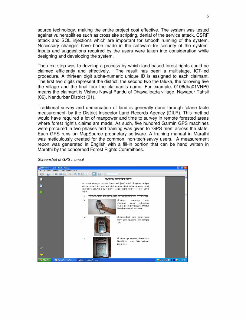
The next step was to develop a process by which land based forest rights could be claimed efficiently and effectively. The result has been a multistage, ICT-led procedure. A thirteen digit alpha-numeric unique ID is assigned to each claimant. The first two digits represent the district, the second two the taluka, the following five the village and the final four the claimant’s name. For example: 0106dha01VNP0 means the claimant is Vishnu Nawal Pandu of Dhawalipada village, Nawapur Tahsil (06), Nandurbar District (01). Traditional survey and demarcation of land is generally done through ‘plane table measurement’ by the District Inspector Land Records Agency (DILR). This method would have required a lot of manpower and time to survey in remote forested areas where forest right’s claims are made. As such, five hundred Garmin GPS machines were procured in two phases and training was given to ‘GPS men’ across the state. Each GPS runs on MapSource proprietary software. A training manual in Marathi was meticulously created for the common, non-tech-savvy users. A measurement report was generated in English with a fill-in portion that can be hand written in Marathi by the concerned Forest Rights Committees. Screenshot of GPS manual
7
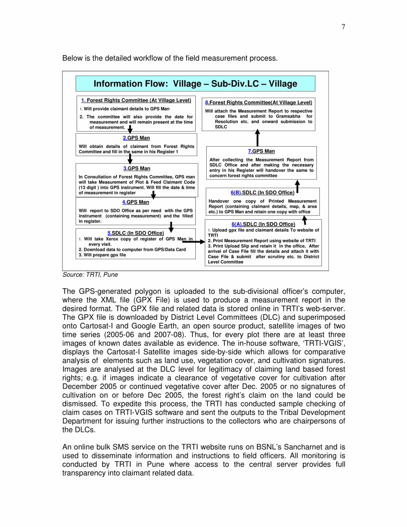
Below is the detailed workflow of the field measurement process.
11
Information Flow: Village – Sub-Div.LC – Village
2.GPS Man
Will obtain details of claimant from Forest Rights Committee and fill in the same in his Register 1
3.GPS Man
In Consultation of Forest Rights Committee, GPS man will take Measurement of Plot & Feed Claimant Code
(13 digit ) into GPS instrument. Will fill the date & time of measurement in register
5.SDLC (In SDO Office)1. Will take Xerox copy of register of GPS Man in
every visit.2. Download data to computer from GPS/Data Card
3. Will prepare gpx file
6(A).SDLC (In SDO Office)1. Upload gpx file and claimant details To website of
TRTI2. Print Measurement Report using website of TRTI
3. Print Upload Slip and retain it in the office, After arrival of Case File fill the details and attach it with
Case File & submit after scrutiny etc. to District Level Committee
4.GPS Man
Will report to SDO Office as per need with the GPS instrument (containing measurement) and the filled in register.
1. Forest Rights Committee (At Village Level)
1. Will provide claimant details to GPS Man
2. The committee will also provide the date for measurement and will remain present at the time of measurement.
7.GPS Man
After collecting the Measurement Report from SDLC Office and after making the necessary
entry in his Register will handover the same to concern forest rights committee
6(B).SDLC (In SDO Office)
Handover one copy of Printed Measurement Report (containing claimant details, map, & area
etc.) to GPS Man and retain one copy with office
8.Forest Rights Committee(At Village Level)
Will attach the Measurement Report to respective case files and submit to Gramsabha for
Resolution etc. and onward submission to SDLC
Source: TRTI, Pune
The GPS-generated polygon is uploaded to the sub-divisional officer’s computer, where the XML file (GPX File) is used to produce a measurement report in the desired format. The GPX file and related data is stored online in TRTI’s web-server. The GPX file is downloaded by District Level Committees (DLC) and superimposed onto Cartosat-I and Google Earth, an open source product, satellite images of two time series (2005-06 and 2007-08). Thus, for every plot there are at least three images of known dates available as evidence. The in-house software, ‘TRTI-VGIS’, displays the Cartosat-I Satellite images side-by-side which allows for comparative analysis of elements such as land use, vegetation cover, and cultivation signatures. Images are analysed at the DLC level for legitimacy of claiming land based forest rights; e.g. if images indicate a clearance of vegetative cover for cultivation after December 2005 or continued vegetative cover after Dec. 2005 or no signatures of cultivation on or before Dec 2005, the forest right’s claim on the land could be dismissed. To expedite this process, the TRTI has conducted sample checking of claim cases on TRTI-VGIS software and sent the outputs to the Tribal Development Department for issuing further instructions to the collectors who are chairpersons of the DLCs. An online bulk SMS service on the TRTI website runs on BSNL’s Sancharnet and is used to disseminate information and instructions to field officers. All monitoring is conducted by TRTI in Pune where access to the central server provides full transparency into claimant related data.

8
The following is the detailed workflow at the district level – it outlines how field measurement is paired with satellite images to determine Forest Rights claims.
13
Verification process workflow at DLC level (District)
3. GPX File Analysis Using MapSource Software
(A) Check For The Following Errors/Mistakes1. Multiple Polygon or Multiple Tracks
2. Difference In Track & GPX File Name3. Widely Open or Wrongly Closed Polygon 4. Others (Pl Mention)
(B) Area Calculations1.If no mistake in (A) above, calculate area 2.If any mistake in (A) above, do not calculate area
(C) Printouts Using Google earth images
1. Superimpose Polygon On Google Earth of a date nearest to 13-12-2005 and 31-12-07 as per availability & Take Printouts
Write above observation in downloaded report
2. Data Downloading
1. Download All GPX Files Of Claimant’s Village From Web Site Of TRTI to Local Computer In Folder with due reference to Village Code.
2. From The Web Site Download & Print The Report viz“List of Downloaded .gpx Files For Measurement Analysis” This report facilitates to write observations during the measurement analysis.
4. GPS Output Analysis Using TRTI-VGIS Software
(A) Observe Following using ‘TRTI-VGIS’1. Road/River/Stream Passes Through Measured Area
2. Adjoining/Surrounding Forest Is Covered3. Change In Vegetation Cover (2005-06) & (07-08)4. Overlapping Boundaries Of Adjoining Polygons5. Others (Pl Mention)
(B) Printouts Using TRTI-VGIS
1. Print Closed & Surrounding View Of Polygon Which Is Superimposed on The Satellite Image(Year05-06 & 07-08)
Write above observation in downloaded report
5. Analysis Details-Enter In TRTI Website
1. In the Website Of TRTI, enter all measurement analysis and observations
a. The Measurement Analysis Slip will be generated.i) when observations are entered, remark column will show
either• Measurement Output: OK
• Measurement Output: Needs Closer Examinationii) According To Observations, Area Column will Show
following• Area Calculated Using MapSource: Area In Sq. Meter• Area Calculated Using MapSource: Faulty Handling Of
GPS machine
6. Printouts To Be Attached To Claimants Case File1. Printout Of The Measurement Analysis Slip2. Printout Of Closed & Surrounding View Of Polygon
Which Is Superimposed On The Satellite Image( Based Year 2005-2006 & 2007-2008)
3. Printout Of GPX Polygon Superimposed on Google earth image/s
1. Case file of claimant received in DLC
1. From the case file of claimant, check whether Measurement Report & Upload Slip Are Attached And Duly Signed, If Found Attached, Follow This Procedure Else Return The Case File.
2. From Measurement Slip, Find Claimant’s Village Name.
Source: TRTI, Pune

9
Below are the final satellite images of an eligible claim case. The first image is taken in January 2006 and shows cultivated land as does the 2008 image following it. The measurement report in the designed template with the GPS polygon, as mapped by the GPS field worker, is completed and displayed below.

10
The following images show an ineligible claim case because the image taken in November 2005 (left) shows forested land while the next indicates cleared land.

11
Methodology OneWorld researchers identified Geo-informatics for Forest Rights as a best practice in public service delivery due to its one-of-a-kind model - a combination of innovative use of technology and comprehensive coordination for the effective recognition of land based forest rights. Background research was completed in New Delhi and used to formulate appropriate questions for field interviews. Researchers travelled to Pune to discuss the programme with TRTI experts. A day was spent travelling to an adivasi village in Ahmadnagar (3.5 hours outside of Pune) where field activities - GPS measurement of forest land and gram sabha decision making – were demonstrated and community members shared their thoughts on and experiences with the programme.
Lessons Learned Despite the daunting task that the programme took on and as a result, the number of challenges that were faced in its design, implementation and monitoring, it has managed to succeed to the utmost degree. Initially, it was difficult to educate all stakeholders and build the capacity of people of varying qualification levels to use the geo-informatics tools. In time, however, the programme was accepted and even hailed for its innovative delivery to the remotely placed forest dwelling target populations as being one of the most empowering factors of well-being – forest rights ownership.
Appropriate and Innovative Use of Technology
The Geo-informatics for Forest rights model leverages cutting-edge technology, but also masterfully deploys simple tools to the field and utilises more complex ones in higher levels of government. This structure allows for easy comprehension of programme benefits by forest right claimants, and simultaneously offers objective evidence couched in a credible and transparent system for efficient decision making and adjudication by the Committees under the Act.
Determined Pursuit of an Alternative System that Promotes Transparency
Implementers managed to convince the Government of Maharashtra of the programme’s need and significance by remaining confident in the ability of technology to provide the transparency necessary to pursue rightful policies. At first, government officials were unsure of the programme’s credibility; specifically, concerns focused on cases being wrongfully dismissed due to technology errors, and encroachments increasing during the time it would take for the tech-based system to be rolled out. Through perseverance, TRTI obtained the government’s approval to take GPS measurements. As a result, 1.6 lakh cases have been measured by GPS to date and the technology is projected to be the standard for state-wide implementation of the Act.
Development of an impactful, sustainable and replicable system
The programme has enabled the timely recognition of forest rights to eligible claimants and rejection of ineligible claims. It has saved forest land from ineligible claimants and it discourages future offenders through increased transparency and
12
tight monitoring. It has generated a platform that will remain useful for Act implementation but also related policies in the long term. The system is user friendly and simple to operate once proper training is imparted on its users. The Minorities board in Maharashtra has shown interest in using a similar system to analyse and document encroachment on waqf lands. Additionally, the Government of Karnataka has expressed their interest in the TRTI system and has consulted the TRTI to learn how it functions. TRTI is actively engaged in sharing knowledge regarding its applications with any and all interested parties. It has already made presentations before the MOEF, MOTA, ICFRE, Dehradun and before the forest departments in the states of Chhattisgarh, Jharkhand, Madhya Pradesh, Karnataka and also in various compulsory courses of IFS officers. TRTI’s model could very well be leveraged for ultimately developing a common GIS based tribal development framework at the national level. As a web-based and centralised application, the programme is easy to replicate. Forest Rights Act PLUS, namely an integration of geo-informatics for forest rights and the Mahatma Gandhi Rural Employment Guarantee Act (MGNREGA), is underway. The aim is to channel and consolidate all welfare programmes at the State level so that the target groups under the Act are effectively brought above the poverty line. Research was carried out by the OneWorld Foundation, Governance Knowledge Centre (GKC) team.
Documentation was created by Knowledge and Research Coordinator, OWFI, Nicole Anand.
For further information, please contact Mr. Naimur Rahman, Director, OWFI.
References TRTI powerpoint presentation 2010 eIndia. http://www.eindia.net.in/2010/awards/details/eGov-G2C-Details.asp?PNo=45
Interviews were conducted with key TRTI officials including Commissioner, Arvind Kumar Jha, and Computer Coordinator, Jitendra Avachat.

13
Appendix A- Interview Questionnaire
The Tribal Research and Training Institute (TRTI)
1. How was the idea of geomapping/ICT use for land rights conceived? 2. Please explain the working design of the geoinformatics for forest rights
programme. How are mobile, GIS, satellite and computer technologies used to achieve the objective of claiming land rights? (perhaps, refer us to someone at NIC)
a. Data is captured through GIS and stored in a central database run by a centralised server? How is this beneficial?
b. Once the mapping is done, how are the occupants of the land (rural poor/tribes) approached/informed about their entitlements? What are TRTI’s methods of interaction with this isolated population?
c. How are land rights claimed? Does TRTI work with other government departments, particularly the Revenue department, and NGOs to accomplish this?
3. What is the role of TRTI – implementation, maintenance, and monitoring? 4. How do you deal with users’ low awareness about and perhaps, adverseness
to learning these new technologies? Does TRTI conduct training sessions, awareness groups etc.?
5. What have been some of the major challenges faced while building and maintaining this programme?
6. What do you think a major advantage of this programme is? What is important/valuable/necessary?
7. How is monitoring and evaluation of work conducted? Are there some statistics you can share that indicate impact
Tribal
1. How were you able to claim ownership over your land? 2. How has your life changed since you became an owner? 3. Are other people in your community able to claim rights as well? 4. Why is land ownership important?

14
Appendix B- Salient Features
Geoinformatics for Forest Rights: Salient Features
Sr No Level Hardware Software Application
1 Forest Land Claimed GPS Machine - 1. To measure claimant land using GPS
machine
2. To assign 13 digit code to land
measured
2 Sub Divisional Level
Committee
(SDLC)
Computer
O.S.-Windows Xp
Broad Band Modem
Laser Printer
1. Mapsource Software
from GPS device
manufacturer
1. To acquire data from GPS machine
2. To prepare individual claimant’s GPX
3. To check /Verify the area of land
measured by GPS
2. Internet Explorer 7+
1. Web site handling
2. Entering claimant details in web site
i.e. Online entry
3. To upload in website the gpx file
pertaining to claimant
3. Adobe PDF Reader 1. Measurement report viewing &
printing
2. Viewing details from website
3 District Level
Committee
(DLC)
Computer
O.S.-Windows Xp
Broad Band Modem
Laser Printer
1. Internet Explorer 7+
1. Web site handling
2. Downloading GPX file uploaded by
SDLC
3. Online data entry of measurement
analysis of each claimant under
consideration which returns
measurement analysis report
2. Mapsource Software
for GPS device
3. Google Earth
1. Viewing and analyzing polygon
generated using downloaded gpx file
2. To Verify the area of measured land
mentioned in measurement report
3. To view polygon in google earth
4. TRTI-VGIS
Tailor made software
prepared by TRTI Pune
using following
components
(VB.Net, Microsoft
.NET Framework 2.0,
MapwinGIS Active-X
controls)
1. To superimpose polygon generated
using downloaded gpx file on satellite
image for the two different time series
i.e. Year 2005 & 2008
2. To create image file consisting of
satellite image showing polygon
generated by gpx file along with
claimant details
3. To analyze polygon superimposed on
satellite image
5. Adobe PDF Reader
1. Measurement analysis report viewing
& printing
2. Viewing details from website
4. State Level Web Server
O.S.: Linux
Database: Postgresql
Software: PHP,
Mapserver Software
1. Publish the FRA and its Rules on
web to public in multi-language
2. Awareness and capacity building on
Forest Rights Act implementation
3. Generate centralize database for GPX
file along with claimants information
and data on progress
4. Implementation progress monitoring
5. Bulk SMS system for implementation
6. Dissemination of Forest Rights ‘Plus’
Concept