T H A M E S V A L L E Y · PDF fileNo finds were recovered and the ditch was cut by ditch 2....
22
T H A M E S V A L L E Y S E R V I C E S ARCHAEOLOGICAL Friars Lane, Lower Brailes, Warwickshire Archaeological Evaluation by Kyle Beaverstock and David Platt Site Code: FLW 16/33 (SP 3159 3922)
Transcript of T H A M E S V A L L E Y · PDF fileNo finds were recovered and the ditch was cut by ditch 2....
T H A M E S V A L L E Y
S E R V I C E S
ARCHAEOLOGICAL
Friars Lane, Lower Brailes,Warwickshire
Archaeological Evaluation
by Kyle Beaverstock and David Platt
Site Code: FLW 16/33
(SP 3159 3922)

Friars Lane, Lower Brailes, Warwickshire
An Archaeological Evaluation
for Mr Alan Griffin
by Kyle Beaverstock and David Platt
Thames Valley Archaeological Services Ltd
Site Code FLW 16/33
February 2016

i
Thames Valley Archaeological Services Ltd, 47–49 De Beauvoir Road, Reading RG1 5NR
Tel. (0118) 926 0552; Fax (0118) 926 0553; email [email protected]; website: www.tvas.co.uk
Summary
Site name: Friars Lane, Lower Brailes, Warwickshire Grid reference: SP 3159 3922 Site activity: Archaeological Evaluation Date and duration of project: 17th February 2016 Project manager: Danielle Milbank Site supervisor: David Platt Site code: FLW 16/33 Area of site: 0.13ha Summary of results: The evaluation successfully identified four ditches and a probable hedgerow. Two of the ditches contained pottery which suggests they are medieval in date; the hedgerow is modern. The site therefore has a moderate archaeological potential. Location and reference of archive: The archive is presently held at Thames Valley Archaeological Services, Reading and will be deposited with Warwickshire Museum Service in due course. This report may be copied for bona fide research or planning purposes without the explicit permission of the copyright holder. All TVAS unpublished fieldwork reports are available on our website: www.tvas.co.uk/reports/reports.asp. Report edited/checked by: Danielle Milbank�10.3.16 Steve Preston� 14.03.16

1
Friars Lane, Lower Brailes, Warwickshire An Archaeological Evaluation
by Kyle Beaverstock and David Platt
Report 16/33
Introduction
This report documents the results of an archaeological field evaluation carried out at The Old Bakery, Friars
Lane, Lower Brailes, Warwickshire (SP 3159 3922) (Fig. 1). The work was commissioned by Ms Isabel Lisboa,
of Archaeologica Ltd, 7 Fosters Lane, Bradwell, Milton Keynes MK13 9HD on behalf of Mr Alan Griffin, The
Old Bakery, Lower Brailes, Warwickshire, OX15 5HU.
An application for planning permission (14/03588/FUL) for the erection of two houses with associated
double garage, landscaping and hard surfacing has been refused by Stratford-on-Avon District Council. One of
the grounds for refusal lay in the absence of archaeological information. Re-submission is to take place and this
report will supply the required information on the archaeological potential of the site to allow an informed
decision to be reached with regard to the archaeological implications of the proposal. This is in accordance with
the Department for Communities and Local Government’s National Planning Policy Framework (NPPF 2012),
and the District Council’s policies on archaeology.
The field investigation was carried out to a specification (Lisboa 2016) approved by Ms Anna Stocks,
Planning Archaeologist at Warwickshire County Archaeological Service, the archaeological adviser to Stratford-
on-Avon District Council. The fieldwork was undertaken by David Platt and Jesse Coxey on the 17th February
2016 and the site code is FLW16/33. The archive is presently held at Thames Valley Archaeological Services,
Reading and will be deposited at Warwickshire Museums Service in due course.
Location, topography and geology
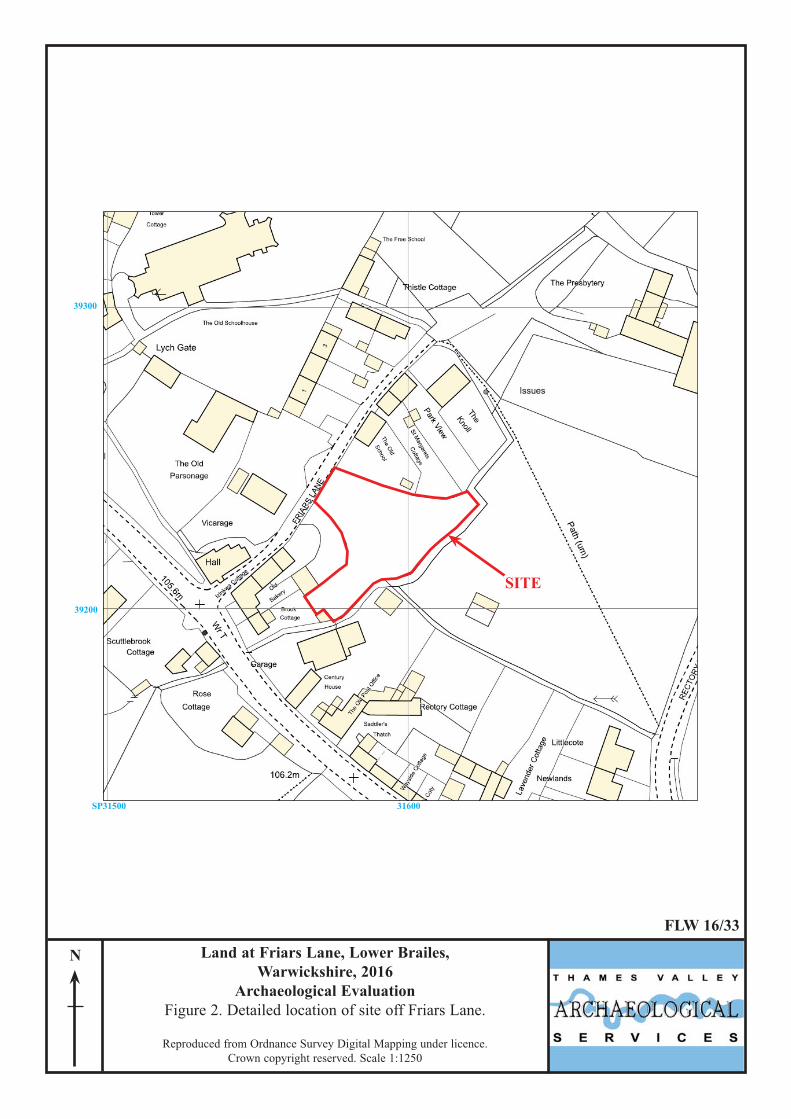
The site is located in the hamlet of Lower Brailes (Fig. 1) c.12km west of Banbury. The site itself consists of an
irregular parcel of land located to the east of Friars Lane and is bordered to the west by The Old Bakery and the
east by a former school, and to the south by the Sutton Stream (Fig. 2). The underlying geology is Charmouth
Mudstone Formation (BGS 1982) and the site lies at 106m above Ordnance Datum sloping down from west to
east towards the stream.

2
Archaeological background
The archaeological potential for the site was highlighted in the WSI (Lisboa 2016) and stems from its location
within the medieval settlement of Lower Brailes, which was centred on the Church of St George located c.80m
to the north-west of the site. The village contains the Scheduled remains of the original medieval motte. Bronze
Age and Iron Age artefacts have been recovered within a 1km radius of the site, and a possible Bronze Age pit
alignment and possible Neolithic long barrow have been recorded in Upper Brailes.
Objectives and methodology
The purpose of the evaluation was to determine the presence/absence, extent, condition, character, quality and
date of any archaeological deposits within the area of proposed development. The particular aim of the project
was to identify, map and date any evidence of the medieval settlement of Lower Brailes within the site, and to
recover any associated finds.
It was proposed to dig two trenches, both 15m in length and 1.6m wide targeting the footprints of the
proposed development. Topsoil and other overburden were removed using a 360° machine equipped with a
toothless ditching bucket under constant archaeological supervision. Where archaeological features were
encountered they were to be excavated or sampled by hand to satisfy the aims of the project.
Results
Both trenches were dug as intended (Fig. 3). They were 13.0m and 17.0m in length and 0.60m and 0.53m in
depth. A complete list of trenches giving lengths, breadths, depths and a description of sections and geology is
given in Appendix 1
Trench 1 (Figs 4 and 5; Pl. 1) Trench 1 was aligned roughly east - west and was 13.0m long and 0.60m deep. The stratigraphy consisted of
0.10m of topsoil and 0.30m subsoil overlying a pale grey-yellow clay natural geology. A ditch (4) was recorded
which was over 1.10m wide and 0.26m deep with a single fill (52) which consisted of dark brown-grey silty clay
with occasional stone inclusions. A single fragment of Northants Shelly Ware dated to the 12th to 15th century
and one fragment of modern earthenware was recovered along with a piece of formless fired clay and two tiny
scraps of animal bone. However, the deposit also contained mass-produced transfer-printed pottery (‘china’) and
coal which were noted but not retained. This demonstrates that the earlier pottery was residual and that the ditch

3
was late post-medieval in date. The base of the ditch was undulating and heavily rooted suggesting that this may
have been a hedgerow.
Trench 2 (Figs 4 and 5; Pl. 2) Trench 2 was aligned north - south and was 17.0m long and 0.53m deep. The stratigraphy consisted of 0.25m of
topsoil and 0.27m subsoil overlying a pale grey yellow clay natural geology. In total 4 ditches were uncovered,
three of them intercutting. Ditches 1, 2 and 3 were observed in the southern end of the trench, all aligned NW–
SE (Pl. 3). Ditch 1 was 0.14m deep and contained a single fill (53) which consisted of a pale brown-grey clayey
silt with very occasional stone inclusions. No finds were recovered and the ditch was cut by ditch 2. Ditch 2 was
0.21m deep and contained a single fill (54) which consisted of a mid brown-grey clayey silt with very occasional
stone inclusions. A single fragment of St Neots type ware (10th - 12th century) and two fragments of Northants
Shelly Ware (12th - 15th century) as well as animal bone and two small fragments of featureless fired clay were
recovered. Ditch 3 was at least 0.35m deep but due to its location in the trench its total depth and width were not
visible: no finds were recovered. The relationship between ditches 2 and 3 was unclear.
Ditch 5 (Pl. 4)was observed at the northern end of the trench, it was 1.0m wide and 0.14m deep and
contained a single fill (56) which consisted of a mid brown grey clayey silt with very occasional stone
inclusions. A single fragment of Early Medieval Oxford Ware (11th - 13th century), two small fragments of
featureless fired clay and animal bone were recovered.
Finds
Pottery by Paul Blinkhorn
The pottery assemblage comprised 6 sherds with a total weight of 95g. It was recorded using the conventions of
the Warwickshire Medieval and Post-Medieval Pottery Type-Series (Ratkai and Soden, in archive), as follows:
CS01: St Neots type Ware, 10th – mid 12th century. 1 sherd, 3g, SG03: Early Medieval Oxford Ware, late 11th – mid 13th century. 1 sherd, 36g. CS05. Northants Shelly Ware, 1100-1400. 3 sherds, 55g. MGW: Modern Earthenwares, late 18th century onwards. 1 sherd, 1g.
The pottery occurrence by number and weight of sherds per context by fabric type is shown in Appendix 3. Each
date should be regarded as a terminus post quem. All the wares are common finds in the region. The whole
assemblage consisted of undecorated bodysherds. The modern sherd aside, all the sherds are in good condition,
and most fairly large, indicating that they were reliably stratified. The range of medieval wares indicate that there
was activity at the site in the 11th – 12th centuries.

4
Animal Bone by Lizzi Lewins
A small assemblage of animal bone (17 pieces, weighing a total of 174g), was recovered from three features
during the course of the evaluation (Appendix 4). The bone was classified according to size (large - cattle/ horse;
medium - sheep/goat, pig, deer) and where possible by species. The condition of the bone was good with little
surface abrasion or erosion noted. Texts by Hillson (1992) and Schmid (1972) were used to confirm
identification when necessary.
Ditch 2 (54) contained six pieces of identifiable bone which consisted of a sliced rib fragment from a
medium sized mammal and two re-fitted fragments of neural spine from a medium/large mammal. Three re-
fitted fragments of a right, proximal cattle metatarsal were also identified and show evidence for bone working
in the form of cut marks which were present on all sides of the shaft. The bone was cut through using a blade
rather than a saw and has left a visible flange on the inner shaft. The metatarsal is considered to be an off-cut of
the bone working process (Pers. Comm. Matilda Holmes).
Ditch 4 (52) contained one identifiable bone which consisted of a sliced rib fragment from a medium/large
mammal. Ditch 5 (56) contained three fragments of a distal cattle metatarsal which could not be re-fitted and
consisted of the shaft and two fragments of the epiphysis. A 35mm long cut mark was noted running down the
length of the shaft.
The small assemblage has shown evidence for both butchery in the form of slicing and bone working taking
place within the immediate area of the site. Apart from the slicing and cutmarks no further taphonomic processes
were observed.
Fired clay by Danielle Milbank
Fired clay weighing 605g was hand collected during the excavation, and was examined under x10 magnification.
Typically, the fabric was slightly soft and frequently friable fine clay with occasional sandy inclusions, and an
orange red colour. Several fragments are of a dark red brown and black colour. None of the recovered fragments
have wattle impressions identifying them as daub, however they are generally highly fragmented and abraded
and may represent daub material. No further categories of fired clay object (such as loomweights) were
identified, and the material cannot be dated.

5
Conclusion
The evaluation revealed largely undisturbed stratigraphy, with subsoil and natural levels present and little
modern truncation on the site.
Four ditches were identified, along with a probable post-medieval hedgerow. Of the ditches found, one was
undated, and three were dated to the medieval period, though on the basis of a very few sheds of pottery. The
undated ditch is also likely to be of medieval date. The medieval ditches (1, 2, 3, and 5) are likely to represent
field boundaries, with ditches 1, 2 and 3 representing a re-definition of the same boundary. Ditch 4 is modern in
date and represents a hedgerow, with one sherd of residual medieval pottery. The archaeological potential of the
site can be considered to be moderate.
References
BGS, 1982, British Geological Survey, 1:50000, Sheet 201, Solid and Drift Edition, Keyworth Hillson, S, 1992, Mammal Bones and Teeth, An Introductory Guide to Methods of Identification, London Lisboa, I, 2016, ‘Written Scheme of Investigation for an Archaeological Evaluation, Friars Lane, Lower Brailes
Warwickshire’, Archaeologica ltd, Milton Keynes NPPF, 2012, National Planning Policy Framework, Dept Communities and Local Govt, London Ratkai, S and Soden, I, in archive ‘Warwickshire Medieval and Post-Medieval Pottery Type-Series’ Schmid, E.1972 Atlas of Animal Bones, London

6
APPENDIX 1: Trench details
0m at south and west end
Trench Length (m) Breadth (m) Depth (m) Comment 1 13.0 1.6 0.60 0–0.10m topsoil, 0.10-0.40m subsoil, 0.40m+ natural geology. Ditch 4. [Pl 1] 2 17.0 1.6 0.53 0–0.25m topsoil, 0.25-0.53m subsoil, 0.53m+ natural geology. Ditches 1,2,3
and 5. [Pls 2, 3 and 4]

7
APPENDIX 2: Feature details
Trench Cut Fill (s) Type Date Dating evidence 2 1 53 Ditch Medieval Stratigraphy 2 2 54 Ditch Medieval Pottery 2 3 55 Ditch 1 4 52 Hedgerow Post Medieval Pottery 2 5 56 Ditch Medieval Pottery

8
APPENDIX 3: Pottery occurrence by number and weight (in g) of sherds per context by fabric type
CS01 SG03 CS05 MGW Date Trench Cut Depositt No Wt No Wt No Wt No Wt (century AD)
2 2 54 1 3 2 16 12th 1 4 52 1 39 1 1 MOD 2 5 56 1 36 Late 11th Total 1 3 1 36 3 55 1 1

9
APPENDIX 4: Catalogue of animal bone.
Cut Deposit Type No. Frags Wt (g) Cattle Medium/ Large
Medium Unid Notes
2 54 Ditch 8 70 3 2 1 2 Slicing, Cut marks 4 52 Ditch 2 14 1 1 Slicing 5 56 Ditch 7 90 3 4 Cut marks
Total 17 174

10
APPENDIX 5: Catalogue of fired clay
Cut Deposit Type No Wt (g) 2 54 Ditch 2 11 4 52 Ditch 1 8 5 56 Ditch 2 8 Total 5 27

SP31000 32000
SITE
FLW 16/33
Reproduced from Ordnance Survey Explorer 191 at 1:12500Ordnance Survey Licence 100025880
SITE
Stratford-upon-Avon
Warwick
Kenilworth
Rugby
Bedworth
Nuneaton
RoyalLeamington Spa
Land at Friars Lane, Lower Brailes,Warwickshire, 2016
Archaeological EvaluationFigure 1. Location of site within Lower Brailes and
Warwickshire.
41000
40000
39000
SP31500 31600
39200
39300
SITE
N
FLW 16/33
Reproduced from Ordnance Survey Digital Mapping under licence.Crown copyright reserved. Scale 1:1250
Land at Friars Lane, Lower Brailes,Warwickshire, 2016
Archaeological EvaluationFigure 2. Detailed location of site off Friars Lane.

FLW 16/33
Figure 3. Location of trenches.
Land at Friars Lane, Lower Brailes, Warwickshire, 2016
Archaeological Evaluation
0 25m
N
SP31600
39200
Friar
s Lan
e
1
2

FLW 16/33
Figure 4. Trench plans and Sections.
Frairs Lane, Lower Brailes,Warwickshire, 2016
Archaeological Evaluation
4
123
5
NE SW
52
41
2
3
5
SE NW
S N
56
53 5455
4m11m
0m 3m 13m 16m
N
N
105.7m aOD 106.7m
106.5m
Trench 1
Trench 2
0
0
1.25m
2.5m

FLW 16/33
Figure 5. Location of features in relation to new development.
Land at Friars Lane, Lower Brailes, Warwickshire, 2016
Archaeological Evaluation
0 25m
N
SP31600
39200
Friar
s Lan
e
1
2
1,2,3
5
4

Plate 1. Trench 1, looking east, Scales: 0.5m, 1m and 2m.
Plate 2. Trench 2, looking north, Scales: 0.5m, 1m and 2m.
FLW 16/33
Friars Lane, Lower BrailesWarwickshire, 2016
Archaeological EvaluationPlates 1 - 2.

Plate 3. Ditches 1, 2 and 3, looking east, Scales: 0.10m and 1m.
Plate 4. Ditch 5, looking south west, Scales: 0.10m and 1m.
FLW 16/33
Friars Lane, Lower Brailes,Warwickshire, 2016
Archaeological EvaluationPlates 3 - 4.

TIME CHART
Calendar Years
Modern AD 1901
Victorian AD 1837
Post Medieval AD 1500
Medieval AD 1066
Saxon AD 410
Roman AD 43BC/AD
Iron Age 750 BC
Bronze Age: Late 1300 BC
Bronze Age: Middle 1700 BC
Bronze Age: Early 2100 BC
Neolithic: Late 3300 BC
Neolithic: Early 4300 BC
Mesolithic: Late 6000 BC
Mesolithic: Early 10000 BC
Palaeolithic: Upper 30000 BC
Palaeolithic: Middle 70000 BC
Palaeolithic: Lower 2,000,000 BC

Thames Valley Archaeological Services Ltd,47-49 De Beauvoir Road, Reading,
Berkshire, RG1 5NR
Tel: 0118 9260552Fax: 0118 9260553
Email: [email protected]: www.tvas.co.uk