Systems of Land Registration on land registration.pdf · Systems of Land Registration Aspects and...
223
Systems of Land Registration Aspects and Effects Jaap Zevenbergen NCG Nederlandse Commissie voor Geodesie Netherlands Geodetic Commission Delft, September 2002
Transcript of Systems of Land Registration on land registration.pdf · Systems of Land Registration Aspects and...

Systems of Land Registration
Aspects and Effects
Jaap Zevenbergen
NCG Nederlandse Commissie voor Geodesie Netherlands Geodetic Commission Delft, September 2002

Systems of Land Registration. Aspects and Effects
Jaap Zevenbergen
Publications on Geodesy 51
ISBN 90 6132 277 4
ISSN 0165 1706
Published by: NCG, Nederlandse Commissie voor Geodesie, Netherlands Geodetic Commission, Delft,
The Netherlands
Printed by: Optima Grafische Communicatie, Optima Graphic Communication, Rotterdam, The
Netherlands
Cover: Dynamic model of the system of land registration, Axel Smit (see also figure 4.8)
NCG, Nederlandse Commissie voor Geodesie, Netherlands Geodetic Commission
P.O. Box 5030, 2600 GA Delft, The Netherlands
Tel.: +31 (0)15 278 28 19
Fax: +31 (0)15 278 17 75
E-mail: [email protected]
Website: www.ncg.knaw.nl
The NCG, Nederlandse Commissie voor Geodesie, Netherlands Geodetic Commission is an institute of
the Royal Netherlands Academy of Arts and Sciences (KNAW).

Systems of Land Registration - Aspects and Effects
Proefschrift
ter verkrijging van de graad van doctoraan de Technische Universiteit Delft,
op gezag van de Rector Magnificus prof.dr.ir. J.T. Fokkema,voorzitter van het College voor Promoties,
in het openbaar te verdedigenop maandag 11 november 2002 te 16.00 uur
door
Jacob Arie ZEVENBERGEN
geodetisch ingenieur
en
meester in de rechten
geboren te Werkendam

Dit proefschrift is goedgekeurd door de promotoren:Prof.dr.ir. M.J.M. BogaertsProf.dr.mr. J. de Jong
Samenstelling promotiecommissie:
Rector Magnificus, voorzitterProf.dr.ir. M.J.M. Bogaerts, Technische Universiteit Delft, promotorProf.dr.mr. J. de Jong, Technische Universiteit Delft, promotorProf.dr.ir. P.M.J. van Oosterom, Technische Universiteit DelftProf.dr.mr. J.M. Otto, Universiteit LeidenProf.Lic.Agro. E. Stubkjær, Aalborg UniversitetProf.dr. I.P. Williamson, The University of MelbourneProf.ir. P. van der Molen, Kadaster en ITC

There’s more to see than can ever be seenMore to do than can ever be done
There’s far too much to take in hereMore to find than can ever be found
from the song Circle of Lifeof the Lion King Soundtrack
(lyrics by Tim Rice)


i
CONTENTS
LIST OF TABLES AND FIGURES v
PREFACE AND ACKNOWLEDGMENTS vii
1 INTRODUCTION 1
1 Land registration 21 Main characteristics 22 Main problems 43 How to overcome? 5
2 Societal impact 101 Land as base of wealth 102 Land markets and the overall economy 133 Institutions and transaction costs 15
3 Research outline 201 Main premises 202 Research questions 203 Research methods 214 Structure of this report 23
2 LAND REGISTRATION 25
1 Terminology and definitions 261 Terminology and English 262 Land registration and cadastre 26
2 Appearances of land registration 311 Historical development 312 Transfer of immovable goods 313 Sophistication of transaction evidence 324 Transaction evidence through registration 355 Describing land parcels 38
3 Principles and features 421 Principles 422 Features 43
4 Concluding remarks 46
3 CLASSIFICATIONS OF SYSTEMS OF LAND REGISTRATION 47
1 Title registration versus deeds registration 481 Basics of title and deeds registration 482 Title registration 493 Deeds registration 554 Debate on “title versus deeds” 60

ii SYSTEMS OF LAND REGISTRATION
2 Other classifications 631 Negative versus positive systems 632 Race versus notice statutes 643 Parcel identification systems 654 Fixed versus general boundaries 675 Systematic versus sporadic adjudication 706 Organization of registry and cadastre 737 Limited importance of classifications 75
3 Fathoming classifications by abstract concepts versus reality 774 Concluding remarks 82
4 LAND REGISTRATION AS A SYSTEM 83
1 Systems approach 841 General systems theory 842 Systems terminology: a system of land registration 863 Systems view 914 Organizations as systems 925 Systems views on land registration 95
2 Land registration approached as a system 981 Goal 982 Whole (and emergent properties) 993 Environment 1014 Relationships 1015 Elements and their attributes 101
3 Modeling land registration 1031 Modeling 1032 Model of the static system of land registration 1033 Model of the dynamic system of land registration 1064 Tasks for updating a system of land registration 1095 Need for further modeling 113
4 Concluding remarks 114
5 CASE STUDY DESIGN 115
1 Case study research 1161 Why case study research? 1162 Case study methodology 1163 Methodological triangulation 1174 Analytical generalization and case selection strategies 118
2 Case design 1201 Research design 1202 Case protocol 123
3 Concluding remarks 131

CONTENTS iii
6 CASE STUDY RESULTS 133
1 the Netherlands 1341 Functional description 1342 Aspect based description 1353 Developments 1374 Task table 1385 Concluding summary 139
2 Indonesia 1411 Functional description 1412 Aspect based description 1433 Developments 1444 Task table 1465 Concluding summary 147
3 Austria 1521 Functional description 1522 Aspect based description 1533 Developments 1554 Task table 1565 Concluding summary 157
4 Ghana 1591 Functional description 1592 Aspect based description 1613 Developments 1644 Task tables 1655 Concluding summary 166
5 Concluding remarks 1711 A first comparison of the cases 1712 Cross case analysis 1723 Other findings 175
7 CONCLUSIONS AND SUMMARY 177
1 Concluding summary 1781 Answers to the research questions 1782 Answer to the study’s question 181
2 Other findings 1841 Case study results 1842 Overall findings 186

iv SYSTEMS OF LAND REGISTRATION
ANNEXES
A. References 187
B. Translations 199
C. List of land administration offices visited 201
Nederlandstalige Samenvatting (Dutch summary) 203
Curriculum Vitae 210

v
LIST OF TABLES AND FIGURES
1.1 Land registration as a nested subset of the economy 14
2.1 Core entities connected 292.2 Types of transaction evidence 322.3 Handing over a twig as a symbolic act for transfer of land 332.4 Risks of private conveyancing 34
3.1 Alternative ways of building cadastral/land registration systems 593.2 Two-dimensional classification of systems of land registration 643.3 Extract of Austrian cadastral map 66
4.1 Hierarchy of systems 854.2 Function and task 894.3 Sub- and aspect systems 904.4 Four partial perspectives of land registration 964.5 The system of land registration abstracted as an input - output model 994.6 The system with emphasis on legal document streams 994.7 The system with emphasis on information streams 99(2.1 Core entities connected 104)4.8 Dynamic model of the system of land registration 1074.9 Relations between the updating tasks and their products (...) 1104.10 Table with tasks, experts and aspect systems for updating (...) 1114.11 Table of tasks and questions of a system (...) 112
5.1 Aspects and their interrelated effects 1215.2 Table of desired characteristics and chosen countries 1255.3 Land Administration Research Centre (...) 127
6.1 Tasks and questions of the Dutch system of land registration 1386.2 Provincial BPN-office (‘Kanwil’) in Yogyakarta 1426.3 Tasks and questions of the Indonesian system of land registration 1466.4 Survey of subdivision caused by road improvement just East of Innsbruck 1546.5 Tasks and questions of the Austrian system of land registration 1566.6 Stool representing a customary community 1636.7 Tasks and questions of the Ghanaian deeds system of land registration 1656.8 Tasks and questions of the Ghanaian title system of land registration 1666.9 Some basic information of the four cases 1716.10 Qualification of aspects of the four cases 172
(4.5 The system of land registration abstracted as an input - output model 179)(4.8 Dynamic model of the system of land registration 179)
(4.5 Het grondboekhoudingsysteem geabstraheerd als een input - output model 204)(4.8 Dynamisch model van grondboekhoudingsysteem 205)


vii
PREFACE AND ACKNOWLEDGMENTS
Already during my studies, especially at the (then) Faculty of Geodetic Engineering, I wasinterested in land registration (and cadastres), thanks to the lectures of prof.dr.ir. M.J.M.Bogaerts, prof.mr. P. de Haan, and prof.mr.ir. J.L.G. Henssen. This interest continued inthe early days of my work at the same Faculty (first as a research assistant, later as anassistant professor). Not only through literature, but also through visits to offices and talkswith staff of land registration authorities in several (European) countries, my basicknowledge of the topic grew.
Concentrating on materials in the English language I was struck by the often depicted blackand white picture of “title versus deeds”, and the apparent lack of understanding ofcontinental European systems by many Anglo-Saxon writers. My first, small attempts toexpress this came with my contribution on issues of land registration and cadastres to the1992 LIS course for Central Europeans in Warsaw and my poster paper for Commission7 at the 1994 FIG Congress in Melbourne on ‘improved registration of deeds’. Inspired bythat 1994 congress and the summer course ‘Cadastral Information Management’ I helpedorganize together with the ITC the same year, I started to think about a PhD topic in thefield of land registration.
Shortly after writing down the first ideas on this, I unexpectedly found myself as aconsultant in Moldova via ILIS-Nedeco for the World Bank, with prof. G. McGrath (nowretired from Queens University, Kingston, Canada) as an inspiring team leader. After Ireturned from that assignment, I had deepened my understanding of land registration andhad got a better idea of my PhD topic as well. In the meantime the Dutch Agency forCadastre and Public Registers (now called Dutch Cadaster and Land Registry Agency) hadoffered to second one of its employees for two years to our department to take over myday-to-day work, so I could work on a PhD. From early 1995 till late 1997 I have been ableto devote over half of my time to my PhD, since then it has been much harder to find thetime for completing it. In addition to my promoters, prof.dr.ir. Theo Bogaerts and prof.dr.mr.Jitske de Jong, I was inspired by discussions on methodological issues with prof.dr. Paulvan Schilfgaarde (Technische Universiteit Delft), prof. Erik Stubkjær (Aalborg Universitet,Denmark) and prof.dr. Andrew Frank (Technische Universität Wien, Austria).
Because of the topic I chose, I had to do a lot of traveling to complete the case study whichincluded three foreign countries (Indonesia, Austria and Ghana). Many people in thesecountries were willing to assist me in my research and supplied me with valuableinformation, sometimes in writing, often during discussions. I would like to thank all of them,by specifically thanking ir. Waljiyanto (UGM, Yogyakarta, Indonesia), Dipl.Ing. GerhardMuggenhuber (BEV, Vienna, Austria) and prof.dr. Kasim Kasanga (UST, Kumasi, Ghana).I thank prof.dr. Alec McEwen (Professor Emeritus of the University of Calgary, Canada) forreviewing and improving the use of the English language in the report and Axel Smits(Technische Universiteit Delft) for improving the graphical quality of the figures
In addition to the research travels I returned to Moldova as a consultant several times(totaling 4 months during 8 trips), meeting other consultants, including two who had recentlycompleted PhD studies on related topics (Dr. David Palmer (now at FAO in Rome) and Dr.Sue Nichols (University of New Brunswick, Canada)). Numerous meals were used to

viii SYSTEMS OF LAND REGISTRATION
discuss these topics. Another major assignment in preparing a World Bank project broughtme to Bulgaria (7 trips totaling 2 months). Although the scope of the visits was differently,Moldova and Bulgaria could be considered as two background ‘cases’ for this study.
The completion of the study took longer than intended. This was mainly caused by my notmaking enough time available to work on it. The consultancy work, numerous papers andarticles, my regular duties as an assistant professor and my marriage and the consecutivebirth of 3 children have all contributed to this, but I don’t regret any of them. If I hadcompleted this PhD study earlier, I am sure the outcome would have been different. Iassume it is better now, and I am sure that I have learned more by now. In my opinion itis the process of doing a PhD that matters for the doctor-to-be, but of course the outcomeof it is the main interest for the rest of the world. I hope you find it of interest.

1
1. INTRODUCTION
This study looks at ‘Systems of land registration’, and particularly at aspects (of thesesystems) and their effects (on the well functioning of these systems). The focus is on thetechnical, legal, and organizational aspects of systems of land registration and theirinterrelations, and the effects thereof on the functioning of systems of land registration. Thisis done through a (comparative) case study in four countries.The subject matter of systems of land registration is introduced in this chapter. Attentionis given to the existing knowledge regarding the subject matter, including the strengths andweaknesses thereof, and to the role a systems approach can play thereby. Specialattention is given in § 2 to the relevance of land registration for a society. In § 3 theresearch questions that form the base for this study are elaborated. The methodologiesused for tackling those (literature study and case study) are described, as well as how thiswas undertaken. At the end of the chapter an outline of the structure of the rest of this studyis given, in which all of the above themes are further elaborated.

2 SYSTEMS OF LAND REGISTRATION
1 Embodying “those legal, contractual or customary arrangements whereby individualsor organisations gain access to economic or social opportunities through land. Theprecise form of tenure is constituted by the rules and procedures which govern therights and responsibilities of both individuals and groups in the use and control over thebasic resource of land.” (Dale/McLaughlin 1988: 6).
2 The system of land tenure can, however, be in the form of unwritten and/or customarylaw, which can be highly influenced by the cultural, religious or political system of thesociety and the developments thereof.
1.1 Land registration
This study is about ‘systems of land registration’. Here it is explained what land registrationis, which problems arise with regard to describing and studying land registration, and howthis study uses a systems approach to improve that.
1.1.1 Main Characteristics
land registration and cadastresIn its shortest possible description the topic of this study concerns ‘land registration’.Although there appears to be no universal definition of what exactly falls under landregistration, and what does not (see § 2.1), land registration can be described as “theprocess of recording legally recognized interests (ownership and/or use) in land”(McLaughlin/Nichols 1989: 81). A closely related topic can be found in cadastres, which ina similar way could be described as “an official record of information about land parcels,including details of their bounds, tenure, use, and value” (McLaughlin/Nichols 1989: 81-82).Land registration and cadastre make up an important part of ‘land administration’. Landadministration can be described as “the process whereby land and information about landare efficiently managed.” (MOLA 1996). Land administration deals with the ownership, useand value of land.
land tenure and surveyingAs the given definition indicates, land registration deals with interests in land (which inmany societies includes improvements such as buildings and trees). These interests canbe described as the way in which (groups of) people ‘hold’ the land. The particular set ofinterests existing in a society is called the land tenure system1, and one has to have a basicunderstanding of this when studying the way land registration is or will be organized in asociety (see § 2.2). Usually the different interests in land are described in a legal way,constituting the land law of that society2.Even when it is clear which interest a certain person (or group) holds in land, it is notimmediately clear which unit of land is concerned. Land as such constitutes a continuum,which people divide into units to which certain interests apply. In addition to the boundariesthat can be seen in the field, many societies use surveying and mapping techniques todescribe the boundaries between these units and to identify the units as such; an activityoften dubbed ‘cadastral surveying’.
organizations and aspects related to the recording processThe given definition made clear that land registration is about ‘the process of recording’ thepreviously described interests. As with every other non-natural occurring process, thisrecording process involves people and instruments, brought together in organizations.Virtually every society which undertakes land registration, has more than one organization

INTRODUCTION 3
3 In many cases different jurisdictions exist within one country (esp. when it is a federalcountry). Both terms are used alternatively in the rest of this study.
4 EDM = Electronic Distance Measuring (often combined with a theodolite into a ‘TotalStation’); GPS = Global Positioning System (best known Global Navigation SatelliteSystem (GNSS) operated by USA; Russia operates GLONASS and European Unionis going to operate GALILEO); GIS = Geographical Information System (computerbased integration of geometric and administrative information).
5 Compare Zevenbergen 1995: 175-176, Twaroch/Muggenhuber 1997: 3 andDale/McLaughlin 1988: 28.
involved in the recording process, which is divided into many tasks. The number oforganizations involved and the exact division of tasks between them differs from countryto country3, often with no apparent explanation apart from historic events. And in eachcountry the background and educational level of the people involved and the level ofsophistication of the instruments used seem to differ considerably. Sometimesacademically trained professionals (especially lawyers and surveyors) are responsible foran important part of the actual process as private practitioners, in other cases technicianlevel staff work for governmental organizations under the supervision of more qualifiedmanagers. In some countries traditional survey equipment (tapes, compasses or simpletheodolites) and paper (books and files) are used, in other cases more advanced surveyequipment (EDM, aerial photogrammetry, GPS) and computer based storage andmanipulation ((administrative) databases and GIS) are used4. Clearly land registrationconcerns a complex process which has many aspects. Three types of aspects that can beconsidered of prime interest are the technical, legal, and organizational ones5. Obviouslythese aspects do not stand on their own, but influence each other.
goals of land registrationIt is the effect of the above mentioned aspects and the interrelation between them on thewell functioning of land registration, which forms the topic of this study. This is looked atwith regard to both the ‘process of recording’ and at the information that is kept on the(legal) tenurial relations between persons and land. Later on these will be considered thedynamic and static form of the system of land registration. The study concentrates on thisfrom the point of view of the private possessor of an interest in land and of the privateperson interested in acquiring such an interest; in short the legal security for the owner andpurchaser. This relates only to a part of the goals that are usually attributed to landadministration. Taking the list of goals given by Van der Molen, being a) improving landtenure security, b) regulating the land market, c) urban and rural land-use planning, and d)the taxation of land (van der Molen 2001: 4-5), the legal security for the owner andpurchaser only relates to a) and a part of b). The rest of the goals are more focused ongovernment and society at large. The information needed for the legal security of ownerand purchaser forms an important subset of all the land information that can be found inland information systems (LIS). Both issues are important and interrelated, but Pryer (1993:64) stresses that there is a wide gulf between those who see land registration as primarilyfor the benefit of the landowner and those who see it as an instrument of state control. Thisstudy concentrates on the providing of legal security (differently Zevenbergen 1998b)

4 SYSTEMS OF LAND REGISTRATION
1.1.2 Main Problems
land registration is complexLand registration is a complex process which involves at least technical, legal, andorganizational aspects, which influence each other. All these aspects are involved inmaking a system of land registration function well. It will not come as a surprise thatnumerous countries do not have such a well functioning system of land registration. It is noteasy to operate an effective system of land registration in a country. Nevertheless projectsare being undertaken in many countries (especially in developing countries and countriesin transition) to improve land registration, or in some cases even start it from scratch.
(not) functioning wellA system of land registration has to achieve its goals to be functioning well. To determinethis it has to be analyzed to see if it is fulfilling the functions needed to achieve its goals ina satisfactory way. For land information systems in general, their usefulness depends upontheir “updatedness, accuracy, completeness, and accessibility, and also upon the extentto which the system is designed for the benefit of the user rather than for the producer ofthe information” (Dale/McLaughlin 1988: 8).Since this study concentrates on the goal of land registration in providing legal security tothe owner and purchaser (see § 2.2), and not so much on other goals, that goal has to beachieved well. This means that especially the conveyance of landed property should besafe, quick and not too expensive. Land registration as such comes into this picture twice.Firstly, whenever a deal in a landed property is to be made, the purchaser (or his or heradvisor) will verify whether the seller has the interest he or she claims to have, and whetherany other interests (like overriding interests) stand in the way of him or her handing thatinterest over to the purchaser. All kinds of additional information can be very useful todetermine the right price for the property. Based on all this information, the parties conducttheir transaction. And secondly, when a system of land registration is active, the transactionwill only become fully completed when (information regarding) the transaction is registeredin order to make the fact known to the outside world. In most countries this land registrationprocess involves one or more practitioners and government agencies scrutinizing thetransaction before the registration can be completed. It is also quite complicated to knowwhat constitutes the object of the transaction. A landed property has to be carved out of thecontinuum of all land, and has to be uniquely identified for registration purposes.
multi-disciplinaryAll in all it is a complex process which involves numerous organizations, legal provisionsand technical activities, which influence each other. It is therefore not surprising that it isnot easy to design, build and operate a system of land registration. This is furthercomplicated due to the fact that this is a multi-disciplinary endeavor, involving at leastlawyers and surveyors, and usually also public administrators, IT-specialists, planners andeconomists.Each of them looks at land registration from a different perspective, as was eloquentlyexpressed by Nichols (1993: 96-108) through the use of a four-sided pyramid. Eachperspective looks at two of the four sides at the most, whereas an apex-view is needed tofully understand land registration (see § 4.1.5).In the terminology of this study, it can be said that to fully understand the system of landregistration, it should be studied in its wholeness. Unfortunately many people, among themalso researchers and consultants, are only familiar with a part of the whole system (asubsystem) or undertake studies from the perspective of one aspect system. Studying

INTRODUCTION 5
6 This statement was clearly true in the early 1990s, but since then the situation hasstarted to improve. Examples can be found in the work at University of New Brunswick(esp. McLaughlin and Nichols), Technische Universität Wien (esp. Frank and severalPhD’s he supervised) and Aalborg Universitet (esp. Stubkjær who also heads the EU-sponsored COST-Action G9 ‘Modelling Real Property Transactions’).
7 Central, Eastern and Baltic Europe: International Conference on the Development andMaintenance of Property Rights; Real Estate Property Rights Administration, Vienna,April 1-4, 1998.
subsystems or aspect systems of the whole is of course possible, but one has to rememberthat the results of such studies do not automatically support conclusions which apply to thewhole. However, many authors on land registration seem to be unaware of this. Theyformulate their conclusions, based on the sub- or aspect system they know, as if they wouldapply to the system of land registration as a whole. A good example is the often expressedstrong preference for registration of title in the dichotomy ‘registration of title versusregistration of deeds’ (see § 3.1). In that example an array of (legal) possibilities issimplified to one question, regularly without even taking into account if the system isachieving its societal goals.
1.1.3 How to overcome?
systems approachTo overcome the problem of not looking at the full picture –the wholeness– of landregistration, land registration is seen in this study as a system and studied as a whole. Intaking a global view of such a system lies the key to understanding it (Williamson 1991:181). With this ‘systems approach’ the system of land registration is studied with attentionto several aspects and their interrelations in order to come to a conceptual model thatcontains the elements, relations and their attributes which one has to consider in studying,describing, analyzing, designing or operating a system of land registration.
Even though the consultants who are involved in numerous land registration projects indeveloping countries and countries in transition have gained a lot of working experience,there is still a lack of development of cohesive body of knowledge (Williamson 1991: 181)6.Describing the system of land registration in a theoretically sound conceptual model wouldsupply a base for a more systematic approach of such projects, and a framework forevaluating project proposals regarding systems of land registration.
With regard to especially non-natural systems, there is a lot of room for deciding where asystem ends and its environment begins. It is the researcher who chooses the system thatbest serves his or her interest. In this study the choice is made to study the ‘system of landregistration’, focusing on goals related to legal security and the land market. This systemcan be seen as a subsystem of ‘land administration’ (or of a ‘multi-purpose cadastre’ as itused to be called). The goals these are trying to achieve keep on widening (compare thetrends described in Ting/Williamson 1999 and the Bathurst Declaration (FIG 1999)).Although there is no doubt regarding the relevance of these wider goals, the opinion istaken that there still is a strong need for a more holistic understanding of the system of landregistration for the ‘traditional’ goals. These have to be seen as the core business of landregistration. If those fail, all the (later) added goals can never be reached. This is also inline with the concluding remarks by a World Bank official at the first “Vienna Initiative”conference7. He said that Central and Eastern European countries should focus on legal

6 SYSTEMS OF LAND REGISTRATION
8 There are only about 30 countries whose cadastral systems would pass a critical test(Bogaerts 2002: 4).
security and land market goals in the short run, before moving towards multi-purposecadastre. (Bogaerts 1998).
diversityNo two countries or jurisdictions that have effective land registration (most of the developedcountries, although some exceptions exist, and several other countries8) have the same oreven a very similar system. Every one has its own system of land registration, partlyadapted to its specific needs, partly determined by the incidences of its (historic)development. This raises the question if it is possible to say anything about land registrationin general at all. This is possible, because the number of basic differences betweensystems of land registration at a functional level is smaller than is normally thought. Toomuch attention is usually placed on the differences at the task level when describingsystems of land registration. A fact that can be explained by the lack of models and thecomplexity of the systems which leads to even researchers needing years to dig out thesimilarities. (Stubkjær in a private communication in March 1996). Similarly Twaroch andMuggenhuber (1997: 15) say that even when the historical developments are different ineach country there are still the same needs to administrate land.
aspectsLand registration is a complex process involving many aspects. Several disciplines performpartial roles within it, and almost everywhere several governmental and privateorganizations are involved. Certainly before computerization emerged, the two maindisciplines involved in land registration were law and land surveying. Nowadayscomputerization is being introduced in most countries and ICT-knowledge is needed aswell. The above can be summarized with the terms technical and legal aspects. At least asimportant for successful land registration is the number of, and the relations between, theorganizations involved in land registration. That can be described as the organizationalaspects.In a similar fashion Dale and McLaughlin distinguish between the legal, technical andinstitutional issues of land registration (Dale/McLaughlin 1988: 28) and Twaroch andMuggenhuber between the legal, organizational and technical principles of landadministration systems (Twaroch/Muggenhuber 1997: 3). And although other distinctionscould be made, this study focuses on the technical, legal, and organizational aspects ofsystems of land registration. The opinion is taken that the way a system of land registrationfunctions within a certain country depends on all three of these aspects, and on the waythese aspects interrelate and supplement each other.
environmentThis study focuses on the technical, legal, and organizational aspects of systems of landregistration. This choice determines to a large extent the boundaries of the system of landregistration from its environment (see § 4.1.2). Important aspects that are part of thisenvironment are the social-cultural aspects –determining the type of legal andadministrative system existing and the mentality of society and the staff involved in landregistration– and the financial-economical aspects –determining the resources availablefor land registration, but also the goals the system is supposed to achieve. Thisenvironment is of course of great importance and influences the system without doubt, butthe emphasis is put here on the technical, legal, and organizational aspects. There is the

INTRODUCTION 7
9 A German Proverb actually says “It is in the limitation that the real Master proveshimself” (trans. G1 – see Annex B).
constant need to limit the scope of any research project9, but one should do so knowinglyand keep that in mind when drawing conclusions. Furthermore regular references are maderegarding aspects that are not taken into account within the system of land registration.
the aspects elaboratedAlthough the terms technical, legal, and organizational aspects relate to a generalunderstanding, it is useful to elaborate here to some extent what is considered to be a partof each of those terms.
technical aspectsMost of the technical aspects belong either to the field of land surveying or the field ofinformation and communication technology (ICT). More than with the other types of aspectsthere seems to be an almost constant change within the technical aspects, due to theongoing and quite rapid development of technology. Therefore the ways that cadastralsystems have evolved have often been dependent more on technology and what istechnically possible than on the dictates of land, law and people (Dale 1979: 29).
Important technical aspects deal with the way parcels are identified and boundaries aredetermined. In most cases this involves cadastral surveying (with or without coordinatesin a national geodetic network). The result can be in the form of a cadastral index map, butdifferent methods do exist. In many cases some use is made of topography (either fromexisting topographic maps or aerial photography) where features like hedges, fences,ditches or specially erected monuments are used as boundary markers. The way this workis carried out in a country depends to some extent on the legislation that is in force, but itis also influenced greatly by the technology that is available at a given moment in time.Sometimes the official demands on the work can not be met using the technology available,but in other cases better and more efficient methods –made possible by new technology–are hindered by the (survey) regulations. On the other hand the latest developedtechnology is not always available locally but at great expense or has not proven itself inthe field yet.
Other important technical aspects deal with the technology used in storing and supplyingthe information (data bases, geographical information systems (GIS), digital networks).Again the question what to do arises. Of course no more should be done than can be done,but sometimes a little less is also acceptable. The setting up of a data base is acomplicated activity, and it is not feasible to upgrade a data base all the time. Once a database has been set up it should be used for some time, before elaborate improvementsshould be made. Otherwise high costs will be involved, and not enough experience can bedrawn from it. This means that a lot of effort has to be put into information analyses andsystem design before any technology is implemented in the day-to-day routine. Onceimplemented this new technology can make the present tasks be performed faster andmore efficient, and make new functions possible. Some of those new functions will help thegoal of legal security of owner and purchaser, others will facilitate authorities and/or privatebusiness involved in real estate.

8 SYSTEMS OF LAND REGISTRATION
legal aspectsAt first hand the legal aspects seem to be a clear set of points of interest. The legal aspectsof land registration have even been described by Ruoff as "the most technical of allbranches of the law" (Simpson 1976: 69, Dekker 1986b: 126). Nevertheless they consistof an amorphous agglomerate of laws and regulations. The legislation dealing directly withregistration of the legal relation between persons and land obviously contains legal aspectsof land registration. Different sets of (legal) principles of land registration exist (see § 2.3.1).
Many other laws and regulations are important as well. Firstly the legislation (which can beunwritten customary law) regarding land tenure is of great importance. Land tenure isorganized differently in every jurisdiction in the world, and leads to different sets of rightsand interests in land. Of course this influences the way the registration of these has to beset up. Furthermore important parts of the general legislation, especially regarding privatelaw, are of importance. Often general principles of ownership, possession, contracting,accountability, bankruptcy etcetera also apply to land. Sometimes the role of registrationin the process of conveyance is regulated in such general legislation.Special legislation treating information as such can be of importance. This could belegislation dealing with liability with regard to information, copyright on information, privacyof the people whose information is registered etcetera. This legislation is however oftenoverruled by the special legislation for the registration.The distinction –especially Anglo-Saxons make– between registration of title andregistration of deeds is defined in such a way that it is clearly a legal aspect of landregistration. Here it is indicated that it is by no means the only legal aspect of systems ofland registration.
organizational aspectsThe organizational aspects could also have been referred to as the institutional aspects,but with that term often all non-technical aspects (including the legal ones) are implied.The main point of interest here is which (separate) organizations and private practitionersare involved in the process and how they compete with and complement each other. Thisis wider than strictly the question whether the 'registrar' is independent from the 'cadastre',or whether the surveys and the drafting of official documents are undertaken bygovernment officials or private surveyors and notaries. The outlines of the way this isorganized in a specific jurisdiction usually follow from relevant legislation, but in manycountries the day-to-day practice differs significantly from this law-in-the-books. It is theactual way things are organized, are being done, that is of prime interest in understanding"what makes a land registration 'go round'".
In addition to the relations between organizations, the way the organizations involved areoperating internally (their internal structure and the way they are managed) influences theway they function, but that is only treated as a side issue in this study.With regard to the organizational principles of land registration Twaroch and Muggenhuberpoint out that independent from legal and technical solutions a land administration system(like land registration) is successful when all partners involved in land management(owners, banks, and agents dealing with information on land) have trust in this system(Twaroch/Muggenhuber 1997: 5). This notion of trustworthiness is considered to be veryimportant, and it is elaborated further in this study (see § 4.2.2).

INTRODUCTION 9
interrelations between aspectsAs already can be seen from the description of each type of aspects, they are closelyrelated. When looking at one type of aspects, the other two types usually set some limitsto what can be achieved by that type. This usually works both ways to some extent.In some cases, for example, the use of certain (new) techniques is not allowed by theexisting legislation, whereas in other cases the legislation makes demands that are nottechnically possible (yet). Regularly implementation of new (ICT) technology can makeorganizational changes inevitable, although so-called ‘information czars’ often try to preventthis to protect their power base. On the other hand improved ICT makes it possible to shareone database between separate organizations. Often there is legislation that describes theoutlines of a certain organizational structure (e.g. private or public surveyors or notaries),whereas an existing organizational structure might effectively hamper the process that isdescribed in a law. These interrelations play an important role in this study when describingthe way systems of land registration function.

10 SYSTEMS OF LAND REGISTRATION
1.2 Societal Impact
A system of land registration should never be an end in itself. It should be an instrumentto reach a goal. That goal, within the context of this study, is providing legal security to theowner and purchaser. But why is that a useful end? That is looked at here from threeperspectives, which are partly related. Firstly land is considered as the base of all wealth,secondly land registration is looked at as a prerequisite for an active land market, andthirdly a quick look is made at how to view land registration in the light of the field ofinstitutional economics. In all perspectives the economic aspects get the most of ourattention, although (wider) social aspects should never be underestimated.
1.2.1 Land as base of wealth
landLand is often described as the base of all wealth (for instance Williamson 1997: 21). Landgives us all we need: food, shelter, fuel, metal, etcetera. Our mere existence is closelyrelated to land (Binns 1953: 1). Therefore it is often assumed that clearness regarding landtenure will strengthen an efficient and environmentally sound exploitation of this wealth.Land registration can provide this important information with regard to the question who‘holds’ which unit of land. It is an important asset for any country, especially when the stateof development demands an intensive use of relative scarce areas of land. (compare Otto2000: 13)
meanings of landNevertheless land (as said including all real estate) has many different meanings in asociety, and even to the same person. Those could include: • economical asset (for industry, but especially for commercial farming) • social security (esp. for subsistence farming) • place to live (compare the Habitat Global Campaign on Secure Tenure) • ‘a family heirloom’ (like castles and mansions in England) • power base for jurisdictions (governments in exile miss this very much) • place to put down transport links • places of social-cultural importance (worship, historical monuments etc.) • etcetera.
The way it is ‘defined’ differs between those approaches. Land is preliminary defined byuse patterns, which if enough individualized and supported at some point by a legalconstruct, can be ‘owned’. Even then a difference can exist between ownership and use(other person, but also use limitations like in zoning regulations which leave ownership perse alone).Although this is not the topic of this study, it should be realized, for it clearly hasimplications on systems of land registration. From the different meanings, can stemdifferent expectations of the system of land registration. There is for instance no real usefor facilitating transfers in the context of the social-cultural meaning, although there is forassuring legal security (including avoiding loss of territory etc.). And since the usual aim isto have a system of land registration apply to a whole jurisdiction, the common expectationsand the most important specific ones have to be found to avoid an unnecessarycomplicated system (see § 3.3).

INTRODUCTION 11
10 Until recently called the UN Centre for Human Settlements.
clarity of tenureLand (and improvements upon it) fulfil a crucial role in virtually every society. To fulfil thisrole, relations between persons and land are made in every society. In most countriesnowadays the system of land tenure in which these relations are laid down, involve rightswhich link individuals (or small groups of people) to relatively small and well defined unitsof land ('parcels'). It is of utmost importance that these relations are stable and that manor woman can be assured that his or her right will be continued for some time. This allowshim or her to recuperate investments he or she makes in or upon the land. An importantinstrument to assure this within a jurisdiction can be land registration (when it is appropriateand efficient enough).
rural land tenureThe Food and Agriculture Organization of the United Nations (FAO) clearly sees thatadequate institutional arrangements to determine rights and access to rural resources, suchas land, water, trees, and wildlife, are a prerequisite to agricultural development and foodsecurity. More specifically this calls for improvements on the institutional arrangements forproperty rights, and on functioning land markets and land administration to take accountof mortgage-secured credit for investment and good governance of land and naturalresources. (http://www.fao.org/sd/IN1_en.htm). Clearly an appropriate system of landregistration is part of this larger complex. FAO clearly takes an interest in that as can beseen from inter alia a Keynote Address at the 1994 FIG Congress in Melbourne, and theFAO publication ‘Cadastral Surveys and Records of Rights in Land’ (Binns 1953 and itsrecent update Binns/Dale 1995).
Habitat Global Campaign on Secure TenureAs a result of the Istanbul Declaration on Human Settlements from the 1996 Habitat IIconference and its follow-ups, secure tenure is getting a lot of attention within Habitat, theUN Human Settlements Programme10 (http://www.unhabitat.org/tenure). The declaration,in order to support the two main themes of the Habitat Agenda “Adequate shelter for all”and “Sustainable human settlements development in an urbanizing world”, among othersseeks the active participation of public, private and non-governmental partners at all levelsto ensure legal security of tenure, protection from discrimination and equal access toaffordable, adequate housing for all persons and their families (Habitat 1996). This hasbeen realized with the launch of the Global Campaign on Secure Tenure, one of the twospecial themes on which Habitat is currently focusing (the other being Urban Governance).The campaign identifies the provision of secure tenure as essential for a sustainable shelterstrategy, and as a vital element in the promotion of housing rights. It recognizes that theurban poor provide the vast majority of their shelter themselves. In a strategic vision on theissue it is said that “There is a mountain of evidence that has demonstrated that thegranting of secure tenure is the single most important catalyst in the mobilising of individualinvestment in the locality. The insecurity of tenure is, likewise, often associated with themarginalisation of individuals and communities, to a concomitant lack of investment, andas a contributory factor to petty criminality and challenges to urban governance generally.”(Habitat 1999)
dormant capitalBefore the link between stimulating individual investment and secure tenure wasintroduced. But even without formally registered tenure arrangements, people invest in their

12 SYSTEMS OF LAND REGISTRATION
11 Instituto Libertad y Democracia (Institute for Liberty and Democracy), the PeruvianN.G.O. headed by Hernando de Soto, the author of i.e. the more general books ‘TheOther Path’ (de Soto 1989) and ‘The Mystery of Capital’ (de Soto 2000). There is alsoliterature on I.L.D.’s work on land registration, incl. de Soto 1994, Palmer 1996,McLaughlin/Palmer 1996.
shelters and (small scale) enterprises. The total amount of money invested in such informal(immovable) property is still enormous, as clearly explained by de Soto in his book ‘TheMystery of Capital’ (de Soto 2000). However, due to its informality this capital is too unsureto be used as collateral for generating more capital to be invested in the economy as awhole. To be able to do that the properties will have to be formalized, or as de Soto alsocalls it ‘paperized’. For immovable properties this formalization will go through a system ofland registration that is accessible for those (informally) holding these properties. As longas that is not the case, this (potential) capital lies dormant, whereas only the elite will profitfrom the formalized sector of the economy. This is to the detriment of the individualsinvolved, as much as to society as a whole, as has been shown inter alia in studies by theI.L.D.11
societal benefitsClearness regarding the land tenure situation is very advantageous to society. It is not onlythe individual who benefits from the enlarged legal security, but society as a whole (de Soto1989: 159-160). Since he or she will be much more inclined to invest in his or her land andthe improvements upon it. Also it will be much easier for the right holder to get loans, sincethe real property can be used as collateral. (similar Dale/McLaughlin 1988: 175) Becausethe right holder knows that he or she (or his or her family) will suffer the long termconsequences of bad management of the land and improvements, the right holder will takegood care of them. Usually this includes using it in a more environmentally sound way, notexhausting the soil for instance.So both the economy and the environment of a country will improve when the land tenuresituation is stable. A good system of land registration is an important tool to help realizethat.
land transfer, conveyancingAt the same time such a system will also improve conveyancing. It will make the transferof rights in land easier by supplying a mechanism for these transfers. That makes it saferto invest in or purchase rights in land. It will reduce the time and cost involved intransferring such rights, and lead to stimulation of the land market and to more costeffective use of land (Dale 1993: 30). It is regularly argued that the development of acountry is not feasible without efficiently operating land markets. Such a land market needsa mechanism for the transfer of rights in land that is based on an efficient system of landregistration.The importance of this is even demonstrated in the 1995 James Bond movie ‘GoldenEye’.Alec, the allegedly killed Agent 006, threatens to return the UK to the Stone Age bywhipping “Everything on every computer in Greater London: The tax records, stockmarkets, credit ratings, land registries, and criminal records ...”.
advantages to the governmentAdequate land registration will also assist the government. Although that angle is onlytreated as a side issue in this study, it is obviously of importance to the government and tosociety. The two most important benefits for the government are the possibility to raise land

INTRODUCTION 13
tax fairly easy and to be able to really carry out land policies through proper landmanagement (Larsson 1991: 57-65). After summing up 23 identifiable benefits fromcadastres (land information systems), Dale (1993: 30-33) concludes: “It is as valid to askwhether a country can afford to be without a good land information system as it is to askwhether it can afford to install one.” The set up of land registration and cadastres was evenexplicitly mentioned by the Dutch Minister for Development Cooperation in an interview onthe importance of good governance in early 1995.
land controlThere is, however, a risk that the use of land registration to support all kinds ofgovernmental land control functions will backfire on the system as a whole (Zevenbergen1998b: 10-11). Such control functions are usually administered through bureaucraticprocedures, which might tip the balance for people not to use the formal system. In additionto these formal constraints, such controls contain material constraints (like not allowingforeigners to own land, maximizing the area one person can own, demanding agriculturaleducation for the purchaser of agricultural land, etcetera). This might cause certain partiesto stay away from the land market, making it less lively. It might also cause parties whichcan not legally own the land, to acquire it informally or through ‘straw men’. To get an open,lively land market, the constraints from the land market should be removed as much aspossible (Williamson 1997: 30).Furthermore one should be aware that in many countries where this is not expected landmarkets operate relatively well although illegally and with no service provision. In terms ofinstitutional economics (see § 1.2.3) this means that land transactions are taking placewithin relatively close communities, over short distances or between people who know oneanother. However, making transactions possible over large distances between unknownpeople is a precondition for real economic growth (North 1990: 35). It is doubtful if that willbe reached through such a regulated land market. Therefore such land markets are to befreed from constraints, supported and formalized. (compare Williamson 1997: 30)
1.2.2 Land markets and the overall economy
markets and institutionsThe economy at large, and within it the land market, will only flourish if supported by certaininstitutional arrangement. “Markets stand on a base of institutions. Like the air we breathe,some of the public goods that those institutions provide are so fundamental to our dailyeconomic life that they go unnoticed. Only when they are not there, as currently happensin many developing countries, do we grasp their importance. Without the rudiments of aninstitutionally-upheld social order, markets cannot function ... Markets cannot achieve highdevelopment without effective property rights. But these rights will be effective only if threeconditions are met:” • protection against theft, violence and other predatory acts; • protection against arbitrary government action disturbing commercial activity (like
unforeseeable special taxes and regulations to out-and-out corruption); • reasonably fair, predictable juridical branch. (Spanish Registrars 1998: 6, referring to
the World Bank’s 1997 World Development Report).
land registration and land marketsIn order to have a flourishing land market, these conditions can be translated in the needfor inter alia a comprehensive system of land registration. Such a system has “the potentialto support effective land markets” (Williamson 1997: 23). Thus a system of land registration

14 SYSTEMS OF LAND REGISTRATION
Figure 1.1; Land registration as a nestedsubset of the economy
will not automatically lead to an effective land market. To achieve that goal, the system hasto be appropriate for the situation at hand, but numerous other conditions have to met aswell. An effective land market depends on an array of institutional arrangements of whichland registration is one. If any of these arrangements is (too) badly designed or operated,or one of the arrangements is ill tailored towards the others, the land market will sufferseverely.The connectivity of all of this can be summarized by depicting these nested subsystems ascontained boxes (see Figure 1.1). Indicating each time that bad functioning of an inner boxwill lead to bad functioning of the outer box, but good functioning of an inner box only hasthe potential to lead to good functioning of an outer box, since that depends on other itemsas well.
land market characteristicsThe land market could be defined as an intense or less intense activity of selling andacquiring land. Selling and buying is only possible under certain circumstances and withthe help of institutions. Thus the land market is a forum where certain activities take placeunder certain institutional conditions.Looking at the market in this way the following elements can be distinguished:: • goods; • players; • legal framework (distinction should be made between the regulations resulting from
an understanding from society and the execution of these regulations throughgovernment, cadastre, etc.);
• administrators (institutions like cadastre, notaries, etc.); • financing, including financial regulations form the state. It is important that the state
creates a good economic environment.
Besides these the following elements should be considered: • the political atmosphere • the social conditions • the environmental considerations (Fendel 1997: 29).

INTRODUCTION 15
More precisely for a land market to work there must be: • a clear definition and sound administration of property rights; • a minimum set of restrictions on property usage consistent with the common good; • the transfer of property rights must be simple and inexpensive; • there should be transparency in all matters; and • there must be an availability of capital and credit. (Dale/Baldwin 2000: 4)
Land market operations need to be supported by three regulatory pillars: • land registration and cadastre • valuation • financial services (Dale/Baldwin 2000: 4-6, also Osskó/Niklasz 1999: 1 claiming the
first one to be the most important one).
Obviously in the context of this study the focus is on the first one only, but it just stressesagain that is a necessary, but not sufficient, prerequisite of a well functioning land marketto have a well functioning system of land registration.
All of this said, it should not be forgotten that there are not only formal, but also informalmarkets, even though governments usually do not know how the informal market works(Fendel 1997: 4-5). Dale says: “It is known that there exist informal land markets, whichoperate in an inefficient way. Furthermore these informal land markets put a high burdenon the owners.” (Fendel 1997: 13)
economic justificationAlthough the economic justification of land titling projects and cadastral systems is thesubject of several studies and publications, there seems to be no absolute positive answer.In developed countries the systems are accepted as basic infrastructure in support of freemarket economies, and the discussions deal with the economic justification ofcomputerization (Williamson 1997: 32). For developing countries especially the (WorldBank) publications by Feder are well known (Feder 1987, Feder 1998, Feder/Nishio 1999).In general there is evidence that land registration has positive (economic) effects, like betteraccess to credit and higher land values. However, certain conditions have to be met, andcertain social aspects need to be considered as well. Williamson (1997: 32-34) alsopresents some less positive results from studies in especially Africa. Unfortunately it is notreally possible to draw general conclusions from this. The actual circumstances, like typeof land tenure, scarcity of land, existence of (small scale) financial institutions,sophistication of the system of land registration, presence of a land reform component,etcetera, all highly influence the outcome of a cost-benefit analysis. As said before, merelyintroducing a system of land registration is seldom enough to really make a difference onits own. Nevertheless it is an important component within a larger package.
1.2.3 Institutions and Transaction Costs
The importance of institutions within a society to reach economical development, has beengreatly emphasized in the work of professor Douglass C. North, 1993 Laureate of Nobelprize in Economics. One of the most important institutions North mentions are propertyrights (although not only on immovables). His work not only supplies a base for looking atthe functioning of systems of land registration, but also for better understanding theproblems that are encountered when improving them. A short look is given at some of hiswork and its application to land registration.

16 SYSTEMS OF LAND REGISTRATION
institutionsNorth defines institutions as the rules of the game in a society. More formally they are “thehumanly devised constraints that shape human interactions.” (North 1990: 3) Institutions(the rules) should be clearly distinguished from organizations (the players). The main goalof institutions is to reduce uncertainty by establishing a stable (but not necessarily efficient)structure to everyday life. Obviously the structure will only reduce uncertainty if it is wellobserved. This makes the costliness of ascertaining violations and the severity ofpunishment an essential part of the functioning of institutions. Enforcement poses noproblem when it is in the interests of the other party to live up to agreements. But withoutinstitutional constraints, self-interested behavior will prevent complex exchange, becauseof the uncertainty that the other party will find it in his or her interest to live up to theagreement. The transaction costs will reflect the uncertainty by including a risk premium,the magnitude of which will turn on the likelihood of default defection by the other party andthe consequent cost to the first party. Throughout history the size of this premium haslargely prevented complex exchanges and therefore limited the possibilities of economicgrowth. (North 1990: 33) In general institutions affect the performance of the economythrough the impact they have on the transaction costs.
North applies the role of institutions and the related transaction costs not only to theeconomic market, but also to the political market. Thus the development or change ofcertain institutions (like property rights) is not undertaken when a group benefitting from itis not able or willing to invest enough bargaining power into it in the political market. Thiscan often account for the obvious persistence of inefficient property rights. For furtherelaboration on North’s concept of the political market and its effects on changing landregistration see (Zevenbergen 1999).In addition to the formal constraints (like laws), informal constraints also play a major rolein the institutional framework. Even when political changes lead to drastic changes in theformal constraints, the informal constraints will not change overnight. In fact, the actualdifferences from before and after such revolutions are much smaller than often expected.At the same time, the complex of informal and formal constraints allows continualincremental changes at particular margins. These small changes in both formal rules andinformal constraints will gradually alter the institutional framework over time, so that itevolves into a different set of choices than it began with. (North 1990: 68)
transaction costsInstitutions influence the height of transaction costs. “The costliness of information is thekey to the costs of transacting, which consist of the costs of measuring the valuableattributes of what is being exchanged and the costs of protecting rights and policing andenforcing agreements.” (North 1990: 27)In the neoclassical theory within economics it is assumed that there is a frictionlessexchange process in which property rights are perfectly and costlessly specified andinformation is likewise costless to acquire (North 1990: 11). In such cases, because buyerand seller have been able to ascertain costlessly the value of all the attributes, and thereis no uncertainty or insecurity of property rights, the standard supply and demand modelswith zero transaction costs would define the value of the asset. In fact, however, manyattributes influence the value to the buyer and seller. The smaller the discount from theidealized neoclassical model, the more perfect the market. Institutions define and determinethe size of the discount, and the transaction costs that the buyer and seller incur reflect theinstitutional framework. (North 1990: 62)

INTRODUCTION 17
But nowhere a perfect market exists. Certain institutions –such as rules that restrict entry,require useless inspections, raise information costs, or make property rights less secure–in fact raise transaction costs. And because political markets are imperfect, institutionsanywhere in the world are a mixed bag composed of those that lower costs and those thatraise them. Even when rather efficient property rights are devised, they will typically havefeatures that will be very costly to monitor or enforce, reflecting built-in disincentives or atthe very least aspects of the exchange that provide temptations to renege, shirk, steal, orcheat. In many cases informal constraints will evolve to mitigate these disincentiveconsequences. And the modern Western world provides abundant evidence of markets thatwork and even approximate the neoclassical ideal. But they are exceptional and difficult tocome by, and the institutional requirements are stringent. (North 1990: 110)Many of the property rights laws of such successful Western countries have been adoptedby other countries, but with very different results. Although the rules are the same, theenforcement mechanisms, the way enforcement occurs, the norms of behavior, and thesubjective models of the actors are not. Hence, both the real incentive structures and theperceived consequences of policies will differ as well. (North 1990: 101)
Transaction costs are the most observable dimension of the institutional framework thatunderlies the constraints in exchange. These constraints consist of costs that go throughthe market and therefore are measurable, as well as of hard-to-measure costs that includetime acquiring information, queuing, bribery, and so forth, and also of the losses due toimperfect monitoring and enforcement. These hard-to-measure costs make it difficult toassess precisely the total transaction costs resulting from a particular institution.Nevertheless some progress is made in measuring the effectiveness of institutions, forinstance through comparing the level of interest rates in capital markets. (North 1990: 68-69)
land conveyancingWhen certain resources reach a certain level of scarcity, property rights over them areintroduced. With regard to land in most of Europe this happened a very long time ago.Property rights are meant here as institutions by which individuals appropriate over certaingoods they posses. “Appropriation is a function of legal rules, organizational forms,enforcement, and norms of behavior –that is, the institutional framework." (North 1990: 33)These property rights help to reduce uncertainty with regard to exchanges like landtransfers. With regard to land transfers a system of land registration is a very important stepin securing land rights and facilitating the land market. But the landowners and purchasersof land rights will have to devote time, money and energy in preparing documents andgoing through procedures to reduce the uncertainty that unregulated land transfers wouldhave. Thus, the working of these institutions induces transactions costs, which used to beignored in the neoclassical theory within economics.An extra complication exists with regard to land, since it is one of the most vital assets ofany society. Therefore the individual interests of the landowner have to be limited in thegeneral interest. Every country has numerous laws by which the government controls orrestricts characteristics which normally go with private ownership when it comes toownership of land. Different laws and regulations exist for land tenure, land transfer, landcontrol and land management. In order to implement government policies to take care ofthese responsibilities, the government needs instruments to accomplish changes and tomonitor the situation. Together this forms the system of land administration. As said beforeregistration is often made dependent on the land control approvals. When these approvalsthemselves are hard to obtain (only through lengthy, expensive and bureaucratic

18 SYSTEMS OF LAND REGISTRATION
procedures), this will certainly impede the speed of registration. In other cases informationfrom the system of land registration is used to monitor whether the laws and regulations areabided by. In cases where the conditions for one of the needed permits are not actually metby a transaction, this transaction cannot be registered in its true form. In such cases thepurchaser might have recourse by using a straw man. Then the registration appears to becomplete and up-to-date, but is in fact showing a paper world, which abides by the laws,whereas reality might be quite different.
transaction costs with landIt is generally understood that land registration is needed for the reduction of uncertaintyon exchange of land rights. The transaction costs caused by this should be compensatedby the reduction in uncertainty that would otherwise occur with such exchanges. To reallyreduce the uncertainty, land registration should lead to reliable information, which is up-to-date and reflects all transactions that took place with regard to a property once it has beenregistered.Experience through time shows that land registration only runs well when virtually everytransfer is registered. To achieve such a level of completeness, many countries makeregistration mandatory. But even then, people are not automatically willing to register everytransfer. The money, time and energy needed to get from the agreement between partiesto formal registration, has to be in balance with their resources and the advantages theyperceive in doing so. Especially for underprivileged people (for instance in informalsettlements), the transaction costs for having their land tenure rights formally recognizedand registered, tend to be too high. Using the land registration process as an instrumentfor implementing land control restrictions might tip the balance in such a way that peoplewill continue to operate in the informal sector. And that in itself is a great disadvantage forsociety as a whole, and especially for the economy of any country. Many useful and desiredeconomic exchanges will not take place because the institutions in the informal sector –asNorth’s theory tells– do not allow for complex exchanges between people who have noprior relationship or kinship. Strictly demanding registration by law under suchcircumstances is likely to worsen the situation. It can even force more people into theinformal sector, although in certain countries –see Indonesia– the courts realize thesituation and accept these unregistered transfers. But even developed countries sometimeshad rules that can turn out to be counterproductive.
It appears that two steps have to be taken to accomplish a formal system of landconveyancing which is useful to almost everybody in society and benefits the economy atlarge. The first step is to make sure that the system of land registration does not contributeto an unattainable level of transaction costs by limiting the procedures to what is reallynecessary. The second step is to convince the landowners and purchasers that it is in theirinterest to use the registration procedure. Doing this by introducing clear incentives toregister (both by having a smooth procedure and by having clear benefits when registered(esp. access to credit)) is more likely to succeed than merely demanding registration by law(Palmer 1996).
It is not always easy to prevent the transaction costs becoming too high. Sometimes certainprofessionals make (a large part of) their living because of existing inefficient procedures.Lawyers usually benefit from confusion regarding land rights and surveyors prosper overhigh levels of surveying accuracy. In both cases their benefits will increase when they areorganized as protected monopolies of private practitioners (like public notaries or licensedsurveyors). In this way lawyers tried to prevent the introduction of title registration in South

INTRODUCTION 19
Australia by Sir Robert Torrens in the 1850's. In addition, many countries have an elaborategovernmental bureaucracy, with many uncooperative agencies, which are likely to protecttheir vested interests. These interests are partly in the sphere of departmental powerstruggles and partly in the sphere of income generation; both for the department throughformal fees and for the individuals working there through informal fees. Often the vested interests use technocratic arguments (which include legalistic intricacies)to favor the level of their involvement (compare Wallace 1999: 314). These kinds ofarguments are not easily understood by outsiders, and sometimes even presented in goodfaith by the specific profession. By not looking at the wider picture of the whole system ofland registration (as is done in this study), or the whole land market or economy, it is quiteeasy to push for the technocratic best solution for one relative detail, without consideringthe costs and benefits for the landowner and purchaser. (Zevenbergen 2000: 74-75)
But even if all involved would really try to come up with the best solution, success is notguaranteed. The formal constraints as laid down in rules can be changed when enoughgroups on the political market are convinced that this is useful, but the informal constraintsare much more durable. It is very important that the landowners and purchasers trust thesystem in such a way that participating in it has more benefits for them than it hasdisadvantages. Inducing them to use the registration process can –as said– best be doneby introducing clear incentives to register (both by having a smooth procedure and byhaving clear benefits when registered (esp. access to credit)). If this fails the price –for boththe individual and society at large– is high. He or she will miss out on many advantages ofthe formal sector and stay ‘hiding’ in the informal sector and forgo economically soundexchanges.

20 SYSTEMS OF LAND REGISTRATION
1.3 Research Outline
1.3.1 Main Premises
In this study land registration is viewed as the whole complex of the process of recording(dynamic) and the collection (static) of information on the (legal) tenurial relations betweenpersons and land.In describing this complex numerous sets of aspects can be defined. In this study thetechnical, legal, and organizational aspects are given the main emphasis, whereby social-cultural and financial-economical aspects are seen as (important) parts of the context.It is assumed that the technical, legal, and organizational aspects, and especially the waythey do interrelate (or not), have a great impact on the way land registration is functioningin any given country.All of this is studied with the main focus more on the point of view of the legal security forthe owner and purchaser of land, than on the importance of land registration for thegovernment (like for land management and land taxes).A system of land registration is functioning well, when this legal security is offered in anadequate way, which not only includes the assurances given, but also the speed offeredand the fees charged. To determine if a system of land registration is functioning well, thisstudy uses the (qualitative) level of ‘trustworthiness’ of the system, and not any quantitativecriteria.
1.3.2 Research Questions
The above leads to the following study’s question:
How do the technical, legal, and organizational aspects and their interrelations affectthe way a system of land registration is able to provide adequate legal security toowners and purchasers of real property within a given jurisdiction?
With regard to this question four hypotheses are formulated in § 5.2.1. In addition toanswering the question as such, the question also forms the base for (conceptually)modeling systems of land registration.
In order to be able to answer the study’s question within the context described in § 1.1, anumber of research questions are asked:
A. What is land registration and how has it developed?
B. What classifications of (parts of) systems of land registrations are used, and howusable are these?
C. What is the systems approach, and how can it be used to (conceptually) modelsystems of land registration?
D. Why is case study research the most appropriate methodology for this study, and howis it undertaken in a ‘rigorous’ way?
E. What are the (main) results of the cases studied (for each case and combined)?

INTRODUCTION 21
12 Napoleon’s Empire and influence sphere collapsed in 1814; many South-Americancountries gained their independence from Spain in the early 19th century; many newcountries gained independence in Middle-Europe in 1918; most African countries weredecolonized in the 1960s; etcetera.
13 As can be seen for instance in Dale/McLaughlin (1988: 24) where they do not evenconsider the Central European Grundbuch as a well known registration of title; only theEnglish and Torrens systems are mentioned.
The remaining chapters each relate to one of these research questions (question A isanswered in chapter 2, etc.).
1.3.3 Research Methods
methods usedFor answering the above mentioned research questions, the following methods were used:
• In order to answer questions A and B mainly the existing literature on land registration(and cadastre) is studied. Some items are derived from the cases studied.
• In order to answer question C primarily existing literature on the systems approachis studied. Furthermore that knowledge is combined with the knowledge on landregistration (and cadastre) to (conceptually) model systems of land registration.
• In order to answer question D primarily existing literature on the case studymethodology in general and on its use with regard to cadastre and land registrationis studied. With this knowledge a rigorous case study design is drawn up as the basefor the next step.
• Answering question E constitutes this next step. Based on the previously mentionedcase study design, a multiple case study with four cases is undertaken. The (main)results are presented here in accordance with the case study design and the modelsof systems of land registration.
literature studySystems of land registration differ from country to country, and therefore most of thedescriptive literature aims at the domestic reader. The emphasis of most literature is on thenational system, and the literature is written in the national language. Some attention isusually given to some general ideas on land registration, including short descriptions ofsome main classifications. In quite a lot of countries the geographic-political situation of the19th century still influences the roots of the system of land registration, even though thissituation has usually changed quite radically since that time12. In addition to the roots oftheir system of land registration, many of this group of countries also share (at least theirofficial) languages. Important groups in this regard are the Spanish (and Portuguese)speaking countries, the French speaking countries and the British Commonwealth. Morerecently the countries with territories that belonged to Habsburg’s Austro-Hungarian Empirehave found their common roots regarding land registration (even though they miss acommon language).Since almost half of the world has been under British rule at some point in history (with thepeak around 1900, with the exception of the USA), English speaking experts are stronglyrepresented in the field. There are relatively many of them, and they can study a lot ofcountries’ systems quite easily. In addition English is the most used academic language inthe field as well. Unfortunately some of these Anglo-Saxon authors (and opinions)13 seemto be not always well informed about the other types of systems, although the situation has
22 SYSTEMS OF LAND REGISTRATION
14 Clearly aware of this is Nichols, who calls for studies in other jurisdictions (Nichols,1993: 190 and 199).
15 A number of countries are quite active in bilateral assistance related to cadastre andland registration (e.g. Canada, Sweden, Switzerland). The World Bank (IBRD) andseveral regional Development Banks are very active in lending money for such projectsas well. Since the 1990s the European Union has taken an interest in such projects inCentral and Eastern Europe and the Baltics, especially in accession countries.
16 The Canadian ‘Geomatica’ (previously ‘The Canadian Surveyor’), the US ‘Surveyingand Land Information Systems’ (previously ‘Surveying and Mapping’, ‘The AustralianSurveyor’, (the UK) ‘Survey Review’.
17 Like the database of O.I.C.R.F. (the International Office of Cadastres and LandRecords) in Apeldoorn (the Netherlands); www.oicrf.org.
improved in the 1990s. Even if they are well informed about other types of systems, theyoften only understand them in terms of the English common law terminology, which islimited in expressing for instance civil law principles14. Obviously even within the Anglo-Saxon world there is a great variety in legal traditions and terminologies, especiallybetween Great Britain and the United States.
In order to be able to study literature, one has to have access to this literature. Three levelscan be seen regarding the accessibility of written documents:
• Firstly one has to know that a certain document exists.• Secondly one has to get hold of the document.• Thirdly one has to be able to read the document (mainly knowledge of the language,
but often also knowledge of the subject matter as such is needed).
In general it is not easy to get hold of documents. It includes much so-called grey literature(not being officially published books, widely distributed congress papers or articles in wellknown journals). Many papers presented at regional, or even national, seminars and allkinds of reports written for bilateral and multilateral projects15 are only to be found ‘byaccident’. Furthermore there is not really a clear list of journals in which articles relating tocadastre and land registration can be found. Traditionally they can be found in the (Anglo-Saxon) professional journals of the land surveying community16. More recently somearticles can be found in journals relating to the general Geographical Information Systems(e.g. IJGIS (International Journal for Geographical Information Science), CEUS(Computers, Environment and Urban Systems)). Furthermore articles can be found injournals dealing with wider land related topics (e.g. Land Use Policy, Habitat International)or occasionally a journal dealing with e.g. economic, legal or anthropological issues. Manylibraries do not subscribe to all these journals, and it can be quite hard to track such articlesand even some journals.Luckily this type of problems is rapidly decreasing in importance since more and morepapers, journals and library indexes, become available over the Internet17.
case studyNext to literature study, the knowledge used in this study is collected through a multiplecase study. This case study is prepared by studying case study methodology, especiallythrough Yin’s book ‘Case Study Research’ (Yin 1994; see chapter 5). In this case study fourcases are studied. As cases the systems of land registration in the Netherlands, Indonesia,Austria and Ghana are used (see § 5.2.2). In each case the following questions are asked:

INTRODUCTION 23
• How are the legal, technical, and organizational aspects of land registration takencare of in each of the selected countries?
• What is the interrelation of these aspects in these countries?• Does this give an effective functioning land registration to these countries?• Which more general conclusions can be derived from this?
The study of each of the countries contains a combination of data collection techniques.Literature is studied, staff from relevant authorities, private practitioners, and university staffare interviewed and time is spent looking at the actual processes in both the offices and thefield. On the basis of this a draft case report is written, along the lines of the provisionalmodel, and these draft case reports are sent to the key contacts in the countries forcomments.
scientific relevanceMuch work is being undertaken regarding land registration. In every jurisdiction expertsregarding the existing land registration in that jurisdiction exist (usually in the agenciesinvolved) and at universities (both land law and surveying departments). Apart from nationalpublications, short papers on the local situation are presented at international forums (e.g.Union Internationale du Notariat Latin (UINL), Fédération Internationale des Géomètres(FIG; International Federation of Surveyors). Mainly tuned towards the Spanish speakingworld is the Centro Internacional de Derecho Registral (CINDER; International Centre ofRegistration Law) and towards the Middle European countries is the Arbeitsgemeinschaftzur Durchführung des Forschungsprojekts Grundbuch in Mittel- und Osteuropa (ARGELand Register).Wider expertise with regard to most of the English speaking world for instance through theCambridge Conference of Commonwealth Survey Officers and Commonwealth Associationfor Surveying and Land Economy (CASLE)). Several important works related to mainlyCommonwealth countries have been published (Dowson/Sheppard 1956, Simpson 1976,Dale 1976). More recent publications have enlarged the scope towards land informationsystems and land administration, where many other attributes beside the land tenuresituation are relevant, and outside (Dale/McLaughlin 1988, Larsson 1991, UN-ECE 1996(‘Land Administration Guidelines’), Dale/McLaughlin 1999).
Internationally there is a small group of experts with a wide view, who often operate asconsultants all over the world. The consultants who have been involved in many of theseprojects have gained a lot of work experience, but not much work has been done on(theoretically) describing land registration in conceptual models. Widening the base for(conceptually) modeling land registration is an important part of this study. With the author’smulti-disciplinary background (surveying, land information, civil law, cadastral law) themodeling will be undertaken in an interdisciplinary way, facilitating experts from neighboringacademic fields (like information theory, comparative law and technology assessment) tostudy systems of land registration.
1.3.4 Structure of this report
The results of the study as described above are contained in this report. In addition to thisfirst chapter, in which the topic is presented, the economic and societal use of landregistration is demonstrated and the research project is described, this report contains sixmore chapters.

24 SYSTEMS OF LAND REGISTRATION
Chapter 2, Land Registration, sets the ground for the whole report by describing landregistration in different ways. Firstly some key definitions are given. Then the differentappearances of land registration are described for different stages of development of asociety; more or less resembling parts of the history of many countries.Chapter 3, Classifications of Systems of Land Registration, contains the classification oftitle registration versus deeds registration and the most important other classifications ofland registration that can be found in literature. The classifications are not only introducedand debated, but also an attempt is made to explain them.Chapter 4, Land Registration as a System, starts with introducing the systems approachas a derivative of the general systems theory and giving several of its concepts that areused in this study. Then the systems approach is applied to land registration, which leadsto (conceptually) modeling systems of land registration at several levels of detail.Chapter 5, Case Study Design, sets the stage for the empirical part of this study. Itdescribes what case study research really is, and how a methodological sound case designis set up. Then the ground work for the actual case study is presented.Chapter 6, Case Study Results, contains the description of the (main) results of the fourcases, with emphasis on those elements which influenced the study the most, andtherefore the results of the study. The results of the cases are presented in several ways.More detailed descriptions of the systems of land registration operating in the Netherlands,Indonesia, Austria and Ghana can be found in the separate case reports.In Chapter 7, Conclusions and Summary, the answers to the study’s question and theresearch questions are presented in a concluding summary. Several other findings whichwere drawn based on this study are given as well. Those are partly based on the casesstudied, and partly on the study overall.

25
2 LAND REGISTRATION
The field of this study has the unfortunate characteristic of lack of clear and uniformdefinitions and general accepted classifications. There might be several reasons for this,but that is not of immediate concern here. In this chapter the most important terms usedthroughout this study are introduced (§ 1). Furthermore the appearances of landregistration through (historical) development of the use and marketability of land in societiesis described. The use of land registration to owners and potential purchasers on a more orless active land market is what this study focuses on. (§ 2) The chapter gives a shortoverview of the main principles and features that can be found in systems of landregistration (§ 3).The chapter ends with some concluding remarks (§ 4).
26 SYSTEMS OF LAND REGISTRATION
18 In general countries which have been under British rule at some point (almost half theworld) have been influenced strongly by common law; the other countries are eitherinfluenced by continental European civil law, by Islamic law or by group-orientedcustomary law traditions.
19 Spanish and French are used in many former colonies of Spain and France, whichquite often operate related systems as well (although France introduced Torrenssystems in some of its colonies); German is used in several Middle European countries,and used as the lingua franca in discussing the revitalization of the Germanic systemin the former communist Central European countries.
2.1 Terminology and Definitions
2.1.1 Terminology and English
unclear terminologyWithin the field of systems of land registration, the use of terminology is very unclearthroughout the world. Almost every country has its own system of land registration, whichis adapted to its own needs and has developed throughout its own history. Many of thesesystems developed independently, or only with limited direct influence from the systems inother countries. Thus in many cases a country introduced its own terms for a certain partof the system, and in other cases a similar term was used for clearly distinguishable partsor solutions.
problems with EnglishIn addition to the relative independent development of the system and terminology in eachcountry, a lot of problems are created by translating terms into other languages. Especiallyproblematic in this sense is the use of English as the lingua franca in the field whendescribing a non-common law country18. More limited land registration communities usingthe Spanish, French or German languages do exist19. Even the Nordic countries(Scandinavia and Finland) convene in ‘Scandinavian’ about this topic.The problem of English as the lingua franca takes two forms. In the first place certain civillaw principles have to be described by using English common law terms which do not reallydescribe this principle correctly, making it difficult for anybody to correctly compare suchprinciples (like mortgage for a hypothec). In the second place those trained in a commonlaw environment usually only study non-common law systems from English-written sources,which will often give them a partly misleading picture, because they assume that a familiarcommon law term which has been used to approximate some principle, means the sameunder common law. To further complicate things there are also differences between thelegal traditions and terminologies used within different English speaking countries (esp.between the US and the UK). Persons from a civil law environment do not immediatelyunderstand all English common law terms, and thus might be easier prompted to study atleast some of the main features of common law to be able to use the English terminology.Nevertheless they often misinterpret or abuse English terms. Surely this happenssomewhere in this study as well.
2.1.2 Land Registration and Cadastre
An important, and very confusing, distinction deals with the terms land registration (orregistry) and cadastre (or cadaster) for which no universal definitions exist.

LAND REGISTRATION 27
20 In the Netherlands it is often used for the whole system of land registration, includingthe deeds registers; in Austria it is meant to indicate the (basic) tax register and map,containing parcels with names of owners and valuation attributes; in Central andEastern Europe it was used to indicate the registers with very detailed (agro-)technicalassessment information; in the Nordic countries the term as such is unknown in thelocal languages.
21 Fédération Internationale des Géomètres = International Federation of Surveyors.
Land registrationthe process of recording legally recognized interests (ownership and/or use) in land
Cadastrean official record of information about land parcels, including details of their bounds,tenure, use, and value
Definitions given by McLaughlin/Nichols 1989: 81-82
land registrationLand registration can be described by the definition already used in § 1.1.1 as “the processof recording legally recognized interests (ownership and/or use) in land”(McLaughlin/Nichols 1989: 81). The term ‘registration’ refers to an active process, wherebythe result should be called a ‘register’ and an organization doing this a ‘registry’. Landregistration usually refers to a predominantly legal registration, where one can see who(supposedly) owns some real property. It usually contains all relevant legal documentsregarding real property. The term is more or less used exclusively in the Anglo-Saxonworld, although the Middle European Grundbuch refers to virtually the same concept. Insome cases land registration is exclusively used for ‘registration of title’ (see § 3.1.2).
cadastreA cadastre can be defined “as an official record of information about land parcels, includingdetails of their bounds, tenure, use, and value” (McLaughlin/Nichols 1989: 82). It usuallyrefers to a predominantly technical registration, which contains information on where a
property lies, what its boundaries are and how large it is. The use of the term cadastre hasbeen mainly found in continental Europe, where it has shifting meanings20. In much of theAnglo-Saxon world the term was virtually unused, although the term cadastral surveys hasbeen in use for the surveying of property boundaries. The term is being promoted at theinternational level by the FIG21 in ‘The FIG Statement on the Cadastre’, which contains thefollowing description:“A Cadastre is normally a parcel based, and up-to-date land information system containinga record of interests in land (e.g. rights, restrictions and responsibilities). It usually includesa geometric description of land parcels linked to other records describing the nature of theinterests, the ownership or control of those interests, and often the value of the parcel andits improvements. It may be established for fiscal purposes (e.g. valuation and equitabletaxation), legal purposes (conveyancing), to assist in the management of land and land use(e.g. for planning and other administrative purposes), and enables sustainable developmentand environmental protection.” (FIG 1995: 1).

28 SYSTEMS OF LAND REGISTRATION
Napoleon I on ‘his’ Cadastre
A good cadastre will be the best complement of my civil law code to achieve systematicorder in the area of real estate property. The plans must be so developed and be madeso exact that they will permit at any time to define and record the boundaries of landproperty limits and to prevent the confusion or law suits otherwise arising.
The cadastre just by itself could have been regarded as the real beginning of theEmpire, for it meant a secure guarantee of land ownership, providing for every citizencertainty of independence. Once the cadastre has been compiled ... every citizen canfor himself control his own affairs, and need not fear arbitrariness of the authorities.
Napoleon I as quoted by Hampel 1978: 42-43
The different applications of the cadastre given in the last sentence, are also referred to asthe fiscal, juridical (or legal) and multi-purpose cadastre (e.g. Dale/McLaughlin 1988: 13,McLaughlin/Nichols 1989: 82). The term ‘multi-purpose cadastre’ means about the sameas the term ‘land information system’ (LIS). A juridical cadastre, which serves as a legallyrecognized record of land tenure, is closely related to land registration.A cadastre usually consists of two parts; a geographic part (‘map’ or ‘plan’) and adescriptive part (‘register’ or ‘indexes’). The relation between the two is of the utmostimportance, and usually arranged through a so-called ‘parcel identifier’. All of this will bediscussed later in this report (especially in § 2.2.5 and 3.2.3).
It is often mentioned that the roots of cadastres have to be found with the taxation of realproperties (e.g. Larsson 1991: 21, Simpson 1976: 111). Without wanting to dismiss thenumerous (small scale) activities that had already taken place before, the majordevelopment in introducing cadastres (with maps) took place in the early 19th century. In1807 Napoleon I, Emperor of France, instituted the cadastre in France and all the areaswhich at that time were under his rule (most of the South and West of continental Europe).In 1817 Francis I, Emperor of Austria, introduced a much improved cadastre for the wholeAustrian-Hungarian Empire, which at that time covered most of Central Europe.
cadastre and land registrationIt is again often mentioned that initially the introduction of the (fiscal) cadastre did notinfluence the existing (juridical) land registration systems much, but that it becameincreasingly desirable to use the cadastral maps, which were compiled through systematicland survey, for identification of real properties in the land registration process (e.g.Simpson 1976: 122, Larsson 1991: 24). This later development in which the cadastre fulfillsboth a fiscal and juridical role had always been the intention of Napoleon I, judging by thequotes given in the box (similar Kurandt 1957: 12). But in most countries the taxation sidegot all the attention during implementation, and the supporting role to the civil code was lostor remained underdeveloped.Nowadays practically all countries which have both a cadastre and a land registry identifythe property in the latter by its description in the cadastre, unless of course the cadastrewas not complete (as was the case in Spain, Portugal and Latin America, where the landregistry often missed a unique identification and is practically independent from the

LAND REGISTRATION 29
22 Results from a questionnaire of the International Office of Cadastres and Land Records(O.I.C.R.F.) as quoted by Larsson 1991: 25.
Figure 2.1; Core entities connected
cadastre)22. This use of cadastral identification in land registration has been both used toenhance deeds registration and to facilitate the change from a deeds to a title registrationsystem (see § 3.1.3) (Larsson 1991: 25-26). On the other hand the cadastre can be keptmuch more up-to-date when the information on land transactions through land registrationis made readily available.Therefore it is essential to consider land registration and cadastre together. They shouldat least cooperate and work closely together, something which is unfortunately not the casein many countries. Experts expressed that “there is a strong need to integrate andrationalize land title registry and cadastral systems” (UN 1996a: 28), but very oftenhistorically grown situations and the vested power structures based on those prevent themerger of the two organizations involved. In the former East-Germany (G.D.R.) thecombined offices where split almost immediately after the re-unification, copying the West-German (F.R.G.) situation.
attempted definitionsWith regard to land registration cadastral and non-cadastral countries can be distinguished,which have had clear differences in the history and development of land registration andtherefore terminology (see also chapter 3). Nevertheless it was attempted to come to cleardefinitions in the Commission 7 Opening Address at the 1990 FIG Congress by Henssenand Williamson. They gave the following definitions, which can be better understood inrelation to Figure 2.1 (a simplified version of the figure in e.g. Henssen 1995: 6, whichdepicts what is considered the static system of land registration in chapter 4)
“land registration is a process of officialrecording of rights in land through deeds ortitle (on properties). It means that there is anofficial record (the land register) of rights onland or of deeds concerning changes in thelegal situation of defined units of land. It givesan answer to the question "who" and "how".“cadastre is a methodically arranged publicinventory of data concerning properties withina certain country or district, based on asurvey of their boundaries. Such propertiesare systematically identified by means ofsome separate designation. The outlines orboundaries of the property and the parcelidentifier are normally shown on large scalemaps which, together with registers, mayshow for each separate property the nature,size, value and legal rights associated withthe parcel. It gives an answer to the questions"where" and "how much".“land recording is usually used to indicate land registration and cadastre together as awhole. Land registration and cadastre usually complement each other; they operate asinteractive systems.” (Henssen/Williamson 1990: 20).
30 SYSTEMS OF LAND REGISTRATION
These descriptions have, however, not been quoted extensively since, and the paper is notincluded in the list of literature of the FIG Statement on the Cadastre (FIG 1995).Nevertheless applying this set of descriptions in this study was considered. Since the aimis to look at the whole complex that is involved in collecting, storing, keeping and supplyinginformation on the legal relations between persons and land, the term land recording shouldhave been picked for the title of this report. Nevertheless it was decided to use the termland registration. It is generally known much better than the term land recording.Furthermore the term land registration implicitly puts the emphasis on the role of legalprotection of owners and purchasers, on which this study concentrates. The term cadastre,however, would imply much more emphasis on the governmental role regarding landadministration and land management. Nevertheless the ‘juridical’ cadastre, includingcadastral surveying and mapping, is seen as a part of the term land registration as usedin this study (compare Figure 1.1).
Land administration is a term used regularly in close relation to land registration andcadastre (e.g. Twaroch/Muggenhuber 1997, Zevenbergen 1998a). It is quite a wide termwhich encompasses land registration, cadastre and more. It could be defined as follows:“Land administration is the operational component of land tenure; land administrationprovides the mechanisms for allocating and enforcing rights and restrictions concerningland. Land administrative functions include regulating land development and use, gatheringrevenue from the land (through sale, leasing, and taxation), controlling land transactions,and providing information about the land. These functions are accomplished, in part,through the development of specific systems responsible for boundary delimitation andspatial organization of settlements, land registration, land valuation, and informationmanagement activities.” (McLaughlin/Nichols 1989: 79).Land administration can also be described as “the process whereby land and informationabout land may be efficiently managed”. It includes the provision of “information identifyingthose people who have interests in real estate; information about those interests e.g. natureand duration of rights, restrictions and responsibilities; information about the parcel, e.g.location, size, improvements, value.” (MOLA 1996).
When describing land administration in a way comparable to Figure 1.1, the smallestsubset would be ‘land register’ with ‘cadastre’ being the next, and ‘land administration’being on the outside.The use of the term ‘land administration’ will in general put the emphasis more on thegovernmental side of things, which is not the focus of this study. Therefore this term will notbe used much in the rest of this report.

LAND REGISTRATION 31
23 A part of the soil, a tree or plant as such and (parts of) a building could be moved witha lot of effort, but usually this will change or terminate the intended use of them, thusmaking them functionally immovable.
2.2 Appearances of Land Registration
2.2.1 Historical Development
The existence of systems of land registration is often explained through an elaboratehistoric overview of its development. This historical development can by and large be seenparallel to the development of a more and more open land market within a country. It is notso much the historical order of events that is important, but the functions society neededfrom the system of land registration in a more and more mature land market that set thepace. This study focuses on the functions the system renders to a present right holder anda (potential) purchaser of such a right in different societies. Since many societies haveevolved through comparable paths, their economies and land markets went through similarphases. Therefore the historical development in many countries will have evolved along(parts of) the line that is described here. Within systems of land registration technology hasalways played a role (even paper and writing are steps of technological development). Andsince the technology available has developed more or less world wide at its own pace,countries making a similar step in their development regarding land registration, might endup with different solutions due to the technological possibilities available at the time theymade the step. On the other hand technology might lead to similar solutions beingintroduced in countries which previously differed a lot in their system of land registration.The following description of securing (individual) rights to land in different societies (or atdifferent times in changing societies) focuses on the most essential features, and does notgive all the details, and differences in details, that one can find when studying differentsocieties. To a certain extent the latter will be done for the Netherlands, Indonesia, Austriaand Ghana in chapter 6.
2.2.2 Transfer of Immovable Goods
movable goodsIn virtually any society individual people (or nuclear families) have control over certaingoods which they use to undertake the most essential human activities (like clothing,washing, cooking) and in many societies people have control over certain tools andmaterials to produce such goods as well. Usually this control over these goods is complete,and the ‘right’ one has over them is then called ‘ownership’. To determine who owns acertain good, one can look at the person who has the good in possession (wears it, carriesit with him or her or stores it in or close to the place he or she sleeps in or works at).Problems may arise when somebody else has taken the good away from him or her (stolenit), but for the rest of the time the situation is clear. If goods change hands (through barteror sale), the ownership of the goods is transferred when the ‘old’ owner hands over thegood as such to the ‘new’ owner (in exchange for another good or some money). Thistransfer through handing over is of course only possible with goods which can be movedeasily; movable goods.
immovable goodsBut not all goods are movable. Land, trees, many other plants and most buildings cannotbe moved easily23; they are immovable goods. Many societies, certainly when they have
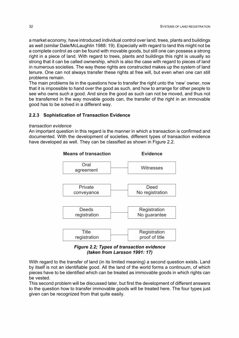
32 SYSTEMS OF LAND REGISTRATION
Figure 2.2; Types of transaction evidence(taken from Larsson 1991: 17)
a market economy, have introduced individual control over land, trees, plants and buildingsas well (similar Dale/McLaughlin 1988: 19). Especially with regard to land this might not bea complete control as can be found with movable goods, but still one can possess a strongright in a piece of land. With regard to trees, plants and buildings this right is usually sostrong that it can be called ownership, which is also the case with regard to pieces of landin numerous societies. The way these rights are constructed makes up the system of landtenure. One can not always transfer these rights at free will, but even when one can stillproblems remain.The main problems lie in the questions how to transfer the right unto the ‘new’ owner, nowthat it is impossible to hand over the good as such, and how to arrange for other people tosee who owns such a good. And since the good as such can not be moved, and thus notbe transferred in the way movable goods can, the transfer of the right in an immovablegood has to be solved in a different way.
2.2.3 Sophistication of Transaction Evidence
transaction evidenceAn important question in this regard is the manner in which a transaction is confirmed anddocumented. With the development of societies, different types of transaction evidencehave developed as well. They can be classified as shown in Figure 2.2.
With regard to the transfer of land (in its limited meaning) a second question exists. Landby itself is not an identifiable good. All the land of the world forms a continuum, of whichpieces have to be identified which can be treated as immovable goods in which rights canbe vested.This second problem will be discussed later, but first the development of different answersto the question how to transfer immovable goods will be treated here. The four types justgiven can be recognized from that quite easily.
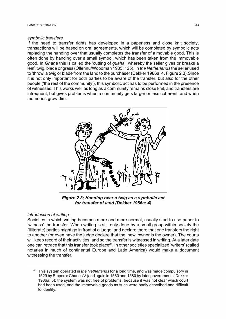
LAND REGISTRATION 33
24 This system operated in the Netherlands for a long time, and was made compulsory in1529 by Emperor Charles V (and again in 1560 and 1580 by later governments; Dekker1986a: 5); the system was not free of problems, because it was not clear which courthad been used, and the immovable goods as such were badly described and difficultto identify.
Figure 2.3; Handing over a twig as a symbolic actfor transfer of land (Dekker 1986a: 4)
symbolic transfersIf the need to transfer rights has developed in a paperless and close knit society,transactions will be based on oral agreements, which will be completed by symbolic actsreplacing the handing over that usually completes the transfer of a movable good. This isoften done by handing over a small symbol, which has been taken from the immovablegood. In Ghana this is called the ‘cutting of guaha’, whereby the seller gives or breaks aleaf, twig, blade or grass (Ollennu/Woodman 1985: 125). In the Netherlands the seller usedto ‘throw’ a twig or blade from the land to the purchaser (Dekker 1986a: 4, Figure 2.3).Sinceit is not only important for both parties to be aware of the transfer, but also for the otherpeople (‘the rest of the community’), this symbolic act has to be performed in the presenceof witnesses. This works well as long as a community remains close knit, and transfers areinfrequent, but gives problems when a community gets larger or less coherent, and whenmemories grow dim.
introduction of writingSocieties in which writing becomes more and more normal, usually start to use paper to‘witness’ the transfer. When writing is still only done by a small group within society the(illiterate) parties might go in front of a judge, and declare there that one transfers the rightto another (or even have the judge declare that the ‘new’ owner is the owner). The courtswill keep record of their activities, and so the transfer is witnessed in writing. At a later dateone can retrace that this transfer took place24. In other societies specialized ‘writers’ (callednotaries in much of continental Europe and Latin America) would make a documentwitnessing the transfer.

34 SYSTEMS OF LAND REGISTRATION
25 An extra complication can be found in the case that for instance N was the heir of M,and no transfer document was drafted between them. In such a case the fact that N gotthe right from M through inheritance has to be proven in another way.
Figure 2.4; Risks of private conveyancing
private conveyancingThese documents witnessing a transfer are often called deeds. Traditionally these deedswere left in the hands of the ‘new’ owner, and were handed over to the next ‘new’ ownerover and over again. After several transfers a whole stack of documents was handed overto the next ‘new’ owner, and usually all these documents were checked by a legalprofessional before the next transfer was made. This system is called ‘privateconveyancing’ and of course has several risks.The idea of the system is that the seller proves his or her right by being in possession ofthe previous documents that were drawn up on previous transfers. Of course the systemhas to start somewhere, but under the assumption that ‘owner A’ was generally acceptedas the owner at some point in time (for example through a grant from the government ornobility), ‘owner F’ will be satisfied when buying some land from ‘owner E’, when E canshow him or her the correct document transferring the right from A to B, and the correctdocument transferring the right for B to C, and the correct document transferring the right
from C to D and finally the correct document transferring the right from D to E25. But evenif E is able to show the whole chain of documents, it is difficult for F to make sure that theseare the correct documents. But if F becomes convinced, then E and F will draw up a newdocument which indicates their contract to transfer the right from E to F, and F will receivethis and all previous documents from E. Anyone interested in acquiring this land from thenon, will not be able to get the previous documents from E, but only from F, and thus willaccept F as the new owner (see Figure 2.4, sub a).Anyone can imagine the risks involved in this system, whereby an often ignorant andsometimes malicious person holds such valuable documents. First of all the owner of theland, and holder of the documents, might see the documents destroyed due to somenatural disaster or ignorance. It is then no longer possible to prove ownership, and therights to this land become very weak and hard to transfer. Even worse is the situation inwhich ‘person G’ steals the documents from ‘owner F’. F can no longer transfer the land inan orderly fashion, and if G falsifies a document suggesting a transfer of the land by ‘ownerF’ to him or her, he or she can then sell the land to an innocent third party (H). H will have

LAND REGISTRATION 35
26 The question how to solve contradictory claims even plays a role in cases whentransaction evidence is done through registration. Several systems exist (also see §3.2.2).
a reasonable claim to the land, as does F who –basically speaking– only lost some papers,and not his or her right to the land (see Figure 2.4 sub b)26.Another bad case appears when F will duplicate the documents by preparing a second setwith falsifications and sell his or her land twice to two different persons (I and J), who willfind themselves in conflict with the same claim at first sight (see Figure 2.4 sub c). Thereis also a serious problem when F wants to subdivide the land, since there is only one setof correct documents. The last major problem is the identification of the land to which theright being mentioned in the documents applies. This is often described in an ambiguousway, leaving ample room for later problems (see § 2.2.5).Keeping within the framework of private conveyancing, several of these problems can bediminished in severity when the evidence from the documents as such has to bestrengthened by other forms of proof, especially by checking if the seller is in actualpossession or is recognized as the landlord by the actual occupant (user). This solutionobviously does not work very well if there is a multi-tiered system of land tenure in place,in which several persons hold different ‘sets of the sticks’ that together make up a fullownership right (see Simpson 1976: 7). Only one (or maybe two) of them can then meetthe additional criterion of actual possession or recognition by the actual occupant.For later reference it is worth noting that the situation in much of England in the mid 19thcentury still mainly relied on private conveyancing, further complicated by a complex, multi-tiered system of land tenure. This was mainly caused by repeated (legal) ingenuity to avoidfeudalism and to circumvent successive laws demanding the (expensive) recording ofinstruments related to the transfer of interests in land (like introducing Equity, the Statuteof Uses and leases) (Burdon 1998: 10-23). This complexity of the English land law lasteduntil 1925 on the British Isles.
2.2.4 Transaction Evidence through Registration
introduction of registersInstead of leaving the documents in the ignorant and/or malicious hands of the owner-of-the-day, their storage could be entrusted to an independent third party, who will greatly limitthe chances of loss and falsification. Such registers of documents have been set upthroughout history in many different countries at different places like the office of a notaryor lawyer, a court, the tax authority, a local authority or an office especially established tostore such documents.When this is limited to an elementary register, it constitutes the most simple form ofregistration of deeds, which often has following drawbacks:
a. For one it was not compulsory in many cases to register the deed, although usuallya registered deed would get precedence over a non-registered deed or a laterregistered deed affecting the same land.
b. Furthermore there was usually no uniform system for identification of properties. Thedescription of the land was left to the parties to the deed.
c. Finally, the original register was arranged according to the deposition dates, whichmade it difficult to search the register to establish if the seller had a good title.(Larsson 1991: 22)

36 SYSTEMS OF LAND REGISTRATION
27 If certain letter-combination are very common extra list could be made (for instance forMc in areas with many Scottish names or Van in areas with Dutch and Flemish names).
enhancementsIn order to improve this situation jurisdictions tried all kinds of enhancements (see forinstance Dale/McLaughlin 1988: 23). The first problem (a) could be solved by making theregistration of all deeds compulsory, but these rules were not always sufficiently effective,because of limited powers to implement and control the law (Larsson 1991: 22) (as is thecase in Indonesia and Ghana). The second problem (b) was tackled by introducing anunambiguous identification of the subject unit of land (prior to registration), often on a mapand with a unique number (see below). To solve the third problem (c) indexes to the mainregister were introduced.
indexing to trace documentsThe first indexes were person-based ‘grantor/grantee’ indexes, which still form the base ofmany deeds registries in US counties (compare Dekker 1986b: 219-223). Imagine ‘personAe’ wants to sell one of his or her parcels of land to ‘person Bb’ at some point. Ae claimsto have become owner ten years ago when he or she bought the land form ‘person Cm’.In the past decade many documents have been registered, and it is very elaborate to gothrough all of them to find the right document. Some kind of index has to be kept. The mostsimple one is keeping a list of all documents mentioning the names of both parties; thegrantor/grantee index. To make this a bit easier to retrace a separate list can be made forevery letter of the alphabet27, and the appropriate names are written down there:
C
Grantor Grantee Type of transactionCz Bq saleCa Lv donationCo Ae saleCa Bx sale
* Cm Kk saleCv Op exchange
* Cm Ae saleCk Mk sale
Still it is not easy to trace back the right document. Furthermore it is complicated todetermine if the two sales by Cm in this case concern two different pieces of land or thesame piece of land twice. Even if the related deeds are studied it is questionable if theproperty description will be such that it will be easy to determine this.
Since the rights, owners, and usage may change but the land remains for ever, the landparcel is an ideal basis for recording information (Dale/McLaughlin 1988: 20). Therefore abetter way of tracing back the documents is a system in which a parcel-based index is kept.A list (or cards) of the identified pieces of land (properties) is kept, and the name of the‘owner’ is kept connected to each of them. This name is updated after every transfer, witha reference to the document concerned:

LAND REGISTRATION 37
(before sale 973) (after sale 973)
Property nr. 5873 Property nr. 5873
Fa sales doc. 303 Fa sales doc. 303 Cm sales doc. 489 Cm sales doc. 489 Ae Ae sales doc. 973
Bb
This way a quick overview can be reached. Basically this constitutes a simplified picture ofmost title registration systems (e.g. Germany), as well as the parcel-based deedsregistration systems (e.g. ‘old’ Scotland). In some countries (parts of) the contents of thedeeds are copied onto the register, instead of only referring to the place were the deed canbe found (e.g. Spain).The property numbers could be allocated purely administratively, as long as the keeper ofthe register is convinced the deed deals with a new property, and not with a property whichis already contained in the parcel-based index. It is not easy to determine that unless theland is described unambiguously and with regard to its surrounds (see § 2.2.5). The bestway to do that is make use of a parcel identifier, to which additional information can belinked as well. In that way something is created that is called a cadastre in quite somecountries. Since the information contained in this case is mainly legal, it concerns a judicialcadastre. In a similar way one could also create a file for each land unit –once clearlyidentified– in which all future transaction documents will be stored. In most countrieshowever, the property number is a separate, administrative number assigned by the staffof the registry or the court. It is quite often linked to a parcel identifier that is assigned bythe cadastral or survey office. Usually it is possible to combine more than one parcel intoone property (see Austria). This is especially useful when several adjoining parcels (whichmight differ in usage) are owned by the same person. Regularly it is also allowed tocombine non-adjoining parcels in order to establish one mortgage on the property as awhole. The usefulness of that is greatly diminished in a computerized system.
level of investigationOnce parcel-based indexes or files exist, different legal regimes could be introduced forentering information into them and for the legal status of the information that is included.Originally documents offered for registration will be accepted and stored at face value.Usually a few formal checks are likely to be made before the document will be accepted forregistration. This will usually include a minimal set of items that need to be present in thedocument, and in several systems a check will be made if the person selling is likely to bethe owner (for instance by verifying the previous deed which has to be mentioned in thisone). Several systems have introduced a rather extensive investigation into the transactionas it is presented for registration. Larsson (1991: 22) calls this ‘title investigation’. Böhringer(1997: 174) refers to it as a “strict examination of the entry request in a formal judicialprocedure”.
legal status of information(1) The legal status of the information that is included in the registration is limited to justbeing informative in a basic system. It indicates that the parties have created a legal factwith the intention of having a certain legal consequence, and decided to have it registered.Usually people relying on it, and who do not know of a problem, are regarded to be of goodfaith (bona fide). E.g. ‘old’ Ghana, some US states.

38 SYSTEMS OF LAND REGISTRATION
28 Land cannot be destroyed in a legal sense, which means no land will be lost, but alsothat no extra land can be created; which means that there is only a limited amount ofland available on the earth (Simons/Franssen 1987: 7).
(2) Often this is strengthened by the fact that registration is compulsory either to affect thirdparties, or even to complete the transfer (constitutive). In this case non-registration meansthat (for third parties) the legal consequence did not take place. On the other handregistration does not prove that the legal consequence did take place. E.g. France, theNetherlands.(3) That proof is included in the last scenario, in which one can rely on the information ‘onthe register’. Usually this register takes the form of a parcel-based book, in which for eachproperty a given set of items is presented, obviously including the present owner (and otherright holders). After the extensive investigation of a presented transaction (as mentionedbefore), the entry will be made or updated. The level of reliance one can place in theregister can still differ from ‘public faith’ (good until proven wrong; e.g. Germany) to a fullguarantee (e.g. Australia). Since contradictory situations can never be totally ruled out, thesystem is usually complemented by indemnification for the ‘loser’. The protection offered(either via guarantee or via indemnification) is restricted virtually always to those who actedin good faith (bona fide) and often to those who acted for valuable consideration.
So there are countries in which the moment a new name is entered through the properprocedures there, he or she will become the undisputable owner, even if the transaction assuch was not valid for whatever reason. The idea of such a system is that the registerreflects the (legal) reality as well as possible, and –to protect the purchaser– one can relyon the entries in the register, which can even be guaranteed (e.g. Germany). Somesystems give such an importance to the entries in the register, that the register itselfbecomes the legal reality, which seems to be an inversion of the original intent of the mirrorprinciple (see § 2.3.1 and 3.3). In many societies operating such a system the owner getsa piece of paper, usually called title certificate, that contains the information that is on theregister at the time of issuance of the paper. There are examples from countries whereduring a transaction the piece of paper is handed over as a representation of the transferof the piece of land, without the registry being informed of the transfer (like Indonesia). Oneshould be aware that possession of the certificate is not conclusive of any right to deal(Burdon 1998: 131 on Scotland). Therefore the use of title certificates is now beingabolished (e.g. Alberta, Canada) or questioned (e.g. Australia, Birrell et al 1995: 2-3).
2.2.5 Describing Land Parcels
identification of units of landLand as such, certainly in its legal meaning, has several characteristics that make itdifferent from any other good. Among these characteristics is the fact that land isimmovable, that land is eternal28 and that land can be treated in units of which theboundaries can be formed in almost any way. Land is, so to speak, a continuum, which (ifwater is included) covers the whole of the earth.Since it is the relation between persons and land that is considered here, the questionarises which unit of land does this person relate to? This question can not be answeredindependently of the right which one has in the land and the use that is made of the land.In communities that use land to hunt on, boundaries are often unclear. The land is usedextensively, and often natural features (like rivers, mountain ranges or open places)function as the borders of the territories of the hunter (group). Depending on the type of

LAND REGISTRATION 39
terrain, the pressure on the land and the relation between different (groups of) hunters, theareas in which different groups hunt might touch or even overlap each other. It is possiblethat different groups want to use the land exclusively, and in some way will formulate aboundary between them (this can be through warfare, but also in peaceful ways). It is verylikely that borders will be set in high interest areas, but not in other places.
intensification of land useIn addition to the land a society might use to hunt on, the society will often have some landwhere the dwellings are situated and some food might be grown (agriculture). If the societyis not nomadic, the dwellings and the fields around it, will be of a permanent nature. As longas these villages are in the middle of the hunting area, no external conflicts arise here. Thequestion can be limited to the internal use of the land in and around the village by themembers of the society. Many societies reached a stage where the rights to the dwellingsand the land are not limited to use rights only, but have grown into a stronger, moreindividualized form of land tenure, often referred to as ownership. Once this moment hasbeen reached it is necessary to delimit the unit of land over which one person (or family)holds such rights.In most cases the limits of a unit of land coincide with different usage of this unit comparedto the next unit. And the way land is used is reflected visibly in the terrain. Thus looking attopographic features is a first and important way of getting an idea of the limits of a certainunit of land (although it does not supply absolute certainty). Some types of land use leadto durable marks in the terrain. Think of walls that are erected, strong fences put up,asphalt or other road materials and of course buildings. These marks are visible for bothadjacent owners, and thus if they are incorrect the one who stands to lose from it has achance to react immediately.There are however also cases where the limits do not become clear from such usagepatterns. Especially in pastures and forests, the topography stays the same for anextensive area. Such areas, however, are very often not owned individually but usedthrough some kind of group right. Therefore the problem of limits in these areas is primarilyfocused on delimiting such an area from that of another group or from the more individuallyowned part of the group’s area.
boundary markersOf course the limits of individual units of land can be made visible in the terrain by puttingup special boundary markers. Many societies use durable materials (stones, iron orconcrete) to make such markers, which are also quite large and put into the ground at aconsiderable depth. There are also societies who use certain natural features for this, forinstance through planting a tree at a boundary point (see Ghana).For both visible usage marks and specially installed boundary markers one problemremains, durable does not mean completely eternal nor totally immovable. Even in theBible, in the Book of Job, it is said that ‘some remove the landmarks’ (Job 24, verse 2).Thus people have sought methods to strengthen the stability of the boundaries of their land.In close knit societies, there is a lot of common knowledge. This knowledge would beenough to notice the removal or reallocation of a boundary in any non incremental case.
surveying and mappingMany societies have, however, lost that level of intense interrelation and commonknowledge, and have to rely on other sources of evidence. Once the art of measuring isavailable in a society, surveying techniques will open new ways for this.The most simple method is measuring the distances between all boundary points relative

40 SYSTEMS OF LAND REGISTRATION
29 See for instance Dale/McLaughlin 1988: 39-40; the postal street address is widespread(Dale 1993: 34).
to one another. If one is moved this will be easily traceable through remeasuring thesedistances. If not too many points have been tampered with, it is even possible toreconstruct their original position. A further improvement can be reached when not onlydistances are measured, but also angles or bearings are included in the survey.Another basic technique to give extra assurance to the points is the use of a graphicrepresentation of the unit of land on paper. These drawings can be made only depicting theconfiguration at large (not to scale, concentrating on the topology), or –when combined withcertain survey techniques– giving a reliable overview of the unit of land at a certain scale.In both cases the plan of the parcel can be made for any given parcel alone, or can be inthe form of a map containing all parcels covering the whole of a certain area (often onevillage with its surroundings). Dale (1993: 33) stresses that each individual parcel surveyneeds to be related to the adjoining properties. This is something not always rememberedin practice (for instance Indonesia).There have been societies which have introduced their area covering maps with the useof a special measuring instrument, the plane table, which leads to a graphic representationright away (most original cadastral surveying in the early 19th century was done this way).But in most other cases the information collected during the survey has to be computed andconverted to the map or plan with use of mathematics. It is also possible to store theinformation on the boundary points as a set of coordinates in a given system in a numericway, without even plotting those onto a map. Many countries are introducing nationalcoordinate systems as a reference network for all surveying activities, including cadastralsurveying. Although there are certain benefits from this, it is doubtful if these benefits fora system of land registration alone will be enough to compensate for the costs, especiallywhen one is trying to get a system running fast.
parcel identificationFrom the above it became clear that it is possible to make the limits of units of land visiblein the terrain, either through the usage patterns or via specially erected markers. In orderto safeguard against accidental or deliberate displacement of the markers, surveying andmapping techniques can be used. But how to know which parcel is being talked about atany given time? In addition to pointing to the parcel on the map, it is very useful to identifythis parcel in such a way that it can be cross referenced easily with administrativeinformation (like who is the owner). “An identifier is a graphic symbol or set of symbolsassociated with a particular entity (e.g. natural person, corporation, land parcel) and is usedto identify data relating to that entity. ... The parcel identifier does not describe the parcel;rather it is used to index and identify data that refer to that particular parcel.” (Moyer/Fischer1973: 4-5)Societies have developed different identifier systems29. In relative empty, large scale areasa rectangular system can be used. This was done from 1785 in the (Western) US throughthe Federal Rectangular System (FRS), which is based on quadrants of six by six miles.For every state an origin is chosen, with corresponding meridian and base-line (northwardsmeridians come closer together, so the ‘quadrants’ become smaller, but this was noproblem for late 18th century surveying precision). Numbered quadrants along the meridiansare called ‘township’ and along the base line ‘range’. The townships are subdivided intosections of one mile by one mile, each identified by its position within the larger ‘township’(numbered 1 through 36 in a set order). One section could be identified as ‘Section 12,Township 4 North, Range 3 West’. Even more refined quad-tree like subdivision numbering

LAND REGISTRATION 41
systems are used. This could lead to a 20 acres rectangular defined as ‘W½ of NE¼ ofNW¼ of Section 12, Township 4 North, Range 3 West’, measuring 20 acres. (Dekker1986b: 227-230) This is however not very convenient for areas with non-systematicparcellation, or where natural features run haphazardly through these parcels.Several societies have never introduced a comprehensive numbering system, but havetried to get by with local descriptions and some reference to later sub-division plans. Othersocieties which have no area covering (index) map, tend to give out numbers in the orderof plotplans brought to the attention of the number-issuing authority. This system does notcompletely protect against the overlap of parcels which are depicted in individual plans,even if the plots are numbered (see Indonesia).
Societies which use an area covering (index) map, usually have developed uniquenumbering systems for the parcels as well. In most cases for every sub-area (usuallycoinciding with a traditional size map sheet, or an administrative area of about that size),a name and/or letter combination is given. Within this sub-area the parcels are numbered.There are different systems used to give (new) numbers to subdivided parcels (see §3.2.3). Some work with sub-numbers and maintain the relative logic of the numbers,whereas others give out new numbers and lose the logic of the numbers through time.These parcel identifiers can be used relatively easy as a reference between the map andthe administrative records. It is not so important which system is used, as long as it fulfilsthe crucial elements of the uniqueness of the parcel identifier and the effectiveness of itsuse in extracting details of ownership, tenure and value (Dale 1993: 37). Identifiers that arestraightforward and mainly number based are advantageous when computers are beingintroduced.

42 SYSTEMS OF LAND REGISTRATION
30 Concerning the public inspection, various countries operate different systems from theland register being open for inspection by anybody who is interested, anybody who hasa legally recognized interest, to the owner or anybody with his or her permission.Henssen identifies a need to have open registers.
2.3 Principles and Features
registration of landRegistration is essentially a written record which is a reliable means of ensuring accurateknowledge of facts after they have occurred, since it is relatively permanent andunalterable. The device is susceptible of infinite variation. Land registration can, as saidbefore, be described as ‘the process of recording legally recognized interests (ownershipand/or use) in land’ (McLaughlin/Nichols 1989: 81-82). The preceding paragraphs lookedat appearances of land registration, mainly by taking partial perspectives of the system ofland registration. To use systems approach terminology (see chapter 4), a subset ofelements was looked at and those were studied from one or a few aspect disciplines. Nowa few existing sets of principles and features often used when describing (certain types of)land registration will be looked at.
2.3.1 Principles
Kurandt describes four land registration principles:• speciality principle• booking principle• consent principle• publicity principle (trans. G2 of Kurandt 1957: 17-18)
He sees them as the base for the (German) system of title registration. Henssen uses thesame list (although he puts the speciality principle at the end) as the four basic legalprinciples of any type of land registration. He describes each of the principles as follows:
“The booking principle implies that a change in real rights on an immovable property,especially by transfer, is not legally effectuated until the change or the expected right isbooked or registered in the land register.The consent principle implies that the real entitled person who is booked as such in theregister must give his consent for a change of the inscription in the land register.The principle of publicity implies that the legal registers are open for public inspection,and also that the published facts can be upheld as being more or less correct by thirdparties in good faith, so that they can be protected by law. ...30
The principle of speciality implies that in land registration, and consequently in thedocuments submitted for registration, the concerned subject (man) and object (i.e. realproperty) must be unambiguously identified.” (Henssen 1995: 7)
Whereas Henssen says that these principles can generally be recognized in differentsystems, they are more useful as a base identifying areas of differences between systems.Even in his own text it becomes clear that the principle of publicity is interpreted verydifferent in different countries (and times). The same goes for the other principles. Forinstance in most US-jurisdictions the change of a right is not depending on its booking,although in practice most changes are booked (mainly due to the fact that mortgage banksdemand this). The consent principle is not explicitly applicable in the Netherlands. The

LAND REGISTRATION 43
31 Simpson adds between brackets “Some knowledge of English land law is need for aproper understanding of this principle, and of course we must not forget that inspectionof the land is always necessary, as also is inquiry of local and other public authoritieswith regard to such matters as planning proposals.”
registration authorities are not even allowed to refuse a deed when the transferor is notregistered as the previous owner (in practice notaries make sure this is the case beforecompleting the deed).
Contrary to the above principles, which put the focus on an activity, there is another list ofmore result oriented (fundamental) principles. This list is often found in Anglo-Saxonliterature, and attributed to Ruoff. He claims that registration of title succeeds or failsaccording to the degree with which the local law and local administration accord with threefundamental principles:
• mirror principle • curtain principle • insurance principle.
“(1) The mirror principle which involves the proposition that the register of title is a mirrorwhich reflects accurately and completely and beyond all argument the current facts that arematerial to title. With certain inevitable exceptions [such as overriding interests] the title isfree from all adverse burdens, rights and qualifications unless they are mentioned in theregister.(2) The curtain principle which provides that the register is the sole source of informationfor proposing purchasers who need not and, indeed, must not concern themselves withtrusts and equities which lie behind the curtain. ...31
(3) The insurance principle which is that, if through human frailty (in the Registry), the mirrorfails to give an absolutely correct reflection of the title and a flaw appears, anyone whothereby suffers loss must be put in the same position, so far as money can do it, as if thereflection were a true one. (Yet no provision is made for indemnity in Malaysia, the Sudanor Fiji, each of which would claim to operate an effective register of title.)” (Simpson 1976:22)
Both sets of principles can only be achieved by having them included in the relevant law(legislation and/or case law/jurisprudence), but also give some theoretical background onhow to perceive land registration (esp. title registration).
2.3.2 Features
In addition to the four land registration principles, Kurandt also gives a set of four featuresone can expect from (the German) title registration: • clarity • correctness • legal security • understandability (also for laymen) (trans. G3 of Kurandt 1957: 17)

44 SYSTEMS OF LAND REGISTRATION
32 The original list of 6 features is contributed to Fortescue-Brickdale, Chief Registrar inLondon at the beginning of the 20th century; the 7th feature was added by Dowson andSheppard (1956: 72).
Another Anglo-Saxon list gives seven features which should be combined in a (wellfunctioning) system of registration32: • security • simplicity • accuracy • cheapness • expedition • suitability to its circumstances • completeness of the record (Dowson/Sheppard 1956: 71-72, Simpson 1976: 17).
A related list can be found in the FIG Statement on the Cadastre, which gives “a numberof well recognized criteria for measuring the actual or potential success of a Cadastre.These criteria include:
a) Security: The system should be secure such that a land market can operate effectivelyand efficiently. Financial institutions should be willing to mortgage land quickly and thereshould be certainty of ownership and parcel identification. The system should also bephysically secure with arrangements in place for duplicate storage of records in case ofdisaster and controls to ensure that unauthorized persons cannot damage or changeinformation.
b) Clarity and Simplicity: To be effective the system should be clear and simple tounderstand and to use. Complex forms, procedures, and regulations will slow the systemdown and may discourage use of the system. Simplicity is also important in ensuring thatcosts are minimized, access is fair, and the system is maintained.
c) Timeliness: The system should provide up-to-date information in a timely fashion. Thesystem should also be complete; that is all parcels should be included in the system.
d) Fairness: In development and in operation, the Cadastre should be both fair and beperceived as being fair. As much as possible, the Cadastre should be seen as an objectivesystem separated from political processes, such as land reforms, even though it may bepart of a land reform program. Fairness also includes providing equitable access to thesystem through, for example, decentralized offices, simple procedures, and reasonablefees.
e) Accessibility: Within the constraints of cultural sensitivities, legal and privacy issues, thesystem should be capable of providing efficient and effective access to all users.
f) Cost: The system should be low cost or operated in such a way that costs can berecovered fairly and without unduly burdening users. Development costs, such as the costof the adjudication and initial survey, should not have to be absorbed entirely by initialusers. Low cost does not preclude the use of new information technologies, as long as thetechnology and its use is appropriate.

LAND REGISTRATION 45
g) Sustainability: There must be mechanisms in place to ensure that the system ismaintained over time. This includes procedures for completing the Cadastre in areasonable time frame and for keeping information up-to-date. Sustainability implies thatthe organizational and management arrangements, the procedures and technologies, andthe required educational and professional levels are appropriate for the particularjurisdiction. “ (FIG 1995: 19-20)
These sets of features could also be dubbed ‘expectations’. It is what can be expected froma (well functioning) system of land registration. It depends mainly on the administrativelayout and day-to-day operation if these expectations can be met, of course within the limitsof the law and other preconditions. Even though the features are formulated rather vaguely,the FIG calls them ‘criteria’ (to be able to measure them obviously more quantitative datais needed, as is now being worked on through benchmarking (Steudler et al 1997)).
These features are extremely important for the system of land registration. Trying to get a(qualitative) sense for these features forms an important part of the case study (seechapters 5 and 6). This is included in the case reports as one of the organizational aspects,called “daily practice versus 'law in books'.” Looking at the different features can bereplaced by looking whether the system of land registration as a whole is functioning welland achieving its goal(s). This can best be summarized with the ‘super’-featuretrustworthiness (which will later be dubbed an emergent property of systems of landregistration (see § 4.2.2)). People who trust and rely on the system, will use it. Thereforeusage can be seen as a critical factor in determining if a system is effective or not, as Barry(1999: 82) discusses with regard to cadastral systems.

46 SYSTEMS OF LAND REGISTRATION
2.4 Concluding Remarks
Acknowledging the terminological inconsistencies existing in the field, the choice was madeto use land registration as the central term for this study over land recording, cadastre orland administration. The main reason for this is the implicit focus it gives towards the roleof legal protection of owners and purchasers of land rights.More or less individual rights in land emerged in most societies once land became scarceenough. Unlike rights in movables, these rights can not be easily traded. It is not possibleto physically hand the property over from the seller to the purchaser. Therefore a moreabstract way of doing this is necessary. Four types of transaction evidence can bedistinguished (oral agreement, private conveyancing, deeds registration and titleregistration). The last two can be seen as forms of ‘land registration’ (also see § 3.1).Several variations are possible, e.g. with regard to the consequences of not registering,existence of a parcel based index, the legal meaning of the information, the ease ofchanging the information, etcetera. Furthermore it is not possible prima facie to see whatis the exact object to which a right applies; what belongs to the property. The boundariesof this have to be determined and the object, often called parcel, has to be identified.Usually surveying and mapping techniques play a role in this, often combined with physicalfeatures (like boundary markers) in the field.The historic developments have great impact on existing systems of land registration.Different countries went through similar phases of increased scarcity of land in differenttimes and at different speeds. This led to different technological possibilities being availableto meet the demands of the emerging land market. Also social and political circumstancesinfluenced the exact outcome.Still several sets of land registration principles and features are identified in the literature.One set deals with the process of recording land rights, another set deals with the meaningof the information on the register, whereas yet other sets contain what could be called theexpectations societies (should) have of a well functioning system of land registration. In theend only a trustworthy system of land registration can succeed.

47
33 Bogaerts and Zevenbergen (2001) additionally discus the following classificationswhich did not really fit into the technical, legal or organizational aspects as used in thisstudy: • centralized versus decentralized cadastral system; • fiscal versus legal cadastre; • financed by government versus self-supporting.
3 CLASSIFICATIONS OF SYSTEMS OF LAND REGISTRATION
Quite a few classifications of systems of land registration can be found in literature. Severalwill be described in this chapter. Most of the classifications put emphasis on a relativedetail, neglecting several other characteristics of a given system. When comparativediscussions are based on these one-dimensional classifications, they have a tendency toquickly turn into almost emotional debates. Based on an often rather incomplete picture,systems are quickly acclaimed or denounced.In § 1 the focus is on the most often used classification of title registration versus deedsregistration. In addition to describing it, its limited usability is discussed as well. Morefundamental critique can be found in (Zevenbergen 1994) and (Zevenbergen 1998a).In § 2 the following other classifications are introduced33: • negative versus positive systems; • race versus notice statutes; • parcel identification; • fixed versus general boundaries; • systematic versus sporadic adjudication; • organization of registry and cadastre.The paragraph concludes with explaining the limited importance of the differences,especially the one-dimensional, oversimplified classifications. To overcome those asystems approach, bridging the different disciplines will be introduced in the next chapter.In § 3 an explanation for the differences is sought in looking at abstract concepts versusreality on the ground.The chapter ends with some concluding remarks (§ 4).

48 SYSTEMS OF LAND REGISTRATION
34 “which could be more aptly labeled ‘title by registration’” (Simpson 1976: 13).
Title registrationA title registration system means that not the deed, describing e.g. the transfer of rightsis registered but the legal consequence of that transaction i.e. the right itself (= title). Sothe right itself together with the name of the rightful claimant and the object of that rightwith its restrictions and charges are registered. With this registration the title or right iscreated.
Deed registrationA deed registration system means that the deed itself, being a document whichdescribes an isolated transaction, is registered. This deed is evidence that a particulartransaction took place, but it is in principle not in itself proof of the legal rights of theinvolved parties and, consequently, it is not evidence of its legality. Thus before anydealing can be safely effectuated, the ostensible owner must trace his ownership backto a good root of title.
Descriptions given by Henssen 1995: 8
3.1 Title Registration versus Deeds Registration
3.1.1 Basics of Title and Deeds Registration
basic descriptionsIn classifying land registration systems the distinction that is usually made first is betweenregistration of title34 and registration of deeds. Legally speaking the most elementarydifference is that “deed registration is concerned with the registration of the legal fact itselfand title registration with the legal consequence of that fact.” (Henssen 1995: 8). Mostauthors, though, take several additional aspects into account. In the same publicationHenssen describes both systems in a way which is very similar to the definition given at the1972 Meeting of the Ad Hoc Group of Experts on Cadastral Surveying and Mapping (UN1973: 25, McLaughlin/Nichols 1989: 81, Larsson 1991: 17-18).In general there appears to be no short definitions of either one of these types ofregistration. Usually, depending on the chosen perspective, one type is described and the
other type is confronted therewith. An important reason for lack of such short definitions isthat it is usually tried to combine two things into them. On the one hand there is thetheoretical desire to describe two ideal types, which are each others extremes. On the otherhand there is the desire to have the definitions fit several existing systems of landregistration that operate in practice. Those systems in practice, however, never fully fit anideal type, especially since the definition needs to take several aspects into account whichcan hardly be fitted into a one-dimensional classification. This can even be seen from thisfirst introduction. In the first description cited the emphasis is on the item that is registered,whereas in the descriptions in the box the question of evidence is added to it (compare §2.2.4).In the next two subparagraphs title registration and deeds registration as usually describedin literature are further introduced, including some of the mix of theory and practice. In §3.1.4 some highlights from the debate on the issue are given.

CLASSIFICATION OF SYSTEMS OF LAND REGISTRATION 49
3.1.2 Title Registration
main principlesLand registration can be refined more and more (see § 2.2.4 and 2.2.5). The most refinedsystem of land registration can be described as the ultimate title registration.In a system of title registration one can immediately see who is the owner of certainproperty. The register therefore needs to be ‘parcel based’, and these parcels are welldefined (usually through ‘title plans’). Each time a legal fact occurs that aims at changinga right holder to a parcel, it is not the documentary evidence (‘deed’) of that fact as suchthat is registered. A deed or form saying who is giving up rights and who is gaining themis presented to the registrar. The registrar will, after thorough checks, change the name ofthe right holder listed with the parcel, dispossessing the previous right holder. Once thisname has been listed there as the new right holder, this person is the right holder by law.Any existing problems with his or her right to the parcel or in the transfer are ‘repaired’ oncethe registrar has accepted the new legal situation. If anyone who is of good faith will losehis or her rights because of this, he or she will be compensated for the loss.
Therefore the register is supposed to reflect the correct legal situation (“mirror-principle”),and there is no need for further (historic) investigation beyond the register (“curtainprinciple”). Whatever is registered is guaranteed to be the truth for a third party of good faithand a bona fide possessor who does not appear on the register will be compensated(“insurance- or guarantee principle”). (Henssen/Williamson 1990: 31; compare § 2.3.1).
Systems of title registration exist in many varieties. Especially with regard to the “insurance-or guarantee principle” numerous variants exist. Furthermore there are great differencesin the ways the parcels are described and identified. In some cases title plans are justcopied from existing large scale topographic maps (like the English and Welsh OrdnanceSurvey maps). Others use precise boundary surveys which are laid down in a numericcadastre (like the Austrian ‘Boundary Cadastre’; see Austria). Many intermediate variantsexist.
sure evidence“Registration of title to land is an authoritative record kept in a public office of the rights tounits of land as vested in some particular person(s) or body for the time being and of thelimitations of such rights.” (Dowson/Sheppard 1956, 74). “It is considered to be a sureevidence of establishing title to land. ... An inspection of the register shows, at all times, thelegal situation of the land. Consequently any person dealing on the evidence of the registerneed have no fear of ejection. The registered proprietor, and he alone, can dispose of hisrights.” (Larbi 1994: § 8.8.2). Therefore “registration of title acts as a warranty of title in theperson registered as owner and bars adverse claims.” (Simpson 1976: 106-107).On the other hand the title register “operates as the only mechanism for the transfer ofrights in question. In other words, by entering the new holder’s name on the register, theprevious owner is dispossessed” (A.W.B. Simpson 1986 as quoted by Palmer 1996: 65).
little need for investigationsWhat this would mean in reality can be described as follows: “The basic idea of registrationof title, the English form of land registration, is to reflect on a register those mattersconcerning land that will be of importance to a potential purchaser and that otherwise wouldonly be discoverable by inspection of the land, enquiries of the occupants and perusal ofa miscellany of documents” (Fairbairn 1993). Nevertheless even under systems of title

50 SYSTEMS OF LAND REGISTRATION
registration there are so-called ‘overriding interests’. This usually include those tenancy orlease agreements that can not legally be registered. In Ghana this even includes actualoccupation.“The title register is intended to be the final authority regarding the validity of a title, thuseliminating the need for subsequent investigation of chains of titles. Achieving such finalityrequired several innovations. Titles could only appear on the register after their validity hadbeen examined by registrars. Organizing title registries around parcels, rather than people(i.e., grantee-grantor system of deeds registries), helped to clearly identify who held therights to a particular parcel.” (Palmer 1996: 64, Simpson 1976: 15-23)
active registrarA registered title in a title registration is indefeasible (and guaranteed) in most cases. Tomake this possible the information entering the register has to be thoroughly checkedbefore registration is completed. For that a system of title registration needs an activeregistering institution. The head of (a branch of) this service is usually dubbed registrar.This registrar will update the title register only after he or she has assured him- or herselfthat the conveyance that is presented to him or her has really taken place. The newsituation has become almost indefeasible because of this and he or she who trusts on it willbe protected to a large extent.
land basedAnother important characteristic of registration of title is found in the definition attributed toHogg which puts the emphasis on the question if the registration (or recording) is done inrelation ‘to some particular land’, thus putting the emphasis on the question of parcelidentification, and what is often referred to as a parcel based, and not person basedregister.Lawrance considers the invention of title registration “a simple one, though far-reaching,for in essence it merely involved a change in the unit of registration. In a system ofregistration of deeds it is the deed itself which is registered. (...) In a system of registrationof title, however, it is the land parcel itself that is registered, thus effecting “the transferenceof primary attention from the mobile, mortal, mistakable persons temporarily possessing orclaiming rights over patches of the earth’s surface, to the immovable, durable, preciselydefinable units of land affected and the adoption of these as the basis of record instead”.The register itself is proof of title and its correctness at all times is usually guaranteed bythe State.” (Lawrance 1980: 2-3).
five featuresLawrance gives five features of title registration: • it constitutes two separate, but related, records: an unambiguous definition of all land
parcels (usually a series of maps, sometimes separate plans), and a descriptiverecord giving all relevant information;
• title depends on the act of registration, not on documents or on judicial orders;dealings are effected by an entry on the Land Register, and by no other means;
• the Land Register consists of folios for each parcel, with three sections (on property,proprietorship and charges);
• registration may be applied selectively to particular areas, but compilation iscompulsory;
• an important objective is to render unnecessary the trouble and expense of repeatedinvestigations of title; thus anyone who purchases on the register for valuable

CLASSIFICATION OF SYSTEMS OF LAND REGISTRATION 51
consideration and in good faith from a registered proprietor acquires an indefeasibletitle, notwithstanding any defect in the vendor’s title. (Lawrance 1980: 4).
three groups of title registrationCountries which operate a system of title registration are often divided into three groups,even though this reflects more the differences in land law, than in registration principles(Henssen 1995: 8):
a. the English Group b. the German/Swiss Group c. the Torrens Group.
The differences can be mainly found within the scope of the technical aspects, and moreprecisely with regard to the way parcels are described. In the English Group use is madeof the large scale topographic maps, in the German/Swiss Group use is made of parcel-based cadastral maps, and in the Torrens group use is made of isolated survey plans(Henssen 1995: 8).
(a) The English Group includes a.o. England, Ireland, some Canadian provinces, Nigeria(Henssen 1995: 8). This system of title registration fulfils almost all the features that weregiven above. The emphasis of the system lies with the legal aspects, since it does notinvolve a cadastre and knows very little boundary surveys. Implementation goes throughsporadic registration, which is mandatory in certain cases (like a sales contract). Theprocess does not ask for preparing an index map of the area before registration cancommence. It uses existing large scale topographic maps for this. When combined with theuse of ‘general boundaries’ (like in the British Isles) this allows for a quick and relativelycheap start. Now that completion is coming nearer in England and Wales, more attentionis given to making (digital) area covering index maps showing all parcels. That is alsonecessary to be able to fulfil the role of “juridical cadastre” within NLIS (national landinformation system). The Land Registry is the central agency. It is primarily anadministrative body, although it adheres to the ministry of justice, and the Chief LandRegistrar has some judicial powers. The title plans are prepared by registry staff, butusually derived in the office from existing Ordnance Survey maps.
A lot has been written on the English system (e.g. Simpson 1976: chapter 3, Pryer 1993).Conveyancing in mid-19th century England was a perilous activity. Private conveyancingwas only regionally replaced with a very basic deeds register, which used a closed register.Under the pretense of privacy-protection, the secrecy this led to added another importantproblem to the system. The use of a secret register (also for the title register) lasted until1990. Another speciality of the situation then and there was the existence of a multi-tieredsystem of land tenure, mainly designed to avoid feudalism and (expensive) recording (see§ 2.2.3). “English common law enabled title to land to be acquired without the consent ofthe previous owner by a process that did not have a divesting effect, i.e., the system wasa multi-titular one and a number of people might have title to the same property. In contrast,Roman law systems were uni-titular systems since a person could only acquire a title toproperty through a process that divests the former holder –there is only one root of title.”(Palmer 1996: 64-65).Introduction of land registration (and in particular of registration of title) does usually aimat leaving the substantive land law as it is (see Ghana). Nevertheless for the introductionof title registration in English common law jurisdictions to be successful, there is the need

52 SYSTEMS OF LAND REGISTRATION
35 For instance in Ontario (Canada) the Statute of Uses 1535 still applies (Burdon 1998:66).
to accompany it by certain simplifications of the land law. The introduction of titleregistration in England could only really go ahead after 60 years, when the 1925 legislationswept away enough of the “rubbish” (Simpson 1976: 75). It could be said that the adoptionof a title registration system in an English common law jurisdiction effects a move awayfrom a multi-titular system to a uni-titular one (Palmer 1996: 65).Even though English land law has been exported to most of the many territories that havebeen under British rule throughout history, these problems are only repeated there to acertain extent. Virtually all territories managed to introduce registration of deeds in an openand more effective way than England did (Simpson 1976: 92). The problem of the multi-titular land law, however, can still be found in most territories, since the 1925 simplificationwas usually not implemented there35. In addition to that in many of these territories pre-existing customary land tenure arrangements operate in addition to this English land law(sometimes parallel, sometimes intertwined (see Ghana and Mulolwa 2002)).
Theoretically conveyancing under a title system can be done by the parties themselves.They do not need to use any legal expert and can fill in the prescribed, relatively simpleforms themselves. The forms are used as the base for checks by the registrar, after whichthe registered rights are guaranteed. In practice the proclaimed advantage of ‘doing ityourself’ is limited very much. The transfer might be the result of a complicated, underlyingcontract, for which most people need legal advice, especially when both parties are on avery different level of legal competence (for instance a private person buying from aprofessional developer). Often financial complications (related to mortgaging and taxes)further complicate matters. Finally, these days planning regulations and land controlgenerally create further difficulties (Simpson 1976: 16). In combination with fixed priceconveyancing very few people in England do their own conveyancing, and professionalcounsel will be needed in virtually all cases.
(b) The German/Swiss group includes a.o. Germany, Austria, Alsace-Lorraine, Switzerland,Egypt, Turkey, Sweden, Denmark (Henssen 1995: 8). In many of these countries thetransfer to this system was simplified by using good cadastral surveys and a wellfunctioning deeds registry. This scenario could surely be applied to the German and theAustrian-Hungarian Empires (and Switzerland) in the late 19th century. Their territories cannow be found not only in Germany, Austria and Switzerland, but also in among othersCroatia, Czech Republic, Hungary, Slovakia, Slovenia and in parts of Poland and Romania.In most of these areas the land registration system retained its main characteristics evenwhen jurisdictions, borders and even social-economical principles changed.The title register is called ‘land book’ (Grundbuch in German) and very similar in structureto the land registers from the previously described systems. A difference exists though,where this system usually does not give a real state guarantee to the registered owner, butonly supplies öffentlicher Glaube to the register. That means that the right holder isprotected by ‘public faith’, but that counter-claims can be lodged (within a certain period)when one can prove a better right.In most of these countries the parties can not prepare the base documents for applicationby themselves. Usually a notary has some involvement (which could be mandatory ‘notarialdeeds’ or the ‘notarization’ of the signatures). Sometimes lawyers can be used asprofessional experts as well. In Austria the few deeds (with approved signatures) that are

CLASSIFICATION OF SYSTEMS OF LAND REGISTRATION 53
36 This is usually defended with reference to article 6 of the European Convention onHuman Rights, which says that any criminal and private law decision should be opento a court decision. Since the direct impact that a decision to register or not will have,they see it as necessary to let the court itself take the primary decision, and not havean administrative body take the primary decision, which one can appeal in a court whennecessary.
registered by the parties themselves have a far larger chance of being rejected (see Austria).The work to be done in these systems of land registration is divided among a lot of parties,both in the public and the private sector. The Grundbuch is usually kept within the courts;officially by special ‘land book judges’ (Grundbuchrichter), but in practice mainly byspecialized support staff (Rechtspfleger). The documents that have to be presented to thecourts must be seen by legal private practitioners (notaries or lawyers). The cadastre assuch is kept by survey departments. At least a part of the cadastral surveys, however, isusually performed by another group of private practitioners (licensed surveyors). All of themtend to perform their functions correctly, and when they cooperate well the system worksfine. Good cooperation is realized in Austria by the use of one common database by thoseinvolved. An even better base for this cooperation would be merging registry and cadastreinto one organization, as is the case in Czech Republic, Hungary and Slovakia. Most othercountries, however, find it very important that the registry is kept within the realm of theindependent and legally well trained judiciary36, making such a move impossible (seeAustria).
(c) The Torrens Group includes a.o. Australia, New Zealand, some provinces of Canada,some parts of the USA, Morocco, Tunisia, Syria (Henssen 1995: 8). The Torrens systemhas become very famous. Sir Robert Torrens managed to introduce the Real Property Actin 1858 in South Australia. He simplified much of the traditional English common law, anddid away with the difference between law and equity and with feudal property law. He alsoousted lawyers from the conveyancing process. Professional advice could not becompletely missed and therefore landbrokers were introduced in 1960. Hofmeister andAuer state that “the negative view on any legal advice on conveyance by Torrens, shouldbe regarded an exaggeration.” (trans. G4 from Hofmeister/Auer 1992: 14).“Basically the Torrens idea was that records of the sort normally kept by any competentland office in respect of Crown leaseholds should also be kept in respect of freehold grants.It was a very simple idea to comprehend; moreover it was essentially feasible. ... A titlegood at the time of grant could easily be kept good by efficient record backed by law.”(Simpson 1976: 71).But what about bringing old titles under such a system? There was no automatic routinefor bringing onto the register old titles, granted prior to the establishment of the register inSouth Australia. A deficiency which was not remedied a century later, leaving numerousestates being conveyed under the ‘old’ system. And it remains most difficult to convertoperational deeds registration to title registration (McLaughlin/Williamson 1985: 96).Therefore two types of registration legislation will normally co-exist, one regarding the ‘old’system and one regarding the ‘new’ system. (Larsson 1991: 23, see Ghana). For a longtime it was voluntary to bring old titles under the new system, and the advantages of theTorrens system did not suffice to let this happen. Even in the 1950s, more old system titleswere created through subdivision than conversions applied. “If this title was good, hederived no immediate benefit from registering it but only the future advantage of reducingthe cost of investigation should he come to deal with it again. If the title was bad ordoubtful, then the last thing the proprietor wanted was to have that disagreeable fact

54 SYSTEMS OF LAND REGISTRATION
37 The existing system of title insurance and the Torrens’ system more or less excludeeach other, and many American authors seem to favor the former (compare Simpson1976: 88-90).
38 In some countries many input documents were not accepted at all and the old situationwas maintained in the register, even though the transaction took place in aneconomical sense. Due to such frozen titles a complete renewal of the land registrationwas necessary in Tunisia, because the title registration was not a reflection of reality.
officially disclosed.” (Simpson 1976: 72) In a 1957 report the question was even asked“What is wrong with the Torrens System which makes it necessary to compel Old Systemowners to accept its benefits?” (Baalman 1957 as quoted by Simpson 1976: 72-73). Morerecently many laws were amended in such a way that conversion will be mandatory on thenext transaction.Nevertheless the Torrens system of land registration as such quickly spread around after1858. Within a few years the other Australian provinces and New Zealand introducedsimilar, but not identical, systems. It can be even argued that the 1862 land registration lawfor England was based on it (although one could also say Torrens was influenced by theEnglish 1857 Report (and its predecessors)). Hofmeister and Auer, however, take theopinion that the English implementation of the Torrens system has been diluted by thecourts (Hofmeister/Auer 1992: 14). Furthermore the system was introduced in variousjurisdictions in North America, although not very concise and more piecemeal. In severalof the Canadian provinces this was a success, but in the United States it was not. The 1895Illinois Torrens Act was held unconstitutional by the State Supreme Court on the groundthat it conferred judicial power on an administrative officer, contrary to the doctrine of theseparation of judicial and executive power. In order to repair this Illinois introduced ‘judicialdetermination of title’ before registration, but this made it very expensive and is one of thean important reason for the failure of the system in the United States. (Simpson 1976: 87)The argument used by the court is comparable to that used in the German/Swiss group(discussed above) to have the title registry as a part of the court. In a 1938 study onregistration in New York the conclusion is reached that “Registration affords greater titlesecurity and ease of transfer than any method dependent on recordation, but it does so ata cost generally deemed prohibitive in this country.” (Simpson 1976: 88-89). Even thoughthere might be some ulterior motives involved here –as Simpson suggests37– this correctlypoints at the contradiction that can be found when trying to solve the principles of highsecurity and quick changes at the same time (Twaroch/Muggenhuber 1997: 3).
disadvantages of registration of titleAs Palmer (1996: 64) puts it “Registration of titles (sometime called the Torrens system)is viewed by some as a means of overcoming the defects of registration of deeds”. Whentitle registration succeeds in being a system that aims at combining security, simplicity,accuracy, cheapness, expedition and suitability to its circumstances (Dowson/Sheppard1956: 71) this might be true. But in reality registration of title has disadvantages as well.“The main disadvantages are that it is complex and elaborate and requires highly skilledpersonnel. It requires high initial capital outlay to start the system, especially in economieswhere there are no up-to-date cadastral surveys.” (Larbi 1994: § 8.8.2).Under registration of title the registrar has to check both the formal requirements and thevalidity of the transaction itself before it can have the intended effect of transfer of title. Thismight take some time in which the parties are in a kind of frozen situation which can causeproblems, especially when it lasts long38.

CLASSIFICATION OF SYSTEMS OF LAND REGISTRATION 55
39 A system based on high legal and technical standards that is not affordable for manyof the new landowners of the post-apartheid era, for whom more suitable solutions arebeing implemented (Fourie/Van Gysen 1995); e.g. for being unsuited to mirror the defacto land tenure practices and too expensive to meet the demands of the majority ofSouth Africa’s population (Barry/Fourie 2002: 30).
In some cases too great devotion to the principle of indefeasibility of title can causeproblems for redress in case of acts or omissions of others. Rectification has only limitedapplication. There is also the twin remedy of indemnification. (Pryer 1993: 70) Registrationof title does transfer titles in cases where the general rules of the law of contract indicatethat the intended transfer should not succeed. Somebody will be victimized by that. Thatis why the registrar will make checks before accepting the deed and changing the titleregister. Still in some cases someone will lose something because of this principle. Thatis why there is usually the insurance principle, to reimburse the loser in these casesthrough the registry. Under registration of deeds the loser (usually another) can attempt toget relief through a normal civil action or tort action. The law could be adapted in such away that the problems concerning the title of the seller are limited only to the firstpurchaser. Third parties, who might purchase later from our present purchaser, will thenbe protected when they rely on the registers. Usually the person losing something becauseof this has had the time and possibility to correct this. Such a system will allow transactionsbetween two parties to be solved according to normal rules of the law of contract, until thepurchaser has sold the property again (see the Netherlands). This way there is no need tointroduce land registration law that discards general principles of the law of contract in allland related cases. This makes it much easier to ascertain that the land registration law fitsin with the rest of the law.
3.1.3 Deeds Registration
main principlesRegistration of deeds will remedy some of the defects that exist under private conveyancing(see § 2.2.3 and 2.2.4). Originally a deed was copied or abstracted into a public register(‘transcribed’). This way the contents of the deed and the date of registration areauthentically stored, and fraud is much harder to commit. Nowadays usually a copy ispresented to the registry, which will be dated and stamped or sealed to have the sameeffect. Compared to the secrecy of private conveyancing a deeds register is generally apublic register, in which everybody can go and inspect the registered deeds. Furthermoreregistration of deeds generally provides a certain level of security to owners since aregistered deed takes priority over an unregistered one. Finally registration is oftencompulsory to affect third parties, but in some countries even to complete the transfer.Nevertheless registration does not prove that the legal consequence intended by theparties to the deed did actually take place.Systems of deeds registration exist in many varieties. Some are simple, rudimentarycollections of unorganized deeds like the ones in many parts of the United States. Othersare well operating, improved deeds registrations (Zevenbergen 1994) like in South-Africa39,of which Simpson even said that it should be called a title registration. It is once more noteasy to describe the essence of all of these systems in a few paragraphs.
weaknesses of deeds registrationSystems of deeds registration are usually described with the main focus on their problems.These problems can be explained by the following defects (Zevenbergen 1994: 4):

56 SYSTEMS OF LAND REGISTRATION
40 In practice one can often limit the title research till one reaches the date where the titleresearch of the previous transaction started, if one trusts that title research. That issurely the case when it was done by the same lawyer or firm, or in the US when a ‘titleplant’ (see Hofmeister/Auer 1992: 15) is used. And even with regard to unregisteredland in England and Wales solicitors regularly rely on the previous ‘abstract of title’(Burdon 1998: 29).
• the fact that the deeds merely prove the fact that a transaction took place, withoutguaranteeing that the intended changes did really occur;
• the fact that it is not compulsory to register (all) changes of ownership, so that acorrect impression at one moment may become erroneous later on;
• the fact that the object the deed refers to is not very well described; • the fact that the chronologically stored deeds are badly accessible, sometimes only
through poorly alphabetized name indexes.
In other words; a deed, in itself, does not prove title. It shows that a transaction took placebut does not prove that the parties are legally entitled to carry out the transaction (Palmer1996: 63). What is registered is not the title but only the ‘evidence’ of title, namelyinstruments purporting to transfer or deal with various interests. Therefore a would-bepurchaser has to decide, by examining these instruments, and by inspection of theproperty, whether or not the vendor is the owner and has the right to sell. The history, orchain of title, of a claim has to be searched back to its original root (if possible), and allregistered instruments relating to that property have to be studied. In many cases, however,this title research is limited to the period given in a statue of limitations (for instance 15years in Singapore (Burdon 1998: 97)). Theoretically, the title research has to be repeatedin full upon each successive transfer40. A fact that is (over-)stressed in the literature.(Simpson 1976: 97-98, Hofmeister/Auer 1992: 15-16).On the other hand an advantage of deeds registration is that the procedure for acceptingthe deed by the registrar can be very quick. Only a short check might be made to see if thedeed meets the formal requirements. In the Netherlands this includes checking if thespeciality information is clear. Is there clear information on the parties included and is theparcel identified by the cadastral parcel number? The deed also has to be drawn up by anotary in most cases. The quick procedure is especially important in cases where it is themoment of acceptance of the deed that completes the transfer of title.
well functioning deeds systems“Despite these weaknesses, Dowson and Sheppard (1956, 71) note that the proceduremay be made to function efficiently, but not on account of any intrinsic merit” (Larbi 1994:§ 8.8.1). “The reliability of title examination procedures can be greatly increased with theaid of appropriate indices, bloc-maps and the imposition of various requirements by law inregard to the proper survey of the lands being dealt with and so on.” (Simpson 1976: 97-98). Many countries have improved the operation of their deeds registration throughnumerous modifications. Some of these include changes in the law, but many others arealso achieved through sound administrative procedures. Examples of those are for instancethe introduction of a geographical index like the ‘abstract index’ in Ontario (Canada) or the‘search sheets’ in Scotland (Simpson 1976: 84 and 100, Burdon 1998: 67 and 46).
improved deeds registrationThere can be various steps taken to improve registration of deeds (for instanceDale/McLaughlin 1988: 23). The following solutions can be used to solve the defects

CLASSIFICATION OF SYSTEMS OF LAND REGISTRATION 57
described above. They are presented in order of increasing need for legal change toimplement them. The use of computers is added as an additional solution to much of thedefects. The solutions are more elaborated in Zevenbergen (1994: 6-10).
• Improved accessibility, to facilitate the searches, by introducing a fully alphabetizedname index, and even a property index (like the Scottish 'search sheets').
• Better object speciality, by clear (graphical) descriptions of boundaries, use of parcelor index maps, and use of straightforward identifiers.
• Use of computers. Although systems of land registration have existed well before theintroduction of computers, use of them is very beneficial, also because of the increasein complexity of society and the increased density of population in certain areas.When improving deeds registration computers can be very helpful, especially inmaking it possible to improve and integrate the indexes to the deeds register. A goodproperty index, that will become even better when computerized, is only possiblewhen there is a good (cadastral) map and numbering system to form its basis.
• Improving completeness, by supplying legal advantages to registered deeds, whichunregistered deeds lack. Making the registration of the deed a prerequisite for thetransfer of title is the most refined form.
• Improving reliability, by assuring that the registered information is as good aspossible. Under many deeds registration systems there also is a check before a deedwill be entered. The purchaser or his or her legal advisor, will investigate if the sellerowns the property and if he or she is entitled to sell it off. In many countries thepurchase of property is (mandatory) done with the assistance of a legal expert (likea notary). He or she often undertakes the same kind of checks that the registrarwould undertake in a registration of title. And when making these checks, they will befacilitated by the improvements on the other problems in an improved registration ofdeeds.In many countries the tracing back through all the deeds to a good root of title islimited by a statute of limitations or prescription. This often obviates the need to traceback further than say 10 to 20 years (resp. in Scotland and the Netherlands).
some successful systems of deeds registrationNumerous countries have moved along this path and operate effective and efficient landregistration systems. The literature also acknowledges the success of several of thesesystems, which –due to the oversimplified one-dimensional classification– still need to bedubbed ‘registration of deeds’. We will shortly look at Scotland, South-Africa, France andthe Netherlands here.In Scotland the Registration Act 1617 formed the base for the Register of Sasines, aneffective and efficient system (Simpson 1976: 98-104, Burdon 1998: 39-48). But only a fewyears before this was established, it was written in 1609 about the then existing registerthat it was “serving little or no use than to acquire gain and commodity to the clerks keepersthereof, and to draw his Majesty’s good subjects to needless, extraordinary and mostunnecessary trouble, turmoil, fasherie and expense” (Burdon 1998: 39).A very important element in the Scottish deeds system is formed by the ‘search sheets’(introduced in 1871, and kept from 1876 onwards), which created a parcel-based index. Itdoes not have any statutory authority and was introduced ‘administratively’. In 1963 theReid Committee concluded about the system: “It affords security without losing flexibility”

58 SYSTEMS OF LAND REGISTRATION
41 After several commissions (1910, 1948) and committees (Reid 1963, Henry 1969) theLand Registration (Scotland) Act 1979 introduced a form of title registration to Scotland,which is very similar to that in England and Wales. The introduction is done county bycounty, and within the county an interest is registered on the first transfer for a valuableconsideration. By 1998 14 of the 33 (old) counties, containing the majority of thepeople, had been brought under the new law, with the latest county planned for 2003(Burdon 1998: 49). The register is comprised of ‘title sheets’, likely to be not only inname closely related to the pre-existing ‘search sheets’.
42 Since land ownership became available to all South-Africans the technical and legallevel of perfection is too expensive for many of the new, poor, small landowners(Fourie/Van Gysen 1995).
and “It keeps bureaucratic control to a minimum and allows maximum freedom of contract.In short, it is a practical system which works well.” (Simpson 1976: 101). Nevertheless titleregistration came into operation in 198141.
In South Africa since 1828 every deed and mortgage has to be subscribed by the registrarof deeds (before this was done by two members of the court according to Roman-Dutchtradition). The registrar is required to satisfy him- or herself that a deed is in order beforehe or she accepts it for registration, and to reject it if he or she is not satisfied. Whensatisfied, the registrar will issue the approved document as the title deed to the rightholder.The only way to acquire ownership of land is through the medium of the deeds registriesand the land parcels are closely defined. (Simpson 1976: 104-108) It leads to a systemwhich is, in principle42, very accurate (Palmer 1996: 65). Simpson (1976: 105) likes thesystem so much that he thinks it should be classified as a title system (see below). Heactually claims that this is the kind of system Torrens aimed at. “But he was handicappedby the system of conveyancing and the English land law and equity which had beenbrought from England with the first settlement.” The Dutch system being “infinitelypreferable to the English system if the strictures of the English lawyers we recounted inChapter 3 are to be believed.” (Simpson 1976: 107-108)
In France every deed has to be registered to have effect against third parties, and since1955 a parcel-based index –the land registry index– is kept, which is in close coordinationwith the cadastre, which falls under the same directorate and with which it shares theoffices (Springer 1998: 3). “The land ledger in France (fichier immobilier) approaches froma technical point of view the land register from the Middle European Grundbuch, althoughlegally speaking it is only a supplementary register (index).” (trans. G5 fromHofmeister/Auer 1992: 18). Simpson (1976: 412-413) says about this French system “Inbrief, here is a popular system which, whatever its theoretical shortcomings, is highlyeffective in working practice, and there is no evident need, still less demand, for any drasticchange.”
In the Netherlands an even further improved system of land registration operates. Thetransfer of ownership only takes place after the deed has been registered, and again aparcel-based index (cadastral ledger, kadastrale legger) was introduced in the 19th centurywhich has grown in to a de facto title register, which fulfills an important role in actualconveyancing, but has no special legal status (see the Netherlands and Zevenbergen1996). Pryer (1993: 61) qualifies this as a cadastre which has been developed to include

CLASSIFICATION OF SYSTEMS OF LAND REGISTRATION 59
43 As a real Anglo-Saxon author he adds that this way “an ‘improved’ system of deedsregistration has been developed, virtually indistinguishable from title registration.”(Pryer 1993: 61).
Figure 3.1; Alternative ways of building cadastral/landregistration systems (taken from Larsson 1991: 27)
land registration43. Hofmeister and Auer classify this system (together with the Spanish one)as having “a peculiar intermediate position between the French system on one hand andthe Middle European Grundbuch system on the other hand.” (trans. G6 fromHofmeister/Auer 1992: 19).In France and the Netherlands the parcel-based registers that –technically– have the samefunction as a title register are part of the cadastre. In general the development of acomplete and efficient cadastre influences the evolution of the land registration system. Inaddition to countries such as France and the Netherlands where the system of “improveddeeds registration” functions so well that no changes are being considered, other countrieshave used the cadastre as a stepping-stone to convert from deeds registration to titleregistration (for instance Austria and Germany in the late 19th century). (compare Figure3.1 and Williamson 1985: 120).
next step or notThus it is possible that a deeds registration system is improved so much, that titleregistration can be introduced on the basis of this (see also § 2.2.4). According to Larsson(1991: 22) this stage is reached when files for each –clearly identified– land unit werecreated in which all future transaction documents would be stored and some kind of ‘titleinvestigation’ was introduced in combination with a legal rule that only registered deedswould be protected against third parties. No longer did one need to search the earlierdeeds, and in addition the state not only guaranteed the content of the register but also

60 SYSTEMS OF LAND REGISTRATION
undertook to indemnify for losses on frauds and mistakes in the register, making it a veryreliable registration system indeed (Larsson 1991: 22). This is the kind of system usuallyreferred to as title registration.Some continental European countries were able to introduce this based on goodinformation they could derive from cadastre and deeds registration together. Other countries, however, decided to introduce title registration to remedy all kinds ofproblems they had with the existing system. In such a case it is much harder to completethe title register, and no jurisdiction which ‘fled’ to title registration seems to have managedto convert all titles (see below).Larsson (1991: 24) also indicates that there are certainly many intermediate stages oftaking this step found in various countries, like South Africa. On the other hand Hofmeisterand Auer (1992: 17) claim that ‘deeds will never become title.’
3.1.4 Debate on “title versus deeds”
“title above deeds”As can be judged from the last sentence of the previous paragraph, strong convictions existabout the issue of title registration versus deeds registration. To a certain extent theseconvictions are so strong, that they get some characteristics of religious beliefs. An opendebate is of course not stimulated by this. In this regard the author admittedly hasdeveloped his own beliefs, which focus mainly on keeping it simple (thus usually notstarting with a full fledged title registration). Introducing title registration in a context whereno reasonable registration system is already existing, is not the panacea it is often held for(Zevenbergen 1998a: 579-580).
highlights of English historyWithin the English-written literature the superiority of title registration is stronglyemphasized. Even in previous paragraphs examples of that could be seen.With regard to England this is not surprising. As described in § 2.2.3 and § 3.1.2conveyancing in mid 19th century England was a perilous activity. Continued privateconveyancing, and in some areas a very rudimentary and secret deeds register, combinedwith multi-tiered tenurial arrangements were in desperate need to be improved. It isimportant to realize this when reading the strongly formulated opinions of many Anglo-Saxon authors. There is of course no doubt about the superiority of title registration whenit is compared to private conveyancing or a ‘secret’ deeds registration under a multi-titularland tenure system. This, however, does not mean that this conclusion can be appliedwithout reservation when comparing just any system that is called deeds registration withany system that is called title registration.To continue on the case of England one should also remember that the mere introductionof title registration (first attempted in 1862) was not a success at all. Only after introducingthe principle of general boundaries and avoiding expensive boundary surveys (1875),introducing selective compulsory registration (1897), simplifying the substantive land law(1925) and making conversion mandatory on transfers in designated areas did the systemstart to get into swing. Even in 1998 25 % of the land was still under the old system, leadingto an extension of the cases in which mandatory conversion is prescribed by law.
other strong opinionsAuthors from the two other title registration groups (see § 3.1.2) also share the believe ofthe superiority of their system(s). From the German/Swiss Group this is done clearly byBöhringer who says “Out of all the land register systems practiced throughout the world,

CLASSIFICATION OF SYSTEMS OF LAND REGISTRATION 61
property buyers and property creditors have the greatest level of security from the landregister system applied in Germany, Austria and Switzerland.” (Böhringer 1997: 169)“When compared internationally, the Central European land registry system with its entryprinciple makes property law extremely reliable and certain, without the practicability andspeedy transfer of rights being materially impaired as a result. The land registry system inGermany, Austria and Switzerland is indisputably one of the best in the world. It can berecommended to any state.” (Böhringer 1997: 176) Coming from a very legalisticperspective, he does add “Considerable costs admittedly have to be incurred in order toguarantee this security” (Böhringer 1997: 169-170).
From experts working in the Torrens Group there is not only literature acclaiming thesuperiority of the Torrens system, but also an active policy of exportation of the system.Throughout the last few decades a lot of work has been invested in South-East Asia (andthe Pacific) in the field of land registration, and all of these systems are set up as Torrenssystems. Especially the activities in Thailand are well documented (e.g. Angus-Leppan/Williamson 1985, Feder 1987, Jeffress/Onsurd 1989). Similar activities in Indonesiahave gone underway in the late 1990s (see Indonesia). Here, however, the system is calleda modified Torrens system (Soni Harsono 1996: 8), some find that term an overrating ofthis basically ‘negative’ system (see § 3.2.1).But Australian authors have at least dared to ask “Is the Torrens system suitable for the 21st
century?” (Birrell et al 1995). Their conclusion is that changes are needed to live up to thefive qualities of Sir Robert Torrens ‘reliability, simplicity, low cost, speed and suitability’.
“neglect of deeds”Still, in much literature title registration is highly praised and considered far superior todeeds registration. Consequently deeds registration is often held in low esteem. Manyproject-proposals and papers therefore, do not take the existence of such a system intoserious consideration in improving land administration practices in a developing country.Immediate introduction of title registration is usually prescribed as the overall solution to theproblems. The author does not agree with this, as can be seen in the paper ‘Is TitleRegistration really the Panacea for defective land administration in developing countries?’(Zevenbergen 1998a).
senseless debateClearly the classification “title versus deeds” only has a very limited value. Trying to put allthese differences into a one-dimensional classification leads to oversimplification.Combined with an extreme legalistic point of view, this has led to a lot of misunderstanding.Especially well established (administrative) practices, which have become part of the lawat large (through custom) have not gotten the attention they deserve. Furthermoretechnological developments (esp. in ICT) have provided the instruments to soften some ofthe former differences (esp. databases can be queried in many ways, not needing separateindexes for parcel, address, owner, transaction, date etcetera). To avoid such debates onehas to look at systems of land registration in a more-dimensional way. A first attempt to doso can be reached by following Dekker, who classifies land registration along two lines; thequestion which documents are registered, and the question which legal proof the contentsof the land registration gives (see § 3.2.1).
The idea that the traditional distinction between title registrations and deeds registration hasonly limited value, has been expressed by McLaughlin, Williamson and Nichols. They saythat in reality most systems lie on a spectrum somewhere between the two extremes

62 SYSTEMS OF LAND REGISTRATION
44 Respectively meaning that 1) it must carry the authority of the Government, 2) theregistration system must provide a complete record of all data required to be registered,and 3) the act of registration conveys legal validity or proof of the data registered(Henssen 1988: 37).
(McLaughlin/Williamson 1985: 96). Also they argue that “In practice this distinction isblurred; in some cases an improved deed registry system may provide as many, if notmore, advantages than a land titles system that has inadequate arrangements formanaging the information in the system.” (McLaughlin/Nichols 1989: 81, similarDale/McLaughlin 1988: 24)). Referring to the latter, Palmer (1996: 64) argues that “theoriginal differences between the two systems can be attributed to quality of information.Improvements made to information management (such as better examinations by registrarsand the creation of parcel-based registers) in deeds registries may render them virtuallyindistinguishable from title registries. Furthermore, the distinctions between registration ofdeeds and titles may have relevance only in countries using English common law.” He thensuggest that it would be more useful to distinguish between “positive” and “negative”systems (see § 3.2.1). Even better is a multi-dimensional approach, focusing onjurisdiction-wide coverage, quality control, currency, guarantee, and indemnity. (Palmer1996: 64-66).
In the end the value of registration depends on whether it is authoritative and complete andhas validity44. "Not only a provision in law gives a strong legal evidence, an efficiently,effectively updated system and well trained officials which are concerned with the 'deed'give in principle the value to the registration system". (Henssen 1988: 37) UnfortunatelySimpson turns this more or less upside down as can be seen when he talks about SouthAfrica. He argues that “the only reason for classifying the South African system as deedsrather than title registration would appear to be that, technically, it is not the fact ofregistration which proves title but the document of transfer, if duly registered. But does thismake any real difference in practice if the registrar is required to satisfy himself that a deedis in order before he accepts it for registration, and to reject it if he is not satisfied,particularly if the deed itself when registered has the effect of a certificate of title?”(Simpson 1976: 105) He concludes that it is misleading to classify it as a deeds system,and that it is registration of title to all intents and purposes (Simpson 1976: 105). Classifyingit as a deeds system is only misleading, when one has developed a biased opinion towardsdeeds systems (Zevenbergen 1998a: 575).
real issuesThere is a certain number of characteristics that have to be met to make a system of landregistration work well. By far the most important seems to be ‘good administrativeoperation’, which has to be backed by some pieces of (statutory) law to make sure enoughinstruments reach the registration office.The question then is ‘do people have trust in the system and rely on it’. If so, they will useit. For cadastral systems its usage has been assumed to be a critical factor in determiningif a cadastral system is effective or not (Barry 1999: 82).Only in cases of a system that has a tendency to foul up regularly, it appears necessary toback up this public trust by a formal guarantee or indefeasibility. Too much concentrationon the odd exception to the general rules is another virtue of land registration publications.

CLASSIFICATION OF SYSTEMS OF LAND REGISTRATION 63
3.2 Other Classifications
3.2.1 Negative versus Positive Systems
first descriptionAgain there appear to be no universal definitions of either one of these types of registration.The classification in negative and positive systems of land registration has been usedextensively in the Netherlands during the debate on the new civil code during the 1950sthrough 1980s, in which the guarantee and indemnity issue was central. Under a positivesystem the registrar or his or her employer (usually the State) guarantees the titles that areregistered. Whatever is in the registration is –by law– regarded correct. Damage causedby mistakes is settled (financially) by the State (or the registry). In a negative system thereis no guarantee regarding the actual title. Only mistakes by keeping the registers areredeemed, not the (mainly private law based) problems that might not appear from thedeeds, but still exist.This can be elaborated in the following list of main characteristics of a negative system,which are amended in a positive system:
• lack of guarantees for completeness, correctness and validity of the inscribings for thetransferee;
• the inactiveness of the registering institutions in connection therewith;• lack of a complete registration of interest themselves, with the accompanying
guarantees;• lack of a financial guarantee in the form of liability for the State for the whole
registration system (de Haan 1992: 311).
But when looking at it from the position of the owner or purchaser, both systems do havepros and contras. The negative system does not give guarantees, but the processing ofinstruments that are being offered is very fast and the registering institution does notinterfere much with the seller and purchaser. In the positive system the guarantee of thetitle one will finally receive, is preceded by an often time consuming and in depthinvestigation in all kinds of aspects of the purchaser, the seller and their agreement.(Zevenbergen 1996: 728)
other descriptionsAlthough the classification appears not to be used so much elsewhere, one can find somedescriptions of ‘negative versus positive’. “One system, the negative, simply records alltransactions which involve a parcel and there is, at least in theory, a continuous record ofthe rights held and any changes that may occur in them. This record of transactions doesnot, in the legal sense, provide a title to the property and can only act as a witness in thecase of disputes. In contrast, the positive system establishes a title to the parcel, and itsrights, which is guaranteed by the government.” (Norman 1965 as quoted by Simpson1976: 21). Palmer describes this similarly as: “In a negative system, the evidence of rightsis merely evidenced in the land registry. In a positive system, title is constituted byregistration, i.e., registration dispossesses the previous owner and vests the rights in thenew owner. Positive systems may be backed by a government guarantee that theregistered information is true.” (Palmer 1996: 65)He introduces this description by saying that the classification “positive versus negative”is more useful than “title versus deeds”. Nevertheless his description of negative andpositive systems does not differ a lot from other’s descriptions of deeds and title

64 SYSTEMS OF LAND REGISTRATION
registration. He even continues by saying that “Here, the classical view of the deedsregistry presented above constitutes a negative system while the title registry representsa positive system”. (Palmer 1996: 65)
a two-dimension classificationFor him and others a positive system is virtually the same as a title registration, whereasa negative system is the same as a deeds registration. In doing so, they end up with thesame one-dimensional oversimplification as under “title versus deeds”. This was clearlyexpressed by Dekker (1986b: 24 and 56-60), who classifies land registration along twoaxes, as is depicted in Figure 3.2. One axis deals with the question which documents areregistered, and the other axis with the question which legal proof the contents of the landregistration gives.
negative positive
registration of deeds e.g. France e.g. South-Africa
registration of title e.g. Germany e.g. Australia
Figure 3.2; Two-dimensional classification of systemsof land registration (derived from Dekker 1986b)
Using this two-dimensional classification avoids some of the problems faced when tryingto classify certain countries in the dichotomy “title versus deeds”. For instance the Roman-Dutch Deeds Registry system of Southern Africa. Regardless of its name, Simpson (1976:105) wanted to classify this system as title registration (see § 3.1.3). Dekker on the otherhand, uses South-Africa as the example to illustrate the positive version of deedsregistration. Differently Palmer (1996: 65) who gives it as an example of a system which,though negative, acts much as if it is positive.In a similar way the fact that the Germanic system, usually regarded as a title registration,does not guarantee the title, but only provides it with public faith, can be easily representedin this way. Germany is the example Dekker uses to illustrate the negative version of titleregistration.
3.2.2 Race versus Notice Statutes
To make sure that documents regarding transfers are actually recorded, there needs to bean incentive to record them. Within deeds registration this incentive is usually the fact thatrecorded deeds get priority over unrecorded ones. In case of so-called double sales (thepresent owner sells his or her property twice to two different people) the question of priorityis important, especially when one of the purchasers knew it concerned a double sale.
recording statutesIn the United States of America each state has its own recording statute. The question ofhow priority is arranged is a major point of classification. There are three classes: race,notice and race-notice statutes (Simpson 1976: 96).Under a ‘race statute’ priority depends on the order in which instruments are registered.Thus the winner of the ‘race’ to the registry gains priority over anybody else, even if he orshe knew of a prior unregistered transfer. Such a statute allows for nearly complete relianceon recorded title, but it could be used for fraudulent purposes (Moyer/Fischer 1973: 16-17).In order to avoid such fraudulent purposes, the ‘notice statutes’ were introduced. “Notice
CLASSIFICATION OF SYSTEMS OF LAND REGISTRATION 65
45 This term of grace applies for deeds signed within the place of registration; if it is signedelsewhere in Ghana the term is 60 days, and abroad 3 months.
statutes place no premium on the race to the registry; the bona fide purchaser for valuewithout notice (actual or constructive) of other competing claims is safe, and the importantquestion here is whether a purchaser in fact had notice of a prior grantee’s interest; a‘notice statute’ enables the grantee to safeguard himself; for it provides that registrationconstitutes general notice, but the registration must be effected before the later purchaseoccurs and not merely before it is registered. Thus a subsequent purchaser can rely on theregister without having to record his own title document for, as against a prior purchaserwho did not record, the subsequent purchaser without notice will always win.” (Simpson1976: 96). In this case it is not possible to rely solely on the recording system due to thefairness as between two conflicting claimants. (Moyer/Fischer 1973: 17-18).The next logical step is the introduction of the ‘race-notice statute’. This hybrid makes asubsequent purchaser prevail against a prior purchaser when the subsequent purchaseris without actual or constructive notice of the earlier claim and registers before the priorpurchaser does. (Simpson 1976: 96). Most civil law systems of deeds registration operatea similar model in which a bona fide purchaser who registers first gets priority over others.Nevertheless in 1973 only half of the US jurisdictions had progressed from ‘notice’ to ‘race-notice’ statutes (only two operated a race statute; Moyer/Fischer 1973: 17).
grace periodsTo further complicate the issue some countries have introduced a grace period, before thepriority is determined by the order of registration. For instance in Ghanaian deeds systemthe purchaser has 15 days45 from the moment the deed is signed to register it, before aconflicting deed that was signed later, but registered earlier gets priority.
‘searches’It is indeed difficult to find the right balance with regard to priority in case of conflictinginterests. The best solution seems to be a system in which one can freeze the register fora few weeks by some kind of caveat. If the same person who placed the caveat register atransfer within those weeks, he or she will always have priority. Anyone else can be saidto have notice (if not actual by checking the register, than constructive by having been ableto do so), and therefore always lose from the pre-marked person. Such a system can bewritten into the law (like the English ‘searches’ or the German ‘Vormerkung’), but it couldalso be arranged through administrative practice. The period of validity of the mark shouldbe kept relatively short, otherwise abuse could be made.
3.2.3 Parcel Identification Systems
part of continuumFor the identification of parts of land many systems are used in systems of land registration.The basic problem is that land is by origin one continuum. The object of a right is alwaysa part of that continuum. This part (parcel) has to be separated from the rest of thecontinuum in some way. Sometimes this is done solely by use of written descriptions,sometimes by the topography in the field and in other cases surveying plays an importantrole (see § 3.2.4). With one of these methods the boundaries might become clear, but stillit is difficult to indicate in a deed or in the registration which of the parcels is meant to bethe object of a right. In some cases ‘metes and bounds descriptions’ are still used (see

66 SYSTEMS OF LAND REGISTRATION
Example of Property Description
“Newton Country, Georgia, Wyatt’s District, containing Sixty Five acres, more or lessBeginning at an iron bar running Northwest to a black gum tree - Thence NorthWest toa stake; thence North west to a bunch of black gum trees. Thence West to a stake;thence North to a marked pine near the line of T. L. Ray’s land. Then with his line to anIron bar about half way up the Mountain. Thence with Mrs. Doresy’s line to ClarenceWoods line; thence with Clarence Woods land to beginning corner. Same being part ofthe J.J. Harris place, of Walton County. Same being part of the land deeded to me byGeorgia Security Company, Athens, Ga.”
Hammarstrom 1989: 197
Figure 3.3 Extract from Austriancadastral map (with sub-numbers)
box), but usually the parcel is identified by referring to a map or plan. When both are usedin regard to the same parcels, often they do not match. Parcels (or their boundaries) whichare represented in a geographical way could be depicted on a series of maps covering awhole area, or on separate plans for each parcel.
cadastral (index) mapsThe series of maps approach is found in countries with a cadastre (in the Napoleonicsense) where they use cadastral maps. On such a cadastral map the whole areaconcerned is initially mapped with all existing boundaries on it. Every parcel is defined bya unique parcel identifier, which plays an important role in the descriptive part of thecadastre, and often also in the land registry. A complicating factor is that parcels will be splitand amalgamated regularly. Such changes in the boundaries of a parcel have to besurveyed, the map has to be updated and the identifier adapted accordingly (either bygiving a new number or by adding a sub-number to the old one, which is depicted in thecase of the Austrian cadastral map in Figure 3.3). In virtually every country these surveyshave to be carried out before the transfer of the new parcel can take place, although someaccept surveying after the transfer (see the Netherlands).

CLASSIFICATION OF SYSTEMS OF LAND REGISTRATION 67
46 Williamson (1985: 118), when referring to graphical, numerical and computationalcadastres, stresses that these are often found next to each other in the samejurisdiction.
graphic and numeric cadastresOriginally the boundaries as depicted on the cadastral map were drawn onto the map in thefield (with plane tables), and resulted in a graphical representation of the parcellation whichwas more or less to scale. Later when the processes of surveying and mapping becameseparated and got improved, the quality of this graphical representation grew. Manycountries still operate a ‘graphic cadastre’ in which the cadastral map contains a graphicrepresentation of the boundaries. If these need to be reconstructed the situation in the fieldand the original survey field notes are used to redetermine their position (see theNetherlands). There are, however, also countries where they operate a ‘numericcadastre’.46 In such a case every boundary point has been determined in a stablecoordinate system (usually the national geodetic network), and the set of coordinates fromthe boundary points represents the parcel. The map as such is the geometricrepresentation of this, but in case reconstruction is needed, the coordinates will be madevisible in the terrain, determining where the boundary is (see Austria).
(title) plansIn case the separate plans approach is used, it depends heavily on the scrutiny of thesurveyors if the parcels are defined properly. Not only do they have to perform technicallygood work, but they also have to watch for the relation of this parcel and that of itsneighbors. Especially when those neighboring parcels are not registered (yet), use of anindex map would define the properties more unambiguous. Numerous countries where anindex map is kept, still demand the use of separate plans for conveyance. This seems tobe an expensive exercise, with little benefit, except for the surveying community. This holdseven stronger in the few cases where a full reconstruction of the boundaries in the field isusually performed on every transfer of the property (e.g. New South Wales, Australia).On the other extreme a small group of countries (especially in the British Isles) can befound. They use existing large scale topographic maps as the base for preparing title plansand keeping an index.
3.2.4 Fixed versus General Boundaries
The difference between fixed and general boundaries has sparked about the same amountof debate within (especially the Anglo-Saxon part of) the land registration community as“title versus deeds”. Again the use of a dichotomy for a more dimensional reality has ledto confusion here. Dale and McLaughlin present at least three concepts of fixed andgeneral boundaries (Dale/McLaughlin 1988: 29). Before studying those, the concept of theboundary as such is discussed.
the boundary“In a legal sense, a boundary is (...) a vertical surface that defines where one land owner’sterritory ends and the next begins.” (Dale/McLaughlin 1988: 29). It could be argued that thisvertical surface runs from the center of the earth into the endlessness of space.Nevertheless the boundary is often seen as the intersections of this vertical surface withthe surface of the earth; giving the boundary line.

68 SYSTEMS OF LAND REGISTRATION
Priorities in Location of Boundaries
1. Natural Features2. Original Markings of Grant Boundaries3. Monuments4. Original Undisturbed Markings of Surveys5. Occupations6. Measurements
Henssen 1991: 53
boundary evidencePrincipally the (two) parties involved when a boundary is created, determine where theboundary will lie. Most of them will mark the limits of their property in the terrain with fencesor hedges (linear features) or with wooden pegs, iron bars, or concrete marks (pointfeatures). Such physical objects could also be called boundaries, although they might notfollow the same line as the legal limit does. (Dale/McLaughlin 1988: 29) Due to all kinds ofreasons parties might lose track of the position of a boundary, and come to a point wherethey want the boundary to be reconstructed. Although surveyors often think that they areespecially equipped to reconstruct boundaries, the original survey field notes are regardedas one of the lowest types of legal evidence of boundaries. Whereas regulations often
decree that ‘pegs are paramount to plans’ and that occupation takes precedence overmeasurements recorded in documents, those responsible for implementing such policiesmay, in practice, reverse the process. (Dale/McLaughlin 1988: 212-213). A more refinedlist of the way different legal evidences of boundaries can be seen in the box. Even with twoof the three types of fixed boundaries (see below) the evidence on the ground takesprecedence over what is actually written down. Only in the last mentioned type theevidence on the register will normally override whatever is on the ground, once theboundary has been fixed and registered as such. (Dale/McLaughlin 1988: 29).
fixed and general boundariesThe fact that the ‘boundary’ that is visible in the terrain may not always follow the same lineas the legal boundary causes confusion, which is also reflected in the three differentconcepts of fixed and general boundaries given by Dale and McLaughlin (1988: 29-30).
A fixed boundary can be: • an accurately surveyed boundary, which makes it possible for a surveyor to
accurately replace any corner monuments that might get lost (also ‘specificboundary’);
• a boundary corner point that becomes fixed in space when agreement is reached atthe time of alienation of the land, and thus cannot change without some document oftransfer; the surveyor’s measurement may provide useful evidence of the boundary’slocation but the boundary is fixed whether or not there has been a survey;
• a boundary for which agreement has been reached between adjoining owners andthe line of division between them is recorded as fixed in the register; from then on theevidence on the register normally overrides whatever is on the ground.

CLASSIFICATION OF SYSTEMS OF LAND REGISTRATION 69
General Boundaries Rule(Rule 278 of the Land Registration Rules 1925)
(1) Except in cases in which it is noted in the Property Register that the boundaries havebeen fixed, the filed plan or General Map shall be deemed to indicate the generalboundaries only.
(2) In such cases the exact line of the boundary will be left undetermined – as, forinstance, whether it includes a hedge or wall and ditch, or runs along the centre of a wallor fence, or its inner or outer face, or how far it runs within or beyond it; or whether or notthe land registered includes the whole or any proportion of any adjoining road or stream.
A general boundary can be: • the case where the precise line of a boundary between adjoining parcels is left
undetermined (it could be one side of a hedge or fence, or the other side, or down themiddle); see the General Boundaries Rule in the box;
• a euphemism for an indefinite boundary, like the line of high tide in coastal regionsor the edge of a forest
• an approximate line that is deliberately kept vague to prevent argument and theproverbial splitting of hairs; it is as if the line of a boundary as marked on a map isplaced out of focus; the open spaces either side of it are clear but the center of theblurred line is indeterminate; provided that there is good monumentation, for instancefences or iron stakes driven into the ground and all that is needed by the registrar isa pointer to ensure that the correct parcel has been referred to.
advantages of general boundaries“The advantages of general boundaries lie primarily in the less demanding standards ofsurvey, and the manner in which the registrar can ignore small changes in the position ofa boundary agreed between two parties, whilst still guaranteeing the title of each. Thecadastral records may therefore be compiled more cheaply and maintained within definedlimits more accurately. If, for example, a fence between two properties falls down and is re-erected along a slightly different line there would be no need to alter any cadastral map orfiled plan. General boundaries are also particularly useful when the ownership of propertiesis being determined in isolation, as in sporadic adjudication, for the ownership of land canbe ascertained without it being necessary to consult the owners of the adjoining properties.”(Dale/McLaughlin 1988: 30-31).For instance the earlier attempts to introduce fixed boundaries in England and Wales (from1862) have been failures, of which the local practice there has learnt a lot. Only severaldozens of fixed boundaries have been registered. Pryer believes that these lessons couldalso be used to the advantage of other jurisdictions. (Pryer 1993: 67) In his eyes thegeneral boundaries rule is a realistic approach for especially rural areas. “Or whatjustification can there be for requiring precision down to the last millimetre in regard to hugetracts of rural land?” (Pryer 1993: 99) In principle one can agree with him, but there are ofcourse some disadvantages as well.
disadvantages of general boundariesAn important disadvantage of general boundaries is that it does not supply the parties withthe level of confidence to the precise spatial extent of their properties that more specifically

70 SYSTEMS OF LAND REGISTRATION
47 In French the process is called constatation.
defined boundaries do. (Dale/McLaughlin 1988: 31). Furthermore the terrain and the landuse patterns have to be such that they allow for general boundaries. The average Englishcountryside with walls and hedges or the Dutch polders with many ditches are well tunedtowards use of such a system. This is different for areas where most boundaries areinvisible lines, ill defined on the ground or crop-lines and other non-permanent features, asreported with respect to Cyprus. This led an official from the Cyprus Department of Landsand Surveys to say “that the nature of boundaries in Cyprus does not permit the system of‘General boundaries’ to operate” (Roussos 1993: 106).
3.2.5 Systematic versus Sporadic Adjudication
adjudicationWhen a system of land registration is being introduced for the first time in an area, thesystem will have to cope with ‘first registration’. In cases where the system is replacing anearlier system, some kind of conversion method will have to be designed. In cases whereno earlier registered information is available, or where the ‘old’ information has a verylimited or bad quality, a process of ‘adjudication’ has to be started. During adjudicationparticulars of all rights and liabilities in a parcel must be ascertained and determinedconclusively47 (Larsson 1991: 101). The process can take place in three cases: • registration of rights • land consolidation • government grants of land.
Often the existing rights that will be registered as a result of adjudication have not beentotally defined. Their exact meaning might be vague, especially when it concerns unwrittenlaw. Therefore, even when this is not intended, adjudication might lead to substantivechanges in the land tenure situation, and therefore constitute a process of land reform.Especially group related rights are often being transformed into more individual forms ofland tenure (like in 1960s Kenya).Adjudication in the end is a process with a strong legal impact. Often the courts, or aspecial Land Tribunal, play an important role in finalizing the results of the process. It tendsto be slow and expensive. In many cases, when the claim is going to be disputed, oneneeds legal counsel, and de facto the underprivileged find themselves in great danger oflosing their rights, even when their claim is legitimate. This can be prevented when a moreadministrative approach is taken. In such an approach the registrar and/or a so-calledadjudication committee plays a major role. Although it is possible in the end to appeal toa court, most cases will be solved before that. This will lead to faster, cheaper andespecially more equal results.
methodsWhen a system is introduced two methods can be used, of which one has two variants: • systematic; • sporadic:
• obligatory; • voluntarily.
In case of a systematic adjudication, the proper authorities will declare one or more areas(usually corresponding with the territories of local government) as a registration area. For

CLASSIFICATION OF SYSTEMS OF LAND REGISTRATION 71
this whole area cadastral (index) maps are being prepared at the same time. Usually theright holders in the area are mandated to indicate their boundaries in the terrain, preferablyin agreement with the neighboring right holder. In addition to the mapping of theboundaries, everybody has to state the right he or she claims to the authorities, and hasto support his or her claim by evidence. Written evidence is preferred, but if not availablesworn statements by the right holder, supported by local (and/or customary) officials, areusually accepted as well (see Indonesia; where the latter has been introduced with the1997 regulation PP24).In addition to the map, a list is made of every parcel that has been identified indicating whohas what right to that parcel. This list is then put up for public inspection (for a few months).Rights on the list that are not contested at the end of the inspection period, become moreor less final (see also under qualified titles). In case of contestation, both claimants willhave to try and prove which one has the best right. A decision can be taken by theadjudication committee, and if necessary ultimately by the courts. This type of systematicregistration has been applied in inter alia several Carribean islands.
sporadic adjudicationIn case of sporadic adjudication, the authorities take less action. They will set up an officeand declare a certain area open for registration, after which people can come to apply forfirst registration. In theory right holders, realizing the advantages of the (new) system,should come quickly in great numbers. In practice they do not often bring their title up forregistration. Talking about pre-Torrens titles in the Australian states, Simpson (1976: 72)says: “If this title was good, he derived no immediate benefit from registering it but only thefuture advantage of reducing the cost of investigation should he come to deal with it again.If the title was bad or doubtful, then the last thing the proprietor wanted was to have thatdisagreeable fact officially disclosed.”Therefore most jurisdictions make it obligatory to register in certain cases, which will atleast include a transfer due to a sales contract. In such a case the parcel in which the soldright is vested, will have to be brought ‘on the register’. This means that for this individualparcel its boundaries will have to be determined, usually by a local survey. Often thismeans that ad hoc the adjoining neighbors will have to be consulted (unless one usesgeneral boundaries, see § 3.2.4). In addition the title has to be proven as good as possible.In these cases written evidence is even more important. Although some kind of publicity isgiven to the claim, it is never as well known as when the whole area is under scrutiny, andabsentee owners stand a serious change of not being aware of possible infringements ontheir rights. Depending on the exact wording of the law at hand, they might lose these rightsas soon as the claim is settled, or they will still have a certain ‘grace’ period to find out andreact (e.g. through primarily issuing qualified titles).
‘floating parcels’A possible drawback of sporadic registration can be the lack of index maps. Since everyparcel is surveyed individually, special arrangements are needed to prevent some of theparcels (partly) overlapping each other (see Indonesia). Imagine two plots with a brook withwide banks between the gardens; if both claim the brook at different times, some controlis needed to find this out. Otherwise both their titles will include the brook. To avoid suchproblems, every parcel of which the rights are on the register, should be easily traceable;both in the office and in the field. A comprehensive index map, of good graphical quality,on which the registered parcels are plotted is the best way to prevent problems in the office.

72 SYSTEMS OF LAND REGISTRATION
48 For this purpose this does not need to be a national geodetic network. Any network thatcovers a clearly separated area will do. See also § 2.2.5 and 3.2.3.
If the surveys are connected to a coordinate system48, they can be easily plotted onto atopographic map of large enough scale. The boundary points can also be reconstructed inthe field based on this information. Of course boundary markers could also be of use, andmore graphic methods of plotting the approximate position of the parcel unto existing mapsor aerial photographs will already prevent many of the possible problems of overlappingparcels.
client drivenSporadic registration has the advantage of being more client driven. People who haverights which are acknowledged in their community, and who have no intention of selling ormortgaging these rights, have no direct benefit from (new) land registration. Neverthelessthey will be forced to participate under a systematic adjudication scheme. In such caseseven dormant differences of interpretation might be awoken, creating new problems in thecommunity instead of solving them. But in communities were there are little problems today–and thus few clients that will voluntary register– this situation may change quickly whenso-called ‘development’ reaches these communities. National authorities, large(international) companies and other ‘outsiders’ will not always recognize the local tenuresystem, and ‘rights’ might suddenly be lost. (see Ghana and Indonesia) And even the localpower structure might break down under the increased land and property values.
qualified titlesWhen there is no complete certainty regarding a title or its extent, it is recommendably toissue so-called ‘qualified’ or ‘provisional’ titles, which can later grow into full titles. Usuallya distinction is made between titles that are qualified with regard to boundaries, and withregard to title. Titles are qualified with regard to boundaries when an elaborate andexpensive process of demarcation and surveying of the (fixed) boundary is replaced by asimple (general) boundary approach. When necessary the title can be upgraded througha final survey. Titles are qualified with regard to title when collecting enough evidence toestablish a title without any legal doubts is not possible or not reasonably possible. Thiscould be the case when there is not enough (written) evidence to fully support a claim orto limit problems caused by the limited publicity under sporadic registration. Usually sucha qualified title can grow into a full title over time, when it is not contested within the setperiod (although the title-holder is usually not inclined to go through another time andmoney consuming procedure for this). The parcel-based index of an improved deedsregistration (like in the Netherlands) could be seen as containing de facto qualified titleswithout a specific maturation date (expect for the normal prescription or statute oflimitations).
costs of adjudicationAdjudication is an expensive process. Depending on the methods chosen, the surveyingwork will often contribute highly to the total costs. It is accepted in general that undersystematic registration, the right holders will not have to pay all the costs involved, but thatsubsequent transaction will be charged at (near) cost recovery fees. Many of the rightholders will have little cash, and would not be able to stomach any serious fees on firstregistration (often many of them do not even pay the small fee to get a title certificate at theend of the process). Of course when a transaction takes place, there is usually cash athand. In such cases more realistic fees can be charged. The same of course goes for

CLASSIFICATION OF SYSTEMS OF LAND REGISTRATION 73
sporadic adjudication, which usually takes place at the time of a transaction.For the government systematic adjudication is therefore more expensive than sporadicregistration, since the right holders bear most of the costs in the latter case. Per parcel,however, sporadic registration is much more expensive, since economies of scale can bereached under systematic registration. Furthermore cadastral (index) maps and registerswhich are area covering, can be used as an important base for land information systemsand other GIS applications. Under sporadic registration it will be a long time before asubstantial part of the area is covered, and certain types of land are unlikely to be everentered (especially land owned by the state, municipalities, religious organizations,railways, trusts etcetera will rarely change hands). To get complete coverage in the end asystematic completion phase would be needed in all cases.
strategiesIn reality it is never possible to introduce land registration in a whole country at the sametime. Even when sporadic adjudication will be used, there need to be enough registrars,surveyors and other experts spread around the country to make this happen. Withsystematic adjudication it is clear that only a few areas can be dealt with at the same time.When many transactions are occurring in areas which have not been put under the ‘new’system, one runs the risk of having more ‘old’ transactions than ‘new’ ones, and increasingthe load of conversion work in a later stage. Therefore a mixed strategy is being used moreand more. In this strategy systematic adjudication is started in areas of high economicimportance or expected development. In such areas that are not covered yet, and in otherareas of average economic importance, sporadic registration is made possible (could bothbe obligatory or voluntarily). For other areas it might be worthwhile to make some simplerimprovements to the ‘old’ system for the time being, and avoid the trap of trying too muchat once.
3.2.6 Organization of Registry and Cadastre
The last difference mentioned here concerns the organizations that are involved in thesystem of land registration. When taking the system of land registration in a broad sensethere are always several players active in addition to the parties who have entered in atransaction. In most countries some of these players are governmental organizations,whereas others are private practitioners. Usually more than one governmental organizationis involved, although there are also countries with one integrated authority performing allgovernmental functions.
governmental organizationsUsually a key role in a system of land registration is played by one or more governmentalorganizations. Often the functions of land registration (in a narrow sense) and cadastre (see§ 2.1.2) are performed by different organizations. The organization performing the formerfunction can be part of the judiciary (regional courts; e.g. Austria, Sweden), another bodywithin the Ministry of Justice (e.g. England), a body within the Ministry of Lands (e.g.Ghana) or a more independent land registry. The latter functions are usually performed bya cadastral authority or a survey department. Different countries have these organizationsas part of different ministries, like the Ministry of Finance (e.g. Bavaria (Germany)), theMinistry of Lands (e.g. Ghana), the Ministry of Building (e.g. Berlin, Bremen, Hamburg(Germany)), the Ministry of Economy (e.g. Austria, Baden-Württemberg, Hessen(Germany)) or the Ministry of Internal Affairs (most other German States).

74 SYSTEMS OF LAND REGISTRATION
There is also a number of countries in which these governmental functions are combinedin one authority, which again can fall under different ministries (Finance in e.g. France orLands in e.g. Indonesia). In some cases the organization is more independent and onlyreports through a minister (e.g. Minister of Planning in the Netherlands) or directly to thecouncil of ministers or the presidency (e.g. in Slovakia, Hungary and Moldova).The introduction of computer databases has influenced the issue of one or moreorganizations. For instance Austria has introduced one database for the information keptby the courts and the survey departments without changing their organizational structure.On the other hand it was reported that Sweden, which also has a relatively long history ofusing computer databases in its system, was considering combining the different functionsinto one organization.In several long established market economies far reaching privatization plans have beenenacted, which have also affected land registration functions to some extent. Usually thesefunctions remain a monopoly regulated by law, but the organizations are set up and run likecommercial firms, sometimes in the form of a joint venture (e.g. the Netherlands, NewZealand, New South Wales (Australia), Ontario and New Brunswick (Canada)).
private practitionersAlthough not everybody agrees with what has been happening in respect of theprivatization of land registries and cadastres, there has been a long establishedinvolvement of private practitioners in the system of land registration as a whole in manycountries.Often deeds can only be drafted by specialized lawyers (e.g. the Netherlands andIndonesia), or at least need their notarization (e.g. Austria). These lawyers can be notaries,conveyancers or (specialized) solicitors. Even in countries where it is not obligatory to usesuch legal experts, most people use their services due to the complexity and high financialstakes of land transactions.The performance of boundary surveys (or cadastral surveys) is restricted to certain peoplein every country. Quite often this is not limited to government surveyors, but includes so-called licensed surveyors who operate as private firms. Often the cadastral authority orsurvey department is involved in the licensing process and approval of every surveyperformed (e.g. Austria and Ghana).Several of the countries which have (semi) privatized their registries or cadastres, aremaking the licensing and approval systems more liberal, relying more on quality assuranceand professional liability and less on bureaucratic procedures.
cooperationIn general the organizational aspects seem to be of great importance in the well functioningof the land registration systems. The author thinks that combining the registry and thecadastre in one organization is a very sensible thing to do. Already in 1972 the Ad HocGroup of Experts on Cadastral Surveys and Mapping stated that ideally the two should beperformed by a single agency, in order to have the best possible coordination (UN 1973:32). Other advantages of this setup are a clearer structure for accountability andresponsibility and a more efficient way of updating (Osskó/Niklasz 1999). Unfortunately theidea finds strong opposition in quite some countries due to historically grown (inter-ministerial) power balances, (legally) established agencies, and strong beliefs on divisionof administration and judiciary (compare UN 1973: 32). Ultimately, it is more important thatthe functions both stand for are performed in a coordinated way in which all organizations(public and private) cooperate well with each other, than how they are exactly organized.With regard to the constant stream of letters being send between the German courts and

CLASSIFICATION OF SYSTEMS OF LAND REGISTRATION 75
49 At a presentation at HMLR in London as part of the technical tour during FIG 1998 itwas mentioned that in 1996/97 about 200 claims were paid totaling around £ 1 million.By far the most claims were related to errors in the register and eight were due to fraudor forgery. Just over half the compensation paid involved the latter.
survey departments, Böhringer (1997: 175) says that “The exchange of data can only bediscontinued as soon as both establishments have changed over to EDP systems.” Thatcan be seen in the Austrian solution. There one, shared database, but separatedresponsibilities, has produced a workable scenario.
3.2.7 Limited Importance of Classifications
differences immaterial for most casesMost of the differences discussed before are immaterial for the large majority of thecases/properties. Only when more than one different person claims to have contradictoryproperty rights to the same object, there is a need for rules on how to settle this. In mostcases it only has to be made easier (and cheaper) for the purchaser to verify the seller’srights, and –by processing the transfer properly– make sure this can be done again on thenext intended transfer. An approach focused on contradictory claims emphasizes the legalintricacies, whereas an approach focused on facilitating transfers emphasizes informationmanagement and transaction costs. Those using the latter approach, like economists andpublic administrators, are likely to disagree with the users of the first approach (mainly thelegal profession). But the legal profession is called upon to deal with the cases whereproblems arise (how few that might be), and there only need to be a limited number ofchaotic and unsatisfactory court cases to have the public lose faith in the system.
risk management strategiesOn the other hand it will be more efficient for everybody when a more ‘risk management’based approach is taken (compare Palmer 1998). Numerous systems of registration havethe state give guarantees to title. This might make the state so anxious to avoid taking risksand hence be overcautious, that it results in unnecessary delays and expense. Risk taking,although not gambling, is a part of effective management. Otherwise when every aspectof a title and its supporting survey are to be meticulously checked, the hidden costs maysignificantly exceed the benefits gained. (Dale/McLaughlin 1988: 211) Some small risk istaken, and in the unlikely event of something going wrong compensation is paid(resembling an insurance policy and the principle underlying US title insurance). Forinstance the registry in England and Wales has taken such an approach, payingapproximately 0.8% of the fees in compensation49.
functional commonalitiesThe attention given to the differences between different systems of land registration is mostprofoundly seen in the classification of systems of land registration in the oversimplifiedone-dimensional classifications (foremost “title versus deeds”). Instead of focusing on suchdifferences, the next chapter will show that it is better to look at the functions the systemof land registration as a whole has to fulfil in order to achieve its goal(s). At this functionallevel the commonalities are clear and large. For the way in which the functions are fulfilledusually several options exist. Different technical, legal, and organizational options are opento set up tasks to fulfil a function. But this holds for every (sub) function, and there seemsto be less correlation between the choices made for different (sub) functions than onewould expect judging by the one-dimensional classifications.

76 SYSTEMS OF LAND REGISTRATION
administrative and ICT practices As already shown at the end of § 3.1.4 under ‘senseless debate’, the use of oversimplifiedone-dimensional classifications can be partly attributed to taking a strong legalistic point ofview and neglecting the importance of well established (administrative) practices, which areincreasingly facilitated by technological developments (esp. in ICT). The ICT provides theinstruments to soften some of the former differences. Well designed databases and querytools, replace the need to manually keep separate indexes for parcel, address, owner,transaction, date etcetera. One can also get access to databases from different places,allowing for separate offices with joint databases. By using distributed databases itbecomes possible to present to the (end) user one set of information, which is actuallycomposed of data from different coordinated databases.Although software for systems of land registration-applications is still mostly tailor made,standard packages, both databases and GIS, are increasingly becoming part of it. Andeven cadastral applications are affected by the standardization efforts in the field ofgeographical information (ISO, OpenGIS, CEN, etc.).

CLASSIFICATION OF SYSTEMS OF LAND REGISTRATION 77
3.3 Fathoming Classifications by Abstract Concepts versus Reality
different meanings of landThe different societal meanings of land described in § 1.2.1 have influence on theexpectations one has of a system of land registration. Land is also differently ‘defined’ forthe purpose of these different meanings. Preliminary land is defined by use patterns, whichif enough individualized can be supported at some point by a legal construct of ‘ownership’.Even then a difference can exist between ownership and use (other person, but also uselimitations like in zoning regulations which leave ownership per se alone).The different meanings lead to different expectations of the system of land registration.Facilitating transfers is not really of use in the context of the social-cultural meaning,although assuring legal security (including avoiding loss of territory etc.) is. Similarly peoplein less favorable agricultural areas in rural parts of Central Europe hang on to the land forsubsistence farming (or keep it idle to have it available for subsistence farming when theyretire). Here some level of legal protection is wanted (but should not cost much), andfacilitating transfers is of relatively little concern.Nevertheless the usual aim is to have a system of land registration apply to a wholecountry. That means there is a need to find the common expectations and the mostimportant specific ones. Fulfilling too little of them is a risk (‘clients’ do not feel helped), toomuch of them will make the system unnecessary complicated, slowing it down and makingit (too) expensive. The realized outcome of this dilemma will differ from country to country.This does not only hold for the existing result of the (historical) developments in thatcountry, but even for the (theoretically) most desirable outcome for this country.Consciously realizing these differences in expectations and historical growth paths shouldhelp in looking through some of the superficial differences and into the functionalcommonalities. It should also help seeing that one-dimensional classifications have verylimited power in describing whole systems of land registration.
abstract conceptsLand as the object of property rights is different from most other types of property. In manycases there is not a ‘logical’ object. The object has to be defined, has to be legallyconstructed, and can change relatively easily (compare § 2.2.5 and § 3.2.4). The objectsare separated by boundaries which define where one landowner’s territory ends and thenext begins. Even though there often is a reasonably high congruity between topographicboundary features and legal extent, there is no necessary identity between the topographyof a parcel and the legal extent of that parcel. The extent and boundaries of land parcelsare a matter of legal definition. (Burdon 1998: 152) Parcels and boundaries are abstractconcepts. This makes a very large difference with most other types of geo-information,which depicts ‘real life’ geographical phenomenon. (compare van der Molen 2001: 15). Titleplans and parcel maps are legal documents in a graphical form and not just another data-set for a geographical information system (GIS) (Burdon 1998: 154).Similarly the rights in land are abstract concepts. Property rights are an important exampleof institutions; humanly devised constraints that shape human interactions (see § 1.2.3).Rights in land are usually described in a complex system of land tenure. Through theabstract concept, land rights can grow into much more than a distribution mechanism forland use. The rights can be activated as capital, allowing inter alia for (cheaper) loansagainst collateral (see § 1.2.1).

78 SYSTEMS OF LAND REGISTRATION
abstract and realThese abstract concepts are very important to society, and instead of seeing them contraryto reality, they can be described as ‘institutional reality’. This includes institutional factswhich exist only by human agreement and are observer relative, as opposed to brutephysical facts which exist in external reality independent of human observers and humanintentions. More on these concepts, derived from J. Searle’s 1995 book ‘The Constructionof Social Reality’, and their application to cadastres can be found with Bittner, von Wolffand Frank. (Bittner et al 2000).
reality on the groundIn the above given descriptions of land rights and parcels as abstract concepts, one couldalready see references to reality on the ground. The abstract concepts of land rights andboundaries find their most important day-to-day application in regulating use patterns. Anduse is a very real, and often very visible phenomenon. Where one person stops to use land,and another person starts to use it, people tend to erect physical features. Those can bepurely practical (keeping domestic animals and/or children in, wild animals and strangersout, or blocking the view) or intended to mark ‘the boundary’. In both cases these are ‘reallife’ translations of the abstract ‘boundary’. Physical features are not infinitesimally thin andsemi-permanent at best. Walls, ditches, and hedges are rather thick. Fences fall down andare accidentally or deliberately erected in a (slightly) different position and hedgessometimes grow more in one direction than in the other. Deliberately placed boundarymarkers are usually rooted rather deep and of durable materials (long iron poles, concretemonuments). But they still can be displaced or removed accidentally or deliberately.In all cases when a boundary ‘alert’ is visible in the terrain, it is often taken at face value,even if it is no longer in the original position. This even applies in most instances where theoriginal position has been ‘registered’ by means of surveying and/or mapping techniques(see before).
master or slaveIn implementing systems of land registration the important question arises, whether to seethe abstract concept as the ‘master’ who is served by ‘reality on the ground’, or to see the‘reality on the ground’ as the ‘master’ who is served by abstract concepts.This question is easier asked than answered. Usually a system of land registration hassome of both. In certain cases the abstract concept takes precedence, in other cases thereality on the ground does. Let it be clear that there is no logical or best choice. The morepractically oriented people might consider ‘the reality on the ground’ as the logical master,but they underestimate the enormous importance of the abstract concepts in an advancedsociety and economy (compare the references to the work of de Soto and North in § 1.2.1and 1.2.3). The simple ‘reality on the ground’ use is available everywhere in the world.People live somewhere and work somewhere, both in the formal and informal economieswithin a country. What is lacking in the informal economy is the possibility to ‘activate’ thecapital which is frozen in mere informal use rights. Abstract constructs (legal, observedand/or recognized) make it possible to get (cheaper) loans against a collateral, and tospread risk, and make it transferable, through stock exchanges and secondary mortgagemarkets.
role of registrationThe question whether abstract concepts or ‘reality on the ground’ should take precedencealso exists with regard to the ‘registration’ issue. In general with regard to property rights(on all types of goods) this can be seen in the expression “Possession is nine points of the

CLASSIFICATION OF SYSTEMS OF LAND REGISTRATION 79
50 A kind of third level comes into being. It deals with the position of those who relied onthe recorded information when that differs from the ‘reality on the ground’.
law”. The person who possesses a good, has the best chance of being considered theholder of a property right (‘owner’). Or, ‘reality on the ground’ plays a very important rolein coloring in our abstract concepts.But once one starts ‘improving’ the type of transaction evidence (see § 2.2.3 and 2.2.4) onestarts to get adrift from this. In case of private conveyancing it is possession of thecollection of (earlier transfer) documents that is of great importance. The advantagecompared to oral agreements is that persons who were not present at the (last) transfer canverify the situation themselves, without having to trace and contact the witnesses. This‘third party’ will play an increasing role in further ‘improved’ types of transaction evidence.Under ‘deeds registration’ the seller transfers the property right to the purchaser, and theyevidence this in a document that is offered to an independent party for safekeeping. Nowan array of ‘reality’ versus ‘abstract’ options arise. Firstly the question comes up if thetransfer takes place in both senses regardless of its recording, or does the ‘abstract’transfer depend on the recording? In the former situation the question then is if a thirdperson is protected in any way when the transfer was not recorded, and he or she reliedon that fact50. In the latter situation ‘reality on the ground’ will differ from the abstractconcept when the transfer is not recorded, be it forgotten or deliberately skipped.Furthermore seller and/or purchaser might have offered the document for recordation, butthe recorder might not have recorded it because some kind of formal (bureaucratic)requirement was not met, the document failed on a substantive check he or she had tomake, he or she made a mistake, or he or she did not feel like recording it (because ofcorruption or nepotism). In all these cases the question is what will happen when thepurchaser of this not recorded transaction, wants to sell the property to a new purchaser.Is this new purchaser going with ‘reality on the ground’ and does he or she dare to buy, ordoes he or she want to be protected by the abstract concept as well? In the latter case thesale is likely to fail, unless the ‘defect’ can still be repaired. Obviously this will only work withrights which are tangible enough for the new purchaser to acquire something ‘on theground’ that is of value to him or her, regardless of the abstract concept. Most likely thenew purchaser will also pay a lower price than when he or she would acquire at both levels.
mechanisms for reconciliationWith so many reasons for the abstract concept to differ from ‘reality on the ground’, someof which can not be blamed on the purchaser, there is a need for a method to get the twoin line once again. One way is through prescription or adverse possession rules, in whichthe abstract concept can be updated in accordance with ‘reality on the ground’ after acertain amount of time has elapsed (usually between 5 and 40 years, differing from countryto country and between different situations). Most systems of law have realized thenecessity of fixing some definite period of time within which owners who have beenunlawfully deprived of their interests in land must prosecute their claims. Statutes oflimitation have for their object the prevention of the rearing up of claims at great distanceof time when evidences are lost. In English law title may be acquired by adversepossession, even where land is registered, which is not easily embedded in the Torrenssystem. A Torrens system without adverse possession rules can lead to considerable doubtabout many titles to land which has either been abandoned by registered proprietors andoccupied by adverse possessors, or else transferred informally and “off the register”through a series of unregistered dealings. (Pryer 1993: 69-70)“In effect [prescription] operates as a self-correcting mechanism, causing a change in the

80 SYSTEMS OF LAND REGISTRATION
“de jure” boundary position to make it coincide with the “de facto” boundary position aftera certain time period. This could be described as a form of quality assurance. For thosecountries where no such statue exists, expensive litigation may ensue after a long periodof peaceful occupation.” (Harris/Price 1993: 135)Without such mechanisms there is a risk of the legal situation lagging behind forever. Andif for political or other reasons someone sits still, it is correct that he or she finally loses hisor her right.
mirror imageTitle registration is the final step in transaction evidence ‘improvement’. As Larssondescribes it, registration leads to proof of title here. But what does that mean? In its mostextreme form it seems to mean “the abstract concept wins, regardless of the ‘reality on theground’”. The reasons for which an intention of the seller and purchaser to transfer aproperty, might not lead to registration, are the same as listed before for deeds registration.In general the checks the registrar has to make here are quite strong, and more often thannot they involve consent or approval from other agencies or (local) authorities. The amountof effort and money the purchaser (and/or seller) will have to invest to make sure theregistration will be successful is therefore quite large. On the other hand once theregistration has succeeded the purchaser really has gotten something. Even if the ‘realityon the ground’ differs from the registered situation, the one in whose name a property rightis registered is protected a long way. Or as a variant on the theme this paragraph startedwith “Being the registered proprietor is nine-and-a-half points of the law”.What is discussed here is usually referred to as the ‘mirror principle’, indicating that theregister is supposed to show the correct legal situation, or the “register of title is a mirrorwhich reflects accurately and completely and beyond all argument the current facts that arematerial to title” (Simpson 1976: 22, also see § 2.3.1). When applied to its fullest extent thiswould lead to the situation in which the register itself becomes the (legal) reality, whichseems to be an inversion of the original intend of the mirror principle. Some title registrationsystems go so far as to virtually exclude prescription/adverse possession rules, so muchtrust do they have in their system mirroring reality (e.g. Austria with regard to the ‘boundarycadastre’). Obviously no country has gone to the absolute extreme, and all operate asystem with some shade of grey. But it is clearly an example of the ‘reality on the ground’versus abstract concept issue.Therefore in the context of registration of title –in Scotland– even if the document is shownto be defective in court, because of the principle of indefeasibility, which is central to theconcept of registration of title, the land register will only be rectified to the prejudice of theproprietor in possession in extremely limited circumstances, notably where such aproprietor consents or where his or her own fraud or carelessness can be demonstrated.The remedy of the notional ‘true’ owner in the face of the principle of indefeasibility isagainst the State in the form of the indemnity. (Burdon 1998: 109) Pryer even goes as faras to say that the “Torrens titles are so relatively sacrosanct that, save, to some degree,for fraud, duress and illegality, even the highest courts in Australia have claimed no morethan a half-hearted jurisdiction over them.” (Pryer 1993: 64) In some cases too greatdevotion to the principle of indefeasibility of title can cause problems for redress in case ofacts or omissions of others. Rectification has only limited application. There is also the twinremedy of indemnification. (Pryer 1993: 70)

CLASSIFICATION OF SYSTEMS OF LAND REGISTRATION 81
equal partnersIt is the abstract concept that provides a large part of the added value of systems of landregistration. In quite some cases this makes the administrators of the system concentrateon the ‘process’ of abstracting or “paperizing” as such, sometimes losing sight of the actualcontents that is dealt with (compare the “paperized” of de Soto (2000), and the secondmortgage markets (e.g. Palmer 1996: 110)). That leads to the extreme of (legally)upholding the abstract situation when it has gone through the appropriate process (has allthe necessary ‘signatures and stamps’), even if it is blatantly in contradiction with reality.That extreme attitude gives such systems a bad press with the general public (on theground). An example seems to be the way the boundaries that are derived from the so-called court yard regulations have been treated in Bulgaria (the planning lines are treatedas paramount to the ownership lines in gardens of existing built up areas, and the notariesand registry deal with the planning lines even if the parties have refrained from adaptingtheir boundaries to this). Systems of land registration have to be abstracted enough to havetrustworthy “paper” representation of properties to support markets in land, real estate,mortgages and other related (financial) products. On the other hand they have to stay closeenough to the reality on the ground to be acceptable and trustworthy for the people on theground. To find this balance it is of the utmost importance to have clear rules of how to dealwith the different types of contradictions that can emerge. Basically a different solution canbe constructed for each type of contradiction, as long as that solution fits the society it hasto serve. It is especially important that for most cases the outcome is clear beforehand, sopeople can trust the system, and do not have to go to court for every case. Not everythingcan be foreseen in laws, and therefore countries with a long-running, established systemof land registration will have an advantage, since many cases not dealt with in the law havebeen solved in rulings of the higher courts (jurisprudence) or in generally accepted doctrine.Providing clarity and simple administrative processes seems to be the paramount objectivea well functioning system of land registration should go for.
explanatory powerUnderstanding this difference between the ‘reality on the ground’ and abstract conceptgoes a long way to fathoming and explaining differences between different systems of landregistration. It appears that many people have become so used to the way their system ofland registration operates in a certain case, that they have not given alternatives muchthought, and certainly have not looked for more ‘holistic’ explanations of (types of)differences.In the end the differences are mainly caused by how the system deals with differencesbetween the ‘abstracted concept’ and the ‘reality on the ground’. Ultimately it is moreimportant that the system has clear rules for the most apparent cases of such differences,than how these rules read.

82 SYSTEMS OF LAND REGISTRATION
3.4 Concluding Remarks
In this chapter we saw the most important classifications used when describing systemsof land registration. In addition to the “title versus deeds” debate, six other classificationsare introduced. Two of those also deal primarily with the land registry (negative/positive,race/notice). Two others focus on cadastre (parcel Identification, fixed/general boundaries).One dealt with the approaches to take on first registration (systematic/sporadicadjudication), and the last one with the organizational structure of systems of landregistration. The limited importance of the classifications is also described.In the last paragraph (§ 3) an attempt is made to fathom the classifications. The explanationis sought in the different expectations that a system of land registration has to live up to and–most importantly– in the relative position that (components of) systems of land registrationgive to the (legal) abstract concept in relation to ‘reality on the ground’.All in all, the classifications often deal only with one part of the system of land registration,and treat even that part oversimplified by squeezing it into a one-dimensional classification.Therefore these classifications only have limited meaning when describing (existing)systems of land registration, and even less value when preparing or implementing a (new)system of land registration in a country.To overcome this there is a need to study land registration much more as a whole.

83
4 LAND REGISTRATION AS A SYSTEM
There is a tendency within the field of 'land registration' to approach the object of study witha lot of emphasis on relative details, which has led to one-dimensional classifications. Sinceit is the intention of this study to break away from this approach, there was a need for aframework which could be used for studying land registration as much as possible as awhole. This framework is found in the 'systems approach'. A characteristic of the systemsapproach is that a system is studied with emphasis on the relations between its elementsand the common goal this wholeness is aimed at. Or as Kast and Rosenzweig (1970: 115)formulate it: “The holistic view is basic to the systems approach. In ... many of the sciences,the subsystems have been studied separately, with the view to later putting the partstogether into the whole. The systems approach emphasizes that this is not possible andthat the starting point has to be with the total system.”
In this chapter the (general) systems theory, on which the systems approach is based, isshortly introduced. The main characteristics of the systems approach as such aredescribed, with some of the explanation already focusing on their application to ‘landregistration’. The latter includes reference to a few publications with system-like views on‘land registration’. (§ 1)Then the 'system of land registration' is introduced. It is modeled at three levels of detail.First as an open system processing input into output (§ 2). Secondly in the form of both astatic and of a dynamic system. For both a list of functions is given. Thirdly two functionsof the system of land registration are further elaborated into a list of tasks. The results ofthe modeling are also depicted in figures. (§ 3)The chapter ends with some concluding remarks (§ 4).

84 SYSTEMS OF LAND REGISTRATION
4.1 Systems approach
4.1.1 General systems theory
The systems approach is a 'way of thinking' whereby the object of our interest is –as itsname indicates– approached as a system. A system can be described as a complex ofelements in interaction (von Bertalanffy 1951: 307). Although the systems approach canbe viewed separately from the systems theory (Keuning 1973: 42), it finds its roots in thelatter.The (general) systems theory was developed mainly from 1950 onwards, based on VonBertalanffy noticing similar occurrences in different sciences. By introducing this commontheory it would be possible for the scientists of different fields to communicate with oneanother. He also saw it as a way towards unity of science, encompassing a base sciencefor all other sciences. In addition to that broad goal it can also encourage the developmentof adequate theoretical models in the fields which lack them, as one of the sub goals of the(formerly called) Society for the Advancement of the General Systems Theory reads;maybe also in the field of land registration.
An important part of the systems theory can be found in several classifications of systems.The widest classification is the one by Boulding; he distinguishes between nine levels ofsystems: • static structure (frameworks), like crystal structures or bridges, which can be
described verbally or pictorially in any discipline; • simple dynamic systems (clockworks), like clocks, machines or the solar system,
studied in physics, classical natural science; • cybernetic systems (control mechanism), like thermostats or homeostasis
mechanisms in organisms, studied in control theory and cybernetics; • open systems (structurally self-maintaining), like flames or biological cells, studied in
theory of metabolism (and information theory); • lower organisms (genetic-societal systems), like plants, studied in botany; • animal systems, like birds and beasts, studied in zoology; • human systems, like men, studied in biology and psychology; • social systems (or socio-cultural systems), like families, the Boy Scouts, drinking
clubs or nations, studied in history, sociology, anthropology and behavioral science; • transcendental systems, like The idea of God. (Boulding 1956: 14-16, Keuning 1973:
16-19 and 53-54, Checkland 1999: 105).
From level to level the complexity increases, making it more difficult for an outside observerto predict behavior, since there is increasing dependence on unprogrammed decisions.Lower level systems are found in higher level systems, for instance man exhibits all theproperties of the six lower levels. (Checkland 1999: 105) This can be depicted in a diagram(see Figure 4.1).
The nine types of systems can be grouped in several ways. The first three can be seen asmechanical systems, the second three as biological systems, and the last three as socialsystems.
Another distinction is made between closed systems and open systems that are ininteraction with their environment. The use of closed systems can be very useful whendealing with mechanical systems, and thus in the physical sciences. A problem with closed

LAND REGISTRATION AS A SYSTEM 85
Figure 4.1; Hierarchy of systems(taken from Keuning 1973: 32)
systems is that they have an inherent tendency to move toward a static equilibrium andentropy (chaotic or random state). Systems that can be defined dealing with biological orsocial problems are, however, in a dynamic relationship with their environment. A systemthat is interacting with the environment is called an open system. An open system receivesvarious inputs, transforms these inputs in some way and exports outputs. These systemsare also open internally, meaning that the elements affect the system as a whole.(Kast/Rosenzweig 1970: 119) Another characteristic of open (biological and social) systemsis that they show equifinality (they can achieve their final results with different initialconditions and in different ways) (Kast/Rosenzweig 1970: 128).
In this study the system of land registration is seen as an open system.An example of equifinality can be found in most computerized systems of landregistration. Even though the underlying legal status and procedures often differconsiderably, their present look and functionality is usually very similar.
Another distinction can be made between static and dynamic systems. These can also becalled one-state and multi-state systems (Ackoff 1971: 663-667, Keuning 1973: 53). In thewords of Kast and Rosenzweig structure and processes represent the static and dynamicfeatures of organizations. In some cases the static features are the most important forinvestigation, in other cases the dynamic features. (Kast/Rosenzweig 1970: 171)
When describing land registration both are useful. The static form of the system ofland registration focuses on describing which information is kept; with regard to whichobjects and with what identifiers. The dynamic form of the system of land registrationfocuses on describing and understanding the main processes of land registration (tofulfill the three main functions of first registration, transfer of whole parcel andsubdivision). See § 4.3.2.
In the lower levels of Boulding’s classification the use of mathematics has proven veryuseful to describe the relations, and some people would demand a mathematicaldescription of a system before a theory would be considered part of the (general) systemstheory (like the younger Von Bertalanffy, but not Boulding). So far attempts to do the same

86 SYSTEMS OF LAND REGISTRATION
51 A query with a search engine on the World Wide Web for the term ‘systems approach’on June 30, 1997 indicated 8000 documents which contain this term; in comparison aquery on the term ‘land registration’ gives 600 and ‘land registry’ 700 documents.
at the higher levels have not been very successful. Therefore some authors are not in favorof Von Bertalanffy's formal science approach, and hold the opinion that unity of sciences(including the non-formal ones) can be reached when operational research will be used asa base for interdisciplinary research, in which the conducts of the system as a whole willbe studied through interrelating the different entities (aspect-variables) (Ackoff 1963: 119-121). This 'way of thinking' in systems at the non-mathematical levels has proven verysuccessful. It has been dubbed the 'systems approach' (Keuning 1973: 35). It can becharacterized by explanatory appeal rather than by predictive power (Rapoport 1970: 16,Keuning 1973: 45).
The original goal of coming to an all encompassing science covering all disciplines has notbeen accomplished. Therefore interest for the general systems theory as such hasdiminished. Slightly less ambitious the ‘systems science’ forms the base for a commonlanguage to be used in interdisciplinary work, for qualitative models when quantitativeapproaches from operations research fail and for the ‘systems approach’ as such. Theideas behind systems science are applied more and more in sociology, psychology,economy, organizational theory, philosophy and technology. (in ‘t Veld 1998: 21-22).Furthermore it is one of the important foundations of theoretical views for the relatively newdiscipline of information systems (or applied informatics) (Steinmüller 1993: 162-164,Brussaard 1995: 22). The systems approach is also used in many publications51. A fewexamples of interesting books in which the systems approach is used are Vos (1993), vander Walle (1994) and Kerzner (1995). Vos wrote a PhD-study on an earlier partialprivatization process at the Dutch Agency for Cadastral and Public Registers, which usesthe systems approach as a base for the research. Van der Walle wrote a book on what theauthor calls ‘human information systems’ (a combination of automation and psychology),again based on the systems approach. Kerzner wrote an extensive introduction to projectmanagement, of which the fifth edition was published in 1995, again based on the systemsapproach.
4.1.2 Systems Terminology: a System of Land Registration
defining ‘system’There have been many definitions of systems. In addition to the one by Von Bertalanffyquoted in § 4.1.1, describing a system as a complex of elements in interaction, Ackoff saysthat a system is “a complex of interrelated entities” (Ackoff 1963: 121).Bos and others identify three items which are common to all the definitions of systems onecan find: (i) the idea of wholeness; (ii) the idea of (inter-)related components, structured according to a plan; (iii) the idea of purpose towards which the activities of the system and its parts are
working. (Bos 1972: 11)
These elements can be clearly seen in Thierry’s definition: ”a system is a whole ofinteracting components, that has been organized according to a plan, in order to reach acertain goal.” (trans. D1 of Thierry 1965: 164).

LAND REGISTRATION AS A SYSTEM 87
Keuning is more critical about what is common to all the definitions of systems, and he onlyfinds the idea of wholeness (i) and the idea of (inter-)relation (part of ii) common to mostdefinitions (Keuning 1973: 56-57). He suggests as definition “a system represents a wholeas an organized collection of interrelated components.” (trans. D2 from Keuning 1973: 67).Both definitions talk about ‘components’, without making the distinction between elements(called objects or entities by others) and relationships. That is an important distinction,which is used later in this paragraph. The distinction can also be found in what Schoderbek,Schoderbek and Kefalas call “a commonly accepted definition” reading “a set of objectstogether with relationships between the objects and between their attributes related to eachother and to their environment so as to form a whole” (Schoderbek et al 1990: 13).For the purpose of studying land registration, however, that last definition is not completelysatisfactory. On the one hand the use of the term ‘objects’ usually points to themathematical systems science, whereas the use of ‘elements’ is more neutral and fitsbetter for qualitative usages (in ‘t Veld 1998: 25). On the other hand it is useful here toinclude the third item identified by Bos and contained in Thierry’s definition with regard tothe ‘goal’. For the purpose of studying land registration, a system should therefore be seenas:
“a set of elements together with relationships between the elements and betweentheir attributes related to each other and to their environment so as to form a wholethat aims to reach a certain goal.”
system componentsThe terms in the definition that are italic will be shortly discussed here (compare in ‘t Veld1998: 24-27).
Elements are the smallest parts the observer wants to look at for the benefit of his or herstudy. A sociologist studying a company as a system will see people and machines aselements. A mechanical engineer who has to design a new machine for the company willlook at the components of that machine as elements.
At a certain level of study of systems of land registration an element could be thecoordinate system in which the parcels are geometrically described. At a moredetailed level of study the coordinate system could be seen as a (sub)system, withelements being the geoid, the map projection, the origin, etc.
Attributes are the characteristics of the elements. They could be physical, geometrical,aesthetic, social, etc. Taking a woman as an element, she has attributes like a height, aface, a character.
The above mentioned element ‘coordinate system’ can have an attribute ‘zero’,indicating that no coordinates are used, but could also have attributes like ‘local’ or‘national’. At the more detailed level ‘map projection’ could have attributes like‘stereographic’, ‘Gauß Krüger’ or ‘UTM’.
Relationships exist between the elements. These relationships describe a certaincoherence between the elements. This is the way in which elements have influence oneach other (bi- or unilateral). This influence means that an attribute of an element leads toa change in the value of the attributes of other elements.
When in the list of tasks given in § 4.3.4 the element ‘checking’ (to decide if theintended transfer will legally take place) gets the attribute ‘accepted’, the ‘registering’will take place (and if ‘issuing’ is present, a certificate will be issued). When the‘checking’ gets the attribute ‘rejected’ no ‘registering’ or ‘issuing’ will take place.

88 SYSTEMS OF LAND REGISTRATION
Environment comprises all the elements outside the system that influence attributes orvalues of attributes of the system elements or retrospectively are influenced by the system.The fact that there are relationships between the system and its environment is essentialfor an open system. All the relationships that go from within the system to elements in theenvironment, and thus cross the boundary of the system, constitute the external structure.When studying an open system it is often a matter of choice which elements are consideredpart of the system and which of the environment. This choice of boundary is usuallydetermined by the perspective taken in the study (in ‘t Veld 1998: 43).
In this study the environment of the system of land registration includes for instancethe system of land tenure, the development of the economy (esp. land and propertymarket and the financial services available) and the penetration of ICT in the society(both telecommunications infrastructure and the ICT-knowledge base). The part oflaw determining the registration process is taken as part of the system, whereas thepart of law regulating land tenure is in the environment.
Whole (and emergent properties) is of course the most fundamental word in the definition.The ‘system as a whole’ is more than its parts together. Groups of elements have attributesthat are only meaningful when they are attributed to the whole, not to its parts. Andalthough they are derived from its component activities and their structure, they cannot bereduced to them. These attributes are the so-called emergent properties. This principle ofemergence can be seen for instance with the smell of ammonia, the picture emerging froma completed jigsaw, the self-awareness of a brain or the vehicular potential of a bicycle.(Hitchins 1992: 10)
For systems of land registration the ‘trustworthiness’ of the system can be dubbed asan emergent property (see § 4.2.2).
Goal is what the system is trying to achieve; the objective of the whole. The activities of thesystem and its parts are not accidental, they have a purpose. Including this in the definitionexcludes those groups of interrelated parts of which the goal it aims at can not be identified.Nevertheless man-made system, and most natural systems as well, clearly have one ormore goals. It is often very difficult and complicated for organizations to define their goals,but it is very important to accurately identify them when developing or analyzing a systemfor an organization. The goal must not be represented by vague statements, but by realgoals, a desired concrete outcome, not just a stated objective. Quite often an objective isstated, but the measure of its performance is not a real measure of that objective. Forinstance, consider a university system in which quality of education is stressed. Instead ofmeasuring this quality in terms of education, it is measured in terms of number of studentsgraduated. But even when a real objective is defined it may then be considered in a“legitimate” view by moving from the real objective to its wider consideration. For instancereducing infant mortality through vaccinations in an area where the then increasedpopulation faces starvation. (Luchsinger/Dock 1982: 14)
The goal of the system of land registration in this study is legal security. In the termsof the HABITAT ‘Global Campaign on Secure Tenure’, this aims to ensure legalsecurity of tenure, protection from discrimination and equal access to affordable,adequate housing for all persons and their families (see § 1.2.1). An example ofmeasuring something else than the real objective in this case would be the measuringof the number of titles issued each year. That would not reveal that the titling process

LAND REGISTRATION AS A SYSTEM 89
52 For instance due to expensive legal costs in the juridical appeals procedure duringadjudication.
Figure 4.2; Function and task(taken from in ‘t Veld 1998: 38)
for instance is benefitting the rich more than the poor52, which would defy the widerconsideration of the poor having access to land and security of tenure (compare vander Molen 2001: 5).
There are two other terms closely related to ‘goal’, that need attention here, being functionand task. A clear distinction between them, as well as an understanding of their relations,is important for thinking in systems. In normal speech they are often consideredinterchangeable. Here we make the following distinction that is also depicted in Figure 4.2:
The function of an element is what this element causes to happen as a desired contributionto the greater whole, in order to achieve the goal(s) of this whole.The task(s) is (or are) what needs to be done to deliver the above mentioned contribution,in order to fulfil the function (and achieve the goal(s)).
Task Function • what the element does • for what that is done • the activity itself • and the ((un-)intentional) result from it • certain tasks, activities • the function thereof.
The function deals with the result outwards and not with how the system makes thishappen. Systems are often designed by first determining the functions needed to achievethe system’s goal. A function changes less quickly in time than does a task. Due totechnical developments there is a constant push in performance of tasks from humanbeings to machines. When the focus is on the function, and not so much on the task, themodel can last longer, and it is also easier to come up with more alternatives to fulfil thatfunction. (in ‘t Veld 1998: 37-40)
Studying a system of land registration (within the context of its goal(s)) at thefunctional level is likely to help us overcome the tendency to focus on the differences,which are much more on the task level. Furthermore the distinction between functionsand tasks is very useful in describing the effects of technological developments. Oftenone ‘mechanizes’ the tasks a certain organization (or even department within it) isperforming, not looking at the wider consideration of the functions that need to befulfilled by the whole system. This might lead to less effective, sub-optimal solutionsfrom the point of view of trying to achieve the goal(s) of the system.
sub- and aspect systemsAs is shown in Figure 4.3, a subsystem consists of a subgroup of the elements of thesystem, but all relations in that part of the system are taken into consideration. In an aspectsystem, however, only a part of all the relations that can be found between the elementsare considered, and the rest of the relations are neglected. Within a company system, for

90 SYSTEMS OF LAND REGISTRATION
instance, the following could be identified: • the technological aspect system • the economic aspect system • the social aspect system (in ‘t Veld 1974: 138-4).
It remains the primary task of the aspect sciences to study the whole from the perspectiveof certain aspects. In case the positional value of one of the elements can not be explainedby any of the aspect sciences, interdisciplinarity is necessary to fully understand the givenorganization. Interdisciplinarity applies then to several aspects sciences, which study thesame whole, but from a different perspective. (Keuning 1973: 68)
aspects(relations)
aspect system
elements
sub- system
part-system
Figure 4.3; Sub- and aspect systems(derived from in ‘t Veld 1998: 31)
An often made distinction in subsystems of a system of land registration is onesubsystem land registry and one subsystem cadastre, which concurs with theinstitutional arrangements in for instance Austria. Nevertheless it is not a very goodexample. In Austria both subsystems share the same database, and in general thedescriptive part of the cadastre and the land register overlap each other for at least70%. Furthermore in most cases legal aspects will get most of the attention whentalking about land registry, whereas technical aspects (incl. surveying) get most of theattention when talking about cadastre, making it almost correct to view land registryand cadastre as two separate aspects systems of the system of land registrationinstead. Thus land registry and cadastre can best be considered as two –partiallyoverlapping– part systems.
Taking after Burdon (1998: 150) legal input, survey input and an overview could beregarded as subsystems of land registration. But in the context of this study they canbetter be compared to the different functions that need to be fulfilled in a system ofland registration. The first two are part of the dynamic system of land registration,whereas the last belongs to the static system (see § 4.3).This study looks at three aspect systems of the system of land registration, being the

LAND REGISTRATION AS A SYSTEM 91
technical, legal, and organizational aspect systems (see § 1.1.3), even though theinterrelations between them are of great value as well. It is clear that more aspectssystems exist and are relevant, for instance the social, cultural and economic aspectsystems.
4.1.3 Systems View
the whole before the partsAn important and for me essential characteristic of the systems approach is that inexamining an element, the focus is not only emphasizing the attributes of the element assuch, but also the relation of this element to other elements in a larger whole. The relation,the cohesion between the constituent parts, regardless of its nature, is put in a centralposition. In case of an open system, the relations between the elements within the systemshould be stronger or of another nature than the external relations of the element with theenvironment. Thus a system represents a certain wholeness that can be examined orengineered relatively independent. Since it is the relation between elements in a largertotality that is put central, a very specific arrangement of elements is needed. An accidentalcombination of some elements does not constitute a whole, and since a system points tothe organization of a whole, there is no system in such a case. (Keuning 1973: 59-61)Angyal says that attributes of the elements are important as far as they enable the elementto fill the positions which are required for the system (Angyal 1941/1969: 27). Keuninginterprets this in such a way that the ideal situation can only occur when all significantpositions within the system are occupied and when all the elements have reached theoptimal positional value for the relevant attributes. In organization terminology (see below)this will give the optimal decree of organization. (Keuning 1973: 64)An even more paramount position to the whole is given by Angyal when he says “In asystem the members are, from the holistic viewpoint, not significantly connected with eachother except with reference to the whole. The constituent parts of a system are notconsidered separately but with respect to a superordinate, more inclusive factor, the systemin and by which they are connected.”. (Angyal 1941/1969: 22).Or as van der Walle (1994: 13) puts it “the WHOLE is more than the sum of the parts andthus essential information is lost if only the parts are examined.”In a similar manner Ramo (1971: 11) tells us that “In the systems approach, concentrationis on the analysis and design of the whole, as distinct from the analysis and design of thecomponents or the parts. It is an approach that insists upon looking at a problem in itsentirety, taking into account all the facets, all the intertwined parameters. It is a process forunderstanding how they interact with one another and how these factors can be broughtinto proper relationship for the optimum solution of the problem. The systems approachrelates the technology to the need, the social to the technological aspects; indeed, it startsby insisting on a clear understanding of exactly what the problem is and of the goals thatshould dominate the solution and lead to the criteria for evaluating alternative avenues.”
system as abstraction of realityA system represents a certain abstraction that has to be used when nature is examinedfrom the viewpoint of a specific scientific discipline. When investigating nature, theexamination is confined to some part that interests us at a given time. This segment ofnature can be called the object of interest, the entire remaining part of nature being calledenvironment. (Klir 1969: 36). Obviously systems like this do not exist in reality. One can,however, examine parts of reality as systems, even though they are not identical to theobjects of interest (Keuning 1973: 54-55). This concurs with Lievegoed, who describes a

92 SYSTEMS OF LAND REGISTRATION
system as a man-determined whole of interrelated elements, terms or variables. He claimsthat in this way one can view a watch, a plant, a school or a company as a system.(Lievegoed 1970: 29) In addition, Keuning emphasizes the fact that in such a case thecompany is not a system, but can be viewed as a system (Keuning 1973: 55). Theemphasis shall be on the ‘way of thinking’ of the researcher. Thus, a system is “asimplification of reality” (Lievegoed 1970: 30). Brussaard also points to this perspectivecharacter of every system’s view. Or as he calls it in ‘Delft’ terminology: “something is nota system, but can be considered a system in the light of the solution to a certain problem.”(trans. D3 from Brussaard 1998: 111). It concerns the limits of the system and itsenvironment, the choice of the subsystems and aspect systems that are consideredrelevant and the determination of the time interval to take into account.The above line of reasoning concurs with the term ‘systems approach’. The goal is to givean approximation of reality by simplifying reality in an orderly fashion in order to fathomreality better. (Keuning 1973: 55)
4.1.4 Organizations as Systems
place of systems theory in organization theoryFor several decades the systems approach, and especially the open systems theory, hada hegemony in the field of organization theory. This was certainly the case in the 1960s and1970s. Later on the hegemony was threatened by a series of alternatives. Criticism wasaimed at functionalism –another major theory– and the systems theory together, withoutdifferentiating between the two (Hassard 1993: 50-53). Organizational sociologists foundmethodological shortcomings in the generic systems approach. Despite claims to thecontrary, they see the typical systems case study focusing on the internal relationshipsinvolved in the problem under investigation. It is assumed meaningful to study thoserelationships in isolation with a boundary that isolates and insulates those relationshipsfrom any causal link with others. This leads to an empiricism in which problems are studiedand explained in a fragmented way, in which the outcomes are dependent on the way theinvestigator has divided the problem into problem areas. In this way it precludes anycomparative analysis. (Allen 1975: 73-81). In addition, the generic social systems approachis seen as being based on a conservative ideology and on static concepts (Hassard 1993:55-56).Although the systems theory no longer has the hegemony, none of the alternativesemerged as the obvious successor to it. There are authors who radically defend theprinciples of systems theory and others who advocate a range of alternatives to it. (Hassard1993: 74) Since numerous texts on organization theory are still based on the systemstheory, some items of ‘organizations as systems’ are briefly mentioned here, especiallythose that have a relation to systems of land registration.
administered organizations as systemsSince there is an orientation towards output functions, environment sensitivity, integration,and perspective and coordination in activities within public administration, the systemsapproach is uniquely apropos to the study and practice of public administration. This canbe seen in a classic writing on administration that proclaimed:“ 1. Administered organizations exhibit sustained collective action.
2. Administered organizations are integral parts of a larger system.3. Administered organizations have specialized delimited goals.4. Administered organizations are dependent upon interchange with the larger system.”
(Luchsinger/Dock 1982: 118)

LAND REGISTRATION AS A SYSTEM 93
53 This paragraph is mainly derived form Kast and Rosenzweig 1970: 119-128 and 170-172. What they call a ‘subsystem’ here is actually an ‘aspect system’ in the terminologyof § 4.1.2 and Figure 4.3.
organization as an open system with subsystems53
The distinction between closed systems and open systems that are in interaction with theirenvironments, is important in organizational theory. It was realized relatively late that anorganization should be seen as an open socio-technical system. Unlike closed systems,organizations can turn the entropy around, this negative entropy can lead to a morecomplete organization. Furthermore the equifinality of open systems has a great impact onthe management of organizations. Of course, any open system has boundaries whichseparate the system that represents the organization from the environment. Whereasboundaries in physical, mechanical and biological systems can be identified, in socialorganizations the boundaries are not easily definable and have to be determined primarilyby the functions and activities (tasks) of the organization. The boundaries also depend onthe problem under scrutiny.Another way of looking at organizations is viewing them as structured socio-technicalsystems. The technical subsystem (technology based on the tasks to be performed) andthe social subsystem (relationship between the participants) are in interaction with eachother and are interdependent. Under this view an organization is not simply a technical orsocial system; it is the structuring and integrating of human activities around varioustechnologies. The organizational structure can be identified as the third subsystem, whichintermeshes the technical and the social subsystems. Therefore organizations can beviewed as a structured, socio-technical system in which each of the primary subsystemsand their interactions are considered. Structure is the established pattern of relationshipsamong the components or parts of the organization. Within organizations there is adifference between the formal and the informal structures. Studies have revealed that theseformal and informal structures are intertwined and often indistinguishable (Mintzberg 1979:11).The structure of the social organizations can not be separated from the processes of thesystem. Structure and processes are the static and dynamic features of the organization.In some cases the static aspects are the most important for investigation, in other casesthe dynamic aspects.The structure of most organizations, and many other complex systems, is so complicatedthat a hierarchy of systems (subsystems and supersystems) can be found in them. Withinthis hierarchy it is useful to define a whole on a next level, when this new whole showsemergent properties, which do not add up from the properties of the subsystems at thelower level. (Hitchins 1992: 11)
role of technology in organizationsScience and technology are a pervasive force in modern society. Large, complexorganizations have become the primary means for utilizing technology. The changingtechnology has impact upon organizational structure, psycho-social systems andmanagement practice. For changing, innovative technology, the flexible, organic systemis most effective, more than the mechanistic form. Hereby it is assumed that technologydoes not only consist of the physical manifestations, but also of the accumulatedknowledge concerning the means to accomplish tasks. Organizational technology is thecomplex of techniques utilized in the transformation of the inputs of the system into outputs.(Kast/Rosenzweig 1970: 167-168)

94 SYSTEMS OF LAND REGISTRATION
These general observations are still true, especially since the development of technologyhas gone even faster than expected in 1970.Related to systems of land registration it has been said that the ways that cadastralsystems have evolved have often been dependent more on technology and what istechnically possible than on the dictates of land, law and people (Dale 1979: 29).
Nevertheless, technological developments are often only used to mechanize or ‘manumate’(Burdon 1998: 105) a formerly human task. It would be better to re-think how to fulfil thefunction with all the available technology, which might lead to a different set of tasks. Therisk of only mechanizing tasks increases when computerization projects are consideredseparately for different subsystems of a system. For instance in the Netherlands thedescriptive and graphical part of the cadastre were mechanized separately, so that thenecessary information exchange between them took place manually for several years afterboth had been computerized. The risk of mechanizing tasks increases further when thesetasks are distributed among different institutions. If in such a case one would reallyautomate the functions, this is likely to lead to a new set of tasks. It is unlikely that this newset of tasks can be distributed among the different institutions without a shift inresponsibilities, authoritativeness, money generation and power between these institutions.An example would be the design of separate databases for the descriptive part of thecadastre and the land registry, even though they overlap for at least 70% of the contents.Obviously this leads to a duplication of effort both in designing and maintaining thedatabases, as well as in data entry and updating, even when the information exchangebetween the two databases itself would be automated. The databases will never be exactlythe same for the overlapping parts, causing inconsistencies with all their consequences.This situation can be found in parts of Germany, whereas in Austria the different institutionsset up one common database.Of course trying to tackle too much at once in an automation project is a sure risk, butkeeping too small the system within which improvements are going to be made is likely tolead to a sub-optimal solution.
organization’s goalIn this study’s and many other definitions of a system, the goal which the system aims toachieve plays an important role. It is this goal that determines which functions the systemfulfils, and which tasks (activities) are performed within the system to fulfil those functions.This applies especially with regard to organizations. “Any organization has a goal set, agroup of desired outcomes or outputs. These are arranged in a hierarchy of goals, basedon importance.” (Luchsinger/Dock 1982: 23). It is generally accepted in organization theorythat one has to formulate a goal first, before one can rationalize the human behavior withinan organization (Keuning 1973: 118). Only if the question why and for which goal peoplecooperate in structured collectives is put first, thinking about organizational questions canescape the danger of the organization becoming an untouchable wholeness whose goalis derived from only a few individuals or from an unclear environment (Keuning 1973: 113).
But when the goal of an organization as such is formulated, there may still becomplications. The creation of subsystems to undertake parts of the work, means one hasto develop goals for the subsystems. “This can create suboptimization where the parts ofsubsystems pursue their own subgoals. Since the parts affect the whole, it is desirable forsubsystem goals to be consistent with overall system goals, but differentiation naturallycreates potential goal conflict.” (Luchsinger/Dock 1982: 23)
LAND REGISTRATION AS A SYSTEM 95
54 In its most extreme form lawyers will focus on legal aspects, and surveyors on technicalaspects, making it also correct to view land registry and cadastre as two separateaspects systems of the system of land registration.
55 Haußmann, Minister of Justice of Baden-Württemberg, at the yearly convention of theunion of licensed surveyors in Heidelberg on October 22, 1955.
It seems that this happens a lot within systems of land registration, even when thesubsystems are part of one organization (BPN in Indonesia) or at least adhere to oneministry (Ministry of Lands in Ghana or Finance in France). The actual tasks beingperformed are no longer seen in the light of the overall goal to be achieved.
“The goal structure sets the framework for the relationships between an organization andits environment. However, the goal-establishing process is dynamic and complex.Organizations typically do not have one single, unitary objective but must satisfy a wholeset of requirements imposed on them by the environment and internal organizationalparticipants.” (Kast/Rosenzweig 1970: 529)“The central objective of a system is its measure of performance. Hopefully, this will be theoutput of the system. Objectives may be classified as real or stated. The real objective ofthe system will not be sacrificed to achieve other goals. ... The stated objective may be thereal objective, but it is not uncommon for an organization to print one objective and tooperate by a different objective. An analysis of the company’s system will reveal the realobjective.” (Luchsinger/Dock 1982: 3)
Most systems of land registration will have as a goal or objective the protection ofinterests in land, most likely it is added that this has to be done in a fair and equalway. Furthermore a goal can be formulated to supply land related data, either foradministrative and policy duties, or even for any societal need (including commercialones).
4.1.5 Systems Views on Land Registration
need for systems viewThe most common division in part systems of systems of land registration distinguishesbetween the land registry and the cadastre. In quite some countries this coincides withinstitutional arrangements, in which both part systems are performed by different agencies,which regularly even adhere to different ministries (land registries often to the Ministry ofJustice or –as a part of the judiciary– to no ministry at all; cadastres can be found undernumerous ministries, including Finance, Planning and the Interior). Furthermore, at leasthistorically, the higher ranks of staff in land registries are lawyers, and in cadastres landsurveyors54. Nevertheless the descriptive part of the cadastre and the land register overlapeach other usually for at least 70%, which makes the distinction less apparent. The needfor the two to work closely together was well formulated by a Minister of Justice of one ofthe German states55:“The survey people and the land book people have to be interested in each others work.One has to know which are the worries and concerns, the goals and attempts of the others.Both have to acknowledge that they are together made the trustees of administration andorder of land, and that therein roots their professional responsibility, their professionalsatisfaction and their professional honor.” (trans. G7 of Kurandt 1957: 6)The systems approach seems to be very appropriate to do this, since it “frees the viewerfrom artificial boundaries in his or her search for effects on the total system and itsobjectives.” (Luchsinger/Dock 1982: 15)

96 SYSTEMS OF LAND REGISTRATION
Figure 4.4; Four partial perspectives of land registration(taken from Nichols 1993: 97)
Others that have called for more ‘systems thinking’ related to systems of land registrationare De Haan, Williamson and Nichols.De Haan points to a lack of ‘systems thinking’ with regard to a study on the future by theDutch Agency for Cadastre and Public Registers in the late 1970s in which the Agencytreated the notariat, with which the cadastre forms one giant information system on thelegal status of real estate, as just one of the ‘clients’. (de Haan 1979: 170).Williamson points to the lack of development of a cohesive body of knowledge in the areaof cadastre and related land administration issues. “The key to understanding cadastralsystems is in taking a global view of a system. This means in the Australian context lookingat conveyancing, land registration, cadastral surveying and cadastral mapping as onesystem which is intimately linked. It means looking at the social, economic and institutionalenvironment in which the system operates.” (Williamson 1991: 181) Clearly a ‘systemsapproach’.As said in chapter 1, Nichols points to the fact that the problems related to land registration“are often approached from narrow perspectives and the theory that could support morefundamental reform has remained fragmented and incomplete.” (Nichols 1993: 95)
earlier systems viewsThe problem Nichols identified about land registration often being viewed from relativelynarrow perspectives derived from disciplinary background, experience, or immediate needs,was eloquently displayed by her in her PhD study. She depicts the whole as a four-sidedpyramid, in which four partial perspectives are distinguished (see Figure 4.4). Usuallyexperts look at land registration from one partial perspectives (either the cadastral, the landpolicy, the conveyancing or the technology perspective), and see only two sides of thepyramid. To fully understand land registration one would need an apex view, in which onelooks at all four sides at the same time. (Nichols 1993: 96-108). In the very informativestudy she looks at land registration with an emphasis on the point of view of informationmanagement.
Also Barry used (Checkland’s) soft systems theory as the conceptual framework for hisPhD study (Barry 1999, see also Barry/Fourie 2002). He has found the systems theory, andsystems thinking in particular, the most suitable methodology for conceptualizing –what he

LAND REGISTRATION AS A SYSTEM 97
calls– the interaction between a cadastral system and systems of land tenure, landadministration and land policy development as sub-systems of land management (Barry1999: 43). This is not far off from the way of thinking in this study, although it has a ratherdifferent focus with the main topic being evaluating cadastral systems in periods ofuncertainty.
Worth mentioning is furthermore Dale’s article ‘A systems view of the cadastre’ (Dale1979). His view on the ‘cadastre’ only partly overlaps with this study’s perspective on the‘system of land registration’. In short Dale identifies four subsystems of cadastre, beingadjudication, demarcation, survey and description. Based on describing several examples,he shows that there is no temporal relation between those four. (Dale 1979: 30) This wayof approaching cadastral surveying and mapping helped me understand the differentmeanings of ‘general boundaries’ and ‘fixed/specific boundaries’ (compare § 3.2.4).

98 SYSTEMS OF LAND REGISTRATION
56 When the Cadastre gained its independent position it was said: The mission of theCadastre is “at the lowest possible cost to serve the purposes of legal security in socialrelations in matters of real estate (including ships and aircraft) and to promote the bestpossible provision of information to the community in this respect.” (Besemer 1994: 15).
4.2 Land Registration Approached as a System
With regard to the meaning of the word ‘system’, it was concluded in § 4.1.2 that, for thepurpose of studying land registration, a system should be seen as:
“a set of elements together with relationships between the elements and betweentheir attributes related to each other and to their environment so as to form a wholethat aims to reach a certain goal.”
The meaning of the system components mentioned therein was explained in the sameparagraph. Here these components are filled in with respect to land registration, startingat the end.
4.2.1 Goal
Land related activities, like land registration, have great relevance for both private persons,and for the public sector (also representing society at large). This study, however, takes thepoint of view of the private possessor of an interest in land and of the private personinterested in acquiring such an interest. Therefore the goal of the ‘system of landregistration’ is ‘to provide legal security to the owner and purchaser of land’. The words inthis goal-description should be interpreted widely; ‘legal security’ meaning not only that onecan ultimately get one’s right acknowledged by a court, but primarily that society at largeaccepts the system of land registration, that the system is “trustworthy”; ‘owner/purchaser’meaning not only those who have an ownership right in land, or are about to purchase it,but also those who hold certain other interests in the land, or who are granted such aninterest; ‘land’ meaning not only (dry) parts of the earth, but also goods that are more orless immovable, such as trees, buildings and other improvements (regularly called realestate or real property) and areas covered with water. With regard to the other interests andother immovable goods the extent to which they are included in the system of landregistration follows from local practice and applicable (tenure) legislation.
This goal of ‘providing legal security to the owner and purchaser of land’ is closely relatedto the wording of the mission statement of the Agency for Cadastre and Public Registersin the Netherlands: "To provide legal security to the parties in the real estate market at thelowest possible costs"56. As explained in § 1.2 this will protect people’s rights in land (sothey will invest in or on it), it will make mortgages feasible (so they get access to credit) andit will facilitate the land market (so they can transfer it).
The goal of ‘providing legal security to the owner and purchaser of land’ is primarilyachieved through reduction of uncertainty by supplying relevant information to the user(compare Dale/McLaughlin 1988: 171). And uncertainty is absorbed when the oneresponsible for a model of the reality (which a system of land registration is) guarantees themodel and compensates users damaged by poor information (Stubkjær 1994: 17-18).Another way of looking at it is by saying that the system of land registration provides “themeans for recognizing formalized property rights, and for regulating the character andtransfer of these rights.” (Dale/McLaughlin 1999: 36)

LAND REGISTRATION AS A SYSTEM 99
Figure 4.5; The system of land registration abstracted as aninput - output model
Figure 4.6; The system with emphasis on legaldocument streams
Figure 4.7; The system with emphasis oninformation streams
4.2.2 Whole (and Emergent Properties)
Administrators and professionals involved in systems of land registration, regularly get soabsorbed in the legal and technical intricacies of the system, that they seem to lose sightof the system as a whole. Even when society does not support and rely on the system, they–often with the best of intentions– are discussing or implementing improvements to onesmall task, without changing the fundamental shortcomings that cause the lack of trust inthe system. Therefore one has to start by looking at the system as a whole, with society’sview on the system as the important emergent property of ‘trustworthiness’.
system as a wholeAs any open system, the system of land registration, can be depicted as a ‘black box’ in aninput - throughput - output model. Since the focus is on increasing the legal security ofpeople holding interests in land with the system of land registration, the input into thesystem is the (factual) land tenure situation and the output the legal security (Figure 4.5).
As was indicated in § 2.2.4 only systems of land registration based on the two moreadvanced types of transaction evidence can really be called ‘land registration’. In suchcases written documentation plays an important role. Therefore one could decide to seea system of land registration primarily as a legal document processing system, and labelthe ‘transfer document (deed)’ and the ‘title document (certificate)’ as in- and output, andleave them outside our system itself (Figure 4.6).
Another way to look at a system of land registration is to see it primarily as an informationprocessing system. This is in line with Nichols’ previously mentioned PhD study, in whichshe describes ‘land registration’ as ‘the official, systematic process of managing informationabout land tenure’ (Nichols 1993: 4). Then ‘agreement’ is labeled as input and ‘information’as output. (Figure 4.7).

100 SYSTEMS OF LAND REGISTRATION
57 Land Administration System, which includes land registration; see § 1.1.
The two systems depicted in Figure 4.6 and 4.7 do represent a rather technocraticviewpoint, which is too narrow. In relation to Figure 4.6 the ‘transfer document (deed)’should be included within the system (compare the reference made to de Haan in § 4.1.5).This gives the opportunity to look into different roles and ways of producing deeds as partof this study. This holds even more for the ‘title document (certificate)’, which is of greatlegal meaning in some cases, but is just an extract depicting the information available ata certain moment in other cases.In Figure 4.7 the emphasis is put too much on the information component and the landmanagement issue, only an side issue in the context of this study. It undervalues theimportance of land registration in providing legal security for owner and purchaser of land.The ‘information’ is not the end-product, and should be included within the system.Therefore the abstracted depiction of Figure 4.5 best represents the focus of this study.
trustworthinessAn important reason for something to be seen as a system is found in it having emergentproperties. For systems of land registration the main emergent property is ‘trustworthiness’.This can not be attributed to one or a few elements (compare § 4.1.2), but it depends onthe system as a whole. As can be derived from § 2.3.2 ‘trustworthiness’ could be seen asthe ultimate expectation society has of the system of land registration, society wants to beable to trust the system. If that is possible or not depends on the way in which all thefeatures mentioned there are being met. It depends on society’s view on the system of landregistration. Society has to realize that it needs a system of land registration, society hasto support the system of land registration in place and society has to use and rely on thesystem of land registration and the information from it. Especially with regard to the lastpoint it is not so much society at large, but individual members of society that have to useand rely on the system of land registration, especially when they want to transact or accepta mortgage. Different individuals can be in different circumstances or might perceive theircircumstances differently. This is likely to influence the balance between incentives anddisincentives to use and rely on the system of land registration, and in the end the level ofsuccess of the system of land registration. The usage of the system can be seen as acritical factor in determining the system’s effectiveness (compare Barry 1999: 82). In themost effective and trusted systems of land registration its use has become self-evident, andthe system is taken for granted (this holds to a large extent for the cases the Netherlandsand Austria).
The ‘trustworthiness’ of the system depends mainly on the administrative layout and day-to-day operation. Although those are influenced by the limits of the law and otherpreconditions, it is the “daily practice” that really counts. Similarly Twaroch andMuggenhuber say that “Independent from legal and technical solutions a LAS57 issuccessful when all partners involved in land management (owners, banks and agentsdealing with information on land) can trust in this system.” (Twaroch/Muggenhuber 1997:5). Unfortunately the administrators and professionals involved in the system, regularly getso absorbed in the legal and technical intricacies of the system that they seem to lose sightof this.In this study, however, it plays an important role, as can be seen in the case study. Underthe heading “daily practice versus 'law in books'” the situation in this respect is reportedfrom each of the countries studied (see chapters 5 and 6).

LAND REGISTRATION AS A SYSTEM 101
4.2.3 Environment
The system of land registration has a boundary with its environment. One can easily thinkof several useful ‘systems’ which partly overlap with the system of land registration. Forinstance the land tenure system of a country; some characteristics of the rights that haveto be registered are part of both systems, but rules for termination of (unregistered) tenancyagreements are not within the system of land registration. Another example can be thesystem of land administration. Elements dealing with taxation and certain characteristicsused for that (like soil quality) are part of the system of land administration, but not of thesystem of land registration. Another example can be the land market system. Whereas theelements dealing with the establishment of a mortgage are part of both systems, elementson determining of interests rates and payback schedules are not part of the system of landregistration.It is very hard to draw the line. The system of land registration is a clear example of anopen system. The goal of the system of land registration is only useful in relation to otheractivities. If people (who for instance just got their family land restituted) are not willing tosell their land rights because of emotional reasons, a good system of land registrationwhich would facilitate land transfers, would hardly help to activate the land market. If people(who are subsistence farmers) have virtually no monetary income, secure land rights, wouldhardly help to get them credit.This study looks at a system of land registration as defined with its limited goal. That doesnot mean that getting a good system of land registration will solve all land administrationproblems or activate the land and credit markets. A good system of land registration is justone of the pieces of those puzzles. Nevertheless an important one, which is oftenmisunderstood or only partly treated.
4.2.4 Relationships
The relationships, or relations, exist between the elements. Relations of a certain typemake up an aspect system. This study focuses on three aspect systems and theirinterrelations, being the technical, legal, and organizational aspects (see § 1.1.3). Othertypes of relations, belonging to other aspect systems, are considered to be part of theenvironment in this study, like the financial-economic, social-cultural and historic aspectsystems. In no way does this mean that they are not important!With regard to the financial-economic aspect system, the importance for land registrationis discussed in § 1.2 and for instance in Williamson (1997). The importance of the social-cultural aspect system can clearly be seen in the case study and for instance in Williamsonand Fourie (1998). Nevertheless, the focus in this study is on the technical, legal, andorganizational aspects systems of systems of land registration.
4.2.5 Elements and their Attributes
In a system the elements are the smallest parts the observer wants to look at for the benefitof his or her study. In this study the system of land registration is modeled at three levels,each of them leading to its own set of elements. This is done through breaking down thegoal into functions that need to be fulfilled to achieve that goal. And a part of the functionsis further broken down into tasks that will have to be performed to fulfil the functions.Systems can be seen as static and dynamic systems (§ 4.1.1), and systems are adescription of reality from a certain perspective that suits the researcher (§ 4.1.3). For thisstudy it is very useful to describe the system of land registration both as a static and as a

102 SYSTEMS OF LAND REGISTRATION
dynamic system. Both have the same goal, but each of them is described with a differentset of functions (which are the elements at that level), which will be presented in the nextparagraph.In § 4.3.4 two functions of the system of land registration (updating through transfer ofwhole parcel and subdivision) are broken down into tasks. At that level these tasks are theelements, and their attributes are represented by a set of answers to questions on if, how,by whom and with what these tasks are performed (see Figure 4.11).

LAND REGISTRATION AS A SYSTEM 103
system of land registration
static (register)
dynamicadjudicationupdating
transfer (of whole parcel)subdivision
4.3 Modeling Land Registration
4.3.1 Modeling
Like any model, this model will have its limits. A model is only a description of (a part) ofthe real world. It is influenced by prima facie decisions, some conscious, someunconscious, and by a certain objective that one is trying to achieve with the model.Never forget that we are talking about our notations of reality, rather than about realityitself. And a model of a system of human activities will express only one particularperception of a connected set of activities out of a range of possibilities. Therefore wecannot expect the kind of match between reality and model which natural science seeks,and which it is possible to achieve in the case of natural systems. (Checkland 1999: 249)With regard to cadastre and land registration this was formulated in a FAO publication as“No model can be simply transplanted, as there are differences, national, infrastructure etc.,and there is no ideal model.” (FAO 1993: 18). In relation to the wider topic of land tenureKasanga said “But the model makes no claim to the existence of a perfect land tenuresystem anywhere. In the final analysis, each system much be judged against set historical,socio-cultural, economic and political values; with due regard to the present and futureneeds of any given society. In doing so, it is essential to reach a majority of those whoselives and struggles really depend on tenurial arrangements.” (Kasanga 1988: 22-23). Buton the other hand Holstein reacts to managers in some countries stating that their countryis unique and their land laws will be also, with “yes but modern land administrationprinciples are common to most countries.” (Holstein 1996: 9).
types of systemsThe difference between static and dynamic systems is very appropriate for describingsystems of land registration. Both types depict a relevant perspective of the system of landregistration. Within the static form the emphasis is on describing which information is keptand how. For each of the three functions of the dynamic form the processes involved haveto be described and understood. Both will be elaborated now.
4.3.2 Model of the Static System of Land Registration
static modelWhen looking at the static system of land registration one sees the question who (whichperson or group) holds how (with which right) where (which property). Each of these threequestions can be related to one of the main objects, being owner, right and parcel. Theseobjects are closely related, and only when they are related one can talk about a system ofland registration. The relations are shown in Figure 2.1 (a simplified version of the figure

104 SYSTEMS OF LAND REGISTRATION
Figure 2.1; Core entities connected
in e.g. Henssen 1995: 6). The owner represents an individual or a group of people, andgives the answer to the question 'who'. The parcel represents a certain part of land andgives the answer to the questions 'where' and 'how much'. The right or title represents acertain legal relation (ownership, leasehold, other form of tenure, etcetera) and gives theanswer to the question 'how'. Each of these three entities has to be identified correctly andunambiguously; so there has to be a unique identifier for each of them.
In ‘Cadastre 2014' a down pointing arrow is added to Henssen’s figure on which Figure 2.1.is based. This is then referred to as the ‘deeds approach’, whereas an upside-downalternative is referred to as the ‘title approach’ (Kaufmann/Steudler 1998: 37-38). Theadding of a one-directional arrow to the figure is regrettable. It undervalues that therelationship between persons and land is bi-directional (humankind to land relationship).It can be agreed that what they call the ‘deeds approach’ is a limited way of looking at theissue. In terms of this study it could be named a view from the perspective of the legalaspect system. However, their alternative view is equally limited to the point of view of (geo)information management (a part of the technical aspect system). Such a view runs the riskof seeing land administration more and more as an end in itself, without looking at the(different) goal(s).The goal of this study being ‘providing legal security to the owner and purchaser of land’,this static register can be used to reassure the rightholder in his or her right, it can convincethe mortgagee to give the credit and the potential buyer to buy.
In order to achieve the goal given to systems of land registration in this study, certainfunctions have to be fulfilled. Related to the static model, each of the three entities fromFigure 2.1 has to be identified correctly and unambiguously. The identification of each ofall three can be described as the three main functions of the static model.
identification of ownerWhen an individual person has to be identified, usually the name is used. In most cases thedate of birth and home town have to be added. This is especially important when certainnames or name types are very common. Of course people can lie about their name, so

LAND REGISTRATION AS A SYSTEM 105
some kind of safeguard on the 'true identity' has to be made (e.g. proving it by agovernment issued id-card). When new nations emerge, certain cultural and linguisticchanges may lead people to change their names or write them with a different alphabet.This causes problems in identifying persons. When a group of people is involved, it is muchmore difficult. The group can have all kinds of forms. It can be a tribal unit (tribe, skin, stool,clan, family), a married couple (with several possible matrimonial regimes regardingproperty) or a 'legal person' (with different types and different persons who are allowed toact in its name). Nevertheless the identification of the owner is usually the easiest of thethree.
identification of parcelFor the identification of parts of land many systems are used in land registration. The basicproblem is that land is by origin one continuum. The object of a right is always a part of thatcontinuum. Or as Snijders said it “Real properties are, with regard to their limits, basicallyliquid” (trans. D4 from Snijders 1991: 125). Therefore this part (usually called parcel) hasto be separated from the rest of the continuum in some way, and given some kind ofidentification to refer to it. It is important that this is done in a way that it becomes clear toothers than the parties involved. If one wants the parties to have unlimited freedom increating boundaries, one needs to make the factual description in the deed decisive, anda cadastral division can only be a tool in this. Most countries, however, do limit the freedomin creating boundaries and the parties have to have their intended boundaries drawn byprofessionals and/or checked by relevant authorities. In the latter cases it is easier toensure that they are also made clear to third parties.Identification is sometimes done solely by use of written descriptions, sometimes by thetopography in the field and in other cases surveying plays an important role. With one ofthese methods the boundaries might become clear, but still it is difficult to indicate in a deedor in the registration which of the parcels is meant to be the object of a right. Use of asimple and clear identification, which can be achieved through a system of unique numbersfor every parcel, facilitates this very much. A complicating factor is that parcels will be splitand amalgamated regularly. So a parcel will change occasionally, which means that theunique identifier has to change too. The number system should allow for this. A way ofdealing with boundaries and parcel identifiers in an efficient way is the use of cadastralmaps. The system used for identification of parts of land and their boundaries has a verylarge influence on the structure of land registration. Or as Snijders said “a tool like thecadastre can not be missed for identification thereof.” (trans. D5 from Snijders 1991: 125).Polman even claims that a unique identification is indispensable for an effective system(Polman 1991: 99).It is important for the prime goal of legal protection and vital to most tasks supporting thegovernment (as a base for a land information system (LIS)). All three aspects this studylooks at, play a clear role here; the techniques used, the status boundaries are given in thelaws and the way surveying and registration are organized (especially in relation to oneanother).
identification of rightThe identification of the right or title is not always as easy as it seems. First of all it dependson the land tenure situation in the area concerned. When this is dominated by customarylaw it is not easy to get clear definitions of the different rights in existence. Since theunderstanding of rights (and even the legislation regarding them) often changes in thecourse of time, this is also the case in jurisdictions with statutory land law, although

106 SYSTEMS OF LAND REGISTRATION
58 The last two of Nichols' list are more related to the wider public sector goals of landregistration.
somewhat milder. So even when the owner and the parcel stay the same, the exactmeaning of the relation between them is subject to variations.For registration purposes the best solution is a closed system of rights that can beregistered, meaning that only a given number of well defined rights exists. But of course theregistration should exist to serve whatever land tenure system is felt appropriate for thejurisdiction. Nevertheless changes in the land tenure situation (land reform, individualizationof customary rights) have been combined with land registration projects. This sets off a fearwith certain groups in some countries that the introduction of a land registration might leadto abolition of customary land tenure (Henssen 1994). But again the land registrationshould be a tool for the land policy that is undertaken, not the cause of changes.
These three identification functions can also be found on a list of seven core functions ofland registration systems given by Wallace: 1. Identification of the land parcels. 2. Identification of the owner. 3. Verification of the interest. 4. Identification of the interest (obtained, the time and mode of its acquisition) 5. Increase of the proprietary protection (available to the interest). 6. Transaction facilitation (by verification of the title, not the identity, of the person
conveying land). 7. Proof of registration. (Wallace 1999: 302-303).
The additional functions Wallace gives (3, 5, 6 and 7) are mainly of legal, evidentiary origin.This also holds for the first three of another list of (five) functions of land registration givenby Nichols, which includes notice, validation, monitoring and enforcement, revenue andmanagement of land tenure information58 (Nichols 1993: 131-135). The additional functionsof Wallace are more related to the actual transfer of property rights and interests, which thedynamic model of the system of land registration deals with.
4.3.3 Model of the Dynamic System of Land Registration
dynamic modelThe dynamic system of land registration has to fulfil three functions. These are describedby Soni Harsono as “the three main cadastral processes of adjudication of land rights, landtransfer and mutation (subdivision or consolidation)”. (Soni Harsono 1996: 3-4).The first process, adjudication –also called first registration or land titling– deals with theinitial compilation of the registers, and is extensively described in § 2.3.5. Once almost allland (that is being traded) has been brought on the register, this function becomes dormant,as is the case in the Netherlands and Austria. In most countries of the world that is howevernot the case yet, including Indonesia and Ghana. But the work done on initial compilationsbecomes quite useless very fast, when the systems is not paying enough attention toupdating the registers through processing the subsequent transfers.This updating can take the form of the other two processes described by Soni Harsono,which can also be called transfer (of whole parcel) and subdivision. These are of courseonly useful when something is already present as a result of earlier adjudication. The firstform deals with updating the existing registers with the subsequent changes due to thetransfer of rights to an unchanged property unit, whereas the second deals with the

LAND REGISTRATION AS A SYSTEM 107
Figure 4.8; Dynamic model of the system of land registration('mushroom' encompasses the static model)
updating of the existing registers (usually including maps) due to subsequent changes inthe boundaries of the property unit –sometimes called property formation– which can notonly take the form of subdivision, but also of consolidation. These three functions of thedynamic system of land registration are represented by the longer arrows in Figure 4.8. Thestatic system is represented by the mushroom. With the exception of ‘adjudication’, this canbe easily compared with Burdon’s model of developed (title) registration systems whichsomewhere deal with legal input, survey input, and an overview (Burdon 1998: 150).
Of the two varieties of updating, the transfer of rights is the most common. It deals with thesituation that another person takes over one or more of the land rights in a defined parcelfrom another person. If the system is working properly the former rights holder is known tothe system, and upon receipt of the notice of change the information can be updated. Suchchanges take place for several reasons, of which the sales transaction is the mostimportant one in case of an active land market, and the inheritance in case of more frozensituation. Especially with regard to the sale the security of the purchaser can be greatlyenhanced when there is a good system of land registration. In principle the procedures forthis situation can and should be kept relatively simple, not involving too manyorganizations.
Subdivision (or consolidation) is less common, but also of great importance. It deals witha change in the part of the continuum that is regarded as one parcel. “[R]eal properties are,with regard to their limits, basically liquid” (trans. D6 from Snijders 1991: 125). Thereforesubdividing and consolidating existing parcels should be possible and is often evendesirable. These changes often take place in conjunction with a change in the land rightsand the usage of the land (or buildings). The formation of a new property, needs to beaccompanied by the redefining of a newly identified parcel, which will then become theobject to which the land rights are (re)connected. The procedures for this are often quite

108 SYSTEMS OF LAND REGISTRATION
complicated. This is partly because of strict control necessary to come (again!) to a clearlydefined and uniquely identified parcel. Further complications are introduced in mostsocieties because of land control mechanisms (need to get one or more permits) and thefact that these changes coincide with changes in usage and/or the rights. (compareMattsson 1997: 13)
For each of these functions the processes involved have to be described and understood.With regard to adjudication this is done in § 3.2.5. The transfer and subdivision aredescribed hereafter.
transfer (of whole parcel)The most common procedure is the one that deals with the transfer of an existing property(parcel), in most cases due to a sale. The main line of this can be described as follows.
The present owner and the owner-to-be agree that they will sell and buy a certain unit ofland. Somehow they have to make sure they are talking about the same unit of land, andthey have to make sure their opinion about this is in concurrence with the rest of the world(especially the persons owning the land around it).This is done by having witnesses of their opinion, in most cases in the form of a writtendocument, which very often involves an expert (solicitor, notary, landbroker in SouthAustralia).This document is then the proof of their intentions, and to announce it to others, and tosafeguard it against (later) fraud, (a copy of) the document or form is put in the hands ofan independent party, who is known to society as the one who has this document, and whoin virtually all cases is a part of the public sector (either part of the judiciary or of the (local)governmental administration).This independent party will accept the document for its registration only if certain conditionsare met. Sometimes the check is limited to purely formal conditions, in other cases thecheck includes all kinds of legal aspects of the transfer itself. If the document is accepted,the registration will proceed. This includes in any system the archiving of the document(which can be called recordation, and sometimes constitutes the legal effect of registration),and the updating of all kinds of lists, registers, ledgers or indexes which refer to thedocument, contain the names of the parties and in most cases a description of the landconcerned. There are numerous systems in which the replacement of the name of theseller by the name of purchaser in the page of the relevant unit of land constitutes the legaleffect of registration.In certain countries finally a title certificate (or land certificate) is issued. In South-Africa theprocessed deed, called title deed, functions as such.
subdivisionWith regard to changing the property as such, the complications are greater, and so is thevariety that can be found in different countries.First comes the intention of the parties with regard to how they want to form the propertythat should be considered. Nevertheless most societies bind this to a large extent byintroducing all kinds of land control rules. For instance minimum size for agricultural plotsand maximum acreage for farms as a whole are quite common (e.g. Bulgaria demandsminimum of 3 decares for arable land, whereas Denmark allows the neighbors to take overthe land when a farm is larger than 70 hectares). In case of new urban developments the(agricultural) mother parcel has to be subdivided in (housing) parcels that follows the lines
LAND REGISTRATION AS A SYSTEM 109
drawn for this purpose on the detailed development plan. Most countries have a provisionin their cadastral regulations that does not allow parcels under a certain size, just to avoidinefficient cadastral activities and prevent non-usable situation from arising.
In most cases where a system of land registration is operating, the new boundaries that asubdivision creates will have to be determined by some kind of geodetic activity. In a rareexception existing topographic features visible on a map or (aerial) photograph can be usedto do this in the office, but in virtually all cases new measurements will have to be made(usually by field survey; airborne methods are not so efficient here because of theincremental nature of these changes). Quite a number of societies even demand theerection of visible boundary markers, being either fences, ditches or hedges on the oneside, or special corner stones (‘monuments’) on the other hand.The cadastral surveys usually need to have been completed before the land rights can bevested in the newly formed properties. For instance the cadastral map and plans have tobe ready in their updated form before the transfer documentation can be fully processed.A rare exception can be found in the Netherlands were the land transfer can take place ofverbally described part of an existing parcel. The new boundary will be surveyed a fewmonths later after which the map is updated and the temporary identifier (the old one witha sub-number added) will be replaced by the new identifier.
other proceduresIn addition to these main procedures, procedures will be necessary to allow for the vestingof limited rights (for instance a long lease, which leaves the ownership as it is, but transfersa strong, but more limited right (some of the sticks of the bundle so to say)) to anotherperson. Usually the same procedure can be used as for the transfer of all rights one has,although the register will have to be a bit more complicated to allow for this. It is evenpossible to limit the lease to a part of the property. Most countries treat that as a sub-division, creating a parcel with the owner in full control and another parcel where the leasedivides the control among the two parties.The status of a holder of land rights can also change when the rights and the parcel remainthe same. This is for instance the case when natural persons marry or divorce, or whencompanies merge. Of course there should be procedures to accommodate these changesas well.
4.3.4 Tasks for Updating a System of Land Registration
Whereas the goals deal with ‘why’ a system of land registration is needed and the functionsindicate ‘what’ has to be done to fulfil those goals, the tasks focus on ‘how’ it is done. Herethe tasks that have to be performed in relation to transfer and subdivision in the context ofthe goal of providing legal security to the owner and purchaser are looked at. Possiblerelated tasks needed to fulfil land control functions are not taken into account.

110 SYSTEMS OF LAND REGISTRATION
Figure 4.9; Relations between the tasks for updatinga system of land registration, with products
In Figure 4.9 the first two rows (numbered a - c and h - l) indicate the consecutive tasks forperforming a transfer. In general most of these tasks can be found in each country, butsome tasks might be missing in some countries. For instance tasks k and l are not presentin countries operating a ‘deeds registration’ (like the Netherlands), and task l is evenmissing in numerous countries operating a ‘title registration’.
The third row of Figure 4.9 (numbered d - g) deals with the tasks of the subdivision as such.In most countries these tasks are performed immediately before the checking of thedocuments offered for registration, usually after the deed has been prepared. This is alsothe order used in Figure 4.10. Sometimes the subdivision will already take place before thecontract is legalized, and occasionally the subdivision will be executed after registration ofthe rights to the ‘part-parcels’ (the Netherlands).
In Figure 4.10 the tasks are more elaborated. For each task a short description is given,and it is also indicated which expert performs the task and whether the task relates to thetechnical, legal and/or organizational aspect system. The tasks relate primarily to oneaspect system (indicated by !), but even at the task level regularly some link is present toanother aspect system (indicated by ").

LAND REGISTRATION AS A SYSTEM 111
task, with description type ofexpert
aspect system
tech-nical
legal organi-zational
a. negotiating between seller andpurchaser
real estateagent
"
b. legal advising, including assisting inthe legal preparations of the transfer
(para) legal !
c. legalizing, to give a certainauthenticity to the transfer deed
(para) legal !
d. surveying, to determine the positionof the parcel boundaries
surveying/mapping
"/! !/"
e. mapping, to depict the parcel in agraphical way
surveying/mapping
!
f. indexing, to take care of a uniqueidentifier for a parcel
surveying/mapping
! "
g. mapping, to keep an index map ofthe registered parcels
surveying/mapping
!
h. checking, to decide if the intendedtransfer will legally take place
(para)legal
!
i. recording / storing of the deed inan orderly fashion
registration "/! !/"
j. indexing, to make references to thedeed in relevant indexes
registration " !
k. registering, to update a parcelbased property register
registration ! "
l. issuing, to supply the purchaserwith an updated (title) certificate
registration ! "
Figure 4.10; Table with tasks, involved experts and related aspect systemsfor updating a system of land registration
In addition to the fact that some tasks might be missing in certain countries, the way inwhich the tasks that are present are being performed differs in many respects from countryto country. One way of representing these differences is by formulating a number ofquestions to be asked.
To use the systems terminology described in § 4.1.2 the tasks can be seen as the elementsof the system of land registration, with the attributes of these elements differing fromcountry to country. For each task the following questions can be asked; their answersconstitute the attributes of these elements:

112 SYSTEMS OF LAND REGISTRATION
i. is this task performed at all? ii. who performs this task (whose role is it)? iii. is it mandatory to have the task performed? iv. what is the legal effect of the task on the transfer? v. what is the legal consequence of a mistake in the performance of this task? vi. is the ‘losing’ party indemnified in the case of a mistake?
Answering these questions for all described tasks, gives us an overview of the system ofland registration at hand. This can be done in the form of a table (see Figure 4.11). Suchtables are one of the ways in which the results of the case study are presented in chapter6. Tables are made for the systems of land registration of the Netherlands, Indonesia,Austria and for both the deeds and the title registration in Ghana in Figures 6.1, 6.3, 6.5,6.7 and 6.8.
questiontask \
done who mandatory legal effect consequenceof mistake
indemnified
negotiating
advising
legalizing
surveying
mapping
indexing
mapping
checking
storing
indexing
registering
issuing
Figure 4.11; Table of tasks and questions of a system of land registration(empty master)
In this study a representation is given of the two updating functions of the system of landregistration in a table with the answers to questions for each identified task (attributes ofelements). In the context of this study –especially the goal of land registration which isfocused on– these are the most important functions. Most of these tasks have to be presentand be performed in a safe, quick and not too expensive manner to get a system that isgoing to be used; that is trustworthy.This type of representation should be possible for other functions that have to be fulfilledin a system of land registration as well.

LAND REGISTRATION AS A SYSTEM 113
4.3.5 Need for Further Modeling
The modeling results should be seen in a proper perspective. In the first place it is a firstattempt in this direction. Hopefully others will step in and help to refine the model. In thesecond place the models concentrate on the technical, legal, and organizational aspects.The social-cultural and financial-economical aspects are not forgotten, but they are neitherin the main core of the study nor in the heart of the model. In the third place any study, andcertainly a case study, is biased against the case(s) taken into account. Here the author’sprimary training in the Dutch system of land registration will have formed important partsof the reference system (although starting as a student he has visited relevantorganizations in other countries, see Annex C). The three other countries used are verydifferent and represent several important groups of land registration types, but missing are,for instance, systems from the Far East (like Japan and South-Korea) and the Nordiccountries (Finland and Scandinavia). Furthermore countries with strong Napoleonicinfluence (like France, Spain and many of their former colonies) are represented in a verylimited way (only through the Netherlands). In a similar way systems related to Englishcommon law and the Torrens system are only indirectly represented through Ghana andIndonesia.Nevertheless, these models are built on applying the systems approach to a wealth ofknowledge about land registration. This knowledge is taken both from the general literatureavailable and from the information collected through the case study (see next twochapters).
114 SYSTEMS OF LAND REGISTRATION
4.4 Concluding Remarks
The systems approach can be characterized by its explanatory appeal, also with regard tosystems of land registration.Systems can be classified in different ways, including closed versus open systems, andstatic versus dynamic systems. The system of land registration is seen here as an opensystem, that is influenced by, and has influence on its environment. For this study it isuseful to look both at a static and at a dynamic system of land registration.Systems have emergent properties which can not be attributed to individual elements. Forsystems of land registration their trustworthiness qualifies as such. The level oftrustworthiness of a system of land registration indicates whether the system achieves itssocietal goal(s); if the people trust it and are willing (and able) to use it.Within a system two types of part systems can be distinguished. Subsystems look at someof the elements, whereas aspect systems look at a certain type of relations betweenelements. Cadastre and land registry are often the first subsystems people think ofregarding systems of land registration. In this study the technical, legal, and organizationalaspect systems are taken along.The definition of system used in this study calls for a goal-driven system. The goal of thesystem of land registration is ‘providing legal security to the owner and purchaser of land’.In order to achieve this goal functions are defined that have to be fulfilled.For the static system of land registration the most important functions deal with theidentification of the three main objects of land registration (the owner, the right and theparcel). For the dynamic system of land registration the functions are adjudication andupdating in two varieties (transfer of whole parcels and subdivision).In order to fulfil those functions certain tasks have to be performed. A model of suchpossible tasks is made for the two updating functions, with a set of questions with regardto each task. This model is used later for the presentation of the results of the case study(see § 6.4). In systems terminology these tasks are the elements of the system, whereasthe answers to the questions are the attributes of those elements.
In this chapter the modeling of systems of land registration leads to models at three levelsof detail. The most important models are depicted in Figures 4.5, 4.8 and 4.9/4.11.
Starting from the goal formulated for the system of land registration as a whole, it becameclear that the functions which needed to be fulfilled and the tasks needed to be performeddid not match one-on-one with existing organizational structures or the views from theperspective of separate aspect disciplines. Therefore it can be concluded that the systemsapproach was useful, even necessary, in obtaining the aim of this study.

115
5 CASE STUDY DESIGN
As is quite common in research related to information supply (Brussaard 1995: 39) it wasquickly understood that the best methodology for collecting empirical data in this studywould be the case study methodology. This follows from comparing the characteristics ofthe topic of this study with the particularities of case study research. This study deals with‘the whole process’ of providing security to people holding land. It is hard to define 'thewhole process' and to draw the boundary between what is still part of it, and what shouldbe considered to be part of the environment. This matches with Yin’s description of a casestudy in which a contemporary phenomenon is studied, with the boundaries betweenphenomenon and context not being evident (Yin 1994: 13). Furthermore the use of casestudy methodology is being recommended for the –highly related– field of cadastral reformand development (Williamson/Fourie 1998, Silva/Stubkjær 2002).This case study aims at getting an integral picture of the system of land registration in thecountries studied, with special attention to the way the legal, technical, and organizationalaspects and their interrelations are taken care of, and whether this gives an effectivefunctioning land registration to the countries. These integral pictures can then be used asa base for more general conclusions.
In § 1 a further explanation of the meaning of case study research and its applicability tothis type of research is given.In § 2 the way the case study was set up and undertaken, including the choice of the fourcountries that were studied, is described. In accordance with Yin’s recommendations thisis done by means of a research design and case protocol.In § 3 a few concluding remarks are given.
The results of the four cases studied (the Netherlands, Indonesia, Austria and Ghana) arelaid down in separate case reports. The main points derived from those are presented inchapter 6, both for each case separate, and for the case study as a whole.

116 SYSTEMS OF LAND REGISTRATION
5.1 Case Study Research
5.1.1 Why Case Study Research?
From the early beginning it has been clear that this study should include a multiple casestudy. This can be explained by comparing the characteristics of the topic of this study, withthe particularities of case study research. The topic of this study is in principle the processof providing security to people holding land. Although an emphasis is made on the role ofland registration within this process, it is 'the whole of the process' that should beconsidered. Obviously 'the whole of the process' is hard to define, and it is possible to keepon extending it until one is looking at virtually everything in society. Although this last givenextreme is not the intention, limiting the research to a small, well-defined part of society isnot either. The research should concentrate on the role of land registration in providingsecurity to people holding land, within the context of society as a whole. Any specifics fromwhichever part of society which will influence that, should be taken into consideration. Andland registration is due to the inseparable relationship between people and land, intimatelytied to the social structure and culture in any country (Williamson/Fourie 1998: 283).
A case study can be described as "an empirical inquiry that investigates a contemporaryphenomenon within its real-life context, especially when the boundaries betweenphenomenon and context are not clearly evident" (Yin 1994: 13). Another description statesthat "a case study involves the intensive studying of a phenomenon in its natural situation,in such a way that the interrelation between the relevant factors is conserved (trans. D7 ofHutjes/Van Buuren 1992: 15). Both descriptions lay an emphasis on the surroundings ofthe subject under scrutiny being a part of the study. This is very useful for this study, sincethe boundaries between the subject and its surroundings are hard to define (in concurrencewith Yin), and the interrelations between the factors play an important role (in concurrencewith Hutjes and Van Buuren).
5.1.2 Case Study Methodology
introductionIn literature there are authors who are not particularly fond of case study research, and whoregard it as a ‘soft' way of doing research. This opinion can in general be regarded asoutdated, but still has followers. Especially researchers familiar with quantitative research,frown a bit on this qualitative method of doing research. It has to be said that in the pastmany people undertaking case studies did this without much preparation or any specificskills, regularly leading to 'sloppy' case studies. Nowadays there is ample literature on howto do case studies, which emphasize the role of good preparation, esp. a rigid case studydesign (Yin 1989, Yin 1994, Hutjes/Van Buuren 1992, etc.). In Dutch literature a lot ofpositive references are made to the design and methods suggested by Yin. Thisencouraged the use of Yin as the base of the rest of this chapter.
basicsCase studies have traditionally been considered to be 'soft' research, but doing case studyresearch is remarkably hard (Yin 1989: 26, Yin 1994: 16). Although the case study is a wayof investigating an empirical topic by following a set of prescribed procedures (Yin 1989:25), these procedures leave room for far more discretion of the researcher than in the otherresearch 'methods'.

CASE STUDY DESIGN 117
59 In this chapter the word ‘survey’ mostly refers to the research methodology in which alarge group of people receives a questionnaire. In the rest of this report ‘survey’ refersto the work of the land surveyor as in surveying and mapping. To avoid confusion theword ‘land’ is added for the latter in this chapter.
60 Both by O.I.C.R.F., one of its permanent branches, and by Commission 7 and itsworking groups; not all of these have led to extensive publications, except for Steudleret al 1997.
Nevertheless it is very dangerous –and this is the main cause for the criticism of case studyresearch– to undertake a case study by just doing it. The strength of a research projectundertaken with a case study will increase manifold, when it is undertaken on the basis ofa clear research design, drawn up early in the project. The components of this researchdesign will be described in § 5.2.1, but one important part of this is the case study protocol(§ 5.2.2), in which the 'boundaries' of the data collection phase are given, and in which thebasis for the analysis of this data is laid down in advance. Having a well-formulated theory(although not final of course) in advance is an immense aid in defining the appropriateresearch design and data collection and also becomes the main vehicle for generalizationof the results of the case study (Yin 1994: 32). Even though this usually takes the form ofa conceptual model, not a complete theory (Hutjes/Van Buuren 1992: 32). Even when thismodel gives a vague base, it usually lays down some semantic relations (Hutjes/VanBuuren 1992: 44).
The research process should ideally be an interaction between research question, datacollection and analyses (Hutjes/Van Buuren 1992: 99).
A short description of Yin is given by (Boskma/Herweyer 1988: 61): Doing research ismaking choices, make these choices deliberately and describe them.
5.1.3 Methodological Triangulation
There is quite a lot of difference of opinion between supporters of quantitative research (likesurvey59 and experiment) and supporters of qualitative research (like the case study). Thisregularly leads to strong debates. Both methods, however, are mainly suited for differentcircumstances. In many situations it is useful to combine a quantitative and qualitativeresearch method to get the best result. For instance starting out with a wide survey, andthen going into depth in just a few cases. Another situation could best be dealt with havinga case study to postulate hypotheses, which consequently are used as a base for questionsin a survey. This combination of methods is called the principle of methodologicaltriangulation. (Hutjes/Van Buuren 1992: 20)This triangulation is not introduced in this study as such. But in the field of land registrationand cadastral systems several surveys have been conducted in the last decade. They weremainly connected to the FIG60 and WPLA (called MOLA before), and mainly aim atbenchmarking and best practices. WPLA has published consecutive reports of its results(e.g. UN-ECE 2000), which contain much valuable information. It, however, also shows theweakness of surveys in this field. Obviously the questions are strongly colored by the waythe persons involved in making them look at the topics at hand. This leads to some of thequestions that are asked being of little or no relevance in certain countries, and somequestions of importance in certain countries not being asked. Furthermore some of thequestions (certainly the multiple-choice ones) do not allow for giving the ‘grey’ reality of thecountry in question, forcing it into a black or white answer. Also the answer to one question,

118 SYSTEMS OF LAND REGISTRATION
might only give the right impression when combined with the answer to another question,which will not always be apparent (certainly not if the second one was not asked). This typeof question is likely to be useful for getting some general idea of the types of systems thatare used in different countries. And when repeated at different times, certain trends maybecome apparent. It is however not the way to get an idea of how and why certain systemsas a whole do function or not. For that the survey –by its nature– does not give enoughattention to the interrelations between different aspects.
Case study like approaches have also been undertaken in the last decade by severalresearchers, like Burdon’s study into ‘Automated Registration of Title of Land’ (Burdon1998). Somewhat in the middle of both approaches is the increased attention for ‘bestpractices’, where based on broad knowledge from a wide variety of countries, comparisonsare made (Williamson 2001).
5.1.4 Analytical Generalization and Case Selection Strategies
generalizationUsually it is the intention of the researcher doing a case study to declare the results fromthe case study of a more general validity. This is often called the process of generalization.Especially when doing a multiple case study, like in this study, one should be very carefulnot to generalize in the way one is used to from other research methods like the survey.Using statistical generalization with a case study implies a fatal flaw, since the cases arenot the same as sampling units (Yin 1994: 31). Generalization of case study results shouldbe done through so-called analytic generalization, whereby you generalize to theoreticalpropositions and not to populations or universes (Yin 1994: 10). This type of generalizationcan also be called theoretical generalization (Hutjes/Van Buuren 1992: 64). Swanborn, onthe other hand, finds the term theoretical generalization too pretentious (Swanborn 1995:248). In any case there will never be a representative case or set of cases.
selection strategiesTo strengthen the relevance of theoretical generalization, it is important to make the rightselection of the case(s) to be studied. If the aim is to make theoretical generalizationpossible, the selection of the cases can be seen as a dominant factor (Hutjes/Van Buuren1992: 60). The reasoning behind the sample of cases that is chosen can be based on oneof the following strategies: • extreme cases; • typical cases; • maximum variance; • minimum variance; • critical cases (Hutjes/Van Buuren 1992: 62-63).In a comparable listing Swanborn includes the selection of cases that are in a differentphase of development (Swanborn 1994: 331). Yin draws the comparison with multipleexperiments, and distinguishes between literal and theoretical replication. In the first onecases are selected to predict similar results, and in the second one to produce contrastingresults for predictable reasons. (Yin 1994: 46).
case contaminationWhen some of the cases that are studied are very easily interdependent, we run the riskof case contamination (Rosenthal/’t Hart 1994). Although several other authors (e.g.Swanborn 1995) consider the extent of the fear for case contamination an exaggeration,

CASE STUDY DESIGN 119
61 Scotland operates a very different system than England and Wales. Where the latterstarted to implement title registration from 1862 on (with a boost after 1925), Scotlandhas only started introducing it in 1980 and aims at having all counties open for firstregistration in 2003.
62 The way in which its system developed in the countries which emerged when itdissolved is the topic of study of the Arbeitsgemeinschaft zur Durchführung desForschungsprojekts Grundbuch in Mittel- und Osteuropa (ARGE Land Register) inVienna.
they also stress the importance of a good strategy and of not over-stretching thegeneralization process.With systems of land registration the risk is limited. No two countries have the exact samesystem of land registration, and even when coming from a common heritage, differentchanges are made in different countries over time.The largest colonial power, the British Empire, already had different systems operating onthe British Isles61. Many of the colonies got much better systems of deeds registrationintroduced than existed in England and Wales, and improvements were not introducedsimultaneously all over the empire. Furthermore several colonies which were taken overfrom other colonizers in the course of history kept a strong influence from the previouscolonizer (e.g. the Dutch-Roman law in Southern Africa and French based civil law onMauritius). Within the French empire a system based on the Torrens system wasintroduced in several colonies, whereas France kept its improved deeds registration. Withthe fall of colonialism the differences have only grown. A special case deals with theNapoleonic Empire in the early 19th century. Much of Western and Southern Europe wasunder Napoleon’s rule for at least a few years in the same period as Napoleon introducedhis systematic cadastre. The effects of this can still be seen in those countries and manyof their former colonies. A similar case can be found for the system of land registration ofthe late 19th century Austrian-Hungarian Empire. Traces of this system can still be foundin most Central European countries, and have actually regained importance after the (re)introduction of the market economy in much of this region62. But even with the commonheritage, differences can also easily be identified. This even holds for the formerCzechoslovakia, which only separated into the Czech and Slovak Republics in 1992, wherethere are already noticeable differences.

120 SYSTEMS OF LAND REGISTRATION
5.2 Case Design
5.2.1 Research Design
A research design encompasses: a. study's questions; b. propositions; c. unit(s) of analysis; d. logic linking data to propositions; e. criteria for interpretation (Yin 1994: 20).
Each of these parts will be elaborated here.
a. study's questionsThe study's question is (§ 1.3.2):
How do the technical, legal, and organizational aspects and their interrelations affectthe way a system of land registration is able to provide adequate legal security toowners and purchasers of real property within a given jurisdiction?
More colloquially phrased one could say What makes a land registration 'go round'?, as thetitle of one of the author’s papers reads (Zevenbergen 1995). To be able to answer this fiveresearch questions are used. The last two relate to the case study methodology and casestudy results (see D and E in § 1.3.2). Within each case studied the following four questionsare asked (compare § 1.3.3): • How are the legal, technical, and organizational aspects of land registration taken
care of in each of the selected countries? • What is the interrelation of these aspects in these countries? • Does this give an effective functioning land registration to these countries? • Which more general conclusions can be derived from this?
The case reports and the (main) results of the cases presented in chapter 6 are, however,not structured along the lines of these questions, as is explained in § 5.2.2 under‘reporting’.
b. propositionsThe first proposition, which can be seen in the aforementioned research question, is thatthe technical, legal, and organizational aspects interrelate, and that it is through thisinterrelation that the system of land registration can supply the adequate legal protection.The second proposition, also to be seen in the research question, is that a system of landregistration within one jurisdiction (country or part thereof where the governmental and legalsystem is uniform) operates the same throughout the jurisdiction, whereas it is by definitiondifferent between different jurisdictions (nevertheless in some jurisdictions several systemsoperate simultaneously, which not necessarily all extend to the whole territory, compareGhana). Obviously this only holds to a certain extent, since many circumstances mightdiffer between areas within a given jurisdiction. The distance to offices for getting approvalsfor instance differs, as does the level of development of the community and its economy.The third proposition consists of the provisional hypotheses. Based on existing knowledgeof several systems of land registration and general literature several hypotheses on the

CASE STUDY DESIGN 121
Figure 5.1; Aspects and their interrelated effects
importance of and the interrelations between the three main groups of aspects wereformulated. They are (Zevenbergen 1995: 177-178):
(1) When the organizational and technical aspects are well taken care of, weak legalaspects can be overcome.
This is based on the way the situation in the Netherlands, especially as it was before 1992,is perceived.
(2) When the technical and legal aspects are well taken care of, bad organizationalaspects will still be a great problem.
This is a situation presumably to be seen in many countries. Especially in countries wherelawyers run a purely descriptive land registry completely independent of (land) surveyingactivities, e.g. for the (fiscal) cadastre, like in many Roman law countries (South and Westof Continental Europe, South America).
(3) When the legal and organizational aspects are well taken care of, bad technicalaspects can be overcome.
This seems to be the situation in many Anglo-Saxon and Commonwealth countries. Nocoherent cadastral mapping exists in most of these (except for England and Wales wherecoherent topographic mapping is used), and still the legal protection can regarded as welltaken care of with the legally sound Torrens-system. Problems with this arise for the(governmental) tasks regarding land management (compare the effort that had to be putinto establishing so-called Multi-Purpose Cadastre (or land information systems (LIS)) insuch countries).
When these three hypothesis are combined, the following fourth hypothesis can beformulated.
(4) Whereas flaws in technical or legal aspects can be overcome when the other twoaspects are well taken care of, flaws regarding organizational aspects will quicklyrender the land registration inadequate.
The hypotheses are depicted in Figure 5.1. They are in line with a review of World Banksupported land titling projects in 1980s that confirmed what most project implementorsknow “that the institutional dimension is a most or the most demanding aspect of titlingprojects.” (Holstein 1996: 4-5)

122 SYSTEMS OF LAND REGISTRATION
c. unit(s) of analysis Land registration (in a broad sense, as described in chapter 4) within the country studiedwas chosen as the unit of analysis. The aim is to look at the system of land registration asa whole in each country. Nevertheless the focus with regard to the system of landregistration in each case is mainly on the technical, legal, and organizational aspectsthereof. Although it would give a completely different study altogether, it would have beenpossible to make each of the distinct aspects a unit of analysis, and to look for the array ofsolutions found in different countries to deal with them. That would, however, not be in linewith the systems approach taken in this study and explained in chapter 4. It is the wholeof the system of land registration in each country that is studied, only specifying thedifferent aspects to limit and structure the project.It is not necessary that the central unit of the model equals the unit of analysis of the case(Hutjes/Van Buuren 1992: 49). In some respects this is the situation in Ghana. The centralunit of the model in this study is the ‘system of land registration’, but in Ghana they havestarted to introduce title registration, whereas during the case study, most of the countrywas still under deeds registration. One could argue that this constituted two systems of landregistration, and that the case study should have been limited to one of them, or that theyshould have been counted as two separate cases. However, land registration in Ghana isseen as the case. Quite some relevant aspects and circumstances do not differ betweenthe title and deeds registration, and most publications on the title registration start bydiscussing the deeds registration and its problems.
d. logic linking data to propositionsSystems of land registration can be described in a dynamic and static form (see Figure4.8). Within the static form the model of the legal relation between persons and land (Figure2.1) forms the base for the study. Owner, right and parcel all have to be clearly identified,and many of the characteristics within the distinct aspects deal with one of these identifiers.Different functions have to be performed in order to fulfil the goal(s) of a system of landregistration. Each function can be performed through the undertaking of one or more tasks.Theoretically different (sets of) tasks can be used to perform the same function, but it ishard to clearly distinguish functions and tasks in real life. The aim in the case studies wasto study for each function, which techniques are used to perform it (‘technical’), which lawsand regulations allow the function to be performed and within which parameters (‘legal’),and which person, organization or combination performs the function (‘organizational’). Foralmost each function there are technical, legal as well as organizational aspects relevant,which often influence each other. That could already be seen as interrelations between thedifferent aspects, certainly if and when we can combine these findings for closely relatedfunctions, and ultimately the whole system of land registration.
e. criteria for interpretationFor each of the forementioned functions there are theoretical statements on theireffectiveness and efficiency. Even more important are the opinions in a country to whatlevel of satisfaction each function is performed and how this affects the whole system ofland registration. A more quantitative approach would have been to determine so-called‘performance indicators’ and establish values for each of those (see Steudler et al 1997).That road was not pursued. It is the author’s opinion that ‘performance indicators’ can onlybe established based on a rather comprehensive conceptual model of systems of landregistration. Creating such a model is an important goal of this study, and therefore the useof performance indicators would be a next step. A priori it is assumed that performanceindicators are strongly influenced by social, cultural and especially economic circumstances

CASE STUDY DESIGN 123
which are treated as part of the environment of the system of land registration here. Finallyperformance indicators could have used here as an additional measure, but it is assumedthat in several situations a performance indicator might not point into the right direction. Itmight reveal the weakness of a chain, without indicating which link within that chain is toblame. Knowing about the weakness of a chain, without knowing which link is the cause,might lead to strengthening the wrong links or unnecessarily replacing the whole chain(compare Ghana). The first ‘solution’ will not help, and the second one is unnecessarilyexpensive.Nevertheless qualitative remarks regarding the studied systems of land registration aremade. Primarily this comes down to the level in which the so-called emergent attribute of“trustworthiness” is met (see § 4.1.2 and 4.1.4). Furthermore we can distinguish differentfeatures and criteria (see § 2.3.2). In the context of this study the most fundamental onescan be seen in the question whether a conveyance of landed property can be done safely,quickly and not too expensive (Zevenbergen 1995: 175). Or to use the words of the BogorDeclaration, “... the success of a cadastre is not dependent on its legal and technicalsophistication, but whether it protects land rights adequately and permits those rights to betraded (where appropriate) efficiently, simply, quickly, securely and at affordable cost.” (UN1996b: 8)
5.2.2 Case Protocol
Another important part of the research design is the case study protocol, which aims at thesingle case level. Such a protocol avoids slipping away from the original intentions in the'reality' of an individual case. It also makes it easier to replicate the research; a prominentfeature of scientific research.
The most important items to be covered by the case study protocol are • background of the case study; • selection of cases; • data collection process; and • outline of the case reports (compare Hutjes/Van Buuren 1992: 94).
Each of these items will be elaborated here.
background of the case studyThis includes the reason behind the study, the background of the study and the specificquestions asked within the study. Much has been said about this before (in § 1.3, 4.3 and5.2.1). The case study is set up as a multiple case study. The system of land registrationas a whole is studied in four different countries. The studies are done with the main focuson the technical, legal, and organizational aspects and their interrelations. The systems arestudied from the whole to the parts (systems approach), along the line goal-function-task(see § 4.1.2).
selection of casesThere is a generally shared notion that “no two systems of land registration are the same”,and that there are many things that can be different (see chapters 2 and 3). Therefore, itwill not be possible to find cases suited for literal replication, and –on the other hand– therisk of case contamination will be very small. As a selection strategy, the strategy of themaximum variance of cases was chosen. This included variety in the phase developmentof the countries and their systems of land registration. (compare § 5.1.4)

124 SYSTEMS OF LAND REGISTRATION
63 Especially strong were the contributions from two countries in transition where theauthor worked extensively as a consultant (Moldova (8 visits between 1994 and 1997)and Bulgaria (7 visits between 1998 and 2000)).
Early on it was decided that four cases would be studied. It was assumed that with fourstrongly differing cases enough data would be collected to verify the hypotheses and tobase a conceptual model on. The latter especially since some data on many more countriesare available through literature and ad hoc visits made on all kinds of occasions (see AnnexC). The data on those other countries are not collected in the same systematically way asare the cases, but still contribute to the author’s general understanding63.In order to come to the choice of four cases that differed enough, five characteristics basedon the preliminary ideas were developed. Each characteristic should be present in at leastone case, and absent in at least one other case. After their listing, the reasons for usingthese characteristics will be described. The characteristics are: • strong influence of customary law; • 'Grundbuch'-like type of registration; • (remnants of) English land law; • government guaranteed parcel boundaries; • completely independent land registry and cadastre (Zevenbergen 1995: 177).
strong influence of customary lawIt is often reported that the cadastral and land registration systems presently used aredirected towards individual ownership, and are not well tailored for different land tenurearrangements. Especially in rural areas of developing countries many communities existthat are regulated by their own customary law. This includes customary land tenure, whichoften differs from the statutory land tenure in the same country, and usually contains amultitude of overlapping rights vested in different groups and/or individuals. This situationis present in many countries where land registration or titling projects are being undertaken,and forms an important reason for criticism towards titling projects.
'Grundbuch'-like type of registrationAs explained at length in § 3.1 the most used theoretical classification of systems of landregistration distinguishes between deeds and title registration. At least one country fromboth types should be included. And, since in the easiest available, English, literature on titleregistration the focus is on the English and Torrens types of title registration, the study ofa country from the third type of title registration, the Central European land book system(or in German Grundbuch) helps widen the scope.
(remnants of) English land lawAs described earlier on almost half of the world has been part of the British Empire at sometime in history. Common law, and the later written English land law, have influenced manyjurisdictions. Coming from a Roman Law environment, it is important to study English landlaw, or at least remnants thereof, to reach maximum variance.
government guaranteed parcel boundariesAs explained in § 3.2.4 boundaries are often classified as fixed or general boundaries.Although sometimes misunderstood, the difference is mainly a legal question of the statusof the boundary once determined, and especially the procedure for determining theboundary. Theoretically an extremely formal, fixed boundary could be guaranteed by theState, as is the title to a real estate in a full fledged title registration system. Obviously

CASE STUDY DESIGN 125
64 For an explanation of the word grey literature see § 1.3.3.65 In 1990 the author visited the Austrian Cadastre (during a student study trip); in 1995
professor Bogaerts of TU Delft was working on an evaluation of the Czech Cadastre;in 1995 the author visited the Ghanaian Survey Department during a mission to identifyfields of possible cooperation between the Departments of Geodetic Engineering atUST Kumasi and TU Delft; in 1994 the author had extensive e-mail contact regardinga land registration project in Honduras; in 1995 the Geodetic Engineering departmentsfrom TU Delft and UGM Yogyakarta and several other organizations were considering
guaranteed boundaries would lead to high standards for the legal and (land) surveying workrelated to boundary determination. Very few countries are reported to extend theirguarantees to include the (exact) boundaries. If it exists, a study of a country which does,would contribute to reach maximum variance.
completely independent land registry and cadastreAs explained in § 3.2.6 different organizational structures are used with regard to systemsof land registration. One of the most important differences is the question if the more legalfunctions and the (land) surveying and mapping functions are performed by the sameorganization, or by separate organizations. In the latter case these are regarded as the landregistries and either cadastres or land survey departments. To reach maximum variancecountries with both the one and multi organizational approach should be include.
the Netherlands Indonesia Austria Ghana
customary law � �
Grundbuch �
(remnants of)English land law
�
guaranteedboundaries �
combinedregistry/cadastre � �
Figure 5.2; Table of desired characteristics and chosen countries
Numerous combinations of countries would be possible that include at least one with andwithout each of the five characteristics described above. But determining for eachcharacteristic if it is present or absent in a country would be quite difficult based on thegenerally available literature alone. For quite some countries reports and other greyliterature64 that might help to determine this might exist, but one usually comes acrossthese by accident. Therefore the selection process was based partly on the expertisegained through literature, and partly through previous visits to the country by the author orthrough extensive contact with persons who had recently visited the countries. This led tothe following short list of countries: Austria, Czech Republic, Ghana, Honduras, Indonesia,the Netherlands and the Canadian province of Ontario65 (Zevenbergen 1995: 177).

126 SYSTEMS OF LAND REGISTRATION
co-operation in the field of land registration; as a student and a staff member the authorhad visited the Dutch Agency for Cadastre and Public Registers several times, and hiseducation (both as a surveyor and as a lawyer) had been based primarily on the Dutchsituation; in 1994 the author had closely worked with professor McGrath from QueensUniversity in Ontario, Canada.
Dependent on the availability of (grey) literature at the Delft University of Technology (TUDelft), the author’s mastering the language, and, most important, a positive reaction fromenough involved agencies within the country, the list was narrowed down to theNetherlands, Indonesia, Austria, and Ghana. In Figure 5.2 you can see how the previouslyintroduced characteristics relate to the countries.
data collectionWith regard to data collection there are three aspects which help to come to a rigorouscase study: • use multiple sources of evidence • create a case study database • maintain a chain of evidence (Yin 1994: 79).
Yin identifies six methods of data collection often used in case study research. They are: • documentation • archival records • interviews • direct observation • participant-observation • physical artifacts (Yin 1994: 80)
In this case study the emphasis lays on ‘documentation’ and ‘interviews’, as explainedbelow.
The data collection took place from the Summer of 1995 till the Spring of 1997. Of courselater developments took place in all cases till the moment this study is completed. That is,however, not important in the context of this study. It is important to study a whole systemof land registration at a certain moment, getting an understanding of how the differentfunctions are performed there and which aspects are involved and how they interrelate. Thestudy of the whole system of land registration at a different time in one of the countrieswould have been as useful as a case, as would have been the study of a different country.The aim of the case study is not to create a perfect, up-to-date description of each country,but to gather coherent information on the wholeness and interrelations of a real system.
In the Summer and Fall of 1995 the system of land registration in the Netherlands was(further) studied. Firstly by reading more literature, and secondly by spending several daysat a notary´s office, the registry department of a Kadaster office and the (land) surveydepartment of the same Kadaster office (about two days in the field, mainly related tosubdivisions).In the Spring of 1996 the author worked 10 weeks in Indonesia, mostly in Yogyakarta,where he got an office and computer at the Geodetic Department of Universitas GadjahMada (UGM). He visited several related organizations in the area, and observed asubdivision in the field. He also made two trips to Jakarta, where he made some morevisits, including one to the head office of the National Land Agency (BPN).

CASE STUDY DESIGN 127
Figure 5.3; Land Administration Research Centreat the campus of UST, Kumasi (Ghana)
In the Fall of 1996 he worked 2 weeks in total in Austria. Firstly a few days in Vienna duringwhich he visited most involved organizations. Later he visited Innsbruck for a week, wherehe visited the provincial offices of several organizations, and participated in the field duringsubdivision.In the Spring of 1997 he worked 6 weeks in Ghana. The first week was spent in Accra, thecapital, with visits to the most involved organizations. Then he spent three weeks inKumasi, at the University of Science and Technology, where he got an office at the LandAdministration Research Centre (LARC). He studied many documents in their archives andvisited several university departments and regional offices of relevant organizations. Aftera holiday, he spent the last two weeks again in Accra, where he visited the most relevantorganizations again, spent a day in the field putting in boundary markers in a newdevelopment area, and located some more documents.
In this case study great emphasize is put on the first method, documentation. Many books,reports and papers on parts of the system of land registration exist in every country. Someof these treat the subject from different angles, so even within this one method multiplesources of evidence are included. Archival records were only important as far as thenumber of parcels, owners, court procedures regarding landed property etc. In eachcountry several interviews were undertaken with some (key) officials of the relevantorganizations. The intended practical periods at the most relevant organizations, did notinclude a lot of direct observations on how the work is actually been carried out. He didspent about a day in the field in each country, observing, or even assisting, in theundertaking of a subdivision. The time he spent in offices of involved agencies andcompanies was mainly used to talk with the employees actually doing the work. Participant-observation is not really used, although he occasionally undertook some small activityhimself (under direct guidance of course). In the field he did see how parcel boundaries arepresent in the terrain (physical artifacts), but this was not undertaken in a systematic way.Especially with the interviews there is the risk of elite bias (Hutjes/Van Buuren 1992: 60).This was experienced to some extent, but during the practical visits, especially in the field,he also spoke with more rank-and-file types of people. The greatest bias that occurred

128 SYSTEMS OF LAND REGISTRATION
66 This forms an important part of the case study database.
during these case studies, was that the emphasis was on persons who work within (partsof) the systems of land registration. The only ‘independent’ persons talked to were personsworking at universities. He did not manage to locate and talk with the ‘clients’ or personsrepresenting them.Most of the information came from the studying of documentation, esp. with regard to thegeneral framework, which was completed by interviews, direct observation and physicalartifacts. The author can easily read the Dutch, English and German languages, and hadno problems with getting enough information both at the framework level and at the detaillevel in the Netherlands, Ghana and Austria. He can not read the Indonesian language, andtherefore he had to rely more on oral sources, from relatively high officials, in gettingenough detailed information in Indonesia.
The data collection methods used are so diverse that we can be sure that there are multiplesources of evidence. In addition to that the findings were checked in three ways. Some ofthe key contacts in the country were asked to comment on them; it was compared with anyother 'independent' description of the situation in this country; and the results werepresented to some international experts. The first method is considered the most importantone, but unfortunately not a lot of response on the draft case reports from Indonesia andGhana was received.
reportingWith a multiple case study research design there are two levels of reporting. Firstly, thereis the overall report of the study as a whole. Yin points out that it is important to start earlywith ‘parts’ of this report (Yin 1994: 128). An early start was made with some parts ofchapter 1, 2 and 3, and a lot of time was spent on drafts of chapter 4 and 5.Secondly, there are the case reports of the cases studied in the research project itself.Before undertaking the actual case studies, a preset structure (an outline) of the casereport was made. Doing this is an important part of the protocol approach. During the datacollection phase several documents were written. The most important ones were: • listing of all activities undertaken (documents read, people met, visits made); • notes on meetings and visits (and summaries of some documents)66
• ongoing description of the system of land registration, which forced to keep puttingthe data into perspective.
At the end of the data collection phase a first draft of the case report was written based onall the information available and according to a preset structure. This allowed for theidentification of some gaps and, where possible, for filling them. Based on this, overheadsfor a presentation were prepared, but in most cases the counterparts had unfortunately notplanned a meeting to present them.After the data collection phase, the case report was further improved and refined. Theresulting draft case reports were then sent back to the key contacts in the countries,including persons working in relevant organizations and academics. This review processof draft case studies is also an important part of enhancing the construct validity of casestudy research. Unfortunately there was only limited response on this, especially fromIndonesia and Ghana. The responses that were received and their influence on the casereports can be found in the paragraph ‘Comments and Update’ of the final version of thecase reports.

CASE STUDY DESIGN 129
67 This holds for the Netherlands, whereas Indonesia and Austria were slightly shorter andGhana larger (due to two systems operating in the country).
68 Originally an additional chapter called ‘some financial aspects’ was included, but sincelimited information relating to that surfaced, a paragraph ‘costs for users’ is addedunder ‘organizational aspects’ instead.
69 Originally this was part of a separate heading ‘financial aspects (some)’.
The results of each case are laid down in an extensive case report, containing about 40pages67, which consists of four parts: • description; • literature studied; • persons interviewed. • comments and update.
The first, and substantive, part contains five chapters: • facts and figures • technical aspects • legal aspects • organizational aspects68
• preliminary conclusions.
The first and last chapter are relatively short, and the bulk of the information is in the threeother chapters. The structure of those chapters was prepared beforehand, in accordancewith the main focus of this study being on the technical, legal, and organizational aspects(see § 1.1.3). Within each of the three types of aspects, topics have been identified to beused as headers for the paragraphs of the case reports. It is not easy to find a topic thatonly relates to one set of aspects, but at least most topics can be said to have a focus fromone of those. It concerns:
technical aspects • boundary determination • data storage • GIS • digital networks
legal aspects • land tenure (legislation) • registration legislation • general civil law • information law
organizational aspects • institutional • registrar - cadastre • government organization / private practitioners • governmental or licensed surveyor • role of notary • daily practice - 'law in books' • costs for users69

130 SYSTEMS OF LAND REGISTRATION
70 They will be placed in the departmental collection of the TU Delft Library.
Due to their size and almost purely informative (and rather detailed) character these casereports are not included in this study themselves70. In chapter 6 the main points of eachcase are presented in three ways. Firstly, the main points of each case are shortlypresented in a functional description (originally prepared for Zevenbergen 1998c). To thissome additional information along the lines of the just presented structure is added.Secondly, each case is represented through a completed table of tasks and questions aspresented in § 4.3.4 (Table 4.11).Thirdly, a more concluding paragraph is given in whichthe system of land registration of the specific country is analyzed (originally prepared forthe ‘preliminary conclusions’ paragraph in the case reports).At the overall level a comparison and cross case analysis are included as well.

CASE STUDY DESIGN 131
5.3 Concluding Remarks
The case study method is an appropriate methodology for collecting empirical data in thisstudy. The systems approach introduced in chapter 4 already points in that direction. Useof the case study methodology has also been recommended for cadastral reform anddevelopment.This case study is a multiple case study, consisting of four cases selected on the basis ofmaximum variance. The cases should not be seen as sampling units, and statisticalgeneralization (as used with surveys) is out of the question. The results can be combinedthrough what is called analytical or theoretical generalization. You generalize to theoreticalpropositions and not to populations or universes. Neglecting the difference with statisticalgeneralization is one of the fatal errors regularly made when looking at case studies andtheir results.Doing a case study right is not easy, and Yin especially gives many useful guidelines towork by. It is especially important to make your choices as early and as consciously aspossible. A case is often so interesting and data rich, that it is easy to ‘drown’ in it and losesight of the main objective of the whole study. On the other hand the case study methodmakes it much easier for unexpected information to be found by the researcher, andespecially for interrelations to be visible.
The selection of cases in this case study aimed at maximum variance of the four cases tobe studied. This was put in effect by defining five characteristics which should be presentin at least one, and absent in at least one other case. Within these confinements, the finalchoice was made on the practical basis of cooperative contacts and base documents at TUDelft. The cases are: the Netherlands, Indonesia, Austria and Ghana.
To support doing a good case study, a case protocol has to be made before the actualcases are undertaken. Although the importance of that is especially great when more thanone researcher will be involved, a case protocol was made for this study as well. Animportant element is the structure of the case reports, which was structured along the linesof the technical, legal, and organizational aspects. These reports each measure around 40pages, and are not included in this study. The main points from them can be found in thenext chapter.

133
6 CASE STUDY RESULTS
In chapter 5 the design of the case study is described. In this chapter the results of the casestudy are presented in two ways. The main points of each of the cases are presented in §6.1-6.4 and the overall results of the case study are presented in § 6.5. The former arepresented in three ways as explained at the end of § 5.2.2. The latter take the form of acomparison of the cases and a cross case analysis.
One should bear in mind that the aim of the case study is not to come to an as good aspossible and up-to-date description of each of the cases, the systems of land registrationin the four countries studied. It is to have empirical material of the system of landregistration as a whole in each country, with emphasis on the technical, legal, andorganizational aspects and their interrelations. In order to get a general picture from thefour cases together, there has to be a framework to fit this into, as was presented in thechapters 4 and 5. Nevertheless each case has its own story to tell, as can be seen in thedifferences in emphasis on certain points in the descriptions of each case.

134 SYSTEMS OF LAND REGISTRATION
71 For a full description see my Report on the case the Netherlands, Delft, May 1997/June2002. The draft case report was also used as an important base for the report on theNetherlands by Prof.Dr. Theo Bogaerts as part of the Review of Planning Options,Cadastral System in Poland, Comparative Analysis of Cadastral Systems in SelectedCountries, dated December 1997.
6.1 The Netherlands (1995)71
6.1.1 Functional Description
overviewAll land has been brought under the system of land registration. This system consists ofthree information collections. These are the archive of deeds (‘public registers’), a parcel-based property register (‘cadastral register’) and an index map (‘cadastral maps’). All threeare kept and maintained by the semi-privatized Agency for Cadastre and Public Registers(‘Cadastre’).
proceduresThe transfer of property rights requires a notarial deed which has to be registered in thepublic registers. The notaries are organized as private practitioners with an extensiveprofessional liability. The registrar has to register any notarial deed in the public registers,as long as it meets a few formal requirements, without checking whether the seller was theproprietor or whether there are any other problems. The same registrar, however, canrefuse to update the cadastral register accordingly when he or she is not satisfied that the–registered– deed indeed has the intended legal effect. Due to the skills of and thecooperation between the notaries and the registrars the quality of the information in thecadastral register is very high, and it functions as a property register, although it is notbacked by statutory guarantees and only by limited governmental indemnities.
identifiersEach property is identified by a unique parcel number, which refers to a parcel on thecadastral map. It is mandatory to include this identifier in any deed relating to this property.The surveyors who work at the Cadastre undertake all boundary surveys, which only havea limited legal meaning. Boundaries are often not monumented, but usually theirapproximate position can be seen from physical features. In the case of a subdivision, oneusually transfers a ‘part-parcel’ first, and postpones the subdivision survey for severalmonths, until there are more surveys to be done in the same area. The reconstruction ofboundaries in the field is not based on the cadastral map (with a relatively mediocreaccuracy), but based on the original survey documents, which are kept as a fourthinformation collection (‘reconstruction archive’).
use of ICTThe public registers are still kept in an analogue form (paper or microfilm). The notaries andthe Cadastre are, however, working on a system whereby the notary would register his orher deeds electronically at the Cadastre. The cadastral register has been kept digitallysince the early 1990s, and all notaries and most local authorities, real estate agents andbanks have on-line access to it. The digitizing of the cadastral maps was finished in 1997.

CASE STUDY RESULTS 135
participantsThe Dutch system of land registration is run by the Agency for Cadastre and PublicRegisters and the notaries. The Cadastre was semi-privatized in 1994 and now functionsas a self-administering state body on a successful cost-recovery basis. There are 15regional offices and about 2000 staff. There are 1250 notaries, working as privatepractitioners. They are appointed by the Crown when they have the right education andexperience. They are united in a professional organization, which maintains and controlsthe quality of their work.
type of systemIn the traditional classifications the Dutch system is a well improved ‘deeds registration’,combined with a cadastre in the Napoleonic sense. The boundaries are surveyed asindicated in the field by the neighbors (like with ‘fixed boundaries’). But this is usually donemonths after the ‘part-parcels’ have been legally created. It is unusual to erect boundarymarkers, and in general it is assumed that he boundaries coincide with topographicfeatures (like with ‘general boundaries’). Parcels are depicted on index maps (a graphiccadastre). There are no title plans. The individual boundary survey sketches, however, mayplay an important role in reconstructing the ‘cadastral boundary’ in case of dispute (butwhen it comes to court this has only a limited meaning). The (supposed) owner does notget a ‘title certificate’, but he or she does get a copy of the registered transfer deed, whichis stamped by the Cadastre.
practiceThe Dutch system works well in practice, even though it has some theoreticalshortcomings. Sensible administration has led to reliable information. It is doubtlesssupporting an active land market, with an acceptable level of legal security. There is arather relaxed attitude towards the precise position of the boundaries. Boundary disputesoccur rarely, but when they do there is little formal evidence to solve them.
6.1.2 Aspect Based Description
technical aspectsThe national geodetic framework is well established and maintained. The cadastral surveysare done in relation to this. Although boundaries are often not monumented, many of themare visible in the terrain. The (graphical) precision of the cadastral maps is 28 cm for urbanand 56 cm for rural areas, but for reconstruction in most cases the much more precisesurvey sketches can be used. The quality of the existing (digital) cadastral maps is verydiverse. The survey work is performed with modern equipment, although by 1995 GPS wasstill used only for the national geodetic framework. All subdivision surveys are performedby surveyors working at the Cadastre, who also update the cadastral maps. In 1995 75%of the cadastral maps had been digitized.The cadastral register is fully digital, and can be accessed on-line by notaries,municipalities, real estate agents, banks, etc. Almost 10 million information requests peryear are made this way. The cadastral register also provides a data set that is often usedby different authorities and some companies in many GIS applications.
legal aspectsThe legal base for most of the system of land tenure is the Civil Code (originally from 1838,but modernized in 1992). The real rights listed in it are ownership, long lease (erfpacht),superficio (opstal), condominium (appartementsrecht), easements, and usufruct (three

136 SYSTEMS OF LAND REGISTRATION
forms), as well as mortgages (hypotheek).The legal base for the system of land registration is found in the Civil Code and –since1992– in the Law on the cadastre and the public registers. Several by-laws regulate theexact operations.Transfer of a real right consists of two phases. The first phase deals with the transactionas such (‘title’), the second phase with the publicly visible activity (‘means of acquiring’).The latter consists of the drafting and signing of the notarial deed of transfer and therecording thereof in the appropriate public register. Legally the title changes hands themoment the deed is offered for recordation (rather unusual under a deeds system). If sucha deed transfers a property which differs from an existing parcel, the Cadastre will –afterrecordation– arrange for its surveyors to inquire about the boundary, to survey theboundary, to update the cadastral map and to replace the temporary ‘sub-numbers’ withnew cadastral numbers.The causal doctrine is applied in the Netherlands, which means that problems in the ‘title’are not repaired by recordation, although bona fide third parties can to a large extent relyon what is and is not present in the public registers.The legislation on privacy does not apply to the system of land registration as such. Allinformation in it is public, and any type of search is allowed. A more strict policy is appliedto queries leading to certain types of selections.
organizational aspectsDutch land registration involves the Cadastre and the notaries.The 15 regional cadastral offices keep and maintain the public registers, the cadastralregister and the cadastral maps (including the necessary surveys). Being a self-administering state body gives it great freedom in the internal and financial set up.Nevertheless it operates as a law-based monopoly, and the fees are set by governmentregulations (on a cost-recovery base). ICT plays an increasing role in the operations, butthe extremely ambitious plan ‘IT 2000', has been partly suspended.The notaries not only legalize the deeds, they also check to see if all prerequisites for theintended transfer are in order. They will look at the underlying sales contract with a legaleye, they will check the cadastral register and the previous deed, and often several otherregisters as well (e.g. the public registers, the company register and the marriage register)and all the money will go through them. They have an ‘active care duty’ in all of this, andare liable for mistakes (they have mandatory indemnity insurance). In 1995 the number ofnotaries was still set by the government at approximately 1250, although many of themhave several highly qualified staff (including candidate notaries who after a year canreplace the notary in his or her absence). There is criticism of the high notarial fees and thelack of competition.The cooperation between Cadastre and notaries is very good, and usually an occasionalmishap by one is (formally or informally) reported by the other, and quickly solved.
The daily practice seems to surpass what one might expect from the ‘law in books’. Severalof the (theoretical) ‘negative’ aspects of the system, are rarely –if ever– experienced inpractice. Occasionally the description in the deed of a subdivision is rather vague, causingproblems during the inquiry and survey in the field. This can be aggravated in cases wherethis field visit takes place long after the deed was signed (although the severe backlogs inseveral offices have been solved). But even in such cases notary and Cadastre usuallymanage to find a workable solution.

CASE STUDY RESULTS 137
6.1.3 Developments
After the case study in 1995, the revised Notary Law was enacted. The number of notariesis no longer set by the government, and any candidate notary with six years experience cannow make a business plan to become a notary. If the plan is acceptable, he or she will beappointed a notary. The fees are no longer fixed, but should (still) be within a prescribedrange. Although this allows for more competition, so far only a few ‘price fighting’ notariesare active.The Cadastre has finished digitizing the cadastral maps, and has created the (technical)infrastructure which allows notaries to submit the deeds of transfer electronically. Due togeneral developments in E-government and E-business (incl. the electronic signature), thenecessary changes to the law have been stalled. The Cadastre has suspended theredesign of its databases.

138 SYSTEMS OF LAND REGISTRATION
6.1.4 Task Table
done who mandatory legal effect consequenceof mistake
indemnified
nego-tiating
yes seller,purchaser(r-e agent)
yes legal basefor transfer
no transfer,but 3rd partiesprotected
usually
advis-ing
yes notary yes liability forthe notary
no transfer,but 3rd partiesprotected
yes
legal-izing
yes notary yes prerequisiteforregistration
no transfer,but 3rd partiesprotected
yes
surve-ying
yes Cadastre only aftersubdivision
no directeffect
liability forCadastre
usually
map-ping
yes Cadastre only aftersubdivision
no directeffect
liability forCadastre
usually
index-ing
yes Cadastre yes prerequisiteforregistration
no transfer,but 3rd partiesprotected
yes
map-ping
yes Cadastre yes no directeffect
liability forCadastre
yes
check-ing
no
stor-ing
yes Cadastre yes transfer onmoment of‘storing’
no transfer,but 3rd partiesprotected
yes
index-ing
yes Cadastre yes no directeffect
liability forCadastre
yes
regis-tering
yes Cadastre yes transfershown toworld
liability forCadastre
usually
issu-ing
no
Figure 6.1, Tasks and questions of the Dutch system of land registration

CASE STUDY RESULTS 139
72 Before 1947 the staff of the Cadastre copied every deed that was presented to theCadastre by hand in the books of the public registers. Since then the notary has tosupply the Cadastre with a (mechanically reproduced) copy in addition to the originalwhich the notary gets back (Law of 28 February 1947, Stb. H.66).
6.1.5 Concluding Summary
It can be said that in the Netherlands an effective land market has operated for a long time.This land market is being supported by a sensible system of land registration. The mainplayers in that system, the Cadastre and the notaries, have grown into their present role,and have regularly introduced new techniques72. A great advantage during the developmentof the present situation has been the fact that the public register and the cadastralregistration were part of the same organization. This avoided a situation in which doublework would be done, in which the cadastral registration would lag behind or in which itwould be unclear which piece of land a deed refers to.Due to good administrative management within both the cadastral and notarial offices, andthe willingness to comment on mistakes found in the work of each other and act upon that,the system reached a much higher level than would be expected on the basis of its lawsand regulations. Especially before 1992 when there were virtually no rules governing theoperation of the cadastral registration and maps, and the rules for the public registers werethose of a 'negative system’, the situation in practice rose far above what one would expectfrom a ‘negative’ deeds registration. Without breaking any legal stipulations and by relyingto a large extent on each others' work, the notaries and the Cadastre maintain thissituation, to the complete satisfaction of owner and purchaser. It could be deemeddesirable to reflect this more clearly in the laws, but even without that an adequateconveyancing system already exists in practice within the Netherlands.When asked in the 1950s if it was necessary to introduce a ‘positive system’ or titleregistration, the Dutch parliament decided not to. It held the opinion that the systemfunctioned so well in practice, that the law did not need to be amended extensively. In otherwords, the –theoretical– deeds registration has developed so much over time, that itbecame –in practice– an extremely improved registration of deeds, which functions so wellthat it is a waste of resources to transform it into a title registration. Snijders (1994: 90)even says that a real check of every deed (normally found in a title registration) wouldgreatly burden the legal practice, and would be unevenly complicated compared to itsinterest.With regard to the subdivisions the general idea deviates quite a lot from most othercountries. The Dutch accept the transfer of parts of parcels (before the subdivision issurveyed). The boundary will be described in the deed, often in words, sometimes througha sketch. Several months may pass between transfer of the part and actual surveying (inthe recent past sometimes even a few years). This allows the surveyors to operate moreefficiently and has kept the additional fee for a transfer requiring a survey very low, ascompared to countries where one has to hire a licensed surveyor to do a survey before thetransfer. And in most cases the parties know and agree on where their boundary is, andthis agrees with what the deed has said. Occasionally the parties do not agree, or there isa discrepancy with what the deed shows and some problems may arise. Nevertheless, onlyin very few cases do people use the more expensive alternative of having the partssurveyed before the transfer.
There are a few, relatively unimportant comments to make on the situation in 1995. Withregard to the Cadastre, this includes the risks of operating too much as a commercial

140 SYSTEMS OF LAND REGISTRATION
enterprise. A further reduction of the staff with 700 people and the ‘black box’ syndromewith more and more of the system being encompassed within computers may drain a lotof knowledge from the organization. With regard to the notaries the risks of operation ascommercial enterprises already exists to some extent. Some people (including thegovernment) think the notaries should become more commercial, others think that the limithas been reached (or already crossed) if one wants to retain their special, independent andimpartial position. It is clear that their fees should be seriously reconsidered. With regardto the government reduction of the transfer tax should be considered.
The main lesson to be learned from the Netherlands by other countries seems to be thatthe system has improved itself through time, mainly by close cooperation betweencadastre, public registers and notaries and by good administration, including regularupdating of the law and regulations (usually more a codification, than a modification). Inmany countries where the system is functioning badly, they try to force throughimprovements by laws or regulations, notwithstanding lack of cooperation betweencadastre, public registers, notaries and/or surveyors and lack of expertise and materialresources within these organizations. But in the Dutch case evolution was more successfulthan revolution.Another lesson could be that it is not sensible to strive for 100%-solutions, not even in thefield of land registration. In the information sector the 80-20 principle is often used, meaningthat the first 80% of the problem can be solved with only 20% of the total costs, solving thelast 20% of a problem, however, requires 80% of the total costs. It is clear that a systemof land registration needs to be more reliable than 80%, but legislation and procedureswhich try to anticipate every conceivable scenario tend to be time and money consuming,bureaucratic and inflexible. Even where it concerns legal security one has to make a cost-benefit analysis. It is better to allow for an occasional mishap (to run some small risk) andcreate a compensation system for it, than to drown every case in an elaborate procedureand find out that many people are eloping your system.

CASE STUDY RESULTS 141
73 For a full description see the ‘Report on the case Indonesia’, Delft/Yogyakarta, August1996/January 2002.
6.2 Indonesia (1996)73
6.2.1 Functional Description
overviewAbout 30% of the non-forest land has been brought under the system of land registration(being 9% of the total area). This system consists of three or four information collections.These are always the property register for each registered right (‘land book’), the surveyplan register (‘survey letter register’) and the archive of deeds. In the areas undersystematic registration it also includes an index map (‘cadastral (base) map’). All three orfour are kept and maintained by the National Land Agency of the Ministry of Lands. Inaddition to this system there are some areas where the local authorities maintain (tax)registers and sketches.
proceduresAccording to the law the transfer of property rights requires an official deed which has tobe registered in the land book. The deeds can only be prepared by ‘land deeds officials’(PPAT’s), in practice usually a head of sub-district (camat) or a notary. They perform theirPPAT-tasks as private practitioners (the fees are personal income, but so far they have littleprofessional liability). Before they can prepare a deed, they need to get the seller’s titlecertificate (copy of the land book entry and of the survey letter) and usually some landcontrol approvals. The deed then has to be presented to the Land Office, who will checkit. If the Land Office is satisfied, the land book (and the other registers) will be updated andthe new owner will receive the updated title certificate.In case of land that has not been registered yet (either through systematic or sporadicregistration), the law prescribes sporadic registration upon transfer. This provision,however, is often not abided by, and the courts have sanctioned this practice. Even incases of registered land, the courts have not denounced non-registered transfers, whichdo occur regularly.
identifiersA registered property is always identified with the land book entry number and the numberof the mandatory survey letter. Where an index map of the area exists, the depictedproperties have parcel numbers as well, but the previous mentioned numbers are alsoshown on the map. So far, all boundary surveys are undertaken by the surveyors who workat the National Land Agency (BPN). The use of private (licensed) surveyors has beeninitiated for systematic registration projects. Although the boundaries are monumented, itis often hard to retrace sporadically registered parcels. The surveys are usually donethrough ‘free mapping’, without any connection to a triangulation. This has led to theissuance of ‘double certificates’, whereby two titles apply (partially) to the same piece ofland. In case of a subdivision the new boundary (or even both new parcels if there is noindex map) will be surveyed by the surveyors of the National Land Agency after thenecessary approvals have been received, but before the transfer deed is formalized by theland deeds official.

142 SYSTEMS OF LAND REGISTRATION
Figure 6.2; Provincial BPN-office (‘Kanwil’) in Yogyakarta
use of ICTAll registers and maps are still kept in an analogue form, although computers have beenintroduced as part of several pilot projects.
participantsThe Indonesian system of land registration is run by the National Land Agency (BPN) andthe land deeds officials. The National Land Agency is tied strongly to the government, sinceits director also holds the title of Minister of Lands. The Agency has 27 provincial and 301district offices (Land Offices) and employs 26,000 staff. Only a quarter is involved in landregistration, whereas the rest deals with land grants and land (use) control. The land deedsofficials work as private practitioners. They are appointed by the Minister of Lands, aftertaking a special examination. In practice the function is performed by heads of sub-districtand notaries.
type of systemIn the traditional classifications the Indonesian system is regularly referred to as a modifiedTorrens system. Parcels are monumented and the survey results in a title plan (‘surveyletter’). This title plan and a copy of the entry in the land book constitute the title certificate,which is issued to the (supposed) owner. This certificate serves as a strong evidence oftitle, but it does not constitute an indefeasible title. Therefore others refer to the Indonesiansystem as a ‘negative system’. In practice there are examples of the hand-over of thecertificate itself being used to transfer land, without making an official deed and having itregistered.
practiceAlthough the Indonesian system looks quite decent at first sight, the practice is ratherdifferent. In a decreasing amount of traditional, close-knit communities, there exists internalsecurity of tenure through customary (Adat) law (de Haas-Engel 1993: 9) and without thedescribed system of land registration. In an increasing amount of areas communities havechanged, or are about to change, into more heterogeneous societies. Here the lack ofwritten documentation regarding land rights is causing many problems. Nevertheless so far

CASE STUDY RESULTS 143
people in such areas have not had recourse to this in the system of land registration. TheIndonesian government, with assistance from the World Bank and Australia, has embarkedon an ambitious project to improve this; the Land Administration Project. But so far theproject focuses mainly on Java and urban areas elsewhere and the regulations lackprovisions for the registration of certain, communal customary (Adat) rights, which can stillbe found in numerous other areas.
6.2.2 Aspect Based Description
technical aspectsIn the case of 1996 Indonesia there was no digital data storage, use of GIS or digitalnetworks with regard to land registration. Therefore only ‘boundary determination’ needsto be discussed here.
The national geodetic framework is not dense enough to be used for land registration tasks.In case of systematic registration a local reference network will be set up, to which themeasurements are connected. If such a network does not exist in an area when anapplication for a sporadic registration comes in, the measurements are now connected tohard topography, but before 'floating' parcel-plans were made. If there is no photo-map orother base map of an area, there is no certainty that a sporadically registered parcel will notoverlap with another sporadically registered parcel. Boundaries of registered parcels haveto be monumented by markers supplied by the National Land Agency. The requirementsfor accuracy are derived from the scale of the map and the area of the parcel, and are inthe order of 2% of the area. Both surveying and mapping are still undertaken with'traditional' techniques. GPS is being introduced to densify the national reference network,in order to bring the cadastral maps into this system. Mapping is still done by the staff ofthe National Land Agency, but the involvement of private licensed surveyors is beingpromoted.
legal aspectsIn the case of 1996 Indonesia information law and general civil law have virtually no bearingon land registration. The (written) legal base for both the system of land tenure and landregistration is found in the Basic Agrarian Law (No. 5/1960), which is as much a policydocument as a law. In general the law acknowledges –unstated– principles of Adat law,unless these contradict the ‘national interests’. The law pays little attention to the diversityof Adat throughout the country and aims at unification and centralization of the land law.The framework set by the law needs numerous regulations to color in all kinds of legal andadministrative provisions. Several of these have never been enacted, and others are notalways well coordinated. In 1996 land registration is dealt with in Government RegulationNo. 10/1961. This regulation has some weaknesses, but the main problems lie in theimplementation in practice. The necessity for mandatory registration to realize a workingsystem is clearly expressed in the elucidation of the law. However, the Supreme Court,following Adat principles, holds that rights are transferred upon payment in front ofwitnesses, and that registration has merely an administrative character. Therefore, informaltransfers still take place, even of already registered land. Sometimes the title certificate assuch is handed over as ‘proof’ of the transfer.Further complications can be found in so-called forestry areas. These areas, coveringabout 70% of the territory, are not covered by the Basic Agrarian Law (BAL). In 1996 therelevant legislation (Basic Forestry Law No. 5/1967) focuses on the timber industry, and byand large ignores the Adat rights of traditional communities who live near, of, or in the
144 SYSTEMS OF LAND REGISTRATION
forest. The boundaries between the two basic laws are often unclear, and surely outdated.It is even reported that 40-60 million people live in areas which are officially designatedforest areas.
organizational aspectsLand registration involves the National Land Agency and the land deeds officials (PPAT).All tasks concerning the registration as such are performed by one of the 301 local officesof National Land Agency, called Land Offices. This includes keeping the deeds, updatingthe Land Book, issuing or updating the title certificates, and cadastral surveying andmapping. It functions as a combined land registry and cadastre. Several other landadministration activities are also performed by these Land Offices, like land use planningand land reform. Some of these activities are intertwined in the procedures of transfer andespecially in of subdivision. Whereas land use planning concentrates on the present landuse, the future land use should be considered a part of spatial planning, which is theresponsibility of another ministry and regional authorities. In practice the two types ofplanning are not clearly separated and the implementation of both is not alwayscoordinated very well.In case of a transfer the holder of the title and the purchaser have to go together to a PPAT(an official appointed by the Minister of Lands who took a special exam (usually a notaryor a head of sub-district)). When the necessary approvals are there, the PPAT makes upthe transfer deed. Upon registration of the deed at the Land Office, the Land Book and thetitle certificate will be updated.PPAT’s, although their work is monitored by the Land Office, operate as privatepractitioners for the land deeds related tasks. After a few pilots, private licensed surveyorswill be introduced in addition to the present surveyors who work for the National LandAgency.
In general it is reported that there is a wide gap between the law in the books and dailypractice. The procedures appear to be lengthy and expensive for the right holder, certainlyin relation to the perceived benefits. This is worsened by weaknesses and widespreadcorruption within the involved organizations. Clients may have to pay much more than theofficial fees to get results. Many people do not perceive land registration as a means toincrease the security of their land rights. Land registration might even reduce the (internal)security for those living in functioning Adat communities. However, when such an areacomes under development, non-registered rights suddenly stand rather weak under thesystem of ‘land acquiring’. They might get lower compensation paid, or their rights mightbe totally ignored and the land is taken. Improved land registration (that is more efficientand clearly allows for customary rights) would likely help a lot in such situation, if and whenadministered correctly and honestly.
6.2.3 Developments
In the case of 1996 Indonesia the Land Administration Project had just started as the firstfive year phase of a 25 year program to register all parcels. After the lessons from severalpilot projects around Jakarta were learned, the systematic registration under the projectbecame very productive. At the end of the first five year project about 600,000 titles wereadjudicated per year.Most of the improvements to the Government Regulation on land registration that wereunder discussion in 1996 have been enacted in 1997 (PP24/1997). It includes inter alia theprovision that registered titles can only be challenged within 5 years, provisions for proving

CASE STUDY RESULTS 145
undocumented titles, the obligation to compare certificate against the current register, theobligation for PPAT’s to register a deed within 7 days, liability for PPAT’s when they do notobey the law, provisions for more isolated areas to transact with provisional PPAT’s or evenwithout them, and a clear base for a systematic adjudication process. It does not includethe possibilities for registration of customary communal rights. According to several studiesperformed as part of LAP, such possibilities, however, will be necessary to have registrationincrease tenure security in much of the outer islands (certainly in many rural areas).From mid 1996 there has been political unrest in Indonesia. This eventually led to the endof the New Order regime, and publications on the rampant practice of corruption, cronyism,and nepotism (dubbed KKN), also in the land sector, emerged.A new Basic Forestry Law (No. 41/1999) was enacted, which –after extensive pressurefrom NGOs and environmental experts– provides that the state must take into account therights of Adat communities.(Rahmadi 2002: 5). It is still being criticized for making littleprogress on the key issue of the rights of local communities (World Bank 2000: 19). It isunclear how to prove that there is a functioning forest community (Adat or otherwise).Important changes in the structure of the administration are being implemented, especiallythrough decentralization of many former state bodies. It is disputed if BPN is included in thisdecentralization drive or not (von Benda-Beckmann 2002: 5). The written system of landtenure and land registration came under discussion. Many of the wrongs can be blamedon the way these were implemented by a centralized and rent-seeking administration, ina country overly focused on (large scale) ‘development’. But many also see fundamentalflaws in the BAL and related regulations, which only in name adhered to Adat principles.There is increased attention for Adat, although it seems that many do not really know thetrue meaning of this any longer and it is often not easy to determine what constitutes anAdat community these days. Re-introduction of Adat in the local government structure ofWest-Sumatra clearly has winners and losers. Among the latter especially those who wereunderprivileged in the past (like (descendants from) non-kinsmen and former slaves). Thereare also many claims being made to profit from (large scale) land use on land to which local(Adat) communities claim hak ulayat or similar rights, which creates new uncertainties(although they can very well be justified). It will be a while before the dust has settled onland related issues in Indonesia.

146 SYSTEMS OF LAND REGISTRATION
74 The courts have accepted unregistered deeds as valid.
6.2.4 Task Table
done who mandatory legal effect consequenceof mistake
indemnified
nego-tiating
yes s,p, (r) yes agreement no transfer no
advis-ing
some-times
lawyer no lawyer canbe liable
possibly notransfer
some-times
legal-izing
yes PPAT(deedsofficial)
yes(in mostareas)
registrabledeed
no transfer74 yes
surve-ying
yes BPN on sub-division
necessaryforregistration
unclear title yes
map-ping
yes BPN on sub-division
necessaryforregistration
unclear title yes
index-ing
yes BPN on sub-division
no directeffect
no direct effect no
map-ping
partly BPN if indexmap isavailable
no directeffect
floating parcel no
check-ing
yes BPN yes necessaryfor registr.
no transfer24 yes
stor-ing
yes BPN yes base forcertificate
no transfer24 yes
index-ing
yes BPN yes no directeffect
no direct effect no
regis-tering
yes BPN yes necessaryfor reg.
no transfer24 yes
issu-ing
yes BPN yes needed forlater trans.
strong eviden-ce, no full proof
yes
Figure 6.3; Tasks and questions of the Indonesian system of land registration

CASE STUDY RESULTS 147
6.2.5 Concluding Summary
support of the land marketLand registration should never be considered a means by itself. It is there to serve amongothers the land market, about which the World Bank (1994: 2) says: "Efficient and equitableland markets are an important basis for modern economic development, since they wouldquickly and flexibly accommodate changes in land use, allow fair land transactions, andmobilize financial resources through collateral arrangements. A comprehensive, accurateand efficient land registration system is a sine qua non in developing such land markets,since it enables land to be freely traded, by reducing or eliminating the risk perceived bypurchasers and vendors of land. However, land registration in Indonesia has not yetreached that stage."
are there problems with unregistered land?It is clear that there are many areas in Indonesia where only very few land rights are partof a 'modern' land registration. In fact there are only very few areas where all land rightscan be found in such a 'modern' land registration. In which areas and for which types ofright holders does this absence of land registration cause what kind of problems, and is thepresent land registration able to solve these.
The diversity of communities in Indonesia is very large, from the business center of Jakartato the Baliem Valley, one can find almost all levels of economic development and socialcoherence. And since Indonesia is developing and changing at an enormous speed thesituation in any given community can change rapidly. In a decreasing amount of traditional,close-knit communities, people do not experience a serious lack of (internal) legal securityregarding their land rights, although no 'modern' registration of land tenure is in force. Insuch areas Adat is effective in protecting those rights of the villagers that the local Adatacknowledges. Adat is highly recognized by the villagers for maintaining their land rights,and in such areas there is a long time absence of conflict over the land among the villagers.And it is rather efficient, because villagers are familiar with it and respect it. In adocumented case on West Kalimantan only a few villagers who live near the main roadhave title certificates based on the BAL rights, and this concerns mainly the land on whichtheir houses stand (Sumardjono et al 1996: 31-38). However, it is not always easy todetermine exactly what constitutes an Adat community and what is exactly the Adat thatapplies there. In many case the community has become heterogenous, with people fromelsewhere living in the area as well. In general Adat favors (certain groups of) kinsmen overoutsiders and other underprivileged groups (like descendants from slaves or women). Butif there is still a functioning Adat community, it is well possible that the process of landregistration, including conversion from local customary land rights to BAL land rights, is feltas an attack on their 'legal' security, when the people feel a strong attachment to theexisting customary law (Henssen 1988: 39). Nevertheless Gautama and Hornick (1983: 73)described the situation of the land that was unregistered and subject to unwritten,customary law, as giving a relatively low degree of legal certainty to the indigenous people,when compared with the land under Western law before 1960.
That can be said to hold quite clearly for the external legal security in such areas. Whenland in such an area draws the attention of those planning a ‘development’ project, likeinfrastructure, plantation or transmigration, the community usually stands rather weak. Ingeneral in Indonesia the very complicated procedure for expropriation is avoided byapplying ‘land clearance’, which involves no force, but voluntary abandonment. The one

148 SYSTEMS OF LAND REGISTRATION
75 Soni Harsono (1995: 14) indicates that it is noted that due to general uncertainty inrights in Indonesia, interest rates are higher than in surrounding countries.
looking for land makes an offer to those holding rights, who –theoretically– can accept it,or turn it down. When a governmental agency is involved, a Land Clearance Committee willadvise upon it. In practice the right holders are pressured to accept the offers, even if theydo not want to part from the land or the compensation is unrealistically low. (de Haas-Engel1993: 146-151) Those persons and communities having unregistered (Adat) rights aretreated even less favorable. They might be considered mere users and only get a bonusinstead of full compensation, and communal rights (especially in forest areas) are regularlyignored and the land is just ‘grabbed’ (World Bank 1994: 28). In such cases social conflictarises with the traditional, Adat land tenure systems (Soni Harsono 1995: 3).
In an increasing amount of areas, especially in the urban fringes or other developmentareas, the close-knit societal structures are gone and there is no longer a homogenousAdat community. The traditional land rights seem to be inadequate and a lack of securityis felt when the 'modern' land registration is missing (also Sherer 1985: 7). The lack of a'modern' land registration is of course felt much more, when there is no form of writtenevidence at all, than when the village office keeps a rudimentary land register of some sort.In the former case it is also very hard to get (still unregistered) land rights converted intoregistered BAL-rights without written evidence. To overcome this, the draft for the revisionof Gov. Reg. No. 10/1961 proposes to make it possible to replace written evidence withholding the land for 20 years in good faith with the consent of the local Adat community. Butthis provision runs the risk of abuse, especially when the Adat community is not reallyfunctional any more. In such areas the value of land has risen very much, because of theexpected possibilities for high economic value development (this might includespeculation). Because buyer and seller usually will not know each other in these situations,and certainly will not belong to the same coherent community, an informal land transfer willmuch easier be subject to fraud and false statements (compare § 1.2.3).Regardless of these problems many areas exist in which development (especially of officesand houses) takes place at a high rate. And many of the land transfers necessary for thistake place without registration. Even in the Jakarta business district big office buildings arebuilt on unregistered land.
Because of the lack of registered land, and the troublesome procedures for registering amortgage on registered land before enactment of the Mortgage Law No. 4/1996, the useof land as collateral for (bank) loans did not encourage banks to give loans, especially notagainst low interest rates75, as is the case in societies with an efficient and secure landmarket. Whether the new mortgage law, which only allows a mortgage on unregistered landif an application for registration is filed at the same time, will improve this situation willbecome clear in the near future.
can the present land registration activities solve these problems?From the above it becomes clear that the lack of a 'modern' land registration causesproblems in Indonesia. The extent of the problems differs between traditional, rural andmodern, urban communities, and is especially prominent in areas where developments(both rural and urban) are being undertaken. But can the present land registration activitiessolve these problems?

CASE STUDY RESULTS 149
76 Under the domain principle (domeinbeginsel) it is assumed that all land to which noother rights can be proven, are in the domain of the state. This principle wasannounced in 1870 as part of a major revision of the colonial Agrarian Law.
Again the answer is not a simple yes or no, but we have to look at the background withregard to land tenure and land registration, as can be found in the land policies and thebasic legislation, and the implementation of it in daily practice, as can be seen in the lowerregulations, the actual operations of the government staff involved and the appreciation ofit by the people.
The Basic Agrarian Law No. 5/1960 can be seen as a policy statement as much as as alaw. Its policies emit the spirit of the time, and it leaves much room for uncertainty. Thiscauses complex problems in the day-to-day operations. Questions can be asked withregard to the results of a national Seminar in 1992 in which it was concluded that the BALitself is still suitable for the present, fastly developing society, and does not need to berevised (Djoko 1993: 16). The BAL is only a basic law, and it needs many additionalregulations. Some of them even at the high levels of law and of government regulations.Of both types several important ones are still missing or need to be revised.A serious problem on this level can be seen in the lack of coordination between the BALand the Basic Forestry Law. Especially regarding the recognition of traditional group rightsthe attitude of both laws differs. Furthermore the laws are not clear as to how to determinewhich one of them is applicable in a certain area.
There also can be many problems identified with the implementation of policy regardingland tenure and land registration as laid down in the BAL. BAL aims for a land law thatshould be written and supported by an efficient and effective land registration system.Whereas the elucidation to the BAL states that land registration that is not mandatory istotally useless (BAL 1960: 16), the informal transfers have continued. The government staffis not willing or not able to stop it, and the people are not convinced of the advantages ofdoing it in the formal way (at least in relation to extra time and money that it would take).And although the BAL recognizes that it will take time to register the whole of the country,the progress until recently has been extremely slow. The people apparently are notconvinced of the advantages of applying for registration, and the government has not givena high priority to starting registration projects in the past. The fact that, although in namebased on Adat, the BAL focuses much more on unified and individualized land rights, thanon the local varieties of mainly communal Adat rights.
The BAL clearly rejects the domain principle76 from the colonial era, but replaces it with theconcept of land managed by the State, which in practice does not differ much from it. Theidea that all land which has no other owner –with written proof of his or her ownership–island owned by the state can be recognized in many (land registration) activities in practice.One example being the treatment of traditional group rights in general and in forest areasin particular (the last also caused by the different approach of this in the 1967 BasicForestry Law). Another example is the deviation from the BAL on the issue of existing landrights which are not supported by written evidence. When one wants to have such landregistered, the existing land right will not be recognized (and when necessary converted),but the government will grant the land to the person who thought he or she already ownedit. This will cost this person more money, take longer and not strengthen the believe of thisperson in the justice of the land policy and its implementation. When such land is wanted

150 SYSTEMS OF LAND REGISTRATION
for some ‘development’ project, the person stands very weak in the process of landclearance, and might feel that the land is grabbed from him, her or their community.
Whereas land surveying and mapping of parcel boundaries, which is relatively expensive,is meant to enlarge the security of the land right one holds in such a parcel, the practice insporadic registration has not accomplished this. Because of the lack of (local) referencenetworks, the lack of large scale base maps or photo-maps and the fact that often noconnections were made to hard topographic features in the area (only when they were onor directly in the vicinity of the parcel), the parcel-maps produced during sporadicregistration cannot prevent the later issuance of a title certificate for a parcel that (partly)overlaps with this one.
Whereas the BAL aims at making the greater security of land rights readily available to allIndonesians, in practice a procedure for registration has evolved that is complicated, timeconsuming and expensive (with formal and informal fees). So for many people the possibledisadvantages of having unregistered land and participating in informal land transfers asthey perceive them, do not outweigh the direct disadvantages of having the land registered.Each person makes his own 'cost-benefit analysis' is this regard, whereby the benefits willbe underestimated in general because of the lack of awareness of the land policy and roleof land registration within it. A comparison could be made with the possibility introduced in1872 (sic!) to convert traditional Hak milik to the colonial right of agrarische eigendom, withwritten rules, registration in the land registry and possibility of mortgaging it. "Theconversion procedure was sufficiently complex so that few took advantage of theopportunity." (Gautama and Hornick 1983: 75).
The system of land registration in itself seems quite decent. The legal base provides asatisfactory start, but the practice should adopt an unambiguous obligation of registrationof every transfer. Apparently there is a discrepancy between the benefits for most peopleof having their transfers registered, and the hassle of doing this. The legal base could alsobe improved by introducing the principle that the de facto situation after a certain time willbe acknowledged de jure. Rules like a statute of limitations on making claims against theregistered situation and the introduction of prescription rights can be useful in this regard,but only if the administrative system is strong enough to support this.The organizational frame can be regarded as satisfactory, since all registration relatedtasks (keeping the records, cadastral surveying and issuing title certificates) are fulfilled bythe same organization (BPN), although co-operation between the divisions of BPN couldbe improved. The division of tasks between BPN and the PPAT's, and their cooperationseems adequate. A problem, however, is that for a large part of the population both PPATand the Land Office are not close by. There are 301 Land Offices and thousands ofPPAT's, but they are rather concentrated in the cities and main towns. Further distributionof Land Offices would be difficult, because even now it is hard to get good staff for thesmall offices.In the field of technology very traditional methods are used. They are time consuming, andsince the lack of staff, more efficient methods would be highly desirable. The biggestproblem in this regard is the lack of (qualified) staff at BPN, being willing and able toundertake the sensitive task of land registration in such a way, that it is effective, efficientand the public will trust it. Right now the work methods and integrity of the staff involvedcan not guarantee that the procedures will lead in practice to the effect one would expectwhen knowing the theory of the system.

CASE STUDY RESULTS 151
77 A proposal to allow 45 days after registration of the deed for BPN to issue the titlecertificate in the revised Gov. Reg. on Land registration was turned down by BPN.
So, apart from only covering a minority of the parcels in the country, the land registrationhas not been responsive to the needs of the public (too much time needed to process titledeeds77); made it difficult to obtain legally reliable information and has lacked legalprovisions for the protection of Adat rights, especially regarding locally accepted, butundocumented occupation and group rights. This has led to social conflicts, inhibited landtransactions and discouraged private investments (World Bank 1994: 3).
final remarksAlthough the system of land registration in Indonesia looks quite decent at first sight, thepractice is very different. In a growing number of places throughout the country the lack ofregistered land causes problems, but in general the people do not see the present landregistration activities as a useful means to solve these problems.The most serious problem is the mentality and the knowledge of the staff presently involvedin land registration. Also the procedures for first registration and the registration ofsubsequent transfers are complicated, including all kinds of permissions which only partlydeal with land registration as such. Long process periods, high costs (due to informal feesseveral times the formal fees) and a lack of real benefits from the result in their minds(partly because of unawareness and partly because of lack of mandatory registration inpractice and the weak administrative processes) will keep many people from applying forland registration.The government of Indonesia is aware of these problems and has started –with aid fromthe World Bank and the Australians– the Land Administration Project as the first five yearphase of a twenty-five year program. In this project a lot of attention is given tostrengthening the staff, raising public awareness, studying the impact in non-urban areasand starting systematic registration of the whole country at a high speed.
A short look at the situation with regard to the technical, legal, and organizational aspectsgives the following picture.The technical aspects are inadequate. The methods used are very traditional and not veryefficient, which is a problem since there is a lack of staff and much work to be done.Especially the surveying and mapping of 'floating' parcel-maps in sporadic registrations isineffective, and should thus be seen a mistake.The legal aspects are mediocre at best. The policy framework of the BAL is lacking muchneeded clear and coordinated regulations. The acceptance of informal transfers without anyregulation of them has to be altered if an effective and efficient system of land registrationwill ever emerge.The organizational aspects are inadequate. Although all land registration functions arecombined within BPN, numerous circumstances have made it impossible for BPN to let theland registration function in an effective and efficient way. The daily practice is in manyways not in concurrence with the land policy as laid down in the BAL. The present state ofthe knowledge and mentality of the staff has led to a mediocre administrative system, thatis not seen by the people as the solver of their land tenure problems.
The Indonesian government has started the Land Administration Project to improve theorganizational, legal and technical aspects by training and awareness campaigns, therevision of key regulations and the acquiring of new equipment.

152 SYSTEMS OF LAND REGISTRATION
78 For a full description see the ‘Report on the case Austria’, Delft/Vienna/Innsbruck, May1997/February 2002. The draft case report was also used as an important base for thereport on Austria by Prof.Dr. Theo Bogaerts as part of the Review of Planning Options,Cadastral System in Poland, Comparative Analysis of Cadastral Systems in SelectedCountries, dated December 1997.
6.3 Austria (1996)78
6.3.1 Functional Description
overviewVirtually all land has been brought under the present system of land registration. Thissystem consists of two (partly overlapping) sets of information collections. The first oneconsists of the parcel-based property register (‘land book’), supported by the archive ofdeeds and an index map (‘registry map’, which is a copy of the cadastral map). This is keptand maintained at the local courts. The second one consists of a parcel based land register(‘cadastral register’), an index map (‘cadastral map’) and the archives of survey documents.This is kept and maintained by the regional survey departments.
proceduresThe transfer of property rights requires a notarized deed which has to be registered in theland book. The deed can be drawn up by the parties themselves, but usually the assistanceof a notary or other lawyer is used. The obligatory notarization is limited to verification ofthe signatures by a notary. In many cases the transfer deed has to be accompanied byseveral other documents (mostly governmental approvals) before a successful applicationcan be lodged for registration. The registrar (‘land book judge’) will check the deed and theother documents before he or she will make his or her decision. In case of a positivedecision he or she will make the appropriate entries in the land book. The surveydepartment will be informed of the changes.
identifiersEach property is required to be identified by a property number, and is made up of one ormore parcels. These parcels are identified by a unique parcel number, which refers to thecadastral map. Most of the boundary surveys are undertaken by licensed surveyors, whohave to offer their survey documents to the survey department for approval and –ifnecessary– issuance of parcel numbers. The information is used to update the cadastralmap and registers. The land book court is informed of the changes. Boundaries have to bemonumented with boundary stones or other markers.The cadastral map finds its origins in land taxation, and has the appropriate specifications.To improve the map, the Austrians introduced in 1969 the ‘boundary cadastre’. The stateguarantees the boundaries of a parcel entered into the boundary cadastre, and theseboundaries are no longer subject to prescription. To enter a parcel one needs writtenconsent of all neighboring owners, and a precise survey of the whole parcel. So far about8% of the parcels have been converted into the boundary cadastre. Parcels of both typesof cadastre are depicted on the same cadastral map.
use of ICTAlready in the early 1980s the digital ‘land parcel database’ was set up, which contains boththe information from the land book and the cadastral register. The information which usedto be duplicated in both, is now kept only once. The database has completely replaced the

CASE STUDY RESULTS 153
79 It seems to be a good example of an existing system that has been so perfected thatits legal security level seems to be a 100-120% (Kaufmann/Steudler 1998: 26-27).
analogue registers. Each land book court and survey department inputs the changes withinits jurisdiction into the database, which is kept centrally at the Federal Computer Centre inVienna. All land book courts, survey departments, notaries and licensed surveyors andmany others have on-line access to the database. The digitizing of the cadastral map iscombined with an upgrade of its quality, and thus taking some time. In 1996 some 60% ofthe country had been finished. With financial assistance from local authorities and technicalassistance from the licensed surveyors the aim is to complete the whole country by theyear 2000.
participantsThe Austrian system of land registration is a joint effort of the land book courts, the FederalOffice of Metrology and Surveying, the licensed surveyors and the notaries (and otherlawyers). In 1996 there were 187 land book courts, which are part of the lowest level of thejudiciary system, whereas the Federal Office of Metrology and Surveying had 68 regionaloffices (survey departments). There are approximately 260 licensed surveyors, organizedin a professional body. Since 1994 their fees are no longer controlled by a legally bindingordinance. The number of notaries and their fees are set by government, and their qualityis controlled by a professional body as well.
type of systemIn the traditional classifications the Austrian system is ‘title registration’. The registeredowner has ‘public faith’ of being owner. The title registration is operated in closecooperation with a cadastre in the Napoleonic sense. Parcels are mainly defined with ‘fixedboundaries’, monumented or marked and recorded in national coordinates and depictedon the cadastral maps (numeric cadastre). Each boundary survey is documented in a titleplan (a ‘certified survey document’). The owner receives a copy of the transfer deed andthe relevant decision of the land book judge, which resemble a title certificate.
practiceThe Austrian system looks very consistent and works well in practice. It is supporting anactive land market, with a high level of legal security. The author takes the opinion that thesystem is more bureaucratic than necessary. It could be operated more efficiently if theAustrians accepted a more ‘risk management’ oriented approach, instead of the presentaim for 100% solutions79. It also seems to be over-decentralized, with some land bookcourts only handling a few hundred transfers each year. However, the introduction of acombined database of the land book courts and the survey departments, has been abrilliant move.
6.3.2 Aspect Based Description
technical aspectsThe national geodetic framework is well established and maintained. The cadastral surveysare done in relation to this, and already 40% of the boundary point coordinates are of‘numeric cadastre’ quality. Parcels with such coordinates could be moved to the ‘boundarycadastre’ if all adjacent owners sign off on their correctness. About 8% of the parcels hasbeen entered into this ‘boundary cadastre’. Boundary points have to be monumented. Therequirements for accuracy is +/- 15 cm, for the worst case where both base points deviate

154 SYSTEMS OF LAND REGISTRATION
Figure 6.4; Survey of subdivision caused byroad improvement just East of Innsbruck
from the allowed maximum of +/- 7 cm in opposite directions. The survey work is performedwith modern equipment, although little GPS was used for this in 1996. Most subdivisionsurveys are performed by licensed surveyors, who pass their data on to the surveydepartments for approval and updating of the cadastral map. In 1996 60% of the cadastralmaps had been digitized. In addition to the land parcel database, there is also a boundarypoint database. Both can be accessed on-line. Local and national authorities are using GISmore and more, and the cadastral data is one of the data sets that is shared betweendifferent authorities.
legal aspectsThe legal base for most of the system of land tenure is the General Civil Lawbook (1811).The real rights listed in it are possession, ownership (both single and joint), easements(both personal and real types) and lease (which can be registered and then gets real rightcharacteristics). It includes also the mortgage and preemption rights. Other legislationallows for long lease (Baurecht) and condominium (Wohnungseigentum).The legal base for the system of land registration is made up of several laws. For the landbook there is a law on its creation (1929), a law on its keeping (1955) and a law on itsmigration to the computer (1980). For the cadastre there is the Subdivision Law (1929) andthe Survey Law (1968). Transfer of a real right consists of two phases. The first phasedeals with the transaction as such (‘title’), the second phase with the publicly visible activity(‘means of acquiring’). The latter includes the application for registration of a notarized deedat the land book court. When the land book judge has approved the application, the landbook will be updated and the legal transfer takes place retrospectively to the moment theapplication was filed. The ‘booking principle’ (see § 2.3.1) plays an important role in theAustrian system.Transactions in which a parcel has to be changed or formed, have to be processed in thecadastre first, before the land book can be updated. The subdivision will usually be carriedout by a licensed surveyor, and entered (provisionally) into the cadastre (map and register)by the survey department. After this the application can be made at the land book court,and if the transactions is accepted there, all data will be updated and final.

CASE STUDY RESULTS 155
The causal doctrine is applied in Austria, which means that problems in the ‘title’ are notrepaired by the entry in the land book, although bona fide third parties can rely on the landbook.The legislation on privacy does not apply to the system of land registration. Although allinformation in it is public, the search by name is not generally available (this was introducedwith the computerization).
organizational aspectsIn the case of 1996 Austria land registration involves the land book courts, the surveydepartments, notaries (and other lawyers) and licensed surveyors. The Federal ComputerCentre plays an important supportive role.The land book courts keep and maintain the land registry, including controlling the deedsoffered. Legally the notary’s role is limited to certifying the signatures on the deeds, butoften he or she or another lawyer will assist in drafting it as well. The survey departmentskeep and maintain the cadastral map and register. Cadastral surveys, mainly subdivisions,are mostly done by licensed surveyors (some by governmental surveyors). Both the landbook and the cadastral register are computerized and kept in one database, which isconnected to all relevant offices. This network and the database are supported by the(recently privatized) Federal Computer Centre.The separation between registrar and cadastre is very strict in a legal and organizationalsense (different laws and ministerial responsibilities). In practice they cooperate very well,and in a technical and administrative sense it can be seen as an integrated system of landregistration.
The daily practice seems to be much in tune with the ‘law in books’. Even when oneconsiders some provisions quite bureaucratic, the benefits of using the system surelyoutweigh the time and money involved in most cases. An occasional exception have beenreported for unregistered leases of rural land in some areas, and the use of the not-registered right to have a (temporary) construction on someone’s land (calledSuperädifikate) instead of the complex real right of long lease (Baurecht). All in all a nearperfect system for a well organized society where there is good cooperation betweendifferent parts of the administration.
6.3.3 Developments
Just after the case study in 1996, the Federal Office of Metrology and Surveying wasreorganized and the number of survey departments reduced by 35%. In 1997 changeswere made in the legislation to allow for improved on-line access to the land parceldatabase (including abolishment of subscription fee and a motivated reason for gettingaccess).

156 SYSTEMS OF LAND REGISTRATION
6.3.4 Task Table
done who mandatory legal effect consequenceof mistake
indemnified
nego-tiating
yes s,p, (r) yes legal base fortransfer
no transfer, but3rd partiesprotected
usually
advis-ing
usually
lawyer,notary
no liability forexpert
no transfer, but3rd partiesprotected
yes
legal-izing
yes notary yes prerequisitefor registration
no transfer, but3rd partiesprotected
yes
surve-ying
yes LicensedSurveyor
beforesubdivision
prerequisitefor registration
no transfer, but3rd partiesprotected
yes
map-ping
yes LicensedSurveyor
beforesubdivision
prerequisitefor registration
no transfer, but3rd partiesprotected
yes
index-ing
yes SurveyDepartment
yes prerequisitefor registration
no transfer, but3rd partiesprotected
yes
map-ping
yes SurveyDepartment
yes,esp forboundarycadastre
liability forstate forbound. cad.
boundarycadastre isguaranteed
yes
check-ing
yes LandBookCourt
yes transfer onmoment ofacceptance
still transferred,but 3rd partiesprotected
yes
stor-ing
yes LandBookCourt
yes no direct effect no direct effect yes
index-ing
yes SurveyDepartment
yes, but formainly fortaxes
no direct effect no direct effect yes
regis-tering
yes LandBookCourt
yes introduces‘public faith’
still transferred,but 3rd partiesprotected
yes
issu-ing
yes LandBookCourt
yes, copyof decision
no direct effect no direct effect yes
Figure 6.5; Tasks and questions of the Austrian system of land registration

CASE STUDY RESULTS 157
80 In 1993 the responsible minister called this ‘a notable innovation thrust’ (BEV 1993: 5).
6.3.5 Concluding Summary
It can be said that in Austria an effective land market has operated for a long time. Thisland market is supported by a well run, but elaborate system of land registration. There isa large group of players, including the land registry courts, the survey department, notariesand attorneys and licensed surveyors. In the more recent history these players have beenable to supplement each other without many problems. New technology has beenimplemented energetically80 by both the land registry courts and the survey departments.A very good step was set by combining all land related data from those two organizationsin one database, which is accessible by all players. Before this, much of the informationwas kept in duplicate at both organizations and in the 1970s complaints about the chaosat the land registries was heard. (Hofmeister/Auer 1992: 98). The use of informationtechnology in the field of land related data has offered Austria an appropriate solution in atimely fashion (BEV 1993: 50).
Without any doubt the system is supplying good security of title to land (real estate) to theAustrian society. But the ‘price’ they have to pay for this seems quite high (similarHofmeister/Auer 1992: 79-80).The high registration fee (1 - 1.1%) is usually supplemented by the fees of the privatepractitioners (notary, attorney, surveyor), and a stamp duty has to be paid for any form senttowards a governmental agency.In addition to the money that has to be paid, the system also appears to be bureaucraticand not quick. To be able to make an application to have a transfer registered, one needsfour to six documents. Each of which needs some input from a governmental organization(at national and/or provincial level). It takes a lot of time to get all these documents, andstamp duties and/or fees have to be paid. And depending on the workload of the staff withinthe local land registry court, the time between application and actual registration can varybetween a few days and several months.It is not desirable that such differences exist between regions. This is only one example ofthe effect of the large number of offices throughout the country. Although Austria is largerin size and traveling is much more difficult because of the topography, the difference in thenumber of offices as compared to for instance the 15 offices found in the Netherlands isastonishing. There were 68 survey departments in 1996, whereas there were 187 landregistry courts, following the organization of the district courts. Most of the offices have alimited work load and a small staff. This makes them very vulnerable for absenteeism ofstaff (illness and holidays) and sudden peaks in the workload. In addition, it is less efficientto introduce all kinds of computer applications in smaller offices. The system seems to beover-decentralized! It was reported that there are land registries with only 100 entries ayear.
The combination of many offices, high transfer costs and long processing times is likely tohinder the land market of growing to its full potential, even though the system supplies ahigh level of security with regard to the transactions that do occur.Such a system will create evasive action by some parties in the land market. An exampleof this, in a legal way, can be seen with the Superädifikate, which are used in almost allcases of constructing a building on the land of someone else. This construction is onlymeant for buildings which are erected with the intention to be there only for a (relatively)short period of time. For ‘everlasting’ buildings one should use the Baurecht, which is

158 SYSTEMS OF LAND REGISTRATION
81 In practice there has been a lot of attention from these countries for the Austrian model;as can be judged from the popularity of the book by Hofmeister/Auer (1992) and thelarge amount of visits by delegations from these countries to Austria (see BEV 1993:6). Reviewing such a visit an Austrian official, however, commented that he had theimpression that the visitors recognized very well which are the points to be copied andwhich are Austrian bureaucracy.
considered too complicated in practice. Unregistered transactions have been reported totake place, esp. in the rural domain (50% of leases are unregistered), and in cases wherethe (provincial) government might not be willing to grant needed permissions (likeforeigners buying holiday houses).The Austrian system is working well in Austria, but it seems to cost more than absolutelynecessary, and certainly more than many other societies are willing or able to afford. In theauthor’s eyes, this makes the system as a whole not very suitable for unchangedexportation, not even to neighboring Central European countries81. The unsuitability forexportation applies especially to countries which have no culture of good cooperationbetween involved organizations.
A short look at the situation with regard to the technical, legal, and organizational aspectsgives the following picture.
The technical aspects are extremely well taken care of. The methods used are scientificallysound, use modern equipment and produce excellent results. The quality of the surveyingand mapping might actually surpass the needed requirements, and thus cost too much. Theonly oddity can be found in the uncontrolled use of digitized graphic boundary points withinthe numeric cadastre.
The legal aspects are extremely well taken care of as well. The Civil Code gives a solidframework, and the system of land registration as such is laid down in well establishedlaws. Because everything has worked well for a long time, there has grown some inertness,hampering further improvements (see also Mansberger et al 2000: 95). The level of securityis high, as are the costs and the time needed to process a transfer.
The organizational aspects are satisfactory. Maybe not extremely efficient, the systemworks out very effectively at the moment. Because of the number of players involved,conflicts could arise quite easily, but this has not happened for a long time. The introductionof the combined database has been a brilliant move, avoiding discrepancies and doublework between land registry and cadastre. A further combination of them seems very difficultbecause the Austrian see the land registry as a part of the court (the judiciary). In theirminds a governmental organization (authority) can not take decisions influencing the(personal) rights of people. (see also § 3.1.2 and 3.2.6).

CASE STUDY RESULTS 159
82 For a full description see the ‘Report on the case Ghana’, Delft/Accra/Kumasi, April1997/February 2002. A paper (Zevenbergen 1998a) was mainly based on the case ofGhana.
6.4 Ghana (1997)82
6.4.1 Functional Description
overviewIt is estimated that about 30% of the parcels has been brought under a system of landregistration. Almost 10,000 parcels are under the 1986 Land Title Registration Law(explained here under “B”), whereas the rest of the registered land falls under the 1962Land Registry Act (explained here under “A”).A. The latter system consists of the archive of deeds (‘deeds register’), and issupplemented by the information collections of the ‘records room’ at the secretariat of theLands Commission. This includes an index map (‘town survey sheet’) and parcel-basedindexes. The deeds register is kept at the Deeds Registry, which functions as a part of theLands Commission, which holds the other information collections.B. The former system consists of a parcel-based property register (‘land title register’), andthe archives of survey plans (‘title plans’) and transfer forms. In case of systematicregistration there is also an index map (‘registry map’). Although the Survey Departmentplays an important role with regard to the preparation of the registry map and the title plans,all of the information collections are (also) kept at the Land Title Registry.
proceduresA. According to the law any written document relating to the transfer of any interest in landhas no effect until it is registered. Before such a document is registered, several approvalshave to be present (incl. tax clearance certificate and often permission from the LandsCommission). Usually the document is drafted by a lawyer, but this is not mandatory. Thesection of the law empowering the registrar to verify if the intended effect of the deed couldtake place, has never been enacted. The registrar, however, also functions as the legalexpert within the Lands Commission, and thus can usually prevent the granting ofpermission in case something is obviously wrong. Many customary land transfers still takeplace orally, which has limited the effect of the law which only deals with the registrationof written documents (an attempt to register oral agreements in the early 1970s has failed).B. The transfer of registered land can only be done through prescribed forms, which haveto be registered within three months. The form will be checked and the payment of stampduty is another prerequisite for acceptance. The law makes no reference to the land controlfunctions of the Lands Commission, and apparently some transfers which need, but do nothave, permission have in certain cases been registered. Upon acceptance of the form theentry in the register will be updated, and the land title certificate will be issued or updatedas well.In areas declared registration district there should be systematic registration, but so farprogress has been slow. In practice most first registration has taken the form of more orless sporadic registration. The mandatory conversion of existing deeds records has notbeen performed in most cases. After a bad start, improvements are being introduced.
identifiersA. A transfer document usually refers to a certified map, either one connected to a previousdocument on the same property, or one specially prepared for this transfer by a licensed

160 SYSTEMS OF LAND REGISTRATION
surveyor. In practice many of these plans are prepared by others, and only signed by alicensed surveyor. This has led to many maps of bad quality, and therefore a mandatoryapproval by the Director of Surveys has been introduced in 1989, but this has had littleeffect. The director is also solely responsible for the licensing system. In practice there areno licences being revoked or surveyors held liable for mistakes. Although the law does notdemand the keeping of an index map, in practice such a map is kept within the LandsCommission by plotting the parcels onto the town survey sheets. The Lands Commissionalso assigns a unique reference number. The sheets are usually outdated, their paper isof poor quality and the scale is often not sufficient. This leads to a ‘cadastral map’ of atmost mediocre quality.B. Every registered property has to be identified by a title plan, even if it is represented atthe registry map. All title plans have to be signed by the Director of Surveys himself. Theseregistry maps are prepared as part of the systematic registration by (or under supervisionof) the Survey Department. If no registry map is available, a separate survey by the SurveyDepartment will be made. The latter poses a potential problem, due to the lack of adequateindex maps. This problem did occur at the outset of the system, and might re-appear whensporadic registration is allowed in the whole country (as suggested in a draft bill). The titleplans form a bottle-neck in the system, due to their manual preparation and the fact thatthe Director of Surveys approves them all himself.
use of ICTA. The registers and maps are still kept in an analogue form. A start has been made withcomputerizing some of the indexes, and other pilots are considered.B. The land title register is completely analogue, and no serious plans for computerizationexist. A pilot with computerized preparation of title plans, based on digitized registry mapshad promising results, and is likely to be introduced, alleviating a part of the bottle neck.
participantsThe Lands Commission, the Land Title Registry and the Survey Department are all underthe supervision of the Ministry of Lands and Forestry. This has not assured goodcooperation between them, which has badly affected the systems of land registration in thecountry. The Survey Department operates over-centralized, and any approval needed hasto be got in Accra from the Director of Surveys himself. The licensing system of thesurveyors is not directly connected with the professional body ‘Ghana Institution ofSurveyors’ and appears weak.A. The older Ghanaian system of land registration is run by the Deeds Registry and theLands Commission, with assistance from private practitioners, both lawyers and surveyors.Since 1989 the Survey Department is also formally involved. The Deeds Registry functionsas a part of the Lands Commission, although the registrars are formally employed by theAttorney General’s Office. There are only six registry offices (some of which do not havetheir own registrar). Recently some of the functions of the Lands Commission weredecentralized to the ten regional lands commissions.B. The newer Ghanaian system of land registration is run by the Land Title Registry, withassistance from the Survey Department. The Land Title Registry is independent from theAttorney General’s office. They intend to establish an office in each of the declared districts(so far four offices have been established, but only one has issued title certificates so far).
type of systemA. In the traditional classifications the older Ghanaian system is referred to as an improveddeeds registration. Parcels are represented by certified maps, which usually depict ‘general

CASE STUDY RESULTS 161
boundaries’. Upon registration one can request a certified copy or an extract from thedeeds register. In practice one relies mainly on a ‘title search’ performed at the ‘recordsroom’ of the Lands Commission.B. In the traditional classifications the newer Ghanaian system is referred to as a titleregistration. Parcels are represented by title plans. The boundaries, although in generalreferred to as ‘general boundaries’, are demarcated and monumented. Upon registrationone receives a ‘land title certificate’ which includes the title plan and a copy of the entry inthe land title register. Although the title is in principle indefeasible, the law recognizes quitesome overriding interests, including actual occupation. This is caused by an attempt toavoid changes in the substantive rights of the customary land tenure systems, but alsoposes a threat to the completeness of the system of land registration.
practiceGhana has had, and still has, a reputation for land litigation. There are numerous causesfor this. The attempt to improve the situation by greatly improving the deeds registrationwith the Land Registry Act (1962) has only had limited success, and the later attempt toregister traditional, oral transfers was never really implemented. Even the introduction ofthe Land Title Registration Law has had little effect so far. In practice the problems areoften not experienced in the numerous traditional, close-knit communities that still exist,where the customary law system provides security of tenure. When such communities are‘overrun’ by modern development, however, great problems arise. If the land isexpropriated, compensation is often paid only to the (tribal) chiefs, or not paid at all. In othercases land is granted more than once by different chiefs. Confusion is also caused by theunclear mix of customary and national land law, which often seems to benefit the chiefs.The government is working on formulating a clear land policy and improving the landadministration processes to implement it (with some assistance form the World Bank).
6.4.2 Aspect Based Description
technical aspectsIn the case of 1997 Ghana there was no digital data storage or digital networks with regardto land registration, and only a small pilot to use GIS for preparing title plans. So only‘boundary determination’ needs to be discussed here.
Although work is being done on the national geodetic framework, it is, especially in theNorth, not always dense enough to be used for land registration tasks. When the distanceto a control point is too far away, the measurements are connected to hard topography. Therequirements for accuracy are specified through the fractional misclosure. The standard isset as 1/3000, but usually 1/5000 to 1/10,000 is reached. For a scale of 1:2500 this relatesto about two feet in the field.Under the deeds system not every transfer needs to be accompanied by a certified map.If it does this map is signed by an official or licensed surveyor. In the latter case it shouldofficially be approved by the Survey Department as well. In practice the records room of theLands Commission keeps a kind of mediocre quality index map. Each parcel of whichdocumentation has passed through the Lands Commission is drawn on existingtopographic maps, although those are often outdated and starting to fall apart.Under the title system every parcel on the register has to be depicted on a title plan signedby the Director of Surveys. When the implementation is done through systematicregistration (as intended) the Survey Department will prepare a registry map (or have itprepared by licensed surveyors). When available aerial photographs are used in this

162 SYSTEMS OF LAND REGISTRATION
process. Their usability is limited in areas of rapid development, especially due to the longtime that has expired since they were taken. Even for a parcel on the registry map, anindividual title plan will have to be made and checked, before the registration can becompleted. In practice a lot of applications for registration are filed for areas where noregistry map exists yet. Then a separate survey will lead to a title plan. It is unclear ifinformation about such parcels is put onto a kind of index map. Problems have arisen insuch cases during the later, more systematic phase. In general the plans used for the titleregistration can, and regularly do, differ from the plans used with the contract and/or in theconsent or concurrence procedures which are based on the approved lay-outs.
legal aspectsThe system of land tenure is mainly made up of (unwritten) customary law. The allodial orparamount title is usually vested in the community, often represented by the stool (or skin)(see Figure 6.6). The occupant of the stool (or skin) is a trustee for the community.Members of the community can have determinable estate (or usufruct) in land, which canbe seen as a kind of ‘customary freehold’. Access to this right is inherent and not throughcontract. Nowadays the opinion is that one can alienate this right even to non-members,as long as the customary services (usually payment of drink money) are passed on as well.But creation of new freehold titles (customary or other) has been forbidden since the 1992Constitution. These days land to erect a building on in (sub)urban areas can only beacquired through leasehold, both for government and most stool (skin) land. This leaseholdis derived from (English) common law. The government intervenes with every leaseholdagreement through the (regional) Lands Commission. Every leasehold agreement needsconsent (on granting) or concurrence (on transferring) from this commission.Use of land as collateral is regulated by the 1972 Mortgages Decree. The mortgagee is nota proprietary interest, but a security right, and foreclosure is done through a juridical saleonly (usually an auction). Since 1979 this decree also applies to customary loantransactions, which –on paper– ended the use of pledges.Although the customary law did not really know the concept of prescription, the 1972Limitation Decree introduced the idea that someone who occupies land without permission,but not in secrecy and without force, becomes the owner of the land after twelve years.Land registration in Ghana has for a long time fallen under the 1962 Land Registry Actwhich prescribes a (more or less improved) deeds registration system. The law is veryweak on demanding parcels to be clearly defined and identified. In practice this is repairedto some extent by the administrative practices in the ‘records room’ of the LandsCommission. Two provisions that would have gradually improved the quality of theinformation in the deeds system have never been enacted. Also the attempts through the1973 Conveyancing Decree to start registration of (oral) customary transactions has failed.The 1986 Land Title Registration Law aimed at solving the land registration problems. Theaim is not to change substantive law, and therefore the list of overriding interests is ratherlong. Transfers can be done through forms, but the number of other procedures likeconsent that should be performed first limits the benefits of this very much. Even when theregistry map (index map) exists for an area, individual title plans, signed by the Director ofSurveys, have to be prepared. These are reported to deviate regularly from the plansaccompanying the contract and consent procedures. The adjudication procedure has runinto problems, especially in the first registration districts in greater Accra. One problem hasbeen that individual usufruct and leasehold titles have been registered, whereas theunderlying paramount titles have not been registered (and their boundaries not settled).Other problems have been lack of resources at both the Survey Department and the LandTitle Registry, and the weak cooperation with the Land Commission/Deeds Registry.

CASE STUDY RESULTS 163
Figure 6.6; Stool representing a customary community(taken from postcard)
General principles of (customary) law hold that possession of land by itself gives a goodtitle in most cases. Oral transactions are also quite normal. Even the Land Title RegistrationLaw acknowledges actual possession as an overriding interest.In the case of 1997 Ghana information law has virtually no bearing on land registration.
organizational aspectsIn the case of 1997 Ghana land registration involves a long list of government agencies,including the Deeds Registry, the Lands Commission, the Land Title Registry, the SurveyDepartment, and to some extent private practitioners as lawyers and licensed surveyors.The agencies are rather centralized and even where a few branch offices exist, these rarelyhave the full power to act by themselves. With the exception of the registrar of deeds, allagencies fall under the Ministry of Lands and Forestry. Nevertheless the cooperationbetween them leaves something to be desired.Under the deeds system all functions are de facto performed within the Lands Commission,although the registrar of deeds is employed by the Attorney General’s Office. Some of thecadastral function is administratively performed in the ‘records room’, without a legalstipulation demanding this.Under the title system all functions are de jure performed within the Land Title Registry,which also keeps the registry map. But every document must be accompanied by a titleplan that needs to be signed by the Director of Surveys (head of the Survey Department),even when it is directly derived from this registry map.Private practitioners exist both in the legal and surveying domain, but do not fulfill afundamental role within the system. Surveys for certified plans under the deeds system canbe performed by both official and licensed surveyors. The rule that the work of the latter hasto be approved by the Director of Surveys seems not to work very well. Under the titlesystem the work is either performed by the Survey Department or contracted out tolicensed surveyors. The licensing system is controlled by the Director of Surveys on hisown, without a role for other government agencies or the professional and academicsurveying community.

164 SYSTEMS OF LAND REGISTRATION
There is no legal obligation to use a lawyer when transacting in land. Nevertheless thesituation is complicated enough to have most written transactions being performed withtheir assistance.
In general it is reported that there is a wide gap between the law in the books and dailypractice. The official procedures appear to be lengthy and expensive for the interest holder,and the end result is not always what one would have expected. Although the title systemhas been introduced to tackle the weaknesses of the deeds system, it left several importantweaknesses untouched. The introduction itself was also not very successful, due to internaland external factors. In the end land registration is only one link in the wider chain of landadministration, which as a whole needs to be better coordinated and simplified.In many areas there is clearly lack of security of title, causing land litigation and landgrabbing. But so far the system(s) of land registration are not seen by many people as theway out of this.
6.4.3 Developments
In the case of 1997 Ghana there was attention for the need to improve land registration.A small component of the World Bank’s Urban II project dealt with this (including aerialphotographs and pilot for digitized preparation of title plans). In 1998 an internationalcompany, AmCad, was asked by the Government of Ghana, Ministry of Lands andForestry, to perform a study on how to improve the Ghanaian system of land registration.The report ‘Land Records Storage and Management Study’ was published in May 1998.The report distinguished between short, medium and longer time solutions after a thoroughanalysis of the situation.Among many other things the report calls for the recording of the boundaries between theparamount titles of the stools (and skins), and for a look into the feasibility of eliminating theregistration requirement for a tax clearance certificate. In general it calls attention to the factthat the land administration problems should no longer be viewed as divided problems peragency, but should be viewed as a whole. Right now no one has the responsibility forensuring that all tasks are completed.The author’s only reservation towards the report relates to the very negative description ofthe existing deeds registration system, which seems to ignore the administrativeimprovements made to it within the Lands Commission, especially through the (graphical)indexing in the ‘records room’.The author did not have any further information on if, and how, the recommendations of thisreport have been taken up in Ghana.

CASE STUDY RESULTS 165
6.4.4 Task Tables
done who mandatory legal effect consequenceof mistake
indemnified
nego-tiating
yes s,p, (r) yes agreement no transfer no
advis-ing
usual-ly
lawyer no liability forthe lawyer
no transfer usually
legal-izing
no
surve-ying
yes LicensedSurveyor
for eachparcel
prerequisiteforregistration
possibly notransfer
no
map-ping
yes LicensedSurveyor
for eachparcel
prerequisiteforregistration
possibly notransfer
no
index-ing
yes LandsCommis-sion
only for landuse control
no directeffect
no direct effect no
map-ping
yes LandsCommis-sion
only for landuse control
no directeffect
no direct effect no
check-ing
no (not enacted)
stor-ing
yes DeedsRegistry
yes transfer onmoment of‘storing’
no transfer no
index-ing
yes LandsCommis-sion
only for landuse control
no directeffect
no direct effect no
regis-tering
no
issu-ing
no
Figure 6.7; Tasks and questions of the Ghanaian deeds system of land registration

166 SYSTEMS OF LAND REGISTRATION
done who mandatory legal effect consequenceof mistake
indemnified
nego-tiating
yes s,p, (r) yes agreement no transfer no
advis-ing
some-times
lawyer no liability forthe lawyer
no transfer probably
legal-izing
no
surve-ying
yes SurveyDept.
for eachparcel
prerequisiteforregistration
possibly notransfer
not really
map-ping
yes SurveyDept.
for eachparcel
prerequisiteforregistration
possibly notransfer
not really
index-ing
yes SurveyDept.
yes no directeffect
no direct effect no
map-ping
yes SurveyDept.
yes no directeffect
risk of doubletitles
no
check-ing
no (not enacted)
stor-ing
yes LandTitleRegistry
yes no directeffect
no transfer yes
index-ing
yes LandTitleRegistry
- no directeffect
no direct effect no
regis-tering
yes LTR yes transfer onbooking
no transfer yes
issu-ing
yes LTR yes proof fornext transfer
problems withnext transfer
??
Figure 6.8; Tasks and questions of the Ghanaian title system of land registration
6.4.5 Concluding Summary
support of the land marketLand registration should never be considered a means by itself. It exists to serve amongothers the land market. According to Woodman (1988: 130) Simpson asserted that titleregistration is relevant and required only in a free-enterprise economy, which –accordingto Simpson– is the sort of economy that goes back to the dawn of civilization when manfirst began to grow his or her own food and wanted ‘security of tenure’ in the land he or shehad cleared. Although the Ghanaian economy can more and more be seen in that light, theland registration situation does not seem to meet the challenge of such an economy.
CASE STUDY RESULTS 167
are there problems with unregistered land?“Originally all rights were derived from allodial titles acquired in the distant past as a resultof events not recorded in writing. The customary law freehold usually depended on the factof occupation of the land, often long ago, by the person through whom the present holderclaimed. All customary-laws and some common-law transfers were by oral transactions.”(Woodman 1988: 212) “Security of tenure is a question of fact and as a fact it can existwhether there is documentary evidence to prove it or not" (Kumah 1988: 1). But, as Kumah(1988: 24) observed, the traditional systems of land holding can not give the security of titlethey used to give in the past when communities were close-knit and publicity through theperformance of some symbolic act before witnesses was sufficient evidence of transfer ofland. Due to changing social, political and economical systems, communities becomecomplex and writing replaces mere oral enquiry to prove title. Due to the constant changesof the membership of the public, memories grow dim and tradition becomes susceptible todistortions and transactions become difficult to determine with time.And though the customary tenurial systems appear to be open, equitable, flexible,accessible and less expensive (at least to most locals), they are currently characterized bylack of written records, of basic data concerning transactions and of permanent boundaryindicators, which has led to land disputes, litigation and related problems in certain areas,especially in the southern part of Ghana (Kasanga 1991: 37). Nevertheless Kasanga alsomentions that the results of questionnaires in three diverse areas indicated that eventhough interests in land are not in writing, the interests held by various people are not indoubt (Kasanga 1988: 57).
In the cases of doubt about who has an interest in the land, this is partly due to theunauthorized disposal of land by chiefs, individuals or family heads resulting in disputeswith the rightful authorities for repossession (Kasanga 1991: 97). Kasanga mentions thatthe results of questionnaires in three cities indicated that still many people are not awareof the need to inquire about the ownership of the parcel of land at the Lands Commission,although there is evidence of chiefs even selling government land to customers (Kasanga1991: 98-99).These serious problems especially arise when the traditional community is ‘overrun’ bydevelopment. Examples of this can be seen with many agricultural modernization projects,like irrigation projects. Because of lack of communication between the indigenous peopleand the formal sector planners, the former did not use the irrigation facilities. So thegovernment brought in commercial farmers from elsewhere, which led to conflicts (Kasanga1992: 12). For land that was taken away almost no compensation was paid. The moneythat was paid was only for crops and houses, and it was often paid to the chiefs (who hadbeen introduced here by the British). (Kasanga 1992: 13) Another example is the fact thatinsecurity of title to land is high among developers (Kasanga 1991: 144).
can the present land registration activities solve these problems?"Land administration in the country has been the subject of intense criticism in recent times,greater focus being on the Public Land Sector. The lack of transparency in administration,inefficient data capture, storage, manipulation, and the lack of effective linkages withrelevant institutions have given rise to criticism." (Adusei 1996: 2)
The answer seems to be rather negative. The Land Registry Act has not been successfullyimplemented because of the excessive bureaucracy in the process of deeds registration.Whereas it was the purpose of the act to prevent land disputes, the fact that people wereoften not registering their instruments made it impossible to reach this goal. (Naana Amakie

168 SYSTEMS OF LAND REGISTRATION
1993: 173) Some of the process’ biggest shortcomings are that it is often slow and costlyand above all it is not conclusive. For every deal, a different lawyer is involved. He or sheneeds to repeat the investigation to satisfy him- or herself that the title is sound. Theefficacy of the investigation, and the title itself will depend on the skill and integrity of thelawyers. These lawyers demand –and indeed deserve– a substantial fee. (Kumah 1988:2). Nevertheless it is not unusual to own a paper title without having access to the landitself (Kumah 1988: 41).
The attempt of the Conveyancing Decree 1973 –a reproduction of the Law of Property Act(England) 1881– to simplify documentation, has been thwarted by the conservatism of thelawyers in the conveyancing practice (at least in Ashanti). Clients have to sign documentswhich contain technical expressions they hardly understand. They incur unnecessaryexpenses in relying on lawyers to draw up documents to effect their transaction, not tomention the amount of time they waste (Minnah-Donkoh 1990: 93).
Thus land acquirers frequently decline to register their acquisition. Registration is soughtby those seeking credit (commercial banks demand it) or greater tenure security than theybelieve is possible under customary tenure arrangements. Also persons requiring permitsor similar services from the government may have to register, as for example in the caseof a petrol station that cannot sign a contract with a fuel wholesaler unless the commercialproperty is formally registered. Such cases usually concern members from the elite, whopay a nominal ground rent once the lengthy and costly registration process has ended(Kasanga et al 1995: 1 and 12).
All in all the system of land registration, the Land Registry Act 1962 set out to achieve, hasnot emerged in practice in Ghana. Because of this, and the long standing concern over therelatively large number of land litigations in court, an atmosphere was created to go for aradical change. Instead of gradually repairing the obvious flaws in the existing system,which could be found most prominently in the technical, but also in the organizational andlegal aspects, the Ghanaians decided to introduce a whole new system of land registration.This resulted in the Land Title Registration Law 1986, which lays down the foundations ofthis new system.
Unfortunately the implementation of this law has run into quite some problems as well.Instead of checking and converting the information already available in the deedsregistration onto a (provisional) register, they started out with 're-titling' the declaredregistration districts, as if nothing had happened in the past. Although the preparation ofregistry maps, which form the geometrical base of the title registration, has had a very slowstart, the frequency of declaring new registration districts is quite high. Several mistakeshave been made, including issuing two title certificates for one parcel (due to the mappingproblems) and issuing title certificates for public lands and to dishonest people abusing thelack of cooperation with the Lands Commission.All in all the process of title registration is more cumbersome than is claimed. An applicanthas to go through a lengthy process of registration. The registration exercise is alsoconstrained by lack of logistics and personnel. (Larbi 1995: 61) But the problems go beyondlogistics and funding. The implementation of the title registration is largely based on theKenyan model, where individual title certificates are used, which are not necessarily thebest starting point for compulsory title registration among a predominantly illiteratepopulation, governed largely by customary land law. Given the realities of the customaryland holding patterns, the registration exercise should have started with the ‘allodial’ land

CASE STUDY RESULTS 169
83 According to Aidoo (1986: 124) this is different from the Torrens system, which is oftengoverned by a radically different code of substantive law from that which relates tounregistered property.
holdings, down to the village and individuals. (Kasanga 1996: 17-18)The only reasonable conclusion seems to be that the optimistic view that title registrationtakes the whole activity away from bureaucratic red-tapism to commerce where the conceptof profit dominates (Asante-Asong 1981: 72) is not valid in Ghana (yet). And this should notbe all that surprising, when we see Kumah (1988: 84) say that the study of the history ofregistration shows that the difficulties that have so frequently been encountered in thesuccessful establishment of this obvious and common sense record have been caused bydefects in, or handicaps to, the daily working of the service, not to any extraneousdisturbing conditions, and certainly not to fraud. And although the LTRL might be a nicepiece of legislation as such, its introduction did not repair such defects and handicaps, andnew ones were even introduced with its implementation (like not using information andknowledge available at the Lands Commission/Deeds Registry). Kumah (1988: 92) alsoinforms us that the experiences with introducing title registration in developing countrieshave not been encouraging. In his mind, however, there was no alternative, exceptconfusion in land affairs. The author disagrees with the latter statement, and he isconvinced that a gradual improvement of the deeds registration would have been a betterchoice. When saying this the information at the Lands Commission’s Records Room iscounted as a part of the deeds registration, and do not limit it to the ‘archives ofinstruments’ at the Deeds Registry (also Zevenbergen 1998a).
One last issue remains. With the implementation of the LTRL the Ghanaian legislaturechose not to change the substantive land law as such83, but to introduce ‘Land TitleRegistration without Prejudice’. This way they embodied customary tenure into statutorylaw. Kasanga et al (1995: 55) calls this commendable, even when he indicates that manyof the legal problems cited earlier could be easily dealt with by legal and regulatory reforms.However, by this choice they only sought to remove one of two types of uncertainties, asdistinguished by Woodman (1988: 127): “In the absence of title registration a system ofland tenure may contain uncertainties as to various particular facts, primarily the identitiesof interest-holders, the types of interests they hold and the boundaries of parcels. Apartfrom those uncertainties a system of land law, and particularly it is alleged, a system ofcustomary land law, may contain uncertainties as to various general laws, such as thosewhich stipulates the rights exercisable by the holder of a certain interest in the landwhenever it exists. Uncertainties as to facts are sought to be removed by title registration;uncertainties in the laws by codification.”It is generally accepted that codification of customary law will lead to at least somesubstantive changes, a fact that is regularly mentioned as a disadvantage of landregistration (as codification of the land law is often a part of the same operation). By makingthe LTRL as it is, Ghana avoided this. Nevertheless in practice one can see quite rapidchanges in the land law in Ghana. As the customary law would have done in the past, theland tenure system keeps adapting itself to changing societal and economic needs of thecountry. Codification could be a step in that process as well, as long as the outcome is awell tailored tenure system for this country.
final remarksIt is not easy to study land registration in Ghana. It consists of two rather different, co-existing systems, which each on its own looks reasonably consistent, but the practices of

170 SYSTEMS OF LAND REGISTRATION
which are quite different. In a growing number of places throughout the country the lack ofregistered land is causing problems, but still many people do not see the present landregistration activities as a useful means to solve these problems.The most serious problem is the mentality and the knowledge of the staff involved in landregistration, and the lack of cooperation between the different organizations. Also theprocedures for a transfer under the deeds registration (concurrence/consent combined withregistration) and first registration under the title registration are complicated, including allkinds of checks which only partly deal with land registration as such. Long process periods,high costs (due to informal fees in addition to formal fees) and a lack of real benefits fromthe result in their minds (partly because of unawareness and partly because of lack of realdisadvantages in practice for non-registration) will keep many people from registering.The government of Ghana seems to be aware of these problems and is –with some aidfrom the World Bank– trying to alleviate several of the problems in the present titlingexercise. However, there is no guarantee that this will be successful in the short run, sincethere still is lack of equipment, qualified staff and both public and staff lack the incentivesto go ‘the extra mile’ to make the system work.
A short look at the situation with regard to the technical, legal, and organizational aspectsgives the following picture.
The technical aspects are inadequate. Most of the work is done with traditional groundsurveys and the especially the rapid developments seem to make the usefulness of usingphotomaps in the title exercise very limited. The latter is worsened by the fact that the aimof the surveying and mapping activities seems to be the use of fixed boundaries, eventhough general boundaries are quicker, cheaper and clearly allowed by the legislation.
The legal aspects are mediocre. The land tenure law is unclear, and apparently there is nointention to change this in the short run. The registration laws (LRA and LTRL) are basicallysound, but are either not completely enacted, or not completely obeyed. Oral customarytransactions still seem to happen and are usually accepted by the courts.
The organizational aspects are inadequate. Although all government land registrationfunctions fall under the Ministry of Lands and Forestry, the coordination and cooperationbetween the Lands Commission (incl. the Deeds Registry) and the Land Title Registry isextremely strained in Accra (seems to be better in Kumasi). Although fewer problems seemto exist between the Survey Department and the others, all organizations are very muchinvolved in their own work, without really looking at the larger picture of land administrationas a whole. But even within each of the land administrating organizations, the state of theknowledge and mentality of the staff has led to a mediocre administrative system, that isnot efficient and only partly effective. The public does not really see land registration as thesolution for their land tenure problems.

CASE STUDY RESULTS 171
84 Estimated for the non-forest areas (30% of the country). Of these 16 million areregistered (30% of the non-forest area, 9% of the country).
85 A deed has to be drawn up by a land deed official, who usually is either a head of sub-district or a notary.
6.5 Concluding Remarks
In § 5.2.1 (and already in § 1.3.3) the following questions per case are listed: • How are the legal, technical, and organizational aspects of land registration taken
care of in each of the selected countries? • What is the interrelation of these aspects in these countries? • Does this give an effective functioning land registration to these countries? • Which more general conclusions can be derived from this?
For each case as such the first and second questions are largely answered in thedescription of the cases, whereas the more analytical answer to the third questions is to befound in the concluding summary, which also gives some indications with regard to thefourth question.In this paragraph we want to look at these questions in a more comparative way.
6.5.1 A First Comparison of the Cases
Comparing the findings of the four cases gives a rather grim picture. The two so-calledWestern countries have effective systems of land registration, which support quite activeland markets. The two developing countries are only partly covered by systems of landregistration, which do not work very well. In areas where the customary laws are dominant,there usually is little problem with tenure security, until so-called development overrunssuch an area (compare van der Molen 2001: 7-8, Otto 2000: 13). Some basic informationof the four countries and their systems of land registration is represented in the table inFigure 6.9.
the Netherlands Indonesia Austria Ghana
inhabitants (in millions) 15 195 8 18
parcels (in millions) 7 5484 11 unknown
area not registered - 91% - 70%
area under ‘deeds’ (%) 100% - <1% 30%
area under ‘title’ (%) - 9% >99% <1%
area with index map (%) 100% <5% 100% <5%
relation map & registry combined combined separated separated
type of surveyor ‘governmental’ governmental private private
use of notary or lawyer obligatory obligatory85 partly obliged important
Figure 6.9; Some basic information of the four cases

172 SYSTEMS OF LAND REGISTRATION
Even the two Western countries do not bring us to the ideal system. The Netherlands havea rather efficient system, which does not strive for 100% solutions in its laws. But the factthat it is working well is grown out of a long history, which had its ups and downs. TheAustrian system might be very safe from a purely legal perspective, it is overburdened bybureaucratic procedures and many, often small offices. Both do, however, make good useof modern (information) technology, which makes it possible for the different players to co-operate even better than before. For both countries the fact that the main functions arecombined or closely coordinated make the system work well.
6.5.2 Cross Case Analysis
To be able to look back at the preliminary hypotheses presented in § 5.2.1 we need todepict the situation in each country with regard to the technical, legal, and organizationalaspects. This is done in the table in Figure 6.10.
the Netherlands Indonesia Austria Ghana
technical modern,very good
scattered,inadequate
modern,extremely well
unclear,inadequate
legal simple,good
incomplete,mediocre
refined,extremely well
complex,mediocre
organizational sound,very good
unclear,inadequate
cooperative,satisfactory
uncooperative,inadequate
trustworthiness very good,straightforward
very weak,evasions
accepted bycourts
near perfect,at times
overbearing
weak,informalevasions
Figure 6.10; Qualification of aspects of the four cases
Although it was clear from the start of this study that the technical, legal, and organizationalaspects are interrelated, the interrelations turn out so intense, that it is very hard to qualifythe types of aspects separately and without taking the overall ‘trustworthiness’ into account.For instance the inadequacy of the Ghanaian technical aspects is to a large extent causedby the unclear practice with regard to the licensed surveyors. The fact that the regulationsthat ask for approval of the survey work under the deeds system are often ignored and thatlicenses are rarely revoked (or granted), belong primarily to the ‘daily practice vs law inbooks’, one of the organizational aspects. The fact that the licensing regulations put thesole responsibility for issuing and revoking licenses with the Director of Surveys is more alegal aspect that calls for improvement. Therefore for Ghana all three types of aspect arenegatively influenced by this situation, as is the overall ‘trustworthiness’.Similarly the impact of the daily practice (vs. law in books) as one of the organizationalaspects, make the qualification of the organizational aspects follow the overall success ofthe system. From the theoretical point of view we should have the functions of the systemof land registration performed by as few organizations as possible. That would mean thatthe qualification of the Austrian organizational aspects would be rather low. Neverthelessin daily practice it works fine, maybe even beyond what one would expect from the ‘law inbooks’. Obviously this means that both the organizational aspects and the overall‘trustworthiness’ will be qualified very positively.

CASE STUDY RESULTS 173
Two findings can be made here. Firstly the interrelations between the three types ofaspects that are distinguished within this study are even stronger than expectedbeforehand. Secondly the distinct aspects classified here as ‘organizational aspects’ aretoo different to be put under one heading. At least the institutional arrangements should beseen separately from the administrative practices. Since the level of cooperation betweenthose involved in different functions, and even tasks, clearly seems to be more importantthan the level at which their units have a shared head, we possibly need to differentiatebetween the institutional framework and the level of cooperativeness. Based on these twofindings we can conclude that usefulness of trying to classify systems of land registrationalong the lines of their technical, legal, and organizational aspects is about as limited asusing one of currently used classifications described in chapter 3.
Although the above limits the value of the hypothesis described in § 5.2.1, we will test themhere. Each hypothesis is given, followed by a short analysis, ending in its acceptance orrejection.
(1) When the organizational and technical aspects are well taken care of, weak legalaspects can be overcome.
This is based on the way the situation in the Netherlands, especially as it was before 1992,is perceived. The pre 1992 situation as such was not part of the case study, but it is clearthat the Dutch system of land registration reached its present state through gradualimprovements, in which the legal aspects lagged behind. Good organizational aspects (withboth rather unified institutional arrangements and sound administrative practices) and goodtechnical aspects (index maps and use of technology) are very visible, whereas the(theoretical) legal weaknesses do not really play a role. But the number and severity ofthese (theoretical) legal weaknesses has been so reduced since 1992, that we can nolonger classify the legal aspects in the Netherlands as weak. None of the other cases reallyrelates to this hypothesis.
Purely based on the case study we can neither accept or reject the hypothesis.
But one can still read in the Dutch case study, the lesson that with good organizationalaspects (both regarding institutional arrangements and administrative practices) and goodtechnical aspects (index maps and use of technology), some (theoretical) legal weaknessescan be overcome.
(2) When the technical and legal aspects are well taken care of, bad organizationalaspects will still be a great problem.
This hypothesis was beforehand based on a situation presumably to be seen in manycountries, where lawyers run a purely descriptive land registry completely independent of(land) surveying activities, e.g. for the (fiscal) cadastre. No country really matching thisprofile was studied as one of the cases. A cadastre in the Napoleonic sense is only presentin the cases of the Netherlands and Austria. In the Netherlands the organizational aspectsare better taken care of than the legal ones, so it does not match this profile. Austria doeshave a system with very good technical and legal aspects, and overall has a well runningsystem. If one would limit the organizational aspects to the number of organizationsinvolved, Austria would score badly on that, thus rejecting the hypothesis. But when the

174 SYSTEMS OF LAND REGISTRATION
organizational aspects focus on the level of cooperation and/or the administrative practicesAustria scores well on these, and no longer relates to this hypothesis.
Purely based on the case study we can neither accept or reject the hypothesis.
One can read the lesson in the Austrian case study, that with good levels of cooperationand sound administrative practices the number of organizations involved is no real issue.
(3) When the legal and organizational aspects are well taken care of, bad technicalaspects can be overcome.
This hypothesis was beforehand based on the situation in many Anglo-Saxon andCommonwealth countries, where often no coherent cadastral mapping exists (except forEngland and Wales where coherent topographic mapping is used), and still the legalprotection can be regarded as well taken care of with the legally sound Torrens-system.None of the countries studied turned out to really match this profile. In Ghana, being partof the commonwealth, only almost 10,000 titles had been issued under the relatively newtitle registration system, which even has its legal and organizational weaknesses. Whenimplemented according to the law this system should include a good index map (theregistry map). The Indonesian system of land registration is regularly called a ‘modifiedTorrens system’. But in addition to several legal and organizational weaknesses, the lackof index mapping for parcels which were brought sporadically onto the register has causedserious problems with ‘floating’ parcels.
Purely based on the case study we can neither accept or reject the hypothesis.
One can read the lesson in the Indonesian case study, as well as in the Ghanaian one, thatgood index mapping, even with limited surveying accuracy, is essential when introducinga system through sporadic adjudication.
(4) Whereas flaws in technical or legal aspects can be overcome when the other twoaspects are well taken care of, flaws regarding organizational aspects will quicklyrender the land registration inadequate.
The fourth hypothesis comes from combining the previous three hypotheses, from whichwe could not draw clear conclusions based on the case study.
Based on the case study we can neither accept or reject the hypothesis.
We could repeat the lessons that good cooperation between persons and organizationsinvolved (an organizational aspect) and good index mapping (a technical aspect) areimportant from the previous hypotheses. From the case study as a whole the importanceof getting all transfers into the system through having enough incentives (mainly a legalaspect) and having not too many disincentives (related to both organizational and legalaspects) can be added. These lessons combined include all three types of aspects andwould seem to support the view that to a certain level all three types of aspects have to betackled adequately to have a well functioning system of land registration.

CASE STUDY RESULTS 175
6.5.3 Other Findings
It is very useful to describe the systems of land registration along the lines of the differenttechnical, legal, and organizational aspects. It is, however, not very useful to givequalifications to each of the three types of aspects as such (see § 6.5.2). This is causedby both the fact that they are even more interrelated than expected, and by the fact that toomany different types of aspects are treated as belonging to one type (this holds esp. for theorganizational aspects).
More than expected beforehand it is very useful to give an overall qualification of a systemof land registration by its trustworthiness. This fits very well with the concept of emergentproperties in the systems approach. The fact that such an emergent property of a systemof land registration comes up so clearly also strengthens the boundaries that were chosenbetween the system of land registration and its environment.
As was expected it is clear that a (modern) system of land registration only contributes toan increased security of the (legal) tenurial relations between persons and land, whenthese relations are rather individualized and regularly traded (thus when a land marketexist). The added value of the system increases a lot when other preconditions for lendingmoney are also created, allowing use of the system for securing loans through mortgages.In areas where the customary laws are still dominant, there usually are little problems withtenure security. But when such areas are overrun by so-called development, often thecustomary system breaks down. Partly because of the interference of the (national)statutory system, and partly due to the increased pressures of the higher scarcity and/orvalue of the land. In most countries where this is happening, the system of land registrationis not able to quickly and smoothly take over securing land tenure is such areas.
It is also noticeable that once the system of land registration reaches a certain level oftrustworthiness, there is little chance of major improvements, at least with regard to legaland organizational aspects. Introduction of new technology is a more or less ongoingprocess in the cases of the Netherlands and Austria.Further (theoretical) legal improvement by introduction of title registration in theNetherlands has been explicitly rejected on the base that the work involved would be toogreat for the limited additional gain (compare Zevenbergen 1996). In Austria strong (legal)opinions exist with regard to combining several land registration functions into oneorganization. Since the present organizational fragmentation causes no problems due togood cooperation and use of a joint database, there is also no need to challenge this, evenif it might increase efficiency a bit.This is clearly in line with what can be expected at North’s second level of markets, beingthe ‘political markets’ (see Zevenbergen 1999 and § 1.2.3). There will be less incentive inthat market to change (further improve) the system, when the present system does notreally cause serious problems. With such a level of trustworthiness, the chances forintroducing legal intricacies are small.
When a difficult and bureaucratic formal procedure can be avoided by using a lighter, butstill formal, procedure, the latter will be used in most cases. An example can be found inthe avoidance of using the real property right of Baurecht for owning a building on someoneelse’s land. Instead people often use the right for temporary constructions with a lighter,less bureaucratic procedure, called Superädifikate. Interestingly we see virtually the samesituation in Indonesia where Hak guna-bangunan is avoided because of the bureaucratic

176 SYSTEMS OF LAND REGISTRATION
procedures, and the non registered Hak sewa is used instead. This way the advantagesof staying in the formal institutional framework can still be kept, because an alternativeformal procedure was available. In many cases where such a lighter, formal, procedure isnot present, informal ‘procedures’ are used or even created within communities. But in thelatter case the advantages of the formal institutional framework as described by North(1990; see § 1.2.3) are missed (like transacting over large distances with previous unknownparties).

177
7 CONCLUSIONS AND SUMMARY
This chapter contains the main conclusions that can be drawn from the previous chapters.In § 1 we look back at the research questions and study’s question and answer these in theform of a concluding summary.In § 2 several other findings will be given. These are partly directly drawn from the casestudy (compare § 6.5), and partly from the study overall. Although some of them might notbe surprising –even look as ‘open doors’– presenting them here is still felt useful, as theyare the author’s personal findings after this study. It also re-iterates their importance forstudying and designing systems of land registration. Some findings relate to landregistration as such and some to the more theoretical aspects of (studying) landregistration.

178 SYSTEMS OF LAND REGISTRATION
7.1 Concluding Summary
Here the study’s question and the research questions formulated in § 1.3.2 will beanswered. Since the final answer to the study’s question is based on the answers to theresearch questions, the latter will be dealt with first.
7.1.1 Answers to the Research Questions
Each of the chapters 2 - 6 is based on one of the research questions. After repeating thequestion, the main line of the answer given in the chapters is given here.
A. What is land registration and how has it developed?
This question is answered in chapter 2, following the line of (historical) development. Largeparts of this line can be found through time in most countries.Land registration can be described as “the process of recording legally recognized interests(ownership and/or use) in land” (McLaughlin/Nichols 1989: 81). It links together the owner,right (title) and parcel (see Figure 2.1). Four types of transaction evidence can be identified(oral agreement; private conveyancing; deeds registration; and title registration). Only thelast two really constitute land registration (see Figure 2.2).Units of land have to be made separately identifiable in one way or another, e.g. throughthe use of cadastral or index maps and identifiers (see § 2.2.5).Although often the emphasis is on the differences between the systems in differentcountries, several often used principles and features exist. An important list of principlesconsists of the speciality, booking, consent and publicity principles. An important list offeatures includes security, simplicity, accuracy, expedition, cheapness, suitability to itscircumstances and completeness of the record. These features can be said to reflect theexpectations society has of a system of land registration. The are summarized in the‘trustworthiness’ of the system.
B. What classifications of (parts of) systems of land registrations are used, and howusable are these?
This question is answered in chapter 3. In addition to the (overused) classification in titleregistration vs deeds registration, six other classifications are covered. They are negativeversus positive systems; race vs notice statutes; parcel identification systems; fixed vsgeneral boundaries; systematic vs sporadic adjudication; and organization of registry andcadastre. At best the classifications can be used to classify a sub- or aspect system of thesystem of land registration. But even for such part systems it only supplies a one-dimensional classification, where usually a multi-dimensional array of attributes, each ofwhich can have different occurrences, would be needed to fully describe the differentsystems that can be found world wide. Projecting such complexities into a one-dimensionalclassification is bound to lead to the almost emotional discussion that sometimes springsup around title vs deeds and fixed vs general.In the end the differences are mainly caused by how the system deals with differencesbetween the abstract concept and the ‘reality on the ground’. Ultimately it is more importantthat the system has clear rules for the most apparent cases of such differences, than howthese rules read.

CONCLUSIONS AND SUMMARY 179
Figure 4.5; The system of land registration abstracted as aninput - output model
Figure 4.8; Dynamic model of the system of land registration('mushroom' encompasses the static model)
C. What is the systems approach, and how can it be used to (conceptually) modelsystems of land registration?
Within the systems approach systems are primarily studied as a whole. For this study asystem is a set of elements together with relationships between the elements and betweentheir attributes related to each other and to their environment so as to form a whole thataims to reach a certain goal. Each of the italic terms is explained and applied to systemsof land registration. The system as a whole is characterized by emergent properties, ofwhich the trustworthiness of a system of land registration is a clear example.
Land registration is presented as an open system, and is depicted as a ‘black box’ in aninput - throughput - output model. In the context of this study as input into the system the(factual) land tenure situation and as output the legal security are chosen (Figure 4.5).
For describing land registration both the static and dynamic system are useful. The staticsystem concentrates on describing which information is kept and how. It re-iterates the linkof owner, right (title) and parcel (see Figure 2.1). The dynamic system concentrates on thethree functions of adjudication, transfer of whole parcel and subdivision. Whereas the firstone is a once occurring activity (project), the other two are a continuous process (updating),as can be seen in Figure 4.8. The two updating functions are further broken down into a

180 SYSTEMS OF LAND REGISTRATION
list of tasks, most of which are present in any system. For each task a number of questionsare formulated. This leads to a table (see Figure 4.11) which can be completed for anysystem (this is done in chapter 6 for each case).
The modeling results should be seen in a proper perspective. In the first place it is a firstattempt in this direction. In the second place the models concentrate on the technical, legal,and organizational aspects, leaving the social-cultural and financial-economical aspects outof the heart of the model. In the third place any study, and certainly a case study, is biasedto the cases studied, which in this study do not represent all important groups of landregistration types to their full extent. Therefore further study to improve the models wouldbe recommendable.
D. Why is case study research the most appropriate methodology for this study, and howis it undertaken in a ‘rigorous’ way?
Case study research is very appropriate for investigating a contemporary phenomenonwithin its real-life context, especially when the boundaries between the phenomenon andcontext are not clearly evident. It also conserves the interrelation between the relevantfactors. This is very useful for studying systems of land registration, for which the boundarybetween the system and its environment is not always clear beforehand, and in which theinterrelations between the different elements and aspects are expected to be very strong.Undertaking a rigorous case study starts with studying methodological literature on casestudy research (esp. Yin 1994). It is important to carefully make a research design and acase protocol before looking into the case(s). We can say that doing research is makingchoices. It is important to make these choices deliberately and describe them. A gooddesign and protocol will help to keep the focus when there is the risk of being carried awayin looking into a case by very interesting, but not to the point, information. The researchdesign includes hypotheses on how the different types of aspects interrelate.This study is set up as a multiple case study, involving four cases. These cases are thesystems of land registration of the Netherlands (1995), Indonesia (1996), Austria (1996)and Ghana (1997). These cases were selected to achieve maximum variance, especiallywith regard to five predefined characteristics (see Figure 5.2). Each case report is writtenalong the lines of a predefined structure, based on the technical, legal, and organizationalaspects of land registration.
E. What are the (main) results of the cases studied (for each case and combined)?
The results of the four cases are laid down in separate case reports. A short overview alongthe lines of the processes and the aspects is presented in this report. The main conclusionsper case are also given, as are the tables of the tasks that have to be performed in thedynamic system of land registration to fulfill the two updating functions of transfer andsubdivision (see Figures 6.1, 6.3, 6.5, 6.7 and 6.8).
The main result is that the systems of land registration in Indonesia and Ghana have onlylimited impact throughout the country and can not be regarded as very trustworthy. Thesystems of the Netherlands and Austria clearly support functional land markets. The casesdo not really make it possible to accept or reject the hypotheses formulated in the researchdesign (see under study’s question).

CONCLUSIONS AND SUMMARY 181
Taking the system of land registration as the primary systems level is very useful in thisstudy, which focuses on land registration for providing legal security to the owner andpurchaser. The system of land registration clearly shows the emergent property oftrustworthiness, which can not be attributed to any of its part systems. Although it is hardto quantify, it is not very hard to get a qualitative feeling about the question if a society(which could be a part of a jurisdiction) trusts in the system or not.One should, however, not forget that a trustworthy system of land registration is not theonly prerequisite for an active land market (e.g. financial infrastructure allowing formortgages is needed as well). When the land market is the topic of a study, landregistration should be viewed as a subsystem, and the primary systems level should behigher.
7.1.2 Answer to the Study’s Question
Now that the research questions have been answered, answering the study’s questions isfeasible. The study’s question reads:
How do the technical, legal, and organizational aspects and their interrelations affectthe way a system of land registration is able to provide adequate legal security toowners and purchasers of real property within a given jurisdiction?
A part of this question led to the hypotheses presented in Figure 5.1 which looked at theinterrelated impact of the quality of the three types of aspects. The cases do not supply theinformation needed to accept or reject the hypotheses formulated in the research design,although they contain some indications that the hypotheses might hold, and –thus– that theorganizational aspects would be the most important in making a land registration “go‘round”. The interrelations between the different types of aspects turn out to be evengreater than expected. Furthermore the aspects grouped under organizational aspects areso different that they can not really be given one joint qualification. It can be concluded thatthe hypotheses are based on too small a number of dimensions to be able to accept orreject them based on the cases studied.
The study’s question already implies that the technical, legal and organizational aspectshave effect on the system of land registration and on it achieving its goal(s). The samegoes for the interrelations between them. We can conclude that the interrelations are evenstronger than expected beforehand.The subsystems that can be seen as being part of land registration, as well as the functionsneeded to fulfill land registration, may –to a certain extent– be described and experiencedas the domain of one aspect system (lawyer, surveyor, IT-specialist). Nevertheless aspectsof other aspect systems are always influencing the constraints and possibilities (like the useof new technologies which depends on the way the survey regulations are phrased and onthe financial and human resources available to acquire and use them). A description basedon one type of aspects should therefore always be viewed with the overall system in mind.This study provides (conceptual) models of this overall system of land registration, whichcould help those studying part systems of land registration to put their results into the rightperspective.
In the end the daily practice, for better or worse, determines to a large extent if the systemachieves its goal(s) and if it can be trusted. What can be considered a less than perfecttheoretical solution –if that can be agreed on– from a technical, legal or organizational point

182 SYSTEMS OF LAND REGISTRATION
86 For instance graphical cadastral maps (like in the Netherlands, much of Austria) ormaps derived from medium scale topographic maps (like in the Ghanaian ‘recordsroom’, but also on the British Isles), instead of precise and controlled registry maps ornumeric cadastral maps (like the Austrian boundary cadastre, but also the AustralianTorrens’ systems).
87 For instance deeds systems in the Netherlands, South-Africa and the Scottish Registerof Sasines, instead of title systems (like Austria).
88 For instance the land book courts and survey departments in Austria (which cooperatewell), instead of combined agencies (like the Netherlands, but also Slovakia, Hungaryand the Czech Republic).
89 Compare Williamson/Fourie 1998 and Barry/Fourie 2002, who say “Too often situationsare oversimplified for technical project management purposes leading to incorrectdecisions and quick fixes. This is especially true in developing countries undergoingchange.” (Barry/Fourie 2002: 25).
90 Compare Otto (2000: 10), who says the same with regard to legal systems in general.91 The studies on performance indicators and benchmarking are working on this.
of view, might work in practice. Examples are index maps86, deeds systems87, andseparated registries88. The opposite, bad daily practice of a theoretically sound solution,can also be found quite easily. Especially worrying are the cases where one part systemor function is theoretically perfected, whilst leaving the rest of a weak system of landregistration as it is. This happens when a project to improve or reform a system has toonarrow a focus (e.g. mechanizing the existing tasks with computers), or when the projecthas not been prepared on the basis of a wide enough (case) study into the existingsituation89. The latter resembles the situation where a system –or elements of it– from onecountry are ‘parachuted’ into another country. The realization that such an approach is notappropriate is expressed by virtually all authors on land registration and cadastre, but it stillseems to creep into the design and especially implementation of many projects. None ofus can escape our primary training and field experience, which is usually limited to one ortwo countries.
In the study’s question a system of land registration has to provide adequate legal securityto owners and purchasers of real property within a given jurisdiction. In this study this is notmeasured in any quantitative way, but eventually expressed by the system’strustworthiness. This trustworthiness of the system of land registration, is a so-calledemergent property of that same system. An important characteristic of emergent propertiesis that they can not be reduced to adding up attributes of elements. Therefore there is littleuse in distinguishing the aspects, and interrelations between them, of a system of landregistration in the context of this study’s question. Thus the answer to the study’s questioncould be said to be “together as a whole”; highlighting the usefulness of the systemsapproach for the topic at hand. This means that the appropriateness of the combination of(solutions of) subsystems or elements and interrelations far outweighs the individualsolution chosen for any specific subsystem or element. The damage from one weak link,far outweighs the benefits from another link that is made extra strong. Although anycomparison only partly holds, it can be described as “the chain is only as strong as itsweakest link”.90 Unfortunately we do not know (yet) how to measure the strength of eachlink in a comparable way91, and perhaps the comparison should be with a cord of manystrands, in which a weaker spot in one strand could be covered by enough strength in the

CONCLUSIONS AND SUMMARY 183
other strands. All in all, only pulling the whole chain or cord will tell us its strength, ergo thetrustworthiness of the system of land registration.
The answer to the study’s question is:
The interrelations between the technical, legal and organizational aspects are sostrong, that –in the context of this study– only the overall effect can be determinedthrough the level of trustworthiness, and we thus have to assume that the aspectsaffect the system fulfilling its goal together as a whole.

184 SYSTEMS OF LAND REGISTRATION
92 For a description of such problems in Sub-Saharan Africa, as well as an appropriatetenure and required registry model see Mulolwa 2002.
7.2 Other Findings
In addition to the just given exposé on answering the research questions and the study’squestion, other findings came up during this study. Partly these are directly drawn from thecase study (also see § 6.5), partly from the study overall.
7.2.1 Case Study Results
short impression of the casesThe two so-called Western countries have effective systems of land registration, whichsupport quite active land markets. But they do not bring us to the ideal system. TheNetherlands have a rather efficient system, which does not strive for 100% solutions in itslaws. But the fact that it is working well is grown out of a long history, which had its ups anddowns. The Austrian system might be very safe from a purely legal perspective, it isoverburdened by bureaucratic procedures and many, often small offices. Both do, however,make good use of modern (information) technology, which makes it possible for thedifferent players to co-operate even better than before. For both countries the fact that themain functions are combined or closely coordinated makes the system work well.
The two developing countries are only partly covered by systems of land registration, whichdo not work very well. In areas where the customary laws are dominant, there usually islittle problem with (internal) tenure security for those acknowledged as part of thatcommunity. This changes when so-called development overruns such an area. Often thecustomary system breaks then down, partly because of the interference of the (national)statutory system, and partly due to the increased pressures of the higher scarcity and/orvalue of the land.The impact of the land tenure systems on the legal security for owner and purchaser inthese countries turned out to be underestimated in the case design of this study. Theexisting dualism of the land tenure system, as well as the ongoing struggle on how to dealwith it92, causes so much complications and insecurity in countries such as Indonesia andGhana, that this overshadows the data on the rather ‘technocratic’ approach of studyingtechnical, legal, and organizational aspects of systems of land registration there. Based onthis it is recommended that multiple case studies with study’s questions of a related kindshould be primarily confined to more comparable jurisdictions.
strong interrelationsAs mentioned and explained in § 6.5, the interrelations between the studied aspects turnedout to be even stronger than expected beforehand. Furthermore too many distinct aspectswere classified under ‘organizational aspects’.This made it very hard to qualify each type of aspects separately and without taking theoverall success into account. This re-iterated the need to study a system of land registrationas a whole, giving an overall qualification through the emergent property of its trustwor-thiness.This made it also not really possible to formally accept or reject the preliminary hypotheses.Nevertheless the following lessons can be read into the cases studied: • with good organizational aspects (both regarding institutional arrangements and
administrative practices) and good technical aspects (index maps and use of

CONCLUSIONS AND SUMMARY 185
93 It seems save to assume that this also holds for the related and partly overlapping fieldof cadastre and the field of land administration.
technology), some (theoretical) legal weaknesses can be overcome (theNetherlands);
• with good levels of cooperation and sound administrative practices the number oforganizations involved is no real issue (Austria);
• good index mapping, even with limited surveying accuracy, is essential whenintroducing a system through sporadic adjudication (Indonesia and Ghana);
• all transfers need to go into the system, and therefore there have to be enoughincentives and not too much disincentives (overall).
Therefore it can be concluded that to a certain level all three types of aspects have to betackled adequately to have a well functioning system of land registration.
‘political market’It was also noted that once the system of land registration reaches a certain level oftrustworthiness, there is little chance of major improvements, at least with regard to legaland organizational aspects. Introduction of new technology usually is a more or lessongoing process. This is in line with what can be expected at North’s second level ofmarkets, being the ‘political markets’ (see § 1.2.3). There will be less incentive in thatmarket to change (further improve) the system, when the present system does not reallycause serious problems. With such a level of trustworthiness, the chances for introducinglegal intricacies are small.
evasive actionWhen a difficult and bureaucratic formal procedure can be avoided by using a lighter, butstill formal, procedure, the latter will be used in most cases (even in Austria). In manycountries even when no lighter formal procedure exists people avoid the difficult one byinformally transacting.
never confine case study to the capitalSystems of land registration virtually always encompass more than one organization. Inmost jurisdictions these organizations will have regional and/or local branch offices. A goodcase study should never be confined to the offices in the capital city, but also include(other) branch offices. Often the competition and power struggles that can be found in thecapital city are not present elsewhere. In any case there is likely to be a difference in theeconomic, social and other characteristics.
application of methodologyStudying a complex real-life system as a system of land registration can only be done withthe appropriate attention for the methodologies to be used at the start of the study. Thecase study methodology highly recommends having a well-formulated theory (although notfinal of course) in advance, but in the field of land registration93 it is still a more cyclic affair.For many highly relevant study’s questions, there is no such a well-formulated theoryavailable beforehand. The case study design has to be based on less elaborated concepts,which themselves will be theoretically strengthened as a result of the studies. Obviously,the results of the studies will also make it possible to improve some of these concepts. Atthe start of this study the static model of land registration with the three entities to beidentified was well known, but the dynamic model of the system of land registration, with

186 SYSTEMS OF LAND REGISTRATION
its three main functions, has been worked out during the study, and mainly after completionof the case study.
7.2.2 Overall findings
complexity of land rightsProperty rights are complex institutions which need a wide variety of conditions to be met(the rights institutional framework) in order to succeed. This seems to apply even more toproperty rights in land. Except for relatively closed local communities, a well functioningsystem of land registration seems to be one of these conditions, but certainly not the onlyone.
wider goalsIn projects where land registration is only a component, it is possible that the system of landregistration is not the weakest link. For instance a land market stands on three pillars, ofwhich land registration (and cadastre) is only one, whereas valuation and financial servicesare the others (see e.g. Dale/Baldwin 2000: 4-6). This emphasizes that land registration isonly a tool, and no end in itself. We should always optimize the tool in the context of thegoal it is supposed to be achieving.
parcels are no ordinary geographical informationParcels, being the object of property rights in land, can not be measured or surveyed. Theyhave to be identified by humanly constructed institutional arrangements. Even though theirlink to use patterns often allows for some link to topographical features, this should neverbe forgotten. This makes land registers and cadastres clearly different from othergeographical information systems, which record physical attributes, whose collection canbe purely technological. (compare van der Molen 2001: 15)
land tenure confusionThe general IT phrase ‘garbage in is garbage out’ also holds for systems of landregistration. When there is 'land tenure confusion' in an area, (digitally) registering this isnot going to mend the confusion. If the system of land tenure is unclear or uncertain, thisshould be solved first, even before any kind of adjudication starts. This would turn theproject into a land reform, not always (politically or socially) desirable. Confusion in theparcel boundaries and/or the titles to these can be solved with the adjudication function,but only if this approach is acceptable to most people, if the process does not divest certain(usually weak) groups more or less systematically of their rights, and if the process isequally accessible to all kinds of right holders.

187
94 Publications with * were only used to check references made by others; not studied.
ANNEX A REFERENCES94
Ackoff, Russel L. (1963). General System Theory and Systems Research, In: GeneralSystems, Vol. VIII *
Adusei, Benjamin Kofi (1996). GIS as a Tool in Land Administration, Lands Commission,Thesis UST Kumasi (Geodetic Engineering)
Aidoo, E.S. (1986). The Land Title Registration Law: An Introduction, In: Review of GhanaLaw, Vol. 15, No. 6, p. 112-128
Allen, V.L. (1975). Social analysis - a Marxist critique and alternative, Harlow (Essex):Longman Group
Angus-Leppan, P.V. and /Williamson, I.P. (1985). A Project for Upgrading the CadastralSystem in Thailand, In: The Survey Review, Vol. 28, No. 215/216, p. 2-14/63-73
Angyal, A. (1969). A Logic of Systems, In: Systems Thinking, ed. F.E. Emery,Harmondsworth: Penguin Books Ltd. (originally from 1945) *
Asante-Asong, S. (1978). The executive control on land use, In: Review of Ghana Law,Vol. X, Nos. 2-3, p. 152-168
BAL (1960). Elucidation of the Basic Agrarian Law (BAL) 1960; in an English translation,the first page of it bearing the name of Warren L. Wright, solicitor
Barry, M.B. (1999), Evaluating Cadastral systems in Periods of Uncertainty: A Study ofCape Town’s Xhosa-speaking Communities, PhD Thesis University of Natal, Durban,http://www.geomatics.uct.ac.za
Barry, Michael and Fourie, Clarissa (2002). Analysing Cadastral Systems in UncertainSituations: A Conceptual Framework based on Soft Systems Theory, In: InternationalJournal for Geographical Information Science (IJGIS), Vol. 16, No. 1, p. 23-40
von Benda-Beckmann, Franz and von Benda-Beckmann, Keebet (2002). Recreating thenagari: decentralisation in West Sumatra, Paper presented at Leiden University, 13February 2002
von Bertalanffy, Ludwig (1951). General Systems Theory: A new Approach to Unity ofScience, In: Human Biology, Vol. 23, p 303-361 *
Besemer, Jaap (1994). The Cadastre as an Independent Public Body, Papers OpeningCeremony ITC-TUD Centre for Cadastral Studies, 14 September 1994, Delft, p. 5.1-5.24
BEV (1993). Bundesamt für Eich- und Vermessungswesen, 70 Jahre Bundesamt für Eich-und Vermessungswesen [70 Years of Federal Office for Metrology and Surveying],Vienna (German)
Binns, Bernard O. (1953). Cadastral surveys and records of rights in land, AgriculturalStudies 18, Rome: FAO
Binns, Bernard O. Binns and Dale, Peter F. (1995). Cadastral surveys and records of rightsin land, FAO Land Tenure Studies 1, Rome: FAO

188 SYSTEMS OF LAND REGISTRATION
Birrell, Sandra; Barry, John; Hall, Dennis and Parker, John (1995). Is the Torrens Systemsuitable for the 21st Century?, Paper presented at the 1995 New Zealand - AustraliaCadastral Conference ‘2010 - A Vision’, http://helium.dosli.govt.nz/cadconf/wksp_b1.html (visited 18 December 1995)
Bittner, Steffen; von Wolff, Annette and Frank, Andrew U. (2000). The Strucutre of Realityin a Cadaster, In: Proceedings of 23rd International Wittgenstein Symposium,Kirchberg am Wechsel: Austrian Ludwig Wittgenstein Society, p. 88-96
Bogaerts, M.J.M. (1998). Het verdelen van de koek [Distributing the pie], In: VI Matrix, No.39, May 1998, p. 11 (Dutch)
Bogaerts, M.J.M. (2002). De relatie tussen mensen en grond [The relation betweenhumans and land], Retirement Address, TU Delft (Dutch)
Bogaerts, Theo and Zevenbergen, Jaap (2001). Cadastral Systems; alternatives, In:Computers, Environment and Urban Systems, Vol. 25, No. 4-5, p. 325-337
Böhringer, Walter (1997). Comparison of the Land Registry System in Central Europe withOther Forms of Property Law: Introduction to the Basic Features of Central EuropeanLand Registry Law and Apartment Ownership, In: Notarius International, 1997/2, p.166-177
Bos, W. (1972). Werkgeversorganisatie/Ondernemingsorganisatie [Employers’ Federation],Universitaire Pers Rotterdam, Rotterdam 1972 (Dutch) *
Boskma, A.F. and Herweyer, M. (1988). Beleidseffectiviteit en case-studies: Een vergelijk-king van verschillende onderzoeksontwerpen [Policy effectiveness and case studies:A comparison between different research designs], In: Beleidswetenschap 1988/1,p. 52-69
Boulding, Kenneth (1956). General Systems Theory - the skeleton of science, In: GeneralSystems, Vol. I, p 11-17
Brussaard, B.K. (1995). Informatiesystemen in theorie [Information systems in theory],Retirement Speech TU Delft, Delft
Brussaard, B.K. (1998). Maatschappelijke relevantie van de onbetrouwbaarheid vaninformatie en informatiesystemen [Societal relevance of the unreliability of informationand information systems], In: Bewaar me (Herschberg-Bundel) [Save me(Herschberg-Retirement Book)], Delft, p 108-116 (Dutch)
Burdon, Ian (1998). Automated Registration of Title to Land, Registers of ScotlandCheckland, Peter (1999). Systems Thinking, Systems Practice, Includes a 30-year
retrospective, Chichester: Wiley (partly)Dale, P.F. (1976). Cadastral Surveys within the Commonwealth, Overseas Research
Publication No. 23, London: Her Majesty’s Stationery OfficeDale, P.F. (1979). A Systems View of the Cadastre, In: Survey Review Vol. XXV, No. 191,
January 1979, p. 28-32Dale, P.F. (1993). Computerization and the Cadastre; a Review of Practices and Principles,
In: Computer application to the cadastre and land registration in the Near East,Rome: FAO, p. 28-58

ANNEX A REFERENCES 189
Dale, Peter and Baldwin, Richard (2000). Lessons Learnt from the Emerging Land Marketsin Central and Eastern Europe, In: Proceedings of the FIG Working Week 2000, 21-26 May, Prague, Czech Republic, p. 1-33, http://www.ddl.org/figtree/pub/proceedings/prague-final-papers/Papers-acrobats/baldwin-dale-fin.pdf (visited 11 June 2002)
Dale, Peter F. and McLaughlin, John D. (1988). Land Information Management, Anintroduction with special reference to cadastral problems in Third World countries,Oxford: Clarendon Press
Dale, Peter F. and McLaughlin, John D (1999). Land Administration, Oxford: OxfordUniversity Press
Dekker, H.A.L. (1986a). Kadaster [Cadastre], Numij’s Studie en Praktijkreeks Vastgoed,No. 2, Leiden: Numij (Dutch)
Dekker, H.A.L. (1986b). Nationale Grondboekhoudingen, Overzicht kadaster-systemen[National land recordings, Overview of cadastral systems], Leiden: Numij B.V. (Dutch)
Djoko, Walijatun (1993). Indonesian Land Administration Project, Preparation for theFuture, Workshop on Land Records Management in South East Asia "Current Statusand Prospectus for the Future", AIBAD - LASA BPN, Bali 11-12 Nov. 1993
Dowson, Sir E. and Sheppard, V.L.O. (1956). Land registration, Colonial ResearchPublications No. 13 (2nd edition), London: Her Majesty’s Stationery Office *
Fairbairn, D.J. (1993). Property-base GIS: data supply and conflict, In: GeographicalInformation Handling, Research and applications (ed. P.M. Mather), Chichester:Wiley, p. 261-271
FAO (1993). Computer application to the cadastre and land registration in the Near East,Rome: FAO
FIG (1995). International Federation of Surveyors (FIG), The Statement on the Cadastre,FIG Publication No. 11, Canberra
FIG (1999). The Bathurst Declaration on Land Administration for Sustainable Development,FIG in co-operation with the United Nations, FIG Publication No. 21
Feder, G. (1987). Land registration and titling from an economist’s perspective: A casestudy in rural Thailand, In: Survey Review, Vol. 29, No. 226, October 1987, p. 163-174
Feder, Gershon (1998). Economic Aspects of Land Registration and Titling, In: CadastralCongress, Warsaw 1998, p. 47-59
Feder, Gershon and Nishio, Akihiko (1999). The benefits of land registration and titling:economic and social perspectives, In: Land Use Policy, Vol. 15, No. 1 (1999), p. 25-43
Fendel, Elfriede M. (1997). The development of land markets in Central and EasternEurope, Action for Co-operation in the field of economics (ACE), Project P2128 R,Delft
Fourie, Clarissa and van Gysen, Herman (1995). Constructing Cadastral Reform Theoryin South Africa, In: Geomatica, Vol. 49, No. 3, 1995, p. 315-328, http://www.und.ac.za/und/survey/clarissa/public/geo.htm (visited 18 February, 2002)
Gautama, Sudargo and Hornick, Robert N. (1983). An Introduction to Indonesian Law,Unity in Diversity, Bandung 1983 (reprint of 1974 edition)

190 SYSTEMS OF LAND REGISTRATION
de Haan, P. (1979). De toekomst van het kadaster in juridisch-bestuurlijk persepctief [Thefuture of the cadastre from a legal-administravie perspective], In: NGT, p. 170-179(Dutch)
de Haan, P. (1992). Asser-Mijnssen-De Haan - Zakenrecht (I) [Property Law (I)], Zwolle:Tjeenk Willink (Dutch)
de Haas-Engel, R.H. (1993). Het Indonesisch agrarisch recht, Een studie van bepalingenvan belang voor Indonesische staatsburgers, nationale bedrijven, buitenlanders enbuitenlandse bedrijven [The Indonesian agrarian law, A study of the provisionsrelevant for Indonesian citizens, national companies, foreigners and foreigncompanies] (Dutch)
Habitat (1996). United Nations Centre for Human Settlements (Habitat), IstanbulDeclaration on Human Settlements (Habitat Agenda), Istanbul 1996,http://www.unhabitat.org/unchs/english/hagenda/ist-dec.htm (visited 29 March 2002)
Habitat (1999). United Nations Centre for Human Settlements (Habitat), The GlobalCampaign For Secure Tenure; A Strategic Vision for UN-HABITAT; Discussion andRecommendations, 1999, http://www.unhabitat.org/tenure/vision.htm (visited 29March 2002)
Hammarstrom, Carl (1989). Property Descriptions, Boundary Notes, In: Surveying andMapping, No. 4, 1989, p. 197-198
Hampel, Gerhard (1978). From Tax-Oriented to Multi-Purpose Cadastres, In: Inter-regionalworkshop cadastral surveying, mapping and land information (report), Hannover,November 18 - December 20
Harris, D.W. and Price, J.G. (1993). A More Cost Effective Approach to Cadastral Surveysin Developing Countries, In: Computer application to the cadastre and landregistration in the Near East, Rome: FAO, p. 132-147
Hassard, John (1993). Sociology and organization theory; Positivism, paradigms andpostmodernity, Cambridge: Cambridge University Press (partly)
Henssen, J.L.G. (1988). Indonesia, Management and delivery systems of land for humansettlements, The Hague: Ministry of Housing, Physical Planning and the Environment
Henssen, J.L.G. (1991). Administrative and legal aspects of Landregistration/ Cadastre,Papers on behalf of lectures for urban/rural stream GIS/LIS-course, Enschede: ITC,1991/1992
Henssen, Jo (1994). Cadastral Information, an important land management tool,Proceedings CCS Summer Course Cadastral Information Management, Delft
Henssen, Jo (1995). Basic principles of the main cadastral systems in the world, In: ModernCadastres and Cadastral Innovations, Proceedings of the One Day Seminar in Delfton May 16, 1995, FIG Commission 7 and University of Melbourne, p. 5-12
Henssen, J.L.G. and Williamson, I.P. (1990). Land registration, cadastre and its interaction;a world perspective, Proceedings XIX FIG Congress, Commission 7, Paper 701.1,Helsinki 1990, p. 14-43
Hitchins, Derek K. (1992). Putting Systems to Work, Chichester: Wiley *

ANNEX A REFERENCES 191
Hofmeister, Herbert and Auer, Helmut (1992). Das Moderne Grundbuch [The Modern LandRegistry], Schriftenreihe des Bundesministeriums für Justiz No. 58, Vienna:Österreichische Gesellschaft für Internationale Zusammenarbeit im Notariat undBundesministerium für Justiz (German)
Holstein, Lynn (1996). Towards best practice from World Bank experience in land titlingand registration, Paper presented at the International Conference on Land Tenure &Administration, Orlando, Florida
Hutjes, J.M. and van Buuren, J.A. (1992). De gevalsstudie: Strategie van kwalitatiefonderzoek [The case study: Strategy for qualitative research], Meppel: Boom
Jeffress, Gary A. and Onsrud, Harlan J. (1989). The Thailand Land Titling Project - AnOverview, In: Surveying and Mapping, Vol. 49, No. 1, p. 17-20
Job 24/2. The Book of Job, Chapter 24, Verse 2, The Bible (King James Version),http://www.rosicrucian.com/bible/18_job.htm (visited 16 June 1997)
Kasanga, R. Kasim (1988). Land tenure and the development dialogue, The MythConcerning Communal Landholdings in Ghana, Occasional Paper 19, Departmentof Land Economy, University of Cambridge, Granta Editions
Kasanga, R. Kasim (1991). Institutional/Legal arrangements for land development, A casestudy of three secondary cities - Ghana, Urban Management Programme, Habitat,Nairobi, June 1991
Kasanga, R. Kasim (1992). Agricultural land administration and social differentiation: ACase Study of the Tono, Vea, and Fumbisi Belts of North-Eastern Ghana, WorkingPaper # 10 of The Project on African Agriculture, Social Science Research Council,New York, July 1992
Kasanga, R. Kasim; Cochrane, Jeff; King, Rudith and Roth, Michael (1995). Land Marketsand Legal Contradictions in the Peri-urban area of Accra, Ghana: Informantinterviews and secondary data investigations, Land Tenure Center, University ofWisconsin, Madison USA and LARC, UST, Kumasi Ghana
Kasanga, R. Kasim (1996). Land tenure, resource access and decentralization: the politicaleconomy of land tenure in Ghana, Paper presented at the Franco-British Conferenceon Land Tenure and Resource Access in West Africa, Dakar, Senegal, 18-22November 1996
Kast, Fremont E. and Rosenzweig, James E. (1970). Organization and Management, Asystems approach, New York: McGraw and Hill (partly)
Kaufmann, Jürg and Steudler, Daniel (1998). Cadastre 2014, A vision for a future cadastralsystem, FIG
Kerzner, Harold (1995). Project Management; A Systems Approach to Planning,Scheduling and Controlling, New York: Van Nostrand Reinhold (5th ed) (partly)
Keuning, D. (1973). Algemene systeemtheorie, systeembenadering en organisatietheorie;Een systematiserende verkenningstocht door de ‘systems jungle’ en een onderzoeknaar enkele consequenties van het systeemdenken voor de organisatietheorie[General Systems Theory, The Systems Approach and Organization Theory; Asystemizing exploration of the ‘systems jungle’ and an investigation into someconsequences of systems reasoning for the organization theory], PhD Thesis VUAmsterdam, Leiden: Stenfert Kroese (Dutch)

192 SYSTEMS OF LAND REGISTRATION
Klir, George J. (1969). An Approach to General Systems Theory, New York: Van NostrandReinhold Company *
Kumah, Charles Kwame (1988). The Impact of Land Registration Laws on Customary LandHoldings in Ghana, Thesis UST Kumasi (Land Economics)
Kurandt, F. (1957). Grundbuch und Liegenschaftskataster [Land book and parcel cadastre],Sammlung Wichmann, Band 18, Berlin: Herbert Wichmann Verlag (German)
Larbi, Wordsworth Odame (1994). Management of Urban Land, chapter 8 of Urban LandPolicies and the Delivery of Developable Land in Ghana, PhD Thesis University ofReading
Larbi, Wordsworth Odame (1995). The Urban Land Development Process and Urban LandPolicies in Ghana, 'Our Common Estate', RICS
Larsson, Gerard (1991). Land Registration and Cadastral Systems: tools for landinformation and management, Harlow (Essex): Longman Scientific and Technical
Lawrance, J.C.D. (1980). Registration of Title, In: Papers Seminar ‘Title registration, landresource management and land use policy’, Kumasi: Land Administration ResearchCentre, p. 2-27
Lievegoed, B.C.J. (1970). Organisaties in ontwikkeling - Zicht op de toekomst[Organizations in development - Look to the future], Rotterdam: Lemniscaat (Dutch)*
Luchsinger, Vincent P. and Dock, V. Thomas (1982). The Systems Approach: anintroduction (2nd edition), Dubuque (Iowa): Kendall/Hunt Publishing Company (partly)
Mansberger, R.; Dixon-Gough, R.W.; Seher, W. and Whitehouse, Sh.G.(2000). AComparative Evaluation of Land Registration and Agrarian Reform in Austria and theUnited Kingdom, In: Transactions in International Land Management. Vol. 1,Aldershot: Ashgate, p. 73-104
Mattsson, Hans (1997). The Need for Dynamism in Land, In: Land Law in Action, Acollection of contributions by participants in the seminar on the theme Land Reformincluding Land Legislation and Land Registration in Stockholm on 16-17 June 1996,Stockholm 1997, p. 9-17
McLaughlin, J.D. and Nichols, S.E. (1989). Resource Management: The LandAdministration and Cadastral Systems Component, In: Surveying and Mapping, No.2, p. 77-86
McLaughlin, John and Palmer, David (1996). Land registration and development, In: ITCJournal No. 1, p. 10-17
McLaughlin, John D. and Williamson, Ian P. (1985). Trends in Land Registration, In: TheCanadian Surveyor, Vol. 39, No. 2, p. 95-108
Minnah-Donkoh, Mabel (1990). The Land Delivery System in Ashanti And Likely Effect ofthe Land Title Registration law 1986 on it, Thesis UST Kumasi (Land Economy)
Mintzberg, Henry (1979). The Structuring of Organizations; A Synthesis of the Research,Englewood Cliffs: Prentice-Hall
MOLA (1996). Meeting of Officials on Land Administration, Statement on LandAdministration, Geneva, February 26-27, 1996, http://www.sigov.si/mola (visited 20October 1999)

ANNEX A REFERENCES 193
van der Molen, Paul (2001). Cadastres Revisited: The promised land of landadministration, Inaugural Address ITC, Enschede
Moyer, D. David and Fischer, Kenneth Paul (1973). Land Parcel Identifiers for InformationSystems, Chicago: American Bar Foundation
Mulolwa, Augustine (2002). Appropriate tenure model for Sub-Saharan Africa, In:Proceedings XXII FIG Congress, Commission 7, TS7.7, Washington 2002
Naana Amakie, Boakye Agyeman (1993). Land tenure and residential development in theKumasi metropolis, Thesis UST Kumasi (Land Economics)
Nichols, Sue E. (1993). Land Registration: Managing Information for Land Administration,PhD. Thesis University of New Brunswick, Department of Surveying EngineeringTechnical Report No. 168, Fredericton: UNB
North, Douglass C. (1990). Institutions, Institutional Change and Economic Performance,Cambridge: Cambridge University Press
Ollennu, N.A. and Woodman, G.R. (1985). Ollennu's Principles of Customary Land Law inGhana, Birmingham: CAL Press
Osskó, András and Niklasz, László (1999). The multipurpose unified land registry as oneof the essential pillars of developing an active land market in Hungary, In: FIGWorking Week 30 May-4 June, Sun City (South Afirca)
Otto, J.M. (2000). Reële rechtszekerheid in ontwikkelingslanden [Real legal security indeveloping countries], Inaugural Address Universiteit Leiden, Leiden (Dutch)
Palmer, David W. (1996). Incentive-base Maintenance of Land Registration Systems, PhDThesis University of Florida, Gainesville
Palmer, David (1998). Security, risk and registration, In: Land Use Policy, Vol. 15, No. 1,p. 83-94
Polman, J. (1991). Developments in cadastral surveying and mapping in the Netherlands,In: Kadaster in Perspectief (Henssen-Bundel) [Cadastre in Perspective (Henssen-Retirement Book)], Apeldoorn, p. 97-108
Pryer, E. John (1993). Computer Application of Land Registration, In: Computer applicationto the cadastre and land registration in the Near East, Rome: FAO, p. 59-101
Rahmadi, Takdir (2002). Forestry Law and Policy in Relation to EnvironmentalManagement in Indonesia, Paper presented at Leiden University, 13 February 2002
Ramo, Simon (1971). Cure for Chaos, Fresh Solutions to Social Problems Through theSystems Approach, New York: MacKay 1969/1971
Rapoport, Anatol (1970). Modern Systems Theory - An Outlook for Coping with Change,In: General Systems, Vol. XV *
Rosenthal, Uriel and ’t Hart, Paul (1994). Het één en het ander: Case-contaminatie enandere methodologische complicaties in beleidswetenschappelijk onderzoek [The oneand the other: Case contamination and other methodological complications in policyscientific research], In: Beleidswetenschap 1994/2, p. 141-163
Roussos, Nicos C. (1993). Objectives and Technical Issues for the Proposed Cyprus landInformation System, In: Computer application to the cadastre and land registration inthe Near East, Rome: FAO, p. 102-131

194 SYSTEMS OF LAND REGISTRATION
Schoderbek, Peter P.; Schoderbek, Charles G. and Kefalas, Asterios G. (1990).Management systems: conceptual considerations, Homewood, IL: BPI/Irwin *
Sherer, Samuel A. (1985). Indonesia Case Study, World Bank Staff Training Seminar onLand Information Systems, March 19-22
Silva, Maria Augusta and Stubkjær, Erik (2002). A review of methodologies used inresearch on cadastral development, In: Computers, Environment and Urban Systems,Vol 26, No. 5, p. 403-423
Simons, R.M.J. and Franssen, P.J.M. (1987). Een administratief Kadastraal InformatieSysteem Voor Ontwikkelingslanden [An administrative Cadastral Information Systemfor Developing Countries], Thesis TU Delft (Geodetic Engineering), May 1987
Simpson, S. Rowton (1976). Land Law and Registration (book 1), London: SurveyorsPublications
Snijders, W. (1991). Het Kadaster en de vervlechting van privaatrecht en publiek recht [TheCadastre and the intertwining of private law and public law], In: Kadaster inPerspectief (Henssen-Bundel) [Cadastre in Perspective (Henssen-Retirement Book)],Apeldoorn, p. 123-132 (Dutch)
Snijders, H.J. and Rank-Berenschot, E.B. (1994). Goederenrecht [Property law], Deventer:Kluwer
Soni Harsono (1995). Promoting Social Justice and Cultural Vibrance through improvedLand Policies and Allocations, Keynote address, Regional Seminar on Land Policies,Indonesian Real Estate Developer Union, Bekasi, 28-30 August 1995
Soni Harsono (1996). Opening speech by the Minister of Lands, United Nations Inter-Regional Meeting of Cadastral Experts (of Asia and the Pacific) at Bogor, 18-22March 1996
de Soto, Hernando (1989). The other path; the invisible revolution in the third world, NewYork: Harper and Row
de Soto, Hernando (1994). DIES keynote speech, In: Addresses of the 44th Dies Natalisof ITC, Enschede: ITC, p. 4-8
de Soto, Hernando (2000). The Mystery of Capital, Why Capitalism Triumphs in the Westand Fails Everywhere Else, London: Bantam Press
Spanish Registrars (1998). Colegio de Registradores de la Propiedad y Mercantiles deEspaña (Association of Registrars of Deeds and Mercantile Registrars), Revenuesand Fees of Land Registration Systems, Key Note presented at the InternationalConference on the Development and Maintenance of Property Rights; Real EstateProperty Rights Administration, Vienna, April 1-4, 1998
Springer, Bernard (1998). The French Expierence, Paper presented at the InternationalConference on the Development and Maintenance of Property Rights; Real EstateProperty Rights Administration, Vienna, April 1-4, 1998
Steinmüller, Wilhelm (1993). Informationstechnologie und Gesellschaft; Einführung in dieAngewandte Informatik [Information Technology and Society; Introduction to AppliedInformatics], Darmstadt: Wissenschaftliche Buchgesellschaft (German) (partly)
Steudler, Daniel; Williamson, Ian; Kaufmann, Jürg and Grant, Don (1997). BenchmarkingCadastral Systems, The Australian Surveyor, Vol. 42, No. 3, p 87-106

ANNEX A REFERENCES 195
Stubkjær, E. (1994). A theoretical basis for cadastral development, In: Proceedings ELIS,Delft 1994, p. 0.9-0.23
Sumardjono, Maria S.W.; Yus, Thadeus; and Ismail, Nurhasan (1996). A study on landtenure and development co-operation in West Kalimantan (Kabupaten Sanggau), May1996 (draft)
Swanborn, Peter (1994). Het ontwerpen van case-studies: enkele keuzen [Designing casestudies: some dilemmas], In: Mens en Maatschappij, Augustus 1994, p. 322-335
Swanborn, Peter G. (1995). Hoe erg is contaminatie van cases? [How serious a problemis contamination of cases?], In: Beleidswetenschap 1995, No. 3, p. 247-254
Thierry, H. (1965). Organisatie en Leiding - Terreinverkenning en ontwikkeling[Organization and Supervision - Scan and development], Leiden: Stenfert Kroese(Dutch) *
Ting, L. and Williamson, I. (1999). Cadastral Trends: A Synthesis, In: The AustralianSurveyor, Vol. 4, No. 1, 46-54, http://www.geom.unimelb.edu.au/research/publications/IPW/CadastralTrendsSynthesis.html
Twaroch, Ch. and Muggenhuber, G. (1997). Evolution of Land Registration and Cadastre;Case study: Austria, In: Lecture material Workshop F, JEC GI, Vienna p. F.3 - F.16
UN (1973). United Nations, Report of the Ad Hoc Group of Experts on Cadastral Surveyingand Mapping from 9 to 20 October 1972, contained as Annex II to United NationsEconomic and Social Council E/CONF.77/L.I. of 2 January 1985, Materials for theThird United Nations Regional Cartographic Conference for the Americas, p. 25-34
UN (1996a). United Nations, Report of the United Nations Interregional Meeting of Expertson the Cadastre, Bogor
UN (1996b). United Nations, The Bogor Declaration (by the United Nations InterregionalMeeting of Experts on the Cadastre), Bogor
UN-ECE (1996). United Nations Economic Commission for Europe (Meeting of Officials onLand Administration), Land Administration Guidelines
UN-ECE (2000). United Nations Economic Commission for Europe, Working Party on LandAdministration, Study on Key Aspects of Land Registration and Cadastral Legislation,London: Her Majesty’s Land Registry
in ‘t Veld, J. (1974). Systeem- en Modelbegrippen; Systeembenadering van bedrijven eninstellingen; Procesbeheersing [Systems and Models Terminology; SystemsApproach of companies and institutions; Process Control], Reader TU Delft, Delft1974 (Dutch)
in ‘t Veld, J. (1998). Analyse van organisatieproblemen; Een toepassing van denken insystemen [Analysis of organizational problems; An application of thinking in systemsand processes], Houten: Educatieve Partners Nederland (Dutch)
Vos, Jantje F.J. (1993). Organisatie van Privatisering: een systeembenadering[Organization of Privatization: a systems approach], PhD Thesis RU Groningen,Groningen: Wolters-Noordhoff (Dutch) (partly)
Wallace, Jude (1999). A Methodology to Review Torrens Systems and Their Relevance toChanging Societies from a Legal Perspective, In: Technical Papers of theInternational Conference on Land Tenure and Cadastral Infrastructure for SustainableDevelopment, UN & FIG, October 24-27, 1999, p. 299-316

196 SYSTEMS OF LAND REGISTRATION
van der Walle, Frans (1994). Automation and Psychology: Information of the HumanInformation System: A systems thinking approach to Psychology, Evolution, ArtificialIntelligence and Law with an application to Strategic Decision Making in 2000, Oss:Novoware (partly)
Williamson, I.P. (1985). Cadastres and Land Information Systems in Common LawJurisdictions, In: Survey Review, Vol. 28, No. 217 and 218, p.114-129 and 186-195
Williamson, I.P. (1991). Cadastral reform - An Australian vision for the 1990s, In: Kadasterin Perspectief (Henssen-Bundel) [Cadastre in Perspective (Henssen-RetirementBook)], Apeldoorn, p. 175-191
Williamson, Ian (1997). The Justification of Cadastral Systems in Developing Countries, In:Geomatica, Vol. 51, No. 1, 1997, p. 21-36
Williamson, Ian P. (2001). Land administration “best practices” providing the infrastrucutrefor land policy implementation, In: Land Use Policy, Vol. 18, No. 4, p. 297-307
Williamson, Ian and Fourie, Clarissa (1998). Using the Case Study Methodology forCadastral Reform, In: Geomatica, Vol. 52, No. 3, p. 283-295
Woodman, Gordon R. (1988). Land Title Registration without Prejudice: The Ghana LandTitle Registration law, 1986, In: Journal of African Law, Vol. 31, No. 1-2, p. 119-135
World Bank (1994). The World Bank staff appraisal report 'Indonesia - Land AdministrationProject', 16 August 1994
World Bank (2000). Indonesia; The Challenges of Word Bank Involvement in Forest,Evaluation Country Case Study Series, World Bank OED
Yin, Robert K. (1989). Case study research: design and methods - rev. edt (Applied SocialResearch Methods Series, vol. 5), London: Sage
Yin, Robert K. (1994). Case study research: design and methods - sec. edt (Applied SocialResearch Methods Series, vol. 5), London: Sage
Zevenbergen, Jaap (1994). Characteristics of improved registration of deeds, In:Proceedings XX FIG Congress, Commission 7, Paper PP725, Melbourne 1994, p.536-547
Zevenbergen, Jaap (1995). What makes a land registration 'go round'?, In: Proceedingsof 3rd Polish-Dutch Symposium on Geodesy, Olsztyn 1995, p. 171-179
Zevenbergen, J.A. (1996). Het Nederlandse stelsel van grondboekhouding, eentitelregistgratie met een 'geprivatiseerde' bewaarder [The Dutch system of landregistration, title registration with a ‘privatized’ registrar], In: WPNR, No. 6240 (1996)(Dutch), p. 727-731
Zevenbergen, J. (1998a). Is Title Registration really the Panacea for defective landadministration in developing countries?, In: Proceedings International Conference onLand Tenure in the Developing World, Cape Town 1998, p. 570-580,http://www.gtz.de/orboden/capetown/cape60.htm
Zevenbergen, Jaap (1998b). The narrow balance between private and public interestsregarding real property; how to prevent disincentives for land registration, In:Proceedings of 4th Dutch-Polish Seminar on Geodesy ‘Juridical and TechnicalAspects for LIS’, Delft 1998, p. II.7-II.16

ANNEX A REFERENCES 197
Zevenbergen, J.A. (1998c). The interrelated influence of the technical, legal andorganisational aspects on the functioning of land registrations (cadastres), In:Proceedings XXI FIG Congress, Commission 7, p. 130-145, Brighton 1998
Zevenbergen, J. (1999). Are cadastres really serving the landowner?, In: Proceedings of21st Urban Data Management Symposium ‘Information Technology in the service oflocal government planning and management’, Venice 21-23 April 1999, Delft, Theme1, p. 3.1-3.10
Zevenbergen, J.A. (2000). Land Registration, Transaction Costs and the Land Market, In:Proceedings of the 22nd Urban Data Management Symposium ‘Urban and RuralData Management; Common Problems - Common Solutions?’ (Land MarketSeminar), Delft 11-12 september 2000, VII p. 69-77


199
ANNEX B TRANSLATIONS
from Dutch
D1”een systeem is een geheel van elkaar wederzijds beïnvloedende componenten dievolgens een plan geordend zijn teneinde een bepaald doel te bereiken.” (Thierry 1965: 164)
D2“een systeem representeert een geheel als georganiseerde verzameling van onderlingsamenhangende componenten.” (Keuning 1973, p 67) D3“iets is geen systeem maar kan met het oog op de oplossing van een bepaald probleemals een systeem worden beschouwd.” (Brussaard 1998: 111)
D4“Het specialiteitsbeginsel en het publiciteitsbeginsel grijpen hier in elkaar (zie o.a.HR 6 juni1986, NJ 1986, 750) ...” (Snijders 1991: 125)
D5“een hulpmiddel als het kadaster voor de identificatie daarvan onmisbaar.” (Snijders 1991:125)
D6“onroerende zaken zijn, wat hun begrenzing betreft, in wezen vlottend ...” (Snijders 1991:125)
D7"bij een gevalsstudie gaat het om de intensieve bestudering van een verschijnsel binnenzijn natuurlijke situatie, zodanig dat de verwevenheid van relevante factoren behoudenblijft" (Hutjes/Van Buuren 1994: 15)
from German
G1In der Beschränkung zeigt sich erst der Meister (Proverb; Wolters’ WoordenboekDuits/Nederlands [Dictionary German/Dutch], 1987, under Beschränkung)
G2Spezialitätsprinzip; Eintragungsprinzip; Konsensprinzip; Publizitätsprinzip (Kurandt 1957:17-18)
G3Klarheit, Richtigkeit, Rechtssicherheit, Verständlichkeit (auch für den Laien) (Kurandt 1957:17)

200 SYSTEMS OF LAND REGISTRATION
G4... die Geringschätzung jeglicher juristischer Beratertätigkeit beim Liegenschaftserwerbdurch Torrens aber als zu weitgehend angesehen werden. (Hofmeister/Auer 1992: 14).
G5Grundkartei im Frankreich (Fichier immobilier) ähnelt in technischer Hinsicht demHauptbuch der mitteleuropäischen Grundbücher, stellt aber rechtlich ein bloßesHilfsregister dar. (Hofmeister/Auer 1992: 18).
G6... [[das spanische und das niederländischen System nehmen]] eine eigentümlicheMittelstellung zwischen dem französischen System einerseits und dem mitteleuropäischenGrundbuchtypus anderseits ein. (Hofmeister/Auer 1992: 19).
G7Die Vermessungsleute und die Grundbuchleute müssen sich für die beiderseitigeBerufsarbeit interessieren. Der eine muß wissen, welches die Sorgen und Nöte, die Zieleund Bestrebungen des anderen sind. Beide müssen erkennen, dass darin ihreBerufsverantwortung, ihre Berufsbefriedigung und ihre Berufsehre wurzelt. (So Haußmann,Justizminister des Landes Baden-Württemberg, auf der Jahrestagung des Bundes derÖffentlich bestellten Vermessungsingenieure in Heidelberg am 22. Oktober 1955.) (Kurandt1957: 6)

201
ANNEX C VISITED LAND ADMINISTRATIONS OFFICES
Country LandRegistry/Court
Notary/Lawyer
Cadastre/SurveyDept.
LicensedSurveyor
Town &CountryPlanning
Land(s)Commis-sion
Other
Australia C (94) C (94)
Austria R (962) R (962) S (90), R(962), S(00)
R (96) R (96)
Bulgaria A (98-002)
A (98-00)
A (98), A(00)
A (98) A (00) A (98), A(00)
A (00)
Czech R. -cad.- S (00)
Czecho-slovakia
� S (90) � S (90)
Denmark S (87)
England C (98) S (89)
Ghana R (972) O (95), R(97)
R (97) O (95) O (95),R (97)
R (97)
Hungary � S (85) � S (85)
Indonesia -cad.- R (96) R (96) R (96)
Italia � S (86)
Moldova -cad.- A(94-97) A (94) A (94-97)
Nether-lands
-cad.- R (95) S (85), R(95), O ()
S (88)
Spain C (00) � S (88)
Sweden O (98)
S = during student trip (Snellius International Excursions; student or supervisor)C = conference participant (during Technical Tours)R = researcher (PhD case studies)A = advisor/consultantO = other (orientation etc.)(95) = year of visit (2 means two visits in same year)
� = comparable organization� = partly comparable organization-cad.- = land registration performed by same organization that keeps the cadastre = present during actual performance of field work or transaction


NEDERLANDSTALIGE SAMENVATTING (DUTCH SUMMARY) 203
GRONDBOEKHOUDINGSYSTEMEN - ASPECTEN EN EFFECTEN
Jaap Zevenbergen
Aan de hand van de onderzoeksvraag en de deelvragen wordt in het onderstaande eenoverzicht van de uitkomsten van het onderzoek gegeven. Begonnen wordt met dedeelvragen.
deelvragenElk van de hoofdstukken 2 - 6 is gebaseerd op één daarvan deelvragen. Na herhaling vande vraag, volgt de hoofdlijn van het antwoord zoals dat in de hoofdstukken is uitgewerkt.
A. Wat is grondboekhouding and hoe heeft het zich ontwikkeld?
Deze vraag is beantwoord in hoofdstuk 2, waarbij de lijn wordt gevolgd van de (historische)ontwikkeling. Grote delen van die lijn kunnen door de tijd heen in de meeste landen wordenaangetroffen.Grondboekhouding can worden omschreven als het proces van het vastleggen vanjuridisch erkende (eigendoms- en/of gebruiks-) rechten op grond. Het koppelt de eigenaar,het recht (ook wel titel) en het perceel aan elkaar (zie Figure 2.1). Er kunnen vier typentransactiebewijs worden onderscheiden (mondelinge overeenkomst, private conveyancing,aktenregistratie en rechtsregistratie). Alleen bij de laatste twee kan met recht van eengrondboekhouding gesproken worden (zie Figure 2.2).Eenheden grond moeten op één of andere manier afzonderlijk identificeerbaar wordengemaakt, bijv. door het gebruik van kadastrale of index kaarten en identificatienummers(zie § 2.2.5).Hoewel vaak de nadruk wordt gelegd op de verschillen tussen de systemen die inverschillende landen bestaan, bestaan er ook verschillende vaak gebruikte principes enkenmerken. Een belangrijke lijst van principes bestaat uit het specialiteits-, het boekings-,het instemmings- en het publiciteits-principe. Een belangrijke lijst van kenmerken bevatveiligheid, eenvoudigheid, accuratesse, snelheid, goedkoopheid, toepasselijkheid voor deomstandigheden en volledigheid van de boekhouding. Deze kenmerken kunnen als eenreflectie worden gezien van de verwachtingen die de maatschappij van eengrondboekhoudingsysteem heeft. Ze kunnen worden samengevat als de ‘betrouwbaarheid’.
B. Welke indelingen van (delen van) grondboekhoudingsystemen worden gebruikt, enhoe bruikbaar zijn deze?
Deze vraag is beantwoord in hoofdstuk 3. In aanvulling op de (te vaak gebruikte) indelingin rechtsregistratie versus aktenregistratie, worden zes andere indelingen behandeld. Hetgaat om negatief versus positief systeem, perceelsidentificatiesystemen, race versus noticestatutes, fixed versus general boundaries, systematische versus sporadische adjudication,en organisatie van kadaster en openbare registers (‘hypotheekkantoor’). In het meestgunstige geval kunnen de indelingen worden gebruikt om een deel- of aspectsysteem vanhet grondboekhoudingsysteem te classificeren. Maar zelfs voor zulke deelsystemen leidtdit slechts tot een één-dimensionele indeling, terwijl meestal een multi-dimensionele matrixvan attributen, die elk verschillende occurences kunnen hebben, nodig zou zijn om eenvolledig beschrijving te kunnen geven van de verschillende systemen die wereldwijdaangetroffen kunnen worden. Het projecteren van zulke complexiteiten op een één-

204 SYSTEMS OF LAND REGISTRATION
Figuur 4.5; Het grondboekhoudingsysteemgeabstraheerd als input - output model
dimensionale indeling leidt vrijwel onherroepelijk tot het soort haast emotionele discussiedat regelmatig ontstaan over rond rechts- versus aktenregistratie en fixed versus general.Uiteindelijk worden de verschillen vooral veroorzaakt door de manier waarop het systeemomgaat met de verschillen tussen het geabstraheerde concept en de werkelijkheid op degrond. Tenslotte is het belangrijker dat het systeem heldere keuzes bevat aangaande debelangrijkste verschillen, dan hoe die keuzes luiden.
C. Wat is de systeembenadering, en hoe kan die worden gebruikt om tot een(conceptueel) model van grondboekhoudingsystemen te komen?
Binnen de systeembenadering gaat het primair om het bestuderen van het geheel. In hetkader van dit onderzoek kan onder een systeem worden verstaan als een set vanelementen, samen met de relaties tussen de elementen en tussen hun attributen in relatietot elkaar en tot hun omgeving zodanig dat ze een geheel vormen dat beoogt een bepaalddoel te bereiken. Elk van de cursieve termen is uitgelegd en toegepast op hetgrondboekhoudingsysteem. Het systeem als geheel wordt gekenmerkt door emergenteeigenschappen, waar de betrouwbaarheid van het grondboekhoudingsysteem een duidelijkvoorbeeld is.
Grondboekhouding wordt gepresenteerd als een open systeem, en is afgebeeld als een‘black box’ in een input - throughput - output model. In de context van dit onderzoek is alsinput voor de (werkelijke) grondgebruiksrechten-situatie en als output voor de juridischezekerheid gekozen (zie Figuur 4.5).
Voor de beschrijving van grondboekhouding zijn zowel het statische als het dynamischesysteem nuttig. Het statische systeem concentreert zich op het beschrijven van welkeinformatie is vastgelegd en hoe. Het sluit goed aan op de link tussen eigenaar, recht (titel)en perceel (zie Figure 2.1). Het dynamische systeem concentreert zich op de drie functiesvan adjudication, overdracht van een geheel perceel en perceelssplitsing. Terwijl de eersteeen eenmalige activiteit (project) is, gaat het bij de andere twee om continue processen(bijhouding), zoals blijkt in Figuur 4.8. De twee bijhoudings-functies worden verderuitgewerkt in een lijst van taken, waarvan de meeste in ieder systeem voorkomen. Vooriedere taak is een aantal vragen geformuleerd. Dit leidt tot een tabel (zie Figure 4.11) dievoor ieder systeem kan worden ingevuld (zoals in hoofdstuk 6 voor de cases is gedaan).
De resultaten van het modelleren dienen wel in het juiste perspectief te worden gezien. Inde eerste plaats is het een eerste poging in deze richting. In de tweede plaats concentrerende modellen zich op de technische, juridische en organisatorische aspecten, en laten dusde sociaal-culturele en financieel-economische aspecten buiten het hart van het model. Inde derde plaats wordt iedere studie, en zeker een casestudie, beïnvloed door de cases diebestudeerd zijn, zoals bijv. in dit onderzoek niet alle belangrijke groepen vangrondboekhoudingtypes volledig zijn vertegenwoordigd. Daarom kan nader onderzoek terverbetering van de modellen zeker worden aangeraden.

NEDERLANDSTALIGE SAMENVATTING (DUTCH SUMMARY) 205
Figuur 4.8; Dynamisch model van grondboekhoudingsysteem('champignon' geeft het statische model weer)
D. Waarom is casestudie-onderzoek de meest geschikte methodologie voor ditonderzoek, en hoe zet je zo’n onderzoek ‘solide’ op?
Casestudie-onderzoek is bijzonder geschikt voor het bestuderen van actuele fenomenenbinnen hun werkelijke context, en vooral waarneer de grenzen tussen het fenomeen en decontext niet op voorhand duidelijk zijn. Het behoudt verder de onderlinge relaties tussende relevante factoren. Het is erg bruikbaar voor het bestuderen van grondboek-houdingsystemen. De grenzen tussen zulke systemen en hun omgeving is niet altijd opvoorhand duidelijk, en de verwachting bestaat dat de onderlinge relaties (samenhang)tussen de verschillende elementen en aspecten erg sterk is.Het uitvoeren van een ‘solide’ casestudie begint met het bestuderen van methodologischeliteratuur over casestudie-onderzoek (vooral Yin 1994). Het is belangrijk om voorafgaandaan het daadwerkelijk bestuderen van de cases een goed onderzoeksontwerp en case-protocol op te stellen. We kunnen zeggen dat het doen van onderzoek vooral bestaat uithet maken van keuzen. Het is belangrijk om die keuzes weloverwogen te maken en ze tebeschrijven. Een goed ontwerp en protocol dragen er aan bij om de focus te behoudenwanneer het risico bestaat dat we afdwalen door erg boeiende, maar niet relevante,informatie. Het gebruikte onderzoeksontwerp bevat hypothesen aangaande de onderlingesamenhang tussen de verschillende aspecten.Dit onderzoek is opgezet als een meervoudige casestudie, die vier cases omvat. Dezecases zijn de grondboekhoudingsystemen in Nederland (1995), Indonesië (1996),Oostenrijk (1996) en Ghana (1997). Met de cases is naar maximale variante gestreefd,vooral wat betreft de vijf vooraf gedefinieerde karakteristieken (zie Figure 5.2). Elke caserapport is geschreven langs de lijnen van een vooraf gedefinieerde structuur, gebaseerdop de technische, juridische en organisatorische aspecten van grondboekhouding.

206 SYSTEMS OF LAND REGISTRATION
E. Wat zijn de (belangrijkste) uitkomsten uit de bestudeerde cases (voor elke case engecombineerd)?
Het resultaat van de vier cases is neergelegd in afzonderlijke case rapporten. Een kortoverzicht langs de lijnen van de processen en de aspecten maakt deel uit van dit boek. Debelangrijkste conclusies per case worden ook gegeven, evenals ingevulde lijsten met takendie vervuld moeten worden om de twee bijhoudings-functies van het dynamischegrondboekhoudingsysteem (overdracht en splitsing) te vervullen (zie Figures 6.1, 6.3, 6.5,6.7 en 6.8).
Het belangrijkste resultaat is dat de grondboekhoudingsystemen in Indonesië en Ghanaslechts beperkte invloed hebben in het land en niet gezien kunnen worden as ergbetrouwbaar. De systemen in Nederland en Oostenrijk ondersteunen duidelijk eenfunctionerende grondmarkt. De cases maken het niet echt mogelijk om de in hetonderzoeksontwerp geformuleerde hypothesen te aanvaarden of te verwerpen.
Het bleek erg handig om het grondboekhoudingsysteem als primair systeemniveau tegebruiken in dit onderzoek, dat zich vooral richt op de grondboekhouding voor het voorzienin juridische zekerheid voor eigenaar en koper. Het grondboekhoudingsysteem toontduidelijk de emergente eigenschap van betrouwbaarheid, welken niet aan enigdeelsysteem kan worden toegerekend. Hoewel moeilijk te kwantificeren, is het niet moeilijkom een kwalitatief gevoel te verkrijgen over de mate waarin een gemeenschap/maatschappij (die een deel van een rechtsgemeenschap kan omvatten) vertrouwen in eensysteem stelt of niet.Men moet, echter, niet vergeten dat een betrouwbaar grondboekhoudingsysteem niet deenige voorwaarde voor een actieve grondmarkt is (o.a. een financiële infrastructuur diehypotheken mogelijk maakt is evenzeer nodig). Wanneer de grondmarkt het onderwerp vanstudie is, dan moet grondboekhouding als een subsysteem worden gezien, and moet hetprimaire systeem op een hoger niveau liggen.
hoofdvraagNu dat de deelvragen beantwoord zijn, wordt beantwoording van de onderzoeksvraagreëel. De onderzoeksvraag luidt:
Hoe beïnvloeden de technische, juridische en organisatorische aspecten en hunonderlinge relaties de wijze waarin een grondboekhoudingsysteem in staat is omadequate rechtszekerheid te verschaffen aan eigenaar en koper van onroerend goedin een bepaald land (jurisdictie)?
Een deel van deze vraag leidde tot de hypothesen die in Figure 5.1 worden gepresenteerden zien op de onderlinge invloed van de kwaliteit van de drie soorten aspecten. De casesvoorzien niet in voldoende informatie om de in het onderzoeksontwerp geformuleerdehypothesen te kunnen accepteren of verwerpen. Er zijn wel indicaties dat de hypothesenzouden kunnen kloppen, en –dus– dat de organisatorische aspecten het belangrijkstezouden zijn bij het werkend maken van een grondboekhouding. De onderlinge relatiestussen de verschillende soorten aspecten blijken nog sterker dan verwacht. Bovendienblijken de aspecten gegroepeerd als organisatorische aspecten zo divers, dat deze nietgoed met één kwalificatie kunnen worden afgedaan. Geconcludeerd kan worden dat dehypothesen op een te klein aantal dimensies zijn gebaseerd om ze op basis van debestudeerde cases te accepteren of verwerpen.

NEDERLANDSTALIGE SAMENVATTING (DUTCH SUMMARY) 207
De onderzoeksvraag impliceert al dat de technische, juridische en organisatorischeaspecten invloed hebben op het grondboekhoudingsysteem en hoe dat zijn doel(en)bereikt. Het zelfde geldt voor de onderlinge relaties ertussen. We kunnen vaststellen datde onderlinge relaties nog sterker zijn dan van tevoren verwacht.De subsystemen die als deel van een grondboekhouding gezien kunnen worden, evenalsde functies die nodig zijn om de grondboekhouding te voeren, kunnen –tot op zekerehoogte– beschreven en gezien worden als het domein van één aspectsysteem (jurist,landmeter, IT-specialist). Desalniettemin beïnvloeden aspecten uit andere aspectsystemenaltijd de beperkingen en mogelijkheden (zoals het gebruik van nieuwe technologie datafhangt van de wijze waarop de regelgeving over landmeten is geformuleerd en deaanwezigheid van geld en mankracht om deze aan te schaffen en in te zetten). Een op éénsoort aspect gebaseerde beschrijving dient daarom altijd bekeken te worden met hetgehele systeem voor ogen. Het onderhavige onderzoek voorziet in (conceptuele) modellenvan zo’n geheel grondboekhoudingsysteem, dat degene die een deelsysteem van eengrondboekhoudingsysteem bestuderen kan helpen om hun uitkomsten in het juisteperspectief te plaatsen.
Uiteindelijk bepaalt de dagelijkse praktijk (hoe goed of slecht die ook is) in hoge mate ofhet systeem zijn doel(en) bereikt en of men het kan vertrouwen. Wat als een minder danperfecte theoretische oplossing vanuit technisch, juridisch of organisatorisch oogpuntgezien moet worden –als we het daarover eens kunnen worden–, blijkt in de praktijk somstoch te werken. Voorbeelden zijn index kaarten, aktenregistraties en losstaande openbareregisters. Het omgekeerde, een slechte dagelijks uitvoering van een theoretisch goedeoplossing kan ook eenvoudig gevonden worden. Vooral zorgelijk zijn de gevallen waarinéén deelsysteem of functie theoretisch geperfectioneerd wordt, terwijl de rest van hetzwakke systeem met rust wordt gelaten. Dit gebeurt wanneer een project ter verbeteringof aanpassing van een systeem een te nauwe focus kent (o.a. het ‘mechaniseren’ vanbestaande taken met behulp van computers), of wanneer het project niet is gebaseerd opeen breed genoeg zijnde (case) studie van de bestaande situatie. Het laatste lijkt op desituatie waarin een systeem –of elementen daarvan– van het ene land in een ander landgeparachuteerd worden. Vrijwel alle auteurs realiseren zich dat dit niet wenselijk is, maartoch sluipt het regelmatig in het ontwerp en vooral in de uitvoering van veel projecten. Geenvan ons kan aan zijn primaire training en ervaring ontsnappen. En die beperkt zich veelaltot één of twee landen.
In de onderzoeksvraag gaat het erom dat het grondboekhoudingsysteem in staat is omadequate rechtszekerheid te verschaffen aan eigenaar en koper van onroerend goed ineen bepaald land (jurisdictie). In dit onderzoek is dat niet op een kwantitatieve maniergemeten, maar uitgedrukt middels de betrouwbaarheid van het systeem. Dezebetrouwbaarheid van het grondboekhoudingsysteem is een zgn. emergente eigenschapvan hetzelfde systeem. Een belangrijke karakteristiek van emergente eigenschappen is datdeze niet kunnen worden gereduceerd tot een optelling van attributen van elementen.Daarom heeft het in de context van deze onderzoeksvraag weinig zin om de aspecten enhun onderlinge relaties te onderscheiden. Het antwoord op de onderzoeksvraag zou dusals volgt kunnen luiden ‘samen als geheel’. Dit onderstreept de toepasselijkheid van desysteembenadering voor dit onderwerp. Dit betekent dat de toepasselijkheid van decombinatie van (oplossingen van) deelsystemen of elementen en hun onderlinge relatiesveel belangrijker is dan de individuele oplossing die voor een specifiek subsysteem ofelement wordt gekozen. De schade van één zwakke schakel overtreft in hoge mate devoordelen van een andere schakel die extra sterk is gemaakt. Hoewel iedere vergelijking

208 SYSTEMS OF LAND REGISTRATION
maar in beperkte mate opgaat, kan dit worden beschreven als “een ketting is zo sterk alszijn zwakste schakel”. Helaas weten we (nog) niet hoe de sterkte van iedere schakelafzonderlijk op een vergelijkbare wijze te meten, en misschien zou de vergelijking moetenzijn met een meervoudig snoer, waarbij de zwakke plek in de ene streng gecompenseerdkan worden door genoeg kracht in de andere strengen. Uiteindelijk kan alleen het trekkenaan de hele ketting of snoer ons vertellen hoe sterk deze is; ergo wat de betrouwbaarheidvan het grondboekhoudingsysteem is.
Het antwoord op de onderzoeksvraag is:
De onderlinge relaties tussen de technische, juridische en organisatorische aspectenzijn zo sterk, dat –in de context van dit onderzoek– alleen het totale effect kan wordenbepaald door middel van de mate van betrouwbaarheid, en dat we er van uit moetengaan dat de aspecten samen als geheel invloed hebben op de mogelijkheden voorhet systeem om zijn doel te realiseren.


210 SYSTEMS OF LAND REGISTRATION
CURRICULUM VITAE
Jaap Zevenbergen was born in 1965 in the South of the Netherlands, but grew up on afarm in the newly reclaimed polder Flevoland. After completing his secondary education,he spent a year as an exchange student in the United States. From 1984 till 1992 hestudied, partly parallel, Geodetic Engineering at the Delft University of Technology andDutch Law at the University of Leiden. Since 1989 he has worked at the GeodeticDepartment of the Delft University of Technology, where he became an assistant professorin 1991.
Areas in which he lectures or has lectured include cadastre and land registration, propertylaw, physical planning, land consolidation and organizational and legal aspects of local landinformation systems and national geo-information infrastructures. At numerous occasionshe has lectured to students from Central and Eastern Europe.
In the areas of land registration, cadastre and land information systems Mr. Zevenbergenhas undertaken research projects, authored and co-authored papers and articles,supervised student projects as well as MSc and PhD theses, participated in national andinternational consultancies and acted as advisor to the Dutch Ministry of Housing, PhysicalPlanning and the Environment. Since 1995 he worked, mostly parallel to this, on theunderlying PhD study.
Mr. Zevenbergen contributed to the administration of the Geodetic Department as amember of the General Board (1993-1995) and as a member, secretary and chairman ofthe Study Board (1991-1993 and 1999-date). He was involved with several redesigns ofstudy programs (both in Delft and in Ljubljana, Slovenia), three of which he co-authored.He fulfils and has fulfilled several other functions related to educational processes.
Mr. Zevenbergen is married with three children. He is actively involved in organizing churchactivities in the English language in Delft.