Case Study A Systematic Approach to Conservation at Grand ...

Systematic Conservation Planning in the
Wyoming Basins
Kei Sochi, Michael Heiner, Holly Copeland, Amy Pocewicz and Joseph Kiesecker 2013

Systematic Conservation Planning in the Wyoming Basins| 2
Acknowledgements
We wish to thank all those who contributed to the completion of this project. We are grateful to the Wyoming
Natural Diversity Database (WYNDD), the Colorado Natural Heritage Program (CNHP), the Utah Conservation Data
Center, the Montana Natural Heritage Program, Colorado Parks and Wildlife, and the Wyoming Game and Fish
Department for providing advice and spatial data. We thank our colleagues in the Wyoming, Colorado, Utah, Idaho
and Montana chapters of The Nature Conservancy for providing review and data to the effort. In particular, the
decisions made at different stages of the planning process were greatly improved by the insights and knowledge of
Terri Schulz, Chris Pague, John Sanderson and Betsy Neely (The Nature Conservancy), Renee Ronadeau (CNHP) and
Gary Beauvais, George Jones, Bonnie Heidel, Doug Keinath, Mark Anderson and Melanie Arnett (WYNDD). Funding
for this project was provided by QEP Resources (formerly Questar Corporation).
The Nature Conservancy
2424 Spruce Street
Boulder, CO 80302
www.nature.org/smart‐development
The Nature Conservancy, Development by Design
117 E Mountain Avenue, Suite 201
Fort Collins, CO 80524
www.nature.org/smart‐development
The Nature Conservancy, Wyoming Program
258 Main Street, Suite 200
Lander, WY 82520
www.nature.org/wyoming
Cover image: Wyoming’s Red Desert (Joe Kiesecker)

Systematic Conservation Planning in the Wyoming Basins| 3
Systematic Conservation Planning in the
Wyoming Basins
INTRODUCTION ..................................................................................... 6 Purpose of this study: ............................................................................................................................... 6
Project Benefits: ....................................................................................................................................... 6
The Study Area.......................................................................................................................................... 7
Development by Design ............................................................................................................................ 9
Conservation Planning ............................................................................................................................ 10
Previous regional conservation plans ..................................................................................................... 11
METHODS ......................................................................................... 12 Overview ................................................................................................................................................. 12
Biodiversity Targets ................................................................................................................................ 13
Focal Species (fine‐filter) ........................................................................................................................ 14
Terrestrial Ecosystems (coarse‐filter) ..................................................................................................... 15
Representation Goals ............................................................................................................................. 16
Disturbance Index ................................................................................................................................... 20
Analysis framework ................................................................................................................................ 23
Site Selection .......................................................................................................................................... 23
Portfolio Design ...................................................................................................................................... 24
Conflicts with energy development ........................................................................................................ 24
RESULTS & DISCUSSION ............................................................................ 27 Portfolio with Standard Ecoregional Goals ............................................................................................. 27
Disturbance Index and Optimacity Results ............................................................................................. 30
Land Management, Ownership and GAP status ..................................................................................... 32
Sage Grouse 75% core areas solution .................................................................................................... 33
Conflicts with energy development ........................................................................................................ 35
Conflicts with projected wind energy development .............................................................................. 36
Conclusion .............................................................................................................................................. 36
REFERENCES ................................................................................................................................................ 39

Systematic Conservation Planning in the Wyoming Basins| 4
List of tables/figures Table 1. Land ownership in the Wyoming Basins
Table 2. GAP status categories and distribution across the Wyoming Basins
Table 3. Summary of fine filter targets by taxonomic group
Table 4. Terrestrial ecosystems
Table 5. Disturbance index components and data sources
Table 6. Summary of targets captured within the portfolio
Table 7. Distribution of disturbance index values
Table 8. Percent planning units selected by number of optimacity scenarios
Table 9a. Pattern of land ownership within the portfolio
Table 9b. GAP status within the portfolio
List of Figures Figure 1. Wyoming Basins Ecoregion
Figure 2. Land ownership in the Wyoming Basins Ecoregion
Figure 3. Portfolio design process
Figure 4. Terrestrial Ecosystems: Matrix‐forming ecological systems
Terrestrial Ecosystems: Wetland ecological systems
Terrestrial Ecosystems: Other ecological systems
Figure 5. Landform classification based on elevation and topography
Figure 6. Infrastructure and land use
Figure 7. Disturbance index
Figure 8. Planning units
Figure 9a. Potential oil and gas development
Figure 9b. Potential wind development
Figure10. Portfolio of conservation areas
Figure 11. Portfolio of conservation areas compared to 2001 assessment
Figure 12. Conservation areas and the disturbance index
Figure 13. Optimacity
Figure 14. Distribution of matrix terrestrial systems and Greater Sage Grouse by GAP status
Figure 15. Portfolio & Greater Sage Grouse 75% core areas
Figure 16a. Conflicts with potential oil and gas development (base scenario)
Figure 16b. Conflicts with potential oil and gas development (unconstrained scenario)
Figure 17. Revised conservation areas with oil and gas vulnerability (base scenario)
Figure 18. Portfolio & current development – oil and wind
Appendices Appendix A. Conservation targets and data sources
Appendix B. Conservation target goals and portfolio results
Appendix C. Conservation areas and distribution of targets
Appendix D. Conservation areas and land ownership
Appendix E. Distribution of targets within the portfolio that overlap with projected oil and gas development (base
scenario)
Appendix F. Distribution of targets within the portfolio that overlap with projected oil and gas development
(unconstrained scenario)
Appendix G Portfolio of conservation areas (large format map)
Appendix H. Conservation area summaries

Systematic Conservation Planning in the Wyoming Basins| 5
Executive Summary
1. The Wyoming Basins Ecoregion (WBE) comprises 13.3 million hectares of basin, plain, desert,
and “island” mountains in Wyoming, Montana, Idaho, Colorado, and Utah (Bailey 1996). The area
is a stronghold for the greater sage‐grouse (Centrocercus urophasianus), an emblematic native
game bird now being considered for listing under the Endangered Species Act. The WBE is also
home to some of the western United States richest oil and gas deposits (Copeland et al. 2009)
and best wind resources (Kiesecker et al. 2011b) including some that intersect areas selected in
the ecoregional assessment conducted in 2001 (Freilich et al. 2001).
2. We identified a set of areas that could maintain the biodiversity and ecological processes
representative of the region, given adequate protection and management as high quality core
habitat within a larger landscape matrix that supports habitat use and movement. This set of
priority conservation areas is referred to as a portfolio. The methods that we used were
developed to address the scope and scale of conservation planning across the study area using
available data. Focal biodiversity elements, or targets, are 108 focal species, including Sage
Grouse core areas, and a mapped ecosystem classification that consists of three levels:
biogeographic zones, ecosystems based on vegetation, and landforms. We designed the
portfolio to a) meet representation goals for the amount and distribution of each focal species
and ecosystem type and b) optimize for ecological condition based on a GIS index of disturbance
and cumulative anthropogenic impacts. To ensure long‐term viability of biodiversity, additional
consideration should be given to the maintenance of connectivity between sites
3. The portfolio includes a) lands in GAP status 1 and 2 and b) sites selected with the
conservation planning software MARXAN to meet representation goals for ecosystems and
target species while optimizing ecological condition. The portfolio covers 5,931,000 ha, or 43 %
of the study area, and consists of 132 sites that range in size from 1,000 ha to 804,000ha. Lands
in gap status 1 and 2 make up 10% of the portfolio area. Sage Grouse core areas make up 54% of
the portfolio and 60% of the Sage Grouse core areas can be found in the portfolio. 62% of the
portfolio is either a Sage Grouse Core Area or Gap status 1 and 2 lands. To evaluate the
significance to conservation of all planning units across the study area, we developed an index of
the relative contribution of each planning unit to the MARXAN optimization.
4. We identified areas of potential conflict between the conservation portfolio and areas leased
for wind or petroleum development. Approximately 10% of the portfolio lies in areas of potential
oil and gas or wind development. In portfolio areas that contain occurrences of very rare species,
and are therefore critical to maintaining the viability of the targets, the overlap with oil, gas and
wind development is less (2%). In these critical areas, development should be avoided or
minimized to the degree necessary to maintain the viability of the targets. Energy development
will still pose a significant challenge for the ecoregion given potential cumulative impacts.

Systematic Conservation Planning in the Wyoming Basins| 6
INTRODUCTION
Purpose of this study:
Estimates suggest that the Wyoming Basins Ecoregion has only seen 10‐20% of the energy
development projected over the next 30 years (Copeland et al. 2009, 2011, Kiesecker et al.
2011b). Ideally, the scientific analysis of where and how to compensate for energy development
will be developed early in the development process. The current study addresses those
questions at a landscape, or ecoregional, scale. Going forward, TNC hopes its conservation
science will influence the siting of development to avoid conflict within the most sensitive areas.
The primary goal of this study was to assess the spatial distribution needs of biological targets
and energy development in the Wyoming Basins Ecoregion and identify potential conflicts
between the two. The result is a framework for evaluating strategies to circumvent these
conflicts. These strategies include avoidance, minimization and offsite mitigation. The
landscape‐level perspective is essential to ensure that cumulative impacts are considered and
field‐level assessments align with ecoregional goals.
Offsite mitigation is currently one tool that is being used to abate impacts associated with oil and
gas development in the Wyoming Basins Ecoregion (Kiesecker et al. 2009). One of the key
questions concerning the use of offsite mitigation is when it can and when it cannot be used. The
Nature Conservancy’s ecoregional planning process provides a framework to address this
important question (Kiesecker et al. 2010, Heiner et al. 2011). Because this process is goal‐driven,
it provides a framework with which to guide the decisions regarding offsite mitigation. For
example, a proposed development project may occur in an area that is critical to meeting the
viability goals of one or more focal targets. If the portfolio cannot be re‐designed to meet
representation and viability goals elsewhere and loss of this area would make meeting viability
goals for this target impossible, then this site should be considered for avoidance or minimization
of impacts in order to ensure continued viability of this target.
Conservation scientists and practitioners have used regional conservation assessments around
the world to support and guide comprehensive and representative biodiversity protection (e.g.
Cowling and Pressey 2003; Noss 2003; Groves 2003; Groves et al. 2002; Dinerstein et al. 2000;
Margules and Pressey 2000). In addition to identifying important places, these assessments help
organize and update biodiversity information; develop, implement and prioritize strategies;
evaluate success, and inform adaptive management of conservation investments and actions.
The Nature Conservancy and its partners have completed over 100 ecoregional assessments
around the world over the past 20 years. By considering future land use changes that will drive
mitigation decisions, these assessments can identify important synergies that will produce better
outcomes for conservation and business (Kiesecker et al. 2010, Kiesecker et al. In Press).
Project Benefits: • Conservation action directed from an ecoregional perspective ensures long‐term
viability of biological targets and provides a better return on conservation investments.
• Identifying conflict areas upfront provides industry with information that can be used in
making business decision on where and when to develop areas, providing industry with better risk
management.

Systematic Conservation Planning in the Wyoming Basins| 7
The Study Area
The Wyoming Basins Ecoregion (WBE)
comprises 13.3 million hectares of
basin, plain, desert, and “island”
mountains in Wyoming, Montana,
Idaho, Colorado, and Utah (Bailey
1996). The Wyoming Basins Ecoregion
(WBE) was defined and delineated first
by Bailey et al. (1994) and incorporated
into a global map of terrestrial
ecoregions (Olson et al. 2001). The
boundary has since been refined by
The Nature Conservancy (2009), as
shown in Figure 1. The WBE lies on the
continental divide and contains
headwaters of the Big Horn, Platte,
Green, and Yampa Rivers. The area is a
stronghold for the greater sage‐grouse
(Centrocercus urophasianus), an emblematic native game bird now being considered for listing
under the Endangered Species Act (FWS 2010). The ecoregion provides critical habitat for
migratory big game, songbirds and raptors within the reaches of the Greater Yellowstone
Ecosystem. Some of the world’s largest herds of mule deer (Odocoileus hemionus) and
pronghorn antelope (Antilocarpa americana) winter here, relying on the snow‐free forage to get
them through harsh winter weather.
Over 60% of the ecoregion is publicly owned and managed (56% federal and 7% state) with an
additional 34% in private and 6% in tribal ownership (see Table 1, Figure 2). The largest public
land manager is the Bureau of Land Management which is responsible for 51% of the ecoregion.
While a portion of those BLM lands (e.g., ACECs, Wilderness Areas) are managed for biodiversity,
the bulk are managed for multiple uses and are subject to extractive uses. Tribal lands within the
ecoregion include the Uintah and Ouray Indian Reservation in Utah and the Wind River
Reservation in Wyoming.
The WBE is also home to some of the western United States richest oil and gas deposits (US DOI
2006) including some that intersect areas selected in the ecoregional assessment. In fact, the
expected to increase over the next 30 years (Copeland et al. 2007, Doherty et al. 2009).
Figure 1. Wyoming Basins Ecoregion
Table 1. Land ownership in the Wyoming Basins ecoregion (source: USGS 2011)
Land Ownership Hectares Acres % of Ecoregion
Federal
Bureau of Land Management (BLM) 6,762,058 16,709,044 51%
Bureau of Reclamation (BOR) 309,848 765,634 2%
Fish and Wildlife Service (FWS) 46,065 113,826 < 1%
Forest Service (USFS) 77,278 190,954 1%
National Park Service (NPS) 20,061 49,570 < 1%
State State Lands 899,056 2,221,566 7%
Private Private Conservation Land 93,625 231,346 1%
Private (Unprotected) 4,459,499 11,019,421 33%
Tribal Native American Lands 746,320 1,844,157 6%

Systematic Conservation Planning in the Wyoming Basins| 8
Figure 2. Land ownership in the Wyoming Basins Ecoregion

Systematic Conservation Planning in the Wyoming Basins| 9
Conservation of the biological diversity in this ecoregion is in question, in part, because the U.S.
government has authorized exploration and development in 4 million of the 8 million ha (52%) of
the federal mineral estate within the ecoregion (Doherty et al. 2009).
Development by Design
The Nature Conservancy is working to balance development with conservation through a
science‐based approach called “Development by Design” (Kiesecker et al. 2009, Kiesecker et al.
2010, McKenney and Kiesecker 2010, Kiesecker et al 2011a). Development by Design (DbyD)
blends landscape conservation planning with the mitigation hierarchy – avoid, minimize, restore,
or offset – to identify situations where development plans and conservation outcomes may be in
conflict, and to identify which step of the mitigation hierarchy is consistent with conservation
goals. For development impacts that are consistent with conservation goals, DbyD seeks to
maximize the return to conservation provided by compensatory mitigation, or biodiversity
offsets. The four‐step DbyD framework supports sound land use planning, helping decision‐
makers avoid and mitigate conflicts between development impacts and conservation priorities,
and supporting the use of compensating conservation actions (offsets) to achieve better
outcomes for people and nature.
DbyD is applied for two distinct spatial scales. First, DbyD focuses at a landscape level (see Study
Area below) to evaluate conservation priorities, assess cumulative impacts in the region, identify
potential conflicts between development and conservation goals, and inform decision‐making
about where avoidance and minimization of impacts should be a priority consideration (Steps 1
&2). Second, DbyD is applied at a project or site level (mining or energy site) to assess project
impacts and their suitability for offsets, and where appropriate support design of an offsets
strategy for mitigating these impacts (Steps 3 & 4).
Landscape Level:
1. Develop a landscape conservation plan (or use an existing conservation
plan such as an Ecoregional Assessment)
2. Blend landscape planning with the mitigation hierarchy to evaluate
conflicts based on vulnerability and irreplaceability
Project Level:
3. Determine residual impacts associated with development and select
optimal offset portfolio.
4. Estimate offset contribution to conservation goals
This study focuses on providing a landscape‐level analysis, as this is essential for addressing the
first critical question concerning the application of mitigation: when should impacts from
planned developments (mining, energy) be avoided altogether, minimized onsite, or offset
(Kiesecker et al. 2010, Thorne et al. 2009)? Conservation planning, in particular the ecoregional
assessment (e.g. Groves 2003) carried out for this study, provides the structure to ensure
mitigation is consistent with conservation goals, maintaining large and resilient ecosystems to
support human communities and healthy wildlife habitat. Blending the mitigation hierarchy with
landscape planning offers distinct advantages over the traditional project‐by‐project approach
because it: 1) considers the cumulative impacts of both current and projected development; 2)
provides regional context to better guide which step of the mitigation hierarchy should be
applied (i.e. avoidance versus offsets); and 3) offers increased flexibility for choosing offsets that

Systematic Conservation Planning in the Wyoming Basins| 10
can maximize conservation return by focusing efforts towards the most threatened ecosystems
or species.
Conservation Planning
Systematic conservation planning is a methodical and comprehensive process for identifying a
set of places or areas that, together, represent the majority of species, natural communities, and
ecological systems found within a planning area. Landscape‐level planning and action is rapidly
emerging as a necessary strategy for achieving conservation results (Olson et al. 2001). A
conservation portfolio of priority sites, the end product of conservation planning, is a set of areas
selected to represent the full distribution and diversity of these systems (e.g. Noss et al. 2002).
Often systematic conservation plans utilize an optimization approach automated with spatial
analysis tools such as MARXAN (Ball and Possingham 2000), where the design of the portfolio is
meant to meet the minimum viability needs of each biological target in a configuration that
minimizes the amount of area selected (Pressey et al. 1997, Ball 2000, Ball and Possingham
2000). Thus, even though areas outside of a portfolio have not been selected they may still have
value at meeting biodiversity goals.
The key feature of a conservation plan is the clear articulation of a biodiversity vision that
incorporates the full range of biological features, how they are currently distributed, and what
minimum needs each feature has to maintain long‐term persistence (i.e. Lovejoy 1980,
Armbruster and Lande 1993, Doncaster et al. 1996). The creation of a vision and the
implementation of the conservation strategy depend on the active involvement of host
governments, experts of many disciplines, development organizations, and citizens of countries
or states within the region. The ultimate goal is a conservation strategy with specific action plans
that are widely embraced and implemented by the stakeholders.
Figure 3. Portfolio Design Process

Systematic Conservation Planning in the Wyoming Basins| 11
This approach is based on ecoregional assessment practices and standards described by Groves
et al. (2002), Groves (2003) and Higgins & Esselman (2006). The basic components of these
approaches are: (1) define and map a suite of biodiversity targets including species, ecosystems
or other features that collectively represent the biological diversity of the study area; (2) set
quantitative goals for the estimated abundance and distribution of biodiversity targets necessary
to maintain ecological and evolutionary potential over time; (3) evaluate the relative viability and
ecological integrity of, and threats to, occurrences (populations and examples of communities
and ecosystems) of the suite of biodiversity targets; (4) use this information to identify the
occurrences of biodiversity targets that collectively meet representation goals and are the most
likely to persist, i.e. are viable, with highest relative ecological integrity and minimal risk from
future threats. A diagram illustrating this process is shown in Figure 3.
Previous regional conservation plans
A number of regional planning efforts have been completed for the Wyoming Basins and have
made important contributions to conservation efforts in the region, but none have examined the
intersection between future energy development and conservation priorities. In 2001, TNC
completed the original Wyoming Basins Ecoregional Plan (Freilich et al 2001). The portfolio of
sites identified by the 2001 plan (Freilich et al. 2000) totals 3.5 million hectares or 27% of the
total area in the ecoregion. This assessment is due for revision because during the ten years since
completion, new biological information is available and there has been a dramatic acceleration of
energy development in the ecoregion. The Wyoming State Wildlife Action Plan (SWAP),
published in 2005, was produced to provide a long‐term coordinated strategy across the state for
species of greatest conservation need (WGFD 2010). The Wyoming SWAP identified species of
greatest conservation need (SGCN), important habitat types and priority conservation areas. A
2011 assessment of the Wyoming Basins led by the USGS (Hanser et al 2011produced a series of
analyses and distribution models for species associated with the sagebrush system but did not
identify priority conservation areas.

Systematic Conservation Planning in the Wyoming Basins| 12
METHODS
Overview
Our objective was to identify a portfolio of sites that support the native biodiversity and
ecological processes representative of the Wyoming Basins. To define biodiversity elements, we
compiled information to represent the distributions of 75 focal species, including Sage Grouse
core areas, and developed a terrestrial ecosystem classification based on biogeographic zones,
ecological systems based on vegetation and landforms. We designed the portfolio to meet the
following criteria:
Representation: meet goals for a specified number or amount of each biodiversity
element needed to maintain their ecological and evolutionary potential over time. We
defined biodiversity elements to include 75 focal species and 33 ecosystems, and set
representation goals for area and amount of each element.
Ecological Condition: ensure that the selected areas contain biodiversity targets that
have the highest relative viability or ecological integrity, as measured by an index of
disturbance from human impacts.
Efficiency: The portfolio contains the least area and number of sites that meet
biodiversity goals.
Connectivity: where there is a choice, select adjacent planning units in contiguous
groups, following the general principle that a portfolio consisting of fewer, larger
contiguous sites is preferable to one consisting of many, smaller sites. This does not
consider landscape connectivity beyond adjacent first‐order neighbors.
We designed the portfolio in two stages:
1. Existing protected areas. We identified areas already managed primarily for the maintenance
of biodiversity and with protections against land conversion using the USGS GAP land status
rankings within the Wyoming Basins (USGS 2011). Specifically, lands ranked as GAP status 1 and
2 (see Table 2 for expanded definitions) were used as a foundation, or starting point, for portfolio
design. These lands included Research Natural Areas, Wilderness areas, National Monuments,
Areas of Critical Environmental Concern, selected habitat management areas and state parks and
privately conserved lands (including TNC preserves and conservation easements).
2. Site selection. Through a GIS analysis, we identified a set of areas that, in combination with
existing protected areas would meet representation goals for species and ecosystems. This
analysis involved four steps. First, compile data describing the distribution of focal species.
Second, develop a terrestrial ecosystem classification to define and map terrestrial habitat types
based on a hierarchy of biogeographic zones; ecosystem types based on vegetation; and
landforms. Third, develop an index of ecological disturbance derived from spatial data
representing current human impacts, to identify areas that are ecologically degraded and areas
with competing economic values. Fourth, conduct site selection using a conservation planning
software (MARXAN) to identify a set of planning units that, in combination with existing
protected areas, meets representation goals for focal species and ecosystems in a configuration

Systematic Conservation Planning in the Wyoming Basins| 13
that optimizes for ecological condition and connectivity (contagion).
Biodiversity Targets
The essential feature of systematic conservation planning is the clear articulation of a
biodiversity vision that incorporates the full range of biological features, how they are currently
distributed, and the minimum needs of each feature to maintain long‐term persistence. Given
the complex organization of biological systems and the limits of existing data and knowledge, it is
neither feasible nor desirable to analyze individually the many thousands of biodiversity targets
for a given region. Therefore, we must select an effective representative subset of species and
environmental features, or biodiversity targets, a) that best represents the broad range of native
biodiversity and b) for which data exists to map current distributions.
Biodiversity is expressed at a variety of spatial scales and ecological levels of organization.
Therefore, a comprehensive regional vision must consider spatial scales and levels of
organization from species to ecosystems (Noss 1996, Margules and Pressey 2003, Groves 2003).
Biodiversity targets can be organized by spatial scale in a framework created by Poiani et al
(2000) that defines local, intermediate, coarse and regional scales.
Table 2. GAP status categories and distribution across the Wyoming Basins (see http://www.gap.uidaho.edu/padus/PADUS1_2_metadata_html.html)
GAP status Definition Hectares
Status 1 An area having permanent protection from conversion of natural land cover and a mandated management plan in operation to maintain a natural state within which disturbance events (of natural type, frequency, intensity, and legacy) are allowed to proceed without interference or are mimicked through management. (examples include: Research Natural Areas, National Wildlife Refuges, selected private conservation lands)
39,970
Status 2 An area having permanent protection from conversion of natural land cover and a mandated management plan in operation to maintain a primarily natural state, but which may receive uses or management practices that degrade the quality of existing natural communities, including suppression of natural disturbance. (examples include: Areas of Critical Environmental Concern, Wilderness Areas, Habitat or Species Management Areas)
482,231
Status 3 An area having permanent protection from conversion of natural land cover for the majority of the area, but subject to extractive uses of either a broad, low‐intensity type (e.g., logging, OHV recreation) or localized intense type (e.g., mining). It also confers protection to federally listed endangered and threatened species throughout the area. (examples include: State Parks, State Trust Lands, Recreation Management Areas)
7,691,989
Status 4 There are no known public or private institutional mandates or legally recognized easements or deed restrictions held by the managing entity to prevent conversion of natural habitat types to anthropogenic habitat types. The area generally allows conversion to unnatural land cover throughout or management intent is unknown.
(examples include: Private land with no designation, undesignated BLM lands)
5,201,987

Systematic Conservation Planning in the Wyoming Basins| 14
Regional conservation plans often apply a ‘coarse filter / fine filter approach’ to define
biodiversity targets. This includes treatment of all ecosystem types (the coarse‐filter) and a sub‐
set of natural communities and species which will not be well represented by ecosystems alone
(the fine filter), such as those that are rare, with highly specific habitat requirements, or are
migratory over long distances (Groves et al 2002; Groves 2003). The coarse‐filter premise is that
conserving representative ecosystems conserves many common species and communities,
species that are unknown or poorly sampled, and the environments in which they evolve (Jenkins
et al 1976, Hunter 1991). A sole focus on species is not adequate because species sampling data
does not represent the environmental matrix and broad‐scale processes necessary to maintain
habitat.
This coarse filter/fine filter approach has ecological advantages in that it considers multiple
scales of organization, environmental patterns and processes that influence habitat structure and
function. Choosing targets that represent the range of environmental gradients and settings is a
way to address the dynamic nature of ecosystems and the uncertain impacts of climate change
(Hunter 1988, Halpin 1998, Groves 2003, Beier & Brost 2010, Anderson & Ferree 2010).
This approach also has practical advantages in that it makes best use of available data to
represent the full range of representative biodiversity with a practical number of targets. Our
knowledge regarding species ranges and habitat needs will always be incomplete. As coarse
filter targets, ecosystems can often be mapped with available GIS data. This alone provides a
basis for conservation planning and fills a significant information gap. Fine‐filter species and
natural community data are typically more limited and dependent on survey effort, and
therefore vary in geographic coverage. Thus, the coarse but geographically consistent ecosystem
classification complements the locally accurate but uneven coverage of species data.
Focal Species (fine‐filter)
We used several criteria to select fine‐filter targets for the Wyoming Basins (see Appendix A for a
list of species targets, their associated G ranks, and source data). These criteria included:
1. Imperiled species: species that have a global rank of G1‐G2 (T1‐T2) as defined by
NatureServe (http://www.natureserve.org/explorer/ranking.htm) and considered
critically imperiled across its entire range;
2. Endangered and threatened species: species that are federally listed or proposed for
listing under the Endangered Species Act (ESA);
3. Species of special concern: Species that are ranked G3 (vulnerable) – G5 (secure) by
NatureServe, but warrant consideration based on additional considerations, such as:
a. Declining species: species that are exhibiting significant, long‐term declines in
habitat and/or population numbers and are facing continued high levels of
threats. We referred to published findings, Partner in Flight ranks, and expert
opinion to determine which species were declining.
b. Endemic species: species restricted to the ecoregion and therefore are likely to
be more vulnerable than species more broadly distributed.
c. Disjunct species: species that have populations that are geographically isolated
from its primary range.
d. Limited species: species that occur in the ecoregion and only within a few
other adjacent ecoregions.

Systematic Conservation Planning in the Wyoming Basins| 15
e. Wide‐ranging: species that typically depend on large areas but may not be
well‐captured by the coarse‐filter targets because they tend to range across
multiple coarse filter types.
f. Species aggregations: critical migratory stopover sites that contain significant
numbers of migratory individuals of any species.
We identified 75 focal species (fine filter targets), listed in Table 3, that meet at least one of the
criteria above and for which sufficient data was available to reliably map distribution across the
WBE. A full list of all species conservation targets and their associated global ranks, distributions
and data sources is in Appendix A.
Of the 57 plant species, 53 are considered globally imperiled (<20 occurrences) and 12 endemic
to the ecoregion. Eight species listed by the U.S. Fish and Wildlife Service as endangered and
threatened were also included (e.g., Wyoming Toad, Black‐footed ferret). Several species,
although considered to be widespread, were also included due to known declines or significant
threats, such as Pronghorns and the Ferruginous Hawk. Several other species were also
considered for inclusion but not incorporated into analysis due to a lack of data of known
occurrences (in particular, invertebrates).
Table 3. Summary of fine filter targets by taxonomic group
Taxonomic Group Total Number G1‐G2/T1‐T2
ranked species (n)
Amphibians 2 1
Birds 5 0
Mammals 11 3
Plants 57 53
Total: 75
Terrestrial Ecosystems (coarse‐filter)
To define and map coarse‐filter biodiversity targets, we developed an ecosystem classification
that is organized as a hierarchy of biogeographic zones, terrestrial ecological systems based on
vegetation and geomorphology, and landforms. This classification describes 224 ecosystem
types, or unique combinations of biogeographic zones, terrestrial ecological systems and
landforms, as described in Table 4 and listed in Appendix A
Tier I: Biogeographic Zones
To divide the WBE into biogeographic zones, we used a map of ecoregional sub‐regions
developed by Bailey et al. (1994). Sub‐regions, or sections, are the finest level of Bailey’s
Ecoregions and Sub‐regions of the US, and are delineated based on land cover and terrain
features. The WBE contains five sub‐regions, as shown in Figure 4 and listed in Table 4.
Tier II: Terrestrial Ecological Systems
Ecosystems are generally defined as a biotic component (vegetation) and abiotic component
(physical environmental features and processes). To represent terrestrial ecosystems, we used a

Systematic Conservation Planning in the Wyoming Basins| 16
mapped classification of Ecological Systems developed by NatureServe. This dataset maps 44
types within the WBE. We revised this classification based on expert advice to map 33 types, as
shown in Figure 4 and listed in Table 4.
Tier III: Landforms
Five matrix‐forming ecosystem types, shown in Figure 4, occupy almost 63% of the study area,
but are a heterogeneous, patchy matrix of plant communities formed by topography,
disturbance regimes and successional cycles. Patterns of plant species composition within these
matrix‐forming ecosystems generally follow topographic environmental gradients. To capture
this ecological, environmental and genetic diversity, we stratified these widespread steppe
ecosystem types by landforms. We defined and mapped eight landforms according to a cluster
analysis of elevation, insolation (Rich et al. 1995) and a topographic index (Moore et al. 1991), as
shown in Figure 5.
The three factors – elevation, insolation and topographic position ‐ are known to influence
temperature and moisture regimes that influence the spatial distribution of plant communities
and biogeography in general. We derived all three measures from a digital elevation model at 90
meter resolution, produced by the Shuttle Radar Tomography Mission (SRTM) and modified for
HydroSHEDs (Lehner et al. 2008). To estimate insolation, we calculated an index of clear sky
solar radiation using a computer program named SOLARFLUX (Rich et al. 1995). SOLARFLUX will
estimate clear‐sky solar radiation for a given time period based on slope, aspect and sun
angle. Because our goal was to roughly estimate and map the pattern of annual solar radiation,
and because the calculation requires a long processing time, we calculated solar radiation for
two dates, the spring equinox and the summer solstice. To measure the influence of topography
on soil moisture, we calculated a topographic moisture index named the Compound Topographic
Index, or CTI (Tarboton 1997, Gessler et al. 1995, Moore et al. 1993). Finally, we defined and
map landforms with a migrating means cluster analysis available in the ESRI ArcInfo GIS software
(ESRI, 2011). Because our goal was to create a simple, coarse‐scale classification of characteristic
environmental settings, we chose a small number of classes or clusters (n=8). The result is
shown in Figure 5.
Representation Goals
Choosing a preliminary set of quantitative representation goals is an elementary step in any
portfolio design, and necessary for optimized site selection. Quantitative goals provide
transparent, flexible measures of representation and progress that are essential to the iterative,
adaptive process of portfolio design, review, data collection, analysis and revision (Carwardine et
al., 2009). For fine‐filter targets, we chose representation goals based on established TNC
standards (Higgins & Esselman 2006; Groves 2003), other ecoregional assessments, state wildlife
action plans, and species range‐wide conservation plans. For 57 critically imperiled or imperiled
species and subspecies (G1‐G2/T1‐T2), representation goals were set at 100% of all known
records. For other focal species, representation goals ranged from 50‐75% of known records or
areal extents. We assigned a 100% goal to the Wyoming Ground Squirrel (Spermophilus elegans),
ranked as a G5, because is considered endemic at the subspecies level in the WBE. For a full list
of fine filter targets and their associated representation goals, see Appendix A.

Systematic Conservation Planning in the Wyoming Basins| 17
Table 4. Terrestrial ecosystems (coarse‐filter targets)
Name Ecoregion sub‐sections Patch
type BB CB GR BL UB
Inter‐Mountain Basins Active & Stabilized Dune o o* o* o Matrix
Colorado Plateau Pinyon‐Juniper Woodland, Shrubland & Savanna o* o* Matrix
Inter‐Mountain Basins Mixed Salt Desert Scrub o* o* o* o o Matrix
Inter‐Mountain Basins Big Sagebrush Steppe & Shrubland o* o* o* o o* Matrix
Northwestern Great Plains Mixedgrass Prairie o o* o o Matrix
Rocky Mountain Foothill Limber Pine‐Juniper Woodland o o o o Large
Inter‐Mountain Basins Montane Sagebrush Steppe o o o o o Large
Inter‐Mountain Basins Mat Saltbush Shrubland o o o o o Large
Wyoming Basins Dwarf Sagebrush Shrubland & Steppe o o o o o Large
Inter‐Mountain Basins Semi‐Desert Grassland o o Large
Inter‐Mountain Basins Greasewood Flat o o o o o Large
Riparian Woodland & Shrubland o o o o o Linear
Western Great Plains Floodplain o o o o Linear
Inter‐Mountain Basins Cliff & Canyon o o o o o Small
Colorado Plateau Mixed Bedrock Canyon & Tableland o o Small
Inter‐Mountain Basins Shale Badland o o o o o Small
Rocky Mountain Aspen Forest & Woodland o o o o Small
Inter‐Mountain Basins Curl‐leaf Mountain Mahogany Woodland & Shrubland o o o o Small
Northern Rocky Mountain Dry‐Mesic Montane Mixed Conifer Forest o o o o o Small
Rocky Mountain Lodgepole Pine Forest o o o o Small
Rocky Mountain Ponderosa Pine Woodland & Savanna o o o Small
Rocky Mountain Subalpine Dry‐Mesic Spruce‐Fir Forest and Woodland o o o o Small
Rocky Mountain Lower Montane‐Foothill Shrubland o o Small
Rocky Mountain Gambel Oak‐Mixed Montane Shrubland o o o Small
Northern Rocky Mountain Lower Montane, Foothill & Valley Grassland o o o o Small
Southern Rocky Mountain Montane‐Subalpine Grassland o o o o o Small
North American Arid West Emergent Marsh o o o o o Small
Inter‐Mountain Basins Interdunal Swale Wetland o o o o o Small
Rocky Mountain Alpine‐Montane Wet Meadow o o o o o Small
Western Great Plains Open Freshwater Depression Wetland o o o o Small
Columbia Plateau Vernal Pool o o o o Small
Western Great Plains Saline Depression Wetland o o o o Small
Ecoregion subsections: BB ‐ Bighorn Basin and Owl Creek Mountains; CB ‐ Central Basin and Hills; GR ‐ Green River Basin; BL ‐ Bear Lake; UB ‐ Uinta Basin. o occupied o* occupied & stratified by landform

Systematic Conservation Planning in the Wyoming Basins| 18
Figure 4. Terrestrial ecological systems in the Wyoming Basins

Systematic Conservation Planning in the Wyoming Basins| 19
Figure 4 (continued) Terrestrial ecological systems in the Wyoming Basins Figure 5. Landform classification based on elevation & topology

Systematic Conservation Planning in the Wyoming Basins| 20
For coarse‐filter targets, we chose representation goals as 30% of existing area distribution of
each ecosystem type. Many regional conservation plans have also set coarse filter goals as 30%
of historic areal extent, based loosely on the species‐area relationships derived from studies of
island biogeography and “habitat islands” (MacArthur & Wilson, 1967; Dobson, 1996; Groves
2003). Loss of habitat tends, over time, to result in the loss of species within an approximate
range. The species/area relationship adapted from Dobson (1996), suggests that coarse filter
representation within the range of 10%‐30% of historic extent of each ecosystem type would
retain approximately 55%‐85% of native species.
Setting goals is a challenge because both knowledge and supporting data are limited. Few
species have been studied thoroughly enough to estimate population size, number of
populations and habitat distribution required for long‐term persistence. Therefore,
representation goals are an initial estimate of the amount and distribution required to support
the long‐term persistence of species and ecological processes, and working hypotheses that
provide the basis for adaptive management. Meeting goals does not necessarily mean that
terrestrial systems or species populations are necessarily adequately conserved and stated goals
should be taken as a starting point and revised as more information becomes available. Our
intent was to identify a set of areas that represent the full range of habitat and environmental
settings with sufficient redundancy to withstand current and future threats.
Disturbance Index
In order to measure cumulative human impacts as an indirect measure of ecological integrity, or
departure from historic or natural conditions, we calculated an index of disturbance derived from
available GIS data for sources and types of current human disturbance. Source data are listed in
Table 5 and included agricultural lands, irrigated lands, developed areas, active and inactive mine
sites, active and inactive oil and gas wells, current wind turbine locations, roads, natural gas
pipelines and transmission lines (Figure 6). The resulting disturbance index is shown in Figure 7.
Table 5. Disturbance index components and data sources
Disturbance Data Source
Development (a) High/Medium (b) Low
Davidson, A., J. Aycrigg, E. Grossmann, J. Kagan, S. Lennartz, S. McDonough, T. Miewald , J. Ohmann, A. Radel, T. Sajwaj, C. Tobalske. 2009. Digital Land Cover Map for the Northwestern United States. Northwest Gap Analysis Project: USGS GAP Analysis Program. http://www.gap.uidaho.edu/Northwest/data.htm.
Mines (a) active (b) inactive
(1) Mineral Resources Data System (MRDS ‐ USGS) http://tin.er.usgs.gov/mrds/ (2) Wyoming Mines PSOC (WY DEQ)
Oil and Gas wells (a) active (b) inactive)
(1) Colorado OIl and Gas Conservation Commission (http://cogcc.state.co.us/) (2) DNRC Montana Board of Oil and Gas (http://www.bogc.dnrc.mt.gov/onlinedata.asp) (3) Division of Oil, Gas and Mining ‐ Department of Natural Resources (UT) (http://oilgas.ogm.utah.gov/Data_Center/DataCenter.cfm) (4) Wyoming Oil and Gas Commission (WY) (http://wogcc.state.wy.us/)
Pipelines Ventyx 2011‐03. Energy Velocity Energy Map data.
Roads (a) Primary/Secondary) (b) Local/Primitive
TIGER/Line files 2006 Second Edition http://www.census.gov/geo/www/tiger/tiger2006se/tgr2006se.html
Transmission Lines Ventyx 2011‐03. Energy Velocity Energy Map data.
Wind farms FAA obstructions data (1992‐2010) Wyoming built turbines database (O’Donnell & Francher 2010)

Systematic Conservation Planning in the Wyoming Basins| 21
Figure 6. Disturbance index components

Systematic Conservation Planning in the Wyoming Basins| 22
Figure 7. Disturbance index
Systematic Conservation Planning in the Wyoming Basins| 23
We designed this index to maximize selection of un‐disturbed occurrences of biodiversity targets,
i.e. those in good ecological condition, and minimize selection of areas with competing economic
values, such as areas densely populated with active oil and gas wells. As such, the index
functions as a measure of ecological disturbance and a generalized, coarse‐scale measure of
relative cost of conservation effort and investment.
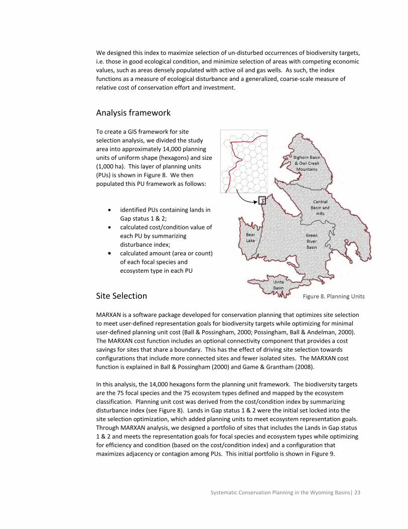
Analysis framework
To create a GIS framework for site
selection analysis, we divided the study
area into approximately 14,000 planning
units of uniform shape (hexagons) and size
(1,000 ha). This layer of planning units
(PUs) is shown in Figure 8. We then
populated this PU framework as follows:
identified PUs containing lands in
Gap status 1 & 2;
calculated cost/condition value of
each PU by summarizing
disturbance index;
calculated amount (area or count)
of each focal species and
ecosystem type in each PU
Site Selection
MARXAN is a software package developed for conservation planning that optimizes site selection
to meet user‐defined representation goals for biodiversity targets while optimizing for minimal
user‐defined planning unit cost (Ball & Possingham, 2000; Possingham, Ball & Andelman, 2000).
The MARXAN cost function includes an optional connectivity component that provides a cost
savings for sites that share a boundary. This has the effect of driving site selection towards
configurations that include more connected sites and fewer isolated sites. The MARXAN cost
function is explained in Ball & Possingham (2000) and Game & Grantham (2008).
In this analysis, the 14,000 hexagons form the planning unit framework. The biodiversity targets
are the 75 focal species and the 75 ecosystem types defined and mapped by the ecosystem
classification. Planning unit cost was derived from the cost/condition index by summarizing
disturbance index (see Figure 8). Lands in Gap status 1 & 2 were the initial set locked into the
site selection optimization, which added planning units to meet ecosystem representation goals.
Through MARXAN analysis, we designed a portfolio of sites that includes the Lands in Gap status
1 & 2 and meets the representation goals for focal species and ecosystem types while optimizing
for efficiency and condition (based on the cost/condition index) and a configuration that
maximizes adjacency or contagion among PUs. This initial portfolio is shown in Figure 9.

Systematic Conservation Planning in the Wyoming Basins| 24
For a given set of input parameters (biodiversity targets, goals, cost index, boundary lengths and
weighting coefficients), a MARXAN analysis will generate multiple possible solutions, and report
the results as a ‘best solution’ and a ‘sum of solutions.’ Each individual solution is a set of sites
identified by the MARXAN algorithm to optimize for the lowest combination of planning unit cost
(based on disturbance index), target shortfall and boundary length. The ‘best’ solution is the
solution with the lowest combined score relative to the other individual solutions that were
evaluated. The ‘sum of solutions’ is the frequency with which each planning unit was selected.
These two results are both useful and serve complementary purposes. The best solution
identifies one optimal, efficient configuration of planning units that collectively meets
representation goals, while the sum of solutions is a measure of the relative contribution of any
planning units towards an optimal solution. Because data representing biodiversity targets and
ecological condition are always limited and incomplete, and because portfolio design must
continually adapt to new data and changing land uses, the sum of solutions is a useful measure
of the relative conservation value of any part of the study area, and useful for visualizing
alternative portfolio designs.
The sum of solutions is derived from a single set of MARXAN parameters, and a single set of
representation goals. Wilhere et al. (2008) designed an index for site prioritization using
MARXAN that is a measure of relative contribution to an optimal solution, but is independent of
a single set of goals. This measure, called optimacity, is calculated as the sum of solutions across
the full range of goals, from zero to 100%. Therefore, optimacity is a measure of the relative
value of any part of the study area towards an optimal solution regardless of the representation
goal. We calculated optimacity as the sum of the sum of solutions at nine goals levels: 10%, 20%,
30%, 40%, 50%, 60%, 70%, 80% and 90%. The result is shown in Figure 10.
Portfolio Design
Considerations of future conservation actions in the Wyoming Basins cannot ignore two large
and important issues playing out within the landscape: the threatened listing of the Greater Sage
Grouse under the Endangered Species Act (see Knick and Connelly 2011 for a detailed discussion)
and the accelerating pace of projected energy development. For portfolio design we considered
two scenarios: first, a standard portfolio design intended to meet standard target goals for both
course filter and fine filter targets and second, with goals driven by the Greater Sage Grouse 75%
core areas as defined by Doherty et al. (2011) and then revised at the state level by individual
state planning processes. For both scenarios we considered conflicts between conservation
priorities and projected oil and gas and wind development.
Conflicts with energy development
We examined the intersection between conservation priorities identified as part of this analysis
and patterns of future oil and gas development forecasted by Copeland et al (2009 & in review)
and proposed wind development farms compiled by the Wyoming Department of Environmental
Quality and Wyoming Chapter of TNC in June 2011 (see Figures 9a and 9b). These proposed wind
farms correspond to other estimate of potential wind development in Wyoming (Kiesecker et al
2001b, Copeland et al., In Review.). In looking specifically at the potential conflicts between
projected oil and gas development and conservation areas, we used the vulnerability function
within Marxan to consider trade‐offs in the selection of a planning unit to the final solution

Systematic Conservation Planning in the Wyoming Basins| 25
against a weighted likelihood of development occurring. Marxan then optimizes the selection of
a reserve network configuration to minimize the tradeoffs involved.

Systematic Conservation Planning in the Wyoming Basins| 26
Figure 9a. Potential oil and gas development scenarios Figure 9b. Proposed wind development

Systematic Conservation Planning in the Wyoming Basins| 27
RESULTS & DISCUSSION
Portfolio with Standard Ecoregional Goals
The portfolio of conservation areas defined by fine and coarse filter goals as stated in Appendix
A, covers 5.9 million ha, or 43% of the study area, and consists of 132 sites that range in size from
1,000 ha to 804,000 ha (Figure 10). In comparison, the suite of priority conservation areas
identified in the 2001 Wyoming Basins ecoregional assessment covered 352,000 ha, or 27% of
the study area and consisted of 76 conservation areas that ranged in size from 48 ha to 516,000
ha. The two priority conservation areas are coincident over 2 million hectares. In other words,
56% of the conservation areas identified in the 2001 assessment are also part of the conservation
solution in this revised analysis (Figure 11).
We achieve all representation goals set for terrestrial ecosystems broadly across the ecoregion
(table 6), although we fall short of achieving at least 95% of our stated goals on a by‐section level
for 4 coarse filter small‐patch targets. For example, although we meet our 30% representation
goal for Rocky Mountain Lower Montane‐Foothill Shrublands at the ecoregional scale, we only
achieve 78% and 80% of our 30% goals in the Central Basin and Hills (#2) and the Uinta Basin (#5)
sections respectively. There are no terrestrial ecosystems for which we fail to reach at least 75%
of our stated goals.
Similarly, we achieve all representation goals with two exceptions for fine filter targets broadly
across the ecoregion – the Pygmy Rabbit (94%) and Swift Fox (85%). We fail to meet at least 95%
of our by section goals for an additional two species targets ‐ Bald Eagle and Mountain Plover.
On the whole however, we achieve almost all of our conservation goals with the current portfolio
configuration. For a full list of conservation goals met by section by target, please refer to
Appendix B.
Of the 132 sites selected as part of the portfolio of conservation areas, 46 consist of a single
planning unit. All but 2 of these sites were selected to meet goals for fine filter targets for which
we set a goal of capturing all known occurrences. These include the suite of globally rare or
imperiled plant and mammal targets. The other 2 sites, # 131 (John Weller Mesa) and #132
(Halfway Hollow North), were selected because they represented the best occurrences of two
small patch terrestrial ecosystems (Rocky Mountain Ponderosa Pine Woodland and Savanna and
Table 6. Summary of targets captured within the portfolio
Targets (n) Target meeting goal (n) % targets meeting goal
Terrestrial Ecosystems
Matrix 5 5 100%
Large 6 6 100%
Linear 3 3 100%
Small Patch 19 19 100%
Species
Amphibians 2 2 100%
Birds 5 3 60%
Mammals 11 9 82%
Plants 57 57 100%

Systematic Conservation Planning in the Wyoming Basins| 28
Figure 10.Portfolio of conservation areas

Systematic Conservation Planning in the Wyoming Basins| 29
Figure 11. Portfolio of conservation areas compared to 2001 portfolio of conservation areas

Systematic Conservation Planning in the Wyoming Basins| 30
Southern Rocky Mountain Montane‐Subalpine Grassland) in the ecoregion. For a summary of
number of targets and areas size by conservation area, see Appendix C.
Disturbance Index and Optimacity Results
Disturbance Index
We compared the distribution of disturbance index values within the portfolio against areas
outside the portfolio and against the ecoregion as a whole. Lower average and sums of
disturbance index values suggests that areas captured in any subset are likely to be in better
ecological condition relative to other subsets. Values in table 7 suggest that the portfolio
selection process succeeded in meeting conservation goals in areas with lower disturbance
values. Figure 12 also compares the areas within and outside the portfolio relative to the
disturbance index.
Table 7. Distribution of disturbance index values ecoregion‐wide, within the portfolio, and outside of the portfolio
Ecoregion ‐ wide Inside Portfolio Outside Portfolio
Minimum value 0 0 0
Maximum value 3,411 2,699 3,411
Range 3,411 2,699 3,411
Mean 134 105 152
Median 71 66 76
Sum 22,882,703,360 6,920,954,368 15,961,749,504
Figure 12. Conservation areas and the disturbance index
Optimacity
To evaluate the relative contribution of each planning units to the overall solution set of
conservation areas, we calculated the optimacity index (Wilhere et al. 2008) (figure 13). High
optimacity scores for a planning unit suggest that it likely contain one or more rare targets

Systematic Conservation Planning in the Wyoming Basins| 31
Figure 13. Optimacity

Systematic Conservation Planning in the Wyoming Basins| 32
and/or contain a large set of important targets in relatively good condition. Optimacity scores for
planning units can be used to prioritize places for conservation within a portfolio of conservation
areas as well as areas outside of the portfolio. In table X4 below, planning units with a score of
100 are those selected in every alternate solution considered at every goal representation level.
58% of the planning units selected as part of the final solution were selected in 100% of the
optimacity runs considered. Of the planning units within the ecoregion selected at every
representation level, 99% were included within the final portfolio solution set.
Land Management, Ownership and GAP status
The distribution of ownership and management of lands within the portfolio does not differ
significantly from the distribution across the ecoregion (Table 8a). Federal and state agencies
own or manage 70% of the lands within the portfolio. The largest manager of the portfolio
conservation areas is the Bureau of Land Management (BLM). Private lands encompass 29% of
the portfolio area. For a summary of land ownership by conservation area, see Appendix D.
Approximately 30% of the lands within the portfolio fall within GAP status 4 with no known
mandate for protection (Table 8b). An additional 10% are managed in some manner for
biodiversity, with the remaining majority of lands managed for multiple uses.
Table 8. Percent planning units elected by number of optimacity scenarios
# of runs selected: 0 < 10 10 20 30 40 50 60 70 80 90 100
ecoregion ‐ wide 0.3% 0.0% 13.6% 7.9% 8.9% 10.0% 10.8% 6.7% 4.9% 4.2% 8.1% 24.4%
within portfolio 0.0% 0.0% 0.1% 0.2% 0.5% 1.5% 1.9% 4.3% 6.4% 8.5% 18.6% 58.1%
Table 9a. Pattern of land ownership within the portfolio
Land Ownership Hectares Acres % of Portfolio
Federal
Bureau of Land Management (BLM) 3,339,522 8,251,959 56%
Bureau of Reclamation (BOR) 139,699 345,197 2%
Fish and Wildlife Service (FWS) 46,161 114,063 1%
Forest Service (USFS) 101,417 250,600 2%
National Park Service (NPS) 18,666 46,124 < 1%
State State Lands 544,890 1,346,424 9%
Private Private Conservation Land 99,988 247,070 2%
Private (Unprotected) 1,633,500 4,036,380 27%
Tribal Native American Lands 60,744 150,100 1%
Table 9b. GAP status within the portfolio
GAP code Management Description Hectares Acres % of Portfolio
1 1 ‐ managed for biodiversity ‐ disturbance events proceed or are mimicked
53,580 132,400 1%
2 2 ‐ managed for biodiversity – disturbance events suppressed
536,213 1,325,012 9%
3 3 ‐ managed for multiple uses – subject to extractive (e.g. mining or logging) or OHV use
3,689,116 9,116,003 62%
4 4 ‐ no known mandate for protection 1,705,679 4,214,825 29%

Systematic Conservation Planning in the Wyoming Basins| 33
Figure 14. Distribution of matrix terrestrial systems and Greater Sage Grouse by GAP status
We examined the distribution of the matrix terrestrial systems (5) and the Greater Sage Grouse
core areas across the ecoregion and within the portfolio across the GAP status categories (Figure
14). Of the matrix systems, the Northwestern Great Plains Mixedgrass Prairie is the least
protected with over half of its distribution across the ecoregion (274,000 of 403.000 hectares)
and within the portfolio (72,000 of 132,000 hectares) in GAP 4 status. For the Greater Sage
Grouse, 68% of areas identified as core habitat that was also captured within the ecoregion are
managed for multiple uses (GAP 3) with less than 10% of core areas in either GAP status 1 or 2.
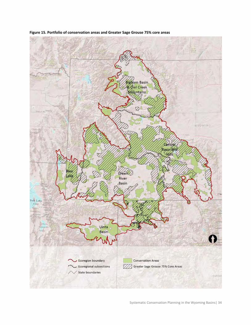
Sage Grouse 75% core areas solution
How much of our ecoregional goals do we meet if we were to default to the Greater Sage Grouse
75% core areas alone? The 75% core areas represent an area of approximately 5.8 million
hectare or about 44% of the ecoregion boundary. 60% of the Greater Sage Grouse core areas (or
3.2 million hectares) overlaps with the conservation areas selected (figure 15).
Given the extensive reach of these core areas, how well does the Greater Sage Grouse function
as an umbrella species for extending conservation action to the other species and terrestrial
ecosystem targets in the assessment? The results, not surprisingly are mixed. Of the 659
planning units with targets whose goals were set at 100% of known records, only 40% were
captured within the core areas.
Systematic Conservation Planning in the Wyoming Basins| 34
Figure 15. Portfolio of conservation areas and Greater Sage Grouse 75% core areas

Systematic Conservation Planning in the Wyoming Basins| 35
While the core areas do well in meeting goals for a small set of targets, the majority fall short for
a number of reasons. First, because the core areas tend to be concentrated in Wyoming, they do
a poor job of meeting goals for targets that we stratified across ecoregional sections. Second,
many of our fine filter targets were selected precisely because they were considered to be
inadequately captured by a coarse filter approach alone. In many cases, these endemic and
imperiled species have severely constrained known distributions outside of the sagebrush
ecosystem and so it is not surprising that the Greater Sage Grouse core areas do a poor job in
sweeping in this suite of targets.
Conflicts with energy development
Baseline projections of potential oil and gas build‐out in the foreseeable future intersected with
493,000 hectares, or 8% of the conservation priorities identified in this analysis (Figure 16a). The
areas of potential conflict impact critical winter ranges for wide‐ranging species such as Elk,
Pronghorn, and Mule Deer as well as known nest areas for Bald Eagle and Ferruginous Hawk and
core areas for the Greater Sage Grouse (Appendix E). In particular 40% of the ecoregion‐wide
representation goals set for Mountain Plover and 57% of goals for the Pygmy Rabbit overlap with
areas of projected future baseline level of development. Importantly, 12% of the overlap of
potential oil and gas development areas with the portfolio of conservation areas also coincide
with known locations of globally imperiled species for which we assigned a representation goal of
protecting all currently known occurrences. These include close to half of the current
occurrences for the Wyoming Pocket Gopher and substantive proportions of known occurrences
of rare or globally imperiled (G1‐G2 ranked) plants such as Porters Sagebrush (Artemisia porteri),
Big Piney Milkvetch (Astragalus drabelliformis), Large‐fruited Bladderpod (Lesquerella
macrocarpa), and Beaver Rim Phlox (Phlox pungens). These conflicts in particular should be
highlighted for avoidance or minimization of potential impacts from development.
Conservation areas with large extents overlapping potential development include Mexican Flats
(#52), Hams Fork (#58), Upper Green River (#100) and Alkali Flats (#104).
A more expansive estimate of potential oil and gas build‐out (unconstrained scenario), allowing
development in the highest quintile of oil and gas potential areas, intersected with an additional
902,000 hectares which altogether represents approximately 24% of the area identified as
conservation priorities in the Wyoming Basins (Figure 16b). Under this unconstrained
development scenario, over 40% of the ecoregion‐wide goals set for the terrestrial systems (and
captured with the current conservation area configuration) Rocky Mountain Aspen Forest and
Woodland and Inter‐Mountain Basins Mixed Salt Desert Scrub, 62% of the Colorado Plateau
Mixed Bedrock Canyon and Tableland and 146% of the Inter‐Mountain Basins Semi‐Desert
Grassland overlap with areas of potential development (Appendix F). The area of development
also overlaps with all currently known occurrences of the G1‐ranked Hamiltons Milkvetch
(Astragalus hamiltonii) and G2‐ranked Goodrich’s Penstemon (Penstemon goodrichii).
We re‐ran the Marxan analysis deploying base levels of projected oil and gas development as an
additional weighted future threat vulnerability layer to examine what trade‐offs might be made
to avoid conflicts with development while still meeting our conservation goals as efficiently as
possible. The resulting network of conservation areas dropped certain areas of the original
portfolio while adding in other areas, amounting to a net additional land area of 61,000 hectares
(Figure 17). 95% of the original portfolio of conservation areas selected were also selected in

Systematic Conservation Planning in the Wyoming Basins| 36
the revised analysis. Ecoregion‐wide conservation goals were met for all biodiversity targets with
small exceptions at the stratified section level. The disturbance index summed across the
planning units included in the revised conservation areas is slightly greater than the value for the
original set of conservation areas.
Of the area in the original set of conservation areas that overlapped with projected areas of
development, 96% were also selected as part of the revised network of conservation areas.
Although the increased areal extent and disturbance index score suggests a drop in the efficiency
of the revised network of the conservation areas, overall there appears to be few tradeoffs to be
found in the final solution set. There are two possible explanations for these results. First, it may
be that the probability weighting of future development needs to be increased. However, it’s
more likely that we see few changes because there are few viable alternatives to be considered.
Of the planning units in the original set of conservation areas that were also in conflict with
future base levels of development, 71% were selected in the optimacity analysis across all
representation goal scenarios. This suggests that these areas are important because they
contain occurrences of rare targets with high conservation goals or they contain an unusually
large number of targets in relatively good ecological condition.
Conflicts with projected wind energy development
The potential wind farms extend over approximately 242,000 hectares in the ecoregion, of which
76,000 hectares overlap with conservation priorities identified in this analysis (Figure 18). In
total, 1.3% of the overall conservation priorities overlap with currently known locations of
potential wind development areas. Less than 0.5 % of the conservation portfolio with known
locations of imperiled fine filter species for which we assigned a goal of 100% of all known
occurrences overlap with areas at risk for wind development.
Conclusion
This ecoregional portfolio is a starting point to support long‐term conservation of the ecoregion’s
biodiversity. This analysis was completed also to help direct investments in conservation to
places that advance regional conservation goal, especially in the context or current Greater Sage
Grouse conservation efforts and forecasts of future energy development. Conservation areas
defined at the ecoregional level are large and complex and often include areas that are not
suitable for conservation as well as areas that are suitable for multiple uses, and we expect local
planners to refine boundaries accordingly. Still, the ecoregional approach is useful for informing
smaller scale conservation decisions by highlighting the regional importance of any particular
place and in considering trade‐offs as the landscape of opportunities and challenges for
implementing conservation actions across the ecoregion shift over time.

Systematic Conservation Planning in the Wyoming Basins| 37
Figure 16a. Conflicts with potential oil and gas development (base scenario) Figure 16b. Conflicts with potential oil and gas development (unconstrained scenario)

Systematic Conservation Planning in the Wyoming Basins| 38
Figure17. Revised conservation areas with oil and gas vulnerability Figure 18. Conflicts with wind energy development

Systematic Conservation Planning in the Wyoming Basins| 39
REFERENCES
Anderson MG, Ferree CE (2010) Conserving the Stage: Climate Change and the Geophysical
Underpinnings of Species Diversity. PLoS One 5.
Bailey, R.G., McNab, W.H., Avers, P.E., and King, T., 1994, Ecoregions and Subregions of the
United States (Lower 48): USDA Forest Service, Washington, DC.
Ball IR. (2000) Mathematical applications for conservation ecology: the dynamics of tree hollows
and the design of nature reserves. PhD Thesis, The University of Adelaide.
Ball IR & Possingham HP (2000) MARXAN (V1.8.2): Marine Reserve Design Using Spatially Explicit
Annealing, a Manual. Available online at
http://www.ecology.uq.edu.au/index.html?page=27710
Bartelmus P (1997) Measuring sustainability: data linkage and integration, pp110‐118 in Moldan
and Billharz Sustainability Indicators: Report of the Project on Indicators of Sustainable
Development, Countryside Commission, Cheltenham.
Beier P & Brost B (2010) Use of Land Facets to Plan for Climate Change: Conserving the Arenas,
Not the Actors. Conservation Biology, DOI: 10.1111/j.1523‐1739.2009.01422.x
Carwardine J, Klein CJ, Wilson KA, Pressey RL & Possingham HP (2009) Hitting the target and
missing the point: target‐based conservation planning in context. Conservation Letters, 2, 3–10.
Copeland HE, Doherty KE, Naugle DE, Pocewicz A, and Kiesecker JM (2009) Mapping Oil and Gas
Development Potential in the US Intermountain West and Estimating Impacts to Species. PLoS
ONE 4(10): e7400. doi:10.1371/journal.pone.0007400
Copeland, HE, Pocewicz A & Kiesecker JM (2011) Geography of energy development in Western
North America: Potential impacts to terrestrial ecosystems. Chapter in: Energy development and
wildlife conservation in Western North America (Edited by DE Naugle)
Copeland HE, Pocewicz A, Naugle DE, Griffith, T, Keinath D, & J.S. Evans. In Review. Quantifying
the benefits of the core area policy and conservation easements to sage‐grouse in Wyoming.
PloS ONE in review.
Copeland HE, Tessman SA, Girvetz EH, Roberts L, Enquist C, Orabona A, Patla S, and JM Kiesecker.
2010. A geospatial assessment on the distribution, condition, and vulnerability of Wyoming's
wetlands Ecological Indicators 10: 869‐879.
Dobson A (1996) Conservation and Biodiversity. Scientific American Library, New York. page 66.
Doherty, K. E., D. E. Naugle, H. E. Copeland, A. Pocewicz, and J. M. Kiesecker. 2011. Energy
development and conservation tradeoffs: systematic planning for Greater Sage‐Grouse in their
eastern range. Pp. 505–516 in S. T. Knick and J. W. Connelly (editors). Greater Sage‐Grouse:
Systematic Conservation Planning in the Wyoming Basins| 40
ecology and conservation of a landscape species and its habitats. Studies in Avian Biology (vol.
38), University of California Press, Berkeley, CA.
Doherty KE, Tack JD, Evans JE, and DE Naugle (2010). Mapping breeding densities of greater sage‐
grouse: A tool for rage‐wide conservation planning. BLM Completion Report. Interagency
Agreement #LP0PG00911.
Fish and Wildlife Service (2010). 12‐Month Findings for Petitions to List the Greater Sage‐Grouse
(Centrocercus urophasianus) as Threatened or Endangered, Department of Interior. 50 CFR Part
17.
Game ET & Grantham HS (2008) Marxan User Manual: For Marxan version 1.8.10. University of
Queensland, St. Lucia, Queensland, Australia, and Pacific Marine Analysis and Research
Association, Vancouver, British Columbia, Canada.
Gessler, P.E., I.D. Moore, N.J. McKenzie, and P.J. Ryan. 1995. Soil‐landscape modeling and spatial
prediction of soil attributes. International Journal of GIS. Vol 9, No 4, 421‐432.
Grand J, Cummings MP, Rebelo TG, Ricketts TH & Neel MC (2007) Biased data reduce efficiency
and effectiveness of conservation reserve networks. Ecology Letters, 10, 364‐374.
Groves C, Jensen D, Valutis L, Redford K, Shaffer M, Scott J, Baumgartner J, Higgins J, Beck M &
Anderson M (2002) Planning for biodiversity conservation: Putting conservation science into
practice. BioScience, 52, 499‐512.
Groves C (2003) Drafting a Conservation Blueprint: A Practitioner's Guide to Planning for
Biodiversity. Island Press, Washington.
Halpin PN (1997) “Global climate change and natural‐area protection: Management responses
and research directions.” Ecological Applications 7(3): 828‐843.
Hanser, S. E., M. Leu, S. T. Knick, and C. L. Aldridge (editors). 2011. Sagebrush ecosystem
conservation and management: ecoregional assessment tools and models for the Wyoming
Basins. Allen Press, Lawrence, KS.
Higgins J & Esselman R (2006) Ecoregional Assessment Toolbox. The Nature Conservancy,
Arlington, VA. Available online at http://conservationgateway.org/era.
Hoekstra JM, Boucher TM, Ricketts TH, Roberts C. 2005. Confronting a biome crisis: global
disparities of habitat loss and protection. Ecology Letters 8: 23‐29.
Hunter ML, Jacobson Jr. GL & Webb T (1988) Paleoecology and the coarse filter approach to
maintaining biological diversity. Conservation Biology, 2, 375‐385.
Hunter ML (1991) Coping with ignorance: The coarse filter strategy for maintaining biodiversity.
In: Balancing on the Brink of Extinction (Ed. K.A. Kohm), pp. 266‐281. Island Press, Washington.
International Energy Agency (2007) World Energy Outlook 2007. Paris, France.

Systematic Conservation Planning in the Wyoming Basins| 41
Jenkins RE (1976) Maintenance of natural diversity: approach and recommendations. In: K. Sabol
(ed.) Transactions–Forty‐first North American Wildlife and Natural Resources Conference.
Washington, D. C. March 21‐25, 1976. Pp. 441‐451.
Kiesecker JM, Copeland H, Pocewicz A, Nibbellink N & McKenney B (2009) A framework for
implementing biodiversity offsets: selecting sites and determining scale. Bioscience 59: 77‐84.
Kiesecker JM, Copeland H, Pocewicz A & McKenney B (2010) Development by design: blending
landscape‐level planning with the mitigation hierarchy. Frontiers in Ecology and the Environment
8: 261‐266.
Kiesecker JM, Copeland H, McKenney B, Pocewicz A, and K Doherty (In Press) Energy by Design:
Making mitigation work for conservation and development. Chapter in: Energy development and
wildlife conservation in Western North America (Edited by DE Naugle)
Kiesecker, J.M., Evans, J.S., Fargione, J., Doherty, K., Foresman, K.R., et al. 2011b. Win‐Win for
Wind and Wildlife: A Vision to Facilitate Sustainable Development. PLoS ONE 6: e17566.
doi:10.1371/journal.pone.0017566
Kiesecker JM, Sochi K, Heiner M, McKenney B, Evans J, H Copeland. (In Press) Development by
Design: Using a Revisionist History to Guide a Sustainable Future. Chapter in: The Encyclopedia of
Biodiversity (Edited by Simon Levin and Peter Kareiva)
Knick, S.T. and J. W. Connelly (editors). 2011. Greater Sage‐Grouse: ecology and conservation of
a landscape species and its habitats. Studies in Avian Biology (vol. 38), University of California
Press, Berkeley, CA.
Lehner, B., Verdin, K., Jarvis, A. (2008): New global hydrography derived from spaceborne
elevation data. Eos, Transactions, AGU, 89(10): 93‐94.
MacArthur RH & Wilson EO (1967) The Theory of Island Biogeography. Princeton University
Press, Princeton, NJ.
Margules CR & Pressey RL (2000) Systematic conservation planning. Nature, 405, 243‐253.
McKenney B, & Kiesecker JM (2010) Policy Development for Biodiversity Offsets: A Review of
Offset Frameworks. Environmental Management 45:165–176.
Moore, ID., Gessler, P.E., Nielsen, G.A., and Petersen, G.A. 1993 Terrain attributes: estimation
methods and scale effects. In Modeling Change in Environmental Systems, edited by A.J.
Jakeman M.B. Beck and M. McAleer (London: Wiley), pp. 189 ‐ 214.
Moore ID, Grayson RB & Ladson AR (1991) Digital Terrain Modelling: A Review of Hydrological,
Geomorphological, and Biological Applications. Hydrological Processes, 5:3‐30.
Noss RF (1996) “Ecosystems as Conservation Targets.” Trends in Ecology and Evolution 11: 351.
O’Donnell M.S. & Francher T.S. (2010) Spatial mapping and attribution of Wyoming wind
turbines: U.S. Geological Survey Data Series 524.

Systematic Conservation Planning in the Wyoming Basins| 42
Olson DM, Dinerstein E, Wikramanayake ED, Burgess ND, Powell GVN, Underwood EC, D'Amico
JA, Itoua I, Strand HE, Morrison JC, Loucks CJ, Allnutt TF, Ricketts TH, Kura Y, Lamoreux JF,
Wettengel WW, Hedao P, & Kassem KR. Terrestrial Ecoregions of the World: A New Map of Life
on Earth. BioScience 51:933‐938.
Poiani K, Richter B, Anderson M, & Richter H (2000) Biodiversity Conservation at Multiple Scales.
Bioscience 50 (2). 133‐146.
Possingham HP, Ball IR & Andelman S (2000) Mathematical methods for identifying
representative reserve networks. In: Quantitative Methods for Conservation Biology (Eds S.
Ferson & M. Burgman), pp. 291‐305. Springer‐Verlag, New York.
Pressey RL, and Bottrill MC (2008) Opportunism, threats, and the evolution of systematic
conservation planning. Conserv. Biol. 22: 1340‐1345.
Pressey RL, Possingham HP, and Day JR (1997) Effectiveness of alternative heuristic algorithms
for identifying indicative minimum requirements for conservation reserves. Biol Conserv 80 :207‐
19.
Pritchard D (1993) Towards sustainability in the planning process: the role of EIA. ECOS: A Rev of
Conserv 14:3‐15.
Rich PM, Hetrick WA & Savings SC (1995) Modelling topographical influences on solar radiation:
manual for the SOLARFLUX model. LA‐12989‐M, Los Alamos National Laboratories, Los Alamos.`
Tarboton, D. G., (1997), A New Method for the Determination of Flow Directions and
Contributing Areas in Grid Digital Elevation Models, Water Resources Research, 33(2): 309‐319.
Tear TH, Karieva P, Angermeir PL, Comer P, Czech B, Kautz R, Landon L, Mehlman D, Murphy K,
Ruckleshaus M, Scott JM, & Wilhere G (2005) How Much is Enough?: The Recurrent Problem of
Setting Quantitative Objectives in Conservation. BioScience Vol. 55, No. 10, pp. 835‐849.
Thorne JH, Huber PR, Girvetz EH, Quinn J, & McCoy MC (2009) Integration of Regional Mitigation
Assessment and Conservation Planning. Ecology and Society 14(1): 47‐63.
US Geological Survey, Gap Analysis Program (GAP). February 2011. Protected Areas Database of
the United States (PADUS), version 1.2.
Wilhere G, Goering M & Wang H (2008) Average optimacity: An index to guide site prioritization
for biodiversity conservation. Biological Conservation, 141, 770‐781.
Wyoming Game and Fish Department (2010) State Wildlife Action plan. Wyoming Game and Fish
Department, Cheyenne WY. website:
http://wgfd.wyo.gov/web2011/Departments/Wildlife/pdfs/SWAP_2012_FULL0002194.pdf

Appendix A. Conservation targets for the Wyoming Basins Ecoregion and data sources
Tax. Group
Scientific Name Common Name Global Rank
Distrib USFWS ‐ ESA Data Source Data by State
CO ID MT UT WY
Amphibian Rana pipiens Northern leopard frog G5 W Petitioned Natural Heritage Program data ‐ x ‐ x x
Amphibian Bufo baxteri Wyoming toad G1 E Endangered Natural Heritage Program data ‐ ‐ ‐ ‐ x
Bird Haliaeetus leucocephalus
Bald eagle G5 W Natural Heritage Program data (filtered for nests) CDOW Bald Eagle Active Nest Sites (http://cogcc.state.co.us/)
x x ‐ x x
Bird Tympanuchus phasianellus columbianus
Columbian sharp‐tailed grouse
G4T3 E Petitioned Natural Heritage Program data CDOW CSTGR Production Areas (http://ndis.nrel.colostate.edu/ftp/index.html)
x ‐ ‐ ‐ x
Bird Buteo regalis Ferruginous hawk G4 W Natural Heritage Program data (filtered for nests) CDOW Ferruginous Hawk Active Nest Sites (http://cogcc.state.co.us/)
x x ‐ x x
Bird Centrocercus urophasianus
Greater sage grouse ‐ core areas
G4 W Candidate
CO: Greater Sage Grouse Priority Habitat areas (http://www.arcgis.com/home/item.html?id=32687e3f2a95432dbc6428f5bde7af29) ID: 75% Sage Grouse core areas (Doherty et al 2010) MT: Sage Grouse core areas (http://fwp.mt.gov/gisData/metadata/sgcore.htm) WY: WG
x x x x x
Bird Charadrius montanus Mountain plover G3 L Listing being reconsidered
Natural Heritage Program data ‐ ‐ x x x
Mammals Mustela nigripes Black‐footed ferret ‐ poly
G1 L Endangered
CO: Black‐footed Ferrets release sites (CDOW) UT: White‐tailed Prairie Dog colonies (UTDWR) matched against UTNHP data with BFF occurrences (per recommendation of UTDWR) WY: Black‐footed Ferret occupied colonies, release site, colonies with high probabili
x ‐ ‐ x x
Mammals Cervus canadensis Elk G5 W CO: Elk Winter Concentration + Severe Winter Range (CDOW ‐ NDIS) UT: Elk Critical Range: (UTDWR) WY: Elk Crucial Range Boundaries for Wyoming (WGFD)
x ‐ ‐ x x
Mammals Thomomys idahoensis Idaho pocket gopher ‐ SDM
G4 L
ID: Idaho pocket gopher (AMAFX01070) wildlife habitat model (http://www.wildlife.uidaho.edu/idgap.htm) SWReGAP: Idaho Pocket Gopher Animal Habitat Model (180225) (http://fws‐nmcfwru.nmsu.edu/swregap/habitatreview/ModelQuery.asp) WY: SGCN Habitat Models (
x x ‐ x x
Mammals Odocoileus hemionus Mule Deer G5 W
CO: Mule Deer Winter Concentration Areas + Severe Winter Range + Critical Winter Range (CDOW) ID: Western States and Provinces Mule Deer Habitat Mapping Project Class D/E polygons http://www.gis.usu.edu/current_proj/muledeer.html) WY: Mule Deer Crucial Ra
x x x x x

Appendix A. Conservation targets for the Wyoming Basins and their data sources (continued)
Appendix A – Conservation targets for the Wyoming Basins Ecoregion and data sources Systematic Conservation Planning in the Wyoming Basins| 44
Tax. Group
Scientific Name Common Name Global Rank
Distrib USFWS ‐ ESA Data Source Data by State
CO ID MT UT WY
Mammals Zapus hudsonius preblei
Preble's meadow jumping mouse
G5T2 L Threatened (de‐listed in
WY) Natural Heritage Program data ‐ ‐ ‐ ‐ x
Mammals Antilocapra americana Pronghorn G5 W
CO: Pronghorn Winter Concentration + Severe Winter Range (CDOW ‐ NDIS) UT: Pronghorn crucial habitat (UTDWR) WY: 2006 Pronghorn Crucial Range Boundaries For Wyoming (WGFD)
x ‐ ‐ x x
Mammals Brachylagus idahoensis Pygmy rabbit G4 D Petitioned Natural Heritage Program data ‐ x ‐ x x
Mammals Vulpes velox Swift fox G3 L Natural Heritage Program data ‐ ‐ ‐ ‐ x
Mammals Cynomus leucurus White tailed Prairie dog ‐ poly
G4 L Natural Heritage Program data CDOW White‐tailed Prairie Dog colonies, NW populations
x ‐ ‐ x x
Mammals Spermophilus elegans Wyoming ground squirrel
G5 L Natural Heritage Program data ‐ ‐ ‐ ‐ x
Mammals Thomomys clusius Wyoming pocket gopher G2 E Natural Heritage Program data ‐ ‐ ‐ ‐ x
Plants Antennaria arcuata Meadow Pussytoes G2 Natural Heritage Program data ‐ ‐ ‐ ‐ x
Plants Artemisia porteri Porter's Sagebrush G2 Natural Heritage Program data ‐ ‐ ‐ ‐ x
Plants Astragalus detritalis Debris Milkcetch G3 L Natural Heritage Program data ‐ ‐ ‐ x ‐
Plants Astragalus diversifolius var diversifolius
Mesic Milkvetch G2 Natural Heritage Program data ‐ ‐ ‐ ‐ x
Plants Astragalus drabelliformis
Big Piney Milkvetch G2G3 E Natural Heritage Program data ‐ ‐ ‐ ‐ x
Plants Astragalus duchesnensis
Duchesne milkvetch G3 E Natural Heritage Program data x ‐ ‐ ‐ ‐
Plants Astragalus gilviflorus var. purpureus
Dubois Milkvetch G5T2 Natural Heritage Program data ‐ ‐ ‐ ‐ x
Plants Astragalus hamiltonii Hamilton's Milkvetch G1 Natural Heritage Program data ‐ ‐ ‐ x ‐
Plants Astragalus jejunus var. articulatus
Hyattville Milkvetch G3T1 Natural Heritage Program data ‐ ‐ ‐ ‐ x
Plants Astragalus proimanthus
Precocious Milkvetch G1 Natural Heritage Program data ‐ ‐ ‐ ‐ x
Plants Astragalus racemosus var. treleasei
Trelease's Racemose Milkvetch
G5T2 Natural Heritage Program data ‐ ‐ ‐ ‐ x
Plants Boechera crandallii Crandall's Rockcress G2 Natural Heritage Program data ‐ ‐ ‐ ‐ x
Plants Boechera pusilla Small Rockcress G1 Candidate Natural Heritage Program data ‐ ‐ ‐ ‐ x
Plants Cirsium pulcherrimum var. aridum
Cedar Rim Thistle G2Q E Natural Heritage Program data ‐ ‐ ‐ ‐ x
Plants Cleome multicaulis Many‐stemmed Spider‐flower
G2G3 Natural Heritage Program data ‐ ‐ ‐ ‐ x
Plants Cryptantha subcapitata Owl Creek Miner's Candle
G2 Natural Heritage Program data ‐ ‐ ‐ ‐ x
Plants Cymopterus evertii Evert's Waferparsnip G2G3 Natural Heritage Program data ‐ ‐ ‐ ‐ x

Appendix A. Conservation targets for the Wyoming Basins and their data sources (continued)
Appendix A – Conservation targets for the Wyoming Basins Ecoregion and data sources Systematic Conservation Planning in the Wyoming Basins| 45
Tax. Group
Scientific Name Common Name Global Rank
Distrib USFWS ‐ ESA Data Source Data by State
CO ID MT UT WY
Plants Descurainia torulosa Wyoming Tansymustard G1 Natural Heritage Program data ‐ ‐ ‐ ‐ x
Plants Elymus simplex var. luxurians
Dune Wildrye G4T1 E Natural Heritage Program data ‐ ‐ ‐ ‐ x
Plants Ericameria discoidea var. winwardii
Winward's Goldenweed GNRT1 E Natural Heritage Program data ‐ ‐ ‐ ‐ x
Plants Lepidium integrifolium var. integrifolium
Entire‐leaved Peppergrass
G2G3T2T3 Natural Heritage Program data ‐ ‐ ‐ x x
Plants Lesquerella fremontii Fremont Bladderpod G2 Natural Heritage Program data ‐ ‐ ‐ ‐ x
Plants Lesquerella lesicii Pryor Mountains Bladderpod
G1 Natural Heritage Program data ‐ ‐ x ‐ ‐
Plants Lesquerella macrocarpa
Large‐fruited Bladderpod
G2 Natural Heritage Program data ‐ ‐ ‐ ‐ x
Plants Lesquerella prostrata Prostrate Bladderpod G2G3 Natural Heritage Program data ‐ ‐ ‐ x x
Plants Oenothera acutissima narrow‐leaf evening primrose
G2 E Natural Heritage Program data x ‐ ‐ ‐ ‐
Plants Oonopsis wardii Ward's Goldenweed G3 E Natural Heritage Program data ‐ ‐ ‐ ‐ x
Plants Oxytropis besseyi var. obnapiformis
Maybell Locoweed, Bessey Locoweed
G5T2 Natural Heritage Program data ‐ ‐ ‐ ‐ x
Plants Penstemon absarokensis
Absaroka Beardtongue G2 Natural Heritage Program data ‐ ‐ ‐ ‐ x
Plants Penstemon acaulis var. acaulis
Stemless Beardtongue G3T2 Natural Heritage Program data ‐ ‐ ‐ x x
Plants Penstemon flowersii Flower's Penstemon G1 Natural Heritage Program data ‐ ‐ ‐ x ‐
Plants Penstemon gibbensii Gibbens' Beardtongue G1G2 E Natural Heritage Program data x ‐ ‐ ‐ x
Plants Penstemon goodrichii Goodrich's Penstemon G2 Natural Heritage Program data ‐ ‐ ‐ x ‐
Plants Penstemon grahamii Graham beardtongue G2 E Proposed Threatened
Natural Heritage Program data x ‐ ‐ ‐ ‐
Plants Penstemon haydenii Blowout Pentemon G1 Endangered Natural Heritage Program data ‐ ‐ ‐ ‐ x
Plants Penstemon scariosus var. albifluvis
White River penstemon G4T1 E Candidate Natural Heritage Program data x ‐ ‐ x ‐
Plants Phacelia glandulosa var. deserta
Desert Glandular Phacelia
G4T1T2 Natural Heritage Program data ‐ ‐ ‐ ‐ x
Plants Phlox pungens Beaver Rim Phlox G2 Natural Heritage Program data ‐ ‐ ‐ ‐ x
Plants Physaria condensata Tufted Twinpod G2 Natural Heritage Program data ‐ ‐ ‐ ‐ x
Plants Physaria dornii Dorn's Twinpod G1 Natural Heritage Program data ‐ ‐ ‐ ‐ x
Plants Physaria eburniflora Devil's Gate Twinpod G2G3 E Natural Heritage Program data ‐ ‐ ‐ ‐ x
Plants Physaria saximontana var. saximontana
Rocky Mountain Twinpod
G3T2 Natural Heritage Program data ‐ ‐ ‐ ‐ x
Plants Pyrrocoma carthamoides var. subsquarrosa
Absaroka Goldenweed G4G5T2T3 Natural Heritage Program data ‐ ‐ x ‐ ‐

Appendix A. Conservation targets for the Wyoming Basins and their data sources (continued)
Appendix A – Conservation targets for the Wyoming Basins Ecoregion and data sources Systematic Conservation Planning in the Wyoming Basins| 46
Tax. Group
Scientific Name Common Name Global Rank
Distrib USFWS ‐ ESA Data Source Data by State
CO ID MT UT WY
Plants Pyrrocoma clementis var. villosa
Hairy Tranquil Goldenweed
G3G4T1 Natural Heritage Program data ‐ ‐ ‐ ‐ x
Plants Schoenocrambe argillacea
Clay Reed‐mustard G1 Threatened Natural Heritage Program data ‐ ‐ ‐ x ‐
Plants Sclerocactus brevispinus
Pariette Cactus G1 Natural Heritage Program data ‐ ‐ ‐ x ‐
Plants Sclerocactus wetlandicus
Uinta Basin Hookless Cactus
G3 E Threatened Natural Heritage Program data ‐ ‐ ‐ x ‐
Plants Shoshonea pulvinata Shoshonea G2G3 Natural Heritage Program data ‐ ‐ ‐ ‐ x
Plants Sphaeromeria simplex Laramie False Sagebrush G2 Natural Heritage Program data ‐ ‐ ‐ ‐ x
Plants Spiranthes diluvialis Ute's Ladies Tresses G2G3 Threatened Natural Heritage Program data x ‐ ‐ x ‐
Plants Thelesperma caespitosum
Green River Greenthread
G1 Natural Heritage Program data ‐ ‐ ‐ x x
Plants Thelesperma pubescens
Uinta Greenthread G1 Natural Heritage Program data ‐ ‐ ‐ ‐ x
Plants Townsendia condensata var. anomala
North Fork Easter Daisy G4T2 Natural Heritage Program data ‐ ‐ ‐ ‐ x
Plants Townsendia microcephala
Cedar Mountain Easter Daisy
G1 Natural Heritage Program data ‐ ‐ ‐ ‐ x
Plants Trifolium barnebyi Barneby's Clover G1 Natural Heritage Program data ‐ ‐ ‐ ‐ x
Plants Yermo xanthocephalus Desert Yellowhead G1 Threatened Natural Heritage Program data ‐ ‐ ‐ ‐ x
Plants Yucca harrimaniae var. sterilis
Spanish Bayonet G4G5T1T2 Natural Heritage Program data ‐ ‐ ‐ x ‐

Appendix B. Conservation Targets, Representation Goals, and Distribution in the Portfolio
Tax. Group Target Common Name (Scientific Name) Goal (%) Section Goal
(amount) Metric
AmountAvailable
Amount in Portfolio
% Goal Met
Terr Ecosys Inter‐Mountain Basins Active and Stabilized Dune 30%
1 92 ha 306 143 156%
2 4,165 ha 13,881 7,039 169%
3 51,577 ha 171,922 67,366 131%
4 83 ha 277 94 114%
Terr Ecosys Inter‐Mountain Basins Cliff and Canyon 30%
1 7,734 ha 25,778 11,989 155%
2 10,492 ha 34,972 20,951 200%
3 18,289 ha 60,964 27,299 149%
4 1,203 ha 4,010 2,237 186%
5 361 ha 1,202 847 235%
Terr Ecosys Colorado Plateau Mixed Bedrock Canyon and Tableland 30% 3 627 ha 2,089 1,261 201%
5 12,568 ha 41,893 22,235 177%
Terr Ecosys Inter‐Mountain Basins Shale Badland 30%
1 31,291 ha 104,303 41,482 133%
2 10,983 ha 36,612 11,081 101%
3 15,073 ha 50,244 20,760 138%
4 285 ha 950 444 156%
5 7,589 ha 25,297 13,731 181%
Terr Ecosys Rocky Mountain Aspen Forest and Woodland 30%
1 292 ha 973 510 175%
2 1,826 ha 6,088 3,280 180%
3 3,924 ha 13,079 4,471 114%
4 7,103 ha 23,677 10,194 144%
Terr Ecosys Inter‐Mountain Basins Curl‐leaf Mountain Mahogany Woodland and Shrubland
30%
1 2,821 ha 9,404 5,357 190%
2 743 ha 2,478 1,245 168%
3 174 ha 579 215 123%
4 681 ha 2,271 1,017 149%
Terr Ecosys Colorado Plateau Pinyon‐Juniper Woodland Shrubland and Savanna 30% 3 16,548 ha 55,162 36,108 218%
5 36,269 ha 120,898 63,202 174%
Terr Ecosys Northern Rocky Mountain Dry‐Mesic Montane Mixed Conifer Forest 30%
1 2,193 ha 7,312 3,581 163%
2 1,834 ha 6,115 2,035 111%
3 348 ha 1,159 956 275%
4 327 ha 1,090 357 109%
5 49 ha 164 69 141%
Terr Ecosys Rocky Mountain Foothill Limber Pine‐Juniper Woodland 30%
1 22,295 ha 74,318 22,477 101%
2 31,093 ha 103,645 56,242 181%
3 25,219 ha 84,064 25,714 102%
4 11,849 ha 39,496 14,177 120%
Terr Ecosys Rocky Mountain Lodgepole Pine Forest 30%
1 1,590 ha 5,301 2,494 157%
2 5,836 ha 19,455 5,919 101%
3 2,972 ha 9,906 2,979 100%
4 413 ha 1,376 656 159%

Appendix B. Conservation Targets, Representation Goals, and Distribution in the Portfolio
Sections: 1 = Bighorn Basin & Owl Creek Mountains; 2 = Central Basin and Hills; 3 = Green River Basin; 4 = Bear Lake; 5 = Uinta Basin
Appendix B. Conservation Targets, Representation Goals, and Distribution in the Portfolio Systematic Conservation Planning in the Wyoming Basins| 48
Tax. Group Target Common Name (Scientific Name) Goal (%) Section Goal
(amount) Metric
AmountAvailable
Amount in Portfolio
% Goal Met
Terr Ecosys Rocky Mountain Ponderosa Pine Woodland and Savanna 30%
1 648 ha 2,159 1,395 215%
2 862 ha 2,873 965 112%
3 233 ha 776 307 132%
Terr Ecosys Rocky Mountain Subalpine Dry‐Mesic Spruce‐Firt Forest and Woodland 30%
1 1,082 ha 3,607 1,843 170%
2 2,199 ha 7,329 4,934 224%
3 324 ha 1,081 480 148%
4 227 ha 757 234 103%
Terr Ecosys Inter‐Mountain Basins Mixed Salt Desert Scrub 30%
1 22,036 ha 73,451 21,621 98%
2 43,478 ha 144,927 47,186 109%
3 198,228 ha 660,764 231,229 117%
4 1,008 ha 3,360 1,833 182%
5 39,290 ha 130,965 89,463 228%
Terr Ecosys Inter‐Mountain Basins Big Sagebrush Steppe and Shrubland 30%
1 390,347 ha 1,301,156 488,586 125%
2 597,198 ha 1,990,659 952,061 159%
3 823,815 ha 2,746,050 1,211,044 147%
4 118,571 ha 395,236 181,719 153%
5 78,979 ha 263,263 153,030 194%
Terr Ecosys Inter‐Mountain Basins Montane Sagebrush Steppe 30%
1 24,025 ha 80,082 34,799 145%
2 21,835 ha 72,783 29,073 133%
3 60,961 ha 203,205 87,134 143%
4 38,380 ha 127,933 57,294 149%
5 878 ha 2,925 2,669 304%
Terr Ecosys Inter‐Mountain Basins Mat Saltbush Shrubland 30%
1 67,334 ha 224,448 66,080 98%
2 75,422 ha 251,405 107,137 142%
3 109,753 ha 365,844 139,349 127%
4 1,749 ha 5,829 3,192 183%
5 5,489 ha 18,295 10,937 199%
Terr Ecosys Wyoming Basins Dwarf Sagebrush Shrubland and Steppe 30%
1 12,023 ha 40,076 13,121 109%
2 132,734 ha 442,448 202,118 152%
3 84,257 ha 280,857 133,561 159%
4 21,769 ha 72,563 43,764 201%
5 20,526 ha 68,419 42,291 206%
Terr Ecosys Rocky Mountain Lower Montane‐Foothill Shrubland 30%
2 1,282 ha 4,272 1,002 78%
3 2,119 ha 7,064 3,047 144%
5 37 ha 122 29 80%
Terr Ecosys Rocky Mountain Gambel Oak‐Mixed Montane Shrubland 30% 3 1,064 ha 3,547 1,194 112%
4 72 ha 241 63 88%

Appendix B. Conservation Targets, Representation Goals, and Distribution in the Portfolio
Sections: 1 = Bighorn Basin & Owl Creek Mountains; 2 = Central Basin and Hills; 3 = Green River Basin; 4 = Bear Lake; 5 = Uinta Basin
Appendix B. Conservation Targets, Representation Goals, and Distribution in the Portfolio Systematic Conservation Planning in the Wyoming Basins| 49
Tax. Group Target Common Name (Scientific Name) Goal (%) Section Goal
(amount) Metric
AmountAvailable
Amount in Portfolio
% Goal Met
5 155 ha 517 459 296%
Terr Ecosys Northern Rocky Mountain Lower Montane Foothill and Valley Grassland 30%
1 2,564 ha 8,546 4,940 193%
2 1,580 ha 5,266 3,263 206%
3 133 ha 445 317 239%
4 292 ha 973 295 101%
Terr Ecosys Southern Rocky Mountain Montane‐Subalpine Grassland 30%
1 734 ha 2,447 954 130%
2 1,424 ha 4,746 1,618 114%
3 223 ha 744 299 134%
4 169 ha 565 198 117%
5 88 ha 293 104 118%
Terr Ecosys Inter‐Mountain Basins Semi‐Desert Grassland 30% 3 11,151 ha 37,169 31,668 284%
5 1,904 ha 6,347 4,275 225%
Terr Ecosys Northwestern Great Plains Mixedgrass Prairie 30%
1 9,188 ha 30,628 13,087 142%
2 103,354 ha 344,513 104,921 102%
3 7,950 ha 26,501 13,014 164%
4 612 ha 2,040 775 127%
Terr Ecosys North American Arid West Emergent Marsh 30%
1 27 ha 89 85 314%
2 1 ha 3 1 81%
3 5 ha 16 11 218%
4 1,989 ha 6,629 6,311 317%
5 17 ha 56 27 159%
Terr Ecosys Inter‐Mountain Basins Interdunal Swale Wetland 30% 3 279 ha 931 774 277%
Terr Ecosys Rocky Mountain Alpine‐Montane Wet Meadow 30%
1 177 ha 590 407 230%
2 282 ha 940 291 103%
3 521 ha 1,735 743 143%
4 175 ha 582 313 179%
5 646 ha 2,152 675 105%
Terr Ecosys Western Great Plains Open Freshwater Depression Wetland 30%
1 903 ha 3,011 933 103%
2 3,494 ha 11,647 3,662 105%
3 3,049 ha 10,162 5,317 174%
4 595 ha 1,983 446 75%
Terr Ecosys Columbia Plateau Vernal Pool 30%
1 4 ha 13 10 254%
2 1 ha 2 1 90%
3 1 ha 4 2 243%
Terr Ecosys Western Great Plains Saline Depression Wetland 30%
1 3,531 ha 11,771 4,649 132%
2 23,416 ha 78,054 29,178 125%
3 19,389 ha 64,629 29,919 154%

Appendix B. Conservation Targets, Representation Goals, and Distribution in the Portfolio
Sections: 1 = Bighorn Basin & Owl Creek Mountains; 2 = Central Basin and Hills; 3 = Green River Basin; 4 = Bear Lake; 5 = Uinta Basin
Appendix B. Conservation Targets, Representation Goals, and Distribution in the Portfolio Systematic Conservation Planning in the Wyoming Basins| 50
Tax. Group Target Common Name (Scientific Name) Goal (%) Section Goal
(amount) Metric
AmountAvailable
Amount in Portfolio
% Goal Met
4 3,970 ha 13,232 5,157 130%
Terr Ecosys Riparian 30%
1 9,095 ha 30,318 12,506 138%
2 14,551 ha 48,503 22,447 154%
3 26,556 ha 88,521 31,232 118%
4 19,416 ha 64,721 19,199 99%
5 3,994 ha 13,315 4,586 115%
Terr Ecosys Inter‐Mountain Basins Greasewood Flat 30%
1 11,961 ha 39,869 13,438 112%
2 29,921 ha 99,736 39,634 132%
3 39,569 ha 131,897 42,681 108%
4 2,508 ha 8,359 5,197 207%
5 14,927 ha 49,756 22,799 153%
Terr Ecosys Western Great Plains Floodplain 30%
1 2,290 ha 7,634 2,408 105%
2 6,299 ha 20,996 9,876 157%
3 2,665 ha 8,884 5,226 196%
4 574 ha 1,913 559 97%
Amphibian Northern Leopard Frog (Rana pipiens) 50%
1 44 count 89 84 191%
2 6 count 11 6 100%
3 4 count 7 6 150%
4 13 count 26 14 108%
5 14 count 29 14 100%
Amphibian Wyoming Toad (Bufo baxteri) 100% 246 count 246 246 100%
Bird Bald Eagle (Haliaeetus leucocephalus) 75%
1 380 count 507 371 98%
2 270 count 360 267 99%
3 408 count 544 408 100%
4 102 count 136 87 85%
5 82 count 109 82 100%
Bird Columbian Sharp‐tailed Grouse (Tympanuchus phasianellus columbianus) 75% 3 35,756 ha 47,675 35,794 100%
Bird Ferruginous Hawk (Buteo regalis) 50%
1 12 count 23 13 108%
2 233 count 466 281 121%
3 210 count 421 210 100%
4 1 count 20 7 700%
5 306 count 611 538 176%
Bird Greater Sage Grouse (core areas) (Centrocercus urophasianus) 60%
1 439,733 ha 732,889 439,776 100%
2 1,203,983 ha 2,006,638 1,202,430 100%
3 1,368,667 ha 2,281,111 1,367,940 100%
4 164,327 ha 273,878 182,036 111%
5 13,675 ha 22,791 20,340 149%

Appendix B. Conservation Targets, Representation Goals, and Distribution in the Portfolio
Sections: 1 = Bighorn Basin & Owl Creek Mountains; 2 = Central Basin and Hills; 3 = Green River Basin; 4 = Bear Lake; 5 = Uinta Basin
Appendix B. Conservation Targets, Representation Goals, and Distribution in the Portfolio Systematic Conservation Planning in the Wyoming Basins| 51
Tax. Group Target Common Name (Scientific Name) Goal (%) Section Goal
(amount) Metric
AmountAvailable
Amount in Portfolio
% Goal Met
Bird Mountain Plover (Charadrius montanus) 75%
1 56 count 74 52 93%
2 454 count 606 404 89%
3 508 count 678 493 97%
5 184 count 246 210 114%
Mammals Black‐footed Ferret (Mustela nigripes) 100% 54,645 ha 54,645 54,645 100%
Mammals Elk (Cervus canadensis) 75%
1 115,993 ha 154,657 116,117 100%
2 84,220 ha 112,294 83,837 100%
3 567,964 ha 757,286 567,419 100%
4 73,238 ha 97,651 73,456 100%
5 129,529 ha 172,705 129,593 100%
Mammals Idaho Pocket Gopher (Thomomys idahoensis) 50% 3 293,434 ha 586,868 292,855 100%
4 330,588 ha 661,177 328,624 99%
Mammals Mule Deer (Odocoileus hemionus) 50%
1 302,208 ha 604,415 317,723 105%
2 186,898 ha 373,797 253,090 135%
3 471,630 ha 943,260 567,957 120%
4 121,642 ha 243,284 140,263 115%
5 114,284 ha 228,569 116,548 102%
Mammals Preble's Meadow Jumping Mouse (Zapus hudsonius preblei) 100% 6 count 6 6 100%
Mammals Pronghorn (Antilocapra americana) 75%
1 200,400 ha 267,200 200,498 100%
2 477,748 ha 636,998 475,696 100%
3 739,949 ha 986,599 738,125 100%
4 45,976 ha 61,301 46,072 100%
5 266,320 ha 355,093 266,346 100%
Mammals Pygmy Rabbit (Brachylagus idahoensis) 50%
2 144 count 287 145 101%
3 3,236 count 6,472 3,010 93%
4 338 count 677 333 99%
Mammals Swift Fox (Vulpes velox) 75%
1 2 count 2 2 100%
2 83 count 111 70 84%
3 2 count 3 2 100%
Mammals White tailed Prairie Dog (Cynomus leucurus) 75%
1 4,163 ha 5,551 4,039 97%
2 3,146 ha 4,194 3,146 100%
3 42,898 ha 57,198 42,925 100%
4 122 ha 163 163 134%
5 42,498 ha 56,664 41,601 98%
Mammals Wyoming Ground Squirrel (Spermophilus elegans) 100% 59 count 59 59 100%
Mammals Wyoming Pocket Gopher (Thomomys clusius) 100% 11 count 11 11 100%
Plants Meadow Pussytoes (Antennaria arcuata) 100% 78 count 78 78 100%

Appendix B. Conservation Targets, Representation Goals, and Distribution in the Portfolio
Sections: 1 = Bighorn Basin & Owl Creek Mountains; 2 = Central Basin and Hills; 3 = Green River Basin; 4 = Bear Lake; 5 = Uinta Basin
Appendix B. Conservation Targets, Representation Goals, and Distribution in the Portfolio Systematic Conservation Planning in the Wyoming Basins| 52
Tax. Group Target Common Name (Scientific Name) Goal (%) Section Goal
(amount) Metric
AmountAvailable
Amount in Portfolio
% Goal Met
Plants Porters Sagebrush (Artemisia porteri) 100% 217 count 217 217 100%
Plants Debris Milkvetch (Astragalus detritalis) 100% 2 count 3 3 150%
Plants Mesic Milkvetch (Astragalus diversifolius var diversifolius) 100% 22 count 22 22 100%
Plants Big Piney Milkvetch (Astragalus drabelliformis) 100% 40 count 40 40 100%
Plants Duchesne Milkvetch (Astragalus duchesnensis) 100% 1 count 1 1 100%
Plants Dubois Milkvetch (Astragalus gilviflorus var. purpureus) 100% 120 count 120 120 100%
Plants Hamiltons Milkvetch (Astragalus hamiltonii) 100% 1 count 1 1 100%
Plants Hyattville Milkvetch (Astragalus jejunus var. articulatus) 100% 19 count 19 19 100%
Plants Precocious Milkvetch (Astragalus proimanthus) 100% 23 count 23 23 100%
Plants Treleases Racemose Milkvetch (Astragalus racemosus var. treleasei) 100% 44 count 44 44 100%
Plants Crandalls Rockcress (Boechera crandallii) 100% 4 count 4 4 100%
Plants Small Rockcress (Boechera pusilla) 100% 18 count 18 18 100%
Plants Cedar Rim Thistle (Cirsium pulcherrimum var. aridum) 100% 54 count 54 54 100%
Plants Many‐stemmed Spider‐flower (Cleome multicaulis) 100% 16 count 16 16 100%
Plants Owl Creek Miners Candle (Cryptantha subcapitata) 100% 18 count 18 18 100%
Plants Everts Waferparsnip (Cymopterus evertii) 100% 22 count 22 22 100%
Plants Wyoming Tansymustard (Descurainia torulosa) 100% 4 count 4 4 100%
Plants Dune Wildrye (Elymus simplex var. luxurians) 100% 7 count 7 7 100%
Plants Winwards Goldenweed (Ericameria discoidea var. winwardii) 100% 3 count 3 3 100%
Plants Entire‐leaved Peppergrass (Lepidium integrifolium var. integrifolium) 100% 39 count 39 39 100%
Plants Fremont Bladderpod (Lesquerella fremontii) 100% 13 count 13 13 100%
Plants Pryor Mountains Bladderpod (Lesquerella lesicii) 100% 11 count 11 11 100%
Plants Large‐fruited Bladderpod (Lesquerella macrocarpa) 100% 75 count 75 75 100%
Plants Prostrate Bladderpod (Lesquerella prostrata) 100% 63 count 63 63 100%
Plants Narrow‐leaf evening Primrose (Oenothera acutissima) 100% 1 count 1 1 100%
Plants Wards Goldenweed (Oonopsis wardii) 75% 22 count 30 23 105%
Plants Maybell Locoweed (Oxytropis besseyi var. obnapiformis) 100% 4 count 4 4 100%
Plants Absaroka Beardtongue (Penstemon absarokensis) 100% 14 count 14 14 100%
Plants Stemless Beardtongue (Penstemon acaulis var. acaulis) 100% 45 count 45 45 100%
Plants Flowers Penstemon (Penstemon flowersii) 100% 28 count 28 28 100%
Plants Gibbens Beardtongue (Penstemon gibbensii) 100% 90 count 90 90 100%
Plants Goodrichs Penstemon (Penstemon goodrichii) 100% 1 count 1 1 100%
Plants Graham beardtongue (Penstemon grahamii) 100% 7 count 7 7 100%
Plants Blowout Pentemon (Penstemon haydenii) 100% 4 count 4 4 100%
Plants White River Penstemon (Penstemon scariosus var. albifluvis) 100% 30 count 30 30 100%
Plants Desert Glandular Phacelia (Phacelia glandulosa var. deserta) 100% 24 count 24 24 100%
Plants Beaver Rim Phlox (Phlox pungens) 100% 344 count 344 344 100%

Appendix B. Conservation Targets, Representation Goals, and Distribution in the Portfolio
Sections: 1 = Bighorn Basin & Owl Creek Mountains; 2 = Central Basin and Hills; 3 = Green River Basin; 4 = Bear Lake; 5 = Uinta Basin
Appendix B. Conservation Targets, Representation Goals, and Distribution in the Portfolio Systematic Conservation Planning in the Wyoming Basins| 53
Tax. Group Target Common Name (Scientific Name) Goal (%) Section Goal
(amount) Metric
AmountAvailable
Amount in Portfolio
% Goal Met
Plants Tufted Twinpod (Physaria condensata) 100% 65 count 65 65 100%
Plants Dorns Twinpod (Physaria dornii) 100% 105 count 105 105 100%
Plants Devils Gate Twinpod (Physaria eburniflora) 100% 53 count 53 53 100%
Plants Rocky Mountain Twinpod (Physaria saximontana var. saximontana) 100% 26 count 26 26 100%
Plants Absaroka Goldenweed (Pyrrocoma carthamoides var. subsquarrosa) 100% 1 count 1 1 100%
Plants Hairy Tranquil Goldenweed (Pyrrocoma clementis var. villosa) 100% 2 count 2 2 100%
Plants Clay Reed‐mustard (Schoenocrambe argillacea) 100% 13 count 13 13 100%
Plants Pariette Cactus (Sclerocactus brevispinus) 100% 64 count 64 64 100%
Plants Uinta Basin Hookless Cactus (Sclerocactus wetlandicus) 100% 23 count 23 23 100%
Plants Shoshonea (Shoshonea pulvinata) 100% 17 count 17 17 100%
Plants Laramie False Sagebrush (Sphaeromeria simplex) 100% 276 count 276 276 100%
Plants Utes Ladies Tresses (Spiranthes diluvialis) 100% 29 count 29 29 100%
Plants Green River Greenthread (Thelesperma caespitosum) 100% 34 count 34 34 100%
Plants Uinta Greenthread (Thelesperma pubescens) 100% 41 count 41 41 100%
Plants North Fork Easter Daisy (Townsendia condensata var. anomala) 100% 15 count 15 15 100%
Plants Cedar Mountain Easter Daisy (Townsendia microcephala) 100% 21 count 21 21 100%
Plants Barnebys Clover (Trifolium barnebyi) 100% 28 count 28 28 100%
Plants Desert Yellowhead (Yermo xanthocephalus) 100% 17 count 17 17 100%
Plants Spanish Bayonet (Yucca harrimaniae var. sterilis) 100% 1 count 1 1 100%

Appendix C. Conservation area target summary – distribution of targets
Cons Area ID
Conservation Area Name Acres Targets (n)
Terr Sys (n)
Amphib(n)
Birds (n)
Mammals (n)
Plants (n)
Greater Sage Grouse site?
90 Alkali Creek 2,471 8 7 0 0 0 1
104 Alkali Flats 32,124 22 16 0 3 2 1
79 Anderson Canyon 4,942 12 10 0 0 1 1
71 Antelope Hills Dunes 2,471 15 12 0 0 2 1
15 Ashley Valley 9,884 11 9 0 0 1 1
25 Aspen Mountain 2,471 11 9 0 0 1 1
10 Asphalt Ridge 2,471 9 7 0 0 1 1
37 Bamforth Lake 4,942 13 10 0 0 3 0
82 Bear Lake 37,066 17 13 1 1 2 0 Yes
51 Bigelow Bench 27,182 14 12 0 1 1 0 Yes
128 Bighorn Canyon 44,479 21 16 1 1 3 0
115 Bighorn River ‐ Horse Gulch 4,942 10 8 0 0 2 0
118 Bighorn River ‐ Tenmile/Sixmile Creeks
17,297 14 10 0 1 3 0
1 Bitter Creek 7,413 9 7 0 0 2 0
36 Blacks Fork 2,471 14 12 0 0 1 1
35 Bone Draw 2,471 13 10 0 1 2 0 Yes
72 Box Canyon 37,066 18 13 0 3 1 1 Yes
108 Boysen 17,297 18 15 0 0 2 1
78 Bradley Peak 2,471 14 13 0 0 0 1
28 Bridger Butte 2,471 15 11 0 0 3 1
17 Browns Park 103,784 24 15 1 1 4 3
84 Buckhorn Draw 4,942 11 9 0 1 0 1 Yes
18 Bull Run Creek 4,942 13 11 0 0 2 0
95 Burnt Wagon Draw 7,413 14 13 0 1 0 0 Yes
60 Cannonball Joe Cut 2,471 7 6 0 0 1 0
105 Cedar Ridge 2,471 14 11 0 0 2 1
27 Centennial Valley 9,884 12 10 0 1 1 0
73 Chain Lakes Flat 96,371 18 12 0 3 2 1 Yes
44 Coal Gulch 4,942 12 10 0 1 1 0
8 Cockey Hollow 128,495 21 16 1 1 2 1
52 Cooper Lake 2,471 11 8 0 1 2 0
33 Cooper Ridge 64,247 19 15 0 1 3 0 Yes
113 Cottonwood Creek 4,942 17 13 0 1 2 1 Yes
5 Coyote Canyon 27,182 18 12 0 1 2 3
92 Cretaceous Mountain 2,471 18 15 0 0 1 2
49 Delaney Rim 4,942 9 7 0 0 2 0
16 Douglas Mountain 7,413 7 6 0 0 0 1
93 Dry Basin 2,471 10 6 0 0 3 1
126 Dry Bear Creek 17,297 21 15 0 3 3 0 Yes
91 Dry Sandy Creek 14,826 15 13 0 1 1 0 Yes
111 Du Noir Creek 7,413 15 14 0 1 0 0

Appendix C. Conservation area target summary – distribution of targets (continued)
Appendix C – Conservation area target summary Systematic Conservation Planning in the Wyoming Basins| 55
Cons Area ID
Conservation Area Name Acres Targets (n)
Terr Sys (n)
Amphib(n)
Birds (n)
Mammals (n)
Plants (n)
Greater Sage Grouse site?
75 Eightmile Creek 2,471 13 11 0 1 0 1 Yes
2 Evacuation Creek 2,471 10 8 0 0 1 1
121 Fifteen Mile Creek 484,327 26 19 0 2 3 2 Yes
45 Flaming Gorge 543,632 43 26 1 4 6 6 Yes
20 Flaming Gorge ‐ Henry's Fork 2,471 17 15 0 0 1 1
24 Flat Top Mountain 2,471 10 8 0 0 0 2
77 Fontelle Reservoir 2,471 13 11 0 0 1 1
114 Gooseberry Creek ‐ Enos Creek
14,826 17 14 0 0 2 1
80 Great Divide Basin 116,140 19 13 0 3 2 1 Yes
42 Green River 7,413 15 13 0 0 0 2
132 Halfway Hollow North 2,471 7 7 0 0 0 0
9 Halfway Hollow South 2,471 10 9 0 0 0 1
58 Hams Fork 39,537 18 12 0 3 3 0 Yes
125 Heart Mountain 9,884 13 12 0 1 0 0 Yes
22 Hilliard Flat 9,884 18 17 0 0 1 0
87 Hogback Ridge 7,413 18 14 0 0 3 1
131 John Weller Mesa 2,471 9 9 0 0 0 0
98 Kirby Draw 2,471 7 5 0 0 2 0
31 Laramie 4,942 15 11 1 1 2 0
55 Laramie Plains 29,653 20 13 0 4 3 0 Yes
30 Laramie Plains Lakes 46,950 26 15 1 2 7 1
38 Laramie River 2,471 10 9 0 0 1 0
117 Little Buffalo Basin 4,942 19 18 0 0 1 0
65 Long Canyon 2,471 9 7 0 0 2 0
50 Lookout Mountain Foothill 7,413 14 10 0 0 4 0
11 Lower Green River/Eight Mile Flat
869,811 33 16 1 3 5 8
116 Lysite Mountain 803,092 35 24 0 4 4 3 Yes
124 McCullough Peaks 42,008 16 15 0 1 0 0 Yes
119 Meeteetse Rim 9,884 15 11 0 2 2 0 Yes
47 Mexican Flats 180,387 26 17 0 4 4 1 Yes
101 Moneta Hills 12,355 13 10 0 1 1 1
67 Monte Cristo 106,255 30 22 0 1 5 2
59 North Baxter Basin 27,182 14 12 0 1 1 0
88 North Creek 4,942 15 14 0 0 1 0
69 North Fork Alkali Creek 2,471 13 10 0 0 2 1
76 North Laramie River 2,471 13 11 0 1 0 1 Yes
96 North Platte ‐ Coal Creek 4,942 5 5 0 0 0 0
19 North Platte ‐ Threemile Creek
17,297 19 15 0 2 2 0 Yes

Appendix C. Conservation area target summary – distribution of targets (continued)
Appendix C – Conservation area target summary Systematic Conservation Planning in the Wyoming Basins| 56
Cons Area ID
Conservation Area Name Acres Targets (n)
Terr Sys (n)
Amphib(n)
Birds (n)
Mammals (n)
Plants (n)
Greater Sage Grouse site?
123 North/South Fork Shoshone ‐ Greybull
355,832 39 27 0 4 4 4 Yes
120 Nowood River 54,363 17 12 0 2 3 0
103 Ocean Lake ‐ Missouri Valley 54,363 14 11 1 2 0 0
62 Opal 4,942 17 11 0 1 3 2
3 Park Canyon 2,471 9 7 0 0 1 1
127 Pat O'Hara Creek 19,768 17 13 0 3 1 0 Yes
57 Pierce Reservoir 2,471 12 10 0 1 1 0
29 Pine Butte 2,471 16 13 0 1 1 1 Yes
89 Piney Creek 2,471 18 14 0 0 3 1
129 Pryor Mountains 32,124 25 22 0 1 1 1
112 Putney Flat 66,718 33 24 0 3 4 2 Yes
40 Quaking Aspen Mountain 2,471 16 15 0 0 0 1
34 Ragan 42,008 24 16 0 1 4 3
97 Red Butte 12,355 23 19 0 1 2 1 Yes
56 Red Wash Draw 4,942 12 10 0 0 2 0
64 Rich Spring 2,471 10 7 0 0 2 1
130 Sage Creek 2,471 8 7 0 0 0 1
21 Sand Creek 2,471 15 12 0 1 2 0
94 Sand Draw 9,884 14 8 0 2 2 2
63 Sand Hills 7,413 14 11 0 2 1 0 Yes
106 Sand Mesa 51,892 13 13 0 0 0 0
26 Sawmill Canyon 4,942 9 9 0 0 0 0
85 Sheep Mountain 2,471 15 14 0 0 0 1
83 Shirley Basin 2,471 6 5 0 0 0 1
61 Sinclair 2,471 12 10 0 0 2 0
32 Skull Creek Rim 128,495 16 12 0 2 2 0
107 Snyder Creek 4,942 18 15 0 1 1 1
7 Stinking Gulch 14,826 14 10 0 2 2 0 Yes
81 Stratton Rim 2,471 12 11 0 0 0 1
99 Sweetwater River and Central Basins Megasite
5,503,037 64 28 1 4 9 22 Yes
46 Telephone Canyon 2,471 14 12 0 0 1 1
53 Teton Reservoir 4,942 12 11 0 0 1 0
12 Tridell 2,471 7 6 0 0 0 1
66 Twelvemile Gulch 22,239 12 9 0 1 2 0 Yes
74 Upper Bear River 684,482 44 27 1 3 7 6 Yes
100 Upper Green River 884,637 43 25 1 4 5 8 Yes
109 Upper Wind River 172,974 32 26 0 1 4 1
41 Watt Lake 4,942 7 6 0 0 1 0
6 West Bench 2,471 9 7 0 0 1 1

Appendix C. Conservation area target summary – distribution of targets (continued)
Appendix C – Conservation area target summary Systematic Conservation Planning in the Wyoming Basins| 57
Cons Area ID
Conservation Area Name Acres Targets (n)
Terr Sys (n)
Amphib(n)
Birds (n)
Mammals (n)
Plants (n)
Greater Sage Grouse site?
68 West Bluegrass Creek 4,942 7 5 0 1 0 1 Yes
122 West slope ‐ Bighorn Mountains
148,263 28 19 0 4 3 2 Yes
70 Wheatland Reservoir 14,826 19 12 0 4 3 0 Yes
48 White Mountain 2,471 14 12 0 0 1 1
4 White River 2,471 13 10 0 0 2 1
39 Wild Rose Draw 2,471 11 10 0 0 1 0
86 Wildcat Canyon 2,471 13 10 0 0 2 1
43 Wilkins Peak 2,471 10 9 0 0 0 1
13 Williams Fork Mountain/Dill Gulch
49,421 17 13 0 3 1 0 Yes
23 Willow Creek 7,413 13 12 0 0 0 1
102 Wind River ‐ Martin Ponds 4,942 13 11 0 2 0 0 Yes
110 Wind River Canyon/ Bighorn River
9,884 14 12 0 1 1 0
14 Yampa River 9,884 10 7 0 2 1 0
54 Yampa River ‐ Lower 1,986,727 42 28 0 5 7 2 Yes

Appendix D. Conservation Areas and land ownership (hectares) BLM= Bureau of Land Management; BOR=Bureau of Reclamation; FWS = Fish & Wildlife Service; USFS=U.S. Forest Service; NPS=National Park
ID Conservation Area Name BLM BOR FWS USFS NPS State Private
(protected) Private
Native American
Total Size (Hectares)
Total Size (Acres)
1 Bitter Creek 363 0 0 0 0 2,443 0 194 0 3,000 7,413
2 Evacuation Creek 296 0 0 0 0 0 0 704 0 1,000 2,471
3 Park Canyon 45 0 0 0 0 0 0 955 0 1,000 2,471
4 White River 810 0 0 0 0 189 0 0 1 1,000 2,471
5 Coyote Canyon 0 0 0 0 0 2,906 0 3,157 4,938 11,000 27,182
6 West Bench 0 0 0 0 0 0 0 1,000 0 1,000 2,471
7 Stinking Gulch 509 0 0 0 0 265 0 5,226 0 6,000 14,826
8 Cockey Hollow 0 0 0 0 0 17,947 4,686 30,452 3,601 52,000 128,495
9 Halfway Hollow South 742 0 0 0 0 2 0 256 0 1,000 2,471
10 Asphalt Ridge 251 0 0 0 0 645 0 104 0 1,000 2,471
11 Lower Green River/Eight Mile Flat 238,331 0 3,555 0 3,329 32,625 0 48,565 25,877 352,000 869,811
12 Tridell 0 0 0 0 0 0 0 954 46 1,000 2,471
13 Williams Fork Mountain/Dill Gulch 470 0 0 0 0 4,010 48 15,520 0 20,000 49,421
14 Yampa River 0 0 0 0 0 358 1,770 3,019 0 4,000 9,884
15 Ashley Valley 389 0 0 0 0 145 0 3,466 0 4,000 9,884
16 Douglas Mountain 2,118 0 0 0 0 0 0 882 0 3,000 7,413
17 Browns Park 30,457 0 4,809 793 2,378 3,251 0 1,212 0 42,000 103,784
18 Bull Run Creek 498 0 0 0 0 61 0 1,441 0 2,000 4,942
19 North Platte ‐ Threemile Creek 1,108 0 0 1,741 0 130 0 4,045 0 7,000 17,297
20 Flaming Gorge ‐ Henry's Fork 570 0 0 0 0 258 0 172 0 1,000 2,471
21 Sand Creek 0 0 0 0 0 206 0 794 0 1,000 2,471
22 Hilliard Flat 0 0 0 0 0 259 403 3,339 0 4,000 9,884
23 Willow Creek 2,967 0 0 0 0 32 0 1 0 3,000 7,413
24 Flat Top Mountain 986 0 0 0 0 0 0 14 0 1,000 2,471
25 Aspen Mountain 354 0 0 0 0 5 0 641 0 1,000 2,471
26 Sawmill Canyon 77 0 0 0 0 1 1,010 912 0 2,000 4,942
27 Centennial Valley 0 0 0 761 0 531 977 2,120 0 4,000 9,884
28 Bridger Butte 104 0 0 0 0 0 0 896 0 1,000 2,471
29 Pine Butte 477 0 0 0 0 0 0 523 0 1,000 2,471
30 Laramie Plains Lakes 1,023 0 1,827 701 0 1,310 647 13,751 0 19,000 46,950
31 Laramie 0 0 0 0 0 55 0 1,945 0 2,000 4,942
32 Skull Creek Rim 50,223 0 0 0 0 137 0 1,640 0 52,000 128,495
33 Cooper Ridge 22,707 0 0 0 0 2,272 0 1,021 0 26,000 64,247
34 Ragan 5,451 0 0 0 0 610 0 10,939 0 17,000 42,008
35 Bone Draw 479 0 0 0 0 0 0 521 0 1,000 2,471
36 Blacks Fork 246 0 0 0 0 0 0 754 0 1,000 2,471

Appendix D. Conservation Areas and land ownership (hectares) – (continued) BLM= Bureau of Land Management; BOR=Bureau of Reclamation; FWS = Fish & Wildlife Service; USFS=U.S. Forest Service; NPS=National Park
Appendix D – Conservation areas and land ownership Systematic Conservation Planning in the Wyoming Basins| 59
ID Conservation Area Name BLM BOR FWS USFS NPS State Private
(protected) Private
Native American
Total Size (Hectares)
Total Size (Acres)
37 Bamforth Lake 33 0 385 0 0 580 0 1,002 0 2,000 4,942
38 Laramie River 0 0 0 0 0 95 0 905 0 1,000 2,471
39 Wild Rose Draw 559 0 0 0 0 0 0 441 0 1,000 2,471
40 Quaking Aspen Mountain 369 0 0 0 0 0 0 631 0 1,000 2,471
41 Watt Lake 0 0 0 0 0 81 0 1,919 0 2,000 4,942
42 Green River 656 149 0 686 0 33 0 1,476 0 3,000 7,413
43 Wilkins Peak 544 0 0 0 0 0 0 456 0 1,000 2,471
44 Coal Gulch 953 0 0 0 0 29 0 1,017 0 2,000 4,942
45 Flaming Gorge 130,169 15,540 0 22,220 0 7,877 702 44,273 0 220,000 543,632
46 Telephone Canyon 32 0 0 0 0 0 0 968 0 1,000 2,471
47 Mexican Flats 52,554 0 0 0 0 1,795 0 18,651 0 73,000 180,387
48 White Mountain 523 0 0 0 0 0 0 477 0 1,000 2,471
49 Delaney Rim 850 0 0 0 0 0 0 1,150 0 2,000 4,942
50 Lookout Mountain Foothill 169 0 0 0 0 61 0 2,770 0 3,000 7,413
51 Bigelow Bench 4,635 0 0 0 0 489 0 5,876 0 11,000 27,182
52 Cooper Lake 0 0 0 0 0 0 0 1,000 0 1,000 2,471
53 Teton Reservoir 1,002 0 0 0 0 0 0 998 0 2,000 4,942
54 Yampa River ‐ Lower 459,000 0 0 245 458 86,720 837 257,535 0 804,000 1,986,727
55 Laramie Plains 765 0 0 0 0 503 0 10,732 0 12,000 29,653
56 Red Wash Draw 938 0 0 0 0 0 0 1,062 0 2,000 4,942
57 Pierce Reservoir 0 0 0 0 0 24 0 976 0 1,000 2,471
58 Hams Fork 5,831 0 0 0 0 1,079 0 9,089 0 16,000 39,537
59 North Baxter Basin 4,345 0 0 0 0 306 0 6,349 0 11,000 27,182
60 Cannonball Joe Cut 118 0 0 0 0 200 0 681 0 1,000 2,471
61 Sinclair 150 0 0 0 0 0 0 850 0 1,000 2,471
62 Opal 551 0 0 0 0 153 0 1,297 0 2,000 4,942
63 Sand Hills 1,055 0 0 0 0 51 0 1,894 0 3,000 7,413
64 Rich Spring 989 0 0 0 0 0 0 11 0 1,000 2,471
65 Long Canyon 413 0 0 0 0 0 0 587 0 1,000 2,471
66 Twelvemile Gulch 4,476 0 0 0 0 0 0 4,524 0 9,000 22,239
67 Monte Cristo 26,620 0 0 2,425 0 2,127 0 11,828 0 43,000 106,255
68 West Bluegrass Creek 658 0 0 0 0 251 0 1,091 0 2,000 4,942
69 North Fork Alkali Creek 1,000 0 0 0 0 0 0 0 0 1,000 2,471
70 Wheatland Reservoir 1,002 0 0 0 0 292 0 4,706 0 6,000 14,826

Appendix D. Conservation Areas and land ownership (hectares) – (continued) BLM= Bureau of Land Management; BOR=Bureau of Reclamation; FWS = Fish & Wildlife Service; USFS=U.S. Forest Service; NPS=National Park
Appendix D – Conservation areas and land ownership Systematic Conservation Planning in the Wyoming Basins| 60
ID Conservation Area Name BLM BOR FWS USFS NPS State Private
(protected) Private
Native American
Total Size (Hectares)
Total Size (Acres)
71 Antelope Hills Dunes 926 0 0 0 0 0 0 74 0 1,000 2,471
72 Box Canyon 4,618 0 0 0 0 1,487 0 8,895 0 15,000 37,066
73 Chain Lakes Flat 10,336 0 0 0 0 25,317 0 3,606 0 39,000 96,371
74 Upper Bear River 141,509 0 11,251 0 3,366 17,912 0 102,967 0 277,000 684,482
75 Eightmile Creek 1,000 0 0 0 0 0 0 0 0 1,000 2,471
76 North Laramie River 236 0 0 0 0 113 0 651 0 1,000 2,471
77 Fontelle Reservoir 562 366 0 0 0 72 0 0 0 1,000 2,471
78 Bradley Peak 270 0 0 0 0 250 0 480 0 1,000 2,471
79 Anderson Canyon 2,000 0 0 0 0 0 0 0 0 2,000 4,942
80 Great Divide Basin 44,046 0 0 0 0 2,815 0 139 0 47,000 116,140
81 Stratton Rim 878 0 0 0 0 118 0 4 0 1,000 2,471
82 Bear Lake 1,781 0 7,206 0 0 454 0 5,559 0 15,000 37,066
83 Shirley Basin 1,000 0 0 0 0 0 0 0 0 1,000 2,471
84 Buckhorn Draw 2,000 0 0 0 0 0 0 0 0 2,000 4,942
85 Sheep Mountain 778 0 0 0 0 0 0 222 0 1,000 2,471
86 Wildcat Canyon 1,000 0 0 0 0 0 0 0 0 1,000 2,471
87 Hogback Ridge 2,672 0 0 0 0 224 0 104 0 3,000 7,413
88 North Creek 0 0 0 0 0 0 0 2,000 0 2,000 4,942
89 Piney Creek 939 0 0 0 0 0 0 61 0 1,000 2,471
90 Alkali Creek 1,000 0 0 0 0 0 0 0 0 1,000 2,471
91 Dry Sandy Creek 5,390 0 0 0 0 546 0 65 0 6,000 14,826
92 Cretaceous Mountain 896 0 0 0 0 0 0 104 0 1,000 2,471
93 Dry Basin 1,000 0 0 0 0 0 0 0 0 1,000 2,471
94 Sand Draw 3,828 0 0 0 0 23 0 149 0 4,000 9,884
95 Burnt Wagon Draw 1,900 0 0 0 0 431 0 669 0 3,000 7,413
96 North Platte ‐ Coal Creek 384 0 0 0 0 185 1,135 863 0 2,000 4,942
97 Red Butte 778 0 0 0 0 1,039 1,541 2,748 300 5,000 12,355
98 Kirby Draw 0 0 0 0 0 0 0 0 1,000 1,000 2,471
99 Sweetwater River and Central Basins Megasite
1,332,814 82,284 17,128 3,111 0 171,660 40,042 590,061 2,742 2,227,000 5,503,037
100 Upper Green River 183,753 0 0 16,535 0 20,209 22,438 133,839 0 358,000 884,637
101 Moneta Hills 3,464 0 0 0 0 657 0 879 0 5,000 12,355
102 Wind River ‐ Martin Ponds 0 0 0 0 0 0 806 0 1,194 2,000 4,942
103 Ocean Lake ‐ Missouri Valley 0 9,912 0 0 0 7,154 0 0 5,036 22,000 54,363
104 Alkali Flats 10,390 0 0 0 0 943 0 1,667 0 13,000 32,124

Appendix D. Conservation Areas and land ownership (hectares) – (continued) BLM= Bureau of Land Management; BOR=Bureau of Reclamation; FWS = Fish & Wildlife Service; USFS=U.S. Forest Service; NPS=National Park
Appendix D – Conservation areas and land ownership Systematic Conservation Planning in the Wyoming Basins| 61
ID Conservation Area Name BLM BOR FWS USFS NPS State Private
(protected) Private
Native American
Total Size (Hectares)
Total Size (Acres)
105 Cedar Ridge 587 0 0 0 0 316 0 97 0 1,000 2,471
106 Sand Mesa 0 9,585 0 0 0 7,315 0 0 4,128 21,000 51,892
107 Snyder Creek 1,226 0 0 0 0 220 0 554 0 2,000 4,942
108 Boysen 4,360 75 0 0 0 964 0 278 1,324 7,000 17,297
109 Upper Wind River 11,111 0 0 14,878 0 21,567 5,472 9,539 8,071 70,000 172,974
110 Wind River Canyon/ Bighorn River 262 0 0 0 0 384 1 3,353 0 4,000 9,884
111 Du Noir Creek 0 0 0 2,689 0 0 0 311 0 3,000 7,413
112 Putney Flat 10,676 0 0 0 0 1,336 0 12,518 2,470 27,000 66,718
113 Cottonwood Creek 946 0 0 0 0 0 0 1,054 0 2,000 4,942
114 Gooseberry Creek ‐ Enos Creek 2,903 0 0 0 0 716 968 2,381 0 6,000 14,826
115 Bighorn River ‐ Horse Gulch 1,999 0 0 0 0 1 0 0 0 2,000 4,942
116 Lysite Mountain 213,905 637 0 0 0 29,988 2,180 78,667 0 325,000 803,092
117 Little Buffalo Basin 1,749 0 0 0 0 212 0 39 0 2,000 4,942
118 Bighorn River ‐ Tenmile/Sixmile Creeks
5,817 131 0 0 0 0 0 1,053 0 7,000 17,297
119 Meeteetse Rim 830 0 0 0 0 610 0 2,560 0 4,000 9,884
120 Nowood River 16,456 779 0 0 0 869 0 3,896 0 22,000 54,363
121 Fifteen Mile Creek 143,496 16,162 0 0 0 8,957 3,647 25,563 0 196,000 484,327
122 West slope ‐ Bighorn Mountains 41,571 0 0 0 0 9,527 837 8,091 0 60,000 148,263
123 North/South Fork Shoshone ‐ Greybull 17,264 136 0 32,276 0 27,280 8,885 60,110 0 144,000 355,832
124 McCullough Peaks 14,476 954 0 0 0 545 0 1,025 0 17,000 42,008
125 Heart Mountain 684 13 0 0 0 264 957 2,082 0 4,000 9,884
126 Dry Bear Creek 6,200 0 0 0 0 462 0 338 0 7,000 17,297
127 Pat O'Hara Creek 2,252 2,943 0 0 0 448 0 2,357 0 8,000 19,768
128 Bighorn Canyon 4,181 0 0 0 7,641 7,765 0 2,918 0 18,000 44,479
129 Pryor Mountains 9,641 34 0 1,359 1,494 0 0 458 15 13,000 32,124
130 Sage Creek 0 0 0 997 0 0 0 3 0 1,000 2,471
131 John Weller Mesa 907 0 0 0 0 0 0 93 0 1,000 2,471
132 Halfway Hollow North 868 0 0 0 0 132 0 0 0 1,000 2,471

Appendix E.Distribution of targets within conservation areas overlapping with projected oil and gas development (base scenario)
Tax Target Name Amount
Impacted (metric)
Overall Goal impacted
(%)
Terr Ecosys Inter‐Mountain Basins Active and Stabilized Dune 5,139.00 ha 9%
Terr Ecosys Inter‐Mountain Basins Cliff and Canyon 5,165.46 ha 14%
Terr Ecosys Colorado Plateau Mixed Bedrock Canyon and Tableland 1,075.14 ha 8%
Terr Ecosys Inter‐Mountain Basins Shale Badland 5,086.53 ha 8%
Terr Ecosys Rocky Mountain Aspen Forest and Woodland 289.35 ha 2%
Terr Ecosys Inter‐Mountain Basins Curl‐leaf Mountain Mahogany Woodland and Shrubland
42.12 ha 1%
Terr Ecosys Colorado Plateau Pinyon‐Juniper Woodland Shrubland and Savanna 3,972.06 ha 8%
Terr Ecosys Northern Rocky Mountain Dry‐Mesic Montane Mixed Conifer Forest 51.21 ha 1%
Terr Ecosys Rocky Mountain Foothill Limber Pine‐Juniper Woodland 1,288.26 ha 1%
Terr Ecosys Rocky Mountain Lodgepole Pine Forest 160.92 ha 1%
Terr Ecosys Rocky Mountain Ponderosa Pine Woodland and Savanna 4.23 ha 0%
Terr Ecosys Rocky Mountain Subalpine Dry‐Mesic Spruce‐Firt Forest and Woodland 60.39 ha 2%
Terr Ecosys Inter‐Mountain Basins Mixed Salt Desert Scrub 49,683.60 ha 16%
Terr Ecosys Inter‐Mountain Basins Big Sagebrush Steppe and Shrubland 271,297.98 ha 14%
Terr Ecosys Inter‐Mountain Basins Montane Sagebrush Steppe 7,834.77 ha 5%
Terr Ecosys Inter‐Mountain Basins Mat Saltbush Shrubland 46,416.96 ha 18%
Terr Ecosys Wyoming Basins Dwarf Sagebrush Shrubland and Steppe 12,893.13 ha 5%
Terr Ecosys Rocky Mountain Lower Montane‐Foothill Shrubland 8.28 ha 0%
Terr Ecosys Rocky Mountain Gambel Oak‐Mixed Montane Shrubland 31.23 ha 2%
Terr Ecosys Northern Rocky Mountain Lower Montane Foothill and Valley Grassland 65.79 ha 1%
Terr Ecosys Southern Rocky Mountain Montane‐Subalpine Grassland 23.76 ha 1%
Terr Ecosys Inter‐Mountain Basins Semi‐Desert Grassland 9,950.13 ha 76%
Terr Ecosys Northwestern Great Plains Mixedgrass Prairie 1,617.03 ha 1%
Terr Ecosys Rocky Mountain Alpine‐Montane Wet Meadow 33.57 ha 2%
Terr Ecosys Western Great Plains Open Freshwater Depression Wetland 1,126.53 ha 14%
Terr Ecosys Western Great Plains Saline Depression Wetland 6,478.11 ha 13%
Terr Ecosys Riparian 7,167.60 ha 10%
Terr Ecosys Inter‐Mountain Basins Greasewood Flat 9,560.43 ha 10%
Terr Ecosys Western Great Plains Floodplain 1,314.09 ha 11%
Amphibian Northern Leopard Frog 2 count 2%
Bird Bald Eagle 94 count 8%
Bird Columbian Sharp‐tailed Grouse 1,748.00 ha 5%
Bird Ferruginous Hawk 66 count 9%
Bird Greater Sage Grouse (core areas) 213,616.00 ha 7%
Bird Mountain Plover 483 count 40%
Mammals Elk 98,204.00 ha 10%
Mammals Idaho Pocket Gopher 46,772.00 ha 8%
Mammals Mule Deer 127,324.00 ha 11%
Mammals Pronghorn 172,896.00 ha 10%

Appendix E.Distribution of targets within conservation areas overlapping with projected oil and gas development (base scenario) – (continued)
Appendix E – Targets within conservation areas overlapping with oil and gas development (base scenario) Systematic Conservation Planning in the Wyoming Basins| 63
Tax Target Name Amount
Impacted (metric)
Overall Goal impacted
(%)
Mammals Pygmy Rabbit 2,130.00 count 57%
Mammals White tailed Prairie Dog 8,525.00 ha 9%
Mammals Wyoming Ground Squirrel 1 count 2%
Mammals Wyoming Pocket Gopher 5 count 45%
Plants Porters Sagebrush 172 count 79%
Plants Mesic Milkvetch 4 count 18%
Plants Big Piney Milkvetch 28 count 70%
Plants Treleases Racemose Milkvetch 20 count 45%
Plants Cedar Rim Thistle 3 count 6%
Plants Large‐fruited Bladderpod 43 count 57%
Plants Gibbens Beardtongue 6 count 7%
Plants Desert Glandular Phacelia 8 count 33%
Plants Beaver Rim Phlox 172 count 50%
Plants Tufted Twinpod 12 count 18%

Appendix F.Distribution of targets within conservation areas overlapping with projected oil and gas development (unconstrained scenario)
Taxonomic Group Target Name Amount
Impacted (metric)
Overall Goal impacted%
Terr Ecosys Inter‐Mountain Basins Active and Stabilized Dune 5,139.00 ha 9.2%
Terr Ecosys Inter‐Mountain Basins Cliff and Canyon 5,165.46 ha 13.6%
Terr Ecosys Colorado Plateau Mixed Bedrock Canyon and Tableland 1,075.14 ha 8.1%
Terr Ecosys Inter‐Mountain Basins Active and Stabilized Dune 18,415.44 ha 33%
Terr Ecosys Inter‐Mountain Basins Cliff and Canyon 11,242.35 ha 30%
Terr Ecosys Colorado Plateau Mixed Bedrock Canyon and Tableland 8,214.75 ha 62%
Terr Ecosys Inter‐Mountain Basins Shale Badland 18,666.99 ha 29%
Terr Ecosys Rocky Mountain Aspen Forest and Woodland 5,236.74 ha 40%
Terr Ecosys Inter‐Mountain Basins Curl‐leaf Mountain Mahogany Woodland and Shrubland
1,121.40 ha 25%
Terr Ecosys Colorado Plateau Pinyon‐Juniper Woodland Shrubland and Savanna 14,244.12 ha 27%
Terr Ecosys Northern Rocky Mountain Dry‐Mesic Montane Mixed Conifer Forest 437.49 ha 9%
Terr Ecosys Rocky Mountain Foothill Limber Pine‐Juniper Woodland 10,933.74 ha 12%
Terr Ecosys Rocky Mountain Lodgepole Pine Forest 565.11 ha 5%
Terr Ecosys Rocky Mountain Ponderosa Pine Woodland and Savanna 10.17 ha 1%
Terr Ecosys Rocky Mountain Subalpine Dry‐Mesic Spruce‐Firt Forest and Woodland 145.08 ha 4%
Terr Ecosys Inter‐Mountain Basins Mixed Salt Desert Scrub 129,262.32 ha 43%
Terr Ecosys Inter‐Mountain Basins Big Sagebrush Steppe and Shrubland 788,719.14 ha 39%
Terr Ecosys Inter‐Mountain Basins Montane Sagebrush Steppe 30,891.15 ha 21%
Terr Ecosys Inter‐Mountain Basins Mat Saltbush Shrubland 91,293.66 ha 35%
Terr Ecosys Wyoming Basins Dwarf Sagebrush Shrubland and Steppe 54,493.02 ha 20%
Terr Ecosys Rocky Mountain Lower Montane‐Foothill Shrubland 369 ha 11%
Terr Ecosys Rocky Mountain Gambel Oak‐Mixed Montane Shrubland 133.92 ha 10%
Terr Ecosys Northern Rocky Mountain Lower Montane Foothill and Valley Grassland 760.14 ha 17%
Terr Ecosys Southern Rocky Mountain Montane‐Subalpine Grassland 395.91 ha 15%
Terr Ecosys Inter‐Mountain Basins Semi‐Desert Grassland 19,008.63 ha 146%
Terr Ecosys Northwestern Great Plains Mixedgrass Prairie 7,590.87 ha 6%
Terr Ecosys North American Arid West Emergent Marsh 1.62 ha 0%
Terr Ecosys Inter‐Mountain Basins Interdunal Swale Wetland 37.8 ha 14%
Terr Ecosys Rocky Mountain Alpine‐Montane Wet Meadow 122.58 ha 7%
Terr Ecosys Western Great Plains Open Freshwater Depression Wetland 2,242.26 ha 28%
Terr Ecosys Columbia Plateau Vernal Pool 0.18 ha 3%
Terr Ecosys Western Great Plains Saline Depression Wetland 15,403.77 ha 31%
Terr Ecosys Riparian 22,768.11 ha 31%
Terr Ecosys Inter‐Mountain Basins Greasewood Flat 28,389.96 ha 29%
Terr Ecosys Western Great Plains Floodplain 2,997.54 ha 25%
Amphibian Northern Leopard Frog 6 count 7%
Bird Bald Eagle 208 count 17%
Bird Columbian Sharp‐tailed Grouse 8,748.00 ha 24%
Bird Ferruginous Hawk 307 count 40%

Appendix F.Distribution of targets within conservation areas overlapping with projected oil and gas development (unconstrained scenario) – (continued)
Appendix F – Targets within conservation areas overlapping with oil and gas development (unconstrained scenario) Systematic Conservation Planning in the Wyoming Basins| 65
Taxonomic Group Target Name Amount
Impacted (metric)
Overall Goal impacted%
Bird Greater Sage Grouse (core areas) 686,970.00 ha 22%
Bird Mountain Plover 545 count 45%
Mammals Black‐footed Ferret 3,799.00 ha 7%
Mammals Elk 258,647.00 ha 27%
Mammals Idaho Pocket Gopher 194,393.00 ha 31%
Mammals Mule Deer 339,333.00 ha 28%
Mammals Pronghorn 492,746.00 ha 28%
Mammals Pygmy Rabbit 2,829.00 count 76%
Mammals Swift Fox 1 count 1%
Mammals White tailed Prairie Dog 37,228.00 ha 40%
Mammals Wyoming Ground Squirrel 4 count 7%
Mammals Wyoming Pocket Gopher 6 count 55%
Plants Meadow Pussytoes 9 count 12%
Plants Porters Sagebrush 178 count 82%
Plants Debris Milkvetch 1 count 50%
Plants Mesic Milkvetch 4 count 18%
Plants Big Piney Milkvetch 30 count 75%
Plants Hamiltons Milkvetch 1 count 100%
Plants Treleases Racemose Milkvetch 34 count 77%
Plants Cedar Rim Thistle 12 count 22%
Plants Owl Creek Miners Candle 1 count 6%
Plants Everts Waferparsnip 1 count 5%
Plants Entire‐leaved Peppergrass 1 count 3%
Plants Large‐fruited Bladderpod 51 count 68%
Plants Prostrate Bladderpod 32 count 51%
Plants Flowers Penstemon 17 count 61%
Plants Gibbens Beardtongue 33 count 37%
Plants Goodrichs Penstemon 1 count 100%
Plants Desert Glandular Phacelia 10 count 42%
Plants Beaver Rim Phlox 203 count 59%
Plants Tufted Twinpod 12 count 18%
Plants Dorns Twinpod 3 count 3%
Plants Utes Ladies Tresses 1 count 3%
Plants Desert Yellowhead 7 count 41%

Systematic Conservation Planning in the Wyoming Basins| 66
Appendix G. Portfolio of conservation areas – Wyoming Basins Ecoregion

Appendix H. Conservation Area Summaries
Tax Group Target Name Patch Type G‐rank Amount
1 Bitter Creek
3,000
7,413 94%
Utah
‐ ‐ ‐ ‐ x
Size (hectares):
Size (acres): % Public:
State(s): Section(s): 1 2 3 4 5
Terr Ecosys Inter‐Mountain Basins Cliff and Canyon Small 10 ha
Colorado Plateau Mixed Bedrock Canyon and Tableland Small 92 ha
Colorado Plateau Pinyon‐Juniper Woodland Shrubland and Savanna Matrix 225 ha
Inter‐Mountain Basins Mixed Salt Desert Scrub Matrix 6 ha
Inter‐Mountain Basins Big Sagebrush Steppe and Shrubland Matrix 84 ha
Wyoming Basins Dwarf Sagebrush Shrubland and Steppe Large 96 ha
Inter‐Mountain Basins Greasewood Flat Large 2 ha
Mammals Elk (Cervus canadensis) G5 204 ha
Mule Deer (Odocoileus hemionus) G5 453 ha
Tax Group Target Name Patch Type G‐rank Amount
2 Evacuation Creek
1,000
2,471 30%
Utah
‐ ‐ ‐ ‐ x
Size (hectares):
Size (acres): % Public:
State(s): Section(s): 1 2 3 4 5
Terr Ecosys Colorado Plateau Mixed Bedrock Canyon and Tableland Small 101 ha
Inter‐Mountain Basins Shale Badland Small 3 ha
Colorado Plateau Pinyon‐Juniper Woodland Shrubland and Savanna Matrix 143 ha
Inter‐Mountain Basins Mixed Salt Desert Scrub Matrix 59 ha
Inter‐Mountain Basins Big Sagebrush Steppe and Shrubland Matrix 374 ha
Inter‐Mountain Basins Mat Saltbush Shrubland Large 18 ha
Wyoming Basins Dwarf Sagebrush Shrubland and Steppe Large 39 ha
Inter‐Mountain Basins Greasewood Flat Large 10 ha
Mammals Mule Deer (Odocoileus hemionus) G5 726 ha
Plants White River Penstemon (Penstemon scariosus var. albifluvis) G4T1 6 count
Tax Group Target Name Patch Type G‐rank Amount
3 Park Canyon
1,000
2,471 5%
Utah
‐ ‐ ‐ ‐ x
Size (hectares):
Size (acres): % Public:
State(s): Section(s): 1 2 3 4 5
Terr Ecosys Inter‐Mountain Basins Cliff and Canyon Small 3 ha
Colorado Plateau Mixed Bedrock Canyon and Tableland Small 52 ha
Colorado Plateau Pinyon‐Juniper Woodland Shrubland and Savanna Matrix 117 ha
Inter‐Mountain Basins Mixed Salt Desert Scrub Matrix 3 ha
Inter‐Mountain Basins Big Sagebrush Steppe and Shrubland Matrix 584 ha
Wyoming Basins Dwarf Sagebrush Shrubland and Steppe Large 62 ha
Systematic Conservation Planning in the Wyoming Basins: Appendix H. Conservation Area Summaries Page |67
Sections: 1 = Bighorn Basin and Owl Creek Mountains; 2 = Central Basin and Hills; 3 = Green River Basin; 4 = Bear Lake; 5 = Uinta Basin.

Appendix H. Conservation Area Summaries
Terr Ecosys Inter‐Mountain Basins Greasewood Flat Large 2 ha
Mammals Mule Deer (Odocoileus hemionus) G5 825 ha
Plants White River Penstemon (Penstemon scariosus var. albifluvis) G4T1 2 count
Tax Group Target Name Patch Type G‐rank Amount
4 White River
1,000
2,471 100%
Utah
‐ ‐ ‐ ‐ x
Size (hectares):
Size (acres): % Public:
State(s): Section(s): 1 2 3 4 5
Terr Ecosys Colorado Plateau Mixed Bedrock Canyon and Tableland Small 122 ha
Inter‐Mountain Basins Shale Badland Small 11 ha
Colorado Plateau Pinyon‐Juniper Woodland Shrubland and Savanna Matrix 23 ha
Inter‐Mountain Basins Mixed Salt Desert Scrub Matrix 219 ha
Inter‐Mountain Basins Big Sagebrush Steppe and Shrubland Matrix 340 ha
Inter‐Mountain Basins Mat Saltbush Shrubland Large 48 ha
Wyoming Basins Dwarf Sagebrush Shrubland and Steppe Large 97 ha
Inter‐Mountain Basins Semi‐Desert Grassland Large 28 ha
Riparian Linear 3 ha
Inter‐Mountain Basins Greasewood Flat Large 75 ha
Mammals Mule Deer (Odocoileus hemionus) G5 398 ha
Pronghorn (Antilocapra americana) G5 735 ha
Plants Uinta Basin Hookless Cactus (Sclerocactus wetlandicus) G3 1 count
Tax Group Target Name Patch Type G‐rank Amount
5 Coyote Canyon
11,000
27,182 26%
Utah
‐ ‐ ‐ ‐ x
Size (hectares):
Size (acres): % Public:
State(s): Section(s): 1 2 3 4 5
Terr Ecosys Inter‐Mountain Basins Cliff and Canyon Small 10 ha
Colorado Plateau Mixed Bedrock Canyon and Tableland Small 341 ha
Colorado Plateau Pinyon‐Juniper Woodland Shrubland and Savanna Matrix 4,072 ha
Inter‐Mountain Basins Mixed Salt Desert Scrub Matrix 101 ha
Inter‐Mountain Basins Big Sagebrush Steppe and Shrubland Matrix 740 ha
Inter‐Mountain Basins Mat Saltbush Shrubland Large 2 ha
Wyoming Basins Dwarf Sagebrush Shrubland and Steppe Large 2,300 ha
Southern Rocky Mountain Montane‐Subalpine Grassland Small 2 ha
Inter‐Mountain Basins Semi‐Desert Grassland Large 9 ha
Rocky Mountain Alpine‐Montane Wet Meadow Small 1 ha
Riparian Linear 67 ha
Inter‐Mountain Basins Greasewood Flat Large 344 ha
Bird Ferruginous Hawk (Buteo regalis) G4 3 count
Mammals Elk (Cervus canadensis) G5 4,533 ha
Mule Deer (Odocoileus hemionus) G5 5,013 ha
Plants Debris Milkvetch (Astragalus detritalis) G3 1 count
Utes Ladies Tresses (Spiranthes diluvialis) G2G3 4 count
Systematic Conservation Planning in the Wyoming Basins: Appendix H. Conservation Area Summaries Page |68
Sections: 1 = Bighorn Basin and Owl Creek Mountains; 2 = Central Basin and Hills; 3 = Green River Basin; 4 = Bear Lake; 5 = Uinta Basin.

Appendix H. Conservation Area Summaries
Plants Green River Greenthread (Thelesperma caespitosum) G1 1 count
Tax Group Target Name Patch Type G‐rank Amount
6 West Bench
1,000
2,471 0%
Utah
‐ ‐ ‐ ‐ x
Size (hectares):
Size (acres): % Public:
State(s): Section(s): 1 2 3 4 5
Terr Ecosys Colorado Plateau Mixed Bedrock Canyon and Tableland Small 1 ha
Colorado Plateau Pinyon‐Juniper Woodland Shrubland and Savanna Matrix 138 ha
Inter‐Mountain Basins Big Sagebrush Steppe and Shrubland Matrix 561 ha
Wyoming Basins Dwarf Sagebrush Shrubland and Steppe Large 39 ha
Inter‐Mountain Basins Semi‐Desert Grassland Large 1 ha
Riparian Linear 74 ha
Inter‐Mountain Basins Greasewood Flat Large 13 ha
Mammals Mule Deer (Odocoileus hemionus) G5 431 ha
Plants Utes Ladies Tresses (Spiranthes diluvialis) G2G3 1 count
Tax Group Target Name Patch Type G‐rank Amount
7 Stinking Gulch
6,000
14,826 13%
Colorado
‐ ‐ x ‐ ‐
Size (hectares):
Size (acres): % Public:
State(s): Section(s): 1 2 3 4 5
Terr Ecosys Rocky Mountain Aspen Forest and Woodland Small 4 ha
Colorado Plateau Pinyon‐Juniper Woodland Shrubland and Savanna Matrix 11 ha
Inter‐Mountain Basins Big Sagebrush Steppe and Shrubland Matrix 1,381 ha
Inter‐Mountain Basins Montane Sagebrush Steppe Large 734 ha
Rocky Mountain Lower Montane‐Foothill Shrubland Small 16 ha
Rocky Mountain Gambel Oak‐Mixed Montane Shrubland Small 608 ha
Southern Rocky Mountain Montane‐Subalpine Grassland Small 1 ha
Inter‐Mountain Basins Semi‐Desert Grassland Large 21 ha
Riparian Linear 16 ha
Inter‐Mountain Basins Greasewood Flat Large 5 ha
Bird Columbian Sharp‐tailed Grouse (Tympanuchus phasianellus columbianus) G4T3 3,818 ha
Greater Sage Grouse (core areas) (Centrocercus urophasianus) G4 3,545 ha
Mammals Elk (Cervus canadensis) G5 1,599 ha
Mule Deer (Odocoileus hemionus) G5 3,668 ha
Tax Group Target Name Patch Type G‐rank Amount
8 Cockey Hollow
52,000
128,495 32%
Utah
‐ ‐ ‐ ‐ x
Size (hectares):
Size (acres): % Public:
State(s): Section(s): 1 2 3 4 5
Terr Ecosys Inter‐Mountain Basins Cliff and Canyon Small 212 ha
Systematic Conservation Planning in the Wyoming Basins: Appendix H. Conservation Area Summaries Page |69
Sections: 1 = Bighorn Basin and Owl Creek Mountains; 2 = Central Basin and Hills; 3 = Green River Basin; 4 = Bear Lake; 5 = Uinta Basin.

Appendix H. Conservation Area Summaries
Terr Ecosys Colorado Plateau Mixed Bedrock Canyon and Tableland Small 398 ha
Rocky Mountain Aspen Forest and Woodland Small 28 ha
Colorado Plateau Pinyon‐Juniper Woodland Shrubland and Savanna Matrix 22,504 ha
Northern Rocky Mountain Dry‐Mesic Montane Mixed Conifer Forest Small 58 ha
Rocky Mountain Ponderosa Pine Woodland and Savanna Small 0 ha
Inter‐Mountain Basins Mixed Salt Desert Scrub Matrix 14 ha
Inter‐Mountain Basins Big Sagebrush Steppe and Shrubland Matrix 11,851 ha
Inter‐Mountain Basins Montane Sagebrush Steppe Large 2,669 ha
Wyoming Basins Dwarf Sagebrush Shrubland and Steppe Large 825 ha
Rocky Mountain Gambel Oak‐Mixed Montane Shrubland Small 457 ha
Southern Rocky Mountain Montane‐Subalpine Grassland Small 24 ha
Inter‐Mountain Basins Semi‐Desert Grassland Large 11 ha
Rocky Mountain Alpine‐Montane Wet Meadow Small 103 ha
Riparian Linear 207 ha
Inter‐Mountain Basins Greasewood Flat Large 133 ha
Amphibian Northern Leopard Frog (Rana pipiens) G5 1 count
Bird Bald Eagle (Haliaeetus leucocephalus) G5 2 count
Mammals Elk (Cervus canadensis) G5 38,522 ha
Mule Deer (Odocoileus hemionus) G5 36,724 ha
Plants Utes Ladies Tresses (Spiranthes diluvialis) G2G3 4 count
Tax Group Target Name Patch Type G‐rank Amount
9 Halfway Hollow South
1,000
2,471 74%
Utah
‐ ‐ ‐ ‐ x
Size (hectares):
Size (acres): % Public:
State(s): Section(s): 1 2 3 4 5
Terr Ecosys Colorado Plateau Mixed Bedrock Canyon and Tableland Small 22 ha
Colorado Plateau Pinyon‐Juniper Woodland Shrubland and Savanna Matrix 55 ha
Inter‐Mountain Basins Mixed Salt Desert Scrub Matrix 3 ha
Inter‐Mountain Basins Big Sagebrush Steppe and Shrubland Matrix 701 ha
Wyoming Basins Dwarf Sagebrush Shrubland and Steppe Large 6 ha
Southern Rocky Mountain Montane‐Subalpine Grassland Small 0 ha
Inter‐Mountain Basins Semi‐Desert Grassland Large 1 ha
Riparian Linear 1 ha
Inter‐Mountain Basins Greasewood Flat Large 1 ha
Plants Utes Ladies Tresses (Spiranthes diluvialis) G2G3 1 count
Tax Group Target Name Patch Type G‐rank Amount
10 Asphalt Ridge
1,000
2,471 90%
Utah
‐ ‐ ‐ ‐ x
Size (hectares):
Size (acres): % Public:
State(s): Section(s): 1 2 3 4 5
Terr Ecosys Colorado Plateau Mixed Bedrock Canyon and Tableland Small 53 ha
Colorado Plateau Pinyon‐Juniper Woodland Shrubland and Savanna Matrix 441 ha
Inter‐Mountain Basins Mixed Salt Desert Scrub Matrix 11 ha
Systematic Conservation Planning in the Wyoming Basins: Appendix H. Conservation Area Summaries Page |70
Sections: 1 = Bighorn Basin and Owl Creek Mountains; 2 = Central Basin and Hills; 3 = Green River Basin; 4 = Bear Lake; 5 = Uinta Basin.

Appendix H. Conservation Area Summaries
Terr Ecosys Inter‐Mountain Basins Big Sagebrush Steppe and Shrubland Matrix 374 ha
Wyoming Basins Dwarf Sagebrush Shrubland and Steppe Large 60 ha
Inter‐Mountain Basins Semi‐Desert Grassland Large 6 ha
Riparian Linear 1 ha
Mammals White tailed Prairie Dog (Cynomus leucurus) G4 41 ha
Plants Hamiltons Milkvetch (Astragalus hamiltonii) G1 1 count
Tax Group Target Name Patch Type G‐rank Amount
11 Lower Green River/Eight Mile Flat
352,000
869,811 79%
Colorado, Utah
‐ ‐ ‐ ‐ x
Size (hectares):
Size (acres): % Public:
State(s): Section(s): 1 2 3 4 5
Terr Ecosys Inter‐Mountain Basins Cliff and Canyon Small 613 ha
Colorado Plateau Mixed Bedrock Canyon and Tableland Small 20,593 ha
Inter‐Mountain Basins Shale Badland Small 13,004 ha
Inter‐Mountain Basins Curl‐leaf Mountain Mahogany Woodland and Shrubland Linear 8 ha
Colorado Plateau Pinyon‐Juniper Woodland Shrubland and Savanna Matrix 17,444 ha
Northern Rocky Mountain Dry‐Mesic Montane Mixed Conifer Forest Small 11 ha
Inter‐Mountain Basins Mixed Salt Desert Scrub Matrix 83,172 ha
Inter‐Mountain Basins Big Sagebrush Steppe and Shrubland Matrix 92,410 ha
Inter‐Mountain Basins Mat Saltbush Shrubland Large 6,567 ha
Wyoming Basins Dwarf Sagebrush Shrubland and Steppe Large 38,682 ha
Rocky Mountain Gambel Oak‐Mixed Montane Shrubland Small 1 ha
Southern Rocky Mountain Montane‐Subalpine Grassland Small 21 ha
Inter‐Mountain Basins Semi‐Desert Grassland Large 3,488 ha
Rocky Mountain Alpine‐Montane Wet Meadow Small 551 ha
Riparian Linear 4,071 ha
Inter‐Mountain Basins Greasewood Flat Large 19,187 ha
Amphibian Northern Leopard Frog (Rana pipiens) G5 13 count
Bird Bald Eagle (Haliaeetus leucocephalus) G5 80 count
Ferruginous Hawk (Buteo regalis) G4 402 count
Mountain Plover (Charadrius montanus) G3 210 count
Mammals Black‐footed Ferret (Mustela nigripes) G1 9,103 ha
Elk (Cervus canadensis) G5 21,799 ha
Mule Deer (Odocoileus hemionus) G5 37,721 ha
Pronghorn (Antilocapra americana) G5 249,902 ha
White tailed Prairie Dog (Cynomus leucurus) G4 27,161 ha
Plants Debris Milkvetch (Astragalus detritalis) G3 2 count
Flowers Penstemon (Penstemon flowersii) G1 28 count
Graham beardtongue (Penstemon grahamii) G2 7 count
White River Penstemon (Penstemon scariosus var. albifluvis) G4T1 22 count
Clay Reed‐mustard (Schoenocrambe argillacea) G1 13 count
Pariette Cactus (Sclerocactus brevispinus) G1 64 count
Uinta Basin Hookless Cactus (Sclerocactus wetlandicus) G3 22 count
Spanish Bayonet (Yucca harrimaniae var. sterilis) G4G5T1 1 count
Systematic Conservation Planning in the Wyoming Basins: Appendix H. Conservation Area Summaries Page |71
Sections: 1 = Bighorn Basin and Owl Creek Mountains; 2 = Central Basin and Hills; 3 = Green River Basin; 4 = Bear Lake; 5 = Uinta Basin.

Appendix H. Conservation Area Summaries
Tax Group Target Name Patch Type G‐rank Amount
12 Tridell
1,000
2,471 0%
Utah
‐ ‐ ‐ ‐ x
Size (hectares):
Size (acres): % Public:
State(s): Section(s): 1 2 3 4 5
Terr Ecosys Colorado Plateau Mixed Bedrock Canyon and Tableland Small 1 ha
Colorado Plateau Pinyon‐Juniper Woodland Shrubland and Savanna Matrix 73 ha
Inter‐Mountain Basins Big Sagebrush Steppe and Shrubland Matrix 25 ha
Wyoming Basins Dwarf Sagebrush Shrubland and Steppe Large 1 ha
Riparian Linear 21 ha
Inter‐Mountain Basins Greasewood Flat Large 3 ha
Plants Goodrichs Penstemon (Penstemon goodrichii) G2 1 count
Tax Group Target Name Patch Type G‐rank Amount
13 Williams Fork Mountain/Dill Gulch
20,000
49,421 22%
Colorado
‐ ‐ x ‐ ‐
Size (hectares):
Size (acres): % Public:
State(s): Section(s): 1 2 3 4 5
Terr Ecosys Rocky Mountain Aspen Forest and Woodland Small 16 ha
Colorado Plateau Pinyon‐Juniper Woodland Shrubland and Savanna Matrix 15 ha
Northern Rocky Mountain Dry‐Mesic Montane Mixed Conifer Forest Small 4 ha
Inter‐Mountain Basins Mixed Salt Desert Scrub Matrix 2 ha
Inter‐Mountain Basins Big Sagebrush Steppe and Shrubland Matrix 4,740 ha
Inter‐Mountain Basins Montane Sagebrush Steppe Large 1,241 ha
Rocky Mountain Lower Montane‐Foothill Shrubland Small 35 ha
Rocky Mountain Gambel Oak‐Mixed Montane Shrubland Small 256 ha
Southern Rocky Mountain Montane‐Subalpine Grassland Small 1 ha
Inter‐Mountain Basins Semi‐Desert Grassland Large 47 ha
North American Arid West Emergent Marsh Small 3 ha
Riparian Linear 452 ha
Inter‐Mountain Basins Greasewood Flat Large 3 ha
Bird Bald Eagle (Haliaeetus leucocephalus) G5 1 count
Columbian Sharp‐tailed Grouse (Tympanuchus phasianellus columbianus) G4T3 12,636 ha
Greater Sage Grouse (core areas) (Centrocercus urophasianus) G4 8,254 ha
Mammals Elk (Cervus canadensis) G5 13,291 ha
Tax Group Target Name Patch Type G‐rank Amount
14 Yampa River
4,000
9,884 7%
Colorado
‐ ‐ x ‐ ‐
Size (hectares):
Size (acres): % Public:
State(s): Section(s): 1 2 3 4 5
Terr Ecosys Colorado Plateau Pinyon‐Juniper Woodland Shrubland and Savanna Matrix 2 ha
Systematic Conservation Planning in the Wyoming Basins: Appendix H. Conservation Area Summaries Page |72
Sections: 1 = Bighorn Basin and Owl Creek Mountains; 2 = Central Basin and Hills; 3 = Green River Basin; 4 = Bear Lake; 5 = Uinta Basin.

Appendix H. Conservation Area Summaries
Terr Ecosys Inter‐Mountain Basins Mixed Salt Desert Scrub Matrix 5 ha
Inter‐Mountain Basins Big Sagebrush Steppe and Shrubland Matrix 410 ha
Inter‐Mountain Basins Montane Sagebrush Steppe Large 12 ha
Rocky Mountain Gambel Oak‐Mixed Montane Shrubland Small 2 ha
Riparian Linear 265 ha
Inter‐Mountain Basins Greasewood Flat Large 8 ha
Bird Bald Eagle (Haliaeetus leucocephalus) G5 3 count
Columbian Sharp‐tailed Grouse (Tympanuchus phasianellus columbianus) G4T3 909 ha
Mammals Elk (Cervus canadensis) G5 2,525 ha
Tax Group Target Name Patch Type G‐rank Amount
15 Ashley Valley
4,000
9,884 13%
Utah
‐ ‐ ‐ ‐ x
Size (hectares):
Size (acres): % Public:
State(s): Section(s): 1 2 3 4 5
Terr Ecosys Colorado Plateau Mixed Bedrock Canyon and Tableland Small 14 ha
Colorado Plateau Pinyon‐Juniper Woodland Shrubland and Savanna Matrix 181 ha
Inter‐Mountain Basins Mixed Salt Desert Scrub Matrix 9 ha
Inter‐Mountain Basins Big Sagebrush Steppe and Shrubland Matrix 71 ha
Wyoming Basins Dwarf Sagebrush Shrubland and Steppe Large 26 ha
Southern Rocky Mountain Montane‐Subalpine Grassland Small 3 ha
Rocky Mountain Alpine‐Montane Wet Meadow Small 20 ha
Riparian Linear 83 ha
Inter‐Mountain Basins Greasewood Flat Large 45 ha
Mammals Mule Deer (Odocoileus hemionus) G5 2,552 ha
Plants Utes Ladies Tresses (Spiranthes diluvialis) G2G3 16 count
Tax Group Target Name Patch Type G‐rank Amount
16 Douglas Mountain
3,000
7,413 71%
Colorado
‐ ‐ x ‐ ‐
Size (hectares):
Size (acres): % Public:
State(s): Section(s): 1 2 3 4 5
Terr Ecosys Colorado Plateau Pinyon‐Juniper Woodland Shrubland and Savanna Matrix 351 ha
Rocky Mountain Ponderosa Pine Woodland and Savanna Small 47 ha
Inter‐Mountain Basins Big Sagebrush Steppe and Shrubland Matrix 568 ha
Inter‐Mountain Basins Montane Sagebrush Steppe Large 3 ha
Rocky Mountain Lower Montane‐Foothill Shrubland Small 9 ha
Inter‐Mountain Basins Semi‐Desert Grassland Large 26 ha
Plants Narrow‐leaf evening Primrose (Oenothera acutissima) G2 1 count
Systematic Conservation Planning in the Wyoming Basins: Appendix H. Conservation Area Summaries Page |73
Sections: 1 = Bighorn Basin and Owl Creek Mountains; 2 = Central Basin and Hills; 3 = Green River Basin; 4 = Bear Lake; 5 = Uinta Basin.

Appendix H. Conservation Area Summaries
Tax Group Target Name Patch Type G‐rank Amount
17 Browns Park
42,000
103,784 97%
Colorado, Utah
‐ ‐ x ‐ ‐
Size (hectares):
Size (acres): % Public:
State(s): Section(s): 1 2 3 4 5
Terr Ecosys Inter‐Mountain Basins Active and Stabilized Dune Matrix 3 ha
Inter‐Mountain Basins Cliff and Canyon Small 30 ha
Colorado Plateau Mixed Bedrock Canyon and Tableland Small 219 ha
Inter‐Mountain Basins Shale Badland Small 294 ha
Colorado Plateau Pinyon‐Juniper Woodland Shrubland and Savanna Matrix 2,790 ha
Rocky Mountain Foothill Limber Pine‐Juniper Woodland Large 2,695 ha
Inter‐Mountain Basins Mixed Salt Desert Scrub Matrix 2,174 ha
Inter‐Mountain Basins Big Sagebrush Steppe and Shrubland Matrix 15,162 ha
Inter‐Mountain Basins Montane Sagebrush Steppe Large 6 ha
Inter‐Mountain Basins Mat Saltbush Shrubland Large 365 ha
Wyoming Basins Dwarf Sagebrush Shrubland and Steppe Large 9 ha
Rocky Mountain Lower Montane‐Foothill Shrubland Small 0 ha
Northern Rocky Mountain Lower Montane Foothill and Valley Grassland Small 0 ha
Riparian Linear 222 ha
Inter‐Mountain Basins Greasewood Flat Large 323 ha
Amphibian Northern Leopard Frog (Rana pipiens) G5 1 count
Bird Bald Eagle (Haliaeetus leucocephalus) G5 24 count
Mammals Elk (Cervus canadensis) G5 13,990 ha
Idaho Pocket Gopher (Thomomys idahoensis) G4 11,615 ha
Mule Deer (Odocoileus hemionus) G5 20,936 ha
White tailed Prairie Dog (Cynomus leucurus) G4 365 ha
Plants Duchesne Milkvetch (Astragalus duchesnensis) G3 1 count
Gibbens Beardtongue (Penstemon gibbensii) G1G2 8 count
Utes Ladies Tresses (Spiranthes diluvialis) G2G3 3 count
Tax Group Target Name Patch Type G‐rank Amount
18 Bull Run Creek
2,000
4,942 28%
Colorado
‐ x ‐ ‐ ‐
Size (hectares):
Size (acres): % Public:
State(s): Section(s): 1 2 3 4 5
Terr Ecosys Inter‐Mountain Basins Cliff and Canyon Small 0 ha
Rocky Mountain Aspen Forest and Woodland Small 2 ha
Rocky Mountain Foothill Limber Pine‐Juniper Woodland Large 87 ha
Inter‐Mountain Basins Big Sagebrush Steppe and Shrubland Matrix 8 ha
Inter‐Mountain Basins Montane Sagebrush Steppe Large 99 ha
Wyoming Basins Dwarf Sagebrush Shrubland and Steppe Large 435 ha
Rocky Mountain Lower Montane‐Foothill Shrubland Small 412 ha
Northwestern Great Plains Mixedgrass Prairie Matrix 218 ha
Western Great Plains Open Freshwater Depression Wetland Small 1 ha
Systematic Conservation Planning in the Wyoming Basins: Appendix H. Conservation Area Summaries Page |74
Sections: 1 = Bighorn Basin and Owl Creek Mountains; 2 = Central Basin and Hills; 3 = Green River Basin; 4 = Bear Lake; 5 = Uinta Basin.

Appendix H. Conservation Area Summaries
Terr Ecosys Western Great Plains Saline Depression Wetland Small 8 ha
Inter‐Mountain Basins Greasewood Flat Large 0 ha
Mammals Elk (Cervus canadensis) G5 913 ha
Mule Deer (Odocoileus hemionus) G5 353 ha
Tax Group Target Name Patch Type G‐rank Amount
19 North Platte ‐ Threemile Creek
7,000
17,297 42%
Colorado, Wyoming
‐ x ‐ ‐ ‐
Size (hectares):
Size (acres): % Public:
State(s): Section(s): 1 2 3 4 5
Terr Ecosys Inter‐Mountain Basins Cliff and Canyon Small 2 ha
Inter‐Mountain Basins Shale Badland Small 3 ha
Rocky Mountain Aspen Forest and Woodland Small 260 ha
Northern Rocky Mountain Dry‐Mesic Montane Mixed Conifer Forest Small 69 ha
Rocky Mountain Foothill Limber Pine‐Juniper Woodland Large 762 ha
Rocky Mountain Lodgepole Pine Forest Small 642 ha
Rocky Mountain Subalpine Dry‐Mesic Spruce‐Firt Forest and Woodland Small 52 ha
Inter‐Mountain Basins Big Sagebrush Steppe and Shrubland Matrix 275 ha
Inter‐Mountain Basins Montane Sagebrush Steppe Large 2,669 ha
Wyoming Basins Dwarf Sagebrush Shrubland and Steppe Large 68 ha
Rocky Mountain Lower Montane‐Foothill Shrubland Small 6 ha
Rocky Mountain Gambel Oak‐Mixed Montane Shrubland Small 49 ha
Northwestern Great Plains Mixedgrass Prairie Matrix 130 ha
Western Great Plains Saline Depression Wetland Small 9 ha
Riparian Linear 9 ha
Bird Bald Eagle (Haliaeetus leucocephalus) G5 1 count
Greater Sage Grouse (core areas) (Centrocercus urophasianus) G4 2,869 ha
Mammals Elk (Cervus canadensis) G5 2,678 ha
Mule Deer (Odocoileus hemionus) G5 347 ha
Tax Group Target Name Patch Type G‐rank Amount
20 Flaming Gorge ‐ Henry's Fork
1,000
2,471 83%
Wyoming
‐ ‐ x ‐ ‐
Size (hectares):
Size (acres): % Public:
State(s): Section(s): 1 2 3 4 5
Terr Ecosys Inter‐Mountain Basins Cliff and Canyon Small 115 ha
Colorado Plateau Mixed Bedrock Canyon and Tableland Small 44 ha
Inter‐Mountain Basins Shale Badland Small 5 ha
Colorado Plateau Pinyon‐Juniper Woodland Shrubland and Savanna Matrix 0 ha
Rocky Mountain Foothill Limber Pine‐Juniper Woodland Large 107 ha
Inter‐Mountain Basins Mixed Salt Desert Scrub Matrix 122 ha
Inter‐Mountain Basins Big Sagebrush Steppe and Shrubland Matrix 327 ha
Inter‐Mountain Basins Montane Sagebrush Steppe Large 1 ha
Inter‐Mountain Basins Mat Saltbush Shrubland Large 133 ha
Wyoming Basins Dwarf Sagebrush Shrubland and Steppe Large 4 ha
Systematic Conservation Planning in the Wyoming Basins: Appendix H. Conservation Area Summaries Page |75
Sections: 1 = Bighorn Basin and Owl Creek Mountains; 2 = Central Basin and Hills; 3 = Green River Basin; 4 = Bear Lake; 5 = Uinta Basin.

Appendix H. Conservation Area Summaries
Terr Ecosys Western Great Plains Open Freshwater Depression Wetland Small 15 ha
Western Great Plains Saline Depression Wetland Small 1 ha
Riparian Linear 8 ha
Inter‐Mountain Basins Greasewood Flat Large 10 ha
Western Great Plains Floodplain Linear 0 ha
Mammals Mule Deer (Odocoileus hemionus) G5 773 ha
Plants Precocious Milkvetch (Astragalus proimanthus) G1 8 count
Tax Group Target Name Patch Type G‐rank Amount
21 Sand Creek
1,000
2,471 21%
Wyoming
‐ x ‐ ‐ ‐
Size (hectares):
Size (acres): % Public:
State(s): Section(s): 1 2 3 4 5
Terr Ecosys Inter‐Mountain Basins Active and Stabilized Dune Matrix 0 ha
Inter‐Mountain Basins Cliff and Canyon Small 3 ha
Rocky Mountain Foothill Limber Pine‐Juniper Woodland Large 1 ha
Inter‐Mountain Basins Mixed Salt Desert Scrub Matrix 1 ha
Inter‐Mountain Basins Big Sagebrush Steppe and Shrubland Matrix 48 ha
Inter‐Mountain Basins Montane Sagebrush Steppe Large 4 ha
Wyoming Basins Dwarf Sagebrush Shrubland and Steppe Large 452 ha
Northwestern Great Plains Mixedgrass Prairie Matrix 378 ha
Western Great Plains Open Freshwater Depression Wetland Small 9 ha
Western Great Plains Saline Depression Wetland Small 27 ha
Riparian Linear 31 ha
Inter‐Mountain Basins Greasewood Flat Large 33 ha
Bird Ferruginous Hawk (Buteo regalis) G4 2 count
Mammals Mule Deer (Odocoileus hemionus) G5 821 ha
Wyoming Ground Squirrel (Spermophilus elegans) G5 2 count
Tax Group Target Name Patch Type G‐rank Amount
22 Hilliard Flat
4,000
9,884 6%
Utah, Wyoming
‐ ‐ ‐ x ‐
Size (hectares):
Size (acres): % Public:
State(s): Section(s): 1 2 3 4 5
Terr Ecosys Inter‐Mountain Basins Cliff and Canyon Small 7 ha
Inter‐Mountain Basins Shale Badland Small 0 ha
Rocky Mountain Aspen Forest and Woodland Small 357 ha
Rocky Mountain Bigtooth Maple Ravine Woodland Linear 0 ha
Rocky Mountain Foothill Limber Pine‐Juniper Woodland Large 135 ha
Rocky Mountain Lodgepole Pine Forest Small 1 ha
Inter‐Mountain Basins Big Sagebrush Steppe and Shrubland Matrix 404 ha
Inter‐Mountain Basins Montane Sagebrush Steppe Large 1,401 ha
Wyoming Basins Dwarf Sagebrush Shrubland and Steppe Large 65 ha
Rocky Mountain Lower Montane‐Foothill Shrubland Small 9 ha
Rocky Mountain Gambel Oak‐Mixed Montane Shrubland Small 11 ha
Systematic Conservation Planning in the Wyoming Basins: Appendix H. Conservation Area Summaries Page |76
Sections: 1 = Bighorn Basin and Owl Creek Mountains; 2 = Central Basin and Hills; 3 = Green River Basin; 4 = Bear Lake; 5 = Uinta Basin.

Appendix H. Conservation Area Summaries
Terr Ecosys Southern Rocky Mountain Montane‐Subalpine Grassland Small 1 ha
Northwestern Great Plains Mixedgrass Prairie Matrix 26 ha
Rocky Mountain Alpine‐Montane Wet Meadow Small 2 ha
Western Great Plains Open Freshwater Depression Wetland Small 3 ha
Western Great Plains Saline Depression Wetland Small 601 ha
Riparian Linear 3 ha
Mammals Idaho Pocket Gopher (Thomomys idahoensis) G4 3,166 ha
Tax Group Target Name Patch Type G‐rank Amount
23 Willow Creek
3,000
7,413 100%
Wyoming
‐ ‐ x ‐ ‐
Size (hectares):
Size (acres): % Public:
State(s): Section(s): 1 2 3 4 5
Terr Ecosys Inter‐Mountain Basins Active and Stabilized Dune Matrix 3 ha
Inter‐Mountain Basins Cliff and Canyon Small 227 ha
Inter‐Mountain Basins Shale Badland Small 187 ha
Rocky Mountain Foothill Limber Pine‐Juniper Woodland Large 6 ha
Inter‐Mountain Basins Mixed Salt Desert Scrub Matrix 867 ha
Inter‐Mountain Basins Big Sagebrush Steppe and Shrubland Matrix 331 ha
Inter‐Mountain Basins Montane Sagebrush Steppe Large 1 ha
Inter‐Mountain Basins Mat Saltbush Shrubland Large 1,161 ha
Wyoming Basins Dwarf Sagebrush Shrubland and Steppe Large 12 ha
Western Great Plains Saline Depression Wetland Small 65 ha
Riparian Linear 37 ha
Inter‐Mountain Basins Greasewood Flat Large 105 ha
Plants Gibbens Beardtongue (Penstemon gibbensii) G1G2 36 count
Tax Group Target Name Patch Type G‐rank Amount
24 Flat Top Mountain
1,000
2,471 99%
Wyoming
‐ ‐ x ‐ ‐
Size (hectares):
Size (acres): % Public:
State(s): Section(s): 1 2 3 4 5
Terr Ecosys Inter‐Mountain Basins Active and Stabilized Dune Matrix 0 ha
Inter‐Mountain Basins Cliff and Canyon Small 5 ha
Inter‐Mountain Basins Shale Badland Small 64 ha
Inter‐Mountain Basins Big Sagebrush Steppe and Shrubland Matrix 679 ha
Inter‐Mountain Basins Montane Sagebrush Steppe Large 6 ha
Inter‐Mountain Basins Mat Saltbush Shrubland Large 3 ha
Wyoming Basins Dwarf Sagebrush Shrubland and Steppe Large 241 ha
Northwestern Great Plains Mixedgrass Prairie Matrix 1 ha
Plants Gibbens Beardtongue (Penstemon gibbensii) G1G2 6 count
Desert Glandular Phacelia (Phacelia glandulosa var. deserta) G4T1T2 4 count
Systematic Conservation Planning in the Wyoming Basins: Appendix H. Conservation Area Summaries Page |77
Sections: 1 = Bighorn Basin and Owl Creek Mountains; 2 = Central Basin and Hills; 3 = Green River Basin; 4 = Bear Lake; 5 = Uinta Basin.

Appendix H. Conservation Area Summaries
Tax Group Target Name Patch Type G‐rank Amount
25 Aspen Mountain
1,000
2,471 36%
Wyoming
‐ ‐ ‐ x ‐
Size (hectares):
Size (acres): % Public:
State(s): Section(s): 1 2 3 4 5
Terr Ecosys Inter‐Mountain Basins Shale Badland Small 5 ha
Rocky Mountain Aspen Forest and Woodland Small 27 ha
Rocky Mountain Foothill Limber Pine‐Juniper Woodland Large 22 ha
Inter‐Mountain Basins Big Sagebrush Steppe and Shrubland Matrix 501 ha
Inter‐Mountain Basins Montane Sagebrush Steppe Large 108 ha
Wyoming Basins Dwarf Sagebrush Shrubland and Steppe Large 276 ha
Northwestern Great Plains Mixedgrass Prairie Matrix 22 ha
Western Great Plains Saline Depression Wetland Small 2 ha
Riparian Linear 26 ha
Mammals Idaho Pocket Gopher (Thomomys idahoensis) G4 1,004 ha
Plants Prostrate Bladderpod (Lesquerella prostrata) G2G3 2 count
Tax Group Target Name Patch Type G‐rank Amount
26 Sawmill Canyon
2,000
4,942 4%
Wyoming
‐ x ‐ ‐ ‐
Size (hectares):
Size (acres): % Public:
State(s): Section(s): 1 2 3 4 5
Terr Ecosys Inter‐Mountain Basins Big Sagebrush Steppe and Shrubland Matrix 179 ha
Inter‐Mountain Basins Mat Saltbush Shrubland Large 169 ha
Wyoming Basins Dwarf Sagebrush Shrubland and Steppe Large 96 ha
Rocky Mountain Lower Montane‐Foothill Shrubland Small 26 ha
Northwestern Great Plains Mixedgrass Prairie Matrix 511 ha
Western Great Plains Saline Depression Wetland Small 0 ha
Riparian Linear 5 ha
Inter‐Mountain Basins Greasewood Flat Large 30 ha
Western Great Plains Floodplain Linear 1 ha
Tax Group Target Name Patch Type G‐rank Amount
27 Centennial Valley
4,000
9,884 29%
Wyoming
‐ x ‐ ‐ ‐
Size (hectares):
Size (acres): % Public:
State(s): Section(s): 1 2 3 4 5
Terr Ecosys Rocky Mountain Aspen Forest and Woodland Small 2 ha
Rocky Mountain Foothill Limber Pine‐Juniper Woodland Large 18 ha
Inter‐Mountain Basins Montane Sagebrush Steppe Large 119 ha
Wyoming Basins Dwarf Sagebrush Shrubland and Steppe Large 67 ha
Northwestern Great Plains Mixedgrass Prairie Matrix 690 ha
Systematic Conservation Planning in the Wyoming Basins: Appendix H. Conservation Area Summaries Page |78
Sections: 1 = Bighorn Basin and Owl Creek Mountains; 2 = Central Basin and Hills; 3 = Green River Basin; 4 = Bear Lake; 5 = Uinta Basin.

Appendix H. Conservation Area Summaries
Terr Ecosys Western Great Plains Open Freshwater Depression Wetland Small 69 ha
Western Great Plains Saline Depression Wetland Small 140 ha
Riparian Linear 21 ha
Inter‐Mountain Basins Greasewood Flat Large 25 ha
Western Great Plains Floodplain Linear 72 ha
Bird Bald Eagle (Haliaeetus leucocephalus) G5 1 count
Mammals Mule Deer (Odocoileus hemionus) G5 953 ha
Tax Group Target Name Patch Type G‐rank Amount
28 Bridger Butte
1,000
2,471 10%
Wyoming
‐ ‐ x ‐ ‐
Size (hectares):
Size (acres): % Public:
State(s): Section(s): 1 2 3 4 5
Terr Ecosys Inter‐Mountain Basins Active and Stabilized Dune Matrix 2 ha
Inter‐Mountain Basins Cliff and Canyon Small 1 ha
Inter‐Mountain Basins Shale Badland Small 2 ha
Rocky Mountain Foothill Limber Pine‐Juniper Woodland Large 94 ha
Inter‐Mountain Basins Big Sagebrush Steppe and Shrubland Matrix 510 ha
Wyoming Basins Dwarf Sagebrush Shrubland and Steppe Large 93 ha
Northwestern Great Plains Mixedgrass Prairie Matrix 0 ha
Western Great Plains Open Freshwater Depression Wetland Small 0 ha
Western Great Plains Saline Depression Wetland Small 19 ha
Riparian Linear 16 ha
Inter‐Mountain Basins Greasewood Flat Large 0 ha
Mammals Elk (Cervus canadensis) G5 169 ha
Idaho Pocket Gopher (Thomomys idahoensis) G4 1,004 ha
Mule Deer (Odocoileus hemionus) G5 957 ha
Plants Prostrate Bladderpod (Lesquerella prostrata) G2G3 2 count
Tax Group Target Name Patch Type G‐rank Amount
29 Pine Butte
1,000
2,471 48%
Wyoming
‐ ‐ x ‐ ‐
Size (hectares):
Size (acres): % Public:
State(s): Section(s): 1 2 3 4 5
Terr Ecosys Inter‐Mountain Basins Cliff and Canyon Small 5 ha
Inter‐Mountain Basins Shale Badland Small 36 ha
Rocky Mountain Aspen Forest and Woodland Small 13 ha
Northern Rocky Mountain Dry‐Mesic Montane Mixed Conifer Forest Small 1 ha
Rocky Mountain Lodgepole Pine Forest Small 12 ha
Inter‐Mountain Basins Mixed Salt Desert Scrub Matrix 177 ha
Inter‐Mountain Basins Big Sagebrush Steppe and Shrubland Matrix 223 ha
Inter‐Mountain Basins Montane Sagebrush Steppe Large 360 ha
Inter‐Mountain Basins Mat Saltbush Shrubland Large 7 ha
Wyoming Basins Dwarf Sagebrush Shrubland and Steppe Large 162 ha
Northwestern Great Plains Mixedgrass Prairie Matrix 0 ha
Systematic Conservation Planning in the Wyoming Basins: Appendix H. Conservation Area Summaries Page |79
Sections: 1 = Bighorn Basin and Owl Creek Mountains; 2 = Central Basin and Hills; 3 = Green River Basin; 4 = Bear Lake; 5 = Uinta Basin.

Appendix H. Conservation Area Summaries
Terr Ecosys Riparian Linear 0 ha
Inter‐Mountain Basins Greasewood Flat Large 0 ha
Bird Greater Sage Grouse (core areas) (Centrocercus urophasianus) G4 1,000 ha
Mammals Mule Deer (Odocoileus hemionus) G5 793 ha
Plants Wyoming Tansymustard (Descurainia torulosa) G1 2 count
Tax Group Target Name Patch Type G‐rank Amount
30 Laramie Plains Lakes
19,000
46,950 25%
Wyoming
‐ x ‐ ‐ ‐
Size (hectares):
Size (acres): % Public:
State(s): Section(s): 1 2 3 4 5
Terr Ecosys Inter‐Mountain Basins Active and Stabilized Dune Matrix 5 ha
Inter‐Mountain Basins Cliff and Canyon Small 34 ha
Rocky Mountain Aspen Forest and Woodland Small 11 ha
Rocky Mountain Foothill Limber Pine‐Juniper Woodland Large 0 ha
Inter‐Mountain Basins Mixed Salt Desert Scrub Matrix 286 ha
Inter‐Mountain Basins Big Sagebrush Steppe and Shrubland Matrix 815 ha
Inter‐Mountain Basins Montane Sagebrush Steppe Large 0 ha
Inter‐Mountain Basins Mat Saltbush Shrubland Large 644 ha
Wyoming Basins Dwarf Sagebrush Shrubland and Steppe Large 2,600 ha
Northwestern Great Plains Mixedgrass Prairie Matrix 8,531 ha
Western Great Plains Open Freshwater Depression Wetland Small 133 ha
Western Great Plains Saline Depression Wetland Small 2,547 ha
Riparian Linear 21 ha
Inter‐Mountain Basins Greasewood Flat Large 798 ha
Western Great Plains Floodplain Linear 120 ha
Amphibian Wyoming Toad (Bufo baxteri) G1 244 count
Bird Bald Eagle (Haliaeetus leucocephalus) G5 9 count
Ferruginous Hawk (Buteo regalis) G4 1 count
Mammals Elk (Cervus canadensis) G5 469 ha
Mule Deer (Odocoileus hemionus) G5 2,232 ha
Preble's Meadow Jumping Mouse (Zapus hudsonius preblei) G5T2 6 count
Pronghorn (Antilocapra americana) G5 4,450 ha
Swift Fox (Vulpes velox) G3 2 count
White tailed Prairie Dog (Cynomus leucurus) G4 112 ha
Wyoming Ground Squirrel (Spermophilus elegans) G5 3 count
Plants Wards Goldenweed (Oonopsis wardii) G3 10 count
Tax Group Target Name Patch Type G‐rank Amount
31 Laramie
2,000
4,942 3%
Wyoming
‐ x ‐ ‐ ‐
Size (hectares):
Size (acres): % Public:
State(s): Section(s): 1 2 3 4 5
Terr Ecosys Inter‐Mountain Basins Active and Stabilized Dune Matrix 1 ha
Rocky Mountain Foothill Limber Pine‐Juniper Woodland Large 3 ha
Systematic Conservation Planning in the Wyoming Basins: Appendix H. Conservation Area Summaries Page |80
Sections: 1 = Bighorn Basin and Owl Creek Mountains; 2 = Central Basin and Hills; 3 = Green River Basin; 4 = Bear Lake; 5 = Uinta Basin.

Appendix H. Conservation Area Summaries
Terr Ecosys Inter‐Mountain Basins Mixed Salt Desert Scrub Matrix 8 ha
Inter‐Mountain Basins Big Sagebrush Steppe and Shrubland Matrix 182 ha
Inter‐Mountain Basins Mat Saltbush Shrubland Large 42 ha
Wyoming Basins Dwarf Sagebrush Shrubland and Steppe Large 102 ha
Northwestern Great Plains Mixedgrass Prairie Matrix 176 ha
Western Great Plains Open Freshwater Depression Wetland Small 5 ha
Western Great Plains Saline Depression Wetland Small 86 ha
Inter‐Mountain Basins Greasewood Flat Large 110 ha
Western Great Plains Floodplain Linear 7 ha
Amphibian Wyoming Toad (Bufo baxteri) G1 2 count
Bird Bald Eagle (Haliaeetus leucocephalus) G5 1 count
Mammals Swift Fox (Vulpes velox) G3 1 count
Wyoming Ground Squirrel (Spermophilus elegans) G5 2 count
Tax Group Target Name Patch Type G‐rank Amount
32 Skull Creek Rim
52,000
128,495 97%
Wyoming
‐ ‐ x ‐ ‐
Size (hectares):
Size (acres): % Public:
State(s): Section(s): 1 2 3 4 5
Terr Ecosys Inter‐Mountain Basins Active and Stabilized Dune Matrix 12,471 ha
Inter‐Mountain Basins Cliff and Canyon Small 246 ha
Inter‐Mountain Basins Shale Badland Small 1,702 ha
Rocky Mountain Foothill Limber Pine‐Juniper Woodland Large 2 ha
Inter‐Mountain Basins Mixed Salt Desert Scrub Matrix 20,101 ha
Inter‐Mountain Basins Big Sagebrush Steppe and Shrubland Matrix 9,278 ha
Inter‐Mountain Basins Montane Sagebrush Steppe Large 0 ha
Inter‐Mountain Basins Mat Saltbush Shrubland Large 6,154 ha
Wyoming Basins Dwarf Sagebrush Shrubland and Steppe Large 268 ha
Western Great Plains Saline Depression Wetland Small 534 ha
Riparian Linear 626 ha
Inter‐Mountain Basins Greasewood Flat Large 616 ha
Bird Ferruginous Hawk (Buteo regalis) G4 1 count
Mountain Plover (Charadrius montanus) G3 12 count
Mammals Pronghorn (Antilocapra americana) G5 6,179 ha
White tailed Prairie Dog (Cynomus leucurus) G4 28 ha
Tax Group Target Name Patch Type G‐rank Amount
33 Cooper Ridge
26,000
64,247 96%
Wyoming
‐ ‐ x ‐ ‐
Size (hectares):
Size (acres): % Public:
State(s): Section(s): 1 2 3 4 5
Terr Ecosys Inter‐Mountain Basins Active and Stabilized Dune Matrix 5 ha
Inter‐Mountain Basins Cliff and Canyon Small 101 ha
Inter‐Mountain Basins Shale Badland Small 717 ha
Rocky Mountain Aspen Forest and Woodland Small 20 ha
Systematic Conservation Planning in the Wyoming Basins: Appendix H. Conservation Area Summaries Page |81
Sections: 1 = Bighorn Basin and Owl Creek Mountains; 2 = Central Basin and Hills; 3 = Green River Basin; 4 = Bear Lake; 5 = Uinta Basin.

Appendix H. Conservation Area Summaries
Terr Ecosys Rocky Mountain Foothill Limber Pine‐Juniper Woodland Large 2,908 ha
Inter‐Mountain Basins Mixed Salt Desert Scrub Matrix 3,225 ha
Inter‐Mountain Basins Big Sagebrush Steppe and Shrubland Matrix 15,614 ha
Inter‐Mountain Basins Montane Sagebrush Steppe Large 496 ha
Inter‐Mountain Basins Mat Saltbush Shrubland Large 219 ha
Wyoming Basins Dwarf Sagebrush Shrubland and Steppe Large 1,761 ha
Northwestern Great Plains Mixedgrass Prairie Matrix 49 ha
Western Great Plains Open Freshwater Depression Wetland Small 16 ha
Western Great Plains Saline Depression Wetland Small 42 ha
Riparian Linear 445 ha
Inter‐Mountain Basins Greasewood Flat Large 372 ha
Bird Greater Sage Grouse (core areas) (Centrocercus urophasianus) G4 20,368 ha
Mammals Mule Deer (Odocoileus hemionus) G5 12,559 ha
Pronghorn (Antilocapra americana) G5 15,774 ha
Pygmy Rabbit (Brachylagus idahoensis) G4 1 count
Tax Group Target Name Patch Type G‐rank Amount
34 Ragan
17,000
42,008 36%
Wyoming
‐ ‐ x x ‐
Size (hectares):
Size (acres): % Public:
State(s): Section(s): 1 2 3 4 5
Terr Ecosys Inter‐Mountain Basins Active and Stabilized Dune Matrix 2 ha
Inter‐Mountain Basins Cliff and Canyon Small 54 ha
Inter‐Mountain Basins Shale Badland Small 6 ha
Rocky Mountain Aspen Forest and Woodland Small 95 ha
Rocky Mountain Foothill Limber Pine‐Juniper Woodland Large 1,705 ha
Inter‐Mountain Basins Mixed Salt Desert Scrub Matrix 11 ha
Inter‐Mountain Basins Big Sagebrush Steppe and Shrubland Matrix 11,446 ha
Inter‐Mountain Basins Montane Sagebrush Steppe Large 43 ha
Inter‐Mountain Basins Mat Saltbush Shrubland Large 26 ha
Wyoming Basins Dwarf Sagebrush Shrubland and Steppe Large 2,211 ha
Northwestern Great Plains Mixedgrass Prairie Matrix 18 ha
Western Great Plains Open Freshwater Depression Wetland Small 33 ha
Western Great Plains Saline Depression Wetland Small 101 ha
Riparian Linear 541 ha
Inter‐Mountain Basins Greasewood Flat Large 215 ha
Western Great Plains Floodplain Linear 44 ha
Bird Bald Eagle (Haliaeetus leucocephalus) G5 31 count
Mammals Elk (Cervus canadensis) G5 1,960 ha
Idaho Pocket Gopher (Thomomys idahoensis) G4 16,937 ha
Mule Deer (Odocoileus hemionus) G5 12,853 ha
Pronghorn (Antilocapra americana) G5 3,285 ha
Plants Prostrate Bladderpod (Lesquerella prostrata) G2G3 20 count
Tufted Twinpod (Physaria condensata) G2 2 count
Dorns Twinpod (Physaria dornii) G1 3 count
Systematic Conservation Planning in the Wyoming Basins: Appendix H. Conservation Area Summaries Page |82
Sections: 1 = Bighorn Basin and Owl Creek Mountains; 2 = Central Basin and Hills; 3 = Green River Basin; 4 = Bear Lake; 5 = Uinta Basin.

Appendix H. Conservation Area Summaries
Tax Group Target Name Patch Type G‐rank Amount
35 Bone Draw
1,000
2,471 48%
Wyoming
‐ ‐ x ‐ ‐
Size (hectares):
Size (acres): % Public:
State(s): Section(s): 1 2 3 4 5
Terr Ecosys Inter‐Mountain Basins Active and Stabilized Dune Matrix 2 ha
Inter‐Mountain Basins Cliff and Canyon Small 35 ha
Inter‐Mountain Basins Shale Badland Small 97 ha
Inter‐Mountain Basins Mixed Salt Desert Scrub Matrix 131 ha
Inter‐Mountain Basins Big Sagebrush Steppe and Shrubland Matrix 685 ha
Inter‐Mountain Basins Mat Saltbush Shrubland Large 20 ha
Wyoming Basins Dwarf Sagebrush Shrubland and Steppe Large 25 ha
Western Great Plains Saline Depression Wetland Small 1 ha
Riparian Linear 0 ha
Inter‐Mountain Basins Greasewood Flat Large 7 ha
Bird Greater Sage Grouse (core areas) (Centrocercus urophasianus) G4 792 ha
Mammals Elk (Cervus canadensis) G5 935 ha
Wyoming Pocket Gopher (Thomomys clusius) G2 1 count
Tax Group Target Name Patch Type G‐rank Amount
36 Blacks Fork
1,000
2,471 25%
Wyoming
‐ ‐ x ‐ ‐
Size (hectares):
Size (acres): % Public:
State(s): Section(s): 1 2 3 4 5
Terr Ecosys Inter‐Mountain Basins Active and Stabilized Dune Matrix 15 ha
Inter‐Mountain Basins Cliff and Canyon Small 1 ha
Rocky Mountain Foothill Limber Pine‐Juniper Woodland Large 7 ha
Inter‐Mountain Basins Mixed Salt Desert Scrub Matrix 43 ha
Inter‐Mountain Basins Big Sagebrush Steppe and Shrubland Matrix 203 ha
Inter‐Mountain Basins Mat Saltbush Shrubland Large 6 ha
Wyoming Basins Dwarf Sagebrush Shrubland and Steppe Large 1 ha
Western Great Plains Open Freshwater Depression Wetland Small 7 ha
Western Great Plains Saline Depression Wetland Small 18 ha
Riparian Linear 69 ha
Inter‐Mountain Basins Greasewood Flat Large 103 ha
Western Great Plains Floodplain Linear 1 ha
Mammals Idaho Pocket Gopher (Thomomys idahoensis) G4 496 ha
Plants Treleases Racemose Milkvetch (Astragalus racemosus var. treleasei) G5T2 2 count
Systematic Conservation Planning in the Wyoming Basins: Appendix H. Conservation Area Summaries Page |83
Sections: 1 = Bighorn Basin and Owl Creek Mountains; 2 = Central Basin and Hills; 3 = Green River Basin; 4 = Bear Lake; 5 = Uinta Basin.

Appendix H. Conservation Area Summaries
Tax Group Target Name Patch Type G‐rank Amount
37 Bamforth Lake
2,000
4,942 50%
Wyoming
‐ x ‐ ‐ ‐
Size (hectares):
Size (acres): % Public:
State(s): Section(s): 1 2 3 4 5
Terr Ecosys Inter‐Mountain Basins Mixed Salt Desert Scrub Matrix 96 ha
Inter‐Mountain Basins Big Sagebrush Steppe and Shrubland Matrix 256 ha
Inter‐Mountain Basins Mat Saltbush Shrubland Large 155 ha
Wyoming Basins Dwarf Sagebrush Shrubland and Steppe Large 534 ha
Northwestern Great Plains Mixedgrass Prairie Matrix 187 ha
Western Great Plains Open Freshwater Depression Wetland Small 2 ha
Western Great Plains Saline Depression Wetland Small 556 ha
Riparian Linear 10 ha
Inter‐Mountain Basins Greasewood Flat Large 16 ha
Western Great Plains Floodplain Linear 0 ha
Mammals Pronghorn (Antilocapra americana) G5 1,645 ha
White tailed Prairie Dog (Cynomus leucurus) G4 22 ha
Wyoming Ground Squirrel (Spermophilus elegans) G5 1 count
Tax Group Target Name Patch Type G‐rank Amount
38 Laramie River
1,000
2,471 9%
Wyoming
‐ x ‐ ‐ ‐
Size (hectares):
Size (acres): % Public:
State(s): Section(s): 1 2 3 4 5
Terr Ecosys Inter‐Mountain Basins Mixed Salt Desert Scrub Matrix 3 ha
Inter‐Mountain Basins Big Sagebrush Steppe and Shrubland Matrix 46 ha
Inter‐Mountain Basins Mat Saltbush Shrubland Large 0 ha
Wyoming Basins Dwarf Sagebrush Shrubland and Steppe Large 33 ha
Northwestern Great Plains Mixedgrass Prairie Matrix 563 ha
Western Great Plains Open Freshwater Depression Wetland Small 2 ha
Western Great Plains Saline Depression Wetland Small 193 ha
Inter‐Mountain Basins Greasewood Flat Large 119 ha
Western Great Plains Floodplain Linear 10 ha
Mammals Wyoming Ground Squirrel (Spermophilus elegans) G5 1 count
Tax Group Target Name Patch Type G‐rank Amount
39 Wild Rose Draw
1,000
2,471 56%
Wyoming
‐ ‐ x ‐ ‐
Size (hectares):
Size (acres): % Public:
State(s): Section(s): 1 2 3 4 5
Terr Ecosys Inter‐Mountain Basins Active and Stabilized Dune Matrix 4 ha
Inter‐Mountain Basins Cliff and Canyon Small 5 ha
Systematic Conservation Planning in the Wyoming Basins: Appendix H. Conservation Area Summaries Page |84
Sections: 1 = Bighorn Basin and Owl Creek Mountains; 2 = Central Basin and Hills; 3 = Green River Basin; 4 = Bear Lake; 5 = Uinta Basin.

Appendix H. Conservation Area Summaries
Terr Ecosys Inter‐Mountain Basins Shale Badland Small 8 ha
Inter‐Mountain Basins Mixed Salt Desert Scrub Matrix 296 ha
Inter‐Mountain Basins Big Sagebrush Steppe and Shrubland Matrix 554 ha
Inter‐Mountain Basins Montane Sagebrush Steppe Large 0 ha
Inter‐Mountain Basins Mat Saltbush Shrubland Large 102 ha
Western Great Plains Saline Depression Wetland Small 4 ha
Riparian Linear 21 ha
Inter‐Mountain Basins Greasewood Flat Large 5 ha
Mammals Wyoming Pocket Gopher (Thomomys clusius) G2 1 count
Tax Group Target Name Patch Type G‐rank Amount
40 Quaking Aspen Mountain
1,000
2,471 37%
Wyoming
‐ ‐ x ‐ ‐
Size (hectares):
Size (acres): % Public:
State(s): Section(s): 1 2 3 4 5
Terr Ecosys Inter‐Mountain Basins Cliff and Canyon Small 9 ha
Inter‐Mountain Basins Shale Badland Small 33 ha
Rocky Mountain Aspen Forest and Woodland Small 1 ha
Inter‐Mountain Basins Mixed Salt Desert Scrub Matrix 1 ha
Inter‐Mountain Basins Big Sagebrush Steppe and Shrubland Matrix 581 ha
Inter‐Mountain Basins Montane Sagebrush Steppe Large 149 ha
Inter‐Mountain Basins Mat Saltbush Shrubland Large 12 ha
Wyoming Basins Dwarf Sagebrush Shrubland and Steppe Large 135 ha
Rocky Mountain Lower Montane‐Foothill Shrubland Small 33 ha
Northwestern Great Plains Mixedgrass Prairie Matrix 7 ha
Rocky Mountain Alpine‐Montane Wet Meadow Small 11 ha
Western Great Plains Open Freshwater Depression Wetland Small 1 ha
Western Great Plains Saline Depression Wetland Small 17 ha
Riparian Linear 9 ha
Inter‐Mountain Basins Greasewood Flat Large 7 ha
Plants Wyoming Tansymustard (Descurainia torulosa) G1 2 count
Tax Group Target Name Patch Type G‐rank Amount
41 Watt Lake
2,000
4,942 4%
Wyoming
‐ x ‐ ‐ ‐
Size (hectares):
Size (acres): % Public:
State(s): Section(s): 1 2 3 4 5
Terr Ecosys Inter‐Mountain Basins Big Sagebrush Steppe and Shrubland Matrix 16 ha
Wyoming Basins Dwarf Sagebrush Shrubland and Steppe Large 183 ha
Northwestern Great Plains Mixedgrass Prairie Matrix 1,245 ha
Western Great Plains Saline Depression Wetland Small 36 ha
Inter‐Mountain Basins Greasewood Flat Large 80 ha
Western Great Plains Floodplain Linear 1 ha
Mammals Wyoming Ground Squirrel (Spermophilus elegans) G5 2 count
Systematic Conservation Planning in the Wyoming Basins: Appendix H. Conservation Area Summaries Page |85
Sections: 1 = Bighorn Basin and Owl Creek Mountains; 2 = Central Basin and Hills; 3 = Green River Basin; 4 = Bear Lake; 5 = Uinta Basin.

Appendix H. Conservation Area Summaries
Tax Group Target Name Patch Type G‐rank Amount
42 Green River
3,000
7,413 51%
Wyoming
‐ ‐ x ‐ ‐
Size (hectares):
Size (acres): % Public:
State(s): Section(s): 1 2 3 4 5
Terr Ecosys Inter‐Mountain Basins Active and Stabilized Dune Matrix 6 ha
Inter‐Mountain Basins Cliff and Canyon Small 436 ha
Inter‐Mountain Basins Shale Badland Small 623 ha
Rocky Mountain Foothill Limber Pine‐Juniper Woodland Large 36 ha
Inter‐Mountain Basins Mixed Salt Desert Scrub Matrix 14 ha
Inter‐Mountain Basins Big Sagebrush Steppe and Shrubland Matrix 986 ha
Inter‐Mountain Basins Mat Saltbush Shrubland Large 471 ha
Wyoming Basins Dwarf Sagebrush Shrubland and Steppe Large 7 ha
Western Great Plains Open Freshwater Depression Wetland Small 6 ha
Western Great Plains Saline Depression Wetland Small 77 ha
Riparian Linear 15 ha
Inter‐Mountain Basins Greasewood Flat Large 194 ha
Western Great Plains Floodplain Linear 47 ha
Plants Desert Glandular Phacelia (Phacelia glandulosa var. deserta) G4T1T2 2 count
Green River Greenthread (Thelesperma caespitosum) G1 31 count
Tax Group Target Name Patch Type G‐rank Amount
43 Wilkins Peak
1,000
2,471 54%
Wyoming
‐ ‐ x ‐ ‐
Size (hectares):
Size (acres): % Public:
State(s): Section(s): 1 2 3 4 5
Terr Ecosys Inter‐Mountain Basins Active and Stabilized Dune Matrix 5 ha
Inter‐Mountain Basins Cliff and Canyon Small 80 ha
Inter‐Mountain Basins Shale Badland Small 77 ha
Rocky Mountain Foothill Limber Pine‐Juniper Woodland Large 170 ha
Inter‐Mountain Basins Mixed Salt Desert Scrub Matrix 24 ha
Inter‐Mountain Basins Big Sagebrush Steppe and Shrubland Matrix 607 ha
Inter‐Mountain Basins Mat Saltbush Shrubland Large 2 ha
Wyoming Basins Dwarf Sagebrush Shrubland and Steppe Large 15 ha
Riparian Linear 5 ha
Plants Desert Glandular Phacelia (Phacelia glandulosa var. deserta) G4T1T2 2 count
Systematic Conservation Planning in the Wyoming Basins: Appendix H. Conservation Area Summaries Page |86
Sections: 1 = Bighorn Basin and Owl Creek Mountains; 2 = Central Basin and Hills; 3 = Green River Basin; 4 = Bear Lake; 5 = Uinta Basin.

Appendix H. Conservation Area Summaries
Tax Group Target Name Patch Type G‐rank Amount
44 Coal Gulch
2,000
4,942 49%
Wyoming
‐ ‐ x ‐ ‐
Size (hectares):
Size (acres): % Public:
State(s): Section(s): 1 2 3 4 5
Terr Ecosys Inter‐Mountain Basins Active and Stabilized Dune Matrix 7 ha
Inter‐Mountain Basins Cliff and Canyon Small 1 ha
Rocky Mountain Foothill Limber Pine‐Juniper Woodland Large 1 ha
Inter‐Mountain Basins Mixed Salt Desert Scrub Matrix 765 ha
Inter‐Mountain Basins Big Sagebrush Steppe and Shrubland Matrix 1,077 ha
Inter‐Mountain Basins Montane Sagebrush Steppe Large 2 ha
Inter‐Mountain Basins Mat Saltbush Shrubland Large 114 ha
Wyoming Basins Dwarf Sagebrush Shrubland and Steppe Large 0 ha
Western Great Plains Saline Depression Wetland Small 2 ha
Riparian Linear 29 ha
Bird Mountain Plover (Charadrius montanus) G3 14 count
Mammals Pygmy Rabbit (Brachylagus idahoensis) G4 6 count
Tax Group Target Name Patch Type G‐rank Amount
45 Flaming Gorge
220,000
543,632 80%
Utah, Wyoming
‐ ‐ x ‐ ‐
Size (hectares):
Size (acres): % Public:
State(s): Section(s): 1 2 3 4 5
Terr Ecosys Inter‐Mountain Basins Active and Stabilized Dune Matrix 4,301 ha
Inter‐Mountain Basins Cliff and Canyon Small 5,771 ha
Colorado Plateau Mixed Bedrock Canyon and Tableland Small 430 ha
Inter‐Mountain Basins Shale Badland Small 4,970 ha
Rocky Mountain Alpine Bedrock and Scree Small 6 ha
Rocky Mountain Aspen Forest and Woodland Small 341 ha
Inter‐Mountain Basins Curl‐leaf Mountain Mahogany Woodland and Shrubland Linear 27 ha
Colorado Plateau Pinyon‐Juniper Woodland Shrubland and Savanna Matrix 84 ha
Northern Rocky Mountain Dry‐Mesic Montane Mixed Conifer Forest Small 1 ha
Rocky Mountain Foothill Limber Pine‐Juniper Woodland Large 9,812 ha
Rocky Mountain Lodgepole Pine Forest Small 58 ha
Inter‐Mountain Basins Mixed Salt Desert Scrub Matrix 15,551 ha
Inter‐Mountain Basins Big Sagebrush Steppe and Shrubland Matrix 97,113 ha
Inter‐Mountain Basins Montane Sagebrush Steppe Large 6,505 ha
Inter‐Mountain Basins Mat Saltbush Shrubland Large 20,341 ha
Wyoming Basins Dwarf Sagebrush Shrubland and Steppe Large 21,083 ha
Rocky Mountain Lower Montane‐Foothill Shrubland Small 502 ha
Rocky Mountain Gambel Oak‐Mixed Montane Shrubland Small 47 ha
Inter‐Mountain Basins Semi‐Desert Grassland Large 37 ha
Northwestern Great Plains Mixedgrass Prairie Matrix 1,456 ha
Rocky Mountain Alpine‐Montane Wet Meadow Small 4 ha
Systematic Conservation Planning in the Wyoming Basins: Appendix H. Conservation Area Summaries Page |87
Sections: 1 = Bighorn Basin and Owl Creek Mountains; 2 = Central Basin and Hills; 3 = Green River Basin; 4 = Bear Lake; 5 = Uinta Basin.

Appendix H. Conservation Area Summaries
Terr Ecosys Western Great Plains Open Freshwater Depression Wetland Small 427 ha
Western Great Plains Saline Depression Wetland Small 2,760 ha
Riparian Linear 2,624 ha
Inter‐Mountain Basins Greasewood Flat Large 2,798 ha
Western Great Plains Floodplain Linear 172 ha
Amphibian Northern Leopard Frog (Rana pipiens) G5 2 count
Bird Bald Eagle (Haliaeetus leucocephalus) G5 38 count
Ferruginous Hawk (Buteo regalis) G4 4 count
Greater Sage Grouse (core areas) (Centrocercus urophasianus) G4 88,376 ha
Mountain Plover (Charadrius montanus) G3 1 count
Mammals Elk (Cervus canadensis) G5 29,379 ha
Idaho Pocket Gopher (Thomomys idahoensis) G4 56,313 ha
Mule Deer (Odocoileus hemionus) G5 59,713 ha
Pronghorn (Antilocapra americana) G5 106,372 ha
Pygmy Rabbit (Brachylagus idahoensis) G4 4 count
White tailed Prairie Dog (Cynomus leucurus) G4 1,208 ha
Plants Precocious Milkvetch (Astragalus proimanthus) G1 15 count
Crandalls Rockcress (Boechera crandallii) G2 4 count
Stemless Beardtongue (Penstemon acaulis var. acaulis) G3T2 45 count
Desert Glandular Phacelia (Phacelia glandulosa var. deserta) G4T1T2 2 count
Uinta Greenthread (Thelesperma pubescens) G1 41 count
Cedar Mountain Easter Daisy (Townsendia microcephala) G1 21 count
Tax Group Target Name Patch Type G‐rank Amount
46 Telephone Canyon
1,000
2,471 3%
Wyoming
‐ ‐ x ‐ ‐
Size (hectares):
Size (acres): % Public:
State(s): Section(s): 1 2 3 4 5
Terr Ecosys Inter‐Mountain Basins Active and Stabilized Dune Matrix 0 ha
Inter‐Mountain Basins Cliff and Canyon Small 56 ha
Inter‐Mountain Basins Shale Badland Small 83 ha
Inter‐Mountain Basins Mixed Salt Desert Scrub Matrix 2 ha
Inter‐Mountain Basins Big Sagebrush Steppe and Shrubland Matrix 135 ha
Inter‐Mountain Basins Mat Saltbush Shrubland Large 37 ha
Wyoming Basins Dwarf Sagebrush Shrubland and Steppe Large 0 ha
Western Great Plains Open Freshwater Depression Wetland Small 3 ha
Western Great Plains Saline Depression Wetland Small 14 ha
Riparian Linear 7 ha
Inter‐Mountain Basins Greasewood Flat Large 60 ha
Western Great Plains Floodplain Linear 14 ha
Mammals Pygmy Rabbit (Brachylagus idahoensis) G4 1 count
Plants Green River Greenthread (Thelesperma caespitosum) G1 2 count
Systematic Conservation Planning in the Wyoming Basins: Appendix H. Conservation Area Summaries Page |88
Sections: 1 = Bighorn Basin and Owl Creek Mountains; 2 = Central Basin and Hills; 3 = Green River Basin; 4 = Bear Lake; 5 = Uinta Basin.

Appendix H. Conservation Area Summaries
Tax Group Target Name Patch Type G‐rank Amount
47 Mexican Flats
73,000
180,387 74%
Wyoming
‐ ‐ x ‐ ‐
Size (hectares):
Size (acres): % Public:
State(s): Section(s): 1 2 3 4 5
Terr Ecosys Inter‐Mountain Basins Active and Stabilized Dune Matrix 1,726 ha
Inter‐Mountain Basins Cliff and Canyon Small 195 ha
Inter‐Mountain Basins Shale Badland Small 147 ha
Rocky Mountain Foothill Limber Pine‐Juniper Woodland Large 196 ha
Rocky Mountain Ponderosa Pine Woodland and Savanna Small 5 ha
Inter‐Mountain Basins Mixed Salt Desert Scrub Matrix 22,441 ha
Inter‐Mountain Basins Big Sagebrush Steppe and Shrubland Matrix 26,517 ha
Inter‐Mountain Basins Montane Sagebrush Steppe Large 74 ha
Inter‐Mountain Basins Mat Saltbush Shrubland Large 15,656 ha
Wyoming Basins Dwarf Sagebrush Shrubland and Steppe Large 1,773 ha
Rocky Mountain Lower Montane‐Foothill Shrubland Small 0 ha
Northwestern Great Plains Mixedgrass Prairie Matrix 60 ha
Western Great Plains Open Freshwater Depression Wetland Small 67 ha
Western Great Plains Saline Depression Wetland Small 561 ha
Riparian Linear 1,091 ha
Inter‐Mountain Basins Greasewood Flat Large 1,907 ha
Western Great Plains Floodplain Linear 0 ha
Bird Bald Eagle (Haliaeetus leucocephalus) G5 5 count
Ferruginous Hawk (Buteo regalis) G4 15 count
Greater Sage Grouse (core areas) (Centrocercus urophasianus) G4 2,316 ha
Mountain Plover (Charadrius montanus) G3 311 count
Mammals Mule Deer (Odocoileus hemionus) G5 8,779 ha
Pronghorn (Antilocapra americana) G5 26,058 ha
Pygmy Rabbit (Brachylagus idahoensis) G4 48 count
White tailed Prairie Dog (Cynomus leucurus) G4 1,152 ha
Plants Desert Glandular Phacelia (Phacelia glandulosa var. deserta) G4T1T2 2 count
Tax Group Target Name Patch Type G‐rank Amount
48 White Mountain
1,000
2,471 52%
Wyoming
‐ ‐ x ‐ ‐
Size (hectares):
Size (acres): % Public:
State(s): Section(s): 1 2 3 4 5
Terr Ecosys Inter‐Mountain Basins Active and Stabilized Dune Matrix 3 ha
Inter‐Mountain Basins Cliff and Canyon Small 269 ha
Inter‐Mountain Basins Shale Badland Small 83 ha
Rocky Mountain Foothill Limber Pine‐Juniper Woodland Large 27 ha
Inter‐Mountain Basins Mixed Salt Desert Scrub Matrix 29 ha
Inter‐Mountain Basins Big Sagebrush Steppe and Shrubland Matrix 301 ha
Inter‐Mountain Basins Mat Saltbush Shrubland Large 141 ha
Systematic Conservation Planning in the Wyoming Basins: Appendix H. Conservation Area Summaries Page |89
Sections: 1 = Bighorn Basin and Owl Creek Mountains; 2 = Central Basin and Hills; 3 = Green River Basin; 4 = Bear Lake; 5 = Uinta Basin.

Appendix H. Conservation Area Summaries
Terr Ecosys Wyoming Basins Dwarf Sagebrush Shrubland and Steppe Large 27 ha
Rocky Mountain Lower Montane‐Foothill Shrubland Small 53 ha
Western Great Plains Saline Depression Wetland Small 0 ha
Riparian Linear 0 ha
Inter‐Mountain Basins Greasewood Flat Large 10 ha
Mammals Pronghorn (Antilocapra americana) G5 863 ha
Plants Desert Glandular Phacelia (Phacelia glandulosa var. deserta) G4T1T2 2 count
Tax Group Target Name Patch Type G‐rank Amount
49 Delaney Rim
2,000
4,942 43%
Wyoming
‐ ‐ x ‐ ‐
Size (hectares):
Size (acres): % Public:
State(s): Section(s): 1 2 3 4 5
Terr Ecosys Inter‐Mountain Basins Cliff and Canyon Small 8 ha
Inter‐Mountain Basins Shale Badland Small 12 ha
Inter‐Mountain Basins Mixed Salt Desert Scrub Matrix 705 ha
Inter‐Mountain Basins Big Sagebrush Steppe and Shrubland Matrix 1,069 ha
Inter‐Mountain Basins Mat Saltbush Shrubland Large 132 ha
Riparian Linear 68 ha
Inter‐Mountain Basins Greasewood Flat Large 3 ha
Mammals Pygmy Rabbit (Brachylagus idahoensis) G4 2 count
Wyoming Pocket Gopher (Thomomys clusius) G2 4 count
Tax Group Target Name Patch Type G‐rank Amount
50 Lookout Mountain Foothill
3,000
7,413 8%
Wyoming
‐ x ‐ ‐ ‐
Size (hectares):
Size (acres): % Public:
State(s): Section(s): 1 2 3 4 5
Terr Ecosys Rocky Mountain Aspen Forest and Woodland Small 4 ha
Rocky Mountain Foothill Limber Pine‐Juniper Woodland Large 1 ha
Inter‐Mountain Basins Big Sagebrush Steppe and Shrubland Matrix 186 ha
Inter‐Mountain Basins Montane Sagebrush Steppe Large 74 ha
Wyoming Basins Dwarf Sagebrush Shrubland and Steppe Large 695 ha
Northwestern Great Plains Mixedgrass Prairie Matrix 1,650 ha
Western Great Plains Saline Depression Wetland Small 30 ha
Riparian Linear 8 ha
Inter‐Mountain Basins Greasewood Flat Large 129 ha
Western Great Plains Floodplain Linear 134 ha
Mammals Elk (Cervus canadensis) G5 1,268 ha
Pronghorn (Antilocapra americana) G5 1,533 ha
Swift Fox (Vulpes velox) G3 3 count
White tailed Prairie Dog (Cynomus leucurus) G4 28 ha
Systematic Conservation Planning in the Wyoming Basins: Appendix H. Conservation Area Summaries Page |90
Sections: 1 = Bighorn Basin and Owl Creek Mountains; 2 = Central Basin and Hills; 3 = Green River Basin; 4 = Bear Lake; 5 = Uinta Basin.

Appendix H. Conservation Area Summaries
Tax Group Target Name Patch Type G‐rank Amount
51 Bigelow Bench
11,000
27,182 47%
Wyoming
‐ ‐ x ‐ ‐
Size (hectares):
Size (acres): % Public:
State(s): Section(s): 1 2 3 4 5
Terr Ecosys Inter‐Mountain Basins Active and Stabilized Dune Matrix 1,169 ha
Inter‐Mountain Basins Cliff and Canyon Small 54 ha
Inter‐Mountain Basins Shale Badland Small 85 ha
Inter‐Mountain Basins Mixed Salt Desert Scrub Matrix 793 ha
Inter‐Mountain Basins Big Sagebrush Steppe and Shrubland Matrix 5,346 ha
Inter‐Mountain Basins Mat Saltbush Shrubland Large 2,220 ha
Wyoming Basins Dwarf Sagebrush Shrubland and Steppe Large 1 ha
Western Great Plains Open Freshwater Depression Wetland Small 24 ha
Western Great Plains Saline Depression Wetland Small 224 ha
Riparian Linear 227 ha
Inter‐Mountain Basins Greasewood Flat Large 844 ha
Western Great Plains Floodplain Linear 11 ha
Bird Greater Sage Grouse (core areas) (Centrocercus urophasianus) G4 6,825 ha
Mammals Pronghorn (Antilocapra americana) G5 7,434 ha
Tax Group Target Name Patch Type G‐rank Amount
52 Cooper Lake
1,000
2,471 0%
Wyoming
‐ x ‐ ‐ ‐
Size (hectares):
Size (acres): % Public:
State(s): Section(s): 1 2 3 4 5
Terr Ecosys Inter‐Mountain Basins Mixed Salt Desert Scrub Matrix 0 ha
Inter‐Mountain Basins Big Sagebrush Steppe and Shrubland Matrix 39 ha
Inter‐Mountain Basins Mat Saltbush Shrubland Large 2 ha
Wyoming Basins Dwarf Sagebrush Shrubland and Steppe Large 23 ha
Northwestern Great Plains Mixedgrass Prairie Matrix 303 ha
Western Great Plains Saline Depression Wetland Small 41 ha
Inter‐Mountain Basins Greasewood Flat Large 590 ha
Western Great Plains Floodplain Linear 0 ha
Bird Mountain Plover (Charadrius montanus) G3 1 count
Mammals White tailed Prairie Dog (Cynomus leucurus) G4 24 ha
Wyoming Ground Squirrel (Spermophilus elegans) G5 1 count
Systematic Conservation Planning in the Wyoming Basins: Appendix H. Conservation Area Summaries Page |91
Sections: 1 = Bighorn Basin and Owl Creek Mountains; 2 = Central Basin and Hills; 3 = Green River Basin; 4 = Bear Lake; 5 = Uinta Basin.

Appendix H. Conservation Area Summaries
Tax Group Target Name Patch Type G‐rank Amount
53 Teton Reservoir
2,000
4,942 50%
Wyoming
‐ x ‐ ‐ ‐
Size (hectares):
Size (acres): % Public:
State(s): Section(s): 1 2 3 4 5
Terr Ecosys Inter‐Mountain Basins Cliff and Canyon Small 0 ha
Inter‐Mountain Basins Shale Badland Small 0 ha
Inter‐Mountain Basins Mixed Salt Desert Scrub Matrix 901 ha
Inter‐Mountain Basins Big Sagebrush Steppe and Shrubland Matrix 568 ha
Inter‐Mountain Basins Mat Saltbush Shrubland Large 94 ha
Wyoming Basins Dwarf Sagebrush Shrubland and Steppe Large 257 ha
Northwestern Great Plains Mixedgrass Prairie Matrix 3 ha
Western Great Plains Open Freshwater Depression Wetland Small 3 ha
Western Great Plains Saline Depression Wetland Small 26 ha
Riparian Linear 21 ha
Inter‐Mountain Basins Greasewood Flat Large 57 ha
Mammals Wyoming Pocket Gopher (Thomomys clusius) G2 5 count
Tax Group Target Name Patch Type G‐rank Amount
54 Yampa River ‐ Lower
804,000
1,986,727 68%
Colorado, Wyoming
‐ x x ‐ x
Size (hectares):
Size (acres): % Public:
State(s): Section(s): 1 2 3 4 5
Terr Ecosys Inter‐Mountain Basins Active and Stabilized Dune Matrix 3,358 ha
Inter‐Mountain Basins Cliff and Canyon Small 3,586 ha
Colorado Plateau Mixed Bedrock Canyon and Tableland Small 1,010 ha
Inter‐Mountain Basins Shale Badland Small 5,837 ha
Rocky Mountain Aspen Forest and Woodland Small 3,869 ha
Inter‐Mountain Basins Curl‐leaf Mountain Mahogany Woodland and Shrubland Linear 41 ha
Colorado Plateau Pinyon‐Juniper Woodland Shrubland and Savanna Matrix 49,968 ha
Northern Rocky Mountain Dry‐Mesic Montane Mixed Conifer Forest Small 46 ha
Rocky Mountain Foothill Limber Pine‐Juniper Woodland Large 3,278 ha
Rocky Mountain Lodgepole Pine Forest Small 37 ha
Rocky Mountain Ponderosa Pine Woodland and Savanna Small 34 ha
Inter‐Mountain Basins Mixed Salt Desert Scrub Matrix 35,292 ha
Inter‐Mountain Basins Big Sagebrush Steppe and Shrubland Matrix 443,431 ha
Inter‐Mountain Basins Montane Sagebrush Steppe Large 41,479 ha
Inter‐Mountain Basins Mat Saltbush Shrubland Large 42,594 ha
Wyoming Basins Dwarf Sagebrush Shrubland and Steppe Large 42,600 ha
Rocky Mountain Lower Montane‐Foothill Shrubland Small 2,073 ha
Rocky Mountain Gambel Oak‐Mixed Montane Shrubland Small 282 ha
Southern Rocky Mountain Montane‐Subalpine Grassland Small 84 ha
Inter‐Mountain Basins Semi‐Desert Grassland Large 32,258 ha
Northwestern Great Plains Mixedgrass Prairie Matrix 5,518 ha
Systematic Conservation Planning in the Wyoming Basins: Appendix H. Conservation Area Summaries Page |92
Sections: 1 = Bighorn Basin and Owl Creek Mountains; 2 = Central Basin and Hills; 3 = Green River Basin; 4 = Bear Lake; 5 = Uinta Basin.

Appendix H. Conservation Area Summaries
Terr Ecosys North American Arid West Emergent Marsh Small 34 ha
Rocky Mountain Alpine‐Montane Wet Meadow Small 89 ha
Western Great Plains Open Freshwater Depression Wetland Small 190 ha
Western Great Plains Saline Depression Wetland Small 2,458 ha
Riparian Linear 3,066 ha
Inter‐Mountain Basins Greasewood Flat Large 8,810 ha
Western Great Plains Floodplain Linear 46 ha
Bird Bald Eagle (Haliaeetus leucocephalus) G5 48 count
Columbian Sharp‐tailed Grouse (Tympanuchus phasianellus columbianus) G4T3 18,431 ha
Ferruginous Hawk (Buteo regalis) G4 181 count
Greater Sage Grouse (core areas) (Centrocercus urophasianus) G4 503,764 ha
Mountain Plover (Charadrius montanus) G3 1 count
Mammals Black‐footed Ferret (Mustela nigripes) G1 20,933 ha
Elk (Cervus canadensis) G5 425,939 ha
Mule Deer (Odocoileus hemionus) G5 306,463 ha
Pronghorn (Antilocapra americana) G5 190,074 ha
Pygmy Rabbit (Brachylagus idahoensis) G4 3 count
White tailed Prairie Dog (Cynomus leucurus) G4 51,844 ha
Wyoming Ground Squirrel (Spermophilus elegans) G5 1 count
Plants Gibbens Beardtongue (Penstemon gibbensii) G1G2 35 count
Desert Glandular Phacelia (Phacelia glandulosa var. deserta) G4T1T2 4 count
Tax Group Target Name Patch Type G‐rank Amount
55 Laramie Plains
12,000
29,653 11%
Wyoming
‐ x ‐ ‐ ‐
Size (hectares):
Size (acres): % Public:
State(s): Section(s): 1 2 3 4 5
Terr Ecosys Inter‐Mountain Basins Cliff and Canyon Small 2 ha
Rocky Mountain Ponderosa Pine Woodland and Savanna Small 0 ha
Inter‐Mountain Basins Mixed Salt Desert Scrub Matrix 25 ha
Inter‐Mountain Basins Big Sagebrush Steppe and Shrubland Matrix 179 ha
Inter‐Mountain Basins Mat Saltbush Shrubland Large 10 ha
Wyoming Basins Dwarf Sagebrush Shrubland and Steppe Large 1,213 ha
Rocky Mountain Lower Montane‐Foothill Shrubland Small 2 ha
Northwestern Great Plains Mixedgrass Prairie Matrix 9,098 ha
Western Great Plains Open Freshwater Depression Wetland Small 1 ha
Western Great Plains Saline Depression Wetland Small 105 ha
Riparian Linear 1 ha
Inter‐Mountain Basins Greasewood Flat Large 81 ha
Western Great Plains Floodplain Linear 20 ha
Bird Bald Eagle (Haliaeetus leucocephalus) G5 1 count
Ferruginous Hawk (Buteo regalis) G4 3 count
Greater Sage Grouse (core areas) (Centrocercus urophasianus) G4 10,821 ha
Mountain Plover (Charadrius montanus) G3 4 count
Mammals Pronghorn (Antilocapra americana) G5 5,293 ha
Swift Fox (Vulpes velox) G3 4 count
Wyoming Ground Squirrel (Spermophilus elegans) G5 5 count
Systematic Conservation Planning in the Wyoming Basins: Appendix H. Conservation Area Summaries Page |93
Sections: 1 = Bighorn Basin and Owl Creek Mountains; 2 = Central Basin and Hills; 3 = Green River Basin; 4 = Bear Lake; 5 = Uinta Basin.

Appendix H. Conservation Area Summaries
Tax Group Target Name Patch Type G‐rank Amount
56 Red Wash Draw
2,000
4,942 47%
Wyoming
‐ ‐ x ‐ ‐
Size (hectares):
Size (acres): % Public:
State(s): Section(s): 1 2 3 4 5
Terr Ecosys Inter‐Mountain Basins Active and Stabilized Dune Matrix 423 ha
Inter‐Mountain Basins Cliff and Canyon Small 1 ha
Inter‐Mountain Basins Shale Badland Small 0 ha
Inter‐Mountain Basins Mixed Salt Desert Scrub Matrix 463 ha
Inter‐Mountain Basins Big Sagebrush Steppe and Shrubland Matrix 949 ha
Inter‐Mountain Basins Montane Sagebrush Steppe Large 17 ha
Inter‐Mountain Basins Mat Saltbush Shrubland Large 93 ha
Wyoming Basins Dwarf Sagebrush Shrubland and Steppe Large 0 ha
Riparian Linear 47 ha
Inter‐Mountain Basins Greasewood Flat Large 3 ha
Mammals Pronghorn (Antilocapra americana) G5 1,954 ha
Pygmy Rabbit (Brachylagus idahoensis) G4 18 count
Tax Group Target Name Patch Type G‐rank Amount
57 Pierce Reservoir
1,000
2,471 2%
Wyoming
‐ x ‐ ‐ ‐
Size (hectares):
Size (acres): % Public:
State(s): Section(s): 1 2 3 4 5
Terr Ecosys Northern Rocky Mountain Dry‐Mesic Montane Mixed Conifer Forest Small 1 ha
Rocky Mountain Foothill Limber Pine‐Juniper Woodland Large 1 ha
Inter‐Mountain Basins Big Sagebrush Steppe and Shrubland Matrix 411 ha
Inter‐Mountain Basins Montane Sagebrush Steppe Large 0 ha
Wyoming Basins Dwarf Sagebrush Shrubland and Steppe Large 66 ha
Northwestern Great Plains Mixedgrass Prairie Matrix 141 ha
Western Great Plains Open Freshwater Depression Wetland Small 2 ha
Western Great Plains Saline Depression Wetland Small 14 ha
Riparian Linear 5 ha
Inter‐Mountain Basins Greasewood Flat Large 6 ha
Bird Bald Eagle (Haliaeetus leucocephalus) G5 9 count
Mammals Wyoming Ground Squirrel (Spermophilus elegans) G5 1 count
Tax Group Target Name Patch Type G‐rank Amount
58 Hams Fork
16,000
39,537 43%
Wyoming
‐ ‐ x ‐ ‐
Size (hectares):
Size (acres): % Public:
State(s): Section(s): 1 2 3 4 5
Terr Ecosys Inter‐Mountain Basins Active and Stabilized Dune Matrix 1,068 ha
Systematic Conservation Planning in the Wyoming Basins: Appendix H. Conservation Area Summaries Page |94
Sections: 1 = Bighorn Basin and Owl Creek Mountains; 2 = Central Basin and Hills; 3 = Green River Basin; 4 = Bear Lake; 5 = Uinta Basin.

Appendix H. Conservation Area Summaries
Terr Ecosys Inter‐Mountain Basins Cliff and Canyon Small 52 ha
Inter‐Mountain Basins Shale Badland Small 70 ha
Inter‐Mountain Basins Mixed Salt Desert Scrub Matrix 1,278 ha
Inter‐Mountain Basins Big Sagebrush Steppe and Shrubland Matrix 9,429 ha
Inter‐Mountain Basins Mat Saltbush Shrubland Large 2,285 ha
Wyoming Basins Dwarf Sagebrush Shrubland and Steppe Large 0 ha
Western Great Plains Open Freshwater Depression Wetland Small 11 ha
Western Great Plains Saline Depression Wetland Small 161 ha
Riparian Linear 247 ha
Inter‐Mountain Basins Greasewood Flat Large 240 ha
Western Great Plains Floodplain Linear 2 ha
Bird Bald Eagle (Haliaeetus leucocephalus) G5 1 count
Ferruginous Hawk (Buteo regalis) G4 1 count
Greater Sage Grouse (core areas) (Centrocercus urophasianus) G4 1,564 ha
Mammals Pronghorn (Antilocapra americana) G5 14,941 ha
Pygmy Rabbit (Brachylagus idahoensis) G4 7 count
White tailed Prairie Dog (Cynomus leucurus) G4 155 ha
Tax Group Target Name Patch Type G‐rank Amount
59 North Baxter Basin
11,000
27,182 42%
Wyoming
‐ ‐ x ‐ ‐
Size (hectares):
Size (acres): % Public:
State(s): Section(s): 1 2 3 4 5
Terr Ecosys Inter‐Mountain Basins Active and Stabilized Dune Matrix 10 ha
Inter‐Mountain Basins Cliff and Canyon Small 385 ha
Inter‐Mountain Basins Shale Badland Small 192 ha
Rocky Mountain Foothill Limber Pine‐Juniper Woodland Large 6 ha
Inter‐Mountain Basins Mixed Salt Desert Scrub Matrix 5,290 ha
Inter‐Mountain Basins Big Sagebrush Steppe and Shrubland Matrix 1,989 ha
Inter‐Mountain Basins Montane Sagebrush Steppe Large 13 ha
Inter‐Mountain Basins Mat Saltbush Shrubland Large 2,611 ha
Wyoming Basins Dwarf Sagebrush Shrubland and Steppe Large 11 ha
Western Great Plains Saline Depression Wetland Small 53 ha
Riparian Linear 321 ha
Inter‐Mountain Basins Greasewood Flat Large 118 ha
Bird Mountain Plover (Charadrius montanus) G3 1 count
Mammals Pronghorn (Antilocapra americana) G5 11,000 ha
Tax Group Target Name Patch Type G‐rank Amount
60 Cannonball Joe Cut
1,000
2,471 32%
Wyoming
‐ x ‐ ‐ ‐
Size (hectares):
Size (acres): % Public:
State(s): Section(s): 1 2 3 4 5
Terr Ecosys Inter‐Mountain Basins Big Sagebrush Steppe and Shrubland Matrix 108 ha
Inter‐Mountain Basins Mat Saltbush Shrubland Large 0 ha
Systematic Conservation Planning in the Wyoming Basins: Appendix H. Conservation Area Summaries Page |95
Sections: 1 = Bighorn Basin and Owl Creek Mountains; 2 = Central Basin and Hills; 3 = Green River Basin; 4 = Bear Lake; 5 = Uinta Basin.

Appendix H. Conservation Area Summaries
Terr Ecosys Wyoming Basins Dwarf Sagebrush Shrubland and Steppe Large 95 ha
Northwestern Great Plains Mixedgrass Prairie Matrix 782 ha
Western Great Plains Saline Depression Wetland Small 12 ha
Inter‐Mountain Basins Greasewood Flat Large 1 ha
Mammals Wyoming Ground Squirrel (Spermophilus elegans) G5 1 count
Tax Group Target Name Patch Type G‐rank Amount
61 Sinclair
1,000
2,471 15%
Wyoming
‐ x ‐ ‐ ‐
Size (hectares):
Size (acres): % Public:
State(s): Section(s): 1 2 3 4 5
Terr Ecosys Inter‐Mountain Basins Active and Stabilized Dune Matrix 1 ha
Inter‐Mountain Basins Shale Badland Small 1 ha
Rocky Mountain Foothill Limber Pine‐Juniper Woodland Large 1 ha
Inter‐Mountain Basins Mixed Salt Desert Scrub Matrix 488 ha
Inter‐Mountain Basins Big Sagebrush Steppe and Shrubland Matrix 234 ha
Inter‐Mountain Basins Mat Saltbush Shrubland Large 34 ha
Northwestern Great Plains Mixedgrass Prairie Matrix 12 ha
Western Great Plains Saline Depression Wetland Small 63 ha
Riparian Linear 11 ha
Inter‐Mountain Basins Greasewood Flat Large 30 ha
Mammals Pronghorn (Antilocapra americana) G5 692 ha
Wyoming Ground Squirrel (Spermophilus elegans) G5 1 count
Tax Group Target Name Patch Type G‐rank Amount
62 Opal
2,000
4,942 35%
Wyoming
‐ ‐ x ‐ ‐
Size (hectares):
Size (acres): % Public:
State(s): Section(s): 1 2 3 4 5
Terr Ecosys Inter‐Mountain Basins Active and Stabilized Dune Matrix 2 ha
Inter‐Mountain Basins Cliff and Canyon Small 16 ha
Inter‐Mountain Basins Shale Badland Small 44 ha
Inter‐Mountain Basins Mixed Salt Desert Scrub Matrix 344 ha
Inter‐Mountain Basins Big Sagebrush Steppe and Shrubland Matrix 899 ha
Inter‐Mountain Basins Mat Saltbush Shrubland Large 286 ha
Wyoming Basins Dwarf Sagebrush Shrubland and Steppe Large 5 ha
Western Great Plains Saline Depression Wetland Small 53 ha
Riparian Linear 18 ha
Inter‐Mountain Basins Greasewood Flat Large 44 ha
Western Great Plains Floodplain Linear 1 ha
Bird Mountain Plover (Charadrius montanus) G3 1 count
Mammals Idaho Pocket Gopher (Thomomys idahoensis) G4 284 ha
Pronghorn (Antilocapra americana) G5 517 ha
Pygmy Rabbit (Brachylagus idahoensis) G4 1 count
Plants Large‐fruited Bladderpod (Lesquerella macrocarpa) G2 8 count
Systematic Conservation Planning in the Wyoming Basins: Appendix H. Conservation Area Summaries Page |96
Sections: 1 = Bighorn Basin and Owl Creek Mountains; 2 = Central Basin and Hills; 3 = Green River Basin; 4 = Bear Lake; 5 = Uinta Basin.

Appendix H. Conservation Area Summaries
Plants Desert Glandular Phacelia (Phacelia glandulosa var. deserta) G4T1T2 2 count
Tax Group Target Name Patch Type G‐rank Amount
63 Sand Hills
3,000
7,413 37%
Wyoming
‐ x ‐ ‐ ‐
Size (hectares):
Size (acres): % Public:
State(s): Section(s): 1 2 3 4 5
Terr Ecosys Inter‐Mountain Basins Shale Badland Small 1 ha
Rocky Mountain Ponderosa Pine Woodland and Savanna Small 1 ha
Inter‐Mountain Basins Mixed Salt Desert Scrub Matrix 21 ha
Inter‐Mountain Basins Big Sagebrush Steppe and Shrubland Matrix 2,238 ha
Inter‐Mountain Basins Mat Saltbush Shrubland Large 2 ha
Wyoming Basins Dwarf Sagebrush Shrubland and Steppe Large 446 ha
Northwestern Great Plains Mixedgrass Prairie Matrix 14 ha
Western Great Plains Open Freshwater Depression Wetland Small 11 ha
Western Great Plains Saline Depression Wetland Small 8 ha
Riparian Linear 13 ha
Inter‐Mountain Basins Greasewood Flat Large 207 ha
Bird Ferruginous Hawk (Buteo regalis) G4 1 count
Greater Sage Grouse (core areas) (Centrocercus urophasianus) G4 3,000 ha
Mammals Wyoming Ground Squirrel (Spermophilus elegans) G5 3 count
Tax Group Target Name Patch Type G‐rank Amount
64 Rich Spring
1,000
2,471 99%
Utah
‐ ‐ ‐ x ‐
Size (hectares):
Size (acres): % Public:
State(s): Section(s): 1 2 3 4 5
Terr Ecosys Inter‐Mountain Basins Cliff and Canyon Small 0 ha
Inter‐Mountain Basins Shale Badland Small 1 ha
Rocky Mountain Foothill Limber Pine‐Juniper Woodland Large 0 ha
Inter‐Mountain Basins Big Sagebrush Steppe and Shrubland Matrix 982 ha
Wyoming Basins Dwarf Sagebrush Shrubland and Steppe Large 14 ha
Northwestern Great Plains Mixedgrass Prairie Matrix 0 ha
Riparian Linear 1 ha
Mammals Idaho Pocket Gopher (Thomomys idahoensis) G4 998 ha
Mule Deer (Odocoileus hemionus) G5 948 ha
Plants Prostrate Bladderpod (Lesquerella prostrata) G2G3 1 count
Systematic Conservation Planning in the Wyoming Basins: Appendix H. Conservation Area Summaries Page |97
Sections: 1 = Bighorn Basin and Owl Creek Mountains; 2 = Central Basin and Hills; 3 = Green River Basin; 4 = Bear Lake; 5 = Uinta Basin.

Appendix H. Conservation Area Summaries
Tax Group Target Name Patch Type G‐rank Amount
65 Long Canyon
1,000
2,471 41%
Wyoming
‐ ‐ x ‐ ‐
Size (hectares):
Size (acres): % Public:
State(s): Section(s): 1 2 3 4 5
Terr Ecosys Inter‐Mountain Basins Shale Badland Small 101 ha
Inter‐Mountain Basins Mixed Salt Desert Scrub Matrix 4 ha
Inter‐Mountain Basins Big Sagebrush Steppe and Shrubland Matrix 856 ha
Inter‐Mountain Basins Montane Sagebrush Steppe Large 19 ha
Inter‐Mountain Basins Mat Saltbush Shrubland Large 11 ha
Wyoming Basins Dwarf Sagebrush Shrubland and Steppe Large 0 ha
Riparian Linear 14 ha
Mammals Mule Deer (Odocoileus hemionus) G5 1,000 ha
Wyoming Ground Squirrel (Spermophilus elegans) G5 1 count
Tax Group Target Name Patch Type G‐rank Amount
66 Twelvemile Gulch
9,000
22,239 50%
Wyoming
‐ ‐ x ‐ ‐
Size (hectares):
Size (acres): % Public:
State(s): Section(s): 1 2 3 4 5
Terr Ecosys Inter‐Mountain Basins Active and Stabilized Dune Matrix 1 ha
Inter‐Mountain Basins Shale Badland Small 3 ha
Rocky Mountain Foothill Limber Pine‐Juniper Woodland Large 32 ha
Inter‐Mountain Basins Mixed Salt Desert Scrub Matrix 735 ha
Inter‐Mountain Basins Big Sagebrush Steppe and Shrubland Matrix 7,798 ha
Inter‐Mountain Basins Montane Sagebrush Steppe Large 8 ha
Inter‐Mountain Basins Mat Saltbush Shrubland Large 1 ha
Wyoming Basins Dwarf Sagebrush Shrubland and Steppe Large 0 ha
Riparian Linear 426 ha
Bird Greater Sage Grouse (core areas) (Centrocercus urophasianus) G4 9,000 ha
Mammals Elk (Cervus canadensis) G5 6,306 ha
Pronghorn (Antilocapra americana) G5 1,189 ha
Tax Group Target Name Patch Type G‐rank Amount
67 Monte Cristo
43,000
106,255 72%
Utah
‐ ‐ ‐ x ‐
Size (hectares):
Size (acres): % Public:
State(s): Section(s): 1 2 3 4 5
Terr Ecosys Inter‐Mountain Basins Active and Stabilized Dune Matrix 2 ha
Inter‐Mountain Basins Cliff and Canyon Small 149 ha
Inter‐Mountain Basins Shale Badland Small 30 ha
Rocky Mountain Aspen Forest and Woodland Small 1,778 ha
Systematic Conservation Planning in the Wyoming Basins: Appendix H. Conservation Area Summaries Page |98
Sections: 1 = Bighorn Basin and Owl Creek Mountains; 2 = Central Basin and Hills; 3 = Green River Basin; 4 = Bear Lake; 5 = Uinta Basin.

Appendix H. Conservation Area Summaries
Terr Ecosys Rocky Mountain Bigtooth Maple Ravine Woodland Linear 0 ha
Inter‐Mountain Basins Curl‐leaf Mountain Mahogany Woodland and Shrubland Linear 369 ha
Northern Rocky Mountain Dry‐Mesic Montane Mixed Conifer Forest Small 230 ha
Rocky Mountain Foothill Limber Pine‐Juniper Woodland Large 2,495 ha
Rocky Mountain Lodgepole Pine Forest Small 473 ha
Rocky Mountain Subalpine Dry‐Mesic Spruce‐Firt Forest and Woodland Small 172 ha
Inter‐Mountain Basins Mixed Salt Desert Scrub Matrix 1 ha
Inter‐Mountain Basins Big Sagebrush Steppe and Shrubland Matrix 26,614 ha
Inter‐Mountain Basins Montane Sagebrush Steppe Large 4,645 ha
Inter‐Mountain Basins Mat Saltbush Shrubland Large 36 ha
Wyoming Basins Dwarf Sagebrush Shrubland and Steppe Large 2,150 ha
Rocky Mountain Lower Montane‐Foothill Shrubland Small 34 ha
Southern Rocky Mountain Montane‐Subalpine Grassland Small 40 ha
Northwestern Great Plains Mixedgrass Prairie Matrix 62 ha
Rocky Mountain Alpine‐Montane Wet Meadow Small 7 ha
Western Great Plains Saline Depression Wetland Small 114 ha
Riparian Linear 2,272 ha
Inter‐Mountain Basins Greasewood Flat Large 0 ha
Bird Ferruginous Hawk (Buteo regalis) G4 1 count
Mammals Elk (Cervus canadensis) G5 1,990 ha
Idaho Pocket Gopher (Thomomys idahoensis) G4 36,583 ha
Mule Deer (Odocoileus hemionus) G5 22,594 ha
Pronghorn (Antilocapra americana) G5 9,841 ha
Pygmy Rabbit (Brachylagus idahoensis) G4 1 count
Plants Entire‐leaved Peppergrass (Lepidium integrifolium var. integrifolium) G2G3T2 1 count
Prostrate Bladderpod (Lesquerella prostrata) G2G3 2 count
Tax Group Target Name Patch Type G‐rank Amount
68 West Bluegrass Creek
2,000
4,942 45%
Wyoming
‐ x ‐ ‐ ‐
Size (hectares):
Size (acres): % Public:
State(s): Section(s): 1 2 3 4 5
Terr Ecosys Inter‐Mountain Basins Big Sagebrush Steppe and Shrubland Matrix 1,332 ha
Wyoming Basins Dwarf Sagebrush Shrubland and Steppe Large 101 ha
Northwestern Great Plains Mixedgrass Prairie Matrix 17 ha
Riparian Linear 0 ha
Inter‐Mountain Basins Greasewood Flat Large 35 ha
Bird Greater Sage Grouse (core areas) (Centrocercus urophasianus) G4 1,493 ha
Plants Laramie False Sagebrush (Sphaeromeria simplex) G2 8 count
Systematic Conservation Planning in the Wyoming Basins: Appendix H. Conservation Area Summaries Page |99
Sections: 1 = Bighorn Basin and Owl Creek Mountains; 2 = Central Basin and Hills; 3 = Green River Basin; 4 = Bear Lake; 5 = Uinta Basin.

Appendix H. Conservation Area Summaries
Tax Group Target Name Patch Type G‐rank Amount
69 North Fork Alkali Creek
1,000
2,471 100%
Wyoming
‐ ‐ x ‐ ‐
Size (hectares):
Size (acres): % Public:
State(s): Section(s): 1 2 3 4 5
Terr Ecosys Inter‐Mountain Basins Active and Stabilized Dune Matrix 6 ha
Inter‐Mountain Basins Cliff and Canyon Small 7 ha
Inter‐Mountain Basins Big Sagebrush Steppe and Shrubland Matrix 299 ha
Inter‐Mountain Basins Montane Sagebrush Steppe Large 67 ha
Inter‐Mountain Basins Mat Saltbush Shrubland Large 2 ha
Wyoming Basins Dwarf Sagebrush Shrubland and Steppe Large 537 ha
Northwestern Great Plains Mixedgrass Prairie Matrix 26 ha
Western Great Plains Saline Depression Wetland Small 6 ha
Riparian Linear 15 ha
Inter‐Mountain Basins Greasewood Flat Large 16 ha
Mammals Idaho Pocket Gopher (Thomomys idahoensis) G4 998 ha
White tailed Prairie Dog (Cynomus leucurus) G4 28 ha
Plants Tufted Twinpod (Physaria condensata) G2 4 count
Tax Group Target Name Patch Type G‐rank Amount
70 Wheatland Reservoir
6,000
14,826 22%
Wyoming
‐ x ‐ ‐ ‐
Size (hectares):
Size (acres): % Public:
State(s): Section(s): 1 2 3 4 5
Terr Ecosys Inter‐Mountain Basins Active and Stabilized Dune Matrix 1 ha
Inter‐Mountain Basins Mixed Salt Desert Scrub Matrix 206 ha
Inter‐Mountain Basins Big Sagebrush Steppe and Shrubland Matrix 180 ha
Inter‐Mountain Basins Montane Sagebrush Steppe Large 0 ha
Inter‐Mountain Basins Mat Saltbush Shrubland Large 69 ha
Wyoming Basins Dwarf Sagebrush Shrubland and Steppe Large 202 ha
Northwestern Great Plains Mixedgrass Prairie Matrix 4,004 ha
Western Great Plains Open Freshwater Depression Wetland Small 1 ha
Western Great Plains Saline Depression Wetland Small 684 ha
Riparian Linear 0 ha
Inter‐Mountain Basins Greasewood Flat Large 134 ha
Western Great Plains Floodplain Linear 3 ha
Bird Bald Eagle (Haliaeetus leucocephalus) G5 5 count
Ferruginous Hawk (Buteo regalis) G4 16 count
Greater Sage Grouse (core areas) (Centrocercus urophasianus) G4 180 ha
Mountain Plover (Charadrius montanus) G3 4 count
Mammals Swift Fox (Vulpes velox) G3 10 count
White tailed Prairie Dog (Cynomus leucurus) G4 3 ha
Wyoming Ground Squirrel (Spermophilus elegans) G5 2 count
Systematic Conservation Planning in the Wyoming Basins: Appendix H. Conservation Area Summaries Page |100
Sections: 1 = Bighorn Basin and Owl Creek Mountains; 2 = Central Basin and Hills; 3 = Green River Basin; 4 = Bear Lake; 5 = Uinta Basin.

Appendix H. Conservation Area Summaries
Tax Group Target Name Patch Type G‐rank Amount
71 Antelope Hills Dunes
1,000
2,471 93%
Wyoming
‐ ‐ x ‐ ‐
Size (hectares):
Size (acres): % Public:
State(s): Section(s): 1 2 3 4 5
Terr Ecosys Inter‐Mountain Basins Active and Stabilized Dune Matrix 748 ha
Inter‐Mountain Basins Cliff and Canyon Small 32 ha
Inter‐Mountain Basins Shale Badland Small 1 ha
Inter‐Mountain Basins Mixed Salt Desert Scrub Matrix 6 ha
Inter‐Mountain Basins Big Sagebrush Steppe and Shrubland Matrix 146 ha
Inter‐Mountain Basins Mat Saltbush Shrubland Large 4 ha
Wyoming Basins Dwarf Sagebrush Shrubland and Steppe Large 6 ha
Inter‐Mountain Basins Interdunal Swale Wetland Small 23 ha
Rocky Mountain Alpine‐Montane Wet Meadow Small 26 ha
Western Great Plains Saline Depression Wetland Small 2 ha
Riparian Linear 7 ha
Inter‐Mountain Basins Greasewood Flat Large 3 ha
Mammals Elk (Cervus canadensis) G5 483 ha
Mule Deer (Odocoileus hemionus) G5 195 ha
Plants Dune Wildrye (Elymus simplex var. luxurians) G4T1 2 count
Tax Group Target Name Patch Type G‐rank Amount
72 Box Canyon
15,000
37,066 41%
Wyoming
‐ x ‐ ‐ ‐
Size (hectares):
Size (acres): % Public:
State(s): Section(s): 1 2 3 4 5
Terr Ecosys Inter‐Mountain Basins Active and Stabilized Dune Matrix 4 ha
Inter‐Mountain Basins Shale Badland Small 0 ha
Rocky Mountain Foothill Limber Pine‐Juniper Woodland Large 78 ha
Rocky Mountain Ponderosa Pine Woodland and Savanna Small 19 ha
Inter‐Mountain Basins Mixed Salt Desert Scrub Matrix 1 ha
Inter‐Mountain Basins Big Sagebrush Steppe and Shrubland Matrix 5,483 ha
Inter‐Mountain Basins Mat Saltbush Shrubland Large 33 ha
Wyoming Basins Dwarf Sagebrush Shrubland and Steppe Large 3,604 ha
Northwestern Great Plains Mixedgrass Prairie Matrix 2,702 ha
Western Great Plains Saline Depression Wetland Small 5 ha
Riparian Linear 38 ha
Inter‐Mountain Basins Greasewood Flat Large 416 ha
Western Great Plains Floodplain Linear 13 ha
Bird Ferruginous Hawk (Buteo regalis) G4 2 count
Greater Sage Grouse (core areas) (Centrocercus urophasianus) G4 7,616 ha
Mountain Plover (Charadrius montanus) G3 2 count
Mammals Swift Fox (Vulpes velox) G3 1 count
Plants Laramie False Sagebrush (Sphaeromeria simplex) G2 95 count
Systematic Conservation Planning in the Wyoming Basins: Appendix H. Conservation Area Summaries Page |101
Sections: 1 = Bighorn Basin and Owl Creek Mountains; 2 = Central Basin and Hills; 3 = Green River Basin; 4 = Bear Lake; 5 = Uinta Basin.

Appendix H. Conservation Area Summaries
Tax Group Target Name Patch Type G‐rank Amount
73 Chain Lakes Flat
39,000
96,371 91%
Wyoming
‐ ‐ x ‐ ‐
Size (hectares):
Size (acres): % Public:
State(s): Section(s): 1 2 3 4 5
Terr Ecosys Inter‐Mountain Basins Active and Stabilized Dune Matrix 1,098 ha
Inter‐Mountain Basins Cliff and Canyon Small 14 ha
Inter‐Mountain Basins Shale Badland Small 12 ha
Rocky Mountain Foothill Limber Pine‐Juniper Woodland Large 1 ha
Inter‐Mountain Basins Mixed Salt Desert Scrub Matrix 12,815 ha
Inter‐Mountain Basins Big Sagebrush Steppe and Shrubland Matrix 18,926 ha
Inter‐Mountain Basins Mat Saltbush Shrubland Large 1,920 ha
Wyoming Basins Dwarf Sagebrush Shrubland and Steppe Large 1 ha
Western Great Plains Open Freshwater Depression Wetland Small 0 ha
Western Great Plains Saline Depression Wetland Small 1,636 ha
Riparian Linear 328 ha
Inter‐Mountain Basins Greasewood Flat Large 2,153 ha
Bird Ferruginous Hawk (Buteo regalis) G4 13 count
Greater Sage Grouse (core areas) (Centrocercus urophasianus) G4 18,581 ha
Mountain Plover (Charadrius montanus) G3 6 count
Mammals Pygmy Rabbit (Brachylagus idahoensis) G4 1 count
Swift Fox (Vulpes velox) G3 1 count
Plants Mesic Milkvetch (Astragalus diversifolius var diversifolius) G2 18 count
Tax Group Target Name Patch Type G‐rank Amount
74 Upper Bear River
277,000
684,482 63%
Idaho, Utah, Wyoming
‐ ‐ ‐ x ‐
Size (hectares):
Size (acres): % Public:
State(s): Section(s): 1 2 3 4 5
Terr Ecosys Inter‐Mountain Basins Active and Stabilized Dune Matrix 90 ha
Inter‐Mountain Basins Cliff and Canyon Small 1,976 ha
Inter‐Mountain Basins Shale Badland Small 308 ha
Rocky Mountain Aspen Forest and Woodland Small 7,705 ha
Rocky Mountain Bigtooth Maple Ravine Woodland Linear 33 ha
Inter‐Mountain Basins Curl‐leaf Mountain Mahogany Woodland and Shrubland Linear 487 ha
Northern Rocky Mountain Dry‐Mesic Montane Mixed Conifer Forest Small 86 ha
Rocky Mountain Foothill Limber Pine‐Juniper Woodland Large 9,695 ha
Rocky Mountain Lodgepole Pine Forest Small 135 ha
Rocky Mountain Subalpine Dry‐Mesic Spruce‐Firt Forest and Woodland Small 54 ha
Inter‐Mountain Basins Mixed Salt Desert Scrub Matrix 1,828 ha
Inter‐Mountain Basins Big Sagebrush Steppe and Shrubland Matrix 132,607 ha
Inter‐Mountain Basins Montane Sagebrush Steppe Large 47,117 ha
Inter‐Mountain Basins Mat Saltbush Shrubland Large 3,112 ha
Wyoming Basins Dwarf Sagebrush Shrubland and Steppe Large 30,595 ha
Systematic Conservation Planning in the Wyoming Basins: Appendix H. Conservation Area Summaries Page |102
Sections: 1 = Bighorn Basin and Owl Creek Mountains; 2 = Central Basin and Hills; 3 = Green River Basin; 4 = Bear Lake; 5 = Uinta Basin.

Appendix H. Conservation Area Summaries
Terr Ecosys Rocky Mountain Lower Montane‐Foothill Shrubland Small 30 ha
Rocky Mountain Gambel Oak‐Mixed Montane Shrubland Small 52 ha
Northern Rocky Mountain Lower Montane Foothill and Valley Grassland Small 14 ha
Southern Rocky Mountain Montane‐Subalpine Grassland Small 25 ha
Northwestern Great Plains Mixedgrass Prairie Matrix 568 ha
North American Arid West Emergent Marsh Small 508 ha
Rocky Mountain Alpine‐Montane Wet Meadow Small 77 ha
Western Great Plains Open Freshwater Depression Wetland Small 410 ha
Western Great Plains Saline Depression Wetland Small 4,032 ha
Riparian Linear 13,546 ha
Inter‐Mountain Basins Greasewood Flat Large 4,860 ha
Western Great Plains Floodplain Linear 532 ha
Amphibian Northern Leopard Frog (Rana pipiens) G5 13 count
Bird Bald Eagle (Haliaeetus leucocephalus) G5 73 count
Ferruginous Hawk (Buteo regalis) G4 6 count
Greater Sage Grouse (core areas) (Centrocercus urophasianus) G4 151,899 ha
Mammals Elk (Cervus canadensis) G5 57,211 ha
Idaho Pocket Gopher (Thomomys idahoensis) G4 255,275 ha
Mule Deer (Odocoileus hemionus) G5 102,151 ha
Pronghorn (Antilocapra americana) G5 33,743 ha
Pygmy Rabbit (Brachylagus idahoensis) G4 201 count
White tailed Prairie Dog (Cynomus leucurus) G4 163 ha
Wyoming Ground Squirrel (Spermophilus elegans) G5 1 count
Plants Winwards Goldenweed (Ericameria discoidea var. winwardii) GNRT1 3 count
Entire‐leaved Peppergrass (Lepidium integrifolium var. integrifolium) G2G3T2 38 count
Prostrate Bladderpod (Lesquerella prostrata) G2G3 36 count
Beaver Rim Phlox (Phlox pungens) G2 9 count
Tufted Twinpod (Physaria condensata) G2 45 count
Dorns Twinpod (Physaria dornii) G1 102 count
Tax Group Target Name Patch Type G‐rank Amount
75 Eightmile Creek
1,000
2,471 100%
Wyoming
‐ ‐ x ‐ ‐
Size (hectares):
Size (acres): % Public:
State(s): Section(s): 1 2 3 4 5
Terr Ecosys Inter‐Mountain Basins Cliff and Canyon Small 119 ha
Inter‐Mountain Basins Shale Badland Small 56 ha
Inter‐Mountain Basins Mixed Salt Desert Scrub Matrix 67 ha
Inter‐Mountain Basins Big Sagebrush Steppe and Shrubland Matrix 675 ha
Inter‐Mountain Basins Mat Saltbush Shrubland Large 11 ha
Wyoming Basins Dwarf Sagebrush Shrubland and Steppe Large 1 ha
Western Great Plains Open Freshwater Depression Wetland Small 1 ha
Western Great Plains Saline Depression Wetland Small 16 ha
Riparian Linear 44 ha
Inter‐Mountain Basins Greasewood Flat Large 7 ha
Western Great Plains Floodplain Linear 2 ha
Bird Greater Sage Grouse (core areas) (Centrocercus urophasianus) G4 826 ha
Plants Beaver Rim Phlox (Phlox pungens) G2 2 count
Systematic Conservation Planning in the Wyoming Basins: Appendix H. Conservation Area Summaries Page |103
Sections: 1 = Bighorn Basin and Owl Creek Mountains; 2 = Central Basin and Hills; 3 = Green River Basin; 4 = Bear Lake; 5 = Uinta Basin.

Appendix H. Conservation Area Summaries
Tax Group Target Name Patch Type G‐rank Amount
76 North Laramie River
1,000
2,471 35%
Wyoming
‐ x ‐ ‐ ‐
Size (hectares):
Size (acres): % Public:
State(s): Section(s): 1 2 3 4 5
Terr Ecosys Rocky Mountain Ponderosa Pine Woodland and Savanna Small 7 ha
Inter‐Mountain Basins Big Sagebrush Steppe and Shrubland Matrix 4 ha
Inter‐Mountain Basins Montane Sagebrush Steppe Large 1 ha
Wyoming Basins Dwarf Sagebrush Shrubland and Steppe Large 295 ha
Rocky Mountain Lower Montane‐Foothill Shrubland Small 2 ha
Northwestern Great Plains Mixedgrass Prairie Matrix 16 ha
Western Great Plains Open Freshwater Depression Wetland Small 0 ha
Western Great Plains Saline Depression Wetland Small 78 ha
Riparian Linear 3 ha
Inter‐Mountain Basins Greasewood Flat Large 12 ha
Western Great Plains Floodplain Linear 5 ha
Bird Greater Sage Grouse (core areas) (Centrocercus urophasianus) G4 373 ha
Plants Laramie False Sagebrush (Sphaeromeria simplex) G2 2 count
Tax Group Target Name Patch Type G‐rank Amount
77 Fontelle Reservoir
1,000
2,471 100%
Wyoming
‐ ‐ x ‐ ‐
Size (hectares):
Size (acres): % Public:
State(s): Section(s): 1 2 3 4 5
Terr Ecosys Inter‐Mountain Basins Active and Stabilized Dune Matrix 1 ha
Inter‐Mountain Basins Cliff and Canyon Small 69 ha
Inter‐Mountain Basins Shale Badland Small 116 ha
Inter‐Mountain Basins Mixed Salt Desert Scrub Matrix 240 ha
Inter‐Mountain Basins Big Sagebrush Steppe and Shrubland Matrix 289 ha
Inter‐Mountain Basins Mat Saltbush Shrubland Large 220 ha
Wyoming Basins Dwarf Sagebrush Shrubland and Steppe Large 0 ha
Western Great Plains Open Freshwater Depression Wetland Small 0 ha
Western Great Plains Saline Depression Wetland Small 5 ha
Riparian Linear 32 ha
Inter‐Mountain Basins Greasewood Flat Large 22 ha
Mammals Mule Deer (Odocoileus hemionus) G5 110 ha
Plants Beaver Rim Phlox (Phlox pungens) G2 3 count
Systematic Conservation Planning in the Wyoming Basins: Appendix H. Conservation Area Summaries Page |104
Sections: 1 = Bighorn Basin and Owl Creek Mountains; 2 = Central Basin and Hills; 3 = Green River Basin; 4 = Bear Lake; 5 = Uinta Basin.

Appendix H. Conservation Area Summaries
Tax Group Target Name Patch Type G‐rank Amount
78 Bradley Peak
1,000
2,471 52%
Wyoming
‐ x ‐ ‐ ‐
Size (hectares):
Size (acres): % Public:
State(s): Section(s): 1 2 3 4 5
Terr Ecosys Inter‐Mountain Basins Active and Stabilized Dune Matrix 85 ha
Inter‐Mountain Basins Cliff and Canyon Small 1 ha
Inter‐Mountain Basins Shale Badland Small 2 ha
Rocky Mountain Aspen Forest and Woodland Small 11 ha
Rocky Mountain Foothill Limber Pine‐Juniper Woodland Large 420 ha
Rocky Mountain Lodgepole Pine Forest Small 27 ha
Inter‐Mountain Basins Big Sagebrush Steppe and Shrubland Matrix 330 ha
Inter‐Mountain Basins Montane Sagebrush Steppe Large 43 ha
Wyoming Basins Dwarf Sagebrush Shrubland and Steppe Large 52 ha
Northwestern Great Plains Mixedgrass Prairie Matrix 2 ha
Western Great Plains Saline Depression Wetland Small 1 ha
Riparian Linear 23 ha
Inter‐Mountain Basins Greasewood Flat Large 2 ha
Plants Blowout Pentemon (Penstemon haydenii) G1 2 count
Tax Group Target Name Patch Type G‐rank Amount
79 Anderson Canyon
2,000
4,942 100%
Wyoming
‐ ‐ x ‐ ‐
Size (hectares):
Size (acres): % Public:
State(s): Section(s): 1 2 3 4 5
Terr Ecosys Inter‐Mountain Basins Active and Stabilized Dune Matrix 0 ha
Inter‐Mountain Basins Cliff and Canyon Small 173 ha
Inter‐Mountain Basins Shale Badland Small 8 ha
Rocky Mountain Foothill Limber Pine‐Juniper Woodland Large 0 ha
Inter‐Mountain Basins Mixed Salt Desert Scrub Matrix 317 ha
Inter‐Mountain Basins Big Sagebrush Steppe and Shrubland Matrix 1,428 ha
Inter‐Mountain Basins Mat Saltbush Shrubland Large 14 ha
Wyoming Basins Dwarf Sagebrush Shrubland and Steppe Large 7 ha
Western Great Plains Saline Depression Wetland Small 2 ha
Riparian Linear 43 ha
Mammals Pygmy Rabbit (Brachylagus idahoensis) G4 2 count
Plants Beaver Rim Phlox (Phlox pungens) G2 9 count
Systematic Conservation Planning in the Wyoming Basins: Appendix H. Conservation Area Summaries Page |105
Sections: 1 = Bighorn Basin and Owl Creek Mountains; 2 = Central Basin and Hills; 3 = Green River Basin; 4 = Bear Lake; 5 = Uinta Basin.

Appendix H. Conservation Area Summaries
Tax Group Target Name Patch Type G‐rank Amount
80 Great Divide Basin
47,000
116,140 100%
Wyoming
‐ ‐ x ‐ ‐
Size (hectares):
Size (acres): % Public:
State(s): Section(s): 1 2 3 4 5
Terr Ecosys Inter‐Mountain Basins Active and Stabilized Dune Matrix 764 ha
Inter‐Mountain Basins Cliff and Canyon Small 16 ha
Inter‐Mountain Basins Shale Badland Small 1 ha
Rocky Mountain Foothill Limber Pine‐Juniper Woodland Large 3 ha
Inter‐Mountain Basins Mixed Salt Desert Scrub Matrix 26,519 ha
Inter‐Mountain Basins Big Sagebrush Steppe and Shrubland Matrix 11,608 ha
Inter‐Mountain Basins Montane Sagebrush Steppe Large 4 ha
Inter‐Mountain Basins Mat Saltbush Shrubland Large 6,215 ha
Wyoming Basins Dwarf Sagebrush Shrubland and Steppe Large 4 ha
Western Great Plains Open Freshwater Depression Wetland Small 0 ha
Western Great Plains Saline Depression Wetland Small 154 ha
Riparian Linear 743 ha
Inter‐Mountain Basins Greasewood Flat Large 936 ha
Bird Ferruginous Hawk (Buteo regalis) G4 11 count
Greater Sage Grouse (core areas) (Centrocercus urophasianus) G4 46,893 ha
Mountain Plover (Charadrius montanus) G3 79 count
Mammals Pygmy Rabbit (Brachylagus idahoensis) G4 45 count
White tailed Prairie Dog (Cynomus leucurus) G4 454 ha
Plants Mesic Milkvetch (Astragalus diversifolius var diversifolius) G2 4 count
Tax Group Target Name Patch Type G‐rank Amount
81 Stratton Rim
1,000
2,471 100%
Wyoming
‐ x ‐ ‐ ‐
Size (hectares):
Size (acres): % Public:
State(s): Section(s): 1 2 3 4 5
Terr Ecosys Inter‐Mountain Basins Cliff and Canyon Small 1 ha
Rocky Mountain Aspen Forest and Woodland Small 0 ha
Northern Rocky Mountain Dry‐Mesic Montane Mixed Conifer Forest Small 1 ha
Rocky Mountain Foothill Limber Pine‐Juniper Woodland Large 96 ha
Rocky Mountain Lodgepole Pine Forest Small 26 ha
Inter‐Mountain Basins Big Sagebrush Steppe and Shrubland Matrix 133 ha
Inter‐Mountain Basins Montane Sagebrush Steppe Large 253 ha
Wyoming Basins Dwarf Sagebrush Shrubland and Steppe Large 460 ha
Northwestern Great Plains Mixedgrass Prairie Matrix 22 ha
Western Great Plains Saline Depression Wetland Small 1 ha
Inter‐Mountain Basins Greasewood Flat Large 5 ha
Plants Devils Gate Twinpod (Physaria eburniflora) G2G3 2 count
Systematic Conservation Planning in the Wyoming Basins: Appendix H. Conservation Area Summaries Page |106
Sections: 1 = Bighorn Basin and Owl Creek Mountains; 2 = Central Basin and Hills; 3 = Green River Basin; 4 = Bear Lake; 5 = Uinta Basin.

Appendix H. Conservation Area Summaries
Tax Group Target Name Patch Type G‐rank Amount
82 Bear Lake
15,000
37,066 63%
Idaho
‐ ‐ ‐ x ‐
Size (hectares):
Size (acres): % Public:
State(s): Section(s): 1 2 3 4 5
Terr Ecosys Inter‐Mountain Basins Active and Stabilized Dune Matrix 0 ha
Inter‐Mountain Basins Cliff and Canyon Small 43 ha
Inter‐Mountain Basins Shale Badland Small 85 ha
Rocky Mountain Aspen Forest and Woodland Small 4 ha
Inter‐Mountain Basins Curl‐leaf Mountain Mahogany Woodland and Shrubland Linear 87 ha
Rocky Mountain Foothill Limber Pine‐Juniper Woodland Large 212 ha
Inter‐Mountain Basins Big Sagebrush Steppe and Shrubland Matrix 5,349 ha
Inter‐Mountain Basins Montane Sagebrush Steppe Large 325 ha
Inter‐Mountain Basins Mat Saltbush Shrubland Large 11 ha
Wyoming Basins Dwarf Sagebrush Shrubland and Steppe Large 212 ha
Rocky Mountain Lower Montane‐Foothill Shrubland Small 1 ha
North American Arid West Emergent Marsh Small 5,803 ha
Riparian Linear 1,949 ha
Amphibian Northern Leopard Frog (Rana pipiens) G5 1 count
Bird Greater Sage Grouse (core areas) (Centrocercus urophasianus) G4 13,364 ha
Mammals Mule Deer (Odocoileus hemionus) G5 3,687 ha
Pygmy Rabbit (Brachylagus idahoensis) G4 130 count
Tax Group Target Name Patch Type G‐rank Amount
83 Shirley Basin
1,000
2,471 100%
Wyoming
‐ x ‐ ‐ ‐
Size (hectares):
Size (acres): % Public:
State(s): Section(s): 1 2 3 4 5
Terr Ecosys Inter‐Mountain Basins Big Sagebrush Steppe and Shrubland Matrix 314 ha
Wyoming Basins Dwarf Sagebrush Shrubland and Steppe Large 587 ha
Northwestern Great Plains Mixedgrass Prairie Matrix 2 ha
Riparian Linear 11 ha
Inter‐Mountain Basins Greasewood Flat Large 84 ha
Plants Laramie False Sagebrush (Sphaeromeria simplex) G2 7 count
Tax Group Target Name Patch Type G‐rank Amount
84 Buckhorn Draw
2,000
4,942 100%
Wyoming
‐ ‐ x ‐ ‐
Size (hectares):
Size (acres): % Public:
State(s): Section(s): 1 2 3 4 5
Terr Ecosys Inter‐Mountain Basins Cliff and Canyon Small 35 ha
Rocky Mountain Foothill Limber Pine‐Juniper Woodland Large 0 ha
Systematic Conservation Planning in the Wyoming Basins: Appendix H. Conservation Area Summaries Page |107
Sections: 1 = Bighorn Basin and Owl Creek Mountains; 2 = Central Basin and Hills; 3 = Green River Basin; 4 = Bear Lake; 5 = Uinta Basin.

Appendix H. Conservation Area Summaries
Terr Ecosys Inter‐Mountain Basins Mixed Salt Desert Scrub Matrix 108 ha
Inter‐Mountain Basins Big Sagebrush Steppe and Shrubland Matrix 1,722 ha
Inter‐Mountain Basins Mat Saltbush Shrubland Large 2 ha
Wyoming Basins Dwarf Sagebrush Shrubland and Steppe Large 2 ha
Riparian Linear 56 ha
Inter‐Mountain Basins Greasewood Flat Large 71 ha
Western Great Plains Floodplain Linear 1 ha
Bird Greater Sage Grouse (core areas) (Centrocercus urophasianus) G4 827 ha
Plants Beaver Rim Phlox (Phlox pungens) G2 13 count
Tax Group Target Name Patch Type G‐rank Amount
85 Sheep Mountain
1,000
2,471 78%
Wyoming
‐ x ‐ ‐ ‐
Size (hectares):
Size (acres): % Public:
State(s): Section(s): 1 2 3 4 5
Terr Ecosys Inter‐Mountain Basins Active and Stabilized Dune Matrix 22 ha
Inter‐Mountain Basins Cliff and Canyon Small 11 ha
Inter‐Mountain Basins Shale Badland Small 19 ha
Rocky Mountain Aspen Forest and Woodland Small 2 ha
Rocky Mountain Foothill Limber Pine‐Juniper Woodland Large 55 ha
Inter‐Mountain Basins Mixed Salt Desert Scrub Matrix 2 ha
Inter‐Mountain Basins Big Sagebrush Steppe and Shrubland Matrix 445 ha
Inter‐Mountain Basins Montane Sagebrush Steppe Large 43 ha
Inter‐Mountain Basins Mat Saltbush Shrubland Large 23 ha
Wyoming Basins Dwarf Sagebrush Shrubland and Steppe Large 354 ha
Northwestern Great Plains Mixedgrass Prairie Matrix 3 ha
Western Great Plains Saline Depression Wetland Small 0 ha
Riparian Linear 16 ha
Inter‐Mountain Basins Greasewood Flat Large 2 ha
Plants Devils Gate Twinpod (Physaria eburniflora) G2G3 2 count
Tax Group Target Name Patch Type G‐rank Amount
86 Wildcat Canyon
1,000
2,471 100%
Wyoming
‐ ‐ x ‐ ‐
Size (hectares):
Size (acres): % Public:
State(s): Section(s): 1 2 3 4 5
Terr Ecosys Inter‐Mountain Basins Active and Stabilized Dune Matrix 2 ha
Inter‐Mountain Basins Cliff and Canyon Small 89 ha
Inter‐Mountain Basins Shale Badland Small 37 ha
Rocky Mountain Foothill Limber Pine‐Juniper Woodland Large 8 ha
Inter‐Mountain Basins Mixed Salt Desert Scrub Matrix 170 ha
Inter‐Mountain Basins Big Sagebrush Steppe and Shrubland Matrix 612 ha
Inter‐Mountain Basins Mat Saltbush Shrubland Large 7 ha
Wyoming Basins Dwarf Sagebrush Shrubland and Steppe Large 52 ha
Riparian Linear 20 ha
Systematic Conservation Planning in the Wyoming Basins: Appendix H. Conservation Area Summaries Page |108
Sections: 1 = Bighorn Basin and Owl Creek Mountains; 2 = Central Basin and Hills; 3 = Green River Basin; 4 = Bear Lake; 5 = Uinta Basin.

Appendix H. Conservation Area Summaries
Terr Ecosys Inter‐Mountain Basins Greasewood Flat Large 2 ha
Mammals Mule Deer (Odocoileus hemionus) G5 1,000 ha
Pronghorn (Antilocapra americana) G5 223 ha
Plants Treleases Racemose Milkvetch (Astragalus racemosus var. treleasei) G5T2 4 count
Tax Group Target Name Patch Type G‐rank Amount
87 Hogback Ridge
3,000
7,413 97%
Wyoming
‐ ‐ x ‐ ‐
Size (hectares):
Size (acres): % Public:
State(s): Section(s): 1 2 3 4 5
Terr Ecosys Inter‐Mountain Basins Cliff and Canyon Small 1 ha
Rocky Mountain Aspen Forest and Woodland Small 21 ha
Inter‐Mountain Basins Curl‐leaf Mountain Mahogany Woodland and Shrubland Linear 10 ha
Northern Rocky Mountain Dry‐Mesic Montane Mixed Conifer Forest Small 8 ha
Rocky Mountain Foothill Limber Pine‐Juniper Woodland Large 90 ha
Rocky Mountain Lodgepole Pine Forest Small 80 ha
Rocky Mountain Subalpine Dry‐Mesic Spruce‐Firt Forest and Woodland Small 31 ha
Inter‐Mountain Basins Big Sagebrush Steppe and Shrubland Matrix 223 ha
Inter‐Mountain Basins Montane Sagebrush Steppe Large 427 ha
Wyoming Basins Dwarf Sagebrush Shrubland and Steppe Large 695 ha
Northern Rocky Mountain Lower Montane Foothill and Valley Grassland Small 1 ha
Southern Rocky Mountain Montane‐Subalpine Grassland Small 2 ha
Northwestern Great Plains Mixedgrass Prairie Matrix 58 ha
Western Great Plains Saline Depression Wetland Small 19 ha
Mammals Elk (Cervus canadensis) G5 982 ha
Mule Deer (Odocoileus hemionus) G5 728 ha
Pygmy Rabbit (Brachylagus idahoensis) G4 8 count
Plants Big Piney Milkvetch (Astragalus drabelliformis) G2G3 2 count
Tax Group Target Name Patch Type G‐rank Amount
88 North Creek
2,000
4,942 0%
Idaho
‐ ‐ ‐ x ‐
Size (hectares):
Size (acres): % Public:
State(s): Section(s): 1 2 3 4 5
Terr Ecosys Inter‐Mountain Basins Shale Badland Small 0 ha
Rocky Mountain Aspen Forest and Woodland Small 10 ha
Inter‐Mountain Basins Curl‐leaf Mountain Mahogany Woodland and Shrubland Linear 58 ha
Northern Rocky Mountain Dry‐Mesic Montane Mixed Conifer Forest Small 1 ha
Rocky Mountain Lodgepole Pine Forest Small 3 ha
Rocky Mountain Subalpine Dry‐Mesic Spruce‐Firt Forest and Woodland Small 0 ha
Inter‐Mountain Basins Big Sagebrush Steppe and Shrubland Matrix 496 ha
Inter‐Mountain Basins Montane Sagebrush Steppe Large 54 ha
Wyoming Basins Dwarf Sagebrush Shrubland and Steppe Large 2 ha
Northern Rocky Mountain Lower Montane Foothill and Valley Grassland Small 262 ha
Southern Rocky Mountain Montane‐Subalpine Grassland Small 89 ha
Systematic Conservation Planning in the Wyoming Basins: Appendix H. Conservation Area Summaries Page |109
Sections: 1 = Bighorn Basin and Owl Creek Mountains; 2 = Central Basin and Hills; 3 = Green River Basin; 4 = Bear Lake; 5 = Uinta Basin.

Appendix H. Conservation Area Summaries
Terr Ecosys North American Arid West Emergent Marsh Small 0 ha
Rocky Mountain Alpine‐Montane Wet Meadow Small 177 ha
Riparian Linear 607 ha
Mammals Idaho Pocket Gopher (Thomomys idahoensis) G4 120 ha
Tax Group Target Name Patch Type G‐rank Amount
89 Piney Creek
1,000
2,471 94%
Wyoming
‐ ‐ x ‐ ‐
Size (hectares):
Size (acres): % Public:
State(s): Section(s): 1 2 3 4 5
Terr Ecosys Inter‐Mountain Basins Active and Stabilized Dune Matrix 1 ha
Inter‐Mountain Basins Cliff and Canyon Small 6 ha
Rocky Mountain Aspen Forest and Woodland Small 0 ha
Inter‐Mountain Basins Mixed Salt Desert Scrub Matrix 0 ha
Inter‐Mountain Basins Big Sagebrush Steppe and Shrubland Matrix 150 ha
Inter‐Mountain Basins Montane Sagebrush Steppe Large 17 ha
Inter‐Mountain Basins Mat Saltbush Shrubland Large 0 ha
Wyoming Basins Dwarf Sagebrush Shrubland and Steppe Large 759 ha
Northwestern Great Plains Mixedgrass Prairie Matrix 7 ha
Western Great Plains Open Freshwater Depression Wetland Small 1 ha
Western Great Plains Saline Depression Wetland Small 18 ha
Riparian Linear 3 ha
Inter‐Mountain Basins Greasewood Flat Large 31 ha
Western Great Plains Floodplain Linear 1 ha
Mammals Idaho Pocket Gopher (Thomomys idahoensis) G4 180 ha
Mule Deer (Odocoileus hemionus) G5 987 ha
Wyoming Ground Squirrel (Spermophilus elegans) G5 1 count
Plants Big Piney Milkvetch (Astragalus drabelliformis) G2G3 2 count
Tax Group Target Name Patch Type G‐rank Amount
90 Alkali Creek
1,000
2,471 100%
Wyoming
‐ ‐ x ‐ ‐
Size (hectares):
Size (acres): % Public:
State(s): Section(s): 1 2 3 4 5
Terr Ecosys Inter‐Mountain Basins Cliff and Canyon Small 2 ha
Inter‐Mountain Basins Mixed Salt Desert Scrub Matrix 60 ha
Inter‐Mountain Basins Big Sagebrush Steppe and Shrubland Matrix 481 ha
Inter‐Mountain Basins Mat Saltbush Shrubland Large 416 ha
Wyoming Basins Dwarf Sagebrush Shrubland and Steppe Large 1 ha
Western Great Plains Saline Depression Wetland Small 2 ha
Riparian Linear 38 ha
Plants Beaver Rim Phlox (Phlox pungens) G2 4 count
Systematic Conservation Planning in the Wyoming Basins: Appendix H. Conservation Area Summaries Page |110
Sections: 1 = Bighorn Basin and Owl Creek Mountains; 2 = Central Basin and Hills; 3 = Green River Basin; 4 = Bear Lake; 5 = Uinta Basin.

Appendix H. Conservation Area Summaries
Tax Group Target Name Patch Type G‐rank Amount
91 Dry Sandy Creek
6,000
14,826 99%
Wyoming
‐ ‐ x ‐ ‐
Size (hectares):
Size (acres): % Public:
State(s): Section(s): 1 2 3 4 5
Terr Ecosys Inter‐Mountain Basins Active and Stabilized Dune Matrix 0 ha
Rocky Mountain Aspen Forest and Woodland Small 3 ha
Rocky Mountain Foothill Limber Pine‐Juniper Woodland Large 1 ha
Inter‐Mountain Basins Mixed Salt Desert Scrub Matrix 2 ha
Inter‐Mountain Basins Big Sagebrush Steppe and Shrubland Matrix 3,829 ha
Inter‐Mountain Basins Montane Sagebrush Steppe Large 444 ha
Inter‐Mountain Basins Mat Saltbush Shrubland Large 1 ha
Wyoming Basins Dwarf Sagebrush Shrubland and Steppe Large 1,323 ha
Northwestern Great Plains Mixedgrass Prairie Matrix 29 ha
Western Great Plains Open Freshwater Depression Wetland Small 2 ha
Western Great Plains Saline Depression Wetland Small 27 ha
Riparian Linear 318 ha
Inter‐Mountain Basins Greasewood Flat Large 17 ha
Bird Greater Sage Grouse (core areas) (Centrocercus urophasianus) G4 6,000 ha
Mammals Elk (Cervus canadensis) G5 5,532 ha
Tax Group Target Name Patch Type G‐rank Amount
92 Cretaceous Mountain
1,000
2,471 90%
Wyoming
‐ ‐ x ‐ ‐
Size (hectares):
Size (acres): % Public:
State(s): Section(s): 1 2 3 4 5
Terr Ecosys Inter‐Mountain Basins Cliff and Canyon Small 1 ha
Rocky Mountain Aspen Forest and Woodland Small 17 ha
Inter‐Mountain Basins Curl‐leaf Mountain Mahogany Woodland and Shrubland Linear 18 ha
Northern Rocky Mountain Dry‐Mesic Montane Mixed Conifer Forest Small 2 ha
Rocky Mountain Foothill Limber Pine‐Juniper Woodland Large 1 ha
Rocky Mountain Lodgepole Pine Forest Small 8 ha
Rocky Mountain Subalpine Dry‐Mesic Spruce‐Firt Forest and Woodland Small 18 ha
Inter‐Mountain Basins Big Sagebrush Steppe and Shrubland Matrix 19 ha
Inter‐Mountain Basins Montane Sagebrush Steppe Large 312 ha
Wyoming Basins Dwarf Sagebrush Shrubland and Steppe Large 465 ha
Northern Rocky Mountain Lower Montane Foothill and Valley Grassland Small 2 ha
Southern Rocky Mountain Montane‐Subalpine Grassland Small 2 ha
Northwestern Great Plains Mixedgrass Prairie Matrix 0 ha
Western Great Plains Saline Depression Wetland Small 9 ha
Riparian Linear 1 ha
Mammals Mule Deer (Odocoileus hemionus) G5 319 ha
Plants Big Piney Milkvetch (Astragalus drabelliformis) G2G3 2 count
Treleases Racemose Milkvetch (Astragalus racemosus var. treleasei) G5T2 10 count
Systematic Conservation Planning in the Wyoming Basins: Appendix H. Conservation Area Summaries Page |111
Sections: 1 = Bighorn Basin and Owl Creek Mountains; 2 = Central Basin and Hills; 3 = Green River Basin; 4 = Bear Lake; 5 = Uinta Basin.

Appendix H. Conservation Area Summaries
Tax Group Target Name Patch Type G‐rank Amount
93 Dry Basin
1,000
2,471 100%
Wyoming
‐ ‐ x ‐ ‐
Size (hectares):
Size (acres): % Public:
State(s): Section(s): 1 2 3 4 5
Terr Ecosys Rocky Mountain Aspen Forest and Woodland Small 0 ha
Inter‐Mountain Basins Big Sagebrush Steppe and Shrubland Matrix 275 ha
Wyoming Basins Dwarf Sagebrush Shrubland and Steppe Large 638 ha
Northwestern Great Plains Mixedgrass Prairie Matrix 42 ha
Riparian Linear 14 ha
Inter‐Mountain Basins Greasewood Flat Large 36 ha
Mammals Idaho Pocket Gopher (Thomomys idahoensis) G4 382 ha
Mule Deer (Odocoileus hemionus) G5 1,000 ha
Pygmy Rabbit (Brachylagus idahoensis) G4 2 count
Plants Big Piney Milkvetch (Astragalus drabelliformis) G2G3 2 count
Tax Group Target Name Patch Type G‐rank Amount
94 Sand Draw
4,000
9,884 96%
Wyoming
‐ ‐ x ‐ ‐
Size (hectares):
Size (acres): % Public:
State(s): Section(s): 1 2 3 4 5
Terr Ecosys Inter‐Mountain Basins Active and Stabilized Dune Matrix 8 ha
Inter‐Mountain Basins Mixed Salt Desert Scrub Matrix 440 ha
Inter‐Mountain Basins Big Sagebrush Steppe and Shrubland Matrix 2,662 ha
Inter‐Mountain Basins Mat Saltbush Shrubland Large 685 ha
Wyoming Basins Dwarf Sagebrush Shrubland and Steppe Large 24 ha
Western Great Plains Saline Depression Wetland Small 1 ha
Riparian Linear 110 ha
Inter‐Mountain Basins Greasewood Flat Large 9 ha
Bird Ferruginous Hawk (Buteo regalis) G4 2 count
Mountain Plover (Charadrius montanus) G3 1 count
Mammals Pygmy Rabbit (Brachylagus idahoensis) G4 334 count
White tailed Prairie Dog (Cynomus leucurus) G4 319 ha
Plants Cedar Rim Thistle (Cirsium pulcherrimum var. aridum) G2Q 11 count
Beaver Rim Phlox (Phlox pungens) G2 2 count
Tax Group Target Name Patch Type G‐rank Amount
95 Burnt Wagon Draw
3,000
7,413 78%
Wyoming
‐ x ‐ ‐ ‐
Size (hectares):
Size (acres): % Public:
State(s): Section(s): 1 2 3 4 5
Terr Ecosys Inter‐Mountain Basins Cliff and Canyon Small 2 ha
Systematic Conservation Planning in the Wyoming Basins: Appendix H. Conservation Area Summaries Page |112
Sections: 1 = Bighorn Basin and Owl Creek Mountains; 2 = Central Basin and Hills; 3 = Green River Basin; 4 = Bear Lake; 5 = Uinta Basin.

Appendix H. Conservation Area Summaries
Terr Ecosys Inter‐Mountain Basins Shale Badland Small 15 ha
Rocky Mountain Foothill Limber Pine‐Juniper Woodland Large 17 ha
Rocky Mountain Ponderosa Pine Woodland and Savanna Small 722 ha
Inter‐Mountain Basins Mixed Salt Desert Scrub Matrix 0 ha
Inter‐Mountain Basins Big Sagebrush Steppe and Shrubland Matrix 1,863 ha
Inter‐Mountain Basins Montane Sagebrush Steppe Large 0 ha
Inter‐Mountain Basins Mat Saltbush Shrubland Large 3 ha
Wyoming Basins Dwarf Sagebrush Shrubland and Steppe Large 315 ha
Western Great Plains Open Freshwater Depression Wetland Small 0 ha
Western Great Plains Saline Depression Wetland Small 2 ha
Riparian Linear 18 ha
Inter‐Mountain Basins Greasewood Flat Large 43 ha
Bird Greater Sage Grouse (core areas) (Centrocercus urophasianus) G4 3,000 ha
Tax Group Target Name Patch Type G‐rank Amount
96 North Platte ‐ Coal Creek
2,000
4,942 22%
Wyoming
‐ x ‐ ‐ ‐
Size (hectares):
Size (acres): % Public:
State(s): Section(s): 1 2 3 4 5
Terr Ecosys Inter‐Mountain Basins Big Sagebrush Steppe and Shrubland Matrix 18 ha
Inter‐Mountain Basins Mat Saltbush Shrubland Large 0 ha
Riparian Linear 1 ha
Inter‐Mountain Basins Greasewood Flat Large 4 ha
Western Great Plains Floodplain Linear 1 ha
Tax Group Target Name Patch Type G‐rank Amount
97 Red Butte
5,000
12,355 28%
Wyoming
‐ x ‐ ‐ ‐
Size (hectares):
Size (acres): % Public:
State(s): Section(s): 1 2 3 4 5
Terr Ecosys Inter‐Mountain Basins Cliff and Canyon Small 46 ha
Inter‐Mountain Basins Shale Badland Small 34 ha
Rocky Mountain Aspen Forest and Woodland Small 18 ha
Inter‐Mountain Basins Curl‐leaf Mountain Mahogany Woodland and Shrubland Linear 181 ha
Northern Rocky Mountain Dry‐Mesic Montane Mixed Conifer Forest Small 67 ha
Rocky Mountain Foothill Limber Pine‐Juniper Woodland Large 115 ha
Rocky Mountain Lodgepole Pine Forest Small 7 ha
Rocky Mountain Subalpine Dry‐Mesic Spruce‐Firt Forest and Woodland Small 0 ha
Inter‐Mountain Basins Big Sagebrush Steppe and Shrubland Matrix 2,840 ha
Inter‐Mountain Basins Montane Sagebrush Steppe Large 184 ha
Inter‐Mountain Basins Mat Saltbush Shrubland Large 2 ha
Wyoming Basins Dwarf Sagebrush Shrubland and Steppe Large 109 ha
Northern Rocky Mountain Lower Montane Foothill and Valley Grassland Small 77 ha
Southern Rocky Mountain Montane‐Subalpine Grassland Small 1 ha
Western Great Plains Open Freshwater Depression Wetland Small 5 ha
Systematic Conservation Planning in the Wyoming Basins: Appendix H. Conservation Area Summaries Page |113
Sections: 1 = Bighorn Basin and Owl Creek Mountains; 2 = Central Basin and Hills; 3 = Green River Basin; 4 = Bear Lake; 5 = Uinta Basin.

Appendix H. Conservation Area Summaries
Terr Ecosys Western Great Plains Saline Depression Wetland Small 5 ha
Riparian Linear 124 ha
Inter‐Mountain Basins Greasewood Flat Large 11 ha
Western Great Plains Floodplain Linear 86 ha
Bird Greater Sage Grouse (core areas) (Centrocercus urophasianus) G4 4,113 ha
Mammals Elk (Cervus canadensis) G5 737 ha
Mule Deer (Odocoileus hemionus) G5 3,420 ha
Plants Beaver Rim Phlox (Phlox pungens) G2 2 count
Tax Group Target Name Patch Type G‐rank Amount
98 Kirby Draw
1,000
2,471 0%
Wyoming
‐ x ‐ ‐ ‐
Size (hectares):
Size (acres): % Public:
State(s): Section(s): 1 2 3 4 5
Terr Ecosys Inter‐Mountain Basins Big Sagebrush Steppe and Shrubland Matrix 631 ha
Inter‐Mountain Basins Mat Saltbush Shrubland Large 140 ha
Western Great Plains Saline Depression Wetland Small 17 ha
Riparian Linear 1 ha
Inter‐Mountain Basins Greasewood Flat Large 210 ha
Mammals Pronghorn (Antilocapra americana) G5 487 ha
Wyoming Ground Squirrel (Spermophilus elegans) G5 1 count
Tax Group Target Name Patch Type G‐rank Amount
99 Sweetwater River and Central Basins Megasite
2,227,000
5,503,037 72%
Wyoming
‐ x x x ‐
Size (hectares):
Size (acres): % Public:
State(s): Section(s): 1 2 3 4 5
Terr Ecosys Inter‐Mountain Basins Active and Stabilized Dune Matrix 45,962 ha
Inter‐Mountain Basins Cliff and Canyon Small 28,516 ha
Inter‐Mountain Basins Shale Badland Small 12,671 ha
Rocky Mountain Aspen Forest and Woodland Small 2,007 ha
Inter‐Mountain Basins Curl‐leaf Mountain Mahogany Woodland and Shrubland Linear 950 ha
Northern Rocky Mountain Dry‐Mesic Montane Mixed Conifer Forest Small 2,267 ha
Rocky Mountain Foothill Limber Pine‐Juniper Woodland Large 53,856 ha
Rocky Mountain Lodgepole Pine Forest Small 3,589 ha
Rocky Mountain Ponderosa Pine Woodland and Savanna Small 202 ha
Rocky Mountain Subalpine Dry‐Mesic Spruce‐Firt Forest and Woodland Small 1,957 ha
Inter‐Mountain Basins Mixed Salt Desert Scrub Matrix 122,847 ha
Inter‐Mountain Basins Big Sagebrush Steppe and Shrubland Matrix 1,273,449 ha
Inter‐Mountain Basins Montane Sagebrush Steppe Large 28,974 ha
Inter‐Mountain Basins Mat Saltbush Shrubland Large 113,317 ha
Wyoming Basins Dwarf Sagebrush Shrubland and Steppe Large 233,588 ha
Rocky Mountain Lower Montane‐Foothill Shrubland Small 791 ha
Northern Rocky Mountain Lower Montane Foothill and Valley Grassland Small 512 ha
Southern Rocky Mountain Montane‐Subalpine Grassland Small 95 ha
Systematic Conservation Planning in the Wyoming Basins: Appendix H. Conservation Area Summaries Page |114
Sections: 1 = Bighorn Basin and Owl Creek Mountains; 2 = Central Basin and Hills; 3 = Green River Basin; 4 = Bear Lake; 5 = Uinta Basin.

Appendix H. Conservation Area Summaries
Terr Ecosys Northwestern Great Plains Mixedgrass Prairie Matrix 73,419 ha
North American Arid West Emergent Marsh Small 0 ha
Inter‐Mountain Basins Interdunal Swale Wetland Small 751 ha
Rocky Mountain Alpine‐Montane Wet Meadow Small 344 ha
Western Great Plains Open Freshwater Depression Wetland Small 3,830 ha
Columbia Plateau Vernal Pool Small 0 ha
Western Great Plains Saline Depression Wetland Small 32,304 ha
Riparian Linear 33,394 ha
Inter‐Mountain Basins Greasewood Flat Large 53,836 ha
Western Great Plains Floodplain Linear 10,127 ha
Amphibian Northern Leopard Frog (Rana pipiens) G5 7 count
Bird Bald Eagle (Haliaeetus leucocephalus) G5 380 count
Ferruginous Hawk (Buteo regalis) G4 340 count
Greater Sage Grouse (core areas) (Centrocercus urophasianus) G4 1,629,702 ha
Mountain Plover (Charadrius montanus) G3 301 count
Mammals Black‐footed Ferret (Mustela nigripes) G1 24,609 ha
Elk (Cervus canadensis) G5 203,365 ha
Idaho Pocket Gopher (Thomomys idahoensis) G4 47,272 ha
Mule Deer (Odocoileus hemionus) G5 273,537 ha
Pronghorn (Antilocapra americana) G5 744,355 ha
Pygmy Rabbit (Brachylagus idahoensis) G4 533 count
Swift Fox (Vulpes velox) G3 50 count
White tailed Prairie Dog (Cynomus leucurus) G4 4,622 ha
Wyoming Ground Squirrel (Spermophilus elegans) G5 29 count
Plants Meadow Pussytoes (Antennaria arcuata) G2 63 count
Porters Sagebrush (Artemisia porteri) G2 43 count
Big Piney Milkvetch (Astragalus drabelliformis) G2G3 4 count
Small Rockcress (Boechera pusilla) G1 18 count
Cedar Rim Thistle (Cirsium pulcherrimum var. aridum) G2Q 36 count
Many‐stemmed Spider‐flower (Cleome multicaulis) G2G3 16 count
Dune Wildrye (Elymus simplex var. luxurians) G4T1 5 count
Fremont Bladderpod (Lesquerella fremontii) G2 13 count
Large‐fruited Bladderpod (Lesquerella macrocarpa) G2 14 count
Wards Goldenweed (Oonopsis wardii) G3 13 count
Maybell Locoweed (Oxytropis besseyi var. obnapiformis) G5T2 4 count
Gibbens Beardtongue (Penstemon gibbensii) G1G2 5 count
Blowout Pentemon (Penstemon haydenii) G1 2 count
Desert Glandular Phacelia (Phacelia glandulosa var. deserta) G4T1T2 2 count
Beaver Rim Phlox (Phlox pungens) G2 138 count
Tufted Twinpod (Physaria condensata) G2 10 count
Devils Gate Twinpod (Physaria eburniflora) G2G3 48 count
Rocky Mountain Twinpod (Physaria saximontana var. saximontana) G3T2 20 count
Hairy Tranquil Goldenweed (Pyrrocoma clementis var. villosa) G3G4T1 2 count
Laramie False Sagebrush (Sphaeromeria simplex) G2 164 count
Barnebys Clover (Trifolium barnebyi) G1 28 count
Desert Yellowhead (Yermo xanthocephalus) G1 17 count
Systematic Conservation Planning in the Wyoming Basins: Appendix H. Conservation Area Summaries Page |115
Sections: 1 = Bighorn Basin and Owl Creek Mountains; 2 = Central Basin and Hills; 3 = Green River Basin; 4 = Bear Lake; 5 = Uinta Basin.

Appendix H. Conservation Area Summaries
Tax Group Target Name Patch Type G‐rank Amount
100 Upper Green River
358,000
884,637 59%
Wyoming
‐ ‐ x ‐ ‐
Size (hectares):
Size (acres): % Public:
State(s): Section(s): 1 2 3 4 5
Terr Ecosys Inter‐Mountain Basins Active and Stabilized Dune Matrix 1,073 ha
Inter‐Mountain Basins Cliff and Canyon Small 3,976 ha
Inter‐Mountain Basins Shale Badland Small 1,506 ha
Rocky Mountain Aspen Forest and Woodland Small 1,222 ha
Inter‐Mountain Basins Curl‐leaf Mountain Mahogany Woodland and Shrubland Linear 20 ha
Northern Rocky Mountain Dry‐Mesic Montane Mixed Conifer Forest Small 74 ha
Rocky Mountain Foothill Limber Pine‐Juniper Woodland Large 3,147 ha
Rocky Mountain Lodgepole Pine Forest Small 2,152 ha
Rocky Mountain Subalpine Dry‐Mesic Spruce‐Firt Forest and Woodland Small 94 ha
Inter‐Mountain Basins Mixed Salt Desert Scrub Matrix 7,124 ha
Inter‐Mountain Basins Big Sagebrush Steppe and Shrubland Matrix 175,513 ha
Inter‐Mountain Basins Montane Sagebrush Steppe Large 29,338 ha
Inter‐Mountain Basins Mat Saltbush Shrubland Large 5,152 ha
Wyoming Basins Dwarf Sagebrush Shrubland and Steppe Large 17,668 ha
Northern Rocky Mountain Lower Montane Foothill and Valley Grassland Small 202 ha
Southern Rocky Mountain Montane‐Subalpine Grassland Small 171 ha
Northwestern Great Plains Mixedgrass Prairie Matrix 5,047 ha
North American Arid West Emergent Marsh Small 1 ha
Rocky Mountain Alpine‐Montane Wet Meadow Small 501 ha
Western Great Plains Open Freshwater Depression Wetland Small 3,745 ha
Columbia Plateau Vernal Pool Small 2 ha
Western Great Plains Saline Depression Wetland Small 10,744 ha
Riparian Linear 6,266 ha
Inter‐Mountain Basins Greasewood Flat Large 5,647 ha
Western Great Plains Floodplain Linear 2,808 ha
Amphibian Northern Leopard Frog (Rana pipiens) G5 1 count
Bird Bald Eagle (Haliaeetus leucocephalus) G5 112 count
Ferruginous Hawk (Buteo regalis) G4 20 count
Greater Sage Grouse (core areas) (Centrocercus urophasianus) G4 223,687 ha
Mountain Plover (Charadrius montanus) G3 7 count
Mammals Elk (Cervus canadensis) G5 5,622 ha
Idaho Pocket Gopher (Thomomys idahoensis) G4 188,852 ha
Mule Deer (Odocoileus hemionus) G5 109,367 ha
Pronghorn (Antilocapra americana) G5 57,226 ha
Pygmy Rabbit (Brachylagus idahoensis) G4 2,140 count
Plants Meadow Pussytoes (Antennaria arcuata) G2 15 count
Big Piney Milkvetch (Astragalus drabelliformis) G2G3 28 count
Treleases Racemose Milkvetch (Astragalus racemosus var. treleasei) G5T2 28 count
Cedar Rim Thistle (Cirsium pulcherrimum var. aridum) G2Q 7 count
Large‐fruited Bladderpod (Lesquerella macrocarpa) G2 53 count
Desert Glandular Phacelia (Phacelia glandulosa var. deserta) G4T1T2 2 count
Beaver Rim Phlox (Phlox pungens) G2 162 count
Systematic Conservation Planning in the Wyoming Basins: Appendix H. Conservation Area Summaries Page |116
Sections: 1 = Bighorn Basin and Owl Creek Mountains; 2 = Central Basin and Hills; 3 = Green River Basin; 4 = Bear Lake; 5 = Uinta Basin.

Appendix H. Conservation Area Summaries
Plants Tufted Twinpod (Physaria condensata) G2 4 count
Tax Group Target Name Patch Type G‐rank Amount
101 Moneta Hills
5,000
12,355 82%
Wyoming
‐ x ‐ ‐ ‐
Size (hectares):
Size (acres): % Public:
State(s): Section(s): 1 2 3 4 5
Terr Ecosys Inter‐Mountain Basins Cliff and Canyon Small 69 ha
Inter‐Mountain Basins Shale Badland Small 118 ha
Inter‐Mountain Basins Big Sagebrush Steppe and Shrubland Matrix 2,942 ha
Inter‐Mountain Basins Montane Sagebrush Steppe Large 1 ha
Inter‐Mountain Basins Mat Saltbush Shrubland Large 1,640 ha
Southern Rocky Mountain Montane‐Subalpine Grassland Small 1 ha
Western Great Plains Saline Depression Wetland Small 1 ha
Riparian Linear 26 ha
Inter‐Mountain Basins Greasewood Flat Large 93 ha
Western Great Plains Floodplain Linear 12 ha
Bird Mountain Plover (Charadrius montanus) G3 60 count
Mammals Pronghorn (Antilocapra americana) G5 476 ha
Plants Porters Sagebrush (Artemisia porteri) G2 10 count
Tax Group Target Name Patch Type G‐rank Amount
102 Wind River ‐ Martin Ponds
2,000
4,942 0%
Wyoming
‐ x ‐ ‐ ‐
Size (hectares):
Size (acres): % Public:
State(s): Section(s): 1 2 3 4 5
Terr Ecosys Inter‐Mountain Basins Cliff and Canyon Small 9 ha
Inter‐Mountain Basins Shale Badland Small 91 ha
Rocky Mountain Foothill Limber Pine‐Juniper Woodland Large 60 ha
Inter‐Mountain Basins Mixed Salt Desert Scrub Matrix 4 ha
Inter‐Mountain Basins Big Sagebrush Steppe and Shrubland Matrix 870 ha
Inter‐Mountain Basins Mat Saltbush Shrubland Large 4 ha
Western Great Plains Open Freshwater Depression Wetland Small 32 ha
Western Great Plains Saline Depression Wetland Small 45 ha
Riparian Linear 21 ha
Inter‐Mountain Basins Greasewood Flat Large 75 ha
Western Great Plains Floodplain Linear 222 ha
Bird Bald Eagle (Haliaeetus leucocephalus) G5 1 count
Greater Sage Grouse (core areas) (Centrocercus urophasianus) G4 990 ha
Systematic Conservation Planning in the Wyoming Basins: Appendix H. Conservation Area Summaries Page |117
Sections: 1 = Bighorn Basin and Owl Creek Mountains; 2 = Central Basin and Hills; 3 = Green River Basin; 4 = Bear Lake; 5 = Uinta Basin.

Appendix H. Conservation Area Summaries
Tax Group Target Name Patch Type G‐rank Amount
103 Ocean Lake ‐ Missouri Valley
22,000
54,363 77%
Wyoming
‐ x ‐ ‐ ‐
Size (hectares):
Size (acres): % Public:
State(s): Section(s): 1 2 3 4 5
Terr Ecosys Inter‐Mountain Basins Cliff and Canyon Small 1 ha
Inter‐Mountain Basins Shale Badland Small 45 ha
Inter‐Mountain Basins Mixed Salt Desert Scrub Matrix 26 ha
Inter‐Mountain Basins Big Sagebrush Steppe and Shrubland Matrix 5,162 ha
Inter‐Mountain Basins Montane Sagebrush Steppe Large 7 ha
Inter‐Mountain Basins Mat Saltbush Shrubland Large 1,142 ha
Western Great Plains Open Freshwater Depression Wetland Small 111 ha
Western Great Plains Saline Depression Wetland Small 1,293 ha
Riparian Linear 34 ha
Inter‐Mountain Basins Greasewood Flat Large 494 ha
Western Great Plains Floodplain Linear 15 ha
Amphibian Northern Leopard Frog (Rana pipiens) G5 1 count
Bird Bald Eagle (Haliaeetus leucocephalus) G5 1 count
Mountain Plover (Charadrius montanus) G3 2 count
Tax Group Target Name Patch Type G‐rank Amount
104 Alkali Flats
13,000
32,124 87%
Wyoming
‐ x ‐ ‐ ‐
Size (hectares):
Size (acres): % Public:
State(s): Section(s): 1 2 3 4 5
Terr Ecosys Inter‐Mountain Basins Active and Stabilized Dune Matrix 0 ha
Inter‐Mountain Basins Cliff and Canyon Small 46 ha
Inter‐Mountain Basins Shale Badland Small 111 ha
Rocky Mountain Foothill Limber Pine‐Juniper Woodland Large 2 ha
Inter‐Mountain Basins Mixed Salt Desert Scrub Matrix 69 ha
Inter‐Mountain Basins Big Sagebrush Steppe and Shrubland Matrix 6,250 ha
Inter‐Mountain Basins Montane Sagebrush Steppe Large 2 ha
Inter‐Mountain Basins Mat Saltbush Shrubland Large 5,729 ha
Wyoming Basins Dwarf Sagebrush Shrubland and Steppe Large 0 ha
Southern Rocky Mountain Montane‐Subalpine Grassland Small 1 ha
Northwestern Great Plains Mixedgrass Prairie Matrix 0 ha
Western Great Plains Open Freshwater Depression Wetland Small 13 ha
Western Great Plains Saline Depression Wetland Small 76 ha
Riparian Linear 275 ha
Inter‐Mountain Basins Greasewood Flat Large 259 ha
Western Great Plains Floodplain Linear 23 ha
Bird Bald Eagle (Haliaeetus leucocephalus) G5 4 count
Ferruginous Hawk (Buteo regalis) G4 6 count
Mountain Plover (Charadrius montanus) G3 54 count
Systematic Conservation Planning in the Wyoming Basins: Appendix H. Conservation Area Summaries Page |118
Sections: 1 = Bighorn Basin and Owl Creek Mountains; 2 = Central Basin and Hills; 3 = Green River Basin; 4 = Bear Lake; 5 = Uinta Basin.

Appendix H. Conservation Area Summaries
Mammals Mule Deer (Odocoileus hemionus) G5 876 ha
Pronghorn (Antilocapra americana) G5 5,797 ha
Plants Porters Sagebrush (Artemisia porteri) G2 156 count
Tax Group Target Name Patch Type G‐rank Amount
105 Cedar Ridge
1,000
2,471 90%
Wyoming
‐ x ‐ ‐ ‐
Size (hectares):
Size (acres): % Public:
State(s): Section(s): 1 2 3 4 5
Terr Ecosys Inter‐Mountain Basins Active and Stabilized Dune Matrix 0 ha
Inter‐Mountain Basins Cliff and Canyon Small 11 ha
Inter‐Mountain Basins Shale Badland Small 2 ha
Northern Rocky Mountain Dry‐Mesic Montane Mixed Conifer Forest Small 1 ha
Rocky Mountain Foothill Limber Pine‐Juniper Woodland Large 618 ha
Inter‐Mountain Basins Mixed Salt Desert Scrub Matrix 25 ha
Inter‐Mountain Basins Big Sagebrush Steppe and Shrubland Matrix 319 ha
Inter‐Mountain Basins Mat Saltbush Shrubland Large 21 ha
Wyoming Basins Dwarf Sagebrush Shrubland and Steppe Large 2 ha
Western Great Plains Saline Depression Wetland Small 3 ha
Inter‐Mountain Basins Greasewood Flat Large 2 ha
Mammals Mule Deer (Odocoileus hemionus) G5 938 ha
Pronghorn (Antilocapra americana) G5 368 ha
Plants Devils Gate Twinpod (Physaria eburniflora) G2G3 1 count
Tax Group Target Name Patch Type G‐rank Amount
106 Sand Mesa
21,000
51,892 80%
Wyoming
‐ x ‐ ‐ ‐
Size (hectares):
Size (acres): % Public:
State(s): Section(s): 1 2 3 4 5
Terr Ecosys Inter‐Mountain Basins Active and Stabilized Dune Matrix 0 ha
Inter‐Mountain Basins Cliff and Canyon Small 0 ha
Inter‐Mountain Basins Shale Badland Small 69 ha
Inter‐Mountain Basins Mixed Salt Desert Scrub Matrix 83 ha
Inter‐Mountain Basins Big Sagebrush Steppe and Shrubland Matrix 5,970 ha
Inter‐Mountain Basins Montane Sagebrush Steppe Large 2 ha
Inter‐Mountain Basins Mat Saltbush Shrubland Large 5,653 ha
Southern Rocky Mountain Montane‐Subalpine Grassland Small 906 ha
Western Great Plains Open Freshwater Depression Wetland Small 77 ha
Western Great Plains Saline Depression Wetland Small 973 ha
Riparian Linear 112 ha
Inter‐Mountain Basins Greasewood Flat Large 619 ha
Western Great Plains Floodplain Linear 443 ha
Systematic Conservation Planning in the Wyoming Basins: Appendix H. Conservation Area Summaries Page |119
Sections: 1 = Bighorn Basin and Owl Creek Mountains; 2 = Central Basin and Hills; 3 = Green River Basin; 4 = Bear Lake; 5 = Uinta Basin.

Appendix H. Conservation Area Summaries
Tax Group Target Name Patch Type G‐rank Amount
107 Snyder Creek
2,000
4,942 72%
Wyoming
x x ‐ ‐ ‐
Size (hectares):
Size (acres): % Public:
State(s): Section(s): 1 2 3 4 5
Terr Ecosys Inter‐Mountain Basins Active and Stabilized Dune Matrix 0 ha
Inter‐Mountain Basins Cliff and Canyon Small 10 ha
Inter‐Mountain Basins Shale Badland Small 2 ha
Inter‐Mountain Basins Curl‐leaf Mountain Mahogany Woodland and Shrubland Linear 24 ha
Rocky Mountain Foothill Limber Pine‐Juniper Woodland Large 141 ha
Inter‐Mountain Basins Mixed Salt Desert Scrub Matrix 136 ha
Inter‐Mountain Basins Big Sagebrush Steppe and Shrubland Matrix 719 ha
Inter‐Mountain Basins Montane Sagebrush Steppe Large 4 ha
Inter‐Mountain Basins Mat Saltbush Shrubland Large 486 ha
Wyoming Basins Dwarf Sagebrush Shrubland and Steppe Large 262 ha
Northwestern Great Plains Mixedgrass Prairie Matrix 20 ha
Western Great Plains Open Freshwater Depression Wetland Small 4 ha
Western Great Plains Saline Depression Wetland Small 45 ha
Riparian Linear 79 ha
Inter‐Mountain Basins Greasewood Flat Large 43 ha
Bird Ferruginous Hawk (Buteo regalis) G4 1 count
Mammals Mule Deer (Odocoileus hemionus) G5 629 ha
Plants Porters Sagebrush (Artemisia porteri) G2 3 count
Tax Group Target Name Patch Type G‐rank Amount
108 Boysen
7,000
17,297 77%
Wyoming
x ‐ ‐ ‐ ‐
Size (hectares):
Size (acres): % Public:
State(s): Section(s): 1 2 3 4 5
Terr Ecosys Inter‐Mountain Basins Cliff and Canyon Small 508 ha
Inter‐Mountain Basins Shale Badland Small 1,170 ha
Inter‐Mountain Basins Curl‐leaf Mountain Mahogany Woodland and Shrubland Linear 14 ha
Rocky Mountain Foothill Limber Pine‐Juniper Woodland Large 2,195 ha
Inter‐Mountain Basins Mixed Salt Desert Scrub Matrix 29 ha
Inter‐Mountain Basins Big Sagebrush Steppe and Shrubland Matrix 1,903 ha
Inter‐Mountain Basins Montane Sagebrush Steppe Large 5 ha
Inter‐Mountain Basins Mat Saltbush Shrubland Large 737 ha
Wyoming Basins Dwarf Sagebrush Shrubland and Steppe Large 7 ha
Northwestern Great Plains Mixedgrass Prairie Matrix 3 ha
Western Great Plains Open Freshwater Depression Wetland Small 1 ha
Western Great Plains Saline Depression Wetland Small 11 ha
Riparian Linear 53 ha
Inter‐Mountain Basins Greasewood Flat Large 45 ha
Western Great Plains Floodplain Linear 3 ha
Systematic Conservation Planning in the Wyoming Basins: Appendix H. Conservation Area Summaries Page |120
Sections: 1 = Bighorn Basin and Owl Creek Mountains; 2 = Central Basin and Hills; 3 = Green River Basin; 4 = Bear Lake; 5 = Uinta Basin.

Appendix H. Conservation Area Summaries
Mammals Mule Deer (Odocoileus hemionus) G5 1,434 ha
Pronghorn (Antilocapra americana) G5 512 ha
Plants Owl Creek Miners Candle (Cryptantha subcapitata) G2 14 count
Tax Group Target Name Patch Type G‐rank Amount
109 Upper Wind River
70,000
172,974 67%
Wyoming
‐ x ‐ ‐ ‐
Size (hectares):
Size (acres): % Public:
State(s): Section(s): 1 2 3 4 5
Terr Ecosys Inter‐Mountain Basins Active and Stabilized Dune Matrix 36 ha
Inter‐Mountain Basins Cliff and Canyon Small 3,017 ha
Inter‐Mountain Basins Shale Badland Small 1,665 ha
Rocky Mountain Alpine Bedrock and Scree Small 1,031 ha
Rocky Mountain Aspen Forest and Woodland Small 103 ha
Inter‐Mountain Basins Curl‐leaf Mountain Mahogany Woodland and Shrubland Linear 225 ha
Northern Rocky Mountain Dry‐Mesic Montane Mixed Conifer Forest Small 468 ha
Rocky Mountain Foothill Limber Pine‐Juniper Woodland Large 2,972 ha
Rocky Mountain Lodgepole Pine Forest Small 1,944 ha
Rocky Mountain Subalpine Dry‐Mesic Spruce‐Firt Forest and Woodland Small 3,134 ha
Inter‐Mountain Basins Mixed Salt Desert Scrub Matrix 274 ha
Inter‐Mountain Basins Big Sagebrush Steppe and Shrubland Matrix 23,550 ha
Inter‐Mountain Basins Montane Sagebrush Steppe Large 5,463 ha
Inter‐Mountain Basins Mat Saltbush Shrubland Large 44 ha
Wyoming Basins Dwarf Sagebrush Shrubland and Steppe Large 6,424 ha
Northern Rocky Mountain Lower Montane Foothill and Valley Grassland Small 2,801 ha
Southern Rocky Mountain Montane‐Subalpine Grassland Small 669 ha
Northwestern Great Plains Mixedgrass Prairie Matrix 890 ha
North American Arid West Emergent Marsh Small 0 ha
Rocky Mountain Alpine‐Montane Wet Meadow Small 87 ha
Western Great Plains Open Freshwater Depression Wetland Small 115 ha
Columbia Plateau Vernal Pool Small 0 ha
Western Great Plains Saline Depression Wetland Small 196 ha
Riparian Linear 661 ha
Inter‐Mountain Basins Greasewood Flat Large 695 ha
Western Great Plains Floodplain Linear 563 ha
Bird Bald Eagle (Haliaeetus leucocephalus) G5 11 count
Mammals Elk (Cervus canadensis) G5 11,904 ha
Mule Deer (Odocoileus hemionus) G5 33,941 ha
Pronghorn (Antilocapra americana) G5 9,952 ha
White tailed Prairie Dog (Cynomus leucurus) G4 50 ha
Plants Dubois Milkvetch (Astragalus gilviflorus var. purpureus) G5T2 41 count
Systematic Conservation Planning in the Wyoming Basins: Appendix H. Conservation Area Summaries Page |121
Sections: 1 = Bighorn Basin and Owl Creek Mountains; 2 = Central Basin and Hills; 3 = Green River Basin; 4 = Bear Lake; 5 = Uinta Basin.

Appendix H. Conservation Area Summaries
Tax Group Target Name Patch Type G‐rank Amount
110 Wind River Canyon/ Bighorn River
4,000
9,884 16%
Wyoming
x ‐ ‐ ‐ ‐
Size (hectares):
Size (acres): % Public:
State(s): Section(s): 1 2 3 4 5
Terr Ecosys Inter‐Mountain Basins Cliff and Canyon Small 12 ha
Inter‐Mountain Basins Shale Badland Small 56 ha
Rocky Mountain Foothill Limber Pine‐Juniper Woodland Large 99 ha
Inter‐Mountain Basins Big Sagebrush Steppe and Shrubland Matrix 2,443 ha
Inter‐Mountain Basins Montane Sagebrush Steppe Large 0 ha
Inter‐Mountain Basins Mat Saltbush Shrubland Large 203 ha
Northwestern Great Plains Mixedgrass Prairie Matrix 4 ha
Western Great Plains Open Freshwater Depression Wetland Small 16 ha
Western Great Plains Saline Depression Wetland Small 55 ha
Riparian Linear 23 ha
Inter‐Mountain Basins Greasewood Flat Large 49 ha
Western Great Plains Floodplain Linear 55 ha
Bird Bald Eagle (Haliaeetus leucocephalus) G5 15 count
Mammals Mule Deer (Odocoileus hemionus) G5 2,845 ha
Tax Group Target Name Patch Type G‐rank Amount
111 Du Noir Creek
3,000
7,413 90%
Wyoming
‐ x ‐ ‐ ‐
Size (hectares):
Size (acres): % Public:
State(s): Section(s): 1 2 3 4 5
Terr Ecosys Inter‐Mountain Basins Shale Badland Small 0 ha
Rocky Mountain Aspen Forest and Woodland Small 23 ha
Inter‐Mountain Basins Curl‐leaf Mountain Mahogany Woodland and Shrubland Linear 3 ha
Northern Rocky Mountain Dry‐Mesic Montane Mixed Conifer Forest Small 13 ha
Rocky Mountain Lodgepole Pine Forest Small 361 ha
Rocky Mountain Subalpine Dry‐Mesic Spruce‐Firt Forest and Woodland Small 136 ha
Inter‐Mountain Basins Big Sagebrush Steppe and Shrubland Matrix 112 ha
Inter‐Mountain Basins Montane Sagebrush Steppe Large 121 ha
Northern Rocky Mountain Lower Montane Foothill and Valley Grassland Small 4 ha
Southern Rocky Mountain Montane‐Subalpine Grassland Small 12 ha
North American Arid West Emergent Marsh Small 0 ha
Rocky Mountain Alpine‐Montane Wet Meadow Small 22 ha
Columbia Plateau Vernal Pool Small 1 ha
Riparian Linear 5 ha
Bird Bald Eagle (Haliaeetus leucocephalus) G5 1 count
Systematic Conservation Planning in the Wyoming Basins: Appendix H. Conservation Area Summaries Page |122
Sections: 1 = Bighorn Basin and Owl Creek Mountains; 2 = Central Basin and Hills; 3 = Green River Basin; 4 = Bear Lake; 5 = Uinta Basin.

Appendix H. Conservation Area Summaries
Tax Group Target Name Patch Type G‐rank Amount
112 Putney Flat
27,000
66,718 44%
Wyoming
x ‐ ‐ ‐ ‐
Size (hectares):
Size (acres): % Public:
State(s): Section(s): 1 2 3 4 5
Terr Ecosys Inter‐Mountain Basins Active and Stabilized Dune Matrix 30 ha
Inter‐Mountain Basins Cliff and Canyon Small 783 ha
Inter‐Mountain Basins Shale Badland Small 612 ha
Rocky Mountain Alpine Bedrock and Scree Small 38 ha
Rocky Mountain Aspen Forest and Woodland Small 30 ha
Inter‐Mountain Basins Curl‐leaf Mountain Mahogany Woodland and Shrubland Linear 210 ha
Northern Rocky Mountain Dry‐Mesic Montane Mixed Conifer Forest Small 545 ha
Rocky Mountain Foothill Limber Pine‐Juniper Woodland Large 1,072 ha
Rocky Mountain Lodgepole Pine Forest Small 381 ha
Rocky Mountain Subalpine Dry‐Mesic Spruce‐Firt Forest and Woodland Small 606 ha
Inter‐Mountain Basins Mixed Salt Desert Scrub Matrix 16 ha
Inter‐Mountain Basins Big Sagebrush Steppe and Shrubland Matrix 13,174 ha
Inter‐Mountain Basins Montane Sagebrush Steppe Large 3,504 ha
Inter‐Mountain Basins Mat Saltbush Shrubland Large 181 ha
Wyoming Basins Dwarf Sagebrush Shrubland and Steppe Large 950 ha
Northern Rocky Mountain Lower Montane Foothill and Valley Grassland Small 233 ha
Southern Rocky Mountain Montane‐Subalpine Grassland Small 347 ha
Northwestern Great Plains Mixedgrass Prairie Matrix 57 ha
Rocky Mountain Alpine‐Montane Wet Meadow Small 5 ha
Western Great Plains Open Freshwater Depression Wetland Small 163 ha
Western Great Plains Saline Depression Wetland Small 70 ha
Riparian Linear 307 ha
Inter‐Mountain Basins Greasewood Flat Large 444 ha
Western Great Plains Floodplain Linear 201 ha
Bird Bald Eagle (Haliaeetus leucocephalus) G5 1 count
Ferruginous Hawk (Buteo regalis) G4 1 count
Greater Sage Grouse (core areas) (Centrocercus urophasianus) G4 19,970 ha
Mammals Elk (Cervus canadensis) G5 3,517 ha
Mule Deer (Odocoileus hemionus) G5 17,517 ha
Pronghorn (Antilocapra americana) G5 477 ha
White tailed Prairie Dog (Cynomus leucurus) G4 296 ha
Plants Rocky Mountain Twinpod (Physaria saximontana var. saximontana) G3T2 2 count
Shoshonea (Shoshonea pulvinata) G2G3 1 count
Systematic Conservation Planning in the Wyoming Basins: Appendix H. Conservation Area Summaries Page |123
Sections: 1 = Bighorn Basin and Owl Creek Mountains; 2 = Central Basin and Hills; 3 = Green River Basin; 4 = Bear Lake; 5 = Uinta Basin.

Appendix H. Conservation Area Summaries
Tax Group Target Name Patch Type G‐rank Amount
113 Cottonwood Creek
2,000
4,942 47%
Wyoming
x ‐ ‐ ‐ ‐
Size (hectares):
Size (acres): % Public:
State(s): Section(s): 1 2 3 4 5
Terr Ecosys Inter‐Mountain Basins Active and Stabilized Dune Matrix 0 ha
Inter‐Mountain Basins Cliff and Canyon Small 1 ha
Inter‐Mountain Basins Shale Badland Small 163 ha
Rocky Mountain Foothill Limber Pine‐Juniper Woodland Large 55 ha
Inter‐Mountain Basins Mixed Salt Desert Scrub Matrix 0 ha
Inter‐Mountain Basins Big Sagebrush Steppe and Shrubland Matrix 1,224 ha
Inter‐Mountain Basins Montane Sagebrush Steppe Large 5 ha
Inter‐Mountain Basins Mat Saltbush Shrubland Large 128 ha
Western Great Plains Open Freshwater Depression Wetland Small 5 ha
Western Great Plains Saline Depression Wetland Small 21 ha
Riparian Linear 86 ha
Inter‐Mountain Basins Greasewood Flat Large 149 ha
Western Great Plains Floodplain Linear 38 ha
Bird Greater Sage Grouse (core areas) (Centrocercus urophasianus) G4 627 ha
Mammals Mule Deer (Odocoileus hemionus) G5 1,375 ha
White tailed Prairie Dog (Cynomus leucurus) G4 52 ha
Plants Rocky Mountain Twinpod (Physaria saximontana var. saximontana) G3T2 2 count
Tax Group Target Name Patch Type G‐rank Amount
114 Gooseberry Creek ‐ Enos Creek
6,000
14,826 52%
Wyoming
x ‐ ‐ ‐ ‐
Size (hectares):
Size (acres): % Public:
State(s): Section(s): 1 2 3 4 5
Terr Ecosys Inter‐Mountain Basins Shale Badland Small 0 ha
Rocky Mountain Aspen Forest and Woodland Small 8 ha
Inter‐Mountain Basins Curl‐leaf Mountain Mahogany Woodland and Shrubland Linear 310 ha
Northern Rocky Mountain Dry‐Mesic Montane Mixed Conifer Forest Small 174 ha
Rocky Mountain Lodgepole Pine Forest Small 149 ha
Rocky Mountain Subalpine Dry‐Mesic Spruce‐Firt Forest and Woodland Small 4 ha
Inter‐Mountain Basins Big Sagebrush Steppe and Shrubland Matrix 3,055 ha
Inter‐Mountain Basins Montane Sagebrush Steppe Large 262 ha
Wyoming Basins Dwarf Sagebrush Shrubland and Steppe Large 38 ha
Northern Rocky Mountain Lower Montane Foothill and Valley Grassland Small 312 ha
Southern Rocky Mountain Montane‐Subalpine Grassland Small 3 ha
North American Arid West Emergent Marsh Small 0 ha
Rocky Mountain Alpine‐Montane Wet Meadow Small 14 ha
Riparian Linear 20 ha
Mammals Elk (Cervus canadensis) G5 2,754 ha
Mule Deer (Odocoileus hemionus) G5 3,027 ha
Systematic Conservation Planning in the Wyoming Basins: Appendix H. Conservation Area Summaries Page |124
Sections: 1 = Bighorn Basin and Owl Creek Mountains; 2 = Central Basin and Hills; 3 = Green River Basin; 4 = Bear Lake; 5 = Uinta Basin.

Appendix H. Conservation Area Summaries
Plants Everts Waferparsnip (Cymopterus evertii) G2G3 8 count
Tax Group Target Name Patch Type G‐rank Amount
115 Bighorn River ‐ Horse Gulch
2,000
4,942 100%
Wyoming
x ‐ ‐ ‐ ‐
Size (hectares):
Size (acres): % Public:
State(s): Section(s): 1 2 3 4 5
Terr Ecosys Inter‐Mountain Basins Shale Badland Small 82 ha
Inter‐Mountain Basins Mixed Salt Desert Scrub Matrix 774 ha
Inter‐Mountain Basins Big Sagebrush Steppe and Shrubland Matrix 990 ha
Inter‐Mountain Basins Montane Sagebrush Steppe Large 4 ha
Inter‐Mountain Basins Mat Saltbush Shrubland Large 134 ha
Western Great Plains Saline Depression Wetland Small 0 ha
Riparian Linear 8 ha
Inter‐Mountain Basins Greasewood Flat Large 10 ha
Mammals Mule Deer (Odocoileus hemionus) G5 528 ha
Pronghorn (Antilocapra americana) G5 1,622 ha
Tax Group Target Name Patch Type G‐rank Amount
116 Lysite Mountain
325,000
803,092 75%
Wyoming
x x ‐ ‐ ‐
Size (hectares):
Size (acres): % Public:
State(s): Section(s): 1 2 3 4 5
Terr Ecosys Inter‐Mountain Basins Active and Stabilized Dune Matrix 73 ha
Inter‐Mountain Basins Cliff and Canyon Small 3,683 ha
Inter‐Mountain Basins Shale Badland Small 8,559 ha
Rocky Mountain Aspen Forest and Woodland Small 4 ha
Inter‐Mountain Basins Curl‐leaf Mountain Mahogany Woodland and Shrubland Linear 326 ha
Northern Rocky Mountain Dry‐Mesic Montane Mixed Conifer Forest Small 296 ha
Rocky Mountain Foothill Limber Pine‐Juniper Woodland Large 13,099 ha
Rocky Mountain Lodgepole Pine Forest Small 11 ha
Rocky Mountain Ponderosa Pine Woodland and Savanna Small 1,183 ha
Rocky Mountain Subalpine Dry‐Mesic Spruce‐Firt Forest and Woodland Small 12 ha
Inter‐Mountain Basins Mixed Salt Desert Scrub Matrix 4,780 ha
Inter‐Mountain Basins Big Sagebrush Steppe and Shrubland Matrix 219,714 ha
Inter‐Mountain Basins Montane Sagebrush Steppe Large 8,005 ha
Inter‐Mountain Basins Mat Saltbush Shrubland Large 27,603 ha
Wyoming Basins Dwarf Sagebrush Shrubland and Steppe Large 2,748 ha
Northern Rocky Mountain Lower Montane Foothill and Valley Grassland Small 2 ha
Southern Rocky Mountain Montane‐Subalpine Grassland Small 65 ha
Northwestern Great Plains Mixedgrass Prairie Matrix 11,140 ha
Rocky Mountain Alpine‐Montane Wet Meadow Small 2 ha
Western Great Plains Open Freshwater Depression Wetland Small 282 ha
Western Great Plains Saline Depression Wetland Small 638 ha
Riparian Linear 4,467 ha
Systematic Conservation Planning in the Wyoming Basins: Appendix H. Conservation Area Summaries Page |125
Sections: 1 = Bighorn Basin and Owl Creek Mountains; 2 = Central Basin and Hills; 3 = Green River Basin; 4 = Bear Lake; 5 = Uinta Basin.

Appendix H. Conservation Area Summaries
Terr Ecosys Inter‐Mountain Basins Greasewood Flat Large 5,971 ha
Western Great Plains Floodplain Linear 383 ha
Bird Bald Eagle (Haliaeetus leucocephalus) G5 40 count
Ferruginous Hawk (Buteo regalis) G4 14 count
Greater Sage Grouse (core areas) (Centrocercus urophasianus) G4 237,930 ha
Mountain Plover (Charadrius montanus) G3 35 count
Mammals Elk (Cervus canadensis) G5 26,583 ha
Mule Deer (Odocoileus hemionus) G5 120,728 ha
Pronghorn (Antilocapra americana) G5 129,351 ha
White tailed Prairie Dog (Cynomus leucurus) G4 1,158 ha
Plants Porters Sagebrush (Artemisia porteri) G2 5 count
Dubois Milkvetch (Astragalus gilviflorus var. purpureus) G5T2 64 count
Owl Creek Miners Candle (Cryptantha subcapitata) G2 4 count
Tax Group Target Name Patch Type G‐rank Amount
117 Little Buffalo Basin
2,000
4,942 98%
Wyoming
x ‐ ‐ ‐ ‐
Size (hectares):
Size (acres): % Public:
State(s): Section(s): 1 2 3 4 5
Terr Ecosys Inter‐Mountain Basins Active and Stabilized Dune Matrix 2 ha
Inter‐Mountain Basins Cliff and Canyon Small 49 ha
Inter‐Mountain Basins Shale Badland Small 45 ha
Rocky Mountain Aspen Forest and Woodland Small 10 ha
Inter‐Mountain Basins Curl‐leaf Mountain Mahogany Woodland and Shrubland Linear 9 ha
Northern Rocky Mountain Dry‐Mesic Montane Mixed Conifer Forest Small 9 ha
Rocky Mountain Foothill Limber Pine‐Juniper Woodland Large 3 ha
Rocky Mountain Lodgepole Pine Forest Small 1 ha
Rocky Mountain Subalpine Dry‐Mesic Spruce‐Firt Forest and Woodland Small 2 ha
Inter‐Mountain Basins Big Sagebrush Steppe and Shrubland Matrix 1,472 ha
Inter‐Mountain Basins Montane Sagebrush Steppe Large 141 ha
Inter‐Mountain Basins Mat Saltbush Shrubland Large 47 ha
Wyoming Basins Dwarf Sagebrush Shrubland and Steppe Large 59 ha
Northern Rocky Mountain Lower Montane Foothill and Valley Grassland Small 6 ha
Southern Rocky Mountain Montane‐Subalpine Grassland Small 0 ha
Western Great Plains Saline Depression Wetland Small 0 ha
Riparian Linear 58 ha
Inter‐Mountain Basins Greasewood Flat Large 25 ha
Mammals White tailed Prairie Dog (Cynomus leucurus) G4 313 ha
Tax Group Target Name Patch Type G‐rank Amount
118 Bighorn River ‐ Tenmile/Sixmile Creeks
7,000
17,297 85%
Wyoming
x ‐ ‐ ‐ ‐
Size (hectares):
Size (acres): % Public:
State(s): Section(s): 1 2 3 4 5
Terr Ecosys Inter‐Mountain Basins Shale Badland Small 196 ha
Systematic Conservation Planning in the Wyoming Basins: Appendix H. Conservation Area Summaries Page |126
Sections: 1 = Bighorn Basin and Owl Creek Mountains; 2 = Central Basin and Hills; 3 = Green River Basin; 4 = Bear Lake; 5 = Uinta Basin.

Appendix H. Conservation Area Summaries
Terr Ecosys Inter‐Mountain Basins Mixed Salt Desert Scrub Matrix 4,550 ha
Inter‐Mountain Basins Big Sagebrush Steppe and Shrubland Matrix 732 ha
Inter‐Mountain Basins Montane Sagebrush Steppe Large 17 ha
Inter‐Mountain Basins Mat Saltbush Shrubland Large 482 ha
Western Great Plains Open Freshwater Depression Wetland Small 9 ha
Western Great Plains Saline Depression Wetland Small 33 ha
Riparian Linear 28 ha
Inter‐Mountain Basins Greasewood Flat Large 115 ha
Western Great Plains Floodplain Linear 3 ha
Bird Bald Eagle (Haliaeetus leucocephalus) G5 2 count
Mammals Mule Deer (Odocoileus hemionus) G5 1,456 ha
Pronghorn (Antilocapra americana) G5 3,728 ha
Swift Fox (Vulpes velox) G3 1 count
Tax Group Target Name Patch Type G‐rank Amount
119 Meeteetse Rim
4,000
9,884 36%
Wyoming
x ‐ ‐ ‐ ‐
Size (hectares):
Size (acres): % Public:
State(s): Section(s): 1 2 3 4 5
Terr Ecosys Inter‐Mountain Basins Cliff and Canyon Small 25 ha
Inter‐Mountain Basins Shale Badland Small 65 ha
Rocky Mountain Foothill Limber Pine‐Juniper Woodland Large 20 ha
Inter‐Mountain Basins Big Sagebrush Steppe and Shrubland Matrix 3,229 ha
Inter‐Mountain Basins Mat Saltbush Shrubland Large 2 ha
Wyoming Basins Dwarf Sagebrush Shrubland and Steppe Large 268 ha
Northwestern Great Plains Mixedgrass Prairie Matrix 0 ha
Western Great Plains Open Freshwater Depression Wetland Small 1 ha
Western Great Plains Saline Depression Wetland Small 1 ha
Riparian Linear 66 ha
Inter‐Mountain Basins Greasewood Flat Large 27 ha
Bird Bald Eagle (Haliaeetus leucocephalus) G5 1 count
Greater Sage Grouse (core areas) (Centrocercus urophasianus) G4 4,000 ha
Mammals Mule Deer (Odocoileus hemionus) G5 3,935 ha
White tailed Prairie Dog (Cynomus leucurus) G4 141 ha
Tax Group Target Name Patch Type G‐rank Amount
120 Nowood River
22,000
54,363 82%
Wyoming
x ‐ ‐ ‐ ‐
Size (hectares):
Size (acres): % Public:
State(s): Section(s): 1 2 3 4 5
Terr Ecosys Inter‐Mountain Basins Cliff and Canyon Small 0 ha
Inter‐Mountain Basins Shale Badland Small 448 ha
Rocky Mountain Foothill Limber Pine‐Juniper Woodland Large 2 ha
Inter‐Mountain Basins Mixed Salt Desert Scrub Matrix 6,605 ha
Inter‐Mountain Basins Big Sagebrush Steppe and Shrubland Matrix 9,589 ha
Systematic Conservation Planning in the Wyoming Basins: Appendix H. Conservation Area Summaries Page |127
Sections: 1 = Bighorn Basin and Owl Creek Mountains; 2 = Central Basin and Hills; 3 = Green River Basin; 4 = Bear Lake; 5 = Uinta Basin.

Appendix H. Conservation Area Summaries
Terr Ecosys Inter‐Mountain Basins Montane Sagebrush Steppe Large 58 ha
Inter‐Mountain Basins Mat Saltbush Shrubland Large 1,818 ha
Western Great Plains Open Freshwater Depression Wetland Small 28 ha
Western Great Plains Saline Depression Wetland Small 140 ha
Riparian Linear 151 ha
Inter‐Mountain Basins Greasewood Flat Large 355 ha
Western Great Plains Floodplain Linear 28 ha
Bird Bald Eagle (Haliaeetus leucocephalus) G5 31 count
Mountain Plover (Charadrius montanus) G3 5 count
Mammals Mule Deer (Odocoileus hemionus) G5 3,262 ha
Pronghorn (Antilocapra americana) G5 14,694 ha
White tailed Prairie Dog (Cynomus leucurus) G4 198 ha
Tax Group Target Name Patch Type G‐rank Amount
121 Fifteen Mile Creek
196,000
484,327 85%
Wyoming
x ‐ ‐ ‐ ‐
Size (hectares):
Size (acres): % Public:
State(s): Section(s): 1 2 3 4 5
Terr Ecosys Inter‐Mountain Basins Active and Stabilized Dune Matrix 6 ha
Inter‐Mountain Basins Cliff and Canyon Small 1,702 ha
Inter‐Mountain Basins Shale Badland Small 19,416 ha
Rocky Mountain Aspen Forest and Woodland Small 1 ha
Inter‐Mountain Basins Curl‐leaf Mountain Mahogany Woodland and Shrubland Linear 5 ha
Northern Rocky Mountain Dry‐Mesic Montane Mixed Conifer Forest Small 4 ha
Rocky Mountain Foothill Limber Pine‐Juniper Woodland Large 411 ha
Rocky Mountain Lodgepole Pine Forest Small 0 ha
Inter‐Mountain Basins Mixed Salt Desert Scrub Matrix 4,288 ha
Inter‐Mountain Basins Big Sagebrush Steppe and Shrubland Matrix 120,135 ha
Inter‐Mountain Basins Montane Sagebrush Steppe Large 856 ha
Inter‐Mountain Basins Mat Saltbush Shrubland Large 34,722 ha
Wyoming Basins Dwarf Sagebrush Shrubland and Steppe Large 179 ha
Northern Rocky Mountain Lower Montane Foothill and Valley Grassland Small 66 ha
Western Great Plains Open Freshwater Depression Wetland Small 63 ha
Western Great Plains Saline Depression Wetland Small 438 ha
Riparian Linear 4,217 ha
Inter‐Mountain Basins Greasewood Flat Large 3,916 ha
Western Great Plains Floodplain Linear 567 ha
Bird Bald Eagle (Haliaeetus leucocephalus) G5 9 count
Greater Sage Grouse (core areas) (Centrocercus urophasianus) G4 117,865 ha
Mammals Mule Deer (Odocoileus hemionus) G5 50,912 ha
Pronghorn (Antilocapra americana) G5 57,074 ha
White tailed Prairie Dog (Cynomus leucurus) G4 283 ha
Plants Everts Waferparsnip (Cymopterus evertii) G2G3 10 count
Rocky Mountain Twinpod (Physaria saximontana var. saximontana) G3T2 2 count
Systematic Conservation Planning in the Wyoming Basins: Appendix H. Conservation Area Summaries Page |128
Sections: 1 = Bighorn Basin and Owl Creek Mountains; 2 = Central Basin and Hills; 3 = Green River Basin; 4 = Bear Lake; 5 = Uinta Basin.

Appendix H. Conservation Area Summaries
Tax Group Target Name Patch Type G‐rank Amount
122 West slope ‐ Bighorn Mountains
60,000
148,263 85%
Wyoming
x ‐ ‐ ‐ ‐
Size (hectares):
Size (acres): % Public:
State(s): Section(s): 1 2 3 4 5
Terr Ecosys Inter‐Mountain Basins Active and Stabilized Dune Matrix 13 ha
Inter‐Mountain Basins Cliff and Canyon Small 4,481 ha
Inter‐Mountain Basins Shale Badland Small 1,496 ha
Rocky Mountain Aspen Forest and Woodland Small 21 ha
Inter‐Mountain Basins Curl‐leaf Mountain Mahogany Woodland and Shrubland Linear 2,224 ha
Northern Rocky Mountain Dry‐Mesic Montane Mixed Conifer Forest Small 2 ha
Rocky Mountain Foothill Limber Pine‐Juniper Woodland Large 1,937 ha
Rocky Mountain Ponderosa Pine Woodland and Savanna Small 61 ha
Inter‐Mountain Basins Big Sagebrush Steppe and Shrubland Matrix 32,350 ha
Inter‐Mountain Basins Montane Sagebrush Steppe Large 18 ha
Inter‐Mountain Basins Mat Saltbush Shrubland Large 4,262 ha
Wyoming Basins Dwarf Sagebrush Shrubland and Steppe Large 916 ha
Northern Rocky Mountain Lower Montane Foothill and Valley Grassland Small 6 ha
Northwestern Great Plains Mixedgrass Prairie Matrix 69 ha
Western Great Plains Open Freshwater Depression Wetland Small 51 ha
Western Great Plains Saline Depression Wetland Small 152 ha
Riparian Linear 204 ha
Inter‐Mountain Basins Greasewood Flat Large 394 ha
Western Great Plains Floodplain Linear 2 ha
Bird Bald Eagle (Haliaeetus leucocephalus) G5 11 count
Ferruginous Hawk (Buteo regalis) G4 1 count
Greater Sage Grouse (core areas) (Centrocercus urophasianus) G4 46,922 ha
Mountain Plover (Charadrius montanus) G3 1 count
Mammals Elk (Cervus canadensis) G5 11,153 ha
Mule Deer (Odocoileus hemionus) G5 18,935 ha
White tailed Prairie Dog (Cynomus leucurus) G4 363 ha
Plants Dubois Milkvetch (Astragalus gilviflorus var. purpureus) G5T2 15 count
Hyattville Milkvetch (Astragalus jejunus var. articulatus) G3T1 19 count
Tax Group Target Name Patch Type G‐rank Amount
123 North/South Fork Shoshone ‐ Greybull
144,000
355,832 53%
Wyoming
x ‐ ‐ ‐ ‐
Size (hectares):
Size (acres): % Public:
State(s): Section(s): 1 2 3 4 5
Terr Ecosys Inter‐Mountain Basins Active and Stabilized Dune Matrix 21 ha
Inter‐Mountain Basins Cliff and Canyon Small 218 ha
Inter‐Mountain Basins Shale Badland Small 403 ha
Rocky Mountain Alpine Bedrock and Scree Small 109 ha
Rocky Mountain Aspen Forest and Woodland Small 436 ha
Systematic Conservation Planning in the Wyoming Basins: Appendix H. Conservation Area Summaries Page |129
Sections: 1 = Bighorn Basin and Owl Creek Mountains; 2 = Central Basin and Hills; 3 = Green River Basin; 4 = Bear Lake; 5 = Uinta Basin.

Appendix H. Conservation Area Summaries
Terr Ecosys Inter‐Mountain Basins Curl‐leaf Mountain Mahogany Woodland and Shrubland Linear 2,136 ha
Northern Rocky Mountain Dry‐Mesic Montane Mixed Conifer Forest Small 2,378 ha
Rocky Mountain Foothill Limber Pine‐Juniper Woodland Large 2,983 ha
Rocky Mountain Lodgepole Pine Forest Small 1,950 ha
Rocky Mountain Subalpine Dry‐Mesic Spruce‐Firt Forest and Woodland Small 1,220 ha
Inter‐Mountain Basins Mixed Salt Desert Scrub Matrix 526 ha
Inter‐Mountain Basins Big Sagebrush Steppe and Shrubland Matrix 53,509 ha
Inter‐Mountain Basins Montane Sagebrush Steppe Large 21,451 ha
Inter‐Mountain Basins Mat Saltbush Shrubland Large 38 ha
Wyoming Basins Dwarf Sagebrush Shrubland and Steppe Large 7,198 ha
Rocky Mountain Lower Montane‐Foothill Shrubland Small 1 ha
Northern Rocky Mountain Lower Montane Foothill and Valley Grassland Small 4,212 ha
Southern Rocky Mountain Montane‐Subalpine Grassland Small 552 ha
Northwestern Great Plains Mixedgrass Prairie Matrix 186 ha
North American Arid West Emergent Marsh Small 85 ha
Rocky Mountain Alpine‐Montane Wet Meadow Small 386 ha
Western Great Plains Open Freshwater Depression Wetland Small 46 ha
Columbia Plateau Vernal Pool Small 10 ha
Western Great Plains Saline Depression Wetland Small 959 ha
Riparian Linear 2,558 ha
Inter‐Mountain Basins Greasewood Flat Large 305 ha
Western Great Plains Floodplain Linear 234 ha
Bird Bald Eagle (Haliaeetus leucocephalus) G5 217 count
Ferruginous Hawk (Buteo regalis) G4 1 count
Greater Sage Grouse (core areas) (Centrocercus urophasianus) G4 2,915 ha
Mountain Plover (Charadrius montanus) G3 1 count
Mammals Elk (Cervus canadensis) G5 69,303 ha
Mule Deer (Odocoileus hemionus) G5 77,580 ha
Swift Fox (Vulpes velox) G3 1 count
White tailed Prairie Dog (Cynomus leucurus) G4 1,263 ha
Plants Everts Waferparsnip (Cymopterus evertii) G2G3 4 count
Absaroka Beardtongue (Penstemon absarokensis) G2 14 count
Shoshonea (Shoshonea pulvinata) G2G3 16 count
North Fork Easter Daisy (Townsendia condensata var. anomala) G4T2 15 count
Tax Group Target Name Patch Type G‐rank Amount
124 McCullough Peaks
17,000
42,008 94%
Wyoming
x ‐ ‐ ‐ ‐
Size (hectares):
Size (acres): % Public:
State(s): Section(s): 1 2 3 4 5
Terr Ecosys Inter‐Mountain Basins Active and Stabilized Dune Matrix 1 ha
Inter‐Mountain Basins Cliff and Canyon Small 279 ha
Inter‐Mountain Basins Shale Badland Small 5,255 ha
Inter‐Mountain Basins Curl‐leaf Mountain Mahogany Woodland and Shrubland Linear 0 ha
Rocky Mountain Foothill Limber Pine‐Juniper Woodland Large 63 ha
Inter‐Mountain Basins Big Sagebrush Steppe and Shrubland Matrix 8,587 ha
Inter‐Mountain Basins Montane Sagebrush Steppe Large 18 ha
Inter‐Mountain Basins Mat Saltbush Shrubland Large 2,112 ha
Systematic Conservation Planning in the Wyoming Basins: Appendix H. Conservation Area Summaries Page |130
Sections: 1 = Bighorn Basin and Owl Creek Mountains; 2 = Central Basin and Hills; 3 = Green River Basin; 4 = Bear Lake; 5 = Uinta Basin.

Appendix H. Conservation Area Summaries
Terr Ecosys Wyoming Basins Dwarf Sagebrush Shrubland and Steppe Large 243 ha
Northern Rocky Mountain Lower Montane Foothill and Valley Grassland Small 6 ha
Western Great Plains Open Freshwater Depression Wetland Small 1 ha
Western Great Plains Saline Depression Wetland Small 8 ha
Riparian Linear 147 ha
Inter‐Mountain Basins Greasewood Flat Large 157 ha
Western Great Plains Floodplain Linear 3 ha
Bird Greater Sage Grouse (core areas) (Centrocercus urophasianus) G4 1,175 ha
Tax Group Target Name Patch Type G‐rank Amount
125 Heart Mountain
4,000
9,884 24%
Wyoming
x ‐ ‐ ‐ ‐
Size (hectares):
Size (acres): % Public:
State(s): Section(s): 1 2 3 4 5
Terr Ecosys Inter‐Mountain Basins Cliff and Canyon Small 13 ha
Inter‐Mountain Basins Shale Badland Small 146 ha
Rocky Mountain Foothill Limber Pine‐Juniper Woodland Large 71 ha
Inter‐Mountain Basins Big Sagebrush Steppe and Shrubland Matrix 1,156 ha
Inter‐Mountain Basins Montane Sagebrush Steppe Large 0 ha
Inter‐Mountain Basins Mat Saltbush Shrubland Large 44 ha
Wyoming Basins Dwarf Sagebrush Shrubland and Steppe Large 1 ha
Northern Rocky Mountain Lower Montane Foothill and Valley Grassland Small 0 ha
Western Great Plains Open Freshwater Depression Wetland Small 1 ha
Western Great Plains Saline Depression Wetland Small 6 ha
Riparian Linear 8 ha
Inter‐Mountain Basins Greasewood Flat Large 23 ha
Bird Greater Sage Grouse (core areas) (Centrocercus urophasianus) G4 764 ha
Tax Group Target Name Patch Type G‐rank Amount
126 Dry Bear Creek
7,000
17,297 95%
Wyoming
x ‐ ‐ ‐ ‐
Size (hectares):
Size (acres): % Public:
State(s): Section(s): 1 2 3 4 5
Terr Ecosys Inter‐Mountain Basins Active and Stabilized Dune Matrix 0 ha
Inter‐Mountain Basins Cliff and Canyon Small 402 ha
Inter‐Mountain Basins Shale Badland Small 1,310 ha
Rocky Mountain Aspen Forest and Woodland Small 1 ha
Inter‐Mountain Basins Curl‐leaf Mountain Mahogany Woodland and Shrubland Linear 28 ha
Rocky Mountain Foothill Limber Pine‐Juniper Woodland Large 21 ha
Inter‐Mountain Basins Big Sagebrush Steppe and Shrubland Matrix 4,243 ha
Inter‐Mountain Basins Montane Sagebrush Steppe Large 22 ha
Inter‐Mountain Basins Mat Saltbush Shrubland Large 770 ha
Wyoming Basins Dwarf Sagebrush Shrubland and Steppe Large 34 ha
Northwestern Great Plains Mixedgrass Prairie Matrix 1 ha
Western Great Plains Open Freshwater Depression Wetland Small 0 ha
Systematic Conservation Planning in the Wyoming Basins: Appendix H. Conservation Area Summaries Page |131
Sections: 1 = Bighorn Basin and Owl Creek Mountains; 2 = Central Basin and Hills; 3 = Green River Basin; 4 = Bear Lake; 5 = Uinta Basin.

Appendix H. Conservation Area Summaries
Terr Ecosys Western Great Plains Saline Depression Wetland Small 1 ha
Riparian Linear 102 ha
Inter‐Mountain Basins Greasewood Flat Large 53 ha
Bird Bald Eagle (Haliaeetus leucocephalus) G5 1 count
Greater Sage Grouse (core areas) (Centrocercus urophasianus) G4 1,917 ha
Mountain Plover (Charadrius montanus) G3 2 count
Mammals Elk (Cervus canadensis) G5 2,807 ha
Mule Deer (Odocoileus hemionus) G5 5,865 ha
Pronghorn (Antilocapra americana) G5 2,559 ha
Tax Group Target Name Patch Type G‐rank Amount
127 Pat O'Hara Creek
8,000
19,768 71%
Wyoming
x ‐ ‐ ‐ ‐
Size (hectares):
Size (acres): % Public:
State(s): Section(s): 1 2 3 4 5
Terr Ecosys Inter‐Mountain Basins Cliff and Canyon Small 0 ha
Inter‐Mountain Basins Shale Badland Small 293 ha
Rocky Mountain Aspen Forest and Woodland Small 0 ha
Inter‐Mountain Basins Big Sagebrush Steppe and Shrubland Matrix 5,647 ha
Inter‐Mountain Basins Montane Sagebrush Steppe Large 31 ha
Inter‐Mountain Basins Mat Saltbush Shrubland Large 436 ha
Wyoming Basins Dwarf Sagebrush Shrubland and Steppe Large 256 ha
Northern Rocky Mountain Lower Montane Foothill and Valley Grassland Small 95 ha
Western Great Plains Open Freshwater Depression Wetland Small 19 ha
Western Great Plains Saline Depression Wetland Small 21 ha
Riparian Linear 280 ha
Inter‐Mountain Basins Greasewood Flat Large 354 ha
Western Great Plains Floodplain Linear 140 ha
Bird Bald Eagle (Haliaeetus leucocephalus) G5 5 count
Greater Sage Grouse (core areas) (Centrocercus urophasianus) G4 6,399 ha
Mountain Plover (Charadrius montanus) G3 42 count
Mammals Mule Deer (Odocoileus hemionus) G5 1,852 ha
Tax Group Target Name Patch Type G‐rank Amount
128 Bighorn Canyon
18,000
44,479 87%
Wyoming
x ‐ ‐ ‐ ‐
Size (hectares):
Size (acres): % Public:
State(s): Section(s): 1 2 3 4 5
Terr Ecosys Inter‐Mountain Basins Cliff and Canyon Small 9 ha
Inter‐Mountain Basins Shale Badland Small 1,005 ha
Northern Rocky Mountain Dry‐Mesic Montane Mixed Conifer Forest Small 2 ha
Rocky Mountain Foothill Limber Pine‐Juniper Woodland Large 27 ha
Rocky Mountain Ponderosa Pine Woodland and Savanna Small 53 ha
Inter‐Mountain Basins Mixed Salt Desert Scrub Matrix 65 ha
Inter‐Mountain Basins Big Sagebrush Steppe and Shrubland Matrix 6,575 ha
Systematic Conservation Planning in the Wyoming Basins: Appendix H. Conservation Area Summaries Page |132
Sections: 1 = Bighorn Basin and Owl Creek Mountains; 2 = Central Basin and Hills; 3 = Green River Basin; 4 = Bear Lake; 5 = Uinta Basin.

Appendix H. Conservation Area Summaries
Terr Ecosys Inter‐Mountain Basins Montane Sagebrush Steppe Large 251 ha
Inter‐Mountain Basins Mat Saltbush Shrubland Large 1,806 ha
Northwestern Great Plains Mixedgrass Prairie Matrix 25 ha
Rocky Mountain Alpine‐Montane Wet Meadow Small 0 ha
Western Great Plains Open Freshwater Depression Wetland Small 278 ha
Western Great Plains Saline Depression Wetland Small 2,137 ha
Riparian Linear 177 ha
Inter‐Mountain Basins Greasewood Flat Large 1,503 ha
Western Great Plains Floodplain Linear 746 ha
Amphibian Northern Leopard Frog (Rana pipiens) G5 84 count
Bird Bald Eagle (Haliaeetus leucocephalus) G5 39 count
Mammals Mule Deer (Odocoileus hemionus) G5 2,414 ha
Pronghorn (Antilocapra americana) G5 4,362 ha
White tailed Prairie Dog (Cynomus leucurus) G4 28 ha
Tax Group Target Name Patch Type G‐rank Amount
129 Pryor Mountains
13,000
32,124 96%
Montana, Wyoming
x ‐ ‐ ‐ ‐
Size (hectares):
Size (acres): % Public:
State(s): Section(s): 1 2 3 4 5
Terr Ecosys Inter‐Mountain Basins Cliff and Canyon Small 70 ha
Inter‐Mountain Basins Shale Badland Small 1,267 ha
Inter‐Mountain Basins Curl‐leaf Mountain Mahogany Woodland and Shrubland Linear 59 ha
Northern Rocky Mountain Dry‐Mesic Montane Mixed Conifer Forest Small 128 ha
Rocky Mountain Foothill Limber Pine‐Juniper Woodland Large 351 ha
Rocky Mountain Lodgepole Pine Forest Small 1 ha
Rocky Mountain Ponderosa Pine Woodland and Savanna Small 98 ha
Inter‐Mountain Basins Mixed Salt Desert Scrub Matrix 16 ha
Inter‐Mountain Basins Big Sagebrush Steppe and Shrubland Matrix 2,567 ha
Inter‐Mountain Basins Montane Sagebrush Steppe Large 117 ha
Inter‐Mountain Basins Mat Saltbush Shrubland Large 2,063 ha
Wyoming Basins Dwarf Sagebrush Shrubland and Steppe Large 1 ha
Rocky Mountain Lower Montane‐Foothill Shrubland Small 18 ha
Northern Rocky Mountain Lower Montane Foothill and Valley Grassland Small 2 ha
Southern Rocky Mountain Montane‐Subalpine Grassland Small 2 ha
Northwestern Great Plains Mixedgrass Prairie Matrix 1,575 ha
North American Arid West Emergent Marsh Small 0 ha
Western Great Plains Open Freshwater Depression Wetland Small 5 ha
Western Great Plains Saline Depression Wetland Small 33 ha
Riparian Linear 113 ha
Inter‐Mountain Basins Greasewood Flat Large 34 ha
Western Great Plains Floodplain Linear 105 ha
Bird Mountain Plover (Charadrius montanus) G3 1 count
Mammals Mule Deer (Odocoileus hemionus) G5 7,446 ha
Plants Pryor Mountains Bladderpod (Lesquerella lesicii) G1 11 count
Systematic Conservation Planning in the Wyoming Basins: Appendix H. Conservation Area Summaries Page |133
Sections: 1 = Bighorn Basin and Owl Creek Mountains; 2 = Central Basin and Hills; 3 = Green River Basin; 4 = Bear Lake; 5 = Uinta Basin.

Appendix H. Conservation Area Summaries
Tax Group Target Name Patch Type G‐rank Amount
130 Sage Creek
1,000
2,471 100%
Montana, Wyoming
x ‐ ‐ ‐ ‐
Size (hectares):
Size (acres): % Public:
State(s): Section(s): 1 2 3 4 5
Terr Ecosys Inter‐Mountain Basins Curl‐leaf Mountain Mahogany Woodland and Shrubland Linear 11 ha
Northern Rocky Mountain Dry‐Mesic Montane Mixed Conifer Forest Small 43 ha
Rocky Mountain Foothill Limber Pine‐Juniper Woodland Large 6 ha
Inter‐Mountain Basins Big Sagebrush Steppe and Shrubland Matrix 0 ha
Inter‐Mountain Basins Montane Sagebrush Steppe Large 39 ha
Northwestern Great Plains Mixedgrass Prairie Matrix 8 ha
Western Great Plains Floodplain Linear 3 ha
Plants Absaroka Goldenweed (Pyrrocoma carthamoides var. subsquarrosa) G4G5T2 1 count
Tax Group Target Name Patch Type G‐rank Amount
131 John Weller Mesa
1,000
2,471 91%
Colorado
‐ ‐ x ‐ ‐
Size (hectares):
Size (acres): % Public:
State(s): Section(s): 1 2 3 4 5
Terr Ecosys Inter‐Mountain Basins Curl‐leaf Mountain Mahogany Woodland and Shrubland Linear 2 ha
Colorado Plateau Pinyon‐Juniper Woodland Shrubland and Savanna Matrix 499 ha
Northern Rocky Mountain Dry‐Mesic Montane Mixed Conifer Forest Small 8 ha
Rocky Mountain Ponderosa Pine Woodland and Savanna Small 236 ha
Inter‐Mountain Basins Big Sagebrush Steppe and Shrubland Matrix 122 ha
Inter‐Mountain Basins Montane Sagebrush Steppe Large 2 ha
Wyoming Basins Dwarf Sagebrush Shrubland and Steppe Large 3 ha
Rocky Mountain Lower Montane‐Foothill Shrubland Small 116 ha
Inter‐Mountain Basins Semi‐Desert Grassland Large 11 ha
Tax Group Target Name Patch Type G‐rank Amount
132 Halfway Hollow North
1,000
2,471 100%
Utah
‐ ‐ ‐ ‐ x
Size (hectares):
Size (acres): % Public:
State(s): Section(s): 1 2 3 4 5
Terr Ecosys Colorado Plateau Mixed Bedrock Canyon and Tableland Small 4 ha
Colorado Plateau Pinyon‐Juniper Woodland Shrubland and Savanna Matrix 174 ha
Inter‐Mountain Basins Mixed Salt Desert Scrub Matrix 3 ha
Inter‐Mountain Basins Big Sagebrush Steppe and Shrubland Matrix 197 ha
Wyoming Basins Dwarf Sagebrush Shrubland and Steppe Large 59 ha
Rocky Mountain Gambel Oak‐Mixed Montane Shrubland Small 0 ha
Southern Rocky Mountain Montane‐Subalpine Grassland Small 54 ha
Systematic Conservation Planning in the Wyoming Basins: Appendix H. Conservation Area Summaries Page |134
Sections: 1 = Bighorn Basin and Owl Creek Mountains; 2 = Central Basin and Hills; 3 = Green River Basin; 4 = Bear Lake; 5 = Uinta Basin.

Systematic Conservation Planning in the Wyoming Basins
2013