SYNTHETICAL APPROACH TO THE ROMANIAN...
96
1 BABES-BOLYAI UNIVERSITY INCD URBANPROIECT FACULTY OF GEOGRAPHY BUCURESTI CENTRE FOR REGIONAL GEOGRAPHY Coordinators Prof. Pompei Cocean, Ph.D. Architect Adriana Vartanoff SYNTHETICAL APPROACH TO THE ROMANIAN SYNTHETICAL APPROACH TO THE ROMANIAN SYNTHETICAL APPROACH TO THE ROMANIAN SYNTHETICAL APPROACH TO THE ROMANIAN TISA BASIN TISA BASIN TISA BASIN TISA BASIN This issue of RRRG is dedicated to the synthesis of the project entitled “The analysis of the present state of territorial development tendencies in the Romanian Tisa Basin”, representing the first stage of research, at national level, of the development phenomena within the entire hydrographical basin, approached together by Romania, Hungary, Slovakia, Ukraine and Serbia.
Transcript of SYNTHETICAL APPROACH TO THE ROMANIAN...
1
BABES-BOLYAI UNIVERSITY INCD URBANPROIECT FACULTY OF GEOGRAPHY BUCURESTI CENTRE FOR REGIONAL GEOGRAPHY
Coordinators
Prof. Pompei Cocean, Ph.D. Architect Adriana Vartanoff
SYNTHETICAL APPROACH TO THE ROMANIAN SYNTHETICAL APPROACH TO THE ROMANIAN SYNTHETICAL APPROACH TO THE ROMANIAN SYNTHETICAL APPROACH TO THE ROMANIAN
TISA BASINTISA BASINTISA BASINTISA BASIN
This issue of RRRG is dedicated to the synthesis of the project entitled “The analysis of the present state of territorial development tendencies in the Romanian Tisa Basin”, representing the first stage of research, at national level, of the development phenomena within the entire hydrographical basin, approached together by Romania, Hungary, Slovakia, Ukraine and Serbia.

2
AUTHORS
1. Prof. Pompei Cocean, Ph.D. 2. Architect Adriana Vartanoff 3. Prof. Victor Sorocovschi, Ph.D. 4. Lecturer Alexandru Păcurar, Ph.D. 5. Architect Lidia Florescu 6. Lecturer Sorin Filip 7. Architect Valentina Dumitru 8. Sociologist Alina Chicoş 9. Sociologist Anca Crişan 10. Associate Professor Marcel Oncu, Ph.D. 11. Engineer Viorica Niculescu 12. Engineer Florin Chiperi 13. Prof. Nicolae Ciangă, Ph.D. 14. Engineer Dinu Zaharescu 15. Engineer Mariana DorobanŃu 16. Lecturer Nicolae Har, Ph.D. 17. Engineer Elena Stancu 18. Prof. Ioan Irimuş, Ph.D. 19. Lecturer Iuliu Vescan, Ph.D. 20. Prof. Virgil Surdeanu, Ph.D. 21. Associate Professor Florin Moldovan, Ph.D. 22. Lecturer Titus Man 23. Lecturer Radu Cocean, Ph.D. 24. Teaching Assistant Ciprian Moldovan 25. Technician Nastasia Boia 26. Technician Monica Tache 27. Technician Cristina Ivana 28. Technician Marioara Dumitru 29. Technician Bucur Pâslaru 30. Veronica Vâlceanu 31. Alexandru Petrişor, Ph.D. 32. Lelia Papp, Ph.D. student 33. Lecturer Egon Nagy, Ph.D. 34. Teaching Assistant Oana-Ramona Ilovan

3
RROOMMAANNIIAANN RREEVVIIEEWW OOFF RREEGGIIOONNAALL SSTTUUDDIIEESS Journal of the Centre for Regional Geography
Volume III _______Number 1 ______ 2007
CONTENTS
Introduction..................................................................................................................... 5
1. THE PECULIARITIES OF THE NATURAL ENVIRONMENT.... ................... 7
1.1. The Romanian Basin of the Tisa River as a Hydrological System ……..……. 7
1.2. The Romanian Basin of the Tisa River as an Integrated Natural System .…. 14
1.3. The Romanian Basin of the Tisa River as an Ecological System …………..... 29
2. SOCIAL SITUATION OF THE REGION …………………………..………. 32 2. 1. Demographic phenomena and processes .………………………………….…. 32 2. 2.Work resources ...……………………………………………………………….. 38 2. 3. Social infrastructure ..………………………………………………………….. 39 3. SPATIAL STRUCTURE ...…………………………………………………...….. 42
3.1. Settlement network .…………………………………………………………….. 42
3.2. Built cultural heritage .…………………………………………………………. 47
4. TERRITORIAL AND SETTLEMENT INFRASTRUCTURES . ……………... 49
4.1. Transport .…………………………………………………….………………..... 49
4.2. Energy .……………………………………………………………….………….. 50
4.3. Communication system .…………………………………………….…………. 54
4.4. Water management system .……………………………………………..……... 55
4.5. Waste management .………………………………………………..…………… 58
5. ECONOMY .………………………………………………………………………. 60
5.1. Agriculture .…………………………………………………….……………….. 60
5.2. Industry .………………………………………………………….……………… 63
4
5.3. Tourism .…………………………………………………………………………. 65
6. CROSS-BORDER COOPERATION .…………………………………...……… 67
6.1. Cooperations in the Carphatian Euroregion .………………………………… 67
6.2. The Romanian-Serbian-Hungarian Cross-border Interrelations in the Danube-Cris-Mureş-Tisa Euroregion ..…………………………………………….
68
6.3. Bihor-Bihar Euroregion .………………………………………………………. 69
7. TRENDS AND POTENTIAL DIRECTIONS OF DEVELOPMENT.… ……... 70
7.1. Social situation of the region .………………………………………………….. 70
7.2. Spatial infrastructure .………………………………………………………….. 72
7.3. Territorial and settlement infrastructures .…………………………………… 73
7.4. Economy ………………………………………………………………………… 77
8. SWOT ANALYSIS OF THE ROMANIAN TISA BASIN …….……. .............. 81
References .................................................................................................................... 94 Annexes …………….................................................................................................... 96
Synthetical Approach to the Romanian Tisa Basin
5
Introduction
This issue of the Romanian Review of Regional Studies is entirely dedicated to the synthetic presentation of the Romanian Tisa Basin. The river Tisa is the most important tributary of the Danube on its left side. The work has been initiated in the shape of a project launched and financed by the Ministry of Transport, Building and Tourism and now taken over also by the Ministry of Development, Public Works and Housing. It thus represents an overview of the existing situation from the point of view of nature, society, economy, infrastructure and environment in the most extensive (more than 71,000 km2) and most inhabited (more than 5 million inhabitants) sector of the Tisa Basin, the others belonging to Hungary, Ukraine, Slovakia and Serbia.
The researches performed regarding the phenomenology of the Romanian Tisa Basin brought into relief the participation of a set of strictly hierarchical external and internal factors which define the features of the territorial system. Their action, direct or indirect, general or sectorial, local or regional, materialized in the individualization of a spatial entity with peculiar features, some of them highly original or even unique. The political, administrative, economic, social or environmental factors are added to the natural ones in order to define not just the structure and typology of the system, but rather its dynamics and functional characteristics.
The analysis focused mainly on the structure of the territorial system, endeavouring a “radiography” of its present state. It started from the premises of its three views: the Tisa Basin as a hydrological system, the Tisa Basin as an integrated natural system and the Tisa Basin as an ecological system. The social aspects, the settlement systems, the territorial technical infrastructure, the economy, the cross-border relations (the “opening” of the system towards the neighbouring spatial entities) and the tendencies concerning its future evolution have been incorporated within this systemic framework.
The substance of this first approach, meant to shed light on structures, functions and shortcomings, is fully recognizable in the SWOT analysis proposed hereby. The strengths of the Romanian sector of the Tisa Basin result from the variety of natural and human landscapes, the rich resources of the soil and subsoil, the consistency of the human resources on the background of a multicultural region generating diversity, the economic potential and the optimal geographical location. There are also a series of weaknesses, such as natural hazards, economic and social disparities, a low level of the technical infrastructure of the territory, processes of demographical risk (the numerical decrease and aging of the population among them) and critical environmental issues.
The territorial diagnosis precedes, as a sine qua non condition, the second major stage in approaching the Tisa Basin - the drawing up of the economic and social development strategy. On its account, specific projects would be imagined in a later stage, regarding the development of economic branches (industry, agriculture, tourism), society (education, health, culture, religion), infrastructure (transport networks, water, energy or gas supply networks, telecommunications) or environment (reconstruction, protection or conservation of the environment). At present, the scientific approach resembles a puzzle whose main segments, comprising the analyses performed apart at the level of each country, Romania, Hungary, Slovakia, Ukraine and Serbia, must be imbricated, associated and fitted so that they may provide the integrated image of the whole hydrographical basin of the river concerned.
Fruit of the combined work of two teams of very experienced researchers from Romania, one from the Faculty of Geography of the “Babeş-Bolyai” University of Cluj-Napoca, grouped in the Centre for Regional Geography, and the other from the National Institute of Research-Development for Urban and Regional Planning – URBANPROIECT Bucharest, this project, due to its remarkable size and complexity, and also its international proportions, represents a true test area for the

Pompei Cocean & Adriana Vartanoff - Coordinators
6
application and materialization of the newest concepts and paradigms of regional and territorial planning. Because of its size and its complex desiderata, it takes place among the most daring accomplishments of this type in the European Union.
Synthetical Approach to the Romanian Tisa Basin
7
SYNTHETICAL APPROACH TO THE ROMANIAN TISA
BASIN The Romanian basin of the Tisa River extends over an area of about 71,000 km², equivalent with that of Belgium and Holland taken together, and represents over 60 % out of the total extension of the entire hydrographic system. It includes in its perimeter 13 counties (Alba, Arad, Bihor, BistriŃa-Năsăud, Cluj, Harghita (partially), Hunedoara, Maramureş, Mureş, Satu Mare, Sălaj, Sibiu and Timiş (the last two only partially). Its territory is also included into three development regions (North-West, Centre and West) and three Euroregions (the Carpathian Euroregion, the Danube-Criş–Mureş-Tisa Euroregion and Bihor – Hajdú-Bihar Euroregion). The population afferent to the Romanian basin of the Tisa River exceeds 5 million inhabitants.
1. THE PECULIARITIES OF THE NATURAL ENVIRONMENT
The special complexity of the natural and environmental phenomena and processes from the analyzed basin imposes the necessity of three distinguished approaches: as hydrological system, as natural integrated system and as ecological system.
1.1. The Romanian Basin of the Tisa River as a Hydrological System
Throughout the basin, there are phreatic and ground waters, a well-structured hydrographic network and lacustrine accumulations differentiated after their genesis and their organization and functioning conditions. 1.1.1. The phreatic waters from the Carpathian area are stored especially in the mantle-rock, which cannot assure great momentary reserves. In contrast with the interfluves, in the intramontane depressions great reserves of insufficiently- drained phreatic waters do accumulate. The phreatic waters from the Eastern Carpathians belong to various subregions differentiated from a lithological point of view. The reserves are richer on the western slope of the mountainous massifs (2-8 l/s. km²) than on the eastern side (1.5-5 l/s. km²). In the areas of crystalline schists and igneous rocks, the waters have a low mineralization (50-100 mg/l) and they are bicarbonated and calcium waters. Azonal, in the proximity of salt massifs from the Maramureş Depression, chlorinated waters appear. The phreatic waters from the Apuseni Mountains are stored in the crystalline area and in the deposits of the Cretaceous flysch and the Neogene eruptive from the southern part of this mountainous area. The specific water discharge varies between 2 and 8 l/s. km², more reduced in the eastern and southern part of the region. The mineralization is lower in the crystalline and igneous rocks area and medium in the flysch area. Important reserves of karstic waters appear in Pădurea Craiului, Bihor, Codru-Moma and Trascău mountains. The phreatic waters from the Southern Carpathians belong mostly to the subregion corresponding to the crystalline schists. In the HaŃeg Depression, the phreatic waters are stored especially in the Quaternary deposits. The specific ground water discharge varies between 3 and 11 l/s. km². The mineralization of the phreatic waters is low (under 200 mg/l), dominating the carbonated waters. The phreatic waters from the Transylvania Depression are stored in the deeply fragmented Paleogene-Neogene deposits. The underground runoff towards the rivers presents low values that
Pompei Cocean & Adriana Vartanoff - Coordinators
8
range between 0.1 and 1.0 l/s. km². Several subregions, differentiated due to the storage and quality conditions, can be distinguished. Thus, in the region of the peripheral monocline, the sulphated waters, related to the intercalations of gyps from the sedimentary formations, have a high mineralization and hardness (50-70 gg), the rest having a medium mineralization. The phreatic waters, stored in the diapiric region situated at the periphery of the Transylvanian Depression, are salty in the proximity of the salt massifs. The phreatic waters from the central part of the Transylvanian Depression are stored in the sandy deposits of Sarmatian and Pliocene. Their quality is better in the Pliocene area. The phreatic waters from the Western Hills and the Western Plain are included in several subregions with different drainage and depth conditions of the phreatic level. Thus, in the subregion of the deeply fragmented piedmonts, the descending captive phreatic waters are intensely drained. In the slightly fragmented piedmonts, they appear at 10-25 m deep in the interfluves and at 1-5 m deep in the meadows. The phreatic waters from the piedmont plains have the maximum spread and their depth lowers gradually, from 10-15 m to 2-5 m, as the distance from the high piedmonts increases. In the low divagation plains or subsidence plains, the phreatic waters are close to the surface of the land (0.5-3.0 m) and they have a very slow runoff or they are even stationary. Their regime is strongly influenced by the hydrological land management works. In these conditions, salty soils, damp buildings, poor water quality (high mineralization, high organic content etc.) are frequent. Among the azonal waters, those from Eced Swamp, nowadays mainly drained, and those from the sandy area of Eriu can be mentioned. Important resources of phreatic waters are stored in the fluvio-lacustrine, sandy deposits, sometimes covered, on large surfaces, by clayey deposits or, locally, by loess deposits. The bicarbonated waters, from the calcium group, dominate. Tendencies of continental chlorinated salinization are also present.
1.1.2. The groundwaters with ascensional or artesian character appear especially in the sedimentary regions from hills and plains.
In the Transylvanian artesian basin several subunits have been identified: the western peripheral monocline, with artesian waters (Huedin), sub-artesian and ascensional (Cluj, Jibou), with strong-mineralized, undrinking water, sometimes with hydrocarbon traces; the peripheral diapir, with ascensional, strong chloro-sodium waters; the brachyanticline folds with deposit waters, ascensional due to drillings (Sărmaş), which are strong-mineralized, chloro-sodium, sulphated, brominated and iodated waters. These waters can be used successfully in balneal purposes. In the western artesian basin, on the fault lines, thermal waters appear in the vertical zone of the re-consolidated sediments (Carei, Tăşnad, Oradea) or to the surface (Băile Felix and 1 Mai). In some locations, mofettes appear (Ouari, Zalnoc, Tămăşeni, Tinca, Lipova). The great majority of the exploitable artesian waters are found at depths of 250-400 m, in the Pannonian sands and gravels, and are supplied with water from the Carpathians. The artesian waters from the Western Plain are intensely exploited in order to assure some towns and numerous villages with water supply. The hydro-geological watershed massifs, identified in the Carpathians, do not assure the development of special resources of groundwater. Important reserves of groundwater appear in the Pliocene-Quaternary deposits from the depressions (Maramureş, Gheorgheni). In the basins with sea deposits (Maramureş, HaŃeg), strong-mineralized deposit waters (sulphated, chlorinated) were identified in the inferior levels. The aquifer horizon from the mofettic area of the Eastern Carpathians contains different quantities of CO2.
The mineral, thermo-mineral and radioactive waters Throughout the hydrographic basin of the Tisa River, numerous mineral springs appear which present a great variety of hydro-chemical types. Due to the presence of carbon dioxide, many of them become carbonated (the Eastern Carpathians, the southern part of the Apuseni Mountains, the Western Plain). The bicarbonated and ferruginous waters are more widespread (the upper Tisa, Someşul Mare,
Synthetical Approach to the Romanian Tisa Basin
9
Tur, Mureş, Crasna, Barcău basins) than the sulphurous (Lăpuş, Crasna, Someş), sulphated (Crasna, Barcău), chloro-sodium (Someşul Mare, Someşul Mic, Mureş) and iodated waters (Mureş). The thermal waters appear on the fault lines from the Western Hills and the Western Plain (Timişoara, Călacea, Arad, Răbăgani, Tinca, Salonta, Oradea, etc), from the southern part of the Apuseni Mountains and HaŃeg Depression (VaŃa, Moneasa, Geoagiu, Călan) or in the regions with high geothermic gradients in the igneous areas of Eastern Carpathians (TopliŃa) or in the sedimentary area from the Western Plain (Oradea, Tăşnad, Satu Mare etc.).
Some waters are hyperthermal (Băile Felix and 1 Mai in the proximity of Oradea), others are hypothermal (Şumal, Răbăgani, Moneasa, Salonta, Călan, Geoagiu-Băi etc.). From a hydro-chemical point of view, the majority can be included in the category of oligomineral waters, except for the hypothermal waters from Timişoara, Arad, TopliŃa and Lunca, which have a diverse chemical composition.
The radioactive waters have been identified in the Someş basin, at Sângeorz-Băi and Jibou. 1.1.3. The river network On the territory of Romania, the Tisa River gathers the waters from a total area of 71,100 km², representing 29.9 % out of the country's total area (232,275 km²). The total stream length has been estimated to come up to 26,220 km, while the value of the drainage density (0.37 km/km²) exceeds the national average (0.27 km/km²). The annual average volume of water has been estimated to get to 15,489 million m³, which means an average discharge of 490.8 m³/s or a specific discharge of 6.9 l/s.km². The mountainous and sub-Carpathian regions deliver most part of the drained volume of water, the rest being delivered by the piedmont, plateau and plain regions. A characteristic of the runoff regime, determined by the temperate-continental climate, is the unequal distribution of values during the whole year (30-50 % in spring and only 15-25 % in summer). This situation implies that in the water management activity, the construction of reservoirs should become an important objective. The hydrographic system is structured on several hydrographic basins of the first order: the upper Tisa, Someş-Crasna, the Criş rivers, Mureş-Aranca-Ier and Bega.
The rivers from the analyzed territory have been grouped into several hydrographic systems, depending on the spatial distribution, the position of the hydrographic systems in connection with the main collectors and the runoff regime. The northwestern group of hydrographic systems includes the northern tributaries of the Tisa River (the Vişeu, Iza, SăpânŃa and Tur), tributaries which drain 6.4 % out of the total area of the analyzed territory. The rivers included in this group are characterized by small basin surfaces that do not exceed 1,630 km², high average altitudes and lop-sided basins, especially in the case of the Vişeu and the Iza rivers. The western group of hydrographic systems includes three main hydrographic basins (the Someş, the Criş rivers, Mureş), which drain together 87.4 % out of the total surface of the analyzed territory. Generally, these basins are elongated and have a low shape coefficient. The asymmetry of the basin is a characteristic element in certain sectors. Because of the general slope gradient of the relief, the rivers gravitate westwards, delivering about 380 m³/s of water into Tisa. Thus, the Mureş River, the greatest tributary of Tisa, brings 165 m³/s, Someş 118 m³/s, Crişul Alb 22 m³/s, Crişul Negru 30 m³/s and Crişul Repede 23 m³/s.
The Someş River rises from the Eastern Carpathians (Rodna Mountains), having a total length of 376 km on the Romanian territory. The reception basin includes 403 codified streams whose length totalizes 5,528 km, representing 21.1 % out of the total length of the codified hydrographic network existing in the analyzed territory and 7 % out of the one existing in Romania. The average density of the hydrographic network is 0.35 km/km², a value superior to the average value of the country (0.33 km/km²).
Pompei Cocean & Adriana Vartanoff - Coordinators
10
The system of the Someş River is organized in the northern part of the Transylvanian basin, the watershed lines being placed on the ridges of Apuseni, Gutâi łibleş, Rodna, Bârgău and Căliman mountains.
The Crasna has its origin in the southern extremity of the Silvania Depression, at the contact between Meseş and Plopiş mountains. The river has a length of 134 km, up to the Hungarian border. The reception basin includes 54 codified water streams, whose length totalizes 708 km, representing 2.7 % out of the total length of the codified hydrographic network existing in the analyzed territory. The average density of the hydrographic network is 0.34 km/km². Although it has a large reception basin (2,100 km²), it still has a low average discharge (4.5 m³/s) due to the low flow rate of its tributaries.
The system of the Criş rivers drain the northern, western and southern slopes of the Apuseni Mountains and the central-northern part of the Western Hills and the Western Plain. The hydrographic basin covers an area of 14,860 km² and includes 365 codified streams, which have a length of 5,785 km (22.1 % out of the total length of the hydrographic network existing in the analyzed territory).
The rivers of this system, observed from north to south, are: the Barcău, Crişul Repede, Crişul Negru and Crişul Alb, whose streams are generally oriented from east to west. Because of its maximum length (238 km), the Crişul Alb is considered the source.
Initially, the rivers from this system used to flood large territories in the piedmont and subsidence plains, that is why several improvement works were performed: damming, started in the middle of the 8th century; meander-cutting; obstacles-removing from the riverbed; channels for collecting the waters flowing from the piedmont regions; channels for draining the ‘inland waters’ and pumping stations.
The system of Mureş River is organized in different landforms, collecting the waters from a total area of 27,890 km², representing 39.2 % out of the area of the analyzed territory and 11.7 % out of the total area of the country. The Mureş rises from the Eastern Carpathians, in the southern part of the Giurgeu Depression, and flows 761 km, being the longest among the Romanian inland rivers.
The course of the Mureş River has been divided into several characteristic sectors:
- The upper Mureş includes the Giurgeu Depression and the TopliŃa – Deda Gorge (110 km). In this sector, the density of the hydrographic network is high (0.0-1.1 km²) and the tributaries, although small, have high values of the slope gradient (40-60 m/km).
- The middle Mureş, centred in the central zone of the Transylvanian Plateau, stretches between Deda and Alba Iulia (266 km). The longitudinal slope is low in this sector (0.75 m/km), which explains the high degree of meandering and its aspect of a large corridor.
- The lower Mureş Corridor, between Alba Iulia and Lipova, is characterized by a uniform and a quite low slope (0.3-0.5 m/km). Downstream Lipova, the Mureş enters the Western Plain, where it has created a large alluvial fan with quite high slopes for a plain (0.35-0.45 m/km).
The hydrographic system of the Ier River is organized between the Mureş and the Crişul Alb rivers and stretches on an area of 530 km², the main collector having a length of 65 km on the Romanian territory. The Ier canal, built between 1890 and 1900, completed afterwards, has the function of removing the excess of phreatic and surface water from the plain area.
The southwestern group of hydrographic systems includes the Aranca and the Bega rivers, direct affluents of the Tisa, rivers which develop their hydrographical basins south of the Mureş.
The Aranca system overlaps the old parasitical courses of the Mureş, which used to be flooded during high waters before its damming. Its system drains an area of 1,016 km² on the Romanian territory and its main course has a length of 108 km, up to the Serbian border.
Synthetical Approach to the Romanian Tisa Basin
11
The Bega system comprises two collecting courses: the Bega and the Bega Veche, which join togheter on the Serbian territory. Bega rises from the Poiana Ruscă Mountains, having a length of 170 km, up to the border. The basin area is of 4,470 km², representing 1.9 % out of the total area of the country. The Bega Veche represents the abandoned course of the Bega and has a length of 107 km and a basin area of 2,108 km².
The density of the river network
High values of the density of the river network (0.7 - 1.0 km/km²) appear in the Southern Carpathians, Eastern Carpathians, Apuseni Mountains and Poiana Ruscă Mountains (fig. 3). The highest densities (0.9-1.0 km/km²) appear in the Giurgeu Depression and the Vlădeasa Mountains and the lowest in the calcareous formations areas from the Apuseni Mountains. In the Transylvanian Plateau and the Western Hills, the values of the density maintain themselves between 3 and 6 km/km², while the values under 3 km/km² appear in the Western Plain.
It has been established that, at the level of the basins of first order, the highest values (0.39 km/km²) correspond to the hydrographical basins of the Criş and the Mureş and the lowest ones to the Ier (0.15 km/km²), Aranca (0.30 m/km²) and Bega (0.32 km/km²). Intermediate values, between 0.33 and 0.35 km/km², appear in the upper Tisa, Someş and Crasna basins.
The morphometric characteristics of the water streams and the reception basins
The length of the first order rivers maintains between 761 km (the Mureş) and 61 km (the upper Tisa and the Ier). The Someş, 376 km long, follows the Mureş, while the rest of the rivers have much more reduced values (table 2). From the rivers of the second order, only the Crişul Alb (234 km in the country), Someşul Mic (178 km), Crişul Repede (171 km in the country), Arieş (166 km) and Crişul Negru (164 km) have greater lengths. The rest of the rivers have lengths less than 150 km. The majority of the codified water streams (97.7 %) have short lengths, less than 51 km.
In the longitudinal profile of the water courses from the mountainous region, slopes with values up to 300 m/km appear in limited areas. The values lower gradually towards the rivers mouth, where they get even under 1 o/oo. The rivers which cross the northern side of the Rodna Mountains have high slopes (the Vişeu 47.4 o/oo). The slopes of some water courses from the Eastern Carpathians and the Apuseni Mountains have lower values (Someşul Mic 16.8 o/oo).
In the Transylvanian Plateau and in the Western Hills, the average slopes of the main courses do not exceed, except locally, the value of 2.0 o/oo (the Bega 1.8 o/oo, Crişul Alb 1.5 o/oo, Târnava Mare 1.4 o/oo, Mureş 1.0 o/oo). In the Western Plain, the average slopes of the longitudinal profiles present quite low values (the Mureş 0.2 o/oo, Someş 0.38 o/oo, Bega 0.4 o/oo), having a special influence in the flow process.
In the case of the rivers arranged for hydroelectric power generation, the longitudinal profile is influenced by the presence of the reservoirs (Sebeş, Râu Mare, Someşul Cald etc.).
The greatest hydrographic basins are, in order, those of the rivers Mureş (27,890 km², representing 39.2 % out of the area of the analyzed territory), Someş (15,740 km² / 22.1 %) and the Criş rivers (14,860 km² / 20.9 %). The rest of the hydrographic basins have a low percentage out of the area of the analyzed territory.

Pompei Cocean & Adriana Vartanoff - Coordinators
12
1.1.4. Lakes
In the hydrographic basin of the Tisa River, the part situated in the territory of Romania, 138 lakes, larger or equal to 25 ha, have been catalogued. Out of these, only 12.3 % are natural lakes, the rest of 87.7 % being artificial lakes. In the last category, both washlands (10.1 %) and temporary lakes (19.6 %) have been included. It has been estimated that the surface occupied by the lake units is 20,701 ha, from which the natural ones represent only 1.1 %. The accumulated volume of water in the natural lakes (6,568 million m³) is much more reduced than in the permanent artificial lakes (1,607 million m³).
The natural lakes are few (17 lakes, having an area larger or equal to 25 ha) and quite diverse from a genetic point of view. It has been estimated that the natural lakes cover an area of 232 ha. The largest lacustrine areas appear in the Bega system (38.8 %), followed by the Criş rivers (22.0 %) and the upper Tisa (19.0 %). The other hydrographic systems have lower percentages out of the area occupied by the lake units. The greatest diversity of genetic types appears in the Mureş hydrographic system.
In the mountainous region, the most wide-spread lakes are the glacial lakes, which appear in the Retezat Mountains (Bucura being the largest: 10 ha, Zănoaga being the deepest: 29 m, Gemenele, Galeş), Şureanu (Şureanu) from the Mureş basin and in the Rodna Mountains (Buhăiescu) from the upper Tisa basin.
The karstic lakes represent a less-spread genetic type of lakes, appearing in the reception basins of the Pârâul łarinii (Ponoare) and Iezer (Iezer) rivers, from the hydrographic systems of the Criş rivers and the Mureş River respectively, as well as Ighiu from the Trascău Mountains.
The salt lakes appear in the Maramureş Depression (Ocna Şugatag and Coştiui) and in the diapir structures of the Transylvanian Plateau, where they appear mostly under the form of lacustrine complexes such as the ones from Sovata (Ursu) and Turda, from the Mureş basin, and from Ocna Dej, Cojocna and Sic, from the Someş basin.
In the plain region, the lakes are less diverse from a genetic point of view, but they have large areas. For these territories, the meadow lakes (Satchinez, from the Apa Mare basin) and the excavation lakes (Jimbolia, from the Bega Veche basin, and Ghioroc, from the Matca basin) are characteristic.
The artificial lakes occupy an area of 20,468.77 ha and the volume of water accumulated at NNR has been estimated to reach 1,311.5 million m³. The largest area occupied by the artificial lakes is held by the Criş rivers system (10,114.57 ha) and the smallest by the Crasna system (878.00 ha).
The permanent reservoirs occupy an area (16,182 ha) and have a volume (1,607.59 million m³) which are much more reduced. If the hydrographic systems are taken into consideration, the largest areas occupied by the permanent lakes appear in the Criş rivers basin, which holds more than a half (54.1 %) out of the total area of the Romanian Tisa basin. The Mureş and the Someş basins follow from afar, but with close percentages (16.5 % and 14.6 % respectively) (table 6).
The temporary reservoirs hold almost a quarter (22.3 %) out of the total artificial lakes. The area occupied by this category of lakes has been estimated to 3,620 ha and the volume of water to 141.82 million m³. The largest areas occupied by temporary reservoirs appear in the Criş rivers system (2,694 ha). The Mureş and Crasna systems follow from afar.
The multi-purpose lakes occupy large areas in the Criş rivers system (46.9 % out of the total area occupied by this type of lakes), the hydropower lakes in the Mureş (52.4 %) and Someş (47.6 %) hydrographic systems and the fish-breeding lakes in the Criş rivers system (55.2 %).
The multi-purpose lakes (for hydroelectric power generation, water-supply, flood-control, fish-breeding etc.) appear in the upper Tisa (Călineşti, on Tur; Runcu, on Mara), Someş (ColibiŃa, on BistriŃa;

Synthetical Approach to the Romanian Tisa Basin
13
Strâmtori, on Firiza), Crasna (VârşolŃ), Mureş (Zetea, on Târnava Mare; Bezid, on Cuşmed; Feneş, on Feneş; Teliuc, on Cerna) and Bega (Surduc, on Gladna; Murani, on Măgheruş) hydrographic systems.
Most of the multi-purpose lakes appear in the Criş rivers hydrographic system: TauŃ, on the Cigher; Lugaş and Tileagd, on the Crişul Repede; Drăgan, on the Drăgan Valley; Leşu, on the Iada Valley; Miersig on the Corhana; Sălacea and Cristur, on the Făncia Valley; Diosig, on the Ier Valley etc.
The total volume of water stored in the multi-purpose lakes has been estimated to 674.7 million m³ and at NNR to 482.6 million m³.
The hydropower lakes appear in the mountainous region from the Someş (Someşul Cald and Someşul Mic) and Mureş (Sebeş and Râu Mare) basins. Although reduced in number, these lakes are characterized by large areas and a great volume of water (394.4 million m3). The lakes from the Someşul Cald (Fântânele, TarniŃa, Someşu Cald), Râu Mare (Gura Apelor, Ostrovul Mic, Pâclişa, HaŃeg etc.) and Sebeş (Oaşa, Tău, Căpâlna, Petreşti) basins have large areas.
Hydropower lakes of small dimensions appear on the Someşu Mic River (Gilău, Floreşti). In the case of some multi-purpose lakes (Leşu, Drăgan etc.) the major role is the hydroelectric power generation.
The fish-breeding lakes (ponds and fishponds) have been arranged in the regions with low relative altitudes (hills and plains). The total volume of water from the lakes with a fish-breeding function has been estimated to 119.6 million m³ and at NNR to 103.4 million m³. Numerous lakes appear on the tributaries of the Mureş and Someşul Mic rivers from the Transylvanian Plain: on the Şar (Toldal, Păingeni, Glodeni I and II); Pârâul de Câmpie (Zau de Câmpie) with Şes (Văleni, Şăulia) and Fizeş (łaga Mare, Cătina, Tău Popii, Sucutard) with Sic (Sântejude) rivers. In the Western Hills and the Western Plain, numerous lakes of this kind appear in the Criş rivers basin, on the Canalul Morilor (Ineu I and II, Chişineu Criş, Socodor, Pilu, Seleuş), on the Teuz (Cermei), the Collecting Canal (Tămaşda) and on the Valea Mare (Martihaz). Ponds also appear on the Mureş (Cipău, Iernut and Nădlac), Bega (Ghiroda), Crasna (Moftin) and Tur (Bercu Nou and Livada) rivers.
The lakes with a water-supply function are few and they have small areas and a low volume of water in comparison with the other types of reservoirs (Gilău for Cluj-Napoca city, currently non-functional; Mihoeşti, on the Arieş; Mihăileni, on the Crişul Alb; Ighiş, on the Ighiş, a tributary of the Târnava Mare, for Mediaş city).
Among the multi-purpose lakes, which have a dominant role in supplying water for some cities, the following can be mentioned: Strâmtori, on Firiza (Baia Mare); Teliuc, on Cerna (Hunedoara) etc.
1.1.5. The assessment of water resources
The water resources of the inland rivers have been estimated to 490.8 m³/s, this means a multi-annual average volume of 15,489 million m³. Knowing the area of the analyzed territory (71,100 km²), the specific average discharge could be calculated, resulting a value (6.9 l/s.km²) which exceeds the country's average value (4.6 l/s.km²).
The water resources of the rivers included in the Romanian part of the Tisa basin represent over one third (38.2 %) out of the ones calculated at the level of the inland rivers. Over one third of these resources are formed in the Mureş-Aranca system. The Someş-Crasna (25.3 %), the Criş rivers with Barcău (19.1 %), the upper Tisa (16.2 %) and Bega (1.3 %) hydrographic systems follow.
The underground water resources have been estimated to 2,149 million m³, representing 18.4 % out of those calculated at the level of the whole country. The underground waters represent only
Pompei Cocean & Adriana Vartanoff - Coordinators
14
12.2 % out of the total resources assessed at the level of the Tisa basin. Important resources of underground water are formed in the Criş rivers-Barcău (38.7 % out of total) and Mureş-Aranca (36.1 %) hydrographic systems. The Someş-Crasna hydrographic system also brings an important contribution to the total quantity of underground water resources (16.9 %). The upper Tisa and Bega systems bring modest contributions (6.1 % and 2.1 %).
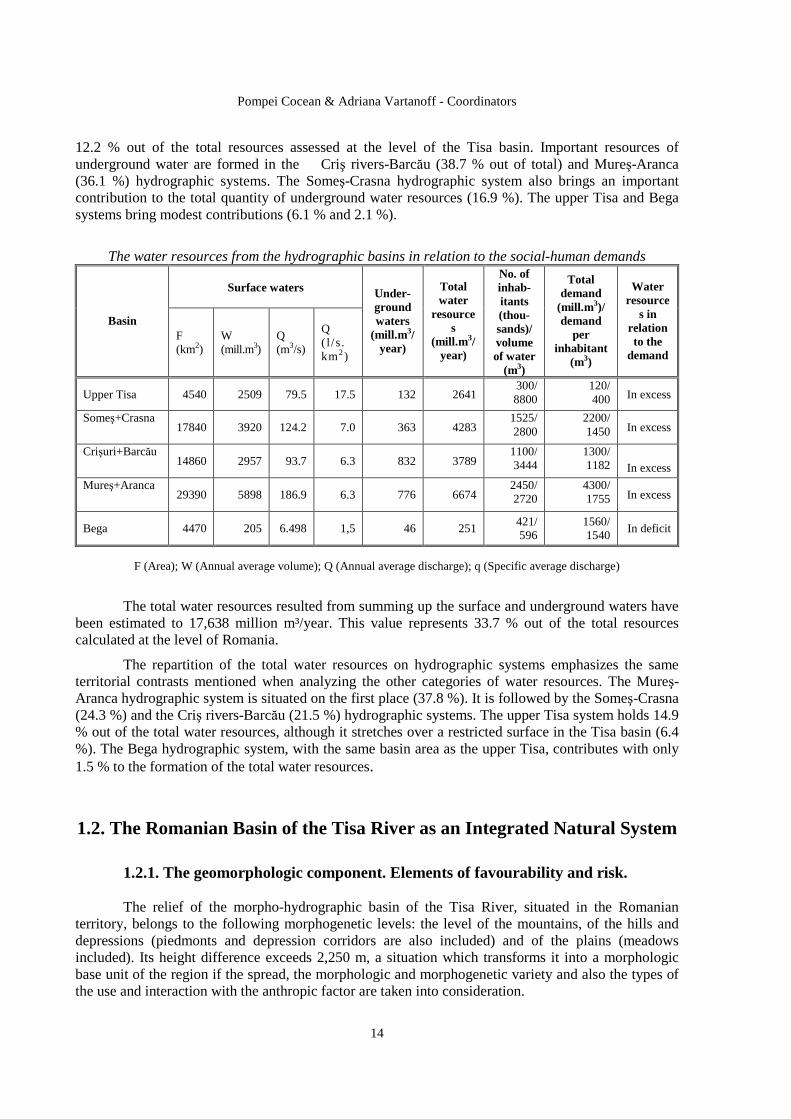
The water resources from the hydrographic basins in relation to the social-human demands
Surface waters
Basin F (km2)
W (mill.m3)
Q (m3/s)
Q ( l /s. km2)
Under-ground waters
(mill.m 3/year)
Total water
resources
(mill.m 3/year)
No. of inhab-itants (thou-sands)/ volume of water
(m3)
Total demand
(mill.m 3)/ demand
per inhabitant
(m3)
Water resource
s in relation to the
demand
Upper Tisa 4540 2509 79.5 17.5 132 2641 300/ 8800
120/ 400 In excess
Someş+Crasna 17840 3920 124.2 7.0 363 4283
1525/ 2800
2200/ 1450 In excess
Crişuri+Barcău 14860 2957 93.7 6.3 832 3789
1100/ 3444
1300/ 1182
In excess
Mureş+Aranca 29390 5898 186.9 6.3 776 6674
2450/ 2720
4300/ 1755 In excess
Bega 4470 205 6.498 1,5 46 251 421/ 596
1560/ 1540
In deficit
F (Area); W (Annual average volume); Q (Annual average discharge); q (Specific average discharge)
The total water resources resulted from summing up the surface and underground waters have been estimated to 17,638 million m³/year. This value represents 33.7 % out of the total resources calculated at the level of Romania.
The repartition of the total water resources on hydrographic systems emphasizes the same territorial contrasts mentioned when analyzing the other categories of water resources. The Mureş-Aranca hydrographic system is situated on the first place (37.8 %). It is followed by the Someş-Crasna (24.3 %) and the Criş rivers-Barcău (21.5 %) hydrographic systems. The upper Tisa system holds 14.9 % out of the total water resources, although it stretches over a restricted surface in the Tisa basin (6.4 %). The Bega hydrographic system, with the same basin area as the upper Tisa, contributes with only 1.5 % to the formation of the total water resources.
1.2. The Romanian Basin of the Tisa River as an Integrated Natural System
1.2.1. The geomorphologic component. Elements of favourability and risk. The relief of the morpho-hydrographic basin of the Tisa River, situated in the Romanian territory, belongs to the following morphogenetic levels: the level of the mountains, of the hills and depressions (piedmonts and depression corridors are also included) and of the plains (meadows included). Its height difference exceeds 2,250 m, a situation which transforms it into a morphologic base unit of the region if the spread, the morphologic and morphogenetic variety and also the types of the use and interaction with the anthropic factor are taken into consideration.

Synthetical Approach to the Romanian Tisa Basin
15
The mountainous unit develops above 700 m high and includes the Apuseni Mountains (known as a petrographic ‘mosaic’, a fact which determines a great morphologic variety, partly amplified by an accented tectonism), the volcanic mountains (Oaş-Gutâi-Tibleş-Călimani-Gurghiu-Harghita and the Metaliferi Mountains), the Maramureş and Rodna Mountains, the Bârgău Mountains (with a mixed lithology, igneous and sedimentary), the Giurgeu Mountains, the northern slope of the Cândrel, Retezat and Poiana Ruscăi mountains (with a morphology developed mainly on crystalline rocks). The petrographic composition of the mountainous morphogenetic level (prevailing igneous and crystalline rock) expresses the premises of a morpho and hydrodynamic stability of the region. The great intensity of weathering processes (especially mechanical weathering) is responsible for its morphodynamics. The Apuseni Mountains represent a monolithic compartment and appear as a mountainous massif totally integrated into the Tisa basin, for which it functions as a real ‘water castle’. It presents a central orographic nucleus, formed by the Bihor-Vlădeasa Mountains, the Gilău-Muntele Mare Mountains and Găina Mountain, and a peripheral unit, about 800 -1,000 m lower than the central orographic nucleus of the Bihor, with a strongly-humanized landscape. The highest altitudes appear in the central part, in certain peaks such as Curcubăta (1849 m), Vlădeasa (1836 m) and Muntele Mare (1826 m) and lower down in the Mureş Mountains (Drocea, 806 m), the Criş Mountains (Moma, 927 m), the Şes or Plopiş Mountains (757 m), the Meseş Mountains (Măgura Priei, 996m), but also towards the depression and piedmont units (Budureasa, 750 m; Măgura Dosului, 948 m).
The long erosion led to the formation of planation surfaces with a pastoral and habitat function, unique in Europe. The oldest one, Fărcaş-CârligaŃi, of Danian and Oligocene age, is known under the oronim of Fărcaşa platform. It ranges between 1,400 and 1,600 m altidude.
The Măguri – Mărişel platform was gemorphologically accomplished during the Medium Sarmatian and the Upper Sarmatian and has an average height of 1,100-1,300 m, being much more undulated and fragmented by valleys.
The third one, the Feneş-Deva platform (Pliocene-Quaternary) is lower (700-1,000 m) and is situated peripherally.
Among the most numerous landforms can be mentioned the following: the caves (more than 5,000, amongst which, Vântului Cave is more than 50 km long), the gorges (22 sectors in the Trascău Mountains but also in the Pădurea Craiului, Bihor and Metaliferi Mountains), the dolines, uvalas, depressions, escarpments, swallow holes, lapieses etc.
The valley corridors and the depressions proximate to the Apuseni Mountains favour the appearance of temperature and vegetation inversions (Leontopodium alpinum appears even at 600 m high, in the Întregalde small depression basin), a reason for which the settlements prefer the smooth ridges, instead of valleys.
The volcanic mountains (Oaş, Gutâi, łibleş, Călimani, Gurghiu, Harghita), which form the Europe's longest volcanic range, impose distinct characters in landscape, through altitude, fragmentation, the preservation degree of the volcanic apparatuses, the suitability for technical arrangements and infrastructures. The post-volcanic phenomena manifest themselves through the appearance of the most wide- spread and rich moffetic aureola from our continent. In the Metaliferi Mountains, the nowadays morphology presents landforms developed on the intrusive igneous structures (batholites, laccolithes, lodes, dykes, necks) and effusive (cones, lava platforms and volcanic agglomerations). Volcanism generated here, through hydrothermal phenomena, the storage of massive reserves of precious metals (gold, silver) exploited for over 5,000 years.
The highest altitude from the Tisa basin is recorded in the Rodna Massif (Pietrosu Peak, 2,304 m). The Maramureş Mountains present a relief modelled in crystalline and igneous rocks (Farcău, 1957 m; Toroioaga, 1930 m). In the case of Rodna Mountains, the presence of a deep karst
Pompei Cocean & Adriana Vartanoff - Coordinators
16
must be mentioned. This deep karst comprises the Izvorul Tăuşoare Cave (more than 15 km long), the cave from Izvorul Albastru al Izei, Jghiabul lui Zalion etc.
The Bârgău Mountains emphasizes a sedimentary-igneous petrographic mosaic, the knolls Heniu Mare, 1611m; Miroslava, 1606 m; MăguriŃa, 1582 m; Tomnatec, 1580 m, being made of under-volcanic aggregates.
The northern endings of the Cândrel, Şureanu, Retezat, Poiana Ruscă mountains define the southern limit of the Romanian morpho-hydrographic basin of the Tisa River. The morphological characters of these massifs (with the exception of the Poiana Ruscă Mountains) can be summarized as follows: massiveness, average altitudes between 1,850 and 2,100 m, average declivity of 25-30°, the presence of planation surfaces, of large corridors (the Mureş Corridor, the Apold Corridor) and of peripheral depressions (the HaŃeg Depression, the Hunedoara Depression).
The hills, depression and depression corridors unit (or the hilly unit), develops between 200-400 m and 700 m high and is represented by the units and subunits of the Transylvanian Depression, the Maramureş Depression, the Giurgeu Depression, the HaŃeg Depression and the Western piedmont Hills. The average altitudes range between 400 and 700 m, while the relative altitudes range between 30 and 200 m, indicating the maturity of the valleys and implicitly that of the relief.
The Transylvanian Depression, formed by a central compartment, that of the Transylvanian Plateau, and a peripheral one, that of the depressions and submontane corridors, appear as a well-outlined unit, crossed by the main tributaries of the Tisa, the Someş and Mureş rivers. The central plateau is subdivided in three units (the Someş Plateau, the Transylvanian Plain and the Târnave Plateau), with altitudes between 500 and 700 m and with a morphology dominated by structural forms (cuestas, subsequent valleys, domes and diapiric folds), landslides and gully erosion.
The depression and peripheral depression corridors (Lăpuş, Almaş-Agriş, Huedin, Turda-Aiud-Alba Iulia and Orăştie, BistriŃa, Voivodeni, Sovata, Praid) have a great morphologic complexity, with a geographical potential articulated by the socio-economic activities, due to the proximity of the saliferous or diapiric areas from the Transylvanian Plateau, to the presence of the methane gas from the domes of the Transylvanian Depression, to the gold and complex ores from the Apuseni Mountains, to the forestry stocks, mineral waters or ores from the Eastern Carpathians.
The intra-Carpathian depressions, formed by volcanic or tectonic blockage, such as the Maramureş, Giurgeu and HaŃeg depressions, offered the best conditions for living since ancient times, a situation illustrated by the affirmation of the ‘lands’, namely mental spaces of great specificity. It is worth mentioning that the capital of the Roman Dacia, Sarmizegetusa Ulpia Traiana, is localized in the HaŃeg Depression.
The Western piedmont Hills or the Banat-Crişana Hills stretch outward from the Maramureş volcanic mountains (the Oaş Piedmont or the Oaş Hills), on a submerged crystalline foundation (the Silvania and Someş Hills), on the western edge of the Apuseni Mountains (the Crişana Hills), and south of the Mureş River (the Banat Hills). They stretch as a hill shelf, with altitudes between 200 and 600 m.
The morphogenetic unit of the plains rise between 20 and 200 m high, being represented by the Banat-Crişana Plain and its subunits. It presents a high piedmont subunit (the Carei, Cermei, Miersig, Arad, Timiş plains), fragmented by a network of divergent and flat-riverbed valleys. The plains of this subunit penetrate into the interior of the gulf-depressions, mediated by the series of terraces, the highest reaching an elevation of 90-110 m, while the lowest 2-3 m. In the piedmont deposits of the plain, the phreatic stratum generally appears at 6-14 m deep.
The low plain or the divagation plains, developed outward from the piedmont plain, presents altitudes of 20-80 m and the maximum extension north of the Barcău River and between the Crişul
Synthetical Approach to the Romanian Tisa Basin
17
Negru and Bârzava rivers, disappearing between the Barcău and Crişul Repede rivers. The relief is characterized by the great development of the meadows of the chief rivers, with numerous meanders, diffluences, braided streams and abandoned river courses. The flood areas reflect the influence of the subsidence process and the alluvial ones (the over-raising of the riverbed and the lateral sand banks, inclusively).
1.2.2. The climatic potential and the associated risks from the Tisa hydrographic basin
The analysis of the climatogenetic factors takes into consideration the solar radiation, the atmospheric circulation and the particularities of the active surface.
The total solar radiation, determined on a horizontal surface from the meteorological platform, at 12 o'clock, reaches annual average values that range between 110 kcal/cm², in the high mountainous regions, and 125 kcal/cm², in the low areas from the northwestern and western part of the Banat Plain.
The atmospheric circulation in altitude is characterized by the clear prevalence of the directions from the western sector (Atlantic influences). In the plain and hill zones situated on the territory of Arad county and in the northern part of Timiş county, there are also sub-Mediterranean influences coming from southwest and south.
The atmospheric circulation in the proximity of the earth surface presents a greater territorial differentiation and the frequency of the atmospheric calm has important variations: from 10-20 %, on the mountainous ridges, up to 65-75 %, in the intra-mountainous depressions.
The active surface from the Tisa River hydrographic basin is characterized by a great diversity as here all the major landforms appear. The exposition to the dominant circulation is very important, as well as the presence of relative extended depression areas, more or less closed by the surrounding units.
The general climatic characterization of the Tisa River hydrographic basin.
The annual mean temperature presents a large scale of variation, from more than 10 oC, in the Banat Plain, up to negative values, below -2 oC, on the highest ridges of Retezat Mountains.
The mean temperature of the hottest month (July or August in the high mountainous zones) ranges between 20-21 oC, in the plain regions, and 6-8 oC, on the ridges exceeding an elevation of 1,900 m.
The mean temperature of the coldest month (January or January-February, in the mountains) presents a more reduced difference: about -2 oC, in the plain and low hills zones, and between -8 oC and below -10 oC, in the highest mountainous regions.
The annual mean rainfalls. At the level of the entire Tisa basin, the annual amounts of rainfalls range from about 550 mm (in the Turda-Alba Iulia corridor, where foehn effects appear) to more than 1,200 mm (in the high mountainous zones). The greatest amounts are recorded on the western-exposed slopes of the Apuseni Mountains (1,335 mm at Stâna de Vale, a meteorological station situated at an elevation of 1,108 m and which is the Romania's rainfall pole). As far as the annual regime of rainfall is concerned, the greatest monthly amounts are recorded in June, in the most part of the Tisa basin, while the pluviometric minimum is produced in February-March. In the Banat Plain, due to the existent sub-Mediterranean influences, a secondary pluviometric maximum appears in October-November and a secondary pluviometric minimum in August-September. In the mountainous zone, the pluviometric minimum belongs to the month of October.

Pompei Cocean & Adriana Vartanoff - Coordinators
18
Climatic risk phenomena
Frost and rime. The mean and extreme data when these phenomena are produced strictly depend on the altitude.
Extreme temperatures. The lowest absolute minimum temperatures (below or equal to -32.0 oC) were recorded in depressions and depression corridors that favor the storage of cold air and the appearance of temperature inversions (Joseni, -38.0 oC; Tg. Lăpuş, -38.0 oC; Cluj-Napoca). The highest absolute maximum temperatures were recorded in the plain regions: 42.5 oC at Jimbolia, 41.0 oC at Timişoara, 40.4 oC at Arad, 40.0 oC at Oradea, 39.4 oC at Satu Mare.
The maximum amount of precipitations fallen in 24 hours were recorded, in most of the observation points, during summer, especially in June. The greatest amounts were recorded in the lower zones (262.0 mm at Deva).
Periods with excess and deficit of precipitations. In the Transylvanian Depression, the years with climatic risk due to the excess of precipitations are almost equal in number with those in which a deficit of precipitations appears. For each of the two categories, the frequency is about 15-20 %, the rest being normal years from a pluviometric point of view.
Hail has a relative low frequency. The annual mean number of days with hail ranges between 1-2 days, in the plain and low hills regions, and 3-11 days, in the Southern Carpathians.
Thunderstorms. The annual mean number of days with such phenomena is about 35-45 days, with the highest values in the mountains and their proximate regions.
Gales represent a characteristic phenomenon especially in the Banat-Crişana Plain and Hills. There are on average 10 cases per year, from which 1-3 cases are very violent. The strong wind, with a speed exceeding or equalizing 16 m/s, appears more frequently in the high mountainous regions.
Solid precipitations. The annual mean number of days with hoarfrost is highest in the high mountainous regions (100 days at Vlădeasa meteorological station situated at 1,800 m high). The annual mean number of days with glazed frost averages between 1-2 days, in the plain regions, and over 5 days, in the high mountains. The phenomenon takes place especially at the end of autumn- the beginning of winter.
Snowstorms. Due to the protection offered by the Eastern Carpathians and the Southern Carpathians, the populated zones of the Tisa hydrographic basin are less affected by this phenomenon (one snowstorm per year, on an average).
The hierarchy of the climatic risk phenomena, formed on in a descending order of their negative impact, indicates that, in the case of the Banat-Crişana Plain and Hills, the order is the following: heavy frontal rainfalls, strong wind, hailstone, drought, heat waves, heavy convectional rainfalls, thunderstorms, cool waves, fog, glazed frost, snowstorms, dust and sand transportation. In the Transylvanian Depression the following succession resulted: heavy frontal rainfalls, heavy convectional rainfalls, hailstone, cool waves, heat waves, drought, thunderstorms, glazed frost, snowstorms, dust and sand transportation.
1.2.3. The biopedogeographic potential
The biopedogeographic cover, which sums up the vegetation, fauna and soils, in their close reciprocal inter-conditioning, reflects through their general characteristics, the position of the Romanian part of the Tisa hydrographic basin in the heart of the temperate climate zone with oceanic influences. But altitude, ranging from 80-100 m to 2,500 m, also plays an extremely obvious role, determining the vertical zonality associated to the latitudinal one.
Synthetical Approach to the Romanian Tisa Basin
19
Soils
The territory of the Tisa hydrographic basin stands out for its great diversity of the biopedogeographic cover, on its surface appearing almost all the soil specific to Romania (zonal, azonal and intrazonal soils). The great variety of the soil cover is the consequence of the spatial and temporal interaction of the pedogenetic factors (relief, lithology, climate, vegetation, fauna and man). Time, as duration of manifestation of the other factors, is also added.
Among the pedogenetic factors, the relief plays an extremely obvious role, together with the general bio-climatic factors, in the genesis, evolution and distribution of the soils from this territory. The influence of the relief materializes, firstly, through the vertical zoning of its major units (mountains, hills, plains), and secondly, through its great morphologic and morphogenetic variety.
From a pedogeographic point of view, the analyzed territory places itself in the ‘Central-European Region’, characterized by the passing from chernozems to preluvosoils and luvosoils (specific to Central Europe), with the following provinces:
I, the Carpathian province, in which the mountainous soils predominate (luvosoils, districambosoils, prepodzols, podzols, humosiosoils);
II, the Transylvanian province, with hill and plateau soils: typical luvosoils, albic luvosoils, eutricambosoils, phaeozems (marnic, cambic, argic), preluvosoils and cambic chernozems;
III, the Banat-Crişana province, with plain and low hills soils: chernozems, phaeozems, preluvosoils and, on relative restricted areas, hydrosoils and salsodisoils.
As a consequence of the great diversity of the pedogenetic factors, the soil cover from the Tisa hydrographic basin is extremely varied, as far as the typology and the spatial distribution mode, fertility and agricultural suitability are concerned, generating the premises of an extremely diverse use.
The plain region is represented by the Banat-Crişana Plain (the Western Plain), from its northern border up to the Timiş-Bega interfluve, and is characterized by a very diverse soil cover, due to the high frequency of the soils with an azonal-intrazonal character. The pedogeographic specificity is marked by the double zonality of the soils: from west to east and from north to south. From the zonal soils, the chernozems and phaeozems stand out (they are representative for the higher-tabular sectors of the plain). Luvisoils (preluvosoils and luvisoils) also appear on relative extended areas and are dominant in the Someş Plain and in the eastern part of the piedmont plain, at the contact with the Western Hills. The intrazonal soils, with a remarkable extension, are represented by a great typological variety: gleysoils, salsodisoils (especially solonchak), alluviosoils and psammosoils.
The hill and plateau regions, being situated in a wetter climate, are characterized by the prevalence of luviosoils and cambisoils. The soil cover is still, very much ‘complicated’ especially because of the great variety of the landforms and of their age, lithologic mosaic and the intensity of the erosion processes.
The mountainous regions include relative important areas from all the three branches of the Carpathians: the Eastern Carpathians (the northern and central-western part), the Southern Carpathians (Şureanu, Retezat-Godeanu, łarcu) and, especially the Western Carpathians (the Apuseni and Poiana Ruscă mountains). The main characteristic of the soil cover is its vertical zonality. The differences which appear, from a pedogeographic point of view, can be assigned, mainly, to the graet variation of the lithologic substratum (especially in the case of the Apuseni Mountains and the Eastern Carpathians). The bio-pedo-climatic vertical zonality is very obvious in the case of the high mountainous massifs (Rodna-Maramureş, Şureanu, Retezat-Godeanu-łarcu), presenting the classic succession of soils: luvosoils and eutricambosoils (in depressions)-districambosoils-prepodzols-podzols-humosiosoils. The volcanic range Oaş-Gutâi-łibleş-Călimani-Gurghiu-Harghita presents important contrasts to the high mountainous massifs, because of the constant presence, on extended areas, of andosoils and the andic subtypes of the districambosoils and eutricambosoils. In the context
Pompei Cocean & Adriana Vartanoff - Coordinators
20
of the mountainous areas from the analyzed territory, the Apuseni Mountains occupy a special place, because of its fundamental pedogeographic characteristics. The lithologic mosaic and the geomorphologic specificity have brought their contribution to the genesis and the evolution of a rarely-met pedological diversity. Some of the zonal soils are: luvisoils, cambisoils and spodosoils and from the soils with an azonal character can be mentioned the following: rendsines, rodic eutricambosoils, andosoils and even some hydrosoils (in the depression areas).
Vegetation
Vegetation is the most representative element of the pedogeographic cover, directly conditioned by climate. It can be considered as a very sensitive component of the geographic environment, reacting to the most trifling variations of the factors it depends upon directly and of the climate, in the first place.
The vertical zonality, structured on the three major levels of the relief from the Tisa hydrographic basin, implies a climatic vertical zonality and, as a consequence, the phytogeographic component appears structured on several zones: the steppe and forest steppe zone, the forest zone and the alpine zone.
Taking into consideration the analysis of the geographical distribution of different flora elements and the participation degree to the formation of the vegetal cover, the analyzed territory belongs mostly to the Central-European Region, the East-Carpathian Province with the following subprovinces: the Eastern Carpathians, the Southern Carpathians, the Apuseni Mountains (the Someş Plateau and the Oaş-Gutâi Mountains are also included) and the Transylvanian Plateau. The western part of the territory is included into the Macaronezo-Mediterranean Region (sub-Mediterranean subregion), the Dacian Province with the Banato-Getic subprovince (the Poiana Ruscă Mountains); the Dacian-Illyrian Province, with the following districts: the Mureş Corridor, the Lipova Hills, the Zarand Mountains; the Criş Hills and the western Someş Plateau and the Pannonian-Illyrian, with the districts: the Banat-Crişana Plain and the Someş Plain (Geografia României, vol. I, 1983).
Fauna
In accordance with the living conditions imposed by the characteristics of the natural environment of the Tisa hydrographic basin (from the Romanian territory), the fauna presents several particular attributes, allowing the distinction of the following zoogeographic regions (R. Călinescu, 1969): the Dacian Province-includes most part of the territory, the Pannonian Province-includes the Banat-Crişana Plain and a part of the Western Plains, and the Moesian Province-on a limited area in the Timiş-Bega Plain. The variety of the terrestrial fauna, aquatic fauna and avifauna shows a remarkable biodiversity and the hunting (bear, wild boar, stag, roebuck, hare) and piscicultural potential (trout, chub, barbel) is also high.
1.2.4. Tourist resources
The tourism in the Romanian Tisa basin is stimulated by the existence of extremely varied resources, some of them of great originality and uniqueness in European context. The tourist infrastructure is also added, being differently distributed in the territory, generally adapted to the tourist supply, but needing ample measures of modernization, rehabilitation and even profound structural changes, related to promoting and organizing activities.
Synthetical Approach to the Romanian Tisa Basin
21
The tourist potential of the natural environment is related to the variety of the relief ranging between less than 50 m and 2,300 m high, with a structure and a tumultuous geologic past with impact over all the components of the natural environment, from the value and diversity of the tourist attractiveness point of view.
The morphologic potential is directly related to the genetic and evolutionary particularities of the main major and minor landforms.
- The glacial relief stands out for its monumentality, diversity and landscape contrasts, due to the peaks, ridges, glacial cirques, glacial valley steps, escarpments and waterfalls, glacial valleys from the representative mountainous units, from the Eastern Carpathians-Rodna Mountains and the Southern Carpathians-Retezat Mountains.
- The volcanic relief from the Eastern Carpathians and the southern part of the Apuseni Mountains is the result of the eruptions from the Neogene period, marked out by the weathering processes which individualized outliers of the Creasta Cocoşului type (in the Gutâi Mountains), calderas and volcanic cones in the Călimani, Gurghiu and Harghita mountains, relief in cupola or knoll shape as the one in the Tibleş, Bârgău or Metaliferi mountains.
- The relief sculptured in limestone and conglomerates is extremely complex, imposing itself especially due to the surface karst and the deep karst from the Apuseni Mountains, one of the most representative speleological tourist regions from Europe. The caves from the Apuseni Mountains stand out for the length of the cavern (Vântului Cave, Hodobana, the Cave from Valea Firii), for the monumentality of some sectors (CetăŃile Ponorului from the Apuseni Mountains, Izvorul Tăuşoarelor Cave from the Rodna Mountains), the sheltered fossil glaciers (Scărişoara Cave, Focul Viu Cave) and especially for the richness of the speleothemes (Urşilor Cave from Chişcău, Pojarul PoliŃei Cave, Altarului Cave). Other attractive caves are the ones from Platoul Luncani from the western part of the Şureanu Mountains.
An extremely spectacular landscape component is the one of the valleys and gorges sectors, developed especially in limestone and deepened for hundreds of metres, with very narrow profiles. They appear frequently in the Apuseni Mountains, especially in the mountainous units of the Trascău, Bihor and Pădurea Craiului mountains. The defiles, such as TopliŃa-Deda Defile, on the Mureş River, the Arieş Defile, the Crişul Repede Defile or the Defile from Lăpuşteşti, on the Someşul Cald), exceed the gorges in size and complexity.
The climatic tourist potential is important due to its characteristics and variations caused by the vertical zonality imposed by the relief, having the temperate continental climate as a general base. The characteristics of the bio-climates have a direct impact upon the human organism, stimulating or improving some of its deficient functions or favouring directly some of the typically tourist activities such as climatic cure or winter sports. Some of the bio-climates detach significantly due to their characteristics and effects: the plain bio-climate, the hills and submontane depressions bio-climate, the mountainous tonic-stimulating bio-climate.
The hydrogeographic tourist potential is remarkable for the Romanian part of the Tisa basin and it is a factor of direct impact due to its all categories of water.
The mineral and thermal waters are the ones that favoured the oldest balneo-tourist arrangements, some dating back from the Roman antiquity, such as the ones from Călan-Aque and Geoagiu Băi-Germisara. The hydrochemical characteristics and the physical characteristics, such as the thermal ones, led in time to the development of a large array of cure resorts with bathing profiles related to these characteristics (Băile Felix, 1 Mai, Moneasa, Geoagiu Băi, VaŃa de Jos etc).
The springs with carbonic-acid and bicarbonated mineral water are extremely numerous, with a large array of hydrochemical subtypes, characteristic to the moffetic aureola from the Eastern Carpathians, but also from the western part, which led to the appearance and development of

Pompei Cocean & Adriana Vartanoff - Coordinators
22
numerous resorts. The saline mineral waters, extremely rich in sodium chloride, present an equal importance. They appear as springs but also as salty lakes in the place of former salt exploitations, in the Transylvanian Depression and the Maramureş Depression, with a well-recognized curative value. In the western part, the thermal-mineral waters, mesothermal and hyperthermal waters, stand out. They have different uses, but their curative and pleasure potential are insufficiently valorized.
The lakes have a multiple tourist-use potential, from the one of landscape and pleasure impact, as in the case of glacial lakes from Rodna and Retezat mountains, to the one of pleasure and sporting impact, in the case of the reservoirs on the Drăgan, Iada, Someşul Cald rivers, from the Apuseni Mountains; ColibiŃa, Călinesti-Oaş, Firiza, Zetea, from the Eastern Carpathians or Râul Mare, from the Retezat Mountains, and the reservoirs from HaŃeg. The ponds from the Transylvanian Plain are also added, stimulating the sport-fishing tourism.
The biogeographic tourist potential is represented especially by the ecosystem of the forests, at all levels, with multiple functionalities. The subalpine and alpine pasture ecosystems have also an important tourist potential.
The need for protecting the natural environment, its components and the ensembles of its components has also a major tourist impact, leading to the individualization and organization of some multifunctional parks, including the tourist function, such as the Retezat National Park and Pietrosul Rodnei National Park, both of them included in the category of great biosphere reservations, or the Apuseni Natural Park, which also includes components of rural habitat, specific to this region.
The anthropic tourist patrimony
The anthropic tourist patrimony is organically related to the components of the human civilization, whose traces identified in the analyzed region date back from the early Palaeolithic (it must be mentioned that the traces of ‘the Vârtop Man’, discovered in one of the caves from the Apuseni Mountains are 62,000 years old!), revealing a millenary continuity and diversification.
The cultural-historic tourist patrimony is the most representative component. It is the result of a long and eventful history, to which human communities, ethnical and confessional, brought their contribution, creating a valuable heritage with a multicultural, complex character and with a unique personality.
- The archaeological vestiges, belonging to the Dacian and Roman antiquity, appear in the archaeological sites from the Orăştie Mountains, among which, Sarmizegetuza Regia and the fortresses which surrounded it in two rings and the Dacian fortresses (called ‘dava’) scattered over the Dacian geopolitical space, stand out. Other important archaeological vestiges are the ones from the Roman period, preserved at Ulpia Traiana Sarmizegetusa, Apulum, Potaissa, Napoca, in the Roman castra (Tibiscum, Micia, Porolissum, Buciumi, Românaşi, Căsei, Ilişua, Orheiu BistriŃei) or the gold and silver exploitations (CetăŃile Romane from Alburnus Major-Roşia Montană) and salt exploitations.
- The historical objectives dating from the Middle Ages, which present tourist attractiveness, are much more numerous and, as a rule, better preserved. Some of these historical objectives are the defence works of the fortress type, the fortified towns (the burghs) built by the German-Saxon communities, among which Sebeş, Sighişoara, Mediaş, BistriŃa and also Cluj, Tg. Mureş, Făgăraş, Baia Mare can be mentioned. The fortresses of Vauban type, built under the Habsburg administration, are also important, the most representative and well-preserved one being Alba Iulia, followed by Timişoara, Arad and Oradea. The peasant fortresses represent a characteristic component of the rural landscape from the southern Transylvania, with localizations at Cîlnic, Slimnic, Săsciori, Cisnădioara. The feudal fortified castles reflect the force of some personalities from the Middle Ages, as in the case of Hunedoara Castle, which belonged to Iancu of Hunedoara.

Synthetical Approach to the Romanian Tisa Basin
23
- The religious objectives of tourist interest have a special symbolic value through dimensions, architectonical style, iconography, collections of worship objects, characteristic for the numerous Christian confessions or for other religions. The religious buildings of Orthodox cult stand out, among which, the one from Densuş opens a page in the history of Orthodoxy of the Romanians from Transylvania. The Romanesque churches and basilicas are represented by CârŃa-Făgăraş, Herina-BistriŃa Năsăud or by the Roman-Catholic cathedral from Alba Iulia. The Gothic religious buildings are present in the majority of the Transylvanian towns: the Sfântul Mihail Church from Cluj Napoca and the Evangelic Church from BistriŃa, followed by the ones from Tg. Mureş, Sighişoara, Sebeş, Sibiu, Oradea etc. The Christian-Orthodox religious buildings, discriminated in the Middle Ages, from which o series of foundations are still preserved (Feleac and Vad, built during Ştefan cel Mare's reign), are also represented by monasteries such as RâmeŃi-Alba and Nicula-Cluj, and especially by the hundreds of wooden churches from Maramureş, Sălaj and Apuseni.
A distinct category in the Transylvanian confessional landscape is represented by the fortified churches from the Transylvanian Plateau, a remarkable and original accomplishment of the German rural communities.
- The urban architectonic complexes give the real architectural and humane personality to the centuries or even bi-millenary old towns, with the entire range of civilian and religious buildings and the specific street network, all of them situated sometimes in the interior of the fortified medieval precincts such as in Sibiu, Sighişoara, Mediaş, Cluj Napoca, BistriŃa.
- The patrimony belonging to the rural traditional culture and civilization of tourist interest, from the ‘lands’ of Maramureş, Oaş, Chioar, Năsăud, Lăpuş, HaŃeg, Zarand, Beiuş, łara MoŃilor, stands out for the residential and religious piles, among which, the wooden churches and the households dominate. The aspects related to activities, handicrafts, technologies and traditional methods of processing and the spiritual component, related to traditions and customs, can also be mentioned. The same aspects related to the Szekler communities from the eastern part of Transylvania and the rural settlements belonging to the Transylvanian Saxons, mostly emigrated, must be noticed.
1.2.5. Underground resources
The geologic complexity met in the zone which corresponds to the Tisa hydrographic basin implies a great diversity of underground mineral resources. These can be included, depending on their nature and genesis, into the following categories: metalliferous and nonmetalliferous mineral resources, hydrocarbon deposits, solid fuels, all kind of rocks (igneous, metamorphic and sedimentary) which can be used in the construction and building materials industry.
Metalliferous and nonmetalliferous mineral resources
The metalliferous and nonmetalliferous mineral resources are the result of complex genetic processes of metamorphic, magmatic and sedimentary origin. Such resources are:
- The deposits of useful mineral substances associated to the sedimentary-magmatic processes from the Middle Proterozoic appear in the Carpathian zone, in carbonate formations from the Rodna Mountains (Guşet, CurăŃel and Valea Blaznei), in the Preluca Mountains (Maşca Răzoare) and in the Poiana Ruscă Mountains (Valea Fierului, BouŃari). In the Rodna Mountains, there are lead and zinc deposits, while copper, silver, arsenic, titanium etc. appear as accessory minerals. In the Preluca Mountains, the accumulation from Maşca Răzoare contains manganese and iron and, in subordinate quantities, magnesium, aluminium, phosphorus etc.
- The deposits of useful mineral substances associated to the metamorphism from the Middle Proterozoic are deposits of pegmatite and feldspars localized in the Rodna Mountains (Rebra Scăricele), the Preluca Mountains (Copalnic Mănăştur and Râpa lui Filip) and in the Gilău Mountains (Râşca – Muntele Rece).
Pompei Cocean & Adriana Vartanoff - Coordinators
24
- The deposits of useful mineral substances associated to the sedimentary-magmatic processes from the Upper Proterozoic-Cambrian are represented by pyrite ores and copper, lead and zinc sulphurs (NovâŃ – Novicior and Baia Borşa). In the Poiana Ruscă Mountains, some stratiform concentrations of pyrite, hepatic iron and blende are known (BoiŃa HaŃeg).
- Deposits of useful mineral substances associated to different geological processes. The most important deposits are the ones of sideritic iron of Ghelari-Teliuc type from the Poiana Ruscă Mountains (Nădejdia, Teliuc, Ghelari, Vadu Dobrei and Pârâul cu Raci - RuşchiŃa).Concentrations of magnetite and hematite are known in the Poiana Ruscă Mountains (Iazuri, Dâmbu Pascului-Bătrâna and Tomeşti). In the Poiana Ruscă Mountains, there are also lead and zinc mineralizations of hydrothermal origin (Muncelul Mic) and polymetallic ores (VeŃel). Copper mineralizations of hydrothermal origin, of small importance, though, are known in the Highiş Mountains. - Deposits of useful mineral substances associated to the geological processes from the alpine cycle. In the ophyolitic rocks from the Metaliferi Mountains there are local, liquid-magmatic concentrations of iron-titanium-vanadium (Almaş – Sălişte and Ciungani – Căzăneşti) and nickel (Ciungani). Deposits of copper and/or sulphurs (Pătrâş, Corbeşti, Almăşel, Roşia Nouă – Hunuleasa, Căzăneşti – Valea Caprei şi Căzăneşti – Valea Sasului) or mineralizations of Pb, Zn ± Au, Ag (VorŃa şi Valea Lungă) also appear. The mineralizations associated to the igneous rocks are generally hydrothermal, having a predominant polymetallic character (Pb–Zn–Cu–Au–Ag ± Te, W, Mo). They appear at Strâmbu-BăiuŃ, Bocşa – Săcărâmb, Coranda – Hondol or at Valea Vinului, Cobăşel, Larga – Zlatna, Baia de Arieş. The ores are highly-diversified, existing auriferous deposits (Bixad - Oaş, Săsar, Stânceni, Măgura Băii, Câine, Caraci – Măgura łebei, Corabia and Roşia Montană) and auriferous tellurides, as a characteristic of the Metaliferi Mountains (Săcărâmb, Haneş, Baia de Arieş – Afiniş). The mineralizations have, in many cases, a mixed auriferous-polymetallic character (Ilba, Cicârlău, Dealul Crucii, Herja, Baia Sprie, BăiŃa – Crăciuneşti, Draica, Muncăceasca – Stănija, Baia de Arieş – Ambru). Mainly polymetallic mineralizations appear in the Baia Mare zone, but they also appear in the Metaliferi Mountains. Less important mercury mineralizations are known in all the zones with volcanism from the Neogene period (Cămârzana – Oaş and Izvorul Ampoiului). Deposits of nonmetalliferous substances are quite frequent, being represented by: kaolinite in the Oaş – Gutâi Mountains (Lepteş, Neteda) and Rodna Mountains (Parva, CormăiŃa), bentonite in the Oaş – Gutâi Mountains (Oraşul Nou) and aragonite in the Gurghiu Mountains (Corund). In the Călimani Mountains there are sulphur deposits (Iezerul Mic) and sulphur and limonite deposits (Negoiul Românesc). The bentonite deposits from the Mureş Corridor (Gurasada and Mihăieşti – Dobra) or from the Transylvanian basin (Hădăreni, Ocna Mureş, Ciugud, Oarda and Staja) and the zeolite deposits associated to the volcanic tuffs from the HaŃeg basin (Sântămăria de Piartă), the Silvania basin (Mirşid) and trans-Carpathian depression (Bârsana), are related to the Neogene volcanism. The sedimentary formations contain important deposits of useful mineral substances, especially of nonmetalliferous character. The bauxite deposits appear in the Pădurea Craiului Mountains (RemeŃi, Meziad, Zece Hotare, Bratca – Secătura, Cornet – Valea Poieni, Răcaş), the Bihor Mountains (Galbena, Valea Seacă), the Metaliferi Mountains (Câmpeni – Sohodol) and HaŃeg (Ohaba Ponor). In the łicău Mountains the kaolinite deposit from Stejera is known. In the northwestern side of the Transylvanian basin, there are deposits of ferruginous oolites from Săvădisla and Căpuş, and gypsum, precipitated in the lagoonal domain, (Treznea, Aghireşu). Extremely rich salt deposits appear in the northwestern and southwestern sides of the Transylvanian basin (Ocna Dejului, Turda, Nireş, Ocna Mureş, Gurghiu and Praid) and in the Maramureş Depression (Ocna Şugatag). Concentrations of heavy minerals (titanium, zirconium, iron, gold) are also present, appearing in the alluvial deposits of some rivers from the Transylvanian and Pannonic basins, the Apuseni and Poiana Ruscă mountains.

Synthetical Approach to the Romanian Tisa Basin
25
Hydrocarbon deposits The hydrocarbon deposits from the analyzed territory are distributed in three distinct zones: the Transylvanian Depression, the Pannonic basin and the trans-Carpathian flysch zone (the Maramureş Depression).
The deposits related to the Transylvanian Depression contain exclusively gaseous hydrocarbons. The gas structures are related to the domes resulted from the diapirism of the Badenian salt. The most important gas structures from the Transylvanian Depression are: Beudiu, łaga, Sărmăşel, Silivaşul de Câmpie, Şincai, Zaul de Câmpie, Grebeniş, Dumbrăvioara, Târgu Mureş, Ernei, Luduş, Bogata de Mureş, LechinŃa – Iernut, AcăŃari, Corunca, Miercurea Nirajului, Filitelnic, Axente Sever, Copşa Mică, Bazna, Şiumuş, Cristuru, Saros – Deleni, Retiş, Noul Săsesc, Alămor, Bârghiş etc.
The hydrocarbon deposits related to the Pannonian Depression are discontinuously spread and are stored in sedimentary formations of different ages. The deposits are represented by oil and gas deposits (Foieni, Calacea – Sat Chinez – Şandra, Variaş, Teremia, Cherestru, Pordeanu, Nădlac, Turnu, Sântana, Ciumeghiu, Borş, Suplacu de Barcău, AbrămuŃ, Sâniob, Mihai Bravu, Curtuiuşeni, Carei and Mădăraş) or by gas (Sânmărtin, Tomnatec, Salonta, Ciocala, Săcuieni, PiscolŃ and Moftinu).
In the zone of the trans-Carpathian flysch from the Maramureş Depression, the oil deposit from Săcel is known.
Solid fuels
Numerous coal and combustible shale deposits are known, whose extension and calorific values vary from one zone to another. There are several petrographic types: (1) peat, (2) lignite, (3) brown coal, (4) carboniferous shale, (5) bituminous shale.
- Peat represents a product of the current sedimentation and appears in the Apuseni Mountains, in CălăŃele – Huedin zone.
- Lignite has a great extension in the Romanian territory. In the analyzed territory there are lignite deposits at Caransebeş (Balta Sărată) and Borod (Borod – Borozel), in the Şimleul Silvaniei basin (Roşiori – Biharia, Tătăruş, Derna Dudoi, Popeşti – Voievozi, Suplacul de Barcău, Marca – Cozniciu, Sărmăşag) and Lugoj basin (Sinersig – Vişag).
- Brown coal is less extended. It appears in the Pannonic basin, in the immediate proximity of the above-mentioned lignite deposits. In the Brad – Săcărâmb zone, deposits of brown coal appear at łebea – Baia de Criş and in the Almaş – Agrij basin, the deposits of Upper Oligocene-Aquitanian age from CristolŃel – Trestioara, Surduc, Lupoaia, Jac, Brusturi, Hida – Zimbor and Ticu.
- The carboniferous shales are associated to the coal deposits, usually in their layer bed. In the analyzed zone, there is only one occurrence of carboniferous shales, of Oligocene age, at Coaş, in the northwestern side of the Preluca Massif.
- The bituminous shales are the result of the accumulation of the organic matter in the large areas of marine sedimentation. Bituminous shales appear in the Transylvanian basin (Ileanda).
1.2.6. Geographical risk phenomena
Geomorphologic risk phenomena
As far as the geographical risk phenomena are concerned, some aspects have been identified in the Tisa hydrographic basin, a result of the multifactor analysis:

Pompei Cocean & Adriana Vartanoff - Coordinators
26
- in the mountainous area, the small risks, from an economic point of view, have a great extension. This situation is given by the type of rocks, the land use and by the fact that the residential zones are dispersed. Thus, the probability of affecting a great number of inhabited spaces is lower. In the mountainous areas, the rock falls, the collapse of the caves roof, gully erosion, debris flow and small landslides are frequent. The processes rise in frequency in the places where the anthropic intervention is evident: in the zones of raw material exploitation, along the ways of communication, in small hydrographic basins (the Eastern, Southern and Western Carpathians);
- in the contact areas between the mountains the depression areas, in the places where lithologic entities of different geotechnical behaviour are in direct contact, the risk has medium to high values. This special behaviour is complicated by the presence of salt and gypsum deposits, which have changed in the long run the geological properties of the rocks. On the mountainsides, in certain limited areas, intense gully erosion and widely extended landslides may appear ( in the Maramureş Depression, the Oaş Depression, the gulf-depressions from the western part of the Apuseni Mountains, the Western Hills, the Transylvanian interior Subcarpathians, the Măhăceni Plateau);
- the great geomorphologic risk phenomena appear in the hilly areas, both in the inland hydrographic basins and the western side of the Western Carpathians. They are mainly generated by the landslides, gully erosion, having as subsidiary an extended sheet erosion. The fragility of these territories is given by a previous evolution (maybe post-Pleistocene), when this kind of processes was widespread in these areas and the ampleness of the phenomena was very great. On this inherited situation, we witness nowadays, during the periods of heavy precipitations, to the recrudescence of such phenomena. In the small hydrographic basins, these phenomena are more visible, the area exposed to the risk induced by geomorphologic phenomena coincides with their entire area. The induced damages refer, in these cases, to lands which have mostly an agricultural destination. However, some risks induced by such phenomena may appear indirectly: quick pond-silting, the over-raising of the riverbed, bogging up and high risk during floods (the Someş and Mureş basins);
- small risk, from a geomorphologic point of view, may by recorded in the high mountainous areas, on the quasi-horizontal plateaus or in the plain areas. In the plain areas, though, the risk generated by earthquakes may appear (the central-southern part of the Western Plain). This phenomenon may induce modifications of the riverbed, effluence of sands in the flood plain and damages in the residential zones.
The risk induced by floods
Floods represent the most widely-spread hazard, with numerous losses of human lives and high-proportion material damages. The floods from the Tisa hydrographic basin take place during the spring high-waters and during the high floods of pluvial, plovio-nival, nivo-pluvial and seldom nival origin. An analysis of the years in which high waters occurred (for the interval between 1900 and 2005) indicates that the years characteristic for the maximum flow were the following: 1912, 1932, 1933, 1970, 1972, 1975, 1981, 1995, 1997, 1998, 2000. The rapid and violent floods cause losses of human lives and important material damages because the water level increases in a very short period of time. They have been recorded in small hydrographic basins. These areas overlap the eastern part of the Someş Plateau, the Transylvanian Subcarpathians between the Târnava Mare and Mureş rivers, the Maramureş Mountains, the western slopes of the Oaş, Gutâi and łibleş mountains. The rapid floods can be divided into three categories: instantaneous floods, generated by rainstorms that affect restricted areas, from several hectares to several sq. kilometres, without the possibility of being precisely localized and forecasted; flash floods, produced on areas ranging from

Synthetical Approach to the Romanian Tisa Basin
27
several sq. kilometres to hundreds of sq. kilometres, are the result of intense rainstorms (over 100 mm); rapid floods, produced on areas of more than 500 km². The slow floods are generated by successive, long-term rain showers, of modest intensity, from several millimetres to dozens of millimetres. Their rise and fall periods are slow and progressive and, thus, predictable. They may also have a mixed origin (plovio-nival or nivo-pluvial). The total duration of the slow floods maintains from several days to several months. The maximum discharges of these floods ranged between 1,344 m3/s (December 1995) and 3,342 m3/s (May 1970) in the Someş-Tisa basin, 538 m3/s (May 1989) and 890 m3/s (July 1932) in the Criş rivers basin, 1,729 m3/s (June 1913) and 2,321 m3/s (June 1970) in the Mureş basin. The slow increase of water is typical for the rivers from the hill and plain regions. Floods have a high frequency in spring (30-50 %) and a low one in autumn (10-20 %) and winter (15-30 %). On the rivers from the Tisa basin, the natural floods have the maximum frequency. They are caused by the heavy precipitations and by the sudden snowmelt and sometimes by their co-occurrence. Accidental floods were not recorded in the analyzed period (1950-2005). Slow floods are characteristic for the big rivers from the hill and plain regions, which have developed large basins. These floods are the result of the slow increase of the consecutive waters resulted from long-term rainfalls. The interval between the beginning of the rainfall and the increase of the water level generally allow the possibility of taking the necessary measures and dispositions to warn the population. Some floods associated to the most important rivers may be catastrophic. This is the situation of the floods produced in May-June 1970, which affected all the rivers from the Tisa basin. The floods from December 1995- January 1996 had catastrophic effects in the Someş-Tisa and the Criş rivers basins, while the floods from April and July 1932 affected the territories belonging to the Mureş basin and Criş rivers basin respectively. The floods from the spring of 2001 affected the majority of the rivers from the Someş-Tisa basin, producing great damages in the Maramureş, BistriŃa-Năsăud and Cluj counties. The rapid floods are formed in particular conditions: intense, localized rain showers, of stormy character. They are characterized by a very rapid flow and increase of the water levels, presenting the risk factors worsen by important dangers. Torrential floods are produced unexpectedly and appear in the mountainous regions. These are short-time floods, taking place for about an hour. The catastrophic floods which took place on August 23, 2005, on the right-side tributaries of the Târnava Mare River, in the Brădeşti - Cristuru-Secuiesc sector, were extremely great, producing material damage and losses of human lives. During the torrential precipitations recorded on August 23, some floods appeared in other Romanian regions: Walachia (Prahova and IalomiŃa counties), Moldavia, the Tur hydrographic basin. During the flood of August 2005, the maximum levels reached in the Târnava Mare River exceeded the warning levels at Odorheiu-Secuiesc, with 20 cm over the attention level, and at Sighişoara, with 32 cm over the flood level. On the Târnava Mare River there were no levels recorded over the danger levels, while on numerous tributaries, this level was exceeded by far. The floods recorded on the Feernic, Seiche (Şoş), Busjac, Cireşeni, Bată, Tăietura rivulets, were extraordinary great and intensive, inflicting important damages. These floods had a typical ‘flash flood’ character because they were formed in small-size hydrographic basins (less than 100 km2), developed into a high-hills region, slightly-forested and with high, runoff slopes. The starting of the floods took place as a consequence of high-intensity precipitations (more than 100 mm in 2 hours). The floods were characterized by rapid raise of water levels, high flow speed and important transport of alluviums and floating materials. The exceptional flood produced in June 20-23, 2006, in the hydrographic basin of the Ilişua rivulet, had a pluvial origin. The precipitations which generated the flood were dispersed and ranged between 20 mm in the lower basin of the Târlişua rivulet and more than 120 mm in the upper basin. The flood, generated by the heavy rain showers determined by intensified convective nucleuses, which

Pompei Cocean & Adriana Vartanoff - Coordinators
28
moved slowly southwards, is included in the ‘flash flood’ category, characterized by a concentration and a sudden increase of discharges. Thus, the maximum discharge of the flood, considered in a section situated in the middle part of the basin, with an area of 160 km2, reached 280 m³/s, a value which has a probability of production of 0.7-0.8 %. The flood effects were disastrous and consisted in losses of human lives (10 deceased and 3 missing persons), important material damages recorded in all the 16 flooded localities, the destruction of numerous houses and household annexes, agricultural fields, harvests, ways of communication, bridges, footbridges, hydrotechnical constructions. The vulnerability degree to the risk of flooding differs in time and space. For the interval 1992-2005, the vulnerability degree to the risk of flooding was very high in the territories of Maramureş, Sălaj, BistriŃa-Năsăud, Cluj, Mureş, Alba, Hunedoara and Arad counties. The vulnerability degree was high in the territories of Satu Mare and Bihor counties, in which the following basins develop: the lower basin of the Someş and Crasna rivers and the Crişul Repede and Crişul Negru basins. In order to prevent and reduce the impacts induced by floods, a series of structural measures have been taken (damming the main rivers in the plain and hill regions, creating permanent and temporary reservoirs, regularisations of the watercourses etc.). The non-structural measures refer mainly to: applying a suitable management for the flooded areas (zoning); creating an operational and efficient action plan in case of flooding; exact forecasting and warning in case of flooding, as well as the evacuation of persons from the flood-prone regions; assessing the resistance of buildings in the areas of high risk of flooding; offering help to the affected areas and starting their rehabilitation as soon as possible etc. All these measures (structural and non-structural) lead, in the case of their application, only to the reduction of the damages produced by floods, but they cannot prevent them totally. Risks induced by human activities Mainly associated to the technologic risks, the risks induced by human activities may become, in the future, the ones with major effects. In this category, the risks induced by the exploitation of raw materials can be mentioned in the first place. The extraction of the raw materials, in the Tisa hydrographic basin, is mainly underground. The risks which may appear are related to the storage of the residual materials (mine dumps decantation ponds) or induced by the arrangement of ways of access, temporary residential and social zones etc. The mountainous areas where these phenomena are frequent are positioned in the Vişeu hydrographic basin (NovăŃ and Baia Borşa zone); the Someş – Săsar hydrographic basin (Baia Mare – 11 decantation ponds); the Arieş basin (Câmpeni – Abrud area); the Mureş basin (Săcărâmb – Deva); the Strei basin (Râul Mare – Retezat). A special case is related to the salt exploitations situated at the border of the mountainous area. The accidents which take place when the mine roof collapses are well-known (Coştiui – Maramureş; Dej – Cluj; Ocna Mureş – Alba). The surface ore exploitations in open-pit mines, besides their generated unaesthetic aspect, they produce numerous and important damages in the surrounding areas (the Roşia Montană – Alba case). A special case is represented by the exploitations of construction aggregates from riverbeds performed in the great hydrographic thoroughfares from the Tisa basin (Someş, Mureş, the Criş rivers). Besides the fact that these can induce major modifications in the transit of the solid and liquid discharge and modifications of courses, a series of modifications of the neighbouring valley-sides also appear, induced by the acceleration of lateral erosion and mass-movements processes. The risks induced by the raw-materials processing usually appear at great distances from the sources. It is the case of the following urban zones: Baia Mare, Târnăveni, Copşa-Mică and Zlatna - for compex ores; Tg. Mureş –chemical industry; Cluj-Napoca zone – complex industry; Turda –

Synthetical Approach to the Romanian Tisa Basin
29
Câmpia Turzii zone (cement, chemical industry); metallurgic industry Deva – Mintia – thermal power station, cement industry etc. Another type of risks is related to the oil exploitation / oil storage from the Western Plain zone (the Barcău basin; the lower Mureş basin) and to the deposits of the firms that commercialize the finite oil products existent in the big towns from the Tisa basin.
1.3. The Romanian Basin of the Tisa River as an Ecological System The hydrographic network represents a primordial factor in structuring the territory (habitats, infrastructure, activities etc.) and, in the same time, in determining the environmental impacts. The diverse types of human activities, synthesized in the land use, leave their mark, in a greater or smaller degree, upon the state of the water quality. In this respect, the different pressures of morphological, physical, chemical, biological origin, with final effects upon structuring the hydric ecosystems, can be considered, in most of the situations, as a reflection of the land use mode (agricultural, industrial, residential, transportation etc.).
The Romanian part of the Tisa hydrographic basin is a complex territorial unit, which overlaps several ecoregions (10 – the Carpathian Mountains; 10s – the Transylvanian Plateau; 11 – the Pannonian Plain). These units delineated in the UE catalogue are mainly based on the differentiation of the morphological and climatic conditions. The morphological conditions have also determined the structuring of the hydrographic network, with a general character of directing the material and energetic fluxes from east to west. Taking into consideration the geographical reasons, coupled with the hydric environment management reasons, the following major hydrographic areas have been identified: Someş-Tisa; the Criş rivers; Mureş; Bega.
In accordance with the integrated scheme of hydrographic basins assessment, recommended by the Frame Regulation for Water 2000/60/EC, the analysis refers to the identification of pressures (punctiform, diffuse and hydro-morphological), which affect the water bodies and influence the quality of the water resources and the ecosystems.
All these pressures, which have an impact upon the various components of the environment, either they manifest over the hydric component through direct evacuations or affect the quality of air and soil, have a contribution to the generation of cumulative effects over the ecosystems and are finally reflected in the quality of water resources.
1.3.1. The quality of the environmental factors
Due to the economic development, which took place between 1960 and 1989, the quality of the environment got worse in comparison with the reference state of the 50s. After 1989, the quality of the environment improved due to the decrease in the economic and social activities and to the application of the legislative and economic mechanisms in the domain of environment, inclusively of the principle ‘the polluter pays’.
Surface water pollution
The most important categories of impacts from the Tisa hydrographic basin are the punctiform, diffuse and hydro-morphological impacts.
116 significant punctiform sources of pollution have been identified out of the total of 435 assessed sources of pollution. Out of these, 58 sources are represented by human agglomerations with more than 10,000 equivalent inhabitants, in which the sewage-treatment plants and/or the sewage network do not function properly. The contribution of the significant sources of pollution discharges out of the total discharges of the assessed punctiform sources is more than 75 % (500,000 m³).
Pompei Cocean & Adriana Vartanoff - Coordinators
30
The sources of diffuse pollution are represented especially by:
o The chemical fertilizers used in agriculture, which were between 10-20 kg N/ha and 2-5 kg P/ha, below the average value from the Danube Basin (31.4 kg N/ha and 5.9 kg P/ha respectively);
o The pesticides used for pest control were between 0.4-0.6 kg/ha, below 1,39 kg/ha, the average value of seven states in the Danube Basin;
o The domestic animals from the analysed hydrographic area, which have a density of 0.35 equivalent cows/ha, below the average value from the Danube basin, which ranges between 0.45 – 0.55 equivalent animals/ha, depending on the method of calculus used;
o The human agglomerations from the rural environment and the urban environment, having in view the small percentages of population connected to the sewage network (2.5 % and 75 % respectively). The hydro-morphological pressures affect 350 hydrographic segments out of the total of 1,700
from the hydrographic area, but the most important hydro-morphological pressures are caused by: • 36 reservoirs, the most important being Drăgan, Lugaş, Tileagd, Leşu, Fântânele, ColibiŃa, Oaşa,
Gura Apelor etc. • 2,300 km of dams, 2,500 km of watercourse regularizations and 600 km of embankments; • 40 water derivations, 3 canals inclusively; • 63 water intakes that draw important water discharges and 78 important restitutions.
An important characteristic of the hydrographic basin is represented by the achievement of numerous fishponds which affect the hydrodynamic regime of 35 rivers. Air pollution Air is the most important environmental factor for the pollutants transport because it represents the fastest means of transporting the pollutants into the environment and thus, the air quality surveillance is situated on the first place in the monitoring activity. Air pollution has numerous causes, some being the result of the human activities, other being due to some natural conditions of place and climate. After analyzing the data acquired from the monitoring network belonging to the Waters and Environment Protection Ministry, it results a slight improvement of air quality due to the decrease in the economic activities and to modernization and changing of technologies carried out at the level of some industrial units. Critical zones with regard to air pollution Critical zone or hot zone is the zone in whose territory systematic exceeding of environment quality indicators, given the standardized norms, are recorded, producing serious degradation of the environment state, with consequences upon the people's health, economy and natural capital. The critical zones with regard to air pollution are: - Arad Zone, due to Arad thermal power station and to the emissions of gas pollutants (NO2, SO
2); a secondary source of air pollution is the ash dump due to the airborne ash particles;
- ReşiŃa Zone, due to the dust and gas pollutants from the SC Combinatul Siderurgic SA OŃelăria electrică ReşiŃa;
- Hunedoara Zone, polluted especially with iron oxides, ferrous metals and sedimentary dust proceeded from the ironworks;
- Baia Mare Zone continues to be a critical zone as regards the pollution level due to the activity of the non-ferrous metallurgy and the decantation ponds;
- Copşa Mică-Mediaş Zone, with pollution produced by the emission into the atmosphere of important amounts of particles and compounds of non-ferrous metals, with harmful effects upon the environment, emitted by SC SOMETRA SA Copşa Mică; - Târgu Mureş Zone polluted especially with ammonia and nitrogen oxides proceeded from the chemical fertilizers industry SC Azomureş SA Târgu-Mureş; - Dej Zone, affected especially by the emissions of sulphur dioxide, carbon disulphide, hydrogen sulphide, mercaptans proceeded from the cellulose, paper and synthetic fibres industry.

Synthetical Approach to the Romanian Tisa Basin
31
Soil pollution Soil quality is significantly affected in the areas where there are industrial and domestic waste dumps. The mining worksites detain an important percentage due to depositing the gangue and to the infiltration into the soil, up to the phreatic water level, of toxic chemical substances and heavy metals. Chemical soil pollution affects about 0.9 million ha, out of which excessive pollution affects 0.2 million ha. Pollution with heavy metals (especially with copper, lead, zinc, cadmium) and sulphur dioxide produces extremely powerful aggressive effects upon the soil. This kind of pollution has been identified especially in the following zones: Baia Mare, Zlatna, Copşa Mică. Although, a series of industrial units have been closed in the last period, and others have reduced their activity, soil pollution maintains high in the serious-affected zones. Soil destruction due to diverse excavation works affects about 5,000 ha, being the worse form of soil deterioration. It appears in the case of open-pit mining, such as in the mining basin of the Metaliferi Mountains. The potential of the lands affected by this type of pollution decreased with 1-3 classes, thus, some of these areas have become practically unproductive. The soil coverage with wastes and solid residues has determined the drawing out from the agricultural circuit of about 18,000 ha of agricultural lands. The direct economic damages over the agricultural production owed to the above-mentioned restrictions are assessed to diminish with about 20 % yearly. The aggressive agricultural practices represent an important generator of soil erosion. Due to the economic advantages, the maintaining of monoculture for long periods of time leads to soil impoverishment, reduction of productive potential, reduction of productions and, in the end, to the degradation of the soil fertile horizons (Cluj, Maramureş, Sibiu, Arad counties). Excessive grazing is very harmful for the soil stability because, on the one hand, it imposes the deforestation of some forested areas in order to extend the grazing zones, and on the other hand, it impoverishes the vegetation, generating brambles, which have a very small role in stabilizing the land. Critical zones with regard to soil pollution are represented by Zlatna, Baia Mare and Copşa Mica, where the big industrial units, heavy metal polluters, function or have functioned. The implementation of an integrated system against soil pollution must be noticed in the Zlatna zone and also the initiation of the most efficient measures of restoring the soils polluted with heavy metals (for example Copşa Mică and Zlatna), as well as researches within the framework of the integrated soil and vegetation monitoring (10 counties).
1.3.2. Natural patrimony and protected areas The great diversity of the natural habitats and ecosystems existent in the Tisa hydrographic basin is due to the climate and altitudinal variation and to the diversity of the substratum, soils, flora and vegetation. Thus, in the Tisa hydrographic basin all types of major natural habitats can be found, except for the coastal and marine habitats. Protected natural areas of national importance The protected natural areas of national importance, in conformity with the current principles of classification (including the ones established by the International Union for Nature Preservation), are represented, in the Tisa hydrographic basin, by: national parks, natural parks, natural monuments, nature reserves and landscape reserves, their structure being different from one site to the other: geological (g), palaeontological (p), speleological (s), botanical (b), zoological (z), geographical and landscape (gl) or mixed (m). In conformity with Law No. 5, issued on March 6, 2000, regarding the approval of the National Land Management Plan – Section III - Protected Zones, published in the Official Gazette of Romania, no. 152, issued on April 12, 2000, in the hydrographic basin of the Tisa River, following categories of protected areas are assigned:
Biosphere reserves, natural or national parks There are 8 national or natural parks in the hydrographic basin of the Tisa River, which include more than 441,000 ha in the corresponding categories of protection.
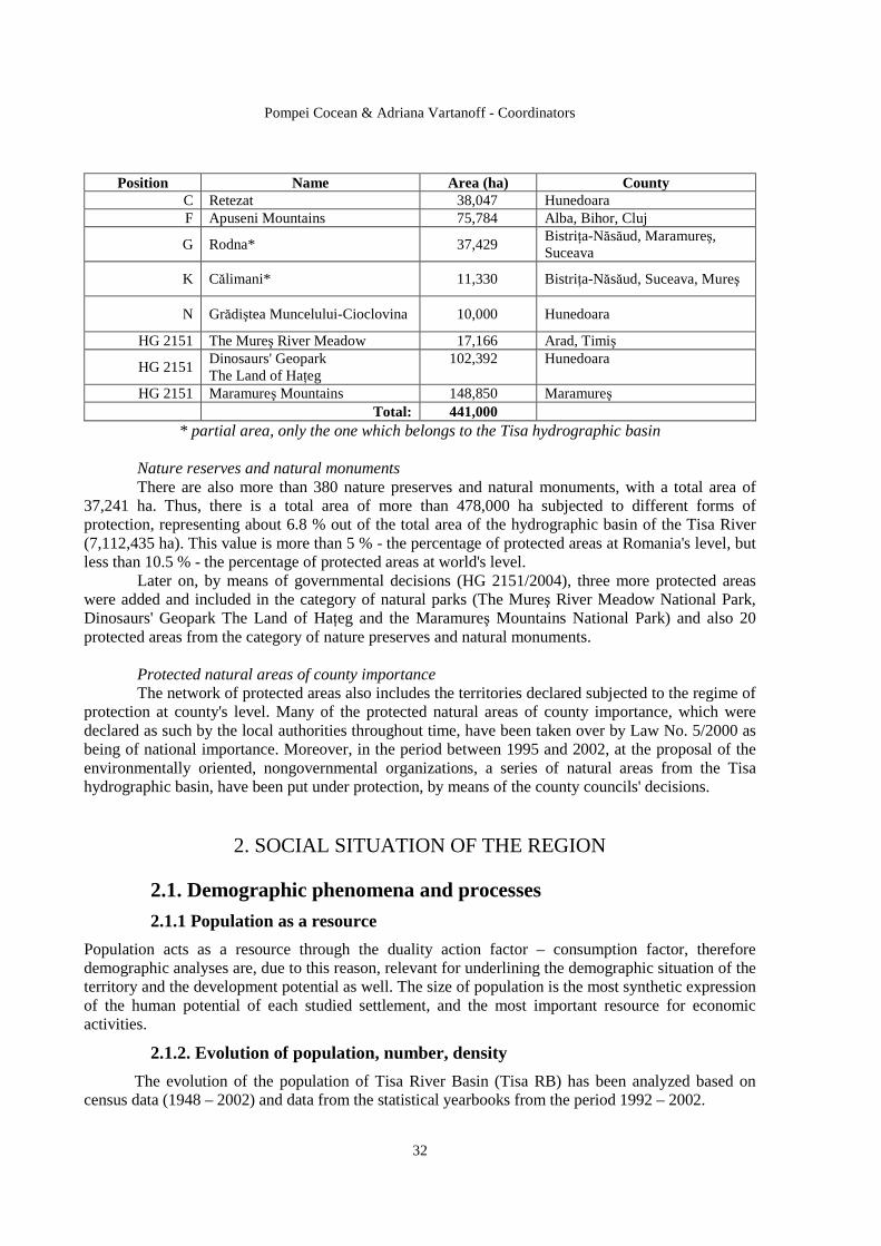
Pompei Cocean & Adriana Vartanoff - Coordinators
32
Position Name Area (ha) County
C Retezat 38,047 Hunedoara F Apuseni Mountains 75,784 Alba, Bihor, Cluj
G Rodna* 37,429 BistriŃa-Năsăud, Maramureş, Suceava
K Călimani* 11,330 BistriŃa-Năsăud, Suceava, Mureş
N Grădiştea Muncelului-Cioclovina 10,000 Hunedoara
HG 2151 The Mureş River Meadow 17,166 Arad, Timiş
HG 2151 Dinosaurs' Geopark The Land of HaŃeg
102,392 Hunedoara
HG 2151 Maramureş Mountains 148,850 Maramureş Total: 441,000
* partial area, only the one which belongs to the Tisa hydrographic basin
Nature reserves and natural monuments There are also more than 380 nature preserves and natural monuments, with a total area of 37,241 ha. Thus, there is a total area of more than 478,000 ha subjected to different forms of protection, representing about 6.8 % out of the total area of the hydrographic basin of the Tisa River (7,112,435 ha). This value is more than 5 % - the percentage of protected areas at Romania's level, but less than 10.5 % - the percentage of protected areas at world's level. Later on, by means of governmental decisions (HG 2151/2004), three more protected areas were added and included in the category of natural parks (The Mureş River Meadow National Park, Dinosaurs' Geopark The Land of HaŃeg and the Maramureş Mountains National Park) and also 20 protected areas from the category of nature preserves and natural monuments.
Protected natural areas of county importance The network of protected areas also includes the territories declared subjected to the regime of protection at county's level. Many of the protected natural areas of county importance, which were declared as such by the local authorities throughout time, have been taken over by Law No. 5/2000 as being of national importance. Moreover, in the period between 1995 and 2002, at the proposal of the environmentally oriented, nongovernmental organizations, a series of natural areas from the Tisa hydrographic basin, have been put under protection, by means of the county councils' decisions.
2. SOCIAL SITUATION OF THE REGION
2.1. Demographic phenomena and processes
2.1.1 Population as a resource
Population acts as a resource through the duality action factor – consumption factor, therefore demographic analyses are, due to this reason, relevant for underlining the demographic situation of the territory and the development potential as well. The size of population is the most synthetic expression of the human potential of each studied settlement, and the most important resource for economic activities.
2.1.2. Evolution of population, number, density
The evolution of the population of Tisa River Basin (Tisa RB) has been analyzed based on census data (1948 – 2002) and data from the statistical yearbooks from the period 1992 – 2002.
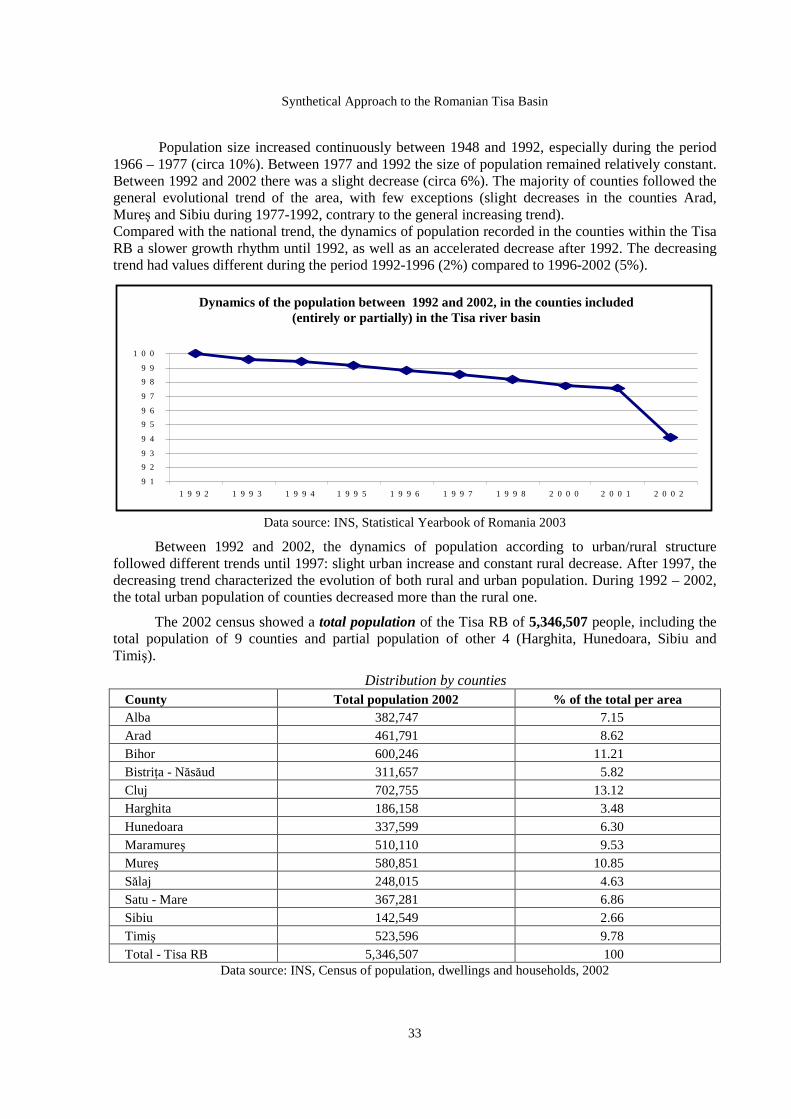
Synthetical Approach to the Romanian Tisa Basin
33
Population size increased continuously between 1948 and 1992, especially during the period 1966 – 1977 (circa 10%). Between 1977 and 1992 the size of population remained relatively constant. Between 1992 and 2002 there was a slight decrease (circa 6%). The majority of counties followed the general evolutional trend of the area, with few exceptions (slight decreases in the counties Arad, Mureş and Sibiu during 1977-1992, contrary to the general increasing trend). Compared with the national trend, the dynamics of population recorded in the counties within the Tisa RB a slower growth rhythm until 1992, as well as an accelerated decrease after 1992. The decreasing trend had values different during the period 1992-1996 (2%) compared to 1996-2002 (5%). ynamicsduri
Data source: INS, Statistical Yearbook of Romania 2003
Between 1992 and 2002, the dynamics of population according to urban/rural structure followed different trends until 1997: slight urban increase and constant rural decrease. After 1997, the decreasing trend characterized the evolution of both rural and urban population. During 1992 – 2002, the total urban population of counties decreased more than the rural one.
The 2002 census showed a total population of the Tisa RB of 5,346,507 people, including the total population of 9 counties and partial population of other 4 (Harghita, Hunedoara, Sibiu and Timiş).
Distribution by counties County Total population 2002 % of the total per area Alba 382,747 7.15 Arad 461,791 8.62 Bihor 600,246 11.21 BistriŃa - Năsăud 311,657 5.82 Cluj 702,755 13.12 Harghita 186,158 3.48 Hunedoara 337,599 6.30 Maramureş 510,110 9.53 Mureş 580,851 10.85 Sălaj 248,015 4.63 Satu - Mare 367,281 6.86 Sibiu 142,549 2.66 Timiş 523,596 9.78 Total - Tisa RB 5,346,507 100
Data source: INS, Census of population, dwellings and households, 2002
D i n a m i c a p o p u l a t i e i î n p e r i o a d a 1 9 9 2 - 2 0 0 2 î n j u d et e l e c u p r i n s e ( i n t e g r a l s a u p a r t i a l ) î n b a z i n u l h i d r o g r a f i c a l
R â u l u i T i s a
9 1
9 2
9 3
9 4
9 5
9 6
9 7
9 8
9 9
1 0 0
1 9 9 2 1 9 9 3 1 9 9 4 1 9 9 5 1 9 9 6 1 9 9 7 1 9 9 8 2 0 0 0 2 0 0 1 2 0 0 2
Dynamics of the population between 1992 and 2002, in the counties included (entirely or partially) in the Tisa river basin
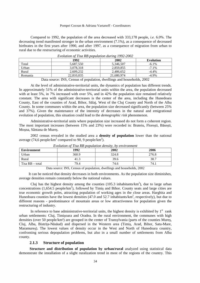
Pompei Cocean & Adriana Vartanoff - Coordinators
34
Compared to 1992, the population of the area decreased with 333,178 people, i.e. 6.0%. The decreasing trend manifested stronger in the urban environment (7.1%), as a consequence of decreased birthrates in the first years after 1990, and after 1997, as a consequence of migration from urban to rural due to the restructuring of economic activities.
Evolution of Tisa RB population during 1992-2002 1992 2002 Evolution
Total 5,687,550 5,346,507 -6.1% Urban 3,078,318 2,859,855 -7.1% Rural 2,609,232 2,486,652 -4.4% Romania 22,810,035 21,680,974 -4.9%
Data source: INS, Census of population, dwellings and households, 2002
At the level of administrative-territorial units, the dynamics of population has different trends. In approximately 51% of the administrative-territorial units within the area, the population decreased with at least 5%, in 7% increased with over 5%, and in 42% the population size remained relatively constant. The area with significant decreases is the center of the area, including the Hunedoara County, East of the counties of Arad, Bihor, Sălaj, West of the Cluj County and North of the Alba County. In some communes within the area, the population size decreased significantly (between 25% and 37%). Given the maintenance of the intensity of decreases in the natural and emigrational evolution of population, this situation could lead to the demographic risk phenomenon.
Administrative-territorial units where population size increased do not form a coherent region. The most important increases (between 15% and 23%) were recorded in: Brateiu, Floreşti, Băseşti, Moşna, Sântana de Mureş.
2002 census revealed in the studied area a density of population lower than the national average (74,6 people/km2 compared to 90, 9 people/km2).
Evolution of Tisa RB population density, by environment Environment 1992 2002 2006 Urban 360.9 324.8 276.8 Rural 41.3 39.6 38.7 Tisa RB – total 79.4 74.6 74.1
Data source: INS, Census of population, dwellings and households, 2002
It can be noticed that density decreases in both environments. As the population size diminishes, average densities remain constantly below the national values.
Cluj has the highest density among the counties (105.3 inhabitants/km2), due to large urban concentrations (1,654.5 people/km2), followed by Timiş and Bihor. County seats and large cities are true economic growth poles, attracting population of working ages in the close areas. Harghita and Hunedoara counties have the lowest densities (47.0 and 52.7 inhabitants/km2, respectively), but due to different reasons - predominance of mountain areas or low attractiveness for population given the restructuring of industry.
In reference to base administrative-territorial units, the highest density is exhibited by 1st rank urban settlements: Cluj, Timişoara and Oradea. In the rural environment, the communes with high densities (over 50 people/km²) are grouped in the center of Transylvania (parts of the counties Mureş, Cluj, Alba, BistriŃa-Năsăud) and dispersed in the Western area (Timiş, Arad, Bihor, Satu-Mare, Maramureş). The lowest values of density occur in the West and North of Hunedoara country, confronting serious depopulation problems, but also in a small number of settlements from Alba county.
2.1.3 Structure of population
Structure and distribution of population by urban/r ural analyzed using statistical data demonstrate the installation of a slight ruralization trend in most of the regions of the country. This
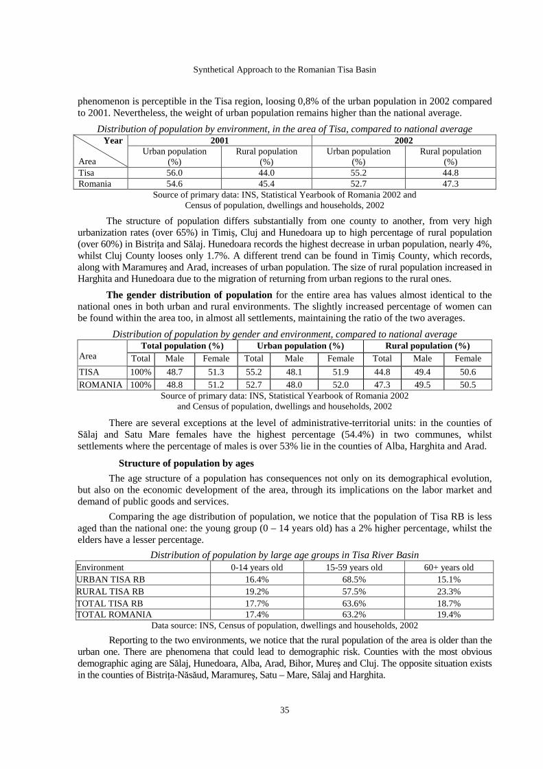
Synthetical Approach to the Romanian Tisa Basin
35
phenomenon is perceptible in the Tisa region, loosing 0,8% of the urban population in 2002 compared to 2001. Nevertheless, the weight of urban population remains higher than the national average.
Distribution of population by environment, in the area of Tisa, compared to national average 2001 2002 Year
Area
Urban population (%)
Rural population (%)
Urban population (%)
Rural population (%)
Tisa 56.0 44.0 55.2 44.8 Romania 54.6 45.4 52.7 47.3
Source of primary data: INS, Statistical Yearbook of Romania 2002 and Census of population, dwellings and households, 2002
The structure of population differs substantially from one county to another, from very high urbanization rates (over 65%) in Timiş, Cluj and Hunedoara up to high percentage of rural population (over 60%) in BistriŃa and Sălaj. Hunedoara records the highest decrease in urban population, nearly 4%, whilst Cluj County looses only 1.7%. A different trend can be found in Timiş County, which records, along with Maramureş and Arad, increases of urban population. The size of rural population increased in Harghita and Hunedoara due to the migration of returning from urban regions to the rural ones.
The gender distribution of population for the entire area has values almost identical to the national ones in both urban and rural environments. The slightly increased percentage of women can be found within the area too, in almost all settlements, maintaining the ratio of the two averages.
Distribution of population by gender and environment, compared to national average Total population (%) Urban population (%) Rural pop ulation (%)
Area Total Male Female Total Male Female Total Male Female
TISA 100% 48.7 51.3 55.2 48.1 51.9 44.8 49.4 50.6
ROMANIA 100% 48.8 51.2 52.7 48.0 52.0 47.3 49.5 50.5 Source of primary data: INS, Statistical Yearbook of Romania 2002
and Census of population, dwellings and households, 2002
There are several exceptions at the level of administrative-territorial units: in the counties of Sălaj and Satu Mare females have the highest percentage (54.4%) in two communes, whilst settlements where the percentage of males is over 53% lie in the counties of Alba, Harghita and Arad.
Structure of population by ages
The age structure of a population has consequences not only on its demographical evolution, but also on the economic development of the area, through its implications on the labor market and demand of public goods and services.
Comparing the age distribution of population, we notice that the population of Tisa RB is less aged than the national one: the young group (0 – 14 years old) has a 2% higher percentage, whilst the elders have a lesser percentage.
Distribution of population by large age groups in Tisa River Basin Environment 0-14 years old 15-59 years old 60+ years old URBAN TISA RB 16.4% 68.5% 15.1% RURAL TISA RB 19.2% 57.5% 23.3% TOTAL TISA RB 17.7% 63.6% 18.7% TOTAL ROMANIA 17.4% 63.2% 19.4%
Data source: INS, Census of population, dwellings and households, 2002
Reporting to the two environments, we notice that the rural population of the area is older than the urban one. There are phenomena that could lead to demographic risk. Counties with the most obvious demographic aging are Sălaj, Hunedoara, Alba, Arad, Bihor, Mureş and Cluj. The opposite situation exists in the counties of BistriŃa-Năsăud, Maramureş, Satu – Mare, Sălaj and Harghita.
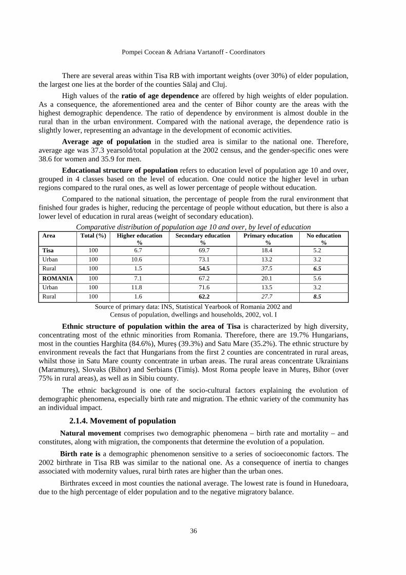
Pompei Cocean & Adriana Vartanoff - Coordinators
36
There are several areas within Tisa RB with important weights (over 30%) of elder population, the largest one lies at the border of the counties Sălaj and Cluj.
High values of the ratio of age dependence are offered by high weights of elder population. As a consequence, the aforementioned area and the center of Bihor county are the areas with the highest demographic dependence. The ratio of dependence by environment is almost double in the rural than in the urban environment. Compared with the national average, the dependence ratio is slightly lower, representing an advantage in the development of economic activities.
Average age of population in the studied area is similar to the national one. Therefore, average age was 37.3 yearsold/total population at the 2002 census, and the gender-specific ones were 38.6 for women and 35.9 for men.
Educational structure of population refers to education level of population age 10 and over, grouped in 4 classes based on the level of education. One could notice the higher level in urban regions compared to the rural ones, as well as lower percentage of people without education.
Compared to the national situation, the percentage of people from the rural environment that finished four grades is higher, reducing the percentage of people without education, but there is also a lower level of education in rural areas (weight of secondary education).
Comparative distribution of population age 10 and over, by level of education Area Total (%) Higher education
% Secondary education
% Primary education
% No education
% Tisa 100 6.7 69.7 18.4 5.2
Urban 100 10.6 73.1 13.2 3.2
Rural 100 1.5 54.5 37.5 6.5
ROMANIA 100 7.1 67.2 20.1 5.6
Urban 100 11.8 71.6 13.5 3.2
Rural 100 1.6 62.2 27.7 8.5
Source of primary data: INS, Statistical Yearbook of Romania 2002 and Census of population, dwellings and households, 2002, vol. I
Ethnic structure of population within the area of Tisa is characterized by high diversity, concentrating most of the ethnic minorities from Romania. Therefore, there are 19.7% Hungarians, most in the counties Harghita (84.6%), Mureş (39.3%) and Satu Mare (35.2%). The ethnic structure by environment reveals the fact that Hungarians from the first 2 counties are concentrated in rural areas, whilst those in Satu Mare county concentrate in urban areas. The rural areas concentrate Ukrainians (Maramureş), Slovaks (Bihor) and Serbians (Timiş). Most Roma people leave in Mureş, Bihor (over 75% in rural areas), as well as in Sibiu county.
The ethnic background is one of the socio-cultural factors explaining the evolution of demographic phenomena, especially birth rate and migration. The ethnic variety of the community has an individual impact.
2.1.4. Movement of population
Natural movement comprises two demographic phenomena – birth rate and mortality – and constitutes, along with migration, the components that determine the evolution of a population.
Birth rate is a demographic phenomenon sensitive to a series of socioeconomic factors. The 2002 birthrate in Tisa RB was similar to the national one. As a consequence of inertia to changes associated with modernity values, rural birth rates are higher than the urban ones.
Birthrates exceed in most counties the national average. The lowest rate is found in Hunedoara, due to the high percentage of elder population and to the negative migratory balance.
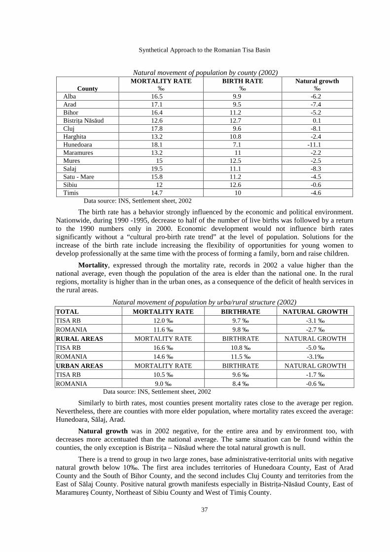
Synthetical Approach to the Romanian Tisa Basin
37
Natural movement of population by county (2002)
County MORTALITY RATE
‰ BIRTH RATE
‰ Natural growth
‰ Alba 16.5 9.9 -6.2 Arad 17.1 9.5 -7.4 Bihor 16.4 11.2 -5.2 BistriŃa Năsăud 12.6 12.7 0.1 Cluj 17.8 9.6 -8.1 Harghita 13.2 10.8 -2.4 Hunedoara 18.1 7.1 -11.1 Maramures 13.2 11 -2.2 Mures 15 12.5 -2.5 Salaj 19.5 11.1 -8.3 Satu - Mare 15.8 11.2 -4.5 Sibiu 12 12.6 -0.6 Timis 14.7 10 -4.6
Data source: INS, Settlement sheet, 2002
The birth rate has a behavior strongly influenced by the economic and political environment. Nationwide, during 1990 -1995, decrease to half of the number of live births was followed by a return to the 1990 numbers only in 2000. Economic development would not influence birth rates significantly without a “cultural pro-birth rate trend” at the level of population. Solutions for the increase of the birth rate include increasing the flexibility of opportunities for young women to develop professionally at the same time with the process of forming a family, born and raise children.
Mortality , expressed through the mortality rate, records in 2002 a value higher than the national average, even though the population of the area is elder than the national one. In the rural regions, mortality is higher than in the urban ones, as a consequence of the deficit of health services in the rural areas.
Natural movement of population by urba/rural structure (2002) TOTAL MORTALITY RATE BIRTHRATE NATURAL GROWTH TISA RB 12.0 ‰ 9.7 ‰ -3.1 ‰ ROMANIA 11.6 ‰ 9.8 ‰ -2.7 ‰
RURAL AREAS MORTALITY RATE BIRTHRATE NATURAL GROWTH TISA RB 16.6 ‰ 10.8 ‰ -5.0 ‰ ROMANIA 14.6 ‰ 11.5 ‰ -3.1‰
URBAN AREAS MORTALITY RATE BIRTHRATE NATURAL GROWTH TISA RB 10.5 ‰ 9.6 ‰ -1.7 ‰ ROMANIA 9.0 ‰ 8.4 ‰ -0.6 ‰ Data source: INS, Settlement sheet, 2002
Similarly to birth rates, most counties present mortality rates close to the average per region. Nevertheless, there are counties with more elder population, where mortality rates exceed the average: Hunedoara, Sălaj, Arad.
Natural growth was in 2002 negative, for the entire area and by environment too, with decreases more accentuated than the national average. The same situation can be found within the counties, the only exception is BistriŃa – Năsăud where the total natural growth is null.
There is a trend to group in two large zones, base administrative-territorial units with negative natural growth below 10‰. The first area includes territories of Hunedoara County, East of Arad County and the South of Bihor County, and the second includes Cluj County and territories from the East of Sălaj County. Positive natural growth manifests especially in BistriŃa-Năsăud County, East of Maramureş County, Northeast of Sibiu County and West of Timiş County.
Pompei Cocean & Adriana Vartanoff - Coordinators
38
Migratory movement of population led to important changes in the territorial distribution of population during 1992 – 2002 under the concomitant influence of three factors: differentiated level of natural growth, internal migration fluxes and intensity of external migration.
The migratory increase expressed by the difference between incoming and outgoing population in 2002 within the Tisa RB is almost null. Nevertheless, there is an accentuated shift of population from urban to rural regions, and between rural regions from the same county or from different counties. Most of the area with important population decreases are those with negative migratory growth, especially in the counties Cluj, Alba, Bihor and Hunedoara, but the largest concentration of settlements with an accentuated negative growth lie in counties with the highest poverty rates, BistriŃa-Năsăud and Maramureş.
Settlements with an accentuated positive growth are mostly rural, situated in the proximity of the cities – county seats, as a consequence of restructuring activities within the urban economy, but also due to advantageous conditions for purchasing land or houses close to the city. If during the first part of the 90's migrations were directed from poorer to more developed regions, after 1995 the migration was reverted, considered crucial to provide for the subsistence (rural areas allow for the satisfaction of fundamental needs at a lower cost).
2002 census showed that the population changing its residence within the Tisa area has the highest percentages (compared to the population of the county) in the counties Timiş (46.8%), Hunedoara (45.6%) and Arad (34.7%). Counties Arad and Timiş have the highest percentage of immigrants from other countries (1.1% and, respectively, 1.4%), followed by Sibiu, Bihor and Satu Mare.
In regard to inter-county migration fluxes within the Tisa area, there are differences between the fluxes of immigrants and emigrants, enabling for the identification of donor and recipient counties. Cluj is the only both donor and recipient county within the studied area.
A specific type of migration is the circulatory or temporary migration, characteristic to the labor force traveling outside the country borders to search for a better-paid job. A study of 2262 Romanian villages during 1992 – 2002, demonstrates that the intensity of circulatory migration depends a lot in the rural environment on the dominant cultural type of village specific to the respective area and on the migratory experience. Out of the six cultural types identified in Romania, only four can be found in the studied area: communities minority – ethnic, communities minority – religious, immigration communities and isolated communities. Circulatory migration was more intense in villages with a maximum migration experience in the counties of Arad, Timiş, Alba and Hunedoara, in villages with a high percentage of religious minorities (Bihor, Satu Mare, Maramureş, BistriŃa-Năsăud and Sibiu) and in villages with a high percentage of Hungarian population from Sălaj, Cluj, Mureş and Harghita.
2. 2. Work resources
The structure of labor force within Tisa RB has an ageing trend determined by an increased percentage of the age group 45-64 years old (by 1%) and decreased percentage of the age group 15-29 years old (by 2%) between 1992 and 2002. In the rural environment, the imbalance results from a reduced percentage of the age group 35-59 years old, due to the massive migratory phenomenon during the period of city industrialization and increased weight of the young labor force (15-35 years old) that exercises a big pressure on the rural labor market, which lacks the absorption capacity.
The global occupation rate, computed as percent ratio of occupied population and population of working age, illustrates synthetically the capacity of economy to offer workplaces to the labor force. Given that unemployed population had a general increasing trend, the degree of occupation decreased for the labor force. The global occupation rate in Tisa RB is comparable with the national average, but in the counties Arad, Hunedoara, Mureş, Sălaj and Sibiu its values fall below 35%. Among the
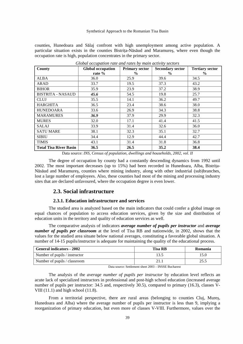
Synthetical Approach to the Romanian Tisa Basin
39
counties, Hunedoara and Sălaj confront with high unemployment among active population. A particular situation exists in the counties BistriŃa-Năsăud and Maramureş, where even though the occupation rate is high, population concentrates in the primary sector.
Global occupation rate and rates by main activity sectors County Global occupation
rate % Primary sector
% Secondary sector
% Tertiary sector
% ALBA 36.0 25.9 39.6 34.5 ARAD 33.7 19.5 37.3 43.2 BIHOR 35.9 23.9 37.2 38.9 BISTRITA - NASAUD 45.6 54.5 19.8 25.7 CLUJ 35.5 14.1 36.2 49.7 HARGHITA 36.5 23.4 38.6 38.0 HUNEDOARA 33.6 26.9 34.3 38.8 MARAMURES 36.9 37.9 29.9 32.3 MURES 32.0 17.1 41.4 41.5 SALAJ 33.9 31.4 32.6 36.0 SATU MARE 38.1 32.3 35.1 32.7 SIBIU 34.4 12.9 44.4 42.7 TIMIS 43.1 31.4 31.8 36.8 Total Tisa River Basin 36.5 26.5 35.2 38.4
Data source: INS, Census of population, dwellings and households, 2002, vol. II
The degree of occupation by county had a constantly descending dynamics from 1992 until 2002. The most important decreases (up to 15%) had been recorded in Hunedoara, Alba, BistriŃa-Năsăud and Maramureş, counties where mining industry, along with other industrial (sub)branches, lost a large number of employees. Also, these counties had most of the mining and processing industry sites that are declared unfavoured, where the occupation degree is even lower.
2.3. Social infrastructure
2.3.1. Education infrastructure and services
The studied area is analyzed based on the main indicators that could confer a global image on equal chances of population to access education services, given by the size and distribution of education units in the territory and quality of education services as well.
The comparative analysis of indicators average number of pupils per instructor and average number of pupils per classroom at the level of Tisa RB and nationwide, in 2002, shows that the values for the studied area situate below national averages, constituting a favorable global situation. A number of 14-15 pupils/instructor is adequate for maintaining the quality of the educational process.
General indicators - 2002 Tisa RB Romania
Number of pupils / instructor 13.5 15.0
Number of pupils / classroom 21.1 25.5 Data source: Settlement sheet 2003 – INSSE Bucharest
The analysis of the average number of pupils per instructor by education level reflects an acute lack of specialized instructors in professional and post-high school education (increased average number of pupils per instructor: 34.5 and, respectively 30.5), compared to primary (16.3), classes V-VIII (11.1) and high school (11.8).
From a territorial perspective, there are rural areas (belonging to counties Cluj, Mureş, Hunedoara and Alba) where the average number of pupils per instructor is less than 9, implying a reorganization of primary education, but even more of classes V-VIII. Furthermore, values over the

Pompei Cocean & Adriana Vartanoff - Coordinators
40
threshold of 14-15 pupils per instructor are recorded in the North (Maramureş, Satu Mare, BistriŃa-Năsăud) and Southwest (Timiş, Arad), but the situation fits within the normal limits, except for few communes exceeding 18 pupils per instructor. In the urban environment, the indicator exhibits favorable values: 12-18 pupils per instructor. One could note the high percentage of administrative-territorial units with less than 9 pupils per instructor in classes V-VIII (42.5%) and pre-university education (18.8%), implying actions to make the ration pupils/instructor more efficient.
The value lower than the national mean of the indicator average number of pupils per classroom shows either a lower rate of inclusion in pre-university education, or decreased size of population of scholar age. Nevertheless, territorial analyses allowed for the identification of 23 administrative-territorial units (5 in Maramureş) with 32 - 50 pupils/classroom, indicating an imperious need for extending the space designed for the education process.
The counties of Cluj, Hunedoara, Alba and Mureş include areas with less than 12 pupils/classroom, whilst the value of the indicator exceeds 26 in a significant number of administrative-territorial units from Maramureş, Satu Mare and Bihor.
The education network with a territorial role is balanced, as high school and post-high school education is spread out uniformly in the analyzed area. University education is well represented by 33 universities in the studied area, grouped by university centers as follows: Cluj-Napoca – 10, Timişoara – 8, Oradea – 5, Târgu Mureş – 3, Alba-Iulia, Arad and Baia Mare – 2 each, BistriŃa – 1.
We could conclude that the analyzed area is confronted with the same education problems identified nationwide. The Ministry of Education and Research provides policies and strategies oriented to make the obligatory education, as well as professional, arts and crafts education more efficient.
2.3.2. Health infrastructure and services
The degree of endowment with health services provided by qualified personnel was in 2002 in Tisa RB on average higher that the national one, as the number of people per physician was much lower in the studied area, and the number of people per average medical staff member slightly exceeded the national value.
Reference area Number of people / physician Number of people / average medical staff member Tisa RB 407.3 178.7 Romania 476 176
Data source: Settlement sheet 2003 – INSSE Bucharest
The analyses of the indicators people / medical doctor and distribution of health institutions prove that health services in rural areas situate below those offered in urban areas. Most of the communes offer only primary healthcare, as there are 308 communes with only one physician, but also 25 communes with no medical services or physician. Most of them are situated in the counties of Hunedoara (9), Alba (6) and Sălaj (4).
The territorial analysis led to the identification of an area with real problems in providing access to primary healthcare (over 2800 people/physician) in the Northwest of the studied area, including the counties of Maramureş, Satu Mare, Sălaj, BistriŃa-Năsăud and Bihor.
The values of the indicator differ very much in the urban environment (258.2 people/physician) compared to the rural one (1529.9 people/physician), exceeding in some communes 5,500 people/medical doctor: Medieşu Aurit, Viseu de Jos and Sânpetru Mare. One could notice the extremely low percentage of medical doctors practicing in the rural environment (11.7% out of the total per area). The lack of medical doctors in the rural environment is associated with the poor endowment with spaces adequate for their activity and medical apparatus, characteristic of rural health services.

Synthetical Approach to the Romanian Tisa Basin
41
Public health units with a role in the territory present in the studied area consist of: 110 hospitals, 12 state policlinics and 197 pharmacies or pharmaceutical points, the largest majority situated in urban areas. In the rural one, 696 communes (90% of the total) have no pharmacy or pharmaceutical point. The network of health units with a role in the territory is relatively balanced, allowing for the access of people to emergency services. The unfavoured areas are the ones in the mountains, less accessible.
Specialized medical services are localized with few exceptions in the urban environment. In order to access such services, people from the rural environment must travel to nearby cities or towns, sometimes on long distances. Therefore, the development of a specialized health services system alternative to the public one should be encouraged.
The indicator number of hospital beds per thousand people offers a very good image of the medical surveillance capacity within the health units – hospitals, sanatoria or preventive centers, and its value is 8.2 for the studied area, slightly higher than the national average (7.5). One could notice the counties Cluj, Timiş, Bihor, Mureş and Hunedoara exceeding the average per area, and lower values recorded in BistriŃa-Năsăud, Satu Mare and Sălaj.
2.3.3. Cultural infrastructure and services Among the culture and art units with a territorial role, 2002 analyses included theatres, musical
institutions and libraries. Most of these units are concentrated in the municipalities within the studied area, out of which the following stand through the large number of such units – Timişoara with 9 theatres and musical institutions, Cluj-Napoca - 8, Oradea and Târgu Mureş - 7 each. These municipalities have a territorial role, and are recognized as significant cultural centers.
The network of public and private libraries, with a role in forming generations and informing people (even though diminished by the expansive development of television and radio network), consists of 3,871 libraries, out of which 822 are public. The average distribution indicates that there are 2,238 libraries in the rural environment and 1433 in the urban one. On average, a commune has 3 libraries, and an urban settlement has approximately 8 libraries. Cities with over 100 public or private libraries are Cluj-Napoca, Timişoara and Arad. In regard to the large number of volumes per library, Cluj County stands out compared to the other counties within the studied area with 10,453,193 volumes.
The 13 counties within the studied area have 667 museums and public collections, out of which there are lesser in Sălaj, BistriŃa-Năsăud and Arad.
2.3.4. Housing The studied area disposed in 2002 of a stock of 2,022,704 dwellings, out of which
approximately 2.5% were in public property, and 97.5% in private property. The rural environment had 44.8% of the total per area (out of which 1.6% were in public property), and the urban environment had 55.2% (out of which 3.1% were in public property).
5046 dwellings were finished in 2002, 42.6% situated in the rural environment. Only 13.8% of these are in public property, and most of them are placed in urban areas. Finished private dwellings are relatively uniformly distributed by environment.
The state of the buildings stock is analyzed in correlation with population size, from the standpoint of the degree of agglomeration and comfort offered by the average dwelling of the area, based on quantitative indicators. One could notice that the average number of dwellings per thousand people of the area is comparable to the national average (378, respectively 375), and also the average number of people per dwelling is not significantly different from the average per country (2.7, respectively 2.6).

Pompei Cocean & Adriana Vartanoff - Coordinators
42
Territorial analysis reveals three areas characterized by both a building stock per thousand people lesser than the average per studied area and a number of people per dwelling above the average per studied area: first and largest, situated in the Northeast of Tisa RB, includes a part of the administrative territory of counties Maramureş and BistriŃa-Năsăud; the second lies in the South-Southeast at the common border of the counties Cluj, Alba, Mureş and Sibiu, and the third is placed in the Southwest of the studied area, including administrative-territorial units of the counties Arad and Timiş.
Previous analyses were followed by the analysis of other two indicators defining the quality of housing in the studied area: average livable surface per person and average livable surface per dwelling. The average values of these indicators for the studied area (14.9 and 39.3) are slightly different from national averages (14.1 and 37.7).
The extreme values of the two indicators in the studied area are found entirely in the rural environment. Communes Poiana Vadului (AB), Repedea (MM), Poienile de sub Munte (MM), Bistra (MM) and Dorolt (SM) stand for low values of the average livable surface per person (below 10 m2). Values of the average livable surface per dwelling below 25 m2 are found in the communes RâmeŃ and Poiana Vadului, Alba county.
In conclusion, we appreciate that the area confronts with different problems based on the environments: problems related to connecting dwellings to utilities are found in the rural environment, whilst in the urban environment problems are due to over-agglomeration or unequal access to a dwelling.
3. SPATIAL STRUCTURE
3.1. Settlement network 3.1.1. Number, structure, distribution in territory
The Romanian portion of Tisa RB fully embeds Region 6 (Northwest) and partially Regions 5 (South-West) and 7 (Center). According to Law no. 2/1968 regarding the administrative and territorial organization, republished in 1981, and later changes (Decree no. 38/1990 according to which suburban communes became communes, other laws and decrees published until July 2006 through which new settlements were declared municipalities, cities or communes), this area presents the following administrative structure:
County Total municipalities
Total cities
Total communes
Total administrative-territorial units
Alba 4 7 67 78 Arad 1 9 68 78 Bihor 4 6 90 100 BistriŃa -Năsăud
1 3 58 62
Cluj 5 1 75 81 Harghita 3 1 29 33 Hunedoara 4 4 54 62 Maramureş 2 11 63 76 Mureş 4 7 91 102 Satu - Mare 2 3 59 64 Sălaj 1 3 57 61 Sibiu 1 4 24 29 Timiş 1 4 55 60 Total Tisa RB 33 63 790 886
The studied territory includes 96 urban settlements (30% of the total national number of cities and towns), part of them being important centres of development.

Synthetical Approach to the Romanian Tisa Basin
43
The analysis of the percentage of urban and rural administrative-territorial units in 2006 indicates that communes predominate as both number and surface.
Number % total number Surface % surface Urban settlements* 96 10.8 10,668.4 15.0 Rural settlements** 790 89.2 60,992.7 85.0 Total Tisa RB 886 100 71,661.1 100
* Data refer to cities and towns as administrative-territorial units; **Data refer to communes
The current administrative-territorial structure results from an evolution characterized during the last 15 years by accentuated dynamics of declaring new municipalities, cities and communes.
Number of administrative-territorial units Category of administrative-territorial unit
1992 2002 2006 Municipalities 18 29 33 Cities 59 51 63 Communes 762 760 790 Total Tisa RB 839 840 886
One could note that during this period 15 towns became cities in an attempt to revitalize them by attracting investments in accordance with the new status, but many of them continued their oscillating or descending evolution. During the same interval, 19 new small towns were declared, sometimes debatably given their profoundly rural physiognomy, but in accordance with the aspirations of people and local administrations. The dynamics of founding communes, very accentuated after 2002 (46 new communes) is the result of the fragmentation trend by the separation of some villages.
The analysis of the evolution of the administrative – territorial structure must also account for the demographic and territorial indicators. Given the accentuated decrease of population in the entire Romanian portion of Tisa RB, differences exist in the evolution of population by urban/rural structure.
1992 2002 2006
Number % Number % Number % URBAN 3,078,318 54.1 2,859,855 53.5 2,953,240 55.6 RURAL 2,609,232 45.9 2,486,652 46.5 2,359,471 44.4 Total Tisa RB 5,687,550 100 5,346,507 100 5,312,711 100
Even though the percentage of urban population is constantly greater than the rural one, no significant changes occur in their ratio until 2002. The slight decrease of rural population is partially determined by the migration to rural as a consequence of economic changes. Later, the gap was recovered and passed by an increase of urban population until 2006, not so much as a result of inverse migration, but due to declaring new urban settlements. The process is underlined by the evolution of surfaces by environment, showing that the urban one increased by 3% in the last 15 years, reaching circa 15% of the total studied area.
Referring to the density, lower than the national average (74.1 compared to 90.5 in 2006), one could notice a constant decrease, both total and by environments. The accentuated decrease in the urban environment (circa 23.3% between 1992 and 2006) is due to the increase of urban territory by embedding newly declared cities, usually settlements with a small number of people.
The density of urban settlements underlines their dispersion within the territory. There are 1.34 settlements per 1000 km² in the Romanian part of Tisa RB, as well as nationwide.
The analysis of the distribution of settlements in the territory by large relief forms underlines the fact that most cities developed in regions favorable geographically: points/areas of contact between natural units and resources and central spaces within the large geographical units. Most cities
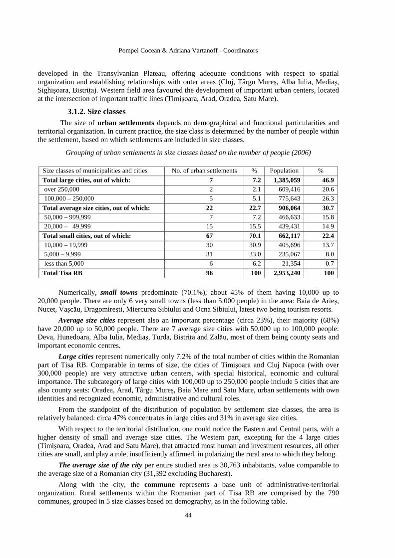
Pompei Cocean & Adriana Vartanoff - Coordinators
44
developed in the Transylvanian Plateau, offering adequate conditions with respect to spatial organization and establishing relationships with outer areas (Cluj, Târgu Mureş, Alba Iulia, Mediaş, Sighişoara, BistriŃa). Western field area favoured the development of important urban centers, located at the intersection of important traffic lines (Timişoara, Arad, Oradea, Satu Mare).
3.1.2. Size classes The size of urban settlements depends on demographical and functional particularities and
territorial organization. In current practice, the size class is determined by the number of people within the settlement, based on which settlements are included in size classes.
Grouping of urban settlements in size classes based on the number of people (2006)
Size classes of municipalities and cities No. of urban settlements % Population %
Total large cities, out of which: 7 7.2 1,385,059 46.9 over 250,000 2 2.1 609,416 20.6
100,000 – 250,000 5 5.1 775,643 26.3
Total average size cities, out of which: 22 22.7 906,064 30.7 50,000 – 999,999 7 7.2 466,633 15.8
20,000 – 49,999 15 15.5 439,431 14.9
Total small cities, out of which: 67 70.1 662,117 22.4 10,000 – 19,999 30 30.9 405,696 13.7
5,000 – 9,999 31 33.0 235,067 8.0
less than 5,000 6 6.2 21,354 0.7
Total Tisa RB 96 100 2,953,240 100
Numerically, small towns predominate (70.1%), about 45% of them having 10,000 up to 20,000 people. There are only 6 very small towns (less than 5.000 people) in the area: Baia de Arieş, Nucet, Vaşcău, Dragomireşti, Miercurea Sibiului and Ocna Sibiului, latest two being tourism resorts.
Average size cities represent also an important percentage (circa 23%), their majority (68%) have 20,000 up to 50,000 people. There are 7 average size cities with 50,000 up to 100,000 people: Deva, Hunedoara, Alba Iulia, Mediaş, Turda, BistriŃa and Zalău, most of them being county seats and important economic centres.
Large cities represent numerically only 7.2% of the total number of cities within the Romanian part of Tisa RB. Comparable in terms of size, the cities of Timişoara and Cluj Napoca (with over 300,000 people) are very attractive urban centers, with special historical, economic and cultural importance. The subcategory of large cities with 100,000 up to 250,000 people include 5 cities that are also county seats: Oradea, Arad, Târgu Mureş, Baia Mare and Satu Mare, urban settlements with own identities and recognized economic, administrative and cultural roles.
From the standpoint of the distribution of population by settlement size classes, the area is relatively balanced: circa 47% concentrates in large cities and 31% in average size cities.
With respect to the territorial distribution, one could notice the Eastern and Central parts, with a higher density of small and average size cities. The Western part, excepting for the 4 large cities (Timişoara, Oradea, Arad and Satu Mare), that attracted most human and investment resources, all other cities are small, and play a role, insufficiently affirmed, in polarizing the rural area to which they belong.
The average size of the city per entire studied area is 30,763 inhabitants, value comparable to the average size of a Romanian city (31,392 excluding Bucharest).
Along with the city, the commune represents a base unit of administrative-territorial organization. Rural settlements within the Romanian part of Tisa RB are comprised by the 790 communes, grouped in 5 size classes based on demography, as in the following table.

Synthetical Approach to the Romanian Tisa Basin
45
Grouping of communes in size classes based on the number of people (July 2006)
Size classes of communes (number of people)
Number of communes
% Population (number of people)
%
10,000 and over 2 0.3 21,465 0.9 5,000 – 9,999 85 10.7 534,607 22.7 2,000 – 4,999 458 58.0 1,454,577 61.6 1,000 – 1,999 211 26.7 325,380 13.8 less than 1,000 34 4.3 23,442 1.0 Total Romanian part of Tisa RB 790 100 2,359,471 100
Their analysis shows the predominance of communes with 2,000 up to 5,000 people (58 %), also of those with 1,000 up to 2,000 people (26.7%), relatively uniformly distributed in the territory. Large communes (over 5,000 people) are situated either in the Western field areas close to large cities with elevated economic dynamics or in counties of Central Transylvania (Alba, Mureş, Sibiu, Harghita, BistriŃa-Năsăud). The two communes with over 10,000 people are exceptions: Poienile de sub Munte (Maramureş) and Vladimirescu (Arad). Very small communes (less than 1,000 people) represent a very law percentage and belong in majority to mountain areas in the counties Hunedoara and Alba.
The majority of rural population (61.6%) is included in communes with 2,000-5,000 people.
Average size of a commune based on the number of people is 2,986 people for the entire studied area, much lower than the average size per Romania (3,388 people).
3.1.3. Hierarchy of settlements by rank
According to Law no. 351/2001 on the approval of the National Spatial Plan – Section IV – Settlement network, establishing the functional hierarchy of urban and rural settlements based on importance and territorial role, urban settlements within the Romanian part of Tisa RB have:
• Rank I: 3 urban settlements – Timişoara, Cluj Napoca and Oradea, cities of national importance, with potential European influence, centres of economic and cultural development with high attractiveness situated on major transport axes, with a geographical position favouring development and accentuating their relationships with the territory. The cities of Timişoara and Cluj Napoca (over 300,000 people) represent centres of large demographic convergence. Oradea (205,000 people) constitutes an important attraction pole and gave birth to a metropolitan zone.
• Rank II : 30 urban settlements, cities of regional or county importance or having a balance role within the settlement network, situated in the counties: Alba, Bihor, Cluj, Hunedoara, Mureş (4 in each), Harghita (3), Maramureş and Satu Mare (2 in each), Arad, BistriŃa – Năsăud, Sălaj and Sibiu (1 in each).
Differences between rank II urban settlements in terms of demographical and economic development are significant. The cities of Arad, Baia Mare, Satu Mare and Târgu Mureş stand out for their demographic dimension (over 100,000 people) and level of economic development. They are industrial and cultural centres with own identities, and offer specialized services. Most rank II settlements are average size cities balancing the urban network. An important role is played by county seats. For newly founded cities, small ones like Beiuş, Marghita, Salonta, Brad, Gheorgheni, TopliŃa, the consolidation of their position within the network is imperative.
The analysis of the distribution in territory of the rank II urban settlements underlines their concentration in the Center and South parts of the Romanian portion of Tisa RB.
• Rank III : 63 urban settlements, cities of county or zonal importance, playing a balancing role within the settlement network or serving the adjacent area. Territorially, they are spread out predominantly in the West and North-West of the studied area, in the counties of Arad, Timiş, Bihor,

Pompei Cocean & Adriana Vartanoff - Coordinators
46
and Maramureş. With respect to their demographic dimension, they usually have less than 20,000 people (exceptions: Cugir and Borşa). The economic potential is reduced, as the economy is based on one industry or is specialized in agriculture. A distinct category is represented by tourist resorts of national (Sovata, Sângeorz Băi, Geoagiu) or local (Borşa, Ocna Sibiului, Miercurea Sibiului, Lipova) importance.
Small cities (less than 10,000 people) have a slow development, oriented especially to valorizing local resources or an economy undergoing consolidation and have a reduced local influence.
The hierarchy of rural settlements indicates for the analyzed area:
• Rank IV: 790 villages that are commune seats, influencing other villages within the commune, having administrative and social institutions that provide services to the villages included in that commune. For some villages, newly declared commune seats, the level of endowment is still deficitary. Commune seats with diversified institutions could exercise a polarizing role extended to neighbouring rural areas.
• Rank V: villages situated on the last level of the settlement hierarchy. In the analyzed area, numerous problems relate to their endowment, especially in mountain areas were the dispersion of small villages, with low accessibility, makes the provision of required institutions difficult.
Law no. 350/2001 establishes the main quantitative and qualitative indicators for defining urban settlements, for the two types – cities and towns. Analyzing the coverage of these indicators in the cities of the Romanian part of Tisa RB, one could notice significant differences. Large traditional cities do not meet 1 or 2 of the 16 indicators defined by law (surface of green spaces, modernized streets), small cities do not meet 2 up to 8 indicators, mainly town equipment (water distribution, sewerage, wastewater treatment, modernized streets), but also number of people (Salonta, Beiuş, Brad, TopliŃa). The situation is even more difficult for towns: the number of indicators which are not met is between 2 and 10, including mainly town equipment indicators.
3.1.4. Polarizing centers – influence areas Two intensely related subsystems could be distinguished within the «city» system: the city per
se and its influence area. The relationships between cities and their areas of influence are very complex, of economic, demographic, social, cultural and politico-administrative nature. Economic relationships had become fundamental for shaping the influence areas of cities, making the material connection between the rural and urban spaces.
The most significant areas of influence belong to large cities and sometimes they prevented the development of other urban centers in their proximity. The most extended polarization is exercised by the cities Cluj Napoca and Timişoara, which include in their areas of influence lower ranked urban settlements. The city of Oradea is currently the only urban centre within the analyzed area around which a metropolitan zone has been set up. The cities of Târgu Mureş, Baia Mare and Arad also polarize relatively extended zones at regional level.
Average size cities have differentiated areas of influence. Nevertheless, one could notice a clear regional shaping of areas of influence of county residences, especially where the urban network is sparse, and economic development relatively modest (BistriŃa, Zalău). Small cities generally have small areas of influence, based on their position relative to other urban centers, natural setting, and functional type.
Law no. 351/2001 allowed for the nationwide identification of profound rural zones, lacking any city on a radius of circa 25 – 30 km, requiring priority activities to develop settlements with a role in inter-communal serving. These areas are characterized by a poor development of town and transport infrastructure, negative demographic phenomena, and reduced economic development.
Synthetical Approach to the Romanian Tisa Basin
47
3 profound rural zones had been identified within the Romanian portion of Tisa RB. Their surface varies and they are situated predominantly in the Western part, disposed partially on the territory of the counties of Arad, Timiş, Bihor, Cluj and Sălaj. Revitalization of profound rural zones depends at large on the level of development of small and average size cities polarizing these areas. The development of rural centers with an inter-communal role is another option for providing territorial services to rural areas.
Accessibility is a very important indicator for underlining the possibilities of developing and creating relationships between urban settlements. The studied territory is crossed by major transport axes (European corridor IV). Its route will include motorways, express roads or 4-lane roads, increasing the level of integration of cities and towns in the major settlement network. Most urban settlements have direct access to national roads or railways with few exceptions: 10 towns without direct access to a national road (Cavnic, Târgu Lăpuş, Cehu Silvaniei, Sărmaşu, Miercurea Nirajului, Ocna Sibiului, Cugir, Pâncota, and Curtici) and 7 towns without direct access to a railway (Cavnic, Târgu Lăpuş, Miercurea Nirajului, Abrud, Câmpeni, Baia de Arieş and Nucet).
3.2. Built cultural heritage
The studied area overlaps almost entirely the territory of Transylvania, geographical area situated at the meeting point of two large civilizations, Eastern and Western, that marked the political, religious, economic, social and cultural destiny of the European society during the 1st and 2nd millennia.
The analyzed area corresponding to the Romanian part of Tisa RB has a significant size and an important and diversified cultural heritage, determined by the historical and cultural identity of Transylvania. Vestiges of the Neolithic culture, antique and feudal civilization, religious art monuments, and civil and industrial architecture objectives are found in numerous zones and settlements.
Responsible spatial planning should account for the appropriate rehabilitation, conservation, protection and valorization of the cultural heritage.
The following paragraphs present quantitative and qualitative analysis, as well as the territorial distribution of cultural heritage values, in order to identify areas containing outstanding resources within the studied territory.
The most representative Romanian values of built heritage had been included by specialists in the two main legislative documents referring to this subject: Law no. 5/2000 regarding the National Spatial Plan, Section III, Protected areas and Decree no. 2314/2004 on the updated list of historical monuments.
Law no. 5/2000 underlines protected built areas of national interest and identifies natural cultural heritage values in order to assure their specific protection. According to this law, the studied territory has 215 historical monuments with exceptional national value, representing 32.8% of the total number in Romania (654). The analysis of their distribution per county within the studied area, one could notice that most of the historical monuments with exceptional value are situated in the counties of Hunedoara (34), Alba (32) and Cluj (32). The counties of BistriŃa-Nasaud (5), Satu Mare (5) and Timiş (6) are situated at the opposite end.
Within the category of architectural monuments and assemblies, representative for the studied area, we could mention: wooden churches (50), churches and monastery assemblies (45), fortified citadel-churches, civil urbane buildings (15), and citadels (17). Archaeological sites and monuments with exceptional national value are relatively uniformly distributed within the studied territory, most of them consisting of Dacian fortifications (12) and Roman-Byzantine fortifications (8).
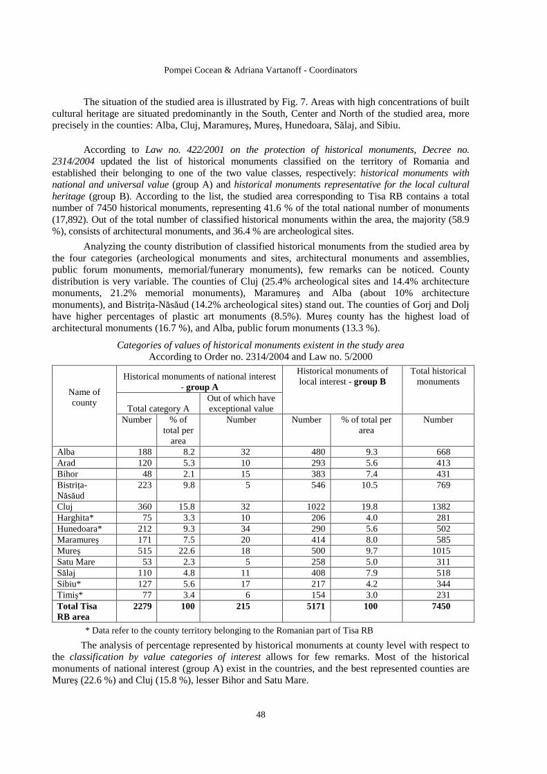
Pompei Cocean & Adriana Vartanoff - Coordinators
48
The situation of the studied area is illustrated by Fig. 7. Areas with high concentrations of built cultural heritage are situated predominantly in the South, Center and North of the studied area, more precisely in the counties: Alba, Cluj, Maramureş, Mureş, Hunedoara, Sălaj, and Sibiu.
According to Law no. 422/2001 on the protection of historical monuments, Decree no. 2314/2004 updated the list of historical monuments classified on the territory of Romania and established their belonging to one of the two value classes, respectively: historical monuments with national and universal value (group A) and historical monuments representative for the local cultural heritage (group B). According to the list, the studied area corresponding to Tisa RB contains a total number of 7450 historical monuments, representing 41.6 % of the total national number of monuments (17,892). Out of the total number of classified historical monuments within the area, the majority (58.9 %), consists of architectural monuments, and 36.4 % are archeological sites.
Analyzing the county distribution of classified historical monuments from the studied area by the four categories (archeological monuments and sites, architectural monuments and assemblies, public forum monuments, memorial/funerary monuments), few remarks can be noticed. County distribution is very variable. The counties of Cluj (25.4% archeological sites and 14.4% architecture monuments, 21.2% memorial monuments), Maramureş and Alba (about 10% architecture monuments), and BistriŃa-Năsăud (14.2% archeological sites) stand out. The counties of Gorj and Dolj have higher percentages of plastic art monuments (8.5%). Mureş county has the highest load of architectural monuments (16.7 %), and Alba, public forum monuments (13.3 %).
Categories of values of historical monuments existent in the study area According to Order no. 2314/2004 and Law no. 5/2000
Historical monuments of national interest - group A
Total category A
Out of which have exceptional value
Historical monuments of local interest - group B
Total historical monuments
Name of county
Number % of total per
area
Number Number % of total per area
Number
Alba 188 8.2 32 480 9.3 668 Arad 120 5.3 10 293 5.6 413 Bihor 48 2.1 15 383 7.4 431 BistriŃa-Năsăud
223 9.8 5 546 10.5 769
Cluj 360 15.8 32 1022 19.8 1382 Harghita* 75 3.3 10 206 4.0 281 Hunedoara* 212 9.3 34 290 5.6 502 Maramureş 171 7.5 20 414 8.0 585 Mureş 515 22.6 18 500 9.7 1015 Satu Mare 53 2.3 5 258 5.0 311 Sălaj 110 4.8 11 408 7.9 518 Sibiu* 127 5.6 17 217 4.2 344 Timiş* 77 3.4 6 154 3.0 231 Total Tisa RB area
2279 100 215 5171 100 7450
* Data refer to the county territory belonging to the Romanian part of Tisa RB
The analysis of percentage represented by historical monuments at county level with respect to the classification by value categories of interest allows for few remarks. Most of the historical monuments of national interest (group A) exist in the countries, and the best represented counties are Mureş (22.6 %) and Cluj (15.8 %), lesser Bihor and Satu Mare.

Synthetical Approach to the Romanian Tisa Basin
49
The analysis of percentage represented by historical monuments of exceptional national value selected by Law no. 5/2000 within each county, compared to the total number of monuments in group A, shows that the first class represents about 10 % of the latter.
The analysis of the value of existent historical monuments classified within the Tisa RB area indicates the presence of historical monument with international importance enlisted with the UNESCO World Patrimony List since 1999, namely:
• Village sites with fortified churches in Transylvania (code UNESCO C1/596 bis): Biertan, Valea Viilor (Sibiu), Câlnic, Dârjiu (Alba), and Saschiz (Mureş).
• Assembly of wooden churches in Maramureş (cod UNESCO C5/904): Bârsana, Budeşti, Deseşti, Ieud, Plopiş, Poienile Izei, Rogoz, and Şurdeşti.
• Historical center Sighişoara (Cod UNESCO C4/902) – Mureş.
• Dacian forts of Orăştie mountains (cod UNESCO C6/906): Sarmizegetusa Regia, Costeşti-CetăŃuie, Costeşti-Blidaru, Luncani-Piatra Roşie, BăniŃa (Hunedoara), and Căpâlna (Alba).
Analyzing the list of historical monuments of international importance (UNESCO) from Romania, one could notice that a high percentage (66%) of these lie within the studied area.
4. TERRITORIAL AND SETTLEMENT INFRASTRUCTURES
4.1. Transport
4.1.1. National roads
Analysis of technical endowment of Tisa RB with national and European roads reveals the fact that the national road network is well represented: 80 parts of national roads out of which the following are European ones: E 58 (Halmeu– Sculeni), E 60 (ConstanŃa – Bucharest– Oradea – Hungarian border), E 70 (border at Giurgiu - Timişoara – Serbian border), E 68 (Braşov - Deva – Hungarian border), E 79 (Oradea –Deva – Bulgarian border), E 81 (Bucharest – Cluj Napoca - Ukrainian border), E 576 (Cluj Napoca – Suceava), E 578 (BistriŃa – Chichiş), E 671 (Timişoara – Oradea), E 673 (Lugoj – Ilia).
The length of national and European roads within the studied area is about 4178 km. National roads are mostly modernized (88%), 11% have light asphalt envelopes, and 1% are not modernized. Generally, the technical situation of national national roads could be considered good. Average density of national roads is 5,1 km/100 km2, below the average per country (6,6 km/100 km2). Sălaj, Alba, Mureş and Satu Mare counties have higher densities than the national average.
The problems of the national road network consist of: lack of a motorway network, existence of portions of the national national roads requiring works for the improvement of transport infrastructure, insufficient links by national roads between counties, lack of direct connections between the county roads and the national ones, the centers of communes, or between villages belonging to neighboring communes, unequipped passes over railways, low number of rings around settlements, directions that do not provide an optimal circulation capacity.
4.1.2. Railways
The studied area has railways totalizing a length of 3,765 km, out of which 25% electrified, 78% one-rail, 21% two-rails and 1% wide rail. The average density of railways is 44.7 km/1000 km2, less than the average per country (46.4 km/1000 km2). Arad, Bihor and Timiş counties have higher densities (over 60 km/1000 km2).
Pompei Cocean & Adriana Vartanoff - Coordinators
50
The studied area is crossed by the following main railways, also considered international: line 200 (Braşov – Deva – Arad – Curtici), line 300 (Bucharest – Braşov – Cluj Napoca – Episcopia Bihor), line 400 (Braşov – Deda – Dej – Baia Mare – Satu Mare) and line 900 (Bucharest – Craiova – Caransebeş – Timişoara – Jimbolia)
The problems of railways refer to: need for modernizing most of them, lower speeds than European standards due to advanced wearing of railways, decline of railways transport favouring national road transport, existence of sectors affected by floods, landslides, crosses with national roads without automated signaling, reduced number of underpasses.
4.1.3. Navigation
Bega Canal is the only navigable route within the area, from the portion upstream of Timişoara City down to the Serbian border. The canal is 44.5 km long, 30-45 m wide, and 15-20 m deep. Navigation started on this canal along with the creation of the hydro-technical node Coştei. The main issue is that the navigation on the canal is stopped, affecting the connection with Danube harbours.
4.1.4. Air routes
The Romanian portion of Tisa RB is served by the International Airport Timişoara – Traian Vuia and by 6 regional airports in the counties Bihor, Baia Mare, Satu Mare, Arad, Mureş, and Cluj Napoca. With respect to services and endowments, both the international airport and the other ones do not meet the European standards.
4.1.5. Border crossing and checkpoints
According to Government Ordinance no. 105/2001, there are several border crossing and checkpoints open to international traffic within the studied area:
Road: Petea, Borş, Vărşand, Cenad, Nădlac, and Turnu - Hungary Railway: Carei, Episcopia Bihor, Curtici - Hungary, Câmpulung la Tisa, Valea Vişeului - Ukraine Road and railway: Valea lui Mihai, Salonta – Hungary, Jimbolia – Serbia, Halmeu - Ukraine
The customs from most border crossing and checkpoints are not endowed according to the international standards for developing safe and controlled customs activities.
The free zone Curtici –Arad, the only one in the West of Romania, founded by Governmental Decision in 1999, has an area of 90 ha and consists of two 2 parts: a 75 ha land near the city Curtici, between the railway to Hungary and county road 792C, and a 15 ha land in the West of Arad City, close to the airport. The areas have all endowments required for a proper functioning.
4.1.6. Combined transport
Combined transport is represented in the studied area by 14 terminals with a relatively balanced disposition: Alba Iulia, Baia Mare, BistriŃa North, Cluj Napoca East, Deva, GlogovăŃ-Arad, Mediaş, Oradea East, Petea-Satu Mare, Semenic-Timişoara South, Târgu Mureş, Târnăveni West, Zalău North and Turda. Among these, Timişoara and Cluj Napoca are the main terminals. The main problem is the insufficient development of combined transport and required logistics.
4.2. Energy 4.2.1. Electro-energetic system
Sources used to produce electric energy within the Tisa RB consist of hydropower plants and thermo-electric power plants. Counties using most efficiently hydropower are Hunedoara (18 hydropower plants; instP = 484.7 MW), Cluj (7 hydropower plants,instP = 300 MW), and Bihor (7

Synthetical Approach to the Romanian Tisa Basin
51
hydropower plants,instP =201 MW). Important thermo-electric power plants are in the counties of
Hunedoara (Mintia, Paroşeni) and Mureş (Iernut, Fântânele).
121 hydropower plants currently function within the Tisa RB, with a total installed power over 1,571 MW, producing on average year about 3,036 thousands Mwh/year. River basins with the best endowment with hydropower plants and installed powers are the Crişuri and the Mureş.
Main power transport networks cover Tisa RB in a balanced manner and consist of: - 400 KV lines (LEA 400 KV – 867 km), towards Ukraine (Sibiu – Iernut – Gădălin – Tihău – Roşiori – Mucacevo), Hungary (Sibiu – Mintia – Arad - Szeged); - 220 KV lines (LEA 220 KV- 1554 km) on the direction North-South (Sălaj – Tihău – Cluj – Alba Iulia - Mintia) or East-West (Mintia – Timişoara, Cluj – Câmpia Turzii – Iernut – Ungheni - Fântânele)
The company TRANSELECTRICA SA acquired full membership in the UCTE (Union for the Coordination of Transmission of Electricity). Connection in synchronism of the LEA 400 KV transport line Arad – Sandorfalva in 2004 marked the connection between the National Energy System with the interconnected systems of the European Union countries.
110 KV distribution networks supply transformation stations 110 KV/MT of the National Energy System (400/220/110 KV). System transformation stations within the area are placed around the 110 KV networks and supply networks with average power from urban or rural areas. Average power networks could have the reserve provided by another transformation station connected to a different 110 KV source, or the average power bars of the same station. Average powers are 20 KV, 10 KV and 6 KV. Average power networks are above ground in rural areas and underground in the urban ones.
Low power distribution networks are above ground in rural areas (LEA 0.4 KV) and have a length of 39,328 km. Urban areas have underground networks in the centers (LES 0.4 KV), and above ground in the others. The length of underground networks is 10.812 km. Low power distribution networks are supplied by 20,216 transformation stations.
Electric energy consumption is predominant in the industry (63%), while household consumption represents circa 15%. The trend during the last years is to increase household consumption (circa 10% yearly), mostly due to increasing incomes of population.
Electrica branch Number of customers
Power sold in 2004
Percentage of household consumption (%)
Banat 837,218 3,847,753 25.88 Transylvania North
1,101,673 3,996,908 24.24
Transylvania South
1,075,111 4,309,219 33.42
After the accession of Romania to the European Union, Romania will use more energy. Consumption will increase by 20% until 2013, reaching 2970 kwh/person. The trend is underlined by the energy consumption during the first trimester of 2007, greater with 0,7% than in 2006. The consumption by economy represents 64.2%, by population – 15.3%, the technological one – 12.7%, and public lighting – 1.1%.
The main problems of the transport and distribution of power are:
- Existence of settlements with powerless households, worst in the county Alba, where 37 rural settlements have no power and 90 are partially endowed, mostly due to the specific of Apuseni mountains, were households are distanced one from another.
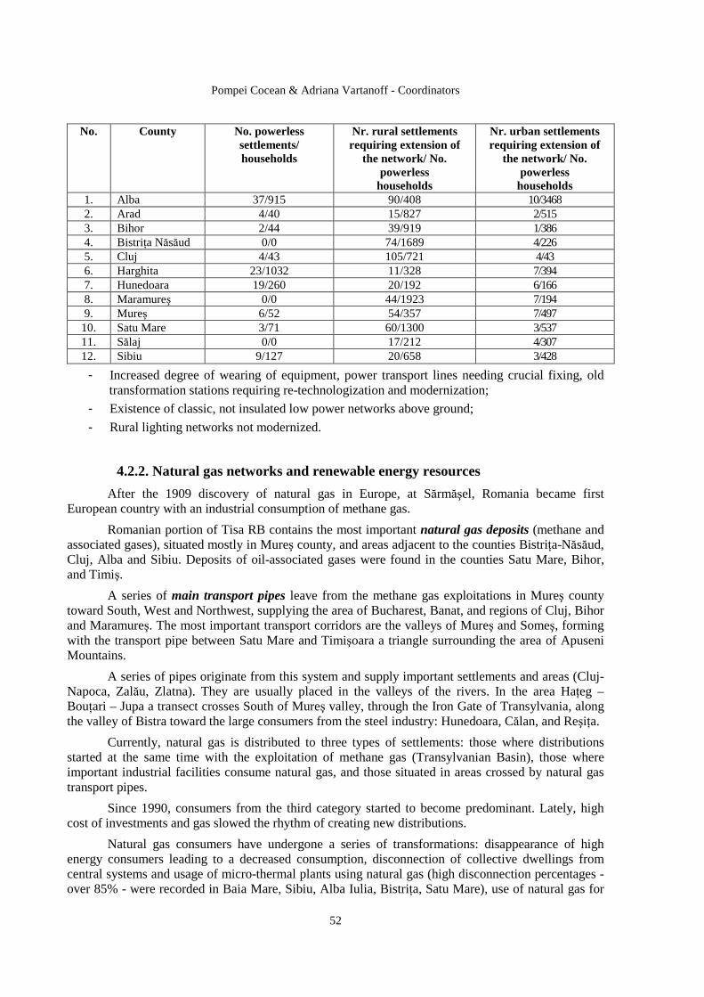
Pompei Cocean & Adriana Vartanoff - Coordinators
52
No. County No. powerless settlements/ households
Nr. rural settlements requiring extension of
the network/ No. powerless households
Nr. urban settlements requiring extension of
the network/ No. powerless households
1. Alba 37/915 90/408 10/3468 2. Arad 4/40 15/827 2/515 3. Bihor 2/44 39/919 1/386 4. BistriŃa Năsăud 0/0 74/1689 4/226 5. Cluj 4/43 105/721 4/43 6. Harghita 23/1032 11/328 7/394 7. Hunedoara 19/260 20/192 6/166 8. Maramureş 0/0 44/1923 7/194 9. Mureş 6/52 54/357 7/497 10. Satu Mare 3/71 60/1300 3/537 11. Sălaj 0/0 17/212 4/307 12. Sibiu 9/127 20/658 3/428
- Increased degree of wearing of equipment, power transport lines needing crucial fixing, old transformation stations requiring re-technologization and modernization;
- Existence of classic, not insulated low power networks above ground;
- Rural lighting networks not modernized.
4.2.2. Natural gas networks and renewable energy resources
After the 1909 discovery of natural gas in Europe, at Sărmăşel, Romania became first European country with an industrial consumption of methane gas.
Romanian portion of Tisa RB contains the most important natural gas deposits (methane and associated gases), situated mostly in Mureş county, and areas adjacent to the counties BistriŃa-Năsăud, Cluj, Alba and Sibiu. Deposits of oil-associated gases were found in the counties Satu Mare, Bihor, and Timiş.
A series of main transport pipes leave from the methane gas exploitations in Mureş county toward South, West and Northwest, supplying the area of Bucharest, Banat, and regions of Cluj, Bihor and Maramureş. The most important transport corridors are the valleys of Mureş and Someş, forming with the transport pipe between Satu Mare and Timişoara a triangle surrounding the area of Apuseni Mountains.
A series of pipes originate from this system and supply important settlements and areas (Cluj-Napoca, Zalău, Zlatna). They are usually placed in the valleys of the rivers. In the area HaŃeg – BouŃari – Jupa a transect crosses South of Mureş valley, through the Iron Gate of Transylvania, along the valley of Bistra toward the large consumers from the steel industry: Hunedoara, Călan, and ReşiŃa.
Currently, natural gas is distributed to three types of settlements: those where distributions started at the same time with the exploitation of methane gas (Transylvanian Basin), those where important industrial facilities consume natural gas, and those situated in areas crossed by natural gas transport pipes.
Since 1990, consumers from the third category started to become predominant. Lately, high cost of investments and gas slowed the rhythm of creating new distributions.
Natural gas consumers have undergone a series of transformations: disappearance of high energy consumers leading to a decreased consumption, disconnection of collective dwellings from central systems and usage of micro-thermal plants using natural gas (high disconnection percentages - over 85% - were recorded in Baia Mare, Sibiu, Alba Iulia, BistriŃa, Satu Mare), use of natural gas for

Synthetical Approach to the Romanian Tisa Basin
53
heating, warming household water and food in rural areas, and new industrial consumers benefiting upon modern equipment, with high energy efficiency.
Transport and distribution technologies were modernized, aiming to increase the functioning elasticity of the entire system. The existence of underground deposits of natural gases assures the accumulation of natural gases during the summer. The main underground deposits lie within Tisa RB in: Sărmăşel, Târgu Mureş, Nadeş, and Cetatea de Baltă
Law of Gases no. 351/2004 aims to establish a legal framework required to develop activities specific to the gas sector in competitive and transparent conditions.
The number of settlements connected to natural gas systems, as well as the number of consumers, increase continuously, but less explosively than after 1990. Within the studied area, settlements of Mureş county are mostly connected to natural gas, followed by those in Sibiu county, plain areas of the counties Cluj, Alba, Hunedoara, BistriŃa Năsăud, Maramureş, and the region of settlements in the Western Plain along Satu Mare – Timişoara pipe system. Difficulties in assembling the pipes prevent settlements from the mountain areas of the Western Carpathians from connecting to the natural gas networks.
The annual natural gas consumption of Tisa RB is about 4.500.000 thousands m3, out of which 2,500,000 m3/year is the household share. Counties with high consumptions are Mureş and Sibiu, and the opposite situation is represented by Sălaj. Regarding the percentage of settlements endowed with natural gas, the best situation is found in the counties: Mureş-81%, Sibiu (studied part)-76%, Harghita (studied part) – 36%, and Alba – 32%. The average per entire area is 31%.
The national natural gas transport system was interconnected to the systems of the neighboring countries (Ukraine, in the studied area), obtaining natural gas supply from Russia, via Ukraine, as well as transiting of Romania in order to provide natural gas to countries of the Balkan Peninsula. The most important interconnection from Tisa RB is on the direction Hust (Ukraine) – Satu Mare. Through the undertaking, measuring, regulation and redirection station of gases in Medieşu Aurit, gases are redirected to Baia Mare – Sărmaş and Satu Mare – Arad.
Currently, a pipe is under construction between Szeged (Hungary) – Arad, part of the gas pipe “Nabucco” connecting the Caspian Sea with Central Europe, crossing Turkey, Bulgaria, Romania, Hungary and Austria.
Geothermal energy exists in the Romanian subsoil on large areas, where the geothermic gradient, measuring energy accumulated underground exceeds worldwide average, as the maximum is 7 K/100 m in the North of the Western Plain.
If a certain geological structure (sandy soils, limestone, cracked sandstone) contains water, this is the temperature of the rocks where it is deposited; therefore thermal energy can be captured by drills. The temperature of geothermal waters ranges between 50…120ºC, and depth of aquifer deposits between 1 and 3 km.
Characteristics of main hydro-geothermal systems from Western Romania Hydro-geothermal
system Average depth of
probes [m]
Average temperature of
water [ºC]
Average flow per probe
[l/s]
Total minerals in water [mg/l]
Crişul Negru - Someş 1500 65 10 3…11 Borş 2800 120 10 8…14 Oradea 2800 80 12 1…3 Mureş – Crişul Negru 1500 6 8 2…5 Western Banat 2000 75 10 3…11
The high temperature of geothermal waters around Oradea – Borş made possible for them to be the first ones used in Romania for heating, and, for a while, directly as warm household water.
Pompei Cocean & Adriana Vartanoff - Coordinators
54
Balneary and entertainment use is possible in hotels and treatment bases in the resorts Băile Felix and Băile 1 Mai.
Based on the temperature of geothermal water, there are different thermal valorization modalities: greenhouse heating, household heating and warm water preparation with heat pumps (30-50ºC); household heating and warm water preparation by association with a top thermal plant for civil and industrial consumers and greenhouses (50-80ºC); heating in drying technological processes (over 80ºC).
An example of using these geothermal waters is offered by central heating provided to consumers from Beiuş, where circa 1900 apartments receive circa 12,000…14,000 Gcal/year for heating and preparing household water.
Use of solar energy as thermal source implies an architecture different from the buildings, their orientation with respect to the position of the Sun, and additional insulation of buildings. In order for the solar heating equipment to function in good condition, additional energy sources are needed (classic or renewable). Currently, solar energy is used scarcely, exclusively to prepare warm household water.
Heating systems using solar energy can belong to one of two categories: passive systems characterized by the fact that spaces are heated naturally, active systems that presume the existence of mechanic equipments producing the circulation of the thermal agent.
Areas efficient in using solar energy within Tisa RB are those with a higher solar energy potential (over 115 Kcal/cm²/year), depression and plain areas.
Biomass is an insufficiently used energy resource, excepting for burning vegetal waste and wood (locust tree, poplar) in rural areas during the winter. Evacuation of vegetal waste along with household waste represents a loss in all respects. Wood dust resulting from cutting and processing wood is dumped in rivers, leading to serious pollution. Only two settlements within the studied area use wood waste for heating and preparing household warm water: Huedin (Cluj) and Gheorgheni (Harghita).
4.3. Communication system There are 1,500,000 fixed telephone accounts within Tisa RB (representing a density of circa
36 accounts per 100 people). Cord telephone density differs by county: it is higher in Sibiu, Timiş and Arad (21 – 24 accounts/100 people) and lower in Harghita and Satu Mare (about 13.8).
Development in telecommunication technology manifested through the installation of digital telephone stations in most urban settlements, sustained by a network aligned to the international standards. At the same time, a national network of magisterial optic fibers interconnects the main urban settlements.
Romtelecom started the regionalization of the institution in order to become efficient. The counties of Arad, Bihor, Hunedoara and Timiş are part of the Timiş region, characterized by a higher degree of urbanization, a degree of telephony of 17.9%, and a degree of digitalization over 50%. The counties Timiş and Arad have the highest telephony rates (30% in urban and 10% in rural environments), and a degree of digitalization of 70%.
In order to develop rural telephony in hardly accessible areas with scarce households (Alba County) Romtelecom used a fixed radio access fixed telephony, providing complete access in a flexible and easily expandable network.
Problems of fixed telephony refer mainly to the poor development of the network in the rural areas, where numerous settlements lack telephone lines. For example, 14 settlements in Timiş county lacked telephony at the end of 2004. Cluj County, even though having the highest penetration rate of
Synthetical Approach to the Romanian Tisa Basin
55
fixed telephony in the North-West region, has 96 rural settlements without telephony. The counties of BistriŃa Năsăud and Satu Mare have a law penetration rate of fixed telephony.
4.4. Water management system
4.4.1. Water and town infrastructure
The analysis of endowment of settlements with central water and wastewater sewerage equipments reveals very different situations based on the living environment.
Water supply in centralized system is provided for all 96 urban settlements, but only for 55.7% of the communes. The quantity of water introduced in the network is 374,641 thousands m3/year, out of which 87.7% in urban settlements and 12.3% in rural ones. Drinkable water distributed to consumers totalizes 277,849 thousands m3/year, out of which 85.3% in urban settlements and 14.7% in rural ones. Cluj County provides and distributes to consumers the largest quantity of drinkable water.
Problems related to water supply refer to:
- Lack of central water supply for extended rural areas, a very low percentage (circa 50% of all rural settlements) is recorded in the counties of Alba, BistriŃa Năsăud, Harghita, Hunedoara, Mureş, Sibiu, respectively the Southern and Eastern parts of Tisa RB;
- Substantial drinkable water losses in the distribution network (circa 25.8% of the volume introduced), due to advanced wearing and destruction of the distribution networks, most losses being recorded in the counties Hunedoara (43.8%), Satu Mare (39.2%) and Sălaj (37.2%);
Wastewater sewerage represents a special problem of the area. Urban settlements have sewerage systems, except for newly founded towns: Miercurea Nirajului (Mureş), Săcuieni (Bihor), Săliştea de Sus, TăuŃii Măgheruş (Maramureş), Miercurea Sibiului (Sibiu), but the provision of sewerage services in rural areas is totally unsatisfactory. The treatment of collected wastewaters is made in 82.3% of urban settlements and 2% of the rural ones.
Problems refer to:
- Very low percentage of rural settlements benefiting upon sewerage systems, respectively 16.8% of the total number of communes, low percentage of communes with central drinkable water systems (26.8%);
- Low percentage of wastewater treatment plants in the rural areas (2%) compared to the urban one (82.3%); lack of wastewater treatment plants in some urban settlements (13.2%) and most of the rural ones (87.8%), among those with sewerage systems; the counties Alba, Arad, Maramureş, Sălaj, and Sibiu have no rural wastewater treatment plants;
- Low efficiency (49.2%) of wastewater treatment plants due to inappropriate treatment processes, lowest efficiency being recorded in plants from the counties of Arad (69.8%), Bihor (71.5%), Maramureş (63.1%) and Sălaj (77.4%); the part of Sibiu County within Tisa RB has wastewater treatment plants with exceeded capacities due to advanced wearing.
4.4.2. Flood protection infrastructure
Floods, as a manifestation of natural hazards, produced by waters during the exceeding periods, are a constant phenomenon in Tisa RB. Their duration, size and general characteristics are directly influenced by the physic-geographical conditions existent in the river basin.
Intensification of the destructive character of the phenomenon has both natural and anthropic causes, such as: torrential character of precipitations, reduced transitory capacity of maximum flows through minor beds of watercourses, massive deforestations, inadequate maintenance of beds, inappropriate placement of buildings in floodable areas, clogged networks for collecting pluvial

Pompei Cocean & Adriana Vartanoff - Coordinators
56
waters. Important material damages were also favoured by: inadequate endowment of the warning system, limited promotion of hydro-technical works and protection systems against floods.
The main areas with a high flood potential are represented in the following figure.
Historical floods originate from the following nuclei, established through specialized analyses:
River basin Year of
historical flood
Probability of exceeding
(p%)
Main river affected
Placement of nucleus
Affected counties
1970 1% 5%
Someş Crasna
Beclean, Lăpuş, Moftin
Satu Mare, BistriŃa Năsăud
Someş Tisa 1995
5% 1%
Someş Iza
Beclean, Lăpuş, Vad
Satu Mare, BistriŃa N
1970 10% 5% 10%
Ier Barcău Crişul Negru
Săcuieni, Sălard Zerind
Bihor Crişuri
1980 1% 5%
Crişul Negru Crişul Repede
Zerind Oradea
Bihor
1970 1% 5%
Mureş, Gurghiu TopliŃa, Glodeni Solovăstru
Alba Mureş
1975 1% 2% 3%
Mureş Târnave, Arieş
Arad Blaj Turda
Arad Hunedoara Mureş
Mureş
1995 1% 10%
Arieş Mureş
Turda Lunca Bradului
Mureş Hunedoara
1970 2% Bega BalinŃ Timiş Banat
1991 10% 10%
Bega Timiş
Făget Lugoj
Timiş Timiş
The main flood protection works by river regularizations and dams within the Romanian part of Tisa RB are:
- In the hydrographic space Someş-(upper) Tisa 153 settlements, 74 industrial platforms, about 129 km of railways, 186 km of national roads, 444 km of county roads and circa 137200 ha of land (out of which 17870 ha arable) are protected. Among the urban settlements, 6 are protected according to their importance category (Borşa, Vişeu de Sus, Negreşti, Seini, Dej, and Jibou), 5 belong to a lower protection category (Sighetul MarmaŃiei, Beclean, Năsăud, Cluj, and Sângeorz Băi), and the remainder is protected to an uncertain degree.
Under-dimensioned protection works needing studies to determine the degree of protection were executed on the river Iza, tributaries of the river Tur, the river BistriŃa in BistriŃa Mountains, the rivers Dipşa, Şieu, Someşul Mare in the area of Beclean, Năsăud, Sângeorz Băi, Nimigea de Sus, Nimigea de Jos, and Salva, the river Lăpuş in the area of Remetea Chioarului – Recea, tributaries of the river Someş Mic around the area of Cluj County mountains, and the river Crasna and its tributaries.
- In the hydrographic space Crişuri 157 industrial objectives, circa 264,000 ha of land, circa 59000 households, 174 km of railways, about 1,360 km of motorways are protected. Protection works totalize about 1158 km dams, 183 km bank consolidations, 128 complex, nonpermanent accumulations or polders, totalizing a protection volume of 282 million m3.
Under-dimensioned protection works (circa 30 km dams and 48 km regularization) were made on the rivers Înot at Marghita, Crişul Repede in Oradea City, lower course of the river Bistra downstream of Ciutelec reservoir and confluence with the river Barcău, and the river Teuz. Areas without protection works or having only local works totally insufficient were made on sectors of the rivers Barcău, Crişul Negru, Crişul Alb, Călata and Secueu.
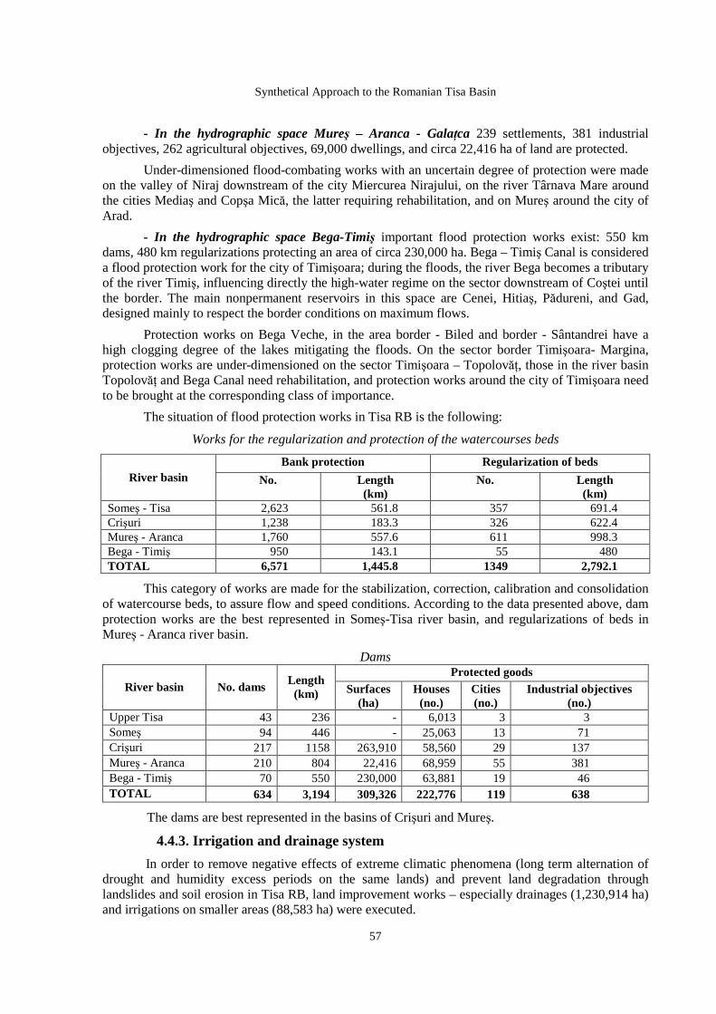
Synthetical Approach to the Romanian Tisa Basin
57
- In the hydrographic space Mureş – Aranca - GalaŃca 239 settlements, 381 industrial objectives, 262 agricultural objectives, 69,000 dwellings, and circa 22,416 ha of land are protected.
Under-dimensioned flood-combating works with an uncertain degree of protection were made on the valley of Niraj downstream of the city Miercurea Nirajului, on the river Târnava Mare around the cities Mediaş and Copşa Mică, the latter requiring rehabilitation, and on Mureş around the city of Arad.
- In the hydrographic space Bega-Timiş important flood protection works exist: 550 km dams, 480 km regularizations protecting an area of circa 230,000 ha. Bega – Timiş Canal is considered a flood protection work for the city of Timişoara; during the floods, the river Bega becomes a tributary of the river Timiş, influencing directly the high-water regime on the sector downstream of Coştei until the border. The main nonpermanent reservoirs in this space are Cenei, Hitiaş, Pădureni, and Gad, designed mainly to respect the border conditions on maximum flows.
Protection works on Bega Veche, in the area border - Biled and border - Sântandrei have a high clogging degree of the lakes mitigating the floods. On the sector border Timişoara- Margina, protection works are under-dimensioned on the sector Timişoara – TopolovăŃ, those in the river basin TopolovăŃ and Bega Canal need rehabilitation, and protection works around the city of Timişoara need to be brought at the corresponding class of importance.
The situation of flood protection works in Tisa RB is the following:
Works for the regularization and protection of the watercourses beds
Bank protection Regularization of beds River basin No. Length
(km) No. Length
(km) Someş - Tisa 2,623 561.8 357 691.4 Crişuri 1,238 183.3 326 622.4 Mureş - Aranca 1,760 557.6 611 998.3 Bega - Timiş 950 143.1 55 480 TOTAL 6,571 1,445.8 1349 2,792.1
This category of works are made for the stabilization, correction, calibration and consolidation of watercourse beds, to assure flow and speed conditions. According to the data presented above, dam protection works are the best represented in Someş-Tisa river basin, and regularizations of beds in Mureş - Aranca river basin.
Dams Protected goods
River basin No. dams Length (km) Surfaces
(ha) Houses (no.)
Cities (no.)
Industrial objectives (no.)
Upper Tisa 43 236 - 6,013 3 3 Someş 94 446 - 25,063 13 71 Crişuri 217 1158 263,910 58,560 29 137 Mureş - Aranca 210 804 22,416 68,959 55 381 Bega - Timiş 70 550 230,000 63,881 19 46 TOTAL 634 3,194 309,326 222,776 119 638
The dams are best represented in the basins of Crişuri and Mureş.
4.4.3. Irrigation and drainage system
In order to remove negative effects of extreme climatic phenomena (long term alternation of drought and humidity excess periods on the same lands) and prevent land degradation through landslides and soil erosion in Tisa RB, land improvement works – especially drainages (1,230,914 ha) and irrigations on smaller areas (88,583 ha) were executed.
Pompei Cocean & Adriana Vartanoff - Coordinators
58
Irrigation works covered a reduced surface (4.3% of the arable surface of the area), by lots: over 1000 ha (43,857 ha), less than 1000 ha (15,331 ha) or local (31,395 ha).
According to data provided by ISPIF Bucharest, most of the works executed on lots over 1000 ha are situated in the counties of Arad (23,059 ha), Timiş (7,216 ha) and Cluj (5,955 ha).
The irrigated agricultural surface in Tisa RB is small compared to other areas in Romania. There are areas with water deficit needed for crops and areas with irrigable agricultural potential lacking endowments. Irrigated areas decrease also as a consequence of high costs for maintaining and extending the existing systems.
Drainage works executed to remove the excess of humidity cover an area representing 58.7 % of the total arable surface, for lots: over 1000 ha (1,136,481 ha), less than 1000 ha (66,816 ha) or local (29,615 ha).
The analysis of the territorial distribution shows that most of the works executed on lots over 1000 ha are situated in the counties of Arad (222,167 ha), Timiş (437,998 ha), Bihor (170,648 ha) and Satu Mare (232,873 ha).
The problems referring to land improvement works refer to: unsatisfactory state of endowments requiring rehabilitation and modernization, impossibility of economically efficientization of endowed areas, reduced usage of irrigation systems, decreasing interest to extend such works.
4.5. Waste management Wastes raise a series specific and relatively complex of problems, as there is a trend of
increasing their amount and diversify their characteristics, as a consequence of development and diversification in industry, agriculture and due to urbanization. Waste management in Tisa RB takes place according to Waste Management County Plans.
4.5.1. Household waste management
Urban waste management in settlements within the studied area, both urban and rural, takes place according to Governmental Decree no. 87/2001, approved by Law no. 139/2002, with the assistance of public health services. Elimination of household waste takes place by depositing on soil, as both urban and rural settlements are endowed with household waste deposits.
Based on the analysis of data on the production of urban waste per person, counties within the studied area were grouped in three categories. Most urban wastes are generated in the counties of Arad, Hunedoara, and Sibiu (over 550 kg/person/year), and least (250-400 kg/person/year) in the counties Bihor, BistriŃa-Năsăud, Cluj, Alba, and Timiş.
The situation of urban waste deposits in Tisa RB is very diverse according to environmental reports (2003 – 2005).
Urban settlements have household waste deposits, but most of them lack endowments and do not comply with the existing legislation, and some have no available stocking capacity. The modernization of the waste management system has just started. The number of urban settlements benefiting upon ecological platforms is very low (Oradea, Arad, and Sighişoara). In order to organize county-level waste management, in some cases transfer stations were built (Chişineu-Criş, Arad County). Also, few municipalities base waste management on public – private partnerships: Oradea, Arad, Târgu Mureş, and Sebeş. Modernization or closing of urban waste management deposits in noncompliance with European standards received a grace period until 2012, according to Directive no. 1999/31/EC transposed in the national legislation by Governmental Decision no. 349/2005.

Synthetical Approach to the Romanian Tisa Basin
59
Rural household waste platforms/deposits are established by a Decision of the Local Council, but in most cases they are noncompliant, and lead to environmental pollution. Also, there is no public waste collection system. Rural household waste deposits not modernized must stop their activity by 2009.
4.5.2. Industrial and dangerous waste management
The main types of industrial wastes are: mining gangues, thermal power plant cinders and ashes, industrial wastewater treatment muds, and agro-husbandry wastes.
The analysis of production and distribution of industrial wastes points to counties generating large amounts (Sălaj, Hunedoara and Alba), or have large areas occupied by these wastes (Maramureş and Alba).
There are numerous industrial waste deposits with environmental impact in Tisa RB. Based on the development or dropout in economic activities that generate waste, some of them need either modernization and ecological reconstruction, or closing and environmental restoration of the affected lands. Most of these deposits are in the counties of Maramureş, Alba, Mureş and Hunedoara.
Dangerous industrial waste deposits (mainly gangue stock-piles, mining decantation ponds, uranium stock-piles, chemical industry waste) are inadequately managed, and most of them are situated in the counties Alba, Arad, Maramureş, Harghita, Sălaj, and Hunedoara. Municipalities Oradea and Timişoara are endowed with incinerators for dangerous wastes.
In some cases, industrial wastes are deposited on mixed platforms, close to household wastes, contributing to increased environmental pollution, if they are noncompliant, and could generate inflammable, explosive or corrosive mixtures.
The main problems related to waste management refer to: noncompliant collection/ transport/ depositing practices affecting the environment, placement in vulnerable areas (close to dwellings, surface waters, entertainment areas), sometimes irreversible degradation of lands where they are deposited, landscape changes, and visual discomfort.
Pompei Cocean & Adriana Vartanoff - Coordinators
60
5. ECONOMY
The economic peculiarities of the Tisa hydrographic basin region from Romania are the result of the interference of some major factors, among which the following can be mentioned: natural resources, anthropic potential, tradition and random factors (political and social).
The economy from the geographical area of the Tisa hydrographic basin is the most complex of the Romanian space. This situation is due to the following attributes: - the age of industrialization, which started in the 18th-19th centuries, with the construction of railways since 1856, together with the implementation of advanced agro-technical methods; - the economic development, and then its profile, was formed in concordance with the energy and raw material resources, which are very diverse, but in small quantities; - the industrial landscape has suffered transformations closely-related to the phases of evolution: the manufacture an extensive agriculture stage, from the 18th-19th centuries; the start of the industrial activity stage, when the first industrial nucleuses appear in the 19th century (Gugeşti-Timi ş County, Poiana Codrului - Satu Mare County, Oradea, Arad, Târgu Mureş), as well as the first intensive agricultural exploitations; the capitalist industrialization stage, from the first half of the 20th century, when a series of industrial areas are formed: Baia Mare, Deva, Hunedoara, Arad, Tmişoara, Sighişoara, for the textile industry, Turda – Cluj, for the building materials industry, ceramics, glassware etc.; the centralized development stage, in a nationalized economy, with the inhibition of private initiative, without any relation with resources, traditions, regional specificity. The result was the extensive development of industry, each town having its own ‘industrial platform’, nowadays, huge ‘grey zones’; the stage after 1990, when, after a free fall of the industry and agriculture, the restructuring and re-conversion followed, with a sinuous running and the appearance of the ‘services economy’. Currently, the region has a slightly-upward economic trend. Except for Bucharest, this region registers the greatest economic and gross domestic product growth rate.
5.1. Agriculture The primary economic sector – agriculture – reflects faithfully the macroeconomic and social problems of the region. The main premises in the development of this economic branch are:
• The lack of large and very large properties in most part of the region, with the exception of the Banat Plain and Hills and of some properties of about 150-300 ha, which represent the nucleuses of modernity for the field agriculture;
• The forms of co-operation between producers are still little-developed; they exist, but the tendency is that each agricultural exploitation unit wants to produce as much as possible from its own necessary products, as a reflex of subsistence agriculture;
• The labour force has reduced dramatically and is substantially aged.
The landed stock structure is different, depending on the particularities of each county. Thus, the ratio of the agricultural area is above the average in Timiş (80.7 %), Satu Mare (71.9 %), BistriŃa-Năsăud (66.2 %) and Arad (66 %), counties situated mostly in the Western Plain, a subdivision of the Tisa Plain. In the counties with extended mountainous areas, the ratio of the agricultural lands is below the average: Hunedoara (49 %), Maramureş (49.4 %), Alba (52.7 %) and BistriŃa-Năsăud (55.8%).
In these counties, the ratio of forest lands exceeds by far the average value of 30.6 %: Maramureş – 45.8 %, Hunedoara – 44.8 %, Alba – 36.5 %, Harghita – 35 %. If the agricultural lands structure (5,109 million ha) is taken into consideration, the greatest ratio (49.8 %) belongs to the arable lands – 2,542 million ha, followed by pastures (30.5 %) – 1,558 million ha, hayfields (17.7 %) with 0.902 million ha and only a little more than 100,000 ha to vineyards and orchards (2 %). Naturally, the most extended areas of arable lands belong to the
Synthetical Approach to the Romanian Tisa Basin
61
counties situated in the plain area: Satu Mare – 69.1 % out of the total area of agricultural lands, Timiş – 75.9 %, Arad – 68 %, Bihor – 60.9 % and Mureş – 53.6 %, while the most extended areas of orchards appear in BistriŃa-Năsăud – 3.1 % out of the total area of agricultural lands, Satu Mare – 2.5 %, Maramureş and Sălaj – 2 %, and those of vineyards in Satu Mare – 1.5 %, Bihor – 0.9 %, Arad – 0.8 %, Alba –1.4 % and Sălaj – 1.1 %. The cultivated lands structure is somehow unadapted to the requirements of a modern agriculture, having a ratio of more than 63.9 % out of the total arable land cultivated with cereals, with small productions per hectare, between 2,000 and 3,600 kg, in the conditions in which a modern agriculture requires the extension of the lands cultivated with technical crops – sugar beet, oil plants, textile plants, medicinal herbs, and with those used for sustaining the animal breeding sector, the fodder crops, whose ratio in the agricultural lands must oscillate between 30-35 %. Out of the total cultivated area, which is more than 2,338 million ha, cereals represent 1,495 million ha, meaning 63.95 %, while maize (764,653 ha) is almost in equal proportion with the straw cereals (wheat, rye, barley, oats) – 731,046 ha. The maize growing has a high frequency, maize being also a fodder and technical plant (for oils). Its production exceeded 2.7 million tones, with an average of 3,600 kg/ha. Productions which exceed the average were recorded in Cluj – 3,853 kg/ha, Alba – 4,101 kg/ha, Satu Mare – 4,317 kg/ha. Global productions which amounted to 300,000 tones were recorded in the counties of Mureş, Arad, Bihor and Satu Mare. The production of barley, two-row barley and oats exceeded 61,100 tones, on an area of 309,008 ha and an average production of about 2,000 kg/ha. The counties of Timiş, Satu Mare, Bihor and Mureş are the most important producers, with productions which exceeded the average value per hectare. The oil technical plants, mainly sunflower and soy, were cultivated on an area of 148,712 ha, the production being of 224,248 tones, the great producers being the counties situated in the plain areas – Arad, Timiş, Bihor and Satu Mare. The technical plants, flax and hemp, totalize only 1,087 ha of systematic crops, out of which 738 ha are in Arad and small areas in Satu Mare – 151 ha, Mureş– 142 ha, Bihor – 30 ha. Due to the lack of mechanization in agriculture, the cultivation of sugar beet faces a major decrease, being cultivated on only 1,356 ha, its production exceeding slightly 379,000 tones. More extended areas are cultivated in Mureş – 3,008 ha, a situation explained by the presence of a sugar factory that stimulates the cultivation, Satu Mare – 1,828 ha, Cluj – 1,619 ha, Bihor – 1,735 ha and Arad – 2,069 ha. Potato, a food, technical and fodder plant, is cultivated on about 122,491 ha, its production exceedin 1.7 million tones. The great producers are the counties of Cluj, Bihor, Satu Mare and Mureş. The vegetables production exceeded 910,000 tones and the cultivated areas occupied more than 73,000 ha. The counties which are vegetable-producers by tradition are Arad, Timiş, Cluj, Mureş, Bihor. They have fertile alluvial soils in the meadows of the Mureş River, Someş River and the Criş rivers, the possibility of stimulating the plant-growing in heated greenhouses and a high ratio of consumers from the urban areas. Closely-related to the importance of the animal breeding sector in an advanced agriculture is the fodder crops growing, which totalized in this region areas of more than 468,000 ha and a production of about 2 million tones. The great producers are Bihor – 333,000 tones, Timiş – 287,266 tones, followed by Arad, Hunedoara, Cluj, Sălaj, Alba and Mureş, with productions of 130-140,000 tones.
Fruit trees are cultivated on areas that totalize 743,338 ha, within the systematic orchards. Beginning with 1990, the area decreased continuously until 2003, after which it maintains at constant values. In 2004, the production was 434,384 tones. The greatest productions are obtained in the counties with a strong fragmentation of the relief, on hills with soils of medium fertility: Cluj, BistriŃa-Năsăud, Maramureş, Satu Mare, Mureş, appearing some fruit-tree zones: BistriŃa Hills, the western and northern peripheral hills of the Someş Plateau, the Oaş depression zone (TurŃ, Tarna Mare, Bătarci), Şimleu Depression.
Pompei Cocean & Adriana Vartanoff - Coordinators
62
The structure of the production is dominated by apples, with 59.3 %, followed by plums – 23.4 %, pears – 5.8 %, sweet cherries and sour cherries – 3 %, nuts – 2.7 %, strawberries – 2.5 %, peaches – 1.7 %, apricots – 0.7 % and other types of fruits – 0.9 %. The ratios oscillate depending on the county, a consequence of their specialization depending on the pedo-climatic conditions and traditions. Thus, the Satu Mare county is specialized in growing strawberries, which detain 24.3 % out of its total production. For apples, the following counties are very important: BistriŃa Năsăud, where the ratio of the apple-tree is 82.2 %, Sibiu – 84.3 %, Mureş – 83.1 % and Maramureş – 76 %. For plums, Arad county - 44.9 % out of its production, Timiş - 52.3 %, Cluj - 34.4 % and Satu Mare – 39.1% stand out. For peaches and apricots: Bihor – 14.5 % out of its total production, Timiş – 5.4 % and for nuts, Hunedoara 8.54%, Sălaj 4.4 % and Alba 4 %. The area of fruitful vine is of 24,694 ha out of the 30,719 ha cultivated with vine. Vine growing has old traditions and thus, several vineyards have developed throughout time: Târnave, Alba Iulia, Arad, Sătmar (Turulung, Viile Satu Mare), Oradea, (Valea lui Mihai, Diosig, Marghita), BistriŃa (LechinŃa, Teaca). Out of this area, 55.9% are lands occupied by grafted and native vine and 44.1 % by hybrid vine. The most extended areas occupied with vine appear in Arad – 2,573 ha (90.6 % out of the total area), Timiş – 2,273 ha (80.9 %), Alba - 3,568 ha (86.8 %), Mureş – 1,154 ha (79.3 %) and Sibiu – 1,095 ha (80.5 %). The production amounted to 105,000 tones, out of which 51 % belonged to the noble vines, with the remark that, from a quantitative point of view, noble vines give smaller productions. The animal breeding sector has recorded a constant regress after 1989, as regards the number of the domestic animals and the general and specific density (UVM) of animals per area unit.
The animal breeding zoning is related to the natural conditions, due to the succession and ratio of the landforms, which influences the specificity of the fodder reserve. The cattle stock is slightly below one million heads (954,000), the number of cattle recording the greatest regress. The greatest stocks appear in the hilly counties: Bihor – 107,000 heads, Maramureş – 104,000, Cluj – 86,000, Mureş – 82,000, the counties situated in the plain areas having surprisingly small effectives: Arad -59,000 heads, Timiş - 60,000, Satu Mare – 64,000 or even in some hilly counties such as Sălaj – 57,000 and Sibiu – 48,000. The number of horses increased slightly due to the insufficient mechanization of agriculture, amounting to more than 234,000 heads. There are several studs in this region (Izvin, BonŃida, Balc, Beclean) and also stallion deposits (Arad, Târgu Mureş). The number of sheep and goats has also decreased in this region up to 2,741 million heads. The most numerous are in Sibiu – 345,000 heads, Mureş – 303,000, Alba, BistriŃa Năsăud, Cluj and Maramureş, with 224,000 -270,000 heads and in the counties situated in the plain area: Timiş and Arad, with 337,000 and 240,000 heads. The number of swine exceeds 2,608 million heads, having an average density of 102.6 heads per 100 ha of arable land, a value above the country's average. Greater densities appear in the counties from the Transylvanian Plain: Cluj – 144.6 heads per100 ha of arable land, Alba – 163.2, BistriŃa-Năsăud – 227.9 and Mureş – 129.4. Their foddering is complex, consisting either in cereals or potatoes and beet in the counties of Harghita and Maramureş. The varied pedo-climatic conditions and the relief led to specializations in animal breeding:
• In the mountainous areas – the Apuseni Mountains, Oaş – Gutâi łibleş and Bârgău mountains, the cattle and sheep breeding, whose foddering is based on natural grasslands – pastures and hayfields, is specific, with a specialization in meat, wool and milk production. The amelioration of races, the modern agro-technics – the amelioration of pastures, the parcelling of pasturelands led to the condition of quasi-intensive exploitation;
• In the depression and hilly areas from the gulf-depressions situated in the western side of the Apuseni Mountains, the conditions are more favourable for cattle, swine and sheep breeding;
• In the plain areas – the Western Plain, the Mureş, the Târnava rivers, the Someş corridors and the low hills from the Transylvanian Plain, it is the domain of cattle and swine intensive breeding. In these areas, the modern farms for breeding animals are more numerous and in the valleys situated in

Synthetical Approach to the Romanian Tisa Basin
63
the proximity of the big towns, a pre-town agriculture developed, consisting in providing fowl, eggs, milk and meat for the urban areas. Meat production exceeds 485,351 tones, out of which 48 % is pork (232,905 tones), followed by beef (27.9 %), fowl (15.1 %) and mutton (9 %). Therefore, it is a zone of swine breeding, existing old traditions of processing pork: Sibiu, Salonta, Timişoara, Mediaş. The counties situated among the great producers are: Mureş, Arad, Timiş and Cluj. Beef is processed especially in Bihor, Maramureş, Mureş and Alba, the total production amounting to 135,399 tones. For milk production, important are the counties of Bihor, BistriŃa Năsăud, Cluj, Maramureş and Mureş, counties with extended mountainous and high hills areas. In these areas, the production recorded values of more than 1.5 million hl. Throughout the Romanian Basin of the Tisa, the crop sector has a contribution of 59.6 % out of the total agricultural production, while the animal breeding sector has a contribution of 40 %, 0.4 % represents the contribution of the services from agriculture. These values are above the national average. High ratios of the animal production are recorded in Alba – 46.5 %, Bihor – 44.4 %, Hunedoara – 42.6 %, Harghita – 41.5 % and Mureş – 41 %. The presentation, even concisely-made, of the main crop cultures allows a series of conclusions:
The region has an agricultural multi-specialization – the entire range of products is produced; cereals and fodder plants predominate. The cultivated lands have continuously decreased; important areas of arable lands are let ‘to rest’, because their use is not profitable at the moment. The production structure is not in concordance with the current tendencies of European agriculture. The mechanization is very precarious; investments in labour per ha of agricultural land is high, a situation which makes the domain unattractive for the young farmers.
5.2. Industry A primary defining characteristic of industry in the analyzed region is the one related to the modification of the ratio of the different branches in the industrial sector. The major recoil recorded by the extractive industry is made evident, both in the sector of energy resources extraction (coal, in the mining basins Ip-Sărmăşag-Voivozi, łebea; oil, in the Western Hills area – Suplacu de Barcău, AbrămuŃ etc.), as well as the metalliferous and nonmetalliferous mineral resources (Baia Mare Mining Region, the mining exploitations from the Apuseni Mountains – Roşia Montană, Roşia Poieni, the mining exploitations from the Poiana Ruscă Mountains – Ghelari, Telicu Inverior, Vadu Dobrii). Associated to the economic dynamics descendant at national level, the electric power producing industry also diminished the values of production, and so, some units function with only 50 % out of the installed power (Iernut, Mintia). The same tendency of recoil is associated to the iron and steel and metallurgic industry, which has affected powerful and traditional industrial centres, such as Hunedoara, Călan, Câmpia Turzii. The machine construction industry lost significant productive units, entirely closed or found in a major process of reorganization (Cluj-Napoca, Satu Mare, Mediaş), in the conditions in which, the national market for different products (heavy equipment, mining equipment, machine tools) did not absorbed their overproduction. Another industrial branch with recoil tendencies is the chemical industry, whose polluting valences determined the shutting down or the drastic restriction of the activity of some important units Copşa Mică, Zlatna, Baia Mare. But a tendency of ascendant evolution can be also noticed in the case of some industrial branches or some industrial units corresponding to the above-mentioned major reorganization branches. At present, such a tendency is to be noticed in the case of processing industry, on the basis of the increasing number of small and medium enterprises and of their profitableness, but also as a result of the removal of the production deficiencies, in the case of some industrial units. Thus, in the

Pompei Cocean & Adriana Vartanoff - Coordinators
64
case of chemical industry, the re-launching of production is notices in the case of some profile units from Oradea, Cluj-Napoca, Baia Mare, Timişoara, Zalău and Târgu Mureş, which cover a large range of specific products: varnishes and dyes, chemical fertilizers, reagents, medicines, tyres etc. whose market is found both in the region and at the national level or for export. An industrial sector with a significant ratio and ascendant dynamics is represented by the natural gas extraction, transport and distribution, a situation which raises significantly the region's value of the revenues, in the conditions of efficient exploitation of the significant resources from the Transylvanian Depression (Puini, Sărmaşu, Zau de Câmpie, Bogata, Sângeorgiu de Pădure, etc.). Currently, it must be noticed the fact that some polarisation centres appeared territorially, which attract the investments in the locations of the ‘greenfield’ type, usually farther from the town, or of the ‘brownfield’ type, within the companies which have been privatized.
Presently, the regional industrial polarisation centres are: Timişoara – the most attractive as regards the privatisations and the edification of a new
industrial infrastructure; Arad – stimulated by an aggressive local management which has managed to create industrial
parks that have become attractive for investors (pharmaceutical products, electrotechnical industry); Satu Mare – a very good local management succeeded to transform this city into a favourite
attraction. Its industrial park stretches over 80 ha; Cluj Napoca – after it has been ‘avoided’ by the industrial companies for about a decade, it
has begun to recover the lost time after 2000 due to the offered attractions and the edification of a friendly business environment. It sees great investments in IT, communications, light industry, with an industrial park which is still extending;
Oradea – a polarisation centre specialized in textile industry, footwear industry, chemical industry;
Târgu Mureş – taking the advantages from its favourable central position and from a varied transportation infrastructure, after it had lost some of the representative industrial branches (leather goods industry), it managed to edify an attractive industrial park, specialized in furniture, food industry, chemical fertilizers. Some of the small-sized towns managed to become attractive for different industrial branches: Blaj – for beer, textiles; BistriŃa – automobile cablings, textiles, accumulators; Zalău – textiles and tyres; Sighetu MarmaŃiei – with the presence of the firm Steilmann, with three factories and some units from the furniture industry. Others, with mono-specialized industrial profiles, not yet adapted to the current economic demands, face a descendant evolutionary tendency: Ştei,Vaşcău,Nucet, in Bihor county; Sângeorz-Băi, Nasăud, Beclean, in BistiŃa Năsăud county; Tăşnad, Seini, Negreşti-Oaş, in Satu Mare county; Teiuş, Aiud, Câmpeni, Abrud, in Alba county. It also must be noticed that in the region, there are industrial locations in which the infusion of capital was made by strategic investors: Continental and Siemens in Timişoara, Lafarge in Aleşd, Leoni in BistriŃa, Rambaxi in Cluj-Napoca, Steilmann in Satu Mare and Sighetu MarmaŃiei, Nokia and Ericsson in Cluj, and by autochthonous firms as well – Marmosim in the basalt, marble and travertine quarries, Stison – Poiana Codrului (glassware). An important aspect is the fact that together with the reorganization of the economy of the great cities, a tertialization of their economic profile took place, while in the case of the small-sized, mono-industrial towns, the economic dynamics is a stationary one, the economic profile induced to the majority of them aims at specializations in textile industry, leather goods and footwear industry, food industry, a fact which is reflected in the dysfunctions related to the labour force occupancy. At the regional level, two main industrial regions can be individualized, each of them with several groups: the industrial region from the Transylvanian Plateau and the Northwest and West industrial region. The industrial region from the Transylvanian Plateau associates the following industrial groups:

Synthetical Approach to the Romanian Tisa Basin
65
• The Târnave group, specialized in chemical industry – Târnăveni, non-ferrous metals processing – Copşa Mică (in decline), machine constructions– Mediaş, ceramic materials and glass – Mediaş, Sighişoara, Târnăveni, textile – leather goods – Mediaş and Sighişoara, and wood processing – Blaj, food industry – Blaj (beer);
• The group from the lower Arieş and the middle Mureş, with a complex character of the industry. The following industrial branches are present: chemical industry - Târgu Mureş, Ocna Mureş, machines constructions – Târgu Mureş, building materials – Turda, Câmpia Turzii, Târgu Mureş, food industry – Turda (canned meat), Luduş – sugar and Târgu Mureş – dairy and sausages,electric power on the basis of natural gas - Iernut – Cuci and Fântânele, wood processing in Târgu Mureş, thermo-insulating woodwork – Târgu Mureş;
• The industrial group on the Someşul Mic, on the axis of Cluj-Napoca – Gherla – Dej, with a diversified profile: chemistry of fine synthesis (medicines) in Cluj-Napoca, paper in Dej, wood processing industry in Cluj-Napoca and Dej, food industry in Cluj-Napoca, Dej and Gherla, heavy equipment – Cluj-Napoca, textile – Cluj-Napoca, telecommunications – Cluj-Napoca;
• The Alba Iulia – Sebeş – Petreşti group, of smaller size, concentrated on fine ceramics in Alba Iulia, wood processing – Sebeş, paper – Petreşti;
• The non-ferrous group from the Apuseni Mountains: Deva – RuşchiŃa - Muncelu Mic – Brusturi – Zlatna, has experienced a massive reorganization and a gradual reduction of the mining and refining activities. The opening of the silver and gold exploitations from Roşia Montană is a long-term project.
The North-West and West industrial region includes several industrial groups: • The industrial group on the Crişul Repede, with the following industrial centres:
Oradea, Aleşd, Chiştag, Tileagd, Aştileu. Oradea is the main industrial centre, having developed the electrical power industry, non-ferrous metallurgy – alumina, chemical industry - varnishes and dyes, organic products of synthesis, wood processing – furniture, leather goods and footwear, sugar, drinks, spirits, beer and soft drinks. The abundance of limestone, marl and clay led to the development of the building materials industry: Aleşd – Chiştag, with cement, lime, calcareous amendments, Aştileu – refractory briks.
• The Baia Mare - Carei - Satu Mare group includes the industrial centres from the Baia Mare Depression and from the lower course of the Someş. The presence of the non-ferrous ores in the Baia Mare zone led to the exploitation and refining the non-ferrous metals in Baia Mare. Other industrial branches developed in the area are: textile- Baia Mare, Satu Mare, wood processing, in Baia Mare, Bixad, Satu Mare, TăuŃi, food industry (sugar, oil) in Carei, Baia Mare and Satu Mare.
• The Arad – Timişoara industrial group, very dynamic and complex, presents a high attractiveness for the foreign capital. The progress of some industrial units of long tradition is remarked (the Wagon Factory Arad), but also the appearance of some new industrial parks, such as the one from Ineu, specialized in machine construction industry and electrotechnical industry. Almost entirely privatized, the industry from the analysed region registers annual growths of about 6-7 %, transforming the analysed region into an attractive one for investors. Nowadays, even a lack of labour force begins to be felt.
5.3. Tourism Although there is a special attractive tourist potential as far as diversity and richness are concerned, tourism remains a secondary economic branch, being clearly surpassed by agriculture and industry (with values of less than 2 % in the regional gross domestic product). Among the types of tourism practiced in the Romanian basin of the Tisa River the following can be mentioned: balneal tourism, recreational tourism (winter sports, mountaineering, speleological tourism, rural tourism), cultural tourism and mixed tourism. The tourist traffic in the region is modest (less than 2.5 million foreign tourists per year) and points out a pronounced seasonality (a maximum in summer and winter). The origin of the foreign

Pompei Cocean & Adriana Vartanoff - Coordinators
66
tourists certifies a majority of those coming from Hungary, Germany, Italy, Republic of Moldavia, Austria, Ukraine etc. The tourist material base (the tourist infrastructure), with a certain dimension, structure, complexity and territorial repartition (spread or concentration) has been conditioned in time by the tourist potential, the historical and social-economic conditions. Its management policy was related to orientations and tendencies, with its adaptation to the fundamental factor – the primary tourist offer, possessing natural and anthropic resources, with a different potential of attraction. The arrangement of the general and tourist infrastructure involves directly into the attraction and the holding the tourists, for different lengths of time, determining the transformation of the tourist resources in capitalizing tourist products. The current tourist material base is the result of the evolution of the profile phenomenon and activity for about a century (some of the hotels or villas from the resorts are about a century old, requiring ample measures of modernization or rehabilitation) and presents, depending on the characteristics of the activities and their level of capitalization, the following types of concentrations: a. Health resorts, capitalizing the mineral and/or thermal waters, among which, the complex resorts, with more than 1,000 places, stand out: Băile Felix (6,070 places, the greatest resort with balneal function from Romania), Sovata, Sângeorz Băi, 1 Mai, Băile Geoagiu, Buziaş), resorts with capacities ranging between 100-1,000 places (Moneasa, Ocna Sibiului, Ocna Şugatag, Bazna, Praid, TopliŃa-Bradul, VaŃa de Jos, Bizuşa, Băile Turda, Tăşnad), small, local spas and localities with unarranged balneal potential (Ocna Mureş, Cojocna, Someşeni, Miercurea Sibiu, Călacea, Băile Călan, Băile Lipova, Tinca, Boghiş, Corund); b. Climatic mountain resorts and winter sports complexes. From the first category, some resorts such as Borşa, Mogoşa, ColibiŃa, Straja, Muntele Mic, Semenic, Beliş, Stâna de Vale stand out and from the second category: Cavnic, Piatra Fântânele, Râuşor. Chalets can be also added. c. Towns with different accommodation capacities and complexity, from the metropolises with more than 3,000 places such as Cluj Napoca, Timişoara, followed by the other cities with the function of county seats (Oradea, Arad, Tărgu Mureş, Deva, Baia Mare, Satu Mare, Alba Iulia, BistriŃa, Zalău) or a series of other municipiums and towns (Sighişoara, Mediaş, Dej, Sighetu MarmaŃiei, Turda, Gherla, Blaj, Târnăveni, Câmpeni, Abrud, Sebeş, Huedin, Beiuş, Caransebeş etc.), with 1-3 accommodation units of hotel type, with a lower degree of comfort ; d. Rural settlements with tourist boarding-houses, grouping from several dozens to several hundreds of places, from Maramureş County (Vadu Izei, Botiza, Ieud, Săliştea de Sus), BistriŃa Năsăud County (Anieş, Lunca Ilvei, Valea Vinului), Mureş County (Stânceni, Lunca Bradului, Gurghiu, Sângeorgiu de Mureş), Harghita County (Praid, Corund, Lăzarea, Ditrău), Cluj County (Sâncrai, Bologa, Ciucea, Negreni, Beliş, Băişoara), Alba County (Gârda de Sus, Albac, Arieşeni, Rimetea) etc. e. Secondary tourist bases, from the category of motels, campings and chalets, are placed along the thoroughfares. The main tourist regions from the Romanian basin of the Tisa River are:
1. The Apuseni Mountains, with an extremely rich offer for the recreational tourism (speleological tourism, mountaineering, hiking, rural tourism), curative (thermal waters at Moneasa, Geoagiu Băi, VaŃa de Jos) and cultural (ethnography, wooden churches, monuments, medieval fortresses). The main tourist bases are Geoagiu Băi, Moneasa, VaŃa de Jos, Stâna de Vale, Beliş-Fântânele, Băişoara resorts. It possesses great reserves for the long-term arrangements (caves, gorges and defiles, ethnographical resources etc.).
2. The Transylvanian Depression includes the only authentic Carpathian basin, with objectives important for the curative tourism (salt lakes and mineral springs - Sovata, Praid, Ocna Mureş, Sic, Cojocna, Turda, Ocna Dej) and for the cultural one (diverse objectives situated in towns: Cluj- Napoca, Alba Iulia, Târgu Mureş, Sighişoara, BistriŃa, Blaj, Sebeş, Turda, Dej). Small tourist bases are situates in Sovata, Praid, Bazna, Cojocna, and Bizuşa. The geographical position generates intense transit tourism.

Synthetical Approach to the Romanian Tisa Basin
67
3. The Eastern Carpathians, the western mountainside respectively, have great hydro-mineral resources (includes the Europe's most extended moffetic aureola), landscape, climatic, hunting and cultural resources (the wooden churches from Maramureş, the ethnography of the ‘lands’ of Oaş, Maramureş, Năsăud, of the Szekler's territory etc.). The main resorts are Ocna Şugatag, Sângerorz Băi, Baia Borşa, Cavnic, Mogoşa, ColibiŃa, Izvoarele.
4. The Western Hills and the Western Plain possess great resources of thermal waters, on the fault network oriented on a north-south direction, between Satu Mare and Timişoara, but also landscapes or anthropic objectives (medieval fortresses, churches, monuments, ethnographic values etc.). As main tourist bases, besides the big cities (Timişoara, Arad, Oradea, Satu Mare), resorts such as Băile Felix, 1 Mai, Boghiş, Beltiug, Tinca, Buziaş, Lipova, Zaua Băi, Meseşeni Băi etc. can also be mentioned.
6. CROSS-BORDER COOPERATION
The Romanian basin of the Tisa River is partially integrated into three euroregions: the Carpathian Euroregion, the Danube - Criş – Mureş - Tisa Euroregion and Bihor – Hajdú-Bihar Euroregion.
6.1. Cooperations in the Carpathian Euroregion As the official relations are concerned, they were institutionalized when the counties of Satu Mare, Bihor and Maramureş were integrated into the Carpathian Euroregion, in 1997. Afterwards, other two counties from the Tisa basin, Sălaj and Harghita, adhered to the euroregion. Since then, through the PHARE-CBC programme, the consolidation of the relations were financed, through the elaboration of the cooperation projects especially between the Satu Mare and Szabolcs – Szatmár – Bereg counties, Bihor and Hajdú – Bihar respectively. Firstly, joint seminaries on the theme of the European integration were organized, but also official visits, organized meetings at the county councils, town halls and different specialized institutions, having in view the identification of the possible cross-border cooperations. Within the euroregion, a partnership of collaboration was concluded between the counties of Satu Mare and Szabolcs-Szatmár-Berge, in March 2000, which was also extended over the Zakarpatskaja region in October, the same year (Interregio project). Many brotherhood relations, collaborations and joint projects between several localities were accomplished. Thus, out of 44 of such associated foreign localities 14 are from Hungary. Seven localities from Szabolcs-Szatmár-Bereg have brotherhood relations with the localities from Satu Mare county, and with one they even have a joint project. Moreover, the locality of Livada has an agreement of brotherhood with Vinogradov city from the Zakarpatskaja region. In the last years, the cross-border relations of ‘brotherhood’ type have increased between the localities from the counties of the Tisa basin, often based on joint projects of collaboration, most of these localities being close to the border, and the cities show a special interest from this point of view. Regarding the brotherhood-related localities, the Satu Mare County sustains such contacts with 44 foreign localities, and 12 settlements from the county distinguish themselves with partnership relations with 14 settlements from Hungary. Out of these Hungarian localities, seven are placed in the neighbourhood county of Szabolcs-Szatmár-Bereg. Out of the 12 settlements from Satu Mare, three of them have relations, one having relations based on joint projects, the others having mostly conventional relations of brotherhood. One of the localities, which has established relations of brotherhood with a commune from Satu Mare, is placed in Zakarpatskaja region from Ukraine. The localities from Bihor County have partnership relations with 53 settlements from abroad. Out of these, 19 localities from Bihor have established partnerships with 28 localities from Hungary.

Pompei Cocean & Adriana Vartanoff - Coordinators
68
Out of these 28 Hungarian localities, 13 are placed in the neighboured county of Hajdú-Bihar, 6 localities in the neighboured county of Békés, and one in Szabolcs-Szatmár-Bereg. The most important stipulations of the bilateral agreements existent between the analyzed counties, which represent the basic documents of the cross-border cooperation organizations, are:
1. The convention of partnership, concluded in 2000, between the counties of Satu Mare and Szabolcs-Szatmár-Bereg;
2. The INTERREGIO agreement was also signed in 2000, between the counties of Satu Mare, Szabolcs-Szatmár-Bereg and the Zakarpatskaja region respectively and aims at the development of the following collaboration domains:
- common borders and the belonging infrastructures; - the construction of the 5th European transportation corridor; - nature, environment and water protection; - economy and tourism; - cultivation of common traditions of the nationalities in the area; - education and professional training.
In order to detail these possible collaborations, the conception and the strategy of developing the joint cross-border region were elaborated in 2003 by the Zajarpatksaja Regional Council and the Szabolcs-Szatmár-Bereg Agency of County Development.
6.2. The Romanian-Serbian-Hungarian Cross-border Interrelations in the Danube-Criş-Mureş-Tisa Euroregion
The Danube-Criş-Mureş-Tisa Euroregion has started to organize itself in an informal and consultative manner since 1992, but it exists in an institutionalized form only since 1997 (the exact date of the euroregion foundation is November 21, 1997, at Szeged, and it was constituted as a result of voluntary cooperation and association between the county/regional self-governments from Romania, Hungary and Serbia-Montenegro).
The Danube-Criş-Mureş-Tisa Euroregion stipulated from the very beginning the creation of its own structures of management, which meant especially the forming of a common secretary. In 2000, The Community Initiative Office of the Euroregion, was created, as an administrative body, directly subordinated to the President’s Forum led by the President in duty. In the long run, besides the initial administrative units, other territorial units from Hungary, such as the microregions from the Hungarian participating counties, as well as the cities with county district statute (Békéscsaba, Kecskemét, Szeged) joined the euroregion. Many civilian, nongovernmental organizations also added, but also other organizations, such as the universities from the region, which have a direct participation in the decisional process.
The working groups are based on different domains of collaboration: 1. The economy, infrastructure and tourism working group; 2. The town planning, nature and environment protection working group; 3. The culture, sport, civilian organizations and social problems working group; 4. The international relationships, information and public relations working group.
In order to assure the financial means for the development projects taking place in the euroregion and for supporting the Euro-Atlantic integration, The Development Agency of the Danube-Criş-Mureş-Tisa Euroregion – Public Use Society was formed, whose constitutive document was signed on May 24, 2003 and on this occasion the headquarters of the euroregion was established in Szeged. In accordance with the protocol of the constitution of the euroregion, in order to accomplish the purpose of cooperation, the signing parts aim at harmonizing the preoccupations in the following
Synthetical Approach to the Romanian Tisa Basin
69
domains: economic relations, transport and communication infrastructure works, environment, tourism, science, culture, education, civic relations, health and sport.
For the whole DCMT Euroregion, the PHARE-CBC programme had, among others, the following more important achievements:
- projects for transport infrastructure: the location of a cargo terminal in Arad Airport, the modernization of DN6 national road between Timisoara and the border, the arrangement of the Cenad-Kiszombor border pass point (which was opened also due to the lobby of the Italian enterprisers from the region, who invested in the light industry, and wanted to get to the border with the transports of finite products without the deviation to Arad-Nadlac);
- flood-control in the valleys of the Criş rivers, the localization of a monitoring system for measuring the water discharges and the setting of a meteorological radar to work.
6. 3. Bihor – Bihár Euroregion
The Bihor – Bihár Euroregion, which was formed due to the collaboration of the Bihor and Hajdu-Bihar counties in January 2003 (both belonging to the Carpathian Euroregion!) aim, in the Agreement of Collaboration, at accomplishing the following concrete objectives:
- creating an efficient framework for cross-border cooperation; - achieving some changes of relevant information in the cross-border collaboration domain and the assurance of access to this information for as many people as possible; -collaboration as regards the environment and nature protection, water management and flood-control, attraction of investments in order to assure the preservation and the improvement of the natural environment and of the values of the anthropic environment; -growing the economic capacity of the region by using the cross-border economic relationships. -developing some quality services and the partnership relations between the organizations that facilitate the economic activities; -supporting the projects meant to assure the economic development in some of the viable domains; -enlargement of the development possibilities of the activity of the small and medium enterprises, facilitation of the cross-border relations between them, promotion of some products specific for the area of the agreement; -using fully the possibilities offered by tourism and the elaboration of some joint projects in the domain; -the creation of the social base of cross-border collaboration, which will also serve as a base for developing the social-economic cooperation; -granting facilities to the education institutions from the Euroregion and offering support for their professional cooperation; - developing the educational and cultural relations by developing the collaboration between the nongovernmental organizations, developing some relations between the youth and sport organizations; - improving the health state and the social protection situation of the population who lives within the Euroregion, as well as the quality of the services from this domain. As regards the cross-border relations with Transcarpathia, Ukraine, we can say that,
unfortunately, they are not as functional as in the case of the relation with Hungary. It is felt, for example, the acute lack of a Maramureş Euroregion, although such intentions were expressed for many times at the bilateral meetings between the leaders of the territorial - administrative neighbored units. After a long period of preparations, the opening of a new border pass finally took place between Sighetu MarmaŃiei and Slatina, using the bridge rebuilt over the Tisa River.
Pompei Cocean & Adriana Vartanoff - Coordinators
70
In April 2005, The PHARE-INTERREG Regional Office of cooperation between the Western and North-Western Developing Regions from Romania and the regions from the east of Hungary opened at Oradea, which will set in the western part of the country the PHARE – CBC programme (Cross-Border Cooperation). It is conceived as the same with the INTERREG IIIA programme on the Hungarian side and it will be applied in the counties of Satu Mare, Bihor, Arad, Timiş and the Hungarian counties of Szabolcs-Szatmár-Bereg, Hajdú-Bihar, Békés and Csongrád respectively. The domains of the projects financed through these programmes are infrastructure, environment protection, tourism, economic cooperation, culture and civil society, a characteristic of these two programmes representing the condition of the existence of a project partnership from the other side of the border.
7. TRENDS AND POTENTIAL DIRECTIONS OF DEVELOPMENT
Determination of strengths, weaknesses, opportunities and threatens as factors conditioning the
development of a territory is followed by underlining determinations existing between these factors, in order to identify trends and potential directions of development. Opportunities, accounting for their relationships with the other factors, are those constituting the base of territorial development strategies.
7.1. Social situation of the region Demographic processes and phenomena
In order to prevent demographic decline in identified risk areas, one must identify directions of development focusing on:
- Policies for preventing the depopulation of the area from the Center and South of Tisa RB affected by important decreases of population;
- Diminish demographic aging process by stimulating birth rate either by facilities attracting young labour force, or by presenting flexible opportunities of professional development to women concomitantly with giving birth to and raising children;
- Improve access of rural population to health and education services;
- Attract youth in rural areas or reduce their emigration;
- Create facilities for familial planning;
- Improve welfare and life quality.
Work resources
Convergence between priorities of economic stakeholders and local development objectives is essential to the process of revigorating work resources. The directions of development will envisage:
- Identify regional centers with developmental potentials to coordinate programs for developing work resources, disseminate information and access consulting services;
- Create jobs by: stimulating private entrepreneurs, especially small and average companies, grant preferential credits, develop alternative sectors by exploiting natural resources and stimulating local crafts (agriculture, tourism, small industry, specialized services in some urban centers);
- Synchronize periods of closures of mines with those of development programs, especially professional re-conversion, to create alternative jobs;
- Develop programs diversifying professional qualification, especially in the tertiary sector;
- Develop programs of active actions to combat unemployment;

Synthetical Approach to the Romanian Tisa Basin
71
- Develop informational connections (between education and the labor market/ production environment).
Social infrastructure
Strategic directions for education infrastructure and services envisages:
● for pre-university education:
- Constitute poles of the pre-university education network both in the urban and rural environments;
- Rehabilitate the infrastructure of existing education units;
- Reorganize education infrastructure and services in rural areas with a reduced number of pupils or instructors;
- Rethink the concept of “education unit” in concordance with modern requirements in order to constitute campuses that could become socio-cultural centers;
- Assure infrastructure necessary to develop education and distance communication and information programs (use IT technologies and Internet).
● for university education:
- Optimize the territorial structure of university services and sustain a process of wise aggregation of higher education institutions in university centers;
- Concentrate university activities in limited locations - university campuses;
- Improve educational (educational spaces, laboratories, libraries) and social (accommodation camps, commerce and public alimentation, health assistance, sport fields, entertainment and cultural interest spaces within campuses) infrastructure.
Directions for developing health infrastructure aim to improve the access of population to health services, as well as the quality and efficiency of health services by:
- Closing, transforming or restructuring non-performing hospital units and provide adequate funding to stimulate the performance of hospitals;
- Increase participation of the private sector to financing health services;
- Assure minimal medical services to administrative-territorial units without medical doctors, medical cabinet or pharmaceutical point, and endow rural medical cabinets with modern medical technical equipment.
Housing trends and directions of development refer to:
- Short-term development of real estate investments, based on urbanism documents, in favorable areas at the periphery of large cities (Cluj-Napoca, Timişoara), and long-term development of real estate investments on available lots within average-size cities, by efficient valorization of the residential space;
- Reorganize rural and urban residential areas by attracting European funds;
- Improve living conditions for people with modest income (social/youth housing etc.);
- Rehabilitate and modernize the building stock, promote new construction technologies;
- Correlate construction of buildings with provision of town and socio-cultural infrastructures (cultural centers, libraries, stations, meeting places).
Pompei Cocean & Adriana Vartanoff - Coordinators
72
7.2. Spatial structure Settlement network – poles and axes of development
Polycentric and balanced spatial development of the settlement network sets as main direction the identification, formation, consolidation and balanced distribution of development poles.
Criteria used by European studies (ESPON 1.1.1.) to structure the urban pole network establish a hierarchy based on the size of population, allowing to be identified as Metropolitan Growth Areas (MEGA) and Functional Urban Areas (FUA) the following categories of urban agglomerations: poles of European importance (over 1,000,000 people), national importance (250,000 – 1,000,000), regional – (50,000 – 249,999) and local (20,000 – 49,999).
Accounting for the European classification and in relationship with the rank hierarchy established by Law no. 351/2001, the urban development poles proposed in Tisa RB are:
● National poles with metropolitan potential and transnational influence: - the cities of Timişoara, Cluj Napoca (over 300,000 people, rank I) – centres with high attractiveness, situated on major transport axes, with high economic level, well defined historical and cultural identity, able to develop metropolitan level tertiary services, and have European influence;
● Over-regional poles with long-term metropolitan potential and regional influence: - 3 cities: Oradea (rank I) and Arad, Târgu Mureş (rank II) – regional centres (over 140,000 people), with favourable affirmation premises (airport, position on trans-European transport corridors, university education and several specialized “excellence” functions);
● Regional poles: - 8 cities (50,000 – 249,999 people): Alba Iulia, Baia Mare, BistriŃa, Deva, Satu Mare, Zalău, Mediaş, Turda (rank II), the majority being county seats, important economic and administrative centres with extended influence, connected to the major transport network. Baia Mare and Alba Iulia could be considered functionally specialized (gates for tourist areas);
● Under-regional poles: - 13 urban settlements (20,000 – 49,999 people): cities - rank II, average size cities with a county balancing role, some with special economic development, favorable positioning, with a potential to decentralize/ de-concentrate/ de-localize some functions;
● Local poles: - 70 urban settlements (67 under 20,000 people), small towns (rank III), with a role in serving the rural space, very different levels of development, implying specific orientations of local territorial policies in order to affirm their role in revitalizing their polarized areas.
Proposed directions of intervention promoting polycentric and balanced urban development aim to assume and consolidate the specific role of each pole of development, by:
- Strengthening metropolitan functions of superior urban poles with metropolitan potential, by increasing competitiveness (Timişoara, Cluj Napoca, Oradea, Arad, and Târgu Mureş);
- Affirming and developing the regional role of urban poles by improving the economic base, environment, and services infrastructure;
- Consolidate local poles, small and average-size cities, by valorizing endogen resources, make those in rural areas viable, promote economic diversification strategies;
- Promote cooperation between cities and neighboring rural areas to strengthen functional regions and support partnership-based cooperation between urban centers;
- Assure a high level and a balanced system for services offered to population by achieving the minimum values of indicators defining urban settlements (according to Law no. 351/2001);
- Reduce uncontrolled urban sprawl by regulating urban development.
The directions of developing the settlement network within Tisa RB also account for:
- Territorial balancing of the Western settlement network (counties of Timiş, Arad, Bihor, and Satu Mare), by consolidating the polarizing role of small cities, forming more competitive urban poles, in order to attenuate excessive polarization exercised by the city of Timişoara;
Synthetical Approach to the Romanian Tisa Basin
73
- Identification of rural settlements with a potential for becoming cities in rural areas lacking urban settlements (areas from the counties of Arad, Timiş, Bihor, Cluj and Sălaj);
- Develop rural settlements as polarizing, inter-communal centers;
- Develop settlements in the border area by promoting crossborder cooperation; the envisaged sectors are technical infrastructures, tourism, valorization of the cultural heritage;
Proposals for identifying and creating a hierarchy of urban poles refer to the setting of development axes correlated with the following major transport axes: European Corridor IV, road and railway, on the direction East – West throughout the Southern part of the studied area, the motorways: Braşov– Borş, Alba Iulia – Cluj Napoca, and Arad – Oradea, and express roads.
Built cultural heritage
Valorization of built cultural heritage, specific strategic spatial development objective, could be achieved by a creative management of the cultural heritage and landscapes. Spatial sustainable development should account for the cultural heritage by: major investment programs including opportunities for its valorization, urban restructuring programs (e.g.. historical centers of cities), valorization of the heritage for the benefit of society.
In order to better study, protect, conserve and valorize areas with a built cultural heritage, the following directions of action are considered:
- Elaboration and approval of specific urbanism documents (Zonal Urban Plans of protected areas) and afferent regulations, in order to institute built protected areas;
- Inclusion in urbanism documents of provisions assuring the protection and integrity of monuments (specify type of activities, servitudes, permanent interdictions);
- Studies and project for revitalizing and for the sustainable development of valuable monuments;
- Establish cultural networks including classified monuments;
- Integrate cultural landscape in spatial planning policies;
- Education and instruction in subjects related to the conservation and promotion of the heritage.
7.3. Territorial and settlement infrastructures
Transport
The road network will be developed and modernized by means of the following works:
- Motorways: directions ConstanŃa-Nadlac, Timişoara-Stamora MoraviŃa, Zalău-Sebeş, Lugoj- Calafat, Borş-Zalău, Turda - Făgăraş, Petea- Suceava, Mireşu Mare-Zalău, Târgu Mureş- Sculeni, Halmeu-Seini, Arad-Deva, Oradea- Arad, and Vărşad-Chişineu Criş;
- Express or 4-lane roads: directions Borş- Zalău, Timişoara-Nadlac, Zalău-Halmeu, Oradea -Satu Mare, Baia Mare- Bacău, Sighetu MarmaŃiei-Budeşti, Moisei-Târgu Mureş, Dej -Târgu Secuiesc, Chişineu Criş - Cluj Napoca, Deva -Oradea, and Cenad-Timişoara;
- Finishing motorways for which contracts are signed: Borş-Cluj, and Cluj -Târgu Mureş- Braşov;
- Modernize national roads with inadequate infrastructure;
- The building of rings: Târgu Mureş - East and South, Adjud, Reghin, Mediaş, Sighetu MarmaŃiei, Satu Mare, Chişineu Criş, Zalău, Blaj, BistriŃa, Alba Iulia, Dej, Oradea, Beiuş, and Cluj East;
- Rehabilitate local road network by works concerned to improve its viability, consolidate and modernize all parts of county and communal roads.
Pompei Cocean & Adriana Vartanoff - Coordinators
74
In order to make railways efficient, modernization and extension of the infrastructure will be made by:
- Conventional railways, with speeds over 160 km/h on existing rehabilitated sectors: Episcopia Bihor-Cluj Napoca-Sighişoara-Bucharest, Curtici-Arad-Simeria-Alba Iulia- Braşov-Bucharest-ConstanŃa, Arad-Timişoara-Caransebeş-Craiova-Calafat, Oradea-Episcopia Bihor, Halmeu-Satu Mare-Oradea-Cluj Napoca-Coşlariu, Stamora MoraviŃa-Timişoara, Oradea-Arad, Satu Mare-Baia Mare-Dej-Apahida, Braşov- Ciceu-Deda-Beclean pe Someş
- Local interest railroads, new portions: Zalău-Cehu Silvaniei, Dej-Târgu Lăpuş, Târgu Mureş-Sighişoara, Zalău-Cehu Silvaniei, Baia Mare- Sighetu MarmaŃiei, Satu Mare-Petea
The development of road and railway networks will be correlated with the pan-European Corridor IV, crossing the area from West to East, in order to integrate it in trans-European transport networks.
Directions of developing the air traffic network envisage the modernization of infrastructure, protection of air navigation and serving by existing airports: Timişoara (international) and Arad, Oradea, Baia Mare, Cluj Napoca, Târgu Mureş, and Satu Mare (local), as well as new airports around Alba Iulia and BistriŃa cities.
Rehabilitation of the navigable network will propose the long-term reopening navigation on Bega Canal, ameliorate navigable routes (Someş river between the border and Dej, Mureş river between the border and Alba Iulia) and prospective building of harbours on Mureş river (Arad, Deva and Alba Iulia), Someş river (Satu Mare, Jibou and Dej) and Bega Canal (Timişoara).
The following terminals will be modernized for the combined transport network: Alba Iulia, Baia Mare, BistriŃa North, Cluj Napoca East, Deva, GlogovăŃ-Arad, Mediaş, Oradea East, Petea-Satu Mare, and Semenic-Timişoara South.
The modernization of border crossing and check points in Salonta, Jimbolia, Halmeu (road) and Jimbolia, Carei, Halmeu (railways) is a priority.
Energy networks
The electro – energetic system
Directions of development contained in the programs referring to power networks aim to:
- Launch the 400 KV line Oradea–Bekescsaba, (program TRANSELECTRICA for connecting the National Energy System with the ones of the European Union), on the directions Oradea – Nădab, Arad –Nădab (simple circuit) and Nădab - Bekescsaba (double circuit);
- Modernize the command-control-protection-recording system and internal services for the system stations Pestiş, Hăjdat, Cluj-Floreşti and Baia Mare 3;
- Modernize transforming stations to bring them to a corresponding level by adopting new constructive solutions for all power levels;
- Modernize average and low power networks by replacing classic networks above ground, not insulated, with isolated conductors, torsaded in urban and rural areas; modernization of public lighting system;
- Connection of all households not electrified to the power network in the next two years according to governmental program “Electrification 2007-2009”.
Natural gas networks
The directions of development, correlated with the perspective of increased gas consumption, aim to:
- Extend gas distributions to new consumers, given the decrease of industrial consumption and increase in its profitability, higher storage capacities, and provision of imports;
Synthetical Approach to the Romanian Tisa Basin
75
- Continued interconnection of transport pipes in the National Natural Gas Transport System with systems of neighboring countries: interconnection Arad – Szeged with Hungary through the project “Nabucco”, new interconnection around Oradea with networks in the Berettyoufalu area, in order to assure 2 connections with the network systems of Central and Western Europe;
- Meet conditions for an efficient use of natural gas: compliance with existing legislation, gas saving through a correct thermal insulation of the envelope of buildings, using highly efficient equipment, reduce consumption by reconnect to central thermal energy supplies.
Renewable energy sources
The valorization of geothermal energy is based on complex exploitation of geothermal waters from: Beiuş, Oaş, Baia Mare – Cavnic, Bazna – Cetatea de Baltă, TopliŃa – Lunca Bradului, and VlăhiŃa – Odorhei.
Use of solar energy will be possible by extending warm household water preparation systems with solar panels, especially during summers, in areas more exposed to Sun (plateau, plain).
Valorization of biomass is based on extending central or individual heating systems, or those using wood waste, especially synthesized wood pellets.
Communication system
Objectives related to communication and information technology are included in the Development Strategy of Romtelecom until 2008 and envisage:
- Increase digitalization of the network;
- Continue the process of increased the level of telephony in settlements concomitantly with improving services;
- Introduce new telephony services, broadband, Internet, data exchange.
The directions of development for this sector, according to the observed trends, envisage:
- Modernization by using optic cables, extend digital networks, develop rapidly mobile telephony and Internet telecommunications;
- Install tele-centers in isolated rural settlements in order to assure local, national and international calls in fixed and mobile networks, Internet access, non-stop emergency calls, and fax services.
Water management system
Water and town infrastructure
The development of water and town infrastructure takes place in accordance with the principle of the National Water Strategy. The strategy for sustainable development of public services related to water supply and wastewater sewerage using centralized equipment, aligned to the European concept, is based on: decentralization of public services, increased access of population to public services related to water supply and sewerage, attract private capital, and promote partnerships.
The improvement and development of water and town infrastructure takes place by:
- Increase storage capacity for treated water;
- Extend and rehabilitate drinkable water distribution networks and wastewater sewerage in urban settlements;
- Extend and create water supply and sewerage systems in rural settlements (especially in the Southern and Eastern parts of the area);
- Re-technologize, extend and create urban wastewater treatment plants.
Pompei Cocean & Adriana Vartanoff - Coordinators
76
Flood protection infrastructure
The main directions of development in flood protection account for the Initiative on the Sustainable Spatial Development of Tisa/Tisa River Basin (Ljubliana, 2003), particularly provisions referring to floodable territories. The vision on the integrate and transboundary spatial development accounts for: the management of the water system in relationship with spatial planning, the conservation of rivers and lakes, the prevention of floods, and the limitation of intensive land use.
The new concept on works on watercourses considers that the river and the corridor where it manifests forms an ecosystem, where the works for satisfying water needs of users and for the protection against floods must be harmonized with environmental requirements.
In order to eliminate/mitigate flood effects, the directions of intervention envisage:
- Creation/restoration of flood protection works in areas vulnerable to this phenomenon, in correlation with the protection category of protected objectives;
- Maintenance and fixation of dams, regularizations, and bank consolidations after the occurrence of the phenomenon;
- Maintenance of watercourses beds (care for vegetation, control depositing of wastes);
- Maintenance of torrential valleys through the restoration of vegetation covering eroded versants.
Irrigation and drainage system
Potential directions of developing the irrigation and drainage system are contained in the main provisions of the Strategy on Sustainable Development of Agriculture in Romania (Ministry of Agriculture and Rural Development, 2004):
- Reopening of existing unutilized equipments (2008-2011);
- Creation of new irrigation and drainage equipments (2011-2025);
- Privatization of irrigation equipments and transfer to the Associations of Users of Water for Irrigations;
- Rehabilitate irrigation and drainage equipments created and unfinished during previous years;
- Elaborate local or zonal projects for eliminating the excess of humidity; - Attract private investments to this sector.
Waste management
Trends in this sector could be diverse in the close future, ranging from increasing the amount of urban waste up to a decrease of amount and diversity of urban waste in areas restricting activities related to exploitation and processing mineral resources (and due to using methane gas in the energy sector).
The main directions of intervention, according to the orientations contained by European documents on waste management, refer to:
- Modernization or closure of urban deposits in incompliance with environmental exigencies;
- Integrated waste management by creating zonal platforms and transfer stations for extended areas;
- Modernization or closure and ecological restoration of lands affected by industrial waste deposits, especially for dangerous waste;
- Reduce amount of waste by selective collection, recycling and reusing; manufacture products that do not result into noxious waste;
- Use wastes as a source of energy.
Synthetical Approach to the Romanian Tisa Basin
77
7.4. Economy
7.4.1. In the primary sector The current tendencies, but also the directions to be followed in the primary sector domain are the following:
- The perpetuation of subsistence agriculture, of low productivity, in numerous zones (the Apuseni Mountains, the Transylvanian Plain, the Someş Plateau;
- The drastic decrease of the agricultural population due to demographic aging and to the migration for work of the people living in villages, international migration included;
- The increase of the waste agricultural land areas; - The amplification of the agricultural land speculations; - The drawing out of the agricultural circuit of some vast fertile lands from the meadows,
depressions, terraces used for constructions and infrastructures; - Efforts for the creation of large agricultural properties, farms of more than 50-100 ha, by
concentrating the small properties, having in view the development of a modern and of performance agriculture;
- The agricultural specialization of the region is as follows: • The Western Plain, with all its components: o The high plains such as the Carei Plain, with sandy soils, the Diosig, Oradea and
Miersig plains, the Vinga Plain, with arable lands which have a proportion of about 70-80%, is the domain of the grain crops, the industrial plants – sunflower, sugar beet, tobacco, of the vegetable growing, of fruit tree and vine growing, which are concentrated towards the western hillsides – the Arad Vineyard (Pâncota, Şiria, Ghioroc, Păuliş, Lipova, Miniş), with vine varietes such as cădarcă, red of Miniş, mustoasa of Măderat; the Teremia Mare Vineyard (Recaş); the vineyards spread from the North-West, from Oradea, Biharia, Valea lui Mihai, Ardud, Seini, Marghita, as far as beyond the Intra-Carpathian Yoke, at Sanislău and Zalău. Fruit tree growing is specialized in thermophilous varieties – pear tree, nut tree, peach tree and apricot tree, with extended areas towards the margin of the western hills.
o The low plains, such as the Someş, Eriu, Mureş and Timiş plains have been subjected to vast damming and draining works of the swampy zones, especially in the Timiş and Arad counties, in the Teu, Hanioş – Vărşand, Pogăniş, Ghecea – Jimbolia systems. It is a grain crops domain – maize, of the fodder plants, of intensive swine breeding, of fish breeding, in large piscicultural complexes. The richness of thermal springs, which are due to the geological structure, a ‘chessboard’ form of the strongly faulted geological fundament, especially in the proximity of Oradea, Satu Mare, Arad and Timişoara, the appearance of large greenhouses for vegetable growing, which is also practised in open-fields, especially in the Mureş, Bega, the Criş rivers and Someş corridors, with fertile, alluvial soils. In the southwest, in the Someş Plain, the very extended strawberry growing appear as a genuine specialization, an early crop, which begins its fruit production at the beginning of summer. In the animal breeding branch, this area is the domain of swine and superior-race sheep breeding (merinos).
• The western hilly strip, formed by the Criş Hills, is the domain of the fruit tree and vine growing, which begin in the high plain, of potato, sugar beet, fodder plants, maize and wheat. The ratio of natural hayfields increases up to 15-20%, on the bases of which the cattle and sheep breeding has developed.
• The western depression corridors, which penetrate in a digitated form as far as the interior of the mountainous mass – Vad – Borod, Beiuş, Zarand, Lugoj, are domains of mixed agriculture, with a grain growing and animal breeding specialization, with fodder plants, orchards – plum tree, apple tree and nut tree (Nucet);

Pompei Cocean & Adriana Vartanoff - Coordinators
78
• The Apuseni Mountains, with its platforms with extended natural pastures, and on which, in the lower zones, potato and cabbage are cultivated, is the domain of animal breeding – cattle and sheep. Some fisheries capitalize the waters and the reservoirs of the Crişul Negru River, at Vaşcău and Finiş, of the Iada Valley, at Stâna de Vale and RemeŃi, of the Someşul Mic valley, at Gilău, of the Barcău valley, at Tusa.
• Throughout the Someş Platform, where the ‘Gate of Sălaj’ is situated, from the Someş valley and from the Mureş valley through the ‘Iron Gates of the Transylvania’, we penetrate into the interior of the Transylvanian Depression. In the Someş Platform, consisting in a succession of submerged, well-forested hillocks, plain gulfs and hills, in a succession of cultivated plains and deciduous forests (oak, beech, hornbeam), which form together a typical landscape – the Land of Silvania – is the domain of a mixed agriculture. In crop growing branch, cereals predominate (wheat and maize), the latter intercalated with hemp and cucurbitaceous plants and leguminous plants for beans (beans). The fruit tree (plum tree and apple tree, but also apricot tree and peach tree) and vine plantations are also extended. They are more expanded on the southern-exposed slopes of the Gutâi Mountains, towards the Baia Mare Depression.
• The Cluj Hills are the principal domain of the maize crops, of the apple tree and pear tree orchards, of the cattle and swine breeding. In the Someş corridor, an intensive vegetable growing activity has developed in order to supply vegetables for the urban centres: Cluj, Turda şi Câmpia Turzii.
• The Transylvanian Plain, a hilly zone of 300-400 m high, is the zone of the grain crops (wheat, barely, oats and maize) and of sugar beet, especially in wide and fertile corridors of the Mureş and Someş rivers, as well as of sunflower, tobacco, potato and perennial fodder plants. It is, in the same time, a pastoral domain (cattle, sheep), but also of swine growing, especially of Bazna race. In the numerous fishponds, fish breeding is practised, as well as carp breeding, practised in water accumulations called ponds. They appear on the Luduş valley (Miheşu de Câmpie, Săului, Bujor, Zau de câmpie, Tăureni), on the Fizeş valley (Geaca, Sucutard, Ghiriş, GhiolŃ), on the Gădălin valley (Suatu, Aruncuta) and on the Racilor valley (Mărtineşti, Tureni, Turda);
• Towards the Eastern part of the Romanian Tisa Basin, beginning from North-West, a piedmont strip spreads like a bow, in which depression corridors penetrate: the Oaş Depression, the Baia Mare Piedmont, the Baia Mare Depression, the Lăpuş Depression, the Năsăud Hills, the BistriŃa Hills and Depression, the Reghin Depression and the hills and depressions situates at the feet of the Gurghiu Mountains. So, here it is, a territory with a succession of low heights, depression areas, hills, which bend westwards, and as a result, a relatively varied structure of the landed stock: arable lands (40-50 %), natural hayfields (15-20 %), vine and orchards (10-15%). It is the domain of a diverse agriculture. In the field crops, maize dominates, besides which wheat and oats, sugar beet and potato are also cultivated. Orchards are territorially extended all over the area: in the Baia Mare Piedmont, in the Lăpuş Depression, in the BistriŃa Hills and in the Reghin Hills; apple tree, plum tree and pear tree dominate. There are also punctiform sour cherry and sweet cherry orchards (Cireşoaia, Nimigea, from BistriŃa-Năsăud county). Viticulture has old traditions, but due to the lack of labour force, the vine-planted areas are reduced a lot nowadays; with high-diminished areas, the BistriŃa Vineyards include the Dumitra, BistriŃa, Viişoara, LechinŃa and Teaca areas, with superior varieties. Animal breeding is diversified: cattle, shhep and swine, but also some farms centred on poultry breeding – BistriŃa, Baia Mare.
• The Eastern mountainous area, which includes the Neogene volcanic range of the Oaş –Gutâi – łibleş and Călimani – Gurghiu – Harghita mountains, as well as the interne depressions of Maramureş, Giurgeu and Ciuc, is a pre-eminently agro-pastoral domain (cattle and sheep) and also the domain of the forest fruits. In the depressions, potato is cultivated with very good results, but also several vegetables (cabbage) and flax. Maize and wheat can also be cultivated, but only in some limited areas from depressions. Moreover, several trout farms are also present: on the Lăpuş valley (at Minget), the Firiza valley (at Blidari), the SăpânŃa valley (at SăpânŃa), the Niraj valley (at Câmpu CetăŃii).
- Logistic support for agriculture;

Synthetical Approach to the Romanian Tisa Basin
79
- Mechanization of agriculture and the use of chemical products and biotechnology in agriculture;
- The increase of the ratio of ecological agricultural products; - The creation of institutions with the role of optimizing the agricultural domain (associations of
producers, agricultural exchange, research and innovation centres for agriculture etc. 7. 4.2. In the industrial domain, the following aspects are noticed: - The regional industry registers, with the exception of oil, gas and building materials
exploitations, a quasi-stopping of the non-ferrous, ferrous and coal exploitations from the region, the mining zones being declared disfavoured zones: Câmpul lui Neag, Ip, Sărmăşag, Rodna, Borşa, Nistru, Ilba, Cavnic, Baia Sprie, Zlatna, except for Abrud, for which the hope for the exploitations from the high-disputed Roşia Montană still exists;
- The reorganization of industry, materialized especially by the shutting down of the unprofitable industrial units, meant a deindustrialization, with all its range of depressing consequences – unemployment, social crises, poverty, unfriendly economic environment, but the recent industrial dynamics are, since 2000 up to present, quite positive. Strategic investors have already invested in the region: Continental and Siemens in Timişoara, Lafarge in Aleşd, Leoni in BistriŃa, Rambaxi-Terapia in Cluj, Steilmann in Satu Mare and Sighetul MarmaŃiei, Nokia and Ericsson in Cluj, and so have some autochthonous firms – Marmosin in the basalt, marble and travertine quarries, Stison – Poiana Codrului (glassware), Bentonita - Valea Chioarului, Prundu Bârgăului – paper etc.;
- For the big cities, the reorganization of industry through deindustrialization meant their tertialization;
- The ‘haemorrhage’ of the labour force qualified in different industrial branches, due to premature retirement, reconversion or external migration;
- The incapacity of the existent industry to absorb the newly-formed specialists in the autochthonous educational institutes, which determines their migration or their deprofessionalization;
- Re-defining the local specificities, both through the traditional industrial branches and the innovative ones, in a public-private collaboration, business environment –university environment-research centre. The examples are numerous: the information technology and informatics applied in diverse fields - Cluj, Timişoara, medical equipment – Satu Mare, Cluj, clean technologies – Timişoara, Cluj, BistriŃa. Moreover, the economic revitalization of the mono-industrial towns is required: Ştei-Vaşcău-Nucet in Bihor, Sângeorz-Băi, Năsăud, Beclean in BistriŃa Năsăud, Tăşnad, Seini, Negreşti-Oaş-Satu Mare, Teiuş, Aiud, Câmpeni, Abrud-Alba etc.
7.4.3. In tourism domain, the tendencies and the directions of development are the following:
- The chaotic development, without an adequate strategy, of the tourist bases and infrastructures;
- The continuous degradation of the material base in some resorts of tradition (Moneasa, Sângeorz Băi, Geoagiu Băi);
- The reticence of the great investors in the tourist sector; - The degradation of the tourist patrimony, under the impact of the pression generated by other
types and forms of land use; - The proliferation of the amateurism in arranging and managing the tourist space; - The maintaining of the regional tourism in a state of evident economic and social inefficiency; - Access infrastructures and auxiliary endowments below the level of the current requirements
of the world's tourist market; - The existence of a tourist attractiveness potential, superior to other cross-border sectors of the
Tisa Basin;
Pompei Cocean & Adriana Vartanoff - Coordinators
80
- The affirmation of the rural tourism in the Land of Maramureş, the Land of Oaş, the Land of HaŃeg, the Land of Năsăud, the Apuseni Mountains;
- The tourist specialization of the region, as a primary factor of its competitiveness (speleological tourism, curative tourism, cultural tourism, hunting tourism, religious tourism, rural tourism, winter sports tourism);
- The creation of a network of tourist bases, able to absorb the internal and external request; - An policy of attractive prices, correlated with those of the other players on the European
tourist market; 7.4.4. In commerce and services domain, the following aspects are noticed:
- The multiplication and diversification of activities; - The increase of the imported products ratio in comparison with the autochthonous ones; - The passing from the ‘boutique phase’ to the ‘supermarket commerce phase’; - The improvement of the conditions in the developing of the profile activities (sanitary,
manipulating and canning products); - The increase of the ratio in the economic profile of the localities, zones and region; - The creation of some complex and modern infrastructures (wholesale trade centres,
supermarkets, distribution networks, commerce chambers).
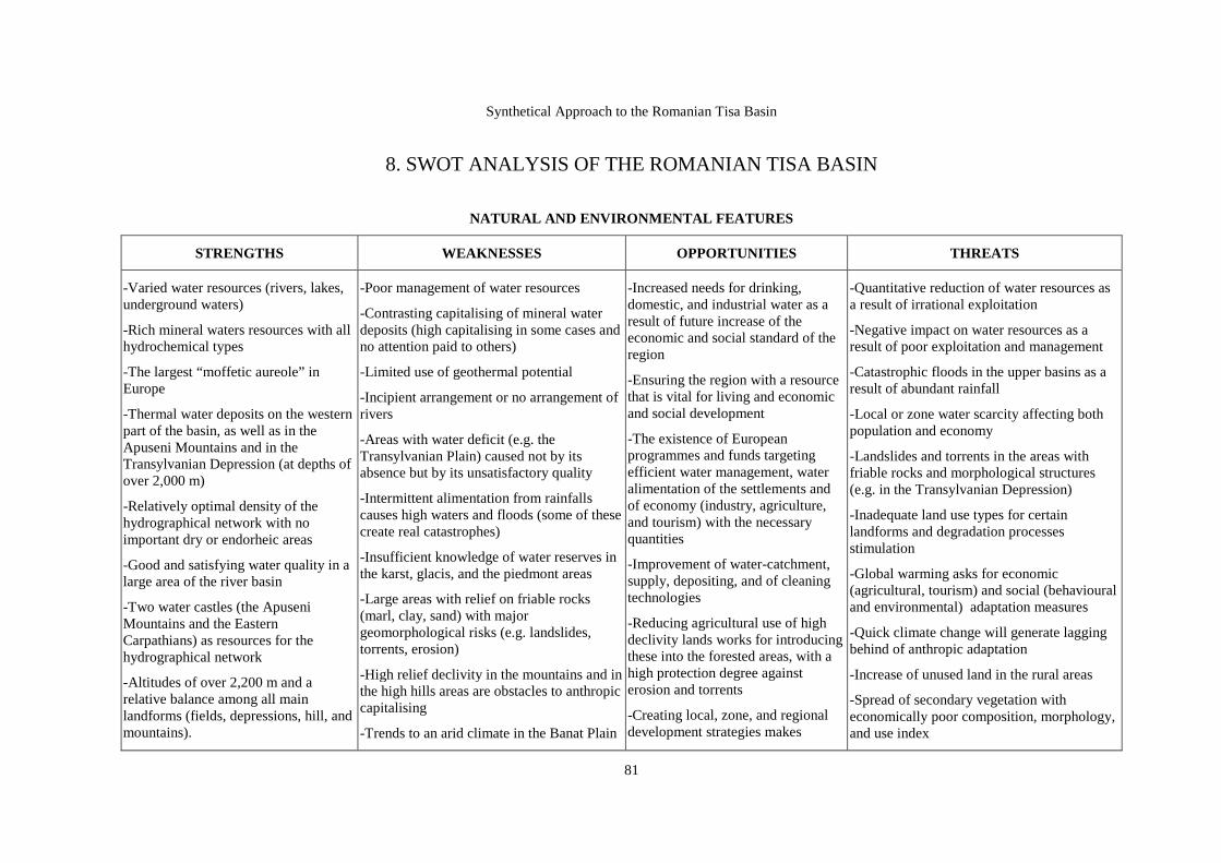
Synthetical Approach to the Romanian Tisa Basin
81
8. SWOT ANALYSIS OF THE ROMANIAN TISA BASIN
NATURAL AND ENVIRONMENTAL FEATURES
STRENGTHS WEAKNESSES OPPORTUNITIES THREATS
-Varied water resources (rivers, lakes, underground waters)
-Rich mineral waters resources with all hydrochemical types
-The largest “moffetic aureole” in Europe
-Thermal water deposits on the western part of the basin, as well as in the Apuseni Mountains and in the Transylvanian Depression (at depths of over 2,000 m)
-Relatively optimal density of the hydrographical network with no important dry or endorheic areas
-Good and satisfying water quality in a large area of the river basin
-Two water castles (the Apuseni Mountains and the Eastern Carpathians) as resources for the hydrographical network
-Altitudes of over 2,200 m and a relative balance among all main landforms (fields, depressions, hill, and mountains).
-Poor management of water resources
-Contrasting capitalising of mineral water deposits (high capitalising in some cases and no attention paid to others)
-Limited use of geothermal potential
-Incipient arrangement or no arrangement of rivers
-Areas with water deficit (e.g. the Transylvanian Plain) caused not by its absence but by its unsatisfactory quality
-Intermittent alimentation from rainfalls causes high waters and floods (some of these create real catastrophes)
-Insufficient knowledge of water reserves in the karst, glacis, and the piedmont areas
-Large areas with relief on friable rocks (marl, clay, sand) with major geomorphological risks (e.g. landslides, torrents, erosion)
-High relief declivity in the mountains and in the high hills areas are obstacles to anthropic capitalising
-Trends to an arid climate in the Banat Plain
-Increased needs for drinking, domestic, and industrial water as a result of future increase of the economic and social standard of the region
-Ensuring the region with a resource that is vital for living and economic and social development
-The existence of European programmes and funds targeting efficient water management, water alimentation of the settlements and of economy (industry, agriculture, and tourism) with the necessary quantities
-Improvement of water-catchment, supply, depositing, and of cleaning technologies
-Reducing agricultural use of high declivity lands works for introducing these into the forested areas, with a high protection degree against erosion and torrents
-Creating local, zone, and regional development strategies makes
-Quantitative reduction of water resources as a result of irrational exploitation
-Negative impact on water resources as a result of poor exploitation and management
-Catastrophic floods in the upper basins as a result of abundant rainfall
-Local or zone water scarcity affecting both population and economy
-Landslides and torrents in the areas with friable rocks and morphological structures (e.g. in the Transylvanian Depression)
-Inadequate land use types for certain landforms and degradation processes stimulation
-Global warming asks for economic (agricultural, tourism) and social (behavioural and environmental) adaptation measures
-Quick climate change will generate lagging behind of anthropic adaptation
-Increase of unused land in the rural areas
-Spread of secondary vegetation with economically poor composition, morphology, and use index

Pompei Cocean & Adriana Vartanoff - Coordinators
82
Variety of geological and morphological structures with positive impact on landscape diversity as well as on underground and tourist resources
-The river basin is characterised by temperate climate with oceanic influence, and thus with limited excesses of the meteorological parameters
-Local climate variety with impact on agriculture, on the forested areas, and on the recreation tourism activities
-Soil variety where all classes, types, and subtypes are represented
-Soil coefficient exceeds 90% and soil fertility is over the average
-Varied forested areas in what their composition is concerned (both deciduous and resinous trees), over 40% of forested areas in the mountains
-Many endemic and relic plants
-Forest steppes, hilly and mountainous pastures with high ecological potential
-Largely spread and varied fish and fauna for hunting
-Highly rich tourist patrimony (caves, mineral and thermal waters, gorges and narrow paths, historical, religious, and cultural objectives, monuments, ethnography)
and in the south-west of the Transylvanian Plain
-Climate processes included in the global climate changes in the latest 3-5 years (droughts, frequent and intense storms, a trend to a “two seasons” climate)
-Increasing erosion affected areas
-Taking out from the agricultural circuit of the fertile soils in riverbanks, terraces, and depressions
-Sequential and not generalised evaluation of soils
-Intense deforestation as a result of giving back the forested areas to their owners
-Planting valuable essences only from time to time and on small areas
-Winter mountain tourism is affected by global warming
-Lack of strong legislation for capitalising and protecting the forested areas
-Increased spreading of illegal hunting and fishing
-No strategy for tourism development
-Insufficient and modest quality tourism infrastructure
-Chaotic exploitation of underground resources
-No strategy for rational exploitation of
possible an efficient and sustainable management of the following resources: forests, fauna, soil, and underground ones
-European programmes ensure financial resources for ecological recovery of affected areas, for the protection and conservation of stable areas
-Detailed and coherent national and European environmental legislation
-Institutions and organisations involved into environmental protection, conservation, and recovery
-Orienting the economy of the country towards the service sector
-Continuous increase of internal tourists’ number
-A need for qualitative and competitive tourism products
-Price increase on the global market for certain metalbearing and nonmetal products
Mining technology perfection
-Deficit ensuring population with local agricultural products and loss of financial resources in order to import them
-Deforestation induced ecological unbalances
-Number increase and a negative impact on fauna and on the species valuable for hunting and fishing
-Settlements degradation as a result of air and water pollutant indices increase
-Appearance of cumulative phenomena of environmental factors degradation
-Attractive potential degradation
-Inefficiency of tourism as an economic branch
-Transforming the basin in a tourist flow transmitter to other destinations
-Certain underground resources (gold, salt, metalbearing substances) might leave the basin if the negative effects of their exploitation are still obvious (decantation ponds, cyanides, etc).
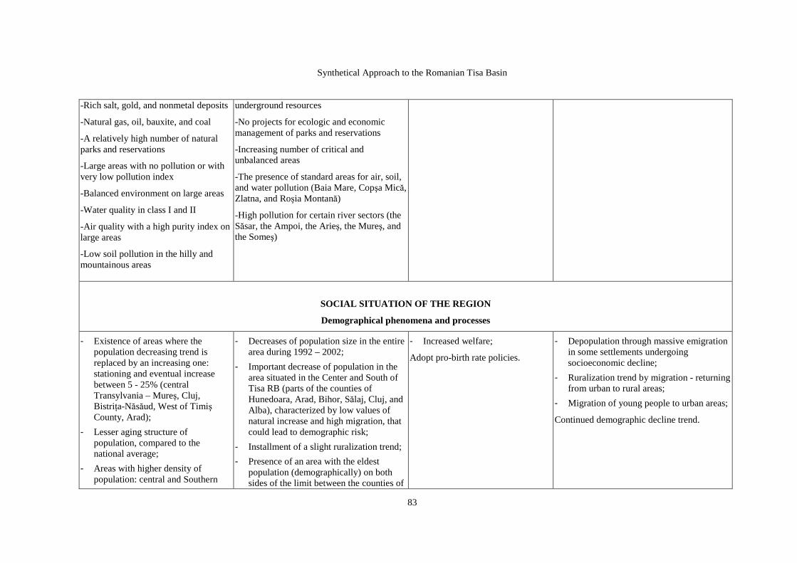
Synthetical Approach to the Romanian Tisa Basin
83
-Rich salt, gold, and nonmetal deposits
-Natural gas, oil, bauxite, and coal
-A relatively high number of natural parks and reservations
-Large areas with no pollution or with very low pollution index
-Balanced environment on large areas
-Water quality in class I and II
-Air quality with a high purity index on large areas
-Low soil pollution in the hilly and mountainous areas
underground resources
-No projects for ecologic and economic management of parks and reservations
-Increasing number of critical and unbalanced areas
-The presence of standard areas for air, soil, and water pollution (Baia Mare, Copşa Mică, Zlatna, and Roşia Montană)
-High pollution for certain river sectors (the Săsar, the Ampoi, the Arieş, the Mureş, and the Someş)
SOCIAL SITUATION OF THE REGION
Demographical phenomena and processes
- Existence of areas where the population decreasing trend is replaced by an increasing one: stationing and eventual increase between 5 - 25% (central Transylvania – Mureş, Cluj, BistriŃa-Năsăud, West of Timiş County, Arad);
- Lesser aging structure of population, compared to the national average;
- Areas with higher density of population: central and Southern
- Decreases of population size in the entire area during 1992 – 2002;
- Important decrease of population in the area situated in the Center and South of Tisa RB (parts of the counties of Hunedoara, Arad, Bihor, Sălaj, Cluj, and Alba), characterized by low values of natural increase and high migration, that could lead to demographic risk;
- Installment of a slight ruralization trend;
- Presence of an area with the eldest population (demographically) on both sides of the limit between the counties of
- Increased welfare;
Adopt pro-birth rate policies.
- Depopulation through massive emigration in some settlements undergoing socioeconomic decline;
- Ruralization trend by migration - returning from urban to rural areas;
- Migration of young people to urban areas;
Continued demographic decline trend.
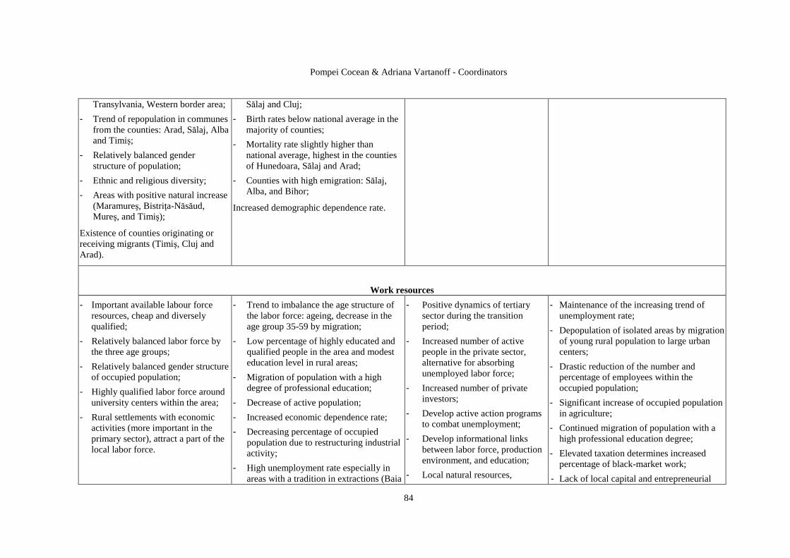
Pompei Cocean & Adriana Vartanoff - Coordinators
84
Transylvania, Western border area;
- Trend of repopulation in communes from the counties: Arad, Sălaj, Alba and Timiş;
- Relatively balanced gender structure of population;
- Ethnic and religious diversity;
- Areas with positive natural increase (Maramureş, BistriŃa-Năsăud, Mureş, and Timiş);
Existence of counties originating or receiving migrants (Timiş, Cluj and Arad).
Sălaj and Cluj;
- Birth rates below national average in the majority of counties;
- Mortality rate slightly higher than national average, highest in the counties of Hunedoara, Sălaj and Arad;
- Counties with high emigration: Sălaj, Alba, and Bihor;
Increased demographic dependence rate.
Work resources
- Important available labour force resources, cheap and diversely qualified;
- Relatively balanced labor force by the three age groups;
- Relatively balanced gender structure of occupied population;
- Highly qualified labor force around university centers within the area;
- Rural settlements with economic activities (more important in the primary sector), attract a part of the local labor force.
- Trend to imbalance the age structure of the labor force: ageing, decrease in the age group 35-59 by migration;
- Low percentage of highly educated and qualified people in the area and modest education level in rural areas;
- Migration of population with a high degree of professional education;
- Decrease of active population;
- Increased economic dependence rate;
- Decreasing percentage of occupied population due to restructuring industrial activity;
- High unemployment rate especially in areas with a tradition in extractions (Baia
- Positive dynamics of tertiary sector during the transition period;
- Increased number of active people in the private sector, alternative for absorbing unemployed labor force;
- Increased number of private investors;
- Develop active action programs to combat unemployment;
- Develop informational links between labor force, production environment, and education;
- Local natural resources,
- Maintenance of the increasing trend of unemployment rate;
- Depopulation of isolated areas by migration of young rural population to large urban centers;
- Drastic reduction of the number and percentage of employees within the occupied population;
- Significant increase of occupied population in agriculture;
- Continued migration of population with a high professional education degree;
- Elevated taxation determines increased percentage of black-market work;
- Lack of local capital and entrepreneurial

Synthetical Approach to the Romanian Tisa Basin
85
Mare Depression, Apuseni Mountains), also in large cities;
- Long-term unemployment, with consequences on welfare;
- Lack of alternatives for the labor force from mono-industry areas;
- Lack of professional orientation centers and adequate labour force re-conversion programs;
- Depopulation by migration of towns in economic decline (Cehu Silvaniei, and Târgu Lăpuş).
traditions and crafts – opportunities to create new jobs;
- Found disfavored areas –attractive for investors;
- Border position of Timiş, Arad, Bihor and Satu Mare counties, favouring crossborder cooperation, generating new jobs and investments.
culture;
- Inexistence of partnerships and socioeconomic cooperation networks between local stakeholders and local and regional authorities;
- Unfavourable image of mining areas disadvantaged by the decline of extractive industry and its secondary effects (economic de-structuring, unemployment, poverty, instability).
Social infrastructure
- Higher education developed in traditional centers;
- Territorially balanced network of high school and post-high school education institutions;
- Relatively balanced network of health institutions with a territorial role: public hospitals and policlinics providing access to emergency services;
- Presence of international level medical universities and research centers;
- Existence of culture and art units recognized as pillars of Romanian cultural life in the urban areas.
- Rural areas with a reduced number of pupils per instructor and classroom;
- Acute lack of specialized instructional personnel in professional, complementary and post-high school education;
- Rural areas with a deficit of primary medical services: 25 communes without medical doctor, areas with over 2800 people/medical doctor, no pharmacy in 90% of the communes;
- Presence of areas with low values of housing indicators;
- High costs of housing;
- Rural areas with a deficit in housing infrastructure.
- Existence of a legislative base of education according to European standards by adopting the implementation of Lisbon strategy and promotion of Bologna process;
- Shape a national network of innovative regions contributing to the adaptation of national policies on research, technological development and innovation to the specific conditions of each region;
- European funding for education, health, housing, culture via Structural Funds.
- Miscorrelation of education strategies with socioeconomic development and continuation of empirical experiments on organizing the educational system;
- Incapacity to attract and absorb Structural Funds for education, research-innovation, health, housing, and culture;
- Intensification of the phenomenon of migration of highly-specialized young personnel;
- Emergence of urban areas characterized by residential segregation due to a deficit of urban planning.
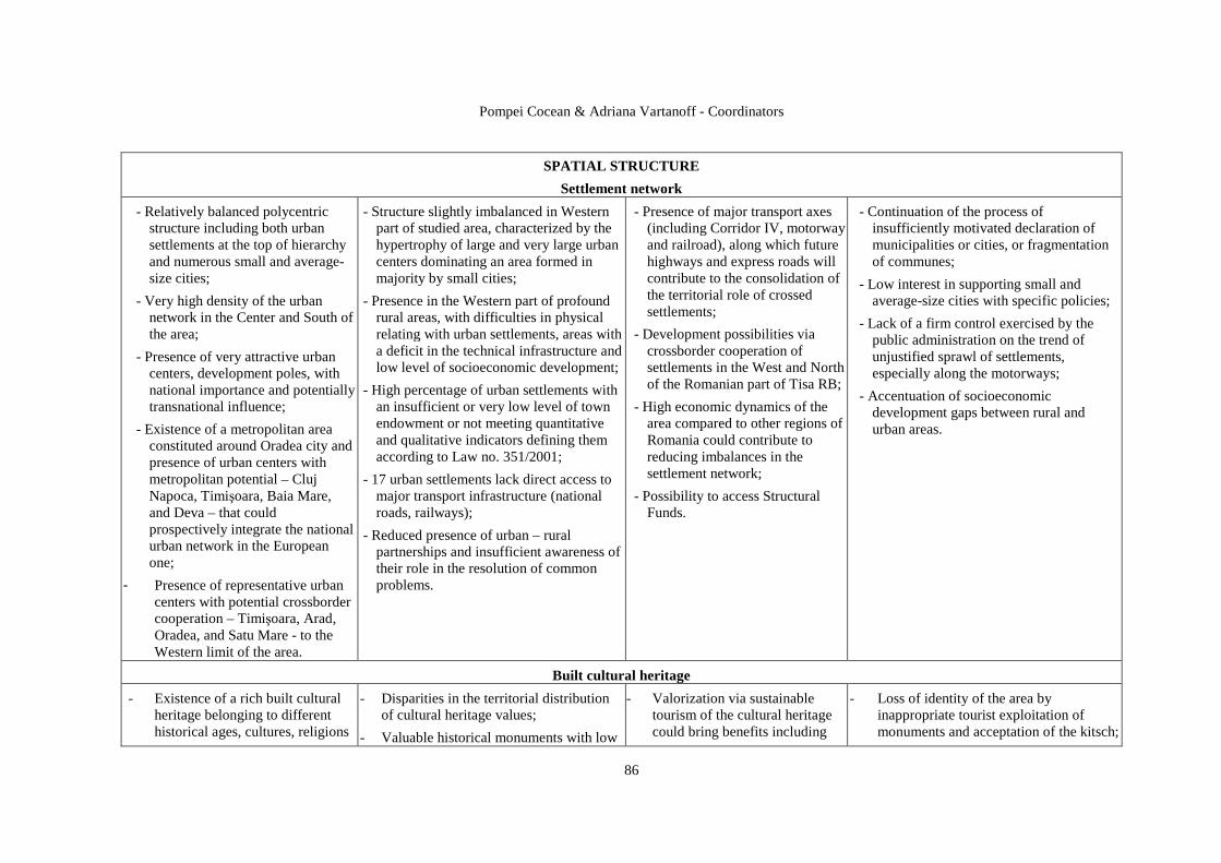
Pompei Cocean & Adriana Vartanoff - Coordinators
86
SPATIAL STRUCTURE
Settlement network
- Relatively balanced polycentric structure including both urban settlements at the top of hierarchy and numerous small and average-size cities;
- Very high density of the urban network in the Center and South of the area;
- Presence of very attractive urban centers, development poles, with national importance and potentially transnational influence;
- Existence of a metropolitan area constituted around Oradea city and presence of urban centers with metropolitan potential – Cluj Napoca, Timişoara, Baia Mare, and Deva – that could prospectively integrate the national urban network in the European one;
- Presence of representative urban centers with potential crossborder cooperation – Timişoara, Arad, Oradea, and Satu Mare - to the Western limit of the area.
- Structure slightly imbalanced in Western part of studied area, characterized by the hypertrophy of large and very large urban centers dominating an area formed in majority by small cities;
- Presence in the Western part of profound rural areas, with difficulties in physical relating with urban settlements, areas with a deficit in the technical infrastructure and low level of socioeconomic development;
- High percentage of urban settlements with an insufficient or very low level of town endowment or not meeting quantitative and qualitative indicators defining them according to Law no. 351/2001;
- 17 urban settlements lack direct access to major transport infrastructure (national roads, railways);
- Reduced presence of urban – rural partnerships and insufficient awareness of their role in the resolution of common problems.
- Presence of major transport axes (including Corridor IV, motorway and railroad), along which future highways and express roads will contribute to the consolidation of the territorial role of crossed settlements;
- Development possibilities via crossborder cooperation of settlements in the West and North of the Romanian part of Tisa RB;
- High economic dynamics of the area compared to other regions of Romania could contribute to reducing imbalances in the settlement network;
- Possibility to access Structural Funds.
- Continuation of the process of insufficiently motivated declaration of municipalities or cities, or fragmentation of communes;
- Low interest in supporting small and average-size cities with specific policies;
- Lack of a firm control exercised by the public administration on the trend of unjustified sprawl of settlements, especially along the motorways;
- Accentuation of socioeconomic development gaps between rural and urban areas.
Built cultural heritage
- Existence of a rich built cultural heritage belonging to different historical ages, cultures, religions
- Disparities in the territorial distribution of cultural heritage values;
- Valuable historical monuments with low
- Valorization via sustainable tourism of the cultural heritage could bring benefits including
- Loss of identity of the area by inappropriate tourist exploitation of monuments and acceptation of the kitsch;
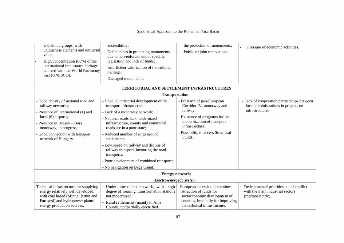
Synthetical Approach to the Romanian Tisa Basin
87
and ethnic groups, with uniqueness elements and universal value;
- High concentration (66%) of the international importance heritage enlisted with the World Patrimony List (UNESCO).
accessibility;
- Deficiencies in protecting monuments, due to non-enforcement of specific legislation and lack of funds;
- Insufficient valorization of the cultural heritage;
- Damaged monuments.
the protection of monuments;
- Public or joint renovations.
- Pressure of economic activities.
TERRITORIAL AND SETTLEMENT INFRASTRUCTURES
Transportation
- Good density of national road and railway networks;
- Presence of international (1) and local (6) airports;
- Presence of Braşov – Borş motorway, in progress;
- Good connection with transport network of Hungary.
- Unequal territorial development of the transport infrastructure;
- Lack of a motorway network;
- National roads lack modernized infrastructure, county and communal roads are in a poor state;
- Reduced number of rings around settlements;
- Low speed on railway and decline of railway transport, favouring the road transports;
- Poor development of combined transport;
- No navigation on Bega Canal.
- Presence of pan-European Corridor IV, motorway and railway;
- Existence of programs for the modernization of transport infrastructure;
- Possibility to access Structural Funds.
- Lack of cooperation partnerships between local administrations in projects on infrastructure.
Energy networks
Electro-energetic system
- Technical infrastructure for supplying energy relatively well developed, with coal based (Mintia, Iernut and Paroşeni) and hydropower plants energy production sources.
- Under-dimensioned networks, with a high degree of wearing, transformation stations not modernized;
- Rural settlements (mainly in Alba County) not/partially electrified.
- European accession determines attraction of funds for socioeconomic development of counties, implicitly for improving the technical infrastructure.
- Environmental priorities could conflict with the main industrial sectors (thermoelectric).
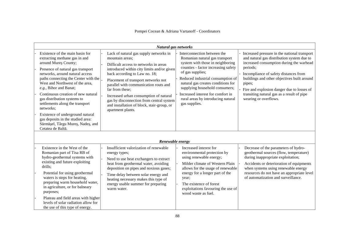
Pompei Cocean & Adriana Vartanoff - Coordinators
88
Natural gas networks
- Existence of the main basin for extracting methane gas in and around Mureş County;
- Presence of natural gas transport networks, around natural access paths connecting the Center with the West and Northwest of the area, e.g., Bihor and Banat;
- Continuous creation of new natural gas distribution systems to settlements along the transport networks;
- Existence of underground natural gas deposits in the studied area: Sărmăşel, Târgu Mureş, Nadeş, and Cetatea de Baltă.
- Lack of natural gas supply networks in mountain areas;
- Difficult access to networks in areas introduced within city limits and/or given back according to Law no. 18;
- Placement of transport networks not parallel with communication routs and far from these;
- Increased urban consumption of natural gas by disconnection from central system and installation of block, stair-group, or apartment plants.
- Interconnection between the Romanian natural gas transport system with those in neighboring counties - factor increasing safety of gas supplies;
- Reduced industrial consumption of natural gas creates conditions for supplying household consumers;
- Increased interest for comfort in rural areas by introducing natural gas supplies.
- Increased pressure in the national transport and natural gas distribution system due to increased consumption during the warhead periods;
- Incompliance of safety distances from buildings and other objectives built around pipes;
- Fire and explosion danger due to losses of transiting natural gas as a result of pipe wearing or overflows.
Renewable energy
- Existence in the West of the Romanian part of Tisa RB of hydro-geothermal systems with existing and future exploiting drills;
- Potential for using geothermal waters is steps for heating, preparing warm household water, in agriculture, or for balneary purposes;
- Plateau and field areas with higher levels of solar radiation allow for the use of this type of energy.
- Insufficient valorization of renewable energy types;
- Need to use heat exchangers to extract heat from geothermal water, avoiding deposition on pipes and noxious gases;
- Time delay between solar energy and heating necessary makes this type of energy usable summer for preparing warm water.
- Increased interest for environmental protection by using renewable energy;
- Milder climate of Western Plain allows for the usage of renewable energy for a longer part of the year;
- The existence of forest exploitations favouring the use of wood waste as fuel.
- Decrease of the parameters of hydro-geothermal sources (flow, temperature) during inappropriate exploitation;
- Accidents or deterioration of equipments when systems using renewable energy resources do not have an appropriate level of automatization and surveillance.

Synthetical Approach to the Romanian Tisa Basin
89
Communication system
- Predominance of the private system and total liberalization of telephony market;
- Exponential increase of investments and development of telecommunication infrastructure;
- High technological level, especially in mobile telecommunication;
- Legislative framework meets international requirements;
- Highly qualified human resources and potential.
- Reduced density due to late liberalization of fixed telephony market;
- Imbalanced territorial development of telecommunications;
- Low number of Internet users;
- Low competition in fixed telephony;
- Low development of broadband telecommunications.
- Improvement of the general economic climate in Romania;
- Increase attractiveness of Romania to foreign investors;
- Worldwide emergence and development of new technologies involving low costs and offering more bands;
- Rapid worldwide rhythm of developing telecommunications.
- Low welfare, limiting the demand and investing opportunities;
- Low capacity of attracting and using European funds;
- Migration of highly qualified labour force from this field to other countries.
Water management system
Water and town infrastructure
- Existence of water sources for supplying population close to human settlements, especially in Central Transylvania;
- All urban settlements endowed with central water supply systems and sewerage of wastewaters.
- Low drinkable water supply via central equipments in rural settlements;
- Very low degree of sewerage and wastewater treatment in rural areas;
- Very few settlements have wastewater treatment plants.
- Existence of programs for investments in local infrastructure, with possibilities for partially non-reimbursable funding from European Union Structural Funds.
- Aquatic environment affected by uncontrolled dumping of wastewaters;
- Water resources affected by intensive and uncontrolled exploitation;
- Depopulation of human settlements, especially rural, due to the lack of water and town equipments.
Flood protection infrastructure
- Existence of important flood protection works in the area: dams, bank protection, and river regularizations.
- Under-dimensioned flood protection works, with uncertain protection degree and exceeded protection class with respect to the objective;
- Protection works not fixed after floods;
- Watercourses not maintained, with deposits
- Existence of the Management Plan of the River Basin, instrument for implementing Framework Directive 2000/60/EC;
- Adapt and apply Community legislation on natural hazards;
- Existence on programs on limiting
- Increased material and human losses due to floods;
- Environmental impact with serious consequences on future generations.
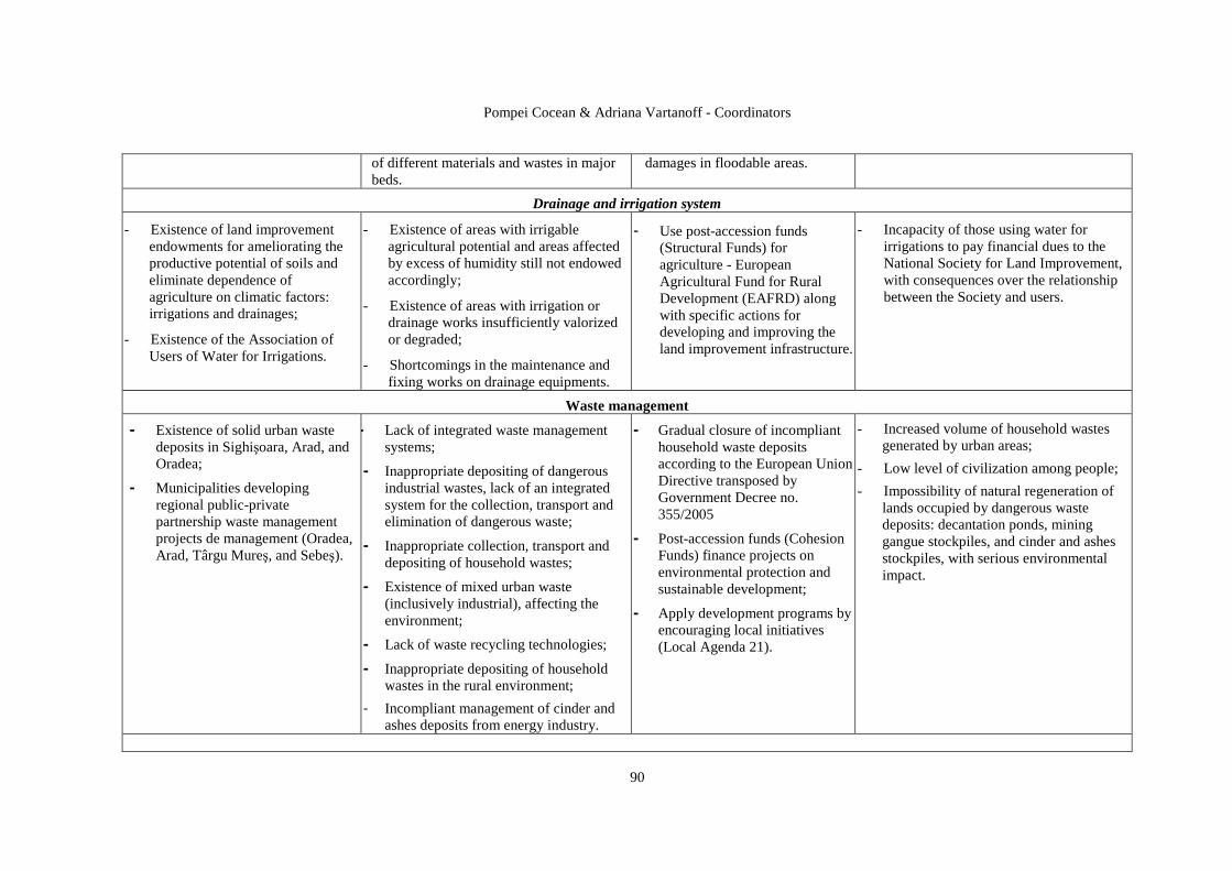
Pompei Cocean & Adriana Vartanoff - Coordinators
90
of different materials and wastes in major beds.
damages in floodable areas.
Drainage and irrigation system
- Existence of land improvement endowments for ameliorating the productive potential of soils and eliminate dependence of agriculture on climatic factors: irrigations and drainages;
- Existence of the Association of Users of Water for Irrigations.
- Existence of areas with irrigable agricultural potential and areas affected by excess of humidity still not endowed accordingly;
- Existence of areas with irrigation or drainage works insufficiently valorized or degraded;
- Shortcomings in the maintenance and fixing works on drainage equipments.
- Use post-accession funds (Structural Funds) for agriculture - European Agricultural Fund for Rural Development (EAFRD) along with specific actions for developing and improving the land improvement infrastructure.
- Incapacity of those using water for irrigations to pay financial dues to the National Society for Land Improvement, with consequences over the relationship between the Society and users.
Waste management
- Existence of solid urban waste deposits in Sighişoara, Arad, and Oradea;
- Municipalities developing regional public-private partnership waste management projects de management (Oradea, Arad, Târgu Mureş, and Sebeş).
- Lack of integrated waste management systems;
- Inappropriate depositing of dangerous industrial wastes, lack of an integrated system for the collection, transport and elimination of dangerous waste;
- Inappropriate collection, transport and depositing of household wastes;
- Existence of mixed urban waste (inclusively industrial), affecting the environment;
- Lack of waste recycling technologies;
- Inappropriate depositing of household wastes in the rural environment;
- Incompliant management of cinder and ashes deposits from energy industry.
- Gradual closure of incompliant household waste deposits according to the European Union Directive transposed by Government Decree no. 355/2005
- Post-accession funds (Cohesion Funds) finance projects on environmental protection and sustainable development;
- Apply development programs by encouraging local initiatives (Local Agenda 21).
- Increased volume of household wastes generated by urban areas;
- Low level of civilization among people;
- Impossibility of natural regeneration of lands occupied by dangerous waste deposits: decantation ponds, mining gangue stockpiles, and cinder and ashes stockpiles, with serious environmental impact.
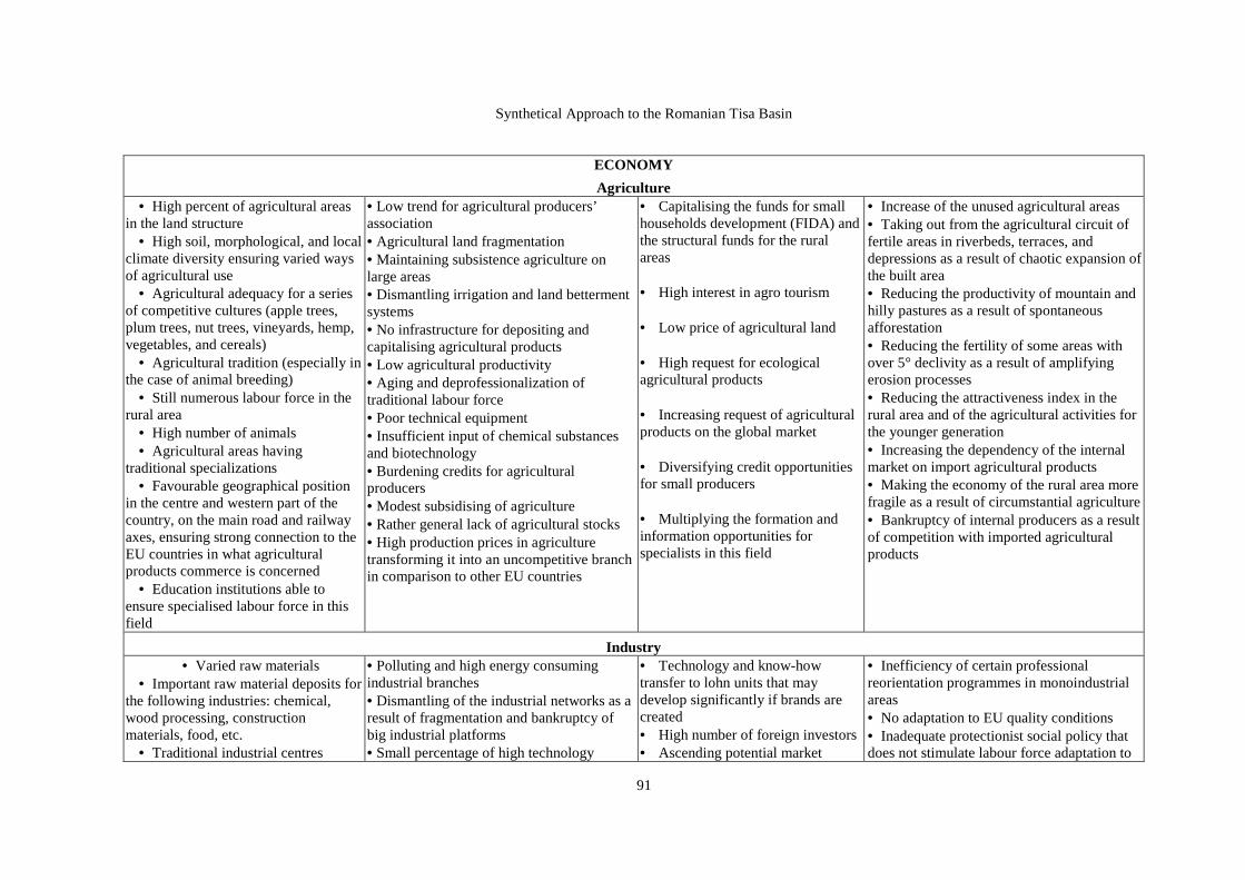
Synthetical Approach to the Romanian Tisa Basin
91
ECONOMY
Agriculture • High percent of agricultural areas
in the land structure • High soil, morphological, and local
climate diversity ensuring varied ways of agricultural use
• Agricultural adequacy for a series of competitive cultures (apple trees, plum trees, nut trees, vineyards, hemp, vegetables, and cereals)
• Agricultural tradition (especially in the case of animal breeding)
• Still numerous labour force in the rural area
• High number of animals • Agricultural areas having
traditional specializations • Favourable geographical position
in the centre and western part of the country, on the main road and railway axes, ensuring strong connection to the EU countries in what agricultural products commerce is concerned
• Education institutions able to ensure specialised labour force in this field
• Low trend for agricultural producers’ association • Agricultural land fragmentation • Maintaining subsistence agriculture on large areas • Dismantling irrigation and land betterment systems • No infrastructure for depositing and capitalising agricultural products • Low agricultural productivity • Aging and deprofessionalization of traditional labour force • Poor technical equipment • Insufficient input of chemical substances and biotechnology • Burdening credits for agricultural producers • Modest subsidising of agriculture • Rather general lack of agricultural stocks • High production prices in agriculture transforming it into an uncompetitive branch in comparison to other EU countries
• Capitalising the funds for small households development (FIDA) and the structural funds for the rural areas • High interest in agro tourism • Low price of agricultural land • High request for ecological agricultural products • Increasing request of agricultural products on the global market • Diversifying credit opportunities for small producers • Multiplying the formation and information opportunities for specialists in this field
• Increase of the unused agricultural areas • Taking out from the agricultural circuit of fertile areas in riverbeds, terraces, and depressions as a result of chaotic expansion of the built area • Reducing the productivity of mountain and hilly pastures as a result of spontaneous afforestation • Reducing the fertility of some areas with over 5° declivity as a result of amplifying erosion processes • Reducing the attractiveness index in the rural area and of the agricultural activities for the younger generation • Increasing the dependency of the internal market on import agricultural products • Making the economy of the rural area more fragile as a result of circumstantial agriculture • Bankruptcy of internal producers as a result of competition with imported agricultural products
Industry • Varied raw materials
• Important raw material deposits for the following industries: chemical, wood processing, construction materials, food, etc.
• Traditional industrial centres
• Polluting and high energy consuming industrial branches • Dismantling of the industrial networks as a result of fragmentation and bankruptcy of big industrial platforms • Small percentage of high technology
• Technology and know-how transfer to lohn units that may develop significantly if brands are created • High number of foreign investors • Ascending potential market
• Inefficiency of certain professional reorientation programmes in monoindustrial areas • No adaptation to EU quality conditions • Inadequate protectionist social policy that does not stimulate labour force adaptation to

Pompei Cocean & Adriana Vartanoff - Coordinators
92
• Diverse activity fields of economic agents
• Successful restructuring of certain industrial branches
• Good start of IT industry • Increasing labour productivity • Qualified labour force, especially
for mechanics and machine construction
• Diverse economic structures facilitating cooperation among economic branches
• Numerical increase and profile diversifying of industrial parks
• Very good technical education institutions
industry • Intra-regional disparities • Economic structures using extensively labour force and resources • Small number of small and medium-sized industrial units in disadvantaged and rural areas • High percentage of lohn industry • Monoindustrial areas and restructuring areas • Weak cooperation between the economic sector and research institutes • Unused production areas and production capacities • Small offers from banks in comparison to the needs of small and medium-sized industrial units • Involution of the internal traditional market • Small investments in human resources of the small and medium-sized industrial units • Poor management of certain industrial units
• Stimulating cooperation among small and medium-sized industrial units and thus increasing the added value of regional products • Identifying market opportunities • Building a network of highways and express ways • Meeting the needs of areas where small and medium-sized industrial units may develop • Financial programmes for supporting small and medium-sized industrial units • Strengthening the firms for economic and technological counseling • Macroeconomic stabilization • Getting involved into programmes for stimulating non-polluting and recycling industries
new economic conditions • Poor correlation of regional and local development programs • Dependency on imported industrial products • Competitiveness and market decrease for national industrial products • Difficult procedures in public administration and in financial sector • Deprofessionalization the extant labour force • Migration of young and specialised labour force to other regions and countries • Industry decrease in GNP and, thus, the appearance of a “service economy”) • Raw material export increase (timber, mineral substances, salt) characteristic of low developed economy countries
Tourism
Optimum dissipation of attractive resources and infrastructure in the entire river basin
Attractive offer in Europe (speotourism, balneal tourism, rural tourism)
Favourable geographical position in what the tourists continental fluxes are
Moral degradation and wear of accommodation, pleasure and cure infrastructure
Modest promotion of the attractive offers
Low level of tourism in the regional GNP
Poor balance between offer and price for tourism services
Road infrastructure below European standards
Lack or little similar offer (for certain tourism types and forms) in the neighbouring regions
Modernizing the IV and the VI continental road transport corridors
Increase of request for cultural tourism (both ethnical and religious)
Increasing request for new destinations
Degradation of cultural tourism values (e.g. the ethnographical ones)
Social and economic inefficiency of tourism
Lagging behind in what competitiveness is concerned as compared to the neighbouring river basins
Orienting internal request towards other destinations
Request may go as a rule to tourist sites

Synthetical Approach to the Romanian Tisa Basin
93
concerned
A large number of airports for medium distance
The largest balneary resorts of Romania (e.g. Băile Felix – 6,070 places)
Superior education institutions involved into human resource training
Favourable geographical position for increasing transit tourism
Lack of regional tourism brands
Still modest number of destinations and trips
No airport for long distance (intercontinental) traffic
Little varied infrastructure for transit tourism and for the tourism of the young
No integrated tourism networks
Revival of air transport after the decline of 2001
Harmonizing internal tourism legislation with the European one
American and Asian tourists’ number increase
Possibilities of accessing European FEDER funds
outside the river basin
Eliminating tourism as an alternative to the economic development of certain areas
CROSS-BORDER COOPERATION
Facilitating presence interrelations of national minorities in the cross-border strips
Many biunivocal relations
Infrastructure elements able to maintain an ascendant trend of economic and social exchanges
Polarizing role of EU
Lack of big regional cooperation
Shortcomings induced by lack of railway and road infrastructure connections
Formal and pertaining to State etiquette nature of many interrelations
Difficulties in diversifying interrelations as a result of political circumstances (as Serbia and Ukraine are not in the EU)
Lack of common legislation for the interested states
Supporting cross-border relations with EU development strategies
Opportunities offered in „no man land” type areas overlapping, usually, cross-border strips
Making the political regimes in Serbia and Ukraine more democratic
Trend of making border functions more flexible and permissive
Functional unbalances in interrelations
Perpetuation of certain nostalgic factors in cross-border interrelations
Perpetuation of the inertia of cross-border as a discontinuity
Social and economic inefficiency of interrelations Perpetuation of formal nature interrelations
Pompei Cocean & Adriana Vartanoff - Coordinators
94
REFERENCES
1. Antonescu Daniela (2003), Dezvoltarea regională în Romnia, Editura Oscar Print, Bucureşti. 2. Benedek, J. (2004), Amenajarea teritoriului şi dezvoltarea regională, Editura Presa Universitară
Clujeană, Cluj Napoca; 3. Berry, B. J. L. (1961), City size distributions and economic development, Economic
Development and Cultural Change, 9, 573-88. 4. Bogdan, Octavia, Niculescu, Elena (1999), Riscurile climatice din România, Academia
Română, Institutul de Geografie, Editur Compania Saga - International, Bucureşti. 5. Bold, I., Crăciun, A. (1999), Organizarea teritoriului. Edit. Mirton, Timişoara. 6. Borcoş, M., Udubaşa, G., Săndulescu, M., Krautner, H., Năstaseanu, I., BiŃioanu, C.,
Rădan, S. (1984) Atlas geologic 1:1000000. Harta substanŃelor minerale utile. Ed. a II-a. Ministerul Geologiei, Institutul de Geologie şi Geofizică. Bucureşti.
7. Botez, M., Celac, Mariana (1980), Sistemele spaŃiului amenajat, Edit. ŞtiinŃifică şi Enciclopedică, Bucureşti
8. Bryant, E. A. (1991), Natural Hazards, Cambridge University Press. 9. Christaller, W. (1966), Central places in Southern Germany (translated by C. Baskin),
Englewood Cliffs, New York, biblioteca Univ. Leicester. 10. Cocean, P. (2004- Coordonator), Planul de Amenajare a Teritoriului Regiunii de Nord-Vest.
Coordonate majore, Editura Presa Universitară Clujeană 11. Cocean, P. (2005), Geografie Regională, EdiŃia a II-a, Editura Presa Universitară Clujeană. 12. Cocean, P. (2007), Amenajarea teritoriilor periurbane. Studiu de caz: zona periurbană BistriŃa,
Editura Presa Universitară Clujeasnă 13. Croitoru, Adina-Eliza (2007), Excesul de precipiaŃii din Depresiunea Transilvaniei, Editura
Casa CărŃii de ŞtiinŃă, Cluj- Napoca. 14. Deneke, D., Gareth, S. (1988), Urban expansion, Planning, vol. 3. 15. Dragotă, Carmen-Sofia (2007), PreciptiaŃiile excedentare în România, Editura Academiei
Române, Bucureşti. 16. Erdely, G. et all. (1999), DicŃionar. Geografie umană, Edit. Corint, Bucureşti. 17. Felmann, J., Getis, A., Getis, J. (1990), Human Geography, Wm. C. Brown Publishers. 18. Gaceu, O. (2005), Clima şi riscurile climatice din MunŃii Bihor-Vlădeasa, Editura UniversităŃii
din Oradea. 19. Gusti, G. (1974), Forme noi de aşezare, Ed. Tehnică, Bucureşti. 20. Hall, P. (1999), Oraşele de mâine. O istorie intelectuală a urbanismului în secolul XX, Edit. All,
Bucureşti. 21. Hofmeister, B. (1982), Die Stadtstructur in interkulturen verligh, Geographische Rundscow, II. 22. Hudson, F. S. (1976), Geography of settlements, Second edit., Macdonald end Evans Ltd.,
Estover, Plymouth. 23. Ianos, I. (1987), Oraşele şi organizarea spaŃiului geografic, Edit. Academiei R.S.R., Bucureşti. 24. Ianoş, I. (2000), Sisteme teritoriale, Editura Tehnică Bucureşti. 25. Ianoş, I., J-B. Humeau (2000), Teoria sistemelor de aşezări umane, Edit. Tehnică, Bucureşti 26. Ilieş Alexandru (2004), România. Euroregiuni, Editura UniversităŃii din Oradea, Oradea. 27. Lăzărescu, C. (1977), Urbanismul în România, Edit. Tehnică, Bucureşti. 28. Lösch, A. (1954), The economics of location, Yale University Press, New Haven, 29. Mih ăilescu, N., Grigore, I. (1981). Resurse minerale pentru materiale de construcŃii în
România. Ghid practic. Editura Tehnică, Bucureşti. 422 p. 30. Molnár, E., Maier, A., Ciangă, N. (1975), Centre şi arii de convergenŃă din România, Studia
Univ. Babeş-Bolyai, Ser. Geographia. 31. Moldovan, F. (2003), Fenomene climatice de risc, Editura Echinox, Cluj-Napoca. 32. Pârvu, G., Mocanu, Gh., Hibomvschi, C., Grecescu, A. (1977). Roci utile din România.
Editura tehnică, Bucureşti. 408 p. 33. Mumford, L. (1947), City development, Secker and Worbury, Biblioteca Univ. Leicester.

Synthetical Approach to the Romanian Tisa Basin
95
34. Nagy Egon (2003), Riscuri potenŃiale în zonele de frontieră, in: Sorocovschi V. (coord.) Riscuri şi catastrofe, Casa CărŃii de ŞtiinŃă, Cluj-Napoca.
35. Nagy Imre (coord.) (2004), A Strategy for the Danube-Criş-Mureş-Tisa Euroregion, Hungarian Academy of Science, Centre for Regional Studies, Alföld Institute, Békéscsaba
36. Nistor, I. (2000), Comuna şi judeŃul în evoluŃia istorică, Edit. Dacia, Cluj-Napoca. 37. Smith, D. M. (1975), Industrial location. An economic geographical analysis, John Wiley and
Sons, NY, London, Sydney, Toronto. 38. Stoica, C., Gherasie, I. (1981). Sarea şi sărurile de potasiu şi magneziu din România. Editura
tehnică, Bucureşti.248 p. 39. Surd, V. (2001), Introducere în geografia spaŃiului rural, Ed. Presa Universitară Clujeană, Cluj-Napoca. 40. Surd, V. (2003), Geografia aşezărilor , Ed. Presa Universitară Clujeană, Cluj-Napoca. 41. Vandermotten, C., Vermoesen, F., De Lannoy, W., De Corte, St. (1999), Villes d’Europe.
Cartographie comparative, în: Bulletin du credit communal, Trimestriel, 53e année, no. 207-208, 1-2, Belgique.
42. Vincze, Maria (2000), Dezvoltarea regională şi rurală. Idei şi practici, Edit. Presa Universitară Clujeană, Cluj-Napoca.
43. Waugh, D. (2000), Geography. An Integrated Approach. Third Edit., Nelson, Mayfield Road, Surrey, U.K.
44. x x x (1998), Planul de Amenajare a Teritoriului NaŃional. 45. x x x (1994), European Spatial Research and Policy, Volume 1, no. 2, Lodz University Press,
Poland. 46. x x x (1998), Carta Verde a Dezvoltării Rurale. 47. x x x PATIJ (Planul de Amenajare a Teritoriului InterjudeŃean), 1997-1999 48. x x x PATR (Planul de Amenajare a Teritoriului Regiunii de Nord-Vest (2000-2004), 49. x x x PATZ – municipiul BistriŃa – 2005-2006 50. x x x PATZ – municipiul Sibiu – 2005-2006 51. x x x PUG-ul judeŃelor aparŃinând bazinului romanesc al Tisei
• PATIJ (Planul de Amenajare a Teritoriului InterjudeŃean), 1997-1999
• PATR (planul de Amenajare a Teritoriului Regiunii de Nord-Vest (2000-2004),
• PATZ – municipiul BistriŃa – 2005-2006
• PATZ – municipiul Sibiu – 2005-2006
• PUG-ul judeŃelor aparŃinând bazinului romanesc al Tise
Legislation HG 2151/2004 privind instituirea regimului de arie naturală protejată pentru noi zone Legea nr. 2/1968 privind organizarea administrativă a teritoriului Republicii Socialiste România cu
modificările ulterioare Legea nr. 71/1996 privind aprobarea PATN – SecŃiunea I – Căi de comunicaŃie Legea nr. 171/1997 privind aprobarea PATN – SecŃiunea a II-a – Apa Legea nr. 5/2000 privind aprobarea PATN – SecŃiunea a III-a – Zone protejate Legea nr. 350 din 6 iulie 2001 privind Amenajarea teritoriului şi urbanismul Legea nr. 351/2001 privind aprobarea PATN – SecŃiunea a IV-a – ReŃeaua de localităŃi Legea 433/2001 privind regimul ariilor naturale protejate, conservarea habitatelor naturale, a florei
şi faunei sălbatice Legea nr. 575/2001 privind aprobarea PATN – SecŃiunea a V-a – Zone de risc natural Legea nr. 451/2002 pentru ratificarea ConvenŃiei Europene a Peisajulu

Pompei Cocean & Adriana Vartanoff - Coordinators
96
Annexes
1. MORPHOGENETICAL LEVELS;
2. PHREATIC WATERS MAP;
3. REGIONALISATION OF CLIMATE HAZARDS;
4. SOIL MAP;
5. FREQUENCY OF FORESTED AREAS ON COMMUNES;
6. DISTRIBUTION OF USEFUL MINERAL SUBSTANCES ACCUMULATIONS;
7. ENVIRONMENTAL STATE. IMPACT, DISFUNCTIONALITIES AND CRITICAL
AREAS;
8. TECHNOLOGICAL, GEOMORPHOLOGICAL AND HYDROLOGICFAL RISKS
ZONNING;
9. NATURAL PATRIMONY AND PROTECTED AREAS;
10. BUILT CULTURAL HERITAGE;
11. ELEMENTS OF THE BUILT PATRIMONY AND THE “LAND” TYPE UNITS;
12. DENSITY OF POPULATION – 2002;
13. NATURAL INCREASE OF POPULATION – 2002;
14. EDUCATION INFRASTRUCTURE;
15. HEALTHCARE INFRASTRUCTURE;
16. HOUSING;
17. SETTLEMENT NETWORK;
18. TRANSPORT;
19. POWER, ENERGY AND COMMUNICATION SYSTEM;
20. NATURAL GAS NETWORKS AND RENWABLE ENERGY;
21. WATER MANAGEMENT SYSTEM;
22. WASTE MANAGEMENT-TEHNICAL INFRASTRUCTURE;
23. AGRICULTURE ZONNING;
24. MAP OF INDUSTRY;
25. TOURISTIC INFRASTRUCTURE OF ACCOMODATION;
26. POTENTIAL DIRECTION OF DEVELOPMENT.