Syllabus of B - Aligarh Muslim University of sedimentary rocks: terrigenous and chemical sedimentary...
76
S Y L L A B U S FOR THE SESSION 2013-2014 B.Sc. (HONS.) GEOLOGY AND M.Sc. (APPLIED GEOLOGY) DEPARTMENT OF GEOLOGY ALIGARH MUSLIM UNIVERSITY ALIGARH
Transcript of Syllabus of B - Aligarh Muslim University of sedimentary rocks: terrigenous and chemical sedimentary...
S Y L L A B U S FOR THE SESSION 2013-2014 B.Sc. (HONS.) GEOLOGY AND M.Sc. (APPLIED GEOLOGY) DEPARTMENT OF GEOLOGY
ALIGARH MUSLIM UNIVERSITY ALIGARH
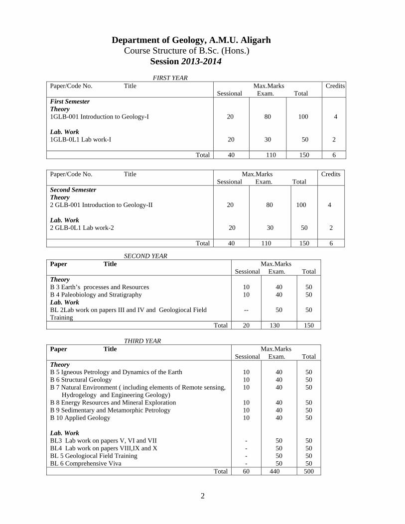
Department of Geology, A.M.U. Aligarh
Course Structure of B.Sc. (Hons.) Session 2013-2014
FIRST YEAR Paper/Code No. Title
Max.Marks Sessional Exam. Total
Credits
First Semester Theory 1GLB-001 Introduction to Geology-I Lab. Work 1GLB-0L1 Lab work-I
20
20
80
30
100
50
4
2
Total 40 110 150 6
Paper/Code No. Title Max.Marks
Sessional Exam. Total Credits
Second Semester Theory 2 GLB-001 Introduction to Geology-II Lab. Work 2 GLB-0L1 Lab work-2
20
20
80
30
100
50
4
2
Total 40 110 150 6
SECOND YEAR Paper Title Max.Marks
Sessional Exam. Total Theory B 3 Earth’s processes and Resources B 4 Paleobiology and Stratigraphy Lab. Work BL 2Lab work on papers III and IV and Geologiocal Field Training
10 10
--
40 40
50
50 50
50
Total 20 130 150 THIRD YEAR
Paper Title Max.Marks Sessional Exam. Total
Theory B 5 Igneous Petrology and Dynamics of the Earth B 6 Structural Geology B 7 Natural Environment ( including elements of Remote sensing, Hydrogelogy and Engineering Geology) B 8 Energy Resources and Mineral Exploration B 9 Sedimentary and Metamorphic Petrology B 10 Applied Geology Lab. Work BL3 Lab work on papers V, VI and VII BL4 Lab work on papers VIII,IX and X BL 5 Geologiocal Field Training BL 6 Comprehensive Viva
10 10 10
10 10 10
- - - -
40 40 40
40 40 40
50 50 50 50
50 50 50
50 50 50
50 50 50 50
Total 60 440 500
2

P A R T - I
3
Syllabus of B.Sc. (Hons.) Session 2013-2014
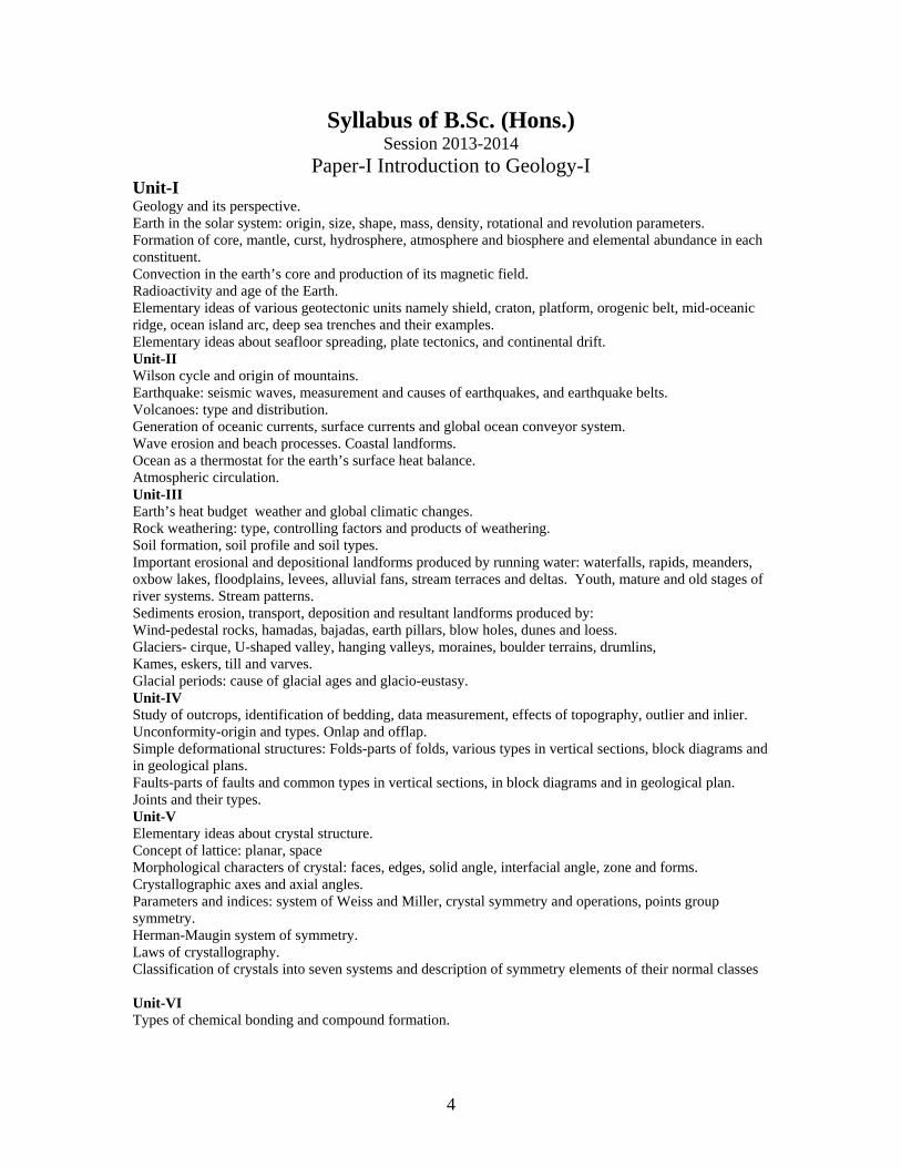
Paper-I Introduction to Geology-I Unit-I Geology and its perspective. Earth in the solar system: origin, size, shape, mass, density, rotational and revolution parameters. Formation of core, mantle, curst, hydrosphere, atmosphere and biosphere and elemental abundance in each constituent. Convection in the earth’s core and production of its magnetic field. Radioactivity and age of the Earth. Elementary ideas of various geotectonic units namely shield, craton, platform, orogenic belt, mid-oceanic ridge, ocean island arc, deep sea trenches and their examples. Elementary ideas about seafloor spreading, plate tectonics, and continental drift. Unit-II Wilson cycle and origin of mountains. Earthquake: seismic waves, measurement and causes of earthquakes, and earthquake belts. Volcanoes: type and distribution. Generation of oceanic currents, surface currents and global ocean conveyor system. Wave erosion and beach processes. Coastal landforms. Ocean as a thermostat for the earth’s surface heat balance. Atmospheric circulation. Unit-III Earth’s heat budget weather and global climatic changes. Rock weathering: type, controlling factors and products of weathering. Soil formation, soil profile and soil types. Important erosional and depositional landforms produced by running water: waterfalls, rapids, meanders, oxbow lakes, floodplains, levees, alluvial fans, stream terraces and deltas. Youth, mature and old stages of river systems. Stream patterns. Sediments erosion, transport, deposition and resultant landforms produced by: Wind-pedestal rocks, hamadas, bajadas, earth pillars, blow holes, dunes and loess. Glaciers- cirque, U-shaped valley, hanging valleys, moraines, boulder terrains, drumlins, Kames, eskers, till and varves. Glacial periods: cause of glacial ages and glacio-eustasy. Unit-IV Study of outcrops, identification of bedding, data measurement, effects of topography, outlier and inlier. Unconformity-origin and types. Onlap and offlap. Simple deformational structures: Folds-parts of folds, various types in vertical sections, block diagrams and in geological plans. Faults-parts of faults and common types in vertical sections, in block diagrams and in geological plan. Joints and their types. Unit-V Elementary ideas about crystal structure. Concept of lattice: planar, space Morphological characters of crystal: faces, edges, solid angle, interfacial angle, zone and forms. Crystallographic axes and axial angles. Parameters and indices: system of Weiss and Miller, crystal symmetry and operations, points group symmetry. Herman-Maugin system of symmetry. Laws of crystallography. Classification of crystals into seven systems and description of symmetry elements of their normal classes Unit-VI Types of chemical bonding and compound formation.
4
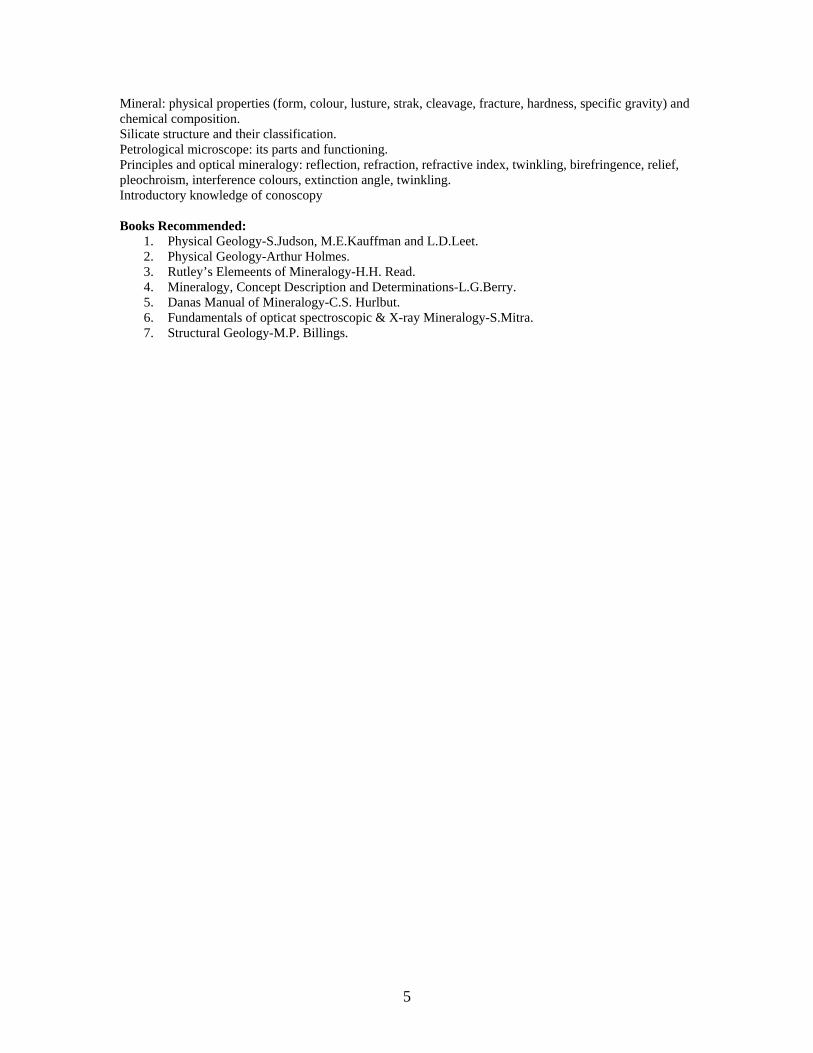
Mineral: physical properties (form, colour, lusture, strak, cleavage, fracture, hardness, specific gravity) and chemical composition. Silicate structure and their classification. Petrological microscope: its parts and functioning. Principles and optical mineralogy: reflection, refraction, refractive index, twinkling, birefringence, relief, pleochroism, interference colours, extinction angle, twinkling. Introductory knowledge of conoscopy Books Recommended:
1. Physical Geology-S.Judson, M.E.Kauffman and L.D.Leet. 2. Physical Geology-Arthur Holmes. 3. Rutley’s Elemeents of Mineralogy-H.H. Read. 4. Mineralogy, Concept Description and Determinations-L.G.Berry. 5. Danas Manual of Mineralogy-C.S. Hurlbut. 6. Fundamentals of opticat spectroscopic & X-ray Mineralogy-S.Mitra. 7. Structural Geology-M.P. Billings.
5
Paper-II Introduction to Geology-II Unit-I Magma: Definition, physical properties and chemical composition, origin. Crystallization of magma: Bowen’s reaction series, magmatic differentiation and assismilation. Forms and structures of extrusive and intrusive igneous rocks. Igneous textures: crystallinity, grain shape, size and mutual relationship of grains. Bases of classification and types of igneous rocks. Unit-II Sediments: origin, transportation, deposition and lithofication. Statistical measure: basic ideas about grain size, sorting, skewness, kurtosis and roundness. Basic concept of size and nomenclature of sediments. Fabric and texture of sedimentary rocks. Roundness of particles and its geological significance. Classification of sedimentary rocks: terrigenous and chemical sedimentary rocks. Important primary sedimentary structure-bedding, ripple marks, cross bedding and mud cracks. Unit-III Introduction to Metamorphic rock and their significance. Classification of Metamorphic rocks. Basic concepts of types of metamorphism. Concepts of isograds and zones of metamorphism. Relationship between matamorphism and deformation. Unit-IV Palaeobiology: definition, branches and scope. Preservation potential of organisms, requirements of fossilization. Fossils, processes of fossilization and different kinds of fossils. Elementary idea about origin of life. Brief account of life through geological time, major steps in evolution of life. Classification of organism up to phylum level, their main characters and geological range. Unit-V Different methods of stratigraphic correlation. Principles of nomenclature and classification of lithostratigraphic, chronostratigraphic, biostratigraphic and tectonic/genetic facies. Standard Geological Time Scale: broad subdivisions and absolute ages. Physiographic subdivisions of Indian subcontinent-their physical, structural and geological features. Brief account of constituent cratons of Indian shield. Brief account of geographical distribution of Palaeozoic, Mesozoic and Cenozoic rocks of India. Unit-VI Introduction to common rock forming, ore forming and industrial minerals. Radioactive minerals, Fuel minerals. Formation and types of mineral deposits, rock association. Basic ideas about the method of mineral exploration, mining, conservation and utilization of natural resources in ancient India. Application of statistics, trigonometry, algebra and calculus to the study of geology. Use of computer in geological studies: construction of travel time curve for two-layer system, determination of velocities, depth to bed rock from seismic surveys. Derivation of the equation to find out age of rocks and minerals from radio-active decay principle. Determination of altitude of a horizon from topographic map and from bore hole data. Trigonometric solutions of faults problems. Measures of central tendency (mean, median and mode), dispersion (mean deviation, standard deviation), correlation co-efficient, least square regression curve. Computer hardware, software, acquaintance with package used in solving geological problems.
6

Books Recommended: 1. Magma and Magmatic Rocks-Middlemost. 2. Igneous and Metamorphic petrology-Best. 3. Sedimentary Rocks-Pettijohn. 4. Metamorphic Petrology-Turner. 5. Basic Concepts of Historical Geology-E.H. Spencer. 6. Structural Geology-M.P. Billings. 7. Fundamentals of Historical Geology and Stratigraphy of India-Ravindra Kumar. 8. Principles of Geomorphology - Thornbury
7
Practical BL 1
(a) Study of important geomorphological models. Reading topographical maps. Use of
Clinometer and Brunton Compass. Laboratory exercise on structural geology problems: Completion of outcrops, drawing and interpretation of cross-sections through elementary representative geological structures. Study of elements of symmetry of at least one representative crystal from normal classes of seven crystal systems. Study of physical properties of minerals and rocks in hand specimen. Study of the optical characters of important minerals using polarizing microscope.
(b) Study of megascopic and microscopic characters of important rock-forming minerals. Study of morphological characters of phyla included in the theory syllabus. Preparation and study of stratigraphic maps.
Geological Field Training: Students will be required to carry out field work in a suitable geological area to study the elementary aspects of field geology and submit a report thereon.
8

P A R T - II
9
Paper-III: Earth’s Processes and Resources Unit-I Factors controlling mineral availability. Global mineral reserves and resources. Renewable and non-renewable energy resources. Coal: origin, raw materials and end products, types of coal. Oil and Gas: source material, geological environment of formation, migration and accumulation. Nuclear fuels: the nuclear fuel cycle, sources of uranium. Hydroelectric power. Energy from the sun, wind, hot springs and sea waves. Distrubution of mineral deposits in space and time. Unit-II Rock forming minerals: Systematic classification of minerals, Chemical composition and physical properties of the following classes of minerals. Silicates, carbonates, oxides, sulfides, sulfates, halides. Unit-III Ore forming minerals: metallic and non-metallic minerals. Processes of ore formation. Ore deposits related to magmatic activity. Hydrotheramal and skarn deposits. Ore deposits formed by sedimentation. Weathering products and Residual deposits. Ore deposits formed by oxidation & supergene enrichment. Ore deposits formed by replacement and biochemical activity, evaporation and metamorphism, colloidal deposition. Unit-IV Global tectonic and metallogeny trough geological time. Geological setting, mineralogical characteristics and Indian distribution of metallic mineral deposits of iron and manganese, chromium, copper, lead and zink, gold, and aluminum. Unit-V Geological setting, mineralogical characteristics and Indian distribution of non-metallic mineral deposits related to and with examples from Indian stratigraphic records: Materials for construction (building stones and cement), ceramics, refractories and fillers, organic chemicals and synthetics, precious and decorative stones, fertilizers. Unit-VI Methods of mineral exploration. Physiographics, mineralogical, stratigraphic, lithologic and structural guides to ore. Methods of mineral exploitation-open pit and underground mining. Mineral processing and beneficiation: methods of size reduction, screening and separation. Environmental implications of exploration of mineral resources. Books Recommended:
1. Economic Mineral Deposits-Jensen and Bateman. 2. Ore Deposits-Parks and Mc diarmid. 3. India’s Mineral Resources-Krishnaswami. 4. Ore Deposits of India-Gokkle and Rao. 5. Ore Petrology-Evans. 6. Industrial Mineral and Rocks-Deb. 7. Mining Geology-Arogyaswami.
10
Paper-IV: Palaeobiology and Stratigraphy Unit-I Methods of fossil identification, description and illustration. Taxonomic categories and code of systematic nomenclature. Variation in fossil assemblage and its causes. Applciation of palaeontalogic studies in organic evolution, biostratigraphy, palaeoecology, palaeogeography, and palaeoclimatology. Microfossils: definition, significance and a brief account of important groups. Unit-II Brachiopoda: Morphology and geological distribution. Echinoidea Morphology and geological distribution. Trilobita: Morphology and geological distribution. Pelecypoda: Morphology and geological distribution. Gastropoda: Morphology and geological distribution. Cephalopoda: Morphology and geological distribution. Rugose Corals Morphology and geological distribution. Unit-III Origin of vertebrates and landmarks in vertebrate evolution. Major groups of vertebrates: pisces, amphibians, reptiles, aves and mammals-their brief description of geological distribution. Evolutionary history of Equidae. Palaeobotany: Broad classification of plant kingdom. Morphology, classification and geological range of important Lr. Gondwana flora. Morphology, classification and geological range of important Upp.Gondwana flora. Unit-IV Stratigraphy and its various branches. Stratigraphic classification and correlation. Methods of collecting stratigraphic data surface data, sub-surface data. Identification and types of stratigraphic contacts: gradational, intercalated, abrupt, unconformable. Different types of facies lith, bio and tectonic/genetic facies. Transgressive and regressive sequences. Unit-V Classification, geographic distribution, lithologic characteristics, fossil content and economic importance of Various geological divisions of Peninsular Shield: Cratons – Dharwar, Baster, Singhbhum, Bundelkhand, Aravalli, and Marwar. Mobile belts: Eastern Ghats, Pandyan and Satpura. Archean Basement Complex: Peninsular Gneiss of Karanata, Banded Gneissic Complex of Rajasthan, Older Metamorphics of Eastern India. Greenschist belts of Karnataka: Sargurs (enclaves), Nuggihalli, Holenarsipur and Chitradurga Belts. Aravalli Supergroup, Dungargarah Supergroup, Iron Ore Group. Delhi Supergroup, Vindhyan Supergroup, Cudappah Supergroup. Unit-VI Classification, geographic distribution, lithologic characteristics, fossil content and economic importance of Haimanta System, Muth Quartzite, Permo-Carboniferous System of Spiti. Gondwana Supergroup, Triassic of Spiti, Jurassic of Kutch, Cretaceous of south east coast of India and Deccan Traps. Dharamshala, Dagshi and Kasauli Formations, Siwalik system. Karewa Group of Western Himalaya and Evolution of Himalayas.
11
Books Recommended:
1. Invertebrate Palaeontology-Woods. 2. The Elements of Palacontology-Black 3. Introduction to Paleobotany-Arnold. 4. Essential of Paleobotany-Shukla and Misra. 5. Geology of India and Burma-Krishnan. 6. Fundamentals of Historicals Geology and Stratigraphy of India-Ravindra Kumar 7. Precambrian Geology of India-Naqvi and Rogers. 8. Geology of India by M.Ramakrishnan & R.Vaidyanadhan Vol. I & II, Geological Society of India,
Bangalore, 2008/2010.
12
Practical BL2
(a) Study of physical and optical properties of additional rock minerals (other than those covered under paper II). Study of physical properties of ore forming minerals in hand specimen. Preparation of maps showing distribution of important ores and other economic minerals in India. Study of metallogenic maps.
(b) Study of morphological characters of important fossil phyla designated in theory paper. Exercises in showing the major stratigraphic and litho tectonic units in hand drawn map of India.
Geological Field Training: Geological mapping and visit to economic mineral deposits in some appropriate area followed by laboratory processing of rock samples, ores and fossils collected during the field work and preparation of report thereon.
13

P A R T - III
14
Paper-V- Igneous Petrology and Dynamics of the Earth Unit-I Mantle petrology: mineralogy and chemistry. Physical properties of magma, volatile contents. Magmatic processes: fractional crystallization, magma mixing, crystal setting, liquid immiscibility, assimilation, differentation. Trace elements and their significance in igneous petrology. Classification of igneous rocks, basis of IUGS classification. Unit-II Basic principles of equilibrium thermodynamics. Concept of system, phase and component. Chemical potential and phase rule. Phase equilibria of the following two and three component silicate systems: Binary system-Albite-Anorthite, Diopside-anorthite, Nepheline-silica. Ternary systems-Albite-Anorthite-Diopside, Nepheline-Kalsilite-silica. Unit-III Rock association in time and space. Concept of Rock Series. General characteristics of the following Precambrian igneous rock assemblages:
(a) Komatiites (b) Anorthosites (c) Tonalite-trondhjemite-granodiorite (TTG) Mineralogical characteristics and origin of the following rock types: (I) Granite, granodiorite, diorite, rhyolite, (II) Basalt, dolerite, gabbro
(III)Syenite, nepheline-syenite, trachyte, (IV) Peridotites. Unit-IV Internal structure constitution and chemical composition of various layers of the earth. Geochemical evolution of the earth. Geophysical conditions of the earth: gravity, magnetism, heat flow. Application of geophysics in understanding the dynamics of the earth. Concept and theories of isostasy. Movements of the earth’s curst: orogenic and epeirogenic phases. Unit-V Continental drift and its evidences. Magnetic anomaly patterns in the ocean basins and sea-floor spreading. Origin, significance and distribution of divergent margins, mid-oceanic ridges. Island arcs and trenches. Plate tectonics theory-the mechanism of plate tectonics. Nature and types of plate margins. Geometry and driving mechanism of plate motion. Unit-VI Evolution of continents and oceans. Tectonics of continental rifts, continental margins, shelves, marginal basins and intracratonic basins. Relationship of magmatism, metamorphism and metallogeny with orogeny. Neotectonics: Active fault systems. Indicators of recent tectonic activity. Geomorphological indicators. Drainage changes. Recurrent seismicity. Causes of natural and man-made geohazards and their prevention. Books Recommended:
1. Principles of igneous and Metamorphic Petrology-Philpots 2. Magma and Magmatic Rocks-Middlemost. 3. Igneous and metamorphic petrology-Best. 4. Plate Tectonics and Crustal evaluation-Condie. 5. Aspects of Tectonics-Valdiya. 6. Global Tectonics-Kearey and Vine.
15
Paper-VI-Structural Geology
Unit-I Mechanical Principles: Definition of force, stress and strain, stages of rock deformation, stress-strain diagram. Effects of geological factors on mechanical behavior of rocks-confining pressures, temperature, time, solutions, pore pressure, anisotropy and inhomogeneity, mechanics of plastic deformation. Unit-II Unconformities, their types and recognition in the fields and on geological maps. Geological significance of unconformities. Criteria for distinguishing faults from unconformities. Evaporite (Salt domes) and serpentinite diapers, sedimentary vents and mud lumps. Unit-III Description and nomenclature of folds. Geometric and genetic classification of folds. Recognition and interpretation of folds in field and geological maps. Synforms and antiforms. Minor folds and their relations to major folds. Drag folds-Origin, geometry and significance. Mechanics and causes of folding. Unit-IV Description and classification of faults. Normal faults, horst and graben, rifts, strike-slip-faults. Reverse faults, thrusts, thrusts and overthrusts. Nappe, Klippe, Window. Effects of faults on outcrop. Criteria for recognition of faults, in the field and on geological maps. Unit-V Planar structures, their identification and description. Type of cleavage and schistosity and their origin, relation of cleavage and schistosity to major structures. Types of lineations, their origin and their relation to major structures. Unit-VI Joints, their classification and significance. Geological criteria for determination of stratigraphic superposition, on the basis of biostratigraphy, fossil disposition, volcanogenic structures, cleavage bedding relationship and external form and internal organization of sediments. Laboratory methods of geological mapping. Methods of analysis of simple structural data. Stereographic projections and its use in structural analysis. Books Recommended:
1. Structural analysis of metamorphic Tectonics-Turner and Weiss. 2. Structural Geology of Rocks and Regions-Davis 3. Folding and Fracturing of Rocks-Ramsay. 4. An outline of Structural Goelogy-Rubbs, Mears and William. 5. A manual of problems in Structural Geology-Gokhle.
16
Paper-VII-Natural Environment (including Elements of Remote
Sensing, Hydrogeology and Engineering Geology) Unit-I Definition of Environmental Geology. The interdisciplinary approach to environmental geology. Fundamental Concept: The earth as closed system, limitation of earth resources, uniformitariasm, understanding hazardous earth processes. Environmental changes due to influence of human dominated activities over nature dominated system: Concept of natural ecosystems on the earth and their mutual relations and interactions (atmosphere, hydrosphere, lithosphere and biosphere): dynamic interaction among system cycling and recycling. Cycles in earth system: carbon energy cycle, biogeochemical cycle, rock cycle,geochemical cycle Unit-II Soil: process of soil formation, classification of soil, soil degradation and mitigation. Hazardous earth process: shifting of river courses and their impact on soil erosion. Landslides: slope stability, causes of land slides, prevention and mitigation. Floods: causes, impact and mitigation. Earthquakes: causes, impact and mitigation. Unit-III Environmental and Geological consideration in site selection of dams, and tunnels. Dams: foundation materials, structures causes of failure, siesmicity, hydrology. Tunnels: geology, structures, seepage problem, role of water table and seismicity. Unit-IV Basics of remote sensing, EMR, platforms, sensors. Types of aerial photographs, Framing and scanning systems. Types of satellites and images. Spatial, spectral and temporal resolution. Sensors and their characteristics on board IRS, Landsat and SPOT satellites EMR interaction with atmosphere and earth surface spectral signatures of soil, water and vegetation Unit-V Elements of image interpretation (photographic and geotechnical). Basic drainage pattern and their recognition on images/aerial photos. Identification and characteristics of common rock types on aerial photographs. Application of remote sensing techniques in natural hazards. Examples from India. Application of remote sensing in geological and geomorphological mapping. Unit-VI Introduction to hydrogeology. Hydrologic cycle and its component. Rock properties affecting groundwater. Vertical distribution of ground water. Classification of aquifers. Darcy’s Law and its validity. Permeability and methods of its measurement. Ground water provinces of India. Concepts of watershed management. Groundwater pollution, waste disposal, Impact of mining activity. Books Recommended:
1. Environmental Geology-Keller 2. Groundwater Hydrogeology-Todd. 3. Principles of Engg. Geology and Geotectonics-Krynine and Judd. 4. Engineering Geology-Kesavulu. 5. Remote Sensing-Principles and Interpretation-Sabins. 6. Environmental Geology-Montgomery. 7. Groundwater Assessment, Development and Management – Karanth 8. Remote Sensing and image interpretation – Lillesand and Keifer 9. Fundamentals of Remote Sensing by George Joseph 10. Remote Sensing of Environment by A.R. Jensen 11. Remote Sensing and Geographical Information System by Anji Reddy
17
Paper-VIII-Energy Resources and Mineral Exploration Unit-I Introduction to fossil fuels Petrology of coal Peat, lignite, bituminous and anthracite coal. Origin of Coal. Gondwana and Tertiary coalfields of India. Geothermal energy provinces in India. Unit-II Origin, migration and entrapment of natural hydrocarbons. Source and reservoir rocks. Structural, stratigraphic and mixed oil traps. Hydrocarbon exploration techniques-geological and geophysical methods. Onshore and off-shore distribution of petroliferous basins in India. Unit-III Radioactive minerals: mineralogy, geochemistry, origin and distribution of uranium and thorium deposits in India. Detection and measurement of radioactivity. Methods of prospecting for radioactive minerals. Radioactive well logging. Nuclear waste disposal: problems and solutions. Unit-IV Surface and subsurface methods of mineral exploration. Application of remote sensing techniques in mineral exploration. Geophysical methods of mineral exploration-airborne versus ground surveys. Gravity, electrical, magnetic and seismic methods. Unit-V Prospecting for economic minerals. Methods of drilling, sampling, assaying and reserve estimation. Fundamentals of geobotanical and Geochemical methods of exploration. Bore-hole logging and deviation testing. Unit-VI Principles of mineral economics. Strategic, critical and essential minerals. Mineral production in India. Changing pattern of mineral consumption. National mineral policy of India including hydrocarbon Mineral concession rules. Mineral resources of the sea and law of sea. Books Recommended:
1. Coal Petrology-Gebruder Borntraeger, Stuttgart. 2. Text Book of Coal-Chandra, Singh and Singh. 3. Petroleum formation and occurrence-Tisot and Welte. 4. Radioactivity in Geology-Principles and Application-Durrance. 5. Courses in Mining Geology-Arogyaswami. 6. Mineral Economics-Husain. 7. Mineral Economics-Chatterjee. 8. Techniques in Mineral exploration-Readman. 9. A text book of Petroleum Geology - Leverson
18
Paper-IX-Sedimentary and Metamorphic Petrology
Unit-I Significance of grain size distribution in relation to environments. Particle size of detrital rocks-grade scale in mm and phi scales. Shape and sphericity of clastic particles. Zingg’s and Folk’s shape classes. Chemistry of weathering processes. Concept of sedimentary facies. Basic principles of paleoenvironment and paleoclimate analysis. Basic ideas about depositional environments and their classification. Dynanics of eolian and fluvial environments: Laminar and tarbulent flows and flow regimes. Unit-II Morphology and occurrence of bedding plane structures, internal structures, soft sediment deformational structures, biogenic structures and significance of ichno fossils. Processes of sediment deposition: aqueous, Aeolian, glacial and gravitational (turbidity, mud flow and debris flow). Diagenesis of terrigenous and chemical sediments. Heavy minerals and their geological signifiance. Unit-III Sandstone: classification and origin. Petrography and geological significance of quartz arenite, arkose and greywacke. Conglomerates: origin and classification. Petrography and geological significance of diamictite and tillite. Concept of maturity from mineralogy of sands and textural attributes. Shale, types, their bedding characteristics and mineralogy. Classification and origin of carbonates with special reference of Folk’s classification. Tectonics and sedimentation. Cratonic and plateform basins and facies. Geosyncline basins and facies. Krynine’s cycle. Unit-IV Metamorphic processes and a detailed account of agents and their role in metamorphism. Nucleation. Chemical equilibrium in metamorphic rocks. Types of metamorphism-contact, regional, cataclastic and metasomatism. Textures and structures of metamorphic rocks and their significance. Unit-V Barrovian zones of regional metamorphism and principles of isograd mapping. Rosenbusch’s zones of thermal metamorphism, contact aureole. Concept of metamorphic facies and facies series. Low pressure and medium to high pressure facies (field relation and mineralogy). Metamorphism in relation to plate tectonics. Paired metamorphic belts. Unit-VI Cataclastic metamorphism and its products. Contact metamorphism of mafic, pelitic and carbonate rocks. Regional metamorphism of mafic, pelitic rocks. Metasomatism: types mass transfer and products, anatexis and granitisation. P-T-t diagrams and projective analysis. Petrology, origin and distribution (in India) of charnockites, khondalites, granulites and eclogites. Books Recommended:
1. Sedimentary Rocks-Pettijohn 2. Palaeo current and Basin Analysis-Potter and Pettijohn. 3. Origin of Sedimentary Rocks-Baltt, Mid delton, Murray. 4. Metamorphic Petrology-Turner. 5. Petrology of Metamorphic Rocks-Mason. 6. Principles of Igneous and Metamorphic Petrology-Philpots.
19
Paper-X-Applied Geology Unit-I Introduction of Urban geology: role of geology in urban planning, Geological hazards, geological and hydrogeological constrains, Foundation problem.Collection of urban geodata (borehole logs, geophysical records, soil and rock properties), their interpretation, storage, retrieval and presentation. Landuse by urbanization.Use of geodata in land use and urban planning, impact of urbanization on landuse. Impact of urban waste disposal, liquid waste disposal their management and control.Environmental policy and law, environmental legislation in India Unit-II Introduction to Medical geology and its future scope: geologic factors of environmental health. Trace elements and human health, chronic diseases and geologic environment.Trace element and heart diseases. Water borne diseases-cause and remedies. Food intake as sources of trace metals in humans, ores and rock processing industries and their impact on human health. Unit-III Maps: elements, scale of map, base map, reference and thematic maps .Concept of datum and coordinate system.Map projections: Conical, cylindrical and azimuthal projection.Digital maps. Vector and raster maps, advantages and disadvantages. Basic concepts and applications of GIS in geosciences, functions of GIS, data structure, data input and analysis in GIS.Global positioning system (GPS): components, operating principle, applications and limitations Unit-IV Geochemical sampling: stream sediments, lake sediments, soil and water samples.Pathfinder elements in exploration. Geobotanical survey and biogeochemistry.Geochemical analysis: precision and accuracy. Introductory knowledge about the principle andfunctioning of flame photometer, spectrometer, AAS (single beam & double beam), XRF, XRD and ICP. Unit-V Formation of minerals, basic qualities (beauty, durability, rarity), classification of gem materials, weight and measures, Physical character of gem stones: hardness, cleavage, fracture, parting, specific gravity optical characteristics. Nature of light: electromagnetic spectrum, transparency, light reflection and refractive index and its measurement.Colour and its causes, pleochroism, dispersion, absorption spectroscopy luminescence phenomenal effects, chatoyancy, asterism, sheen, aventurescence, play of colour, change of colour etc. Unit-VI Description and identification of gem material:Apatite, bery (aquamarine, emerald etc.), corundum (ruby, sapphire), chrysoberyl (alexandrite), Calcite, diamond, diopside, epidote, feldspar (moonstone, labradorite etc.), garnet (almandine, pyrope, spessaritite, grossular, andradite etc.), opal, quartz (crystalline, chalcedony), spinel, kyanite, sillimanite, topaz, tourmaline, turquoise, malachite, lapis lazuli, zoisite, zircon, amber, coral, jet and pearl.Gemstone cuts: basic and simple style of cut. Books Recommended:
1. Environmental Geology-Montgomery. 2. Environmental Sciences-Miller. 3. Manual on environmental and Urban Geology of fast growing cities-ESCAE, United Nations
Publications. 4. Techniques in Mineral Exploration-Readman. 5. Geochemical Exploration-Bjorklund. 6. Practical Gemmology-Webster. 7. Remote Sensing and Geographical Information System-M.Anji Reddy. 8. Fundamentals of GIS- M. Demers 9. Datum Map Projection and Coordinate System – Survey of India (lecture notes) 10. Lecture notes on remote sensing GIS and map protection (reference Copy) 11. Remote sensing and Geographic Information System by A.M. Chandra
20
Practical BL3
(a) Microscopic study of major igneous rocks. Model mineralogy of some Plutonic and hypabassal rocks and their nomenclature using Streckeisen’s approach. Study of sections across continental margins, island arcs and plate tectonics models. Study of geohazard maps and introduction to basic geophysical instruments used for understanding the dynamics of the Earth.
(b)Exercises on structural geology problems. Stereographic projections of structural data.
Geometrical problems on folds and faults. Drawing and the interpretation of profile sections across the geological maps.
(c) Morphometic analysis using sample watershades. Scale determination and conversion.
Exercises related to river basin water availability, drought assessment and flood prone regions. Spatial analysis using multiple data sets. Depth perception using stereoscope.. Classification of data using various methods. Exercise on land degradation and resource depletion.
(d) Hydrogeology: drawing of hydrogeological cycle, depth to water table map, measurement and presentation of rainfall data-arithmetic mean, isohytal map, isocones and other methods of representation of chemical data . Preparation and interpretation of water table maps.
Identification and uses of water on the basis of quality (drinking, irrigation and industrial purpose). BL4
a) Hand specimen study of different types of coals, selected radioactive minerals and their host rocks. Exercises in showing distribution of various mineral deposits, fuel resources and hydrocarbon resources on map of India. Laboratory exercises in solving exploration related problems. Data representation & analysis of field resources. b) Study of important primary sedimentary structures in hand specimens. Microscope study of sedimentary textures, mineralogy and diagenetic features in sedimentary rocks. Microscopic study textures and mineralogy of metamorphic rocks. Laboratory exercises in graphic plots for petrochemistry and interpretation of paragenetic diagrams. c) Gemmology: description and identification of rough and cut precious and semi-precious
stones. Determination of R.I., specific gravity and optical properties. Grading of Gem stones. Industrial mineralogy: industrial specifications of various minerals used in the refractory and ceramic industry, glass industry, cement industry, Abrassive and fertilizer industry. Minerals used in various industries around Aligarh. Case studies of environment related problems. Introduction to modern analytical techniques of geological, geophysical and geobotanical survey for environmental studies. Evaluation and interpretation of geochemical data for exploration.
BL5
Geological Field Training: Field work including geological mapping of structurally complex area. The field report should be based on the mapping as well as laboratory work on the rock samples collected during the fieldwork. BL 6
Comprehensive Viva
21
S Y L L A B U S for the session 2013-2014
M. Sc. (Applied Geology) Part- I & II
Department of Geology
Aligarh Muslim University Aligarh
22
Department of Geology
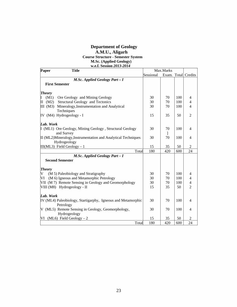
A.M.U., Aligarh Course Structure - Semester System
M.Sc. (Applied Geology) w.e.f. Session 2013-2014
Paper Title Max.Marks Sessional Exam. Total
Credits
M.Sc. Applied Geology Part – I First Semester
Theory I (M1) Ore Geology and Mining Geology II (M2) Structural Geology and Tectonics III (M3) Mineralogy,Instrumentation and Analytical Techniques IV (M4) Hydrogeology - I Lab. Work I (ML1) Ore Geology, Mining Geology , Structural Geology and Survey II (ML2)Mineralogy,Instrumentation and Analytical Techniques Hydrogeology III(ML3) Field Geology – 1
30 30 30
15
30
30
15
70 70 70
35
70 ]
70
35
100 100 100
50
100
100
50
4 4 4
2
4
4
2 Total 180 420 600 24
M.Sc. Applied Geology Part – I Second Semester Theory V (M 5) Paleobiology and Stratigraphy VI (M 6) Igneous and Metamorphic Petrology VII (M 7) Remote Sensing in Geology and Geomorphology VIII (M8) Hydrogeology - II Lab. Work IV (ML4) Paleobiology, Startigarphy, Igneous and Metamorphic Petrology V (ML5) Remote Sensing in Geology, Geomorphology, Hydrogeology VI (ML6) Field Geology – 2
30 30 30 15
30
30
15
70 70 70 35
70
70
35
100 100 100 50
100
100
50
4 4 4 2
4
4
2 Total 180 420 600 24
23
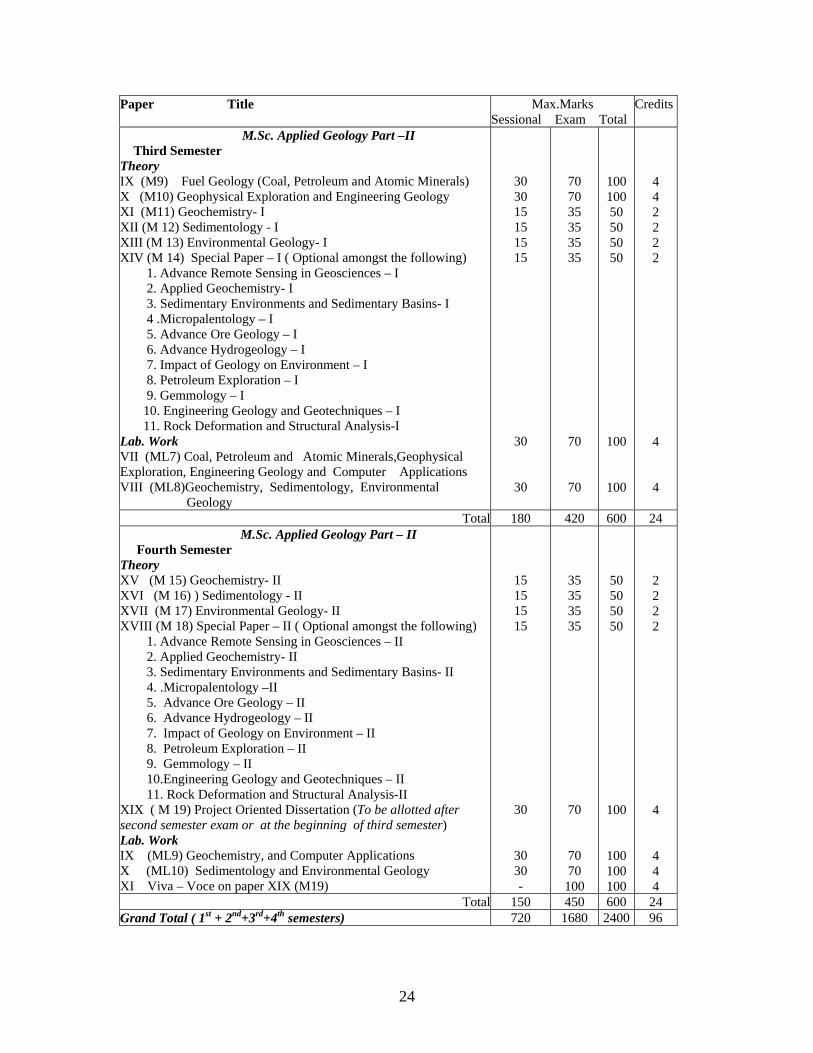
Paper Title Max.Marks Sessional Exam Total
Credits
M.Sc. Applied Geology Part –II Third Semester Theory IX (M9) Fuel Geology (Coal, Petroleum and Atomic Minerals) X (M10) Geophysical Exploration and Engineering Geology XI (M11) Geochemistry- I XII (M 12) Sedimentology - I XIII (M 13) Environmental Geology- I XIV (M 14) Special Paper – I ( Optional amongst the following) 1. Advance Remote Sensing in Geosciences – I 2. Applied Geochemistry- I 3. Sedimentary Environments and Sedimentary Basins- I 4 .Micropalentology – I 5. Advance Ore Geology – I 6. Advance Hydrogeology – I 7. Impact of Geology on Environment – I 8. Petroleum Exploration – I 9. Gemmology – I 10. Engineering Geology and Geotechniques – I 11. Rock Deformation and Structural Analysis-I Lab. Work VII (ML7) Coal, Petroleum and Atomic Minerals,Geophysical Exploration, Engineering Geology and Computer Applications VIII (ML8)Geochemistry, Sedimentology, Environmental Geology
30 30 15 15 15 15
30
30
70 70 35 35 35 35
70
70
100 100 50 50 50 50
100
100
4 4 2 2 2 2 4 4
Total 180 420 600 24 M.Sc. Applied Geology Part – II
Fourth Semester Theory XV (M 15) Geochemistry- II XVI (M 16) ) Sedimentology - II XVII (M 17) Environmental Geology- II XVIII (M 18) Special Paper – II ( Optional amongst the following) 1. Advance Remote Sensing in Geosciences – II 2. Applied Geochemistry- II 3. Sedimentary Environments and Sedimentary Basins- II 4. .Micropalentology –II 5. Advance Ore Geology – II 6. Advance Hydrogeology – II 7. Impact of Geology on Environment – II 8. Petroleum Exploration – II 9. Gemmology – II 10.Engineering Geology and Geotechniques – II 11. Rock Deformation and Structural Analysis-II XIX ( M 19) Project Oriented Dissertation (To be allotted after second semester exam or at the beginning of third semester) Lab. Work IX (ML9) Geochemistry, and Computer Applications X (ML10) Sedimentology and Environmental Geology XI Viva – Voce on paper XIX (M19)
15 15 15 15
30
30 30 -
35 35 35 35
70
70 70 100
50 50 50 50
100
100 100 100
2 2 2 2 4 4 4 4
Total 150 450 600 24 Grand Total ( 1st + 2nd+3rd+4th semesters) 720 1680 2400 96
24
S E M E S T E R - I
25
Syllabus of M.Sc.-Applied Geology for the session
2013-2014
Semester System
M.Sc. App. Geology – Part -I SEMESTER-I
Paper-I Ore Geology and Mining Geology
Unit-I Modern concepts of ore genesis. Spatial and temporal distribution of ore deposits- a global perspective. Comparison between Earth’s evolutionary history and evolutionary trends in ore deposits. Ore deposits and Plate Tectonics. Mode of occurrence of ore bodies-morphology and relationship of host rocks. Textures of ores and their genetic significance. Ore bearing fluids, their origin and migration. Wall-rock alteration. Structural, physico-chemical and stratigraphic controls of ore localization. Petrological Ore associations with Indian examples wherever feasible:
Unit – II Geothermometry of ore deposits. Fluid inclusion in ores: Principles, assumptions, limitations and applications. Inversion points, exsolution textures and stable isotopes as indicators of depositional temperatures. Geochemistry of ores- major, trace elements, REE and isotopic studies Ores of mafic-ultramafic association- diamonds in kimberlite; REE in carbonatites; Ti-V ores; chromite and PGE; Ni ores; Cu, Pb-Zn. Ores of silicic igneous rocks with special reference to disseminated and stock work deposits, porphyry associations.
Unit –III Ores of sedimentary affiliation-chemical and clastic sedimentation, stratiform and stratabound ore deposits (Mn, Fe, non-ferrous ores), placers and palaeoplacers. Ores of metamorphic affiliations-metamorphism of ores, Ores related to weathering and weathered surfaces laterite, bauxite. Contemporary ore-forming systems e.g., black smokers, mineralized crusts, Mn nodules. Mineralogy, genesis and important Indian distribution of ore minerals related to: Mn, Au, Sn, W and U.
Unit – IV Application of rock mechanics in mining. Planning, exploration and exploratory mining of surface and underground mineral deposits involving diamond drilling, shaft sinking, drifting, cross cutting, winzing, stoping, room and pillaring, top-slicing, sub-level caving and block caving. Cycles of surface and underground mining operations. Exploration for placer deposits. Open pit mining. Ocean bottom mining. Types of drilling methods. Mining hazards: mine inundation, fire and rock burst.
26
Books Recommended: 1.Craig, J.M. & Vaughan, D.J., 1981: Ore Petrography and Mineralogy-John wiley 2.Evans, A.M., 1993: Ore Geology and Industrial Minerals-Blackwell 3.Sawkins, F.J., 1984: Metal deposits in relation to plate tectonics-Springer Verlag 4.Stanton, R.L., 1972: Ore Petrography-McGraw Hill 5.Torling, D.H., 1981: Economic Geology and Geotectonics-blackwell Sci publ. 6.Barnes, H.L., 1979: Geochemistry of Hydrothermal Ore Deposits-John Wiley 7.Klemm, D.D. and Schneider, H.J., 1977: Time and Strata Bound Ore Deposits-Springer Verlag 8.Guibert, J.M. and Park, Jr. C.F., 1986: The Geology of Ore Deposits-Freeman 9.Mookherjee, A., 2000: Ore genesis-a Holistic Approach-Allied Publisher 10.Mckinstry, H.E., 1962: Mining Geology. II Ed.-Asia Publishing House 11.Clark, G.B., 1967: Elements of Mining.III Ed.-John Wiley 12.Arogyaswami, R.P.N., 1996: Courses in Mining Geology.IV Ed.-Oxford IBH
27
Paper-II Structural Geology and Tectonics Unit-I Mechanical principles and properties of rocks and their controlling factors. (confining pressure, temperature, time, pore fluid pressure etc). Concept of stress. Two dimensional stress analyses. Concept of strain. Homogeneous and inhomogeneous strain. The fundamental strain equation. Two dimensional strain analysis. Types of strain ellipses and ellipsoids, their properties and geological significance. Strain marker in naturally deformed rocks. Description of componental, parts of folds. Mechanics of folding and buckling. Flexure fold; flexural slip folds, flexural flow folds, passive folds. Distribution of strains in folds. Unit-II Joint description, morphology, genetic and geometric classification. Causes and dynamics of faulting. Strike-slip faults, Normal faults, Thrust, Overthrust fault. Terminology of foliation. Classification and genesis of axial plane foliation, crenulation foliation, bedding foliation (transposition foliation) fracture cleavage (spaced cleavage). Significance of foliation in geology Description of lineations in deformed rocks, their origin and significance. Types of fabric, fabric elements. Unit - III Plate Tectonics : Recent advances, pros and cons. Dynamic evolution of continental and oceanic crust. Principal tectonics features of the earth: oceans basins, structure of continental crust, Precambrian shields, Archean terrane, Proterozoic terrane, Phanerozoic terrane, Continental rifts and modern continental margins, continental platforms, orogenic belts. Tectonics of Precambrian orogenic belts of India : early Proterozoic mobile belts and middle Proterozoic mobile belts of Indian shield Unit - IV Formation of mountain roots. Anatomy of orogenic belts:outer foredeep or foreland basin, foreland fold and thrust belt, crystalline core zone, high angle fault zone. Metamorphism and tectonics. Plume Tectonics. Books Recommended: 1.Badgley, R.C. 1965: Structure and Tectonics-Harper and Row 2.Ramsay, J.G. 1967: Folding and Fracturing of Rocks-McGraw Hill 3.Hobbs, B.E., Means, W.D. and Williams, P.F. 1976: An Outline of Structural Geology-John wiley 4.Davis, G.R., 1984: Structural Geology of Rocks and Region-John Wiley 5.Ramsay, J.G. and Huber, M.I. 1987: Modern structural Geology, Vol. I & II Academic Press 6.Price, N.J. and Cosgrove, J.W. 1990: Analysis of Geological Structure-Cambridge University Press 7.Bayly B., 1992: Mechanics in Structural Geology: Springer Verlag 8.Ghosh S.K., 1995: Structural Geology Fundamentals of Modern Developments-Pergamon Press 9.Moores, E. and Twiss, R.J. 1995: Tectonics-Freeman 10.Keary, P. and Vine, F.J. 1990: Global Tectonics-Balckwell 11.Storetvedt, K.N. 1997: Our Evolving Planet: Earth’s History in New Perspective-Bergen (Norway), Alma Mater Fortag 12.Valdiya, K.S., 1998: Dynamic Himalaya-Universal Press, Hyderabad 13.Summerfield, M.A., 2000: Geomorphology and Global Tectonics-Springer Verlag
28
Paper-III- Mineralogy, Instrumentation and Analytical Techniques Unit-I Indicatrix- concept and application. Orthoscopy- pleochroisom and absorption schemes, Interference colours, dispersion Conoscopy- interference figures (uni- and biaxial) Determinative mineralogy - RI(Beckeline, oblique illumination, immersion), axiality, optic sign, 2V and plagioclase composition by microscope Description and function of microscopic aids- compensation plates and wedges, Spindle stage, Universal stage. Sample - Definition, field samples (rock, soil, sediment, water), sampling methods. Sample preparation-laboratory sample. Selection and screening criterion (physical, optical, biological), Preparation of specimen, Types of specimen Thin Section Studies-Etching technique Staining techniques particularly for feldspars, carbonates, dolomite, paragonite and quartz Model analysis and techniques, Calibration of eyepiece micrometer, areas selection and point counting Polished Section Studies-Reflectance (specular and diffusive) and reflactance spectrometry Bireflactance and reflection pleochroism, Colour of opaques, Microhardness and determination Knowledge of some common photographic Cameras Scanning and Transmission Electron Microscope (SEM & TEM) :Principle, parts, function and application. Diffraction and imaging Electron Probe Microanalyser (EPMA) :Principle, parts, operation and application Principles, instruments and geological applications of Cathodeluminescence and thermoluminescence . Unit-II Properties associated with bond types( ionic size, radius ratio, coordination principle, coordination number) Polymorphism, polytypism, pseudomorphism Atomic structure, mineral chemistry, and mode of occurrence of following mineral groups
(a) Nesosilicates-Garnet, Olivine, (b) Sorosilicates- Epidote ( c) Ionosilicates – Pyroxene, Amphibole ( d) Phyllosilicates - Mica, Clay
minerals (c) Tectosilicates-Quartz, Feldspar, Feldspathoids, Zeolites, Spinel.
P.T. stability diagrams and their significance with suitable examples Unit-III Chemical composition, crystal structure and mode of occurrence of following groups of non-silicate minerals. Native elements: Gold, Silver, Copper, Platinum, Iron, Sulfides- Cu, Fe, Pb, and Zn sulfides. Sulfosalts-Ag, Cu and Pb sulfosalts , Oxides-simple and multiple oxides excluding SiO2 Hydroxides- Brucite, Gibbsite, Goethite, Limonite, Psilomelane, Carbonates-Calcite, Magnesite, Rhodochrosite, Dolomite, Siderite Mineral assemblages- Assemblages and phase rule, Assemblages and rock types Gem and Semi-precious minerals – identification, diagnostic properties, classification, important deposits of India
29

Unit-IV Powdering Methods and tools-Conventional (Steel Mortar, Agate Motar etc.), Modern (Autopulverizer) Contaminations ( precautious and measures) Concept in analytical Chemistry-Terms & definitions, Units of measurement., Accuracy and precision. Statistical tests of reliability. Detection limits. Contamination ( analytical) Calibration of Instruments, Elements and analytical techniques, Presentation of geochemical data X-rays: Nature, generation and spectra of X-ray , Diffraction, Bragg’s law, X – rays and Crystal structure and Mineral chemistry X-ray Diffractrometry , X-ray diffractrometer (XRD) :Principle, parts, operation Mineral composition with particular reference to feldspar, orthopyroxene and clay minerals X-rays and Petrochemistry XRF (wave length dispersive and Energy Dispersive) : Principle, parts and function Preparation of sample for geochemical analyses Rock digestion through acid treatment, Rock digestion through fusion with alkali salts, Soil samples digestion, Water samples – Selection of water quality variables and collection of samples , Preservation techniques Number of samples, Storage before analysis Conventional analytical methods and Instruments: Classical, Photometric, Flame photometric and Titration (EDTA) Rapid methods and Instruments: Determination of ferrous iron, Determination of water & CO2, Determination of Fluorine and Chlorine Optical spectrometry- Principles, Nature of light, Absorption and emission of light Instrumentation for optical spectrometry, Monochromaters, optical filter, slits, photon detectors etc Principles, parts, operation mechanism, advantages and limitations of the following: Atomic Absorption Spectrometer- Single and double beam ( AAS) Inductively Coupled Plasma - Atomic Emission Spectrometer (ICP-AES) HPLC ( for water analysis) Mass Spectrometry & Instruments: Principles and Types Theoretical working knowledge of the following instruments: (a) ICP-Mass, (b) Thermal Ionization-Mass, (c) Gas Source-Mass Books Recommended: 1.Deer, W.A., Howie, R.A. and Zussman, J., 1996: The Rock forming Minerals-Longman 2.Klein, C. and Hurlbut, Jr. C.S., 1993: Manual of Mineralogy-John Wiley 3.Putnis, Andrew, 1992: Introduction to Mineral Sciences-Cambridge University Press 4.Spear, F.S. 1993: Mineralogical Phase Equilibria and Pressure-Temperature-Time paths-Mineralogical 5.Society of America Publ. 6.Phillips, Wm, R. and Griffen, D.T., 1996: Optical Mineralogy-CBS Edition 7.Hutchinson, C.S., 1974: Laboratory Handbook of Petrographic Techniques-John Wiley
30
Paper-IV Hydrogeology-I Unit-I Hydrologic cycle and its components Ground water origin, types, importance, occurrence, renewable and non-renewable ground water resources .Sub surface movement and vertical distribution of groundwater Hydrologic properties of rocks : porosity, permeability, specific yield, specific retention, hydraulic conductivity, transmissivity, storage coefficient and methods of their measurements Hydrographs. Unit-II Hydraulic properties of aquifer and aquitard and their controlling factors, transmissivity, storavity and specific yield, Well Hydraulics, Darcy’s law and its validity, confined, unconfined steady, unsteady and radial flow, Determination of permeability in the lab and field. Ground water flow equations Unit-III Water table contour maps, hydrostratigraphic units of India. Artificial recharge of ground water, rain water harvesting. Water balance methods, water level fluctuations : causitive factors and their measurement, Problem of over exploitation. Ground water legislation. Unit-IV Surface and subsurface geophysical and geological methods of ground water exploration. Hydrogeomorphic mapping using various remote sensing techniques. Surface geophysical methods: resistivity, seismic, gravity and magenetic methods. Well logging for delineation of aquifers and estimation of water quality, electrical resistivity and SP, radiation logging, Gamma, Gamma Gamma, Neutron Caliper and temperature logging
Books Recommended: 1.Todd, D.K., 1980: Groundwater Hydrology-John Wiley 2.Davies, S.N. & De Wiest, R.J.M., 1966: Hydrogeology-John Wiley 3.Freeze, R.A. & Cherry, J.A., 1979: Ground Water-Prentice Hall 4.Fetter, C.W., 1990: Applied Hydrogeology-Merill Publishing 5.Raghunath, N.M., 1982: Ground Water-Wiley Eastern 6.Karanth, K.R., 1987: Groundwater Assessment-Development and Management-Tata McGraw Hall 7.Alley, W.M., 1993: Regional Ground Water Quality-VNR, New York 8.Subramaniam, V., 2000: Water-Kingston Publ. London.
31
LAB WORK I (ML1) Ore Geology (a) Megascopic study of structures and fabrics of different ores and their associations. Mineralogical and textural studies of common ore minerals under ore-microscope and petrological study of other industrial and non-metallic minerals. Exercises in the determination of relative hardness of common ore minerals. Mining Geology (b) Diagrammatic representation of open cast and underground mining. Methods of mining survey. Exercises on mine sampling and determination of tenor, cut-off grades and ore reserves. Structural Geology (c) Preparation and interpretation of geological maps and sections. Structural problems concerning economic deposits. Recording and plotting of field data. Plotting and interpretation petrofabric data and resultant diagrams. Study of large scale tectonic features of the Earth. Survey (d): various methods and instruments of surveying including plane table, prismatic and theodolite and Telescopic Aledade.
II (ML2) (a) Microscopic study of rock forming minerals using optical accessories. Exercises on thin section and polished section making, etching and staining. (b) Exercises in sample dissolution, determination of elemental composition of minerals and rocks by flame photometer and AAS, sample preparation for powder diffraction by XRD and interpretation of X-ray diffractograms of common minerals and components of the bulk rocks (c)Delineation of hydrological boundaries on water-table contour maps and estimation of permeability Analysis of hydrographs and estimation of infiltration capacity. Chemical analysis of water.
III (ML3 ) Field Geology –1
32

S E M E S T E R - II
33
M.Sc. Applied Geology – PART – I
SEMESTER- II Paper-V Paleobiology and Stratigraphy
Unit-I Origin of life, Pre-Cambrian fossil record and major events in the history of life. Organic evolution: evidence, causes, mechanism, and patterns; determining phylogenetic relationship. Species concept in palaeontology: definition, origin, biologic and palaeontologic methods of species determination species problem in palaeontology. Ontogeny and growth of organisms: types of growth, isometric and anisometric growth, rates and causes, interpretation of growth curves.
Functional morphology: methods of functional morphologic analysis with examples from the fossil record. Taphonomy: taphonomic processes, types of fossil assemblages and their application.
Unit II Application of fossils in palaeoclimatic interpretations, climatic bioindicators, use of stable isotopes in palaeoclimatic studies. Major groups of microfossils with special reference to morphology and geological applications of foraminifera. Origin and evolution of early vertebrates: fishes and amphibians, major groups, general characters and geological distribution. Reptiles: general characters, major groups, their geological distribution, evolution and extinction of dinosaurs. Aves and mammals: evolution, general features and geological distribution, adaptive radiation of Cenozoic mammals.
Evolutionary histories of Proboscideans and Homonidae. Unit-III Controls on the development of stratigraphic records. Lithostratigraphy, Codes units, correlation and contacts. Biostratigorphy- units, biogeographical acme zone provinces, controlling factors,zonation and their time significance. Geochronology. Chronostratigarphy : code and units. Basic principles of pedostratigraphy, quantitative stratigraphy, seismic stratigraphy and sequence Stratigraphy, magnetostratigraphy, cyclostratigraphy, event Stratigraphy. Chemostratigraphic and geophysical correlation by instrumental well logs, seismic methods, absolute ages- carbon isotopes, oxygen isotopes. Strontiam isotopes, sulfur isotopes. Origin and composition of primitive crust, atmosphere & hydrosphere. Tectonic evolution of the following cratonic blocks. Dharwar, Aravalli-Bundelkhand, Singhbhum and Bhandara- Bastar. Unit – IV Basin configuration, stratigraphy and sedimentary evolution of the following basins. Vindhyan, Chattisgarh and Cuddappah. Paleogeographic and paleoclimatic conditions prevailing in Indian subcontinent during Paleozoic, Mesozoic and Cenozoic eras. Igneous activity in Indian subcontinent in relation to break up of Gondwanaland. Mountain building activities in Indian subcontinent during Cenozoic Era. Archean-Proterozoic; Proterozoic-Cambrian, Permian- Triassic and Cretaceous-Tertiary boundary problems in Indian subcontinent.
34
Completeness / incompleteness of stratigraphic records; preservation and net rates of accumulation in various basinal settings Books Recommended: 1.Clarkson, E.N.K., 1998: Invertebrate Palaeontology and Evolution.IV Ed.-Blackwell 2.Stearn, C.W. & Carroll, R.L, 1989: Palaeontology-the Record of Life-John Wiley 3. Principles of Paleontology by David M. Raup and Steven M. Stanley. CBS Publishers and Distributers. 4. Evolution of Vertebrates by E.H. Colbert. Wiely Eastern Ltd. 5.Pomerol, C., 1982: The Cenozoic Era: Tertiary and Quaternary-Ellis Harwood Ltd. 6.Goodwin, A.M.,1991: Precambrian Geology: The Dynamic Evolution of Continental Crust-Academic Press 7.Boggs, Sam Jr., 1995: Principles of Sedimentology and Stratigraphy-Prentice Hall 8.Doyle, P. and Bennett, M.R., 1996: Unlocking the Stratigraphic Record-John Wiley 9.Brenner, R.E. and McHargue, T.R.,1988: Integrative Stratigraphy: Concepts and Applications-Prentice Hall 10.Naqvi, S.M. and Rogers, J.J.W., 1987: Precambrian Geology of India-Oxford University Press 11.Pascoe, E.H., 1968: A Manual of Geology of India and Burma, Vol. I-IV-Govt. of India Press
35
Paper-VI- Igneous and Metamorphic Petrology Unit-I Mineralogy and chemistry of earth’ s mantle. Physics of magma generation in the mantle, their nature. Physical properties of magma: temperature, density, viscosity, volatile components their nature, Factors affecting magma and evolution of magma Norms - CIPW, Niggli values Criteria for classification of igneous rocks and IUGS classification. Introduction to igneous rock series . Rock suite : petrographic provinces and associations. Magmatism in relation to plate tectonics. Mantle plumes and associated magmatism. Unit-II Phase equilibrium of the following silicate systems, its relation to magma genesis and crystallization in the light of modern experimental work: Single Systems-Silica, Carbon. Binary Systems-Albite-Anorthite, Diopside-Anorthite. Ternary Systems- Nepheline- Kalsilite-Silica, Fosterite – Anorthite - Silica, Diopsite-Forsterite-Silica. Quaternary system : Diopside- Nepheline-Forsterite – Silica. Crystallization of magmas-nucleation and growth of crystals, quench crystals. Physico-chemical interpretation of igneous textures including spinifex, rapakivi, mixed crystals, intergrowths, reaction rims. Petrogenesis of the following igneous rock types: Ultramafic ( Peridotite and Picrite, Komatiite), Basalts, Andesites, Granites, Syenite, Carbonatite, Anorthosite Unit-III Mineralogical Phase rule of closed and open systems. Factors and processes of matamorphism, diffusion, nucleation. Fabric of metamorphic rocks, mylonite. Metasonatism-types, principle of polarity. Metamorphic facies, detailed description of each facies of low pressure, medium to high pressures and very high pressure with special reference to characteristic metamorphic zones and subfacies: albite-epidote hornfels, hornblende- hornfels, pyroxene hornfels, sanidinite, greenschist, amphibolite,granulite, prehenite-pumpellite, glaucophane-lawsonite (blue-schist), eclogite. Unit-IV Nature of metamorphic reactions and pressure-temperature. Conditions of metamorphism. Isoreactiongrad, Schreinmakers rule and construction of petrogenetic grids. Graphical representation : ACF, AKF, AFM. Metamorphic differentiation. Anatexis and origin of migmatites in the light of experimental studies. Regional metamorphism and paired metamorphic belts. Metamorphism and Tectonics. Metamorphic facies series. P-T-t paths and their implications. Ultra high temperature, ultra-high pressure and ocean-floor metamorphism. Partial melting during granulite metamorphism. Chemical zoning and its relation to tectonism.
36
Books Recommended: 1.Turner, F.J., 1990: Metamorphic Petrology, McGraw Hill, New York 2.Yardley, B.w., 1989: An Introduction to Metamorphic Petrology-Longman, New York 3.Bucher, K. and Frey, M., 1994: Petrogenesis of Metamorphic Rocks-Springer Verlag 4.Philipotts, A., 1992: Igneous and Metamorphic Petrology-Prentice Hall 5.Best, M.G., 1986: Igneous Petrology-CBS Publ. 6.McBirney, A.R., 1993: Igneous Petrology-John & Bartlet Publ. 7.Kretz, R., 1994: Metamorphic Crystallization-John Wiley 8.Bose, M.K., 1997: Igneous Petrology-World Press 9.Perchuk, L.L. and Kushiro, I (eds), 1991: Physical Chemistry of Magmas-Springer Verlag
37
Paper-VII Remote Sensing in Geology and Geomorphology Unit-I Spectral Characteristics of solar radiation. Transmittance of the atmosphere. Spectral reflectance of land covers. RS Satellite characteristics-orbits and swaths. Sensors used in remote sensing. Types of satellite remote sensing data used in earth system studies. Image interpretation and analysis. Applications of Remote Sensing techniques in geological investigations-Mapping lithology, lineaments and minerals. Unit-II Photogrammetry: and applications recent advances. Aerial photographs and their geometry. Errors in aerial photographs and their correction, swing, tilt, ortho photographs. Classification of aerial photographs and aerial mosaics. Photomosaics and its types. Stereoscopes: mirror and pocket stereoscope. Photogrammetric techniques Parallaxes: parallaxe bar, Prallax formula, height and slope determination. Scale determination of photographs on uniform and variable terrain. Unit-III Geological studies: image characters and their relations with ground objects based on recognition elements (photographic and geotechnical elements). Convergence of evidence in interpretations of lithology ( igneous sedimentary and metamorphic rocks) Interpretation of topography and tectonic features and evaluation of ground water potential. Unit-IV Geomorphological studies : geomorphic processes and resulting landorms. Morphometric analysis. Characteristics of various lansdforms in satellite images and aerial photographs. Terrain evaluation for selection of dam, reservoir, industrial sites. Digital processing techniques, image registration and correction, basic concept of geocoding, digital image classification and image enhancement, spatial filtering, band ratioing, FCCs, principal component analysis, IHS and NDVI images, supervised and unsupervised classification and its utility in land-cover mapping. Principles and application of GIS and RS in geohazards monitoring (landslides, floods, droughts, cyclones, earthquakes). Examples and case studies from India. Books Recommended: 1.Millor, V.C., 1961 Photogeology. Mc Graw Hill 2.Sabbins, F.F.,1985 Remote Sensing-Principles and Applications. Freeman 3.Moffitt, F.H. and Mikhail, E.M., 1980 Photogrammetry-Harper and Row 4.Lillesand, T.M. and Kieffer, R.W., 1987: Remote Sensing and Image Interpretation-John wiley 5.Pandey, S.N., 1987: Princdiples and Applications of Photogeology-Wiley Eastern 6. Thornbury, W.D. Principles of Geomorphology 7. Craig, R.G. and Craft, J.L Applied Geomorphology 8. Fundamentals of GIS – M. Demers 9. Encyclopedia of Applied Geology - Finkiel 10. Remote Sensing of Environment by A.R. Jensen 11. Fundamentals of Remote Sensing by George Joseph 12. Geomorphology by Bloom
38
Paper-VIII Hydrogeology-II
Unit – I Methods of pumping test and analysis of test data. Evaluation of aquifer parameters using Theim, Theis, Jacob’s and Walton equations. Flow Net Analyses.Interpretation of pumping test data for hydrogeologic boundaries : positive and negative boundaries Unit-II Water well technology, well types drilling methods, (cable tool, direct rotary, and reverse rotary), yield tests, construction and design, development and maintenance of wells. Salt water intrusion in coastal aquifers and their remedial measures.Electrical and Mathematical modeling, data requirement and application of model; Finite difference and finite element method. Unit-III Chemistry of natural water. Mineral stability in Eh-pH diagram. Types of chemical reaction in water, chemical activities, carbonate equilibrium, oxidation potential, SAR, CEC, major ionic species, hydrochemical facies, major constituents, minor constituents, trace elements of natural waters. Isotope hydrology: tritium, radio carbon dating of ground water. REE in sea and river water. Ground Water quality, estimation and methods of treatment for various uses.
Unit – IV Representations of hydrochemical data, Piper Trilinear diagram, Ground water facies analysis quality criteria for different uses, drinking, irrigation and industrial uses, Use of Water quality in mineral assessment. Ground Water contaminants and pollutants. Dispersion of pollutants.Evaluation of pollution potential and monitoring of ground water quality. Hydrochemical provinces of India. Problem of arsenic and fluoride, radioisotopes in hydrogeological studies. Books Recommended: 1.Todd, D.K., 1980: Groundwater Hydrology-John Wiley 2.Davies, S.N. & De Wiest, R.J.M., 1966: Hydrogeology-John Wiley 3.Freeze, R.A. & Cherry, J.A., 1979: Ground Water-Prentice Hall 4.Fetter, C.W., 1990: Applied Hydrogeology-Merill Publishing 5.Raghunath, N.M., 1982: Ground Water-Wiley Eastern 6.Karanth, K.R., 1987: Groundwater Assessment-Development and Management-Tata McGraw Hall 7.Alley, W.M., 1993: Regional Ground Water Quality-VNR, New York 8.Subramaniam, V., 2000: Water-Kingston Publ. London.
39
LAB WORK IV (ML4)
(a) Recognition of fossil groups in an assorted assemblage and identification of their classes.Study of important fossils from Indian stratigraphic horizons. Measurement of dimensional parameters and preparation of elementary growth-curves and scatter-plots.
( b) Exercises on stratigraphic classification and correlation. Exercises on interpretation of seismic records for staratigraphy study of palaeogeographic maps of all geological periods
(c) Megascopic and microscopic study of igneous lithotypes. Calculation of CIPW Norms, Preparation of variation diagrams.
(d) Megascopic and microscopic study of metamorphic rocks of different facies. Time relationship between deformation and recrystallisation. Graphic construction of ACF, AKF and AFM diagrams. Estimation of pressure and temperature from important models of geothermobarometry. Interpretation of reaction textures.
V (ML 5) Remote sensing and GIS (a) Delineation of gulley erosion and drainage pattern. Photointerpretation and identification of major lithounits in aerial photographs. Morphometric analysis using aerial photographs based on watershed and water divide. Scene identification of IRS and Landsat data using NRSA website. Cultural details on images, landuse and land cover mapping using IRS data. Mapping of geomorphological features in remote sensing data. Display and inspection of multispectral data in individual bands and various FCCs. Calculating image statistics. Combining separate image bands into a single multispectral image file. Subsetting image data. Querying spectral reflectance and geographic coordinates of pixels in georeferenced images. Image enhancement for increased interpretability of landcoverfeatures-linear contrast stretch. Classifying imagery using supervised and unsupervised methods. Ground truth verification using GPS navigation. Integrating ground truth with results of classification. Viewing satellite imagery in 3D. Mapping structural, geological and geomorphological features using satellite imagery.
Geomorphology (b) Drainage analysis of basin watershed on linear, aerial and shape aspect. Slope
suitability analysis based on SOI toposheet, characterization and prioretisation of watershed on the basis of standard methods. Profiles of water valleys and their interpretation. Geomorphological mapping based on remote sensing data. Study and interpretation of varios types of drainage pattern
Hydrogeology (c) Pumping test: time-drawn down and time-recovery tests and evaluation of aquifer
parameters. Step drawn down tests, Electric resistivity sounding for delineation of fresh and saline aquifers. Study of geophysical well logs resistivity and SP logs. Estimation of TDS. Exercises on groundwater exploration using remote sensing techniques.
VI (ML6) Field Geology –2
40
S E M E S T E R - III
41
M.Sc. Applied Geology – Part II
SEMESTER - III Paper-IX-Fuel Geology (Coal, Petroleum and Atomic Minerals) Unit-I Definition, origin, rank, and types of coal. Classification: Indian and International. Physical and petrographic characters: concept of Lithotypes, microlithotypes, and macerals. Chemical characterization: proximate and ultimate analyses. Utilization of coal: preparation of coal, carbonization, gasification and hydrogenation. Application of coal petrology in solving geological problems and in hydrocarbon exploration. Sedimentology of coal bearing strata, coal forming epochs in geological past, coal deposits of India and their distribution Case study of some coal fields of India, prospecting and reserves estimation, and production Coalbed Methane: generation and exploration, coal as reservoir of methane. Unit-II Nature of petroleum: chemical composition and physical properties of organic matters and hydrocarbon. Origin of petroleum: organic and inorganic theories. Migration of oil and gas: evidence of migration, primary and secondary migration. Transformation of organic matter into Kerogen, organic maturation, thermal cracking of kerogen. Diagenesis, ketagenesis and metagenesis. Formation of petroleum in relation to geological processes: temperature, time, and pressure. Timing of oil and gas generation. Petroleum exploration- surface indication of oil and gas, sequence of exploratory steps, wellsite geology. Role of sedimentology in oil exploration, subsurface interpretation of sedimentary environments from curves, cutting and well log. Unit – III Methods of subsurface geological mapping. Reservoir rocks: sandstone reservoirs, carbonate reservoirs and fractured reservoirs. Trapping mechanism for oil and gas, characteristic of structural, stratigraphic and combination traps. Oil fields- water, oil and gas occurrence. Formation evaluation: well-logging, types of well logs, interpretation of lithology, quality and quantity of formation fluids from well logs. Sedimentary basins: mechanism of sedimentary basin formation, oil bearing basins of India and the world. Geology of productive oil fields of India, position of oil and gas in India, future prospects and the economic scenario. Unit-IV Physico – chemical behaviour of U and Th, classification of radioactive minerals. Mode of occurrence and association of atomic minerals in nature, atomic minerals as source of energy. Methods of prospecting and productive geological horizons of India.
42
Geology, geochemistry and origin of hydrothermal, syngenetic, pegmatitic and carbonatitic deposits of U and Th Placer deposits of Th : origin and distribution. Nuclear power stations of the country and future prospects. Books Recommended: 1.Taylor, G.H., Teichmuller, M., Davis, A., Diessel, C.F.K., Littke, R. and Robert, P., 1998: Organic 2.Petrology-Gebruder Borntraeger, Stuttgart 4.Chandra, D., Singh, R.M. and Singh, M.P., 2000: Textbook of Coal (Indian Context)-Tara Book Agency, Varanasi. 5.Singh, M.P., (Ed.), 1998: Coal and Organic Petrology-Hindustan Publ. Corp., New Delhi 6.Stach, E., Mackowsky, M.T.H., Taylor, G.H., Chandra, D., Teichmuller, M. and Teichmuller, R., 1982: 7.Stach’s Text Book of Coal Petrology- Gebruder Borntraeger, Stuttgart 8.Holson, G.D. and Tiratsoo, E.N., 1985: Introduction to Petroleum Geology-Gulf Publ. Houston, Texas 9.Tissot, B.P. and Welte, D.H., 1984: Petroleum Formation and Occurrence-Springer Verlag 10.Selley, R.C., 1998: Elements of Petroleum Geology-Academic Press 11.Durrance, E.M., 1986: Radioactivity in Geology. Principles and Application-Ellis Hoorwool 12.Dahlkamp, F.J., 1993: Uranium Ore Depostis-Springer Verlag 13.Boyle, R.W., 1982: Geochemical Prospecting for Thorium and Uranium Deposits-Elsevier
43
Paper-X-Geophysical Exploration and Engineering Geology Unit-I Variation of gravity over the surface of the earth, principle of gravimeters, gravity field surveys, various types of corrections applied to gravity data, preparation of gravity anomaly maps and their interpretation in terms of shape, size and depth. Geomagnetic field of the earth, magnetic properties of rocks, working principle of magnetometers. Field surveys and data reductions, preparation of magnetic anomaly maps and their interpretation. Reduction of megmatic observation, interpretation of magnetic anomalies. Introduction to aeromagnetic survey. Resistivity method: basic principles, various types of electrode configuration, field procedure: profiling and sounding. Application of electrical methods in ground water prospecting and civil engineering problems. Seismic methods: fundamental principles of wave propagation, refraction and reflection surveys for single interface, horizontal and dipping cases, concept of seismic channel and multi-channel recording of seismic data, end-on and split spread shooting techniques, CDP method of data acquisition, sorting, gather stacking and record section. Seismic velocity and interpretation of seismic data, application in mineral and petroleum exploration. Description of borehole environment, brief outline of various well-logging techniques. Principles of electrical logging and its application in petroleum, groundwater and mineral exploration. Unit-II Role of engineering geology in civil construction and mining industry, various stages of engineering geological investigation for civil engineering projects. Engineering properties of rocks, rock discontinuities, features of active faults. RQD, engineering classification of rock mass. Terzaghi’s rock mass classification, coates, C-factor, Q-system and geomechanical classification. Improvements of properties of rock mass: grouting, gnuting, rock bolting, cable anchorage. Earthquakes and seismicity, seismic zones of India, aseismic design of building.
Unit – III Engineering properties of soil, Atterberg limits, cohesive and noncohesive soils. Soil classification: textural classification, unified soil classification systems, American Association of State Highway and Transport Officials (AASHTO) classification system. Distribution of various soil types in India. Basic idea about engineering problems and performance of aeolian, alluvial, glacial, lacustrine and volcanic ash related soils. Quick clay, quick sand, settlement and consolidation of soils, Thixotrophy, soil liquefaction, creep, influence of geological conditions on foundation and design of buildings. Stress distribution of soil with reference to foundation. Physical characters of building stone, metal and concrete aggregates, size and gradation, shape, surface features and coatings of aggregates. Alkali aggregate reactions, artificial aggregate. Construction materials : exploration and exploitation of natural deposits, sand and gravel. Stone quarrying, blasting, study of rock bursts in mines and detection of subsurface voids and cavities.
44
Unit – IV Mass movements with special emphasis on landslides and causes of hill slope instability. Geological causes for mishaps and failures of engineering structures. Geological consideration for evaluation of dams and reservoir sites, dam foundation rock problems. Geotechnical evaluation of tunnel alignments and transportation routes, methods of tunneling, classification of ground for tunneling purposes, various types of support. Geotechnical investigations for bridges and coastal barriers. Case history of the following engineering projects: (a) Sardar Sarovar hydroelectric project (b) Tehri hydroelectric project. Books Recommended: 1.Sharma, P.V., 1986: Geophysical Methods in Geology-Elsevier 2.Sharma, P.V., 1997: Environmental and Engineering Geophysics-Cambridge Univ. Press 3.Vogelsang, D., 1995: Environmental Geophysics-A Practical Guide-Springer Verlag 4.Dobrin, M.B., 1976: Introduction to Geophysical Prospecting-McGraw Hill 5.Parasnis, D.S., 1975: Principles of Applied Geophysics-Chapman and Hall 6.Stanislave, M., 1984: Introduction to Applied Geophysics-Reidel Publ. 7.Krynine, D.H. and Judd, W.R., 1998: Principles of Engineering Geology-CBS Edition
45
Paper-XI-Geochemistry - I
Unit-I Origin and abundance of elements in the solar system and in the Earth, and its constituents. Nucleosynthesis, Meteorites. Atomic structures and properties of elements in the periodic table. Special properties of transition and rare earth elements. Geochemical classification of elements, major elements trace elements, compatible, incompatible, HFSE, LILE, Low field strength elements, PGE. Unit-II Behaviour of trace elements including REE in igneous, metamorphic and sedimentary rocks. Distribution of elements during crystallization of magma. Partition coefficient : general principle and determination in natural and experimental systems. Trace elements modeling of partial melting, crystal fractionation. Unit-III Radioactive decay law, radiogenic isotopes. Radioactive decay schemes of U-Th-Pb. Geochemistry of U and Th, their decay series, growth of daughter isotopes U, Th, Pb methods of dating, U-Pb concordia, analytical methods of zircon dating, dating of individual zircons. Decay scheme of Sm-Nd, growth of daughter isotopes, geochemistry of Sm and Nd, age determination, CHUR, epsilon and model dates. Unit-IV Geochemistry of Rb, Sr, decay scheme and growth of daughter isotopes. Dating of minerals and whole rock, isochron dates, errorchrons, initial ratio. Principles and methodology of K-Ar dating. Books Recommended: 1.Mason, B. and Moore, C.B., 1991: Introduction to Geochemistry-Wiley Eastern 2.Krauskopf, K.B., 1967: Introduction to Geochemistry-McGraw Hill 3.Faure, G., 1986: Principles of Isotope Geology-John Wiley 4.Hoefs, J., 1980: Stable isotope Geochemistry –Springer Verlag 5.Marshal, C.P. and Fairbridge, R.W., 1999: Encyclopaedia of Geochemistry-Kluwer Academic 6.Govett, G.J.S. (Ed.), 1983: Handbook of Exploration Geochemistry-Elsevier 7.Nordstrorm, D.K. and Munoz, J.L., 1986: Geochemical Thermodynamics-Blackwell 8.Henderson, P., 1987: Inorganic Geochemistry-Pergamon Press
46
Paper- XII Sedimentology- I Unit-I Earth surface systems: Liberation and flux of sediments. Fundamentals of fluids laminar and turbulent flow. Reynodls number, Froude number, velocity profiles and bed roughness. Flow regimes- Idealized sequence of structures in lower and upper flow regimes. Hyulstroms diagram. Particle transport by sediment gravity flow. Boumas ideal sequence. Unit-II Processes of transport and generation of sedimentary structures, Controls on the sedimentary rock records, Geometry and significance of sedimentary bodies. Facies definition, Facies association, Walther’s law of Facies and Application. Sedimentary cycles and cyclotherms Unit-III Classification of sedimentary environments. Facies Models of alluvial-fluvial, lacustrine, desert-aeolian and glacial sedimentary systems. Shallow coastal clastics, Marine and continental evaporates Unit-IV Deep sea basins. Modern carbonate sediments- shallow water carbonates, deep sea carbonates, fresh water carbonates, evaporitic carbonates, Eolian carbonates, Mineralogy and chemical composition of carbonate minerals. Genetic concept of classification of limestone. Petrography and genesis of carbonate rocks. Dolomite: mineralogy, occurrence and mechanism of formation. Limestone Facies: stromatolitic (Tidal Flat), biohermal, cross-bedded winnowed shelf, nodular limestone, chalk (Pelagic) and evaporitic carbonatic facies. Books Recommended: 1.Allen, J.R.L., 1985: Principles of Physical Sedimentation-George Allen & Unwin 2.Allen, P., 1997: Earth Surface Processes-Blackwell 3,Nichols, G., 1999: Sedimentology and Stratigraphy-Blackwell 4.Reading, H.G., 1996: Sedimentary Environment-Blackwell 5.Davis, R.A. Jr., 1992: Depositional System-Prentice Hall 6.Einsele, G., 1992: Sedimentary Basins-Springer Verlag 7.Relneck, H.E. and Singh, I.B., 1980: Depositional Sedimentary Environments-Springer Verlag 8.Miall , A.D., 2000: Principles of Sedimentary Basin Analysis-Springer Verlag 9.Pettijohn, F.J., Potter, P.E. and Siever, R., 1990: Sand and Sandstone-Springer Verlag 10.Bhattacharya, A. and Chakraborti, C., 2000: Analysis of Sedimentary Successions-Oxford-IBH 14.Boggs Sam Jr., 1995: Principles of Sedimentary and Stratigraphy-Prentice Hall
47
Paper-XIII Environmental Geology - I Unit-I Spectrum of environmental geology, global changes in the Earth system and climate Anthropogenic impacts on the atmosphere, local impacts changing the landscape, role of geology in understanding atmospheric changes Unit-II Thermal inversion, suspended particulate matter, heavy metals, carbon mono oxide, sulfurdioxide, nitrogen oxide, volatile organic compounds, ground level ozone, natural sources, smog and tropospheric ozone. Impact of circulation in atmosphere and oceans on climate, rainfall and agriculture, wind system,:global circulation, Coriolis effect Thermal interactions between oceans and atmosphere, advective and convective processess, Heat budget of ocean, ocean ecosystem, ocean currents, general pattern of oceanic circulation. Unit -III Structure and evolution of atmosphere, recent structure, chemical evolution of atmosphere, role of volcanism, volcanism and recent atmospheric changes, Global warming in present atmosphere due to indiscrete exploitation of fossil fuel, volcanic eruptions and deforestation. Global climatic changes, causes impacts, assessment. Examples and case studies. Climate change impacts on water resources and agriculture.
Unit – IV
Nitrogen oxide and ozone layer, cycling of carbon, records of paleotemperature in ice cores of glaciers, palaeo-temperature changes during the glacial ages, glacial ages, last ice age, causes of glaciation, limestone deposits in geological sequence. Cenozoic climate extremes, evolution of life especially the impact on human evolution. Books Recommended: 1.Valdiya, K.S., 1987: Environmental Geology-Indian Context-Tata McGraw Hill 2.Keller, E.A., 1978: Environmental Geology-Bell and Howell, USA 3.Bryant, E., 1985: Natural Hazards-Cambridge University Press 4.Patwardhan, A.M., 1999: The Dynamic Earth System-Prentice Hall 5.Subramaniam, V., 2001: Textbook in Environmental Science-Narosa International 6.Bell, F.G., 1999: Geological Hazards-Routledge, London 7.Smith, K., 1992: Environmental Hazards-Routledge, London
48
Paper-XIV - Special paper Special paper 1. Advance Remote Sensing in Geosciences – I
Unit-I Tpes and geometry of aerial photograph, tilt and relief distortion, elements of photogrammetry, digital photogrammetry, typeof mosaics and its uses, scale variation on aerial photographs, vertical exaggeration, height and slope rectification of aerial photographs. Unit-II Aerial photo-interpretation techniques, recognition of photo-elements and terrain elements like tone, texture, pattern, size, shape, terrain elements like drainage pattern, density, type, landform characteristics, erosion behaviour of rocks and soil material, vegetation characteristics, landuse and land cover classification. Unit –III Photo-interpretation of sedimentary, igneous and metamorphic rocks. Photo-interpretation of structural, denudational, Aeolian and volcanic landforms. Hydrogeomorphic mapping for ground water potential zones. Geomorphologic mapping and terrain evaluation. Unit-IV Hyperspectral remote sensing-Imaging spectrometry, Characteristics of hyperspectral data, reflection and absorption processes, causes of absorption, spectral signatures and spectral libraries, atmospheric corrections applied to hyperspectral data, Data analysis software, Methodology, Availability of data, Application of hyperspectral remote sensing for geological mapping and exploration. Books Recommended:
1.Millor, V.C., 1961 Photogeology. Mc Graw Hill 2.Sabbins, F.F.,1985 Remote Sensing-Principles and Applications. Freeman 3.Moffitt, F.H. and Mikhail, E.M., 1980 Photogrammetry-Harper and Row 4.Lillesand, T.M. and Kieffer, R.W., 1987: Remote Sensing and Image Interpretation- John wiley 5.Pandey, S.N., 1987: Princdiples and Applications of Photogeology-Wiley Eastern 6. Fundamentals of GIS – M. Demers 7. Encyclopedia of Applied Geology – Finkiel
8. Remote Sensing and Geographical Information System-M.Anji Reddy. 9. Remote sensing and Geographic Information System by A.M. Chandra
10.Remote Sensing of Environment by A.R. Jensen 11.Fundamentals of Remote Sensing by George Joseph
49
Special paper 2. Applied Geochemistry - I
Unit-I Historical background and developments. Geochemical cycle, planning- oriented surveys. Geochemical data analysis- evaluation of quality of data, presentation and statistical treatment of data. Interpretation of data Advanced analytical methods- AAS, XRF, ICP-ES, ICP-MS, NAA, IDMS, SSMS, Ion microprobe, EPMA. Unit-II Distribution of elements, primary dispersion, secondary dispersion. Geochemical exploration methods-lithogeochemical, hydrogeochemical, atmogeochemistry. Formation of soil, soil types, soil survey, pedochemical methods, overburden geochemistry. Drainage survey, stream sediment survey-bed sediments, flood plain geochemistry, lake sediments. Unit-III Geochemistry of petroleum- paraffins, napthenes, aromatics, heterocomponnds. Chemical composition of crude oil, chemistry of kerogen. Sulfur, carbon and nitrogen and their isotopes in petroleum. Unit-IV Geochemistry of coal. Cellulose and lignocellulose, resins, fats, salts, organic, acids, paraffins, sulfur, phosphorus, silica. Sulfur carbon and nitrogen and their isotopes in coal. Books Recommended: 1.Pacal, Z. (ed), 1977: Geochemical Prospecting Methods-Ustrendi 2.Brooks, A.R., 1972 : Geobotany and Biogeochemistry in Mineral Exploration-Harper & Row 3.Rose, A.W., Hawkes, H.E. and Webb, J.A. 1979: Geochemistry in Mineral Exploration-Academic Press
50
Special paper 3. Sedimentary Environment and Sedimentary Basins – I Unit –I Silisiclastic sediments-classification, description of major types and their analysis in relation toprovenance. Volacniclastics- formation and general characteristics, types of pyroclastics, transportation and deposition, ignimbrite, tuffs, epiclastic deposits, methods used in studying modern pyroclastic deposits. Unit –II Carbonate grains-sketal and nonskeletal, mineralogy and chemical composition of carbonate minerals. Dolomite-mineralogy, control of dolomitization, occurrence and mechanism of formation. Unit-III Clay deposits-physical properties, mineralogy, chemistry and genesis. Evaporites-mineralogy, physico-chemical controls on precipitation and dissolution. Phosphorites- mineralogy, occurrence. origin of various types of cement. Unit- IV Trace fossils- occurrence, association and petrographic characteristics, use of trace fossils, stromatolites,thrombolites and related structures in paleoenvironment analysis, methods of paleocurrent determination and basin analysis. Sedimentation and plate tectonics-basic model concept, basin classification, basin models, clastic petrofacies.
Books Recommended: 1.Allen, J.R.L., 1985: Principles of Physical Sedimentation-George Allen & Unwin 2.Allen, P., 1997: Earth Surface Processes-Blackwell 3,Nichols, G., 1999: Sedimentology and Stratigraphy-Blackwell 4.Reading, H.G., 1996: Sedimentary Environment-Blackwell 5.Davis, R.A. Jr., 1992: Depositional System-Prentice Hall 6.Einsele, G., 1992: Sedimentary Basins-Springer Verlag 7.Relneck, H.E. and Singh, I.B., 1980: Depositional Sedimentary Environments-Springer Verlag 8.Miall , A.D., 2000: Principles of Sedimentary Basin Analysis-Springer Verlag 9.Pettijohn, F.J., Potter, P.E. and Siever, R., 1990: Sand and Sandstone-Springer Verlag 10.Bhattacharya, A. and Chakraborti, C., 2000: Analysis of Sedimentary Successions-Oxford-IBH 14.Boggs Sam Jr., 1995: Principles of Sedimentary and Stratigraphy-Prentice Hall
51
Special paper 4. Micropalaeontology - I Unit-I History of micropalaeontological research with special reference to India Surface and subsurface collection of samples for micropaleontological analysis Treatment of samples, separation of microfossils, picking, mounting and preparation of microfuanal slide, sectioning storage & repository of microfossils Unit – II Illustration of microfossils: use of Camera lucida microphotography and scanning electron microscope Environmental significances of microfossils and their use in interpretation of paleoenvironments Applied micropaleontology: use of microfossils in exploration of petroleum. Unit-III Foraminifera: living animal, life cycle and dimorphism Test morphology of smaller foraminifera: composition, evolution of different test types, sutures, apertures and their modifications Test ultrastructures: Lamellar characters, pores and canals Significance of variation studies in foraminiferal taxonomy with reference to Jurassic nodosariids Ecology and palacoecology of foraminifera Stratigraphic distribution of foraminifera Use of foraminifera as indicators of marine pollution Unit-IV Outline of modern foraminiferal classification Larger foraminifera: living cell and test morphology, brief classification Major groups of larger foraminifera their morphological features and geological distribution Ecology paleoecology and evolutionary trends larger foraminifera Biometrics of important larger foraminifera and their significance Books Recommended 1.Haq, B.V. and Boersma, A., 1998: Introduction to Marine Micropalaeontology- Elsevier 2.Haynes, J.R., 1981: Foraminifera-John Wiley 3.Bignot, G., 1985: Elements of Micropalaeontology-Graham and Trotman
52
Special paper 5. Advance Ore Geology – I Unit- I Ore-genesis and detailed study of all principal ore mineral groups, their textures and structures. Unit –II Physiographic divisions of the ocean and their potential mineral deposits. Mineral deposits in the continental shelf regions-phosphorite, shell, placer and sand & gravel deposits. Subsurface sea-bed deposits-petroleum, methane hydrate. Heavy metal deposits on the deep-seafloor-ferromanganese nodules. Exploitable mineral and petroleum resources of the Indian Ocean. Ore mineral assemblages in extraterrestrial environments-meteorites and lunar rocks. Unit –III Paragenesis and zoning of ores and their significance. Textures of ore minerals and their significance. Textures formed due to deposition in open spaces. Textures formed due to crystallization from melts.
Textures formed due to replacement. Unit-IV Ore deposits related to mafic intrusives Ore deposits related to intermediate intrusives Ore deposits related to felsic intrusives Ore deposits related to submarine volcanism Ores of vein association-Origin, kinds of veins, zoning in veins. Books recommended: 1. Wolf, K.H., 1976-81. Hand book of strabound and stratiform ore deposits,
Elsevier. 2. Klemm, D.D. and Schneider, H.J. , 1977. Time and strata bound deposits –
Springer Verlag. 3. Ramdhor, P., 1969. The ore minerals and their intergrowths-Pergamon Press. and books given in Paper I. 4. Park, Jr. C.F. and MacDiarmid, R.A., 1975: Ore deposits-Freeman 5. Klein, C. and Hurlbut, Jr. C.S., 1999,: Manual of Mineralogy (after James D. Dana) Revised 21st Edition-John Wiley.
53
Special Paper 6. Advanced Hydrogeology - I Unit-I Hydrologic cycle: precipitation, infiltration, runoff, evaporation and evapotranspiration and their measurement. Ground water in hydrologic cycle. Distribution of water in the earth crust. Hydrographic analyses: hydrograph separation, baseflow recession, storm hydrograph. Gaining and losing streams. Water balance studies. Spring (including thermal): type, origin and movement of water. Methods of identification of groundwater reservoir properties. Unit-II Forces and laws of groundwater movement: Forces acting on groundwater, Water table, infiltration, soil moisture, theory of unsaturated flow water Table recharge, aquifer characteristics, homogeneity and isotropy. Principle of groundwater flow: mechanical energy, hydraulic head, force potential and hydraulic head, Darcy Law in terms of force potential. Unit – III Step draw down test (SDT) and its application in evaluation of well performance. Aquifer performance test (APT), determination of aquifer parameters using Theis recovery, Boultons and distance draw down methods. Hydrogeological boundaries; recharge boundary condition and barrier boundary. Determination of aquifer boundaries. Environmental impact of ground water extraction: Lowering of water table, compaction and surface subsidence Unit-IV Geology of groundwater occurrence with special reference to India: crystalline rocks, volcanic rocks, lithified clastic sediments, limestone terrain including karst terrain, fluvial deposit, eolian deposit, coastal deposit and lacustrine deposits, their hydraulic characteristics, aquifer distribution and yield. Books Recommended: 1.Chow, V.T., 1988: Advances in Hydroscience-McGraw Hill 2.Walton, W.C., 1988: Ground Water Resource Evolution-McGraw Hill 3.Black, W. and Others (Ed.), 1989: Hydrogeology-Geol. Soc. Of America Publ. 4.Mahajan, G., 1990: Evolution and Development of Ground Water-D.K. Publisher 5.Singhal, B.B.S., 1986: Engineering Geosciences-Savita Prakashan
54
Special paper 7. Impact of Geology on Environment- I Unit-I Concept of Ecosystem; Ecology, Ecological perspective of Environment, Biotic communities, Biological Diversity. Values of Indian Biodiversity, Indian Biodiversity under serious threat. Concept of sustainable development- sustainable living and non-living resources. Environmental priorities in India and sustainable development. Mineral Resources and Environment. Unit-II Environmental impact on mineral development, remedial measures. Impacts of mining activities on the Environment and remedial measures. Dumping of ore, fly ash and mine waste, source of hazardous waste, waste disposal, radioactive waste management Unit - III The nature of earth resources. Renewable and non renewable resourses, alternative sources of energy. Energy from solar radiation, geothermal energy, tapping geothermal energy, Energy from Biomass, Alternative fuel, Nuclear energy options. Unit-IV Impact of Human settlement, population, urbanization, global warming and climatic changes, Anthropogenic Impact of Environment, Depletion of Stratospheric ozone, ozone layer, chemistry of ozone layer, ozone hole, effects of ozone depletion. Books Recommended: As given for Paper-XIII
55
Special Paper 8. Petroleum Exploration- I Unit-I Physico-chemical properties of natural hydrocarbon Important factors controlling petroleum occurrence Identification and characterization of petroleum source rocks Formation of petroleum in relation to geological processes-temperature, time and pressure Timing of oil and gas generation Amount and type and maturation of organic matter Unit-II Oil and source rock correlation- correlation parameters, oil-oil correlation, oil and source rock correlation Locating petroleum prospects based on principles of petroleum generation and migration-Geological modeling Unit – III Quantitative evaluation of oil and gas prospects through geochemical studies Reconstruction of the ancient geothermal gradient Migration modeling Geological setting of oil and gas reserves, age distribution of petroleum reserves Unit-IV Direct oil finding methods Geological exploration methods Elements of geophysical methods of exploration: magnetic, gravity and seismic Interpretation of seismic data in basin analysis and preparation of subsurface geological maps Application of Remote Sensing techniques in basin analysis Books Recommended: 1.North, F.K., 1985: Petroleum Geology-Allen and Unwin 2.Tissot, B.P. and Welte, D.H., 1984: Petroleum Formation and Occurrence-Springer Verlag 3.Selley, R.C., 1998: Elements of Petroleum Geology-Academic Press
56
Special Paper 9. Gemmology-I Unit-I Historical background and scope of gems and gemstones. Formation of minerals, basic qualities and classification of gemstones, nature of light, electromagnetic spectrum) units of measurement. Unit-II Nature of crystals: distinction between crystalline and amorphous material, crystal symmetry, Twinning, parallel growth, crystal form, crystal habit, seven crystal system. Identification of rough stones. Unit-III Physical properties including optical properties Hardness, cleavage, Fracture, parting, specific gravity, Estimation of Hell of a gem material. Unit – IV Optical properties: laws of reflection importance in gemology; lusture, sheen chatoancy, asterism. Laws of refraction, Refractive Index and measurement of R.I; colour and its causes pleochroism and dichroism singly and doubly refractive gems. Absorption spectroscope, luminescence aventure scence, play of colour, change of colour etc. use of Chelsea filter, Infra-red ultraviolet and x-rays in gem identification. Books Recommended:
1. Gemmology 2nd Ed.-Peter Read (1991) Butter worth-Heinemanu Ltd.Lundu. 2. Gems 5th Ed. Peter Read. Buurerworth, London 3. Hand book of gem idendification-Richard Laddicoat (1987), G.I.A. Santa Monica. 4. Photo Atlas of Including in Gem Stones-Edward Gubelin 1986 ABC Edition Zurich. 5. Gem Testing 10th Ed. B.W. Anderson (1990) Butterworth Scientific London. 6. Gemstone Enhancement 2nd Edition, K.Nassan. 1994 Butterworths London. 7. Gems 5th Ed. Webster Butterworths London.
57
Special Paper 10 Engineering Geology and Geotechniques-I Unit-I Site Investigation and exploration. Geotechnical Investigations-targets and techniques. Surface and sub-surface Investigations. Geophysical techniques for near surface studies. Gravity survey-acquisition and correction analysis and interpretation of gravity data, Geological applications. Magnetic Survey-data acquisition and interpretation, engineering applications. Unit – II Seismic Survey-Reflation and Refraction, application in mapping fracture zones, shallow faults and cavities, depth to bed rock, dam site investigations. Resistivity Survey-Profiling and souding, Apparent resistivity, electrode configurations, applications in engineering geology. Ground Probing Rader-basic principles and engineering application. Tomography in geophysical geotectonical applications. Unit-III Seismicity- Active faults, Fractal distribution of faults and earthquakes, Gutenberg-Richter Relationship, Scismic Investigations, Dynamic analysis, concept of scismic factor, Induced scismicity, Engineering use of accelerogram, spectrum of an earthquake, aseismic design. Compaction and Liquifaction. Slope Stability-Stability analysis, Terzaghi’s theory, critical slope, slope control, stabilization, Reinforcement. Unit – IV Failure of Rock-Griffith’s theory of fracture initiation in rock mass, failure propagation of jointed rock mass. Discontinuities-Geometry, surface features, roughness, JRC, Rock Quality Indices, RQD, fracture frequency, C-factor, mass factor, velocity ratio, strength of discontinuity. Book Recommended: 1. Environmental and engineering geophysics-P.V. Sharma. 2. Principles of Engineering Geology and Geotechnics-D.P. Krynine and W.R.Judd 3. Fundamentals of Engineering Geology-F.G. Bell. 4. Engineering Geology and Geotechnics-F.G. Bell. 5.Rock Mechanics-W.Wittke 6. Rock Mechanics and Engineering-C.Jeger
58
Special Paper 11. Rock Deformation and Structural Analysis-I Unit-1: Dynamic analysis. Concept of stress analysis. Computing axial stress. Stress vector and its computation. Computation of total state of stress. The Mohr stress diagram. Role of confining pressure temperature, time, solutions in rock deformation. Microstructural behavior of rocks. Unit-2: Kinematic analysis. Concept of Kinematic analysis and strain. Ground rules for strain analysis. Computing changes in line lengths, changes in angles between lines, Shear strain. Strain ellipse and its calculation. Calculating the variations in strain. The Mohr circle strain diagram. The strain ellipsoid and its application. Some practical constraints in strain analysis. Finite and infinitesimal strain. Unit-3:
Fold shape classifications and projection techniques of fold orientations. Mechanism of single layer and multilayer folds and associated structures. Superposed folds. Pi and beta diagrams. Unit-4: Study of various types of fractures. Application of fracture analysis. Significance of fractures and brittle and shear zones. Determination fabrics in deformed rocks and interpretation. Books recommended:
1. Structural analysis of metamorphic Tectonics-Turner and Weiss. 2. Structural Geology of Rocks and Regions-Davis. 3. Folding and Fracturing of Rocks-Ramsay. 4. An Outline of Structural Geology-Rubbs, Mears and William. 5. A Manual of Problems in Structural Geology-Gokhle
59
LAB WORK VII (ML7)
(a). Maps and excercises related to coal geology ( b) Study of geological maps and sections of important oilfields of India.
Excercises and maps related to petroleum geology (c) Study of geological sections of U-Th bearing rocks of the country.
Megascopic study of some uranium and thorium bearing minerals and rocks. (d) Study of gravimeter, magnetometer and seismographs. Resistivity survey. Interpretation of underground structure on the basis of seismic data. (e) Study of properties of common rocks with reference to their utility in engineering projects. Study of maps and models of important engineering structures as dam sites and tunnels. Interpretation of geological maps for landslide problems.
(f) Computer applications in petrology, geochemistry, hydrogeology, structural analysis and other branches of geology using different software packages VIII (ML8)
(a) Rock/Soil/sediments/water analysis . Calculation of mineral formulae from concentration of various oxides in minerals
(b) Study of Primary, secondary and biogenic sedimentary structures in hand specimens, in photographic atlases, field photographs and wherever possible on the outcrops. Exercises related to palaeocurrent data from different environments. Tilt corrections of palaeocurrent data.
(c) Study of seismic and flood-prone areas in India. Analyses for alkalinity, acidity, pH and conductivity (electrical) in water samples. Classification of ground water for use in drinking, irrigation and industrial purposes. Presentation of chemical analyses data and plotting chemical classification diagram,
60

S E M E S T E R - IV
61
M.Sc. App. Geology - Part - II SEMESTR - IV Paper-XV Geochemistry- II
Unit-I Geochemical characteristics of different mantle geochemical components : HIMU, EM – 1, EM- 2, PREMA and DUPAL. Isotopes as petrogenetic indicators. Stable isotopes: nature, abundance and fractionation. Oxygen and hydrogen isotopes in water and water vapour, SMOW. Unit-II Carbon isotopes in modern biosphere and in sediments, fossil fuels, marine and non-marine carbonates. Nitrogen-isotopic fractionation, nitrogen isotopes of igneous, meteorite and lunar rocks, nitrogen on the surface of the earth, fossil fuels. Sulfur-biogenic fractionation, sulfur isotopes in recent sediments, petroleum and coal. Unit-III Laws of thermodynamics, concept of free energy, activity, fugacity and equilibrium constant, thermodynamics of ideal, non-ideal and dilute solutions. Principles of ionic, substitution in minerals, element partitioning in mineral/rock formation. Concept of simple distribution co-efficient and exchange reaction distribution co-efficients. Elements partitioning in mineral assemblages and its use in P-T estimation. Unit-IV Rock weathering and soil formation. Elementary mobility in surface environment. Soil geochemistry, sediment geochemistry. Concept of geochemical-biogeochemical cycling and global climate. Identification and evaluation of geochemical anomalies. Atmosphere composition, evolution of atmosphere and differentiation of elements through geological times. Books Recommended: 1.Mason, B. and Moore, C.B., 1991: Introduction to Geochemistry-Wiley Eastern 2.Krauskopf, K.B., 1967: Introduction to Geochemistry-McGraw Hill 3.Faure, G., 1986: Principles of Isotope Geology-John Wiley 4.Hoefs, J., 1980: Stable isotope Geochemistry –Springer Verlag 5.Marshal, C.P. and Fairbridge, R.W., 1999: Encyclopaedia of Geochemistry-Kluwer Academic 6.Govett, G.J.S. (Ed.), 1983: Handbook of Exploration Geochemistry-Elsevier 7.Nordstrorm, D.K. and Munoz, J.L., 1986: Geochemical Thermodynamics-Blackwell 8.Henderson, P., 1987: Inorganic Geochemistry-Pergamon Press
62
Paper- XVI Sedimentology-II Unit-I Textural and mineralogical maturity of clastic rocks. Sandstone classification.Volcaniclastic: on-land and marine. Diagenesis and fluid flow: diagenesis of mudstones, sandstones and carbonate rocks: changes in mineralogy, fabric and chemistry. Classification of conglomerate. Chert: occurrence and petrographic characteristics. Unit-II Evaluation of sedimentary basins: tectonics and sedimentation; craton facies, geosyncline and related facies.Sedimentary basins and plate tectonics: intraplate basins, divergent margin basins, Rifts, failed rifts aulacogens, convergent margin basins, trench, subduction complex, fore arc, back arc, and inter arc basins Unit – III Clastic petrofacies: paleoclimate and paleoenvironment analysis. Application of trace element, rare earth element and stable isotope geochemistry to sedimentological problem.Field and laboratory techniques in sedimentology: recording of sedimentary structures, preparation of lithologs, rocks and thin section staining, cathodoluminescence Unit-IV Paleocurrent and basin analysis: use of various sedimentary structures like ripple marks, cross bedding, sole marks in reconstruction of paleocurrents, Impact of paleocurrents on size shape, roundness, fabric and bed thickness, Distribution of paleocurrents in space and time and usefulness in paleogeographic reconstruction and basin analysis. Books Recommended: 1.Allen, J.R.L., 1985: Principles of Physical Sedimentation-George Allen & Unwin 2.Allen, P., 1997: Earth Surface Processes-Blackwell 3,Nichols, G., 1999: Sedimentology and Stratigraphy-Blackwell 4.Reading, H.G., 1996: Sedimentary Environment-Blackwell 5.Davis, R.A. Jr., 1992: Depositional System-Prentice Hall 6.Einsele, G., 1992: Sedimentary Basins-Springer Verlag 7.Relneck, H.E. and Singh, I.B., 1980: Depositional Sedimentary Environments-Springer Verlag 8.Prothero, D.R. and Schwab, F., 1996: Sedimentary Geology-Freeman 9.Miall , A.D., 2000: Principles of Sedimentary Basin Analysis-Springer Verlag 10.Pettijohn, F.J., Potter, P.E. and Siever, R., 1990: Sand and Sandstone-Springer Verlag 11.Biatt, H., Murray, G.V. and Middleton, R.C., 1980: Origin of Sedimentary rocks 12.Bhattacharya, A. and Chakraborti, C., 2000: Analysis of Sedimentary Successions-Oxford-IBH 13.Boggs Sam Jr., 1995: Principles of Sedimentary and Stratigraphy-Prentice Hall 14.Sengupta, S., 1997: Introduction to Sedimentology-Oxford-IBH
63
Paper-XVII Environmental Geology - II Unit-I Pollutants and contaminants. Behaviour of contaminants in environment. Point and non-point sources. Assessment and impact of contamination for surface and ground water quality due to industrialization and urbanization. Induced pollution, water quality criteria for different uses.
Unit-II Water logging, problems of water logging due to indiscrete construction of canals, reservoirs, dams, water logging problem in India, Floods, causes of floods, flood hazarad, management of floods Unit –III Soil formation and their classification, soil nature, soil profile, soil types of India, soil erosion by running water, wind, soil deterioration by agricultural and engineering practices. Soil pollution and soil amendments, effects of fertilizers, pesticides and insecticides Unit-IV Natural hazards: Concepts of environmental security. Influence to neotectonic in seismic hazards assessment. Significance of seismic hazard maps. Distribution, magnitude, intensity and geological effects of earthquakes. Seismicity condition in and remedial measures in India. Sea level rise: impacts and risks. Desertification: causes, impact and assessment. Application of remote sensing & GIS in natural hazards. Examples & Case studies. Books Recommended: 1.Valdiya, K.S., 1987: Environmental Geology-Indian Context-Tata McGraw Hill 2.Keller, E.A., 1978: Environmental Geology-Bell and Howell, USA 3.Bryant, E., 1985: Natural Hazards-Cambridge University Press 4.Patwardhan, A.M., 1999: The Dynamic Earth System-Prentice Hall 5.Subramaniam, V., 2001: Textbook in Environmental Science-Narosa International 6.Bell, F.G., 1999: Geological Hazards-Routledge, London 7.Smith, K., 1992: Environmental Hazards-Routledge, London 8.Vulnerability, threats and analysis-Case Studies from India, TERI, The Energy & Resources Institute, New Delhi.
64
Paper – XVIII Special paper Special paper 1. Advance Remote Sensing in Geosciences – II
Unit-I Remote sensing applications in geosciences: visual interpretation of satellite images for geological, geomorphological and structural features. Techniques of image interpretation using spectral, spatial and temporal information. Spectral signatures of natural objects, interpretation of lithology, rock types landuse/landcover under different climatic conditions and physical setup. Unit-II Terrain classification, terrain mapping, applications of remote sensing techniques in study of geomorphology, soil types mapping, hydrogeology, engineering geology, land use and land cover mapping, forest types, their distribution and relationship of vegetation to rock types. Watershed characterization and mapping. Groundwater targeting in various terrains. Case studies from India. Unit- III Digital image processing. Various image processing softwares their environments and working principles of data interpretation. Digital image processing techniques:data formats, enhancement, filtering, preparation of false colour composite image, unsupervised and supervised classification, preparation of training sets, extraction of information, HIS, PCA and vegetation indices and their utility in image interpretation. Unit-IV Digital elevation models, Types of DEMs, Methods for obtaining elevation data used to create DEMs, Use of DEMs in topographic and geologic mapping, mineral exploration, morphometric analysis, Floodplain mapping and analysis, Watershed management, Erosion control, Commercial applications of DEMs, Availability of global elevation data. Books Recommended:
1.Millor, V.C., 1961 Photogeology. Mc Graw Hill 2.Sabbins, F.F.,1985 Remote Sensing-Principles and Applications. Freeman 3.Moffitt, F.H. and Mikhail, E.M., 1980 Photogrammetry-Harper and Row 4.Lillesand, T.M. and Kieffer, R.W., 1987: Remote Sensing and Image Interpretation-John wiley 5.Pandey, S.N., 1987: Princdiples and Applications of Photogeology-Wiley Eastern 6. Fundamentals of GIS – M. Demers 7. Encyclopedia of Applied Geology – Finkie
8. Remote Sensing and Geographical Information System-M.Anji Reddy. 9. Remote sensing and Geographic Information System by A.M. Chandra 10. Fundamentals of Remote Sensing by George Joseph 11. Remote Sensing of Environment by A.R. Jensen
65
Special paper 2. Applied Geochemistry - II Unit-I Geobotanical survey, biogeochemical survey Radon as a geochemical exploration tool-generation, migration, radon measuring methods, applications in exploration Fission tract plateao dating Thermoluminiscence dating Marine and Lacsturine sediments dating with 210 Pb Unit-II Radionuclides and their use in geochemical exploration Cosmogenic radionuclides in ground water Production of 10Be 26Al, Residence times in ocean, Dating sediments with cosmogenic radionuclides: marine sediments, Mn nodules, biogenic silica, continental sediments and soils Unit-III Oxygen and hydrogen isotopes in hydrosphere and atmosphere-fractionation, applications to exploration. Carbon isotopes in modern biosphere and sediments and their use in geochemical exploration Carbon isotopes in hydrothermal ore deposits Unit-IV Nitrogen isotopes-fractionations, nitrogen on the surface of the earth and applications. Sulfur- biogenic fractionation, sulfur in recent sediments, sulfur in the environment and its implications to exploration Sulfur isotopic evolution of marine sulphate Sulfur isotpe fractionation among sulfide minerals Books Recommended: 1.Pacal, Z. (ed), 1977: Geochemical Prospecting Methods-Ustrendi 2.Brooks, A.R., 1972 : Geobotany and Biogeochemistry in Mineral Exploration-Harper & Row 3.Rose, A.W., Hawkes, H.E. and Webb, J.A. 1979: Geochemistry in Mineral Exploration-Academic Press
66
Special paper: 3. Sedimentary Environment and Sedimentary Basins-II Unit –I Sedimentary cycles, rythms and cyclothems. Analysis of sedimentary facies and preparation of facies maps. Lithofacies, biofacies, dynamics and primary structures associated with the environments- desert, alluvial fan, river plains, glaciers, deltas, estuaries, clastic shoreline, clastic shelves, marine evaporite basins, carbonate platforms, deep sea and ocean bottoms, deep sea trench and rise. Unit –II Sedimentation pattern and depositional environment of selected undeformed sedimentary basins of India representing Precambrian, Phenerozoic and contemporary basins. Unit-III Sequence stratigraphy-historical perspective, concepts and principles, sequence stratigraphic tools, application to depositional system. Unit –IV Modern laboratory techniques in sedimentological studies. Thin section studies-types of specimen, etching technique, staining techniques particularly for feldspar and carbonates, modal analysis and techniques. Photomicrography-requirement, technique (choice of objective and eyepiece) scale of photograph. Important common photographic cameras. Scanning electron microscope (principle, parts, function and application). X-ray diffractrometer (XRD)-principle, parts operation. Mineral composition with particular reference to clay and carbonates. Books Recommended: 1.Allen, J.R.L., 1985: Principles of Physical Sedimentation-George Allen & Unwin 2.Allen, P., 1997: Earth Surface Processes-Blackwell 3,Nichols, G., 1999: Sedimentology and Stratigraphy-Blackwell 4.Reading, H.G., 1996: Sedimentary Environment-Blackwell 5.Davis, R.A. Jr., 1992: Depositional System-Prentice Hall 6.Einsele, G., 1992: Sedimentary Basins-Springer Verlag 7.Relneck, H.E. and Singh, I.B., 1980: Depositional Sedimentary Environments-Springer Verlag 8.Miall , A.D., 2000: Principles of Sedimentary Basin Analysis-Springer Verlag 9.Pettijohn, F.J., Potter, P.E. and Siever, R., 1990: Sand and Sandstone-Springer Verlag 10.Bhattacharya, A. and Chakraborti, C., 2000: Analysis of Sedimentary Successions-Oxford-IBH 14.Boggs Sam Jr., 1995: Principles of Sedimentary and Stratigraphy-Prentice Hall
67
Special paper 4. Micropalaeontology-II Unit-I Ostracoda: Appendage and body morphology Detailed carapace morphology of ostracoda Ecology and Palacoecology of Ostracoda Evolution and biostratigraphy of ostracoda Outline classification of ostracods Unit – II Conodonts: Soft parts, origin, morphology of skeletal elements Brief classification of conodonts Mode of growth and function of skeletal apparatus Paleoecology, evolutionary trends and biostratigraphy of conodonts Unit-III Calcareous nanofossils: morphology of coccolithophores Outline classification of coccoliths Ecology and biogeography of coccolithophores Biostratigraphy of coccolithophores Radiolaria: morphology of hard parts and outline classification Ecology and biostratigraphy of radiolaria Unit-IV Palynology: branches and application in various disciplines Palynofossils: morphology of spores and pollens Use of palynofossils in paleoclimatic and paleogeographic interpretation Biostratigraphic use of palynofossils with special reference to Indian stratigraphy Stable isotope studies on foraminifera and their paleoecologic and paleoclimatic significance Books Recommended 1.Haq, B.V. and Boersma, A., 1998: Introduction to Marine Micropalaeontology-Elsevier 2.Haynes, J.R., 1981: Foraminifera-John Wiley 3.Bignot, G., 1985: Elements of Micropalaeontology-Graham and Trotman
68
Special paper: 5. Advance Ore Geology- II Unit- I Detailed study of ore deposits formed as chemical precipitates, syngenetic clastic beds and by weathering. Significance of staratiform and strata-bound ore deposits of sedimentary affiliation and those of metamorphic affiliation. Unit-II Mineral economics and its concept. Mineral legislation in India-Major and minor minerals, mineral concessions, claim system and reyalty. Production and marketing of major minerals in India-taxes and duties, imports and exports. Some important world resources of minerals. Mineral conservation and evolution of National Mineral Policy. Unit – III Quantitative methods in ore microscopy-Reflectance and microindentation hardness. Methods of fluid inclusion studies and their applications. Textures formed due to cooling. Textures formed due to deformation and annealing. Transformation Textures. Applications of textural characteristics to ore dressing. Unit –IV Geological modeling for mineral exploration. Geochemical modeling of ore deposits.
Books recommended: 1. Wolf, K.H., 1976-81. Hand book of strabound and stratiform ore deposits,
Elsevier. 2. Klemm, D.D. and Schneider, H.J. , 1977. Time and strata bound deposits –
Springer Verlag. 3. Ramdhor, P., 1969. The ore minerals and their intergrowths-Pergamon Press. and books given in Paper I. 4. Park, Jr. C.F. and MacDiarmid, R.A., 1975: Ore deposits-Freeman
69
Special Paper 6. Advanced Hydrogeology-II Unit-I Water and aqueous solutions internal structure of water molecule, structure of liquid water, isotopic composition of water. Chemical characteristics of groundwater in relation to various uses-domestic, industrial and irrigation purposes. Water quality standards. Groundwater contamination: septic tank and cesspools, landfills, chemical spills and leaking underground tanks, mining and other sources of groundwater contamination. Unit – II Groundwater pollution and treatment. Microbiology of drinking water: Bacteriological analyses, faecal coliform bacteria, ecological classification of water, biological factor of self purification. Trace elements: source, trace element and health hazards. Trace elements as Nutrients: Sources and impact on water quality. Unit-III Isotope hydrology: tritium, radiocarbon dating of groundwater, stable isotope of oxygen and hydrogen and other isotope. Fossil water and its significance. Salt water intrusion, Ghyben – Herzberg relation between fresh and saline water shape of fresh and salt water interface, control of saline water intrusion Unit-IV Groundwater modeling: Physical scale model, analog models; their principal characteristic application and limitations. R-C analog model Mathematical models: analytical and numerical approaches. Numerical model: finite difference and finite element models. Conceptualization including defining the aquifer system and its boundaries. Discritization and data requirement. Groundwater contamination and modeling: Principles and concepts. Classification of groundwater contamination models. Books Recommended: 1.Chow, V.T., 1988: Advances in Hydroscience-McGraw Hill 2.Walton, W.C., 1988: Ground Water Resource Evolution-McGraw Hill 3.Black, W. and Others (Ed.), 1989: Hydrogeology-Geol. Soc. Of America Publ. 4.Mahajan, G., 1990: Evolution and Development of Ground Water-D.K. Publisher 5.Singhal, B.B.S., 1986: Engineering Geosciences-Savita Prakashan
70
Special paper 7. Impact of Geology on Environment -II Unit-I Sediment pollution, siltation, contamination of sediment, sources of contamination of water, ground water contamination, pattern of marine water, urbanization and climate of cities, disposal of solid wastes. Unit-II Geotechnical consideration and Environmental implication of Roads and Canal construction, Dams and Reservoirs. Landslides and related phenomeno. Unit – III Flood and Flood Management, Causes, flood hazards in India, Management of Flood, Coastal hazards, Hazards on Indian coasts, Cyclones and their mitigation methods. Unit-IV Environmental laws, Implementing the Environmental Laws. Indian Laws, Environmental Policy matters, pollution prevention and control. Environmental Impact Assessment. Hazardous substances management. Environment Education, Information and awareness. Books Recommended: As given for Paper-XXV
71
Special Paper 8. Petroleum Exploration-II Unit-I Rig and their components Elements of well drilling-cable tool drilling, rotary drilling, directional drilling, dyne drilling and horizontal drilling Various types of drilling units ,Types of drill bits, drag bit, tricone bit, diamond bit and reamer Unit – II Formation with the help of geological systems, Standard geo logging system- Ofline, Online Drilling fluids-types and system, Types of pressure surges in the well kick, blow out: causes and control, well completion Unit-III Applied Micropalaeontology-palaeoecologic, biostratigraphic, and palaeogeographic significance of microfossils A brief account of major groups of microfossils used in petroleum exploration with special reference to Formenifera, Ostracoda, spore & pollens, and nannoplanktons Sampling procedure and preparation of samples in commercial micropalaeontological labs, preparation of microfaunal slides for study, identification of microfossils and preparation of range and oscillation charts Use of microfossils in dating and correlation, determination of paleofacies and paleotectonism, palaeogeography and source rock maturation. Significance of organic reefs as petroleum reservoir, types of modern fossils reefs and their hydrocarbon potential Unit-IV Reservoir characterization, reserve calculation and production methods, preliminary volumetric reserve calculation and post discovery reserve calculation, water drive gas cap device, dissolve gas device, artificial lift and enhanced recovery Nonconventional petroleum resources-plastic and solid hydrocarbon, tar sand, oil shale, shale gas, coal bed methane Further prospects and probabilities of petroleum prospects appraisal, geological and economic aspects, assessment of basin and global aspects Application of logs in petrophysical and facies analysis Books Recommended: 1.North, F.K., 1985: Petroleum Geology-Allen and Unwin 2.Tissot, B.P. and Welte, D.H., 1984: Petroleum Formation and Occurrence-Springer Verlag 3.Selley, R.C., 1998: Elements of Petroleum Geology-Academic Press
72
Special Paper 9. Gemmology-II Unit-I Synthetic, Composite and limitation Gemstones; methods of synthesis, stones synthesized, identification techniques, characteristics, manufactures and trade name. Gem Enhancement methods and their identification: colourless/coloured impregnation, heat treatment, coating irradiation, Diffusion treatment Foiling and Laser drilling. Unit-II Description and methods of identifications of all gem varieties of the following INORGANIC : Apatite, Beryl, Chrysoberyl, Corundum, Epidote, Enstatite, Fluorite, Feldspar group Unit – III Diamond, Grarnet group, Jadeile, lolite, Lapis Lazuli, Opal, Peridot, Sillimanite Quartz group, Spinel, Tanzanite Topaz, Tourmaline Turquiose, Zircon. ORGANIC : Amber, Coral, Jet, Pearl (Natural cultured, imitation), Ivory; Varieties, species, occurrence and recovery of the above gem materials. Unit-IV Fashioning of gem stones, Description of the following gemstones cuts including diagrams: Brilliants (with proportion for diamond) Cabochons, mixed, rose, step (Emerald) cut, Scissors or cross cut etc. Importance of Orientation and Valuation. Books Recommended: 1.Gemmology 2nd Ed.-Peter Read (1991) Butter worth-Heinemanu Ltd.Lundu. 2.Gems 5th Ed. Peter Read. Buurerworth, London 3.Hand book of gem idendification-Richard Laddicoat (1987), G.I.A. Santa Monica. 4.Photo Atlas of Including in Gem Stones-Edward Gubelin 1986 ABC Edition 5.Gem Testing 10th Ed. B.W. Anderson (1990) Butterworth Scientific London. 6.Gemstone Enhancement 2nd Edition, K.Nassan. 1994 Butterworths London. 7.Gems 5th Ed. Webster Butterworths London.
73

Special Paper 10 Engineering Geology and Geotechniques-II Unit-I Rock mass fabric-Geotechnical description and classification of rock masses. Classifications based on unconfined compressive strength, modulus ration, Rating concept, RMR, Total Rating, Rock mass quality classification. Rock mass reinforcement. Rock Mechanics-Intact rock strength, Compressive, Tensile, Shear Strenth, Safety Factor, Modulus of elasticity, Poisson’s Ratio, Residual Stress, Heim’s hypothesis. Viscoplastic behaviour. Unit-II Soil- grading, consistency limits and their measurements, shear strength of soil, sessitivity of clay, Bearing capacity, Fill stability. Foundations for Buildings-Stress distribution, foundation failure, settlement, subsidence, Mitigation of subsidence. Geotechnical Classification of soil. Geotechnical issues related to foundations in problematic soils eg gravels, sands, silts, Loess, Clays, tills, fills. Foundation structures-footings, Rafts, Piers, Piles. Ground treatment methods. Unit-III Dams-Geotechnical requirements, Forces on dam, Sliding failure, Settlement and Rebound problems. Reservoirs- geotechnical investigations, leakage, sedimentation in reservoir. Reiver engineering-River control, Flood Regulation. Unit-IV Beach engineering-Erosion, Shoreline Investigations, Protective barriers. Bridges and pavements-abutment and Piers of a bridges, bridge foundations. Tunnels-Technical classification, Pressure Relief phenomena, Payline and overbreak, Rock and Soft ground tunnel. Book Recommended: 1. Environmental and engineering geophysics-P.V. Sharma. 2. Principles of Engineering Geology and Geotechnics-D.P. Krynine and W.R.Judd 3. Fundamentals of Engineeing Geology-F.G. Bell. 4. Engineering Geology and Geotechnics-F.G. Bell. 5.Rock Mechanics-W.Wittke 6. Rock Mechanics and Engineering-C.Jeger
74
Special Paper 11. Rock Deformation and Structural Analysis-II Unit-1: Stress strain relationship. Two and three dimensional strain and stress analysis and its application in deformed rocks. Brittle failure and ductile deformation. Unit-2: Folding mechanism and fold geometry. Classification of folds based on layer shape. Buckling, oblique shear and flow folding. Kinking and formation of chevron folds. Unit-3: Shear stress and brittle failure. Fault orientation in relations to stress and strain axes. Thrust systems. Strike slip fault systems. Shear zones. Unit-4: Types of cleavage and lineation. Geometric relationship of cleavage to folding. Strain significance of cleavage. Tectonites and their significance. Descriptive and geometric analysis of tectonites. Books recommended:
1. Structural analysis of metamorphic Tectonics-Turner and Weiss. 2. Structural Geology of Rocks and Regions-Davis. 3. Folding and Fracturing of Rocks-Ramsay. 4. An Outline of Structural Geology-Hubbs, Mears and William. 5. A Manual of Problems in Structural Geology-Gokhle
75
76
LAB WORK IX ( ML 9)
( a) Calculation of weathering indices in soil and sediments .Presentation of analytical data. (b) Computer applications
X ( ML –10) (a) Exercises related to analysis and interpretation of depositional sedimentary environments using actual case histories from the Indian stratigraphic records. Determination of porosity in clastic and carbonate rock. Staining and mineral identification in carbonate rocks. Petrography of clastic and chemical sedimentary rocks. Detailed study of diagenetic features in thin sections. Microscopic study of heavy minerals. Exercises on mineralogical and geochemical data plots for environmental interpretations (b) Evaluation of environmental impact of air pollution groundwater, landslides, deforestation, cultivation and building construction in specified areas
XI Viva –Voce on Paper XIX (M-19)