Suzanne Smith Sukhjinder Singh Aujla Pawan...
20
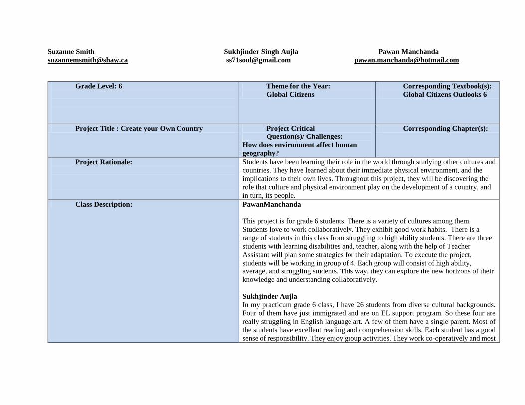
Suzanne Smith Sukhjinder Singh Aujla Pawan Manchanda [email protected] [email protected] [email protected] Grade Level: 6 Theme for the Year: Global Citizens Corresponding Textbook(s): Global Citizens Outlooks 6 Project Title : Create your Own Country Project Critical Question(s)/ Challenges: How does environment affect human geography? Corresponding Chapter(s): Project Rationale: Students have been learning their role in the world through studying other cultures and countries. They have learned about their immediate physical environment, and the implications to their own lives. Throughout this project, they will be discovering the role that culture and physical environment play on the development of a country, and in turn, its people. Class Description: PawanManchanda This project is for grade 6 students. There is a variety of cultures among them. Students love to work collaboratively. They exhibit good work habits. There is a range of students in this class from struggling to high ability students. There are three students with learning disabilities and, teacher, along with the help of Teacher Assistant will plan some strategies for their adaptation. To execute the project, students will be working in group of 4. Each group will consist of high ability, average, and struggling students. This way, they can explore the new horizons of their knowledge and understanding collaboratively. Sukhjinder Aujla In my practicum grade 6 class, I have 26 students from diverse cultural backgrounds. Four of them have just immigrated and are on EL support program. So these four are really struggling in English language art. A few of them have a single parent. Most of the students have excellent reading and comprehension skills. Each student has a good sense of responsibility. They enjoy group activities. They work co-operatively and most
Transcript of Suzanne Smith Sukhjinder Singh Aujla Pawan...
Suzanne Smith Sukhjinder Singh Aujla Pawan Manchanda
[email protected] [email protected] [email protected]
Grade Level: 6
Theme for the Year:
Global Citizens
Corresponding Textbook(s):
Global Citizens Outlooks 6
Project Title : Create your Own Country Project Critical
Question(s)/ Challenges:
How does environment affect human
geography?
Corresponding Chapter(s):
Project Rationale:
Students have been learning their role in the world through studying other cultures and
countries. They have learned about their immediate physical environment, and the
implications to their own lives. Throughout this project, they will be discovering the
role that culture and physical environment play on the development of a country, and
in turn, its people. Class Description: PawanManchanda
This project is for grade 6 students. There is a variety of cultures among them.
Students love to work collaboratively. They exhibit good work habits. There is a
range of students in this class from struggling to high ability students. There are three
students with learning disabilities and, teacher, along with the help of Teacher
Assistant will plan some strategies for their adaptation. To execute the project,
students will be working in group of 4. Each group will consist of high ability,
average, and struggling students. This way, they can explore the new horizons of their
knowledge and understanding collaboratively.
Sukhjinder Aujla
In my practicum grade 6 class, I have 26 students from diverse cultural backgrounds.
Four of them have just immigrated and are on EL support program. So these four are
really struggling in English language art. A few of them have a single parent. Most of
the students have excellent reading and comprehension skills. Each student has a good
sense of responsibility. They enjoy group activities. They work co-operatively and most
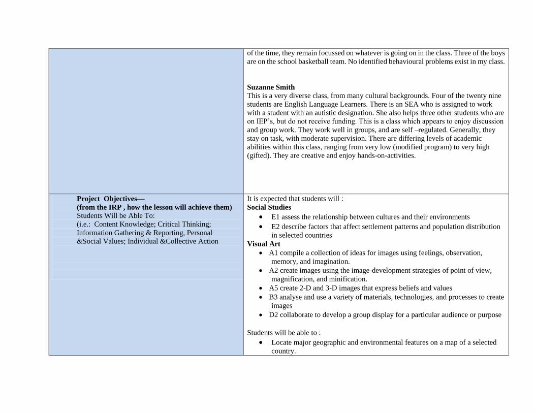
of the time, they remain focussed on whatever is going on in the class. Three of the boys
are on the school basketball team. No identified behavioural problems exist in my class.
Suzanne Smith
This is a very diverse class, from many cultural backgrounds. Four of the twenty nine
students are English Language Learners. There is an SEA who is assigned to work
with a student with an autistic designation. She also helps three other students who are
on IEP’s, but do not receive funding. This is a class which appears to enjoy discussion
and group work. They work well in groups, and are self –regulated. Generally, they
stay on task, with moderate supervision. There are differing levels of academic
abilities within this class, ranging from very low (modified program) to very high
(gifted). They are creative and enjoy hands-on-activities.
Project Objectives—
(from the IRP , how the lesson will achieve them)
Students Will be Able To:
(i.e.: Content Knowledge; Critical Thinking;
Information Gathering & Reporting, Personal
&Social Values; Individual &Collective Action
It is expected that students will : Social Studies
E1 assess the relationship between cultures and their environments
E2 describe factors that affect settlement patterns and population distribution
in selected countries Visual Art
A1 compile a collection of ideas for images using feelings, observation,
memory, and imagination.
A2 create images using the image-development strategies of point of view,
magnification, and minification.
A5 create 2-D and 3-D images that express beliefs and values
B3 analyse and use a variety of materials, technologies, and processes to create
images
D2 collaborate to develop a group display for a particular audience or purpose
Students will be able to :
Locate major geographic and environmental features on a map of a selected
country.
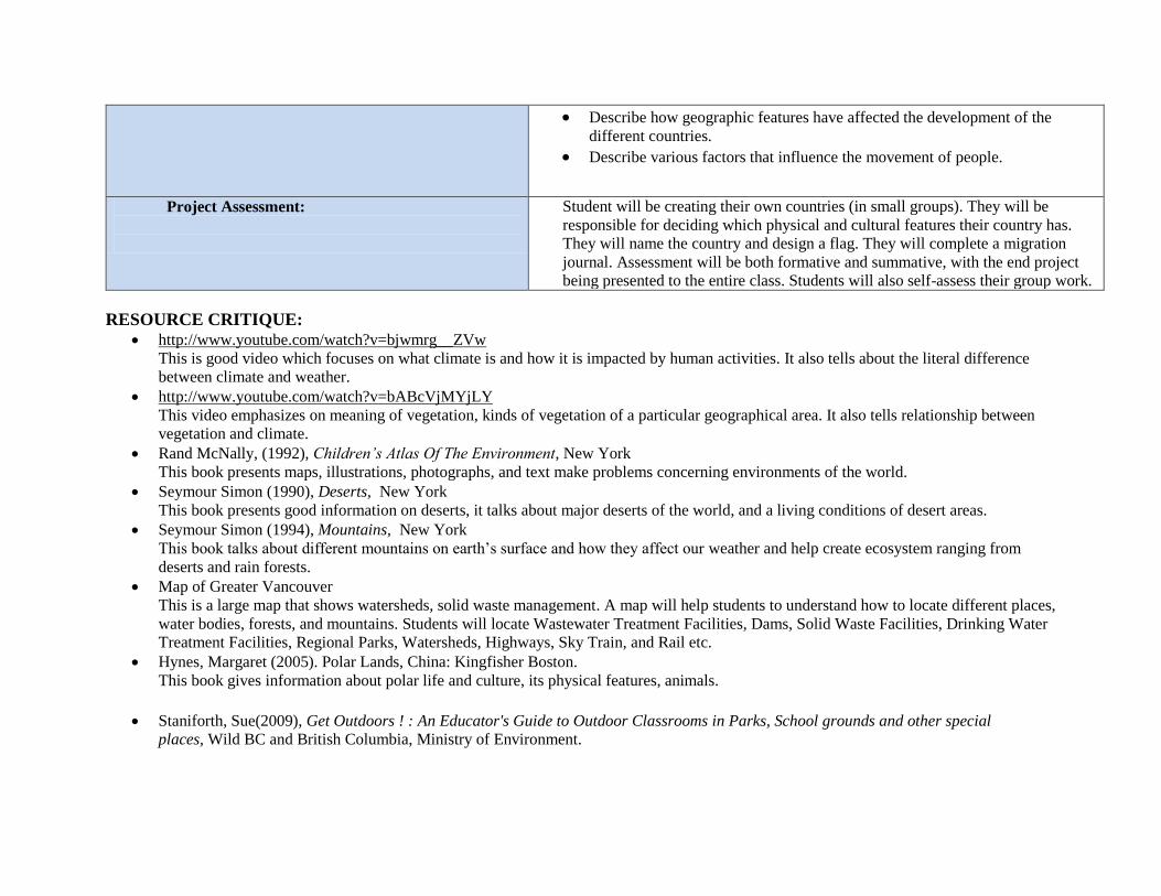
RESOURCE CRITIQUE:
http://www.youtube.com/watch?v=bjwmrg__ZVw
This is good video which focuses on what climate is and how it is impacted by human activities. It also tells about the literal difference
between climate and weather.
http://www.youtube.com/watch?v=bABcVjMYjLY
This video emphasizes on meaning of vegetation, kinds of vegetation of a particular geographical area. It also tells relationship between
vegetation and climate.
Rand McNally, (1992), Children’s Atlas Of The Environment, New York
This book presents maps, illustrations, photographs, and text make problems concerning environments of the world.
Seymour Simon (1990), Deserts, New York
This book presents good information on deserts, it talks about major deserts of the world, and a living conditions of desert areas.
Seymour Simon (1994), Mountains, New York
This book talks about different mountains on earth’s surface and how they affect our weather and help create ecosystem ranging from
deserts and rain forests.
Map of Greater Vancouver
This is a large map that shows watersheds, solid waste management. A map will help students to understand how to locate different places,
water bodies, forests, and mountains. Students will locate Wastewater Treatment Facilities, Dams, Solid Waste Facilities, Drinking Water
Treatment Facilities, Regional Parks, Watersheds, Highways, Sky Train, and Rail etc.
Hynes, Margaret (2005). Polar Lands, China: Kingfisher Boston.
This book gives information about polar life and culture, its physical features, animals.
Staniforth, Sue(2009), Get Outdoors ! : An Educator's Guide to Outdoor Classrooms in Parks, School grounds and other special
places, Wild BC and British Columbia, Ministry of Environment.
Describe how geographic features have affected the development of the
different countries.
Describe various factors that influence the movement of people.
Project Assessment:
Student will be creating their own countries (in small groups). They will be
responsible for deciding which physical and cultural features their country has.
They will name the country and design a flag. They will complete a migration
journal. Assessment will be both formative and summative, with the end project
being presented to the entire class. Students will also self-assess their group work.
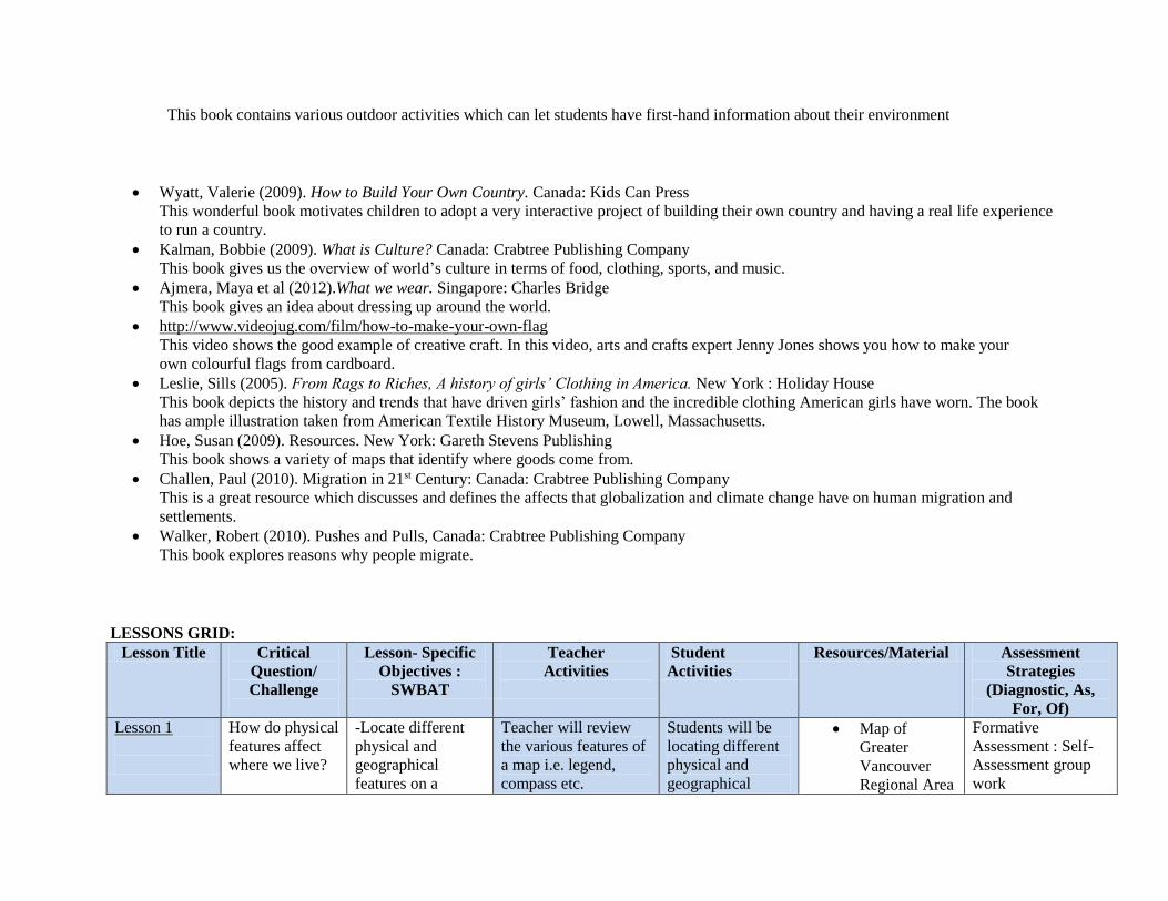
This book contains various outdoor activities which can let students have first-hand information about their environment
Wyatt, Valerie (2009). How to Build Your Own Country. Canada: Kids Can Press
This wonderful book motivates children to adopt a very interactive project of building their own country and having a real life experience
to run a country.
Kalman, Bobbie (2009). What is Culture? Canada: Crabtree Publishing Company
This book gives us the overview of world’s culture in terms of food, clothing, sports, and music.
Ajmera, Maya et al (2012).What we wear. Singapore: Charles Bridge
This book gives an idea about dressing up around the world.
http://www.videojug.com/film/how-to-make-your-own-flag
This video shows the good example of creative craft. In this video, arts and crafts expert Jenny Jones shows you how to make your
own colourful flags from cardboard.
Leslie, Sills (2005). From Rags to Riches, A history of girls’ Clothing in America. New York : Holiday House
This book depicts the history and trends that have driven girls’ fashion and the incredible clothing American girls have worn. The book
has ample illustration taken from American Textile History Museum, Lowell, Massachusetts.
Hoe, Susan (2009). Resources. New York: Gareth Stevens Publishing
This book shows a variety of maps that identify where goods come from.
Challen, Paul (2010). Migration in 21st Century: Canada: Crabtree Publishing Company
This is a great resource which discusses and defines the affects that globalization and climate change have on human migration and
settlements.
Walker, Robert (2010). Pushes and Pulls, Canada: Crabtree Publishing Company
This book explores reasons why people migrate.
LESSONS GRID:
Lesson Title Critical
Question/
Challenge
Lesson- Specific
Objectives :
SWBAT
Teacher
Activities
Student
Activities
Resources/Material Assessment
Strategies
(Diagnostic, As,
For, Of)
Lesson 1
How do physical
features affect
where we live?
-Locate different
physical and
geographical
features on a
Teacher will review
the various features of
a map i.e. legend,
compass etc.
Students will be
locating different
physical and
geographical
Map of
Greater
Vancouver
Regional Area
Formative
Assessment : Self-
Assessment group
work
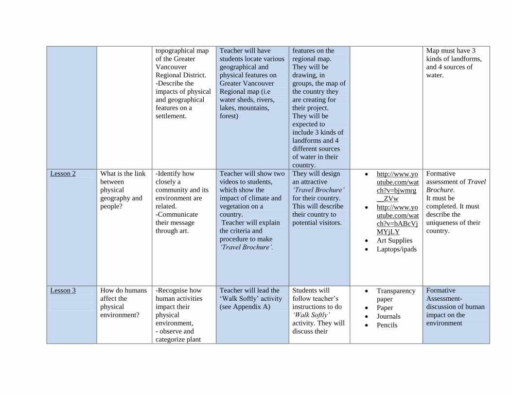
topographical map
of the Greater
Vancouver
Regional District.
-Describe the
impacts of physical
and geographical
features on a
settlement.
Teacher will have
students locate various
geographical and
physical features on
Greater Vancouver
Regional map (i.e
water sheds, rivers,
lakes, mountains,
forest)
features on the
regional map.
They will be
drawing, in
groups, the map of
the country they
are creating for
their project.
They will be
expected to
include 3 kinds of
landforms and 4
different sources
of water in their
country.
Map must have 3
kinds of landforms,
and 4 sources of
water.
Lesson 2
What is the link
between
physical
geography and
people?
-Identify how
closely a
community and its
environment are
related.
-Communicate
their message
through art.
Teacher will show two
videos to students,
which show the
impact of climate and
vegetation on a
country.
Teacher will explain
the criteria and
procedure to make
‘Travel Brochure’.
They will design
an attractive
‘Travel Brochure’
for their country.
This will describe
their country to
potential visitors.
http://www.yo
utube.com/wat
ch?v=bjwmrg
__ZVw
http://www.yo
utube.com/wat
ch?v=bABcVj
MYjLY
Art Supplies
Laptops/ipads
Formative
assessment of Travel
Brochure.
It must be
completed. It must
describe the
uniqueness of their
country.
Lesson 3
How do humans
affect the
physical
environment?
-Recognise how
human activities
impact their
physical
environment,
- observe and
categorize plant
Teacher will lead the
‘Walk Softly’ activity
(see Appendix A)
Students will
follow teacher’s
instructions to do
‘Walk Softly’
activity. They will
discuss their
Transparency
paper
Paper
Journals
Pencils
Formative
Assessment-
discussion of human
impact on the
environment
and animal in a
designated area.
experience in
classroom.
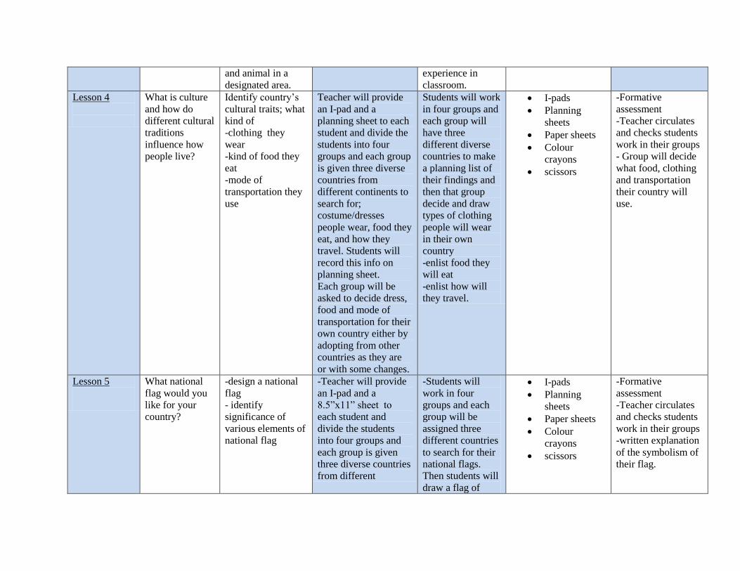
Lesson 4
What is culture
and how do
different cultural
traditions
influence how
people live?
Identify country’s
cultural traits; what
kind of
-clothing they
wear
-kind of food they
eat
-mode of
transportation they
use
Teacher will provide
an I-pad and a
planning sheet to each
student and divide the
students into four
groups and each group
is given three diverse
countries from
different continents to
search for;
costume/dresses
people wear, food they
eat, and how they
travel. Students will
record this info on
planning sheet.
Each group will be
asked to decide dress,
food and mode of
transportation for their
own country either by
adopting from other
countries as they are
or with some changes.
Students will work
in four groups and
each group will
have three
different diverse
countries to make
a planning list of
their findings and
then that group
decide and draw
types of clothing
people will wear
in their own
country
-enlist food they
will eat
-enlist how will
they travel.
I-pads
Planning
sheets
Paper sheets
Colour
crayons
scissors
-Formative
assessment
-Teacher circulates
and checks students
work in their groups - Group will decide
what food, clothing
and transportation
their country will
use.
Lesson 5
What national
flag would you
like for your
country?
-design a national
flag
- identify
significance of
various elements of
national flag
-Teacher will provide
an I-pad and a
8.5”x11” sheet to
each student and
divide the students
into four groups and
each group is given
three diverse countries
from different
-Students will
work in four
groups and each
group will be
assigned three
different countries
to search for their
national flags.
Then students will
draw a flag of
I-pads
Planning
sheets
Paper sheets
Colour
crayons
scissors
-Formative
assessment
-Teacher circulates
and checks students
work in their groups -written explanation
of the symbolism of
their flag.
continents to search
for; their national flags
Then each group will
decide and design a
national flag for their
own country by
keeping in mind
various
physical/cultural
factors of their own
country.
their country and
write a brief
explanation of
what the different
colours and
symbols on the
their flag
represent.
Lesson 6
How are
economies
intertwined?
-select the name of
money
-sign for the
money
-colour and /or
shapes of
banknotes and/or
coins
-collaborate on
system to use for
‘mini-trading post’
Teacher will have a
mini-trading post.
Class will decide how
they will ‘pay’ for
items. They will
collaborate on whether
it will be a barter
system, or currency
will be used.
Students will
discuss the
benefits and
drawback of
different styles of
trading for goods.
They will decide
on a method of
payment for mini-
trading and ‘buy’
items in the
method decided.
In their small
country groups,
they will decide
on what kind of
currency ( if any),
and create an
example.
Paper sheets
Cardboard
sheets
Colour
crayons
scissors
-Formative
assessment
-Teacher circulates
and checks students
work in their groups - group activity,
discussion, and
collaboration
Lesson 7
How does the
changing world
affect our
-assess the
relationship
between a changing
This will be a mini-
lesson on settlement
patterns. Students will
look at settlement
Students will
create a migration
journal for their
country.
Migration
journals
Atlas.gc.ca
Journal entries will
be completed.
settlement
patterns?
world and
settlement
maps of Canada in
1850 and now, in the
iPads. What factors
affect settlement?
Each group will
decide and incorporate
2 factors that made
their people settle in
their new country.
How did they get
there? Why are
they moving to a
new country?
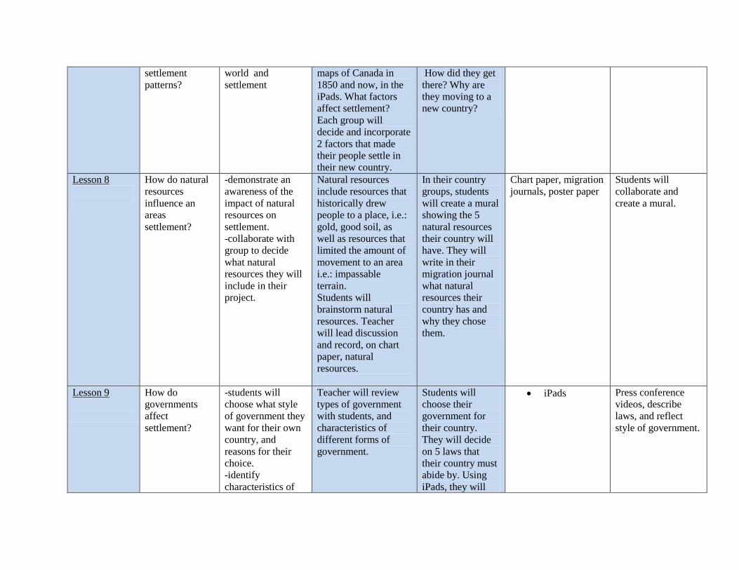
Lesson 8
How do natural
resources
influence an
areas
settlement?
-demonstrate an
awareness of the
impact of natural
resources on
settlement.
-collaborate with
group to decide
what natural
resources they will
include in their
project.
Natural resources
include resources that
historically drew
people to a place, i.e.:
gold, good soil, as
well as resources that
limited the amount of
movement to an area
i.e.: impassable
terrain.
Students will
brainstorm natural
resources. Teacher
will lead discussion
and record, on chart
paper, natural
resources.
In their country
groups, students
will create a mural
showing the 5
natural resources
their country will
have. They will
write in their
migration journal
what natural
resources their
country has and
why they chose
them.
Chart paper, migration
journals, poster paper
Students will
collaborate and
create a mural.
Lesson 9
How do
governments
affect
settlement?
-students will
choose what style
of government they
want for their own
country, and
reasons for their
choice.
-identify
characteristics of
Teacher will review
types of government
with students, and
characteristics of
different forms of
government.
Students will
choose their
government for
their country.
They will decide
on 5 laws that
their country must
abide by. Using
iPads, they will
iPads Press conference
videos, describe
laws, and reflect
style of government.
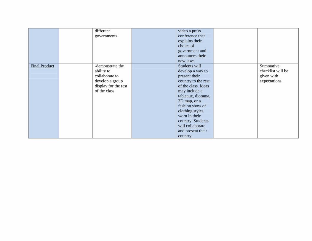
different
governments.
video a press
conference that
explains their
choice of
government and
announces their
new laws.
Final Product
-demonstrate the
ability to
collaborate to
develop a group
display for the rest
of the class.
Students will
develop a way to
present their
country to the rest
of the class. Ideas
may include a
tableaux, diorama,
3D map, or a
fashion show of
clothing styles
worn in their
country. Students
will collaborate
and present their
country.
Summative:
checklist will be
given with
expectations.
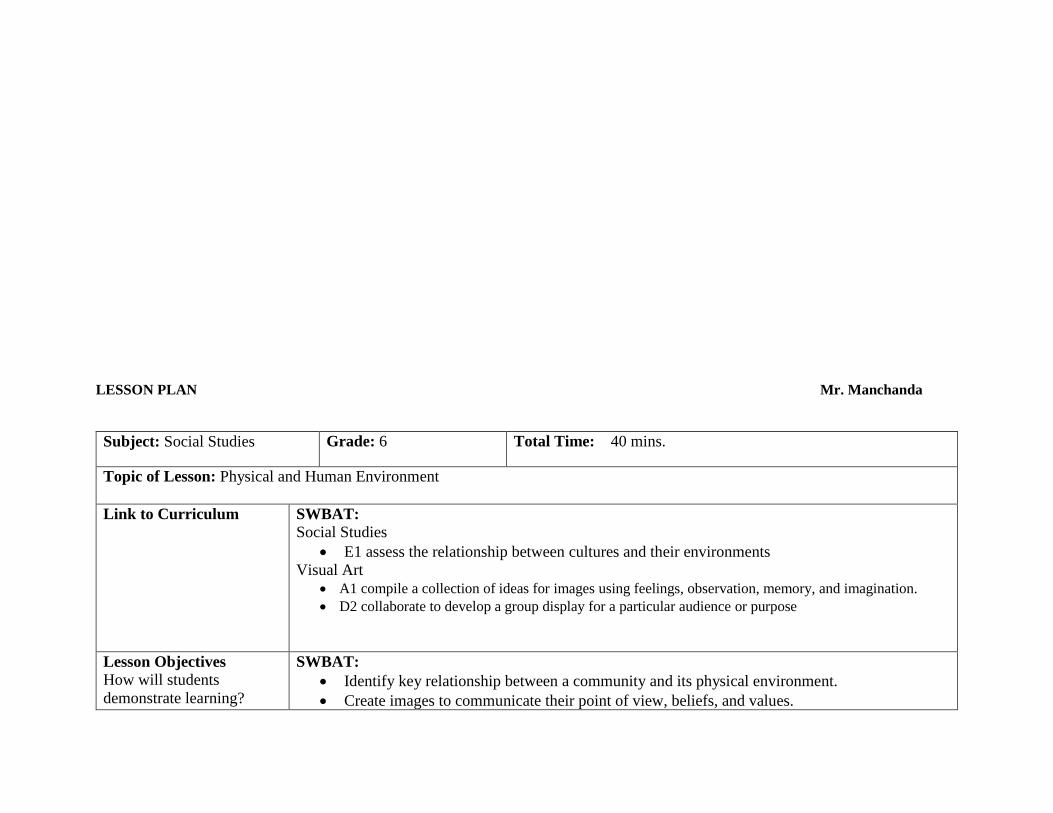
LESSON PLAN Mr. Manchanda
Subject: Social Studies Grade: 6 Total Time: 40 mins.
Topic of Lesson: Physical and Human Environment
Link to Curriculum SWBAT:
Social Studies
E1 assess the relationship between cultures and their environments
Visual Art
A1 compile a collection of ideas for images using feelings, observation, memory, and imagination.
D2 collaborate to develop a group display for a particular audience or purpose
Lesson Objectives
How will students
demonstrate learning?
SWBAT:
Identify key relationship between a community and its physical environment.
Create images to communicate their point of view, beliefs, and values.
(Specific to this lesson)
Prior Knowledge Students are familiar with the vegetation in their community. They are also aware of weather patterns
in their community. They can compare and contrast climate of their place to that of the other places.
Materials Art Supplies, Laptops/ipads
Time
(mins) What the teacher says/does What the students do Materials
5
Hook/Opening
Teacher will show students
some pictures of
vegetation and of all four
seasons of BC.
Teacher will ask students
question/s on those
pictures. (What do you
notice?)
Teacher will announce
today’s topic : ’Climate
and Vegetation’
Hook/Opening
Students will look at
the pictures and
answer their teacher’s
question/s quietly.
Document Camera
Pictures of vegetation and climate of BC.(from
internet
5
Pre-activity
Teacher will assess
students’ prior knowledge
by asking some questions.
(How are vegetation and
climate of a region
Pre-activity
Students will listen to
their teacher
attentively, and will
try to answer his/her
questions.
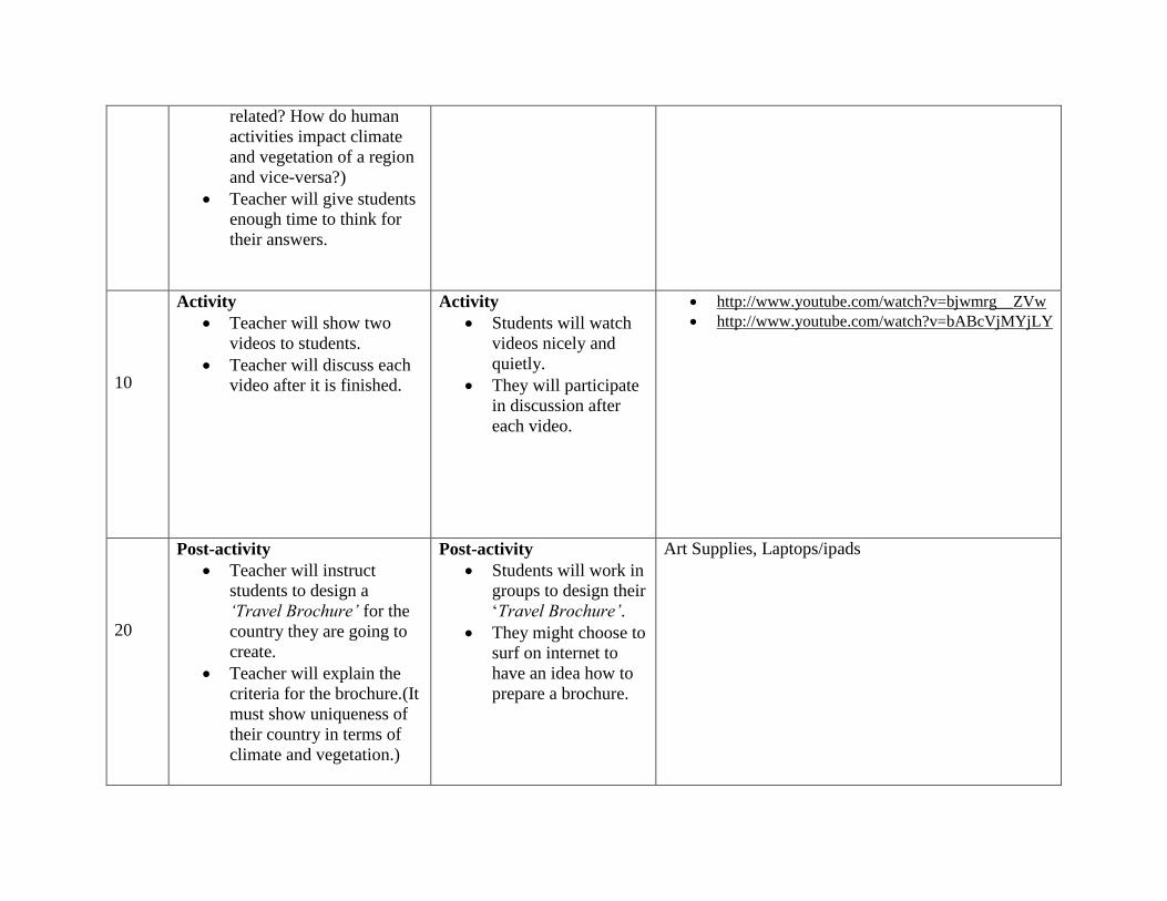
related? How do human
activities impact climate
and vegetation of a region
and vice-versa?)
Teacher will give students
enough time to think for
their answers.
10
Activity
Teacher will show two
videos to students.
Teacher will discuss each
video after it is finished.
Activity
Students will watch
videos nicely and
quietly.
They will participate
in discussion after
each video.
http://www.youtube.com/watch?v=bjwmrg__ZVw
http://www.youtube.com/watch?v=bABcVjMYjLY
20
Post-activity
Teacher will instruct
students to design a
‘Travel Brochure’ for the
country they are going to
create.
Teacher will explain the
criteria for the brochure.(It
must show uniqueness of
their country in terms of
climate and vegetation.)
Post-activity
Students will work in
groups to design their
‘Travel Brochure’.
They might choose to
surf on internet to
have an idea how to
prepare a brochure.
Art Supplies, Laptops/ipads
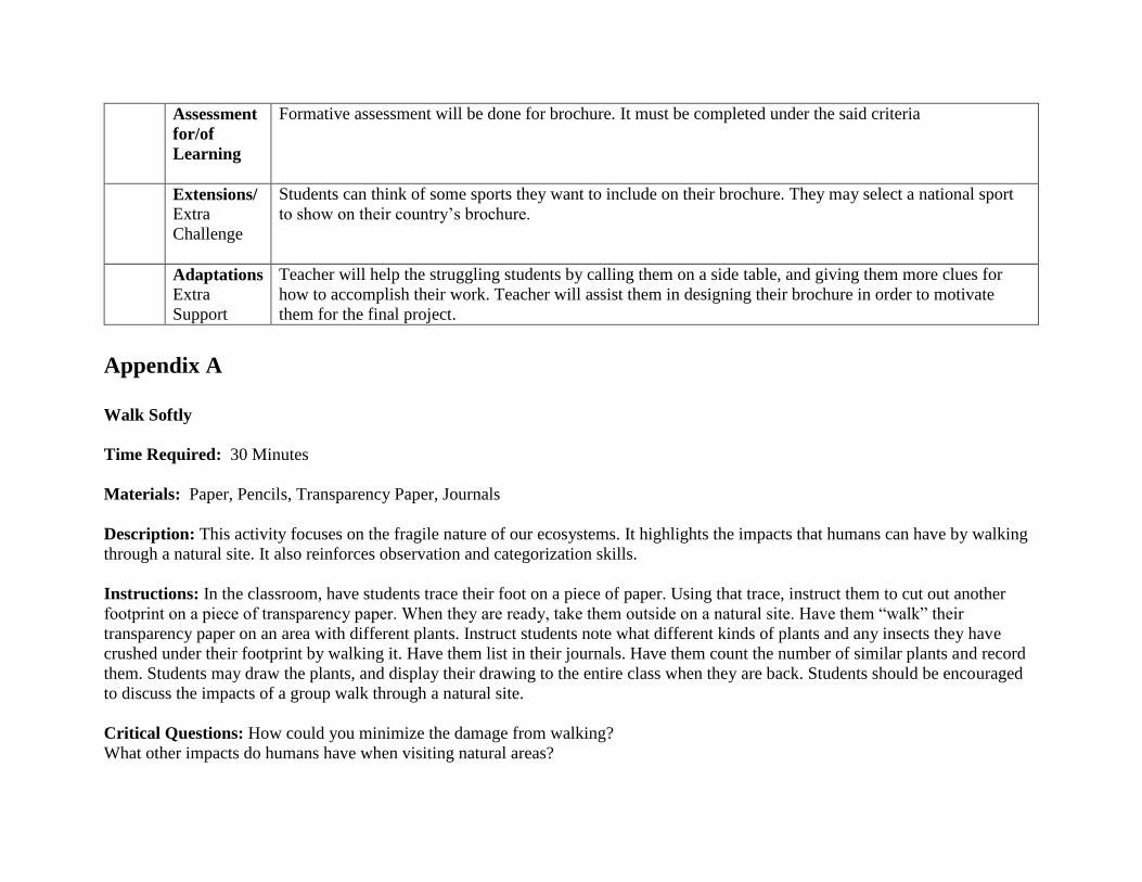
Assessment
for/of
Learning
Formative assessment will be done for brochure. It must be completed under the said criteria
Extensions/
Extra
Challenge
Students can think of some sports they want to include on their brochure. They may select a national sport
to show on their country’s brochure.
Adaptations
Extra
Support
Teacher will help the struggling students by calling them on a side table, and giving them more clues for
how to accomplish their work. Teacher will assist them in designing their brochure in order to motivate
them for the final project.
Appendix A
Walk Softly
Time Required: 30 Minutes
Materials: Paper, Pencils, Transparency Paper, Journals
Description: This activity focuses on the fragile nature of our ecosystems. It highlights the impacts that humans can have by walking
through a natural site. It also reinforces observation and categorization skills.
Instructions: In the classroom, have students trace their foot on a piece of paper. Using that trace, instruct them to cut out another
footprint on a piece of transparency paper. When they are ready, take them outside on a natural site. Have them “walk” their
transparency paper on an area with different plants. Instruct students note what different kinds of plants and any insects they have
crushed under their footprint by walking it. Have them list in their journals. Have them count the number of similar plants and record
them. Students may draw the plants, and display their drawing to the entire class when they are back. Students should be encouraged
to discuss the impacts of a group walk through a natural site.
Critical Questions: How could you minimize the damage from walking?
What other impacts do humans have when visiting natural areas?
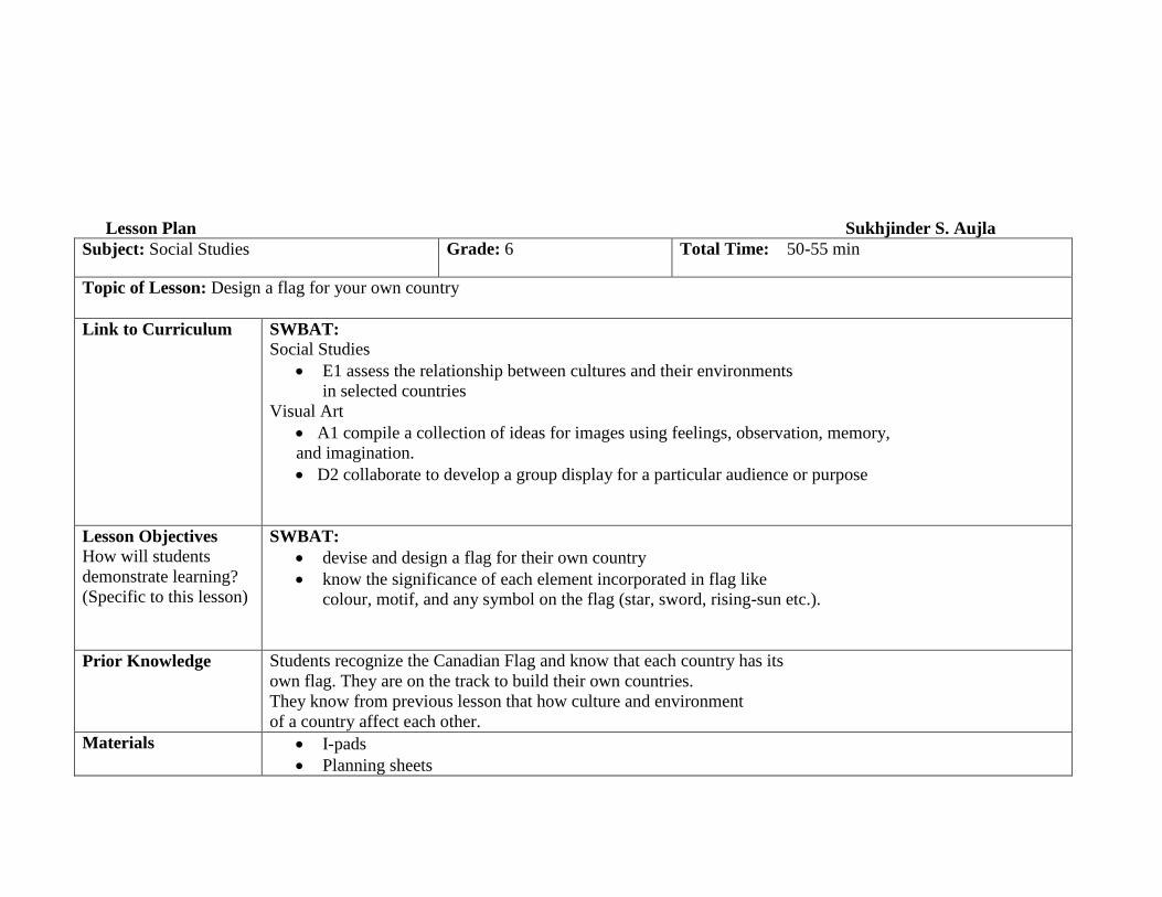
Lesson Plan Sukhjinder S. Aujla
Subject: Social Studies Grade: 6 Total Time: 50-55 min
Topic of Lesson: Design a flag for your own country
Link to Curriculum SWBAT:
Social Studies
E1 assess the relationship between cultures and their environments
in selected countries
Visual Art
A1 compile a collection of ideas for images using feelings, observation, memory,
and imagination.
D2 collaborate to develop a group display for a particular audience or purpose
Lesson Objectives
How will students
demonstrate learning?
(Specific to this lesson)
SWBAT:
devise and design a flag for their own country
know the significance of each element incorporated in flag like
colour, motif, and any symbol on the flag (star, sword, rising-sun etc.).
Prior Knowledge Students recognize the Canadian Flag and know that each country has its
own flag. They are on the track to build their own countries.
They know from previous lesson that how culture and environment
of a country affect each other.
Materials I-pads
Planning sheets
Paper sheets
Colour crayons/felt colours
Scissors
Time What the teacher says/does What the students do Materials
5 min Students will be shown a Canadian Flag
and will be asked Questions like;
What is this?
Why Canada or all countries have
their own Flags?
Which leaf does this Canadian
flag has on it?
Hook/Opening
Student will
respond to the
questions.
Flags of Canada and
some other countries
3-5 min Pre-activity
Teacher will divide the students in
four groups of six
Each group will be provided with
a big planning sheet, each student
in a group will be provided an I-
pad
Pre-activity
Each students will
get an I-pad
Each group will get
a big planning sheet
I pads, planning
sheets,
Felt colors
25-30 min Activity 1:
Each group will be assigned three
diverse countries from different
continents as follows;
Group A : India, Brazil, and France
Group B: China, USA, and South Africa
Group C: Australia, UK, and Iran
Group D: Argentina, Pakistan, and
Norway
Each group will be asked to go
online and do research on the flags
of these countries and record the
Activity 1:
Students work in
groups.
They will do online
search for the flags
of their assigned
countries.
Each group will
relate various
elements of the flag
with physical
I-pads, planning sheet,
Felt colors
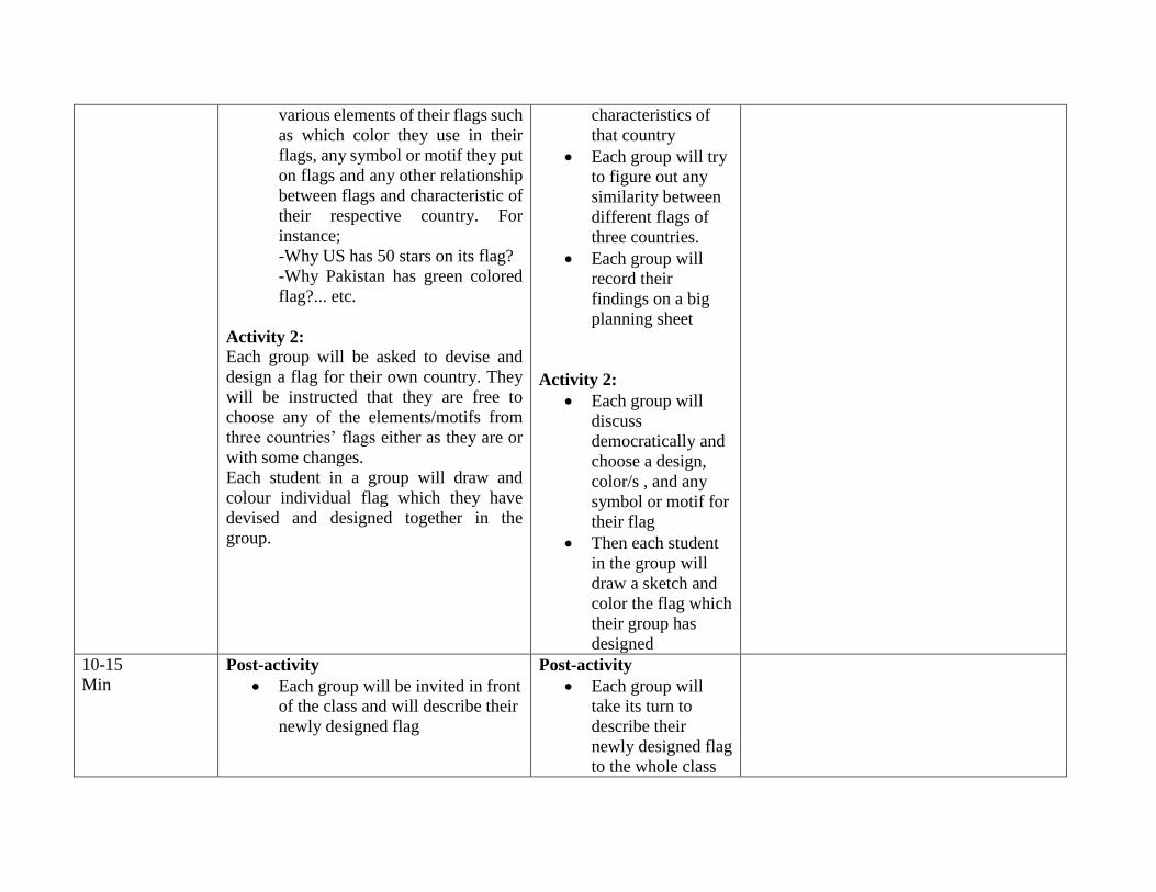
various elements of their flags such
as which color they use in their
flags, any symbol or motif they put
on flags and any other relationship
between flags and characteristic of
their respective country. For
instance;
-Why US has 50 stars on its flag?
-Why Pakistan has green colored
flag?... etc.
Activity 2:
Each group will be asked to devise and
design a flag for their own country. They
will be instructed that they are free to
choose any of the elements/motifs from
three countries’ flags either as they are or
with some changes.
Each student in a group will draw and
colour individual flag which they have
devised and designed together in the
group.
characteristics of
that country
Each group will try
to figure out any
similarity between
different flags of
three countries.
Each group will
record their
findings on a big
planning sheet
Activity 2:
Each group will
discuss
democratically and
choose a design,
color/s , and any
symbol or motif for
their flag
Then each student
in the group will
draw a sketch and
color the flag which
their group has
designed
10-15
Min Post-activity
Each group will be invited in front
of the class and will describe their
newly designed flag
Post-activity
Each group will
take its turn to
describe their
newly designed flag
to the whole class
Each group will display or hang or
paste their flags in specific area /
corner of classroom
They will brief the
reasons why did
they choose any
specific color or
motif or symbol on
their flag
Assessment
for/of
Learning
Teacher will hand out “match the columns” home worksheets to each student
in which they will match different countries to their flags.
Extensions/
Extra
Challenge
If any student needs enrichment or extra challenge, he/she will be asked to
search timelines/history that when did three countries adopt their flags and have
they ever had changed their flags since adoption?
Adaptations
Extra
Support
Teacher will circulate to make sure that each student in a group is working
collaboratively. If any student needs any help at any point, teacher will help
accordingly.
References:
Global Citizens Outlook 6 Text book
How to Build Your Own Country by V. Wyatt
BC Ministry of Education IRPs/PLO’s
http://www.bced.gov.bc.ca/irp/course.php?lang=en&subject=Social_Studies&course=Social_Studies_K_to_7&year=2
006
LESSON PLAN Mrs. Smith
Subject: Socials Studies Grade: 6 Total Time:50 mins
Topic of Lesson: Natural resources
Link to Curriculum SWBAT:
Create a mural.
Respond in written form to a question.
Lesson Objectives
How will students
demonstrate learning?
(Specific to this lesson)
SWBAT:
Demonstrate an awareness of the impact of natural resources on settlement.
Understand the difference between renewable and non-renewable resources.
Collaborate and create a mural
Prior Knowledge
Students have been studying humans and physical geography, this is another aspect of this
subject.
Materials Household products, paint, paper
Time
(mins)
5
What the teacher says/do: Begin
brainstorming with the students. Review
definition of renewable and non-
renewable resources.
What the students do: Students
will brainstorm natural resources
and review meaning of renewable
and non-renewable resources
Materials
5 Hook/Opening
Teacher will show pictures of cars,
thermostat, products commonly
found in one’s home.
Hook/Opening
Each country group will
list items commonly used
in daily living
Products commonly found at home
15 Pre-activity
Teacher will assign one natural
resources to each group- they will
research and find our 5 ‘fast facts’
about their resource (is it
renewable, what is it used for, how
is it acquired?) Students will orally
report what they learned to class.
Pre-activity
Students will research one
natural resource and find 5
‘fast facts’. They will
record information found.
iPads, books, chart paper
15 Activity
Students will decided what
resources they require in their
country. They will create a mural
showing these resources.
Activity
Students will decide on 5
natural resources their
country will have, and
create a mural with
pictures of these resources.
They can show people
using the resources, or
simply the resources
themselves.
Large paper,paint, migration journals
10 Post-activity
Display murals
Ask the questions: “Will your
resources bring people to your
country or move them away?”
Post-activity
In their migration journals
they will write which
resources and a brief
reason of why they chose
the particular resources.
Will their resources bring
people to their country? Or
move them away?
Assessment
for/of
Learning
Students will write why they chose the resources they did. They will choose 5 resources and create a
mural.
Extensions/
Extra
Challenge
Students can research and add more resources.
Adaptations
Extra
Support
For extra support, some students may only be able to choose 2-3 resources.