Sustainably Developing a Historic District such as the Old North St. Louis Restoration Group, and...
58
March 2016 www.epa.gov/smartgrowth Old North St. Louis Sustainably Developing a Historic District
Transcript of Sustainably Developing a Historic District such as the Old North St. Louis Restoration Group, and...
March 2016www.epa.gov/smartgrowth
Old North St. LouisSustainably Developing a Historic District

Sustainably Developing a Historic District - Old North St. Louis | Acknowledgements | i
Acknowledgments | Old North St. Louis
Federal PartnersMelissa Kramer........................ U.S. Environmental Protection Agency, Office of Sustainable CommunitiesDavid Doyle ............................. U.S. Environmental Protection Agency, Region 7Charlie Foley ........................... White House Strong Cities, Strong Communities Initiative
City of St. LouisDon Roe .................................. St. Louis Planning and Urban Design AgencyRoman Kordal.......................... St. Louis Planning and Urban Design AgencyConnie Tomasula ..................... St. Louis Planning and Urban Design Agency
Neighborhood PartnersSean Thomas .......................... Old North St. Louis Restoration GroupMatt Fernandez ....................... Old North St. Louis Restoration GroupDoug Rasmussen .................... Old North St. Louis Restoration Group
Consultant TeamSWT Design Williams Creek Consulting Cohen Architecture

Sustainably Developing a Historic District - Old North St. Louis | Table of Contents | ii
Table of Contents | Old North St. Louis
Executive Summary .......................................iii
I. Introduction ................................................1
II. Neighborhood Workshop ..........................4
III. Project Area Assessment ..........................5
IV. Design Options .........................................18
V. Implementation Strategies .........................44
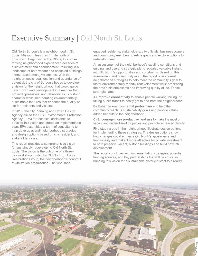
Old North St. Louis is a neighborhood in St. Louis, Missouri, less than 1 mile north of downtown. Beginning in the 1950s, this once-thriving neighborhood experienced decades of disinvestment and abandonment, resulting in a landscape of both vacant and occupied buildings interspersed among vacant lots. With the neighborhood’s ideal location and abundance of potential, the city of St. Louis hopes to develop a vision for the neighborhood that would guide new growth and development in a manner that protects, preserves, and rehabilitates its historic character while incorporating environmentally sustainable features that enhance the quality of life for residents and visitors.In 2015, the city Planning and Urban Design Agency asked the U.S. Environmental Protection Agency (EPA) for technical assistance to develop this vision and create an implementable plan. EPA assembled a team of consultants to help develop overall neighborhood strategies and design options based on city, resident, and stakeholder goals.This report provides a comprehensive vision for sustainably redeveloping Old North St. Louis. The vision is the outcome of a three-day workshop hosted by Old North St. Louis Restoration Group, the neighborhood’s nonprofit revitalization organization. The workshop
Executive Summary | Old North St. Louis
SW
T D
esig
n
engaged residents, stakeholders, city officials, business owners, and community members to refine goals and explore options for redevelopment.An assessment of the neighborhood’s existing conditions and guiding land use and strategic plans revealed valuable insight into Old North’s opportunities and constraints. Based on this assessment and community input, the report offers overall neighborhood strategies to help meet the community’s goal to foster environmentally friendly redevelopment while preserving the area’s historic assets and improving quality of life. These strategies are:A) Improve connectivity to enable people walking, biking, or taking public transit to easily get to and from the neighborhood.B) Enhance environmental performance to help the community reach its sustainability goals and provide value-added benefits to the neighborhood.C) Encourage more productive land use to make the most of vacant and underutilized properties and promote increased density.Five study areas in the neighborhood illustrate design options for implementing these strategies. The design options show how changes could enhance Old North’s appearance and functionality and make it more attractive for private investment to both preserve vacant, historic buildings and build new infill development.The report concludes with implementation strategies, potential funding sources, and key partnerships that will be critical in bringing this vision for a sustainable historic district to a reality.

Sustainably Developing a Historic District - Old North St. Louis | Introduction | 1
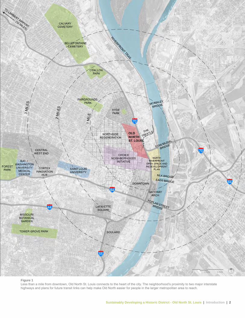
I. Introduction | Old North St. LouisOld North St. Louis, originally settled as an independent village in 1816 and later annexed by the city of St. Louis in 1841, is less than a mile north of downtown. Within the boundaries of this historic neighborhood are three historic districts on the National Register of Historic Places, a recently renovated and flourishing mixed-use development at its main core, and roughly 1,900 residents.Old North was once a dense, low-rise, and vibrant residential neighborhood that was home to blue-collar immigrants, primarily from Germany, Ireland, and Poland. However, beginning in the 1950s, the neighborhood experienced substantial disinvestment and depopulation over several decades, which resulted in property abandonment and widespread vacancy. These issues in turn created negative outside perceptions of the neighborhood that made it difficult to attract new development, financial hardships for residents, and limited access for those without vehicles to basic services such as grocery stores or medical facilities.Beginning in the 1980s, however, residents, organizations such as the Old North St. Louis Restoration Group, and city officials worked to preserve the neighborhood’s historic character, foster community involvement, and catalyze neighborhood investment. Recent and ongoing planning efforts to revitalize neighborhoods adjacent to Old North, including the NorthSide Regeneration Plan, Choice Neighborhoods Initiative, and North Riverfront Open Space and Redevelopment Plan (Figure 1), have the potential to substantially increase the well-being for all residents in the area. The city is also studying major transit-oriented improvements
along the neighborhood’s western boundary that will benefit the community. In addition, many of the neighborhood’s historic qualities, such as its small-scale housing mixed with small commercial buildings and its cohesive, village feel, are once again desirable. The renewed focus on areas north of downtown and Old North’s desirable qualities give the neighborhood an opportunity to leverage this momentum to support environmental sustainability and a better quality of life for current and future residents.The city of St. Louis envisions the redevelopment of Old North as a model for revitalizing a historic neighborhood in an environmentally sustainable way. In 2015, the city asked EPA for technical assistance to turn that vision into an implementable plan. EPA assembled a consultant team to help develop overall neighborhood strategies and design options based on city, resident, and stakeholder goals.The design process began with site visits by EPA, the consultant team, city officials, and neighborhood stakeholders to analyze existing conditions and select five study areas to illustrate design strategies for the neighborhood. The consultant team facilitated a three-day public workshop on August 25-27, 2015, at which participants discussed various options. The consultant team incorporated this input into a design option for each of the five study areas.In addition to strategies to improve the physical condition of the neighborhood, this report identifies options to improve residents’ social conditions, including general well-being, health, and economic opportunity. These options include new bike paths, community spaces, and job training programs. The options also include green infrastructure to manage stormwater near where it falls using the natural processes of soils and vegetation to capture, slow down, and filter runoff.The neighborhood’s overall vision is one of revitalization, historic preservation, and environmental sustainability. This report illustrates strategies and design options that are the first steps towards creating a toolkit of improvements to capitalize on the grassroots efforts that have positioned the neighborhood for revitalization.
Sustainably Developing a Historic District - Old North St. Louis | Introduction | 2
Figure 1Less than a mile from downtown, Old North St. Louis connects to the heart of the city. The neighborhood’s proximity to two major interstate highways and plans for future transit links can help make Old North easier for people in the larger metropolitan area to reach.
0 .5 mile 1 mile
Sustainably Developing a Historic District - Old North St. Louis | Introduction | 3
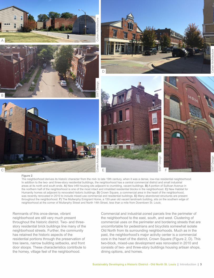
Figure 2The neighborhood derives its historic character from the mid- to late 19th century, when it was a dense, low-rise residential neighborhood. In addition to the two- and three-story residential buildings, the neighborhood has a central commercial district and small industrial areas at its north and south ends. A) New infill housing sits adjacent to crumbling, vacant buildings. B) A portion of Sullivan Avenue in the northern half of the neighborhood is one of the most intact and inhabited residential blocks in the neighborhood. C) New Habitat for Humanity homes sit adjacent to renovated historic buildings. D) Crown Square, a commercial area in the heart of the neighborhood, was recently renovated in 2010 to include mixed-use commercial and residential buildings. E) Many abandoned structures are present throughout the neighborhood. F) The Mullanphy Emigrant Home, a 150-year old vacant landmark building, sits on the southern edge of neighborhood at the corner of Mullanphy Street and North 14th Street, less than a mile from Downtown St. Louis.
SW
T D
esig
nC
ohen
Arc
hite
ctur
e
Coh
en A
rchi
tect
ure
Coh
en A
rchi
tect
ure
SW
T D
esig
n
SW
T D
esig
n
Remnants of this once-dense, vibrant neighborhood are still very much present throughout the historic district. Two- and three-story residential brick buildings line many of the neighborhood streets. Further, the community has retained the historic aspects of the residential portions through the preservation of tree lawns, narrow building setbacks, and front door stoops. These characteristics contribute to the homey, village feel of the neighborhood.
Commercial and industrial-zoned parcels line the perimeter of the neighborhood to the east, south, and west. Clustering of commercial uses on the perimeter and bordering streets that are uncomfortable for pedestrians and bicyclists somewhat isolate Old North from its surrounding neighborhoods. Much as in the past, the neighborhood’s major activity center is a commercial core in the heart of the district, Crown Square (Figure 2, D). This two-block, mixed-use development was renovated in 2010 and consists of two- and three-story buildings housing artisan shops, dining options, and homes.
A
B
D
E FC

Sustainably Developing a Historic District - Old North St. Louis | Neighborhood Workshop | 4
On August 25-27, 2015, Old North St. Louis Restoration Group and the city of St. Louis hosted a neighborhood workshop to present preliminary design options, gather community input, and refine neighborhood design strategies. This three-day workshop gathered local stakeholders and design experts to discuss the future of Old North St. Louis. Attendees included neighborhood residents and business owners; local developers; and representatives from the city, local nonprofit organizations, utility districts, regional transit planning agencies, and federal agencies. Five focus groups enabled workshop attendees to provide input on topics including:
Housing and historic preservation vacancy, character, land use, infill, policies and codes, affordability, and sustainable materialsEnvironment and energy renewable energy, hydrology, air quality, food production, biodiversity, and conservationGrowth economic development, marketing, neighborhood perception, and brandingTransportation multimodal transportation, connectivity, traffic calming, and street systemsImplementation funding sources, potential partnerships, community engagement strategies, city policies, zoning, and barriers to achieving community’s goals
Figure 3Project stakeholders discussed neighborhood assets and challenges during the workshop.
II. Neighborhood Workshop | Old North St. Louis
Participants identified several priority issues and goals for the neighborhood that the consultant team used to further develop the overall design strategies and study area design options illustrated in this report:• Prioritize pedestrian infrastructure and connect the
fragmented sidewalks.• Consider potential safety issues on local streets used as
truck routes to and from the interstate.• Promote maker-spaces that provide training in trades
needed for historic renovation, offer shared resources, and provide temporary housing for workers.
• Buffer traffic noise by increasing tree canopy along Interstate 70.
• Strengthen connections across Interstate 70 to the Mississippi River and future North Riverfront development.
• Examine the potential for increased market demand should the National Geospatial-Intelligence Agency relocate to the adjacent neighborhood.
• Improve utility infrastructure, including advanced fiber optics.• Make neighborhood identity and branding easily
recognizable.• Improve lighting and nighttime safety.• Make the neighborhood look cared for by cleaning up
overgrown lots and replacing missing signs and street lights.• Create job opportunities to keep money in the neighborhood.
SW
T D
esig
n

Sustainably Developing a Historic District - Old North St. Louis | Project Area Assessment | 5
The design team assessed multiple facets of the neighborhood’s existing conditions, assets, opportunities, and constraints (listed at right). The team gathered information through collaboration with the city of St. Louis Planning and Urban Design Agency, Old North St. Louis Restoration Group, and other local utility, transportation, and planning organizations. The team conducted numerous site visits to field verify the data, document existing conditions, and gather an overall feel for the general character and livelihood of the neighborhood.
A. Prior Neighborhood Plans City of St. Louis Strategic Land Use Plan (2005) and A Plan for the Neighborhoods of the 5th Ward (2002).
B. Sewer System Configuration of the existing sanitary sewer, storm sewer, and combined sewer system.
C. Topography Current elevations with high and low points.
D. Tree Canopy and Surface Permeability Existing tree canopy cover and permeable and impermeable surfaces.
E. Streets Most Suitable for Green Infrastructure Streets that are most suitable for green infrastructure based on multiple weighted variables.
F. Destinations and Landmarks Establishments that routinely attract residents and visitors.
G. Vacancy and Ownership Current state of land and building vacancy categorized by ownership.
H. Current Land Use Current land use as designated by the city of St. Louis.
I. Built Density and Zoning Current zoning and building density on a block-by-block basis.
J. Demographic Data Median age, ethnicity, and median home sale price.
K. Connectivity All transit-related infrastructure including sidewalks, bus routes and stops, bicycle routes, and major access points to and from the neighborhood.
L. Street System Functional classification of streets, speed limits, and traffic calming measures.
III. Project Area Assessment | Old North St. Louis Existing Conditions Analysis
Figure 4The consultant team and city of St. Louis department leaders examine a Metropolitan Sewer District demonstration rain garden that is one block north of the neighborhood.
SW
T D
esig
n

Sustainably Developing a Historic District - Old North St. Louis | Project Area Assessment | 6
This 2005 update to the city’s Strategic Land Use Plan provides direction for people who want to make new investments in the city and identifies opportunities to preserve and develop established neighborhoods, historic districts, and business areas. Given Old North’s historic character and its national historic districts, the city designated much of the neighborhood as a neighborhood preservation area where the existing housing and corner commercial building stock will be preserved and augmented with new infill residential and corner commercial development physically integrated with, and primarily serving the immediate neighborhood. Along the western and southern boundaries are neighborhood commercial areas where the plan encourages the development of new and the rehabilitation of existing commercial uses that primarily serve adjacent neighborhoods. To the north and south are business/industrial preservation areas where stable businesses currently exist and the plan encourages them to remain. This plan provides guidance for the design options presented in Section IV of this report.
The 2002 5th Ward plan developed a comprehensive vision for four neighborhoods in the ward. When the plan was adopted, all of Old North was within the 5th Ward. After redistricting in 2011, approximately one quarter of the neighborhood on the northern end is now in the 3rd Ward. The plan calls for predominately single-family homes in the central and northern parts of the neighborhood, with mixed-use development lining North Florissant Avenue to the west and south, institutional uses and parks to the east, and retail concentrated near Crown Square. Design options in Section IV are consistent with this 5th Ward Plan.
City of St. Louis Strategic Land Use Plan of the St. Louis Comprehensive PlanAdopted January 2005
A Plan for the Neighborhoods of the 5th WardAdopted March 2002
Neighborhood Preservation Area
Neighborhood Development Area
Neighborhood Commercial Area
Regional Commercial Area
Recreational Open Space Preservation and Development Area
Business/Industrial Preservation Area
Business/Industrial Development Area
Institutional Preservation and Development Area
Specialty Mixed Use Area
Opportunity Area
Legend
Single Family
Mixed Use
Heavy Industrial
2 Family
Retail Trade (Multiple, Various)
Transportation / Utilities or Communications
3-4 Family
Offices
Institutional / Community Facilities
Multi-Family
Light Industrial
Parks and Recreation
Vacant Land / Buildings
Legend
Figure 5The City of St. Louis Strategic Land Use Plan, adopted in 2005, designates much of the neighborhood for preservation of existing uses.
Figure 6A Plan for the Neighborhoods of the 5th Ward, adopted in 2002, identified opportunities for new housing, retail and mixed-use development, and park improvements.
A. Prior Neighborhood Plans
Sustainably Developing a Historic District - Old North St. Louis | Project Area Assessment | 7
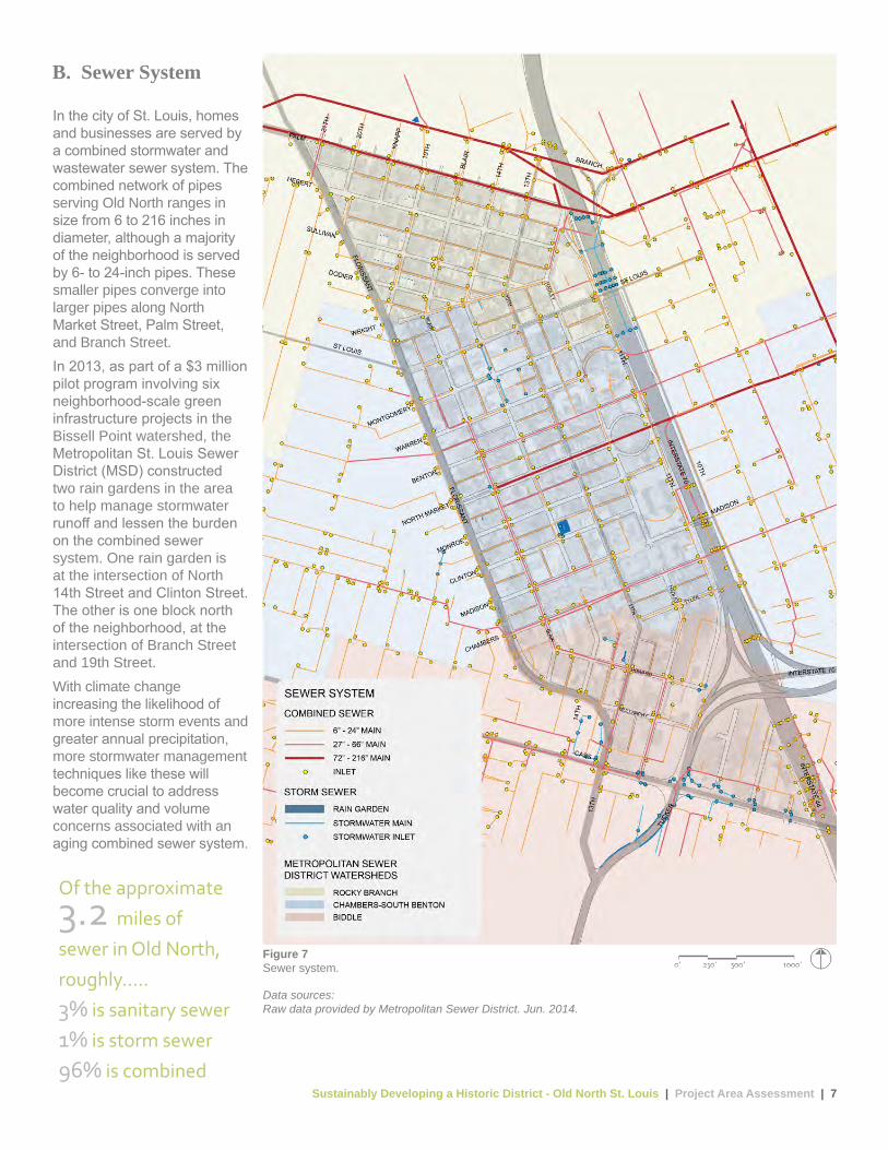
In the city of St. Louis, homes and businesses are served by a combined stormwater and wastewater sewer system. The combined network of pipes serving Old North ranges in size from 6 to 216 inches in diameter, although a majority of the neighborhood is served by 6- to 24-inch pipes. These smaller pipes converge into larger pipes along North Market Street, Palm Street, and Branch Street.In 2013, as part of a $3 million pilot program involving six neighborhood-scale green infrastructure projects in the Bissell Point watershed, the Metropolitan St. Louis Sewer District (MSD) constructed two rain gardens in the area to help manage stormwater runoff and lessen the burden on the combined sewer system. One rain garden is at the intersection of North 14th Street and Clinton Street. The other is one block north of the neighborhood, at the intersection of Branch Street and 19th Street.With climate change increasing the likelihood of more intense storm events and greater annual precipitation, more stormwater management techniques like these will become crucial to address water quality and volume concerns associated with an aging combined sewer system.
B. Sewer System
Figure 7Sewer system.
Data sources:Raw data provided by Metropolitan Sewer District. Jun. 2014.
Of the approximate
3.2 miles of
sewer in Old North,
roughly.....
3% is sanitary sewer
1% is storm sewer
96% is combined
Sustainably Developing a Historic District - Old North St. Louis | Project Area Assessment | 8
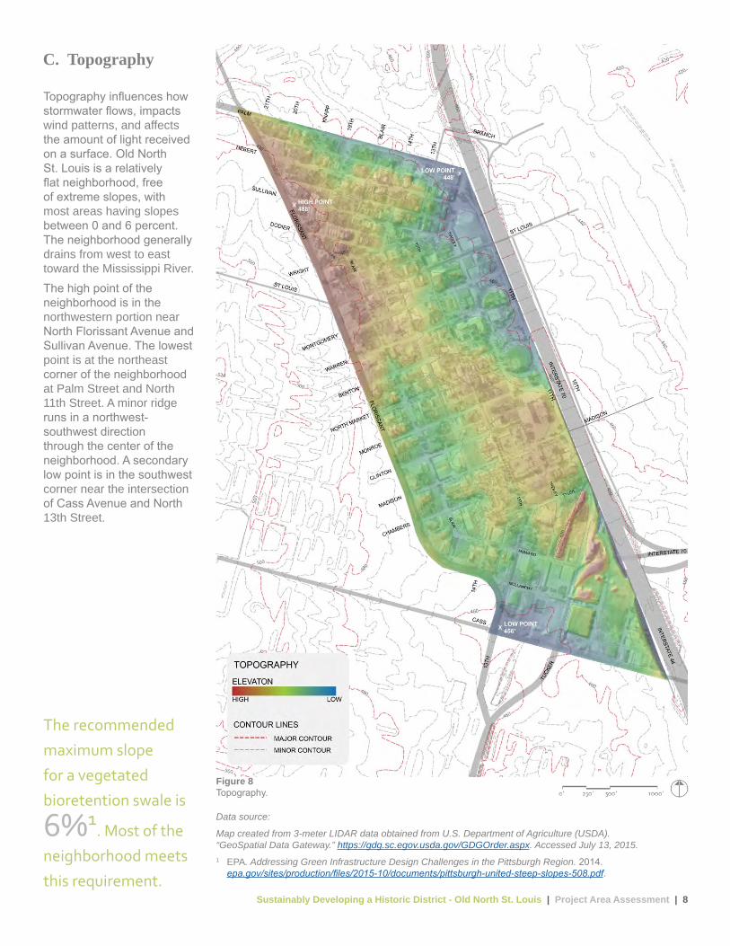
Figure 8Topography.
Data source:
Map created from 3-meter LIDAR data obtained from U.S. Department of Agriculture (USDA). “GeoSpatial Data Gateway.” https://gdg.sc.egov.usda.gov/GDGOrder.aspx. Accessed July 13, 2015.1 EPA. Addressing Green Infrastructure Design Challenges in the Pittsburgh Region. 2014.
epa.gov/sites/production/files/2015-10/documents/pittsburgh-united-steep-slopes-508.pdf.
Topography influences how stormwater flows, impacts wind patterns, and affects the amount of light received on a surface. Old North St. Louis is a relatively flat neighborhood, free of extreme slopes, with most areas having slopes between 0 and 6 percent. The neighborhood generally drains from west to east toward the Mississippi River. The high point of the neighborhood is in the northwestern portion near North Florissant Avenue and Sullivan Avenue. The lowest point is at the northeast corner of the neighborhood at Palm Street and North 11th Street. A minor ridge runs in a northwest-southwest direction through the center of the neighborhood. A secondary low point is in the southwest corner near the intersection of Cass Avenue and North 13th Street.
C. Topography
The recommended
maximum slope
for a vegetated
bioretention swale is
6%1. Most of the
neighborhood meets
this requirement.
Sustainably Developing a Historic District - Old North St. Louis | Project Area Assessment | 9
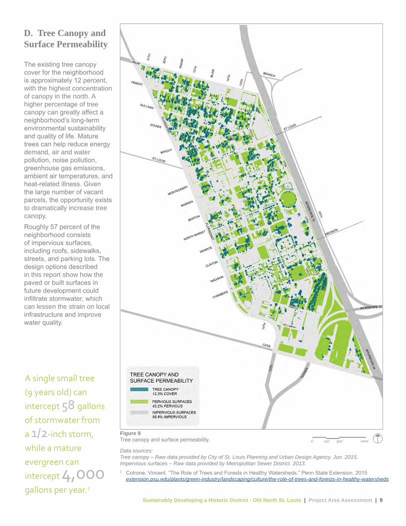
The existing tree canopy cover for the neighborhood is approximately 12 percent, with the highest concentration of canopy in the north. A higher percentage of tree canopy can greatly affect a neighborhood’s long-term environmental sustainability and quality of life. Mature trees can help reduce energy demand, air and water pollution, noise pollution, greenhouse gas emissions, ambient air temperatures, and heat-related illness. Given the large number of vacant parcels, the opportunity exists to dramatically increase tree canopy.Roughly 57 percent of the neighborhood consists of impervious surfaces, including roofs, sidewalks, streets, and parking lots. The design options described in this report show how the paved or built surfaces in future development could infiltrate stormwater, which can lessen the strain on local infrastructure and improve water quality.
D. Tree Canopy and Surface Permeability
Figure 9Tree canopy and surface permeability.
Data sources:Tree canopy – Raw data provided by City of St. Louis Planning and Urban Design Agency. Jun. 2015.Impervious surfaces – Raw data provided by Metropolitan Sewer District. 2013.2 Cotrone, Vincent. “The Role of Trees and Forests in Healthy Watersheds.” Penn State Extension. 2015
extension.psu.edu/plants/green-industry/landscaping/culture/the-role-of-trees-and-forests-in-healthy-watersheds
A single small tree
(9 years old) can
intercept 58 gallons
of stormwater from
a 1/2-inch storm,
while a mature
evergreen can
intercept 4,000 gallons per year.2

Sustainably Developing a Historic District - Old North St. Louis | Project Area Assessment | 10
This green infrastructure suitability analysis considered constructability and hydrological benefits. Constructability is based on street lawn width, the presence of bus stops, and the presence of street trees. Hydrological benefits are based on street slopes, a street’s location within the watershed, and a street’s proximity to sewer backup and flooding complaints from residents.The design team excluded streets with slopes greater than 2 percent from the suitability analysis because green infrastructure is more difficult to construct when slopes are greater, and the water quality benefits tend to be lower.The relatively flat nature of the neighborhood makes it easier to efficiently treat precipitation where it falls. The current absence of trees along a majority of neighborhood streets facilitates construction of green infrastructure projects within the public right-of-way because it will not disturb existing roots.
E. Streets MostSuitable forGreen Infrastructure
Figure 10Streets most suitable for green infrastructure.
Data sources:Street slopes, canopy cover, streets – Raw data provided by the City of St. Louis Planning and Urban Design Agency. Jun. 2015.Watersheds – Raw data provided by Metropolitan Sewer District. Jun. 2014.Sewer backup and flooding complaints – Raw data provided by City of St. Louis. Mar. 2014.
Rain gardens on both
sides of the most
suitable streets could
potentially infiltrate
approximately
583,000 gallons
of water during a
single storm event.

Sustainably Developing a Historic District - Old North St. Louis | Project Area Assessment | 11
Old North St. Louis is home to many popular cultural attractions, none more iconic than Crown Candy Kitchen. This old-fashioned restaurant, which specializes in homemade candy and fountain sodas, has been a St. Louis treasure in Old North since 1913.The neighborhood also houses many churches, schools, Jackson Place Park, and the North City Farmer’s Market. The market is a weekly street market featuring a variety of foods and crafts located in the Crown Square area of Old North St. Louis, which was renovated in 2010. The market takes place every Saturday from the beginning of June through mid-October.At the southern portion of the neighborhood sits the historic Mullanphy Emigrant Home. Listed on the National Register, this structure was built in 1867 to provide housing assistance to the thousands of immigrants that arrived from Europe after the Civil War. The currently vacant building is for sale and could be renovated into the bustling neighborhood attraction it once was.
F. Destinations and Landmarks
Crown Candy Kitchen
was recently ranked
number 4 on the list of
America’s Best Diners
for 2015 by Foursquare,
a popular real-time
location-sharing app.
Figure 11Destinations and landmarks.
3
3
3
3
3
4
Data sources:Schools, churches, and parks – Raw data provided by the City of St. Louis Planning and Urban Design Agency. Jun. 2015.Image sources:3 SWT Design. 2015.4 North City Farmers’ Market Facebook Page. Jul. 2013.

Sustainably Developing a Historic District - Old North St. Louis | Project Area Assessment | 12
Old North St. Louis has experienced substantial depopulation since the 1950s, resulting in widespread property abandonment and vacancy. Over one-third of all neighborhood parcels are currently vacant, 70 percent of which are privately owned. The remaining 30 percent of vacant parcels are owned by the Land Reutilization Authority of St. Louis, a city-run land bank that receives the title to all tax-delinquent properties not sold at the sheriff’s sale. The properties are maintained, marketed, and sold by the St. Louis Development Corporation’s Real Estate Department, the arm of city government that acquires property in the name of the Land Reutilization Authority.The large number of vacant parcels and buildings means the design options could consider infill development at a block scale rather than parcel by parcel.
G. Vacancy and Ownership
Figure 12Vacancy and ownership.
Data sources:Vacancy and ownership – Raw data provided by the City of St. Louis Planning and Urban Design Agency. Jun. 2015.
37% of neighborhood
parcels are vacant.
70% of the vacancies
are privately owned.

Sustainably Developing a Historic District - Old North St. Louis | Project Area Assessment | 13
Commercial and retail activities are concentrated in two areas:Crown Square and adjacent blocks west of North 14th Street between Wright Street and North Market Street. The southern portion of the neighborhood, within the NorthSide Regeneration tax-increment financing (TIF) district bounded by Chambers Street to the north and Hadley Street to the east.Industrial and manufacturing uses are in the southeastern corner of the neighborhood, flanking commercial and retail uses to the west.Institutional and park uses are primarily along the eastern edge of the neighborhood, adjacent to Interstate 70.Residential uses, including single-, two-, and multi-family housing, are concentrated in the northern quarter of the neighborhood, north of Wright Street, and in the southern half between North Market Street and Chambers Street.The large number of vacant lots in the neighborhood creates an opportunity for infill development that can strengthen existing concentrations of commercial and industrial properties while providing new housing in adjacent areas to support these businesses.
H. Current Land Use
At full build-out, Old
North could potentially
house nearly 5 times
the current population,
totaling 9,245 residents.
Figure 13Current land use.
Data sources:Land use and TIF district – Raw data provided by the City of St. Louis Planning and Urban Design Agency. Jun. 2015.Wards – Raw data provided by the City of St. Louis. 2015.
Sustainably Developing a Historic District - Old North St. Louis | Project Area Assessment | 14
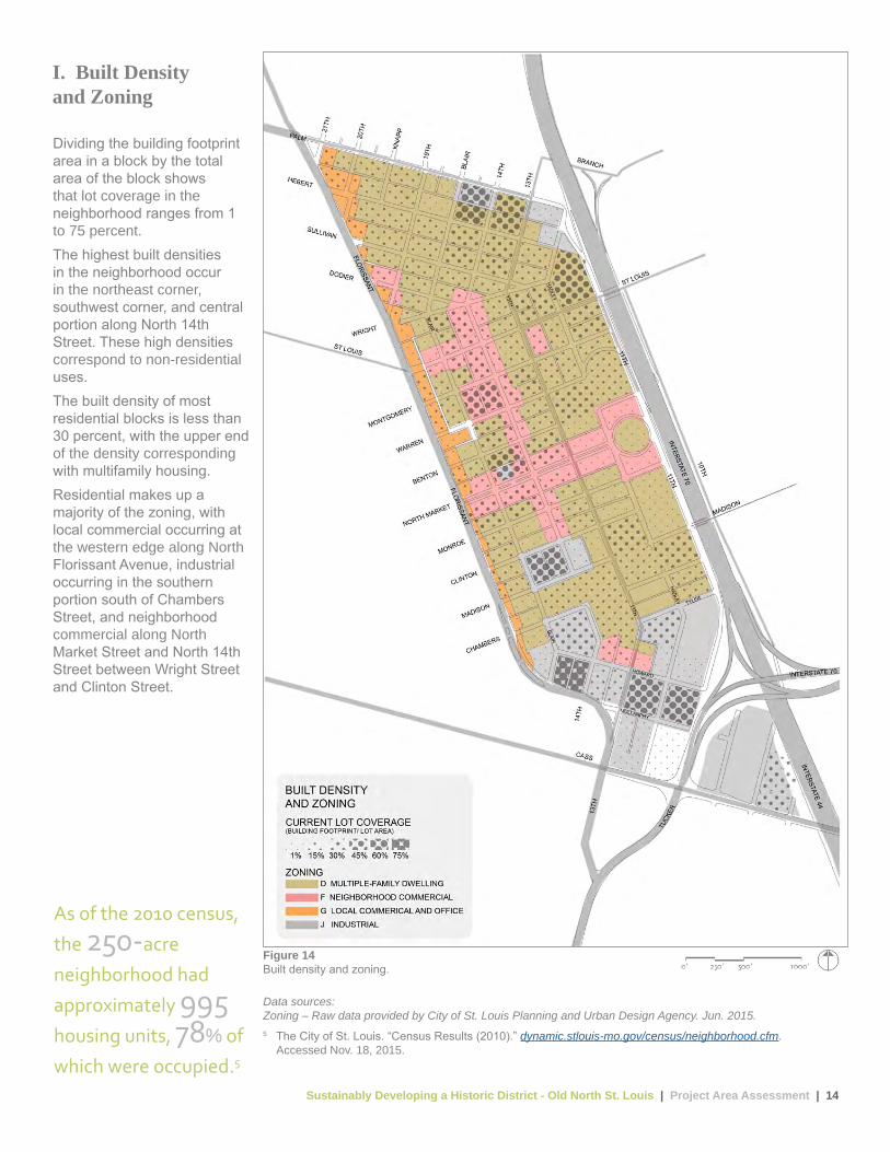
Dividing the building footprint area in a block by the total area of the block shows that lot coverage in the neighborhood ranges from 1 to 75 percent.The highest built densities in the neighborhood occur in the northeast corner, southwest corner, and central portion along North 14th Street. These high densities correspond to non-residential uses.The built density of most residential blocks is less than 30 percent, with the upper end of the density corresponding with multifamily housing.Residential makes up a majority of the zoning, with local commercial occurring at the western edge along North Florissant Avenue, industrial occurring in the southern portion south of Chambers Street, and neighborhood commercial along North Market Street and North 14th Street between Wright Street and Clinton Street.
I. Built Densityand Zoning
As of the 2010 census,
the 250-acre
neighborhood had
approximately 995 housing units, 78% of
which were occupied.5
Figure 14Built density and zoning.
Data sources:Zoning – Raw data provided by City of St. Louis Planning and Urban Design Agency. Jun. 2015.5 The City of St. Louis. “Census Results (2010).” dynamic.stlouis-mo.gov/census/neighborhood.cfm.
Accessed Nov. 18, 2015.
Sustainably Developing a Historic District - Old North St. Louis | Project Area Assessment | 15
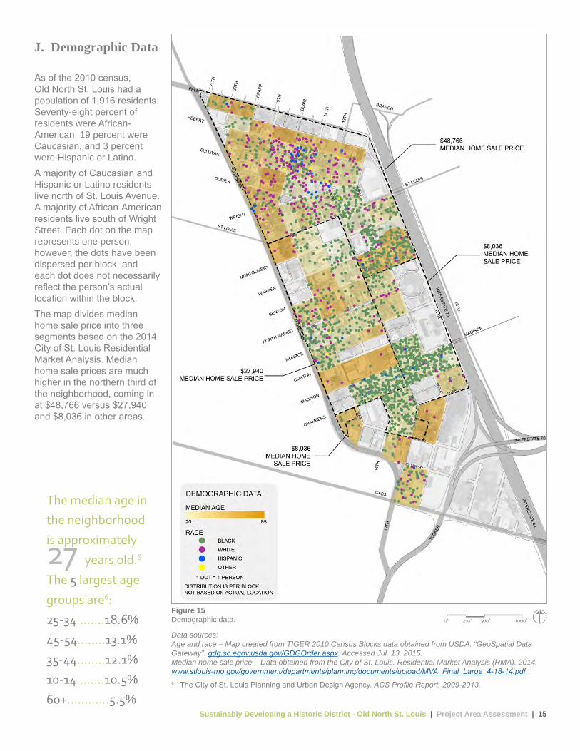
As of the 2010 census, Old North St. Louis had a population of 1,916 residents. Seventy-eight percent of residents were African-American, 19 percent were Caucasian, and 3 percent were Hispanic or Latino.A majority of Caucasian and Hispanic or Latino residents live north of St. Louis Avenue. A majority of African-American residents live south of Wright Street. Each dot on the map represents one person, however, the dots have been dispersed per block, and each dot does not necessarily reflect the person’s actual location within the block.The map divides median home sale price into three segments based on the 2014 City of St. Louis Residential Market Analysis. Median home sale prices are much higher in the northern third of the neighborhood, coming in at $48,766 versus $27,940 and $8,036 in other areas.
J. Demographic Data
Figure 15Demographic data.
Data sources:Age and race – Map created from TIGER 2010 Census Blocks data obtained from USDA. “GeoSpatial Data Gateway”. gdg.sc.egov.usda.gov/GDGOrder.aspx. Accessed Jul. 13, 2015.Median home sale price – Data obtained from the City of St. Louis. Residential Market Analysis (RMA). 2014.www.stlouis-mo.gov/government/departments/planning/documents/upload/MVA_Final_Large_4-18-14.pdf. 6 The City of St. Louis Planning and Urban Design Agency. ACS Profile Report, 2009-2013.
The median age in
the neighborhood
is approximately 27 years old.6
The 5 largest age
groups are6:
25-34........18.6%
45-54........13.1%
35-44........12.1%
10-14........10.5%
60+............5.5%

Sustainably Developing a Historic District - Old North St. Louis | Project Area Assessment | 16
Although many households in Old North have no car, most of Old North is most easily accessed by motor vehicle. While at least a portion of sidewalk exists on almost every block, much of the overall sidewalk network is in disrepair or non-existent, making walking challenging and sometimes dangerous.There are established MetroBus routes in the neighborhood and along the perimeter, with many stops along the way. The route along North 13th Street is the most heavily used in the neighborhood. Most locations within Old North are within two blocks of bus routes along North 13th Street, St. Louis Avenue, or North Florissant Avenue.Current Bike St. Louis routes are along North Florissant Avenue and along Blair Avenue. These routes are shared lanes with vehicular traffic and can be dangerous at times. Future greenway trails are planned in the area, with the most relevant being the Great Rivers Greenway Iron Horse Trestle project, a 1.5-mile elevated, multi-use trail that would terminate at the southern edge of the Old North neighborhood and provide a connection to the larger surrounding regional trail network.Interstate 70 creates the eastern boundary of the neighborhood, and currently three crossing points exist: at St. Louis Avenue, Madison Street, and Cass Avenue.
K. Connectivity
Figure 16Connectivity.
Data sources:Streets, sidewalks, and proposed MetroLink – Raw data provided by City of St. Louis Planning and Urban Design Agency. Jun. 2015.Transit – Raw data provided by the Bi-State Development Agency. Apr. 2013.Bike infrastructure – Raw data provided by Great Rivers Greenway. Feb. 2013.7 The City of St. Louis Planning and Urban Design Agency. ACS Profile Report, 2009-2013.
Residents’ commute
to work (age 16+)7:
drive alone ........ 57%
public transit ..... 16%
carpool .............. 11%
other ................... 7%
work at home ......6%
walk .................... 3%

Sustainably Developing a Historic District - Old North St. Louis | Project Area Assessment | 17
Most of Old North is made up of local streets with a speed limit of 25 miles per hour. North Florissant Avenue creates the western boundary of the neighborhood and is considered a principal arterial with a posted speed limit of 35 miles per hour, though many drivers exceed the speed limit. Interstate 70 forms the western boundary and has a posted speed limit of 60 miles per hour. Cass Avenue flanks the neighborhood to the south and is considered a minor arterial with a 30 miles per hour speed limit. North 13th Street and a portion of St. Louis Avenue and Palm Street are classified as urban collectors with speed limits of 25, 30, and 30 miles per hour, respectively.Three-foot-tall, painted concrete sewer pipe sections, some filled with plantings and locally known as “Schoemehl pots,” function as small traffic circles to help slow vehicles at the intersections of Blair Avenue and Hebert Street, 19th Street and Sullivan Avenue, 19th Street and Palm Street, and 20th Street and Palm Street.
L. Street System
Figure 17Street system.
Data sources:Street functional classification – Raw data provided by City of St. Louis Planning and Urban Design Agency. Jun. 2015.Speed limits – Raw data provided by the City of St. Louis. Apr. 2015.8 AAA Foundation for Traffic Safety. Impact Speed and a Pedestrian’s Risk of Severe Injury or Death. 2011
www.aaafoundation.org/sites/default/files/2011PedestrianRiskVsSpeed.pdf.
The average risk of
severe injury for a
pedestrian struck by
a vehicle goes from
75% to 50%
when the speed of
impact is reduced
from 39 to 31 mph.8
Sustainably Developing a Historic District - Old North St. Louis | Design Options | 18
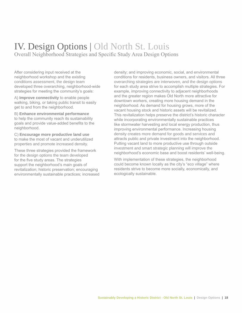
IV. Design Options | Old North St. LouisOverall Neighborhood Strategies and Specific Study Area Design Options
After considering input received at the neighborhood workshop and the existing conditions assessment, the design team developed three overarching, neighborhood-wide strategies for meeting the community’s goals:A) Improve connectivity to enable people walking, biking, or taking public transit to easily get to and from the neighborhood.B) Enhance environmental performance to help the community reach its sustainability goals and provide value-added benefits to the neighborhood.C) Encourage more productive land use to make the most of vacant and underutilized properties and promote increased density.These three strategies provided the framework for the design options the team developed for the five study areas. The strategies support the neighborhood’s main goals of revitalization; historic preservation; encouraging environmentally sustainable practices; increased
density; and improving economic, social, and environmental conditions for residents, business owners, and visitors. All three overarching strategies are interwoven, and the design options for each study area strive to accomplish multiple strategies. For example, improving connectivity to adjacent neighborhoods and the greater region makes Old North more attractive for downtown workers, creating more housing demand in the neighborhood. As demand for housing grows, more of the vacant housing stock and historic assets will be revitalized. This revitalization helps preserve the district’s historic character while incorporating environmentally sustainable practices like stormwater harvesting and local energy production, thus improving environmental performance. Increasing housing density creates more demand for goods and services and attracts public and private investment into the neighborhood. Putting vacant land to more productive use through outside investment and smart strategic planning will improve the neighborhood’s economic base and boost residents’ well-being. With implementation of these strategies, the neighborhood could become known locally as the city’s “eco village” where residents strive to become more socially, economically, and ecologically sustainable.
Sustainably Developing a Historic District - Old North St. Louis | Design Options | 19
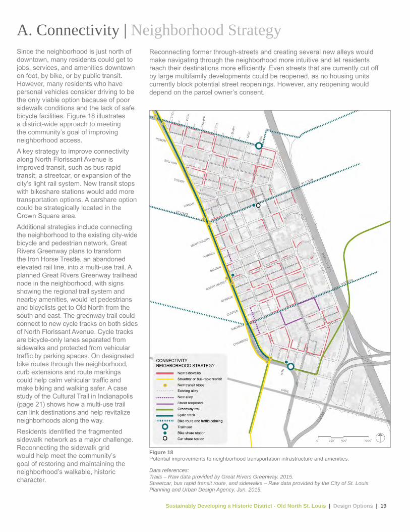
A. Connectivity | Neighborhood StrategySince the neighborhood is just north of downtown, many residents could get to jobs, services, and amenities downtown on foot, by bike, or by public transit. However, many residents who have personal vehicles consider driving to be the only viable option because of poor sidewalk conditions and the lack of safe bicycle facilities. Figure 18 illustrates a district-wide approach to meeting the community’s goal of improving neighborhood access.A key strategy to improve connectivity along North Florissant Avenue is improved transit, such as bus rapid transit, a streetcar, or expansion of the city’s light rail system. New transit stops with bikeshare stations would add more transportation options. A carshare option could be strategically located in the Crown Square area.Additional strategies include connecting the neighborhood to the existing city-wide bicycle and pedestrian network. Great Rivers Greenway plans to transform the Iron Horse Trestle, an abandoned elevated rail line, into a multi-use trail. A planned Great Rivers Greenway trailhead node in the neighborhood, with signs showing the regional trail system and nearby amenities, would let pedestrians and bicyclists get to Old North from the south and east. The greenway trail could connect to new cycle tracks on both sides of North Florissant Avenue. Cycle tracks are bicycle-only lanes separated from sidewalks and protected from vehicular traffic by parking spaces. On designated bike routes through the neighborhood, curb extensions and route markings could help calm vehicular traffic and make biking and walking safer. A case study of the Cultural Trail in Indianapolis (page 21) shows how a multi-use trail can link destinations and help revitalize neighborhoods along the way.Residents identified the fragmented sidewalk network as a major challenge. Reconnecting the sidewalk grid would help meet the community’s goal of restoring and maintaining the neighborhood’s walkable, historic character.
Figure 18Potential improvements to neighborhood transportation infrastructure and amenities.
Data references:Trails – Raw data provided by Great Rivers Greenway. 2015.Streetcar, bus rapid transit route, and sidewalks – Raw data provided by the City of St. Louis Planning and Urban Design Agency. Jun. 2015.
Reconnecting former through-streets and creating several new alleys would make navigating through the neighborhood more intuitive and let residents reach their destinations more efficiently. Even streets that are currently cut off by large multifamily developments could be reopened, as no housing units currently block potential street reopenings. However, any reopening would depend on the parcel owner’s consent.
Sustainably Developing a Historic District - Old North St. Louis | Design Options | 20
Flic
kr U
ser J
ames
Will
amor
, 201
2.
A
D
E
B
C Wik
imed
ia C
omm
ons
Use
r Ben
Sch
umin
, 201
0
SW
T D
esig
nW
illia
ms
Cre
ek C
onsu
lting
Will
iam
s C
reek
Con
sulti
ng
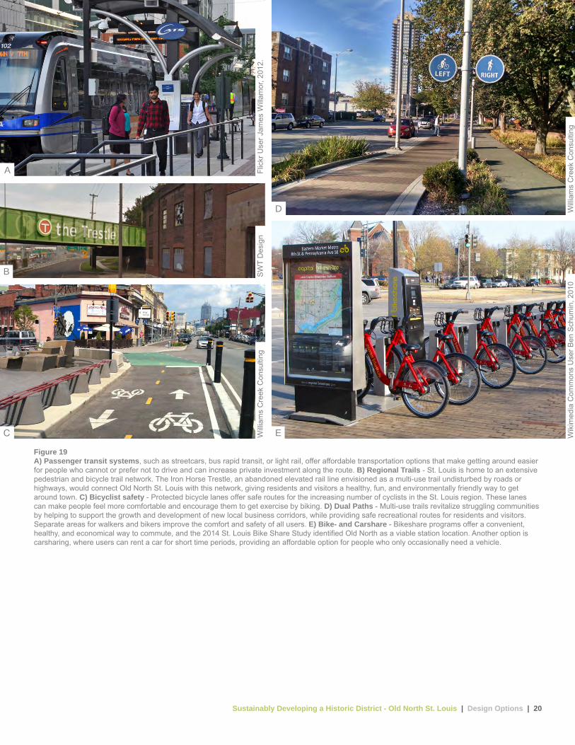
Figure 19A) Passenger transit systems, such as streetcars, bus rapid transit, or light rail, offer affordable transportation options that make getting around easier for people who cannot or prefer not to drive and can increase private investment along the route. B) Regional Trails - St. Louis is home to an extensive pedestrian and bicycle trail network. The Iron Horse Trestle, an abandoned elevated rail line envisioned as a multi-use trail undisturbed by roads or highways, would connect Old North St. Louis with this network, giving residents and visitors a healthy, fun, and environmentally friendly way to get around town. C) Bicyclist safety - Protected bicycle lanes offer safe routes for the increasing number of cyclists in the St. Louis region. These lanes can make people feel more comfortable and encourage them to get exercise by biking. D) Dual Paths - Multi-use trails revitalize struggling communities by helping to support the growth and development of new local business corridors, while providing safe recreational routes for residents and visitors. Separate areas for walkers and bikers improve the comfort and safety of all users. E) Bike- and Carshare - Bikeshare programs offer a convenient, healthy, and economical way to commute, and the 2014 St. Louis Bike Share Study identified Old North as a viable station location. Another option is carsharing, where users can rent a car for short time periods, providing an affordable option for people who only occasionally need a vehicle.

Sustainably Developing a Historic District - Old North St. Louis | Design Options | 21
Figure 21People walking and biking have easy access to cafes and shops along various segments of the trail.
9 Majors, Jessica and Sue Burow. Assessment of the Impact of the Indianapolis Cultural Trail: A Legacy of Gene and Marilyn Glick. Indiana Public Policy Institute. 2015.indyculturaltrail.org.s3.amazonaws.com/wp-content/uploads/2015/07/15-C02-CulturalTrail-Assessment.pdf
Figure 20Stormwater planters are located along the 8-mile, multi-use Cultural Trail.
A. Connectivity | Case Study Indianapolis Cultural Trail | Indianapolis, Indiana
The Indianapolis Cultural Trail is an 8-mile, multi-use trail connecting six cultural districts in downtown Indianapolis, Indiana. The trail was funded through a public-private partnership with an initial gift from local philanthropists Gene and Marilyn Glick in 2007 and a U.S. Department of Transportation Transportation Investment Generating Economic Recovery (TIGER) Grant in 2010.Originally conceived as a way to promote the city’s cultural assets, the trail features 19 public art projects. Landscaping and stormwater planters reduce the volume and rate of stormwater flow to the combined sewer system. The trail’s 26 stormwater planters divert more than 4 million gallons of stormwater annually from the combined system and feature native, drought-resistant species. Indianapolis Cultural Trail Inc., a local nonprofit funded through philanthropic donations, maintains, manages, and promotes the trail.Trail users enjoy protected bike and pedestrian facilities, which make them feel safer and more comfortable. The trail connects to 40 miles of the larger Indianapolis Parks Greenway Trail System and a growing regional trail network in the counties surrounding the Indianapolis metropolitan area. A survey by the Indiana University Public Policy Institute showed that 41.1 percent of users use the trail for exercise and recreational purposes, while 17 percent use the trail for their commute to work.9
The trail has revitalized downtown neighborhoods since its completion in 2013. The same Indiana University Public Policy Institute study found that property values within one block of the trail increased 148 percent between 2008 and 2014 as businesses expanded or relocated along the trail, anticipating the increased pedestrian activity.9 In 2014, Indianapolis Cultural Trail Inc. added 26 bikeshare stations with 250 bikes, providing a convenient option for residents and visitors to enjoy the trail.
Visi
t Ind
yW
illia
ms
Cre
ek C
onsu
lting
Sustainably Developing a Historic District - Old North St. Louis | Design Options | 22
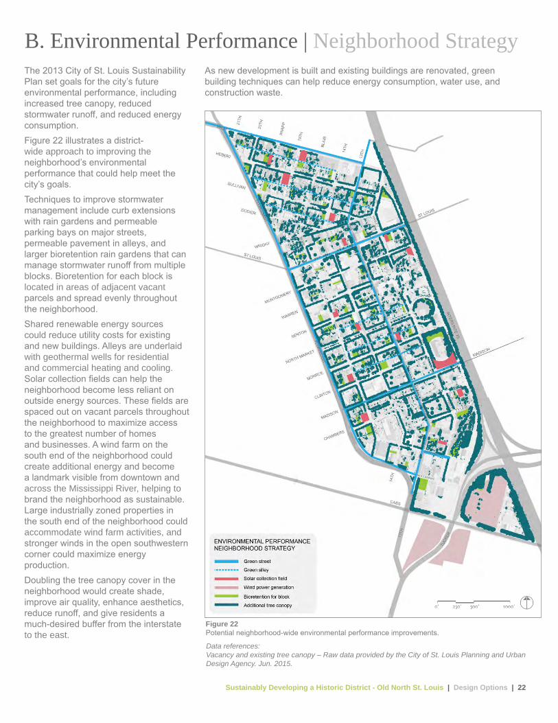
Figure 22Potential neighborhood-wide environmental performance improvements.
B. Environmental Performance | Neighborhood StrategyThe 2013 City of St. Louis Sustainability Plan set goals for the city’s future environmental performance, including increased tree canopy, reduced stormwater runoff, and reduced energy consumption.Figure 22 illustrates a district- wide approach to improving the neighborhood’s environmental performance that could help meet the city’s goals.Techniques to improve stormwater management include curb extensions with rain gardens and permeable parking bays on major streets, permeable pavement in alleys, and larger bioretention rain gardens that can manage stormwater runoff from multiple blocks. Bioretention for each block is located in areas of adjacent vacant parcels and spread evenly throughout the neighborhood.Shared renewable energy sources could reduce utility costs for existing and new buildings. Alleys are underlaid with geothermal wells for residential and commercial heating and cooling. Solar collection fields can help the neighborhood become less reliant on outside energy sources. These fields are spaced out on vacant parcels throughout the neighborhood to maximize access to the greatest number of homes and businesses. A wind farm on the south end of the neighborhood could create additional energy and become a landmark visible from downtown and across the Mississippi River, helping to brand the neighborhood as sustainable. Large industrially zoned properties in the south end of the neighborhood could accommodate wind farm activities, and stronger winds in the open southwestern corner could maximize energy production.Doubling the tree canopy cover in the neighborhood would create shade, improve air quality, enhance aesthetics, reduce runoff, and give residents a much-desired buffer from the interstate to the east.
Data references:Vacancy and existing tree canopy – Raw data provided by the City of St. Louis Planning and Urban Design Agency. Jun. 2015.
As new development is built and existing buildings are renovated, green building techniques can help reduce energy consumption, water use, and construction waste.
Sustainably Developing a Historic District - Old North St. Louis | Design Options | 23
Wik
imed
ia C
omm
ons
Use
r Lab
raun
90, 2
009
Wik
imed
ia C
omm
ons
Use
r Har
ryzi
lber
, 200
9
Will
iam
s C
reek
Con
sulti
ng
SW
T D
esig
nS
WT
Des
ign
AC
D EB
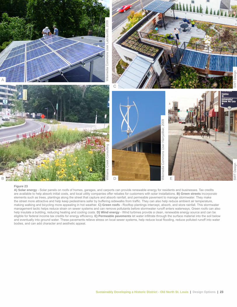
Figure 23A) Solar energy - Solar panels on roofs of homes, garages, and carports can provide renewable energy for residents and businesses. Tax credits are available to help absorb initial costs, and local utility companies offer rebates for customers with solar installations. B) Green streets incorporate elements such as trees, plantings along the street that capture and absorb rainfall, and permeable pavement to manage stormwater. They make the street more attractive and help keep pedestrians safer by buffering sidewalks from traffic. They can also help reduce ambient air temperature, making walking and bicycling more appealing in hot weather. C) Green roofs - Rooftop plantings intercept, absorb, and store rainfall. This stormwater management tactic helps reduce strain on sewer systems and can remove pollutants before stormwater runoff enters waterways. Green roofs can also help insulate a building, reducing heating and cooling costs. D) Wind energy - Wind turbines provide a clean, renewable energy source and can be eligible for federal income tax credits for energy efficiency. E) Permeable pavements let water infiltrate through the surface material into the soil below and eventually into ground water. These pavements relieve stress on local sewer systems, help reduce local flooding, reduce polluted runoff into water bodies, and can add character and aesthetic appeal.
Sustainably Developing a Historic District - Old North St. Louis | Design Options | 24
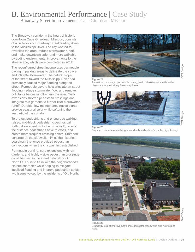
Figure 26Broadway Street improvements included safer crosswalks and new street trees.
Figure 24Pedestrian crossings, permeable paving, and curb extensions with native plants are located along Broadway Street.
Figure 25Stamped concrete resembling a wooden boardwalk reflects the city’s history.
SW
T D
esig
nS
WT
Des
ign
SW
T D
esig
n
B. Environmental Performance | Case Study Broadway Street Improvements | Cape Girardeau, Missouri
The Broadway corridor in the heart of historic downtown Cape Girardeau, Missouri, consists of nine blocks of Broadway Street leading down to the Mississippi River. The city wanted to revitalize the area, reduce stormwater runoff, and make downtown safer and more walkable by adding environmental improvements to the streetscape, which were completed in 2012.The reconfigured street incorporates permeable paving in parking areas to delineate the space and infiltrate stormwater. The natural slope of the street toward the Mississippi River had previously caused major flooding along the street. Permeable pavers help alleviate on-street flooding, reduce stormwater flow, and remove pollutants before runoff enters the river. Curb extensions shorten pedestrian crossings and integrate rain gardens to further filter stormwater runoff. Durable, low-maintenance native plants provide seasonal color while softening the aesthetic of the corridor.To protect pedestrians and encourage walking, raised, mid-block pedestrian crossings calm traffic, draw attention to the crosswalk, reduce the distance pedestrians have to cross, and create more frequent crossing points. Stamped concrete on the sidewalk mimics the historical boardwalk that once provided pedestrian connections when the city was first established.Permeable parking, curb extensions with rain gardens, and highly visible pedestrian crossings could be used in the street network of Old North St. Louis to tie in with the neighborhood’s historic character while helping to mitigate localized flooding and improve pedestrian safety, two issues voiced by the residents of Old North.
Sustainably Developing a Historic District - Old North St. Louis | Design Options | 25
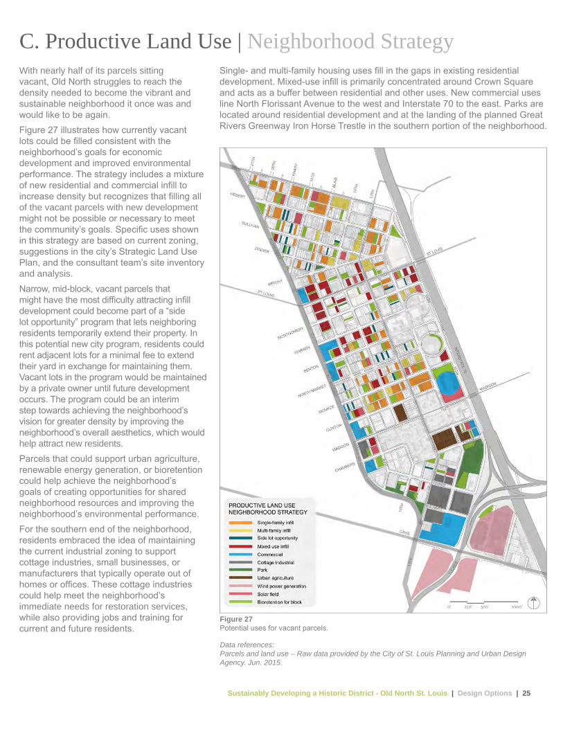
With nearly half of its parcels sitting vacant, Old North struggles to reach the density needed to become the vibrant and sustainable neighborhood it once was and would like to be again. Figure 27 illustrates how currently vacant lots could be filled consistent with the neighborhood’s goals for economic development and improved environmental performance. The strategy includes a mixture of new residential and commercial infill to increase density but recognizes that filling all of the vacant parcels with new development might not be possible or necessary to meet the community’s goals. Specific uses shown in this strategy are based on current zoning, suggestions in the city’s Strategic Land Use Plan, and the consultant team’s site inventory and analysis.Narrow, mid-block, vacant parcels that might have the most difficulty attracting infill development could become part of a “side lot opportunity” program that lets neighboring residents temporarily extend their property. In this potential new city program, residents could rent adjacent lots for a minimal fee to extend their yard in exchange for maintaining them. Vacant lots in the program would be maintained by a private owner until future development occurs. The program could be an interim step towards achieving the neighborhood’s vision for greater density by improving the neighborhood’s overall aesthetics, which would help attract new residents.Parcels that could support urban agriculture, renewable energy generation, or bioretention could help achieve the neighborhood’s goals of creating opportunities for shared neighborhood resources and improving the neighborhood’s environmental performance.For the southern end of the neighborhood, residents embraced the idea of maintaining the current industrial zoning to support cottage industries, small businesses, or manufacturers that typically operate out of homes or offices. These cottage industries could help meet the neighborhood’s immediate needs for restoration services, while also providing jobs and training for current and future residents.
C. Productive Land Use | Neighborhood Strategy
Figure 27Potential uses for vacant parcels.
Data references:Parcels and land use – Raw data provided by the City of St. Louis Planning and Urban Design Agency. Jun. 2015.
Single- and multi-family housing uses fill in the gaps in existing residential development. Mixed-use infill is primarily concentrated around Crown Square and acts as a buffer between residential and other uses. New commercial uses line North Florissant Avenue to the west and Interstate 70 to the east. Parks are located around residential development and at the landing of the planned Great Rivers Greenway Iron Horse Trestle in the southern portion of the neighborhood.

Sustainably Developing a Historic District - Old North St. Louis | Design Options | 26
Wik
imed
ia C
omm
ons
Use
r Vic
torg
rigas
, 201
3 C
ohen
Arc
hite
ctur
e
Wik
imed
ia C
omm
ons
Use
r Dox
Txob
, 201
3
SW
T D
esig
n
SW
T D
esig
n
Figure 28A) Neighborhood energy production - Creating and using renewable energy within a neighborhood can reduce greenhouse gas emissions and lower energy costs. Community solar facilities can also allow multifamily building residents, renters, and homeowners with shaded or unsuitable roofs to get clean, reliable energy. B) Education - Community spaces such as local gardens or monuments can offer more than a relaxing oasis. They can share facts, anecdotes, or lessons about the neighborhood, its history, environmental protection, and other topics. C) Infill development sites are generally close to job centers, already served by public infrastructure, and can help struggling historic communities regain the density of people and amenities that once let them thrive. D) Alternative land use - Reimagining vacant lots with alternative uses, such as dog parks or gathering venues, gives residents more recreational opportunities. Communities offering a broader range of activities are generally more attractive to prospective residents. E) Urban agriculture - Transforming underused parcels into urban farms can have a profound impact on a neighborhood’s success. These farms make healthy, local food easier for residents to get, create jobs, develop skills, remediate brownfields, and encourage residents to meet and work together to improve the neighborhood.
A
C
D EB

Sustainably Developing a Historic District - Old North St. Louis | Design Options | 27
Figure 29A new home in the Lower 9th Ward.
Figure 30Solar panels on new, affordable housing units reduce energy costs for residents.
C. Productive Land Use | Case Study Make it Right | New Orleans, LA
The Make It Right organization has worked in the Lower Ninth Ward of New Orleans since 2007 to provide new, environmentally sustainable infill housing in areas affected by Hurricane Katrina. As of 2015, its roughly 100 houses have all achieved Leadership in Energy and Environmental Design (LEED) Platinum ratings and are home to more than 350 people. The organization also educates neighborhood residents about environmentally sustainable building practices and provides hands-on training, particularly in installing solar panels. While Make It Right mainly provides housing, it also is helping to create neighborhood gardens and a playground.The technologies and design strategies the houses use include alternative energy sources, innovative indoor lighting techniques, and new approaches to improve indoor air quality. Project planners and designers conduct in-depth analyses of the materials’ environmental impacts and life cycles to select the most environmentally sustainable.Residents provided many ideas during public meetings to engage the community and identify residents’ needs. For example, the houses were designed to include many traditional features such as front porches, natural ventilation, and usable outdoor green space. The Make It Right model shows a way to develop clusters of environmentally sustainable, community-focused, single-family housing in blocks that are predominantly vacant. This model gives broad strategies for community engagement while developing contemporary housing that reflects the neighborhood’s historic character.
Flic
kr u
ser M
ark
Gst
ohl,
2008
. Fl
ickr
use
r Mar
k G
stoh
l, 20
08.
Sustainably Developing a Historic District - Old North St. Louis | Design Options | 28
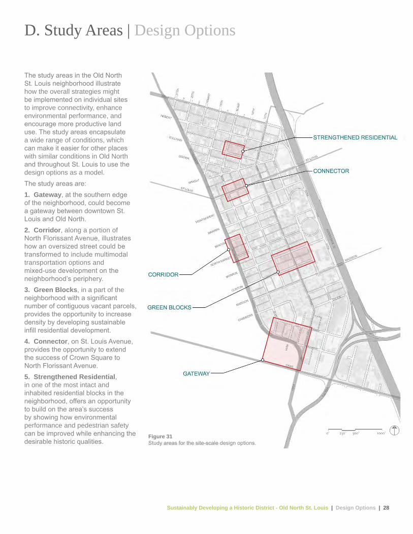
The study areas in the Old North St. Louis neighborhood illustrate how the overall strategies might be implemented on individual sites to improve connectivity, enhance environmental performance, and encourage more productive land use. The study areas encapsulate a wide range of conditions, which can make it easier for other places with similar conditions in Old North and throughout St. Louis to use the design options as a model.The study areas are:1. Gateway, at the southern edge of the neighborhood, could become a gateway between downtown St. Louis and Old North. 2. Corridor, along a portion of North Florissant Avenue, illustrates how an oversized street could be transformed to include multimodal transportation options and mixed-use development on the neighborhood’s periphery.3. Green Blocks, in a part of the neighborhood with a significant number of contiguous vacant parcels, provides the opportunity to increase density by developing sustainable infill residential development.4. Connector, on St. Louis Avenue, provides the opportunity to extend the success of Crown Square to North Florissant Avenue.5. Strengthened Residential, in one of the most intact and inhabited residential blocks in the neighborhood, offers an opportunity to build on the area’s success by showing how environmental performance and pedestrian safety can be improved while enhancing the desirable historic qualities.
D. Study Areas | Design Options
Figure 31Study areas for the site-scale design options.

Figure 32Existing condition, looking northwest.
Figure 33Design option.
The southern portion of the neighborhood is positioned as the gateway to and from downtown St. Louis. It is the first part of the neighborhood people encounter when traveling north from downtown. Significant redevelopment potential exists with numerous large, vacant lots and abandoned structures. The design option enhances the neighborhood’s identity and strengthens connections to downtown by transforming the southern edge of the neighborhood into a gateway. At the heart is a new, activated community gathering space that tells visitors they have arrived in Old North. This space centers on the Mullanphy Emigrant Home, a 150-year-old, vacant landmark building that residents would like restored as a community anchor. Potential uses include a hostel or community event space and visitor center.Reconfigured streetscapes encourage walking and biking by improving safety. Rain gardens and tree plantings treat stormwater, create habitat, and soften the edge of the neighborhood while meeting the goals of improving air quality and increasing tree canopy. The newly created gathering spaces can be used to show how the neighborhood is integrating environmentally sustainable best practices with historic character.
New space for cottage industries meets the community’s goal of providing employment and job training opportunities to residents, while offering historic building renovation services to support neighborhood rejuvenation.
SW
T D
esig
nS
WT
Des
ign
1. Gateway | Study Area Mullanphy Street and 14th Street
Sustainably Developing a Historic District - Old North St. Louis | Design Options | 30
NO
RTH
13T
H S
T
1
2
2
2
2
312
4
5
6
6
6
7
8
9
14
10
17
15
1616
15
13 13
13
1311
11
11
MULLANPHY ST MULLANPHY ST
NO
RTH
14T
H S
TEA
ST 1
4TH
ST
NO
RTH
14T
H S
TBL
AIR
AV
E
Des
ign
12
Context map
0’ 20’ 40’ 60’ 80’
Figure 34Design option.
In this design option, closing of the 130-foot segment of Mullanphy Street west of North 13th Street makes this area safer for pedestrians and frees space to create a gateway park at the southern end of the neighborhood. This segment currently conveys little traffic, and its closure would not require much of a detour for vehicles. Rain gardens and gathering spaces flank the east-west greenway trail as it connects from the North 14th Street transit corridor to the Iron Horse Trestle on the east side of the neighborhood. Neighborhood branding at North 14th Street and Mullanphy Street announces one’s arrival to the revitalized historic neighborhood. The six-lane portion of Mullanphy Street is reconfigured by slightly narrowing driving lanes and removing the continuous center turn lane to improve pedestrian and bike safety, while also designating space for permeable parking areas and bioswales. This street reconfiguration would not slow the flow of traffic given current traffic counts. Highly visible crosswalks create safe pedestrian connections between the blocks of this enhanced gateway. Infill commercial and cottage industrial spaces are developed around this central area. New development incorporates
solar panels, green roofs, and rainwater harvesting to reduce its environmental impacts. The owner of a private parcel between North 14th and 13th streets adjacent to the greenway trail would have an opportunity to open a new business to serve trail users and residents.
SW
T
1. Gateway | Study Area Mullanphy Street and 14th Street 1 Restored Mullanphy
Emigrant Home
2 Greenway trail
3 Bike depot and cafe
4 Bikeshare station
5 Boulevard median
6 Rain garden
7 Reconfigured intersection
8 Light rail or streetcar station
9 Cottage industrial
10 High-visibility crosswalks
11 Permeable parking
12 Solar panels
13 Community gathering space
14 Green roof
15 Neighborhood branding
16 Permeable alley
17 Bioswale
Sustainably Developing a Historic District - Old North St. Louis | Design Options | 31
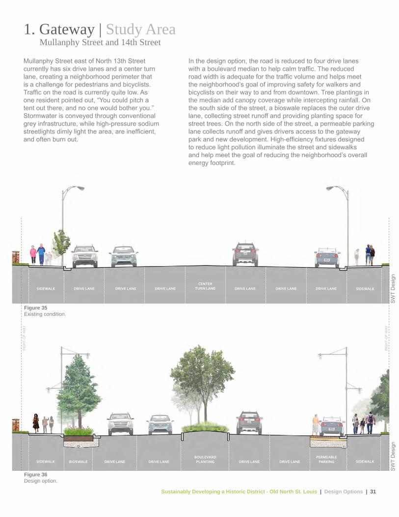
Figure 36Design option.
Figure 35Existing condition.
DRIVE LANE DRIVE LANE DRIVE LANECENTER
TURN LANE DRIVE LANE DRIVE LANE DRIVE LANESIDEWALK SIDEWALK
BIOSWALE DRIVE LANE DRIVE LANEBOULEVARD
PLANTING DRIVE LANE DRIVE LANEPERMEABLE
PARKING SIDEWALKSIDEWALK
RIG
HT-
OF-
WAY
RIG
HT-
OF-
WAY
Mullanphy Street east of North 13th Street currently has six drive lanes and a center turn lane, creating a neighborhood perimeter that is a challenge for pedestrians and bicyclists. Traffic on the road is currently quite low. As one resident pointed out, “You could pitch a tent out there, and no one would bother you.” Stormwater is conveyed through conventional grey infrastructure, while high-pressure sodium streetlights dimly light the area, are inefficient, and often burn out.
In the design option, the road is reduced to four drive lanes with a boulevard median to help calm traffic. The reduced road width is adequate for the traffic volume and helps meet the neighborhood’s goal of improving safety for walkers and bicyclists on their way to and from downtown. Tree plantings in the median add canopy coverage while intercepting rainfall. On the south side of the street, a bioswale replaces the outer drive lane, collecting street runoff and providing planting space for street trees. On the north side of the street, a permeable parking lane collects runoff and gives drivers access to the gateway park and new development. High-efficiency fixtures designed to reduce light pollution illuminate the street and sidewalks and help meet the goal of reducing the neighborhood’s overall energy footprint.
SW
T D
esig
nS
WT
Des
ign
1. Gateway | Study Area Mullanphy Street and 14th Street

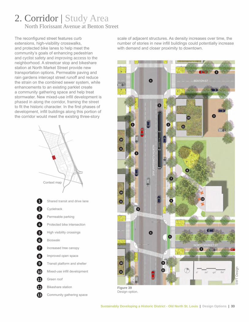
2. Corridor | Study Area North Florissant Avenue at Benton Street
Figure 37Existing condition, looking southeast along North Florissant Avenue. At this intersection, North Florissant Avenue is an oversized street with little traffic around morning rush hour. Though downtown is clearly visible at the end of the street, pavement, vacant land, and aging infrastructure dominate the view.
The multiple, vacant, corner lots at North Florissant Avenue and Benton Street offer opportunities to increase productive land use and commercial and residential densities. New commercial, mixed-use development on the western edge of the neighborhood and a reconfigured streetscape shift the focus from a car-oriented through-street to a shared space incorporating better and safer public transit and bicycle and pedestrian connections. The streetscape is enhanced with green infrastructure and street trees. On-street parking for businesses and amenities such as new transit stops and bikeshare stations enliven the street and promote infill development while addressing the neighborhood goal of increasing density to support new businesses and services and create a market for vacant, historic buildings. Multiple landowners and shallow parcels could potentially create a short-term challenge for development. Over time, a phased approach could include public investments in streetscape improvements and transit coupled
with private rehabilitation efforts that would catalyze development and ultimately establish a corridor with significantly higher residential and commercial densities.
SW
T D
esig
nS
WT
Des
ignFigure 38
Design option (Phase 1).
Sustainably Developing a Historic District - Old North St. Louis | Design Options | 33
Context map
Figure 39Design option.
1
22
3
3
3
3
4
4
5
6
7
8
9
9
12
13
10
11
11
11
11
10
10
10
NO
RTH FLO
RISSAN
T AVE
BENTON ST
NORTH MARKET ST
0’ 20’ 40’ 60’
The reconfigured street features curb extensions, high-visibility crosswalks, and protected bike lanes to help meet the community’s goals of enhancing pedestrian and cyclist safety and improving access to the neighborhood. A streetcar stop and bikeshare station at North Market Street provide new transportation options. Permeable paving and rain gardens intercept street runoff and reduce the strain on the combined sewer system, while enhancements to an existing parklet create a community gathering space and help treat stormwater. New mixed-use infill development is phased in along the corridor, framing the street to fit the historic character. In the first phases of development, infill buildings along this portion of the corridor would meet the existing three-story
scale of adjacent structures. As density increases over time, the number of stories in new infill buildings could potentially increase with demand and closer proximity to downtown.
SW
T D
esig
n
2. Corridor | Study Area North Florissant Avenue at Benton Street
1 Shared transit and drive lane
2 Cycletrack
3 Permeable parking
4 Protected bike intersection
5 High visibility crossings
6 Bioswale
7 Increased tree canopy
8 Improved open space
9 Transit platform and shelter
10 Mixed-use infill development
11 Green roof
12 Bikeshare station
13 Community gathering space

Sustainably Developing a Historic District - Old North St. Louis | Design Options | 34
BIKE LANE
BIKE LANE
STREETSHOULDER
STREETSHOULDERSIDEWALK SIDEWALKDRIVE LANE DRIVE LANE
CENTER TURN LANE DRIVE LANE DRIVE LANE
Figure 41Design option.
Figure 40Existing condition.
SHARED DRIVE LANE/ TRANSIT LANE
SHARED DRIVE LANE/ TRANSIT LANE
PERMEABLE PARKING/
TRANSIT STOP
PERMEABLE PARKING/
TRANSIT STOPCYCLE-TRACK
CYCLE-TRACK B
IOSW
ALE
BIO
SWA
LE
SIDEWALK SIDEWALKDRIVE LANE DRIVE LANE
RIG
HT-
OF-
WAY
RIG
HT-
OF-
WAY
As currently configured, North Florissant Avenue has four drive lanes and a central turn lane. In early 2015, the outermost lanes were restriped as bike lanes, creating narrow, unmarked street shoulders between the bike lanes and sidewalks that some motorists interpret as a driving or parking lane, resulting in potential conflicts for cyclists. The street’s width encourages people to drive faster than the speed limit. As a result, pedestrians and cyclists largely avoid this street.In the design option, lanes on North Florissant Avenue are reconfigured to accommodate a shared drive-transit lane and parking lanes on
each side. The sidewalk realm incorporates a cycle track raised to the level of the sidewalk, bioswales, and street trees. The focus of the street now shifts from vehicles to a more balanced mode share. Raising the cycle track to the pedestrian realm and establishing on-street parking creates a buffer between people and vehicles while helping to remedy Old North residents’ bicycle safety concerns. The parking lanes and cycle tracks are permeable, directing runoff from the entire street and pedestrian realm to the subterranean stormwater management system. Increased tree canopy further captures rainfall, provides shade for people walking and biking, and reduces ambient air temperatures. Well-lit transit shelters with bikeshare stations help the neighborhood achieve its goal of incorporating multimodal transportation options for residents and visitors.
SW
T D
esig
nS
WT
Des
ign
2. Corridor | Study Area North Florissant Avenue at Benton Street
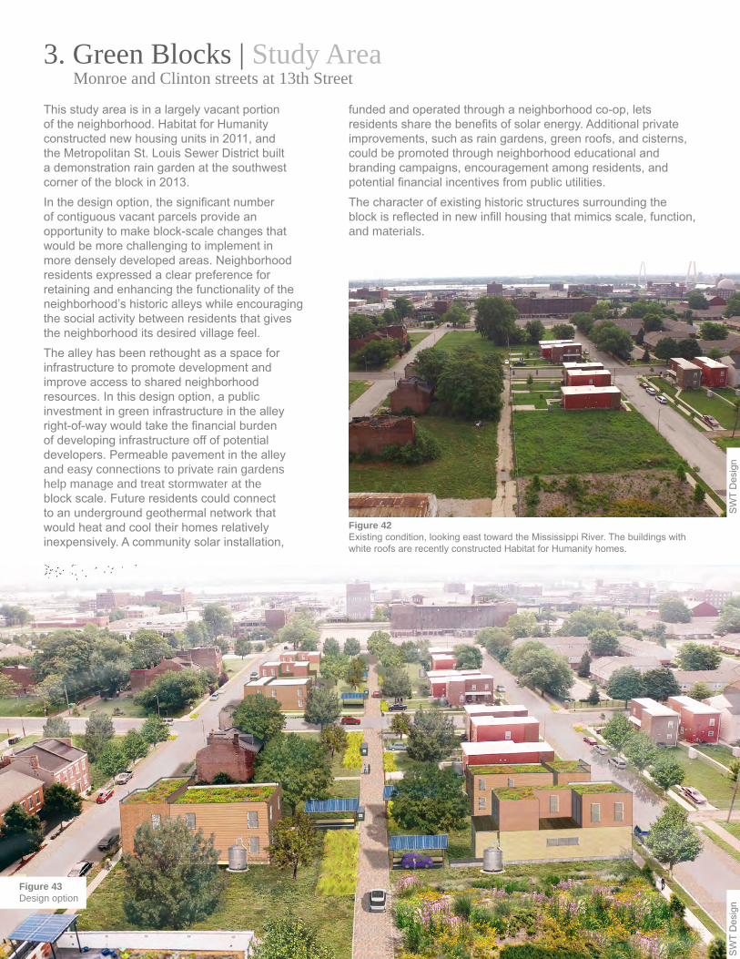
3. Green Blocks | Study Area Monroe and Clinton streets at 13th Street
Figure 42Existing condition, looking east toward the Mississippi River. The buildings with white roofs are recently constructed Habitat for Humanity homes.
This study area is in a largely vacant portion of the neighborhood. Habitat for Humanity constructed new housing units in 2011, and the Metropolitan St. Louis Sewer District built a demonstration rain garden at the southwest corner of the block in 2013.In the design option, the significant number of contiguous vacant parcels provide an opportunity to make block-scale changes that would be more challenging to implement in more densely developed areas. Neighborhood residents expressed a clear preference for retaining and enhancing the functionality of the neighborhood’s historic alleys while encouraging the social activity between residents that gives the neighborhood its desired village feel.The alley has been rethought as a space for infrastructure to promote development and improve access to shared neighborhood resources. In this design option, a public investment in green infrastructure in the alley right-of-way would take the financial burden of developing infrastructure off of potential developers. Permeable pavement in the alley and easy connections to private rain gardens help manage and treat stormwater at the block scale. Future residents could connect to an underground geothermal network that would heat and cool their homes relatively inexpensively. A community solar installation,
funded and operated through a neighborhood co-op, lets residents share the benefits of solar energy. Additional private improvements, such as rain gardens, green roofs, and cisterns, could be promoted through neighborhood educational and branding campaigns, encouragement among residents, and potential financial incentives from public utilities.The character of existing historic structures surrounding the block is reflected in new infill housing that mimics scale, function, and materials.
SW
T D
esig
nS
WT
Des
ign
Figure 43Design option

Sustainably Developing a Historic District - Old North St. Louis | Design Options | 36
0’ 10’ 20’ 40’ 60’
Context map
1
2 2
3
3
4 4
445
8
8
8
6
77
NO
RTH
13T
H S
T
MONROE ST
CLINTON ST
0’ 20’ 40’ 80’ 120’
Figure 44Design option.
This design option incorporates infill residential development that builds on recent projects by Habitat for Humanity. The design option could help achieve a level of density that could sustain the services and amenities residents said they want to attract. New single-family and multifamily infill, along with existing single-family housing, helps achieve the neighborhood’s goal of having more diverse housing options.The illustration of the design option (Figure 44) depicts two scenarios, one on either side of North 13th Street, for how residential infill could be developed. The block to the left of North 13th Street depicts a scenario where parcels would be acquired and developed one by one by multiple developers or owners. The block to the right of North 13th Street, which is currently almost entirely vacant, shows a scenario where a single developer acquires and develops multiple parcels to sell to prospective residents. Under this scenario, the block could reach full capacity more quickly than if it were developed piecemeal by several owners or developers.
Interim strategies on undeveloped parcels could further support the goal of putting land to productive use by offering opportunities for urban agriculture and a self-sufficient food community. The green alley with stormwater and renewable energy infrastructure serves as a shared community space where neighbors interact. Infill residences feature green roofs and solar carports as part of the overall neighborhood sustainability strategy. Perimeter street improvements feature permeable parking, curb extensions with rain gardens, and high-visibility crosswalks. This set of design improvements could be implemented on all new street improvement projects, creating a distinctive visual identity for the neighborhood.
SW
T D
esig
n
3. Green Blocks | Study Area Monroe and Clinton streets at 13th Street
1 Metropolitan Sewer District rain garden
2 Permeable alley
3 Solar carport
4 Single-family infill
5 Multi-family infill
6 Parking pad
7 Rain garden (private)
8 Green roof

Sustainably Developing a Historic District - Old North St. Louis | Design Options | 37
Figure 46Design option.
Figure 45Existing condition.
RESIDENTIAL GEOTHERMAL CONNECTIONESIDENTIAL GEOTHERMAL CONNECTION GEOTHERMALWELLS
SOLAR CARPORTSOLAR CARPORT
PERMEABLE ALLEY
RESIDENTIAL INFILL
RAIN GARDEN
R
RESIDENTIAL LOTRESIDENTIAL PARKING PADALLEYVACANT LOT
RIG
HT-
OF-
WAY
RIG
HT-
OF-
WAY
The existing alley section in this area is representative of many neighborhoods in St. Louis. Alleys are spaces where many back-of-house activities take place, such as trash collection. Power, cable, and phone lines are located on poles in the alleys where they are vulnerable to damage by garbage or other large vehicles, and the tree canopy requires constant maintenance to protect them. Alleys also frequently serve as places for impromptu community gatherings. The existing asphalt alley is bordered by parking pads for some residences or is directly adjacent to back yards and vacant lots. The design option reconstructs the alley with permeable pavers for stormwater infiltration. This
configuration also promotes the interconnection of private rain gardens on the adjacent properties, enabling stormwater to pass through a linked filtering system that can cleanse and manage stormwater better than rain gardens that are not connected to each other. Geothermal wells along the length of the alley serve as a local shared utility. Building on these shared resources and as an alternative to conventional garages, solar carports integrate into a local micro electrical grid. A neighborhood co-op, similar to a homeowner’s association, could fund and build each solar carport, letting residents of that block tap into the micro grid and get lower energy costs. The design option relocates overhead lines into shared duct banks constructed in the alley right-of-way. Increased tree canopy and private rain gardens, which could be funded through city and local utility incentives, create a more welcoming space, further promoting the alley as a communal gathering area.
SW
T D
esig
nS
WT
Des
ign
3. Green Blocks | Study Area Monroe and Clinton streets at 13th Street

4. Connector | Study Area St. Louis Avenue at Crown Square
Figure 47Existing condition, looking west toward North Florissant Avenue.
The redevelopment of the Crown Square commercial area along the 2600 and 2700 blocks of North 14th Street, completed in 2010, has transformed the heart of the neighborhood and attracted new businesses and residents. However, this transformation has been largely confined to the immediate vicinity. Drawing the success of Crown Square westward toward North Florissant Avenue would help connect the neighborhood with the rest of the city. While North 14th Street has been completely rebuilt, St. Louis Avenue has aging street infrastructure and several vacant parcels. The design option includes permeable parking lanes, curb extensions with rain gardens, and new street trees. These additions improve environmental performance and calm traffic to safer speeds. They also deter large commercial trucks from cutting through the neighborhood to get to the highway. Bike route markings further calm traffic. Mixed-use infill that fits the neighborhood’s historic character extends out to North Florissant Avenue. Small wind turbines power street lights and become memorable neighborhood elements. Bikeshare and carshare give residents additional transportation options.
The combination of mixed-use, infill development and infrastructure improvements could pull passersby off of North Florissant Avenue into the heart of the neighborhood. More visitors would bring more revenue to local businesses and would educate more people about the lifestyle offered in a sustainable historic district, something that no other neighborhood in the city currently offers.
SW
T D
esig
nS
WT
Des
ign
Figure 48Design option.
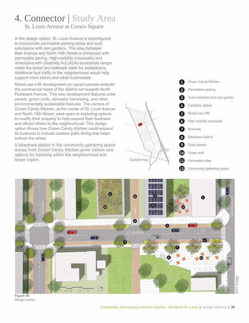
Sustainably Developing a Historic District - Old North St. Louis | Design Options | 39
1
2
34
5
109
5
6
11
12
12
7
8
ST. LOUIS AVE
BLA
IR A
VE
ALL
EY
NO
RTH
14T
H S
T
0’ 10’ 20’ 40’ 60’
Context map
Figure 49Design option.
In the design option, St. Louis Avenue is reconfigured to incorporate permeable parking lanes and curb extensions with rain gardens. The alley between Blair Avenue and North 14th Street is enhanced with permeable paving. High-visibility crosswalks and Americans with Disability Act (ADA)-accessible ramps make the street and sidewalk safer for pedestrians. Additional foot traffic in the neighborhood would help support more stores and other businesses.Mixed-use infill development on vacant parcels extends the commercial heart of the district out towards North Florissant Avenue. This new development features solar panels, green roofs, rainwater harvesting, and other environmentally sustainable features. The owners of Crown Candy Kitchen, at the corner of St. Louis Avenue and North 14th Street, were open to exploring options to modify their property to help expand their business and attract others to the neighborhood. This design option shows how Crown Candy Kitchen could expand its business to include outdoor patio dining that helps enliven the street.A bikeshare station in the community gathering space across from Crown Candy Kitchen gives visitors new options for traveling within the neighborhood and larger region.
SW
T D
esig
n
4. Connector | Study Area St. Louis Avenue at Crown Square
1 Crown Candy Kitchen
2 Permeable parking
3 Curb extension and rain garden
4 Carshare station
5 Mixed-use infill
6 High-visibility crosswalk
7 Bioswale
8 Bikeshare station
9 Solar panels
10 Green roof
11 Permeable alley
12 Community gathering space

Sustainably Developing a Historic District - Old North St. Louis | Design Options | 40
DRIVE LANE DRIVE LANEPERMEABLE
PARKINGPERMEABLE
PARKINGPLAZA /
SIDEWALK
BIO
SWA
LE
SIDEWALKPLAZA
DRIVE LANE DRIVE LANEPARKING PARKING SIDEWALKPLAZA WITH INTERMITTENT
TREE LAWN
Figure 50Existing condition.
Figure 51Design option.
RIG
HT-
OF-
WAY
RIG
HT-
OF-
WAY
The existing St. Louis Avenue has two drive lanes with metered parking on either side. The street is lined with sidewalks to the north and a plaza with intermittent tree lawn to the south. The design option reconfigures the street to incorporate permeable parking lanes and curb extensions with rain gardens for stormwater infiltration. These elements also help to slow vehicular traffic through the corridor, which helps address residents’ concern about fast-moving traffic. New infill development and signature wind turbine-powered street lights line the street.
To reduce the burden on the city’s parking management, parking kiosks replace individual parking meters. Additional street trees increase canopy cover and help reduce cooling loads for new businesses along the corridor.
SW
T D
esig
nS
WT
Des
ign
4. Connector | Study Area St. Louis Avenue at Crown Square
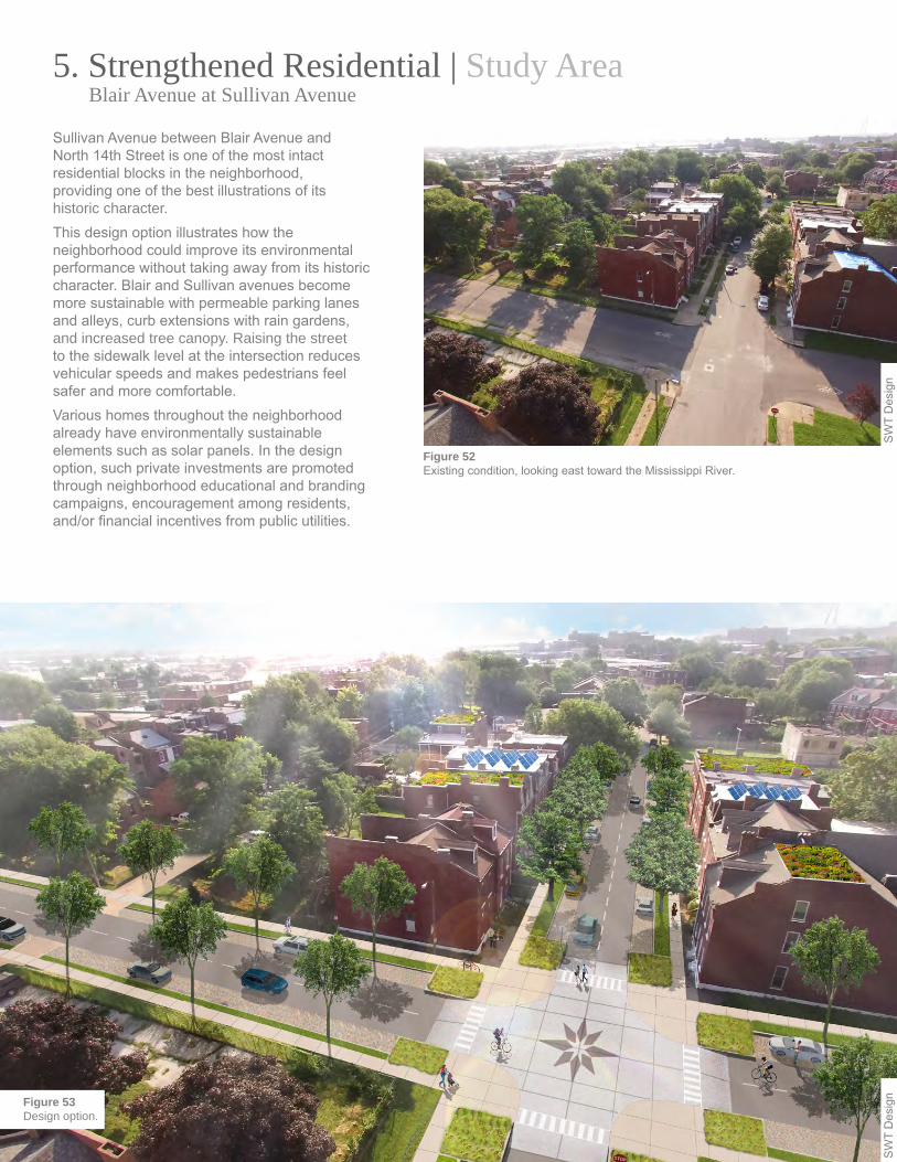
SW
T D
esig
nFigure 53Design option.
5. Strengthened Residential | Study Area Blair Avenue at Sullivan Avenue
Figure 52Existing condition, looking east toward the Mississippi River.
Sullivan Avenue between Blair Avenue and North 14th Street is one of the most intact residential blocks in the neighborhood, providing one of the best illustrations of its historic character. This design option illustrates how the neighborhood could improve its environmental performance without taking away from its historic character. Blair and Sullivan avenues become more sustainable with permeable parking lanes and alleys, curb extensions with rain gardens, and increased tree canopy. Raising the street to the sidewalk level at the intersection reduces vehicular speeds and makes pedestrians feel safer and more comfortable.Various homes throughout the neighborhood already have environmentally sustainable elements such as solar panels. In the design option, such private investments are promoted through neighborhood educational and branding campaigns, encouragement among residents, and/or financial incentives from public utilities.
SW
T D
esig
n

Sustainably Developing a Historic District - Old North St. Louis | Design Options | 42
Context map
1
2
3
45
5
6
9
10
10
7
8
SULLIVAN AVE
ALLEY
BLA
IR A
VE
9 10 0’ 10’ 20’ 40’ 60’
Figure 54Design option.
In the design option, permeable parking lanes replace existing asphalt along each street and along the alleys. Wider tree lawns line the sidewalks for a healthier tree canopy. A variety of species fill the gaps in the existing tree canopy for increased disease resistance and biodiversity. At the intersections, curb extensions with rain gardens and highly visible crossings improve pedestrian safety while slowing traffic and intercepting stormwater. The raised speed-table intersection could incorporate the neighborhood logo for neighborhood branding.Residential roofs feature a variety of privately funded elements including white roofs to reflect sunlight and reduce energy for cooling, green roofs, and solar panels. These elements illustrate how environmentally sustainable technologies could be used on older buildings.
SW
T D
esig
n
5. Strengthened Residential | Study Area Blair Avenue at Sullivan Avenue
1 Speed-table intersection
2 Curb extension and flush crossing
3 High-visibility crosswalk
4 Rain garden
5 Permeable parking
6 Street tree canopy
7 Tree lawn
8 Permeable alley
9 Solar panels
10 Green roof
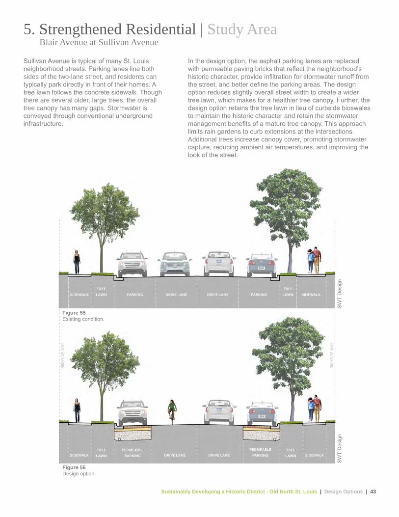
Sustainably Developing a Historic District - Old North St. Louis | Design Options | 43
Figure 56Design option.
Figure 55Existing condition.
DRIVE LANE DRIVE LANE PARKINGPARKINGTREE
LAWNTREE
LAWN SIDEWALKSIDEWALK
PERMEABLE PARKING DRIVE LANE DRIVE LANE
PERMEABLE PARKING
TREE LAWN
TREE LAWN SIDEWALKSIDEWALK
RIG
HT-
OF-
WAY
RIG
HT-
OF-
WAY
Sullivan Avenue is typical of many St. Louis neighborhood streets. Parking lanes line both sides of the two-lane street, and residents can typically park directly in front of their homes. A tree lawn follows the concrete sidewalk. Though there are several older, large trees, the overall tree canopy has many gaps. Stormwater is conveyed through conventional underground infrastructure.
In the design option, the asphalt parking lanes are replaced with permeable paving bricks that reflect the neighborhood’s historic character, provide infiltration for stormwater runoff from the street, and better define the parking areas. The design option reduces slightly overall street width to create a wider tree lawn, which makes for a healthier tree canopy. Further, the design option retains the tree lawn in lieu of curbside bioswales to maintain the historic character and retain the stormwater management benefits of a mature tree canopy. This approach limits rain gardens to curb extensions at the intersections. Additional trees increase canopy cover, promoting stormwater capture, reducing ambient air temperatures, and improving the look of the street.
SW
T D
esig
nS
WT
Des
ign
5. Strengthened Residential | Study Area Blair Avenue at Sullivan Avenue

Sustainably Developing a Historic District - Old North St. Louis | Implementation Strategies - Next Steps | 44
V. Implementation Strategies | Next Steps
Old North Saint Louis has undergone a significant transformation since completion of the neighborhood’s first plan 15 years ago. Recent housing and commercial revitalization initiatives, along with the efforts of supporting community-based organizations, have created momentum that is helping to stabilize the neighborhood. A diverse population of long-time and new residents take pride in the neighborhood attributes that give Old North its character. The following short-, mid-, and long-term implementation strategies could help ensure the preservation of these physical and cultural neighborhood assets while addressing challenges identified during the workshop process, leveraging existing partnerships, and identifying new collaboration opportunities. Although work exploring all of these strategies could begin immediately, some are likely to require more time and resources than others for successful implementation. Beginning on page 48, this report describes funding sources and partnerships to support these strategies.
A. Short-Term Strategies These strategies are relatively uncomplicated to implement and could help create some early successes to build momentum for more difficult changes.• Align existing programs. Old North currently struggles
with a need to stabilize vacant properties, provide a diverse array of housing choices, maintain affordability, and eliminate blighted structures. Existing efforts by the Old North St. Louis Restoration Group to reduce the number of vacant structures by acquiring and stabilizing endangered buildings in the neighborhood could help prevent further disinvestment in the area and improve non-residents’ perceptions of the area. If strategically aligned with historic preservation tax credits available for properties within any of the three separate historic districts in the neighborhood, these strategies could mitigate housing stock deterioration and continue the redevelopment success of the North Market Place and Crown Square redevelopment projects, co-developed by the Old North St. Louis Restoration Group and Rise Community Development. The potential alignment of two U.S. Department of Housing and Urban Development (HUD) programs administered by the city of St. Louis—the Neighborhood Stabilization Program (NSP) and Community Development Block Grant Program (CDBG)—could provide existing neighborhood organizations such as the Old North St. Louis Restoration Group and development partners with financial resources to demolish collapsed structures, purchase and rehabilitate abandoned homes, prevent further demolition of and preserve original historic structures, and redevelop abandoned properties. The removal and/or improvement of dilapidated structures in the area would help attract new residents and promote further redevelopment by local developers who can get financing from local lenders who use New Market Tax Credits, which are federal tax credits for investments in low-income communities. Redevelopment activity could also have the residual impact of stabilizing property values at the neighborhood scale, thus making historic preservation more financially attractive for outside investors.
The strategy of aligning NSP and CDBG funds targeting redevelopment in Old North is supported by HUD’s designation of St. Louis as a “Promise Zone” in spring 2015. The Promise Zone designation lasts 10 years and gives the city preference for certain federal funding streams and access to technical assistance. The city could potentially use this assistance to explore how best to align funding for maximum local impact.
Figure 57The revitalization of Crown Square, completed in 2010 along the 2600 and 2700 blocks of North 14th Street, has created momentum for neighborhood rehabilitation efforts.
SW
T D
esig
n

Sustainably Developing a Historic District - Old North St. Louis | Implementation Strategies - Next Steps | 45
The workshop could also provide guidance for residents on leveraging multiple funding sources and highlight sources such as historic tax credits for which some residents are uniquely qualified. As residents begin making environmentally sustainable property improvements, they might consider creating a neighborhood tour focusing on how they are creating a sustainable historic district, highlighting successes and sharing lessons learned to encourage others to undertake similar efforts.
• Establish a neighborhood infrastructure assessment committee. Workshop participants identified crumbling infrastructure as a major obstacle to neighborhood revitalization. The city of St. Louis updates its Capital Improvement Plan every five years and allocates funds for arterial street resurfacing and ward improvement projects such as alley, sidewalk, curb, and street repair. In the spirit of neighborhood volunteers who call themselves the “Macho Action Group,” and work with the Old North St. Louis Restoration Group to board up vacant buildings and clean up vacant lots, the Old North St. Louis Restoration Group could convene a committee to develop its own rating system of major infrastructure assets. The committee could conduct an inventory of the neighborhood to determine infrastructure needs and recommended improvements that will preserve the historic street width and character in successful areas of the neighborhood. The committee could present its recommendations and priorities to city representatives to consider as they prepare the next five-year capital improvement plan for 2019. The local infrastructure committee could also identify additional opportunities for neighborhood branding and public art installations to ensure that the city consider these as part of future capital improvement projects. Only two intersections in the Old North neighborhood have documented flooding complaints from residents. Inspections of the neighborhood by the local infrastructure committee after heavy rain would highlight potential areas for green infrastructure for use by the Metropolitan St. Louis Sewer District as it plans for future investments.
Figure 58Artists paint a mural of Jesse Owens in Crown Square. Grassroots revitalization efforts throughout the neighborhood demonstrate how the Old North residents’ and local stakeholders’ desire to implement short-term projects can lead to long-term neighborhood stabilization goals.
SW
T D
esig
n
A public-private partnership committee consisting of local community and for-profit developers and community development financial institutions could engage with the city’s Community Development Administration that administers these funds. As a starting point, the committee could use the design options in this report to target funding toward specific geographic areas in Old North. The committee could also use the design options to further refine the building typologies into defined infill development opportunities compatible with existing or historical neighborhood development to attract outside investment and financing for projects. • Increase resident engagement in
sustainability efforts. Individual property owners can also help neighborhood stabilization through private property improvements, including renewable energy and energy efficiency projects, sustainable stormwater management, and water conservation improvements. A variety of traditional funding sources such as rebates and tax credits are available for these improvements, but access to low-interest financing is currently lacking. A possible solution is a revolving loan fund administered by a local community development financial institution or other financial entity with fund management capacity that could provide capital to improve the environmental performance Old North’s existing housing stock. Seed money for the loan fund could be secured from a foundation or other philanthropic grant-making organization with an interest in supporting community revitalization. As a first step, Old North St. Louis Restoration Group could host a workshop to distribute information about existing funding resources and gauge interest in a revolving loan fund structure.
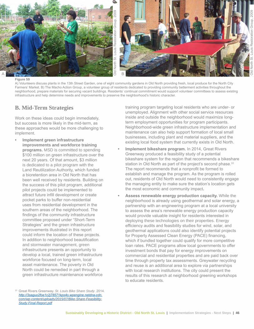
Sustainably Developing a Historic District - Old North St. Louis | Implementation Strategies - Next Steps | 46
B. Mid-Term Strategies
Work on these ideas could begin immediately, but success is more likely in the mid-term, as these approaches would be more challenging to implement. • Implement green infrastructure
improvements and workforce training programs. MSD is committed to spending $100 million on green infrastructure over the next 20 years. Of that amount, $3 million is dedicated to a pilot program with the Land Reutilization Authority, which funded a bioretention area in Old North that has been well received by residents. Building on the success of this pilot program, additional pilot projects could be implemented to attract future infill development or create pocket parks to buffer non-residential uses from residential development in the southern areas of the neighborhood. The findings of the community infrastructure committee proposed under “Short-Term Strategies” and the green infrastructure improvements illustrated in this report could inform the location of these projects. In addition to neighborhood beautification and stormwater management, green infrastructure presents an opportunity to develop a local, trained green infrastructure workforce focused on long-term, local asset maintenance. The poverty in Old North could be remedied in part through a green infrastructure maintenance workforce
training program targeting local residents who are under- or unemployed. Alignment with other social service resources inside and outside the neighborhood would maximize long-term employment opportunities for program participants. Neighborhood-wide green infrastructure implementation and maintenance can also help support formation of local small businesses, including plant and material suppliers, and the existing local food system that currently exists in Old North.
• Implement bikeshare program. In 2014, Great Rivers Greenway produced a feasibility study of a potential bikeshare system for the region that recommends a bikeshare station in Old North as part of the project’s second phase.10 The report recommends that a nonprofit be formed to establish and manage the program. As the program is rolled out, residents of Old North would need to consistently engage the managing entity to make sure the station’s location gets the most economic and community impact.
• Assess renewable energy production capacity. While the neighborhood is already using geothermal and solar energy, a partnership with an engineering program at a local university to assess the area’s renewable energy production capacity would provide valuable insight for residents interested in deploying these technologies on their properties. Energy efficiency audits and feasibility studies for wind, solar, and geothermal applications could also identify potential projects for Property Assessed Clean Energy (PACE) financing, which if bundled together could qualify for more competitive loan rates. PACE programs allow local governments to offer investment bonds that pay for energy improvements on commercial and residential properties and are paid back over time through property tax assessments. Greywater recycling and reuse is an additional area to explore via partnerships with local research institutions. The city could present the results of this research at neighborhood greening workshops to educate residents.
Figure 59A) Volunteers discuss plants in the 13th Street Garden, one of eight community gardens in Old North providing fresh, local produce for the North City Farmers’ Market. B) The Macho Action Group, a volunteer group of residents dedicated to providing community betterment activities throughout the neighborhood, prepare materials for securing vacant buildings. Residents’ continual commitment would support volunteer committees to assess existing infrastructure and help determine needs and improvements to preserve the neighborhood’s historic character.
Old
Nor
th S
t. Lo
uis
Res
tora
tion
Gro
up, 2
009
Old
Nor
th S
t. Lo
uis
Res
tora
tion
Gro
up, 2
009
10 Great Rivers Greenway. St. Louis Bike Share Study. 2014.http://3saguo2foe1c2j78571kps4o.wpengine.netdna-cdn.com/wp-content/uploads/2015/07/Bike-Share-Feasibility-Study-Final-Report.pdf
A B

Sustainably Developing a Historic District - Old North St. Louis | Implementation Strategies - Next Steps | 47
C. Long-Term Strategies In the long term, efforts in Old North could build support and momentum for more far-reaching changes that would require significant time and resources to implement. Many of the strategies previously identified rely on partnerships with organizations outside of the Old North neighborhood.• Form a community improvement district.
One long-term strategy that would provide a direct funding stream for many of the improvements needed in the neighborhood is the formation of a Community Improvement District (CID). Large property owners in the area, and ultimately the city of St. Louis, would need to approve the CID. It could levy additional taxes that would fund infrastructure improvements or redevelopment projects to stimulate growth. If designed to address the neighborhood’s resource needs, a CID could attract new businesses, encourage the development of senior housing, and provide a reliable funding source for infrastructure projects that will strengthen the neighborhood’s walkable feel. Establishing a CID would help the neighborhood capitalize on branding efforts and keep reaping the benefits of more pedestrian activity as Old North becomes one of the area’s premier urban destinations.
• Adopt sustainable design guidelines. The workshop process raised the notion of Old North as an “eco village” — a neighborhood that uses environmentally sustainable systems for energy, food, transportation, stormwater, and waste management at a district scale. The neighborhood’s size and layout create the opportunity to use cutting-edge, environmentally sustainable technologies while preserving the area’s historic feel. The city could advance development compatible with a historic eco village by adopting sustainable design guidelines for the area, with special requirements for redevelopment such as energy efficiency and stormwater management practices that exceed local codes. Residents could help develop sustainable design principles that aim to eventually make new development and redevelopment “net zero” energy, i.e., the development generates all its energy on site, or “net zero” water, i.e., the building uses only water it captures on site or recycles. The process of developing the design principles would bring neighbors together as they collectively define the eco village. Because each local historic district sets its own standards for rehabilitation and new construction, these sustainable design principles could be woven into the standards to help make the eco village vision a reality. These sustainable building standards could also be used as a component of a form-based code that regulates land development by specifying the physical form that it must take rather than the use. A form-based code for Old North could also include landscaping standards designed to encourage green infrastructure on private property.
The design options in this report provide a springboard for pursuing additional planning and implementation dollars from local, state, and federal sources. The next section lists possible funding sources.
Figure 60This Metropolitan Sewer District demonstration rain garden on the northeast corner of Clinton Street and North 14th Street manages runoff and educates residents and visitors about rain gardens.
SW
T D
esig
n
Sustainably Developing a Historic District - Old North St. Louis | Implementation Strategies - Funding Sources | 48
D. Funding SourcesTo implement the short-term, mid-term, and long-term strategies discussed in sections A-C, funding sources must be identified. Potential federal, state, and local funding sources are listed below along with a link to access additional information.
Federal Sources
HUD’s Neighborhood Stabilization Program provides grants to every state, certain communities, and other organizations to purchase foreclosed or abandoned homes and to rehabilitate, resell, or redevelop these homes to stabilize neighborhoods and stem the decline of house values of neighboring homes. This funding source could support rehabilitation of historic housing structures in the neighborhood.
More information is available at: www.hudexchange.info/programs/nsp
HUD’s Community Development Block Grant Program provides funds to municipalities and other units of government to develop viable urban communities by providing affordable, decent housing and a suitable living environment and by expanding economic opportunities, principally for low- and moderate-income persons. Although local units of government develop their own programs and funding priorities, all activities must be consistent with one or more of the HUD national objectives. Street and sidewalk improvements and home repair projects in the Old North neighborhood could be eligible for this funding.
More information is available at: portal.hud.gov/hudportal/HUD?src=/program_offices/comm_planning/communitydevelopment/programs
HUD’s Choice Neighborhood Planning Grant provides funds to create and implement a plan that transforms distressed HUD housing and addresses challenges in the surrounding neighborhood. The program is designed to catalyze critical improvements in neighborhood assets, including vacant property, housing, services, and schools. This funding source could support creation of a transformation plan for the neighborhood based on the ideas generated at the workshop.
More information is available at: http://portal.hud.gov/hudportal/HUD?src=/program_offices/public_indian_housing/programs/ph/cn
The New Markets Tax Credit Program is incorporated as section 45D of the Internal Revenue Code. This code section permits individual and corporate taxpayers to receive a credit against federal income taxes for making qualified equity investments in qualified community development entities. New Markets Tax Credits could help finance the various infill development strategies presented in the report.
More information is available at: www.irs.gov/pub/irs-utl/atgnmtc.pdf
Federal Historic Tax Credits are administered by the National Park Service in partnership with the Internal Revenue Service and Missouri’s State Historic Preservation Office. An income-producing, depreciable property—either a commercial or residential rental unit—can claim a federal credit of 20 percent of the costs of rehabilitation. Federal Historic Tax Credits could help preserve and rehabilitate qualifying historic structures in Old North.
More information is available at: www.nps.gov/tps/tax-incentives.htm
EPA Brownfields Revolving Loan Fund Grants provide funding for a grant recipient to capitalize a revolving loan fund and provide subgrants to carry out cleanup activities at brownfield sites. This funding could help clean up contaminated sites in the neighborhood and support the productive land use strategy.
More information is available at: www.epa.gov/brownfields/types-brownfields-grant-funding#tab-2
EPA Brownfield Assessment Grants provide funding for a grant recipient to inventory, characterize, assess, and conduct planning and community involvement related to brownfields sites. This funding could help identify contaminated sites in the neighborhood for future infill and reuse efforts.
More information is available at: www2.epa.gov/brownfields/types-brownfields-grant-funding
EPA’s Targeted Brownfield Assessment Program helps minimize the uncertainties of contamination often associated with brownfields—especially for those entities without EPA Brownfields Assessment grants. It is not a grant program, but a service provided through an EPA contract in which EPA directs a contractor to conduct environmental assessment activities to address the requester’s needs. This funding could help evaluate sites for redevelopment suitability and prioritize areas for cleanup.
More information is available at: www.epa.gov/brownfields/targeted-brownfields-assessments-tba
http://portal.hud.gov/hudportal/HUD?src=/program_offices/comm_planning/communitydevelopment/programs
http://portal.hud.gov/hudportal/HUD?src=/program_offices/comm_planning/communitydevelopment/programs
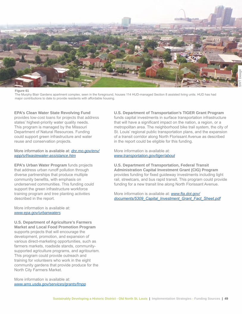
Sustainably Developing a Historic District - Old North St. Louis | Implementation Strategies - Funding Sources | 49
EPA’s Clean Water State Revolving Fund provides low-cost loans for projects that address states’ highest-priority water quality needs. This program is managed by the Missouri Department of Natural Resources. Funding could support green infrastructure and water reuse and conservation projects.
More information is available at: dnr.mo.gov/env/wpp/srf/wastewater-assistance.htm
EPA’s Urban Water Program funds projects that address urban runoff pollution through diverse partnerships that produce multiple community benefits, with emphasis on underserved communities. This funding could support the green infrastructure workforce training program and tree planting activities described in the report.
More information is available at: www.epa.gov/urbanwaters
U.S. Department of Agriculture’s Farmers Market and Local Food Promotion Program supports projects that will encourage the development, promotion, and expansion of various direct-marketing opportunities, such as farmers markets, roadside stands, community-supported agriculture programs, and agritourism. This program could provide outreach and training for volunteers who work in the eight community gardens that provide produce for the North City Farmers Market.
More information is available at: www.ams.usda.gov/services/grants/fmpp
U.S. Department of Transportation’s TIGER Grant Program funds capital investments in surface transportation infrastructure that will have a significant impact on the nation, a region, or a metropolitan area. The neighborhood bike trail system, the city of St. Louis’ regional public transportation plans, and the expansion of a transit corridor along North Florissant Avenue as described in the report could be eligible for this funding.
More information is available at: www.transportation.gov/tiger/about
U.S. Department of Transportation, Federal Transit Administration Capital Investment Grant (CIG) Program provides funding for fixed guideway investments including light rail, streetcars, and bus rapid transit. This program could provide funding for a new transit line along North Florissant Avenue.
More information is available at: www.fta.dot.gov/documents/5309_Capital_Investment_Grant_Fact_Sheet.pdf
Figure 61The Murphy Blair Gardens apartment complex, seen in the foreground, houses 114 HUD-managed Section 8 assisted living units. HUD has had major contributions to date to provide residents with affordable housing.
SW
T D
esig
n

Sustainably Developing a Historic District - Old North St. Louis | Implementation Strategies - Funding Sources | 50
State Sources
Missouri State Historic Tax Credit is a 25 percent income tax credit available for the rehabilitation of buildings that are determined by the Secretary of the Interior, through the National Park Service, to be “certified historic structures.” This funding source could support rehabilitation of historic housing structures in the neighborhood.
More information is available at: dnr.mo.gov/shpo/TaxCrdts.htm
Missouri Department of Natural Resources’ 319 Nonpoint Source Subgrants are authorized by Section 319 of the Clean Water Act to address nonpoint source water pollution, such as polluted runoff from unregulated or unpermitted sources and in waters needing improvements or protection from further degradation. EPA provides funding through the Missouri Department of Natural Resources. Funding is available for organizations to implement best management practices as detailed in a watershed management plan. If a watershed management plan has been completed for any of the three watersheds in Old North St. Louis, this funding could help implement private property green infrastructure improvements.
More information is available at: dnr.mo.gov/env/wpp/nps
Local Sources
Metropolitan St. Louis Sewer District Rainscaping Program Cost Share offered cost share funding through the MSD Project Clear Rainscaping Small Grants Program in 2014 and 2015 for rainscaping improvements including rain gardens and permeable pavement. This funding source could support green infrastructure improvements on private property.
More information is available at: www.projectclearstl.org/get-the-rain-out/rainscaping-small-grants-program
St. Louis County Soil and Water Conservation District Cost Share Program provides financial incentives to landowners to implement conservation practices that help prevent soil erosion and protect water resources, and offers technical support to implement best practices. This funding source could support green infrastructure improvements on private property.
More information is available at: swcd.mo.gov/stlouis
Set The PACE St. Louis Financing provides low-interest, long-term financing for energy efficiency, renewable energy, and water conservation systems for private property owners. This funding could support private property energy efficiency and renewable energy improvements.
More information is available at: www.setthepacestlouis.com
St. Louis Regional Chamber Contractor Loan Fund is a $10 million revolving loan fund to help area minority and women-owned construction contractors access construction-related loans of up to $1 million. This funding source could provide capital for new infill development and rehabilitation of existing structures to stabilize properties in the neighborhood.
More information is available at: clfstl.org
Regional Arts Commission Grant Program provides grants to eligible organizations and individual artists for public art through a variety of grant types. This funding could help add public art throughout the neighborhood.
More information is available at: racstl.org/explore-grants/grant-information

Sustainably Developing a Historic District - Old North St. Louis | Implementation Strategies - Key Partners | 51
E. Key PartnersThe implementation strategies described in the report can help achieve neighborhood revitalization goals by addressing infrastructure needs and neighborhood concerns while supporting sustainability improvements that maintain Old North’s rich cultural and architectural history. The strategies will require strong long-term partnerships between the public, private, and nonprofit sectors. While Old North has unique community partners like the Old North St. Louis Restoration Group whose mission is grounded in the neighborhood, additional outside partners will be needed if Old North is to thrive. The White House Strong Cities, Strong Communities Initiative could give the Old North St. Louis Restoration Group the capacity to help coordinate the partners described in this section of the report. The Old North St. Louis Restoration Group and representatives of the White House Strong Cities, Strong Communities Initiative would need to develop a work plan with detailed tasks and schedules to align the partners’ efforts efficiently. Using the work plan as a roadmap, the two entities, functioning as a steering committee, could then develop workgroups with multiple state and local partners based on the study areas presented at the neighborhood workshop.
Federal Partners
White House Strong Cities, Strong Communities Initiative seeks to strengthen neighborhoods, towns, cities, and regions around the country by enhancing local governments’ capacity to develop and execute their economic vision and strategies, providing necessary technical assistance and access to federal agency expertise, and creating new public- and private-sector partnerships. Although the initiative is set to end in December 2016, Old North could use it to help identify and coordinate federal resources that will be available to help implement the plan in the longer term.
State Partners
Missouri Department of Agriculture is dedicated to the promotion and protection of the state’s agriculture industry and works to connect farmers with consumers. It could provide support for local agriculture programming in Old North.
Missouri Department of Transportation works with the public, transportation partners, state and federal legislators, and other state and local agencies to provide a safe and efficient transportation system to the people of Missouri. It could provide background on transportation standards and right-of-way issues related to neighborhood improvements.
University of Missouri Extension Service is a partnership between the University of Missouri campuses, Lincoln University, the people of Missouri through county extension councils, and the National Institute for Food and Agriculture of the U.S. Department of Agriculture that engages people to understand change, solve problems, and make informed decisions. The Extension Service could provide technical support for local agriculture programming in Old North.
Great Rivers Greenway is a regional parks and trails district created in 2000 that connects the St. Louis region with greenways. It is funded by a special sales tax. It could help with coordination of the proposed section of the Iron Horse Trestle and with other trail-related design options.

Sustainably Developing a Historic District - Old North St. Louis | Implementation Strategies - Key Partners | 52
Local Partners
Old North St. Louis Restoration Group is a community-based nonprofit organization established by neighborhood residents in 1981 to revitalize the physical and social dimensions of the community in a manner that respects its historic, cultural, and urban character. The Old North St. Louis Restoration Group could lead the steering committee for future implementation efforts with the support of neighborhood stakeholders and city of St. Louis department leaders.
Rise is a nonprofit organization that connects key groups working to revitalize communities and neighborhoods in greater St. Louis. Rise acts as a resource and partner to the community, bringing together nonprofit organizations, financial institutions and government that make successful neighborhood revitalization possible. Rise is a possible development partner for Old North St. Louis Restoration Group for infill development projects and a potential recipient of the HUD grant funding sources described in the funding sources section.
Metro Transit – St. Louis operates the St. Louis metropolitan region’s public transportation system whose mission is to meet the region’s transit needs by providing safe, reliable, accessible, and customer-focused service in a fiscally responsible manner. It can provide information on the location of future transit routes to coordinate with proposed development activities.
City of St. Louis Community Development Administration promotes neighborhood growth and stabilization through the production of new and rehabilitated housing, especially for low- and moderate-income people. The CDA administers the Community Development Block Grant funds that could be used for infrastructure and housing improvements in the neighborhood.
City of St. Louis Planning and Urban Design Agency’s mission is to focus on planning for the future of the city of St. Louis through effective measures of planning, design review, construction plan approval, code compliance, and housing assistance. The agency could provide guidance on the development of a form-based code or eco-village overlay for the neighborhood.
City of St. Louis Cultural Resources Office works with property owners, neighborhoods, city departments, public agencies, and elected officials to preserve the city’s historic and cultural heritage. The Cultural Resources Office will review demolition of properties in Old North that are classified as “contributing structures” within one of Old North’s three National Register Historic Districts and can provide technical assistance on future historic property designation efforts.
City of St. Louis Land Reutilization Authority receives title to all city of St. Louis tax delinquent properties not sold at the sheriff’s sale. It also receives title to properties through donations. The St. Louis Development Corporation Real Estate Department maintains, markets, and sells these properties and performs land assemblage for future development. The Land Reutilization Authority owns 30 percent of the vacant parcels within the neighborhood and can provide property-specific information for activities to enhance productive land use.
Community Development Financial Institutions (CDFIs) are specialized community-based financial institutions with a primary mission to promote economic development by providing financial products and services to people and communities underserved by traditional financial institutions, particularly in low-income communities. CDFIs include community development banks, credit unions, and non-regulated institutions such as nonprofit loan funds or venture capital funds. CDFIs in St. Louis include Choices Federal Credit Union, Electro Savings Credit Union, Gateway Community Development Fund, Inc., Great Rivers Community Capital, International Institute CDC, St. Louis Community Credit Union and Unite Burlington Credit Union. CDFIs can provide financing for infill development projects in Old North.
Habitat for Humanity Saint Louis builds simple, decent, and affordable housing in the city of St. Louis and St. Louis County. Since 2008, all new Habitat for Humanity Saint Louis homes are built to LEED platinum standards. Building off the success of its recent infill housing development activities in Old North, Habitat could target additional housing development based on neighborhood input received during the workshop and open house conducted for the report.
The East-West Gateway Council of Governments provides a forum for local governments of the bi-state St. Louis area to work together to solve problems that cross jurisdictional boundaries. Any transportation project within Old North that will be wholly or partially funded with federal dollars must be contained in plans that are formally adopted by the council’s board of directors.
Sustainably Developing a Historic District - Old North St. Louis | Implementation Strategies - Key Partners | 53
Metropolitan St. Louis Sewer District’s service territory includes 525 square miles, including all 62 square miles of the city and 462 square miles (approximately 90 percent) of the county. MSD owns and operates the sewer system, which consists of wastewater, stormwater, and combined collection sewers, pumping stations, and wastewater treatment facilities in its service area. In addition, MSD provides a variety of other services, including sanitary sewer maintenance, stormwater sewer maintenance, floodwater control, monitoring of industrial waste, issuance of pretreatment discharge permits, engineering design and specification, construction of sewer lines, plan review and approvals, issuance of connection permits, public education, and customer service. MSD can provide information about future infrastructure projects planned for the area and is a potential funding and maintenance partner for implementing green infrastructure in the neighborhood.
St. Louis Regional Chamber is one of the oldest chambers of commerce in the United States. The chamber represents the 15-county bi-state metropolitan area that convenes stakeholders to solve regional issues, develop public policy to enhance the region’s business climate, and work in specific economic sectors to help companies startup, expand, or move to St. Louis. The chamber could provide technical assistance for the cottage industries envisioned for the southern end of the neighborhood.
City of St. Louis Health Department provides essential public health services to ensure a healthy St. Louis community. The health department could help address the lack of local health care resources identified during the neighborhood workshop.
Mission: St. Louis is a nonprofit organization started in Forest Park Southeast whose mission is to empower people to transform their neighborhoods through a variety of programs and services. This organization could help with job training related to green infrastructure maintenance.
Grace Hill Settlement House offers early childhood education at Head Start centers, wrap-around services to families across the region, and community-based hubs in North and South St. Louis. Grace Hill can support neighborhood families with young children through its Head Start program and can connect unemployed residents with job training.
Energy Equity Funding, LLC is the program administrator for the Set the PACE St. Louis program described in the local funding section of this report. This organization could provide residents and developers with information about energy efficiency property upgrades and renewal energy deployment opportunities to enhance the neighborhood’s environmental performance.
Landmarks Association of St. Louis is the primary advocate for the region’s built environment. Its mission is to preserve, enhance, and promote St. Louis’ architectural heritage and to encourage sound planning and good contemporary design. Landmarks could help market Old North as a sustainable historic district.
Incarnate Word Foundation is a community partner that collaborates with organizations and other community stakeholders to achieve shared goals through funding, convening, collaborating, representing, and educating. Incarnate Word Foundation recently provided a grant to Saint Louis University to combat food deserts and could help with urban agriculture development and job training efforts in Old North.
St. Louis County Soil and Water Conservation District provides financial incentives to landowners to implement conservation practices that help prevent soil erosion and protect water resources. The district could help advise on erosion and sediment control measures needed to minimize the impact of infill development activities on local water resources.