Sustainable Urban Extension Joint Delivery … · Sustainable Urban Extension Joint Delivery...
12
Sustainable Urban Extension Joint Delivery Statement Evidence Topic Paper for Sleaford West Quadrant August 2016 Central Lincolnshire Local Plans Team c/o North Kesteven District Council Council Offices Kesteven Street SLEAFORD Lincs NG34 7EF Telephone: 01529 414155 Email: talkplanning @central-lincs.org.uk
Transcript of Sustainable Urban Extension Joint Delivery … · Sustainable Urban Extension Joint Delivery...
Sustainable Urban Extension
Joint Delivery Statement
Evidence Topic Paper for
Sleaford West Quadrant
August 2016
Central Lincolnshire Local Plans Team
c/o North Kesteven District Council
Council Offices
Kesteven Street
SLEAFORD
Lincs NG34 7EF
Telephone: 01529 414155
Email: talkplanning @central-lincs.org.uk

Topic Paper: Sustainable Urban Extension Sleaford West Quadrant
Short Summary and Current Status
Summary: A sustainable urban extension to Sleaford which will deliver up to 1400
homes and a range of, employment community facilities and open space
Current Status Scheme submitted for Outline Planning Permission
Scheme Preparation
Date Comp Application Date Comp Implementation Date Comp
Vision and Key Objectives Agreed
Yes Yes Detailed viability assessment
May 2016 estm.
Under way
Phase x
Constraints Identified
Yes
Yes Application Submitted
May 2016 estm
Discharge of Conditions
Access and movement Strategy agreed
Yes Yes Application under consideration
Yes
Site Marketed
Infrastructure Requirements Identified Affordable Housing Highways Health Education Others
2015 Yes Approved Site Developer Secured
Section 106 Agreed
Reserved Matters
Start on Site
Public Consultation undertaken
Nov 2015
Yes Completions
Strategic Framework Plan Developed
Nov 2015
Yes
1.0 INTRODUCTION TO THIS TOPIC PAPER AND OUTLINE OF THE SUE
The purpose of this joint delivery statement is to set out information about the SUE and how
it will be delivered. The following sections provide;
Information on who is delivering it, a description of the opportunity and who else is
involved
the vision and objectives for what will be delivered
any current issues and constraints with the site that will need to be addressed
what will be delivered and when
1.1 Who is delivering the SUE
a) The local planning authority
The local planning authority is North Kesteven District Council.

b) Principal site promoter(s) /lead developer
The site is being promoted by Planning Consultants on behalf of the principle four major
private land owners
A smaller land owner (Mr Dyer) is working collaboratively with the principal land owners
The landowners have entered into a Memorandum of Understanding (MOU) to bring the site
forward.
c) Other Key Delivery Partners
The landowners and their agents
North Kesteven District Council and
Lincolnshire County Council
d) Land Ownership
The four major land owners are entering into a formal MOU going forward, to formalise their
intention and approach to jointly bring the site forward for development. By agreement Mr
Dyer’s land will come forward later on in the development as it is not a principal component
of the Sustainable Urban Extension.
Ancillary landowners on the site are Anglian Water who has a water distribution plant on site
and some private owner occupiers. These do not affect access or delivery to the site.
The landowners have appointed, via their agents, Peacock and Smith, who are an
independent Town Planning and Development Consultancy to coordinate their submissions
throughout the delivery process. In pursuit of this, Peacock and Smith has assembled a
multi-disciplinary Design Team of specialist consultants to address the issues raised. They
are working collaboratively with the local authority, to produce the site concepts and
masterplan, and to address any potential deliverability issues in order to secure the
allocation of the site, and in doing so provide the preparatory work necessary to submit an
outline planning application.
Map showing land ownership (land to west of A15 not included in the SUE)
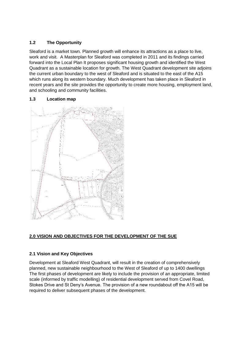
1.2 The Opportunity
Sleaford is a market town. Planned growth will enhance its attractions as a place to live,
work and visit. A Masterplan for Sleaford was completed in 2011 and its findings carried
forward into the Local Plan It proposes significant housing growth and identified the West
Quadrant as a sustainable location for growth. The West Quadrant development site adjoins
the current urban boundary to the west of Sleaford and is situated to the east of the A15
which runs along its western boundary. Much development has taken place in Sleaford in
recent years and the site provides the opportunity to create more housing, employment land,
and schooling and community facilities.
1.3 Location map
2.0 VISION AND OBJECTIVES FOR THE DEVELOPMENT OF THE SUE
2.1 Vision and Key Objectives
Development at Sleaford West Quadrant, will result in the creation of comprehensively
planned, new sustainable neighbourhood to the West of Sleaford of up to 1400 dwellings
The first phases of development are likely to include the provision of an appropriate, limited
scale (informed by traffic modelling) of residential development served from Covel Road,
Stokes Drive and St Deny’s Avenue. The provision of a new roundabout off the A15 will be
required to deliver subsequent phases of the development.

Draft Masterplan for the SUE (larger version at Appendix One) More specifically, proposals for this area should:
deliver a new local centre of around 1 ha to meet the day-to-day needs of Sleaford West Quadrant new community and nearby residents, incorporating provision of local retail facilities, services and community uses.
provide a new healthcare facility of 0.5ha adjoining the local centre;
provide a minimum of 3ha of mainly use class B1 employment land including a range of premises to complement the existing employment offer in the Sleaford area;
provide an on-site two form entry primary school of 1.8ha site area and secondary education facility of 5.5ha site area;
support the delivery of the Sleaford East West Leisure Link to connect the town centre to green wedges and improve connectivity, as identified in the Sleaford Masterplan;
ensure access is provided via The Drove for pedestrians, cyclists, buses, existing residents and businesses and allotment holders. A limited amount of additional vehicle access may be provided for some older persons accommodation in consultation with the highways authority
deliver primary vehicular access for the development via a new junction with the A15 with appropriate measures to manage any adverse impact on movement within the wider Sleaford . Secondary accesses will be provided from Stokes Drive and St Deny’s Avenue; Covel Road will be pedestrian and cyclist access
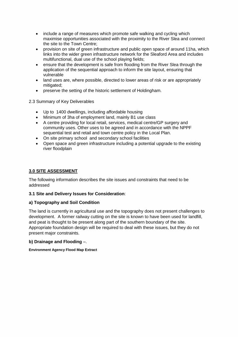
include a range of measures which promote safe walking and cycling which maximise opportunities associated with the proximity to the River Slea and connect the site to the Town Centre;
provision on site of green infrastructure and public open space of around 11ha, which links into the wider green infrastructure network for the Sleaford Area and includes multifunctional, dual use of the school playing fields;
ensure that the development is safe from flooding from the River Slea through the application of the sequential approach to inform the site layout, ensuring that vulnerable
land uses are, where possible, directed to lower areas of risk or are appropriately mitigated;
preserve the setting of the historic settlement of Holdingham.
2.3 Summary of Key Deliverables
Up to 1400 dwellings, including affordable housing
Minimum of 3ha of employment land, mainly B1 use class
A centre providing for local retail, services, medical centre/GP surgery and community uses. Other uses to be agreed and in accordance with the NPPF sequential test and retail and town centre policy in the Local Plan.
On site primary school and secondary school facilities
Open space and green infrastructure including a potential upgrade to the existing river floodplain
3.0 SITE ASSESSMENT
The following information describes the site issues and constraints that need to be
addressed
3.1 Site and Delivery Issues for Consideration:
a) Topography and Soil Condition
The land is currently in agricultural use and the topography does not present challenges to
development. A former railway cutting on the site is known to have been used for landfill,
and peat is thought to be present along part of the southern boundary of the site.
Appropriate foundation design will be required to deal with these issues, but they do not
present major constraints.
b) Drainage and Flooding –.
Environment Agency Flood Map Extract
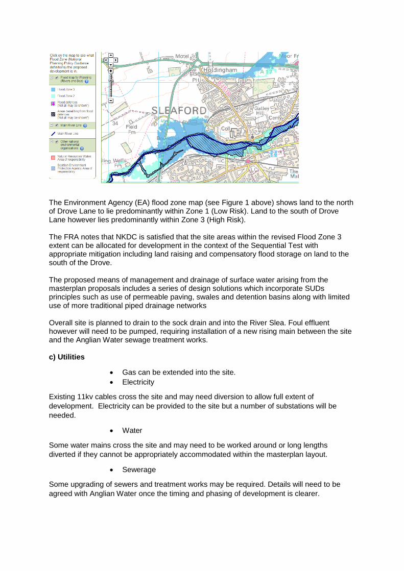
The Environment Agency (EA) flood zone map (see Figure 1 above) shows land to the north of Drove Lane to lie predominantly within Zone 1 (Low Risk). Land to the south of Drove Lane however lies predominantly within Zone 3 (High Risk). The FRA notes that NKDC is satisfied that the site areas within the revised Flood Zone 3 extent can be allocated for development in the context of the Sequential Test with appropriate mitigation including land raising and compensatory flood storage on land to the south of the Drove. The proposed means of management and drainage of surface water arising from the masterplan proposals includes a series of design solutions which incorporate SUDs principles such as use of permeable paving, swales and detention basins along with limited use of more traditional piped drainage networks Overall site is planned to drain to the sock drain and into the River Slea. Foul effluent however will need to be pumped, requiring installation of a new rising main between the site and the Anglian Water sewage treatment works. c) Utilities
Gas can be extended into the site.
Electricity
Existing 11kv cables cross the site and may need diversion to allow full extent of
development. Electricity can be provided to the site but a number of substations will be
needed.
Water
Some water mains cross the site and may need to be worked around or long lengths
diverted if they cannot be appropriately accommodated within the masterplan layout.
Sewerage
Some upgrading of sewers and treatment works may be required. Details will need to be
agreed with Anglian Water once the timing and phasing of development is clearer.
d) Access/Transport
The main access to the site will be from the A15 by creation of a roundabout which has been
approved in principle by Highways.
Connection through the existing residential area to the east via existing roads will be
important to integrate the new development into the town and to enable non car modes of
travel to the town’s facilities.
The Sleaford traffic model informs the exact levels of connectivity from the existing
residential cul de sac road network to the east of the site, however the initial Highway’s
investigations undertaken by the landowners’ transport consultant shows there is the
potential for a significant number of residential dwellings to be constructed served by this
network. Lincolnshire County Council Highways have accepted the principle of access for in
the region of 200 homes, with the potential for an increase in this number subject to
assessing the figures through the traffic model and formal Transport Assessment.
Other than a limited amount of potential residential development of a care home and elderly
persons’ housing; Drove Lane to the south of the site is not considered to be appropriate as
a main access into the development but there is potential for providing sustainable
connectivity using Drove Lane (beyond maintaining the existing users) primarily in the form
of public transport/bus priority, cycling and pedestrian uses.
Some off site highway improvements also likely to be needed, including to the Holdingham
roundabout and to mitigate traffic impact on the existing highways network.
e) Public transport, walking and cycling
In addition to the potential offered by the existing residential area to the east and Drove
Lane in this respect, there are opportunities to loop a new bus service into the development
and/or divert an existing route. Cycle and pedestrian connections into town through the
existing residential area will be provided, together with links to both Sleaford and Rauceby
stations and existing secondary schools elsewhere in the town. These matters will be
addressed via a formal Transport Assessment and Travel Plan.
f) Affordable Housing /Gypsy and Traveller Provision
Affordable housing provision will be phased throughout the site
Gypsy and Traveller Provision – The Further Draft Local Plan set out the need for all Central Lincolnshire authorities to respond to and address the accommodation needs set out in the ‘Gypsy and Traveller Accommodation Assessment 2013’. To ensure this need could be met appropriately the Proposed Submission Local Plan states that the supply of new pitches should be met through a combination of allocated sites and by the provision of suitable land within each new SUE (Policy 28: Sustainable Urban Extensions, Part C). On Monday 18 January 2016 Members of the Central Lincolnshire Joint Strategic Planning
Committee agreed to amend the policy wording as follows:
“Each new urban extension proposal must, where applicable. Set aside an area of land which is suitable for the provision of gypsy and traveller pitches. The size of the site shall be agreed through negotiation, though is likely to be of a size sufficient to accommodate 5-10 pitches. Such set aside land should be on-site unless the developer can demonstrate circumstances which demonstrates that provision on an alternative suitable site is identified, and is made available and deliverable by the applicant. Such set aside land (whether on the SUE site or
off-site) should be provided to the local planning authority at nil cost and be secured through an appropriate legal agreement”
g) Education
Sites for both a primary school, with extended hours provision, and a secondary school will
be required. These could appropriately be located within or adjoining the centre.
h) Health
The provision of healthcare facilities at an appropriate scale to meet requirements.
i) Recreation/Open space
The development will need to provide appropriate play facilities and public open space, but
at this stage no specific recreation requirements are identified. However, there is potential
for shared use of school playing fields and other
j) Heritage
There are no identified heritage assets on the site.
k) Natural environment / Ecology
The land is currently predominantly in agricultural use
From the agent’s initial studies there are no ecological, tree or vegetation issues that are
likely to affect the development going forward. The site contains no statutory nature
conservation sites, none are within 1km of the site and none are likely to be affected by its
development. All of the habitats and plant species present within the site are widespread
and common throughout the UK and Lincolnshire. Overall, the potential impacts on habitats
and flora are considered to be relatively low and capable of mitigation.
There is potential to continue the East-West green link to the town centre along the River
Slea.
l) Community Facilities and Services
Provision of a local centre providing facilities to serve the needs of the SUE
4.0 DELIVERY AND IMPLEMENTATION
4.1 Housing Delivery Trajectory and Phasing
Phase 1( first 5 years of Local Plan period)
2016/17 2017/18 2018/19 2019/20 2020/21
Starts 0 20 80 120 120
Completions 0 0 20 80 120
Assumptions 2 developers 40pa each
2/3 developers 40pa each
3 developers 40pa each
Longer term the housing phasing proposals are to be confirmed- overall delivery-
Phasing (beyond first 5 years )to be confirmed
Total Number
Estimate Start Phasing tbc
Estimate Completion Phasing tbc
Assumptions
Total for SUE (less first 5 year delivery)
1180 2021/22 2030/31 3 developers 40pa each
4.2 Employment Land
Phase
Amount Assumptions
Tbc 3 hectares Predominantly B1 use
4.3 Infrastructure Delivery Trajectory
Infrastructure /Obligations required
The developer will contribute to the costs of other site-specific infrastructure listed below to
the extent that the viability of the scheme allows. This will be either through a planning
obligation or through Community Infrastructure Levy (CIL) depending on whether CIL is in
place at the time the planning application is decided. The IDP gives more information about
the general funding of infrastructure and other sources of finance.
. Item Description When Estimated Cost
How it will be delivered
Site opening up costs
Physical access and connections to services
Commencement £300,000 per net acre assumed
Development Cost
Affordable Housing
Subsidised housing for rent and shared ownership
Phased throughout the development
Up to 35% Section 106 obligation
Gypsy and Traveller Provision
Land for Gypsy and Travellers
Tbc Between 5/10 pitches
Section 106 obligation
Flooding/Drainage SUDs Phased Development Cost Education Primary School 1.8ha of land for
primary schooling Tbc £3.1 million
contribution Section 106 obligation
Secondary School 5.5ha site for secondary schooling
Tbc Tbc Section 106 obligation
Health 0.5 ha land for health care provision
Tbc Tbc Section 106 obligation

Recreation/ Open Space
Approximately 11ha of multi-functional land
Phased Tbc Section 106 obligation
Access/Transport Movement
Tbc Tbc Tbc Section 106 obligation
Heritage Tbc Tbc Tbc Section 106 obligation Environmental (the site )
Tbc Tbc Tbc Section 106 obligation
Design criteria Tbc Tbc Tbc Section 106 obligation Community Facilities and Services
1 ha of land for local facilities including 840m2 local centre
Tbc Tbc Section 106 obligation
Utilities Tbc Tbc Tbc Section 106 obligation
4.3 Deliverability
Aspinal Verdi are undertaking a joint viability assessment for the delivery of the SUE.
4.4 Project Plan
Outline Application Submitted June 2016
Outline Application Resolution to approve December 2016
Section 106 signed January 2017
Site Marketed Jan-June 2017
Reserved Matters Application Summer 2017
Reserved Matters Determined Autumn 2017
Developer Start on Site Jan/March 2018
First Completions Jan/March 2019
5.0 RISK ASSESSMENT
Significant Risks RAG Mitigation
Flood zone 3 G Land use / Masterplanning Reduced development area to 1400 homes
Viability /Delivery of infrastructure A Detailed viability appraisal underway
Key contact
Stephen Priestley
Housing Strategy and Growth Manager
North Kesteven District Council,
Council Offices,
Kesteven Street,
SLEAFORD
Tel 01529 308295
email [email protected]
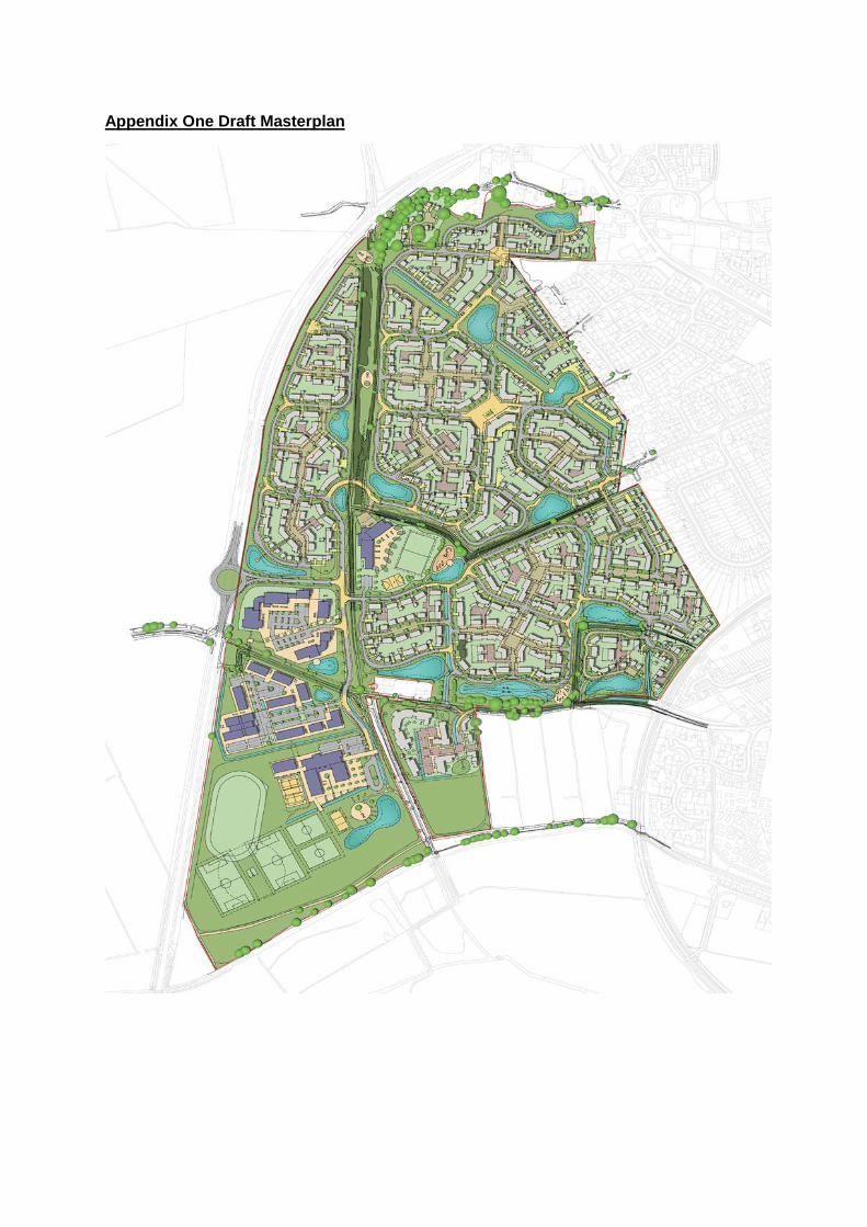
Appendix One Draft Masterplan