SUSTAINABLE DEVELOPMENT OF HYDROPOWER SECTOR
117
STRATEGIC ENVIRONMENTAL ASSESSMENT FIVE INFLUENTIAL CASES India, Myanmar, Pakistan, Rwanda, Viet Nam FOR SUSTAINABLE DEVELOPMENT OF THE HYDROPOWER SECTOR
Transcript of SUSTAINABLE DEVELOPMENT OF HYDROPOWER SECTOR

STRATEGIC
ENVIRONMENTAL
ASSESSMENT
FIVE INFLUENTIAL CASES
India, Myanmar, Pakistan,
Rwanda, Viet Nam
FOR SUSTAINABLE
DEVELOPMENT OF
THE HYDROPOWER
SECTOR

Publication by:
The Netherlands Commission for Environmental Assessment (NCEA).
Edited by Arend Kolhoff, NCEA and Roel Slootweg, SevS
Contributions by David Annandale, Matthew Corbett, Kate Lazarus, Lothar Linde,
Asha Rajvanshi, François Xavier Tetero
May 2021
- 1 -
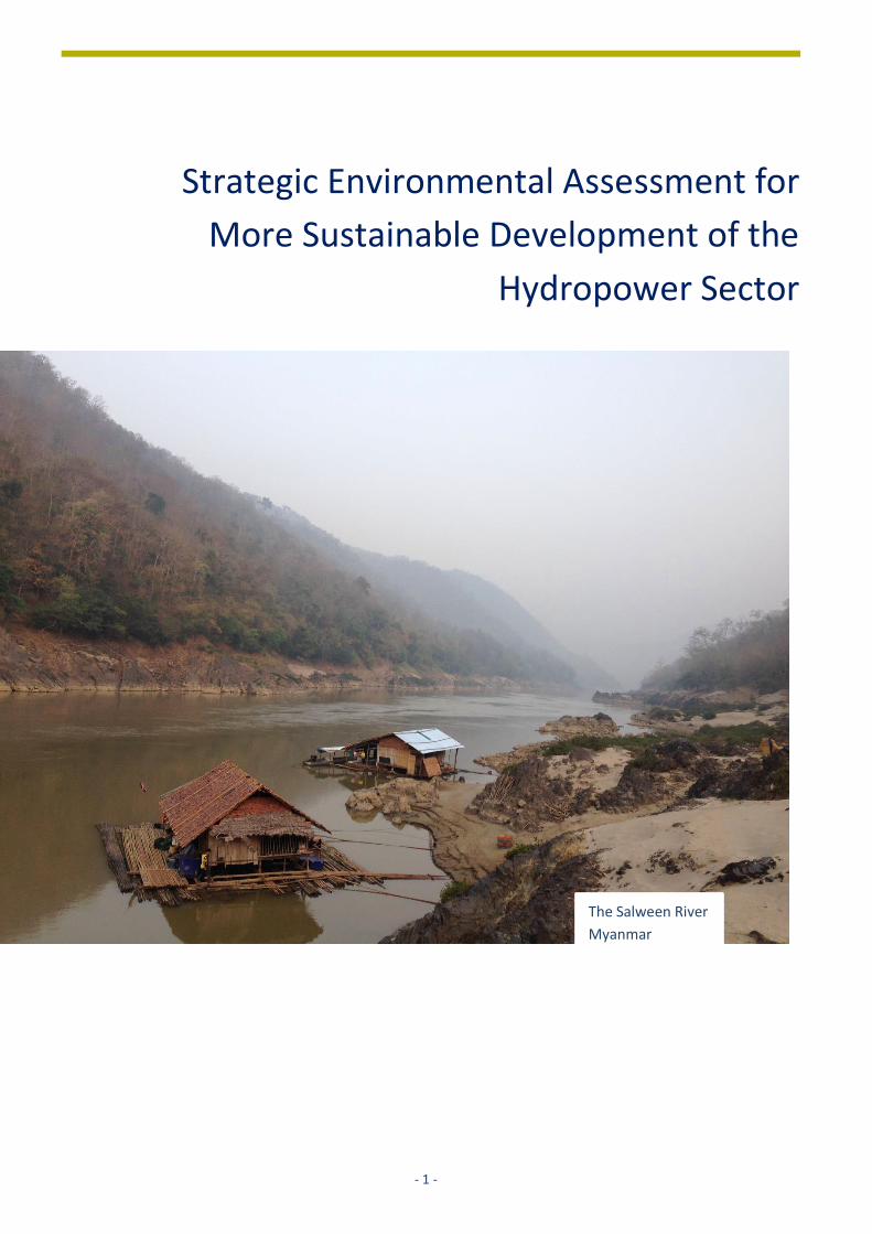
Strategic Environmental Assessment for
More Sustainable Development of the
Hydropower Sector
The Salween River
Myanmar
- 2 -
CONTENTS
Summary for Decision-Makers…………………….…………………………….………………………………………………………………..……….…………....5 Summary for Dam Owners………………………………………………………..………………………………………………………………..……….…………….8 Executive Summary……………………………………………………………………………………………………………………………………..……….…………..11
1 INTRODUCTION............................................................................................................................................................15
1.1 TOWARDS MORE SUSTAINABLE HYDROPOWER ..........................................................................................................................15
1.2 METHODOLOGY ................................................................................................................................................................16
1.3 CHARACTERISTICS OF SEA ...................................................................................................................................................17
1.4 INVENTORY OF SEAS ..........................................................................................................................................................20
FIVE CASES
2 SEA FOR HYDROPOWER DEVELOPMENT IN AZAD JAMMU KASHMIR STATE PAKISTAN .............................22
2.1 INTRODUCTION ................................................................................................................................................22
2.2 BACKGROUND: CONTEXT AND ISSUES .....................................................................................................................22
2.3 APPROACH AND METHODS USED ...........................................................................................................................23
2.4 RESULTS AND LESSONS LEARNT .............................................................................................................................24
2.5 MEASURING THE INFLUENCE OF THE SEA ...............................................................................................................29
3 SEA FOR HYDROPOWER DEVELOPMENT PLANNING IN ALAKNANDA AND BHAGIRATHI BASINS,
UTTARAKHAND STATE INDIA .......................................................................................................................31
3.1 INTRODUCTION ................................................................................................................................................31
3.2 BACKGROUND: CONTEXT AND ISSUES .....................................................................................................................34
3.3 APPROACH AND METHODS USED ...........................................................................................................................36
3.4 RESULTS AND OUTCOMES ...................................................................................................................................40
4 SEA FOR THE HYDROPOWER SECTOR MYANMAR .......................................................................................45
4.1 INTRODUCTION ................................................................................................................................................45
4.2 BACKGROUND: CONTEXT AND ISSUES .....................................................................................................................46
4.3 APPROACH AND METHODS USED ...........................................................................................................................49
4.4 ISSUE SCOPING .................................................................................................................................................49
4.5 RESULTS AND OUTCOMES ...................................................................................................................................56
4.6 LESSONS LEARNT ...............................................................................................................................................59
5 MAINSTREAMING ENVIRONMENT INTO POWER PLANNING: SEA FOR POWER DEVELOPMENT PLAN VII
VIET NAM ....................................................................................................................................................62
5.1 INTRODUCTION ................................................................................................................................................62
5.2 BACKGROUND: CONTEXT AND ISSUES .....................................................................................................................63
5.3 APPROACH AND METHODS USED ...........................................................................................................................64
5.4 RESULTS AND LESSONS LEARNT .............................................................................................................................72
6 SEA FOR MANAGEMENT PLAN OF UPPER NYABARONGO CATCHMENT RWANDA .....................................76
6.1 INTRODUCTION ................................................................................................................................................76
6.2 BACKGROUND: CONTEXT AND ISSUES .....................................................................................................................76
6.3 APPROACH AND METHODS USED ...........................................................................................................................81
6.4 RESULTS AND LESSONS LEARNT .............................................................................................................................85
7 SEA’S INFLUENCE ON DECISION-MAKING AND LESSONS LEARNT .............................................................................88
7.1 MAIN AREAS OF INFLUENCE .................................................................................................................................................88
7.2 LESSONS LEARNT ...............................................................................................................................................................89
7.3 AGENDA FOR THE COMING YEARS ..........................................................................................................................................91

- 3 -
DOCUMENTS CITED AND USED ............................................................................................................................................... 95
ANNEX 1: BRIEF DESCRIPTION OF OTHER TOOLS SUPPORTING HYDROPOWER DEVELOPMENT ................................................. 98
ANNEX 3: LIST OF SEAS APPLIED FOR POLICIES, PLANS OR PROGRAMMES OF THE HYDROPOWER SECTOR ............................. 105
ANNEX 4: LIST OF SEAS APPLIED FOR MULTI-SECTOR POLICIES, PLANS OR PROGRAMMES, INCLUDING HYDROPOWER .......... 107
ANNEX 5: LIST OF CIA STUDIES APPLIED FOR HYDROPOWER DEVELOPMENT ......................................................................... 108
ANNEX 6: OUTPUTS, OUTCOMES AND IMPACTS OF SEA IN FIVE CASE STUDIES ...................................................................... 110

- 4 -
Gibe III Dam
Ethiopia

- 5 -
SUMMARY FOR DECISION-MAKERS
Towards a more sustainable hydropower
development
Hydropower is expected to remain a dominant
worldwide player in the energy sector, given the
rapidly growing energy demand of low- and middle-
income countries. The need for a transition towards
climate neutral energy production, and the necessity
for pumped storage and grid stability when highly
fluctuating wind and solar power generation become
prominent, further influence the role of hydropower.
Negative impacts of individual hydropower projects
can (partly) be avoided, mitigated and compensated,
and positive impacts can be enhanced, by making
use of ESIA. However, most impacts are the result of
the location of a hydropower project, for instance
tributaries located in a national park may be more
sensitive to the effects of a hydropower project, than
those outside a park. Furthermore, cumulative
impacts of a number of projects in a river basin can
be considerable, which may go unnoticed in the ESIA
for an individual project. Cumulative and negative
impacts can be avoided or mitigated by applying SEA
to support strategic planning for hydropower.
Strategic Environmental Assessment (SEA) is a
decision support tool aiming to integrate
environmental and social considerations into
government policies, plans and programmes. Since
2019, SEA has been legally adopted in 106 countries
and this number is expected to grow. Since 1995,
globally, 37 SEAs have been conducted to support
strategic planning and decision-making in the
hydropower sector, mainly in low and middle-
income countries, predominantly in Asia. Of this list,
five cases in Pakistan, India, Myanmar, Viet Nam and
Rwanda, have been analysed in detail.
Influence of SEAs evaluated
The evaluation showed that the five SEA cases have
proven to be influential in the following areas:
• The SEAs contributed to more awareness on the
environmental and social impacts of
hydropower plans for all stakeholders: the
general public as well as investors and planners
of hydropower projects.
• The SEAs contributed to cooperation and
exchange between different ministries, in
particular those concerned with environment
and energy.
• The SEAs provided clarity to project developers
concerning go and no-go areas and the
environmental and social issues associated with
certain sites.
• The SEAs influenced decision-making
profoundly and also had other important spin-
off impacts such as new legislation or easing of
social tensions. Examples are the exclusion of
sensitive areas from hydropower development
and avoidance of investments in hydropower
projects at sites with high social and
environmental risks.
In conclusion, SEA can be an effective and efficient
tool to support more sustainable development of
hydropower.
Lessons for future SEAs supporting hydropower
development
The following lessons have been drawn that can be
applied to future SEAs in support of the hydropower
sector.
Lesson 1 - Regulatory framework
SEA can be applied in regulated and unregulated
situations as sufficient international guidance and
expertise is available.
Lesson 2 - Plan or SEA in the lead
SEA is generally applied in support of formal
decision-making as part of a predefined policy, plan
or programme. However, it can also be used to
inform governments of potential development
pathways in situations where no government policy,
plan or programme is in place.
Lesson 3 – Alternatives
Developing and comparing alternatives are best
practice in SEA; the type of alternatives to examine
cannot be prescribed; they are case and context
specific.

- 6 -
Lesson 4 - Stakeholder involvement
Stakeholder involvement is essential in SEA and is
highly case and context specific. Scope and
geographic range of the plan, issues at stake and
legacy of earlier experiences determine the way
stakeholders are involved.
Lesson 5 – Limited availability of data is no
bottleneck
Methodologies can be adapted to available data,
stakeholders can assist in filling gaps, access to
former planning and assessment studies greatly
facilitates new studies. Of course, it remains
important to be transparent on gaps in information
in the assessment.
Lesson 6 – Government commitment and funding
required
Government commitment is a condition for
influential SEA. In low-income countries external /
international budget is required to implement good
practice SEA.
Lesson 7 – Patience needed to see results
An overall observation is that it takes many years to
be able to see the actual impacts of planning,
assessment and decision-making processes. In this
respect it is a pity that so little ex-post evaluative
studies are being carried out for the hydropower
sector. There is little information on the
effectiveness of SEAs, CIAs and ESIAs to address
sustainability of the sector.
Supporting the SEA agenda
Government decision-makers can support the
application of SEA in the following manner:
• Develop guidelines for strategic planning of the
hydropower sector, including SEA. To secure
application, these guidelines should be adopted
by platform organisations such as the
International Hydropower Association,
International Commission on Large Dams,
International Association for Impact
Assessment, and governments and
international finance institutes.
• Provide river basin authorities with the
necessary knowledge to use SEA jointly with
Integrated Water Resources Planning and
Management to balance different interests in a
river basin management plan;
• Collect and share examples of how SEA can lead
to economically efficient outcomes, while
reducing environmental and social risks.
• Emphasise the importance of SEA to
stakeholders as an effective tool for conflict
resolution.
• Spend time on the evaluation of planning,
assessment and decision-making processes to
determine whether procedures, impacts and
plan outcomes are according to expectations.

- 7 -
The Bhyundar Ganga project
India
- 8 -
SUMMARY FOR DAM OWNERS
Towards a more sustainable hydropower sector
Hydropower is expected to remain a dominant
worldwide player in the energy sector, given the rapidly
growing energy demand of low- and middle-income
countries. The need for a transition towards climate
neutral energy production, and the necessity for
pumped storage and grid stability when highly
fluctuating wind and solar power generation become
prominent, further influence the role of hydropower.
Despite the positive aspects of new hydropower
projects (hereafter referred to as ‘project’), dam
owners are increasingly confronted with opposition
during preparation and implementation of projects.
Two tools can subsequently be applied to get support
for a project and reduce delays and reputational risk,
namely Strategic Environmental Assessment (SEA) and
Environmental and Social Impact Assessment (ESIA).
SEA: a relatively new and promising tool
Environmental and Social Impact Assessments (ESIAs)
are known by dam owners as a legal requirement to
obtain an environmental license. Application of ESIA by
dam owners has become common practice. However,
an ESIA does not always adequately answer questions
raised by stakeholders. The main reason is that
strategic decisions on the necessity of the project, on
the type and size of the project and on the project
location have already been taken before the final
project definition and the start of the ESIA.
Strategic Environmental Assessment (SEA) is a
relatively new tool that supports the above-mentioned
strategic decisions that are not addressed by ESIA. SEA
is led by the government and aims to integrate
environmental and social considerations into
government policies, plans and programmes. Up to
2019, SEA has been legally adopted by 106 countries
and this number is expected to grow. Since 1995,
globally, 37 SEAs have been conducted to support
strategic planning and decision-making in the
hydropower sector, mainly in low and-middle income
countries, predominantly in Asia.
Influence of SEAs evaluated
This report is a first attempt to determine the influence
of SEA on hydropower development. Information on
the influence of these 37 cases has been gathered
through desk review and by approaching members of
the International Association for Impact Assessment
(IAIA) involved in many of these SEAs. This resulted in a
list of 15 SEAs with a moderate to high influence. Of this
list, five cases in Pakistan, India, Myanmar, Viet Nam
and Rwanda, have been selected and further analysed.
The evaluation shows that the five SEA cases have
proven to be influential in the following areas:
• The SEAs contributed to more awareness of the
environmental and social impacts of hydropower
plans for all stakeholders: the general public as well
as investors and planners of hydropower projects.
• The SEAs contributed to cooperation and exchange
between different ministries, in particular those
concerned with environment and energy.
• The SEAs provided clarity to project developers
concerning go and no-go areas and the
environmental and social issues associated with
certain sites.
• The SEAs influenced decision-making profoundly
and also had other important spin-off impacts such
as new legislation or easing of social tensions.
Examples are the exclusion of sensitive areas from
hydropower development and avoidance of
investments in hydropower projects at sites with
high social and environmental risks.
Advantages of SEA for dam owners:
• Better understanding of the cumulative impact of
a series of individual hydropower projects
(cascades), and preventing costly and unnecessary
mistakes;
• Better insight in the trade-offs between
environmental, economic and social issues,
enhancing the chance of finding win-win options;
• Easier ESIAs because strategic decisions, for
instance on locations and power generation
capacity needs, have already been decided upon;
• Better alignment of decisions and information
requirements lead to more efficient assessments;
• Enhanced credibility in the eyes of affected
stakeholders, leading to swifter implementation;
• Easier access to funding from international
development banks.
In conclusion, SEA is an effective and efficient tool to
support the development of more sustainable
hydropower projects. When SEA is applied by

- 9 -
government agencies, which implies they are well
prepared and know the issues at stake, it is an
advantage to hydropower companies. Necessary
regulatory instruments have been updated with
relevant information. Clarity on roles and
responsibilities for private companies and government
agencies, contributes to effective investment and
maximisation of benefits, for companies as well as
society. The process takes place within transparent
boundaries of sustainability and is established in
collaboration with society stakeholders. If for whatever
reason government does not implement an SEA, a
company with large interests in a region can take the
initiative for a regional SEA.
Role of dam owners in supporting SEA
Dam owners can support the application of SEA in the
following manner:
• Request government or bank to adhere to an SEA
and/or request an SEA to be conducted.
• Request government to do SEA for its energy policy
to define the optimal energy mix.
• Request government to do SEA for its river basin
management planning to provide clarity on water
allocation and cumulative social and
environmental issues.
• Request and support the International
Hydropower Association and the International
Commission on Large Dams to develop SEA
guidelines for strategic planning of the hydropower
sector.

- 10 -
Enguri Dam
Georgia
- 11 -
EXECUTIVE SUMMARY
Hydropower is expected to remain a dominant
worldwide player in the energy sector, given the rapidly
growing energy demand of low- and middle-income
countries (LMCs). The need for a transition towards
climate neutral energy production, and the necessity
for pumped storage and grid stability when highly
fluctuating wind and solar power generation become
prominent, further influence the choice for
hydropower.
Negative impacts of individual hydropower projects
can (partly) be avoided, mitigated and compensated,
and positive impacts can be enhanced, by applying
ESIA. However, most impacts are the result of the
location of a hydropower project, for example
tributaries located in a national park are more sensitive
to the effects of a hydropower project than tributaries
outside such a park. In addition, the cumulative impacts
of a number of these projects in a river basin can be
considerable. Cumulative and negative impacts can
(partly) be avoided or mitigated by applying SEA to
support strategic planning of hydropower projects.
Strategic Environmental Assessment (SEA) is a decision
support tool aiming to integrate environmental and
social considerations into government policies, plans
and programmes. Since 2019, SEA has been legally
adopted in 106 countries and this number is expected
to grow.
Since 1995, globally, 37 SEAs have been conducted to
support strategic planning and decision-making in the
hydropower sector, mainly in LMCs and predominantly
in Asia.
Theoretically, SEA may save time and money, create
broader public acceptance of decisions, avoid costly
mistakes, can address dilemmas and conflicts in a
neutral manner, create transparency on trade-offs
between conservation and development, is able to
address risks associated to climate change, put plans in
the wider perspective of the sustainable development
goals, create transparency in negotiations between
states in transboundary river basins, etc.
This report is a first attempt to determine whether SEA
lives up to its promises with respect to hydropower
development. It aims to answer two main questions:
• How many SEAs have been conducted to support
the development of the hydropower sector?
• What lessons can be learnt from a selection of five
influential SEAs?
Inventory of cases
A global inventory of SEA studies supporting
hydropower–related development of policies, plans
and programmes resulted in a list of 37 SEAs that have
been implemented. These SEAs are mainly applied for
the following sectors:
• Energy sector, including hydropower (N = 16)
• Multi-sector (N = 5)
• Hydropower sector (N = 16)
Information regarding the influence of these 37 cases
has been gathered through desk review and by
approaching members of the International Association
for Impact Assessment (IAIA) who were involved in
many of these SEAs. This resulted in a list of 15 SEAs of
moderate to high influence. Out of this list, five cases in
Pakistan, India, Myanmar, Viet Nam and Rwanda, have
been selected and further elaborated.
Influence of SEAs evaluated
The evaluation showed that the five SEA cases have
proven to be influential in the following areas:
• The SEAs contributed to more awareness of the
environmental and social impacts of hydropower
plans for all stakeholders: the general public as well
as investors and planners of hydropower projects.
• The SEAs contributed to cooperation and exchange
between different ministries, in particular those
concerned with environment and energy.
• The SEAs provided clarity to project developers
concerning go and no-go areas and the
environmental and social issues associated with
certain sites.
• The SEAs influenced decision-making profoundly
and also had other important spin-off impacts such
as new legislation or easing of social tensions. A
few examples are the exclusion of sensitive areas
from hydropower development and avoidance of

- 12 -
investments in hydropower projects at sites of high
social and environmental risk.
In conclusion, SEA is an effective and efficient tool to
support more sustainable development of
hydropower.
Lessons for future SEAs supporting hydropower
development
The following lessons have been learnt and can be
applied in future SEAs supporting sustainable
development of especially, the hydropower sector.
Lesson 1 - Regulatory framework
SEA can be applied in regulated and unregulated
situations; sufficient international guidance and
expertise is available.
Lesson 2 - Plan or SEA in the lead
SEA is in general applied to support formal decision-
making as part of a predefined policy, plan or
programme, but can also be used to inform
governments of potential development pathways in
situations where no government policy, plan or
programme is in place.
Lesson 3 – Alternatives
Developing and comparing alternatives is best practice
in SEA but the kind of alternatives to examine cannot
be prescribed; they are case and context specific.
Lesson 4 - Stakeholder involvement
Stakeholder involvement is essential in SEA and
application is highly case and context specific. Scope
and geographic range of the plan, issues at stake and
legacy of earlier experiences determine the way
stakeholders are involved.
Lesson 5 – Limited availability of data is no bottleneck
Limited availability of data does not seem to be a
bottleneck for strategic assessments. Methodologies
can be adapted to available data, stakeholders can
assist in filling gaps, access to former planning and
assessment studies greatly facilitates new studies. Of
course, it remains important to be transparent on gaps
in information in the assessment.
Lesson 6 – Government commitment and funding
required.
Government commitment is a condition for influential
SEA. In low-income countries external / international
budget is required to implement good practice SEA.
Lesson 7 – More evaluation of hydropower planning
An overall observation is that it takes many years to be
able to see the actual impacts of planning, assessment
and decision-making processes. In this respect it is a
pity that so little ex-post evaluative studies are being
carried out for the hydropower sector. There is little
information on the effectiveness of SEAs, CIAs and
ESIAs to address sustainability of the sector.
Agenda for the future
All actors:
• develop guidelines for strategic planning of the
hydropower sector, including SEA. To secure
application, these guidelines should be adopted by
platform organisations such as IHA, ICOLD, IAIA
and governments.
Government authorities:
• provide river basin authorities with the necessary
knowledge to use SEA jointly with IWRM to support
balancing of different interests in a river basin plan;
• collect and share examples of how SEA can lead to
economically efficient outcomes, and reductions in
environmental and social risks;
• emphasise the importance of SEA to stakeholders
as an effective tool for conflict resolution;
• spend more time on the evaluation of earlier
planning, assessment and decision-making as well
as whether this has resulted in the expected
impacts.
Dam owners and investors in hydropower projects:
• require adhering to an SEA and/or request an SEA
or CIA to be conducted.
• refer to SEAs where available, when the need for
ESIA project is determined during the screening
phase.
• request government to do SEA for its energy policy
to define the optimal energy mix.
• request government to do SEA for its river basin
management planning to provide clarity on water
allocation and cumulative social and
environmental issues.
- 13 -
Multilateral Development Banks:
• ask governments for SEAs on energy policy,
hydropower plans, river basin plans and
programmes for cascades of projects in a sub-
catchment of a river basin;
• avoid confusion between application of SEA and
CIA, and apply CIA to assess the cumulative impacts
of one or more projects in a sub-catchment;
• should study cumulative impacts needs, to be
studied as part of ESIAs;
• provide means for additional studies if required
and support governments in developing SEA
capacity.
SEA practitioners and scientists:
• present the outcomes of an SEA in an (visually)
attractive summary. Decision-makers do not
always need to read long SEA documents to be able
to make informed decisions.
• evaluate methodologies and the incorporation of
tools such as Hydropower by Design, Rapid Basin-
wide Assessment tool, and the Cumulative Impact
Assessment and Management Good Practice
Handbook to improve effectiveness and efficiency
of SEA.

- 14 -
Village meeting on the
Vishnuprayag
hydropower project
India
- 15 -
1 INTRODUCTION
1.1 TOWARDS MORE SUSTAINABLE
HYDROPOWER
Hydropower accounts for 16% of the global electricity
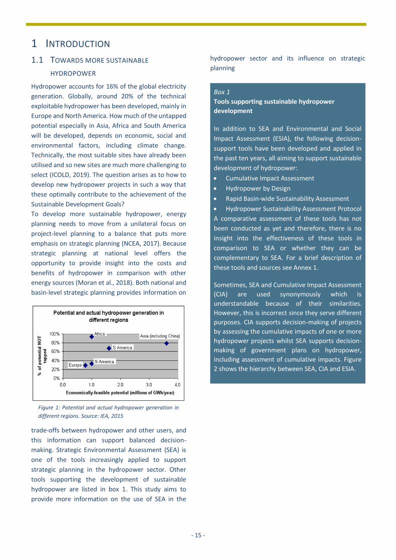
generation. Globally, around 20% of the technical
exploitable hydropower has been developed, mainly in
Europe and North America. How much of the untapped
potential especially in Asia, Africa and South America
will be developed, depends on economic, social and
environmental factors, including climate change.
Technically, the most suitable sites have already been
utilised and so new sites are much more challenging to
select (ICOLD, 2019). The question arises as to how to
develop new hydropower projects in such a way that
these optimally contribute to the achievement of the
Sustainable Development Goals?
To develop more sustainable hydropower, energy
planning needs to move from a unilateral focus on
project-level planning to a balance that puts more
emphasis on strategic planning (NCEA, 2017). Because
strategic planning at national level offers the
opportunity to provide insight into the costs and
benefits of hydropower in comparison with other
energy sources (Moran et al., 2018). Both national and
basin-level strategic planning provides information on
trade-offs between hydropower and other users, and
this information can support balanced decision-
making. Strategic Environmental Assessment (SEA) is
one of the tools increasingly applied to support
strategic planning in the hydropower sector. Other
tools supporting the development of sustainable
hydropower are listed in box 1. This study aims to
provide more information on the use of SEA in the
hydropower sector and its influence on strategic
planning
Box 1
Tools supporting sustainable hydropower
development
In addition to SEA and Environmental and Social
Impact Assessment (ESIA), the following decision-
support tools have been developed and applied in
the past ten years, all aiming to support sustainable
development of hydropower:
• Cumulative Impact Assessment
• Hydropower by Design
• Rapid Basin-wide Sustainability Assessment
• Hydropower Sustainability Assessment Protocol
A comparative assessment of these tools has not
been conducted as yet and therefore, there is no
insight into the effectiveness of these tools in
comparison to SEA or whether they can be
complementary to SEA. For a brief description of
these tools and sources see Annex 1.
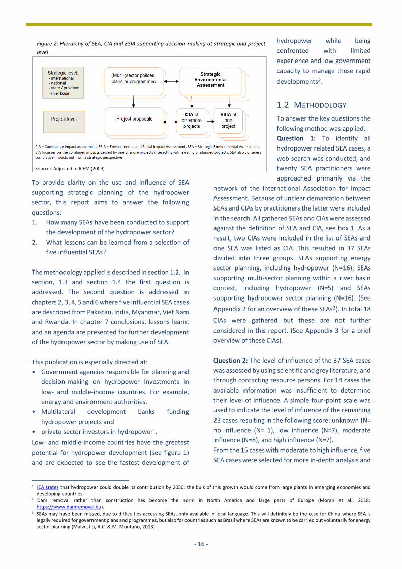
Sometimes, SEA and Cumulative Impact Assessment
(CIA) are used synonymously which is
understandable because of their similarities.
However, this is incorrect since they serve different
purposes. CIA supports decision-making of projects
by assessing the cumulative impacts of one or more
hydropower projects whilst SEA supports decision-
making of government plans on hydropower,
including assessment of cumulative impacts. Figure
2 shows the hierarchy between SEA, CIA and ESIA.
Figure 1: Potential and actual hydropower generation in
different regions. Source: IEA, 2015
- 16 -
To provide clarity on the use and influence of SEA
supporting strategic planning of the hydropower
sector, this report aims to answer the following
questions:
1. How many SEAs have been conducted to support
the development of the hydropower sector?
2. What lessons can be learned from a selection of
five influential SEAs?
The methodology applied is described in section 1.2. In
section, 1.3 and section 1.4 the first question is
addressed. The second question is addressed in
chapters 2, 3, 4, 5 and 6 where five influential SEA cases
are described from Pakistan, India, Myanmar, Viet Nam
and Rwanda. In chapter 7 conclusions, lessons learnt
and an agenda are presented for further development
of the hydropower sector by making use of SEA.
This publication is especially directed at:
• Government agencies responsible for planning and
decision-making on hydropower investments in
low- and middle-income countries. For example,
energy and environment authorities.
• Multilateral development banks funding
hydropower projects and
• private sector investors in hydropower1.
Low- and middle-income countries have the greatest
potential for hydropower development (see figure 1)
and are expected to see the fastest development of
1 IEA states that hydropower could double its contribution by 2050; the bulk of this growth would come from large plants in emerging economies and
developing countries. 2 Dam removal rather than construction has become the norm in North America and large parts of Europe (Moran et al., 2018;
https://www.damremoval.eu). 3 SEAs may have been missed, due to difficulties accessing SEAs, only available in local language. This will definitely be the case for China where SEA is
legally required for government plans and programmes, but also for countries such as Brazil where SEAs are known to be carried out voluntarily for energy sector planning (Malvestio, A.C. & M. Montaño, 2013).
hydropower while being
confronted with limited
experience and low government
capacity to manage these rapid
developments2.
1.2 METHODOLOGY
To answer the key questions the
following method was applied.
Question 1: To identify all
hydropower related SEA cases, a
web search was conducted, and
twenty SEA practitioners were
approached primarily via the
network of the International Association for Impact
Assessment. Because of unclear demarcation between
SEAs and CIAs by practitioners the latter were included
in the search. All gathered SEAs and CIAs were assessed
against the definition of SEA and CIA, see box 1. As a
result, two CIAs were included in the list of SEAs and
one SEA was listed as CIA. This resulted in 37 SEAs
divided into three groups. SEAs supporting energy
sector planning, including hydropower (N=16); SEAs
supporting multi-sector planning within a river basin
context, including hydropower (N=5) and SEAs
supporting hydropower sector planning (N=16). (See
Appendix 2 for an overview of these SEAs3). In total 18
CIAs were gathered but these are not further
considered in this report. (See Appendix 3 for a brief
overview of these CIAs).
Question 2: The level of influence of the 37 SEA cases
was assessed by using scientific and grey literature, and
through contacting resource persons. For 14 cases the
available information was insufficient to determine
their level of influence. A simple four-point scale was
used to indicate the level of influence of the remaining
23 cases resulting in the following score: unknown (N=
no influence (N= 1), low influence (N=7), moderate
influence (N=8), and high influence (N=7).
From the 15 cases with moderate to high influence, five
SEA cases were selected for more in-depth analysis and
Figure 2: Hierarchy of SEA, CIA and ESIA supporting decision-making at strategic and project
level
- 17 -
description (the number of cases being defined by
available budget). The following case selection criteria
were applied:
1. if possible, a minimum of one case per planning
situation, i.e. energy sector planning, including
hydropower, multi-sector planning and
hydropower sector planning;
2. if more than one case in a country, preference goes
to a high-influence case;
3. focus on low- and middle-income countries;
4. public availability of SEA study.
The following five cases were selected:
• Hydropower sector:
o SEA Pakistan
o SEA India
o SEA Myanmar
• Energy sector:
o SEA Viet Nam
• Multi-sector:
o SEA Rwanda
The authors of the SEA case studies were closely
involved with the SEAs in various roles: lead
government expert (Pakistan, Rwanda), advisor to the
government (Viet Nam), lead researcher (India), and
leading expert of the funding agency (Myanmar).
1.3 CHARACTERISTICS OF SEA
What is SEA?
Strategic Environmental Assessment (SEA) can be
defined as a range of “analytical and participatory
approaches that aim to integrate environmental
considerations into policies, plans, and programmes
and evaluate the interlinkages with economic and
social considerations” (OECD, 2006). It is a tool to:
• structure public and government debate in the
preparation of policies, plans and programmes
(PPPs);
• feed this debate through a robust assessment of the
environmental and, where needed, social and
economic consequences;
• ensure that the results of assessment and debate
are considered during decision-making and
implementation.
The purpose of SEA, broadly stated, is to ensure that
environmental and social considerations are integrated
into strategic decision-making in support of
environmentally and socially sound and sustainable
development (UNECE, 2012).
The applicability of SEA is wide. It aims at better
strategies, ranging from legislation and country-wide
development policies, to more specific sectoral and
spatial plans.
In 2019, 106 countries legally established SEA and this
number is expected to increase considerably in the
next decade. In countries where no legal basis exists,
SEA is applied as a voluntary tool and process.
The potential of SEA to support strategic planning of
hydropower is acknowledged by a large number of
institutions such as the United Nations, International
Finance Institutions such as the World Bank,
International Finance Corporation, the Asian
Development Bank, Inter-American Development
Bank, the European Investment Bank and the European
Bank for Reconstruction and Development, the
Mekong River Commission and international NGOs
such as The Nature Conservancy, World Wildlife Fund,
and, International Union for Conservation of Nature.
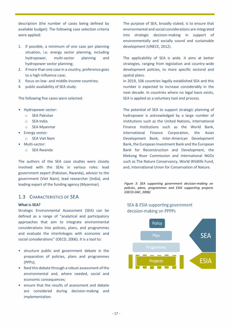
Figure 3: SEA supporting government decision-making on policies, plans, programmes and ESIA supporting projects (OECD-DAC, 2006)

- 18 -
What are the advantages of SEA?
According to the literature SEA has the following
advantages4 :
• better insight into the trade-offs between
environmental, economic and social issues,
enhancing the chance of finding a win-win
situation;
• warns decision-makers and the public about
unsustainable development options, which helps
prevent costly and unnecessary mistakes, as well as
conflicts around natural resource use;
• a better understanding of the cumulative impacts of
multiple smaller developments, and the
opportunity to improve the coherence between
projects;
• enhanced credibility of government decisions,
leading to more public trust in the planning process
and more support for plan implementation;
• easier ESIA at the project level, because strategic
decisions, for example for locations, have already
been addressed in the SEA process;
• SEA can provide an important arena for regional
cooperation between countries to address difficult
issues concerning, for example, shared protected
areas, waterways, transport connections and
transboundary pollution.
What does an SEA process look like?
The SEA process can be divided into phases consisting
of various steps to be taken. However, an SEA should
always be tailored to the specific planning process that
it is supporting. That means it needs to be applied in a
flexible manner. In box 2 a ‘good practice’ sequence of
steps is shown and should be adapted to specific
country context, and to the dynamics of the respective
policy, programme or plan.
Box 2:
Good practice SEA steps according to the
OECD-DAC (2006)
Phase A: Establishing the context for SEA
• Screening: decide on the need and role of SEA.
• Identify the stakeholders and plan their involvement.
• Develop, with the stakeholders, a shared vision on the key (environmental) problems, objectives and
alternatives for the policy or plan.
Phase B: Implementing SEA
• Scope the content for the SEA, including a look at synergies or conflict with existing policy objectives.
• Collect baseline data.
• Assess alternatives.
• Identify how to use opportunities/mitigate impacts.
• Assure quality through independent review and public involvement of draft reports.
• Document results and make these available.
Phase C: Informing and influencing decision-making
• Organise dialogue among stakeholders on SEA results and make recommendations for decision-making.
• Justify the (political) choices that have been made in the finally adopted policy or plan.
Phase D: Monitoring and evaluation
• Monitor the implementation of the adopted policy or plan and alignment with the SEA.
• Evaluate the alignment of the SEA with the outcomes of the policy or plan.
4 OECD-DAC (2006): Applying Strategic Environmental Assessment. Good Practice Guidance for Development Co-operation. UNECE (2012): Resource Manual to Support Application of the Protocol on Strategic Environmental Assessment
- 19 -
Energy sector, including the hydropower
Hydropower sector Multiple-sectors, incl. the
hydropower
• International • National • State/ provincial
• International river basin • National • State/ provincial • River (sub-)basin
• International river basin • National river basins
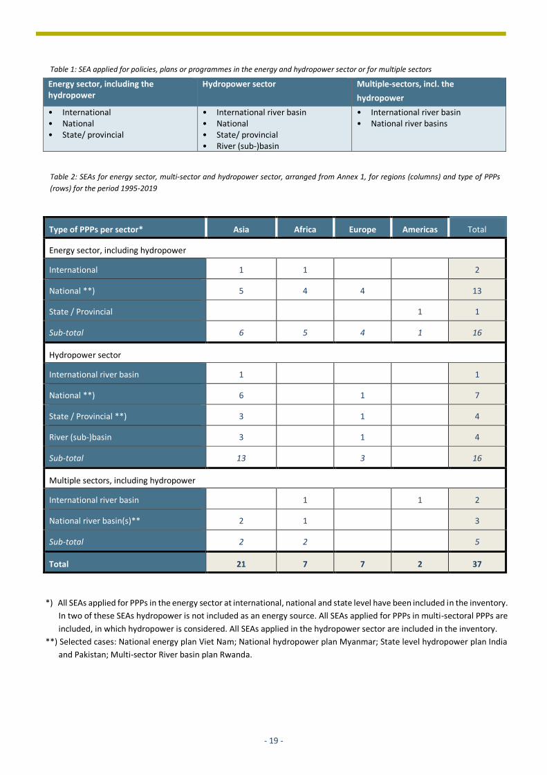
Type of PPPs per sector* Asia Africa Europe Americas Total
Energy sector, including hydropower
International 1 1 2
National **) 5 4 4 13
State / Provincial 1 1
Sub-total 6 5 4 1 16
Hydropower sector
International river basin 1 1
National **) 6 1 7
State / Provincial **) 3 1 4
River (sub-)basin 3 1 4
Sub-total 13 3 16
Multiple sectors, including hydropower
International river basin 1 1 2
National river basin(s)** 2 1 3
Sub-total 2 2 5
Total 21 7 7 2 37
Table 2: SEAs for energy sector, multi-sector and hydropower sector, arranged from Annex 1, for regions (columns) and type of PPPs
(rows) for the period 1995-2019
Table 1: SEA applied for policies, plans or programmes in the energy and hydropower sector or for multiple sectors
*) All SEAs applied for PPPs in the energy sector at international, national and state level have been included in the inventory.
In two of these SEAs hydropower is not included as an energy source. All SEAs applied for PPPs in multi-sectoral PPPs are
included, in which hydropower is considered. All SEAs applied in the hydropower sector are included in the inventory.
**) Selected cases: National energy plan Viet Nam; National hydropower plan Myanmar; State level hydropower plan India
and Pakistan; Multi-sector River basin plan Rwanda.
- 20 -
SEAs supporting strategic planning of hydropower
development
To better understand the wide application of SEAs, one
must look at the variety of PPPs dealing with
hydropower development. Table 1 shows that SEAs are
supporting energy sector PPPs at international,
national and state/ provincial level. An issue typically
considered in an SEA for the energy sector is the
development of alternative fuel mixes with more or
less hydropower, to develop and secure future energy
generation. SEAs are also directly supporting
hydropower sector PPPs at different levels:
international river basin, national, state/provincial,
river (sub-)basin. These SEAs typically support decision-
making by categorising areas that are more or less
suitable for the development of hydropower projects.
SEAs applied for the third group of PPPs, dealing with
multiple sectors in international or national river
basins, support balanced decision-making between all
stakeholders with different interests such as
hydropower, irrigation and nature conservation.
1.4 INVENTORY OF SEAS
The results of a global inventory of SEAs implemented,
supporting the development of hydropower is
presented in table 2. In total 34 SEAs have been
conducted in the period 1995 – 2020.
A closer look at the cases in table 2 leads to the
following conclusions:
Sectors
• Limited number of SEAs for energy sector. In total
16 cases have been conducted of which 2 are
dealing with international power planning and 13
are applied for national planning in which
hydropower is part of the national fuel mix.
• SEA for hydropower on the rise. There is a
significant increase in the application of SEA for
hydropower over the years: one case from the
1990s, 4 cases from the first decade of this century
and 11 from the second decade.
• Few SEAs for river basin planning, including
hydropower. In total 5 cases were carried out for
river basin planning. In these cases, hydropower
was assessed jointly with other water-dependent
sectors within a river basin.
Type of PPPs
• International co-operation. In 4 cases SEA has
supported coordination of planning and decision-
making between two or more countries.
• Majority of SEAs support national plans. The
majority of cases, in total 20, support national
plans, 5 cases support plans at sub-national
(state/provincial) level and 5 cases support
development of basin plans at national level.
Geographic distribution
• Asia in the lead. Most SEAs, 21 in total, have been
carried out in Asia, predominantly in South Asia and
Southeast Asia, followed by Europe and Africa.
In the next chapters the five cases are described.
References
• OECD-DAC, 2006. Applying Strategic Environmental
Assessment. Good Practice Guidance for
Development Co-operation.
• United Nations Economic Commission for Europe,
2012. Simplified Resource Manual to Support
Application of the Protocol on Strategic
Environmental Assessment. United Nations, New York
and Geneva.
• ICEM, 2009. Presentations at the National
Consultations for SEA of Mekong Mainstream Dams
for Mekong River Commission. Vientiane.
• International Commission on Large Dams, 2019.
World Declaration on Dam Safety. Approved on
October 18th 2019, in Porto.
• International Energy Agency, 2015. Key world energy
statistics.
• Moran, E.F., M.C. Lopez, N. Moore, N. Müller, and
D.W. Hyndman, 2018. Sustainable hydropower in the
21st century.
• Malvestio, A.C. & M. Montaño, 2013. Effectiveness of
Strategic Environmental Assessment Applied to
Renewable Energy in Brazil. Journal of Environmental
Assessment Policy and Management 2, Special Issue
on Environmental Assessment in the Context of
Renewable Energy Deployment, Pp. 1-21
• Mekong River Commission, 2015. Initiative on
Sustainable Hydropower. Guidelines for the
evaluation of hydropower and multi-purpose project
portfolios.
• NCEA, 2017. Better Decision-Making about Large Dams
with a View to Sustainable Development. Second Edition.

- 21 -
Ranganadi Dam
Arunachal Pradesh
India

- 22 -
2 SEA FOR HYDROPOWER DEVELOPMENT IN AZAD JAMMU KASHMIR STATE
PAKISTAN
David Annandale
2.1 INTRODUCTION
The Strategic Environmental Assessment (SEA)
examined the cumulative impacts of approximately 60
hydropower projects proposed for Azad Jammu and
Kashmir state (AJK), which is a nominally self-governing
jurisdiction administered by Pakistan. The study
developed a detailed methodology for cumulative
assessment and resulted in conclusions and
recommendations related to the ecological and social
sensitivity of river segments, and institutional reforms
that could improve the way hydropower projects are
planned.
2.2 BACKGROUND: CONTEXT AND ISSUES
The SEA was undertaken in 2014, as part of the
National Impact Assessment Programme. The study
was financially supported by the Embassy of the
Netherlands, with technical support from the
Netherlands Commission for Environmental
Assessment, and with administrative management
provided by IUCN Pakistan. Field work and analysis was
undertaken jointly with a Pakistan consulting company
known as Hagler Bailly. Given Pakistan’s relative
infancy with respect to the implementation of SEA, this
exercise was considered to be an important pilot
project.
At that time, Pakistan was facing an acute shortage of
electric power. Power outages were a common
occurrence, and public frustration had resulted in the
issue becoming an important tipping point in the
national election of 2013. With nearly 9.000 MW of
available capacity, the hydropower sector in AJK was a
natural focus of interest for federal energy planners.
Figure 1 shows the geographical position of AJK.
Authorities Azad Jammu Kashmir (AJK) State – Planning and development department
Type of plan Hydropower development plan AJK State
Scope of SEA All HPPs in AJK State
Key SEA issues Ranking of 62 HPPs (~9,000 MW) in different stages of development, based on cumulative assessment of ecological and socio-economic impacts
Stakeholder engagement Consultation with private actors in the hydropower sector and relevant AJK authorities
Duration and year 12 months; 2014
Influence of SEA
• Set up of hydropower coordination committee preparing a coordinated AJK hydropower development plan
• Proposed Gulpur reservoir project (100 MW) located in most sensitive sub-basin was changed into a run of the river project and a National Park was established
Link to SEA report https://www.commissiemer.nl/docs/mer/diversen/pos722-sea-hydropower-development.pdf
Figure 1: Provincial map of Pakistan

- 23 -
No overall hydropower development plan existed in
AJK, although four separate proponent agencies had
plans for developing a total of around 60 projects.
Depending on their size and siting, these projects may
not necessarily result in significant adverse
environmental or social impacts when they are
assessed individually. However, when looked at as a
whole, their cumulative impact could be significant.
Before embarking on wholesale development of these
projects, an assessment was required to enable
decision-makers to fully understand the implications of
such a large-scale development plan.
Through the SEA Task Force established by the National
Impact Assessment Programme, the Government of
AJK volunteered its de facto hydropower plan as a
focus for a pilot SEA study. Because it was not exactly
clear where each of the proposed hydropower projects
(HPPs) would be sited, and nor were the specifics of
their designs well-defined, this SEA pilot focused on the
overall cumulative impacts that may result from
implementation of the hydropower plan as a whole.
The objectives of the SEA of the hydropower plan were
to:
• Develop an understanding of the state of
hydropower planning in AJK;
• Assess the potential environmental and social
risks associated with the hydropower plan;
• Assess the potential environmental and social
benefits associated with the hydropower plan;
• If necessary, suggest alternative plan options that
better optimise economic, environmental, and
social outcomes; and,
• Assess the institutional and policy constraints to
mainstreaming environmental and social
considerations into AJK hydropower planning and
development and provide recommendations on
how these constrains might be addressed.
2.3 APPROACH AND METHODS USED
Figure 2 outlines the methodological approach taken in
this study. It consisted of eight steps. These were
designed to match the “basic stages” of SEA presented
in the OECD DAC SEA Guidance document1.
1 OECD 2006, Applying Strategic Environmental Assessment: Good Practice Guidance for Development Cooperation
In step 1, the proponent agencies were identified as
the Water and Power Development Authority
(WAPDA), the Hydroelectric Board (HEB), the Private
Power Infrastructure Board (PPB), and the Private
Power Cell (PPC). Each proponent had its own project
development plans. These made it possible to map
proposed HPPs and set objectives for the SEA. This step
also undertook a process to identify relevant
stakeholders.
Step 2 outlined the structural design features of a
selection of proposed HPPs of differing generation
capacity. With this background material it was possible,
in step 3, to define the generic drivers of potential
environmental and social impacts. Categorising HPPs
into different types based on the drivers of impacts
helped to identify the key issues that became the focus
of the study and the recommendations that resulted
from it.
Step 4 began to make the link between drivers and
actual potential impacts by outlining the expected
effects from HPPs of different generation capacities.
Step 5 was time-intensive and focused on
environmental and social “baseline” conditions on
specific stretches of rivers and streams that will likely
see HPP development taking place. Based on ecological
contiguity, the rivers and streams of AJK were divided
into nine zones. The ecological sensitivity of each river
zone was assessed and discussed followed by a
determination of the sensitivity of river sections to the
development of HPPs. A similar analysis of socio-
economic conditions was undertaken. The socio-
economic sensitivity of river/stream segments was
determined and rated as Least, Moderate or Highly
sensitive to HPP development.
Knowing the sites of possible HPPs, the drivers of
potential impacts, and the environmental and social
baseline conditions, it was possible in step 6 to
delineate “cumulative impact zones”. Based on the
possible extent and severity of cumulative impacts,
these zones were categorised into Moderately Critical,
Highly Critical, or Extremely Critical.

- 24 -
In step 7, the Cumulative Impact Zones identified
earlier were superimposed on the ecologically and
socioeconomically sensitive segments of rivers and
streams. This allowed the HPPs listed in the
hydropower development plan to be ranked according
to their overall cumulative impact potential.
Finally, step 8 consisted of communicating the SEA
outcomes to decision-makers, in an attempt to
influence decision-making.
2.4 RESULTS AND LESSONS LEARNT
Cumulative impacts in ecologically and socio-
economically sensitive zones
Superimposing the Cumulative Impact Zones onto the
ecologically and socio-economically sensitive segments
of rivers and streams helped to rank the HPPs based on
their cumulative impact potential. Figure 3 and Figure
4 present maps of the HPPs proposed by the four AJK
proponent agencies, and their ranking based on their
ecological and social impact.
Figure 2: SEA study methodology

- 25 -
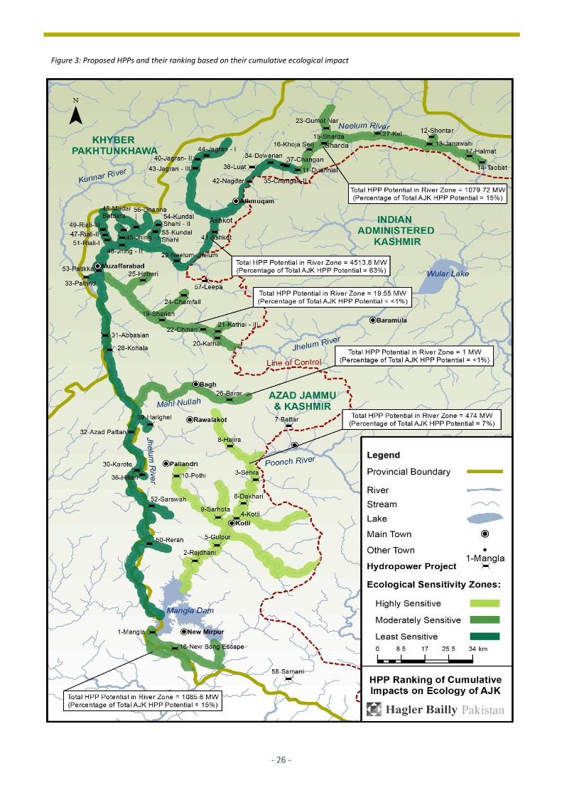
Outcomes of the HPP ranking
A clear outcome from the cumulative impact
assessment was that the area of most concern, both
from ecological and socio-economic perspectives, is
the Poonch River and its feed-in streams from the Line
of Control down to the Mangla Dam. The nine
proposed HPPs (in total 474 MW) all rank highest for
potential ecological and social impact. If government
resources are limited, it was recommended that the
main focus of environmental assessment should be the
nine proposed HPPs in the “Poonch segment”.
Need for detailed studies
River segments with threatened fish species found
nowhere else should be classified as critical natural
habitats and, ideally, would receive high level
protection from dams or other potentially damaging
civil works. The Poonch River, for example, is located in
an environmentally sensitive area. It is home to an
endangered fish species Mahseer (Tor putitora) and is
a declared national park.
It was suggested that further detailed studies should
consider hydrological data at a level of resolution that
is relevant to ecological communities and should
consider any subsistence use of the river. In the
process, thresholds should be identified beyond which
cumulative change will be considered a concern. These
should be expressed in terms of goals or targets,
standards and guidelines, carrying capacity, or limits of
acceptable change. One of the most important
thresholds to determine will be the environmental
flows required downstream of each diversion
structure.
Keeping in view the high ecologically sensitivity of the
Poonch River and its tributaries, it was recommended
that all hydropower projects planned for that river
should use holistic approaches for determination of
downstream environmental flow.
Maximising synergistic project development
Where more than one project is being built in close
proximity of the same tributary or river section,
developers have the opportunity to coordinate with
each other and to redesign projects based on a
synergistic approach. This can help maximise positive
impacts and mitigate adverse environmental impacts.
For example, if there are a number of projects being
planned on the same tributary, the one highest
upstream could have a storage wall designed that
would regulate flow for all of them, thereby preventing
the need for each downstream project to individually
store water. This may also help ensure environmental
flows downstream, especially during the dry season.
Another relevant example relates to transmission lines
from the powerhouse to the local grid. These lines can
have a significant impact on project costs. A remote
site may require considerable investment in
transmission infrastructure to connect the project to
the local grid. However, with strategic planning, this
cost can be shared over more than one project if
several HPPs are developed in close proximity. Similar
efficiencies could be obtained with access points,
construction sites and work camps.
Coordinated mitigation measures can be incorporated
into the design and operation plans to mitigate
expected cumulative impacts at the watershed level. It
was therefore recommended that, where there are
HPPs in close proximity to each other, either on a main
river, or on tributary streams, proponents should be
required to consult about project design to enable
synergistic development. Such consultation should be
required even if project initiation schedules are not
synchronised.
- 26 -
Figure 3: Proposed HPPs and their ranking based on their cumulative ecological impact

- 27 -
Figure 4: Proposed HPPs and their ranking based on their cumulative socio-economic impact
- 28 -
Institutional coordination and revising the
hydropower plan
What the maps do not show is that the development of
specific HPPs is not coordinated across the different
agencies whose projects make up the overall
hydropower plan. For example, it is not possible to
easily revise the whole hydropower plan to minimise
negative impacts, because different agencies may be
responsible for different HPPs, even on the same
stretch of river or stream.
In order to maximise benefits and minimise adverse
cumulative environmental and social impacts from the
development of HPPs, both the AJK and federal
agencies should use the maps and associated ranking
tables to coordinate the development of different
projects. The current hydropower plan for AJK is in a de
facto state. It consists only as a collection of project
proposals developed by the four proponent agencies,
WAPDA, HEB, PPIB, and PPC.
By screening projects and their locations, these
agencies should ideally propose a timetable for the
development of new projects based on environmental
and social considerations. If required, policies and
legislation may need to be introduced and/or amended
to ensure that following the timetable becomes a
mandatory requirement.
Moreover, coordination between the different
regulatory agencies also provides an opportunity for
identifying joint capacity building goals and objectives
for managing the cumulative impacts of the
hydropower plan. It was recommended that a
comprehensive hydropower plan or basin
development plan needs to be developed and “owned”
by all four agencies. It should allow for the timed,
synergistic development of individual projects.
Guidelines for IEEs and EIAs
At the time, environmental assessment regulations
specified that only HPPs over 50 MW required the
production of full environmental impact assessments
(EIAs). Those with generation capacities less than 50
MW required only initial environmental examinations
(IEEs). According to the regulations, projects over
50MW “are generally major projects and have the
potential to affect many people. They also include
projects in environmentally sensitive areas. The impact
of such projects may be irreversible and could lead to
significant changes in land use and in the social,
physical and biological environment”. Projects less
than 50MW “include those where the range of
environmental issues is comparatively narrow, and the
issues can be understood and managed through less
extensive analysis. These are projects not generally
located in environmentally sensitive areas or smaller
proposals in sensitive areas”.
An examination of HPP rankings based on their critical
cumulative impacts on ecologically and
socioeconomically sensitive zones showed that the
majority of the top 20 HPPs in both ranking tables are
less than 50 MW in size. This suggests that using the 50
MW generation capacity figure as the main
determinant of environmental assessment standard is
misguided. HPPs with capacities less than 50 MW but
located in ecologically and socioeconomically sensitive
zones do not necessarily exhibit a narrow range of
environmental issues, and nor can the potential
individual and cumulative impacts of these projects be
understood and managed by the limited scope of
analysis of IEEs.
In the SEA it was argued that the 50 MW benchmark
should not be the main screening criterion used to
determine required level of environmental
assessment. It was recommended that AJK
Environmental Protection Agency (EPA) should use
Figure 3 and Figure 4, along with associated ranking
tables, to determine whether a HPP should require an
IEE or EIA. It was also recommended that AJK EPA
should develop “zone specific” guidelines for IEE and
EIA studies that are not tied to installed capacities of
HPPs. This could be of significant benefit to
proponents. In addition, Terms of Reference for full EIA
studies associated with relevant HPPs should include
cumulative assessment requirements.
Provision of information
The SEA stated that due to limited government funding
and resources, AJK EPA could examine the possibility of
sharing some of its monitoring responsibilities with the
people most likely to be affected by the HPPs. Local
representatives could be made a permanent part of the
monitoring body of the AJK EPA.
Activities could be planned with nearby schools and
universities to monitor the HPPs during the
construction and operation phases. One example of a
monitoring activity is the periodic review of
environmental flows downstream of diversion
structures. It was also suggested that Figure 3 and
Figure 4, along with other maps contained in the final

- 29 -
report, could be digitalised and hyperlinked, so that
interested proponents and members of the public
could click on the name of a HPP, or a general location,
and obtain information about the sensitivity of the area
and required guidelines.
2.5 MEASURING THE INFLUENCE OF THE SEA
The influence of an SEA can be measures in terms of its
outputs, outcomes, and impact. Outputs are usually
understood to be the SEA report itself, and the process
used to produce it. In this case, the SEA applied the
internationally accepted OECD SEA good practice
guidance and extended it by developing a detailed
approach to cumulative assessment. It applied a
rigorous methodology to the assessment of the
cumulative impacts emanating from 62 proposed
projects. It took project development plans from four
different government agencies and mapped all
proposed short-and-medium term proposals for the
first time. The output of this work was a set of easy-to-
interpret maps that enables decision-makers to
understand the relative ecological and socio-economic
sensitivity of different river and tributary stretches.
The outcomes of an SEA process lie in the way it
influences decision-making. The SEA study resulted in
a number of important outcomes. First, it is worth
noting that the maps produced during the study were
of significant value. The two main maps that
superimposed cumulative impact zones onto
environmentally and social sensitive river/stream
segments were used as the focus for discussions with
public officials in AJK, who often do not have enough
time to read long, technical reports. At consultation
meetings with government officials, the maps
engendered spirited engagement that clearly led to
real organisation learning. Second, the original plan for
the SEA allowed for a limited programme of public
participation. However, due to the delicate security
situation in AJK, it was not possible to undertake
anything like a comprehensive consultation
programme. Instead, the consulting team produced a
detailed “stakeholder mapping” exercise which at least
pointed to the interests and values held by different
groups.
Finally, the impact of an SEA process can be measured
by examining its direct implications, in terms of
improved overall planning and capacity. Possibly the
most significant impact was the formation of an AJK
Hydropower Coordination Committee, which brought
the four different HPP proponents together for the first
time and led to the development of a coordinated
hydropower plan. For the first time, it is now possible
for government officials to think holistically about the
planning of specific projects across river basins in the
State. Zones that are most sensitive may require a
great focus from proponents during EIA study. In
addition, regulators may now be able to encourage
proponents to plan their projects in a synergistic
fashion.
References
• Annandale, David D. and Hagler Bailly Pakistan (Pvt)
Ltd. 2014. Strategic Environmental Assessment of
Hydropower Development in Azad Jammu and
Kashmir. Islamabad: IUCN Pakistan. 154 pp.
• Annandale, David D. and Hagler Bailly Pakistan (Pvt)
Ltd. 2014. Strategic Environmental Assessment for
Hydropower Sector Planning – Guidance Material.
Islamabad: IUCN Pakistan. 34 pp.
• OECD-DAC, 2006. Applying Strategic Environmental
Assessment. Good Practice Guidance for
Development Co-operation.
• United Nations Economic Commission for Europe,
2012. Simplified Resource Manual to Support
Application of the Protocol on Strategic
Environmental Assessment. United Nations, New York
and Geneva.
About the author
David Annandale (PhD) is an international
environmental and social safeguards consultant,
working with multi-lateral development agencies such
as the World Bank, Asian Development Bank, FAO,
IFAD, UN Women, Green Climate Fund, Global
Environment Facility, UNDP, UNEP, UNIDO, UNOPS,
and UNICEF. He specialises in the design of
environmental and social management frameworks,
and undertakes EIA and SEA work in developing
countries in Africa and Asia. Much of his SEA work has
focused on the impacts of multiple hydropower
projects. For 13 years he was an academic at Murdoch
University in Perth, Australia, teaching EIA and
environmental policy to undergraduate and
postgraduate students. He has over 25 refereed journal
articles, and is based in Edinburgh.

- 30 -
Ranganadi Dam
Arunachal Pradesh
India
- 31 -
3 SEA FOR HYDROPOWER DEVELOPMENT PLANNING IN ALAKNANDA AND
BHAGIRATHI BASINS, UTTARAKHAND STATE
INDIA
Asha Rajvanshi
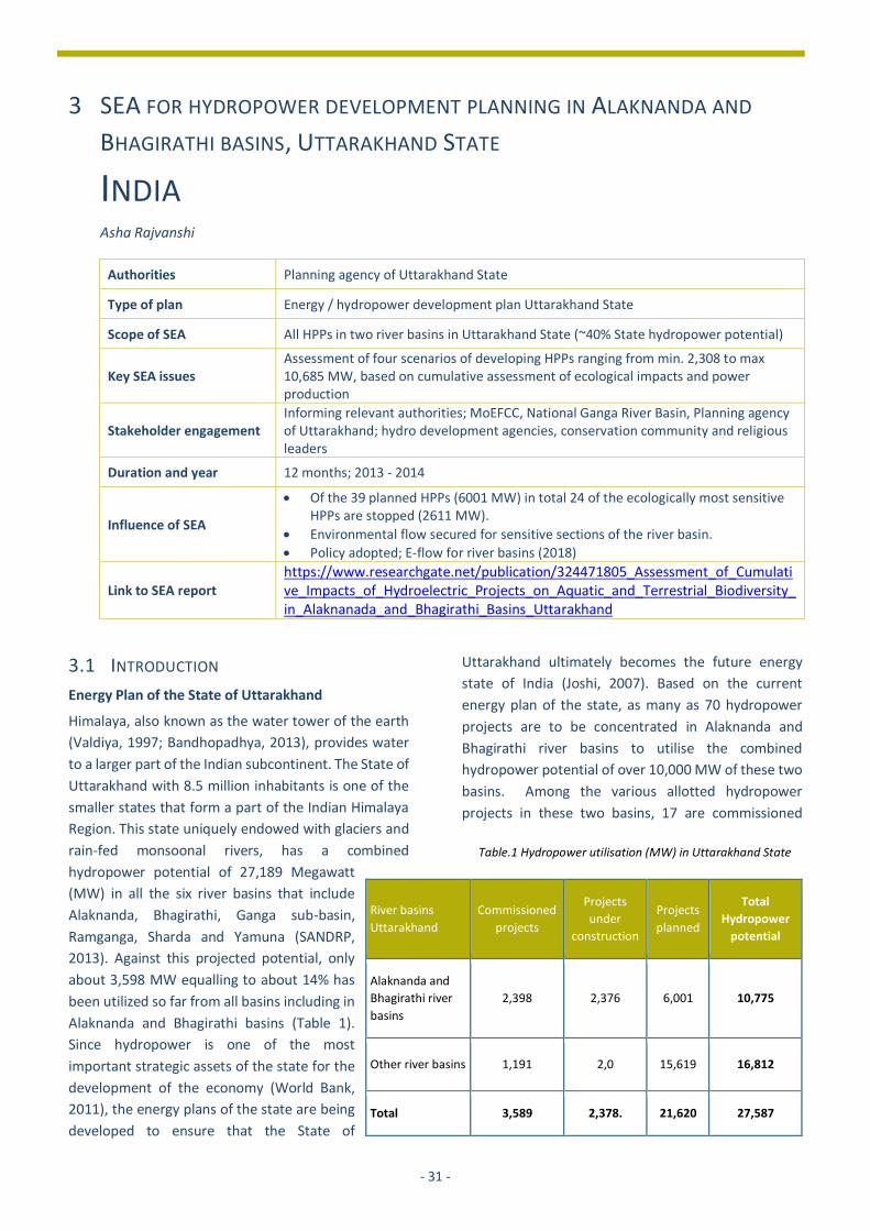
Authorities Planning agency of Uttarakhand State
Type of plan Energy / hydropower development plan Uttarakhand State
Scope of SEA All HPPs in two river basins in Uttarakhand State (~40% State hydropower potential)
Key SEA issues Assessment of four scenarios of developing HPPs ranging from min. 2,308 to max 10,685 MW, based on cumulative assessment of ecological impacts and power production
Stakeholder engagement Informing relevant authorities; MoEFCC, National Ganga River Basin, Planning agency of Uttarakhand; hydro development agencies, conservation community and religious leaders
Duration and year 12 months; 2013 - 2014
Influence of SEA
• Of the 39 planned HPPs (6001 MW) in total 24 of the ecologically most sensitive HPPs are stopped (2611 MW).
• Environmental flow secured for sensitive sections of the river basin.
• Policy adopted; E-flow for river basins (2018)
Link to SEA report
https://www.researchgate.net/publication/324471805_Assessment_of_Cumulative_Impacts_of_Hydroelectric_Projects_on_Aquatic_and_Terrestrial_Biodiversity_in_Alaknanada_and_Bhagirathi_Basins_Uttarakhand
3.1 INTRODUCTION
Energy Plan of the State of Uttarakhand
Himalaya, also known as the water tower of the earth
(Valdiya, 1997; Bandhopadhya, 2013), provides water
to a larger part of the Indian subcontinent. The State of
Uttarakhand with 8.5 million inhabitants is one of the
smaller states that form a part of the Indian Himalaya
Region. This state uniquely endowed with glaciers and
rain-fed monsoonal rivers, has a combined
hydropower potential of 27,189 Megawatt
(MW) in all the six river basins that include
Alaknanda, Bhagirathi, Ganga sub-basin,
Ramganga, Sharda and Yamuna (SANDRP,
2013). Against this projected potential, only
about 3,598 MW equalling to about 14% has
been utilized so far from all basins including in
Alaknanda and Bhagirathi basins (Table 1).
Since hydropower is one of the most
important strategic assets of the state for the
development of the economy (World Bank,
2011), the energy plans of the state are being
developed to ensure that the State of
Uttarakhand ultimately becomes the future energy
state of India (Joshi, 2007). Based on the current
energy plan of the state, as many as 70 hydropower
projects are to be concentrated in Alaknanda and
Bhagirathi river basins to utilise the combined
hydropower potential of over 10,000 MW of these two
basins. Among the various allotted hydropower
projects in these two basins, 17 are commissioned
River basins
Uttarakhand
Commissioned
projects
Projects
under
construction
Projects
planned
Total
Hydropower
potential
Alaknanda and
Bhagirathi river
basins
2,398 2,376 6,001 10,775
Other river basins 1,191 2,0 15,619 16,812
Total 3,589 2,378. 21,620 27,587
Table.1 Hydropower utilisation (MW) in Uttarakhand State
- 32 -
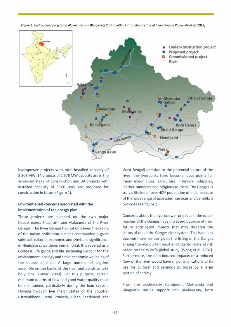
hydropower projects with total installed capacity of
2,308 MW; 14 projects of 2,376 MW capacity are in the
advanced stage of construction and 39 projects with
installed capacity of 6,001 MW are proposed for
construction in future (Figure 1).
Environmental concerns associated with the
implementation of the energy plan
These projects are planned on the two major
headstreams, Bhagirathi and Alaknanda of the River
Ganges. The River Ganges has not only been the cradle
of the Indian civilisation but has commanded a great
spiritual, cultural, economic and symbolic significance
in Hinduism since times immemorial. It is revered as a
Goddess, life giving and life sustaining succour for the
environment, ecology and socio-economic wellbeing of
the people of India. A large number of pilgrims
assemble on the banks of the river and ponds to take
holy dips (Kumar, 2009). For this purpose, certain
minimum depths of flow and good water quality must
be maintained, particularly during the lean season.
Flowing through five major states of the country,
(Uttarakhand, Uttar Pradesh, Bihar, Jharkhand and
West Bengal) and due to the perennial nature of the
river, the riverbanks have become locus points for
many major cities, agriculture, intensive industries,
leather tanneries and religious tourism. The Ganges is
truly a lifeline of over 40% population of India because
of the wide range of ecosystem services and benefits it
provides see figure 2.
Concerns about the hydropower projects in the upper
reaches of the Ganges have increased because of their
future anticipated impacts that may threaten the
status of the entire Ganges river system. This issue has
become more serious given the listing of the Ganges
among the world’s ten most endangered rivers at risk
based on the WWF’S global study (Wong et al. 2007).
Furthermore, the dam-induced impacts of a reduced
flow of the river would have major implications of its
use for cultural and religious purposes by a large
section of society.
From the biodiversity standpoint, Alaknanda and
Bhagirathi Basins support rich biodiversity, both
Figure 1. Hydropower projects in Alaknanda and Bhagirathi Basins within Uttarakhand state of India (Source Rajvanshi et al, 2012)
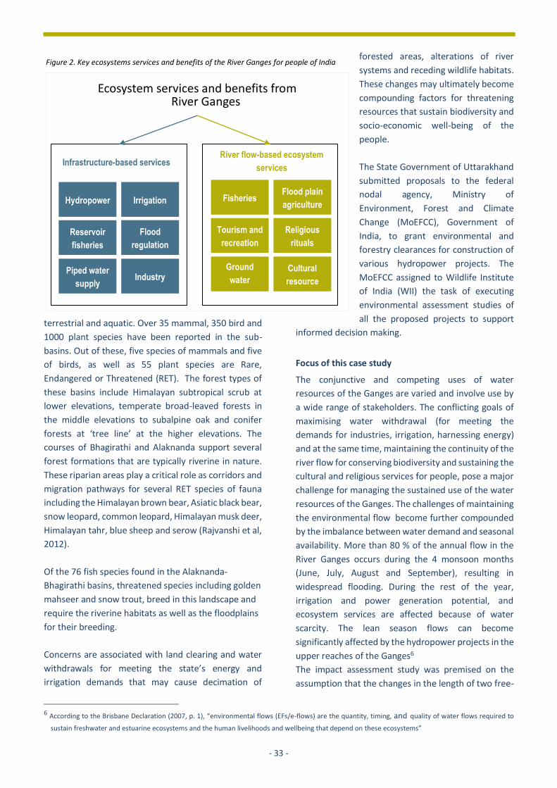
- 33 -
terrestrial and aquatic. Over 35 mammal, 350 bird and
1000 plant species have been reported in the sub-
basins. Out of these, five species of mammals and five
of birds, as well as 55 plant species are Rare,
Endangered or Threatened (RET). The forest types of
these basins include Himalayan subtropical scrub at
lower elevations, temperate broad-leaved forests in
the middle elevations to subalpine oak and conifer
forests at ‘tree line’ at the higher elevations. The
courses of Bhagirathi and Alaknanda support several
forest formations that are typically riverine in nature.
These riparian areas play a critical role as corridors and
migration pathways for several RET species of fauna
including the Himalayan brown bear, Asiatic black bear,
snow leopard, common leopard, Himalayan musk deer,
Himalayan tahr, blue sheep and serow (Rajvanshi et al,
2012).
Of the 76 fish species found in the Alaknanda-
Bhagirathi basins, threatened species including golden
mahseer and snow trout, breed in this landscape and
require the riverine habitats as well as the floodplains
for their breeding.
Concerns are associated with land clearing and water
withdrawals for meeting the state’s energy and
irrigation demands that may cause decimation of
6 According to the Brisbane Declaration (2007, p. 1), “environmental flows (EFs/e-flows) are the quantity, timing, and quality of water flows required to
sustain freshwater and estuarine ecosystems and the human livelihoods and wellbeing that depend on these ecosystems”
forested areas, alterations of river
systems and receding wildlife habitats.
These changes may ultimately become
compounding factors for threatening
resources that sustain biodiversity and
socio-economic well-being of the
people.
The State Government of Uttarakhand
submitted proposals to the federal
nodal agency, Ministry of
Environment, Forest and Climate
Change (MoEFCC), Government of
India, to grant environmental and
forestry clearances for construction of
various hydropower projects. The
MoEFCC assigned to Wildlife Institute
of India (WII) the task of executing
environmental assessment studies of
all the proposed projects to support
informed decision making.
Focus of this case study
The conjunctive and competing uses of water
resources of the Ganges are varied and involve use by
a wide range of stakeholders. The conflicting goals of
maximising water withdrawal (for meeting the
demands for industries, irrigation, harnessing energy)
and at the same time, maintaining the continuity of the
river flow for conserving biodiversity and sustaining the
cultural and religious services for people, pose a major
challenge for managing the sustained use of the water
resources of the Ganges. The challenges of maintaining
the environmental flow become further compounded
by the imbalance between water demand and seasonal
availability. More than 80 % of the annual flow in the
River Ganges occurs during the 4 monsoon months
(June, July, August and September), resulting in
widespread flooding. During the rest of the year,
irrigation and power generation potential, and
ecosystem services are affected because of water
scarcity. The lean season flows can become
significantly affected by the hydropower projects in the
upper reaches of the Ganges6
The impact assessment study was premised on the
assumption that the changes in the length of two free-
Ecosystem services and benefits from River Ganges
Hydropower
Reservoir
fisheries
Piped water
supply
Irrigation
Flood
regulation
Industry
Fisheries
Tourism and
recreation
Ground
water
recharge
Flood plain
agriculture
Religious
rituals
Cultural
resource
Infrastructure-based services River flow-based ecosystem
services
Figure 2. Key ecosystems services and benefits of the River Ganges for people of India

- 34 -
flowing headstreams of the Ganges and the direct loss
of terrestrial habitats would be the key factors leading
to the aggregated impacts of multiple dams planned on
Alaknanda and Bhagirathi rivers. These direct impacts
may result in compounding effects on a range of
receptors including- aquatic and terrestrial species and
on the flow of ecosystem benefits for the range of
stakeholders.
The aims of the impact assessment study were
identified as follows:
• safeguard priority areas for conservation of
terrestrial and aquatic biodiversity in the two
basins;
• provide a 'risk forecast' of dams-induced changes in
environmental flows at the basin level that may
impair the longitudinal connectivity of riverine
ecosystems supporting rare and endangered fish
fauna;
• prioritise to what degree the aquatic and terrestrial
biodiversity values and habitats should be
protected and what ecosystem services would have
to be maintained in the event all developments
proceed as proposed in the state energy plan.
Therefore, four different scenarios depicting changes
associated with different scales of hydropower
development were generated. These scenarios helped
capture the distinctions in the range of impacts on the
river flow and biodiversity elements associated with
different scales of development for decision-makers to
identify. As a result, alternative energy plans were
reviewed to identify that plan that can best help in
aligning the goals of energy planning with those goals
of biodiversity conservation and societal welfare.
This impact assessment study commands significant
merit as the country’s first-ever assessment of
cumulative impacts of developments at a river basin
level. It highlights ‘the acceptable limits of change’ for
making strategic level decisions to regulate and realign
actions associated with future developments that are
part of the state energy plan.
3.2 BACKGROUND: CONTEXT AND ISSUES
Governance situation; social and environmental
setting
Triggered by the declaration of the River Ganges as a
national river on 4 November 2008, the National Ganga
River Basin Authority (NGBA) was constituted as
empowered planning, financing, monitoring and
coordinating body in 2009 to adopt a river basin
approach for managing the environmental
sustainability of the river. This apex level authority is
chaired by the Prime Minister of India and has
members represented by Union Ministers of 6 key
ministries (Environment, Forest and Climate Change;
Power; Finance; Water resources; Urban Development
and Science and Technology) and the Chief Ministers
2016, this Authority renamed as National Council for
River Ganga (Figure 3) has among other things, the
overall responsibility for the superintendence of
pollution prevention and rejuvenation of the River
Ganga Basin.
India also has a well laid down legal and an institutional
framework (MoEFCC, 1994; 2006) for conducting
environmental impact assessment (EIA) of all individual
projects. The Ministry of Environment, Forest and
Climate Change (MoEFCC), Government of India, is the
nodal agency for grant of Environmental Clearance for
all major projects defined under Category ‘A’ of the EIA
Notification (MoEFCC, 2006). These two independent
governance systems for decision-making and planning
of development projects in general, and environmental
management of the Ganga River Basin together
established the clear need for conducting the
environmental assessment of all 70 dams in different
phase of development on the two headstreams of the
Ganges in Uttarakhand.

- 35 -
Figure 3. Governance systems for decsion-making related to dams in Ganga basin, India

- 36 -
Apart from these regulatory bodies, governance
system at the central and state levels and judiciary
plays an important role in overseeing the
implementation of constitutional provisions and
procedures.
Nature of SEA, scope and influence
The timing of the study (ex-post and ex- ante), its scope
to capture basin-wide impacts and the objectives to
guide strategic planning of developments envisaged
under the state’s energy plan imposed the need to
adopt an innovative and hybrid approach for this
assessment.
The existing EIA process as defined under the
legislative framework could not be applied to the series
of projects planned on the upper reaches of the
Ganges, as this would have failed in capturing the
impacts of multiple dams that are invariably more
complex and greater than the simple sum of their
direct impacts. The project level EIAs would not have
unscrambled the more specific impacts of multiple
projects or those resulting from other indirect
perturbations in a landscape (e.g. fragmentation of
wildlife habitats or alteration of river morphology and
longitudinal connectivity). The fact that some of the
projects have already been commissioned, while
others are in advanced stages of construction and
more are planned in future, limited the scope for
subjecting the partially implemented plan to an ex-ante
Strategic Environmental Assessment.
A hybrid approach was therefore adopted consisting of
Cumulative Environmental Impact Assessment (CEIA)
and SEA. This involved a basin-
wide assessment employing
central properties of CEIA for
determining incremental, spatial
and temporal dimensions of
impacts of past, present and
future hydropower
developments on terrestrial and
aquatic biodiversity values. The
results of CEIA/SEA can
contribute to planning of energy
projects in locations within the
basin that are least disruptive to
key ecological processes and
operating them in ways that
protect biodiversity and maintain key ecological
services. CEIA/SEA can sign-post the requirements for
more project specific EIA resulting in 'green decisions'
which are more environmentally sustainable and more
favourable for biodiversity conservation. This approach
(Figure 4), therefore had significant departures from
traditional approaches and also from the provisions
under national legislations.
The approach adopted was also in sync with hybrid
approaches to stream the benefits of SEA in other
regions of Asia (Victor and Agamuthu, 2014).
Bragagnolo and Geneletti, 2012 have also
demonstrated SEA supporting better management of
cumulative effects arising from local-level spatial
planning decisions.
3.3 APPROACH AND METHODS USED
Selection of issues and indicators
A total of 18 sub-basins were delineated within the
study area for assessing the cumulative impacts of all
dams on targeted receptors. These include several RET
species of mammals, birds and plants that have
flagship values and keystone effects and are highly
sensitive to changes in the habitat and intensity of
disturbance in their habitats. Similarly, RET species of
fishes were included to represent the aquatic system.
Scores were generated to reflect the relative
biodiversity values of the sub-basin based on criteria
such as richness and rarity of species that are well
recognised for evaluating the significance of natural
areas for conservation (Smith and Theberge, 1986).
These scores were then converted into percentages
Figure 4. CEIA aided SEA approach adopted for the study

- 37 -
based on proportion of total RET species in the basin
that were found in each of the sub-basins. This
resulted in characterisation of biodiversity values as
low, medium, high and very high.
Growing awareness of the relevance of flow regimes as
a key factor shaping the ecology of rivers (Sparks 1995;
Ward et al, 1999; Bunn and Arthington, 2002; Poff and
Zimmerman 2010) and importance of natural riparian
zones as important corridors for movements of animals
in natural landscapes (Forman and Godron 1986;
Malanson 1993) aided in the selection of stress
indicators. Profiling of the impact on biodiversity
values considered the following two most relevant and
well-recognised criteria for evaluating stress factors:
I. River length affected (river dryness and
submergence): The length of river that would be
deprived of water because of the diversion through
head/tailrace tunnel and the area lost to
submergence.
II. Forest area loss: The location, extent and nature of
forest area cleared and submerged due to
hydroelectric projects construction and operation.
The scores were given for each of the two criteria (river
length affected, forest land diverted for clearing and
submergence) as the determinants of the changes in
habitat size and quality and impacts of river flow on
aquatic and terrestrial biodiversity at the sub-basin
levels in each basin.
Impact analysis
The CEIA/SEA provided the context for a systematic
examination of development choices for decisions
based on the review of plan alternatives. Four
scenarios were developed (Fig. 5) to explore various
trajectories of change that may lead to a broadening
range of plausible alternatives for securing and
safeguarding priority biodiversity values.
• Scenario 1 (N=17): Exclusive impacts of only
commissioned projects (N=17) to assess their
influence on the true biodiversity baseline of the
basins in the ‘no dam’ scenario.
• Scenario 2 (N=31): Assessment of the combined
impacts of all commissioned projects (N=17) and
those under different stages of construction (N =
14) on biodiversity values.
• Scenario 3 (N=70): Evaluating the cumulative
effects of all projects including commissioned
projects (N=17) those under progressive stages of
construction (N=14) and those that are still in the
form of proposals for consideration (N=39).
• Scenario 4 (N=39): Presenting the incremental
impacts of the proposed projects by targeting only
the proposed projects.
These scenarios provided a clear visualisation of the
impacts based on inclusion and exclusion of past,
present and future projects to profile impacts on
biodiversity of the two basins. These scenarios
highlighted the significant overlap in the spatial
expansion of the critically important habitats of
terrestrial and aquatic biodiversity with locations of
existing and proposed hydropower projects in
Alaknanda and Bhagirathi Basins.
Of the 39 planned projects (scenario 4), 24 planned
projects have the potential to impact areas with high
biodiversity values (both aquatic and terrestrial) and
critically important habitats for RET (rare, endangered
or threatened) and IWPA (Indian Wildlife Protection
Act) protected species in different sub-basins in the
two larger landscape units, the Alaknanda and
Bhagirathi basins. One of the sub-basins harbours
areas of outstanding universal values in the Nanda Devi
UNESCO World Heritage Site.

- 38 -
.
Scenario 1: Exclusive impacts of commissioned dams (N=17)
Scenario 2: Combined impacts of dams commissioned and under construction (N= 31)
Scenario 3: Combined impacts of commissioned, under construction, planned dams (N=70)
Scenario 4: Incremental impacts of proposed dams (N=39)
SEA driven alternatives for energy planning
Figure 5. Four different scenarios to explore various trajectories of changes in impacts on biodiversity

- 39 -
Based on the significance of existing and future impact
potential of all dams, three alternatives for promoting
development were presented for making decisions
with respect to energy planning in the state. The
analysis of scenarios provided the estimates of overall
gains and losses for biodiversity and power production
in the event of developments proceeding as planned or
when regulated by proposing exclusion of some dams
to optimise benefits for conservation and power
development.
Outcomes for decision-making
The projected changes in the reduction of the river
flows in the different scenarios of dam construction
yielded a hierarchy of more strategic decisions about
river flow requirements and biodiversity issues linked
to land diversion rather than a one-off decision based
on piecemeal assessment that would have failed to
consider the broader context of sustainable and
equitable water allocation. The results of the
simulation of the combined effects contributed to the
following key strategic decisions in a transparent
manner:
• Exclusion of 24 proposed projects (2611 MW)
from the list of proposed future projects in
Uttarakhand state’s energy plan was
recommended.
• The Government of India recognised the
importance of protecting river ecosystems for
conserving biodiversity through a shift in the
existing water management policies (GoI, 2012)
that were largely driven by concern of food
security, livelihoods and economic growth. It was
made implicit that such a shift in the policy for
managing biodiversity would also help to maintain
the cultural and religious services they provide for
human well-being.
• A recommendation was made for retaining 21.8%
of Mean Seasonal Runoff (MSR) in the golden
mahseer and snow trout zones and 14.5 % of MSR
for river stretches in the ‘no fish zone’.
ALTERNATIVES ENERGY PLANS TO REVIEW THE SCALE OF IMPACTS
Alternative 1 (= scenario 1)
Proceed with
commissioned projects only (N=17;
2308MW)
Alternative 2 (= scenario 2)
Proceed with commissioned projects and
those under construction (N=31; 4684
MW)
Alternative 3
Proceed with planned projects (N=15;
3390 M)
* Of the 39 projects planned (6001 MW –
scenario 3 and 4) in total 24 projects are
excluded (2611 MW)
• Commissioned projects have already
impacted the biodiversity
• Prospects of conserving biodiversity
likely to be further compromised by
projects under construction
Decline in population of Golden
Mahaseer, an endangered fish in
upstream stretches of Bhagirathi River
has already occurred due to
construction of a major reservoir based
Tehri Dam
• 47% river stretch would be
additionally affected by all projects
under different phases of
construction
• 87% fish species would be affected
by changes in the environmental
flow of rivers already influenced by
commissioned projects and by the
development of dam in progress
Diversion of 1700 ha of forest area for
dams would lead to a loss of critical
habitats of many RET species
• 37% reduction in river length would
be affected
• 21.71% decrease in the total forest
land required (9494.68 ha)
• 27% reduction in planned power
generation capacity
• Power deficit by improving the
efficiency of existing projects can be
effectively compensated
Reduction in the transmission loss that
currently accounts for 40% of total
power generated could reduce the need
for projects
Figure 6. Alternatives for developments under the State Energy Plan
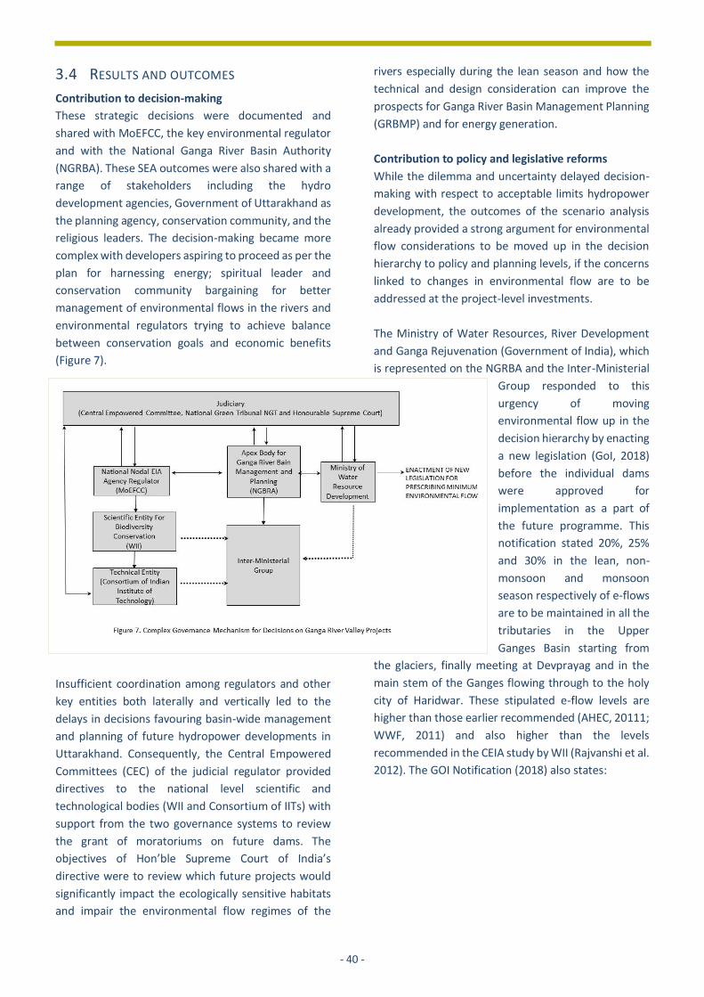
- 40 -
3.4 RESULTS AND OUTCOMES
Contribution to decision-making
These strategic decisions were documented and
shared with MoEFCC, the key environmental regulator
and with the National Ganga River Basin Authority
(NGRBA). These SEA outcomes were also shared with a
range of stakeholders including the hydro
development agencies, Government of Uttarakhand as
the planning agency, conservation community, and the
religious leaders. The decision-making became more
complex with developers aspiring to proceed as per the
plan for harnessing energy; spiritual leader and
conservation community bargaining for better
management of environmental flows in the rivers and
environmental regulators trying to achieve balance
between conservation goals and economic benefits
(Figure 7).
Insufficient coordination among regulators and other
key entities both laterally and vertically led to the
delays in decisions favouring basin-wide management
and planning of future hydropower developments in
Uttarakhand. Consequently, the Central Empowered
Committees (CEC) of the judicial regulator provided
directives to the national level scientific and
technological bodies (WII and Consortium of IITs) with
support from the two governance systems to review
the grant of moratoriums on future dams. The
objectives of Hon’ble Supreme Court of India’s
directive were to review which future projects would
significantly impact the ecologically sensitive habitats
and impair the environmental flow regimes of the
rivers especially during the lean season and how the
technical and design consideration can improve the
prospects for Ganga River Basin Management Planning
(GRBMP) and for energy generation.
Contribution to policy and legislative reforms
While the dilemma and uncertainty delayed decision-
making with respect to acceptable limits hydropower
development, the outcomes of the scenario analysis
already provided a strong argument for environmental
flow considerations to be moved up in the decision
hierarchy to policy and planning levels, if the concerns
linked to changes in environmental flow are to be
addressed at the project-level investments.
The Ministry of Water Resources, River Development
and Ganga Rejuvenation (Government of India), which
is represented on the NGRBA and the Inter-Ministerial
Group responded to this
urgency of moving
environmental flow up in the
decision hierarchy by enacting
a new legislation (GoI, 2018)
before the individual dams
were approved for
implementation as a part of
the future programme. This
notification stated 20%, 25%
and 30% in the lean, non-
monsoon and monsoon
season respectively of e-flows
are to be maintained in all the
tributaries in the Upper
Ganges Basin starting from
the glaciers, finally meeting at Devprayag and in the
main stem of the Ganges flowing through to the holy
city of Haridwar. These stipulated e-flow levels are
higher than those earlier recommended (AHEC, 20111;
WWF, 2011) and also higher than the levels
recommended in the CEIA study by WII (Rajvanshi et al.
2012). The GOI Notification (2018) also states:

- 41 -
“maintenance of uninterrupted flows along the entire
length of the river would be ensured without altering
the seasonal variations.” The notification further states
that “the existing projects, which
currently do not meet the norms of
these environmental flows, shall also
have to comply and ensure that the
requirements of stipulated
environmental flow are met within a
period of three years from the date of
issue of this notification.”
Major influence of outcomes
The e-flows notification provides the
limits of the agreed environmental
flows to be delivered through specific
releases of water from the storages at
the right times to mimic some of the
natural patterns of flows. The
regulation incorporates the larger
policy provisions for maintaining the
longitudinal connectivity and plan-
level or project-level environmental
flow.
With this recent regulation, India is among the few
countries that are global leaders in developed
(Australia, EU, and Florida in USA) and developing
(South Africa and Tanzania) countries (Hirji and Davis,
2009) in integrating environmental flow provisions into
their water resources policies.
This SEA study commands special interest because of
the two key reforms that it could bring in influencing
the decision-making at all levels from plans to the
levels of individual projects. It created a strong ground
for reorienting policies to upstream e-flow
considerations in decisions on dams. The new
legislation stepped up the decision-making process
that was considerably delayed because of the
conflicting interest of the key stakeholders. The new
legislation could also directly influence the strategies
to improve the energy plans at the basin level, which
would finally influence the decision-making at the
project level (Figure 8).
This case exemplifies that if hydropower planning is
supported and driven by good governance and
influenced by outcomes of appropriate assessments,
development planning can be directed to deliver
ecological, social and economic securities linked to
power generation.
Another important insight gained from this case study
is that India should proactively encourage SEA to
become formally linked to the decision-making process
rather than just serve as a voluntary conflict resolution
tool. A well-designed institutional support and a major
shift in policy is urgently needed to make SEA an
effective approach for assisting with the
implementation of policy and sector reforms that
foster sustainable development.
Acknowledgements
The author is grateful to all colleagues – Dr. Vinod B.
Mathur; Dr. Roshni Arora; Dr. K. Sivakumar;
Dr. S. Sathyakumar; Dr. G.S. Rawat; Dr. J.A. Johnson;
and Dr. K. Ramesh whose valuable professional
contributions in the study of cumulative impacts of
dams in Alaknanda and Bhagirathi basins in India
provided the backdrop for this study.

- 42 -
References
• AHEC, 2011. Assessment of Cumulative Impact of
Hydropower Projects in Alaknanda and Bhagirathi
Basins up to Devprayag. Alternate Hydro Energy
Centre, Indian Institute of Technology, Roorkee.
http://www.moef.nic.in/downloads/public-
information/EXECU- TIVE%20SUMARY.pdf
• Bandyopadhyay Jayanta, 2013. Securing the
Himalayas as the Water Tower of Asia.
• An Environmental Perspective. Essays in the
roundtable “Himalayan Water Security: The
Challenges for South and Southeast Asia, 2013.” Asia
Policy https://www.nbr.org/publication/asia-policy-
16-july-2013/
• Brisbane Declaration, 2007. Brisbane Declaration. In:
10th International River Symposium and International
Environmental Flows Conference [online], Brisbane 3–
6 September 2007.
• Bunn, S.E. and A.H. Arthington, 2002. Basic principles
and ecological consequences of altered flow regimes
for aquatic biodiversity. Environmental Management
30 (4): 492-507.
• Bragagnolo C. and D. Geneletti, 2012. Addressing
cumulative effects in Strategic Environmental
Assessment of spatial planning. Aestimum 60,
Giugno: 39-52.
• Government of India, 2012. National Water Policy.
Ministry of Water Resources, River Development and
Ganga Rejuvenation. New Delhi.
• Government of India, 2018. Ministry of Water
Resources, River Development and Ganga
Rejuvenation, Order No. S.O.5195 (E). Published on
9th October 2018 in Gazette of India, New Delhi.
• Joshi M.C., 2007. Hydro Power Potential in
Uttarakhand International Conference on Small
Hydropower - Hydro Sri Lanka, 22-24 October 2007
• Kumar P., 2009. Environmental flow assessment for a
hydropower project on a Himalayan river. Thesis
(PhD), Indian Institute of Technology Roorkee.
• MoEFCC, 1994. Environmental Impact Assessment
Notification, S.O.60 (E) published on January 27, 1994
and amended on April 4, 1994. Ministry of
Environment, Forest and Climate Change,
Government of India, New Delhi.
• MoEFCC, 2006. Environmental Impact Assessment
Notification, published in the Gazette of India,
Extraordinary, Part-II, and Section 3, Sub-section
Published on 14th September 2006. Ministry of
Environment, Forest and Climate Change,
Government of India, New Delhi.
• Hirji R. and R. Davis, 2009. Environmental Flows in
Water Resources Policies, Plans, and Projects:
Findings and Recommendations. The International
Bank for Reconstruction and Development /The
World Bank, Washington DC.
• Rajvanshi A., R. Arora, V.B. Mathur, K. Sivakumar, S.
Sathyakumar, G.S. Rawat, J.A. Johnson, K. Ramesh,
N. K. Dimri and A. Maletha, 2012. Assessment of
Cumulative Impacts of Hydroelectric Projects on
Aquatic and Terrestrial Biodiversity in Alaknanda and
Bhagirathi Basins, Uttarakhand. Wildlife Institute of
India, Technical Report. Pp 203.
• Sharad K. J. and P. Kumar, 2014. Environmental flows
in India: towards sustainable water management,
Hydrological Sciences Journal, 59: (3-4) 751-769.
• Victor D. and P. Agamuthu, 2014. Policy trends of
strategic environmental assessment in Asia
Environmental Science & Policy 41: 63-76.
• Valdiya K. S. (1997) Developing a paradise in peril.
Proceedings of 7th Pandit Govind Ballabh Pant
Memorial Lecture, G.B. Pant Institute of Himalayan
Environment and Development, Kosi- Katarmal,
Almora.
• World Bank, 2011. Uttarakhand. Available at
http://go.worldbank.org/FE04IF2IP0. Accessed on
16th May 2011.
• Wong C.M., C.E. Williams, J. Pittock, U. Collier and P.
Schelle, 2007. World’s top 10 rivers at risk, Gland,
Switzerland: WWF-International.
• WWF-India, 2011. Assessment of environmental flows
for Upper Ganga Basin, New Delhi, India: World Wide
Fund for Nature (WWF)-India. Pp 21.
• South Asia Network on Dams, Rivers and People
(SANDRP) 2013. Uttarakhand: Existing, under
construction and proposed Hydropower Projects: How
do they add to the state’s disaster potential?
https://sandrp.in/2013/07/10/uttarakhand-existing-
under-construction-and-proposed-hydropower-
projects-how-do-they-add-to-the-disaster-potential-
in-uttarakhand/ accessed on 18th March 2020.
• Sparks R.E., 1995. Need for ecosystem management
of large rivers and floodplains. BioScience 45: 168 –
182.
• Smith P.G.R. and J.B. Theberge, 1986. A review of
criteria for evaluating natural areas. Environmental
Management 10 (6): 715-734.
• Ward J.V., Tockner K. and Schiemer F, 1999.
Biodiversity of floodplain ecosystems: Ecotones and
connectivity. Regulated Rivers: Research and
Management 15: 1.

- 43 -
About the author
Asha Rajvanshi (PhD) has over three decades of professional standing as a teacher, trainer, EIA practitioner and the
reviewer of EIAs on behalf of the federal Government of India. She has played the lead role in developing and
encouraging mainstreaming tools for integrating biodiversity in impact assessment in India and the region. She has
been also credited to promote Strategic Environmental Assessment (SEA); Cumulative Impact Assessment; sustainable
land-use planning; Smart Green Infrastructure and mitigation planning for promoting wildlife friendly transportation
projects. She has made significant contribution to Impact Assessment through her global level training initiatives,
scholarly writings, academic mentoring of young researchers and publication of training manuals/best practice guides,
which are being extensively used by students, researchers and IA practitioner’s worldwide. She has created several
knowledge products and learning platforms to promote EIA and SEA. Asha has provided professional support in EIA
and SEA initiatives led by UNEP, the World Bank, IUCN, IAIA, CBD, GIZ, and ADB. She has served as one of the experts
on the Intergovernmental Science-Policy Platform on Biodiversity and Ecosystem Services (IPBES), for the Regional/sub-
regional assessments on biodiversity and ecosystem services for Asia and Pacific region. She is presently also the
member of the IPBES Task Force for Capacity Building and Scoping expert for biodiversity and business assessments.
Asha is a recipient of the prestigious Lifetime Achievement Award from IAIA for the year 2019.

- 44 -
Reservoir Nam Ngum 1 Dam
Lao
- 45 -
4 SEA FOR THE HYDROPOWER SECTOR
MYANMAR Matthew Corbett & Kate Lazarus
Authorities Ministry of Electricity and Energy and Ministry of Natural Resources and Environmental Conservation
Type of plan National planning framework for HPP site selection
Scope of SEA All HPPs >10MW in Myanmar
Key SEA issues Categorising 69 planned HPPs (43,848 MW) in different stages of development, based on cumulative assessment of ecological and socio-economic impacts
Stakeholder engagement Consultation with all identified stakeholders such as relevant authorities at national and regional level, representatives of local organisations, ethnic armed organizations, and affected communities
Duration and year 19 months; 2016 – 2018
Influence of SEA • Myanmar is divided in three zones: low, moderate and high risk
• CIA is carried out for optimisation and E&S risk management of cascade of HPPs
Link to SEA report https://www.ifc.org/wps/wcm/connect/industry_ext_content/ifc_external_corporate_site/hydro+advisory/resources/sea+of+the+hydropower+sector+in+myanmar+resources+page
4.1 INTRODUCTION
Myanmar, a country with substantial water resources,
is considering how to best develop hydropower to help
meet the country’s large power supply shortfall whilst
maintaining river basin process and values that support
critical ecosystem services, underpinning the
livelihoods of millions of people. Given that the
hydropower sector is in the early stages of
development, the opportunity exists to sustainably
develop the industry by balancing energy generation
with environmental and social outcomes.
Current hydropower planning in Myanmar follows
conventional planning based on the assessment of
individual projects as they are proposed. Early project
site selection focuses on engineering and economic
factors, with little if any consideration of cumulative
environmental and social impacts on the river basin.
This project-centric planning approach has resulted in
significant cumulative basin impacts in other countries
in the region that were not recognised until substantial
degradation had resulted. In light of these planning
limitations a strategic environmental assessment (SEA)
was prepared to guide hydropower development at
the basin scale over the next three decades and
beyond, establishing a planning framework for project
site selection that balances development with basin
health.
The SEA was jointly prepared by the Ministry of
Electricity and Energy (MOEE) and Ministry of Natural
Resources and Environmental Conservation
(MONREC), with the assistance of the International
Finance Corporation (IFC) and its development partner,
the Government of Australia.
Sustainable hydropower development recognises the
interdependent processes, functions, and values of a
basin and seeks to maintain basin health and
ecosystem services, while developing hydropower to
help meet the substantial energy needs of the
population. This can be achieved by retaining high
value intact tributaries while developing lower value
rivers as “workhorse” watercourses. In basins and on
rivers that are already highly regulated the adverse
effect of adding additional projects may be far less than
the impact of developing intact rivers. This pathway
avoids dispersed projects being built on many
tributaries with viable hydropower sites without due
consideration of natural resource values.
The primary output of the SEA is the sustainable
development framework (SDF) - a project siting tool
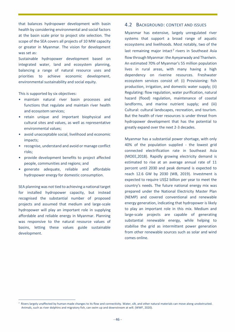
- 46 -
that balances hydropower development with basin
health by considering environmental and social factors
at the basin scale prior to project site selection. The
scope of the SEA covers all projects of 10 MW capacity
or greater in Myanmar. The vision for development
was set as:
Sustainable hydropower development based on
integrated water, land and ecosystem planning,
balancing a range of natural resource uses and
priorities to achieve economic development,
environmental sustainability and social equity.
This is supported by six objectives:
• maintain natural river basin processes and
functions that regulate and maintain river health
and ecosystem services;
• retain unique and important biophysical and
cultural sites and values, as well as representative
environmental values;
• avoid unacceptable social, livelihood and economic
impacts;
• recognise, understand and avoid or manage conflict
risks;
• provide development benefits to project affected
people, communities and regions; and
• generate adequate, reliable and affordable
hydropower energy for domestic consumption.
SEA planning was not tied to achieving a national target
for installed hydropower capacity, but instead
recognised the substantial number of proposed
projects and assumed that medium and large-scale
hydropower will play an important role in supplying
affordable and reliable energy in Myanmar. Planning
was responsive to the natural resource values of
basins, letting these values guide sustainable
development.
7 Rivers largely unaffected by human-made changes to its flow and connectivity. Water, silt, and other natural materials can move along unobstructed.
Animals, such as river dolphins and migratory fish, can swim up and downstream at will. (WWF, 2020).
4.2 BACKGROUND: CONTEXT AND ISSUES
Myanmar has extensive, largely unregulated river
systems that support a broad range of aquatic
ecosystems and livelihoods. Most notably, two of the
last remaining major intact7 rivers in Southeast Asia
flow through Myanmar: the Ayeyarwady and Thanlwin.
An estimated 70% of Myanmar’s 55 million population
lives in rural areas, with many having a high
dependency on riverine resources. Freshwater
ecosystem services consist of: (i) Provisioning: fish
production, irrigation, and domestic water supply; (ii)
Regulating: flow regulation, water purification, natural
hazard (flood) regulation, maintenance of coastal
landforms, and marine nutrient supply; and (iii)
Cultural: cultural landscapes, recreation, and tourism.
But the health of river resources is under threat from
hydropower development that has the potential to
greatly expand over the next 2-3 decades.
Myanmar has a substantial power shortage, with only
40% of the population supplied - the lowest grid
connected electrification rate in Southeast Asia
(MOEE,2018). Rapidly growing electricity demand is
estimated to rise at an average annual rate of 11
percent until 2030 and peak demand is expected to
reach 12.6 GW by 2030 (WB, 2019). Investment is
expected to require US$2 billion per year to meet the
country’s needs. The future national energy mix was
prepared under the National Electricity Master Plan
(NEMP) and covered conventional and renewable
energy generation, indicating that hydropower is likely
to play an important role in this mix. Medium and
large-scale projects are capable of generating
substantial renewable energy, while helping to
stabilise the grid as intermittent power generation
from other renewable sources such as solar and wind
comes online.
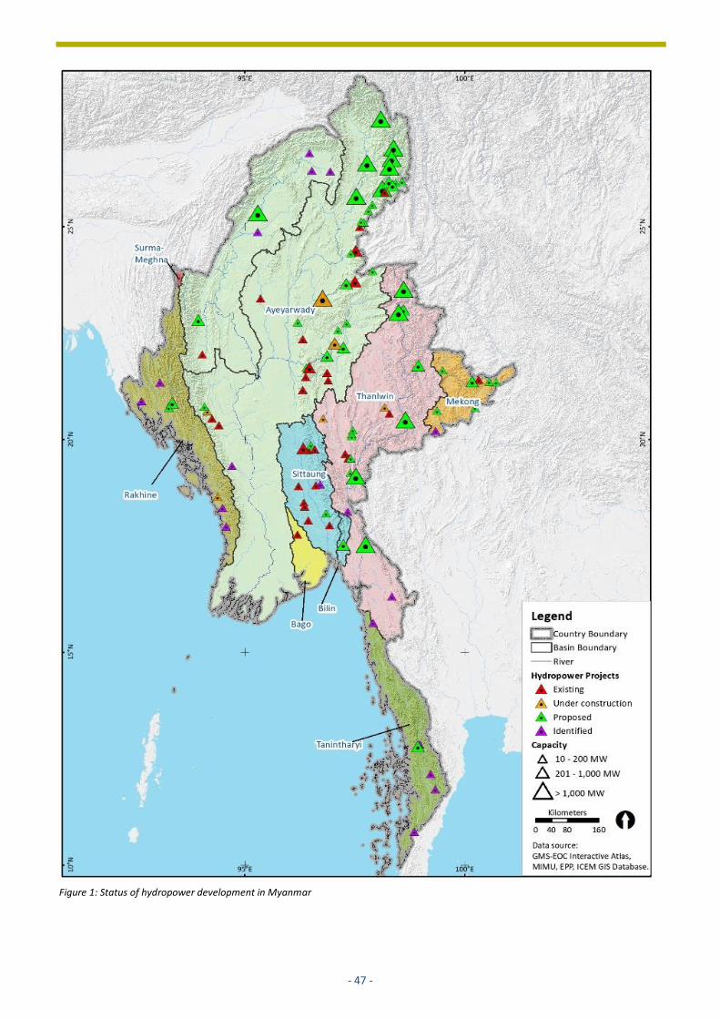
- 47 -
Figure 1: Status of hydropower development in Myanmar

- 48 -
Relatively limited hydropower development has
occurred in Myanmar to date compared with estimates
of potential total capacity. The total installed capacity
of projects 10 MW and greater (29 projects – Figure 1)
is 3,298 MW, accounting for 58% of national energy
supply in early 2018. A further 1,564 MW capacity is
under construction (6 projects), but several of these
projects are stalled or taking far longer to complete
than scheduled. Of these projects 80% has been
developed in cascade arrangements, driven by load
centre locations and limited transmission grid
coverage, coupled with suitable sub-basin hydrology,
topography and geology. The Ayeyarwady river basin
accounts for 64% of total installed capacity, with the
Sittaung river basin contributing 25%. This low overall
level of development is partly a function of the
country’s political and economic isolation between
1988 and 2011, but now there is considerable
international interest in the sector.
Sixty-nine projects are proposed, totalling 43,848 MW
capacity (Table 1), with their stages of development
ranging from initial identification through to various
agreements in place with the government. Very large
projects (>1,000 MW) account for 80% of proposed
capacity, with most of these proposed on mainstem
rivers.
Project Capacity (MW)
Number of Projects
Total Capacity (MW)
% of Total Proposed MW
>2,000 6 25,100 57.3
1,000-2,000
7 10,060 22.9
500-1,000 5 3,020 6.9
100-500 28 4,823 11.0
10-100 23 845 1.9
Total 69 43,848 100
The current level of geographically restricted
hydropower development presents a window of
opportunity to sustainably develop the sector before
dispersed, high impact projects are built.
Over the past decade public opposition to large
projects has risen. Stakeholder objections have
variously been attributed to insufficient project
transparency and stakeholder engagement, the legacy
issues of past projects, conflict affected areas and
political shifts. Projects proposed on major rivers have
received the most objections, leading the government
to suspend the Myitsone, Tamanthi and Tanintharyi
HPPs, totalling 7,800 MW capacity.
Hydropower planning in Myanmar has to contend with
limited natural resource and socio-economic data on
key themes (river hydrology, geomorphology, aquatic
ecology, social and livelihoods), although some current
river basin studies such as the Ayeyarwady Integrated
River Basin Management Project (AIRBMP) are
starting to fill some of the gaps (Hydro-Informatics
Centre, 2017).
Box 1: The importance of basin health and fish production Basin health is critical to maintaining freshwater and marine fish production, an important sector of the Myanmar economy. Changes to seasonal flows, water quality, and river geomorphology all degrade natural freshwater habitat. Outflows from Myanmar’s major rivers into the sea provide nutrients for marine life and help maintain natural coastal processes essential to coastal fisheries production. National fish production in 2014 was 5,048,000 metric tons, accounting for around 3% of the world’s reported fish production. This consisted of 27.3% from inland fisheries, 53.5% from marine fisheries, and 19.1% from aquaculture. National fish production supports the livelihoods of an estimated 3.2 million people employed in the fisheries sector (800,000 full-time, 2.4 million part-time), and is the fourth largest contributor to Myanmar’s GDP and source of foreign exchange earnings. Estimated average annual fish consumption per person is 30 kg. Source: Fisheries Statistics 2014, Department of Fisheries Myanmar.
Table 1: Proposed hydropower projects – by installed capacity (December 2018)
- 49 -
4.3 APPROACH AND METHODS USED
SEA preparation involved six main activities (Figure 2):
• issue scoping;
• stakeholder engagement;
• management unit definition and hydropower GIS
database preparation;
• evaluation of baseline environmental, social and
conflict conditions and trends;
• hydropower business-as-usual (BAU)
sustainability analysis;
• sustainable development framework (SDF)
preparation
4.4 ISSUE SCOPING
Stakeholder engagement with government, civil
society organisations (CSOs), and hydropower
companies were undertaken at the commencement of
SEA preparation to canvass broad views on basin
values, development, protection and management.
Key environmental and socio-economic issues and
concerns raised were analysed under seven strategic
themes for analysis:
• hydropower;
• geomorphology and sediment transport;
• terrestrial biodiversity;
• fisheries, aquatic ecosystems, and river health;
• economic development and land use
• social and livelihoods;
• peace and conflict.
The main hydropower impact issues raised were:
changes in water flow and water quality,
sedimentation and riverbank erosion, flooding,
deforestation, biodiversity loss, food security and
nutrition (e.g. loss of agricultural land, riverbank
gardens, orchards, and capture fisheries), loss of
livelihoods, land grabbing, conflict, and social welfare
issues (e.g. drugs and mental health). The benefits of
hydropower were identified as: access to electricity,
improved access to services (health, education, and
transport), socio-economic development and higher
living standards, opportunity for irrigation (multi-
purpose projects), local employment, and
opportunities to develop small and medium
enterprises.
Stakeholder engagement
Stakeholder engagement was a core component of the
SEA process, aiming to solicit the views and concerns of
different stakeholders, whilst building broad
awareness of existing and proposed hydropower
development, basin values, likely cumulative BAU
BAU Sustainability
Analysis
Regional river basins
Draft SEA Report
Sustainability analysisSustainable Development
Framework
Stakeholder engagement plan
Sustainable development objectives
AG, EG & HDWG
Baseline assessment report
GIS and spatial layers
Stakeholder workshops
Consultations
Develop HPP GIS database
Sub-basin evaluation
ratings
Sustainability Analysis Report
Trend analysis
Spatial analysis
Pipeline hydropower projects (HPP)
Project GISdatabase
Define BAU hydropower
case
Final SEA report
Final stakeholder workshops
Basin zoning
Implementation plan
Studies and data collection
Capacity building
Key E&S issues and strategic themes
Local communities
2016 2017 2018
Oct Nov Dec Jan Feb Mar Apr May Jun Jul Aug Sep Oct Nov Dec Jan Feb Mar Apr
Policy recommendations
Impact assessment workshop
Scoping and Baseline assessment
Figure 2: SEA methodology and outputs
1
- 50 -
adverse impacts, and sustainable development
principles.
An SEA Advisory Group and six technical Expert Groups
were convened to guide the SEA, identify the best
available information, review draft findings and help
engender a commitment to the SEA vision. These
groups consisted of local and international specialists
covering different technical fields, from government
agencies, non-governmental organisations, the private
sector, development partners, multi-lateral agencies,
academic institutions, ex-government officers and
independent researchers.
A Stakeholder Engagement Plan was developed
identifying key groups with an interest in hydropower
development and river basin management and
outlining consultation and communication activities.
Stakeholders included Union and state/region
governments, national and local CSOs, ethnic armed
organisations (EAOs), political parties, local
communities, the private sector, development
partners, international and local NGOs, universities,
multilateral development agencies, and banks. More
than 55 stakeholder engagement events were held
across Myanmar to capture views from as many
states/regions where hydropower is planned as
possible, commencing during issue scoping. The events
involved:
• Regional river-basin consultations: workshops with
civil society organisations (CSO) and state/region
governments to identify basin environmental and
social issues, carry out visioning exercises, and
opportunities during scoping, and to review and
provide feedback on draft SDF recommendations;
• Multi-stakeholder workshops: open to all
stakeholders including representatives from Union
and sub-national governments, international and
local NGOs/CSOs, universities, and the private
sector during all phases of the SEA;
• Local community consultation: key informant
interviews and focus group discussions with villages
affected by the Upper Paunglaung, Lower Yeywa,
Bawgata, Shwe Gyin, and Baluchaung 1, 2 and 3
HPPs to validate actual village-level environmental
and social impacts and broader concerns with
sector developments;
• Consultation with ethnic armed organisations
(EAO) and political parties: consultations with
EAOs, political parties, and CSOs in Mytikyina,
Taunggyi, and Kyauk in Myanmar as well as Mae Sot
and Chiang Mai in Thailand as part of the conflict
and peace assessment;
• Discussions with the Hydropower Developers’
Working Group (HDWG) cum Myanmar
Hydropower Developers’ Association (MHDA):
presentations and discussions with hydropower
companies and consultant firms working in the
sector;
• Information sessions: presentations and
discussions at a range of conferences and
workshops starting from the development of the
SEA Terms of Reference to reach broader audiences
and garner additional inputs into the process;
• Government briefings: multiple briefings were
provided to government Ministers and agencies
from MOEE and MONREC, as well as to the
Parliament and the National Economic
Coordination Committee (NECC) during and
following the completion of the SEA.
• Training: GIS training was provided to MOEE and
MONREC to provide them all the data produced
during the SEA and for these agencies to be able to
use it in their assessments and decision-making,
along with the formal reports.
Informal discussions were also held with numerous
individuals and organisations to share information and
receive inputs throughout the SEA preparation.
Management units and GIS database
Eight basins cover the entire country, consisting of six
river basins (Ayeyarwady, Thanlwin, Mekong, Sittaung,
Bago and Belin) and two coastal basins composed of
small watersheds grouped together for analysis
purposes (Tanintharyi and Rakhine) (Table 2). Two
natural management units with related but discernibly
different functions were defined within the basins:
mainstem rivers and sub-basins.
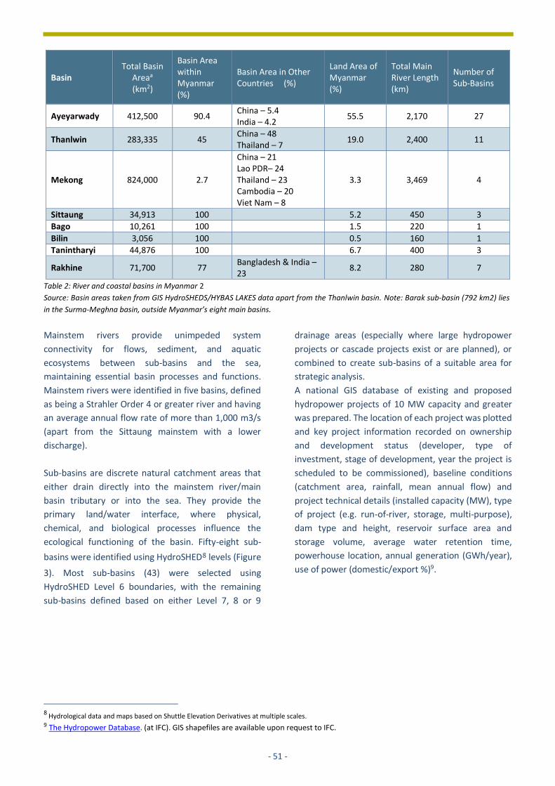
- 51 -
Basin Total Basin
Areaa (km2)
Basin Area within Myanmar (%)
Basin Area in Other Countries (%)
Land Area of Myanmar (%)
Total Main River Length (km)
Number of Sub-Basins
Ayeyarwady 412,500 90.4 China – 5.4 India – 4.2
55.5 2,170 27
Thanlwin 283,335 45 China – 48 Thailand – 7
19.0 2,400 11
Mekong 824,000 2.7
China – 21 Lao PDR– 24 Thailand – 23 Cambodia – 20 Viet Nam – 8
3.3 3,469 4
Sittaung 34,913 100 5.2 450 3
Bago 10,261 100 1.5 220 1
Bilin 3,056 100 0.5 160 1
Tanintharyi 44,876 100 6.7 400 3
Rakhine 71,700 77 Bangladesh & India – 23
8.2 280 7
Mainstem rivers provide unimpeded system
connectivity for flows, sediment, and aquatic
ecosystems between sub-basins and the sea,
maintaining essential basin processes and functions.
Mainstem rivers were identified in five basins, defined
as being a Strahler Order 4 or greater river and having
an average annual flow rate of more than 1,000 m3/s
(apart from the Sittaung mainstem with a lower
discharge).
Sub-basins are discrete natural catchment areas that
either drain directly into the mainstem river/main
basin tributary or into the sea. They provide the
primary land/water interface, where physical,
chemical, and biological processes influence the
ecological functioning of the basin. Fifty-eight sub-
basins were identified using HydroSHED8 levels (Figure
3). Most sub-basins (43) were selected using
HydroSHED Level 6 boundaries, with the remaining
sub-basins defined based on either Level 7, 8 or 9
8 Hydrological data and maps based on Shuttle Elevation Derivatives at multiple scales. 9 The Hydropower Database. (at IFC). GIS shapefiles are available upon request to IFC.
drainage areas (especially where large hydropower
projects or cascade projects exist or are planned), or
combined to create sub-basins of a suitable area for
strategic analysis.
A national GIS database of existing and proposed
hydropower projects of 10 MW capacity and greater
was prepared. The location of each project was plotted
and key project information recorded on ownership
and development status (developer, type of
investment, stage of development, year the project is
scheduled to be commissioned), baseline conditions
(catchment area, rainfall, mean annual flow) and
project technical details (installed capacity (MW), type
of project (e.g. run-of-river, storage, multi-purpose),
dam type and height, reservoir surface area and
storage volume, average water retention time,
powerhouse location, annual generation (GWh/year),
use of power (domestic/export %)9.
Table 2: River and coastal basins in Myanmar 2
Source: Basin areas taken from GIS HydroSHEDS/HYBAS LAKES data apart from the Thanlwin basin. Note: Barak sub-basin (792 km2) lies
in the Surma-Meghna basin, outside Myanmar’s eight main basins.
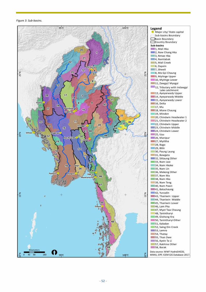
- 52 -
Figure 3: Sub-basins.

- 53 -
Baseline conditions
Baseline conditions and trends were identified in each
basin, covering:
• hydropower;
• geomorphology and sediment transport;
• terrestrial biodiversity;
• fisheries, aquatic ecology, and river health;
• economic development and land use;
• social and livelihoods;
• peace and conflict.
Sub-basin evaluation was then undertaken for five
strategic themes that hydropower is either likely to
affect or be affected by.
Conditions were evaluated using the best available
information, including published research and spatial
data, expert opinion, and stakeholder views. Directly
relevant indicators for each theme were evaluated, or
where such information was not available a proxy
indicator was used:
i. geomorphology and hydrology – river connectivity
and delta/coastline stability; potential sediment
production; river flow;
ii. aquatic ecology and fisheries: river reach rarity
(WWF, 2014); presence of endemic species, key
biodiversity areas, Ramsar sites and important
wetland areas, confluences, karst geology,
presence of threatened fish and aquatic organisms;
iii. terrestrial biodiversity: percentage of protected
area/key biodiversity area; percentage of intact
forest (≥80% crown cover);
iv. social and livelihoods: social vulnerability;
dependence on natural resources – indicated by %
of ‘own account workers as % of workforce’ in
townships within sub-basins (2014 township
Census data); poverty - indicated by % of
households owning a television (Census 2014);
v. conflict 10 : presence and status of ethnic armed
groups; historical population displacement; recent
conflict incidents and estimated battle deaths
(2012-17).
Each of the five themes scored between 1-5 for each
sub-basin by combining the scores for each evaluated
criterion to provide an overall ‘value’ for that theme.
10 Link to the Baseline reports and sub-basin evaluation (at IFC)
A rating of 1 indicates a “low” value and 5 a “very high”
value. Baseline information and theme scores were
then summarised on sub-basin datasheets, with the
scores for each sub-basin used to generate national
theme maps illustrating the distribution of baseline
values.
Business-as-usual basin sustainability analysis
The cumulative impact of BAU hydropower
development on each basin’s processes and values was
assessed to identify the extent and significance of
losses and degradation. Recognising these losses
enables a sustainable development framework to be
developed to avoid them, thereby maintaining basin
health and ecosystem services.
BAU development was assumed to be the installation
of the 69 proposed projects over the next 30 years,
providing a ‘best estimate’ development scenario
indicative of the scale and distribution of projects likely
to be built. BAU development would result in the
Ayeyarwady and Thanlwin basins having 28,000 MW
(53%) and 21,000 MW (40%) of total national
hydropower capacity respectively, with other six basins
adding a further 3,134 MW capacity, ranging between
20-1,220 MW total capacity per basin. Mainstem
development would consist of a single large project on
the Ayeyarwady and Chindwin rivers, and five large
projects on the Thanlwin River.
Key biophysical and socio-economic impacts from BAU
development in each basin were evaluated using the
same five themes and indicators assessed to determine
baseline conditions. The analysis found that BAU
development would triple the total catchment area
regulated by hydropower within Myanmar from 14.4%
at present to 45%, with most hill and mountain
catchments fragmented, resulting in broad-scale
biophysical changes to Myanmar’s rivers and
significant social impacts that are predicted to include:
• altered seasonal and daily river flows in most river
basins - increased dry season flows and reduced
wet season flows from storage projects, daily flow
fluctuations from peaking generation, a delay in the
onset of monsoonal river flows when large
reservoirs refill, and a potential decrease in flood

- 54 -
flows. Figure 4 illustrates natural, existing and BAU
Thanlwin River flows;
• changes to water quality caused by the seasonal
retention in reservoirs;
• reduced downstream sediment loads, altered
sediment size distribution, and increased bank
erosion resulting in changes to river and delta
geomorphology;
• aquatic habitat fragmentation, with most dams and
altered flow conditions preventing fish, larvae, and
egg movement upstream and downstream;
• terrestrial habitat fragmentation and reduced
biodiversity from the construction of reservoirs,
roads and transmission lines, and potential illegal
forest harvesting by the project workforce and
camp followers;
• loss of riverine and terrestrial natural resources;
• large scale resettlement and the loss of livelihoods
from reduced access to natural resources;
• exacerbation of conflict in some areas.
In the Ayeyarwady and Thanlwin basins, which
combined cover three-quarters (74.5%) of the country,
major irreversible basin-scale changes would occur to
river flows and geomorphic and ecological processes
and functions. Most significantly, large scale projects
on the Ayeyarwady, Chindwin and Thanlwin mainstem
rivers would cause substantial impacts on system
connectivity and basin processes. For example, BAU
development would raise the percentage of the
Thanlwin basin within Myanmar that is longitudinally
disconnected from the sea from 12.9% at present to
80.6%, while the Ayeyarwady would be raised from
16.1% to 38.6%.
Sustainable development framework
The ‘sustainable development framework’ (SDF) was
prepared to balance the
maintenance of critical basin
processes and ecosystem services
with the generation of reliable and
affordable hydropower. The
framework is based on Basin
Zoning Plans that recommended
areas for: (i) reservation from
hydropower development due to
high values, and (ii) potential
development - lower value areas
potentially suitable for
hydropower development. The
Plans identify mainstems and sub-
basin management zones and
controls for new hydropower
projects.
Mainstem zoning defines the extent of each basin’s
mainstem recommended for reservation, where
hydropower development and other major structural
water resource developments (e.g. irrigation dams) are
recommended to be excluded to maintain unimpeded
mainstem connectivity with the sea. By leaving the
mainstem intact, decisions on sub-basin utilisation can
be made based on sub-basin values, uncompromised
by the loss of downstream connectivity.
Mainstems recommended for reservation were
identified in five basins based on their significant
system connectivity value. These reaches total 4,100
km: Ayeyarwady (1,500 km), Chindwin (900 km),
Thanlwin (1,200 km), Mekong (200 km) and Sittaung
(300 km) rivers.
Sub-basin zoning (Figure 5) was defined by combining
the scores for the three biophysical features evaluated
in the assessment of baseline conditions:
geomorphology and hydrology, aquatic ecology and
fisheries, and terrestrial ecology. Socio-economic sub-
basin scores were not applied as the level of detail
available was considered a poor indicator of the value
of features likely to be adversely affected by
hydropower. Similarly, the status of armed conflict was
also not applied to determine sub-basin zoning as
conflict is dynamic and variable across a sub-basin.
Instead, conflict zoning is applied as an additional
screening layer for proposed projects by developers
Figure 4: Thanlwin River average natural and regulated flows – by distance
downstream of Myanmar-China border

- 55 -
early in the project feasibility analysis to evaluate the
related risks.
The scores for the three biophysical factors were
totalled and scaled to determine one of three sub-
basin zones (See Table 3 for zone distribution by basin):
• high - provides an important contribution to basin
processes (such as high flows or a large sediment
load), and/or has unique natural values for at least
two biophysical factors;
• medium - no high conservation value features over
a notable area for at least two biophysical factors,
although may contain
notable values for a single
factor or pockets of such
values for multiple factors;
• low - no high conservation
value features over a notable
area for any biophysical
factor, although may contain
pockets of high value.
Ten high zone sub-basins (see
Table 4 for high zone sub-basin
scores) with critical biophysical
processes and values were
defined, covering 24% of
Myanmar. Hydropower
development in these areas is
recommended to be limited to
smaller scale projects with low
environmental and social risks that cumulatively will
not unduly degrade the reserved values. Five of the
high zone sub-basins form a contiguous block in the
headwaters of the Ayeyarwady basin, covering 78,900
km2 (21% of the basin area within Myanmar),
contributing an estimated 47% of total basin discharge
and a substantial volume of sediment.
This area contains high value aquatic habitats and
notable terrestrial ecosystems in Hkakaborazi National
Park, four Wildlife Sanctuaries and numerous key
biodiversity areas, containing 35% of all remaining
intact forest (>80% crown cover) in Myanmar. Two
other high zone sub-basins were defined in Tanintharyi
basin, while one each is located in the Thanlwin,
Mekong, and Rakhine basins.
Twenty-one medium zone and 27 low zone sub-basins
were identified as being potentially suitable for
hydropower development, covering 37% and 39% of
Myanmar respectively. These sub-basins are
recommended to be considered by government for
potential hydropower development, subject to
environmental and social impact assessment. Over
time, as new data is obtained and projects are
approved, it is recommended that the government
consider trade-offs within this group of sub-basins to
achieve a balance between developed and reserved
catchments.
The adoption of the basin zoning plans to site projects
will achieve the underlying principle of sustainable
development: maintain high value intact mainstems
and sub-basins to drive basin health while permitting
development in “workhorse” sub-basins, thus avoiding
the construction of projects in many intact sub-basins.
Developing projects in cascade arrangements versus
Basin % of Myanmar Basin Area1
High Medium Low
Ayeyarwady 20.9 28.6 50.5
Thanlwin 15.9 57.9 26.2
Sittaung - 82.2 17.8
Mekong 29.8 15.5 54.7
Bilin - - 100
Bago - - 100
Tanintharyi 97.8 2.2 -
Rakhine 24.6 66.8 8.6
Surma-Meghna - - 100
Total 24.2 37.3 38.5
Basin Sub-Basin
Geomorph.
and
Sediment
Aquatic
Ecology
Terres-
trial
Ecology
Total
Score
Ayeyarwady
Mali Hka 5 5 5 15
N’mai Hka 5 4 5 14
Chindwin
Headwater 1 3 4 5 12
Chindwin
Headwater 2 2 5 5 12
Chindwin
Upper 5 3 4 12
Thanlwin Thanlwin
Middle 5 4 3 12
Mekong Mekong Other 4 5 2 11
Tanintharyi
Tanintharyi 5 5 5 15
Tanintharyi
Other 5 3 4 12
Rakhine Kaladan 5 4 2 11
Table 4: High zone sub-basin scores
Table 3: Zone distribution by basin

- 56 -
dispersed projects can lower the overall magnitude of
impact per unit of energy generated and increase
power generation per unit of water regulated by
running stored water through multiple powerhouses.
The development of low and medium zone sub-basins,
assuming all BAU projects are installed om the two
zones, would raise the total Myanmar catchment area
regulated by hydropower from 14.4% to 23.5%,
considerably less than 45% that would be regulated
under BAU.
A three-year implementation plan was proposed to
support the introduction of sustainable
hydropower, incorporating:
• the establishment of a joint government
planning committee consisting of MOEE and
MONREC;
• development of a national Sustainable
Hydropower Policy;
• development of a Basin Zoning procedure for
Government of Myanmar implementation;
• recommended sustainable project design
criteria;
• recommended improvements to environmental
and social impact assessment and management
planning including inclusion of conflict
assessments;
• enhanced stakeholder engagement; and
• critical baseline data collection and research.
As a first edition plan, it is recommended that the
framework be reviewed and revised three years
after the commencement of implementation, based
on new, more detailed information and
implementation findings.
4.5 RESULTS AND OUTCOMES
The SEA had the difficult role of defining a
sustainable development pathway for hydropower:
balancing hydropower development to support the
power needs of Myanmar with the maintenance of
river basin health, ecosystem services and the
livelihoods they support. Through the SEA process the
conversation about hydropower development has
started to fundamentally shift, from a debate about the
merits and localised impacts of individual projects to a
more informed discussion about how best to achieve a
balance between power generation and basin health
into the future.
The SEA has promoted this shift by informing
stakeholders about system complexity and
interdependent processes. The divergent views of
different stakeholder groups have been recognised,
ranging from villagers who are focused on their
traditional natural resources, to developers who are
promoting projects. The project GIS identifies the
location, type and main features of all existing and
proposed hydropower projects for the first time,
allowing the extent of development to be clearly seen.
The snapshot of baseline biophysical and
socioeconomic conditions and threats at the sub-basin
level across the entire country, as well as information
on basin processes and ecosystem services, has
brought to light each basin’s resources and values. The
assessment of the main cumulative impacts of BAU
development sets out the previously unrecognised
adverse basin impacts of conventional development on
Figure 5: Sub-basin zoning

- 57 -
largely intact river systems. And importantly, the SEA
provides a rationale planning tool for sustainable
development and sets out clear actions required to
support its implementation.
The SEA is being supported by the implementation of a
program of actions to operationalise sustainable
hydropower development, maintaining the planning
momentum initiated by the SEA. These activities
include further briefings to Ministers and government
agencies, translating the SEA summary into six local
and regional languages, providing SDF and GIS training
to MONREC and MOEE staff, releasing data (GIS files)
to the public to enable uptake by other agencies and
researchers, and the cumulative impact assessment of
cascade hydropower and other renewable energy
options in the modified Myitnge sub-basin.
SEA basin-level planning will de-risk hydropower
projects by identifying development risks early in the
project development cycle and providing solid
justification for project siting from a basin
sustainability perspective, something that multi-lateral
development banks are starting to place greater
importance on. The likelihood of projects sited in
accordance with the basin zoning plans attracting
broad public opposition and subsequently stalling and
not being granted planning approval should be greatly
reduced. It also provides a first set of key information
for prospective project proponents when they enter
the country and consider investment in the sector.
In summary, implementation of the ‘first edition’ basin
zoning plans, supported by project design guidelines,
will move the hydropower sector to sustainable
development before BAU development results in
significant basin regulation and degradation. Decision-
makers and developers have clear planning guidance
on the appropriate siting of projects. The outcomes
that this change in approach is expected to deliver are:
• the maintenance of healthy basins and the
ecosystem services that they provide over the next
100 years and beyond;
• the initiation of meaningful stakeholder
engagement during project development, thereby
improving project design and increasing
stakeholder acceptance of well-planned projects as
well as greater recognition of legacy issues and
conflict-affected areas;
• improved access to international financing by
avoiding/reducing basin-wide cumulative impacts;
and
• the establishment of substantial hydropower
generation, providing affordable and reliable
renewable energy that will drive local and national
development.
By creating the nexus between hydropower
development and natural resource protection, the SEA
has shown that development and protection are both
achievable through basin-level planning. Substantial
hydropower generation can be delivered at a far lower
‘cost’ to natural resources, ecosystem services and
river-dependent communities and businesses. The
expected outcomes of sustainable hydropower
development in the Ayeyarwady basin are illustrated in
Figure 6.

- 58 -
Figure 6: Ayeyarwady Basin sustainability

- 59 -
4.6 LESSONS LEARNT
An SEA is a great planning instrument to comprehend,
assess and plan complex system-level natural resource
and development issues. It has the capacity to combine
a science-based assessment with an understanding of
the often-conflicting values of multiple resource users
and other stakeholders, to enable complexity to be
understood and rationale long-term planning to be
developed. This usually involves a trade-off between
resource use and protection to develop a broadly
acceptable plan to guide sustainable sector
development.
Establishing the vision and objectives for the SEA early
in the process is critical in developing a focused
methodology and conveying its direction to
stakeholders. The SEA methodology should be flexible,
allowing it to be modified as planning progresses. This
is particularly true where there is limited
understanding of the conditions at the start, but even
the best planned SEA will reveal unexpected conditions
that have to be adapted to.
The SEA process is often as important as its findings as
it initiates a conversation with stakeholders about
future management options and outcomes, the first
step in gaining stakeholder buy-in to the planning
direction. To achieve this there is no substitute for
extensive and transparent consultation with all
stakeholder groups, involving the canvassing of views
and informing stakeholders about the issues. A
transparent process underpinned by ongoing
communications and information disclosure is also
important. For the hydropower SEA this involved
developing an SEA website, releasing information via
newsletters, engaging stakeholders through
meetings/workshops/briefings, and translating
information into multiple languages.
The hydropower SEA commenced with strong
government support in the form of a tripartite
agreement between the Myanmar power and
environment Ministers, to establish joint decision-
making and build a shared understanding. Stakeholder
engagement also involved other government agencies,
resource users, developers and NGOs. Divergent views
were respected and considered during the SEA
preparation. By demonstrating this, even when a
different course is eventually taken, a greater
understanding and degree of ownership of the
planning is more likely. The use of an Advisory Group
and Expert Groups made up of decision-makers,
technical specialists and NGOs can be particularly
useful, not only to canvass their views but also as a
sounding board for evolving ideas.
An SEA often has to contend with limited baseline
information, but it is far better to develop a ‘first
edition’ plan, that acknowledges and works with these
limitations rather than delaying planning that permits
sub-optimal development to continue. An initial SEA
also clearly identifies information gaps and the priority
actions based on its analysis. The hydropower SEA was
viewed as the ‘first edition’, to be periodically updated
as implementation occurs and new information to keep
pace with current conditions.
There are many approaches and methodologies for
carrying out SEAs. The hydropower SEA provides
insights into an approach based on limited data and
extensive stakeholder engagement that was
contextualised for Myanmar. It provides better
understanding as to how this may be applied for other
sectors or geographic areas in future.
In conclusion, SEA is valuable in supporting long term
planning of the hydropower sector at country level
providing clarity about risks of investment to all key
stakeholders.
References
• Department of Fisheries Myanmar, 2014. Fisheries
Statistics 2014.
• Hydro-Informatics Centre, 2017. Ayeyarwady State of
the Basin Assessment (SOBA) 2017. Synthesis
Report, Volume 1. Yangon.
• International Finance Corporation, 2020. Strategic
Environmental Assessment of the Myanmar
hydropower sector.
• MOEE, 2018. MOEE presentation to: The Third
Meeting of Energy and Electric Power Sector
Coordination Group – 8 August 2018.
• World Bank Group, 2019. Myanmar Economic
Monitor: Building Reform Momentum.
http://documents.worldbank.org/curated/en/326771
560523871008/pdf/Building-Reform-Momentum.pdf
• WWF, 2020: Mapping Myamar’s free-flowing rivers.
Assessment of current and future impacts of dam-
infrastructure development on river connectivity.

- 60 -
About the authors
Matt Corbett (MSc) has over 35 years’ experience in environmental management in various consulting and
Government roles in 25 countries. He has worked as a private consultant for development banks since 2005, including
the World Bank, International Finance Corporation (IFC) and Asian Development Bank (ADB), where he has provided
project and sector development advice across southeast, southern and central Asia, the Pacific and Africa. He has also
consulted to the United Nations Development Program and the Export Finance Australia. Matt has extensive energy
and infrastructure experience, from early project planning and design, through construction and operation, covering:
power (hydro, wind, solar, gas, geothermal, waste-to-energy, transmission), transport (road, rail, ports, airports,
logistics centres), waste, communications, forestry and a range of other industries. Matt’s experience in environmental
management planning and implementation includes: preparing project, cumulative and strategic impact assessments;
project environmental and social management systems and plans; project due diligence reviews; sustainable land
management planning and implementation; carbon management; environmental policy development; and
environmental training in good international industry practice. [email protected]
Kate Lazarus (MSc) is IFC’s Senior Asia Lead for Environment, Social and Governance (ESG) Advisory. In 2018, Kate
received the 'Top 30 of IFC Individual Corporate Awards' for staff whose exceptional contributions, collaborative
behaviors, and innovative thinking have consistently resulted in the achievement of significant milestones to help a
sector or country reach market potential for private sector investment. She developed, manages and leads advisory
programs on environmental and social (E&S) standards in Asia Pacific and in the hydropower sector in Lao PDR,
Myanmar, Nepal and Pakistan. She leads an ESG Landscape project which carries out upstream assessments to pave
the way for private sector investment. She developed the ground-breaking industry-led Hydropower Developers’
Working Groups and Associations in Lao PDR, Myanmar and Pakistan. She also co-ordinates the Powered by Women
initiative in Myanmar and Nepal, to promote gender diversity in the renewables sector. She has lived and worked in
Asia for 20 years. [email protected]
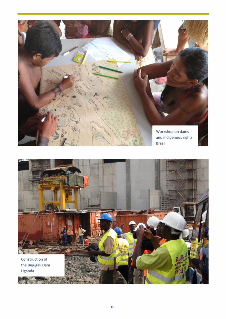
- 61 -
Workshop on dams
and indigenous rights
Brazil
Construction of
the Bujugali Dam
Uganda
- 62 -
5 MAINSTREAMING ENVIRONMENT INTO POWER PLANNING: SEA FOR THE
POWER DEVELOPMENT PLAN VII
VIET NAM Lothar Linde
Authorities Ministry of Energy and Trade, Institute of Energy, Min. of Natural Resources and Environment, Prime Minister’s office
Type of plan National power development plan 2011-2020
Scope of SEA National future energy supply
Key SEA issues Assessment of alternatives concerning fuel mix, including hydropower
Stakeholder engagement Consultation of private actors in the energy sector and all relevant authorities at national and provincial level
Duration and year 24 months; 2009 - 2011
Influence of SEA
• Most sustainable alternative is selected through a major cut in coalfired power generation (-22,000 MW) and a seven-fold increase in the amount of planned renewable energy, including hydropower
• Policy adopted; Payment of ecosystems services included (2010)
Link to SEA report https://gms-eoc.org/resources/two-seas-on-power-development-planning-in-viet-nam
5.1 INTRODUCTION
Power generation in Viet Nam currently relies on three
main primary energy sources: hydropower, coal, and
oil and gas. Electricity is distributed through a high
voltage transmission line system running from the
North to the South of Viet Nam.
The Viet Nam Power Development Plan VII provides a
long-term strategic framework to guide the
development of the power sector for the period 2011-
2020. Guided by the 2006-2010 Socio-economic
development plan (SEDP), the 2011-2015 SEDP, and
the Viet Nam 2020 Vision, it analyses future economic
and social development trends (=economic growth
scenarios), summarises related energy requirements
(=energy demand scenarios), and evaluates the cost
and benefits of a preferred supply option (=power
development scenario or “base case”).
To date, Viet Nam has developed seven Power
Development Plans. The geographic scope of the PDP
is national and the temporal scope 10 years forward
with an outlook for another 10 years. Revisions are
usually done every 5 years, mainly focusing on
reviewing which economic growth scenario has come
true and if that has repercussions on the energy
demand scenarios and supply choices previously
selected and followed.
Focus of this case study
Strategic Environmental Assessments (SEA) for the PDP
have been applied since the PDP VI (2006-2015), after
SEA became a legal requirement in Viet Nam in 2005.
At that time, the PDPs were not sufficiently developed
in the following three areas:
• no systematic accounting of environmental and
related social costs into cost-benefit analysis of
thermal power plants (TPP), hydropower projects
(HPP), and distribution infrastructure (transmission
lines);
• focus on a narrow energy mix (fossil fuel, hydro)
with limited consideration for other supply options
(renewables – small hydro, wind, solar);
• little consideration of demand side management
(DSM) options in energy demand and power
development scenarios.
- 63 -
5.2 BACKGROUND: CONTEXT AND ISSUES
Governance situation; social and environmental
setting
To ensure Viet Nam’s energy security for the coming
decades, the Power Development Plan has to respond
to a wide range of national and sector strategies and
their implications on power demand and development.
The most important orientation for the PDP is the
Socio-Economic Development Plan for the period
2011-2020 with 2030 vision. Growth trajectories in
other key development sectors are studied to inform
the PDP growth and energy demand scenarios,
including urban plans, land use plans, industrial park
development, Transport Development Strategy,
tourism plans, conservation plans, Regional
Multipurpose Water Resources Management Plans,
etc. Lastly, the PDP needs to be aligned to the energy
sectors’ own strategies and sub-plans: a) the National
Energy Development Strategy until 2020 with 2050
vision, b) the National Program for Energy Efficiency
and Conservation, c) the Master Plan for the
Development of the Coal Sector in Viet Nam until 2015
and vision to 2025, and d) the Master Plan for the
Development of the Oil and Gas Industry until 2015 and
direction to 2025.
Despite the countries size and diversity, a few common
environmental and socio-demographic characteristics
can be identified:
• Viet Nam’s N-S coastline and the Red River and
Mekong Delta are largely flat, dominated by
agriculture, industry and urban development, and
hold most of the countries’ population.
Consequently, the country’s major energy demand
falls into these areas, supplied by TPPs
concentrated in the area (which are also there for
short distances to import and distribution hubs for
coal, oil and gas).
• Viet Nam’s North and Centre region features large
mountain ranges with much lower population
density, infrastructure and productive assets, but a
dominance of forest resources and environmental
tourism sites. These areas not only focus on
hydropower development and distribution into the
coastal areas and deltas but are also critical for
water supply and regulation for the downstream
areas (agriculture, disaster protection).
For the purpose of baseline analysis, the PDP sub-
divides the country into seven geographic regions with
distinct (and distinctively different) environmental and
socio-economic features and characteristics. These
are: 1) North-West, 2) North-East, 3) Red River Delta,
4) North Centre and South-Central Coast, 5) Central
Highlands, 6) South-East, 7) Mekong Delta.
Comprehensive environmental and socio-demographic
profiles were developed for each of these regions to
identify and compare environmental and social issues.
Role of the SEA and how it is linked to the decision-
making process
The requirement to conduct SEA in Viet Nam’s strategic
planning was included in the Law on Environmental
Protection 2005 and reaffirmed in the law’s update in
2014. That makes Viet Nam the first country in South-
East Asia that has made SEA mandatory for over 15
years now.
While the legal requirement for SEA was in place since
2005, SEA implementation capacity was not.
Systematic institutional capacity building on SEA did
not start before it was becoming a legal requirement,
leaving many government organisations struggling
with fulfilling their SEA obligations without SEA-
trained/experienced staff nor additional/dedicated
financial resources for conducting SEAs.
Consequently, Viet Nam government organisations
turned to international agencies, in particular the Asian
Development Bank (ADB), the World Bank, GIZ, Dutch
RIVM/PBL, the Netherlands Commission for
Environmental Assessment and others to provide on-
the-job SEA capacity development.
In the case of the PDP, the first full SEA exercise was
conducted by the ADB on the PDP VI. This SEA was an
ex-post assessment with a focus on the national
hydropower sub-plan. Although the influence of the
SEA of the PDP VI on the plan was very limited due to
its ex-post nature, it was fundamental in building
conceptual understanding, appreciation and
commitment with the involved government agencies.
In response to that IoE requested support for the
preparation of the SEA of the PDP VII, the first ex-ante
SEA of the PDP in Viet Nam.
- 64 -
5.3 APPROACH AND METHODS USED
Institutional setting
There are four main actors related to SEA of the PDP in
Viet Nam:
1. the Ministry of Industry and Trade, in charge of
developing the Power Development Plan, for which
it set up a PDP working group;
2. the Institute of Energy, a subsidiary of MoIT, which
is tasked with the implementation of the SEA of the
PDP, for which it set up an SEA working group;
3. the Ministry of Natural Resources and Environment,
which assesses the SEA throughout the process and
the end results in close collaboration with IoE (and
the SEA working group);
4. the Prime Minister’s office, which issues the final
decision on both SEA and PDP.
The SEA working group consisted of 25 members from
different backgrounds, including environment,
economics, electricity etc. The SEA working group was
the main body to steer the design and implementation
of the SEA. It was composed of three groups of
contributors:
1. IoE staff taking a supervisory and steering role and
acting as the main link with the MoITs PDP working
group;
2. National experts from IoE, line ministries and
independent consultants, providing important
national knowledge and analytical inputs;
3. International experts, including staff of the Greater
Mekong Subregion (GMS) Environment Operations
Centre supported by ADB, providing SEA process
guidance and selected technical inputs and capacity
building.
Five members of the SEA group were also members of
the PDP VII working group. The SEA working group was
headed by the Director of the IoE, who is also the
chairman of the PDP VII.
The SEA working group engaged closely with a wide
range of additional organisations for data and
knowledge support, including electricity consulting
companies, Electricity of Viet Nam, National Petroleum
Corporation, Viet Nam Coal & Mineral Resources
Corporation, Forestry Bureau, Institute of Strategic
Development (under Ministry of Planning and
Investment), Institute of Ecology and Biological
Resources, Ministry of Natural Resources and
Environment, and of course the Institute of Energy
itself.
The SEA process
The SEA of the PDP VII followed the commonly
recognised SEA steps.
The analytical framework (step 1) was developed
during an inception workshop held in Qui Nhon city in
July 2010. Key socio-economic and environmental
issues relevant to the sustainability of the PDP were
identified and form the basis for the impact analysis
later.
Data collection and definition of the baseline analysis
(step 2) started soon after that inception workshop.
Data that was still valid from the SEA of the PDP VI – in
particular, the GIS analysis on HPPs – was reused. For
other aspects added to the analysis of the SEA PDP VII,
new statistical and spatial data was collected, and
criteria identified.
Box 1 Legal requirements SEA
Framework law: Law on Environmental Protection
2005 (update in 2014).
Additional legal and guiding documents informing
SEA implementation are:
a) Government Decree No 80/2006/ND-CP of dated
09th Aug 2006 on Instruction of the Law of
Environmental Protection (LoEP) implementation,
b) Government Decree No 21/2008/ND-CP dated
28th Feb 2008 on amendment to Decree
80/2006/ND-CP and
c) Circular No 05/2008/TT-BTNMT dated on 08th
Dec 2008 of MONRE on Instruction of EIA, SEA and
Environmental Protection Commitment
implementation. The latter is the main guiding
document to SEA.
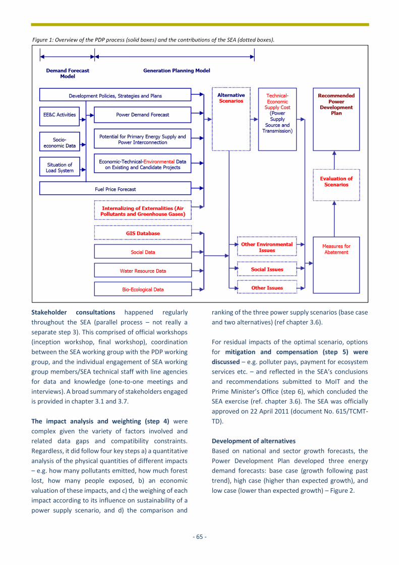
- 65 -
Stakeholder consultations happened regularly
throughout the SEA (parallel process – not really a
separate step 3). This comprised of official workshops
(inception workshop, final workshop), coordination
between the SEA working group with the PDP working
group, and the individual engagement of SEA working
group members/SEA technical staff with line agencies
for data and knowledge (one-to-one meetings and
interviews). A broad summary of stakeholders engaged
is provided in chapter 3.1 and 3.7.
The impact analysis and weighting (step 4) were
complex given the variety of factors involved and
related data gaps and compatibility constraints.
Regardless, it did follow four key steps a) a quantitative
analysis of the physical quantities of different impacts
– e.g. how many pollutants emitted, how much forest
lost, how many people exposed, b) an economic
valuation of these impacts, and c) the weighing of each
impact according to its influence on sustainability of a
power supply scenario, and d) the comparison and
ranking of the three power supply scenarios (base case
and two alternatives) (ref chapter 3.6).
For residual impacts of the optimal scenario, options
for mitigation and compensation (step 5) were
discussed – e.g. polluter pays, payment for ecosystem
services etc. – and reflected in the SEA’s conclusions
and recommendations submitted to MoIT and the
Prime Minister’s Office (step 6), which concluded the
SEA exercise (ref. chapter 3.6). The SEA was officially
approved on 22 April 2011 (document No. 615/TCMT-
TD).
Development of alternatives
Based on national and sector growth forecasts, the
Power Development Plan developed three energy
demand forecasts: base case (growth following past
trend), high case (higher than expected growth), and
low case (lower than expected growth) – Figure 2.

- 66 -
Based on these power demand scenarios, the PDP
developed a power development scenario (supply
options). This scenario was sent to the SEA working
group for assessment and analysis, forming the starting
point for the SEA.
The SEA working group’s analysis of the PDP power
development scenario revealed several concerns of
this initial power development scenario:
1. Strong focus on thermal power and related fuel
imports challenges Viet Nam’s energy security
(market price fluctuation, political dependence);
2. Shift from oil/gas to coal further worsens the
environmental footprint of thermal power
production;
3. Location of TPPs in high population areas increases
risk of environmental and social impacts.
Accordingly, the SEA working group proposed
adjustments to the power development scenario,
which - after endorsement by the PDP working group -
became the new base case scenario. Key adjustments
were:
1. Maintain and expand (instead of reducing) gas
fired TPPs and look for LNG import sources;
2. Increase share of renewable energy to 4%, mainly
from small hydro;
3. Add three additional nuclear power plants.
While this adjusted scenario was now considered the
PDP base case scenario, the SEA working group and the
PDP VII working group continued to consider more
possibilities to optimise the base case scenario, leading
to two alternatives scenarios being analysed by the SEA
(Table 1).
These alternative scenarios tried to capture additional
optimisation options not yet fully captured in the base
case scenario, in particular: 1) increase energy
efficiency in power production, 2) reduce energy loss in
power distribution (transmission grid) and 3) increase
share of renewable energy.
Table 1: Overview of main characteristics of SEA alternative power development scenarios
Scenario Measure (compared to base case) Expected results by 2030
Alt. 1 Increase energy efficiency to 5-8% by 2030 compared with 1-3% in the base case scenario (in production and distribution)
• Reduce energy loss of the whole system to <7% through upgrade to high efficiency thermal and development of super-voltage transmission lines (1000-1100kV)
• Saves approx. 56.3 mil, tons of coal imports
• Estimated avoided env/social cost: 3.893 mill USD
Alt. 2 Increase the rate of renewable energy to 8-10% by 2030 compared with 3,8-4% in the base case scenario.
• Further increase the ratio of gas turbine instead of coal fire TPP
• Reduction of 6200MW from coal, saving about 9 coal fired TPPs and approx. 10,6 mill tons of coal,
• Estimated avoided env/social cost: 1.868 mill USD
Figure 2: Power demand forecast until 2030 (MW)
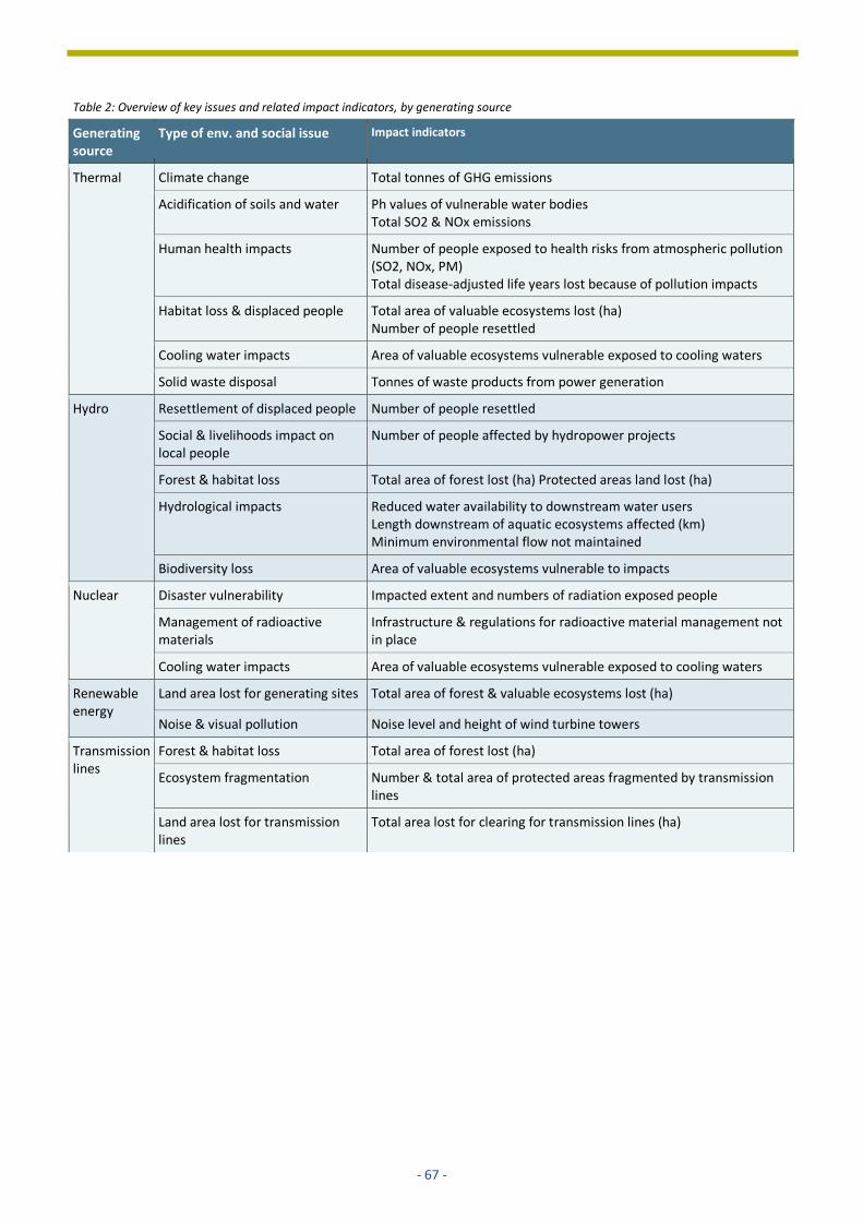
- 67 -
Table 2: Overview of key issues and related impact indicators, by generating source
Generating source
Type of env. and social issue Impact indicators
Thermal Climate change Total tonnes of GHG emissions
Acidification of soils and water Ph values of vulnerable water bodies Total SO2 & NOx emissions
Human health impacts Number of people exposed to health risks from atmospheric pollution (SO2, NOx, PM) Total disease-adjusted life years lost because of pollution impacts
Habitat loss & displaced people Total area of valuable ecosystems lost (ha) Number of people resettled
Cooling water impacts Area of valuable ecosystems vulnerable exposed to cooling waters
Solid waste disposal Tonnes of waste products from power generation
Hydro Resettlement of displaced people Number of people resettled
Social & livelihoods impact on local people
Number of people affected by hydropower projects
Forest & habitat loss Total area of forest lost (ha) Protected areas land lost (ha)
Hydrological impacts Reduced water availability to downstream water users Length downstream of aquatic ecosystems affected (km) Minimum environmental flow not maintained
Biodiversity loss Area of valuable ecosystems vulnerable to impacts
Nuclear Disaster vulnerability Impacted extent and numbers of radiation exposed people
Management of radioactive materials
Infrastructure & regulations for radioactive material management not in place
Cooling water impacts Area of valuable ecosystems vulnerable exposed to cooling waters
Renewable energy
Land area lost for generating sites Total area of forest & valuable ecosystems lost (ha)
Noise & visual pollution Noise level and height of wind turbine towers
Transmission lines
Forest & habitat loss Total area of forest lost (ha)
Ecosystem fragmentation Number & total area of protected areas fragmented by transmission lines
Land area lost for transmission lines
Total area lost for clearing for transmission lines (ha)
- 68 -
Selection of issues and indicators (scoping)
All three power development scenarios – optimised
base case scenario and two alternative scenarios –
were subject to impact analysis. For the impact
analysis, relevant socio-economic and environmental
issues were identified during the inception/scoping.
workshop (July 2010) and following individual
consultations with and by the SEA working group. The
result is a list of strategic environmental and social
issues and related indicators, constituting the
assessment framework of the SEA of PDP VII. A brief
summary is given in Table 2
Impact analysis: methods and tools
Besides the use of national and provincial summary
data for a broader assessment of environmental and
socio-demographic state and trends, the impact
analysis of the SEA of the PDP was characterised by two
main innovations new to SEA in Viet Nam and the GMS
at that time:
• extended use of spatial analysis to quantify
different environmental and socio-demographic
assets (proxies for impact indicators) within the
perimeter of the TPPs, HPPs and transmission lines;
• application of cost factors/coefficients (US$ per
impact unit) to translate statistics into economic
values broadly compatible with cost-benefit
analysis.
For TPPs, an Euclidean distance buffer (straight line
distance) was applied to each TPP subdivided into 3
zones of impacts around the plant site (Figure 3). While
this approach does not model an exact plume at a
certain time and wind direction, it is a deliberate and
valid abstraction given the long analytical horizon (20
years), the lack of detailed atmospheric data for such a
time horizon, and the strategic nature of the
assessment.
For transmission lines, an Euclidean distance buffer
was used to calculate impacts with regard to
forest/ecosystem loss and fragmentation (Figure 3).
For HPPs, a slightly different approach was used. The
dam inundation areas were calculated using a “bathtub
approach” with the base elevation and the average
water level (height) at dam site as benchmarks to
extract the approximate reservoir from a digital
elevation model. Further impacts around the dam site
are expected through dam construction (incl.
necessary support infrastructure, in-migration
(laborers)) and the ecological changes triggered by the
same (e.g. changes in hydrology). This was recognised
through creating a second, wider outline (zone of
influence) around the dam site based on accessibility
(Least-cost path calculation). Both inundation zones
and zones of influence were overlaid on relevant
indicator layers for a zonal summary of the assets
within (e.g. population density map, forest map etc)
(Figure 4).
In a final step, the statistical data produced by the
government and from the GIS analysis were multiplied
with cost coefficients to arrive at values compatible
with the cost-benefit analysis.
As a result of this accounting each individual power
plant (thermal, hydro) and distribution infrastructure
(transmission line, by section) could be transparently
ranked and compared for its costs and benefits. This
led not only to the reduction in number of coal-gas
fired TPPs but also the suspension of two HPP falling
into protected areas.

- 69 -
Figure 3: Left: GIS-bases TPP zone of influence around a TPP site overlaid on population density map, Right: transmission lines overlaid on PA and forest areas (% showing size of fragments compared to original patch without transmission line).
Figure 4: Above: GIS-based inundation zone (blue) and zone of influence (yellow) around a dam site, Under: overlay on land use to identify assets at risk (zonal statistics).

- 70 -
Comparison of alternatives: how, criteria, who was involved The impact analysis of the SEA of the PDP VII strongly pushed to provide reliable and relevant quantitative data to the cost-benefit analysis as the foundation of the comparison of the power development scenarios
(comparison of alternatives). It was established that both alternative scenarios (Alt 1 - energy efficiency, Alt 2 – more renewables) are reducing the environmental and social impacts compared to the base case scenario. Examples of the impacts of both scenarios are provided in Figure 5 and 6.
Figure 5:
Results of alternative scenario 1 (INCREASED ENERGY EFFICIENCY) compared to base case: TOP: Reductions in demand for coal 2011-
2030, MIDDLE: Reductions in atmospheric pollution (Unit: ton, CO2: 1,000 tons), BOTTOM: Reduction in health costs (Unit: million US$)
Figure 6:
Results of alternative scenario 1 (EXPANDED RENEWABLE ENERGY) compared to base case: TOP: Reductions in demand for coal 2011-
2030, MIDDLE: Reductions in atmospheric pollution (Unit: ton, CO2: 1,000 tons), BOTTOM Reduction in health costs (Unit: million US$)

- 71 -
Despite their potential reduction of impacts, residual
impacts remain for both. Consequently, the SEA team
proposed to consider development of a range of power
source specific mitigation and compensation options as
summarised in table 3. Particularly the nationwide
upscaling and adoption of Payment for Forest
Ecosystem Services was recommended by the SEA and
prioritised by the government in the following years. In
addition, investing in science & technology to reduce
emission, and improving the collaboration of inter-area
power development through the Regional Power Trade
Coordination Committee was proposed as source-
independent measures.
Public participation and quality review
During the SEA, 2 national conferences were organised
with the participation of about 70 experts from various
ministries, relevant government management
agencies, and businesses in the electricity sector,
consulting companies, and provincial Departments of
Natural Resources and Environment and Departments
of Industry and Trade. The provincial departments
played an important role in making the SEA
consultation a success. They provided technical
information and data, as well as their expertise
opinions to complete the SEA.
One shortcoming of the consultations was the lack of
direct involvement of local communities. Despite this,
especially provincial authorities were aware of the
environmental and social risks and raised them
explicitly, therefore raising many concerns that local
communities and non-governmental organisations
would have brought forward.
Quality control of the SEA
happened by 3 separate groups:
the PDP working group, the
MONRE SEA appraisal team
(working directly with the SEA
working group and not through
the PDP working group), and the
Prime Minister’s office.
Monitoring and follow up
The GMS Core Environment
Program was only mandated to
support the SEA preparation and
implementation until approval.
Consequently, the activity ended
with the approval and the
consultant team (not EOC core
staff) disbanded after April 2011.
While the expert team did not
stay beyond the completion of
the SEA, the EOC core team
continued to engage with IoE and
MoIT after the end of the SEA
exercise. In the case of the SEA of
the PDP VI, this ex-post
engagement helped to further deepen the
appreciation and commitment to SEA resulting in the
request for ex-ante support of the PDP VII. In the case
of the SEA of the PDP VII, the ex-post engagement was
critical to request for advice for the revision of the PDP
VII, leading to even more ambitious energy efficiency
and renewable energy targets and SEA “champions” at
IoE.
Table 3: Overview of proposed mitigation and compensation options
Generating source
Proposed mitigation or compensation option
Thermal Introduce polluter pays for emissions and waste discharges
Promote renewable energy and energy efficiency to reduce dependence on coal-fired generation
Hydro Reduce deforestation through introduction of Payment for Forest Environmental Services
Strengthen the management of and awareness on Protected Areas
Aquaculture development to mitigate fisheries losses
Nuclear Careful site selection for deposit of radioactive waste to minimise environmental and social impacts
Develop infrastructure and management systems for handling radioactive materials
Renewable energy
Careful site selection to minimise environmental impacts (e.g. bird migratory routes, proximity to protected areas)
Transmission lines
Transmission line routes to minimise environmental impacts and avoid protected and residential areas
Develop super voltage transmission lines (1100kV)

- 72 -
The SEA did not develop or support the development
of an ESMP for the PDP. However, the SEA
recommended that environmental management plans
for individual hydropower projects “should specify
environmental water releases, including for dams
owned or operated by the private sector”. Since the
ESMP is “traditionally” an instrument of EIA, which Viet
Nam also has a legislation for, this was not considered
a priority under the SEA.
However, the need for thorough SEA “aftercare”
remains an important topic. While the strong
commitment of MoIT and IoE to the SEA of the PDP
meant that in this case it was not a critical component,
there are many SEA cases in Viet Nam and elsewhere
in the GMS where there is less commitment which –
due to a common lack of clear accountability
mechanisms in with regard to SEA – promotes SEA
reports and their results being “shelved” instead of
being used.
Expertise, duration & costs
ADB supported mainstreaming environmental and
social concerns into the PDP over a period of 12 years
stretching over three SEA’s: the SEA of the PDP VI, the
SEA of the PDP VII and the revision of the PDP VII. The
support period also includes continued engagement
with the Regional Power Trade Coordination
Committee (RPTCC) which continues to date.
Overall, the “average” cost of the SEAs has reduced
significantly over that period. Reason for this is growing
commitment and capacity of IoE and MoIT, allowing
the stepwise reduction of international inputs. At this
point the SEA is led by IoE staff with international
support is only taking an advisory role. Because of the
increase in scope, analytical depth and impact of the
SEA of the PDP VII (ex-ante) compared to the SEA of the
PDP VI (ex-post), the costs were slightly higher for the
first, but in terms of “value for money” (impact on
PDP), the costs was arguably lower. A brief comparison
of the duration, costs and key expertise in the three
SEAs is provided in table 4.
Table 4: Comparison of duration, cost and key expertise between SEAs for PDP
SEA PDP VI PDP VII PDP VII revision
Duration 2006-2007 2010-2011 2015
Total cost in US$*
500,000 <500,000
Man-months (intl./natl.)*
~140 days intl./~200 days natl.
~90 days intl./~200 days natl.
~30 days intl.
Key expertise (intl.)
Team leader SEA, environment specialist, env. economist, hydropower specialist, GIS
Team leader SEA, energy economist, GIS
SEA advisor
* The numbers provided in this section are broad estimates.
5.4 RESULTS AND LESSONS LEARNT
Contribution to decision-making
The contributions of the SEA of the PDP VII should not
be viewed individually, but in combination with the
previous SEA of the PDP VI and the following SEA advice
to the Revision of the PDP VII.
Through this continuous engagement during and
between SEAs it was possible to trigger decisions that
culminated in a significantly more sustainable PDP
(PDP VII revision), in particular through:
a) a major cut in coalfired power generation (-22,000
MW) and
b) a seven-fold increase in the amount of renewable
energy (table 5).
Table 5: Generation mix of Viet Nam’s PDP VII and revised PDP VII (MW)
Source PDP VII 2011
Revised PDP VII 2014
Coal 77,160 55,252
Natural gas and oil 17,465 19,078
Hydropower and pumped storage
21,125 21,871
Other renewable energy (incl small hydro)
4,829 27,199
Nuclear 10,700 4,600
Imported 6,109 1,508
Generation capacity 2030 137,388 129,508
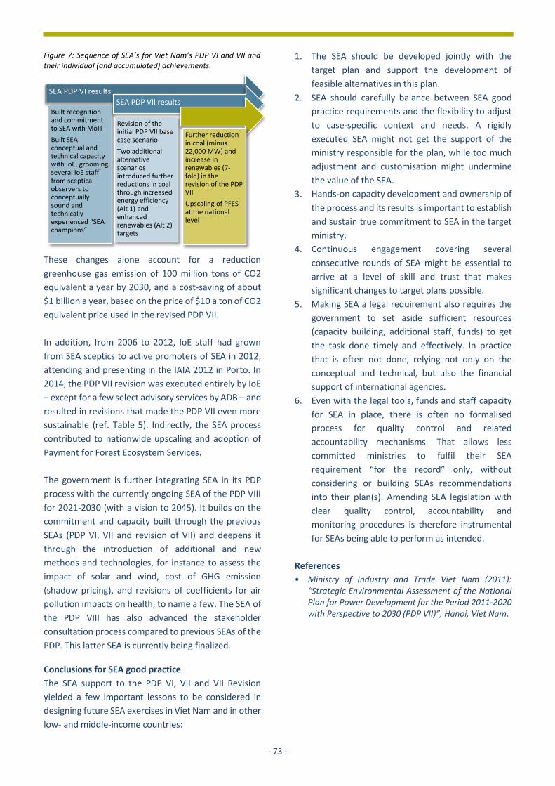
- 73 -
Figure 7: Sequence of SEA’s for Viet Nam’s PDP VI and VII and their individual (and accumulated) achievements.
These changes alone account for a reduction
greenhouse gas emission of 100 million tons of CO2
equivalent a year by 2030, and a cost-saving of about
$1 billion a year, based on the price of $10 a ton of CO2
equivalent price used in the revised PDP VII.
In addition, from 2006 to 2012, IoE staff had grown
from SEA sceptics to active promoters of SEA in 2012,
attending and presenting in the IAIA 2012 in Porto. In
2014, the PDP VII revision was executed entirely by IoE
– except for a few select advisory services by ADB – and
resulted in revisions that made the PDP VII even more
sustainable (ref. Table 5). Indirectly, the SEA process
contributed to nationwide upscaling and adoption of
Payment for Forest Ecosystem Services.
The government is further integrating SEA in its PDP
process with the currently ongoing SEA of the PDP VIII
for 2021-2030 (with a vision to 2045). It builds on the
commitment and capacity built through the previous
SEAs (PDP VI, VII and revision of VII) and deepens it
through the introduction of additional and new
methods and technologies, for instance to assess the
impact of solar and wind, cost of GHG emission
(shadow pricing), and revisions of coefficients for air
pollution impacts on health, to name a few. The SEA of
the PDP VIII has also advanced the stakeholder
consultation process compared to previous SEAs of the
PDP. This latter SEA is currently being finalized.
Conclusions for SEA good practice
The SEA support to the PDP VI, VII and VII Revision
yielded a few important lessons to be considered in
designing future SEA exercises in Viet Nam and in other
low- and middle-income countries:
1. The SEA should be developed jointly with the
target plan and support the development of
feasible alternatives in this plan.
2. SEA should carefully balance between SEA good
practice requirements and the flexibility to adjust
to case-specific context and needs. A rigidly
executed SEA might not get the support of the
ministry responsible for the plan, while too much
adjustment and customisation might undermine
the value of the SEA.
3. Hands-on capacity development and ownership of
the process and its results is important to establish
and sustain true commitment to SEA in the target
ministry.
4. Continuous engagement covering several
consecutive rounds of SEA might be essential to
arrive at a level of skill and trust that makes
significant changes to target plans possible.
5. Making SEA a legal requirement also requires the
government to set aside sufficient resources
(capacity building, additional staff, funds) to get
the task done timely and effectively. In practice
that is often not done, relying not only on the
conceptual and technical, but also the financial
support of international agencies.
6. Even with the legal tools, funds and staff capacity
for SEA in place, there is often no formalised
process for quality control and related
accountability mechanisms. That allows less
committed ministries to fulfil their SEA
requirement “for the record” only, without
considering or building SEAs recommendations
into their plan(s). Amending SEA legislation with
clear quality control, accountability and
monitoring procedures is therefore instrumental
for SEAs being able to perform as intended.
References
• Ministry of Industry and Trade Viet Nam (2011): “Strategic Environmental Assessment of the National Plan for Power Development for the Period 2011-2020 with Perspective to 2030 (PDP VII)”, Hanoi, Viet Nam.
Rev. of PDP VII results
SEA PDP VI results
Built recognition and commitment to SEA with MoIT Built SEA conceptual and technical capacity with IoE, grooming several IoE staff from sceptical observers to conceptually sound and technically experienced “SEA champions”
SEA PDP VII results
Revision of the initial PDP VII base case scenario Two additional alternative scenarios introduced further reductions in coal through increased energy efficiency (Alt 1) and enhanced renewables (Alt 2) targets
Further reduction in coal (minus 22,000 MW) and increase in renewables (7-fold) in the revision of the PDP VII Upscaling of PFES at the national level
- 74 -
About the author
Lothar Linde (MSc) is an Environment and Spatial
Planning Specialist with over 20 years of research and
work experience. He holds a MSc degree in Geography
and Landscape Ecology from the University of Leipzig,
Germany. Between 2002 and 2006 he worked as a
researcher on joint projects of the University of Leipzig
and the Helmholtz Centre for Environmental Research
(UFZ), and the United Nations Environment Program
(UNEP) Reginal Resource Center for Asia and the
Pacific. Since 2006 Lothar has worked as an
independent expert on over 20 long and short-term
projects of the Asian Development Bank, UNDP, the
World Bank, and the African Development Bank. Lothar
has been involved in over 10 Strategic Environmental
Assessments in the Greater Mekong Subregion,
supported the environmental analysis for the Greater
Mekong Subregion Regional Investment Framework
2012-2022, and lead the development and piloting of
several innovative spatial decision support tools on
land use change projection, pollution estimation, and
spatial multi-criteria evaluation for sustainable
investments. Lothar is currently also pursuing a PhD at
the Center for Development and Environment of the
University of Bern, Switzerland. [email protected]
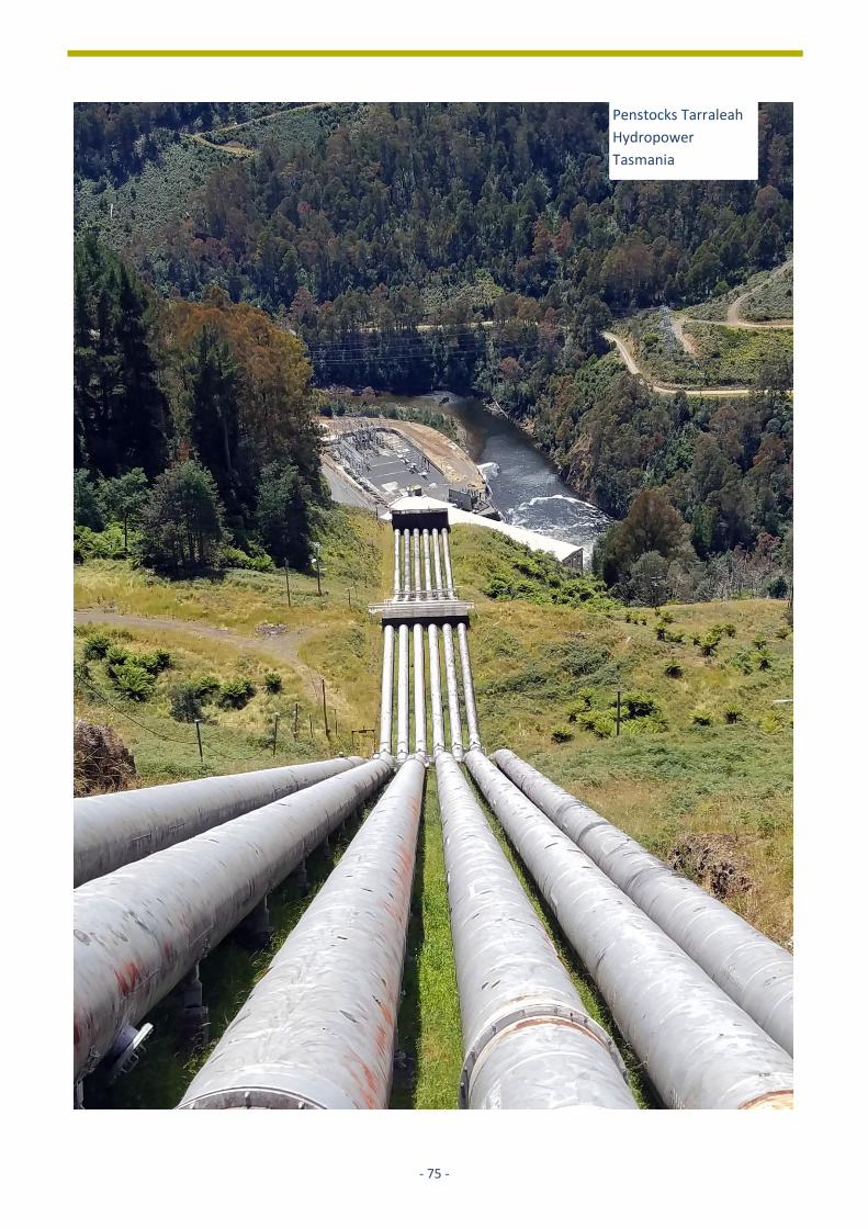
- 75 -
Penstocks Tarraleah
Hydropower
Tasmania
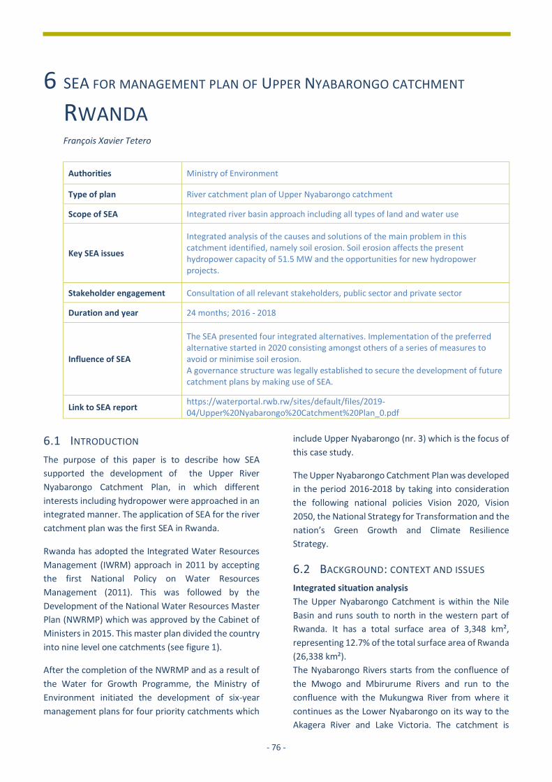
- 76 -
6 SEA FOR MANAGEMENT PLAN OF UPPER NYABARONGO CATCHMENT
RWANDA François Xavier Tetero
Authorities Ministry of Environment
Type of plan River catchment plan of Upper Nyabarongo catchment
Scope of SEA Integrated river basin approach including all types of land and water use
Key SEA issues
Integrated analysis of the causes and solutions of the main problem in this catchment identified, namely soil erosion. Soil erosion affects the present hydropower capacity of 51.5 MW and the opportunities for new hydropower projects.
Stakeholder engagement Consultation of all relevant stakeholders, public sector and private sector
Duration and year 24 months; 2016 - 2018
Influence of SEA
The SEA presented four integrated alternatives. Implementation of the preferred alternative started in 2020 consisting amongst others of a series of measures to avoid or minimise soil erosion. A governance structure was legally established to secure the development of future catchment plans by making use of SEA.
Link to SEA report https://waterportal.rwb.rw/sites/default/files/2019-04/Upper%20Nyabarongo%20Catchment%20Plan_0.pdf
6.1 INTRODUCTION
The purpose of this paper is to describe how SEA
supported the development of the Upper River
Nyabarongo Catchment Plan, in which different
interests including hydropower were approached in an
integrated manner. The application of SEA for the river
catchment plan was the first SEA in Rwanda.
Rwanda has adopted the Integrated Water Resources
Management (IWRM) approach in 2011 by accepting
the first National Policy on Water Resources
Management (2011). This was followed by the
Development of the National Water Resources Master
Plan (NWRMP) which was approved by the Cabinet of
Ministers in 2015. This master plan divided the country
into nine level one catchments (see figure 1).
After the completion of the NWRMP and as a result of
the Water for Growth Programme, the Ministry of
Environment initiated the development of six-year
management plans for four priority catchments which
include Upper Nyabarongo (nr. 3) which is the focus of
this case study.
The Upper Nyabarongo Catchment Plan was developed
in the period 2016-2018 by taking into consideration
the following national policies Vision 2020, Vision
2050, the National Strategy for Transformation and the
nation’s Green Growth and Climate Resilience
Strategy.
6.2 BACKGROUND: CONTEXT AND ISSUES
Integrated situation analysis
The Upper Nyabarongo Catchment is within the Nile
Basin and runs south to north in the western part of
Rwanda. It has a total surface area of 3,348 km²,
representing 12.7% of the total surface area of Rwanda
(26,338 km²).
The Nyabarongo Rivers starts from the confluence of
the Mwogo and Mbirurume Rivers and run to the
confluence with the Mukungwa River from where it
continues as the Lower Nyabarongo on its way to the
Akagera River and Lake Victoria. The catchment is
- 77 -
renowned as Rwanda’s ‘water tower’ and has a
significant number of large tributaries, such as the
Mwogo, Rukarara, Mbirurume River, Munzanga and
Satinsyi Rivers. The source of Rukarara River is
considered the furthest source of the Nile River.
Upper Nyabarongo is considered a strategic catchment
in Rwanda. It has abundant water resources with an
average annual rainfall above 1600 mm and an
elevation ranging between 1,460-2,950 meters. The
predominance of steep slopes and high rainfall within
this catchment make it highly potential for hydropower
development. Currently, 5 hydropower plants are
operational on the Nyabarongo River with a total
capacity of 51.5 MW (Figure 2). These include Rukarara
I (9 MW), Rukarara II (2.2 MW), Rukarara VI (10 MW),
Mushishito/Rukarara V (2.3 MW) and Nyabarongo I (28
MW).
The Upper Nyabarongo Catchment is strongly reliant
on rainfed agriculture and produces traditional cash
crops like coffee and tea, along with new ones, like
honey and horticulture. The main food crops growing
in this area are maize, beans, potato, wheat, cassava,
banana, fruits and rice. Approximately 70% of
households are also engaged in livestock rearing with
the most commonly owned species being cattle, goats,
pigs, rabbits and chickens. Fish farming is already
practised in the Huye and Nyanza Districts and there is
a shift to increase productivity in this sector through
construction of small dams and fishponds. Agroforestry
and forest plantations have been promoted as
appropriate land use management systems in the
catchment. Mining and quarrying for and of granite,
tin, wolfram, colombo-tentalite (coltan) and cassiterite
are important sources of revenue and employment. In
Rutsiro, Ngororero, Nyamagabe, Muhanga, Karongi
Figure1: Rwanda level one catchments Explanation of the abbreviations of the nine level one catchments: CKIV- Congo Kivu Catchment,(ii)
CRUS Congo Rusizi Catchment, (iii) NNYU Nile Nyabarongo Upper Catchment, (iv) NMUK Nile Mukungwa Catchment, (v) NNYL Nile
Nyabarongo Lower Catchment, (vi) NAKN Nile Akanyaru Catchment, (vii) NAKU Nile Akagera Upper Catchment, (viii) NAKL Nile Akagera
Lower Catchment, (ix) NMUV Nile Muvumba Catchment

- 78 -
and in the Nyungwe Forest. Non-regulated artisanal
mining is commonly practiced. Tourism opportunities
around the natural forests in Nyungwe, Mukura,
Gishwati and Busaga exist, but are still largely
underexploited.
The total number of people living within the catchment
is around 1.2 million (7% urban, 93% rural). The
population density in the catchment is high, with the
highest density areas in Muhanga and Nyamagabe and
Huye (900 – 1,500 inhabitants/km2). Another densely
populated area is Ngororero (600 – 900
inhabitants/km2). Poverty rates in the catchment area
are still very high, with approximately 41% classified as
poor and 16% as extremely poor. The cause of poverty
has often been linked to high population growth and
declining soil fertility in a largely agrarian-based
economy.
The main sources of pollution of surface water are from
soil erosion of hillside agriculture, resulting in high to
extremely high river sediment loads and inappropriate
mining. The former has an adverse impact on, and high
removal costs for, drinking water intakes, as well as
turbines and related infrastructure for hydropower
stations. Both hydropower and drinking water intakes
often need to shut down during periods of extreme
sediment loading and operations also suffer regular
interruptions as a result of the need to undertake
sediment removal from settling basins associated with
the intakes. Mining may also lead to contamination
with heavy metals from mine ores, or with substances
used in ore processing posing a human health risk. The
floods are recurrent in the Upper Nyabarongo
Catchment, specifically in the Mwogo and Kiryango Sub
Catchments. Deforestation is also a threat in the Upper
Nyabarongo Catchment as it reduces soil cover and
increases siltation of rivers. Inappropriate settlement
leads to generation of liquid and solid wastewater
without any prior treatment.
Figure 4 illustrates an analysis of the causal relations in
the catchment and it shows how the reduced
hydropower capacity is the direct result of high
sediment load in the Nyabarongo River. This also
effects the lifetime of the Nyabarongo I Hydropower
Project that is located in the catchment, see box 1.
Figure 3: Map showing soil erosion risk areas in the Upper
Nyabarongo Catchment
Figure 2: Map showing the location of hydropower plants
in the Upper Nyabarongo Catchment

- 79 -
Moreover, the high shutdown time of the hydropower
facilities is also an important reason for the relatively
high electricity prices.
Objectives of the plan
The above-mentioned challenges hinder the
sustainable use and further exploration of the
opportunities for development. That was the main
reason for the development of this Management Plan.
The main objective for the development of the river
catchments’ plan is to “Effectively manage land, water,
and related natural resources, to contribute to
sustainable socio-economic development and
improved livelihoods. Taking into consideration
environmental flow, downstream water demands and
resilience to climate change, and minimise water
related disasters.”
The specific objectives were mainly to:
• improve water quality and quantity in water
bodies considering resilience to climate change in
the catchment;
• reduce the pressure on natural resources by
diversifying alternative livelihoods;
• ensure equitable allocation of available water
resources for rural and urban users of current
and future generations;
• strengthen the water governance framework to
ensure effective implementation of integrated
programmes.
Achievement of the specific objectives are conditional
for optimisation and lifetime of the present
hydropower capacity and further development of new
capacity. However, specific objectives for hydropower
have not been set. Box 1 provides a brief description
of the characteristics of the hydropower sector in
Rwanda.
Figure 4: Analysis of problems and responses in the most degraded areas of Upper Nyabarongo

- 80 -
Table 1: List of operational and proposed hydropower plans in Rwanda in 2020.
Hydro-electric station River Type Capacity (MW) Year completed
Operational – medium
Mukungwa Mukungwa Reservoir 12 MW 1982
Mukungwa II Mukungwa Run of river 3.6 MW 2010
Ntaruka Mukungwa Reservoir 11.5 MW 1959
Rugezi Mukungwa Run of river 2.6 MW 2011
Rwaza-Muko Mukungwa Run of river 2.6 MW 2018
Nyabarongo I** Nyabarongo Run of river 28 MW 2014
Rukarara I** Rukarara Run of river 9.5 MW 2010
RukararaII** Rukarara Run of river 2.2 MW 2014
RukararaVI** Rukarara Run of river 10 MW 2016
Mushishito(Rukarara V)** Rukarara Run of river 2.3 MW 2019
Rusizi I* Rusizi Run of river 4.1 MW 1958
Rusizi II* Rusizi Run of river 12.0 MW 1989
Gisenyi Sebeya Run of river 1.7 MW 1957
Gihira Sebeya Run of river 1.8 MW 1984
Keya Sebeya Run of river 2.2 MW 2011
Giciye I Giciye Run of river 4.0 MW 2014
Giciye II Giciye Run of river 4.0 MW 2016
Operational – mini / micro 4.5 MW
Total operational 118.6 MW
Proposed – medium
Rusumo * Kagera Run of river 80 MW 2021
Nyabarongo II Nyabarongo Reservoir 120 MW 2024
Rusizi III * Ruzizi Reservoir 147 MW 2026
Rusizi IV * Ruzizi Run of river 200 MW 2028
Proposed – mini / micro 8 MW 2024
Total 555 MW
*) Developed with neighbouring countries, the capacity indicated is available for Rwanda. **) Rukarara I, II, V & VI and Nyabarongo I are located in the Upper Nyabarongo Catchment while Nyabarongo II will be located in the Lower Nyabarongo Catchment. Sources : ESSP 2014 ; SEA 2015 ; https://www.mininfra.gov.rw/index.php?id=79
Box 1: Hydropower in Rwanda
The total installed power generation capacity is about 228 MW, hydropower contributing 48% of it. Nearly all
operational hydropower projects are medium size and most of these are run of the river type of projects. Scattered
though the country micro and mini hydropower project are operational and nearly all are connected to the national
grid (see table 1). There are also pico-hydropower plants in the range of 1-10 kW which are either publicly owned or
operated by the local communities or entirely private. They are not included in the table.
Rwanda is planning to expand its power generation capacity up to 556 MW in 2024 and hydropower is expected to
contribute 74% to it. Therefore, shared regional hydropower projects will be developed with neighbouring countries
and many micro and small hydropower projects will be developed with an estimated capacity of 8 MW.

- 81 -
6.3 APPROACH AND METHODS USED
As this concerns a Strategic Plan, carrying out a
Strategic Environmental Assessment (SEA) was
obligatory according to the Rwandan Organic Law on
the Environment (2005). A tailor-made approach was
developed supported by the Netherlands Commission
for environmental Assessment (NCEA), that advised on
integration of plan development and SEA requirements
(See table 2).
Table 2: Overview of SEA steps and the integrated approach based upon IWRM and SEA steps
SEA process steps Integrated approach - IWRM & SEA Screening 1. Reach consensus on the need for SEA
and its link to planning
n.a.
2. Find stakeholders and announce start of the plan process
Situation analysis: Develop catchment characterisation report with analysis of important aspects of the catchment: • Physical characteristics; • Water resources characteristics; • Socio-economic analysis; • Stakeholders analysis (of SEA step 2) Consistency analysis of
existing policies, plans, programmes (SEA step 4).
Scoping 3. Do a consistency analysis for
relevant policies that have consequences for the plan
4. Develop a shared vision on problems & opportunities …
Vision development: Creating a vision for the medium to longer term future (SEA step 3) with the Catchment Task Force, kicking off in a joint scoping workshop, and developing ToR for the plan development and assessment (SEA step 5)
…define plan objectives and draft alternatives to reach these objectives
5. Set ToR for the technical assessment, based on scoping results
Integrated planning: Develop Catchment Plan considering competing land and water interests and comprising: • water allocation; • water resources protection/conservation; • land use / catchment rehabilitation. Assessment of development alternatives (SEA step 6).
Assessment 6. Assess impacts of alternatives and
document this. 7. Organise (independent) quality
review (involving stakeholders)
Independent quality assurance of documentation by the Catchment Task Force and representatives of key Agencies and Ministries (SEA step 7). Participatory decision making involving local and central levels (SEA step 8)
Formal decision-making 8. Discuss with all stakeholders the
preferred alternative 9. Motivate the (political) decision in
writing
n.a.
n.a. Coordinated implementation: the implementation of the sector and agency plans respects the time schedules and designs formulated in the integrated plans
Monitoring 10. Monitor the implementation and
discuss the results
Monitoring of implementation is assured by stakeholders in the catchment, together with regular monitoring procedures of implementing organisations, resulting in annual catchment plan implementation M&E reports (implementation of SEA step 10).

- 82 -
Organisational structure
An organisational structure for the development of
catchment plans was set up at national and at
catchment level. The lead agency is the Water
Resources Management Department (WRMD) of the
Rwanda Water and Forestry Authority (RWFA)
responsible to guide the development of the plans with
the support of a team of experts from the Water for
Growth Programme. A steering committee was
established, chaired by the Permanent Secretary of the
Ministry of Environment and senior representatives of
key ministries and agencies namely the Ministry of
Local Government (MINALOC), the Ministry of
Infrastructure (MININFRA), the Ministry of Agriculture
and Animal Resources (MINAGRI), the Ministry in
charge of Emergency Management (MINEMA), a
representative of Non-Governmental Organisations
(WATER AID) and the representative of the Embassy of
the Kingdom of The Netherlands (EKN) in Kigali which
funded the Water for Growth Programme. The steering
committee was responsible for approval of
catchments’ management plans. They were supported
by a technical team of experts from their respective
institutions which was called the Focal Group.
Stakeholder engagement
Adoption of a participatory approach is one of the
characteristics of the integrated approach applied. In
order to ensure a better representation of
stakeholders at catchment level, a task force was
established for the catchment known as the Catchment
Task Force (CTF). The composition of this task force
included:
1. the Vice Mayor in charge of Economic Affairs from
each district covered by the catchment (one of
them was to be elected as the Chair of the CTF);
2. officers in charge of environment from each
district covered by the catchment;
3. a representative of the women council from each
district;
4. a representative of the private sector from each
district;
5. a representative of the youth council from each
district; and
6. a representative of Civil Society Organisations
(CSOs) from each district.
The consultation process also included representatives
of key agencies and ministries like those in charge of
agriculture, energy, water and sanitation, mining and
disaster management. The members of the task force
and the representatives of key agencies and ministries
were consulted at each step of the planning process.
Scenarios and alternatives
As a result of the planning process, a programme of
measures for the catchment was formulated which
consisted of a list of projects or interventions to be
undertaken in order to enhance catchment
management. Considering that the catchment plan
was developed in the context of integrated water
resources management and development, such
measures were derived from a broad range of technical
and non-technical areas and the main focus was on
catchment restoration, water allocation and water
governance.
As part of catchment restoration, the main objective
was to reduce the sedimentation of the rivers which is
a serious threat for hydropower use and development.
The proposed measures included afforestation on very
steep slopes, terracing on agriculture land, protection
of buffer zones of rivers.
The other key component of the catchment plan was
the development of a water allocation model in order
to manage water availability and demand for the
current situation and projections in the future. For that
purpose, three scenarios were developed:
1. low economic development, low population growth
and limited climate change impacts;
2. moderate economic development, moderate
population growth and moderate climate change
impact;
3. high economic development, high population
growth and high climate change impact.
For each of the three development scenarios, the
water allocation model assessed the availability of
water compared to the demand which was the basis for
selecting the best scenario against which management
alternatives were to be compared. Through a series of
consultations with the Catchment Task Force and the
expert group (Focal Group), it was agreed to use
scenario number 2 as the reference scenario against
which four management alternatives were compared.
The four management alternatives assessed for the
catchment were:

- 83 -
A. increased water storage;
B. increased water storage + sustainable land
management;
C. increased water storage + sustainable land
management + water use efficiency;
D. increased water storage + sustainable land
management + water use efficiency + reduced
irrigation.
In selecting a preferred alternative, the merits of the
two most ambitious alternatives number C and D were
compared to each other. Considering the importance
of irrigated agriculture for food security in Rwanda and
the fact that water availability was found not to be a
limiting factor in the Upper Nyabarongo Catchment
(even if the full hydropower potential is exploited
especially under the selected medium scenario of
population growth, economic development and
climate change), alternative C was selected as the
preferred alternative.
This plan was translated into water allocation plans for
all sub-catchments. This alternative has the desired
effect of balancing the need for energy security by
maximising the potential for hydropower development
with food security, whilst avoiding local water
shortage. This can be achieved by combining the
development of water storage, sustainable land
management, and enhanced water use efficiency in all
sectors especially in irrigation.
The selected alternative and related Programme of
Measures by the Catchment Task Force and the group
of experts from key national agencies (Focal Group)
was endorsed by the Steering Committee.
Programme of measures
A Programme of Measures was developed for the Upper Nyabarongo Catchment Plan, primarily for the implementation period 2018-2024.This plan consists of four main components: 1. landscape restoration 2. water allocation 3. water governance and 4. knowledge management
1. Landscape restoration The focus is on reduction of soil erosion and
improvement of land and water productivity. It was
found that an estimate of 55,000 ha in the Upper
Nyabarongo Catchment will be rehabilitated. The
following measures are applied to restore the physical
status of the catchment: construction of terraces,
agroforestry and afforestation, and gullies
rehabilitation.
2. Water allocation
This refers to water demand and management
measures that need to be implemented. These
measures ensure that the amount of water available in
the catchment, meets future demands for e.g.
agriculture, industry, public water supply and
hydropower. The preferred alternative C, was
translated into water allocation plans for all sub-
catchments, per month, per water user, and for the
planning of 2024, 2030, and 2050. These then formed
the basis for water permits and operational water
resources management following a prioritisation
‘ladder’, as follows:
• first priority was given to domestic water supply,
followed by;
• livestock;
• environmental flow (to provide water to
ecosystems and downstream water users);
• industrial water demand (due to its very limited size
and the fact that demand is constant throughout
the year and independent of rainfall); and
• irrigation.
3. Water governance
This refers to institutional, policy and legislative
measures that need to be implemented to ensure
implementation of all other measures. It refers to the
way in which a catchment is ‘governed’, by whom and
how and under which framework. A Catchment Task
Force was established to represent catchment
stakeholders in the development of this Catchment
Plan, within the Water for Growth Programme. The
New Water Law (2018) stipulates the creation of
Catchment Committees. Following ministerial order,
these committees will be established and
operationalised.

- 84 -
4. Knowledge management
This refers to the measures needed to manage, store
and effectively use information, data and ‘knowledge’,
including practical and intellectual capacities that are
required for effective catchment management.
Because catchment planning is a form of spatial
planning, it will be important to enhance GIS
(Geographic Information System) skills to produce
spatial information, and to strengthen capacities of
decision makers to interpret and use maps in their
management tasks.
Implementing the Catchment Plan
This Catchment Plan is a joint plan of many
stakeholders, each with their own mandate and
interests. The plan was, however, the starting point for
joint sector and agency planning and subsequent
coordinated implementation. As of 2020, feasibility
studies for a series of IWRM packages have already
been completed and are implemented. In order to
prioritise where to concentrate efforts considering the
fund’s limitations, it was decided to prioritise the
upstream part of the Nyabarongo Hydropower dam I.
A sediment finger printing study was conducted to
determine the sub-catchments that most contributed
to the siltation of the Nyabarongo River with special
focus on the Nyabarongo dam I. Secoko Sub Catchment
was found to be the most contributing one. Its detailed
rehabilitation plan which was subsequently developed,
is currently implemented.
Figures 5 and 6 illustrate the outcomes from the
sediment fingerprinting study and the detailed
rehabilitation plan for the Secoko Sub-Catchment.
Many stakeholders are involved in implementing the
Catchment Plan, that requires coordination at
catchment level to ensure consistency of individual
projects that fall under the Upper Nyabarongo
Catchment Plan. A provision for establishing
Figure 5: Map illustrating the results from the sediment fingerprinting study in Upper Nyabarongo Catchment
Figure 7: Picture illustrating the rehabilitation works in the Secoko Sub-Catchment with terraces.
Figure 6: Detailed rehabilitation plan for the Secoko Sub Catchment which is under implementation.

- 85 -
Catchment Management Committees was included
during the revision of the law determining the use and
management of water resources in Rwanda in 2018. A
ministerial order governing these committees has been
drafted awaiting its publication in the official gazette.
The development of Upper Nyabarongo Catchment
plan provided an opportunity for all stakeholders to
learn about IWRM, SEA and spatial planning. Lessons
learnt will be applied in the development of the next
series of catchment plans, for 2024-2031 and 2031-
2038.
Indirect effects
The integrated SEA – IWRM approach supported the
development of four catchment plan simultaneously.
The plan for the Upper Nyabarongo catchment was one
of these plans. Based upon this experience a manual
was prepared by the ministry of water resources how
to develop a catchment plan by making use of SEA-
IWRM. Presently, catchment plan supported by SEA-
IWRM are under preparation in the remaining five
category 1 catchments.
6.4 RESULTS AND LESSONS LEARNT
The Upper Nyabarongo Catchment plan was together
with three other catchment plans, the first which were
prepared in Rwanda in a truly participatory manner.
Innovative was the integration of the SEA process steps
into IWRM-based catchment planning approach.
Another innovation brought by the SEA was the
development of inter-district collaboration around
natural resources, based on catchment boundaries,
and by establishing a Catchment Task Force comprising
of district vice mayors, district technical staff, and
representatives of NGOs, National Women Council,
National Youth Council and the Private Sector
Federation. Innovations were also made at the
technical level. GIS was used to map spatial
information that is usually only shared through text
and tables (information on key features, issues,
opportunities, projects, etc.), and surveys were held to
collect geo-referenced data on water users.
Considering that the most pressing issue in the
catchment is soil erosion which is negatively impacting
hydropower development as well as the development
of domestic water supply systems; an innovative tool
named “Catchment Restoration Opportunity Mapping
and Decision Support System” was developed in order
to locate areas prone to soil erosion and to define
appropriate control measures. This tool was later
upscaled at national scale and is now widely used for
planning and reporting on soil erosion control
interventions primarily by district but also central
government agencies.
In addition, as a result of the planning process and SEA,
a water allocation model was developed in order to
ensure equitable water resources allocation and
therefore preventing water use conflicts among
competing uses water utilities and hydropower
developers.
The preparation of the catchment plan by making use
of the integrated SEA inclusive IWRM approach
resulted in the following four lessons for future use:
1. IWRM and SEA are both participatory processes.
Both are equally valuable in shaping the
participatory process. SEA secures quality in the
development and approval of catchment plans and
has the potential to enhance buy-in of
stakeholders at an early stage.
2. The structured process allowed for plan
development in a participatory manner, with
representatives of national and local government,
and of NGOs, the National Women Council, and
the Private Sector, with the local level brought
together in the Catchment Task Force.
Furthermore, primary beneficiaries (the
population and businesses in the catchment)
participated at field level in the areas where
projects were implemented or under preparation.
At all levels, the opportunity to participate from
the earliest stages of plan and project
development was appreciated by stakeholders.
3. The use of GIS and map development is still
limited, certainly at district level. Much of the data
is only available in tabular or textual form or can
only be obtained verbally or on site. Sharing of
(spatial) information is not formalised, and in
practice often tedious and incomplete. Availability
of this information is a condition integrated spatial
planning, such as catchment planning.
4. The integrated approach to the catchment
development plan resulted in a set of measures
that will stop and prevent soil erosion which is
necessary to (i) secure the utilisation of the existing
hydropower capacity and (ii) find investors who

- 86 -
are interested to develop new hydropower
projects.
References
• Government of Rwanda, (2011). National Policy for
water resources management.
• Ministry of Natural Resources, (2015). National
water resources master plan.
• Ministry of Environment, (2018). Upper Nyabarongo
catchment management plan and SEA report.
• Republic of Rwanda, (2018). Law determining the
use and management of water resources in Rwanda.
• Republic of Rwanda, (2005). Organic law on
Environment
About the author
François-Xavier Tetero (MSc) is a Water Resources
Expert with more than eleven (11) years of experience.
He holds a Master of Science degree in Water
Resources and Environmental Management from the
National University of Rwanda in collaboration with
UNESCO-IHE and a bachelor’s degree in Chemistry from
the same University. He occupied various senior
positions in the Government of Rwanda; the latest
being as the Head of Water Resources Management
Department at the former Rwanda Water and Forestry
Authority where he was leading the management of
water resources in Rwanda from 2017 to 2020. Prior to
that, he was the Director in charge of water resources
allocation and regulation in the same department. His
main achievements include leading the development
of the first National water resources master plan for
Rwanda and Integrated Water Resources Management
Plans for four priority catchments with the application
of Strategic Environmental Assessment (SEA) as an
integrated process. [email protected].
- 87 -
Construction of the
Three Gorges Dam
China
- 88 -
7 SEA’S INFLUENCE ON DECISION-MAKING AND LESSONS LEARNT In this chapter the following question will be answered: How influential were these five SEA’s and what lessons can be
learnt?
To start with SEA’s influence, we see three main areas
where the SEAs played a crucial role: awareness of the
impacts by the key actors, cooperation between
government authorities and providing a reference for
lower level assessments such as CIA and ESIA. These
three areas influenced decision-making, ultimately
contributing to more sustainable development. In
Annex 6 the results of the five cases are presented in a
table by making use of criteria describing the output,
outcome and impact.
7.1 MAIN AREAS OF INFLUENCE
SEA aims to provide information for stakeholders and
the general public in a transparent manner. SEA
enables a heightened level of awareness of risks at an
early stage of planning. In the Azad Jammu and Kashmir
State case, the assessment and its resulting maps
enabled hydropower planners to fully understand the
cumulative implications of large-scale developments;
Myanmar has a history of conflict and protest against
hydropower development. SEA was used to raise
awareness amongst all stakeholders, utilising different
tools and approaches and the SEA summary was
translated into 6 local languages resulting in broader
understanding in the States and Regions of the findings
and recommendations. In Rwanda, the SEA provided
insight in the causes of the underutilization of present
hydropower projects through the execution of an
integrated multi-sector analysis with all main
stakeholders.
Multi-sectoral co-operation through SEA was new for
the energy authorities in all five countries. In Azad
Jammu and Kashmir State four separate government
agencies proposing HPPs collaborated for the first time
and in the end created the AJK Hydropower
Coordination Committee. In Myanmar, in response to
the SEA, the government took measures to improve
coordination between ministries by inter-ministerial
committees. The Viet Nam case was a cooperative
effort by the Ministry of Industry and Trade, its
subsidiary, the Institute of Energy, Ministry of Natural
Resources and Environment and the Prime Minister’s
Office. In Myanmar the SEA built horizontal
collaboration in national government, but also
vertically, namely the collaboration between national
and lower tiers of government. The SEA case in India
was one of the first processes lead by the in 2016
established River Ganges Basin Authority chaired by
the prime minister. This basin authority secured
horizontal and vertical coordination with other
relevant authorities, including the federal energy
authorities and the Uttarakhand authorities. In Rwanda
the agency responsible for the plan and SEA is the
Water and Forestry Authority (RWFA). A steering
committee consisting of representatives of relevant
authorities chaired by the Ministry of environment was
set up at national and basin level to secure horizontal
and vertical coordination between authorities and
other stakeholder groups.
The information collected by the Azad Jammu and
Kashmir State SEA was extensively used in a CIA
associated with a single dam in the Poonch river, one
of the sub-basins. In Myanmar a CIA of Mytinge Basin,
recommended in the SEA as a priority follow up,
started in January 2019. The Myanmar environmental
authorities use the SEA as a review framework for
environmental assessment of risk and eventual
Awareness of impacts The SEAs contributed to a broader awareness of the impacts of energy and hydropower plans. Information on the impacts of different scenarios such as the areas affected, possible risks, and related costs was very useful for planners and project developers, decision-makers and affected communities at large.
Government cooperation
The SEAs contributed to cooperation and exchange
between government authorities.
Reference framework for lower-level assessments
The SEAs provided a reference for lower level
planning and assessment studies, both from a
regulatory perspective and in the provision of
information.
- 89 -
decision-making of hydropower projects. In Viet Nam
the baseline assessment, database and GIS system
have informed three other strategic planning studies.
The SEA contained specific recommendations for lower
level ESIAs and ESMPs.
In the India and the Viet Nam cases the SEA had
profound influence on decision-making. In Viet Nam it
resulted in significant changes in the revised power
development plan, which was more ambitious with
regard to hydropower and other renewables, while
significantly reducing coal-fired thermal power. This is
the ‘classical’ way SEA can influence planning. In India,
the outcome of the SEA resulted in a new law on
environmental flows in the Ganges Basin. This law had
far-reaching consequences for all dam projects in the
Ganges Basin, including existing ones that have a three-
year period to adjust to the new situation. It solved the
delay in decision-making for individual projects since it
created clarity about the future of 39 planned projects
of which 24 were stopped. As a result, it calmed down
the social tensions regarding the planned projects. The
Myanmar case resulted in a sustainable development
framework for the hydropower sector to support
decisions about project locations; it is too early for a
final judgement. The SEA did result in a follow up
cumulative impact assessment in one river basin that
was categorised as low conservation value and findings
incorporated into NGO studies on specific river basins.
Members of the Myanmar Hydropower Developers’
Association were able to utilise the information for
their own internal decision-making around specific
assessments to be carried out. The Azad Jammu and
Kashmir State case was a pilot case without linkages to
formal decision-making, but with significant effects on
awareness raising and eventual decision-making
through the establishment of a Hydropower
Coordination Committee. In Myanmar the upcoming
decisions on hydropower projects will determine to
what extent the SEA influences decisions for these
projects
7.2 LESSONS LEARNT
We have identified seven lessons that can be learned
from these cases. These lessons are applicable for all
SEAs supporting strategic planning of the hydropower
sector.
Apart from the Viet Nam case, the other four cases
worked without a formal regulation steering the SEA
process. This did not hinder effective implementation
of SEA because there is international understanding on
what constitutes good practice SEA. In all cases
international acknowledged good practice guidance
was used (OECD-DAC, 2006; UNECE, 2012).
In most cases an SEA is linked to formal strategic
decisions on new policies, plans and programmes. Yet,
only the Viet Nam and Rwanda cases had a formal plan
as a starting point, i.e. respectively the seventh
national energy development plan and a river basin
plan. The integration of SEA in river basin planning in
Rwanda provided quality and efficiency gains in the
development and approval of the catchment plans. For
the other cases it was the prospect of uncoordinated
development of multiple hydropower projects that
triggered the need for a strategic level assessment. The
SEA was leading and demonstrated the need for other
planning, licensing, or legal processes.
According to good practice, SEA and planning
processes should start simultaneously and should be
carried out in an integrated manner to be most
effective. Again, this only applies to the Viet Nam and
Rwanda cases, in the other three cases the SEA
proactively assessed consequences of planned
Influence on decision-making
The SEAs influenced decision-making and had other
important spin-off impacts.
Lesson 1 - Regulatory framework
SEA can be applied in regulated and unregulated
situations; sufficient international guidance and
expertise is available.
Lesson 2 - Plan or SEA in the lead
SEA is in general applied to support formal
decision-making as part of a predefined policy, plan
or programme, but can also be used to inform
governments on potential development pathways
in situations where no government policy, plan or
programme is in place.

- 90 -
hydropower projects and it was reactive to existing
HPPs or those under construction. This might be
explained by the fact that these cases were the first SEA
applied in the sector and the authorities were not yet
aware of the benefits of aligning the SEA and the formal
planning process.
All cases developed alternatives to be able to compare
potential consequences of different development
pathways. The way alternatives were formulated
varied widely and were highly case and problem
specific. The defining variable in India, simply was the
number of dams to be developed. In Myanmar the
sensitivity of sub-basins was used to categorise the
suitability for development of hydropower projects. In
Azad Jammu and Kashmir state the sensitivity of river
stretches was the defining variable. In Viet Nam fuel
mix and energy efficiency defined the alternatives. In
Rwanda four alternatives were elaborated
representing different measures to combat
underutilization of power capacity.
In Azad Jammu and Kashmir State, four government
HPP proponents working in the same river basin
collaborated for the first time. The security situation
hindered broad consultation. Instead a stakeholder
mapping exercise provided relevant information. In
Myanmar the legacy of existing hydropower projects in
areas with severe social tensions and even armed
conflict led the SEA team to adopt the principle that
there should be no surprises in the final report, so
stakeholders had to be involved in each step. It
resulted in 55 stakeholder engagement events
nationwide and incorporated a conflict lens in the
assessment and recommendations. In India,
stakeholders involved came from public and private
sectors, science and the NGO community, while in Viet
Nam the broad national scope of the planning exercise
(energy planning at national level) made the SEA
teamwork with formal stakeholder organisations only.
The SEA conducted in Rwanda also benefited from
extensive consultation with representatives of all
affected stakeholder groups during each step of the
process.
In India significant biodiversity baseline data was
available due to the high biodiversity values of
Uttarakhand state. This was enough to map out the
direct cumulative impacts of the combined
hydropower projects. The indirect impacts on the
downstream reaches of the Ganges were closely linked
to the upstream biodiversity values and provided a
sufficiently detailed way to define the minimally
required environmental flows. In Azad Jammu and
Kashmir State, the consultants were fortunate to have
access to baseline data for rivers, collected earlier for
an environmental study. Consequently, the SEA’s
access to data was adequate. In Viet Nam data from the
6th power development plan was still valid or updated
where needed. The impact analysis introduced an
innovation by combining extended use of spatial
analysis in GIS with the application of cost factors per
unit of impact. Given the strategic nature of the plan
and the long-time prospect of the assessment (20
years) exact modelling exercises were not needed, and
available national statistics provided sufficient data. In
Rwanda and Myanmar, the SEA process made optimal
use of the limited data available. As a result of the SEA
process in Rwanda, a water allocation model was
introduced and will be operational to be ready for the
development of future catchment plans. In Myanmar,
GIS was predominately used to fill gaps and show a
Lesson 3 – Alternatives
Developing and comparing alternatives are best
practice in SEA but the kind of alternatives to
examine cannot be prescribed; they are case and
context specific.
Lesson 4 - Stakeholder involvement
Stakeholder involvement is essential in SEA and
application is highly case and context specific.
Scope and geographic range of the plan, issues at
stake and legacy of earlier experiences determine
the way stakeholders are involved.
Lesson 5 – Limited availability of data is no
bottleneck
Limited availability of data does not seem to be a
bottleneck for SEA. Methodologies can be adapted
to available data, stakeholders can assist in filling
gaps, access to former planning and assessment
studies greatly facilitates new studies. Of course, it
remains important to be transparent on gaps in
information in the assessment.

- 91 -
layered approach to risks and impacts. On the other
hand, the Vietnam case showed that quantification /
monetization of benefits and costs using appropriate
statistical and spatial models supported the
government to accept the recommendations made in
the SEA.
The Viet Nam and India cases show that ownership,
shared between plan-owning departments and
environmental departments, leads to effective
implementation and significant results. In Viet Nam
local capacity gradually increased and external inputs
could be reduced. India shows that commitment and
available in-country capacity leads to full ownership
and complete funding of the instrument. Four cases
have been implemented with international support,
both in terms of budget and international expertise.
Only the India case was completely owned,
implemented, and funded by Indian experts,
institutions, and project planners. In Viet Nam strong
commitment of both energy and environmental
departments allowed for a stepwise reduction of
international inputs over a period of ten years even
though budget support was still available.
7.3 AGENDA FOR THE COMING YEARS
This report showed the added value of SEA supporting
strategic planning of the hydropower sector. SEA is
increasingly acknowledged by the key actors involved
in the development of a more sustainable hydropower
sector. However, the use of SEA is still underutilised
and therefore the authors of the five cases and the two
editors present the following agenda. The objective of
this agenda is to provide ‘practical’ starting points to
increase the application of SEA. The actions are
specified for the main actors.
All actors:
• develop guidelines for strategic planning of the
hydropower sector, including SEA. To secure
application, these guidelines should be adopted by
platform organisations such as IHA, ICOLD, IAIA
and governments.
Government authorities:
• provide river basin authorities with the necessary
knowledge to use SEA jointly with IWRM to
support balancing of different interests in a river
basin plan.;
• collect and share examples of how SEA can lead to
economically efficient outcomes, and reductions in
environmental and social risks.
• emphasise the importance of SEA to stakeholders
as an effective tool for conflict resolution.
• spent more time on the evaluation of earlier
planning, assessment and decision-making as well
as whether this has resulted in the expected
impacts.
Investors in hydropower projects:
• require to adhere to an SEA and/or request an SEA
or CIA to be conducted.
• Refer to SEAs where available, when the need for
ESIA project is determined (screening phase).
Multilateral Development Banks:
• ask governments for SEAs on energy policy,
hydropower plans, river basin plans and
programmes for cascades of projects in a sub-
catchment of a river basin;
• avoid confusion between application of SEA and
CIA, and apply CIA to assess the cumulative
Lesson 6 – Government commitment and funding
required.
Government commitment is a condition for
influential SEA. In low-income countries external /
international budget is required to implement good
practice SEA.
Lesson 7 – More evaluation of hydropower
planning
An overall observation is that it takes many years to
be able to see the actual impacts of planning,
assessment and decision-making processes. In this
respect it is a pity that so little ex-post evaluative
studies are being carried out for the hydropower
sector. There is little information on the
effectiveness of SEAs, CIAs and ESIAs to address
sustainability of the sector.

- 92 -
impacts of one or more projects in a sub-
catchment;
• need to study cumulative impacts needs to be
studied as part of ESIAs;
• provide means for additional studies if required
and support governments in developing SEA
capacity.
SEA practitioners and scientists:
• present the outcomes of an SEA in an (visually)
attractive summary. Decision-makers do not
always need to read long SEA documents to be
able to make informed decisions.
• evaluate methodologies and the incorporation of
tools such as Hydropower by Design, Rapid Basin-
wide Assessment tool, and the Cumulative Impact
Assessment and Management Good Practice
Handbook to improve effectiveness and efficiency
of SEA.
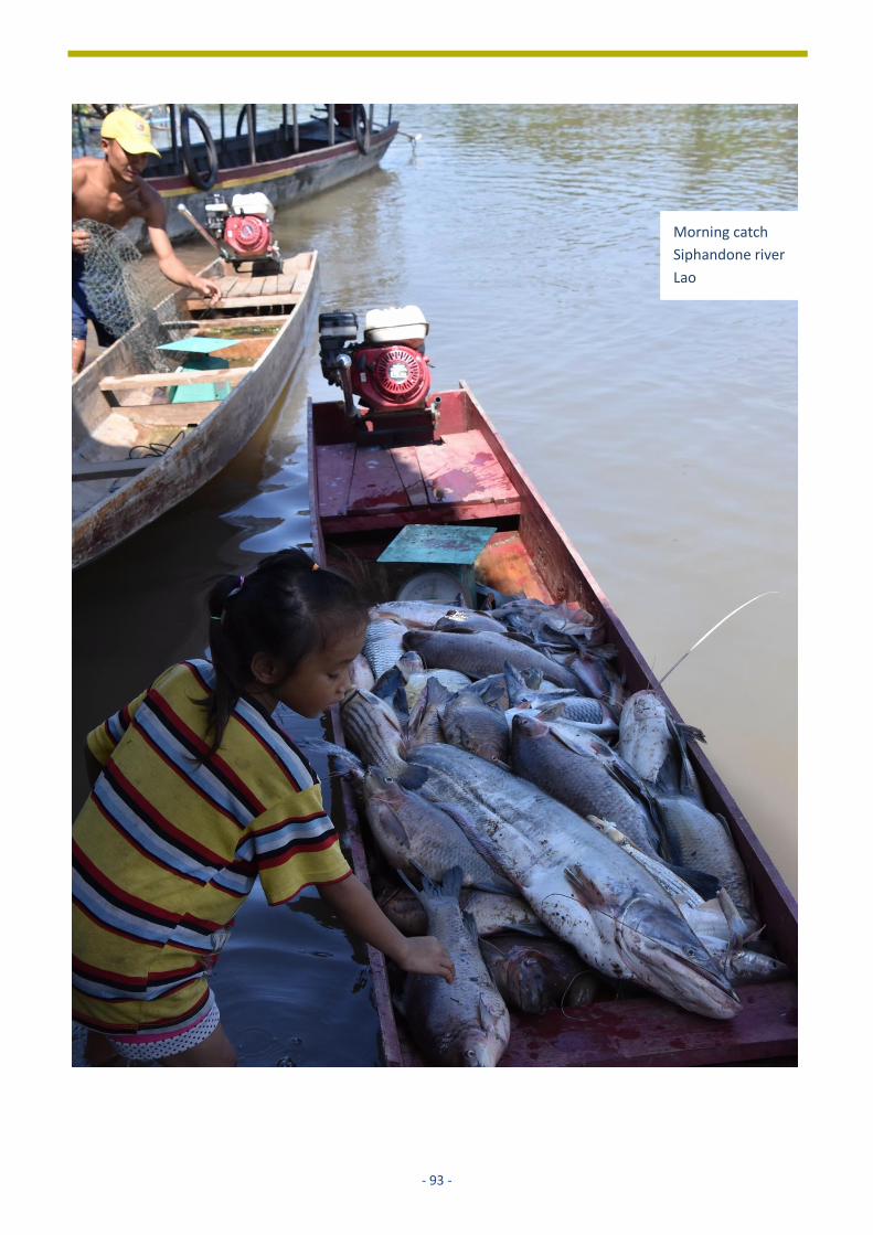
- 93 -
Morning catch
Siphandone river
Lao

- 94 -
About the editors
Arend Kolhoff (PhD) works as senior technical secretary at the international department of the Netherlands
Commission for Environmental Assessment. He finished his PhD research that aims to identify guiding principles for
better performing EIA systems in developing countries in 2017 at Utrecht University. He has a degree in Human
Geography from Utrecht University. He has almost three decades experience as trainer, advisor and reviewer of EIA
and SEA in about 30 low and middle income countries. He is one of the initiators and co-authors of the 2006 CBD
adopted voluntary guidelines for biodiversity in EIA / SEA. Since 2010 he is founder and co-chair of IAIA climate change
section. He is based in the Netherlands. [email protected]
Roel Slootweg (PhD) co-owner of SevS Consultants in The Netherlands, is an ecologist. He supports governments, NGOs
and companies in translating concepts of resilience and sustainability into day-to-day practice. His experience is
particularly strong in biodiversity and ecosystem services, and water and wetland management. Scientific evidence,
public participation and transparency are constant qualities in his work. Roel is lead author of the CBD Voluntary
Guidelines on Biodiversity in Environmental Impact Assessment (EIA) and Strategic Environmental Assessment (SEA),
and has published an academic textbook and various papers on the subject. For this work he has received the lifetime
achievement of the International Association for Impact Assessment.

- 95 -
DOCUMENTS CITED AND USED • TNC, 2018. Hydropower by Design: A Guide - A System-
scale Approach to Hydropower Planning and
Management.
• The Nature Conservancy and the Netherlands Commission
for Environmental Assessment (TNC/NCEA) 2019. A
Strategic Approach to Hydropower Development Applying
Hydropower by Design within the context of Strategic
Environmental Assessment to achieve hydropower goals
in a sustainable and equitable manner.
• OECD-DAC, 2006. Applying Strategic Environmental
Assessment. Good Practice Guidance for Development Co-
operation.
• United Nations Economic Commission for Europe, 2012.
Simplified Resource Manual to Support Application of the
Protocol on Strategic Environmental Assessment. United
Nations, New York and Geneva.
• ADB, 2015a. Integrating Strategic Environmental
Assessment into Power Planning.
• ADB, 2015b. Identifying Sustainability Indicators of
Strategic Environmental Assessment for Power Planning.
• ADB, 2015c. How Strategic Environmental Assessment Can
Influence Power Development Plans: Comparing
Alternative Energy Scenarios for Power Planning in the
Greater Mekong Subregion.
• ADB, 2018. Strategic Environmental Assessments for
Power Sector Planning in the Greater Mekong Subregion.
Greater Mekong Subregion Core Environment Program,
Bangkok, Thailand. Background Paper for the 5th GMS
Environment Ministers’ Meeting, Chiang Mai, Thailand.
• AHEC, 2011. Assessment of Cumulative Impact of
Hydropower Projects in Alaknanda and Bhagirathi Basins
up to Devprayag. Alternate Hydro Energy Centre, Indian
Institute of Technology, Roorkee.
• Annandale, D. and Hagler Bailly Pakistan (Pvt) Ltd, 2014.
Strategic Environmental Assessment of Hydropower
Development in Azad Jammu and Kashmir. Islamabad:
IUCN Pakistan. 154 pp.
• Annandale, David D. and Hagler Bailly Pakistan (Pvt) Ltd,
2014. Strategic Environmental Assessment for
Hydropower Sector Planning – Guidance Material.
Islamabad: IUCN Pakistan. 34 pp.
• Athayde, S.C.G. Duarte, A.L.C.F. Gallardo, E.M. Moretto,
L.A. Sangoi, A.P.A. Dibo, J. Siqueira-Gay, L.E. Sánchez,
2019. Improving policies and instruments to address
cumulative impacts of small hydropower in the Amazon.
Energy Policy 132: 265-271.
• Bandyopadhyay Jayanta, 2013. Securing the Himalayas as
the Water Tower of Asia.
• Bragagnolo C. and D. Geneletti, 2012. Addressing
cumulative effects in Strategic Environmental Assessment
of spatial planning. Aestimum 60, Giugno: 39-52.
• Brisbane Declaration, 2007. Brisbane Declaration. In: 10th
International River Symposium and International
Environmental Flows Conference [online], Brisbane 3–6
September 2007.
• Bunn, S. E. and A.H. Arthington, 2002. Basic principles and
ecological consequences of altered flow regimes for
aquatic biodiversity. Environmental Management 30 (4):
492-507.
• CBD, 2017. Global State of the Application of Biodiversity-
Inclusive Impact Assessment. CBD/SBSTTA/21/INF/13.
• Department of Electricity Development, 2019. Guidelines
for CIA Study in the Major River Basins and its Integration
into the Regulatory Framework Document. Final Draft
Report. Nepal.
• Department of Fisheries Myanmar, 2014. Fisheries
Statistics 2014.
• EBRD, 2016. Environmental and Social Guidance Note for
Hydropower Projects. EBRD Guidance Notes.
• EBRD, 2019. Environmental and social good practice note.
Small hydropower projects.
• EIB, 2019. Environmental, Climate and Social Guideline on
Hydropower Development.
• Gallardo, A.L.C.F., J.C. da Silva, G.L. Gaudereto and D.W.F.
Sozinho, 2017. A avaliação de impactos cumulativos no
planejamento ambiental de hidrelétricas na bacia do rio
Teles Pires (região amazônica). Desenvolv. Meio Ambiente
43, p. 22-47 (Edição Especial: Avaliação de Impacto
Ambiental).
• Government of India, 2012. National Water Policy.
Ministry of Water Resources, River Development and
Ganga Rejuvenation. New Delhi.
• Government of India, 2018. Ministry of Water Resources,
River Development and Ganga Rejuvenation, Order No.
S.O.5195 (E). Published on 9th October 2018 in Gazette of
India, New Delhi.
• Government of Rwanda, (2011). National Policy for water
resources management.
• GMS Environment Operations Center, 2011. “Policy brief:
Strategic Environmental Assessment of Power
Development Plans in Viet Nam”, Bangkok, Thailand
• Green Home, MANS, Forum 2010 & WWF, 2011. The
Morača Remains One Of The Few Free-Flowing Rivers In
Europe. Flawed tender confirms arguments of civil society
and independent experts.
• Hartmann J., D. Harrison, J. Opperman and R. Gill, 2013.
The New Frontier of Hydropower Sustainability: Planning
at the System Scale. IADB & TNC.
• Hirji R. and R. Davis, 2009. Environmental Flows in Water
Resources Policies, Plans, and Projects: Findings and
Recommendations. The International Bank for
Reconstruction and Development /The World Bank,
Washington DC. • Hydro-Informatics Centre, 2017. Ayeyarwady State of the
Basin Assessment (SOBA) 2017. Synthesis Report,
Volume 1. Yangon.
• ICEM, 2009. Presentations at the National Consultations
for SEA of Mekong Mainstream Dams for Mekong River
Commission. Vientiane.

- 96 -
• IFC, 2013. Good Practice Handbook on Cumulative Impact
Assessment and Management: Guidance for the Private
Sector in Emerging Markets.
• IFC, 2015. Hydroelectric Power. A Guide for Developers
and Investors.
• IFC, 2018. Environmental, Health, and Safety Approaches
for Hydropower Projects.
• IFC, 2020. Strategic Environmental Assessment of the
Myanmar hydropower sector.
• IHA, 2018. Hydropower Sustainability Assessment
Protocol. First published November 2010. This edition was
published in July 2018, and includes new chapters on
Climate Change Mitigation and Resilience.
• IHA, 2018. Hydropower Sustainability Guidelines. A good
International Industry Practice.
• International Association for Impact Assessment (IAIA)
2017. Cumulative Effect Assessment. Fastip No. 16,
October 2017.
• International Commission on Large Dams, 2019. World
Declaration on Dam Safety. Approved on October 18th
2019, in Porto.
• International Energy Agency, 2015. Key world energy
statistics.
• Joshi M.C., 2007. Hydro Power Potential in Uttarakhand
International Conference on Small Hydropower - Hydro Sri
Lanka, 22-24 October 2007
• Khosravi, F., U. Jha-Thakur and T.B. Fischer, 2019. The role
of environmental assessment (EA) in Iranian water
management, Impact Assessment and Project Appraisal,
37:1, 57-70, DOI: 10.1080/14615517.2018.1526998
• Kumar P., 2009. Environmental flow assessment for a
hydropower project on a Himalayan river. Thesis (PhD),
Indian Institute of Technology Roorkee.
• Malvestio, A.C. and M. Montaño, 2013. Effectiveness of
Strategic Environmental Assessment Applied to
Renewable Energy in Brazil. Journal of Environmental
Assessment Policy and Management 2, Special Issue on
Environmental Assessment in the Context of Renewable
Energy Deployment, Pp. 1-21. • Mekong river Commission (MRC) Initiative on Sustainable
Hydropower, 2015. Guidelines For The Evaluation Of
Hydropower And Multi-Purpose Project Portfolios.
www.pnas.org/cgi/doi/10.1073/pnas.1809426115
• Mekong River Commission (MRC), ADB & WWF, 2016.
Rapid Basin-wide Hydropower Sustainability Assessment
Tool.
• Mekong River Commission (MRC) 2018. The Rapid Basin-
wide Hydropower Sustainability Assessment Tool; 2016
Edition; 2nd reprint 2018.
• Ministry of Environment, 2018. Upper Nyabarongo
catchment management plan and SEA report.
• Ministry of Natural Resources, 2015. National water
resources master plan, Rwanda.
• Ministry of Natural Resources and Environment, 2018.
Draft Cumulative Impact Assessment Guidelines for
Hydropower Projects in the Lao People's Democratic
Republic.
• Ministry of Industry and Trade Viet Nam, 2011. “Strategic
Environmental Assessment of the National Plan for Power
Development for the Period 2011-2020 with Perspective
to 2030 (PDP VII)”, Hanoi, Viet Nam.
• MOEE, 2018. MOEE presentation to: The Third Meeting of
Energy and Electric Power Sector Coordination Group – 8
August 2018, Myanmar.
• MoEFCC, 1994. Environmental Impact Assessment
Notification, S.O.60 (E) published on January 27, 1994 and
amended on April 4, 1994. Ministry of Environment,
Forest and Climate Change, Government of India, New
Delhi.
• MoEFCC, 2006. Environmental Impact Assessment
Notification, published in the Gazette of India,
Extraordinary, Part-II, and Section 3, Sub-section Published
on 14th September 2006. Ministry of Environment, Forest
and Climate Change, Government of India, New Delhi.
• Moran, E.F., M.C. Lopez, N. Moore, N. Müller and D.W.
Hyndman, 2018. Sustainable hydropower in the 21st
century.
• NCEA, 2014. A Systems Approach to SEA Effectiveness.
NCEA/ISBN 978-90-421-9454-0.
• NCEA, 2017. Better Decision-Making about Large Dams
with a View to Sustainable Development. Second Edition.
• NCEA, 2018. ESIA and SEA for Sustainable Hydropower
Development. Views and Experiences Series.
• Nelson, P.J. (editor) 2015. EIA/SEA of Hydropower Projects
in South East Europe. WWF & SEE Change Net.
• OECD-DAC, 2006. Applying Strategic Environmental
Assessment. Good Practice Guidance for Development Co-
operation.
• OECD, 2012. Strategic Environmental Assessment in
Development Practice: A Review of Recent Experience.
OECD Publishing.
• Opperman J., G. Grill and J. Hartmann, 2015. The Power of
Rivers: Finding balance between energy and conservation
in hydropower development. The Nature Conservancy:
Washington, D.C.
• Opperman J., J. Hartmann, J. Raepple, H. Angarita, P.
Beames. E. Chapin, R. Geressu, G. Grill, J. Harou, A.
Hurford, D. Kammen, R. Kelman, E. Martin, T. Martins, R.
Peters, C. Rogéliz, and R. Shirley, 2017. The Power of
Rivers: A Business Case. The Nature Conservancy:
Washington, D.C.
• Program Sava, 2014. Hydropower sustainability
assessment protocol. Official Assessment Program Sava
d.o.o., Croatia.
• Rajvanshi A., R. Arora, V.B. Mathur, K. Sivakumar, S.
Sathyakumar, G.S. Rawat, J.A. Johnson, K. Ramesh, N. K.
Dimri and A. Maletha, 2012. Assessment of Cumulative
Impacts of Hydroelectric Projects on Aquatic and
Terrestrial Biodiversity in Alaknanda and Bhagirathi Basins,
Uttarakhand. Wildlife Institute of India, Technical Report.
Pp 203.
• Republic of Rwanda, (2005). Organic law on Environment.
• Republic of Rwanda, (2018). Law determining the use and
management of water resources in Rwanda.

- 97 -
• Smith P.G.R. and J.B. Theberge, 1986. A review of criteria
for evaluating natural areas. Environmental Management
10 (6): 715-734.
• Song, Young-Il , Park, Daeryong, Shin, Gihye, Kim, Cheoljin,
Grigg and Neil S., 2010. Strategic environmental
assessment for dam planning: A case study of South
Korea's experience. Water International, 35: 4, 397 —408.
• South Asia Network on Dams, Rivers and People (SANDRP)
2013. Uttarakhand: Existing, under construction and
proposed Hydropower Projects: How do they add to the
state’s disaster potential?
https://sandrp.in/2013/07/10/uttarakhand-existing-
under-construction-and-proposed-hydropower-projects-
how-do-they-add-to-the-disaster-potential-in-
uttarakhand/ accessed on 18th March 2020.
• Sparks R.E., 1995. Need for ecosystem management of
large rivers and floodplains. BioScience 45: 168 –182.
• The Nature Conservancy (TNC) 2017. The power of rivers,
a business case.
• The Nature Conservancy (TNC) 2018. Hydropower by
Design: A Guide A system-scale approach to hydropower
planning and management.
• The Nature Conservancy and the Netherlands Commission
for Environmental Assessment, 2019. A Strategic
Approach to Hydropower Development. Applying
Hydropower by Design within the context of Strategic
Environmental Assessment to achieve hydropower goals
in a sustainable and equitable manner.
• Tushaar S., R.A. Matthew, R.P. Cronin, R. Batten, S.C.
Shifflett, J. Bandyopadhyay, K. Pomeranz, R.G. Wirsing, M.
Giordano and J. L. Turner, 2013. The Environmental
Perspective. Essays in the roundtable “Himalayan Water
Security: The Challenges for South and Southeast Asia,
2013.” Asia Policy https://www.nbr.org/publication/asia-
policy-16-july-2013/
• UNDP Albania, 2018. SEA Report of Small Hydro Power
Development Policy in Albania, a Comprehensive, Climate
Resilient Approach to Sustainable Hydropower for
Albania.
• United Nations Economic Commission for Europe, 2012.
Simplified Resource Manual to Support Application of the
Protocol on Strategic Environmental Assessment. United
Nations, New York and Geneva, 2012. Sharad K. J. and P.
Kumar, 2014. Environmental flows in India: towards
sustainable water management, Hydrological Sciences
Journal, 59: (3-4) 751-769.
• Valdiya K.S. (1997) Developing a paradise in peril.
Proceedings of 7th Pandit Govind Ballabh Pant Memorial
Lecture, G.B. Pant Institute of Himalayan Environment and
Development, Kosi- Katarmal, Almora.
• Victor D. and P. Agamuthu, 2014. Policy trends of strategic
environmental assessment in Asia Environmental Science
& Policy 41: 63-76. • Ward J.V., Tockner K. and Schiemer F, 1999. Biodiversity of
floodplain ecosystems: Ecotones and connectivity.
Regulated Rivers: Research and Management 15: 1.
• Wong C.M., C.E. Williams, J. Pittock, U. Collier and P.
Schelle, 2007. World’s top 10 rivers at risk, Gland,
Switzerland: WWF-International.
• World Bank, 2011. Uttarakhand. Available at
http://go.worldbank.org/FE04IF2IP0. Accessed on 16th
May 2011.
• World Bank, 2018. GOOD PRACTICE HANDBOOK
Environmen World Bank, 2012. Sample Guidelines:
Cumulative Environmental Impact Assessment for
Hydropower Projects in Turkey, December 2012, Ankara.
• tal Flows for Hydropower Projects Guidance for the
Private Sector in Emerging Markets
• World Bank, 2018. Application of the Hydropower
Sustainability Assessment Protocol in the Zambezi River
Basin. World Bank, Washington, DC.
• World Bank Group, 2019. Myanmar Economic Monitor:
Building Reform Momentum.
http://documents.worldbank.org/curated/en/326771560
523871008/pdf/Building-Reform-Momentum.pdf
• World Hydropower Congress, 2017. Better hydro in an
interconnected world. The report.
• WWF-India, 2011. Assessment of environmental flows for
Upper Ganga Basin, New Delhi, India: World Wide Fund
for Nature (WWF)-India. Pp 21.
• WWF, 2011. RIVERS FOR LIFE. The Case for Conservation
Priorities in the Face of Water Infrastructure
Development.
• WWF, 2015. Towards Sustainable Dam and Hydropower in
the South Caucasus. Norwegian Ministry of Foreign
Affairs.
• WWF, 2020: Mapping Myamar’s free-flowing rivers.
Assessment of current and future impacts of dam-
infrastructure development on river connectivity.

- 98 -
ANNEX 1: BRIEF DESCRIPTION OF OTHER TOOLS SUPPORTING
HYDROPOWER DEVELOPMENT
1. INTRODUCTION
In this Annex the following tools are briefly described:
• Cumulative Impact Assessment (CIA);
• Hydropower Sustainability Assessment protocol (HSA protocol);
• Hydropower by Design (HbD);
• Rapid Basin-wide Hydropower Sustainability Assessment Tool (RSAT).
Environmental Impact Assessment (EIA) is a tool that is not described as it assumed to be well-known
as a legal decision-support tool that is mandatory in all countries. Increasingly, the term ESIA is used
because social issues are included as well.
For each tool, the following information is presented:
• Description and objective;
• Application in hydropower development;
• Key references.
Moreover, a comparative assessment of the characteristics of these tools are presented in table 1 and
figure 1.
2. CUMULATIVE IMPACT ASSESSMENT (CIA)
Description and objective
Cumulative Impact Assessment (CIA) is also known as Cumulative Effects Assessment (CEA). CIA has been
a key element of good-practice impact assessment for more than 40 years in countries such as the
United States and Canada. It is now implemented widely in many countries. The International Finance
Corporation (IFC, 2013) of the World Bank defines CIA as: “The process of (a) analysing the potential
impacts and risks of proposed developments in the context of the potential effects of other human
activities and natural environmental and social external drivers on the chosen [valued component] over
time, and (b) proposing concrete measures to avoid, reduce, or mitigate such cumulative impacts and
risks to the extent possible.”
In summary CIA supports decision-making of projects by assessing the cumulative impacts of one or
more hydropower projects. A CIA can be conducted as part of an ESIA or as a separate study.
Application in hydropower development
The International Finance Corporation (IFC, 2013) ‘Good Practice Handbook on Cumulative Impact
Assessment and Management: Guidance for the Private Sector in Emerging Markets’ is commonly
accepted as the standard for CIA supporting hydropower development. IFC is one of the financial
institutes frequently asking for CIAs to assist primarily companies but sometimes also governments to
consider the cumulative impacts of planned and existing hydropower projects from a broad, basin-wide
perspective that includes upstream and downstream developments, not directly related to hydropower
development. IFC has mainly applied CIAs as a voluntary tool supporting funding decision of hydropower
projects in South and South-East Asia. In Appendix 5 a list is presented of all finalised CIAs (N=16) that
have been identified through a web search.

- 99 -
Key references
Besides the IFC (2013) publication, country-specific guidelines for CIA supporting hydropower
development have been made by Turkey, Lao and Nepal.
• Department of Electricity Development, 2019. Guidelines for CIA Study in the Major River Basins
and its Integration into the Regulatory Framework Document. Final Draft Report. Nepal.
• International Association for Impact Assessment (IAIA) 2017. Cumulative Effect Assessment. Fastip
No. 16, October 2017.
• International Finance Corporation (IFC) 2013. Good Practice Handbook on Cumulative Impact
Assessment and Management: Guidance for the Private Sector in Emerging Markets.
https://www.ifc.org/wps/wcm/connect/industry_ext_content/ifc_external_corporate_site/hydro+
advisory/resources/cumulative+impact+assessment+resource+page
• Ministry of Natural Resources and Environment, 2018. Draft Cumulative Impact Assessment
Guidelines for Hydropower Projects in the Lao People's Democratic Republic.
• World Bank, 2012. Sample Guidelines: Cumulative Environmental Impact Assessment for
Hydropower Projects in Turkey, December 2012, Ankara.
3. THE HYDROPOWER SUSTAINABILITY ASSESSMENT PROTOCOL (HAS-PROTOCOL)
Description and objective
The HSA-protocol is developed by the International Hydropower Association (IHA, 2018). It is a tool that
promotes and guides more sustainable hydropower projects. It provides a common language that allows
governments, civil society, financial institutions and the hydropower sector to talk about and evaluate
sustainability issues. The Protocol offers a way to assess the performance of a hydropower project across
more than 20 sustainability topics. Assessments are based on objective evidence and the results are
presented in a standardised way, making it easy to see how existing facilities are performing and how
well new projects are being developed. The Protocol has many uses each with a distinct value, such as:
review of sustainability issues, guiding sustainability issues, comparison with international best practice,
communication with stakeholders, facilitating access to finance, preparing clients to meet bank
requirements, increase awareness on SHD at all levels of decision making and reducing risk of
investment opportunities. It has an ‘Early-Stage Tool’ concerned with the strategic environment from
which proposals for hydropower projects emerge and the early identification of project risks and
opportunities. The stages in the assessment process, including demonstrated demand, options
assessment, legal and regulatory framework, institutional capacity, technical, social an environment
risks, all sound very much parts of the content of an SEA study except that in this tool it is not always
applied in a transparent way like SEA.
Application for hydropower development
This tool is exclusively developed to support the development of more sustainable hydropower. The tool
has been applied about 30 times (personal communication by IHA). In the majority of these applications
the findings are not publicly available. Application of the tool in the Zambesi resulted in a report that is
included as a key reference.
Key references
• International Hydropower Association (IHA) 2018. Hydropower Sustainability Assessment Protocol.
First published November 2010. This edition was published in July 2018, and includes new chapters
on Climate Change Mitigation and Resilience.
• World Bank, 2018. . World Bank, Washington, DC.

- 100 -
4. HYDROPOWER BY DESIGN (HBD)
Description and objective Hydropower by Design (HbD) has been developed by The Nature Conservancy (TNC, 2017). HbD is a
voluntary approach that provides decision makers with energy development options, able to meet their
demands at the time of energy growth with similar or even lower financial costs, while avoiding or
greatly reducing social and environmental conflicts and consequences that would result from traditional
approaches. HbD is a framework that utilises participatory processes and a suite of analytical tools to
integrate environmental, social, economic, and energy considerations into alternative project siting and
operations options. It incorporates effects of reservoirs, project sites, roads, transmission lines, and
downstream flow alteration with energy generation, costs, and financial performance of different
combinations of sites and operations. It illustrates the potential trade-offs for stakeholders across the
range of alternative scenarios and identifies those options that achieve energy goals while best
addressing the collective concerns of stakeholders engaged in or affected by hydropower planning
decisions. HbD can be complementary to SEA. This approach is suitable to develop and assess
alternatives that can be used in SEA. See the publication (TNC and NCEA, 2019) included as a key
reference for more information.
Application for hydropower development
This tool exclusively supports the development of more sustainable hydropower. The tool has been
applied several times, a description of these applications are presented in the publication; The Power of
Rivers, a business case (TNC, 2017). Jointly with a consortium led by Manchester University, TNC is
building on HbD and developing Energy by Design. A tool that supports strategic planning of energy
system development in an integrated manner, also including water, food and environmental interests
at system scale.
Key references
• The Nature Conservancy (TNC) 2017. The power of rivers, a business case.
• TNC, 2018. Hydropower by Design: A Guide - A System-scale Approach to Hydropower Planning and
Management.
• The Nature Conservancy and the Netherlands Commission for environmental Assessment, 2019. A
Strategic Approach to Hydropower Development. Applying Hydropower by Design within the context
of Strategic Environmental Assessment to achieve hydropower goals in a sustainable and equitable
manner.
5. THE RAPID BASIN-WIDE HYDROPOWER SUSTAINABILITY ASSESSMENT TOOL (RSAT)
The Rapid Basin-wide Hydropower Sustainability Assessment Tool (RSAT) has been developed since
2010 by the Mekong River Commission (MRC) in collaboration with World Wildlife Fund (WWF) and
Asian Development Bank (ADB) (RSAT, 2016). Trials were tested in Lao, Thailand, Cambodia and
Vietnam. The RSAT is a voluntary multi-stakeholder dialogue and assessment tool designed to consider
hydropower sustainability issues in a river basin context. It is focussed on the Mekong Basin. Placing
hydropower in a basin-wide context requires looking beyond individual projects to take a broader
integrated approach to planning and management.
Application for hydropower development
Application of RSAT can assist to identify development strategies, institutional responses and
management measures that can be deployed to optimise the benefits of hydropower development and
reduce the risks. The authors emphasise RSAT cannot replace SEA but can be complementary. WWF
assesses the value of applying RSAT within an SEA context (MRC, 2018).

- 101 -
Key references
• Mekong River Commission (MRC), ADB & WWF, 2016. Rapid Basin-wide Hydropower Sustainability
Assessment Tool.
• Mekong River Commission (MRC) 2018. The Rapid Basin-wide Hydropower Sustainability Assessment
Tool; 2016 Edition; 2nd reprint 2018.
In table 1, the five tools described are compared by making use of selected criteria. In figure 1, these
tools are positioned on a continuum from strategic planning on the left side towards project planning
on the right. Moreover, the main decisions taken in the development of hydropower are also linked to
the project–strategic planning continuum.
6. COMPARISON BETWEEN TOOLS
In table 1, the five tools described are compared by making use of selected criteria. In figure 1, these tools are positioned on a continuum from strategic planning on the left side towards project planning on the right. Moreover, the main decisions taken in the development of hydropower are also linked to the project–strategic planning continuum. Table 1: Characteristics of approaches supporting development of hydropower
SEA* CIA ** IHA protocol HbD RSAT
Legal status ~106 countries No No No No
Responsible Government Private Banks
Private Government Private
Government NGOs
Purpose Balanced future development
Evaluation related projects
Project evaluation
Optimisation of interests
Optimisation stakeholders benefits
Scope
Policies Plans (basin, (national) Programmes
Projects Project Plans (basin) Programmes Projects
Plans (basin)
Outcome Alternative sites, types, purposes, sizes
Cumulative env soc impacts Mitigating measures
Sustainability impacts Scorecard & mitigating Measures
Alternative sites, types purposes, sizes
Stakeholder commitment, alternatives, mitigating measures
Number 37 16 ~ 30 5 4
*) All SEAs as listed in Annex 2, 3 and 4. **) All CIAs are listed in Annex 5. Figure 2: Tools supporting sustainable development of hydropower sector
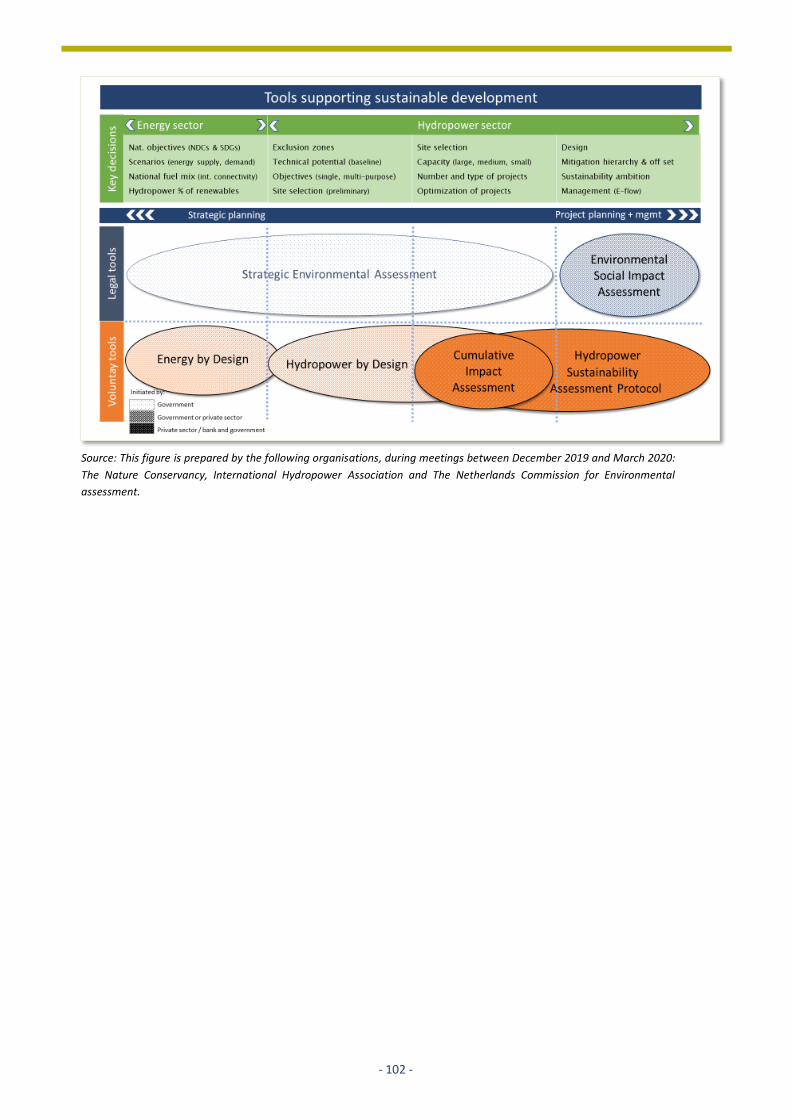
- 102 -
Source: This figure is prepared by the following organisations, during meetings between December 2019 and March 2020:
The Nature Conservancy, International Hydropower Association and The Netherlands Commission for Environmental
assessment.

- 103 -
ANNEX 2: LIST OF SEAS APPLIED FOR POLICIES, PLANS OR PROGRAMMES IN THE
ENERGY SECTOR, INCLUDING HYDROPOWER
Strategic Environmental Assessment for the Energy sector, including hydropower*
Cases (with hyperlink to documents if available) Country Scale / Basin Year / status
Subject of SEA Level of influence
1 SEA or Energy Policy. SEA case description available on request*.
Slovak Republic
National 1997 and 2000
Energy policy Moderate
2 SEA for Energy Policy. SEA case description available on request*.
Czech Republic
National 2002 Energy policy No
3 Strategic/Sectoral, Social and Environmental Assessment of Power Development Options in The Nile Equatorial Lakes Region SEA report available.
Nile Equatorial Lakes Region
International 2007 Energy policy Low
4 SEA for National Energy Policy. SEA case description available.
Ghana National 2008 National energy Policy
Low
5 SEA for Power Development Plan VII. SEA report available: https://gms-eoc.org/resources/two-seas-on-power-development-planning-in-viet-nam
Viet Nam National 2011 Power development plan VII (ex-ante)
High
6 SEA for Saskatchewan electricity planning. SEA report not available.
Canada State / province
2012 Electricity supply plan
Unknown
7 SEA for National Energy Development Strategy by 2030. Summary and review of SEA available: http://www.greenhome.co.me/fajlovi/greenhome/attach_fajlovi/eng/main-pages/2013/07/pdf/Review_Of_The_SEA_For_The_Draft_Energy_Development_Strategy_In_Montenegro_By_2030.pdf
Montenegro National 2013 Energy strategy Unknown
8 SEA for Revised Power Development Plan VII. SEA report not available.
Viet Nam National 2014 Revised power development plan VII
High
9 SEA for Energy Sector Development Strategy. SEA report available: https://mingor.gov.hr/UserDocsImages/UPRAVA-ZA-PROCJENU-UTJECAJA-NA-OKOLIS-ODRZIVO-GOSPODARENJE-OTPADOM/Spuo/29_08_2017_SPU_POS_Strategija_RS.pdf
Serbia National 2015 Energy strategy Low
10 SEA for GMS power planning SEA report available.
Greater Mekong subregion 6 countries
International 2015 Power development plan
Unknown
11 SEA for National Energy Sector Policy SEA report available.
Rwanda National 2015 Energy sector policy
Unknown
12 SEA for National Power Policy*. SEA case description available on request.
Taiwan National 2015 National power plan
Moderate
13 SEA for National Strategy of Renewable Energy. Summary of SEA report available: https://unece.org/fileadmin/DAM/env/greeneconomy/Lea/EaP/SEA_Azerbaijan.pdf
Azerbaijan National 2016 Nat. renewable energy strategy incl. hydropower
Unknown
14 SEA for Power Development Master Plan. SEA report available on request.
Angola National 2018 Power development master plan
Unknown
15 SEA for Master Plan Study on National Power system development. SEA report available as part of master plan. https://africa-energy-portal.org/sites/default/files/2019-
Nigeria National 2019 Power development master plan
Unknown

- 104 -
07/Master%20Plan%20Study%20for%20Power%20Sector%20System%20Development%20in%20Nigeria.pdf
16 SEA for National Power Power System Master Plan 2040. SEA report available as part of master plan. https://openjicareport.jica.go.jp/pdf/12326856_01.pdf
Bhutan National 2019 Power development master plan
Unknown
17 SEA for National Power Plan. SEA report not yet available.
Cambodia National On-going
Power development plan
…
18 SEA for Power Development Plan VIII. SEA report not yet available.
Viet Nam National Ongoing
Power Development Plan VIII
…
*) SEA in which hydropower is not considered
- 105 -
ANNEX 3: LIST OF SEAS APPLIED FOR POLICIES, PLANS OR PROGRAMMES OF
THE HYDROPOWER SECTOR
Strategic Environmental Assessment Hydropower sector
Cases (with hyperlink to documents if available) Country Scale / Basin Year / status
Subject of SEA Level of influence
1 Nepal medium hydropower SEA. SEA report not available. Source: SEA in the World Bank 2012
Nepal National 1997 Policy selecting suitable sites for HPPs 10-300 MW
High
2 Strategic Environmental Assessment for Hydropower. SEA report not available. Source: SEA in the World Bank 2012
Lao PDR National 2004 National plan assessing 22 planned HPPs 2004-2022
Unknown
3 SEA for Long-term Plan for dam construction. SEA report not available. Source: SEA for Long-Term Plan for Dam Construction (various purposes)
South Korea
National 2007 National 10yr dam construction plan assessing existing and planned sites and selecting new sites for dams incl. HPP
High
4 SEA for Quang Nam province Hydropower Plan. SEA report available: SEA of the Quang Nam Province Hydropower Plan for the Vu Gia-Thu Bon River Basin
Viet Nam Province (Quang Nam) Vu Gia – Thu Bon basin
2008 Hydropower development plan for the 2006-2010 assessing 40 HPPs
High
5 SEA for Hydropower Master Plan. SEA report available: Strategic Environmental Assessment Of The Hydropower Master Plan In The Context Of The Power Development Plan VI
Viet Nam National 2009 Hydropower master plan as part of National Power Development Plan VI
Moderate
6 SEA for Mainstream Dams. SEA report available: https://www.mrcmekong.org/assets/Publications/Consultations/SEA-Hydropower/SEA-Main-Final-Report.pdf
Lao, Thailand, CambodiaViet Nam
International Mekong basin
2010 Policy assessment of 11 HPPs in mainstream of the lower Mekong river
Moderate
7 SEA for Moraca rivee basin. SEA report not available. Source: SEA of Morača River HPPs
Monte-negro
Morača basin 2010 Spatial plan assessing 4 HPPs
Low
8 SEA small hydropower plants. SEA report available: https://www.yumpu.com/en/document/read/11592648/strategic-environmental-assessment-small-hydropower-plants-
Georgia Agravi basin 2010 Site selection of projects < 13MW
Moderate
9 SEA for Local spatial plan. SEA report not available. Source: SEA for Special Purposes Plan for HPPs Brodarevo 1 and 2
Serbia Municipality Lim river (reservoir trans-boundary with Monte-negro)
2011 Spatial plan assessment of two HPPs
Low
10 SEA for Punasangchu river basin. SEA report available on request.
Bhutan Punasang-chu river basin
2011 Assessment of 5 mega‐HPPs in one basin
Unknown
11 SEA for Hydropower development in Uttarakhand. SEA report available: http://www.indiaenvironmentportal.org.in/content/352274/assessment-of-cumulative-impacts-of-hydroelectric-projects-on-aquatic-and-
India State (Uttarakhand) and Alaknanda and Bhagirathi
2012 Hydropower development plan assessing 70 HPPs in varying development phases
High

- 106 -
terrestrial-biodiversity-in-alaknanda-and-bhagirathi-basins-uttarakhand/
basins (upstream Ganges)
12 SEA for National hydropower master plan. SEA report available as part of masterplan: Nationwide Master Plan Study on Storage-type Hydroelectric Power Development in Nepal.
Nepal National 2014 HP master Plan select 10 reservoir type HPPs
Unknown
13 SEA for Hydropower development in AJK. SEA report available:
Pakistan State (Azad Jammu and Kashmir)
2014 Hydropower plan 62 HPPs in varying development phases
High
14 SEA for Hydropower development Sutlej river basin. SEA report available on request.
India Sutlej basin (Himachal Pradesh)
2014 Assessing cumulative impacts of 38 HPPs
Moderate
15 SEA of small hydr power development policy. SEA report available: SEA of Small Hydro Power Development Policy
Albania National 2018 Policy on small HP Unknown
16 SEA for National hydropower development. SEA report available: SEA of the Myanmar Hydropower Sector
Myanmar National 2018 Hydropower Policy Moderate
17 SESA od river plans and hydropower masterplans. SEA report not yet available.
Nepal National On-going
SESA of river basin plans and HP master plans
…

- 107 -
ANNEX 4: LIST OF SEAS APPLIED FOR MULTI-SECTOR POLICIES, PLANS OR
PROGRAMMES, INCLUDING HYDROPOWER
Strategic Environmental Assessment Multi sector (water / river basin plan including hydropower)
Cases (with hyperlink to documents if available) Country Scale / Basin Year / status
Subject of SEA
Level of influence
1 SEA Rio Madera. SEA case description available on request.
Bolivia International river basin
2012 Regional planning
Low
2 SEA Mara river basin. SEA report available on request.
Kenya Tanzania
International river basin
2012 Integrated planning
Low
3 SEA for River basin plans. SEA report available as part of plan (4x): https://waterportal.rwb.rw/publications/catchment_plans
Rwanda National, 4 river basins
2015 Integrated planning
Moderate
4 SEA National Water Strategy. SEA report available: strateska_studija.pdf (gov.hr)
Serbia National 2015 Water wide Unknown
5 SEA for River basin plan. Summary of SEA report available on request.
Croatia National, all river basins
2016 Integrated planning
Unknown
6 SESA of Integrated Water Resources Management and Development Plan for six water basins
Tanzania Six of the in total nine basins
On-going Integrated planning
…

- 108 -
ANNEX 5: LIST OF CIA STUDIES APPLIED FOR HYDROPOWER DEVELOPMENT
Cumulative Impact Assessment
Case (with hyperlink to documents if available) Country Scale / Basin Year / status
Subject of CIA
1 Report available: Cumulative Impact Analysis And Nam Theun 2 Contributions
Lao PDR Nam Theun 2 2004 One dam
2 Report available: Rampur Hydropower Development (Cumulative EA)
India Satluj basin 2006 Basin-wide HPPs; inter-basin water transfer
3 Report available: https://www.adb.org/sites/default/files/project-document/66414/40514-lao-tar.pdf
Lao Nam Ngum river basin 2007 One dam in cascade of five dams
4 Report is not available: Integrated Kafue River Basin Environmental Impact Assessment Study -
Kafue river, Zambia
Kafue river basin 2008 Two dams
5 Report available: Cumulative Impact Analysis - Alto Maipo Hydropower
Chile Maipo river upper basin
2011 Unknown
6 Report available: CIA OF KABELI-A HYDROELECTRIC PROJECT
Nepal Kabeli basin 2011 Six HPPs in one basin
7 Report available: Integrated Environmental Assessments for hydropower projects in 12 river basins (= cumulative impact assessments)
Brazil: various states
14 river basins 2007 - 2012 12 CIAs for HP projects
8 Report is not available: Evaluation Régionale Stratégique (ERS) des options de développement hydroélectrique et des ressources en eau dans le bassin du fleuve Sénégal
Senegal basin authority (OMVS)
International river basin
2013 Four dams
9 Report is not available: CIA Alto Maipo hydropower project
Chili River basin 2013 One dam
10 Report is available: Cumulative Impacts and Joint Operation of Small-Scale Hydropower Cascades
Northwest Viet Nam
6 river basins 2014 Small HP cascades
11 Report is available: Gulpur hydropower Cumulative Impact Assessment
Pakistan Poonch river 2014 One dam
12 CIA report is not available. Lao Nam Ou river basin 2016 Cascade 7 dams
13 Study on the Sustainable Development and Management of the Mekong River Basin, including Impacts by Mainstream Hydropower Projects. Report avaiable: Cumulative Impact Assessment Key Findings Report. (The Council Study)
Mekong River Commission
International Mekong river basin
2017 Mainstream dams
14 Report available: Nenskra hydropower project Supplementary Environmental and Social (E&S) Studies
Georgia Nenskra and Enguri basins
2017 Dam, transport lines and inter-basin transfer
15 SEA Rufiji dam project. Report is not available.
Tanzania Part of river basin 2019 Assessment of cumulative impacts of one HPP
16 Report available: CIA and management: hydropower development in Trishuli river basin
Nepal Trishuli river basin (transboundary with Tibet)
2020 Renewable energy, mainly HPP and some irrigation
17 CIA Sekong river basin. Brief note is available: https://www.ifc.org/wps/wcm/connect/00f538c1-f5ae-47d5-82af-2a108eaf7b23/CIA+one+pager+FINAL+-+Eng+version.pdf?MOD=AJPERES&CVID=mlAxe17
Lao PDR Sekong river basin ongoing Renewable energy options, including HPP
https://www3.opic.gov/Environment/EIA/aesgener/pwrplnt/assessment/Cumulative%20Impact%20Analysis.pdf

- 109 -
18 ToR is available: Cumulative Impact Assessment and Management of Renewable Energy Development in the Mytinge River Basin
Myanmar Mytinge river sub-basin
ongoing 11 dams

- 110 -
ANNEX 6: OUTPUTS, OUTCOMES AND IMPACTS OF SEA IN FIVE CASE STUDIES
Criterium Pakistan Myanmar India Viet Nam Rwanda
Outputs: quality of SEA
SEA process complete
Followed OECD-DAC approach with additional methodology for cumulative impact assessment
SEA was the first in Myanmar (demonstration pilot). SEA was more a planning instrument rather than an impact assessment, providing a plan that moves the SEA from a report into implementation.
Not guided by legislation. Independent CIA, initiated as to address a requirements under EIA legislation for 70 HP projects. Partially ex ante, partially ex post resulted in hybrid approach.
SEA mandatory since 2005. Process steps based on international common practice
SEA followed OECD-DAC approach
Alternatives HPPs ranked; suggested maximising synergistic potential of dams, transmission lines and related infra works.
Business as usual (uncoordinated project by project development), tested against Sustainable Development Framework (no HP in mainstem rivers; sub-basins differentiated: protection or development).
Three alternative development options: (i) commissioned projects only, (ii) commissioned and under construction, (iii) exclude 24 projects.
Three PDP energy demand forecasts; SEA suggested more sustainable base case scenario, adopted by PDP. SEA group added 2 alternative scenarios.
Four alternatives studied ranging from one to four measures to tackle soil erosion in river catchment.
Risks addressed Social and environmental baseline, drivers and sensitivity mapped for river stretches; overlay with cumulative impact zones provides ranking of c.i. potential of HPPs.
Significant new information on low, medium and high-risk sub basins for HP development, conservation, (aquatic and terrestrial), local livelihoods, and conflict resolution.
Conflicting goals of maximising water withdrawal while maintaining the continuity of the (downstream) river flow in River Ganges. Interests of upstream aquatic and terrestrial biodiversity values coincide with downstream cultural and religious ecosystem services .
Specific impact indicators developed for each energy source.
No specific risks addressed.
Stakeholders involved
Direct HP project developers for the first time in one room. Security situation hindered broad consultation, but stakeholder mapping exercise provides relevant information.
Government, NGOs, private sector, development partners. Stakeholder engagement plan was first output. SEA team adopted the principle that there should be no surprises in the final report; stakeholders involved in each
National Council for River Ganga combines 6 ministries and ministry of environment in the lead; hydropower agencies, priests and hermits, local people and conservation community were also involved.
The SEA working group engaged closely with a wide range of organisations. Consultations throughout the process.
Catchment Task Force established consisting of representatives from all districts: authorities, private sector and CSOs.
- 111 -
stage. 55 stakeholder engagement events nationwide.
SEA integrated in plan process
No overall HP plan existed; SEA was first time ever look at the overall impacts of 60 HPPs.
Electricity master plan was under revision, environment policy was being drafted , river basin assessment had just started. So SEA assessed existing pipeline of 80 HP projects in the absence of any formal policy or plan.
India’first-ever cumulative impact assessment at basin level. Stand alone. Highlight limits of acceptable change for strategic decision-making to regulate and realign future actions.
Closely coordinated with simultaneous development of PDP VII. Both processes under working groups with 5 members participating in the other group.
SEA and Integrated Water Resources Management approach, new approach supporting river catchment plan.
Criterium Pakistan Myanmar India Viet Nam Rwanda
Outcome: influence on decision-making
Formal Decision taken
No formal plan or decision-making SEA provides a Sustainable Development Framework for the HP sector to support decisions about project locations.
Decision-making on projects was delayed by the conflict. Gov of India speeded up a decision on environmental flow and enacted new legislation in 2018, before approval of new dams. E-flow levels were even higher than recommended in the SEA
PDP VII adopted in 2011, revised version in 2014.
Both significantly influenced by SEA (22,000 MW reduction in coal fired capacity, shift from coal to oil, seven-fold increase in renewables with focus on small hydro, commitment to upscaling PFES as measure for mitigation/benefit-sharing).
The management plan of Upper Nyabarongo catchment adopted. Implementation of the plan started in 2020.
SEA recommendations taken into consideration in the plan
SEA process started a conversation on hydropower to shift fundamentally, from merits and localised impacts of individual projects to an informed discussion about how to achieve a balance between power generation and basin health
Resulted in new legislation During the plan development process adjustments were already made to the plan. Later a formal revision resulted in even more ambitious energy efficiency and renewable energy targets.
During the development of the plan adjustments were made to the plan.
Support/awareness of plan improved
Assessment enabled decision- makers to fully understand the implications of large scale developments
History of conflict and protest against HP development. The SEA is supported by a program of actions, including briefings to Ministers, translating the SEA
Two national conferences with 70 experts, business and government representatives.
Frequent involvement of all relevant stakeholders during the process resulted in wide support

- 112 -
summary into six local languages, providing training to staff, releasing data (GIS files) to public.
for the measures identified in the plan.
SEA resulted in change of plan or decision
SEA resulted in the creation of a coordinated hydropower plan for the state
SEA basin-level planning will de-risk hydropower projects by identifying development risks early in the project development cycle and providing solid justification for project siting from a basin sustainability perspective
Significant influence on Decision-making, even influencing existing HP projects
In revision of plan SEA outcomes influenced the plan significantly towards less coal-fired thermal, more renewables (notably small hydro) and promotion of PFES to mitigate residual impacts.
SEA is fully integrated in the development of the river catchment plan.
SEA resulted in better alternative incorporated
Basin Zoning Plans recommends areas for: (i) refrain from from hydropower development due to high values, and (ii) areas potentially suitable for hydropower development.
Resulting legislation enforces even stricter e-flow requirements.
Yes. Not relevant as the SEA is fully integrated in the plan process.
SEA provided reference for future ESIAs
Information base and recommendations considered in Poonch river CIA.
CIA of Myitnge basin, recommended by SEA as a priority follow up, started in Feb. 2019.
Very clearly defined requirements for e-flows in complete Ganges Basin
Not yet but that could become the case.
Appropriate mitigation included in the plan
Many suggestions for improved planning (high risk, high value basins, methodology to integrate biodiversity into development planning, understanding of socio-economic, biodiversity and conflict issues in relation to HP planning
Power source specific mitigation and compensation measures recommended.
Zoning of areas that are more or less vulnerable to soil erosion. Measures linked to the identified zones.
Stakeholders concerns addressed in plan; stakeholder acceptance of plan
Stakeholder concerns were important inputs in the creation of the sustainable development framework.
Yes. Pragmatic choice of only formal government stakeholders only, given the national policy scope.
Yes.
Government cooperation facilitated
4 separate government agencies proposing HPPs sat together for the first time
In response to SEA government tries to improve coordination between ministries (inter-ministerial committees)
Cooperative effort by Ministry of Industry and Trade, its subsidiary Institute of Energy, Ministry of Natural Resources and Environment and the Prime Minister’s Office.
Cooperation and coordination at basin level between the districts and between the basin committees and the relevant national sector authorities.
- 113 -
Institutional arrangements in place
Recommendation to proactively encourage SEA. SEA regulations not in place yet.
Strong commitment of both energy and environmental departments allowed for a stepwise reduction of international inputs; budget support was available.
SEA is mentioned in framework law, no SEA regulation yet.
Criterium Pakistan Myanmar India Viet Nam Rwanda
Impacts in real life
Changes in plan result in concrete measures
AJK Hydropower Coordination Committee created.
Existing projects that do not meet the E-flow norms shall have to comply within a period of three years.
Highest national policy level so concrete results are unclear.
Yes, the adopted plan identified measures that are implemented since 2020.
Influence on other levels of planning or decision-making
Poonch river CIA, the most critical catchment.
SEA built horizontal and vertical collaboration in government.
Baseline assessment and database have informed three strategic planning studies.
New E-flow legislation stepped up decision-making on new plans.
Specific recommendations for lower level ESIA’s and ESMPs.
Awareness that an integrated SEA – IWRM approach is beneficial for all catchments in Rwanda. Therefore SEA is applied in all four major catchments supporting the development of the respective plans.
Capacity improved Process resulted in organisational learning.
SDF and GIS training to MONREC and MOEE staff, releasing data (GIS files) to the public to enable uptake by other agencies and researchers.
Federal institutions step in where state level institutions cannot solve the issue.
First SEA was an ex post on PDP VI; a decade of learning was fundamentally important for ownership and effective implementation of PDP VII SEA.
Capacity of the ministries of water and environment is improved.
Other (indirect) impacts
Two easy to read maps facilitate discussion on HP plans
Improved access to international financing by avoiding/reducing basin-wide cumulative impacts
A guidelines is developed providing guidance to develop a catchment plan by making use of an integrated SEA – IWRM approach.
N.B: Criteria developed by the Netherlands Commission for Environmental Assessment.
Colophon
© 2021, Netherlands Commission for Environmental Assessment
All rights reserved. No part of this publication may be reproduced and/or made public in any form or by any means,
whether printed, stored in a digital database, photocopied or any other method without prior written permission from
the aforementioned organisation.
Citation: Netherlands Commission for Environmental Assessment (ed. A.J. Kolhoff and R.Slootweg) Strategic
Environmental Assessment for Sustainable Development of the Hydropower Sector. Five influential cases: India,
Myanmar, Pakistan, Rwanda, Viet Nam. 106 p. April 2021, Utrecht, The Netherlands.
Photography
Please note that the photo’s are selected for their illustrative value and do not correspond in anyway with the cases in
this publication.
Cover photo: Nam Gnouang Dam, on a tributary of the Nam Theun River in Laos. Photo by Eric Baran. 2011 - CC BY-NC-ND 2.0
Page 1: The Salween River – By International Rivers - CC BY-NC-SA 2.0 - Flickr
Page 4 Omo river, Gibe III Dam in Wolayita by Mimi Abebayehu - Wikipedia - CC BY-SA 4.0
Page 7: The Bhyundar Ganga project site currently under construction.International Rivers – CC BY-NC-SA 2.0. Flickr
Page 10: The Enguri Dam, Georgia – by Roel Slootweg
Page 14: A village youth takes the lead at the meeting to make his point on the destructive nature of the Vishnuprayag project upstream.
Alaknanda: a photo journey. International Rivers – CC BY-NC-SA 2.0 - Flickr
Page 21: Ranganadai Dam Arunachal Pradesh – by Karen Conniff, Water Alternatives - CC BY-NC 2.0 - Flickr
Page 30: Ranganadi Dam no environmental flow Arunachal Pradesh, by Karen Coniff, Water Alternatives - CC BY-NC 2.0 - Flickr
Page 44: Remaining trunks in the reservoir of Nam Ngum 1 dam built in 1971, Laos - by Guillaume Lacombe/Cirad – 2009 – Water
Alternatives - CC BY-NC 2.0 - Flickr
Page: 61: A) Rio Teles Pires, Workshop on dams and indigenous rights - Tapajós Basin – Brazil, Inernational Rivers - CC BY-NC-SA 2.0 –
Flickr; B) Construction of the Bujugali Hydropower dam, Victoria Nile, Uganda (2011) – By Anne Hardon
Page 75: Hydropower Tasmania, by John Simmons – CC BY-SA 2.0 - Flickr
Page 87: The Three Gorges Dam under construction. By Brooke Wilmsen. 2004 – Water Alternatives - CC BY-NC 2.0 - Flickr
Page 93: Morning fish catch in Siphandone – International Rivers - CC BY-NC-SA 2.0 - Flickr
Design: Anne Hardon - NCEA, Utrecht
Contact
Netherlands Commission for Environmental Assessment
Arthur van Schendelstraat 760
3511 MK Utrecht, The Netherlands
t +31 (0)30-2347660
[email protected] / www.eia.nl