SUSTAINABLE 3D URBAN GOVERNANCE: CREATING …infoscience.epfl.ch/record/167606/files/Paper...
14
1 SUSTAINABLE 3D URBAN GOVERNANCE: CREATING A “DEEP CITY” FOR OUR MODERN CITY LI, Huan-Qing Swiss Federal Institute of Technology in Lausanne (EPFL), Switzerland Abstract Modern urbanism is facing challenges to mitigate two kinds of conflict: the one between different urban land use functions and the one between natural resources exploitations such as water, material and energy. Developing Urban Underground Space (UUS) can bring lots of urban benefits such as releasing more surface land for green open spaces and optimizing land use functions by coupling over-ground and below-ground buildings for a compact mode. Exploiting Urban Underground Resources (UUR) in a sustainable way helps to preserve natural resources for our future, by maintaining our basic need on water supply, energy provision and construction material production. Eco-city governance is an integrated management for living space and its related resources system. 3D urban governance is a complement to Eco-city governance with added value of urban subsurface dimension. A holistic management concept named “Deep City” is put forward to create innovative 3D urban planning; with relevant pilot site studies in China, it aims to advance the movement of Eco-city world-wide. Keywords Deep City, Urban underground space (UUS), Urban underground resources (UUR), 3D governance 1. Introduction: a “Deep City” with valuable space and resources Facing the challenges of population growth, energy crisis, land pressure and environmental deterioration, modern urbanization is calling for governance innovation to facilitate flexible spatial transformations and to promote creative city redevelopment(UN-HABITAT 2009). In order to gain more living spaces, especially in the expensive modern city center, architects and planners have been trying to acquire more floor area with high-rise buildings, creating the trend of going upwards. However, challenging the skyline has its limits, which is the case in lots of ancient city centers, whose valuable view on historical monuments and heritages has to be protected for priority. Moving buildings underground helps to preserve the view on historic sites, examples could be seen from the architectural design of Paris Louvre museum (see figure1-1), from the transport system under Paris Opera theater (see figure 1-2), and from the underground complex under Beijing historic site (see figure 1-3). For cities owning a long history, intensive urban development is always concentrated around heritage sites. Renewing this ancient city centers to meet increasing functional demand with modern infrastructures calls for spatial innovation, which is the very purpose of developing subsurface dimension to host this infrastructures while respecting the surface environment. Figure 1 Urban Underground Space (UUS) under historic sites: 1- Paris Louvre Museum, 2- Paris Opera metro station, and 3- Beijing historic site
Transcript of SUSTAINABLE 3D URBAN GOVERNANCE: CREATING …infoscience.epfl.ch/record/167606/files/Paper...

1
SUSTAINABLE 3D URBAN GOVERNANCE: CREATING A “DEEP CITY” FOR OUR MODERN CITY
LI, Huan-Qing
Swiss Federal Institute of Technology in Lausanne (EPFL), Switzerland
Abstract
Modern urbanism is facing challenges to mitigate two kinds of conflict: the one between different urban land use functions
and the one between natural resources exploitations such as water, material and energy. Developing Urban Underground
Space (UUS) can bring lots of urban benefits such as releasing more surface land for green open spaces and optimizing
land use functions by coupling over-ground and below-ground buildings for a compact mode. Exploiting Urban
Underground Resources (UUR) in a sustainable way helps to preserve natural resources for our future, by maintaining our
basic need on water supply, energy provision and construction material production. Eco-city governance is an integrated
management for living space and its related resources system. 3D urban governance is a complement to Eco-city
governance with added value of urban subsurface dimension. A holistic management concept named “Deep City” is put
forward to create innovative 3D urban planning; with relevant pilot site studies in China, it aims to advance the movement
of Eco-city world-wide.
Keywords
Deep City, Urban underground space (UUS), Urban underground resources (UUR), 3D governance
1. Introduction: a “Deep City” with valuable space and resources
Facing the challenges of population growth, energy crisis, land pressure and environmental deterioration, modern
urbanization is calling for governance innovation to facilitate flexible spatial transformations and to promote creative city
redevelopment(UN-HABITAT 2009). In order to gain more living spaces, especially in the expensive modern city center,
architects and planners have been trying to acquire more floor area with high-rise buildings, creating the trend of going
upwards. However, challenging the skyline has its limits, which is the case in lots of ancient city centers, whose valuable
view on historical monuments and heritages has to be protected for priority. Moving buildings underground helps to
preserve the view on historic sites, examples could be seen from the architectural design of Paris Louvre museum (see
figure1-1), from the transport system under Paris Opera theater (see figure 1-2), and from the underground complex under
Beijing historic site (see figure 1-3). For cities owning a long history, intensive urban development is always concentrated
around heritage sites. Renewing this ancient city centers to meet increasing functional demand with modern infrastructures
calls for spatial innovation, which is the very purpose of developing subsurface dimension to host this infrastructures while
respecting the surface environment.
Figure 1 Urban Underground Space (UUS) under historic sites:
1- Paris Louvre Museum, 2- Paris Opera metro station, and 3- Beijing historic site

2
In some big cities with extreme climat conditions, such as Helsinki and Montreal, underground space serves as an
important location of daily life for various activities such as sports, shopping, etc. (see figure 2). For the city of Helsinki, a
master planning for urban underground space use is legalized to encourage the development of subsurface, in order to
provide additional surface land for housing and commercial use by placing large public infrastructures underground
(VÄHÄAHO 2009).
In addition, moving buildings underground is also an option for cities to solve land scarcity, such as Japan(Tetsuya 1990)
(See figure 3), Singapore(ZHOU and CAI 2011), Hong Kong(LING 2011) and Netherland(Monnikhof, Edelenbos et al.),
whose underground space developments play critical roles in economic development agendas as strategic space resources
supply. From an empirical study in Japan, environmental benefits from using underground space in urban area could be
significant in terms of preserving urban landscape (Nishi, Tanaka et al.).
Underground utilization pattern varies in different urban contexts, depending on local culture, geographical situation, social
environment and economic need (Carmody and Sterling 1993)(page70). Developing urban subsurface as a sustainable
option for renewing congested urban centers and for updating public infrastructures, should be economically viable and
institutionally feasible (Maire 2011). Optimization of Urban Underground Space (UUS) use has to take into accounts
social-economic demand and possible supply of geo-space resources. In this article, an evaluation system for the
development of UUS will be illustrated, with demonstration on a pilot study in China.
There are four main resources (Figure 4) in urban subsurface: underground space, groundwater, excavated material and
geothermal energy. Besides underground space mentioned above, the other resources serve as indispensable components
for urban life. Groundwater is a valuable resource for drinking use, which has been facing serious problems in quality and
quantity due to the rapid development of urbanization; excavated material from underground civil works can be reused for
construction material, to reduce the over-load for landfill while enable a recycling material industry; geothermal energy as a
clean renewable energy can be explored for building heating and cooling use, an alternative to mitigate carbon emission
induced by exploring fossil fuels. These resources are performing as a system in geo-environment, causing interactions
Figure 2 Urban Underground Space (UUS) in cities with extreme winter:
1- Helsinki indoor sports center, 2- Montreal indoor city network
Figure 3 Multi-functional underground shopping center area under a park in Sapporo, Japan

3
during exploitations by human being. Interactions including conflicts and synergies need to be carefully investigated before
underground exploitation projects, in order to have a long-term vision of sustainable utilization.(Blunier 2009)
Figure 4 Urban Underground Resources (UUR) system of Deep City concept
A holistic approach for underground urbanization should be integrated to land use planning and urban planning. Synergetic
development can be promoted, such as integrating geothermal system into underground space structures, in order to benefit
a joint development of renewable energy use and UUS; in reverse, conflicting situation have to be avoided, such as
groundwater contamination by tunnel construction across the aquifers (figure 6), in the case where groundwater is a priority
protection resource for drinking use by legal regulations. This idea of combined-use exploitation, named ―Deep City‖
concept (Parriaux, Blunier et al. 2010) (Figure 4), has been put forward for this purpose, being reconsidered as part of
Swiss federal law of territorial planning (in revision). It is a management methodology which is applicable to other
megacities in the world, to guide their governance towards sustainable use of UUR.
The following discussion is organized in 3 sections: the second section about the contribution of urban subsurface to eco-
city regeneration, the third section concerns ―Deep City‖ concept for UUS planning and UUR management, and the last
section with conclusions.
2. Contribution of Urban Underground Space (UUS) and Urban Underground Resources (UUR) to the
regeneration process of eco-city: 3D urbanism with compact land use pattern and sustainable resources
exploitation
The users of UUS can be divided into two categories: Firstly, functional infrastructures, such as public utility pipelines
(water, energy, waste, sewage, telecom), storage facility (coal, oil, gas, food) and energy exploitation system (geothermal
boreholes). These users support urban daily functions to maintain its metabolism, by enabling smooth resources input and
residual output through the city. Secondly, passing and living spaces, such as transport network (subway, road tunnel),
subterranean stations (parking, subway, and bus), and below-ground recreational centers (shopping, sports, theater,
museum, and library). These users provide spaces for human activities, which are usually passing-through activities or
short-time stays without disturbance of the out-door environment.
Due to the advancement of civil engineering and related mechanic technologies, construction of these users‘ spaces has
been feasible and more and more affordable. Their added value to modern urbanization is evident in many world big cities,
especially with the development of subway system offering fast urban transit solution and energy-efficient transportation
(ITA-WG13 2004). Along with the subway system, various functional infrastructures and living spaces can be linked
together to form a multi-use complex, offering total service of transport, shopping, technical maintenance and social
commuting environment (ITA-CUS 2010).
In fast developing countries like China, nearly 20 main cities are planning to develop comprehensive UUS use planning
strategies, in order to exploit the subsurface potential to meet increasing urban construction demand (SHU, PENG et al.
2006). In dense urban centers, numbers of subsurface land use pattern can be integrated into surface urban planning, such
as under urban public parks (Li, Gu et al. 2009), under city plaza (Zhu, Fu et al. 2009), in Central Business Districts(Zhang
and Liao 2009) and in historic districts (Chen 2009). These forms of urban renewal with UUS will help to release more
surface land, facilitating more housing construction and social places emergence. Detailed demonstration for the benefits of
using UUS is showed in sub-section 2.1.

4
2.1 Urban land use optimization with the development of subsurface/UUS
Under land scarcity pressure, land development for an eco-city should be innovative and environmental. 3D exploitation of
urban land will bring double value to a land parcel, with condition that the planning is envisaged in advance. Technical
guides for architects and planners to integrate subsurface design into planning strategies provide various scenarios for land
development (see figure 5). To revitalize urban center by creating more open space and reducing congestion, deep ground
dimension can be explored, to regain more floor space area without occupying the whole surface and without disturbing the
sky view.
Figure 5 Underground space configurations in urban center (Carmody and Sterling 1993)(page 65)
The potential of moving commercial and institutional buildings underground has been recognized by researchers as J.
Carmody and R. Sterling (University of Minnesota) in the 80s, demonstrating all kinds of advantages of using underground
space (Carmody, Sterling et al. 1983). From the viewpoint of the author, going deep in urban area in a rational way will
bring benefits to both private and public sectors:
Private benefits for investors to develop UUS in urban area with land use pressures and high development value, could be
examined from several aspects:
Gain from commercializing more floor space area:
Because of the fact that underground Floor Area Ratio (FAR) is not always considered as part of regulated land parcel
FAR. Along with urban economic growth, the development of UUS will be required to change from unique use (such as
parking or civil shelters), to multiple use (such as commercial complex, shopping center, cultural exhibition hall, theater,
etc.). The vertical scale of UUS could also be expanded to include multiple functions. This is a trend of investment
adopted by many Chinese real estate developers.
Gain from land acquisition cost savings:
Urban land use policies seek to limit commercial land provision so as to release more land for housing. Moving towards
multi-functions underground development helps save the investment in land purchase which usually accounts for a largest
share of total project investment.
Gain from customer patronage through enhanced pedestrian network:
It is a valuable opportunity to link private commercial space with metro system, by reducing pedestrian‘s travel distance
to a business area. In dense urban area, due to surface traffic congestion, travel time and pedestrian comfort are common

5
concerns in daily life. The form of indoor city with underground pedestrian network is typical in Canadian cities (Michael
B 1986), serving by convenient connection under buildings and roads in a comfortable walking environment. Therefore,
the reduction of intangible ―travel cost‖ of customers and increase in patronage to shops are seen as mutual benefits to
pedestrians and business.
The three factors mentioned above will increase investors‘ ―willingness-to-pay‖ for developing UUS, all contributing to the
attractiveness of UUS development projects.
Public benefits to citizens could be assessed from several living quality related aspects:
Livable city and compact city style:
For land resource management, preservation of farmland for food production has to be well coordinated with
commercialization of urban land. Therefore, urban expansion has to be limited. Many researchers have been advocating
against urban sprawl (Wissen Hayek, Jaeger et al. 2010), because land resource is scare and deserves a rational allocation.
In addition, sprawling city requires more public investment on transport system and related urban services, which is not a
sustainable way for long-term growth. With urban surface-subsurface 3D compact development, urban land will be used
in a more efficient way, avoiding unlimited urban expansion.
Gain from green open space and ecological asset:
Megacities are usually described as ―concrete jungles‖. In order to revitalize city centers, green spaces and ecological
parcels should be reintegrated into our daily life. Developing UUS helps to release more surface land, which could be
planned for urban parks, serving citizens as leisure places. The intangible value of green space was estimated based on
hedonic pricing models of housing market, revealing an increase in rental price due to proximity to green space
(Baranzini and Schaerer 2007).
2.2 Urban natural resources preservation with the protection of geo-environment/UUR
3D urbanism considers urban underground as a natural system, with below-ground space effected by nearby natural
components including water, soil, rock, and thermal source. Groundwater is the main drinking source for many countries:
such as in Switzerland, 80% of drinking water comes from groundwater, which is strictly protected by federal laws and
environmental regulations. The legal status of the protected aquifers enables a long-term exploitation of these resources,
avoiding damages induced by excavation works (see figure 6)(PARRIAUX, TACHER et al. 2006).
Figure 6 Simplified representation of the sectorial approach, example of the competition between space and groundwater

6
The excavated soil or rock was considered as waste of civil works. However, due to construction material shortage and the
decreasing open quarries, this geomaterial is not regarded as waste any more. They are new source of construction material
(aggregate, embankment, etc) with the advancing recycling technologies (Miki, Iwabuchi et al. 2005). Industrial ecology
theory gives new opportunities to reuse the valuable ―waste‖, in order to cover our ―endless‖ demand. The city of Geneva is
initiating an Eco-Mat program for contractors to revalorize geomaterial based on technical guides, to cope with material
shortage and landfill overload.
While construction material supply will influence the cost of housing projects, the production capacity of energy will
influence the stability of urban economy. Renewable energy has different forms, but geothermal energy beneath our feet is
a stable energy source. With constant temperature in the subsurface, the ground can store heat and cool source, which can
be extracted by heat pump system for heating and cooling buildings (see figure 7). The market of heat pump utilization is
expanding around the world, calling for an urgent planning to protect the exploitation of ground source. The coordination
with other underground exploitations is important to safeguard the potential of each resource, enabling a sustainable way of
resources exploitation. For example, the installation of geothermal probes should be coordinated with local groundwater
regimes and laws, to avoid damages on public welfare.
Figure 7 Various forms of geothermal systems for energy exploitation and heat storage underground(Parriaux, Tacher et al. 2004).
(A) Deep advective exploitation; (B) Subsurface conductive exploitation
To conclude from the two sub-sections above, all the four main resources in the subsurface are of high potential for eco-
urbanism. However, current trend of urban planning is ignoring the governance of this hidden dimension, causing sectorial
effects when exploring one of the underground resources. Shallow layers of urban subsurface are approaching to saturated
condition, with disorder utility lines, large public transport system, as well as deep foundation piles. If the planning process
of subsurface is not coordinated with surface planning, even the hidden spaces will become problematic, in terms of land
use and resources exploitation. A comprehensive planning method is put forward in this article to solve this issue. Section 3
will illustrate the evaluation framework for subsurface planning with case studies in China.

7
3. The way to plan a viable “Deep City” to attain the goal of sustainability
Optimization of Urban Underground Space (UUS) use has to take into accounts social-economic demand and possible
supply of geo-space resources.
Firstly, from the demand side: since underground construction technologies keep advancing, construction cost as an
important part of initial investment is decreasing slightly. However, for urban planning practices, the pattern and quantity
of using underground space is not perfectly aligned with engineering innovation. Other dynamic determinants have to be
integrated into the comprehensive economic assessment, such as the needs and preferences of the users on spatial and
environmental concerns.
Secondly, from the supply side: since underground space is an integral part of geo-environment, its development is
constrained by natural conditions and exiting built environment. Geological survey provides useful information for land
administrators to evaluate potential quality and quantity of underground space to be urbanized.
To justify economic viability of building underground, a global indicator of UUS potential is put forward, taking into
accounts the natural conditions and exploitation potential of the relevant area. A case study based on the pilot city of
Suzhou in China is demonstrated for comprehensive evaluation. The aim is to give planners and private developers a
concrete idea of how to materialize the added-value of UUS.
3.1 Integrated planning of UUS linked to the service of surface land
An economic estimation concept is developed to considering investment viability and construction feasibility of
underground projects. Firstly, a comprehensive evaluation of urban subsurface is performed to understand the quality for
construction (influencing the cost) and the quantity for development (influencing the spatial availability); then, socio-
economic factors are considered, to reveal the commercial value of developing subsurface in urban area, which is a vital
indicator for planning purpose; finally, cost-benefit analysis is suggested to justify project investment.
STEP A: Evaluation of urban subsurface/UUS
Natural supply investigation (quality indicator)
Different from general building work and infrastructure construction, underground construction necessities various
excavation techniques and supporting structures. Construction cost and project risk insurance vary substantially according
to the levels of difficulty of civil engineering works. Constructions in a stable and easily excavated subsurface (such as rock
foundation) will cost less than in an environment (such as alluvial soil foundation) facing a lot of geological and
hydrogeological challenges. Since natural disasters are becoming more and more frequent during recent years, our concerns
about urban construction safety should be on the priority agenda of public policy-making.
Evaluation of the degree of difficulty in construction needs to take into accounts various geotechnical parameters and
geological data. Therefore, the more comprehensive the information is, the more precise the evaluation will be.
Spatial restriction investigation (quantity indicator)
Beside natural conditions, a lot of UUS development projects were restricted by the exiting built environment in shallow
underground layers. Users occupying most of the underground land are public networks such as utility pipelines (water, gas,
waste, electricity, cable, etc). With the coming of subway projects in more and more cities of developing countries, our
shallow subsurface is almost saturated (Sterling 2007), just like the surface of many central city. In order to avoid spatial
conflicts, available development volume should be clearly identified and quantified, with a view to preventing
misperception of UUS resource and enabling optimized utilization.
However, to register systematically all underground infrastructure units inside the whole UUS requires a lot of
administration efforts and time, for the reason that they belong to different private and public owners, and the related
administrative bodies usually do not have a shared information platform. As development congestion is gradually extending
to shallow subsurface, rethinking the administration mode of UUS becomes urgent for local authorities. Researchers have
pointed out that an underground property market will probably appear in the near future (Barles 1995; Pasqual 2005),
which also seems to become a trend in some Chinese megacities. If it is intended to leave it to the market to resolve shallow
ground congestion issue, local government should devise management measures to ensure quality development of UUS
without delay.

8
Other spatial restrictions come from the surface, such as special land use type and special building protection zones. While
new development area can be intensively exploited for UUS, locations like ecological preservation area and historic
heritage zones restrict strongly UUS development. All these spatial factors above also represent a high degree of difficulty
for excavation.
STEP B: Evaluation of socio-economic potential of UUS
Urban demand investigation (commercial value indicator)
In big cities, land resource is scarce due to saturated urbanization, high land prices in central city are caused by increasing
demand for real estate development for commercial profits. In addition, population growth and urban immigration are the
driving forces for excessive urban construction, including housing, transport system, public facilities and commercial
spaces. Land use types, as defined in urban land use regulations, could be different above ground and below ground,
because of different surface-subsurface functional requirements, as well as legal property rights. With citizens‘ desire for a
more convenient mobility mode, locations next to rail transit system are valuable for property development by developers.
Therefore, urban indicators such as benchmark land price, population density, land use type, and planned rail transit
location, are important determinants to forecast the demand for UUS. As private sector becomes a main stakeholder to
finance urban infrastructures, it will be useful to integrate their investment priorities into UUS planning practices.
STEP C: Integral evaluation of UUS for planning purpose
Global indicator of demand-supply (cost-benefit indicator)
To conclude, before initiating development planning of UUS, several investigations and evaluations should be performed in
advance. In the first place, urban demand investigation helps to evaluate the potential of creating commercial values and
social benefits; then, natural space resource supply investigation helps to evaluate difficulty levels in engineering works,
which implies a variation in terms of construction costs; at last, to ensure a harmonious development with conventional
urban planning, spatial restriction investigation helps to identify exploitable UUS resource and its quantity. The process
provides input to subsurface land value appraisal in the future land market.
Indicator of demand-supply of UUS exploitation will be translated into monetary terms, being a cost-benefit indicator
(figure 8)
3.2 International case studies
The following demonstrative evaluation is based on a pilot study of Suzhou city for methodological application, under the
―Deep City‖ international research program1.
(1) Pilot city introduction
The city of Suzhou is a typical fast developing municipality in the east coast of China (Figure 9). Having a traditional urban
center with a history of 2‘500years, its new development zones (such as Sino-Singapore Industrial park) have been
attracting an increasing amount of Foreign Direct Investment for its industrial and commercial business. Under land
shortage pressure, the city has planned to limit industrial and commercial land supply in favor of housing land
1 This research program is in collaboration with Institute of Underground Space and Geo-environment in Nanjing University (IUSG-
NJU).
Figure 8 Framework of Demand-supply analysis
9
development2. Facing the constraint of commercial land provision, commercial developers are searching for alternatives,
such as surface-subsurface building integration, and combined development with metro station complex.
Fig. 9 Situation Maps of Suzhou City (downstream of Yangtze River, next to Shanghai) and Metro Lines
(2) Quality evaluation of UUS
Difficulty levels for UUS construction are evaluated with the same method above, by selecting important geotechnical and
environmental factors. In order to forecast a long-term exploitability, each factor is given different weight on different
underground development layers.
Table 1 Layered Planning Approach
For short-term UUS development scale, difficulty for civil engineering is evaluated on four levels (Table 1). Brown-colored
zones represent the highest level of engineering challenges. In the suburban area, it is due to thick soft soil layers, or risky
geological conditions. Investment on supporting structures for construction will account for a large share of total cost
estimation. In the central city, the difficulty is due to over-congested underground pipelines or surface buildings
conservation. Monetary compensation to owners of surrounding infrastructures or buildings will also be costly.
(3) Quantity evaluation of UUS
Exploitable UUS volume is calculated by a selective deduction procedure, taking into account the safety depth limits of
existing infrastructures, as well as special protection units (ecological belts, urban heritages). Here examples are given for
two shallow layers (Figure 11 & 12). They show locations suitable for excavation in the central urban area. (Green zones
meaning ―fully exploitable‖, yellow zones meaning ―partially exploitable‖).
2 From internal governmental reports on benchmark land price appraisal of Suzhou city.
Vertical Layer Use
Shallow layer (0-15m) Existing development layer
Sub-shallow layer (15-30m) Development for short-term
Sub-deep layer (30-50m) Development for far future
Deep layer (50-100m) Development for long-term
Figure 10 Spatial Evaluation for Difficulty (depth 15-30m)
10
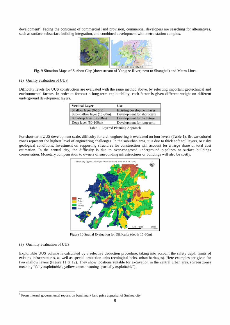
Figure 11 Evaluation of Potential Volume (depth 0-15m) Figure 12Evaluation of Potential Volume (depth 15-30m)
At the scale of city region, it is estimated that, for existing development layer (0-15m depth), exploitable UUS can reach
5‘533 mio m3 (61% of total UUS at that depth range); for short-term development layer (15-30m), exploitable volume is
8‘166 mio m3 (90% of total UUS at that depth range); for the far future, exploitable volume between the depth of 30 and
100m will be about 40‘231 mio m3 (95% of the whole deep layers).This volume estimation could be expressed in
available subsurface area (m2) to be urbanized, serving as a tool to quantify UUS floor area in UUS planning. For urban
subsurface land appraisal, the pricing hierarchy should take into account the depth ranges among others. This potential
volume estimation of UUS supply could be presented in 3D scale3 for easy visualization.
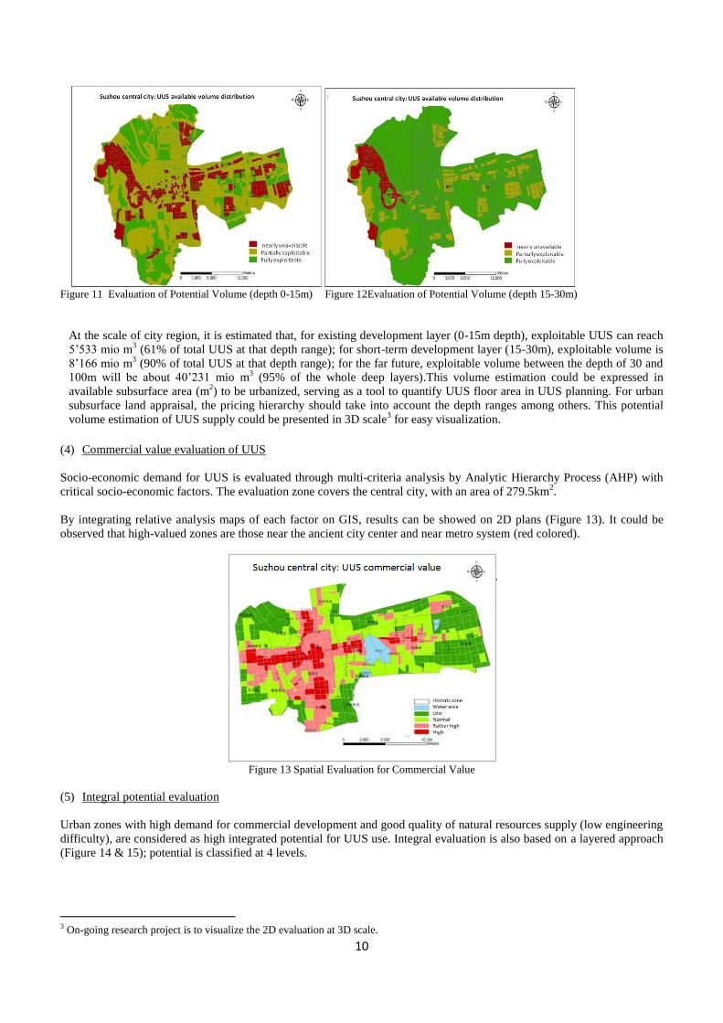
(4) Commercial value evaluation of UUS
Socio-economic demand for UUS is evaluated through multi-criteria analysis by Analytic Hierarchy Process (AHP) with
critical socio-economic factors. The evaluation zone covers the central city, with an area of 279.5km2.
By integrating relative analysis maps of each factor on GIS, results can be showed on 2D plans (Figure 13). It could be
observed that high-valued zones are those near the ancient city center and near metro system (red colored).
Figure 13 Spatial Evaluation for Commercial Value
(5) Integral potential evaluation
Urban zones with high demand for commercial development and good quality of natural resources supply (low engineering
difficulty), are considered as high integrated potential for UUS use. Integral evaluation is also based on a layered approach
(Figure 14 & 15); potential is classified at 4 levels.
3 On-going research project is to visualize the 2D evaluation at 3D scale.

11
Figure 14 Integral Demand-supply Evaluation (5-15m depth, pipeline layer excluded) and Estimated Volumes
Figure 15 Integral Demand-supply Evaluation (15-30m depth) and Estimated Volumes
This comprehensive evaluation for UUS reflects the philosophy of ―Deep City‖ concept, which advocates an urban
governance innovation: ―rethinking supply capacity of natural resources before meeting urban construction needs‖.
Our rapid urbanization process is aggravating the provision pressure of natural resources; a more considerate manner of
space exploitation should be integrated into urban planning and land management.
3.3 Multi-use approach for UUR management, the added value of geo-environment
This section emphasizes environmental protection planning and energy planning in the process of developing urban
subsurface. Since UUS development have not been given much attention in the past decades, it is necessary to take this
opportunity to include it into the whole sustainable city transformation practice (Bobylev 2009).
As presented at the beginning, there is a natural environmental system beneath our urban land. Each of these natural
resources in the system contribute significant role to support our urban life. Placing infrastructure and developments
underground challenges the natural state of these resources. To have a comprehensive understanding of the development
impacts on individual components and the interrelationship of the impacts enables city administrators and project owners to
work jointly for synergy effect in developing UUS (such as combining basement and foundation construction with energy
geostructures4), as well as to avoid engaging in conflicting and incompatible utilization (such as damaging drinkable
4 Energy geostructures: http://lms.epfl.ch/energy-geostructures

12
groundwater during tunnel excavation). The concept of ―Deep City‖ was put forward in the framework of Swiss national
research program NRP54 ―Sustainable development in the built environment‖. This project named ―Underground resources
and sustainable development in urban areas‖ developed a management methodology to optimize multiple exploitation of
these underground resources in city perimeters, with detailed case study for the city of Geneva for methodological
validations. Methodological scheme with multi-use approach to manage urban underground resources is showed in
Figure16.
In order to widen the applicability of this concept to much larger cities around the world, an ongoing project named ―Deep
City China‖ was launched with Nanjing Institute of Underground Space and Geo-environment (whose contributions are
presented in section 3.2). This comparative research between Swiss and Chinese contexts in terms of urban underground
resources (UUR) management will have a complementary focus on economic assessment of subsurface development. It
will also explore the feasibility of UUS development under a coordinated administrative and regulatory system. In order to
guide national application of the concept, territorial underground typology will be classified to suit the needs of various
urban governance and resources management.
4. Conclusion
Urbanisation is undergoing a transitional path, with increasing demand for space and resources on one side, and decreasing
capacity of natural supply on the other side. Transitional cities are also opportunities, to change urban governance and to
rethink our development patterns. Urban subsurface is the last free territory of urban area, offering ―limitless‖ available
space for construction. Geological resources beneath our land are also valuable, offering ―renewable‖ water and energy for
exploitation. If we can begin a third dimension of urban governance without delay, we will benefit a lot from urbanisation
for the long-term future.
Research significance of this paper is to show a comprehensive methodology on the evaluation of demand-supply potential
of Urban Underground Space (UUS) and resources (UUR). Potentials illustrated in the framework are then translated into
economic terms as cost and benefits in order to justify project investments. Further work will be to complete the evaluation
of costs and benefits based on a real project scheme. Finally, the holistic approach of UUR exploitation, ―Deep City‖
concept, is presented with the aim to raise political awareness for optimal use of natural resources.
Figure 16 Multi-uses Evaluation Methodology

13
Acknowledgements
The work presented in this paper is supported by the Sino Swiss Science and Technology Cooperation (SSSTC 2009-2012)
and National Natural Science Foundation of China (40872171).
References
Baranzini, A. and C. Schaerer (2007). "A Sight for Sore Eyes: Assessing the Value of View and Landscape Use on the
Housing Market." SSRN eLibrary.
Barles, S. (1995). L'urbansime Souterrain. Paris.
Blunier, P. (2009). Méthodologie de gestion durable des ressources du sous-sol urbain. Lausanne, EPFL. Ph.D.
Bobylev, N. (2009). "Mainstreaming sustainable development into a city's Master plan: A case of Urban Underground
Space use." Land Use Policy 26(4): 1128-1137.
Carmody, J., R. Sterling, et al. (1983). Underground building design: commercial and institutional structures, Van Nostrand
Reinhold Co.
Carmody, J. and R. L. Sterling (1993). Underground Space Design: Part 1: Overview of Subsurface Space Utilization Part
2: Design for People in Underground Facilities, John Wiley & Sons.
Chen, J. (2009). Development and Utilization of the Underground Space of the conservation districts of historic sites in the
Old City of Beijing——Opportunities and Challenges. Proceedings of 12th International Conference of the Associated
research Centers for Urban Underground Space (ACUUS2009), Shenzhen, China.
ITA-CUS (2010). ITA Committee on Underground Space White paper #2 "Planning the use of underground space".
ITA-WG13 (2004). "Underground or aboveground? Making the choice for urban mass transit systems: A report by the
International Tunnelling Association (ITA). Prepared by Working Group Number 13 (WG13). ‗Direct and indirect
advantages of underground structures‘." Tunnelling and Underground Space Technology 19(1): 3-28.
Li, X.-j., X. Gu, et al. (2009). Pragmatic Development and Utilization of Underground Space in Public Green Space: A
Case of Shenzhen. Proceedings of 12th International Conference of the Associated research Centers for Urban
Underground Space (ACUUS2009), Shenzhen, China.
LING, K.-K. (2011). Towards an underground development strategy for Hong Kong. Planning and Development of
Underground Space: bridging planners, engineers and the public on innovative use of underground space, Hong Kong.
Maire, P. (2011). Étude multidisciplinaire d'un développement durable du sous-sol urbain : aspects socio-économiques,
juridiques et de politique urbaine. . Lausanne, EPFL. Ph.D.
Michael B, B. (1986). "Toronto's underground pedestrian system." Tunnelling and Underground Space Technology 1(2):
145-151.
Miki, H., J. Iwabuchi, et al. (2005). "NEW SOIL TREATMENT METHODS IN JAPAN." TREMTI 2005 –
Communication C189.
Monnikhof, R. A. H., J. Edelenbos, et al. "The new underground planning map of the Netherlands: a feasibility study of the
possibilities of the use of underground space." Tunnelling and Underground Space Technology 14(3): 341-347.
Nishi, J., T. Tanaka, et al. "Estimation of the value of the internal and external environment in underground space use."
Tunnelling and Underground Space Technology 15(1): 79-89.
Parriaux, A., P. Blunier, et al. (2010). Rapport de recherche PNR54: Projet Deep City – Ressources du sous-sol et
développement durable des espaces urbains.

14
Parriaux, A., L. Tacher, et al. (2004). "The hidden side of cities—towards three-dimensional land planning." Energy and
Buildings 36(4): 335-341.
PARRIAUX, A., L. TACHER, et al. (2006). Underground resources and sustainable development in urban areas.
IAEG2006 Paper number 700.
Pasqual, J. (2005). "Underground land values." Land Use Policy 22: 322-330.
SHU, Y., F. PENG, et al. (2006). "Study and Practice of Urban Underground Space Plann ing in China (in Chinese)."
Chinese Journal of Underground Space and Engineering 2(7).
Sterling, R. L. (2007). "Urban Underground Space Use Planning: A Growing Dilemma."
Tetsuya, H. (1990). "Japan's new frontier strategy: Underground space development." Tunnelling and Underground Space
Technology 5(1-2): 13-21.
UN-HABITAT (2009). Planning sustainable cities: global report on human settlements 2009, Earthscan.
VÄHÄAHO, I. (2009). UNDERGROUND MASTER PLAN OF HELSINKI: A city growing inside bedrock, City of
Helsinki.
Wissen Hayek, U., J. Jaeger, et al. (2010). "Measuring and Assessing Urban Sprawl: What are the Remaining Options for
Future Settlement Development in Switzerland for 2030?" Applied Spatial Analysis and Policy: 1-31.
Zhang, T. and Z. Liao (2009). The Discussion on Regulatory Plan for Underground Space in Key Urban Areas — with
underground space plan for Beijing Central Business Districts (CBD) as the case. Proceedings of 12th International
Conference of the Associated research Centers for Urban Underground Space (ACUUS2009), Shenzhen, China.
ZHOU, Y. and J. CAI (2011). Rock cavern space development in Singapore. Planning and Development of Underground
Space: bridging planners, engineers and the public on innovative use of underground space, Hong Kong.
Zhu, W., J. Fu, et al. (2009). Urban Underground Space Value: Case Study of Kaisheng Square Planning in Lanzhou City.
Proceedings of 12th International Conference of the Associated research Centers for Urban Underground Space
(ACUUS2009), Shenzhen, China.