Surveying with the Global Positioning System Code Pseudo-Ranges.
40
Surveying with the Global Positioning System Code Pseudo-Ranges
-
Upload
hubert-simmons -
Category
Documents
-
view
225 -
download
1
Transcript of Surveying with the Global Positioning System Code Pseudo-Ranges.

Surveying with theGlobal
PositioningSystem
Code Pseudo-Ranges

Outline of Session 1• GPS Fundamentals
• Types of GPS Positioning
• Levels of Accuracy
• Pseudo-Ranges
• DOPs
• GLONASS

March 1999 Surveying with GPS
TRANSIT (Doppler Shift)
- 16 or less fixes a day
- Sub-meter accuracy in about 3 days- Worldwide coverage
- Lat/Long/Height
LORAN (Triangulation)
- Continuous position fixes
- Accurate to 300 meters
- Limited coverage
- Lat/Long
Before GPS There Was...

March 1999 Surveying with GPS
GPS
- Continuous position fixes
- Worldwide coverage
- Lat/Long/Height
- Centimeter accuracy in seconds
TRANSIT (Doppler Shift)
- 16 or less fixes a day
- Sub-meter accuracy in about 3 days- Worldwide coverage
- Lat/Long/Height
LORAN (Triangulation)
- Continuous position fixes
- Accurate to 300 meters
- Limited coverage
- Lat/Long
...Now

March 1999 Surveying with GPS
What is GPS?
• A super accurate system
• Developed and maintained by US Department of Defense
• Satellite-based
• Sold US Congress on the idea that other applications would follow
• Signals are free
• Unlimited users

3 Segments of GPS
SpaceSegment
UserSegment
4 Monitor Stations
ControlSegment
and one Master Control Station

GPS Satellite Constellation
• 24 Satellites • 6 orbital planes• 20,000 km high• 12 hour orbits• At least 4
Satellites in view 24 hours per day
• Any weather

Launched on Delta Rockets

The GPS Satellite
• 3 atomic clocks• L Band Radio Signals -
19 -24 cm Wavelength• Codes on the signal• Distance to SV by time
signal takes to reach the receiver or other method
• Satellite Position• Also give health of system
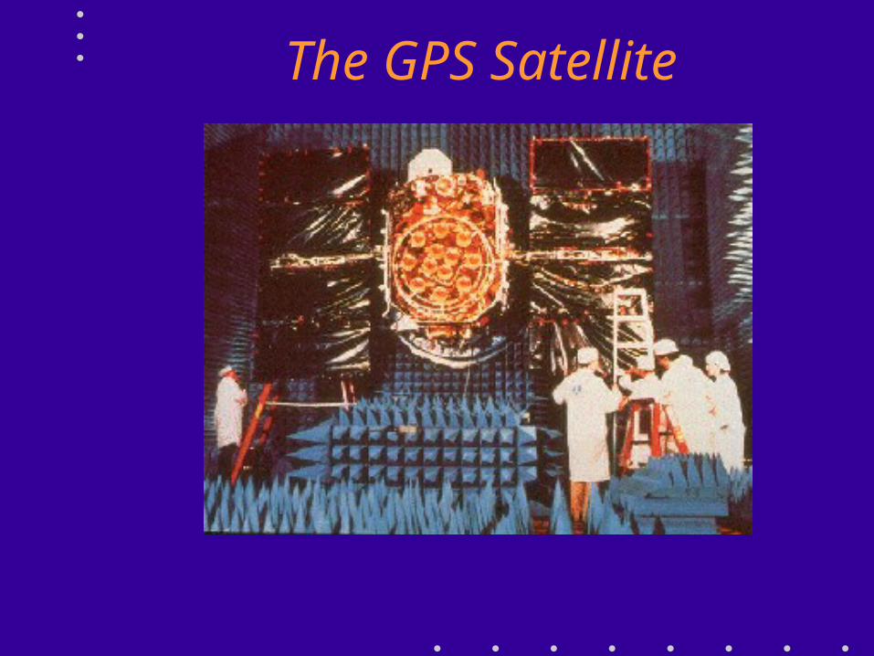
The GPS Satellite

3 Types of GPS Positioning
• Point Positioning
• Differential GPS
• GPS Surveying

3 Levels of GPS Accuracy• Point Positioning - 100m 95% of the Time
for Civilian Users - With SA
• About 10-20m without SA
• Differential GPS - 0.5m to 10m
• GPS Surveying - 5mm per km typical and centimetres in thousands of km possible
• Surveyors can and should be involved in all 3 levels

1 Receiver - “Point Positioning”
• Basic technique for which GPS was designed• Basic Civilian Receivers < $ 500
R3R3R2R2
R1R1
R4R4
Satellites are sayingSatellites are sayingMy Time is …My Time is …My Position is ...My Position is ...

March 1999 Surveying with GPS
4
Based on Trilateration1
Use message from satellite for its location
Correct for Troposphere & Ionosphere5
Distance from satellites (SV) using speed of light
23 4 SVs to solve
for X,Y,Z,t
Code Range GPS in 5 Steps

March 1999 Surveying with GPS
11Trilateration From Satellites
• By measuring distance from several satellites you can calculate your position

March 1999 Surveying with GPS
We're somewhereon the surface ofthis sphere.
20,000 Km
Trilateration• Assume for now we can measure a distance
to a SV
• One measurement narrows down our position to the surface of a sphere

March 1999 Surveying with GPS
Intersection of twoSpheres is a circle
• Second measurement narrows it down to intersection of two spheres
Trilateration

March 1999 Surveying with GPS
• Third measurement narrows to just two points
Trilateration

March 1999 Surveying with GPS
• In theory 3 measurements are enough because
• We can discard one point because it will be a ridiculous answer– Out in space– Or moving at high speed
• But we do need the 4th measurement to cancel out clock errors
Trilateration

4 Ranges to resolve for Latitude, Longitude, Height & Time
It is similar in principle to a resection problem
Trilateration

March 1999 Surveying with GPS
22Satellite Ranging
• Measuring the distance from a satellite
• Done by measuring travel time of radio signals

March 1999 Surveying with GPS
Speed-of-Light Measurement
• Measure how long it takes the GPS signal to get to us
• Multiply that time by 300,000 km/sec – Time (sec) x 300,000 = km
• If you've got a good clock in the receiver, all you need to know is exactly when signal left satellite

Outline Principle : RangeOutline Principle : Range
Xll
Vl
Xl
lll
lll
lVV
VllVlll
X
lX

Xll
Vl
Xl
lll
lll
lVV
VllVlll
X
lX
Outline Principle : RangeOutline Principle : Range

Xll
Vl
Xl
lll
lll
lVV
VllVlll
X
lX
Outline Principle : RangeOutline Principle : Range

Xll
Vl
Xl
lll
lll
lVV
VllVlll
X
lX
Range = Time Taken x Speed of Light
R = t x c
Outline Principle : RangeOutline Principle : Range

March 1999 Surveying with GPS
from satellite
from ground receiver
measure time difference between same part of code
How Do We Know When the Signal Left the Satellite?
• One of the Clever Ideas of GPS: – Use same code at receiver and satellite– Synchronize satellites and receivers so they're
generating same code at same time– Then we look at the incoming code from the
satellite and see how long ago our receiver generated the same code

March 1999 Surveying with GPS
33Accurate Clocks
• Whole system depends on very accurate clocks – Necessary to measure travel time– Ensures receiver and satellite are synchronized
• Satellites have atomic clocks– Accurate but expensive
• Ground receivers need consistent clocks– Secret is in extra satellite measurement that adjusts
receiver clock

March 1999 Surveying with GPS
44 Knowing Where the Satellites Are
• 20,000 km up - high orbit – Very stable orbits– No atmospheric drag– Survivability– Earth coverage
• Monitored by US Defense Department– DOD transmits corrections back to satellite
• Corrections transmitted from satellites to us– Status message

March 1999 Surveying with GPS
Monitor stations• Diego Garcia• Ascension Island• Kwajalein • Hawaii
Current ephemeris is transmitted to users
Space Segment
GPS Control Colorado Springs
Knowing Where the Satellites Are - Ephemeris

March 1999 Surveying with GPS
55
IonosphereTroposphere
Atmospheric Corrections
• Apply estimated corrections
• The signals are delayed by the ionosphere and troposphere
• Receiver makes estimated corrections for these delays

Satellite Geometry

March 1999 Surveying with GPS
Dilution of Precision (DOP)
• A measure of Satellite geometry
• Indicates the quality of position fix
• Can be expressed in different dimensions– for example: PDOP, HDOP, VDOP, TDOP
• PDOP less than 6 is best

March 1999 Surveying with GPS
idealized situation
4 sec6 sec
• Relative position of satellites can affect error
Dilution of Precision (DOP)

March 1999 Surveying with GPS
Point representing position is really a box
4 ‘ish sec6 ‘ish sec
uncertaintyuncertainty
• Real situation - fuzzy circles
Dilution of Precision (DOP)

March 1999 Surveying with GPS
Area of uncertainty becomes larger as satellites get closer together
• Even worse at some
• angles
Dilution of Precision (DOP)

Selective Availability “SA”• Military Users - Precise Positioning Service (PPS)
• +/- 15m for Military Users
• Uses P Code which has high resolution
• Good accuracy Satellite Positions (Ephemeris)
• Civilian Users - Standard Positioning Service (SPS)• +/- 100m 95% of the time (+/- 150m vertical) SA on
• +/- 10-20m 95% of the time SA off
• C/A code 10 times less resolution than P code
• Ephemeris accuracy deliberately downgraded
• Future of SA?• Now turned off - Presidential Directive
• For how long?

GLONASS
• Uses 3 orbital planes rather than 6 with GPS• GPS - same frequency but different codes
GLONASS - same code, different frequency• Channel of Standard Accuracy (CSA) 60m horizontal,
75m vertical (99.7% confidence) • Restricted access to Channel of High Accuracy (CHA)• Gallelio emerging
Russian Federation’s GLObal NAvigation Satellite SystemFirst launch Oct 1982

GLONASS• Receivers with both GPS
and GLONASS
• More satellites available = more robust solution
• Can work despite significant satellite obstruction
• Advantages for surveying; especially for techniques which use minimal observation time
• 2 significant system level issues:– different timing systems used
– different underlying geodetic reference systems, WGS84 for GPS vs PZ90 for GLONASS.
• IGEX98 - observe both systems around the world using geodetic quality equipment
• Station at DNR’s Landcentre in Brisbane

Conclusion to Session 1
• GPS Fundamentals
• Types of GPS Positioning
• Levels of Accuracy
• Pseudo-Ranges
• DOPs
• GLONASS