Surveying, Mapping, and Geosciences Session · Surveying, Mapping, and Geosciences Session •Three...
17
Surveying, Mapping, and Geosciences Session • Three talks – Giovanni Sella – CORS status – Neil Weston – Opus – Dave Doyle – Adjustment and Geoid12A • Short 15 min break • Open discussion
Transcript of Surveying, Mapping, and Geosciences Session · Surveying, Mapping, and Geosciences Session •Three...

Surveying, Mapping, and Geosciences
Session
• Three talks
– Giovanni Sella – CORS status
– Neil Weston – Opus
– Dave Doyle – Adjustment and Geoid12A
• Short 15 min break
• Open discussion

Giovanni Sella
CORS Program Manager
NOAA-National Geodetic Survey
CORS Program Updates FY2011-
2012
CGSIC – Nashville, TN
17 September, 2012

CORS News for FY11-12
• New CORS coordinates released 6 September 2011
• New absolute antenna calibrations released same time
• On 1 July 2012 updated the NGS IDB with new CORS
coordinates, new passive network coordinates, new
geoid
• Released new HTDP 3.2.3
• Growth continues to be strong!

CORS Network Status
Sep 2012
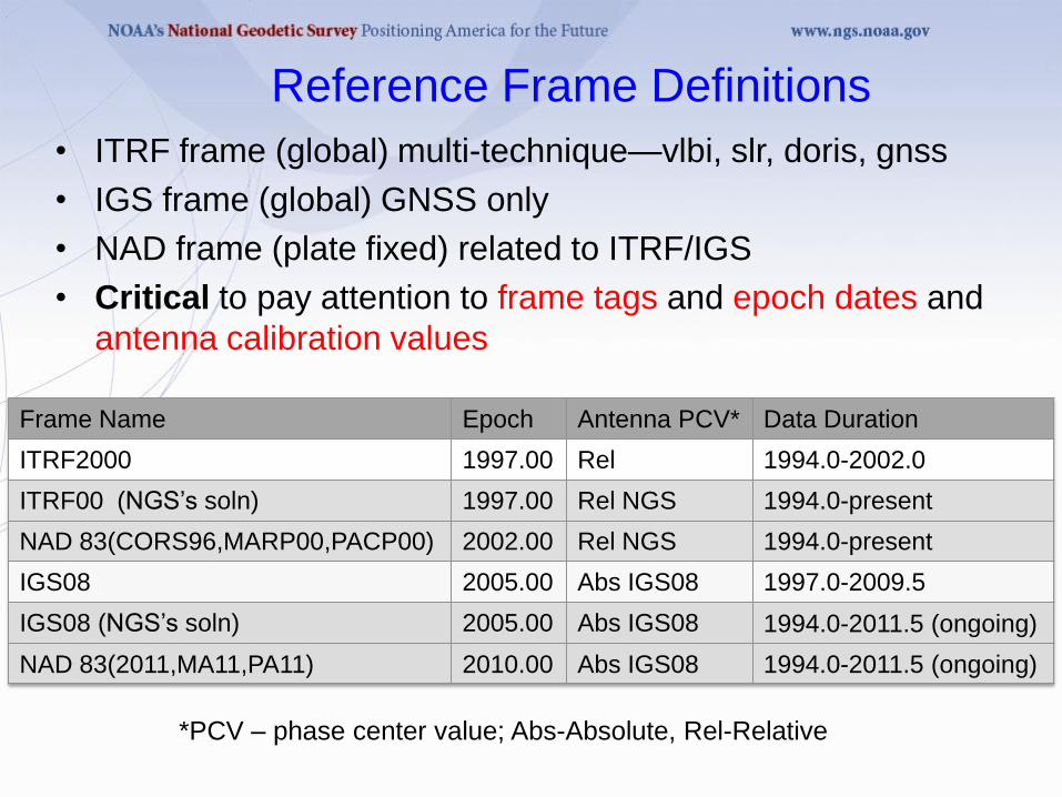
Reference Frame Definitions
• ITRF frame (global) multi-technique—vlbi, slr, doris, gnss
• IGS frame (global) GNSS only
• NAD frame (plate fixed) related to ITRF/IGS
• Critical to pay attention to frame tags and epoch dates and
antenna calibration values
Frame Name Epoch Antenna PCV* Data Duration
ITRF2000 1997.00 Rel 1994.0-2002.0
ITRF00 (NGS’s soln) 1997.00 Rel NGS 1994.0-present
NAD 83(CORS96,MARP00,PACP00) 2002.00 Rel NGS 1994.0-present
IGS08 2005.00 Abs IGS08 1997.0-2009.5
IGS08 (NGS’s soln) 2005.00 Abs IGS08 1994.0-2011.5 (ongoing)
NAD 83(2011,MA11,PA11) 2010.00 Abs IGS08 1994.0-2011.5 (ongoing)
*PCV – phase center value; Abs-Absolute, Rel-Relative

CORS IGS08 Velocity Field
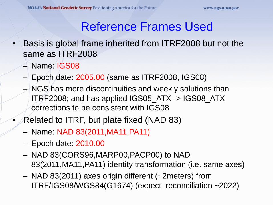
Reference Frames Used
• Basis is global frame inherited from ITRF2008 but not the
same as ITRF2008
– Name: IGS08
– Epoch date: 2005.00 (same as ITRF2008, IGS08)
– NGS has more discontinuities and weekly solutions than
ITRF2008; and has applied IGS05_ATX -> IGS08_ATX
corrections to be consistent with IGS08
• Related to ITRF, but plate fixed (NAD 83)
– Name: NAD 83(2011,MA11,PA11)
– Epoch date: 2010.00
– NAD 83(CORS96,MARP00,PACP00) to NAD
83(2011,MA11,PA11) identity transformation (i.e. same axes)
– NAD 83(2011) axes origin different (~2meters) from
ITRF/IGS08/WGS84(G1674) (expect reconciliation ~2022)

Changes with New Frames
• Change from relative to IGS08 absolute antenna phase
center values (PCV)
• The global frame (IGS08) pos/vel are aligned to full
global frame >100 sites
• Change in epoch from 2002.00 to 2010.00 in NAD
83(2011/MA11/PA11)
• Coordinates change by ~1.5 cm horizontal ~1cm vertical
in Easter USA
• No longer support coordinates in ITRF00 or NAD 83
(CORS96,MARP00,PACP00)
• What amount of change/tolerance are permitted?
– No change 2 cm horizontal, 4 cm vertical
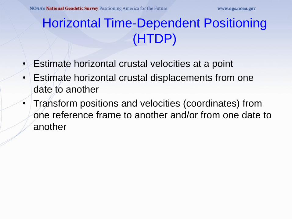
Horizontal Time-Dependent Positioning
(HTDP)
• Estimate horizontal crustal velocities at a point
• Estimate horizontal crustal displacements from one
date to another
• Transform positions and velocities (coordinates) from
one reference frame to another and/or from one date to
another
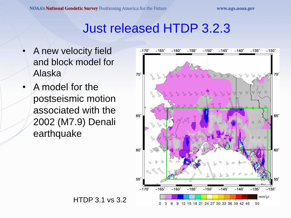
Just released HTDP 3.2.3
• A new velocity field
and block model for
Alaska
• A model for the
postseismic motion
associated with the
2002 (M7.9) Denali
earthquake
HTDP 3.1 vs 3.2

Velocity Differences between HTDP_v3.2 and
HTDP_3.1
- An improved model for estimating velocities in eastern CONUS
(east of 107°W) and slightly improved model for estimating
velocities in western CONUS

HTDP 3.2.3
• A model for estimating velocities on the Philippine Sea
plate
• Improved models for estimating velocities for the
following tectonic plates: Pacific, Caribbean, Juan de
Fuca, and Cocos
• More accurate resolution of the tectonic plate
boundaries
• The capability to transform coordinates between the
new WGS 84(G1674) reference frame and other
popular reference frames
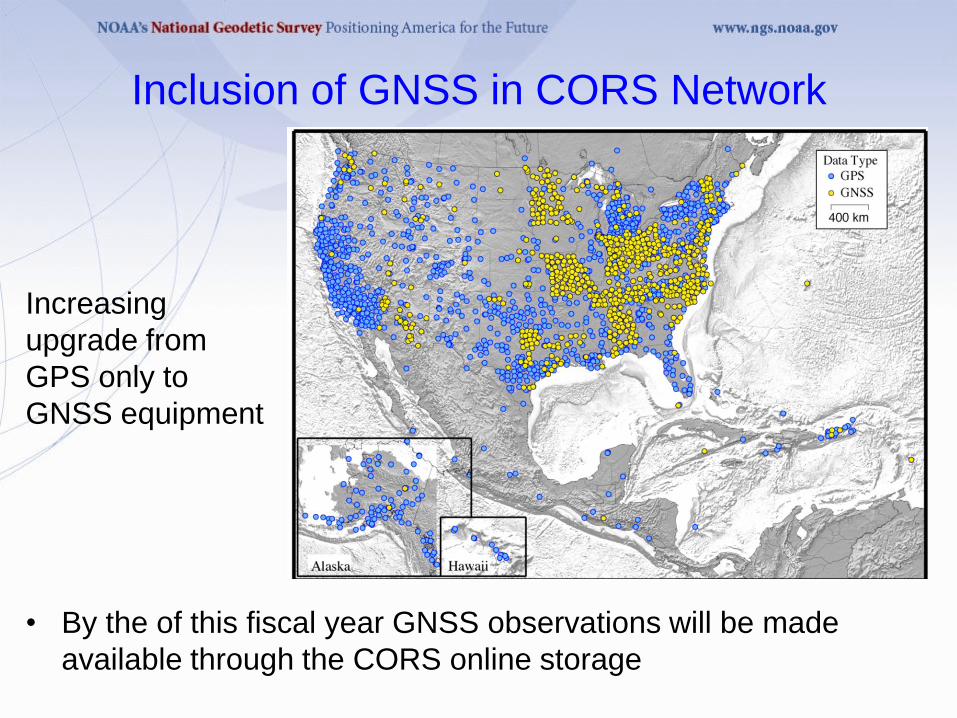
Inclusion of GNSS in CORS Network
• By the of this fiscal year GNSS observations will be made
available through the CORS online storage
Increasing
upgrade from
GPS only to
GNSS equipment

1994 (<10) 1997 (~150) 2000 (~300) 2003 (~600)
2006 (~900) 2009 (~300)
2012 (~1900)
Growth of CORS Network
With Growth Comes Change
• Growth is often thought of as good
• Too much “good” can be bad!
• Emphasis in recent years has been on station quality,
have removed a number of poor quality stations.
• In the next year will be reviewing station quality against
network average, per guidelines issued in 2006
• Update to guidelines forthcoming including spacing
requirements

Summary
• All NGS Products and Services are in consistent frames in
2012:
– IGS08 epoch 2005.00
– NAD 83(2011,MA11,PA11) epoch 2010.00
• Users must use appropriate antenna calibrations with
particular reference frames
• QC of CORS stations will increase updated guidelines
forthcoming
• GNSS data distribution by end of the year
• Reprocessing of CORS should begin within the next year
Questions/Comments
• We recognize that NGS and the public want CORS to be
the primary access to the NSRS, but accuracy and
constancy are not always possible.
• We are keen to hear your comments/concerns
• Check: geodesy.noaa.gov/CORS/news.shtml
geodesy.noaa.gov/CORS
Choose Data Products