Survey of Routing Protocol used in Vehicular Ad Hoc...
12
International Journal of Current Engineering and Technology E-ISSN 2277 – 4106, P-ISSN 2347 – 5161 ©2017 INPRESSCO ® , All Rights Reserved Available at http://inpressco.com/category/ijcet Research Article 1051| International Journal of Current Engineering and Technology, Vol.7, No.3 (June 2017) Survey of Routing Protocol used in Vehicular Ad Hoc Networks Agam Srivastava * and B.P. Chaurasia Department of Computer Science & Engineering, KNIT, Sultanpur, UP, India Accepted 15 May 2017, Available online 24 May 2017, Vol.7, No.3 (June 2017) Abstract VANET (Vehicular ad hoc networks) is a special type of MANET which is mainly used for making Intelligent Transportation System (ITS). This paper presents various routing algorithms/protocols which can be used for implementing VANETs for communication and management of the network. This paper also discusses the advantages and disadvantages of these routing protocols. The routing protocols fall into two noteworthy classes. One is topology-based and the other is position-based routing. The paper talks about the advantages and disadvantages of these routing protocols, explores the motivation behind their design and follow the advancement of these routing protocols. At last, it finishes up the paper by pointing out some open issues and conceivable directions of future research related VANET routing. Keywords: VANET, Ad hoc networks, survey, routing protocol, V2V, V2I, classes of routing protocols. 1. Introduction 1 The number of vehicles around the world has increased a lot during the last decades and will keep on growing in the following years, driving has turned out to be all the more difficult and risky. Streets are immersed, safety distance and sensible and reasonable speeds are not really regarded, and drivers frequently need enough attention. Due to this, leading automotive industries and car manufacturers decided to work together with national government security agencies to find and develop solution for helping drivers on the streets by foreseeing hazardous occasions and to deal with worst traffic environment. One of the outcomes called Wireless Access for Vehicular Environment (WAVE) dedicated to V2V (vehicle-to-vehicle) and V2I(vehicle-to-infrastructure or vehicle-to-roadside) communications. With the power of WAVE communication devices, cars and roadside units shape a profoundly network called a VANET- a special kind of Mobile Ad-Hoc Networks (MANETs). Despite of having countless routing protocols for MANET, many of them do not apply to VANET due to its challenging characteristics which are discussed in the next section. 2. Network Architectures Basically, there are three types of architecture of VANET can be classified: *Corresponding author Agam Srivastava is a PG Scholar and B.P. Chaurasia is working as Associate Professor Figure 1: Types of VANET architecture 3. Network Characteristics 3.1 Dynamic topology: Since vehicles are moving very fast, the topology formed by VANETs will be continuously changing. 3.2 Intermittent availability (Frequent disconnection): The exceptionally dynamic topology results in as often as possible separated (disconnected) system since the
Transcript of Survey of Routing Protocol used in Vehicular Ad Hoc...

International Journal of Current Engineering and Technology E-ISSN 2277 – 4106, P-ISSN 2347 – 5161 ©2017 INPRESSCO®, All Rights Reserved Available at http://inpressco.com/category/ijcet
Research Article
1051| International Journal of Current Engineering and Technology, Vol.7, No.3 (June 2017)
Survey of Routing Protocol used in Vehicular Ad Hoc Networks Agam Srivastava* and B.P. Chaurasia Department of Computer Science & Engineering, KNIT, Sultanpur, UP, India
Accepted 15 May 2017, Available online 24 May 2017, Vol.7, No.3 (June 2017)
Abstract VANET (Vehicular ad hoc networks) is a special type of MANET which is mainly used for making Intelligent Transportation System (ITS). This paper presents various routing algorithms/protocols which can be used for implementing VANETs for communication and management of the network. This paper also discusses the advantages and disadvantages of these routing protocols. The routing protocols fall into two noteworthy classes. One is topology-based and the other is position-based routing. The paper talks about the advantages and disadvantages of these routing protocols, explores the motivation behind their design and follow the advancement of these routing protocols. At last, it finishes up the paper by pointing out some open issues and conceivable directions of future research related VANET routing. Keywords: VANET, Ad hoc networks, survey, routing protocol, V2V, V2I, classes of routing protocols. 1. Introduction
1 The number of vehicles around the world has
increased a lot during the last decades and will keep on growing in the following years, driving has turned out to be all the more difficult and risky. Streets are
immersed, safety distance and sensible and reasonable speeds are not really regarded, and drivers frequently
need enough attention. Due to this, leading automotive industries and car manufacturers decided to work together with national government security agencies to
find and develop solution for helping drivers on the streets by foreseeing hazardous occasions and to deal with worst traffic environment. One of the outcomes
called Wireless Access for Vehicular Environment (WAVE) dedicated to V2V (vehicle-to-vehicle) and
V2I(vehicle-to-infrastructure or vehicle-to-roadside) communications. With the power of WAVE communication devices, cars and roadside units shape
a profoundly network called a VANET- a special kind of Mobile Ad-Hoc Networks (MANETs). Despite of having
countless routing protocols for MANET, many of them do not apply to VANET due to its challenging characteristics which are discussed in the next section.
2. Network Architectures Basically, there are three types of architecture of VANET can be classified:
*Corresponding author Agam Srivastava is a PG Scholar and B.P. Chaurasia is working as Associate Professor
Figure 1: Types of VANET architecture
3. Network Characteristics 3.1 Dynamic topology: Since vehicles are moving very fast, the topology formed by VANETs will be continuously changing. 3.2 Intermittent availability (Frequent disconnection): The exceptionally dynamic topology results in as often as possible separated (disconnected) system since the
Agam Srivastava et al Survey of Routing Protocol used in Vehicular Ad Hoc Networks
1052| International Journal of Current Engineering and Technology, Vol.7, No.3 (June 2017)
connection between two vehicles can rapidly vanish while the two nodes are exchanging information due to their variable pattern and fast speed. 3.3 Propagation Model: In VANETs, the propagation model is typically not thought to be free space due to the presence of nearby vehicles, tress, buildings and others objects. 3.4 Sufficient Energy: Hubs in VANETs are not subject to power and are accepted to have sufficient energy. 3.5 High Mobility: As the nodes are moving very fast, it becomes harder to predict the correct location of the node. 3.6 On-board sensor: Nodes are considered to be fully equipped with the sensors such as GPS, barometer, temperature sensor, etc. help in providing information for routing.
4. Routing Protocols
Routing Protocols are the rules or we can say
algorithms which governs the communication between
nodes in the process of exchanging information. It
consist of establishing the connection by finding the
best route, taken decision for forwarding the packets,
behaving appropriately in the occurrence of fault and
recovering from failure.
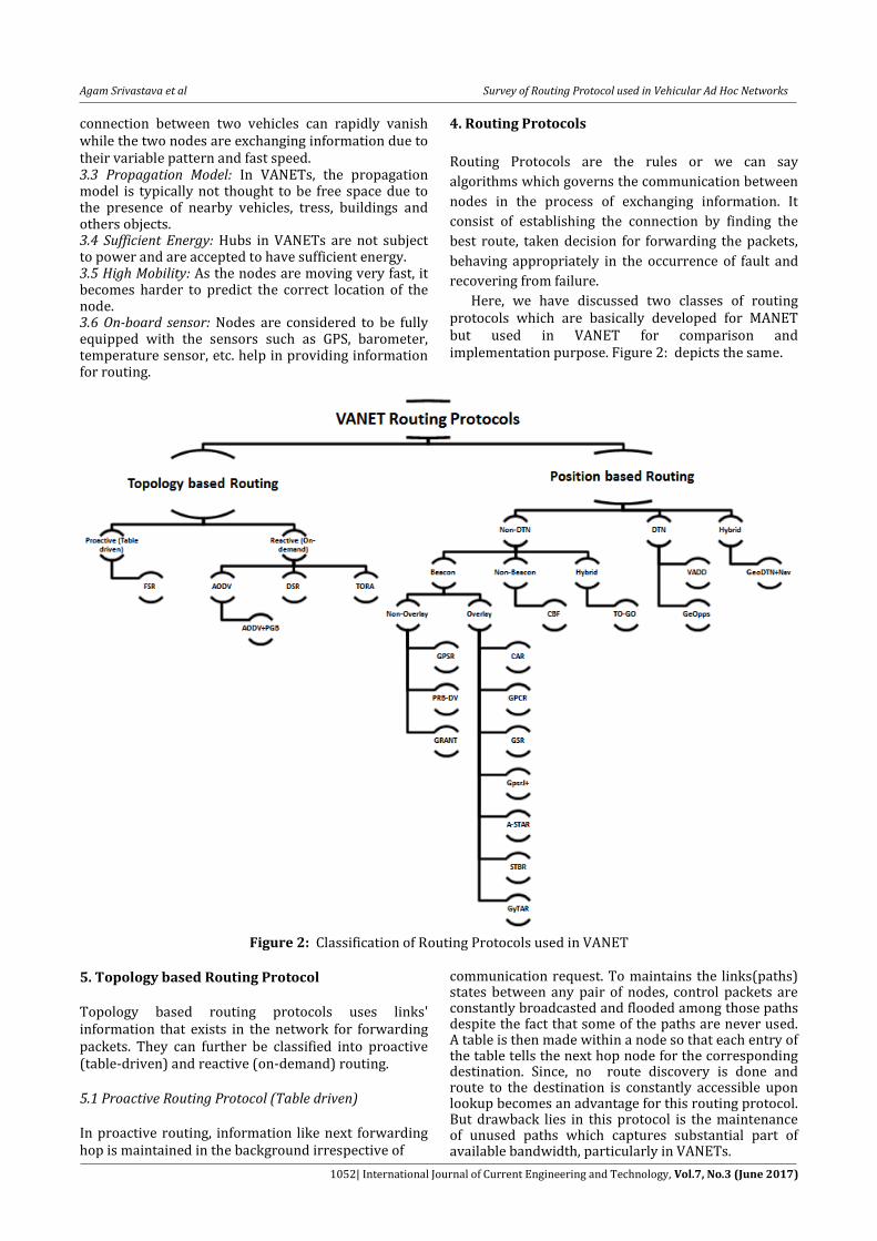
Here, we have discussed two classes of routing protocols which are basically developed for MANET but used in VANET for comparison and implementation purpose. Figure 2: depicts the same.
Figure 2: Classification of Routing Protocols used in VANET
5. Topology based Routing Protocol Topology based routing protocols uses links' information that exists in the network for forwarding packets. They can further be classified into proactive (table-driven) and reactive (on-demand) routing. 5.1 Proactive Routing Protocol (Table driven) In proactive routing, information like next forwarding hop is maintained in the background irrespective of
communication request. To maintains the links(paths) states between any pair of nodes, control packets are constantly broadcasted and flooded among those paths despite the fact that some of the paths are never used. A table is then made within a node so that each entry of the table tells the next hop node for the corresponding destination. Since, no route discovery is done and route to the destination is constantly accessible upon lookup becomes an advantage for this routing protocol. But drawback lies in this protocol is the maintenance of unused paths which captures substantial part of available bandwidth, particularly in VANETs.
Agam Srivastava et al Survey of Routing Protocol used in Vehicular Ad Hoc Networks
1053| International Journal of Current Engineering and Technology, Vol.7, No.3 (June 2017)
5.1.1 Fisheye State Routing (FSR) According to Kleinrock and Stevens, FSR uses the fisheye technique where the technique was used to reduce the size of information required to represent graphical data. The eye of a fish captures with high detail the pixels near the focal point. The detail decreases as the distance from the focal point increases. In routing, the fisheye approach translates to maintaining accurate distance and path quality information about the immediate neighbourhood of a node, with progressively less detail as the distance increases. Routing proceeds as: Link state information for every destination is
stored by every node. Updates messages are periodically broadcasted by
the nodes to their neighbours. Updates correspond to closer nodes propagate
more frequently Advantage FSR reduces significantly the consumed bandwidth
as it exchanges partial routing update information with neighbours only.
In the event of link failure, change in the routing table doesn’t occur.
Reduced routing overhead Disadvantage Very poor performance in small ad-hoc networks Less knowledge about distant nodes. The increase in network size, storage complexity
and the processing overhead of routing table also increases.
Insufficient information for route establishing. 5.2 Reactive Routing Protocol (On-demand) Unlike proactive routing protocols, reactive routing protocols do not make the nodes initiate a route discovery process until a route to a destination is required. It maintains only the routes that are currently in use, thereby reducing the burden on the network. The protocol comprises of two main functions of Route Discovery and Route Maintenance. Route Discovery function is responsible for the discovery of new route, when one is needed and Route Maintenance function is responsible for the detection of link breaks and repair of an existing route. 5.2.1 Ad hoc On demand Distance Vector Routing (AODV) In Ad Hoc On Demand Distance Vector (AODV) (Perkins, 1999) routing, upon receipt of a broadcast query (RREQ), nodes record the address of the node sending the query in their routing table. This process of
recording its previous hop is called backward learning. Upon reaching at its destination, a reply packet (RREP) is then sent to the source which contains complete path obtained from backward learning. At each stop of the path, the node would record its previous hop, therefore resulting into the forward path from the source. This whole process of flooding of query message and sending of reply build up a full duplex path. After the path has been setup, it is kept as long as the source uses it. A failure of link will be accounted recursively to the source and will thus trigger another query-response procedure to find a new route. Advantage An up-to-date path to the destination because of
using sequence number. It reduces excessive memory requirements and the
route redundancy. It responses to the link failure in the network. It can be applied to large scale adhoc network. Disadvantage Requires large time for setting up the connection
and initial communication. Heavy control overhead if there are multiple route
reply packets for single reply packet. Inconsistency occurs when intermediate nodes
contains stale entries. Requires more bandwidth. 5.2.1.1 AODV+PGB (Preferred Group Broadcasting) It is a broadcasting mechanism and seen as an enhancement to AODV protocol which reduces the overhead associated with route discovery in AODV and to provide route stability which is very crucial in VANETs where wireless host for this network are the high speed moving vehicles. Receiver upon receiving the signal can identify whether it belong to the preferred group and which one in the group to broadcast. Since only one node is allowed to broadcast and since the preferred group is not necessarily the one that makes the most progress towards the destination, route discovery might take longer than before. Another drawback is that broadcast can discontinue if the group is found to be empty (possibly because of sparse networks). Packet duplication can happen as two nodes in the preferred group can broadcast at the same time. According to Naumov et al. (2006), the way to deal with broadcast duplication is to add packet's predecessors into the packet. This creates the same type of overhead in the packet as DSR. Advantage Less overhead as compared to AODV Provide route stability
Agam Srivastava et al Survey of Routing Protocol used in Vehicular Ad Hoc Networks
1054| International Journal of Current Engineering and Technology, Vol.7, No.3 (June 2017)
Disadvantage Sometimes takes longer time in route discovery. No broadcast if group found empty. Duplication of packet occurs in same cases. 5.2.2 Dynamic Source Routing (DSR) DSR uses source routing, means that the source tells the sequence of intermediate nodes in the routing path in the data packet itself. In this routing, the IDs of the intermediate nodes it has traversed are copied in the header of the query packet. The destination then fetches the entire path from the query packet, and uses it to respond to the source. Therefore, source can establish a path to the destination. Hence, called as Source Routing. If destination is allowed to send multiple route replies, then the source node may receive and store multiple routes from the destination. These alternative routes can be used when some link in the current route breaks. In a network with low mobility, this is advantageous over AODV since the alternative route can be tried before DSR initiates another flood for route discovery. Advantage No beacon message used Has less overload on the network for obtaining
route between nodes. Uses caching which decrease the network load. No such requirements of periodical update. Disadvantage Network with plenty of nodes tends to increase the
header size of routing information. Unnecessary flooding occurs in the network. Gives worst result if the network has high mobility. 5.2.3 Temporally Ordered Routing Algorithm (TORA) TORA routing belongs to a family of link reversal routing algorithms where a directed acyclic graph (DAG) toward the destination is built based on the height of the tree rooted at the source. The directed acyclic graph directs the flow of packets and ensures reachability to all nodes. When a node has a packet to send, it broadcasts the packet. Its neighbour only broadcasts the packet if it is the sending node’s downward link based on the DAG. A node would construct the directed graph by broadcasting a query packet. Upon receiving a query packet, if a node has a downward link to the destination, it will broadcast a reply packet; otherwise, it simply drops the packet. A node, upon receiving a reply packet, will update its height only if the height from the reply packet gives the minimum of all the heights from reply packets it has received so far. It then rebroadcasts the reply packet. The advantages of TORA are that the execution of the
algorithm gives a route to all the nodes in the network and that it has reduced far-reaching control messages to a set of neighbouring nodes. However, because it provides a route to all the nodes in the network, maintenance of these routes can be overwhelmingly heavy, especially in highly dynamic VANETs. Advantage Reduced network load as the intermediate node
doesn’t rebroadcast the message. Uses DAG (Directed acyclic graph). Result good in case of dense network. Disadvantage Not used practically due to less efficient and
reliable than DSR and AODV. Not scalable in nature.
6. Evaluation of Topology based routing Jaap et al. (2005) has evaluated AODV, DSR, FSR, and TORA in city traffic scenarios on the network simulator ns-2. The city mobility model is based on a Manhattan-like road network of eight horizontal and vertical roads. The speed of the vehicles is determined based on the Intelligent-Driver Model (IDM) where a vehicle’s speed is adjusted by other surrounding vehicles and road topology such as intersections (Helbing 2002). From their simulation, it is shown that AODV has the best performance and lowest control overhead. It is followed by FSR, DSR, and then TORA. DSR suffers from a very high delay because source routes change +continuously due to high mobility. Its route overhead is comparable to FSR yet higher than AODV since DSR keeps route information within the packet header. The common characteristic among all four routing protocols is that performance degrades as network densities increase, indicating their scalability problem.
7. Position based Routing Protocols Position based routing also called as geographic routing, the forwarding decision made by a node is essentially chosen in light of the position of destination of the packet and the position of the one-hop neighbors of the node. Destination's position will be stored in the header of the packet by the source. The position of the node's one-hop neighbors is acquired by sending beacons at times with random jitter (to prevent collisions). Nodes that are inside the radio scope of the node will progress toward becoming neighbors of that node. Geographic routing expect every node knows its position, and the position of destination node is known to the sending node using Global Position System (GPS) unit from an on-board Navigation System and the recent research on location services (Flury, 2006; Li, 2000; Yu, 2004), respectively. Since geographic routing protocols don't trade link state information and don't

Agam Srivastava et al Survey of Routing Protocol used in Vehicular Ad Hoc Networks
1055| International Journal of Current Engineering and Technology, Vol.7, No.3 (June 2017)
keep up established routes like proactive and reactive topology based routings do, hence they are more powerful and promising to the profoundly dynamic conditions like VANETs. In other words, as the packet is forwarded in the network, the route is resolved based on the geographic position of neighbor nodes. 7.1 Non-DTN The Non-DTN Routing Protocols are also known as Min delay protocols. Main focus of this protocol is to minimize the packet delivery time from source to destination. It is classified into three sub-classes that are: beacon based routing, non-beacon based routing and hybrid routing protocols. Some key requirement for Non-DTN routing protocols: As non-DTN routing always try to reduce the
packet delivery time. So to achieve this, the packets should pass through minimum intermediate node and this path should be shortest and optimal so to reduce packet delivery time which is the prime focus of non-DTN protocols.
To get the shortest path, neighbors information is required.
Some recovery mechanism is also required, in case of failure of packets delivery.
Greedy forwarding is the commonly used technique in Non-DTN routing protocols. In this approach packets are forwarded to a neighbor which is geographically closer to the destination node. A problem is seen in this approach when a node reaches closer to the destination and found no neighbour. This is called local maxima. 7.1.1 Beacon based routing It uses the HELLO beacon message to know the neighbors. The nodes send the beacons message periodically to maintain the neighbor lists. It again classified into non-overlay and overlay. 7.1.1.1 Non-Overlay The non-overlay network only uses the existing network. It does not use any type of representative node or other network. Every protocols in non-overlay uses greedy forwarding. The greedy forwarding can fail if no neighbor is closer to the destination is found other than the current node. In that case the different protocol propose different recovery strategy.
7.1.1.1.1 GPSR In Greedy Perimeter Stateless Routing (GPSR) (Karp, 2000), packet is forwarded by the node to an immediate neighbour which is geographically closer to the destination node. This approach of packet forwarding is known greedy approach. Recovery mode
is used to forward the packet when it reaches a local maximum. At this time, forwarding of packet is done in such a way that the node which is closer to the destination receives the packet than the node where local maximum is encountered. Again, greedy mode will be resumed as the packet reaches to a node whose distance is closer than the node at the local maximum to the destination. FuBler in 2002 proposed a work to look at the results in the delivery of packet amongst GPSR and DSR in the highway scenario and showed that the successfully delivered packets for DSR diminish when the communication distance becomes larger. This is because of the way that DSR needs to keep up a route from the sender. The maintenance becomes distinctly harder when the length of the route increases. GPSR packet delivery remains at near 100% despite larger communication distance. The topology of highway favours GPSR since local maximum rarely happens on a highway. However, results of this work established GPSR to be used in a vehicular environment. Advantage Dynamic decisions for forwarding packets. Need to remember only one hop neighbour
location by any node.
Disadvantage
Stale information can be transmitted if the network has high mobility.
7.1.1.1.2 PRB-DV Position-Based Routing with Distance Vector Recovery (PBR-DV) utilizes AODV-style recovery as packets fall into a local maximum. The node at the local maximum would broadcast a request packet which contains the position of the node and destination's location. After getting a request packet, a node will first check whether it is closer to the destination than the node at the local maximum or not. If it is not, then it records the node from which it received the request packet (similar to backward learning) and rebroadcasts the request; else, it sends a reply to the node from which it has received the request. As the reply packet heads out back to the local maximum node, every intermediate node will record the previous node from which it receives the reply packet so that the local maximum node can maintain a route to a closer node than itself. The negative aspect of this approach is that addition flooding is necessary to find the non-greedy part of the route. There is no assessment done contrasting PRB-DV with GPSR nor AODV thus performance in packet delivery and overhead is not certain or unverifiable.
Advantage
Uses AODV approach for recovery Uses both topological and positional approach in
some way greedy manner.
Agam Srivastava et al Survey of Routing Protocol used in Vehicular Ad Hoc Networks
1056| International Journal of Current Engineering and Technology, Vol.7, No.3 (June 2017)
Disadvantage Excessive flooding occurs for non-greedy parts of
the route. 7.1.1.1.3 GRANT Greedy Routing with Abstract Neighbor Table (GRANT) (Schnaufer, 2008) uses the concept of extended greedy routing where every node knows its x hop neighborhood. This gives every node a far sighted vision of the best route to take to avoid local maximum. The metric in selecting the next forwarding neighbor E is based on the multiplication of the distance between the node N, x hop away from E and the destination, the shortest path from N to E, and the charge per hop for multi-hop neighbors. The neighbor E that offers the smallest such metric will be chosen to be the next hop. Because transmitting x-hop neighbors in the beacon result into too much overhead, GRANT separates the plane into areas and includes only one representative neighbor per area. Upon receiving a beacon, a node computes the area that the broadcasting node and its neighbors belong to. Hence, categorizing them into different hops from the current node. Advantage Performs well as compare to usual greedy
approach in urban scenario. Disadvantage Too much overhead of beacon messages. 7.1.1.2 Overlay An overlay routing protocol operates on a set of representative nodes which are overlaid on top of the current network. In the urban environment, it is not hard to observe that decisions are made at junctions where packets make turns onto an alternate route segment. So, there must be some special mechanism to select a route at junction. Some of the overlay routing types are CAR, GSR, GPCR, GpsrJ+, A-STAR, STBR, GyTAR
7.1.1.2.1 CAR (Connectivity Aware Routing) The protocol is intended at solving the problem of determining connected paths between source and destination nodes. Nodes in the VANET present a high degree of mobility, and nodes can't know the location of the rest of the vehicles due to several well-known scalability issues. This lack of information makes it impossible to decide from the earlier that which routes have enough vehicles to permit messages to be directed through them. CAR uses AODV-based path discovery to find routes with limited broadcast from PGB. However, nodes that form the route record
neither their previous node from backward learning nor their previous node that forwards the path reply packet from the destination. CAR’s algorithm is intended to deal with these issues and do work on these issues, algorithm is divided into three stages: (i) finding the destination's location as well as a connected path from the source to it, (ii) using that route to transfer messages, and (iii) maintaining the connectivity of the routes in spite of the changes in the topology because of the mobility of vehicles. Advantage No local maximum problem exists. Guarantees to find the shortest connected path. Higher packet delivery ratio than GPSR. No digital map is required.
Disadvantage Selection of anchor node is not reliable. Not adaptable with different sub-paths when
environment change. 7.1.1.3 GPCR Because nodes are highly mobile in VANETs, node planarization can become a cumbersome, inaccurate, and continuous process. In their work of Greedy Perimeter Coordinator Routing (GPCR), Lochert et al. (2005) have observed that urban street map naturally forms a planar graph such that node planarization can be completely eliminated. In this new representation of the planar graph using the underlying roads, nodes would forward as far as they can along roads in both greedy and perimeter mode and stop at junctions where decision about which next road segment to turn into can be determined. GPCR not only eliminates the inaccuracy of node planarization, but also improves routing performance as packets travel shorter hops in the perimeter mode. Furthermore, the improved routing decision keeps packets from being routed to the wrong direction that often leads to higher delay. GPCR does not rely on a map to determine whether a node is located at a junction, but rather provides two heuristics to determine whether a node is a junction. The first heuristic uses beacon messages and determines a node x is located at a junction if it has two neighbors y and z that are within the range of each other but do not list each other as neighbors. The second heuristic is derived from a correlation coefficient that relates a node to its neighbors. A correlation coefficient close to 0 shows there is no linear relationship between the positions of the neighbors. This indicates the node is located at a junction. Their evaluation, based on a dedicated vehicular traffic simulator, has shown that packet delivery rate does increase over GPSR.

Agam Srivastava et al Survey of Routing Protocol used in Vehicular Ad Hoc Networks
1057| International Journal of Current Engineering and Technology, Vol.7, No.3 (June 2017)
Advantage No such planarization problem. No such requirement of global and external
information. Disadvantage Junction nodes dependency
7.1.1.2.1 GSR (Geographic Source Routing) Geographic Source Routing (GSR) (Lochert et al., 2003) relies on the availability of a map and computes a Dijkstra shortest path on the overlaid graph where the vertices are junction nodes and the edges are streets that connect those vertices. The sequence of junctions establishes the route to the destination. Packets are then forwarded greedily between junctions. GSR does not consider the connectivity between two junctions; therefore, the route might not be connected through. Recovery when such a case happens is greedy forwarding. The major difference between GSR and CAR is that CAR does not use a map and it uses proactive discovery of anchor points that indicate a turn at a junction. As mentioned above, the movements of 955 vehicles are simulated by the traffic flow simulator Videlio (Kronjäger, 1999), that incorporates a special lane changing model. The evaluation also considers a basic form of obstacle modelling as the propagation model. Simulation results have shown that GSR performs better than AODV and DSR in packet delivery ratio. In a densely populated network, most roads are connected that GSR forwards most of the packets. Scalability is not a problem to GSR as to AODV and DSR. However, GSR is not compared with other position-based routing protocols. Its performance in sparse networks is not verified. Advantage Packet delivery ratio is better than than AODV and
DSR. More scalable than AODV and DSR. Disadvantage Not good for sparse network. High routing overhead due to beacon and control
messages. 7.1.1.2.2 GpsrJ+ GpsrJ+ (Lee, 2007) removes the unnecessary stop at a junction while keeping the efficient planarity of topological maps. It uses two-hop neighbor beaconing to predict which road segment its neighboring junction node will take. If the prediction indicates that its neighboring junction will forward the packet onto a
road with a different direction, it forwards to the junction node; otherwise, it bypasses the junction and forwards the packet to its furthest neighboring node. In the perimeter mode, GpsrJ+ uses the right-hand rule to determine the best direction (as opposed to final destination direction) and thereby the best forwarding node. That is, if the furthest node is in the same direction as the best direction, the best forwarding node is the furthest node; otherwise, the best forwarding node is a junction node. GpsrJ+ manages to increase packet delivery ratio of GPCR and reduces the number of hops in the recovery mode by 200% compared to GPSR. Advantage Higher packet delivery ratio. It doesn’t require an expensive planarization
strategy. No. of hop are reduced in the recovery mode. Disadvantage
No support for complex trajectory as only simple
trajectory are used which doesn’t resemble with the realistic roads and traffic.
Not suitable for delay sensitive applications. 7.1.1.2.3 A-STAR
Anchor-Based Street and Traffic Aware Routing (A-STAR) (Seet, 2004) is similar to GSR. In this, packets are forwarded through anchor points of the overlay. However, A-STAR is traffic aware: the traffic on the road determines whether the anchor points of the road will be considered in the shortest path. A-STAR routes based on two kinds of overlaid maps: a statically rated map and a dynamically rated map. A statistically rated map is a graph that displays bus routes that typically imply stable amount of traffic. Dijkstra paths computed over the statistically rated map are in general connected because of the extra knowledge. A dynamically rated map is a map that is generated based on the real-time traffic condition on the roads. Road-side deployment units can monitor the city traffic condition and distribute this information to every vehicle. Thus, the difference between a statically rated map and a dynamically rated map is accuracy of road traffic; while a statically rated map is based on bus routes that typically have high traffic volume, a dynamically rated map is based on the traffic monitored dynamically by road-side units. A-STAR also proposes a different recovery algorithm when the packet gets stuck due to disconnectivity of the current path to the destination. The node will recompute a new anchor path and the road segment where the packet is currently located will be marked as out of service temporarily to prevent other packets from entering into the same problem. The notification of out of service is piggybacked in the recovered packets. Nodes

Agam Srivastava et al Survey of Routing Protocol used in Vehicular Ad Hoc Networks
1058| International Journal of Current Engineering and Technology, Vol.7, No.3 (June 2017)
that receive the recovered packets update their map and recomputed anchor paths accordingly. The mobility model and propagation model are based on the M-Grid mobility model, a variant of the Manhattan model that considers not only the vehicular movement in a typical metropolis where streets are set out on a grid pattern but also the radio obstacles. A-STAR is compared to GSR and GPSR. Its packet delivery ratio is lower than GSR and GPSR with or without recovery as A-STAR can select paths with higher connectivity. Advantage Recovery strategy is more efficient and suitable for
urban scenario. Ensures to find an end-to-end connection in low
traffic density. Provides high connectivity in path selection. Disadvantage Low packet delivery ratio. Not well applicable to all parts of city. 7.1.1.2.4 STBR (Street Topology Based Routing) Street Topology Based Routing (STBR) (Forderer, 2005) went further than A-STAR by computing the road connectivity at junction nodes. One of the nodes at a junction is selected as a master that is responsible for checking if links to the next junctions are up or down. Within the broadcast from every master, there is also link information to all neighboring links. This is because every master will receive every other master’s link information. Thus, every master contains a two-level junction neighbor table. The first level is through neighboring links to its direct junction nodes. The second level is its direct junction nodes through their neighboring links to their own junction nodes. In STBR, packets are routed based on their geographic distance to the street where the destination is on. This is different from GSR or A-STAR where routes are computed through Dijkstra shortest path. Advantage For long distance unicast communication, it
traverse least spanning multiple junctions. Disadvantage Complexity increases due to several cases such as
transferring the two hop neighbour to the new master when old master leaves the junction.
7.1.1.2.5 GyTAR Greedy Traffic Aware Routing protocol (Jerbi, 2007) also known as Improved Greedy Traffic Aware Routing Protocol is intersection-based geographic routing
protocol which use new parameter traffic density to find robust routes. This protocol have two part. Junction’s selection: In this the protocol select the junctions through which the packets must go through. The selection of these junctions are done dynamically and one by one, it calculate a traffic density and the curve-metric distance (the distance measured when following the geometric shape of a road.) for next junctions when a vehicle wants to forward the packet. The source vehicle or an intermediate vehicle looks for the position of the neighboring junctions using the map. Forwarding data between two junctions: Once we found the destination junction, the improved greedy strategy is used to forward packets towards the selected junctions. The current node marks all data packets with the location of next selected junction. When a packet is received by a node, it forward the packets to the node which is geographically closest to destination node. The selection of next node is done by current node based on the parameter (velocity, direction and the latest known position) recorded in neighbors table. If the packet reached to local maxima then it will follow the carry and forward strategy. The node carry the packet until it reached to next junction or any other new node comes to its range, As soon as it reached to next junction or any other new node it will forward the packet. Advantage Rapid topological changes and network
fragmentation is efficiently handled. Shows better delay and routing overhead and
throughput than GSR. Disadvantage Huge dependency on RSUs’ for finding no. of
vehicles on the road. 7.1.3 Non-Beacon based routing To maintain the neighbour lists, this routing protocols don’t use the beacon message. When the packets arrive then they find their neighbors.
7.1.3.1 CBF (Contention Based Forwarding) Contention-Based Forwarding (CBF) (FuBler et al., 2004) is a geographic routing protocol that does not require proactive transmission of beacon messages. Data packets are broadcast to all direct neighbors and the neighbors decide if they should forward the packet. The actual forwarder is selected by a distributed timer-based contention process which allows the most-suitable node to forward the packet and to suppress other potential forwarders. Receivers of the broadcast data would compare their distance to the destination to the last hop’s distance to the destination. The bigger

Agam Srivastava et al Survey of Routing Protocol used in Vehicular Ad Hoc Networks
1059| International Journal of Current Engineering and Technology, Vol.7, No.3 (June 2017)
the difference, the larger is the progress and shorter is the timer. Advantage Saves bandwidth due to elimination of beacon
messages. Gives lower packet forwarding delay in case of
highly mobile nodes in the network. Less packet collision. Discard inaccurate neighbour tables. Disadvantage Works well in the city than highway scenario. 7.1.4 Hybrid Non-DTN routing This routing strategy uses both beacon based as well as non-beacon based approach. Example of this type of routing is TO-GO.
7.1.4.1 TO-GO TOpology-assist Geo-Opportunistic Routing (TO-GO) (Lee et al., 2009) is a geographic routing protocol that exploits topology knowledge acquired via 2-hop beaconing to select the best target forwarder and incorporates opportunistic forwarding with the best chance to reach it. It is different from CBF in three main aspects. First, rather than picking the next forwarding node that makes the best progress to the destination, it picks the next forwarding node that makes the best progress to a target node. A target node is defined to be the node that greedy algorithm or recovery algorithm would normally pick except at the junction where optimization in choosing the target node either beyond the junction or at the junction is based upon whether the routing is in greedy mode or recovery mode. The reason for choosing the target node instead of the destination as the frame of reference is to take care of the city topology where roads intersect and destination usually does not lie on the same street as the source as in the highway. Packets have to make multiple turns into different streets before arriving at the destination. The data is then broadcast to all direct neighbors. Whoever’s distance is closer to the target node gets picked to be the next forwarding node. The second difference is that unlike CBF, there is still the need of beacons, which are used for nodes to pick the target node. The fact that the data is broadcast and only the node that makes the furthest progress toward the target is chosen is to account for wireless channel errors and low packet delivery rate arising from multi-path fading, shadowing, and mobility – the furthest node (the target node) usually does not receive the data packet. Packets are therefore opportunistically making their best progress toward the target node and thus the destination. TO-GO uses a novel way to choose the forwarding set of nodes that
are candidates for the next forwarding node. The set is chosen so that all nodes can hear one another (no hidden terminals) and make a progress toward the target node. Lastly, TO-GO differs from CBF by providing routing decision for recovery. CBF on the highway works because the destination is always straight ahead. Thus, local maximum never occurs on the highway. Thus, the selection of the next forwarding node is always one that’s closest to the destination. However, in city environments, streets cross each other and destination does not lie on the same street as the source. Thus, local maximum frequently occurs. TO-GO adapts the concept of CBF that packets are opportunistically sent to the target node, calculated by the routing decision in both the greedy and recovery mode. Advantage
All node can hear one another so no hidden terminal occurs.
Disadvantage
Higher end-to-end latency. 7.2 DTN There are vehicular routing protocols designed for VANETs which are treated as a form of Delay Tolerant Network (DTN). Since nodes are highly mobile, in this type of a network, they suffer from frequent disconnections. To overcome this, packet delivery is augmented by allowing nodes to store the packets when there is no contact with other nodes, to carry the packets for some distance until meeting with other nodes, and to forward based on some metric on nodes’ neighbors (called carry-and-forward strategy). The notable DTN vehicular routing protocols are VADD and GeOpps
7.2.1 VADD Vehicle-Assisted Data Delivery (VADD) (Zhao et al., 2006) is a vehicular routing strategy aimed at improving routing in disconnected vehicular networks by the idea of carry-and-forward based on the use of predictable vehicle mobility. A vehicle makes a decision at a junction and selects the next forwarding path with the smallest packet delivery delay. A path is simply a branched road from an intersection. The expected packet delivery delay of a path can be modelled and expressed by parameters such as road density, average vehicle velocity, and the road distance. The minimum delay can be solved by a set of linear system equations. Zhao et. al. have introduced variations of VADD that chooses the next forwarding node after the next forwarding path has been determined. Location First Probe (L-VADD) would select a node closest to the next forwarding path even
Agam Srivastava et al Survey of Routing Protocol used in Vehicular Ad Hoc Networks
1060| International Journal of Current Engineering and Technology, Vol.7, No.3 (June 2017)
though such a node is going away from the forwarding path. Direction First Probe (D-VADD) would select a node which is going toward the forwarding path even though such a node might be further from the forwarding path than other nodes on the path. Multi-Path Direction First Probe (MD-VADD) would select multiple nodes going toward the forwarding path so as not to miss forwarding to a node that offers a shorter time to the destination. Finally, Hybrid Probe (H-VADD) combines L-VADD and D-VADD so the long packet delay from D-VADD is offset by L-VADD and routing loops from L-VADD are masked by D-VADD. Results comparing with GPSR plus buffer and various versions of VADD show that H-VADD has the best performance.
Advantage
Higher delivery ratio. Suitable for multi-hop data delivery.
Disadvantage Huge delay in case of rapid topological changes
and high traffic density. 7.2.1 GeOpps Geographical Opportunistic Routing (GeOpps) (Leontiadis, 2007) takes advantage of the suggested routes of vehicles’ navigation system to select vehicles that are likely to move closer to the final destination of a packet. It calculates the shortest distance from packet's destination to the nearest point (NP) of vehicles' path, and estimates the arrival of time of a packet to destination. During the travel of vehicles, if there is another vehicle that has a shorter estimated arrival time, the packet will be forwarded to that vehicle. The process repeats until the packet reaches destination. The minimum delay used by VADD is indirectly obtained by selecting the next forwarding node whose path’s nearest point is closest to the destination. GeOpps requires navigation information to be exposed to the network, thus, privacy such as vehicle’s whereabouts might be an issue. Advantage High packet delivery ratio. Not dependent on density of vehicles for delivery
ratio. Dependent on mobility pattern and road topology. Disadvantage As navigation information is disclosed to the
network so privacy is the major concern. 7.3 Hybrid Geographic Routing This Hybrid approach uses both greedy as well as DTN approach. Examples of such approach is GeoDTN+Nav.
7.3.1 GeoDTN+Nav GeoDTN+Nav (Cheng et al., 2008) is a hybrid of non-
DTN and DTN approach that includes the greedy mode, the perimeter mode, and the DTN mode. It switches
from non-DTN mode to DTN mode by estimating the connectivity of the network based on the number of hops a packet has travelled so far, neighbor’s delivery
quality, and neighbor’s direction with respect to the destination. The delivery quality of neighbors is
obtained through Virtual Navigation Interface (VNI) which abstracts information from underlying hardware (e.g., Navigation System, EDR, etc.) and provides
necessary information for GeoDTN+Nav to determine its routing mode and forwarder. In addition to its
hybrid approach, VNI offers users the option to protect their private data and at the same time provides best-effort routing decision.
Cheng et al. compared GeoDTN+Nav with RandDTN,
a pure DTN routing protocol that works as follows. At
each beacon interval, a node forwards the packet that it
is carrying with probability p. When p = 0, RandDTN is
reduced to direct transmission scheme where packets
reach the destination only when the source node meets
the destination node. When p = 1, a node always
considers its neighbors to forward the packet. To avoid
the packet from being forwarded to any node, thus
reducing progress towards the destination, a node
would forward to its neighbor whose final destination
is closest to the destination of the packet. If such a
neighbor does not exist, the node would simply store
and carry the packet waiting for the next beacon
interval. The mobility trace is generated from
VanetMobisim and the propagation model is road
blocking model. The result in a partitioned network
shows that RandDTN achieves slightly better PDR and
lower latency than GeoDTN+Nav. This illustrates the
adaptive nature of GeoDTN+Nav in that it is able to
recognize the partitioned network and quickly switch
to DTN mode. RandDTN’s slightly better PDR is due to
the fact that GeoDTN+Nav tries to switch back to
geographic routing whenever possible. However, in
such a sparse network, GeoDTN+Nav is likely to fall
back to DTN mode again. This increases the latency and
also decreases the PDR. If the environment is tipped
toward non-DTN network, however, GeoDTN+Nav will
yield more favorable performance.
Advantage As it is a combination of DTN and Non-DTN, so it
can easily switch from Non-DTN to DTN mode. It can also recognize partition in the network. Disadvantage Latency is not certain in case of sparse network.
Agam Srivastava et al Survey of Routing Protocol used in Vehicular Ad Hoc Networks
1061| International Journal of Current Engineering and Technology, Vol.7, No.3 (June 2017)
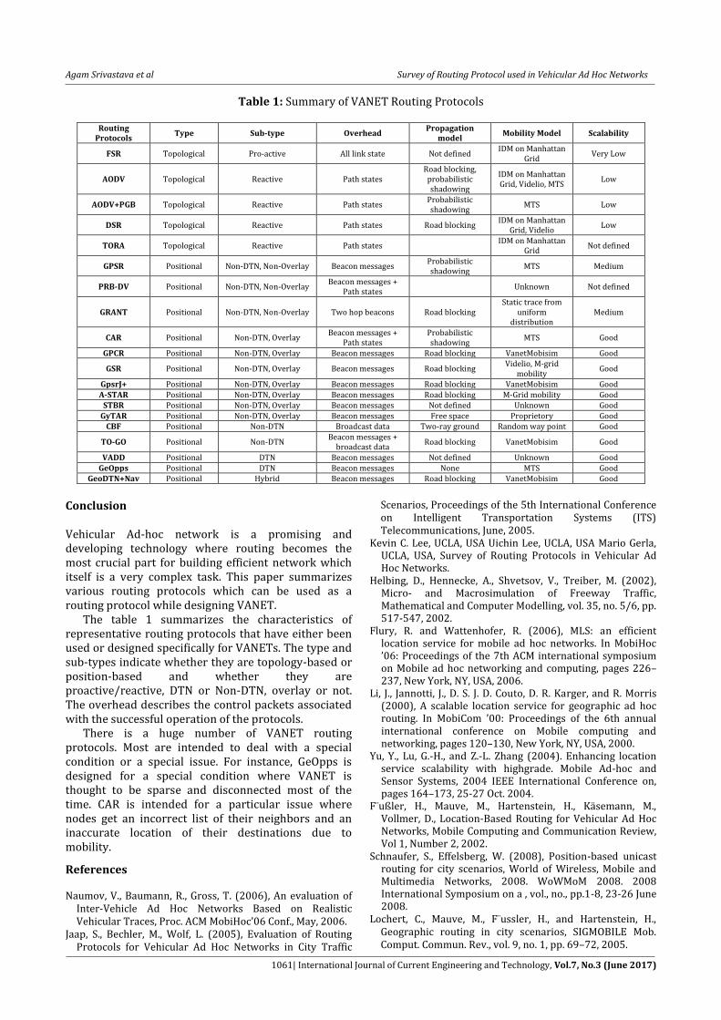
Table 1: Summary of VANET Routing Protocols
Routing Protocols
Type Sub-type Overhead Propagation
model Mobility Model Scalability
FSR Topological Pro-active All link state Not defined IDM on Manhattan
Grid Very Low
AODV Topological Reactive Path states Road blocking,
probabilistic shadowing
IDM on Manhattan Grid, Videlio, MTS
Low
AODV+PGB Topological Reactive Path states Probabilistic shadowing
MTS Low
DSR Topological Reactive Path states Road blocking IDM on Manhattan
Grid, Videlio Low
TORA Topological Reactive Path states IDM on Manhattan
Grid Not defined
GPSR Positional Non-DTN, Non-Overlay Beacon messages Probabilistic shadowing
MTS Medium
PRB-DV Positional Non-DTN, Non-Overlay Beacon messages +
Path states Unknown Not defined
GRANT Positional Non-DTN, Non-Overlay Two hop beacons Road blocking Static trace from
uniform distribution
Medium
CAR Positional Non-DTN, Overlay Beacon messages +
Path states Probabilistic shadowing
MTS Good
GPCR Positional Non-DTN, Overlay Beacon messages Road blocking VanetMobisim Good
GSR Positional Non-DTN, Overlay Beacon messages Road blocking Videlio, M-grid
mobility Good
GpsrJ+ Positional Non-DTN, Overlay Beacon messages Road blocking VanetMobisim Good
A-STAR Positional Non-DTN, Overlay Beacon messages Road blocking M-Grid mobility Good STBR Positional Non-DTN, Overlay Beacon messages Not defined Unknown Good
GyTAR Positional Non-DTN, Overlay Beacon messages Free space Proprietory Good CBF Positional Non-DTN Broadcast data Two-ray ground Random way point Good
TO-GO Positional Non-DTN Beacon messages +
broadcast data Road blocking VanetMobisim Good
VADD Positional DTN Beacon messages Not defined Unknown Good
GeOpps Positional DTN Beacon messages None MTS Good GeoDTN+Nav Positional Hybrid Beacon messages Road blocking VanetMobisim Good
Conclusion Vehicular Ad-hoc network is a promising and developing technology where routing becomes the most crucial part for building efficient network which itself is a very complex task. This paper summarizes various routing protocols which can be used as a routing protocol while designing VANET. The table 1 summarizes the characteristics of representative routing protocols that have either been used or designed specifically for VANETs. The type and sub-types indicate whether they are topology-based or position-based and whether they are proactive/reactive, DTN or Non-DTN, overlay or not. The overhead describes the control packets associated with the successful operation of the protocols. There is a huge number of VANET routing protocols. Most are intended to deal with a special condition or a special issue. For instance, GeOpps is designed for a special condition where VANET is thought to be sparse and disconnected most of the time. CAR is intended for a particular issue where nodes get an incorrect list of their neighbors and an inaccurate location of their destinations due to mobility.
References Naumov, V., Baumann, R., Gross, T. (2006), An evaluation of
Inter-Vehicle Ad Hoc Networks Based on Realistic Vehicular Traces, Proc. ACM MobiHoc’06 Conf., May, 2006.
Jaap, S., Bechler, M., Wolf, L. (2005), Evaluation of Routing Protocols for Vehicular Ad Hoc Networks in City Traffic
Scenarios, Proceedings of the 5th International Conference on Intelligent Transportation Systems (ITS) Telecommunications, June, 2005.
Kevin C. Lee, UCLA, USA Uichin Lee, UCLA, USA Mario Gerla, UCLA, USA, Survey of Routing Protocols in Vehicular Ad Hoc Networks.
Helbing, D., Hennecke, A., Shvetsov, V., Treiber, M. (2002), Micro- and Macrosimulation of Freeway Traffic, Mathematical and Computer Modelling, vol. 35, no. 5/6, pp. 517-547, 2002.
Flury, R. and Wattenhofer, R. (2006), MLS: an efficient location service for mobile ad hoc networks. In MobiHoc ’06: Proceedings of the 7th ACM international symposium on Mobile ad hoc networking and computing, pages 226–237, New York, NY, USA, 2006.
Li, J., Jannotti, J., D. S. J. D. Couto, D. R. Karger, and R. Morris (2000), A scalable location service for geographic ad hoc routing. In MobiCom ’00: Proceedings of the 6th annual international conference on Mobile computing and networking, pages 120–130, New York, NY, USA, 2000.
Yu, Y., Lu, G.-H., and Z.-L. Zhang (2004). Enhancing location service scalability with highgrade. Mobile Ad-hoc and Sensor Systems, 2004 IEEE International Conference on, pages 164–173, 25-27 Oct. 2004.
F¨ußler, H., Mauve, M., Hartenstein, H., Käsemann, M., Vollmer, D., Location-Based Routing for Vehicular Ad Hoc Networks, Mobile Computing and Communication Review, Vol 1, Number 2, 2002.
Schnaufer, S., Effelsberg, W. (2008), Position-based unicast routing for city scenarios, World of Wireless, Mobile and Multimedia Networks, 2008. WoWMoM 2008. 2008 International Symposium on a , vol., no., pp.1-8, 23-26 June 2008.
Lochert, C., Mauve, M., F¨ussler, H., and Hartenstein, H., Geographic routing in city scenarios, SIGMOBILE Mob. Comput. Commun. Rev., vol. 9, no. 1, pp. 69–72, 2005.
Agam Srivastava et al Survey of Routing Protocol used in Vehicular Ad Hoc Networks
1062| International Journal of Current Engineering and Technology, Vol.7, No.3 (June 2017)
Lochert, C., Hartenstein, H., Tian, J., Fussler, H., Hermann, D., Mauve, M. (2003), A routing strategy for vehicular ad hoc networks in city environments, Intelligent Vehicles Symposium, 2003. Proceedings. IEEE , vol., no., pp. 156-161, 9-11 June 2003.
Kronjäger, W. and Hermann D (1999), Travel time estimation on the base of microscopic traffic flow simulation. ITS World Congress, 1999.
Lee, K. C., Haerri, J., Lee, U., and Gerla, M. (2007), Enhanced perimeter routing for geographic forwarding protocols in urban vehicular scenarios, Globecom Workshops, 2007 IEEE, pp. 1–10, 26-30 Nov. 2007.
Seet, B.-C., Liu, G., Lee, B.-S., Foh, C. H., Wong, K. J., Lee, K.-K. (2004), A-STAR: A Mobile Ad Hoc Routing Strategy for Metropolis Vehicular Communications. NETWORKING 2004, 989-999.
Forderer, D (2005). Street-Topology Based Routing. Master’s thesis, University of Mannheim, May 2005.
Jerbi, M., Senouci, S.-M., Meraihi, R., and Ghamri-Doudane, Y. (2007), An improved vehicular ad hoc routing protocol for city environments, Communications, 2007. ICC ’07. IEEE International Conference, pp. 3972–3979, 24-28 June 2007.
F¨ußler, H., Hannes, H., J¨org, W., Martin, M., Wolfgang, E. (2004), Contention-Based Forwarding for Street Scenarios, Proceedings of the 1st International Workshop in Intelligent Transportation (WIT 2004), pages 155–160, Hamburg, Germany, March 2004.
Lee, K.C.; Lee, U.; Gerla, M. (2009), TO-GO: TOpology-assist
geo-opportunistic routing in urban vehicular grids,
Wireless On-Demand Network Systems and Services, 2009.
WONS 2009. Sixth International Conference on , vol., no.,
pp.11-18, 2-4 Feb. 2009.
Zhao, J.; Cao, G. (2006), VADD: Vehicle-Assisted Data Delivery
in Vehicular Ad Hoc Networks, INFOCOM 2006. 25th IEEE
International Conference on Computer Communications.
Proceedings , vol., no., pp.1-12, April 2006.
Leontiadis, I., Mascolo, C. (2007), GeOpps: Geographical
Opportunistic Routing for Vehicular Networks, World of
Wireless, Mobile and Multimedia Networks, 2007.
WoWMoM 2007. IEEE International Symposium on a , vol.,
no., pp.1-6, 18-21 June 2007.
Cheng, P.-C., Weng, J.-T., Tung, L.-C., Lee, K. C., Gerla M., and
Härri J. (2008), GeoDTN+NAV: A Hybrid Geographic and
DTN Routing with Navigation Assistance in Urban
Vehicular Networks, Proceedings of the 1st International
Symposium on Vehicular Computing Systems (ISVCS'08),
Dublin, Irland, July 2008.
Bijan Paul, Md. Ibrahim, Md. Abu Naser Bikas (2011), VANET
Routing Protocols: Pros and Cons, IJCA, Vol No. 3, April
2011