Surface Water Management Plan Guidance · 4 More information on SWMPs and the first edition SWMPs...
109
Surface Water Management Plan Technical Guidance March 2010 www.defra.gov.uk
Transcript of Surface Water Management Plan Guidance · 4 More information on SWMPs and the first edition SWMPs...

Surface Water Management Plan Technical Guidance
March 2010
www.defra.gov.uk

Publishing organisation Department for Environment, Food and Rural Affairs Flood Management Division, Ergon House, Horseferry Road London SW1P 2AL
Tel: 020 7238 3000 Fax: 020 7238 6187
http://www.defra.gov.uk/environment/flooding/manage/surfacewater/index.htm
The guidance has been produced based on evidence from the Integrated Urban Drainage Pilot Studies, which were funded by Defra, with a contribution from UK Water Industry Research Ltd (UKWIR). www.ukwir.org
Halcrow Group Ltd (www.halcrow.com) have provided technical support to Defra to produce the guidance.
© Crown copyright 2010 Copyright in the typographical arrangement and design rests with the Crown. This publication (excluding the royal arms and departmental logos) may be re-used free of charge in any format or medium provided that it is re-used accurately and not used in a misleading context. The material must be acknowledged as crown copyright and the title of the publication specified. Maps are based upon Ordnance Survey material with the permission of Ordnance Survey on behalf of the Controller of Her Majesty’s Stationery Office © Crown copyright. Unauthorised reproduction infringes Crown copyright and may lead to prosecution or civil proceedings. Defra 100018880 [2008].
This document is also available on the Defra website.
Contents
Contents .................................................................... ii
Introduction and background information ............ vi
Introduction ................................................................................. vi
Background information ............................................................ ix
SWMPs in context .................................................................................... ix
Summary of a SWMP study .................................................................... xiv
Preparation ............................................................... 1
Identify the need for a SWMP study ........................................... 3
Identify whether a SWMP study is required .............................................. 3
Establish Partnership .................................................................. 7
Identify who should be involved ................................................................ 7
Clarify roles and responsibilities ............................................................. 10
Scope the SWMP study ............................................................. 13
Set aims and objectives .......................................................................... 13
Establish an engagement plan................................................................ 17
Identify availability of information ............................................................ 19
Identify the level of assessment of a SWMP study ................................. 21
Risk Assessment .................................................... 26
Undertake a strategic assessment ........................................... 28
ii

Collate information for the strategic assessment .................................... 30
Undertake strategic assessment ............................................................. 34
Undertake intermediate assessment ....................................... 35
Collate information for intermediate assessment .................................... 36
Undertake intermediate assessment ...................................................... 40
Determine whether more detailed assessment is required ..................... 41
Undertake Detailed Assessment .............................................. 43
Select modelling approach...................................................................... 45
Develop modelling approach .................................................................. 47
Quantify current and future flood risk ...................................................... 48
Map and Communicate Risk ..................................................... 51
Map surface water flooding ..................................................................... 51
Communicate risk ................................................................................... 54
Options .................................................................... 57
Identify measures ...................................................................... 59
Identify measures ................................................................................... 59
Short-list measures ................................................................................. 62
Assess options .......................................................................... 65
Identify assessment to be carried out ..................................................... 65
Undertake assessment of options ........................................................... 68
Agree preferred option/s ......................................................................... 71
Implementation and Review .................................. 73
Prepare action plan .................................................................... 75

iv
Prepare action plan ................................................................................. 75
Review and publish the action plan ........................................................ 78
Implement and review action plan ........................................... 79
Implement and review action plan .......................................................... 79
Glossary of Terms .................................................. 80


Introduction and background information
Introduction
i.1 This new SWMP guidance seeks to provide a simplified overarching framework which allows different organisations to work together and develop a shared understanding of the most suitable solutions to surface water flooding problems. Principally, the SWMP guidance has been written for local authorities to assist them as they co-ordinate and lead local flood risk management activities.
i.2 A Surface Water Management Plan (SWMP) is a plan which outlines the preferred surface water management strategy in a given location. In this context surface water flooding describes flooding from sewers, drains, groundwater, and runoff from land, small water courses and ditches that occurs as a result of heavy rainfall.
i.3 A SWMP study is undertaken in consultation with key local partners who are responsible for surface water management and drainage in their area. Partners work together to understand the causes and effects of surface water flooding and agree the most cost effective way of managing surface water flood risk for the long term. The process of working together as a partnership is designed to encourage the development of innovative solutions and practices.
i.4 A SWMP should establish a long-term action plan to manage surface water in an area and should influence future capital investment, drainage maintenance, public engagement and understanding, land-use planning, emergency planning and future developments.
i.5 The following benefits are will be achieved through undertaking a SWMP study:
• increased understanding of the causes, probability and consequences of surface water flooding;
• increased understanding of where surface water flooding will occur which can be used to inform spatial and emergency planning functions;
• a co-ordinated action plan, agreed by all partners and supported by an understanding of the costs and benefits, which partners will use to work together to identify measures to mitigate surface water flooding;
• identifying opportunities where SuDS can play a more significant role in managing surface water flood risk and may also contribute to fulfilling the requirements of the Water Framework Directive;
vi

• helping to meet the requirements of the Flood Risk Regulations (2009)1and the proposed Flood and Water Management Bill;
• increased awareness of the duties and responsibilities for managing flood risk of different partners and stakeholders;
• improved public engagement and understanding of surface water flooding.
i.6 It is recognised that SWMP studies will vary to meet local needs and circumstances and the guidance offers a flexible approach that will allow lead local flood authorities to undertake a SWMP study which is tailored to their needs and requirements.
i.7 This guidance is primarily intended to be used for the development of SWMPs in areas of high flood risk with complex integrated drainage arrangements. The principles contained within this guidance may also be usefully applied to less complex or lower risk areas although the approach and level of analysis should be proportionate to the risk and complexity of the area concerned.
i.8 Under the proposed Floods and Water Management Bill2 and Flood Risk Regulations (2009), county councils and unitary authorities have new responsibilities for a leadership role in local flood risk management, of which the production of SWMP will form a key part in many locations. It is important to note that unitary and county local authorities can delegate the production of an action plan to lower tier (e.g. district councils), and therefore lower tier local authorities should make use of this guidance.
i.9 The guidance is not prescriptive, but it provides a clear and logical framework which should be adopted to undertake a SWMP study and to produce an action plan. Technical detail in the main body of the guidance is kept to a minimum and further technical information is signposted throughout the guidance and in annexes. The guidance draws on good practice from the IUD pilot studies3 and the first edition SWMPs4.
i.10 In addition to local authorities the guidance will also be of value to:
• water and sewerage companies (WaSCs) and other partners (e.g. Environment Agency, Internal Drainage Boards, British Waterways) entering SWMP partnerships. It will inform them about what is required when engaging in the SWMP process and how they will benefit;
• managers and technical staff delivering a SWMP study;
1 More information on the Flood Risk Regulations (2009) is available at http://www.opsi.gov.uk/si/si2009/uksi_20093042_en_1
2 More information on the proposed Floods and Water Management Bill is available at http://services.parliament.uk/bills/2009-10/floodandwatermanagement.html
3 More information on the Defra IUD pilot studies is available at http://www.defra.gov.uk/environment/flooding/manage/surfacewater/urbanrisk.htm
4 More information on SWMPs and the first edition SWMPs is available at http://www.defra.gov.uk/environment/flooding/manage/surfacewater/plans.htm
viii
• parties seeking to scrutinise or audit the conclusions of a SWMP study, and;
• the Environment Agency in its strategic overview role for all sources of flooding
i.11 The SWMP guidance is structured into four key phases; preparation, risk assessment, options and implementation and review. The four phases of the guidance provide the framework for undertaking a SWMP study, although the guidance should be used alongside a consideration of local needs and circumstances. Each phase of the guidance is divided into chapters, outlining specific activities or processes involved in undertaking a SWMP study. At the beginning of each chapter of the guidance there are boxes to set out the outputs; this can be used to understand the outputs from a SWMP study at each stage of the process.
i.12 The guidance is supported by a number of annexes, which provide further technical information to support the production of a SWMP. It should also be noted there is a glossary of terms provided at the back of the guidance.

Background information
SWMPs in context i.13 The UK Government’s strategy for flood and coastal erosion risk management, Making Space for Water (MSfW)5, set out a portfolio of approaches to ensure that flood risks would be managed more effectively in the future by adopting a holistic, joined-up, and integrated approach. An area of particular concern in MSfW was flooding in urban areas from surface water due to the finite design capacity of conventional drainage systems. At an early stage the need for integrated urban drainage management (IUDM)6 approaches was identified. It is recognised that, faced with the challenges of climate change and housing growth, and the need for sustainable development, strategic and integrated approaches to surface water drainage are essential to maximise the benefits of drainage investment for society. The MSfW strategy also recognised the importance of land management and stakeholder engagement in new flood risk management approaches.
i.14 As part of the MSfW programme, Defra instigated a series of 15 pilot studies7 in 2007 to examine, in detail, various aspects of IUDM. The Integrated Urban Drainage (IUD) pilot projects were located across England and examined partnership development, data sharing issues, modelling approaches to surface water flood risk assessment and options to mitigate surface water flooding. Some also considered how in large areas of new development a more strategic approach to implementing surface water drainage infrastructure was beneficial. The ‘IUD Pilots’ were highly informative in helping to identify good practice approaches and contributed to the development of this guidance.
5 Defra (2004). Making Space for Water – developing a new Government strategy for flood and coastal erosion risk management in England, more information at http://www.defra.gov.uk/environment/flooding/policy/strategy/index.htm
6 IUDM and surface water management should be considered as synonymous; they are both concerned with a joined up consideration of flooding principally in urban areas and integrated ways to reduce such flooding.
7 MSfW Project HA2 Urban Flood Risk and Integrated Drainage, more information at http://www.defra.gov.uk/environment/flooding/manage/surfacewater/urbanrisk.htm

i.15 The summer 2007 floods further highlighted that intense rainfall events can occur anywhere and the need for all stakeholders to work in partnership to improve understanding and the management of flood risk in urban areas so they are better prepared for future events. In his review of these events, Sir Michael Pitt8 also recommended that SWMP be adopted, particularly where surface water flood risk is predicted to be high.
Mar 2005
Jan 2007
June 2007
June 2008 June 2008
Dec 2008
Feb 2008
Jan 2009
Figure 1-1 Recent timeline affecting development of SWMP process
8 The Pitt Review: Lessons learned from the 2007 floods (2008), more information at http://www.cabinetoffice.gov.uk/thepittreview.aspx
x

i.16 Informed by the ‘IUD Pilots’ and the flooding events which occurred in summer 2007, Defra set out its intention to use Surface Water Management Plans (SWMP) as the primary vehicle to manage surface water flood risk in England. This intention was published in the Future Water Strategy9 and included a specific surface water drainage consultation10 at the same time. The SWMP concept is recognised and promoted within Planning Policy Statement 25 (PPS25).
i.17 In their response to the Pitt Review, the Government11 reiterated its support for the SWMP approach in high risk areas and the proposed Floods and Water Management Bill intends to implement many of the Pitt Recommendations. The Floods and Water Management Bill outlines the intention for local authorities to take a ‘leadership role’ in local flood risk management in partnership with other stakeholders. This also reflected the views of stakeholders who responded to the Improving Surface Water Consultation and the consultation on the draft Floods and Water Management Bill.
i.18 Ofwat, the water company regulator, has also outlined their intention for water and sewerage companies to work with other partners to deliver SWMP12. In addition the Flood Risk Regulations (2009) outline a duty for water and sewerage companies to provide information and co-operate to support the production of Preliminary Flood Risk Assessments (PFRAs) and Flood Risk Management Plans (FRMPs).
i.19 To test the living draft SWMP guidance (February 2009), Defra commissioned six first edition SWMP, which were carried out from January-October 2009. The six locations which undertook the first edition SWMP were Gloucestershire, Hull, Leeds, Richmond & Kingston, Thatcham and Warrington. As early adopters of the SWMP process
9 Defra (2008) Future Water, The Government’s water strategy for England. Available at http://www.defra.gov.uk/Environment/quality/water/strategy/pdf/future-water.pdf
10 Defra (2008). Improving Surface Water Drainage – Consultation to accompany proposals set out in the Government’s Water Strategy, Future Water, more information at http://www.defra.gov.uk/environment/flooding/documents/manage/surfacewater/swmp-consult.pdf
11 Defra (2008). The Government’s response to Sir Michael Pitt’s Review of the Summer 2007 floods, more information at http://www.defra.gov.uk/environment/flooding/documents/risk/govtresptopitt.pdf
12 Ofwat (2008). Sewerage system design and climate change – 20 June 2008, more information at http://www.ofwat.gov.uk/pricereview/pr09phase2/ltr_pr0913_sewdesclimchge
Box 1 The Pitt Review on SWMP
Recommendation 18: “Local Surface Water Management Plans, as set out in PPS25 and coordinated by local authorities, should provide the basis for managing all local flood risk.”
"Surface Water Management Plans (SWMPs) are referred to in PPS25 as a tool to manage surface water flood risk on a local basis by improving and optimising coordination between relevant stakeholders. SWMPs will build on Strategic Flood Risk Assessments (SFRAs) and provide the vehicle for local organisations to develop a shared understanding of local flood risk, including setting out priorities for action, maintenance needs and links into local development frameworks and emergency plans”

the six first edition SWMPs has helped to refine emerging best practice and to assist development on the SWMP guidance13.
How does a SWMP fit with other policy?
i.20 A SWMP will fit within existing policy framework, and it is important that duplication of work is avoided.
Box 2 The Flood Risk Regulations (2009)
The Flood Risk Regulations 2009 transposed the Floods Directive into law for England and Wales and came into force on 10 December 2009. The Regulations bring the Environment Agency, County Councils and Unitary Authorities together with partners such as water companies to manage flood risk from all sources, to reduce the consequence of flooding on human health, economic activity, cultural heritage and the environment. The Floods Directive sets out a six-year cycle of assessments, maps and plans and the Regulations assign the Environment Agency responsibility for main river, the sea and reservoirs and Lead Local Flood Authorities (County or Unitary) responsibility for all other sources of flooding including surface runoff, groundwater and ordinary watercourse flooding.
Preliminary Flood Risk Assessments are the first stage of the cycle and the Environment Agency is preparing national guidance for Lead Local Flood Authorities, a living draft will be available in April 2010. The Assessments consist of simple maps of river basins, coastline, land use and Preliminary Assessment Reports. The Reports must be submitted to the Environment Agency for review by June 2011.
i.21 Where undertaken a SWMP will provide understanding of the mechanisms of surface water flooding and propose mitigation measures, which can provide the evidence base to inform PFRAs and fulfil the requirement for FRMPs under the Flood Risk Regulations (2009).
i.22 The proposed Floods and Water Bill requires lead local flood authorities to develop a strategy for local flood risk management for their area. SWMPs can make an important contribution to inform the development of this strategy and identifying ways to implement it.
i.23 PPS25 sets out how new development should not increase flood risk, A SWMP will inform local planning authorities about the areas at risk from surface water flooding. SWMP information may enhance the existing evidence base contained in Strategic Flood Risk Assessments (SFRAs) which should cover all forms of flooding. Similarly SWMPs are likely to use information contained within SFRAs.
i.24 A SWMP can be used to coordinate and strategically plan the drainage provision in all new developments where piecemeal actions are inefficient and do not support consistent ownership and maintenance regimes for sustainable drainage systems (SuDS). Good drainage practice for new developments protects properties within the
13 More information about the six First Edition SWMPs is available at http://www.defra.gov.uk/environment/flooding/manage/surfacewater/index.htm
xii

development and provides opportunities to reduce existing surface water flood risk downstream or to create capacity in the drainage system by reducing existing runoff.
i.25 SWMPs will also help with forward planning to identify areas where SuDS can be incorporated in public spaces and roads, either in or near future development sites, as well as identifying potential routes for SuDS to discharge to water courses, coasts and rivers. SWMPs will also consider the impacts on water quality, so as not to have untreated discharge.
i.26 In addition a SWMP can also provide a framework for the management of water quality (e.g. the control of discharges from combined sewer overflows, surface water drainage outfalls, sustainable drainage systems and the urban surface generally). Solutions which can address both flood and pollution risk have dual benefits, and can contribute to fulfilling improvements and compliance in ecology, water quality and habitats required under the Water Framework Directive (WFD). When taking an integrated view of flood risk in drainage systems it is necessary to consider the opportunities for water quality improvements at the same time. Mitigation measures in a SWMP have the potential to either improve or cause deterioration of the flow regime and physical habitat (hydromorphology) of a waterbody, and therefore a SWMP must consider the impacts in compliance with the WFD.

* Consideration of sewer flooding in ‘dry weather’ resulting from blockage, collapse or pumping station mechanical failure is excluded from SWMPs as this is for the sole concern of the sewerage undertaker. **Interactions with larger rivers and tidal waters can be important mechanisms controlling surface water flooding
• sewer flooding*; flooding which occurs when the capacity of underground systems is exceeded due to heavy rainfall, resulting in flooding inside and outside of buildings. Note that the normal discharge of sewers and drains through outfalls may be impeded by high water levels in receiving waters** as a result of wet weather or tidal conditions;
• flooding from open-channel and culverted watercourses*** which receive most of their flow from inside the urban area and perform an urban drainage function;
• overland flows from the urban/rural fringe entering the built-up area, and;
• overland flows resulting from groundwater sources.
Surface Water Management Action Plan (or action plan) – The SWMP action plan should outline the preferred surface water management strategy and identify the actions, timescales and responsibilities of each partner. It is the principal output from the SWMP study.
SWMP study - the SWMP study is the process of producing the action plan. The SWMP study is undertaken in order to provide the evidence base to produce the action plan.
Surface water flooding – In this context surface water flooding includes:
• surface water runoff; runoff as a result of high intensity rainfall when water is ponding or flowing over the ground surface before it enters the underground drainage network or watercourse, or cannot enter it because the network is full to capacity, thus causing flooding (known as pluvial flooding);
• flooding from groundwater where groundwater is defined as all water which is below the surface of the ground and in direct contact with the ground or subsoil.
Box 3 Key terminology for SWMP Guidance
Summary of a SWMP study i.27 The purpose of a SWMP is to make sustainable surface water management decisions that are evidence based and risk based, whilst taking climate change into account, and are inclusive of stakeholder views and preferences.
xiv

i.28 The framework for undertaking a SWMP study is illustrated through a wheel diagram, identifying the four principal phases: Preparation; Risk Assessment; Options; and Implementation and Review. The first three phases involve undertaking the SWMP study, whilst the fourth phase involves producing and implementing the action plan, based on the evidence gained from the SWMP study. It is based on a widely adopted generic approach to evidence and risk based decision making.

xvi
1. Preparation
i.29 The first phase of a SWMP study focuses on preparing and scoping the requirements of the study. Initially, partners and stakeholders should identify the need to undertake a SWMP study. Once the need for a SWMP study has been identified a partnership should be established, (if one does not already exist), and partners should identify how they will work together to deliver the SWMP study. The aims and objectives of the study should be established, and in parallel the partnership will also decide how they will engage with stakeholders throughout the SWMP study. An assessment should subsequently be undertaken to identify the availability of information. Based on the defined objectives, current knowledge of surface water flooding, and the availability of information, partners should agree the level of assessment at which the SWMP study should start.
2. Risk assessment
i.30 The outputs from the preparation phase will identify which level of risk assessment will form the first stage of the SWMP study. The first stage is likely to be the strategic assessment where little is known about the local flood risks. The strategic assessment focuses on identifying areas more vulnerable to surface water flooding for further study. The intermediate assessment, where required, will identify flood hotspots in the chosen study area, and identify quick win mitigation measures, and scope out any requirements for a detailed assessment. A detailed assessment of surface water flood risk may be required to enhance the understanding of the probability and consequences of surface water flooding and to test potential mitigation measures in high risk locations. Guidance is provided on undertaking modelling to support a detailed assessment of surface water flood risk and mitigation measures. The outputs from the strategic, intermediate and/or detailed assessment should be mapped and communicated to all stakeholders including spatial planners, local resilience forums, and the public.
3. Options
i.31 In this phase a range of options is identified, through stakeholder engagement, which seek to alleviate the risk from surface water flooding in the study area. The options identified should go through a short-listing process to eliminate those that are unfeasible. The remaining options should be developed and tested using a consideration of their relative effectiveness, benefits and costs. The purpose of this assessment is to identify the most appropriate mitigation measures which can be agreed and taken forward to the implementation phase.
4. Implementation and Review
i.32 Phase 4 is about preparing an implementation strategy (i.e. an action plan), delivering the agreed actions and monitoring implementation of these actions. The first step is to develop a coordinated delivery programme. Once the options have been implemented they should be monitored to assess the outcomes and benefits, and the SWMP should be periodically reviewed and updated, where required.


Phase 1
Preparation
In this phase you will: • identify the need for a SWMP study; • establish the partnership; • scope the SWMP study, and; • undertake a strategic assessment.
1

2
3
Chapter 1
Identify the need for a SWMP study
This chapter provides guidance on: • identifying whether a SWMP study is required.
Identify whether a SWMP study is required 1.1 A SWMP study will not be required in all locations14; they should be prioritised in areas considered to be at greatest risk of surface water flooding or where partnership working is considered essential to both understand and address surface water flooding concerns.
1.2 It is not possible to be too prescriptive as to when and where a SWMP study will need to be undertaken, as this is largely dependent on local needs. However there are some common criteria which may help to identify the need for a SWMP study:
• The implementation of the Flood Risk Regulations (2009) and the proposed Flood and Water Management Bill are expected to identify areas where SWMP studies would be beneficial. A preliminary flood risk assessment (PFRA) is likely to draw heavily on existing information available in the SFRA for the area and current versions of Level 2 Strategic Flood Risk Assessments (SFRAs)15 – may have already identified the location of critical drainage areas16, and also identified a need for a SWMP study.
• Future urbanisation/redevelopment – new building in urban extensions or as part of regeneration presents a challenge to existing drainage systems but can also become an opportunity to address long-standing problems through strategic improvements and upgrades to the drainage system and to ensure surface water runoff from the developed site is reduced in comparison with existing runoff.
14 In August 2009 Defra announced a list of 77 such locations and these will be the first to commence SWMPs. More information on the methodology to identify the 77 locations is available at http://www.defra.gov.uk/environment/flooding/documents/manage/surfacewater/sw-methodology.pdf
15 A level 2 SFRA is defined in Planning Policy Statement 25: Development and Flood Risk (2006) (page 31), which is available at: http://www.communities.gov.uk/documents/planningandbuilding/pdf/planningpolicystatement25.pdf
16 Critical Drainage Areas are specific areas in Flood Zone 1 only, where runoff can cause problems downstream, and is not necessarily an area where flooding problems may occur.

• Evidence of surface water flooding history – this can be an indicator for future flooding. Information on previous flooding is often collated in a SFRA or Catchment Flood Management Plan (CFMP)17, but is also available from local authorities, water companies, the Environment Agency and other stakeholders although this information may not always be complete. The knowledge of local flooding incidents held by local authority staff can play an important role in establishing the need to undertake a SWMP study.
• Drainage system interaction – where the operation of a local drainage system is known to be complicated by interactions between river, groundwater and sewer systems or river and canal systems. Integrated and innovative solutions require a partnering approach best managed through a SWMP.
1.3 The Environment Agency is promoting the use of Water Cycle Strategies18 to address a range of water planning issues, including surface water management, in areas of high growth. This is to ensure that the adequacy of water services infrastructure is a material consideration in planning decisions. A SWMP study, based on this guidance, could be part of a wider process of strategic planning for water services infrastructure that also adopts a partnership approach for cooperation across local government, the Environment Agency and WaSCs.
1.4 Lead local flood authorities should engage with other partners and stakeholders who have responsibility for surface water management (in particular the water and sewerage company and the Environment Agency) when identifying the need to undertake a SWMP study. It is good practice to produce a business case setting out the reasons and benefits for undertaking a SWMP study and this can be a useful way of informing and engaging partners and stakeholders in the process.
17 A CFMP seeks to identify factors that contribute to food risk in a catchment (now and in the future), and recommend the best ways of managing the risk of flooding within the catchment over the next 50 to 100 years.
18 Guidance on Water Cycle Studies is available at http://publications.environment-agency.gov.uk/pdf/GEHO0109BPFF-e-e.pdf
4

• the intermediate assessment, where outputs from the strategic assessment are enhanced, and consideration is given to whether new development will drain to an area/s of existing surface water flooding (‘hotspots’), and;
• the detailed assessment, which should assess, in detail, how proposed new development can reduce existing surface water flood risk (as part of the future scenario).
Within the SWMP guidance, new development is considered as part of:
• the strategic assessment, where surface water mapping can identify whether proposed development is located in areas vulnerable to surface water flooding,
Box 4 Consideration of new development within a SWMP study
With respect to new development, a SWMP study offers the opportunity to reduce existing surface water flood risk downstream or to create capacity in the drainage system through improvements in runoff from development sites.
Surface Water planning of new developments
How a SWMP study provides additional information
A strategy to manage surface runoff from the development sites to control flood risk to drainage or river systems downstream
This is the principal benefit and focus of a SWMP study, in the context of new development, which can assess the surface water runoff required from a development site, in light of an understanding of existing risk.
A strategy to manage surface runoff within development sites to manage flood risk within the development site
This is principally the concern of the FRA, although the SWMP study can provide recommendations on the use of SuDS to inform FRAs
A strategy to manage flood risk in the development site from surface water runoff entering from outside the development site
The strategic, intermediate and detailed assessment in a SWMP study will provide information on surface water hotspots which can be used to identify where proposed development sites might be vulnerable to runoff entering the site. This should feedback into SFRAs and be used to inform FRAs
The table illustrates how surface water should be considered as part of planning for new development. A SWMP study which considers new development is principally concerned with understanding the runoff requirements from a development site in light of an understanding of existing surface water flood risk and/or existing capacity constraints in the downstream drainage system. The intention is not to replace the site-specific flood risk assessments (FRAs) which should be undertaken by developers; rather the SWMP study should inform the requirements of FRAs so that opportunities to reduce flood risk through development are maximised. The opportunities to reduce existing surface water flood risk or to create capacity in the downstream drainage system are more likely to be realised through a SWMP study which considers the interaction between new development and downstream risk. In addition a SWMP study provides an opportunity to strategically plan drainage requirements across large new developments, which reduces the likelihood of piecemeal systems being adopted within development sites.
Under the proposed Floods and Water Management Bill, the Lead Local Flood Authority will have to approve and then adopt SuDS, serving more than one property, in new developments. SWMPs will enable a strategic approach to the planning of drainage requirements across large areas and will therefore provide a key tool for LPAs.
5

6

Chapter 2
Establish Partnership
This chapter provides guidance on: • identifying who should be involved; • clarifying the roles and responsibilities of the partnership; • establishing an engagement plan, and; • setting objectives.
Box 5 Outputs from Chapter 2: Establish partnership
At the end of this stage of the SWMP process you will have:
• identified partners and stakeholders for the SWMP study;
• set up the SWMP study partnership, and;
• clarified the roles and responsibilities of each partner;
Identify who should be involved 2.1 A partnership approach is the most efficient approach to co-ordinate flood risk management activities given the complex nature of surface water flooding (i.e. multiple sources and pathways, and multiple organisations). Evidence from the IUD pilot studies and the first edition SWMPs has demonstrated the benefits of partnership working. Working in partnership is essential to achieving integrated and efficient mitigation measures where multiple organisations are involved (see box 6). Therefore, throughout the SWMP study partners should work collaboratively to understand the surface water flooding issues, identify and assess options to mitigate surface water flooding, and to prepare the surface water management action plan.
7

Box 6 Integrated solutions in the Hartlepool IUD pilot
The Hartlepool pilot proposes flood risk solutions, developed using an IUDM approach, which could save 20% of the cost of a combination of traditional stand alone solutions to resolve fluvial, surface water and sewer flooding. This is achieved by viewing the drainage system as a whole and introducing upstream storage which benefits properties at risk of flooding downstream.
Further information is available at: http://www.defra.gov.uk/environment/flooding/documents/manage/surfacewater/hartlepoolreport.pdf
2.2 Due to the variable nature of organisations involved in a SWMP study, the guidance is not prescriptive about how the partnerships should be established, nor the specific roles and responsibilities of each partner. It is recognised that flexibility is required, and the way a partnership operates in practice will vary. Therefore the guidance outlines some of the key considerations and principles which should be addressed in establishing, operating and maintaining a partnership.
Box 6 Partners and stakeholders in SWMP
For the purposes of the SWMP Guidance a partner can be defined as someone (person or organisation) with responsibility for the decision or actions that need to be taken. They will share responsibility for the decisions and actions and are therefore critical at the outset of the SWMP process. A stakeholder can be defined as anyone affected by the problem or solution or interested in the problem or solution. They can be individuals or organisations and include the public and communities.
2.3 In the SWMP study there are three key partners who must be involved and pro-actively engaged in the process:
• Local authority, including the highways, parks, spatial and emergency planning departments19;
• Environment Agency20, and;
• water and sewerage company21.
19 Unitary and county authorities have the leadership role in SWMP. However, where new development is the main driver for the SWMP district councils may be best placed to lead as the planning authority. The relevant planning authority should be involved to maintain alignment with PPS25.
20 The Environment Agency will have an ‘operational’ role with responsibility for river defences, river structures, development control and water quality. It also has a strategic overview for all sources of flooding and hence an interest in supporting the SWMP framework through the provision of tools, guidance and advice.
21 The water company with responsibility for sewerage services within the SWMP area. Nine such companies cover the whole of England and can be viewed here: http://www.water.org.uk/home/resources-and-links/links/water-operators/sewerage-operators/a4-sewerage-map.pdf.
8

9
2.4 The proposed Floods and Water Management Bill establishes that unitary and county local authorities will lead new local flood risk management activities as the Lead Local Flood Authority. The Lead Local Flood Authority’s responsibility in relation to a SWMP would be to lead/convene its production, ‘hold’ the SWMP and ensure that it is periodically reviewed and updated.
2.5 In light of this, unitary and county authorities should be the lead organisation within a partnership, although it is recognised that in some situations district councils (lower tier) may be best placed to lead the SWMP study, therefore may be delegated responsibility. This means that unitary and county local authorities should co-ordinate and oversee the study. It does not require them to undertake all of the work and other organisations (e.g. district/borough council, water and sewerage companies, Environment Agency or external consultants) may be best placed to undertake some of the detailed technical analysis.
2.6 Where there is an Internal Drainage Board22
active in the study area with responsibility for surface water drainage they should be considered as a key partner providing local knowledge of drainage and flooding. Many will also have an important operational role.
2.7 A number of other stakeholders are affected by decisions made by the partnership. These include, but are not limited to:
• members of the public;
• the local National Flood Forum, where one exists; 22 More information on the role of Internal Drainage Boards is available at http://www.defra.gov.uk/environment/flooding/who/idb.htm
Box 7 Role of IDB in surface water management in Marston Vale
Bedford Group of Internal Drainage Boards plays a significant role in surface water drainage in Marston Vale, and was the lead partner in the development of the Marston Vale Surface Waters Plan. The Group of IDBs is responsible for flood risk management in Elstow Brook and determine the surface water runoff requirement for new development discharging to the Brook in the rapidly developing Marston Vale area, near to Bedford. Marston Vale was one of the Defra IUD pilot studies.
For more information view the link below: http://www.defra.gov.uk/environment/flooding/manage/surfacewater/urpilotmars.htm

• riparian owners;
• developers or regeneration agencies;
• the Highways Agency;
• Highways Authority (as part of unitary and county local authorities);
• Local Resilience Forums, and;
• Navigation and canal authorities23.
• Regional Flood and Coastal Committees (RFCCs)
2.8 The local authority should determine whether these stakeholders will be included as a partner in the SWMP study. Stakeholders can be brought into the SWMP process at different phases, their involvement may depend on whether they are affected by flooding, and if they may be involved in implementing the proposed mitigation measures.
Box 8 Case studies to illustrate the role of different stakeholders
Camborne, Pool and Redruth IUD pilot – This pilot study was principally concerned with establishing the drainage needs to new development and assessing surface water drainage requirements. The partnership included a representative from a local regeneration company (CPR Regeneration) and its associated regional development agency (SWRDA). For more information click on the link: http://www.defra.gov.uk/environment/flooding/manage/surfacewater/urpilotkerr.htm
West Garforth IUD pilot – This pilot study had a strong focus on engaging with public communities and a member of the public was brought in to assist the partnership. For more information click on the link: http://www.defra.gov.uk/environment/flooding/manage/surfacewater/urpilotwestg.htm
Clarify roles and responsibilities 2.9 Clarifying the roles and responsibilities of the partners is a vital step in ensuring that the partnership works together to achieve its objectives. Currently, involvement in a SWMP study by all partners is voluntary, although the proposed Floods and Water Management Bill sets out the requirement for organisations to work in partnership. At this stage the partnership should clarify:
• the specific roles to be played by each partner and how they will work together;
• how data and information will be shared within the partnership;
• how the partnership will work with and engage others including stakeholders;
23 For more information go to http://www.aina.org.uk/aina_members/index.asp
10

11
• the level to which each partner can commit time, resources and funding to the SWMP;
• whether there are sufficient skilled resources within, or accessible by, the partnership to undertake the plan, and;
• how decisions will be made, documented and implemented by the partnership, including accountability for implementation and monitoring.
2.10 It is important that during this step all practical issues are raised and addressed where possible: in particular any data sharing or confidentiality concerns should be highlighted and addressed at the earliest possible opportunity.
2.11 Evidence from the ‘IUD pilots’ and the first edition SWMPs indicate that in some cases data could not be transferred between partners due to concerns over sharing confidential data, licensing issues, skills within organisations, or technical issues such as software incompatibility. With close cooperation and understanding it is possible to negotiate agreements where sensitive data can be shared without risk of disclosure outside of the partnership24. Under the current legislative framework, data sharing between partners will be done voluntarily and there are currently no mechanisms for mandatory data sharing. The proposed Floods and Water Management Bill sets out the intention that all bodies involved in flood risk management should be required to co-operate and share relevant information.
2.12 It may be beneficial to formally draw up a partnership agreement which all partners sign up to, and which outlines the commitment of each partner to the SWMP study and future collaborative flood risk management. It is recommended that unitary and county local authorities take a lead in developing Memoranda of Understanding or partnership charters. This will ensure that a number of SWMP studies within an area can be covered by the same partnership charter.
24 Some ‘IUD Pilots’ tested Memoranda of Understanding to establish ground rules for data sharing. Following the Pitt Review, the Environment Agency and Water UK committed to develop a national protocol for data sharing that will benefit and protect the interests of all parties.
Box 9 Partnership agreements in the first edition SWMPs
In the Richmond and Kingston SWMP ‘ground rules’ were established at the project inception meeting with the aim of ensuring full engagement by the project partners. The ‘ground rules’, agreed by the partners are illustrated below:
• we will proactively engage in the SWMP process; • we will actively co-operate with our partners in the development of the SWMP; • we will be open in our participation in the SWMP; • we will share openly with our partners throughout the development of the SWMP, and; • data confidentiality will be respected at all stages in the SWMP process.
Similarly the Leeds first edition SWMP partners signed a partnership agreement which included a schedule of tasks to be carried out by each partner in the SWMP, alongside a fee for each group of tasks.

12
2.13 Building an effective partnership requires commitment and openness from all partners to pro-actively engage in the SWMP process. Regular communication and meetings, clear agreed objectives and agreed methods of working are recommended to build and enhance relationships and trust between partners.
2.14 Annex A outlines the principal roles and responsibilities of the main partners and stakeholders involved in a SWMP study. It indicates the types of information that may be required from each partner/stakeholder.

Chapter 3
Scope the SWMP study
This chapter provides guidance on: • setting aims and objectives • establishing an engagement plan • identifying the availability of information, and; • identifying the level of assessment.
• identified the level of assessment to be undertaken as part of the SWMP study.
Box10 Outputs from Chapter 3: Scope the SWMP study
At the end of this stage of the SWMP process you will have:
• set aims and SMART objectives for the SWMP study;
• identified other local and regional plans and investment strategies with which the SWMP study can integrate;
• considered how, why and when you will engage with stakeholders;
• identified the availability of information for the SWMP study, and;
Set aims and objectives 3.1 Aims and objectives should be set at an early stage of the SWMP study and will ensure all partners have a stake in the scope of the SWMP. Partners should initially define the aim/s of the SWMP study, to set the context for what partners hope to achieve from the SWMP study. Objectives should subsequently be set in the context of the overall aim of the SWMP study, to identify how partners will work together to achieve the aim/s of the SWMP study.
3.2 Objectives for the SWMP should be SMART (Specific, Measurable, Achievable, Realistic and Timely), and include a realistic timetable for delivery which is agreed by all partners.
13

3.3 There are two types of objective which should be established and agreed at this stage of the SWMP study. Initially, the partners should agree objectives for the SWMP study (i.e. what you want to achieve from the study), and subsequently the partners should agree objectives for partnership working and engaging with others (i.e. how you will work together and with others). With respect to the latter, the section on clarifying roles and responsibilities and establishing an engagement plan provides guidance. This section of the guidance discusses setting objectives for the SWMP study. Objectives will:
• create agreement within the partnership of what needs to be done to allow for more effective working;
• give clarity and transparency throughout the SWMP process;
• drive the SWMP process and help the partnership focus on the desired outcomes, and;
• provide a focus when identifying outcomes, measures and investment strategies.
3.4 Aims and objectives should be stated clearly, linked to the problem in question, and set in the context of the opportunities and constraints that apply (in particular being clear on what is negotiable, open for negotiating, or non-negotiable). The available finance, resources and time to undertake the SWMP must be considered. In so far as is possible, constraints associated with the different agendas, priorities and programmes of individual partners should be set aside to properly test whether an integrated approach can deliver long term benefits. Although a SWMP study is principally concerned with managing surface water flood risk, objectives which can work towards achieving multiple benefits (e.g. water quality improvements, biodiversity or amenity) should be promoted.
3.5 Aims and objectives should be tailored to address the flood risk situation and local priorities, and the guidance does not seek to provide an exhaustive list of potential objectives for a SWMP study. As the study progresses and understanding is improved, new or refined objectives may be set for subsequent stages. Nevertheless, there are some generic objectives which could be common to most SWMP studies. For example:
• we will map current and potential surface water flood risk areas, irrespective of source, and engage the community and all stakeholders to share this knowledge;
• we will determine the consequences of surface water flooding, now and in the future, so that we can establish our priorities and understand and compare the merits of different mitigation strategies;
• we will identify effective, affordable, achievable and, cost-beneficial measures to mitigate surface water flood risk which achieve multiple benefits where possible;
• we will develop a strategy to inform the strategic planning of drainage provision in large new developments;
• we will develop an implementation plan showing how partners and stakeholders will work together to finance and implement the preferred strategy, and;
• we will periodically review the plan and monitor the effectiveness of chosen solutions.
14

3.6 The purpose of the SWMP study is to identify sustainable management responses to surface water flooding. It is not advisable to indicate during objective setting that a certain level of protection from flooding (e.g. 1 in 100 chance in any given year) is achievable or desirable.
3.7 After the risk assessment phase specific objectives should be set to address the flood risk and associated problems in the study area. These specific objectives could include:
• To reduce the risk of flooding to life, properties and vulnerable groups;
• Provide safe access for emergency vehicles;
• Protect and improve water quality in accordance with the objectives of the Water Framework directive;
This is to ensure that the measures assessed in the options appraisal phase can be can be tested against meeting the objectives of the plan.
Establish links with other plans
3.8 As part of the preparation phase of a SWMP study it is vital to consider other local or regional delivery plans which may influence or be influenced by the SWMP. A SWMP should seek to integrate and align with other plans and processes. For example - Environment Agency Catchment Flood Management Plans (CFMPs) and Shoreline Management Plans (SMPs) will explain the policy for the management of flood risk from main rivers and the sea and are likely to influence the development of a SWMP in areas where these interact with surface water. Attention should be paid to the timing and cyclical nature of other plans and processes. It is the responsibility of the partnership in the SWMP study to determine which local and regional plans need to be considered. However, some examples of plans and processes which might be considered are illustrated in Figure 3-1.
15

Environment Agency
Catchment Flood Management Plan/Shoreline Management
PlanRiver Basin Management Plan
National Flood Risk Management Strategy
Local Authority
Regional Spatial Strategy/Core Strategy / Area Action Plans
Regional Flood Risk Assessments/Strategic Flood
Risk AssessmentsGreen Infrastructure Plans
Sustainable Community StrategyBiodiversity Action PlanWater Cycle StrategySustainability Agenda
Water and Sewerage Company
Drainage Area PlanSewerage Management Plan
Asset Management Plan
Figure 3-1 Links between SWMP and other plans
3.9 Wherever possible the SWMP study should seek to align with other investment activities occurring locally; these plans should be made clear through working in partnership. Partners should also be aware of each other’s funding mechanisms25 and constraints. For example:
• Programmes for highway maintenance and highway drainage may offer opportunities such as kerb raising or dropping to incorporate useful changes to flood flow paths.
25 Defra are due to commission new research looking at different organisations funding and decision making processes in 2010 with a view to developing supplementary guidance for local authorities on this.
16

17
• programmes to improve water quality (e.g. combined sewer overflow improvements) or address structural deficiency in drainage systems present opportunities to deliver solutions that have multiple benefits;
• the creation or refurbishment of public green space present opportunities to create wetlands that improve amenity and biodiversity and act as flood storage or above ground conveyance routes, and;
• major commercial or housing (re-)development provides opportunities for new drainage, surface water storage, channel widening and ‘de-culverting’.
• SuDS retro-fit in existing drainage areas, helping to alleviate surface water flooding, such as from combined sewer overflows.
Establish an engagement plan 3.10 In addition to ongoing engagement between the partners involved in the SWMP study, it is necessary for partners to consider how to engage more widely with stakeholders. Stakeholders are affected by the SWMP study, and can help by inputting local knowledge and information into the SWMP process.
3.11 An engagement plan should be drawn up in parallel to setting objectives, to outline how to engage with all stakeholders and at what stages of the SWMP study the stakeholders will be engaged. The benefits of stakeholder engagement include building trust, gaining access to additional local knowledge, and increasing chances of stakeholder acceptance and championing of proposed outcomes and options26. It is recommended that stakeholders are actively engaged throughout the SWMP study.
3.12 In this step the partnership should:
• clarify what you want to achieve through stakeholder engagement;
• identify the stakeholders you want to reach, and why they may want to be engaged;
26 More information in “Environment Agency – Working with others – Building trust with communities – A guide to staff”. The Environment Agency representative in your SWMP partnership can source this guidance.
Box 11 Alignment with other local investment activities
The East and South East Leeds (EASEL) regeneration project involves major regeneration of the area and the provision of up to 10,000 new homes. The regeneration will occur upstream of an area at high surface water flood risk and therefore the development offers a unique opportunity to reduce flood risk through co-ordinated redevelopment. The Leeds first edition SWMP focussed on a sub-catchment in East Leeds and demonstrated that creation of green infrastructure as part of the redevelopment would not only reduce downstream flood risk by reducing surface water runoff, but also create biodiversity and amenity benefits.

• identify the level of engagement the partnership wants from different stakeholders and at what stages of the process stakeholder engagement with different stakeholders will occur;
• identify which partner will take the lead for stakeholder engagement, and;
• draw up and agree an engagement plan.
3.13 Stakeholders can be engaged through a range of methods; these could include distribution of newsletters to the community, exhibition stands, holding public evening meetings, or the use of websites. Maximum use should be made of existing local action groups, where they exist.
Box 12 Engagement through existing local action groups
During the first edition SWMP in Thatcham, the public were engaged throughout the process. At all project steering group meetings, the public were represented through representatives from the Thatcham Flood Forum and Cold Ash Community Group. In addition, the SWMP study was included as an article in the newsletter for Thatcham Town Council, and a member of the steering group gave presentations at council meetings. The Thatcham Flood Forum website was also used as a method to provide information on the SWMP study, and the project steering group has planned to hold a full consultation in due course to communicate the outputs from the study and the proposed way forward.
3.14 The partnership should determine at what stages of the SWMP study the stakeholders will be engaged. It is not possible to be prescriptive as to when stakeholders should be engaged, but stakeholder engagement is encouraged throughout the SWMP study. Stakeholders are more likely to be receptive to proposed mitigation measures if there has been ongoing engagement and transparency throughout the SWMP study. Early stakeholder engagement can also help to manage expectations. There are several different stages when engagement could occur:
• during the preparation phase of the study – this may be useful to inform stakeholders that a SWMP study is being carried out, and to extract useful information and local knowledge at an early stage of the process. In consulting with stakeholders at an early stage it is important to manage their expectations;
• when there is a greater understanding of surface water flood risk– this may be useful to communicate the level of risk which stakeholders are exposed to, or to help verify the understanding of risk based on stakeholders’ local knowledge;
• during the options identification and appraisal process – this may be useful to help identify a range of options and to gain an understanding of what is considered acceptable and realistic to stakeholders, and;
• when the preferred strategy has been determined27 – this may be useful to outline the preferred strategy to all stakeholders, and to identify the actions that stakeholders can
27 Under the Flood Risk Regulations (2009) there is a requirement to publish the flood risk management plans prepared by the Environment Agency and lead local flood authorities.
18

take to reduce their exposure to surface water flooding (e.g. resilience and resistance measures at the household level).
• Undertake ‘stakeholder assessment’ to get an indication of their current views/positions and what they would want to see as outcomes
Identify availability of information 3.15 At an early stage of the SWMP study it is important to understand the availability and quality of data and information to support the SWMP study. Much data and information will already be held by partners and stakeholders and maximum use should be made of existing sources of evidence, where possible to avoid duplication of effort. In particular, data and information collated as part of CFMPs and SFRAs should provide a valuable starting point to understand the availability of information. A list of typical sources of data and information which could be important for a SWMP study is illustrated in Annex B.
3.16 This stage of the SWMP study is about identifying the availability of data and information available from partners and stakeholders. Equally, this stage will help to identify where there might be gaps in available data and information. A project data register could be set up to formally record:
• the availability of data and information;
• the source of the data and information (i.e. who holds the information);
• the provenance of data and information;
• the format of the data and information available, and;
• potential limitations of the use of data and information.
3.17 It is not recommended that any data or information is collated or transferred at this stage; rather the purpose is to identify what can be made available if required. The process of collating data and information should occur during the next stages of the SWMP study (e.g. strategic, intermediate or detailed assessment) to ensure that the data and information collated is proportional to the level of analysis. However, at this stage partners and stakeholders should discuss how the data and information might be used to support the SWMP study. This should be done in the context of the objectives of the SWMP study.
3.18 When data are transferred between partners it is important that there is a transfer of knowledge and understanding with this information. This is best achieved through the active engagement of the data owner/supplier, preferably as a partner in the SWMP study. Active engagement ensures that the data’s limitations are appreciated and that the information is not misinterpreted.
3.19 It is important to understand the quality of data so that any uncertainty or perceived weakness is understood and available for consideration during risk assessment and options appraisal stages of the SWMP. Uncertainties are discussed further in the risk assessment and options appraisal sections of this guidance. An example of a ‘data quality system’ that has been applied in flood management is described in Multi-Coloured
19

Manual28. A score can be associated to each type of data and information identified as being available. Recording ensures that uncertainties are recognised early and understood at a later stage.
Table 3-1 Recording the quality of data
Data Quality Score
Description Explanations Example
1
Best possible No better available; not possible to improve in the near future
High resolution LiDAR
River/sewer flow data
Rain gauge data
2 Data with known deficiencies
Best replaced as soon as new data are available
Typical sewer or river model that is a few years old
3
Gross assumptions
Not invented but based on experience and judgement
Location, extent and depth of much surface water flooding
Operation of un-modelled highway drainage
‘future risk’ inputs e.g. rainfall, population
4 Heroic assumptions
An educated guess Ground roughness for 2d models
3.20 As part of their new responsibilities in the proposed Floods and Water Management Bill, lead local authorities (unitary and county local authorities) will be required to “establish and maintain a register of structures or features which, in the opinion of the authority, are likely to have a significant effect on a flood risk in its area, and a record of information about each of those structures or features, including information about ownership and state of repair”29.
3.21 Where the register has already been produced prior to a SWMP study, then the SWMP study should make reference to the information contained within the register. The analysis undertaken as part of the SWMP study can be used to update the register.
3.22 If a register has not been produced, the SWMP study provides an opportunity to produce such a register (see Box 13 for more information).
28 Flood Hazard Research Centre (2005). The Benefits of Flood and Coastal Risk Management: A Manual of Assessment Techniques
29 http://www.publications.parliament.uk/pa/cm200910/cmbills/009/10009.12-18.html#j592
20

21
Identify the level of assessment of a SWMP study 3.23 A SWMP study can operate at several different geographical scales, and it is important for local authorities, in partnership with key partners and stakeholders, to determine how to assess surface water flooding within its area. It is likely that the objectives for the SWMP will be related to the geographic scale and detail proposed for the SWMP.
3.24 The guidance considers three ‘levels of assessment’ (strategic, intermediate or detailed as described in Table 3-2); each operate at a different geographical scale and level of detail, and will provide different outputs. Depending on local needs and considerations, it is possible to navigate through the three stages of assessment in a linear fashion. Alternatively, the local authority, in partnership with key partners and stakeholders, may decide to undertake one or two of the levels.
3.25 A risk based approach should be adopted to assess surface water flooding. More effort should be focussed in areas of higher risk from surface water flooding to ensure the most cost-effective use of available budgets and resources throughout the SWMP study.
3.26 Therefore it is generally considered to be most cost-effective to undertake an initial assessment (either through a strategic or intermediate assessment, or both) of surface water flooding at a broad spatial scale (e.g. settlement or county scale) to identify flood hotspots, which may include critical drainage areas (CDAs)30, and to inform where further assessment may be required. Initial assessments can also help to identify priorities and areas where the risks are highest would normally be addressed first. It is recommended 30 Critical Drainage areas as set out in The Town and Country Planning (General Development Procedure) (Amendment) (No. 2) (England) Order 2006.
Box 13 Asset registers
The Pitt Report made the recommendation that “Local authorities should collate and map the main flood risk management and drainage assets (over and underground), including a record of their ownership and condition” (Recommendation 16).
The proposed Floods and Water Management Bill sets out a duty for lead local flood authorities to establish and maintain a register of assets that will have a significant impact on flood risk, capturing information on the relevant assets, their ownership and condition.
Defra and the Environment Agency are working with a number of local authorities on a project to develop a register for authorities to use. A register is expected to be available at the end of 2010. Interim guidance on data standards and formats will be issued.
When investigating drainage assets as part of the SWMP process, information for registers can be captured. On a risk and needs basis, two levels of detail are needed. Level 1 information is essential and level 2 would be useful but not a legal requirement.
Level 1. Asset type, ownership and condition
Level 2. Physical parameters (such as dimensions, material, depths and levels)

that local authorities begin the SWMP study at either the strategic or intermediate level unless there is specific evidence which identifies areas requiring a detailed assessment.
3.27 The availability of information and current understanding of surface water flooding will form a part of the decision-making criteria about the initial level of assessment. Where there is less information or current understanding it is recommended that the first stage is a strategic and/or intermediate assessment. The strategic and intermediate assessments should principally be based on existing information or simple analysis techniques.
3.28 At the end of each level of assessment partners should agree whether there is sufficient understanding of surface water flooding and potential mitigation measures to prepare the surface water management action plan. Further levels of assessment should be undertaken where they will enhance the understanding of surface water flooding and potential mitigation measures.
3.29 The role of modelling to understand surface water flood risk is duly recognised as an important component of SWMP studies, but modelling should not be viewed as the default starting position for a SWMP study. In particular it is both time consuming and costly to undertake modelling at a settlement or county wide scale. A detailed understanding of surface water flood risk can be obtained through modelling, but it is possible to gain a thorough understanding of surface water flooding and potential mitigation measures using more simplified approaches and analysis techniques.
Table 3-2 Levels of assessment in a SWMP study
Level of assessment
Appropriate scale & examples
Outputs When might this approach be adopted
Where this is discussed in the guidance
Strategic assessment
1st level of assessment creating a base for further work
County (e.g. Gloucestershire)
OR
Large conurbation (e.g. Greater London)
Broad understanding of locations which are more vulnerable to surface water flooding
Prioritised list for further assessment
Provide outline maps for spatial and emergency planning
Where there is limited current understanding of areas vulnerable to surface water flooding
OR
Where the local authority wants to develop a prioritised list of locations for further assessment
Chapter 4
Intermediate assessment
2nd level of risk assessment including homing in on priority areas.
Large town or city (e.g. Warrington, Leeds)
OR
Borough (e.g. London Borough of Richmond & Kingston)
Identify flood hotspots which might require further analysis through detailed assessment
Identification of immediate mitigation measures which can be implemented
Outputs should be used to inform spatial
To enhance understanding of local surface water flooding issues
OR
To identify flood hotspots which require a detailed assessment
Chapter 5
22

23
Level of assessment
Appropriate scale & examples
Outputs When might this approach be adopted
Where this is discussed in the guidance
and emergency planning
Detailed assessment
3rd level or assessment helping to understand the detailed causes and impacts of flooding. At this level solutions can be designed.
Small town (e.g. Thatcham)
OR
Known flood hotspots (from SFRAs, recent flood incidents, local knowledge etc)
Detailed assessment of the causes and consequences of flooding, which can be used to understand the flooding, and to test mitigation measures (this is done through modelling of surface and sub-surface drainage systems)
Where the locations at higher risk of surface water flooding are already known (e.g. through recent flood incidents or level 2 SFRA)
OR
Where the intermediate assessment identifies the need for the detailed assessment
Chapter 6
Strategic assessment
3.30 The strategic assessment is applicable at the county scale or across a large metropolitan area (e.g. Greater London). The principal purpose of the strategic assessment is to help the local authority identify a prioritised list of locations requiring further assessment. This is done through an assessment of the locations which are considered more vulnerable to surface water flooding. As this operates at a coarse spatial scale, the assessment will necessarily be simplified and should be based on existing information or through simple analysis techniques. Information gathered as part of the strategic assessment should be used to fulfil the requirements of Part 2 of the Flood Risk Regulations (2009), where lead local authorities are required to prepare ‘preliminary assessment maps and reports’31. Outputs can also be integrated into Level 1 SFRAs to ensure surface water flooding is adequately covered.
Intermediate assessment
3.31 The intermediate assessment is applicable across a large town, city or Borough. The need for an intermediate assessment can be informed by the outputs from the strategic assessment. Alternatively a local authority may be able to identify a settlement or Borough which requires an intermediate assessment based on known historical flooding, or outputs from a SFRA, for example. The intermediate assessment should identify ‘local’ hotspots (i.e. parts of a settlement) which are likely to be at greater risk of surface water flooding, and may include CDAs, and require more detailed assessment (the outputs from the intermediate assessment should be used to update spatial and emergency planning). The 31 Flood Risk Regulations (2009), available at http://www.opsi.gov.uk/si/si2009/uksi_20093042_en_2#pt2-l1g10

24
level of analysis in the intermediate assessment should be sufficient to identify plausible mitigation measures; in particular immediate or quick win measures which can be implemented to reduce surface water flooding (for example, improved maintenance and clearance of blockages).
Detailed assessment
The detailed assessment should be undertaken in areas identified as ‘hotspots’ for surface water flooding. These areas can be identified by the outputs from the intermediate assessment, where a level 2 SFRA identifies the need for a SWMP study, or where there are already known flooding hotspots (i.e. due to recent surface water flooding incident). The purpose of this assessment is to gain a detailed understanding of the causes and consequences of surface water flooding, and to test the benefits and costs of mitigation measures. Typically this is achieved through modelling of surface and sub-surface drainage systems.

25

Phase 2
Risk Assessment
In this phase you will undertake the chosen level(s) of assessment which may include: • a strategic assessment; • an intermediate assessment; • a detailed assessment, and; • map and communicate risk.
26

27

Chapter 4
Undertake a strategic assessment
This chapter provides guidance on: • collating information for the strategic assessment, and; • undertaking the strategic assessment.
4.1 The principal purpose of a strategic assessment is to identify broad locations which are considered to be more or less vulnerable to surface water flooding. A strategic assessment is valuable at a county-wide scale or for a large metropolitan area and is therefore not likely to be applicable for all SWMP studies. Given the geographical scale of the strategic assessment, it is most likely that it will be used to inform the locations requiring an intermediate assessment. A strategic assessment is most likely to be required under one of the following circumstances:
• where there is currently limited understanding of surface water flooding within unitary or county local authority boundaries, and;
• where the unitary or county local authority wishes to understand surface water flooding across a broad spatial scale and to help prioritise phased SWMP studies (e.g. developing a prioritised list of settlements within a county).
4.2 As the strategic assessment operates at a large geographical scale the analysis should be based on existing information or the use of simple analysis methods to improve
Box 14 Outputs from Chapter 4: Strategic assessment
At the end of this stage of the SWMP process you will have:
• undertaken the strategic assessment to identify areas more vulnerable to surface water flooding – this should also be consistent with the Flood Risk Regulations (2009) to avoid duplication;
• produced a prioritised list of locations where further assessment is needed;
• provided outputs which can be used to inform spatial and emergency planning, and;
• identified the objectives and next steps of the SWMP study, i.e. the locations to be assessed in further detail through the intermediate and possibly detailed assessment.
28

29
existing information. Maximum use should be made of existing data and information. Critically, the strategic assessment can inform the requirements of lead local flood authorities to prepare preliminary assessment maps and reports, as required under the Flood Risk Regulations (2009). When undertaking the strategic assessment the interactions with the Flood Risk Regulations should be considered to ensure that the strategic assessment is consistent with the regulations and work does not need to be duplicated at a later date. The Environment Agency will be issuing guidance on the Flood Risk Regulations in 2010. Table 4-1 provides a summary of the strategic assessment, which is discussed in further detail through this chapter.
Table 4-1 Key components of the strategic assessment
Criteria Description
Purpose
To obtain a general understanding of surface water flooding within a local authority area. This can lead to the development of a prioritised list for further assessment based on identifying areas more vulnerable and susceptible to surface water flooding
Scale County or large metropolitan area (e.g. Greater London or Greater Manchester)
Inputs (data and information)
Historic flood incident data
Environment Agency national susceptibility to surface water flooding map
Ground model data (e.g. LiDAR), where ‘rolling ball’ analysis is undertaken
Information from Strategic Flood Risk Assessments (SFRAs), Catchment Flood Management Plans (CFMPs) and Shoreline Management Plans (SMPs)
Process
To combine historic flood incident data with the existing Environment Agency Areas Susceptible to Surface Water Flooding (ASTSWF) maps, or other simple analysis techniques, to identify areas more vulnerable or susceptible to surface water flooding
Outputs Objectives and prioritised list of locations for further assessment
Mapping which identifies the hotspots or settlements more vulnerable to surface water flooding
Benefits
Further assessment is targeted in locations which are more vulnerable to surface water flooding – can help to ensure more efficient use of available budgets
Historic flood incident data are improved and held in a central data store – this can also be used to help develop a consistent approach to capturing flood incident data for future flooding incidents
Early surface water maps which can be used for spatial and emergency planning decisions, and which can be refined as further assessment is undertaken
Provides the outputs to inform the preliminary assessment maps and reports, as required by the Flood Risk Regulations (2009)

Collate information for the strategic assessment 4.3 The strategic assessment should use existing information or simple analysis to supplement existing information. There are four principal sources of data and information which are considered to be important for the strategic assessment.
• Historic flood incident data – this is critical to understanding where flooding has occurred in the past. As much information as possible should be collated on historic flood incidents, including the source of the flooding, the depth, the severity, and frequency. All partners should hold information on flood incident data, and stakeholders can be consulted to provide additional knowledge and information, including if and how flooding problems may have been rectified.
• Environment Agency national susceptibility to surface water flood maps – these maps provide an indication of areas which are more susceptible to flood first, flood deepest and flood more frequently. They have been distributed to Local Resilience Forums and local planning authorities, and these maps can be used to help prioritise areas requiring a more detailed assessment of surface water flooding32.
• Ground model data (e.g. LiDAR) – these are models of the ground surface, and the Environment Agency have good national coverage of ground model data. The ground model data will be required where a ‘rolling ball’ analysis is undertaken as part of the strategic assessment. Further information on ‘rolling ball’ is subsequently provided.
• SFRAs, CFMPs, and SMPs – these sources of evidence should be useful to provide further information on historical flood incidents and information on other sources of flooding which should be taken into account, and provide policy recommendations which SWMP studies should consider. SFRAs are available from local planning authorities and CFMPs and SMPs from the Environment Agency.
4.4 Paragraphs 4.5-4.10 provide further guidance on the use of historical flood incident data and simple topographical analysis techniques, to identify areas more or less vulnerable and susceptible to surface water flooding.
Historic flood incident data
4.5 Historical flood incident data are a critical source of information to understand flood hotspots. This information can also be used to understand the history of flood incidents within a location and changes to flooding patterns over time. It is important to gain as much information as possible on historical flood incident data, as demonstrated in Box 15.
4.6 Partners and stakeholders may hold records of flood incident data from their drainage assets, although it can often be difficult to discern the cause of flooding (i.e. fluvial, surface water, foul, groundwater etc) from historical data. Historical flood incident data are also critical to validate any predictions of flooding from simple modelling and mapping
32 Guidance has been provided by the Environment Agency to local resilience forums and local planning authorities on the use of the national susceptibility maps. These should be referred to in order to ensure the maps are being used appropriately.
30

approaches.
4.7 However, it should be noted that historical data are only a register of flooding incidents and do not represent a comprehensive assessment of all likelihoods and consequences. Historical data cannot identify all locations at risk of flooding, and it is possible that areas at low probability and high consequence may not have historical records of flooding due to rarity of such events. Similarly, the historical information may not be a complete representation of properties or locations that have previously been flooded.
4.8 Collecting flood incident data from different partners will undoubtedly highlight inconsistencies, gaps and repetition. People experiencing flooding do not always report flooding or have a single point of contact to report incidents and incorrectly reported flooding (e.g. river flooding reported to the water company) may not be passed on. To build on this process of rationalising flood incident data, partnerships should consider the benefit of implementing new systems to streamline flood incident reporting in the future. An achievable and early outcome is a local multi-agency system for the logging of flood incidents which contains information on, for example, the property or area flooded, time and date, the source(s) of flooding and the severity of associated rainfall.
Box 15 Collating historical flood incident data
To build upon the historical flood incident data collated as part of the level 1 Strategic Flood Risk Assessment (SFRA), the Gloucestershire First Edition SWMP distributed a set of SFRA maps to each of the seven local authorities involved in the study. These maps were given to staff at the “grass roots” to review and enhance the existing information by identifying:
• the source of flooding from the SFRA where unknown;
• additional areas at surface water flood risk not identified in the SFRA;
• the risk area, frequency and severity of flooding, and;
• the flood mechanism (e.g. flooding from watercourse or sewer)
This information was used as part of the overview assessment, to form the preliminary list of surface water flood risk areas in the county.
Subsequently, simple (pluvial only) and intermediate (pluvial plus a representation of the drainage network) modelling was carried out across the county, and was used to identify the location requiring further detailed assessment, and to identify a prioritised list for future SWMP studies.
31

Box 16 Example of inconsistencies in data sharing
The following quotes are taken from the Torbay ‘IUD pilot’ which outlined the inconsistencies in data collected by different partners and recommended a suitable way forward.
“Each organisation has a different, non-compatible, system for report handling. For this study, reports from South West Water and Torbay Council had to be manually loaded into an Environment Agency system. “ “Compatible flood incident recording systems would simplify flooding reports between the different organisations.”
For more information the final report can be found at the link below: http://www.defra.gov.uk/environment/flooding/documents/manage/surfacewater/torbayreport.pdf
Topographical screening techniques
4.9 There has been recent advancement in techniques which can be used to help identify areas naturally susceptible to surface water flooding. When used in combination with other sources of evidence these techniques are useful to identify flood hotspots and areas which may require further investigation. These techniques should also be used to identify where proposed new development sites (e.g. strategic allocations identified in the Core Strategy) may be at risk from surface water flooding to inform the location of new development in areas at lower risk of flooding, in accordance with PPS25. Two common techniques are considered in the guidance:
• Rolling ball analysis (also known as a ‘dry’ technique) which uses GIS tools to analyse ground elevation models to identify natural flow pathways and depressions. It can be undertaken at low-cost, is quick to apply and can clearly define depressions and flow pathways. It has been successfully used in the River Aire IUD pilot and the Richmond and Kingston first edition SWMP to identify areas which may require further investigation.
• Direct rainfall methods (also known as a ‘wet’ technique) which model the overland flow and ponding of surface water in response to rainfall. Direct rainfall methods can be applied for a range of high intensity rainfall events, to assess the flow pathways and locations of ponding for surface water. An example of such an approach is the Environment Agency ASTSWF national map. Whilst these national maps present a more broad brush approach they do provide an assessment of areas which are naturally susceptible to surface water flooding. They highlight locations which are predicted to flood first and deepest, and can be used as a measure of vulnerability to surface water flooding (see Box 17). They can be useful in identifying areas where further investigation or 2-d modelling may be warranted.
4.10 The Environment Agency ASTSWF national map should be used as a starting point, and it is available to both local planning authorities and Local Resilience Forums. Subsequent ‘rolling ball’ or direct rainfall methods should only be undertaken where they can improve the evidence base to identify areas more or less vulnerable and susceptible areas to surface water flooding. The Environment Agency is currently producing an update of the ASTSWF maps (“2nd generation”), which is anticipated to be available in summer 2010.
32

33
Box 17 Areas Susceptible to Surface Water Flooding – Environment Agency National Map
The Environment Agency has produced a national map of susceptibility to surface water flooding using the ‘direct rainfall’ method for a rainfall event with a 0.5% probability (1 in 200 chance of occurring in any given year). The national map, which has been distributed to all LRF and local planning authorities, indicates flow pathways and locations where ponding could occur, and will be particularly useful as a preliminary screening tool to identify the locations most susceptible to surface water flooding, when combined with other flood information and local knowledge. An illustration of the national map is shown below (predicted surface water flooding in purple, recorded surface water flood incidents shown by blue dots and polygons).
Comparisons between the national map and observed surface water flood events in a number of locations across England indicates the map is most useful in areas with significant elevation difference or where the drainage system flows according to natural topography.

Box 18 Preliminary screening in River Aire ‘IUD Pilot’
The River Aire ‘IUD pilot’ study promoted a risk-based approach to determine the level of detail of investigation required for a study area using the rolling ball method. The study identified flow pathways from the LiDAR based Digital Elevation Model (DEM). Where flow pathways (identified in blue in the diagrams) suggested water from flooded manholes would flow in the direction of properties or other important infrastructure then a more detailed analysis would be required. Where flow pathways identified water flows to a safe location (e.g. watercourse, green area) then simple surface routing would be sufficient.
Flow pathways routed into canal Surface water routed to highway junction and railway
For more information the final report can be viewed at http://www.defra.gov.uk/environment/flooding/documents/manage/surfacewater/airereport.pdf
Undertake strategic assessment 4.11 There is no set approach for undertaking the strategic assessment, but it should be based on available information or simple analysis methods. It is recommended that the historic flood incident data are entered into a Geographical Information System (GIS) where it can be combined and viewed alongside the outputs from the Environment Agency national map or a ‘rolling ball’ analysis (which are also displayed in GIS).
4.12 The outputs of a strategic assessment should be capable of identifying locations which are more vulnerable to surface water flooding, which should be used to:
• produce a prioritised list of locations, based on relative flood risk or other criteria, where further assessment is needed;
• provide strategic spatial and emergency planning information and maps (which can be refined and improved as further evidence is collated as part of the SWMP study), and;
• supplement information in a Level 1 SFRA where surface water may not have been covered in adequate detail.
4.13 Based on the outputs, the next steps of the SWMP process should be identified and agreed by the partners. Ideally, the locations which are perceived to be more vulnerable to surface water flooding should be prioritised for further assessment, but it is recognised that the availability of information and finances could constrain the next steps of the study. At this stage, such constraints should also be identified when determining the next steps.
34

Chapter 5
Undertake intermediate assessment
This chapter provides guidance on: • collating information for the intermediate assessment; • undertaking the intermediate assessment, and; • determining whether a more detailed risk assessment is required.
• identified whether further detailed assessment is required and if so, the locations requiring such an analysis, and;
• scoped out the key requirements for further detailed assessment, where required.
Box 19 Outputs from Chapter 5: Intermediate assessment
At the end of this stage of the SWMP process you will have:
• undertaken the intermediate assessment by using existing information applying relatively simple techniques to derive new information, and/or through site visits;
• combined this information to identify the flood hotspots in the study area, or the areas at perceived greatest risk of surface water flooding;
• identified mitigation measures on the basis of the evidence to date, including any quick wins or immediate actions which can be implemented by partners;
5.1 The intermediate assessment is considered to be applicable at the town, city, and London Borough scale. The locations requiring an intermediate assessment can be identified by the strategic assessment, or can be the starting level of analysis for the SWMP study.
5.2 Because the intermediate assessment operates at a smaller spatial scale than the strategic assessment, it will be possible to gain a more thorough understanding of localised surface water flooding. In particular the intermediate assessment should identify the nature and sources of the flooding, and the frequency and severity of flooding. This improved understanding can be used to identify flood hotspots and begin to identify mitigation measures to reduce surface water flooding.
35

5.3 The guidance is not prescriptive as to how the intermediate assessment is carried out. Common to each stage of assessment, objectives for the work should be agreed in advance to support the outcomes and decisions to be made.
5.4 A summary of the key components of the intermediate assessment are indicated in Table 5-1.
Table 5-1 Key components of the intermediate assessment
Criteria Description
Purpose
To gain an improved understanding of surface water flooding, to identify localised flood hotspots and support decisions on whether these may require further assessment, and to identify mitigation measures to reduce surface water flooding
Scale Town, city or London Borough
Inputs (data and information)
Information from the strategic assessment – see chapter 4
Existing asset data or models (drainage, ‘ordinary’ watercourses, highway drainage, rivers, coast, groundwater levels)
Location of proposed new development
Additional evidence collated from site visits, surveys or modelling
Local knowledge (EA / LPA)
Process More detailed information is collated and analysed to improve the understanding of surface water flooding and to identify flood hotspots
Outputs
Improved mapping to support spatial and emergency planning
Identification of flood hotspots which may require further, more detailed assessment (possibly through modelling approaches)
Identification of plausible mitigation measures, including quick wins or immediate measures which can be put in place – see chapter 8 for more on identifying measures
Benefits
Improved understanding of surface water flooding within the study area
Improved mapping which can be used to support spatial and emergency planning functions
Identification of mitigation measures to reduce surface water flooding; in particular ‘quick win’ (or immediate) actions which can be taken by partners and stakeholders
As the intermediate assessment identifies flood hotspots, the detailed assessment can be focussed on the hotspot locations, ensuring greatest value for money
Collate information for intermediate assessment
36

5.5 A SWMP study should make best use of existing information in the first instance, and it is important that SWMP studies do not repeat work already undertaken. Where a strategic assessment has been carried out prior to the intermediate assessment, the intermediate assessment should use this information and build upon it with further evidence. However, if a strategic assessment has not been carried out, information on historical flood incident data, and the Environment Agency ASTSWF map should be collated as this is considered a valuable source of information (further discussion is provided in chapter 4). Where local knowledge is lacking or ASTSWF maps are perceived to be unrepresentative, a high level modelling exercise could be beneficial (i.e. rolling ball or 2d modelling).
5.6 There are numerous sources of data and information which can be used to undertake the intermediate assessment; each SWMP study will require different sources of information depending on the approach adopted and the sources, pathways and receptors of flooding. The guidance outlines the type of information which could be useful for the intermediate assessment. This list is not exhaustive and the information collated should be based on the local needs of the study. Further guidance on the use of these data and information is provided from paragraphs 5.7-5.15.
• Asset data or models of the drainage systems – water and sewerage companies hold asset data and models of the foul, combined and surface water drainage system. These data are commonly available in a GIS format.
• Data on ‘ordinary’ watercourses – frequently data on ‘ordinary’ watercourses is sparse, although some data may be held by local authority drainage departments, the Environment Agency, or Internal Drainage Boards (where present).
• Asset data or models of rivers or coast or groundwater– these can be obtained from the Environment Agency and are important where the influence of river or tidal levels affect the performance of the urban drainage system.
• Highway Drainage records – these should be available from the unitary or county council highways authority and can be useful where highway drainage contributes to surface water flooding.
• Maintenance regimes and records – all partners should hold records of maintenance regimes which are useful to identify where poor maintenance is currently exacerbating surface water flooding.
• Site specific Flood Risk Assessments for recent development and proposed new development
• Locations of proposed new development – these data will be available from the local planning authority and indicate where proposed new development is located.
• Existing incident management plans – these are held by Local Resilience Forums. Outputs from the intermediate assessment can be used to update the incident management plans.
37

• Additional evidence collated from site visits and surveys – it is recommended that site visits are carried out as part of the intermediate assessment to gain a better understanding of the catchment.
• Undocumented information from local drainage or highways engineers can prove invaluable. Setting up meetings or informal interviews can prove to be beneficial.
Asset data or models
5.7 Existing data and models provide key input information for the intermediate assessment. Existing data can be used to identify pinch points in the system, as well as understanding where there are currently gaps in available data. It is critical that when there is agreement for data and models transfer between partners there is also an appropriate transfer of knowledge, so that all partners are aware of the limitations of the data and/or models. Local knowledge on the performance of the drainage system, ordinary watercourses, or highway drainage should be used to enhance the understanding of surface water flooding.
5.8 Where existing models are available these can quickly be re-run to identify the predicted locations of surcharge from drainage systems and flooding from watercourses and provide flood outlines to support the intermediate assessment.
5.9 For the purposes of the intermediate assessment existing drainage models can provide an additional source of evidence on locations where flooding is likely to occur. Warrington first edition SWMP successfully used existing drainage models to inform their initial assessment of flood hotspots. However, many existing drainage models were built for assessing Unsatisfactory Intermittent Discharges (UIDs), and therefore caution must be applied when interpreting flood outlines from these models. Models not built for flood risk assessments should not be used directly to inform an assessment of flood risk without first being checked for suitability, but may be useful to provide indicative flood outlines.
The level to which existing models need to be updated to be appropriate for an integrated flood risk assessment will form part of the decision-making criteria.
Box 20 Use of existing drainage models for SWMP
Evidence from the IUD pilot studies has highlighted the difficulties of using existing drainage models for assessing surface water flooding. In the Brent North study the existing drainage model had a limited representation of the surface water sewers, which was required in the modelling to allow an integrated approach to assessing surfacewater flood risk.
For more information the Brent North final report can be viewed at: http://www.defra.gov.uk/environment/flooding/manage/surfacewater/urpilotbrent.htm
The River Aire ‘IUD pilot’ identified that drainage models built for assessing Unsatisfactory Intermittent Discharges (UID) will require “additional detail or completely rebuilding for use in detailed flood risk assessments, including the modelling of surface water sewers and other surface water drainage systems.”
Maintenance regimes and records
38
5.10 Information on maintenance regimes of the drainage system (water and sewerage companies), ‘ordinary’ watercourses, highway drainage (unitary or county councils or highway authorities), and drainage ditches (local authority drainage department) and IDB drains and ditches should be collated as part of the intermediate assessment. Poor maintenance can exacerbate surface water flooding, and an assessment of the maintenance regimes can identify ‘quick win’ measures (or immediate measures), where improved maintenance could reduce surface water flooding.
Locations of proposed new development
5.11 SWMP studies should be informed by, and in turn should inform, the location and nature of new development or regeneration. There is a clear linkage between the SWMP process and the local development framework (LDF), and the two processes should be integrated as far as is possible. As part of the LDF, local planning authorities will identify and allocate development sites to meet their growth requirements set out in Regional Spatial Strategies. The cumulative effect, on surface water flood risk, of numerous new development and redevelopment sites within an urban area should be examined through a SWMP study.
5.12 SWMP studies can be used to strategically co-ordinate and plan drainage provision in new developments, where piecemeal actions are inefficient and do not support consistent use of SuDS. Within a SWMP study, new development should be assessed within the context of existing surface water flooding, to maximise opportunities to reduce existing surface water flood risk downstream or to create capacity in the drainage system through reducing existing runoff.
5.13 The intermediate assessment should consider the location of future development or regeneration in order to:
• integrate the SWMP study with spatial planning;
• identify where proposed development sites may be vulnerable to surface water flooding;
• identify where new development drains to an area of existing surface water flood risk, and hence where new development offers the opportunity to address existing flood risk issues and;
• Identify flood routes, routes for SuDS conveyance infrastructure and locations of regional SuDS facilities so that these can be planned into development layouts together with identifying the means by which the development can deliver the requisite SuDS infrastructure.
• scope out the requirements for the SWMP study to consider strategic provision of drainage within development sites.
• provide a strong base for the production of a surface water supplementary planning document
39

Site visits and surveys
5.14 The role of site visits and surveys should not be under-estimated as an important component of the intermediate assessment, as they significantly help to increase an understanding of the likely catchment response to rainfall and locations which could be affected by surface water flooding.
5.15 It is recommended that site visits be programmed in as part of the intermediate assessment, but should occur after the other sources of evidence have been collated. Site visits are especially effective to ‘ground truth’ historical flood incident or modelling/mapping information. A member from each of the partner organisations should go on the site visits to aid a shared understanding of the catchment and build upon existing local knowledge. A full briefing for partner organisations prior to site visits may ensure that the visit is focused.
Box 21 Site visits – Richmond & Kingston first edition SWMP
As part of the preliminary risk assessment for Richmond & Kingston, a series of site visits were undertaken, with the aim of ‘ground truthing’ and validating the overall screening approach. 49 site visits were conducted across the catchment, and the site visits involved visual inspection of an identified susceptible area to verify that surface water flooding could occur. Also the likely areal extent of flooding, likely maximum depth and velocity, depressions, critical infrastructure, property thresholds levels, land use and possible mitigation measures were all assessed during the site visits.
The following is an extract from the Richmond & Kingston first edition SWMP report:
“These (site visits) can deliver considerable benefits as a means of ‘ground truthing’ the mapping of susceptible areas derived using screening tools and as a means of gaining an appreciation of locally important factors relevant to surface water flooding, and even potential mitigation measures. Site inspections, in combination with recorded surface water flooding provide a powerful method of validating the overall screening approach”
Undertake intermediate assessment 5.16 To undertake the intermediate assessment the sources of evidence outlined above can be assessed in combination. There is no set approach to do this, but some examples from the first edition SWMPs include:
• combining the sources of evidence using a GIS-based approach to identify flood hotspots – see Box 22 for further information from the Warrington first edition SWMP;
• combining the sources of evidence using scoring techniques to identify flood hotspots – see Box 21 for further information from the Richmond & Kingston first edition SWMP, and;
• using a pluvial modelling approach (modelling approach 2, see chapter 6 for more further detail) with an allowance made for the drainage system – this was carried out as part of the Gloucestershire first edition SWMP, and was used to identify flood hotspots and provide mapping outputs to support spatial and emergency planning.
40

5.17 Scoring and weighting techniques are generally subjective, but provide a reasonable comparative basis which can be used to identify hotspots and determine where more detailed assessment is justified. Two examples are presented in Box 22 to combine the sources of evidence to identify hotspots and hence the need for more detailed assessment. These examples are provided for illustrative purposes, and there will inevitably be other approaches or techniques which are desirable depending on the needs of the SWMP study.
Box 22 Identifying flood hotspots – two case studies
Warrington first edition SWMP
Warrington first edition SWMP combined outputs from the Environment Agency national map, an existing model of watercourse flooding, and an existing model of flooding from the sewer system using a GIS-based approach. Outputs from these three sources were combined into a prototype GIS system, and the catchment area was divided into a regular rectangular grid (100m by 100m). For each cell in the grid a simple numerical score was applied for each of the outputs. In addition, the simple numerical score was applied any cell which had a historic record of a flooding incident. The approach was then enhanced by applying a higher weighting to any flooding in a cell within the urban boundary.
This simplified approach identified an area of current high risk (Penketh), and detailed examination of historic records and modelled results indicated that there was a complex flooding problem in this area. Penketh was subsequently selected for a more detailed modelling assessment of risk and potential mitigation measures.
Richmond & Kingston first edition SWMP
Findings from site visits were combined with the Environment Agency national map and a rolling ball approach, to apply a simple scoring technique to different locations in Richmond & Kingston to rate the perceived overall level of risk of surface water flooding. Based on the information gathered six criteria were identified for the assessment, and for each criterion a score was applied between 0-4 (with 0 being very low and 4 being very high). The scores were then summed for each location to give a “preliminary risk rating” of between 0 (not significant) to >10 (severe). A ranking was then applied to each area to identify a priority list for more detailed assessment, and was agreed by all members of the partnership.
Determine whether more detailed assessment is required 5.18 The intermediate assessment will identify a prioritised list of indicative locations (‘hotspots’) where perceived surface water flooding is greatest. At this stage of the SWMP study the need for a more detailed assessment in these hotspot areas, (which may include critical drainage areas), should be identified.
5.19 For the areas identified as being flood hotspots an assessment should be made of:
• whether there are ‘quick wins’ (immediate actions) which can be implemented to reduce surface water flooding without the need for further assessment, and;
• whether a more detailed assessment is required to better understand the flood risk and potential mitigation measures, possibly through the application of computer-based modelling approaches.
41

42
5.20 The intermediate assessment should be able to identify potential mitigation measures and policies across the study. Indeed it should be possible to identify policy directions, quick wins such as improved maintenance, and resilience and resistance measures, for example, on the evidence base provided thus far. The intermediate assessment can also be used to inform spatial and emergency planning functions. Equally, the partners may decide to provide a high level surface water management strategy at this stage, and come back to look at detailed assessment at a later date.
5.21 The recommendations of quick win, cost effective, measures and the need for more detailed assessment should be recorded for each flood hotspot area. Quick win measures should be adopted where possible, as they represent an early output from the SWMP process. In some cases, quick win measures might be sufficient to alleviate the surface water flooding in a location.
5.22 It is recognised that in hotspot areas surface water flooding can be complex and therefore may require a more detailed assessment to understand the causes, probability and consequences of flooding, as well as to understand how mitigation measures can reduce surface water flood risk (probability x consequence). In such cases detailed assessment, informed by computer-based modelling, will be necessary to quantify the current and future flood risk, and to test mitigation measures. The modelling approach, described in more detail in subsequent chapters, should focus on the locations identified as being at perceived greatest risk.
5.23 The scope of the modelling work should be identified and agreed by the partners should modelling be required. Experienced hydrologists, engineers and modellers should be involved in scoping the requirements for the modelling. The guidance does not specify how the scope should be set out, but it is recommended that the scope should include as a minimum:
• the scale of modelling required;
• the sources, pathways and receptors to be included and how they might be represented (including whether new development will drain to the flood ‘hotspot’/s being assessed, or are located within a hotspot);
• an outline of the dominant flood mechanisms in the study area (where known);
• an indication of funding, time and resources required and available to undertake the modelling.
5.24 The scope will help to identify the preferred modelling approach, which is discussed in chapter 6.

Chapter 6
Undertake Detailed Assessment
This chapter provides guidance on: • selecting a modelling approach • developing a modelling approach, and; • quantifying current and future flood risk.
• selected a modelling approach to undertake the risk assessment;
• developed the selected modelling approach and validated and verified the model, and;
• quantified annualised average damages for the current and future time horizons (including an assessment of where proposed new development can help to reduce surface water flood risk).
Box 23 Outputs from Chapter 6: Undertake Detailed Assessment
At the end of this stage of the SWMP process you will have:
6.1 A detailed assessment of surface water flood risk is likely to be required during a SWMP study where:
• the strategic or intermediate assessment have identified flood hotspots which require a more detailed assessment of surface water flooding;
• other studies have identified specific areas of greater surface water flood risk;
• a recent flood event has occurred, or there are known locations that suffer from regular flooding with sufficient consequences to warrant action, and/or;
• a detailed assessment of the potential mitigation measures is required.
6.2 If none of the above reasons apply, it is recommended that a strategic and/or intermediate assessment is undertaken first to identify whether there are any flooding hotspots and hence determine the requirements and scope for a more detailed assessment.
43

6.3 This chapter presents a framework for using modelling to undertake the detailed assessment as part of a SWMP study. Modelling should be used to enhance understanding of flood risk and to test mitigation measures, and the need for modelling (and the location/s) is discussed in chapter 5. All modelling work must be outcome-focussed and used to improve the understanding of surface water flood risk and hence provide the evidence base to make decisions and inform the effectiveness of potential mitigation measures. Therefore careful consideration should be given to the need for detailed modelling, and the outputs desired should be made explicit at the inception of the modelling work. The level of modelling effort should be proportional to the surface water flood risk and the complexities of the system. Table 6-1 summarises the key components of the detailed assessment.
6.4 The main body of the guidance outlines the process which should be considered when selecting a modelling approach but does not contain detailed technical information. Further information is provided in Annex C.
6.5 The approach described borrows heavily from key texts on the topic: Defra’s Policy Statement on Appraisal of Flood and Coastal Risk Management33 and the supporting guidance developed by the Environment Agency34. This guidance transposes the principles of these standard approaches to the surface water management context in a simplified way. It is recommended that these substantive texts are referenced for further information and detail. SRM35 also contains guidance on risk based approaches for assessing drainage performance.
Table 6-1 Key components of detailed assessment
Criteria Description
Purpose To understand the causes, probability and consequences of surface water flooding in a greater level of detail, and to test mitigation measures to reduce surface water flooding
Scale In flood hotspot locations; generally considered to be at sub-settlement scale
Inputs (data and information)
Existing asset data or models (drainage, ‘ordinary’ watercourses, highway drainage, rivers, coast, groundwater levels)
Location of proposed new development
Additional evidence collated from site visits or surveys
NB: Majority of information already collated in intermediate assessment, but additional data may need to be collected to support
33 Appraisal of flood and coastal risk management: A Defra policy statement, more information at http://www.defra.gov.uk/environment/flooding/documents/policy/guidance/erosion-manage.pdf
34 Environment Agency Flood and coastal erosion risk management appraisal guidance (FCERM-AG) http://www.environment-agency.gov.uk/research/planning/116705.aspx
35 Sewer Risk Management Manual. More information at http://srmupdate.wrcplc.co.uk/
44
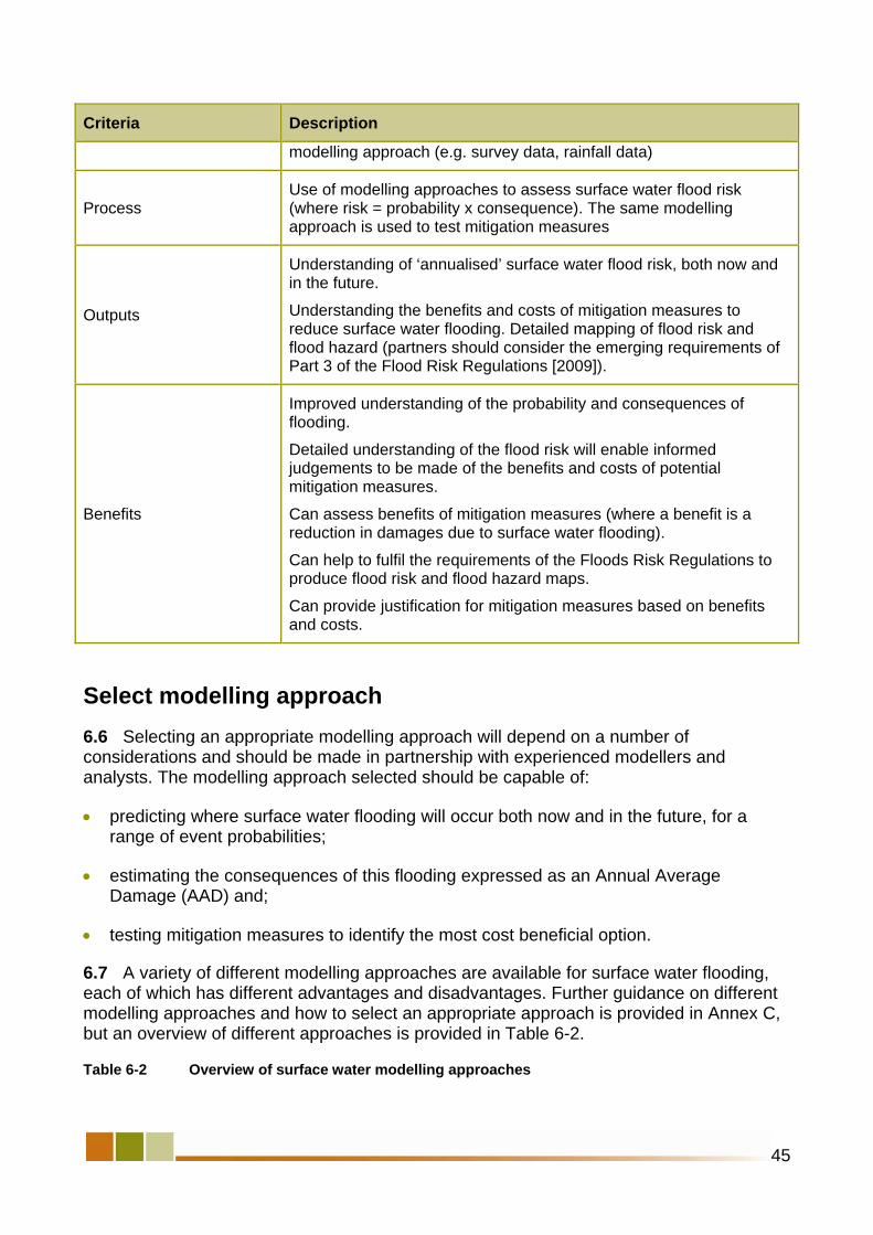
45
Criteria Description
modelling approach (e.g. survey data, rainfall data)
Process Use of modelling approaches to assess surface water flood risk (where risk = probability x consequence). The same modelling approach is used to test mitigation measures
Outputs
Understanding of ‘annualised’ surface water flood risk, both now and in the future.
Understanding the benefits and costs of mitigation measures to reduce surface water flooding. Detailed mapping of flood risk and flood hazard (partners should consider the emerging requirements of Part 3 of the Flood Risk Regulations [2009]).
Benefits
Improved understanding of the probability and consequences of flooding.
Detailed understanding of the flood risk will enable informed judgements to be made of the benefits and costs of potential mitigation measures.
Can assess benefits of mitigation measures (where a benefit is a reduction in damages due to surface water flooding).
Can help to fulfil the requirements of the Floods Risk Regulations to produce flood risk and flood hazard maps.
Can provide justification for mitigation measures based on benefits and costs.
Select modelling approach 6.6 Selecting an appropriate modelling approach will depend on a number of considerations and should be made in partnership with experienced modellers and analysts. The modelling approach selected should be capable of:
• predicting where surface water flooding will occur both now and in the future, for a range of event probabilities;
• estimating the consequences of this flooding expressed as an Annual Average Damage (AAD) and;
• testing mitigation measures to identify the most cost beneficial option.
6.7 A variety of different modelling approaches are available for surface water flooding, each of which has different advantages and disadvantages. Further guidance on different modelling approaches and how to select an appropriate approach is provided in Annex C, but an overview of different approaches is provided in Table 6-2.
Table 6-2 Overview of surface water modelling approaches

Modelling approach Overview
1 – Rolling ball (or topographical analysis)
Surface water flow routes are identified by analysing the topography
This approach would normally be used as part of the strategic or intermediate assessment and is not easily used to quantify damages due to surface water.
2 – Direct rainfall Rainfall is applied directly to a surface and is routed overland to predict flow pathways and locations where water will pond.
The presence of underground drainage can be accounted for by adjusting rainfall profiles
3 – Drainage models (see 3a-3e for variations)
Based around models of the underground drainage network, with rainfall inputs routed directly to the underground network
3a – Store flood water Users can choose to ‘store’ flood water in a virtual above-ground structure which can be dimensioned to provide an approximation of flood depth as well as volume.
3b – Representing internal flooding
Internal flooding of properties (through direct connections to the drainage system) can be modelled by adding the detail of individual lateral sewer connections to each property.
3c – 1D modelling of overland flows
Where surface flood waters are known to flow away from the flooded manhole, 1D flow channels can be modelled on the surface diverting flows to remote storage areas and/or to other inlets to the underground system. This approach is unlikely to be suitable for hazard mapping of flow and depth.
3d – 2D modelling of overland flows (uncoupled)
Flood hydrographs can be added, post simulation, to Digital Terrain Model or Digital Elevation Model flow models (as method 2) that route drainage exceedance flows through streets or in and around buildings. This is also known as an ‘uncoupled’ approach.
3e – 2D modelling of overland flows (coupled)
An advancement on method 3D is to use a fully ‘coupled’ 1D (underground) and 2D (above ground) model which permits surface water flow across the modelled urban surface and re-enter the sewer network where this is an inlet and underground capacity.
4a – Integrated urban drainage river model
Where there are interactions between urban drainage and watercourses (or main rivers) an integrated approach can be used. All components can be modelled in a single software package, or dynamically linked through simulation shells such as Open MI36
4b – Enhanced drainage modelling
Conventional drainage models (method 3) route runoff directly to the underground drainage network. Recent software developments mean it is now possible to apply rainfall directly to the 2D surface. Runoff is generated onto the 2D surface and either enters the underground drainage network at manholes or gullies, or continues to be routed on the 2D surface
36 Open MI (Open Modelling Interface) is software developed to allow different modelling packages to be linked together and run simultaneously. More information is available at http://www.openmi.org/
46

47
6.8 Choosing a method (or range of methods) is a difficult process and somewhat iterative. Choice will depend on the presence of existing data and tools, available funds, and an understanding of existing flood risks and likely plausible mitigation measures. There is no substitute for good judgement, pragmatism and experience when choosing an approach. Increasing the level of model detail does not necessarily correlate to improved surface water management mitigation measures. In some cases robust mitigation measures can be adequately assessed using simple models that are cheaper and relatively quick to apply.
6.9 A flexible attitude to approach selection is required. If uncertainties in risk assessment or options appraisal are high, a more detailed approach could be adopted to improve the robustness of decisions at a later stage. It is important to record the quality of data and models that use them as this will inform how to interpret model results. Good use can be made of existing models but users must be aware of their limitations.
6.10 The level of complexity chosen for the modelling assessment will impact the outputs from the risk assessment and the likely mitigation measures to be tested. For example, if a direct rainfall method is selected it will be difficult to represent potential upgrades to the drainage network in the model, and this should form part of the decision-making criteria.
Develop modelling approach 6.11 The SWMP guidance is not intended to be a modelling manual, and therefore the guidance does not discuss specific technical issues associated with surface water modelling (i.e. integrating fluvial, groundwater and drainage models).
6.12 However, the guidance does provide a framework for developing the selected modelling approach and provides some over-arching principles which should be considered. Excellent detailed technical guidance is available in WaPUG’s (CIWEM) Integrated Urban Drainage Modelling guide37, and should be consulted by modellers and engineers where undertaking detailed modelling to support a SWMP study.
6.13 Where modelling assessments are undertaken experienced drainage modellers, hydrologists and engineers should be utilised to ensure maximum benefit is gained from the modelling assessment.
6.14 The framework for developing the modelling approach is illustrated in Figure 6-1, and further technical guidance is provided in Annex D.
37 The guidance is available at http://www.ciwem.org/groups/wapug/index.asp

Figure 6-1 Flow diagram to illustrate process for developing modelling approach
6.15 The key output from this stage of the SWMP study is to have built and where possible verified a model which can appropriately represent the sources, pathways and receptors of surface water flooding in the study area.
6.16 The model should be able to replicate at least one historical flood incident to give confidence in the accuracy of the model. However, it may not always be possible to replicate historical flooding accurately but this does not necessarily mean the model is not fit for a given purpose. The model should also be capable of replicating complex interactions between different components of the drainage system, where applicable (e.g. interactions between sewer outfalls and river levels).
Quantify current and future flood risk 6.17 The process for quantifying current and future flood risk is indicated below. The main body of the guidance identifies the process for quantifying surface water flood risk, and illustrates the outputs which are expected from this stage. Further guidance on the process is provided in Annex E. Experienced modellers, engineers and hydrogeologists should be consulted to provide further technical input.
6.18 Careful planning and consideration should be carried out prior to running any model simulations and when determining the number of model simulations required. Quantifying flood risk can be a computationally demanding and time consuming process and therefore
48

the modelling must be outcome-focussed. The purpose of using a model to quantify flood risk is to inform robust decision making and therefore all model simulations should be used to help improve confidence in decision making.
6.19 The purpose of quantifying flood risk is to identify the annualised damages due to surface water flooding that are incurred by property (including businesses and critical infrastructure), people and the environment. The guidance provides a framework and outlines key principles for assessing such damages in a SWMP study.
Figure 6-2 Flow diagram to illustrate process for quantifying damages due to surface water flooding
6.20 The outputs from this stage of the SWMP study should be:
• an understanding of the current calculated annualised damages due to surface water flooding;
• an understanding of how annualised damages due to surface water may change in the future due to urban creep, climate change and urbanisation;
• an understanding of where new development or regeneration can contribute to reducing existing surface water flooding,
49

50
• an understanding of the benefits and costs of mitigation measures for differing rainfall events, and;
• an understanding of where surface water may impact water quality in receiving watercourses (either directly through surface water runoff, or indirectly via combined sewer overflows).

Chapter 7
Map and Communicate Risk
This chapter provides guidance on: • mapping surface water flooding, and; • communicating risk.
Box 24 Outputs from Chapter 7: Map and communicate risk
At the end of this stage of the SWMP process you will have:
• mapped outputs from the assessment of surface water flooding (taking into account the requirements of the Flood Risk Regulations and emerging guidance), and;
• communicated the outputs from the assessment of surface water flooding to professional stakeholders (spatial and emergency planners) and the public.
Map surface water flooding 7.1 The SWMP guidance outlines three levels of analysis; strategic, intermediate and detailed. It is valuable to include mapping as an output from all level of analysis as a method of communicating and displaying surface water flooding. It is recognised that the level of information in the mapping will increase as more detailed analysis is carried out. Flood mapping should be undertaken to:
• help engage stakeholders on surface water flood risks;
• inform the spatial planning process (e.g. updating information in SFRA);
• inform emergency planning functions carried out by Local Resilience Forums, and;
• identify whether critical infrastructure is at risk from surface water flooding.
7.2 It is worth noting the requirements of Part 3 of the Flood Risk Regulation (2009) to produce flood risk and flood hazard maps in areas of significant risk. At present, the criteria for significance in terms of Flood Risk Areas is being established by Defra. Guidance on how to identify Flood Risk Areas will be issued by the Environment Agency. Until guidance is available, local authorities should liaise with the Environment Agency to
51

determine the mapping specification to align it with the requirements of the Flood Risk Regulations, where possible.
7.3 Outputs from strategic and intermediate assessments are likely to be coarse in resolution and therefore may not be suitable as risk or hazard maps. The principal benefit of these maps is to identify locations within the study area which are more likely to flood, and can be used to inform spatial and emergency planning functions. The intermediate assessment can be used to enhance and refine spatial and emergency maps which are produced as part of the strategic assessment.
7.4 Where a detailed assessment has been carried out, it will be possible to undertake more detailed mapping of flood risk and flood hazard. Where relevant, the mapping should be aligned with the requirements of the Floods Risk Regulations 19 (1) (a) and (b).
Flood hazard maps
7.5 Flood hazard maps should be produced for a high, medium and low probability rainfall event38. For each rainfall probability event the flood hazard map should show:
• the likely flood extent (including water level or depths) of possible floods;
• the likely direction and speed of flow of possible floods, and;
• whether the probability of each possible flood occurring is low, medium or high.
7.6 Flood hazard rating maps can be produced to analyse the risk to people at different probability rainfall events. Flood hazard can only be mapped where an assessment of depths and velocities has been calculated as part of the risk assessment.
7.7 Defra guidance39 indicates that flood hazard is calculated by:
Hazard rating = d * (v + 0.5) + DF, where: d = depth (m); v = velocity (m/s); and DF = debris factor (0, 0.5 or 1, depending on probability that debris will cause a hazard).
7.8 A flood hazard score of 0.75 to 1.5 indicates danger to some, 1.5 to 2.5 indicates danger for most, and 2.5 to 20 indicates danger to all. A flood hazard analysis was carried out as part of the Upper Rea ‘IUD pilot’ to illustrate hazard from pluvial flooding (see Box 25). Local authorities should also have regard to guidance the Environment Agency will produce under Regulation 20(8) of the Flood Risk Regulations (2009).
7.9 Outputs from computer-based modelling approaches will be used to provide the information to produce the flood hazard maps. Modelling approaches which incorporate an
38 Low, medium and high probability are defined in Regulation 20 (5) of the Flood Risk Regulations, and can be accessed at http://www.opsi.gov.uk/si/si2009/uksi_20093042_en_3
39 Defra and Environment Agency Flood and Coastal R&D Programme (2006). Flood Risks to People – Phase 2, FD2321/TR2, Guidance document, available at http://www.rpaltd.co.uk/documents/J429-RiskstoPeoplePh2-Guidance.pdf
52

53
element of overland flow will provide flood extents, depths and velocities as part of the standard outputs.
Flood risk maps
7.10 Surface Water Flood Risk Maps should also be produced to illustrate:
• the number of people living in the area who are likely to be affected in the event of flooding,
• the type of economic activity likely to be affected in the event of flooding;
• any industrial activities in the area that may increase the risk of pollution in the event of flooding;
• any relevant protected areas that may be affected in the event of flooding;
• any areas of water subject to specified measures or protection for the purpose of maintaining the water quality that may be affected in the event of flooding, and;
• any other effect on human health, economic activity, or the environment (including cultural heritage).
7.11 Where the mapping identifies critical infrastructure is at risk of flooding this will need to be communicated to the appropriate stakeholders. A useful framework for assessing flood risk to critical infrastructure owned by the water companies is provided in guidance produced by Ofwat40.
7.12 The precision and accuracy of flood maps will depend on the modelling approach selected and the certainty of model predictions. It is important to communicate the provenance of the flood map information. At the present time some surface water flood predictions are not as accurate as fluvial or coastal flood predictions because the flood mechanisms are more complex and not fully represented. Mapping however, provides a precise flood outline and it can be difficult to communicate the uncertainty associated with it. Some partners may be reluctant to disclose such information if they unhappy with the degree of certainty or what the mapping implies about the operation of their drainage systems.
40 Ofwat (2008). Asset Resilience to Flood Hazards: Development of an analytical framework, available at http://www.ofwat.gov.uk/pricereview/ltr_pr0912_resilfloodhazglos.pdf

The benefits of the flood hazard mapping are highlighted by the following extract from the final report:
“Additional benefits of this approach were identified through stakeholder engagement in terms of emergency planning, where for the first time a proactive approach to determining flood risk areas, hazardous routes etc. has been undertaken.”
For more information on the Upper Rea IUD Pilot study final report click on the link: http://www.defra.gov.uk/environ/fcd/policy/strategy/ha2/UpperRea/finalreport.pdf
Box 25 Flood hazard mapping
As part of its analysis the Upper Rea IUD pilot study carried out analysis of the flood depths and flood hazard from pluvial flooding. The map on the left indicates predicted flood depths in the catchment for a 1 in 100 chance in any given year (1%) rainfall event (including climate change). Analysis of flood hazard is indicated on the map on the right, and illustrates the hazard based on the Defra classification.
7.13 Flood risk should be proactively communicated to all stakeholders by reference to the probability and consequences of flooding for particular receptors. Risk can be communicated in a number of ways, including:
• the number of properties at risk in a given area;
• expected annual damages (economic, social and environmental costs), and;
• the number of people within an area who could be affected by different flood incidents (including the number of vulnerable people).
7.14 The probability of surface water flooding should be communicated as the chance of a flood occurring in any given year, e.g. 1 in 100 (1%) chance of flooding in any given year. For surface water flooding this is the most likely to be based on the probability of the rainfall event causing the flooding.
Communicate risk7.15 There are various professional stakeholders with an interest in knowing more about surface water flood risks. The SWMP partnership should actively engage with these groups to share their new understanding of surface water flood risk and thus ensure that
54

other plans and policies are updated based on the improved understanding of surface water flooding. Presently, surface water flooding is less well understood than other sources of flooding (i.e. fluvial or coastal), and therefore the SWMP study offers an opportunity to communicate up to date information about locations at risk from surface water flooding.
Communicate risk to local resilience forums
7.16 Local Resilience Forums will use surface water flood maps and knowledge from the partnership to update incident management plans and community risk registers. Responses in an emergency will be informed by known surface water flooding locations, especially near public buildings and major routes through the area.
Box 26 Community Risk Registers and Multi-Agency Flood Plans
Community Risk Registers (CRR) are prepared by Category 1 responders and are required as part of the Civil Contingencies Act (CCA) 2004. The CCA requires that Category 1 responders undertake risk assessments and maintain these risks in a CCR. In this context risks are defined as events which could result in major consequences, and they include risks from flooding. However, to date the majority of CCR do not include surface water flood risks, and outputs from the SWMP can be used to help update the CCR
Multi-Agency Flood Plans (MAFP) are specific emergency plans which should be developed by LRFs, to deliver a coordinated plan to respond to flood incidents. MAFP recognise the need for specific flooding emergency plans, due to the complex nature of flooding and the consequences that arise. Outputs from a SWMP should inform the development of, or update, the MAFP. Guidance on producing a MAFP is available at http://www.ukresilience.gov.uk/media/ukresilience/assets/flooding_ma_planning_guidance_0208.pdf
7.17 In 2008 the Met Office and the Environment Agency set up the Flood Forecasting Centre to provide services to emergency and professional partners. The Flood Forecasting Centre provides an Extreme Rainfall Alert (ERA) service to Category 1 and Category 2 responders. The ERA is issued at county level and is used to forecast and warn for extreme rainfall that could lead to surface water flooding, particularly in urban areas. It is designed to help local response organisations manage the impact of flooding. The ERA has two products:
• guidance – issued when there is a 10% or greater chance or extreme rainfall, and;
• alert – issued when there is a greater than 20% chance of extreme rainfall.
7.18 The ERA cannot provide site-specific real-time surface water flood forecast, but does offer a county level alert of impending rainfall. The alert is based on the probability of rainfall occurring, rather than being a definitive forecast.
7.19 Surface water flooding has very short lead times and is hard to predict in real time because local topography and drainage infrastructure affects the direction or runoff and location of flooding. However, the assessment carried out as part of the SWMP study can identify the likely flow pathways and locations of ponding of surface water, which can be
55

used in parallel with the ERA to improve emergency planning and responses for surface water flooding.
Communicate risk to local planning authorities
7.20 Local authority planning departments can use the map outputs from a SWMP to help update SFRAs, where surface water flooding has not been addressed in detail. They may need to re-consider policies and the design elements in allocated sites as a follow on action from this, if the SWMP study highlights significant risks which were previously not taken into account. Similarly, surface water mapping developed for SFRA can be re-used in SWMP. There is no requirement to repeat mapping that has already been completed. Outputs from the SWMP study can be used in the Sustainability Appraisal of a Core Strategy, or other Development Plan Documents, to provide evidence, sustainability objectives and indicators.
Communicate risk to the public
7.21 The public should be engaged in accordance with the engagement plan specified in the preparation stage of the SWMP study. Under the Flood Risk Regulations (2009) there is a requirement to publish the preliminary assessment reports and maps (Part 2), and the flood risk and flood hazard maps (Part 3) in areas of significant risk41. Therefore, flood maps produced as part of the SWMP study should be shared with, and communicated to, the public. Partners will need to agree the mechanisms to share these maps with the public. Public engagement was a critical component of the Thatcham first edition SWMP (see Box 12)
41 The flood risk and flood hazard mapping undertaken for a SWMP study should align with the requirements of the Flood Risk Regulations, where possible and relevant.
56

Phase 3
Options
In this section you will: • identify the options, and; • assess the options.
57

58

Chapter 8
Identify measures
This chapter provides guidance on: • identifying measures, and; • short-listing measures.
• Reviewed aims and set specific objectives;
• identified a range of measures and options to mitigate surface water flooding;
• short-listed the measures and options to identify which should be taken forward to further analysis, and;
• discarded the options which are considered unfeasible from the short-listing process.
Box 27 Outputs from Chapter 8: Identify measures
At the end of this stage of the SWMP process you will have:
Identify measures 8.1 This chapter focuses on measures which can be taken to mitigate surface water flood risk.
Figure 8-1 Flow diagram to illustrate process for identifying and short-listing measures
59

8.2 The first step is to identify the range of measures which could be taken to manage surface water flood risk. At this stage thinking should not be constrained by partners concern about their funding or delivery mechanisms. Consideration should be given to other sources of flooding and their interaction with surface water flooding and opportunities for measures that deliver multiple benefits. High level assessments in CFMPs may identify such opportunities. A wide range of structural, non-structural and adaptation measures should be proposed and considered, which provide different levels of protection from surface water flooding and have a range of benefits and costs associated with them. This will facilitate development of the most economically advantageous mitigation measures42.
8.3 After the risk assessment phase specific objectives should be set to address the flood risk and associated problems in the study area. To help identify measures that best achieve the objectives indicators can be used to demonstrate those that are more effective. Examples of indicators could include a reduction in the number of properties flooded in a 1 in X chance in any given flood year, or a reduction in the depth of flooding (or duration) to a particular length of road.
8.4 Measures which will achieve multiple benefits, such as water quality, biodiversity and amenity benefits are encouraged and should be promoted.
Box 28 Measures and Options
In this guidance a measure is defined as a proposed individual action or procedure intended to minimise current and future surface water flood risk or wholly or partially meet other agreed objectives of the SWMP. An option (or options) is made up of either a single, or a combination of previously defined measures.
8.5 When identifying measures it is important to consider other local investment plans or initiatives. Reference should be made to Local Green Infrastructure Plans and investment programmes for highways departments and Growth Area Funds (GAF funding). Major commercial or housing re-development is an opportunity to retro-fit surface water management measures.
42 If a Strategic Environmental Assessment (SEA) is required for the SWMP, the measures identified will need to include a section on ‘reasonable alternatives’ considered and their respective environmental impacts. Where required, the SEA should be developed alongside the SWMP. Therefore, close co-operation will be needed between the SWMP partners and the SEA team.
60

Box 29 Combining surface water storage and amenity
External flooding of six properties and two highways areas affected an area of Poole once every two years and it was identified that flooding was due to inadequate capacity in the downstream surface water sewer. The conventional solution would have been to upsize the surface water sewer. However, it was realised that a partly culverted watercourse which discharged to the surface water sewer flowed through a local recreation ground. It was known that the local authority was considering improving this recreation ground as a local amenity area. Through working in partnership a solution was developed to provide surface water attenuation (3500 m3)within the recreation ground to limit flow entering the surface water sewer and to partially de-culvert some of the surface water, whilst improving the amenity of the recreation ground. This has provided protection to the properties at risk of external flooding to 1 in 20.
For more information click on the link below: http://www.bournestreampartnership.org.uk/about_the_project.htm
8.6 In addition, committed future investment (e.g. water company investment identified in business plan) should be examined. In some cases it may not be cost-beneficial to undertake mitigation at present, but when other investment is carried out (e.g. replacement of sewers, redevelopment of town centre) the mitigation may become cost-beneficial, and the SWMP should identify a suitable strategy to ensure the investment reduces surface water flood risk.
8.7 Stakeholders should also be engaged, including the community (see Box 30).This type of engagement can be beneficial for a number of reasons including gauging what the public wants, what is deemed publicly acceptable, whether the community is prepared to raise local funds to reduce flood risk, and to build trust with the public especially where proposed measures change land-use. Engaging stakeholders is also beneficial where the measures may be contentious or require stakeholder acceptance (e.g. use of green space as flood storage in extreme events).
“The meeting began with presentations from the IUD partners about the flooding problems in West Garforth and potential improvement measures available. In the second part of the meeting participants were invited to suggest what improvement measures they thought could be located in different parts of the West Garforth area. Coloured dots and tape were used to signify different improvement measures. Participants were encouraged to place the dots or tape on appropriate locations on maps relating to each of the flood prone areas. Questionnaires were then available for participants to provide comments on the improvement measures suggested.”
For more information on the West Garforth IUD pilot study click the following link: http://www.defra.gov.uk/environment/flooding/documents/manage/surfacewater/wgarforthreport.pdf
Box 30 Public consultation during option identification
The West Garforth IUD pilot study partnership identified options to mitigate flooding at specific locations. In addition a public meeting was held to identify the options that were deemed publicly acceptable. Some of the options proposed by the public were considered as part of the detailed cost-benefit assessment. The following is an extract from the West Garforth report on how the public were incorporated into the option identification stage:
61

Types of measures
8.8 Local circumstances, opportunities and constraints mean that a thorough local knowledge is required to identify plausible local measures. However, broad categories of measures can be identified (see Annex F). It is useful to develop ideas around these categories through a workshop environment within the SWMP partnership.
8.9 When considering types of measures to mitigate surface water flood risk it is useful to consider the source-pathway-receptor model. Further information on the types of measures is provided in Annex F and is illustrated in the diagram below. Local authorities may also need to consider co-operating with neighbouring local authorities where a more strategic approach to mitigation is sought across political boundaries.
Figure 8-2 Mitigation measures which can be considered to reduce surface water flood risk
Short-list measures 8.10 A detailed appraisal of the cost and benefits of options cannot consider all combinations; many of which would be ruled out as either impractical, too risky, too expensive, or ineffective. Therefore a high level scoring exercise is recommended to short-list options and screen out unfeasible measures. There is also a key role for experience and judgment when eliminating options and it is important to consider the experience of all partners at this stage. If affordability is used as a screening criterion, care should be taken not to rule out options which might be affordable if more creative funding routes were pursued, such as contributions from other stakeholders. In line with PAG the ‘do nothing’ (no intervention, including no maintenance) and ‘do minimum’ (continuation of current practice) options should be taken forward to the detailed assessment phase. A key
62

63
criterion is whether the measures will help to meet the objectives established at the outset of the SWMP study.
8.11 Individual measures being considered can be scored against criteria (Table 8-2) and scores summed. Detailed technical and cost appraisals are not required; informed engineering judgement is sufficient. The purpose is to rank individual measures to take forward a subset for more detailed appraisal. A worked example is provided in Annex G.
Table 8-2 Example of short-listing criteria
Criteria Description Score
Technical Is it technically possible and buildable? Will it be robust and reliable?
U (unacceptable) – measure eliminated from further consideration
- 2 severe negative outcome
- 1 moderate negative outcome
+1 moderate positive outcome
+2 high positive outcome
Economic Will benefits exceed costs?
Social Will the community benefit or suffer from implementation of the measure?
Environmental43 Will the environment benefit or suffer from implementation of the measure?
Objectives Will it help to achieve the objectives of the SWMP partnership?
8.12 The short-listing process should be used to identify which measures and options should be taken forward to the next stage of the options appraisal process. Measures/options which are identified as being unfeasible should be discarded at this point. The reasons for short-listing or rejecting measures should be documented to ensure transparency in the process.
43 In assessing environmental criteria the partners should be aware of the requirements of the Water Framework Directive and hydromorphology (flow regime and physical habitat).

64

Chapter 9
Assess options
This chapter provides guidance on: • identifying the assessment to be carried out; • undertaking the options assessment, and; • selecting the preferred option/s.
Box 31 Outputs from Chapter 9: Assessment
At the end of this stage of the SWMP process you will have:
• identified the requirements of the options assessment;
• undertaken an assessment of options which were short-listed, and;
• agreed the preferred option to be taken forward to the surface water management action plan.
9.1 This section of the guidance covers the process for assessing options through a consideration of the benefits and costs of different options. The purpose of options appraisal is to compare all the benefits and costs of different options, and should be used to help decide between different options and to provide an evidence base to justify investment. It aids the identification of a preferred strategy for the future management of surface water flooding.
Identify assessment to be carried out 9.2 The flow diagram in Figure 9-1 illustrates the process which should be adopted for identifying the requirements of the options assessment, and the process to undertake the assessment.
65

Figure 9-1 Flow diagram to illustrate process for assessing options
9.3 The first step in the options assessment process is to determine which benefits and costs are to be included in the analysis. There are a number of criteria or factors of benefits and costs which could be included in the options assessment; an indicative list is illustrated in Table 9-1.
9.4 The assessment should seek to include all relevant benefits and costs to the study, either in monetary or non-monetary terms. The criteria to be included should be discussed and agreed by the partnership, and stakeholders could also be engaged during this decision-making process.
9.5 At this stage partners should also agree which benefits and costs will be monetised, and which will be assessed in non-monetary terms. Where possible, it is recommended that benefits and costs are put into monetary terms so that a full evaluation of benefits and costs can be undertaken. Equally, it is recognised that not all benefits and costs can be put into monetary terms, and hence can be assessed through a more simplified approach (e.g. scoring and weighting the impacts of different options in terms of their benefits and costs). Analysis of monetised costs and benefits should be conducted over an appraisal period reflecting the longest useful life of any assets created in the options considered.
9.6 A detailed assessment of benefits and costs may not be required for all options taken forward from the short-listing process. To develop a high level action plan simplified approaches to options appraisal will be adequate. However, significant investment will generally always require rigorous numerical benefit-cost assessment.
66

Table 9-1 Examples of costs and benefits which can be included in options assessment
Cost / benefit
Description of cost/benefit criteria
Costs
Capital costs (or capital expenditure [CAPEX]) – these are the one-time costs associated with constructing or purchasing of assets, land or equipment.
Operational costs (or operational expenditure [OPEX]) – these are the ongoing costs associated with maintenance of assets, land or equipment.
Carbon costs – these are the direct, indirect, embedded and supply chain emissions of carbon dioxide. It is recommended that carbon costs are only included where it will affect the findings options assessment
Disruption to services – during construction of infrastructure or maintenance there can be disruption to traffic or businesses, for example, and these can be included as a cost. (These may not always be applicable for some funding streams).
Environmental costs – where a proposed option could cause deterioration of the flow regime or physical habitat of a waterbody, this could detriment the ability to meet the WFD
“Do-nothing” flood damage costs – these are the damages which would be incurred without action, as estimated under the detailed assessment. They apply only to the “baseline” do-nothing option.
Opportunity costs – costs associated with having to forego certain benefits. An example would be the loss of development value associated with land use planning restrictions (net of that from development which might be allowed in new, non-vulnerable areas). Opportunity costs may be particularly applicable to non-structural measures.
Benefits
Reduced surface water flood risk to properties, businesses, and critical infrastructure
Reduced social and health impacts of flooding
Reduced emergency costs of responding to flood incidents
Reduced risk to life due to improvements in surface water flood risk management
Contribution to meeting the requirements of the WFD through reducing pollution entering watercourses
Contribution to meeting objectives of green infrastructure plans
Contribution to creating or enhancing biodiversity and amenity
Adaptability to climate change – the benefit could be the reduced use of
67

Cost / Description of cost/benefit criteria benefit
carbon through the use of lower energy options, and greater adaptability of an option to future climate change
Undertake assessment of options 9.7 This section of the guidance outlines steps 2-6 in the flow diagram identified in Figure 9-1.
Calculate costs which are to be monetised (and discount)
9.8 Two types of costs should be included at this stage of the analysis. First, the annualised damage costs associated with surface water flooding, which were calculated as part of the detailed assessment, should be brought forward for the options assessment under the do-nothing ‘baseline’ case.
9.9 Secondly, the infrastructure costs (capital and maintenance costs) of implementing options should be determined. Expert input from engineering sections of water companies, the Environment Agency, Highways Agency and local authorities will be required to cost different options. These data provide the basis of subsequent economic analyses. Where carbon costs are to be included Defra’s guidance on using the shadow price for carbon in policy appraisal should be consulted. In addition Ofwat44 has published guidance on the use of carbon accounting in AMP business planning for water companies.
Calculate benefits which are to be monetised (and discount)
9.10 For each option the benefits of the mitigation should be assessed; that is the reduction in risk to the receptors (people, property and the environment). To assess the benefits of different structural investment options will invariably require the use of computer-based modelling approaches to calculate the reduction in AAD with the option in place. Most measures can be included in hydraulic models by upsizing pipes and channels, creating exceedance flow routes and storage areas or including source control.
9.11 AADs should be calculated using the same method as for the detailed risk assessment, by running a sequence of rainfall events through the model (for current and future scenarios). The effectiveness of some measures might be limited to their role in high probability or low probability events. Hence it is important to annualise the impact by running a sequence of events over the full range of flood probabilities. This includes the full impact of residual flood risk. The outputs from this assessment will be a new AAD, which can be deducted from the ‘do nothing’ AAD to identify the benefit of investment.
44
B Ofwat - Supplementary information in justification for proposed investment – including outcome of Cost-enefit Analysis and Carbon Accounting, available at tp://www.ofwat.gov.uk/aptrix/ofwat/publish.nsf/AttachmentsByTitle/bisplan09_c8_compguidance.doc/$FILEht
/b
68
isplan09_c8_compguidance.doc
Box 32 Discounting
Discounting is a technique used to compare the costs and benefits that occur in different time periods. It is based on the principle that, generally, people prefer to receive benefits now rather than later. All costs and benefits should be discounted over the time horizon of the analysis. The recommended discount rate for assessing the Net Present Vale (NPV) up to 30 year into the future is 3.5%. If the planning horizon is greater than 30 years a lower discount rate should be used. For more information on discounting follow the link to the Treasury Green Book (http://greenbook.treasury.gov.uk/).

Compare monetised benefits and costs
9.12 Benefits and costs which have been monetised can be directly compared to assess whether a proposed option is cost-beneficial. The following summary measures can be calculated:
• a net present value (NPV) – which is the total discounted benefit of the option over the appraisal period minus its total discounted cost. This gives the overall net “worth” or “return” for the costs expended.
• a benefit-cost ratio (BCR) – which is the net present value (NPV) divided by the cost met by partners (typically CAPEX plus OPEX)
9.13 Whether a BCR or an NPV is used as the main summary statistic of appraisal will depend partly on standard practice amongst partner organisations. Although Net Present Value gives the overall net “worth” of an option, it tends to favour larger or more involved interventions. Public sector organisations with limited budgets tend to use the Benefit-Cost Ratio, which gives a measure of return per pound of cost, regardless of project size. Given that resources for SWMP interventions may often be constrained then BCR may be the more useful metric, but the partners should agree on whether to use BCR or NPV to compare the benefits and costs of different options. It should be remembered that the principal purpose of an options assessment in a SWMP study is to identify the preferred option. Partners may subsequently need to prepare more detailed economic assessments to justify any investment.
Undertake sensitivity and uncertainty analysis
9.14 The quality of decision making at this stage will be affected by uncertainty in data, models and the approach chosen. Sophisticated probabilistic approaches are available to understand the influence of uncertainty on decision making. It is not recommend that these are applied unless investment is very significant. Instead a pragmatic approach is recommended which compares closely scoring options and considers unique (to the option) model parameters or data elements that are uncertain (refer to data quality score recorded earlier) and could influence the ranking of options. Where a decision is dependent on uncertain information further data improvement can be justified and sensitivity analysis conducted. Robust decisions are those which are relatively insensitive to uncertainties in input parameters.
Assess unvalued costs and benefits
9.15 Benefits and costs which have not been valued should also form part of the appraisal process; they must not be ignored purely because they cannot easily be valued. In SWMP studies, social and environmental costs and benefits of mitigation measures/options may not be captured in monetary terms (e.g. biodiversity benefits), but should be included in the options assessment. For example, environmental benefits could be measured by
69

assessing the impact on water quality as surface water flows can wash pollutants and contaminates (e.g. from roads) into watercourses.
9.16 As an example, an unvalued cost is an assessment of the risk that an option will cause an impact on the hydromorphology (flow regime and physical habitat) of a , which results in deterioration in status under the Water Framework Directive or a failure to achieve the waterbodies objectives45. Similarly, an unvalued benefit may include the contribution that an option can make to help achieve the WFD objectives for a waterbody.
Box 33 Consideration of WFD in options assessment
Under WFD waterbodies must achieve ‘Good’ status or potential. Programmes of Measures (a WFD term for improvement activities) for waterbodies are published in River Basin Management Plans. These set out what measures are required to move waterbodies towards good status. Some improvements delivered through the SWMP can help to achieve good status/potential, and could be included as benefits at this stage in the analysis. In particular source control measures such as providing storage in an open space and some options to increase capacity such as de-culverting could help to provide improved physical habitat.
The Environment Agency mitigation measures manual (http://publications.environment-agency.gov.uk/epages/eapublications.storefront - search for Digital Good Practice Manual) for flood and coastal erosion risk management and land drainage activities which will set out best practice options for measures to mitigate against the impacts of activities upon ecology and will be relevant for streams and rivers, ditches (but not relevant for sewers). This will be used to ensure that new and existing schemes and management activities will take into consideration WFD requirements and will result in minimal ecological damage. Using this manual will help to deliver River Basin Management Plans Programme of Measures.
9.17 Typically, multi-criteria techniques can be used to aid the assessment of options where all impacts have not been captured in monetary terms. Defra’s PAG states that multi criteria techniques and should be used to support decision making.
45 If this risk is established Article 4.7 of the WFD can be used to justify the measure, but only if certain criteria are met
70

Box 35 Design standards
The guidance does not specify certain design standards or norms for different elements of the surface water drainage system. The approach is entirely risk based, linking benefits to costs, where benefits are the damages avoided by surface water management techniques. Design standards are not considered necessary for surface water management mitigation measures because:
• currently there is not sufficient understanding of the consequences of surface water flooding and hence it is unclear what design standard would be applicable for surface water management in existing urban areas, and;
• the risk (probability and consequence) from surface water flooding will be variable throughout England and therefore the benefits and costs of different levels of protection (or design standards) are expected to vary across England.
In practice, it is recognised that design standards for flood protection from different parts of the surface water drainage system serve as useful benchmarks and will probably be represented in some options (e.g. upsizing of sewers to provide protection against the 1 in 30 (3.33%) chance in any given year. It can also be useful to begin testing options at an assumed design standard to gain an understanding of level of protection which is likely to be cost-beneficial.
In addition, national standards for SuDS are currently being prepared, which will set the design standards for new-build SuDS and will outline the approval process for adopting and maintaining these SuDS. Under the proposed Floods and Water Management Bill lead local flood authorities will be responsible for approving, adopting and maintaining new-build SuDS
Box 34 Assessing unvalued costs and benefits
Subsequent to undertaking a BCA, the Leeds first edition SWMP included an assessment of the carbon impact and adaptability to climate change of different options. The approach, based on a simple scoring system, was used to enhance the findings from the BCA to understand the wider sustainability of different options to mitigate surface water flood risk.
Agree preferred option/s 9.18 The preferred option should be developed based on the evidence base provided by the SWMP study. The options appraisal process is a key factor in providing this evidence base; however partner and stakeholder preferences and constraints are an important
71

72
parallel consideration to economics. Decisions may be made that are economically sub-optimal but have the support of stakeholders and are supported by available finance46.
9.19 A SWMP is considered to be a long-term plan for managing surface water flooding within an area, and therefore it is recommended that the preferred strategy includes some immediate actions and longer term aspirational aims. The aspirational aims may not be considered deliverable in the immediate or short-term, but are considered deliverable in the longer term (e.g. a town centre redevelopment provides a cost-effective opportunity to improve surface water management). The preferred options should therefore include a mix of:
• capital investment, where justified principally by the options assessment;
• identification of, and commitment to implement quick win measures (e.g. improved maintenance by all partners), where this will help to reduce surface water flood risk;
• aspirational options to reduce surface water flooding, which may not be deliverable in the short-term, but nonetheless could become feasible in the longer term, and;
• policy recommendations to influence spatial and emergency planning.
9.20 The preferred option should be agreed in principle by all partners. However, it is recognised that each organisation will inevitably be required to justify the necessary investment independently from the SWMP study. As an example, water and sewerage companies need to justify investment to Ofwat on a periodic basis (Periodic Review [PR] process). If additional investment is required which falls outside the pre-determined expenditure with Ofwat, the water and sewerage company would need to justify this additional investment to Ofwat, so that it could be assessed during the next PR process.
9.21 Based on the agreement in principle about the preferred option/s, the surface water management action plan can subsequently be prepared. However, it is recognised that once the outcome of investment decisions is known, and once partners have tried to secure funding to implement their element of the plan, there may be a requirement to revise the action plan. It is therefore important that partners continue to work together after the SWMP study has been completed. This may be identified as an ongoing action in the Local Flood Risk Management Strategy as set out in the proposed Flood and Water Management Bill.
46 The availability of finance to partners will vary and current arrangements make it difficult to cross-invest in another’s infrastructure.

Phase 4
Implementation and Review
In this phase you will: • prepare the action plan, and; • implement and review the action plan.
73

74

Chapter 10
Prepare action plan
This chapter provides guidance on: • preparing the action plan, and; • reviewing and publishing the action plan
Box 36 Outputs from Chapter 10: Prepare action plan
At the end of this stage of the SWMP process you will have:
• prepared the surface water management action plan, and;
• reviewed and publish the action plan
Prepare action plan 10.1 The final stages of the SWMP study will be to collate the information from the first three phases into a study document, and where appropriate, to prepare an action plan (i.e. the SWMP) for implementing the preferred structural and non-structural option(s). The action plan must be based on the evidence base collated as part of the SWMP study. Contents and format for the action plan will vary depending on local circumstances, but should outline the preferred option, the actions required by each partner and stakeholder, who will pay for the actions, and the timetable for implementation.
10.2 A good SWMP will inform a Local Flood Risk Management (LFRM) Strategy under the proposed Floods and Water Management Bill, and is expected to meet the requirements of a Flood Risk Management Plan (FRMP) for areas of significant risk under the Flood Risk Regulations (2009).
10.3 Local authorities should be aware of emerging guidance and policy on the production of a LFRM strategy and a FRMP, to ensure a surface water management action plan is aligned as closely as possible to these strategies and plans.
10.4 The surface water management action plan should cover some or all of the following (the requirements have been aligned to the requirements of a LFRM strategy and FRMP, where possible):
75

• the objectives set out at the outset of the SWMP study;
• capital and maintenance actions and programmes of work for each partner/stakeholder, including the proposed timing and manner of implementing the actions;
• advice and information to local authority planners;
• advice and information to local resilience forums and emergency planners;
• a programme of further work or follow up actions;
• when the SWMP will be reviewed and updated, and how implementation will be monitored.
• A list of any other flood risk management measures being undertaken in the plan area to achieve objectives in European legislation (such as the Water Framework Directive or the Habitats Directive)
10.5 Much of the detailed technical information should form supplementary documents, but the plan would benefit from a short summary of the risk assessments and maps to provide a context for the action plan.
10.6 As part of the preparation of the SWMP, the need to undertake a Strategic Environmental Assessment (SEA), an Appropriate Assessment (required by the Habitats Directive), or an Article 4.7 (WFD) assessment, should be established.
10.7 Local authorities should decide if a SWMP requires Strategic Environmental Assessment by making a 'screening decision'. Guidance on this is contained in section 2 of ‘A Practical Guide to the Strategic Environmental Assessment Directive' (ODPM, 2005; http://www.communities.gov.uk/documents/planningandbuilding/pdf/practicalguidesea.pdf). Whether a SWMP will require SEA will depend on a number of factors including whether it applies over a wide area, its environmental effects and its statutory status. SWMPs may also require Appropriate Assessment under the Habitats Regulations.
10.8 Under the WFD, new modifications to a waterbody which put it at risk of deterioration of failure to meet its WFD objectives are not permitted unless specific objectives are met. The criteria that permit new modifications are laid out in Article 4.7 of the WFD. ‘New modifications’ encompass new capital works, but also significant changes to the maintenance regimes of waterbodies. Conversely a SWMP represents an opportunity to improve the status or current designation of a waterbody through coordinated investments.
10.9 In broad terms, under Article 4.7 the option selected must be demonstrated to be the best available environmental option. In addition ‘all practicable’ mitigation measures must be in place, i.e. those that are not technically infeasible or disproportionately costly. There are further requirements that the proposal has to be in the overriding public interest and/or benefits to human health and safety must outweigh environmental impacts. These requirements will impact on option selection and cost benefit analysis. Policies on no deterioration and Article 4.7 are currently being prepared by the Environment Agency, in partnership with Defra, and should be available early in 2010.
76
Capital and maintenance actions and programmes of work
10.10 A SWMP will inform the preparation of future maintenance programmes for surface water management assets and any necessary co-ordination of maintenance programmes of different partners to ensure effective operation of these. As the surface water management action plan identifies the locations at greatest risk of surface water flooding this can be used to target maintenance improvements in areas at greatest risk.
10.11 A programme of capital works or activities required to implement the preferred option may need to be developed. This is likely to contain short and longer term programmes of work some of which may initially be aspirational pending agreement from individual partners’ own investment programmes. The availability and transparency of funding to undertake capital and maintenance works should form part of the development of the preferred option.
10.12 The development of programmes of work, particularly where these involve actions on different partners, will require negotiation and leadership by the lead partner (i.e. local authority). Credible and well presented information from the risk assessment and options appraisal and selection stages will support this process and present a clear business case for negotiating action.
Advice and information to local authority planners
10.13 The outputs from a SWMP study are likely to be of considerable value to the spatial planning and development process and in return planners and developers may assist in the achievement of aspects of the action plan. Information and advice to planners might include:
• maps to identify potential areas that are more vulnerable to surface water flooding, which can be used to inform development decisions and update information in SFRAs;
• consideration of how proposed new development will drain to areas of existing surface water flood risk, and therefore the runoff requirements from these development sites;
• information for supplementary planning guidance such as areas where SuDS would be effective or where special drainage arrangements should be applied to support the SWMP implementation, which can be used to inform the requirements for FRAs, and;
• working with local authority planners to inform and find opportunities in spatial planning processes to make space for sustainable surface water risk management, groundwater recharge, green and blue infrastructure and water quality improvements. Also to inform a surface water supplementary planning document or Area Action Plan.
• a SWMP user guide explaining what the aims and objectives are, how the plan can be achieved and maintained and how it links to SFRAs.
Advice and information on emergency planning
10.14 Findings or actions identified in SWMPs should be made available to inform and update multi-agency flood plans / severe weather plans and Local Resilience Forum community risk registers. This might include information on high flood risk areas, roads
77

78
and access routes likely to be impassable, impacts on critical infrastructure or vulnerable people. In addition, schemes which are likely to use roads as conveyance routes or recreational areas for temporary flood storage should be done so with the assistance and support of emergency planners and the relevant highways engineers.
Programme of further work or follow up actions
10.15 Follow up actions might include:
• some aspects of a SWMP that were not completed due to information not being available;
• undecided issues that still need agreement;
• an agreement to continue to work in partnership after the SWMP study has been completed (e.g., setting up a cross-organisational flood risk working group);
• ongoing engagement with communities and businesses still at risk,
• a plan to monitor the effectiveness of the measures put in place, and;
• proposals to undertake work in more detail.
10.16 A provisional timetable for completing follow up actions should be agreed by all partners. As a SWMP study is considered to be a long-term plan, partners should continue to work together after the SWMP study has been completed.
Review and publish the action plan 10.17 Prior to its publication the SWMP should be reviewed to ensure the plan is built upon a sound evidence base. All partners should review the action plan and ‘sign off’ the action plan. This ‘sign off’ demonstrates the commitment of partners (in principle) to seek to undertake the actions proposed in the plan.
10.18 Local Authorities have arrangements in place for the purpose of reviewing the effectiveness of duties they undertake. Local authorities own scrutiny committees should review and approve the plan prior to approval of the final plan.
10.19 Once the plan has been reviewed and approved, the action plan should be published.

Chapter 11
Implement and review action plan
This chapter provides guidance on: • implementing and reviewing the action plan.
Implement and review action plan 11.1 Under the proposed Floods and Water Management Bill, unitary and county local authorities will have responsibility for monitoring and reporting on the implementation of the action plan.
11.2 The unitary and county local authorities should regularly review progress of the surface water management action plan, to check whether the proposed actions are being undertaken by relevant partners and stakeholders.
11.3 It is recommended that the partnership continues to work together to discuss implementation of the proposed actions, and to discuss progress of any further work or follow up actions which were identified in the preparation of the action plan. The action plan should be reviewed and updated once every six years as a minimum, but there are circumstances which might trigger a review and/or an update of the action plan in the interim or in some cases annually:
• occurrence of flooding incident;
• additional data or modelling becoming available, which may alter the understanding of risk within the study area;
• outcome of investment decisions by partners is different to the preferred option, which may require a revision to the action plan, and;
• additional development or other changes in the catchment which affect the surface water flood risk.
79

Glossary of Terms
Area Action Plans (AAP) A type of Development Plan Document focussed on a specific location or area subject to conservation or significant change (e.g. major regeneration).
AMP (Asset Management Plan)
A plan for managing water and sewerage company (WaSC) infrastructure and other assets in order to deliver an agreed standard of service. The Asset Management Plans inform the WaSCs business plans submitted to Ofwat every 5 years and which forms the basis by which price limits for customers are set. These plans identify the timescales and levels of investment required to maintain the serviceability of the assets and improve service where appropriate. (Other organisations have asset management plans e.g. the Environment Agency).
Annual Average Damages (AAD)
The average flood damages that are predicted to occur annually, and could include damages to people, property and the environment
Benefit-Cost Ratio (BCR) A ratio of the present benefits and costs of an option. A BCR of >1 indicates benefits are greater than costs
Biodiversity Action Plan Each Local Biodiversity Action Plan works on the basis of partnership to identify local priorities and to determine the contribution they can make to the delivery of the national Species and Habitat Action Plan targets.
British Waterways British Waterways is the organisation responsible for 2200 miles of Britain’s canals and rivers
Capital Expenditure (CAPEX)
Public expenditure defined by the Office of National Statistics as being within the remit of capital for Treasury allocation purposes. Expenditure that provides a benefit realised over a number of years. Privatised water utilities also define CAPEX budgets.
Catchment Flood Management Plan (CFMP)
A strategic planning tool through which the Environment Agency works with other key decision-makers within a river catchment to identify and agree policies for sustainable flood risk management.
Chance of flooding The chance of flooding is used to describe the frequency of a flood event occurring in any given year, e.g. there is a 1 in 100 chance of flooding in this location in any given year. This can also be described as an annual
80

probability, e.g. a 1% annual probability of flooding in any given year. The guidance uses the chance of flooding with the annual probability of a flood incident occurring in brackets. The use of return periods should be avoided.
Civil Contingencies Act (CCA)
This Act delivers a single framework for civil protection in the UK. As part of the Act Local Resilience Forums must put into place emergency plans for a range of circumstances including flooding.
Combined Sewer Overflow (CSO)
Combined sewer overflow is the discharge of untreated wastewater from a sewer system that carries both sewage and storm water (a combined sewerage system) during a rainfall event. The increased flow caused by the storm water runoff exceeds the sewerage system’s capacity and the sewage is allowed to overflow into streams and rivers through CSO outfalls.
Communities and Local Government (CLG)
Communities and Local Government is the Government department which sets policy on local government, housing, urban regeneration, planning and fire and rescue. They have responsibility for all race equality and community cohesion related issues in England and for building regulations, fire safety and some housing issues in England and Wales. The rest of their work applies only to England.
Provides funding to and agrees expenditure plans for Local Authorities
Core Strategy A Development Plan Document setting out the spatial vision and strategic objectives of the planning framework for an area, having regard to the Community Strategy.
Cost-Benefit Analysis (CBA)
Analysis which quantifies in monetary terms the costs and benefits of a proposed scheme, including items which the market does not provide a readily available monetary value. Sometimes referred to as Benefit-Cost Analysis.
Critical Drainage Area As defined in the Town and Country Planning (General Development Procedure) (Amendment) (No. 2) (England) Order 2006 a Critical Drainage Area is “an area within Flood Zone 1 which has critical drainage problems and which has been notified… [to]…the local planning authority by the Environment Agency”.
Critical infrastructure Infrastructure which is considered vital or indispensable to society, the economy, public health or the environment, and where the failure or destruction would
81

have large impact. This would include emergency services such as hospitals, communications, electricity sub-stations, water treatment works, transport infrastructure and reservoirs.
Department for Environment, Food and Rural Affairs (Defra)
Department that brings together the interests of farmers and the countryside; the environment and the rural economy; the food we eat, the air we breathe and the water we drink.
Designing for Exceedance Designing for Exceedance is an engineering philosophy or approach which aims to plan for and manage flows which are larger than the designed capacity of infrastructure during rainfall events. An example of deigning for exceedance would be the use of car parks to store water during flood events. CIRIA have published a designing for exceedance best practice manual.
DG5 Register A Water and Sewerage Company (WaSC) held register of properties which have experienced sewer flooding (either internal or external flooding) due to hydraulic overload, or properties which are ‘at risk’ of sewer flooding more frequently than once in 20 years.
Digital Elevation Model (DEM)
A model of the elevation of the ground surface and includes building, vegetations etc
Digital Terrain Model (DTM) A model of the terrain of the earth’s surface (‘bare earth’)
Discounting A method used to convert future benefits or costs to present values, using the discount rate.
Drainage Area Plan (DAP) A DAP is a comprehensive assessment of a sewer system’s performance and condition made by the WaSC. It generally includes a hydraulic model of the foul, combined and some surface water sewers. It also proposes sewerage improvements or repairs to achieve desired levels of service (e.g. the alleviation of DG5 sewer flooding properties)
Environment Agency The Environment Agency was established under the Environment Act 1995, and is a Non-Departmental Public Body of Defra. The Environment Agency is the leading public body for protecting and improving the environment in England and Wales today and for future generations. The organisation is responsible for wide-ranging matters, including the management of all forms of flood risk, water resources, water quality, waste regulation, pollution control, inland fisheries, recreation, conservation and navigation of inland waterways.
82

It will also have a new strategic overview for all forms of inland flooding
Environment Agency Flood Zones
Flood zones on the maps produced by Environment Agency providing an indication of the probability of flooding (from rivers and the coast) within all areas of England and Wales.
Exceedance flows Excess flow that appears on the surface once the capacity of the underground drainage system is exceeded
Exception test The exception test is used in spatial planning to ensure that development that has to be in a flood risk area is appropriate and safe. It is part of the PPS25 policy approach (see Table D3 and paragraph D9 of PPS25 and paragraphs 4.46 to 4.48 of the PPS25 Practice Guide). The exception test should only be applied after the PPS25 sequential test has been applied.
Flood Hazard map A map which identifies flood risk areas and shows –
a) the likely extent (including water level or depth) of possible floods,
b) the likely direction and speed of flow of possible floods, and
c) whether the probability of each possible flood occurring is low, medium or high.
Flood Risk Assessment (FRA)
Flood Risk Management Plan
Flood Risk Regulations
An assessment of the flood risk to and from a proposed new development to demonstrate how flood risk from all sources of flooding to the development itself and flood risk to others will be managed now and taking climate change into account (see PPS25 paragraph E8 to E10 and paragraphs 3.98 to 3.94 of the PPS25 Practice Guide).
A plan for the management of a significant flood risk. The plan must include details of –
a) objectives set by the person preparing the plan for the purpose of managing the flood risk, and
b) the proposed measures for achieving those objectives (including measures required by any provision of an Act o subordinate legislation).
Legislation that transposed the Floods Directive in
83
2009
Flood (Risk Management) Strategy
England and Wales.
An Environment Agency output which provides a detailed assessment of flood risks (from rivers and the sea) at a location or for a whole catchment and the preferred management measures.
Flood risk map
A map showing in relation to each flood risk (a) the number of people living in the area who are likely to be affected in the event of flooding, (b) the type of economic activity likely to be affected in the event of flooding, (c) any industrial activities in the area that may increase the risk of pollution in the event of flooding, (d) any relevant protected areas that may be affected in the event of flooding, (e) any areas of water subject to specified measures or protection for the purpose of maintaining the water quality that may be affected in the event of flooding, and (f) any other effect on— (i) human health, (ii) economic activity, or (iii) the environment (including cultural heritage).
Floods and Water Management Bill
The proposed Floods and Water Bill was laid in parliament on the 19th November 2009 and will clarify the legislative framework for managing surface water flood risk in England.
Floods Directive The EU Floods Directive came into force in November 2007 and is designed to help Member States prevent and limit the impact of floods on people, property and the environment. It was transposed into English law in December 2009 by the Flood Risk Regulations.
Future Water The Government’s water strategy for England; Future Water was published in February 2008. This strategy sets out the Government’s long-term vision for water and the framework for water management in England.
Grant in Aid Grant in Aid funding is provided by Defra to the Environment Agency to invest in flood risk management schemes.
84

85
Funding from the Environment Agency which can be provided to local authorities to invest in flood risk schemes is called Capital Grant. Capital Grant is approved through the Project Appraisal Review (PAR) process.
Greenfield runoff rate The rate of runoff which would occur from a site that was undeveloped and undisturbed.
Green Infrastructure Plans These Local Authority plans seek to provide improved green infrastructure within urban environments, such as parks, woodlands etc.
Highways Agency The national body responsible for managing, maintaining and improving England’s motorways and trunk roads
Highways Authority Local authority (unitary or county) with responsibility for managing, maintaining and improving England’s roads which are not under the responsibility of the Highways Agency
Integrated Urban Drainage (IUD) Pilots
These are the 15 Defra funded studies which ran from January 2007-June 2008 to test new approach to working in partnership to improve management of urban drainage.
Internal Drainage Boards (IDB)
Local drainage authorities established in some areas of the country, historically in low-lying areas with particular land drainage problems.
Local Development Framework (LDF)
A non-statutory term used to describe a folder of documents which includes all the local planning authority’s Local Development Documents (LDDs). The local development framework will also comprise the statement of community involvement, the local development scheme and the annual monitoring report.
Local Planning Authority (LPA)
The local planning authority (LPA) is empowered by law to exercise planning functions. Often the local borough or district council. National parks and the Broads authority are also considered to be local planning authorities. County councils are the authority for waste and minerals matters.
Local Resilience Forums (LRF)
LRFs are multi-agency forums, bringing together all organisations who have a duty to co-operate under the Civil Contingencies Act, and those involved in responding to emergencies. They prepare emergency plans in a co-ordinated manner.
Joint Probability Joint probability analysis gives the probability of two or more conditions which affect risk occurring at the same

time. For example, high river levels can impede sewer outfalls.
Main River Main Rivers are watercourses marked as such on a main river map. Generally main rivers are larger streams or rivers, but can be smaller watercourses. Main Rivers are determined by Defra in England, and the Environment Agency has legal responsibility for them.
Making Space for Water MSfW, launched in 2004, outlines the Government strategy for the next 20 years to implement a more holistic approach to managing flood and coastal erosion risks in England.
Metadata Metadata can be described as ‘data about data’. For example, it can contain information about when data was created, who created it, or when it was last updated.
Multi-Agency Flood Plans
(MAFP)
Multi-Agency Flood Plans are specific emergency plans which should be which should be developed by LRFs, to deliver a coordinated plan to respond to flood incidents.
Multi-criteria analysis (MCA)
MCA is a tool to assist decision-making where there are a number of different factors to consider. Each factor is scored and weighted to weigh up the benefits of different intervention options.
Net Present Value (NPV) The discounted value of a range of costs and benefits. NPV is used to describe the difference between the present value of costs and benefits in future years
Ofwat Ofwat (the Water Services Regulation Authority) is the economic regulator of the water and sewerage sector in England and Wales. The industry comprises 21 regional water only and water and sewerage companies. Ofwat seeks to protect consumers, promote value and safeguard the future for the provision of water services. It does this by, wherever appropriate, promoting effective competitive values and acting to enable efficient water and sewerage companies to carry out and finance their functions. For sewerage these functions include the ‘effectual drainage’ of existing (and future) customers’ premises. The price limits Ofwat sets every 5 years allow the companies to deliver any levels of service acceptable to consumers or required by statute, including meeting growth or changes in demand. .
Operational Expenditure (OPEX)
The costs incurred through the day-to-day management of an operation, and maintenance of an asset or a scheme. Public Expenditure defined as annual by the Office of National Statistics for Treasury allocation
86

purposes. Privatised water utilities also define OPEX budgets.
Ordinary watercourse An ordinary watercourse is any other river, stream, ditch, cut, sluice, dyke or non-public sewer which is not a Main River. The local authority or Internal Drainage Board have powers for such watercourses
Outcome Measures Outcome Measures are a method to judge different schemes against one another to allow the best mix of schemes to be approved.
Periodic Review (PR) Ofwat requires WaSCs to periodically submit proposed business plans and price limits for customers. This ‘periodic review’ has taken place every five years since 1994. There was a ‘periodic review’ in 2009 which set price limits for 2010-15.
Permitted development rights
Qualified rights to carry out certain limited forms of development without the need to make an application for planning permission, as granted under the terms of the Town and Country Planning (General Permitted Development) Order 1995
Pitt Review An independent review of the 2007 summer floods by Sir Michael Pitt, which provided recommendations to improve flood risk management in England
Planning Policy Statements (PPS)
These set out the Government’s national policies on different aspect of planning. The policies in these statements apply throughout England and focus on procedural policy and the process of preparing local development documents. PPS25 sets out policy to ensure that flood risk is taken into account at all stages of the planning process to avoid inappropriate development in areas at risk of flooding and direct development away from areas at highest risk.
Pluvial flooding ‘Pluvial’ flooding (or surface runoff flooding) is caused by rainfall and is that flooding which occurs due to water ponding on or flowing over the surface before it reaches a drain or watercourse.
Project Appraisal Guidance (PAG)
A series of five guidance notes issued by Defra which aim to integrate project appraisal, including economic and environmental appraisal, and approach to assessing risk from flooding.
Rate Support Grant Funding mechanism from CLG to Local Authorities, which provides funding for all Local Authority responsibilities.
87

Regional Spatial Strategy (RSS)
A broad development strategy for a region for a 15 to 20 year period prepared by the Regional Planning Body.
Resilience measures Resilience measures are designed to reduce the impact of water that enters property and businesses, and could include measures such as raising electrical appliances
Resistance measures Resistance measures are designed to keep flood water out of properties and businesses, and could include flood guards for example.
Riparian owners A riparian owner is someone who owns land or property adjacent to a watercourse. A riparian owner has a duty to maintain the watercourse and allow flow to pass through freely.
Risk In flood risk management risk is defined as the probability of a flood occurring x consequence of the flood
River Basin Management Plans (RBMP)
A management plan for all river basins required by the Water Framework Directive. These documents will establish a strategic plan for the long-term management of the River Basin District, set out objectives for waterbodies and, in broad terms, what measures are planned to meet these objectives, and act as the main reporting mechanism to the European Commission
Sequential Test A planning principle that seeks to identify, allocate or develop certain types or locations of land before others. The test is designed to guide development away from areas at high risk from flooding.
Sewerage Management Plan (SMP)
A Sewerage Management Plan is the output from the SRM process
Sewerage Risk Management (SRM)
A website outlining how water companies can invest in their drainage assets within a risk-based framework. Previous versions were known as the Sewer Rehabilitation Manual. The fifth edition (2008) with its revised name is an update to align with the risk-based principles used by the UK water industry’s common framework for capital maintenance planning (CMPCF) published by UKWIR.
Sewers for Adoption Standard for new drainage systems in England & Wales so that they can be adopted by a water company. It acts as a guide to assist developers in preparing their submission to a sewerage undertaker before they enter into an Adoption Agreement under Section 104 of the Water Industry Act 1991. Sewers for Adoption is now in
88

its 6th edition (2006) and is available from WRc.
Shadow Price of Carbon The shadow price of carbon an econometric modelling tool used to represent the cost to society of the environmental damage causes by a tonne of carbon dioxide emitted.
Shoreline Management Plan (SMP)
A plan providing a large-scale assessment of the risk to people and to the developed, historic and natural environment associated with coastal processes. It presents a policy framework to manage these risks in a sustainable manner
Strategic Flood Risk Assessment (SFRA)
A SFRA provides information on areas at risk from all sources of flooding. The SFRA should form the basis for flood risk management decisions, and provides the basis from which to apply the Sequential Test and Exception Test (as defined in PPS25) in the development allocation and development control process (see paragraph E5 to E7 of PPS25 and paragraphs 3.39 to 3.79 of the PPS25 Practice Guide)
Supplementary Planning Document (SPD)
Surface water flooding
A Supplementary Planning Document is a Local Development Document that may cover a range of issues, thematic or site specific, and provides further detail of policies and proposals in a 'parent' Development Plan Document.
In this context, surface water flooding describes flooding from sewers, drains, groundwater, and runoff from land, small water courses and ditches that occurs as a result of heavy rainfall.
Sustainable Drainage Systems (SuDS)
Sustainable drainage systems: a sequence of management practices and control measures designed to mimic natural drainage processes by allowing rainfall to infiltrate and by attenuating and conveying surface water runoff slowly compared to conventional drainage. SuDS can operate at different levels; ideally in a hierarchy of source control, local control and regional control, and can be used in both rural and urban areas.
UK Climate Impacts Programme (UKCIP)
UKCIP was established to co-ordinate scientific research into the impacts of climate change. In 2002 UKCIP released climate change scenario data, which was updated in 2009
UK Water Industry Research (UKWIR)
UKWIR was set up by the UK water industry to provide collaborative research for UK water operators. Current
89

90
research is divided into the following topic areas: drinking water quality and health; toxicology; water resources; climate change; wastewater treatment; sewage sludge; water mains and services; sewerage; leakage and metering; as well as customer and regulatory issues.
Urban Pollution Management (UPM)
The UPM procedure, as established in the UPM Manual 1994, seeks to adopt a risk-based approach to assessing and reducing the impact of Combined Sewer Overflows (CSOs) on receiving water quality.
Water and sewerage company (WaSC)
Set up under the Water Industry Act 1991. Ten regional water and sewerage operators provide sewerage services in England and Wales. They are South West Water, Wessex Water, Southern Water, Thames Water, Anglian Water, Severn Trent Water, Yorkshire Water, United Utilities, Northumbrian Water and Welsh Water.
Water Cycle Strategies The purpose of a water cycle strategy is to strategically plan the most sustainable water infrastructure in a timely manner, across all of the water cycle from water supply and water resources, flood risk and surface water drainage, and wastewater and biodiversity (e.g. water quality, ecology).
Water Framework Directive (WFD)
A European Community Directive (2000/60/EC) of the European Parliament and Council designed to integrate the way water bodies are managed across Europe. It requires all inland and coastal waters to reach “good status” by 2015 through a catchment-based system of River Basin Management Plans, incorporating a programme of measures to improve the status of all natural water bodies
Water UK Water UK represents all water and wastewater service suppliers for England, Scotland, Wales and Northern Ireland