Surface bidirectional reflectance and albedo properties...
17
Surface bidirectional reflectance and albedo properties derived using a land cover–based approach with Moderate Resolution Imaging Spectroradiometer observations Yi Luo Noetix Research, Inc., Ottawa, Ontario, Canada Alexander P. Trishchenko and Rasim Latifovic Canada Centre for Remote Sensing, Earth Sciences Sector, Natural Resources Canada, Ottawa, Ontario, Canada Zhanqing Li Department of Meteorology and Earth System Science Interdisciplinary Center, University of Maryland, College Park, Maryland, USA Received 5 March 2004; revised 24 September 2004; accepted 11 October 2004; published 12 January 2005. [1] Surface bidirectional reflectance distribution function (BRDF) and albedo maps are derived from Moderate Resolution Imaging Spectroradiometer (MODIS) multiday surface reflectance composites with a 500-m spatial resolution (MODIS product MOD09A1/MYD09A1). The proposed method dubbed land cover–based fitting employs the processing of clear-sky reflectance data for similar land cover types and takes into account the magnitude of normalized difference vegetation index (NDVI). The BRDF is derived through the fitting of pixel data sorted into small bins according to the values of angular variables and NDVI. Robust statistical processing is applied to reduce the influence of noise and outliers. This method increases the success rate of the fitting process and enables more accurate monitoring of surface temporal changes during periods of rapid spring vegetation green up and autumn leaf fall, as well as changes due to agricultural practices and snow cover variations. The approach is specifically applied over the Atmospheric Radiation Measurement Program Southern Great Plains area. Results are compared to alternative BRDF/albedo products, such as the MOD43 albedo and Multiangle Imaging Spectroradiometer surface products that are derived through a pixel-based fitting process. A good agreement was generally found between different data sets. For example, the average biases in the visible and near-infrared bands are usually less than 0.01 and 0.02, respectively, and correlation coefficients are typically larger than 0.80. An analysis of these differences identifies some unique advantages of the proposed method, such as the ability to capture rapidly changing surface properties and an increased performance in the case of reduced number of clear-sky observations because of frequent cloudy conditions. Results suggest that the developed land cover–based methodology is valuable for the purpose of surface BRDF and albedo mapping using MODIS observations. Citation: Luo, Y., A. P. Trishchenko, R. Latifovic, and Z. Li (2005), Surface bidirectional reflectance and albedo properties derived using a land cover – based approach with Moderate Resolution Imaging Spectroradiometer observations, J. Geophys. Res., 110, D01106, doi:10.1029/2004JD004741. 1. Introduction [2] Surface albedo is defined as the ratio of the total (hemispheric) reflected solar radiation flux to the incident flux upon the surface. It is one of the most important parameters in atmospheric radiation studies. Albedo is important because even small changes in its magnitude can lead to variations in radiative forcing, to which climate is extremely sensitive [Ingram et al., 1989; Houghton et al., 2001; Dirmeyer and Shukla, 1994]. The spatial complexity and temporal variations of surface properties mean that practical albedo estimates over large area are usually derived from satellite observations [Strugnell et al., 2001; Cihlar et al., 2002; Gutman et al., 1989]. Most land surfaces reflect incident radiation anisotropically. Anisotropic prop- erties are described by the surface bidirectional reflectance distribution function (BRDF) [Nicodemus et al., 1977]. An accurate determination of surface BRDF properties is essential because they are directly related to the accuracy of derived surface albedo and radiation fluxes, which are obtained as hemispheric integrals of BRDF and radiance JOURNAL OF GEOPHYSICAL RESEARCH, VOL. 110, D01106, doi:10.1029/2004JD004741, 2005 Copyright 2005 by the American Geophysical Union. 0148-0227/05/2004JD004741$09.00 D01106 1 of 17
Transcript of Surface bidirectional reflectance and albedo properties...

Surface bidirectional reflectance and albedo properties derived
using a land cover–based approach with Moderate Resolution
Imaging Spectroradiometer observations
Yi LuoNoetix Research, Inc., Ottawa, Ontario, Canada
Alexander P. Trishchenko and Rasim LatifovicCanada Centre for Remote Sensing, Earth Sciences Sector, Natural Resources Canada, Ottawa, Ontario, Canada
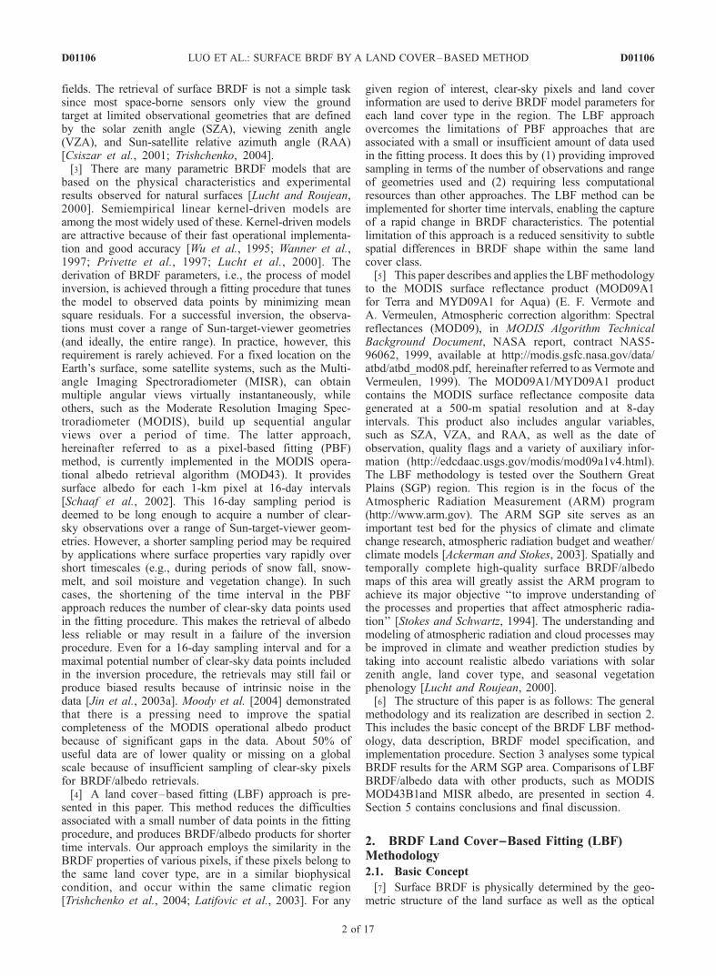
Zhanqing LiDepartment of Meteorology and Earth System Science Interdisciplinary Center, University of Maryland,College Park, Maryland, USA
Received 5 March 2004; revised 24 September 2004; accepted 11 October 2004; published 12 January 2005.
[1] Surface bidirectional reflectance distribution function (BRDF) and albedo maps arederived from Moderate Resolution Imaging Spectroradiometer (MODIS) multidaysurface reflectance composites with a 500-m spatial resolution (MODIS productMOD09A1/MYD09A1). The proposed method dubbed land cover–based fitting employsthe processing of clear-sky reflectance data for similar land cover types and takes intoaccount the magnitude of normalized difference vegetation index (NDVI). The BRDF isderived through the fitting of pixel data sorted into small bins according to the valuesof angular variables and NDVI. Robust statistical processing is applied to reduce theinfluence of noise and outliers. This method increases the success rate of the fittingprocess and enables more accurate monitoring of surface temporal changes during periodsof rapid spring vegetation green up and autumn leaf fall, as well as changes due toagricultural practices and snow cover variations. The approach is specifically applied overthe Atmospheric Radiation Measurement Program Southern Great Plains area. Resultsare compared to alternative BRDF/albedo products, such as the MOD43 albedo andMultiangle Imaging Spectroradiometer surface products that are derived through apixel-based fitting process. A good agreement was generally found between different datasets. For example, the average biases in the visible and near-infrared bands are usually lessthan 0.01 and 0.02, respectively, and correlation coefficients are typically larger than0.80. An analysis of these differences identifies some unique advantages of the proposedmethod, such as the ability to capture rapidly changing surface properties and an increasedperformance in the case of reduced number of clear-sky observations because offrequent cloudy conditions. Results suggest that the developed land cover–basedmethodology is valuable for the purpose of surface BRDF and albedo mapping usingMODIS observations.
Citation: Luo, Y., A. P. Trishchenko, R. Latifovic, and Z. Li (2005), Surface bidirectional reflectance and albedo properties derived
using a land cover–based approach with Moderate Resolution Imaging Spectroradiometer observations, J. Geophys. Res., 110,
D01106, doi:10.1029/2004JD004741.
1. Introduction
[2] Surface albedo is defined as the ratio of the total(hemispheric) reflected solar radiation flux to the incidentflux upon the surface. It is one of the most importantparameters in atmospheric radiation studies. Albedo isimportant because even small changes in its magnitudecan lead to variations in radiative forcing, to which climateis extremely sensitive [Ingram et al., 1989; Houghton et al.,
2001; Dirmeyer and Shukla, 1994]. The spatial complexityand temporal variations of surface properties mean thatpractical albedo estimates over large area are usuallyderived from satellite observations [Strugnell et al., 2001;Cihlar et al., 2002; Gutman et al., 1989]. Most land surfacesreflect incident radiation anisotropically. Anisotropic prop-erties are described by the surface bidirectional reflectancedistribution function (BRDF) [Nicodemus et al., 1977]. Anaccurate determination of surface BRDF properties isessential because they are directly related to the accuracyof derived surface albedo and radiation fluxes, which areobtained as hemispheric integrals of BRDF and radiance
JOURNAL OF GEOPHYSICAL RESEARCH, VOL. 110, D01106, doi:10.1029/2004JD004741, 2005
Copyright 2005 by the American Geophysical Union.0148-0227/05/2004JD004741$09.00
D01106 1 of 17
fields. The retrieval of surface BRDF is not a simple tasksince most space-borne sensors only view the groundtarget at limited observational geometries that are definedby the solar zenith angle (SZA), viewing zenith angle(VZA), and Sun-satellite relative azimuth angle (RAA)[Csiszar et al., 2001; Trishchenko, 2004].[3] There are many parametric BRDF models that are
based on the physical characteristics and experimentalresults observed for natural surfaces [Lucht and Roujean,2000]. Semiempirical linear kernel-driven models areamong the most widely used of these. Kernel-driven modelsare attractive because of their fast operational implementa-tion and good accuracy [Wu et al., 1995; Wanner et al.,1997; Privette et al., 1997; Lucht et al., 2000]. Thederivation of BRDF parameters, i.e., the process of modelinversion, is achieved through a fitting procedure that tunesthe model to observed data points by minimizing meansquare residuals. For a successful inversion, the observa-tions must cover a range of Sun-target-viewer geometries(and ideally, the entire range). In practice, however, thisrequirement is rarely achieved. For a fixed location on theEarth’s surface, some satellite systems, such as the Multi-angle Imaging Spectroradiometer (MISR), can obtainmultiple angular views virtually instantaneously, whileothers, such as the Moderate Resolution Imaging Spec-troradiometer (MODIS), build up sequential angularviews over a period of time. The latter approach,hereinafter referred to as a pixel-based fitting (PBF)method, is currently implemented in the MODIS opera-tional albedo retrieval algorithm (MOD43). It providessurface albedo for each 1-km pixel at 16-day intervals[Schaaf et al., 2002]. This 16-day sampling period isdeemed to be long enough to acquire a number of clear-sky observations over a range of Sun-target-viewer geom-etries. However, a shorter sampling period may be requiredby applications where surface properties vary rapidly overshort timescales (e.g., during periods of snow fall, snow-melt, and soil moisture and vegetation change). In suchcases, the shortening of the time interval in the PBFapproach reduces the number of clear-sky data points usedin the fitting procedure. This makes the retrieval of albedoless reliable or may result in a failure of the inversionprocedure. Even for a 16-day sampling interval and for amaximal potential number of clear-sky data points includedin the inversion procedure, the retrievals may still fail orproduce biased results because of intrinsic noise in thedata [Jin et al., 2003a]. Moody et al. [2004] demonstratedthat there is a pressing need to improve the spatialcompleteness of the MODIS operational albedo productbecause of significant gaps in the data. About 50% ofuseful data are of lower quality or missing on a globalscale because of insufficient sampling of clear-sky pixelsfor BRDF/albedo retrievals.[4] A land cover–based fitting (LBF) approach is pre-
sented in this paper. This method reduces the difficultiesassociated with a small number of data points in the fittingprocedure, and produces BRDF/albedo products for shortertime intervals. Our approach employs the similarity in theBRDF properties of various pixels, if these pixels belong tothe same land cover type, are in a similar biophysicalcondition, and occur within the same climatic region[Trishchenko et al., 2004; Latifovic et al., 2003]. For any
given region of interest, clear-sky pixels and land coverinformation are used to derive BRDF model parameters foreach land cover type in the region. The LBF approachovercomes the limitations of PBF approaches that areassociated with a small or insufficient amount of data usedin the fitting process. It does this by (1) providing improvedsampling in terms of the number of observations and rangeof geometries used and (2) requiring less computationalresources than other approaches. The LBF method can beimplemented for shorter time intervals, enabling the captureof a rapid change in BRDF characteristics. The potentiallimitation of this approach is a reduced sensitivity to subtlespatial differences in BRDF shape within the same landcover class.[5] This paper describes and applies the LBFmethodology
to the MODIS surface reflectance product (MOD09A1for Terra and MYD09A1 for Aqua) (E. F. Vermote andA. Vermeulen, Atmospheric correction algorithm: Spectralreflectances (MOD09), in MODIS Algorithm TechnicalBackground Document, NASA report, contract NAS5-96062, 1999, available at http://modis.gsfc.nasa.gov/data/atbd/atbd_mod08.pdf, hereinafter referred to as Vermote andVermeulen, 1999). The MOD09A1/MYD09A1 productcontains the MODIS surface reflectance composite datagenerated at a 500-m spatial resolution and at 8-dayintervals. This product also includes angular variables,such as SZA, VZA, and RAA, as well as the date ofobservation, quality flags and a variety of auxiliary infor-mation (http://edcdaac.usgs.gov/modis/mod09a1v4.html).The LBF methodology is tested over the Southern GreatPlains (SGP) region. This region is in the focus of theAtmospheric Radiation Measurement (ARM) program(http://www.arm.gov). The ARM SGP site serves as animportant test bed for the physics of climate and climatechange research, atmospheric radiation budget and weather/climate models [Ackerman and Stokes, 2003]. Spatially andtemporally complete high-quality surface BRDF/albedomaps of this area will greatly assist the ARM program toachieve its major objective ‘‘to improve understanding ofthe processes and properties that affect atmospheric radia-tion’’ [Stokes and Schwartz, 1994]. The understanding andmodeling of atmospheric radiation and cloud processes maybe improved in climate and weather prediction studies bytaking into account realistic albedo variations with solarzenith angle, land cover type, and seasonal vegetationphenology [Lucht and Roujean, 2000].[6] The structure of this paper is as follows: The general
methodology and its realization are described in section 2.This includes the basic concept of the BRDF LBF method-ology, data description, BRDF model specification, andimplementation procedure. Section 3 analyses some typicalBRDF results for the ARM SGP area. Comparisons of LBFBRDF/albedo data with other products, such as MODISMOD43B1and MISR albedo, are presented in section 4.Section 5 contains conclusions and final discussion.
2. BRDF Land Cover––Based Fitting (LBF)Methodology
2.1. Basic Concept
[7] Surface BRDF is physically determined by the geo-metric structure of the land surface as well as the optical
D01106 LUO ET AL.: SURFACE BRDF BY A LAND COVER–BASED METHOD
2 of 17
D01106
properties of canopy elements, understory, and soil con-ditions. Several parametric BRDF models have been devel-oped based on various assumptions about these properties[e.g., Roujean et al., 1992; Li and Strahler, 1992; Rahmanet al., 1993]. Surface structure influences the BRDF throughthe reflectors’ geometric features, their shadow casting andtheir spatial distribution. Optical characteristics account forthe absorbing and scattering effects that the surface ele-ments exert on the radiation field. The BRDF modelparameters are closely related to land cover type [e.g., Wuet al., 1995; Lucht et al., 2000]. As shown by Trishchenkoet al. [2004] and Latifovic et al. [2003], it is reasonable toassume that the BRDF shape is generally similar for thesame land cover type under similar biophysical conditionscharacterized by the normalized difference vegetation index(NDVI).[8] The LBF approach uses a multiday clear-sky com-
posite of surface reflectance and groups pixels by land covertype and NDVI value. Landcover and NDVI data are bothrequired for the successful implementation of the LBFapproach. Grouped data are then used to optimally fit theBRDF model parameters for each land cover type. Afterthese generic BRDFs are obtained, pixel-level BRDFs aredetermined by adjusting the general land cover BRDF to theobserved reflectances of a given pixel. A similar strategywas successfully employed for BRDF/albedo retrievalsfrom advanced very high resolution radiometer (AVHRR)and SPOT-VEGETATION data [Cihlar et al., 2002, 2004;Latifovic et al., 2003, 2004; Li et al., 1996].
2.2. Land Cover Map Over the ARM SGP Area
[9] The National Land Cover Data Set (NLCD) is usedin this study. The NLCD was compiled from LandsatThematic Mapper (TM) satellite imagery at 30-m spatialresolution and supplemented by various ancillary data. Itwas produced as part of a cooperative project between theU.S. Geological Survey (USGS) and the U.S. Environ-mental Protection Agency (USEPA) (http://landcover.usgs.gov/natllandcover.asp). The original NLCD land coverdata set was resampled to create a land cover map thatmatched the spatial resolution of the MODIS data used inthis study (500 m). Each land cover class in the resampleddata set was then converted to its International Geosphere-Biosphere Programme (IGBP) equivalent following theapproach described by Latifovic et al. [2004]. The IGBPclassification was selected because of its frequent use inclimate modeling and ecological studies. The preferencewas given to the NLCD land cover map rather than theMODIS land cover product (MOD12) (A. Strahler et al.,MODIS land cover product: Algorithm theoretical basisdocument (ATBD) version 5.0, 1999, available at http://modis.gsfc.nasa.gov/data/atbd/atbd_mod12.pdf) becausethe latter is only available at a spatial resolution of 1 km,and because the use of the former avoids potential biasesand correlation impacts between products from the samesensor.[10] The study region covers an 8� latitude � 10� longi-
tude area centered at the ARM SGP Central Facility (CF)located in northern Oklahoma, United States. Figure 1 showsthe spatial distribution of the 10 IGBP land cover classesthat occur in the region. The area is dominated by grass-lands (53%), croplands (19%) and deciduous forest (13%).
Less frequent land cover types include evergreen forest(3.9%) and open shrublands (3.5%). While cropland is themain land cover type around the CF, it is mixed withgrasslands in the western and northern parts of the studyarea. In addition, shrublands are present in the southwestpart of the study area, while the southeasternmost portion ofthe study area is dominated by forest. Usually, the dominantland cover types are geographically concentrated overrelatively uniform area.
2.3. BRDF Shape and NDVI
[11] The BRDF of the land surface is dependent on bothland cover (vegetation) type and vegetation condition [e.g.,Wu et al., 1995; Li et al., 1996]. The vegetation conditioncan be described by the magnitude of the NDVI [Gutman,1987]. Data collected from fine-resolution Landsat imageryand the MISR 1-km surface product illustrate the impact ofNDVI on BRDF. Figure 2a shows a Landsat-7 EnhancedThematic Mapper (ETM) image acquired over the ARMSGP CF area on March 9 (day 68) 2002. The imagecontains a mixture of cropland and grassland (pasture)according to field surveys for that area [Li et al., 2002].Analysis uses MISR observations over a 2 � 2 km2 areaof cropland close to the CF (marked as square in Figure 2a)to illustrate the variability in surface BRDF properties withNDVI. The MISR sensor is well suited for such ananalysis because it views the target at nine angles almostinstantaneously with a footprint size of 1.1 km [Diner etal., 1998]. The MISR spatial resolution is, however,somewhat too coarse to resolve the spatial variation ofthe BRDF inherent to various crop types. This may reduce
Figure 1. Land cover map in the International Geosphere-Biosphere Programme legend for the Atmospheric Radia-tion Measurement (ARM) Southern Great Plains (SGP) area(north Oklahoma, United States). There are total 10 landcover types identified in this area. The cross at the centerindicates the location of the ARM central facility (CF), andthe squares mark the extended facilities locations.
D01106 LUO ET AL.: SURFACE BRDF BY A LAND COVER–BASED METHOD
3 of 17
D01106

Figure 2. (a) View of the ARM SGP CF area from the Landsat-7 Enhanced Thematic Mapper (ETM)on day 68 (9 March) 2002. The cropland sampling square corresponds roughly to a 2.2 � 2.2 km area(2 � 2 Multiangle Imaging Spectroradiometer (MISR) pixels). (b) Relationship between relative azimuthangle (RAA) and viewing zenith angle (VZA) and normalized difference vegetation index (NDVI) fromMISR observations on day 68 of 2002 for the cropland sampling square. (c) Relationship betweensurface reflectances and VZA in the red band on day 68 of 2002. (d) Relationship between surfacereflectances and VZA in the NIR band on day 68 of 2002. (e) Relationship between RAA and VZA andNDVI from MISR observations on day 91 of 2002 for the cropland sampling square. (f ) Relationshipbetween surface reflectances and VZA in the red band on day 91 of 2002. (g) Relationship betweensurface reflectances and VZA in the NIR band on day 91 of 2002. Diamonds, crosses, triangles, andsquares denote the data for the 2 � 2 pixels in the MISR scan shown in Figure 2a.
D01106 LUO ET AL.: SURFACE BRDF BY A LAND COVER–BASED METHOD
4 of 17
D01106

the actual contrast between various BRDFs. The selectedsampling area corresponds to a group of 2 � 2 pixels inthe MISR data. The observations for each pixel are alsoshown in Figure 2 as a function of the RAA versus VZA(Figure 2b), surface reflectance versus VZA for the redband (661–683 nm) (Figure 2c) and surface reflectanceversus VZA for the near-infrared (NIR) band (846–886 nm) (Figure 2d). The averaged NDVI values (within±50� VZA) are also given in Figure 2b. Figures 2b–2dshow the MISR reflectances for the same day as that ofthe Landsat image. Figures 2e–2g show the MISR reflec-tances 3 weeks later (1 April (day 91) 2002). The SZAsfor day 68 and 91 are approximately 44� and 34�,respectively. Figure 2 shows that the magnitude of NDVIdefines the BRDF shape in a unique way. For day 68,pixels 1 and 3 have similar NDVI and reflectances values.Pixels 2 and 4, however, have an NDVI difference ofnearly 0.2, which corresponds to the large difference invegetation density seen in Figure 2a. The reflectances andBRDF profiles of these pixels are thus substantialitydifferent, especially in the red band. Specifically, the redband reflectance for pixel 4 is strongest for the back-scattered viewing geometry when the VZA is close to theSZA. It should also be noted that the temporal trend inthe surface properties, even after only 3 weeks, isconsiderable. This reflects a rapid change in vegetationproperties during the peak of the growing season asconfirmed by the magnitudes of NDVI between these dates.This emphasizes the advantage of having shorter samplingintervals than the 16-day period currently adopted in theoperational MODIS BRDF/albedo processing. A shortersampling interval is especially important during periodswhen surface properties change rapidly or when detailedknowledge of phenological change is required.
2.4. RossThick––LiSparse Reciprocal BRDF Model
[12] The RossThick–LiSparse model (hereinafter referredto as Ross-Li) is employed in this study. The Ross-Limodel has been identified as one of the most appropriatemodels for the operational processing of MODIS data[Wanner et al., 1997; Privette et al., 1997; Li et al.,1997; Lucht and Lewis, 2000]. It has also been demon-strated that the Ross-Li and the nonlinear Rahman’smodels [Rahman et al., 1993; Martonchik, 1997] performsimilarly. However, the linear Ross-Li model is morecomputationally efficient.[13] The linear BRDF model is expressed as a sum of
several theoretically constructed kernel functions fi (qs, qv,f), where qs, qv and f are the SZA, VZA and RAA,respectively. The reciprocal model of Ross-Li [Wanner etal., 1995] is a model that uses three kernels
rl qs; qv;fð Þ ¼ a0 þ a1f1 qs; qv;fð Þ þ a2f2 qs; qv;fð Þ; ð1Þ
where f1 is the RossThick kernel and represents volumetricscattering from a dense leaf canopy based on a single-scattering approximation of radiative transfer theory [Ross,1981; Roujean et al., 1992] and f2 is the LiSparse kernelwhich is derived from the geometric-optical mutualshadowing model and assumes a sparse ensemble of surfaceobjects [Li and Strahler, 1992]. Parameters a0, a1 and a2 arecoefficients of the kernels and are related to the isotropic,
volumetric and geometric components, respectively.Kernels are given by the following expressions:
f1 ¼ p=2� xð Þ cos xþ sin x½ �= cos qs þ cos qv½ � � p=4; ð2Þ
where cos x = cos qs cos qv + sin qs sin qv cos f
f2 ¼ O qs; qv;fð Þ � sec q0s � sec q0v þ1
21þ cos x0ð Þ sec q0s sec q
0v:
ð3Þ
O ¼ 1
pt � sin t cos tð Þ sec q0s þ sec q0v
� �
cos t ¼ h
b
ffiffiffiffiffiffiffiffiffiffiffiffiffiffiffiffiffiffiffiffiffiffiffiffiffiffiffiffiffiffiffiffiffiffiffiffiffiffiffiffiffiffiffiffiffiffiffiffiffiD2 þ tan q0s tan q
0v sinf
� �2qsec q0s þ sec q0v
D ¼ffiffiffiffiffiffiffiffiffiffiffiffiffiffiffiffiffiffiffiffiffiffiffiffiffiffiffiffiffiffiffiffiffiffiffiffiffiffiffiffiffiffiffiffiffiffiffiffiffiffiffiffiffiffiffiffiffiffiffiffiffiffiffiffiffiffiffiffiffiffiffiffitan2 q0s þ tan2 q0v � 2 tan q0s tan q
0v cosf
q
cos x0 ¼ cos q0s cos q0v þ sin q0s sin q
0v cosf
q0v ¼ tan�1 b
rtan qv
� �; q0s ¼ tan�1 b
rtan qs
� �;
the two ratios, h/b and b/r, describe the relative height andshape of crown. In this paper, we used values of h/b = 2 andb/r = 1, as recommended by Lucht et al. [2000].
2.5. Procedure Implementation
[14] The implementation of proposed LBF method forderivation of surface BRDF parameters involves severalsteps:[15] 1. Input data are taken from the MOD09A1 product
(version 4) for MODIS on Terra satellite and MYD09A1 forMODIS on Aqua satellite. These are MODIS atmospheri-cally corrected surface clear-sky reflectances compositedover 8-day intervals with a spatial resolution of 500 m(see http://edcdaac.usgs.gov/modis/mod09a1v4.html). TheMOD09A1/MYD09A1 archive contains seven spectralbands from 0.46 to 2.15 mm. Bands are located in theshortwave domain and designed for land monitoringapplications. Data are calibrated to an absolute scaleusing the MODIS on-board calibration technique andare accurately geolocated. The data set also includessnow and ephemeral water flags. Cloud screening andatmospheric corrections are carried out using the synchro-nous onboard observations available from the ensemble ofMODIS channels and MODIS data processing technology(Vermote and Vermeulen, 1999).[16] 2. The MOD09A1/MYD09A1 data are remapped
using MODIS reprojection tool (see http://edcdaac.usgs.gov/landdaac/tools/modis/index.asp) from the native Sinu-soidal (SIN) grid onto a latitude-longitude projection overthe ARM-SGP 8� � 10� area. A pixel size of 500 m wasmaintained during the reprojection procedure. To maintaincompatibility with other widely used data sets, the dataare then rearranged from an 8-day composite interval to a10-day composite interval. This procedure is possiblebecause the MOD09A1/MYD09A1 data contain informa-tion on the data acquisition date of each pixel.[17] 3. All pixels in the study area are grouped according
to land cover type. To reduce noise, pixels marked as bad
D01106 LUO ET AL.: SURFACE BRDF BY A LAND COVER–BASED METHOD
5 of 17
D01106

quality or contaminated by clouds are excluded from theanalysis. Pixels that contain some portion of snow cover areselected for separate processing. Snow pixels can be iden-tified by their high reflectance in the visible band andrelatively low reflectance in the shortwave infrared band.The normalized difference snow index (NDSI) or opera-tional snow cover products can be used to identify andremove snow effects in surface reflectance [Hall et al.,2002].[18] 4. The land cover–grouped data are further grouped
into smaller bins according to their NDVI levels and valuesof angular variables. Data binning according to angularvalues is required to lessen the impact of the irregulardistribution of the observational geometry. The histogramsof VZA presented in Figure 3 show the distribution ofsampling geometries for several land cover types andseasons. The distribution of angles depends on severalfactors, such as the orbit configuration, the sensor scanningmode, the distribution of the clear-sky area, and the spatialpatterns of land cover. The distribution of VZA and RAA isgenerally nonuniform. If the data are directly used in thefitting process, unequal weights at different angles may biasthe fitting results toward data with the most frequentlyobserved geometries. This causes the equally important butless frequent data points to have little influence on theretrieved BRDF model. To address this problem, all datapoints for each land cover class are sorted into data bins
defined by certain NDVI and angular intervals, and only onevalue from each data bin contributes to the fitting process. Inthis paper intervals for the NDVI, and the SZA, VZA andRAA, are 0.1, and 5�, 5� and 10�, respectively.[19] 5. Before the fitting procedure is initiated, the data
collected in each data bin are statistically preprocessed. Arobust statistical procedure resistant to outliers similar tothat proposed by Trishchenko [2002] is employed. Theprocedure sorts all data according to their values, removesthe lowest and highest 5% points of the sample and thencomputes the average. Only one value is derived for eachbin after applying the statistical procedure. This valuerepresents the observed reflectance and geometry for thatdata bin. Examples of bin-processed data for grasslands aregiven in Figure 4 (SZA is not grouped here). Figure 4 alsoshows the polar plots of MODIS surface reflectance in twospectral bands (red and NIR) for 4 months over the ARMSGP study area. The average SZA value and its range aregiven at the top of each panel. The radius of the polar plotrepresents the VZA, and the polar angle corresponds to theRAA. The polar plots clearly show how the azimuth anglevaries with season. This angle is close to the perpendicularplane (90�/270�) in winter and autumn (Figures 4a and 4d),and closer to the principal plane (0�/180�) in summer(Figure 4c). The BRDF shape generally shows largerreflectances in the backscattering direction, when theRAA is close to the principal plane. This is consistent with
Figure 3. Histograms of the VZA from Moderate Resolution Imaging Spectroradiometer (MODIS)observations for (top to bottom) grasslands, croplands, and mixed forest in (left to right) January, April,July, and October of 2001 in the ARM SGP area.
D01106 LUO ET AL.: SURFACE BRDF BY A LAND COVER–BASED METHOD
6 of 17
D01106

the commonly observed hot spot effect [Kuusk, 1991]. It isimportant to note the narrow range of RAA, which is amajor source of uncertainty in determining the BRDFfunction for the entire range of three variables (SZA,VZA, and RAA).[20] 6. The land cover–grouped and preprocessed data
are used to determine a set of optimal parameters for theRoss-Li BRDF model (equation (1)). In this paper, thenonlinear least squares method of Levenberg-Marquardt[Press et al., 1992] is employed for the fitting process.[21] 7. Pixel-level BRDF parameters are retrieved by
scaling the land cover- and NDVI-dependent BRDF param-eters obtained in step 6 to the observations at each pixelaccording to equation (4):
rl qs; qv;fð Þ ¼ 1þ a1
a0f1 qs; qv;fð Þ þ a2
a0f2 qs; qv;fð Þ
� �
robsl qs; qv;f
� �1þ a1
a0f1 qs; qv;f� �
þ a2
a0f2 qs; qv;f� �� � ; ð4Þ
where qs, qv, f are angles corresponding to the geometry ofobserved clear-sky pixel.
[22] When the observed data for some pixels are cloud-contaminated or are of bad quality, an interpolation isperformed based on the model results (derived from clear-sky data elsewhere in the region) and multiyear statistics fora particular pixel and time interval. The pixel-level BRDFparameters are temporally interpolated and smoothed iffurther data gaps or outliers are identified. This processuses a complete phenological cycle (12 months) of timeseries data for each pixel, and employs a Fourier transformfilter technique.[23] 8. The hemispheric reflectance, i.e., albedo, is com-
puted using the BRDF parameters. Two types of albedo aredistinguished: direct and diffuse [Iqball, 1983]. Directalbedo is defined as the albedo of the surface illuminatedby a direct beam of radiation. Diffuse albedo is defined asthe albedo of the surface under a fully isotropic downwardradiance field. With a linear model like the Ross-Li, bothtypes of albedo can be computed using a lookup table ofprecomputed kernel integrals or by using analyticalapproximations that express albedo as a function ofBRDF parameters and SZA [Lucht et al., 2000; Schaafet al., 2002]. The albedo of the surface under naturalillumination, i.e., the superposition of direct and diffuseradiance fields, can be estimated as a linear combination
Figure 4. Polar plots of the surface reflectance from MODIS observations for two spectral bands ((top)red and (bottom) near-infrared (NIR)) for grasslands in the ARM SGP area: (a) January 2001, (b) April2001, (c) July 2001, (d) October 2001. The SZA range, its average for each month, and NDVI intervalsare indicated at the top of each panel. The radius of the polar plot represents the VZA, while the polarangle represents the RAA.
D01106 LUO ET AL.: SURFACE BRDF BY A LAND COVER–BASED METHOD
7 of 17
D01106

of direct and diffuse albedo components, with the weightsdepending on the atmospheric conditions.
3. BRDF and Albedo Results
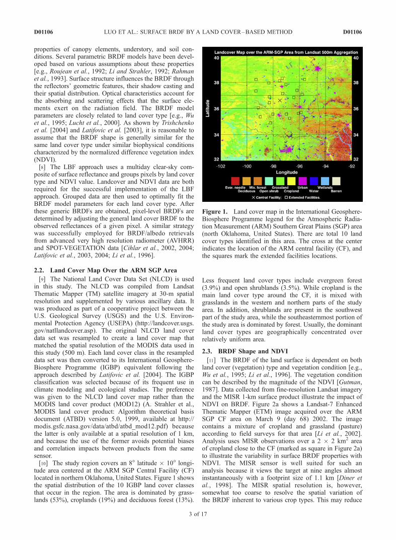
[24] The results of fitting MODIS reflectances by theRoss-Li model using the LBF methodology are shown inFigure 5. The reflectances in the red and NIR bands areplotted against the VZA for grasslands (Figure 5a), crop-lands (Figure 5b), and deciduous forest (Figure 5c) atvarious NDVI levels for April 2001. As expected, theseplots show that observations are sampled almost continu-ously against the VZA axis and with approximately equalweights. The observations cover a wide range of viewinggeometries and clearly produce an anisotropic BRDF shape.The observations and model fitting results are distributed astight clusters. This indicates that successful fittings havebeen mostly achieved. The BRDF dependence upon NDVIis smooth within each land cover type. The magnitude of aBRDF varies much more than its shape, which provides anadditional support to the LBF methodology. On the otherhand, the differences in the BRDF shape among the landcover types are obvious. For example, grasslands (Figure 5a)always show relatively smaller forward scattering (i.e.,
when VZA > 0) and much smoother backward scatteringreflectances (i.e., when VZA < 0) compared to cropland(Figure 5b). This is probably due to the smaller size ofgrass leaves and larger and more uniform volume densityof grasslands [Wu et al., 1995]. In the case of forests(Figure 5c), a distinct reflectance peak in the backscatteringdirection is observed. This is caused by their large protrudingcanopy shape. The same argument may be made fromFigure 6, which conveys similar information to that shownin Figure 5 but for July 2001. Here the fitting results forgrasslands (Figure 6a) and croplands (Figure 6b) are close,indicating similarity of their properties in summertime.The BRDF shapes for croplands (Figure 6b) and forest(Figure 6c) in July are considerably different from those inApril (Figures 5b and 5c). This partially reflects the factthat the canopy for the croplands and forest changesdifferently between the summer and spring.[25] The retrieved parameters of the Ross-Li BRDF
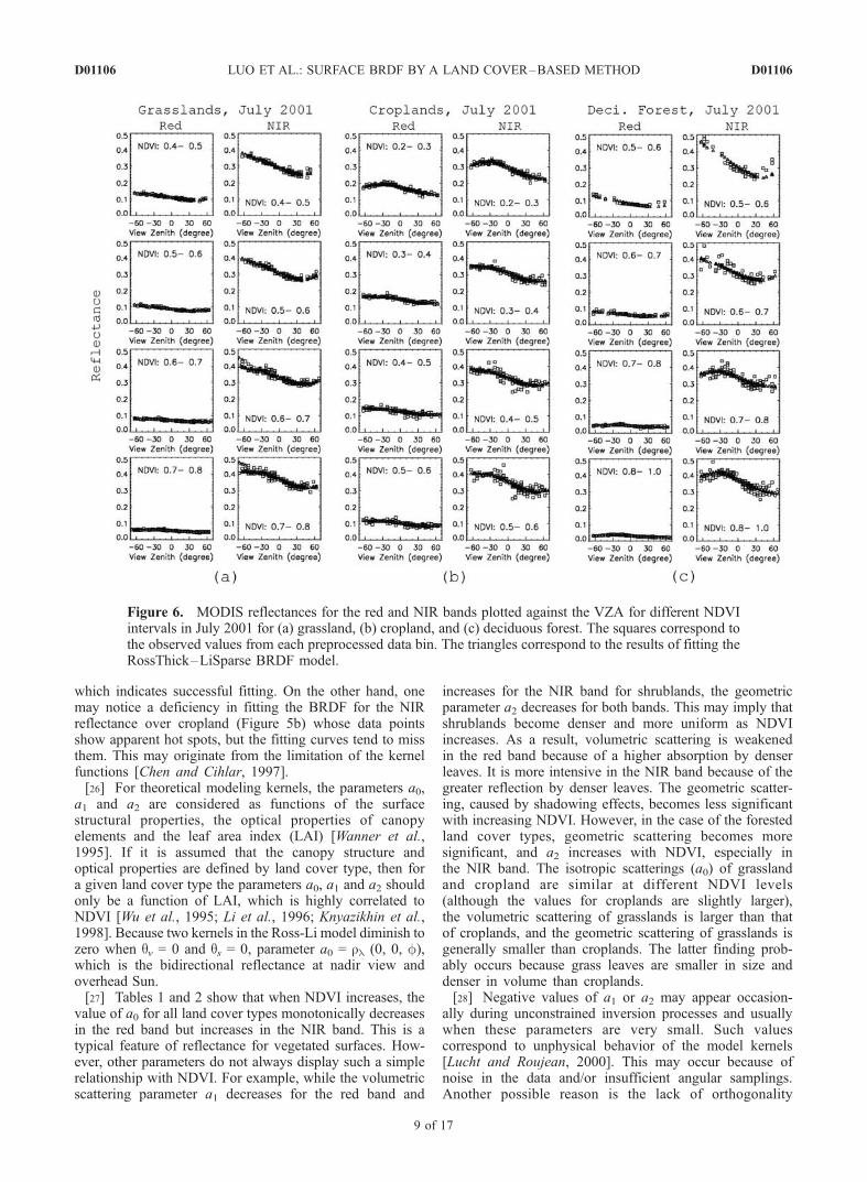
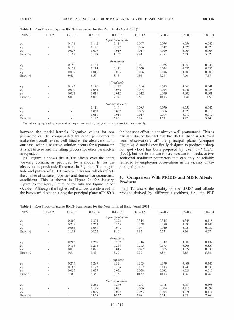
model for four major land cover types in April 2001 atdifferent NDVI levels are presented in Tables 1 and 2 forthe red and NIR bands, respectively. The relative errors(standard deviations normalized by the mean), whichindicate the agreement between the model fit and obser-vations, are also listed. Most errors are less than 10%,
Figure 5. MODIS reflectances at the red and NIR bands plotted against the VZA for different NDVIintervals in April 2001 for (a) grassland, (b) cropland, and (c) deciduous forest. The squares correspond tothe observed values from each preprocessed data bin (obtained in step 5, see text for details). Thetriangles correspond to the results of fitting the RossThick–LiSparse bidirectional reflectance distributionfunction (BRDF) model as described in the text.
D01106 LUO ET AL.: SURFACE BRDF BY A LAND COVER–BASED METHOD
8 of 17
D01106
which indicates successful fitting. On the other hand, onemay notice a deficiency in fitting the BRDF for the NIRreflectance over cropland (Figure 5b) whose data pointsshow apparent hot spots, but the fitting curves tend to missthem. This may originate from the limitation of the kernelfunctions [Chen and Cihlar, 1997].[26] For theoretical modeling kernels, the parameters a0,
a1 and a2 are considered as functions of the surfacestructural properties, the optical properties of canopyelements and the leaf area index (LAI) [Wanner et al.,1995]. If it is assumed that the canopy structure andoptical properties are defined by land cover type, then fora given land cover type the parameters a0, a1 and a2 shouldonly be a function of LAI, which is highly correlated toNDVI [Wu et al., 1995; Li et al., 1996; Knyazikhin et al.,1998]. Because two kernels in the Ross-Li model diminish tozero when qv = 0 and qs = 0, parameter a0 = rl (0, 0, f),which is the bidirectional reflectance at nadir view andoverhead Sun.[27] Tables 1 and 2 show that when NDVI increases, the
value of a0 for all land cover types monotonically decreasesin the red band but increases in the NIR band. This is atypical feature of reflectance for vegetated surfaces. How-ever, other parameters do not always display such a simplerelationship with NDVI. For example, while the volumetricscattering parameter a1 decreases for the red band and
increases for the NIR band for shrublands, the geometricparameter a2 decreases for both bands. This may imply thatshrublands become denser and more uniform as NDVIincreases. As a result, volumetric scattering is weakenedin the red band because of a higher absorption by denserleaves. It is more intensive in the NIR band because of thegreater reflection by denser leaves. The geometric scatter-ing, caused by shadowing effects, becomes less significantwith increasing NDVI. However, in the case of the forestedland cover types, geometric scattering becomes moresignificant, and a2 increases with NDVI, especially inthe NIR band. The isotropic scatterings (a0) of grasslandand cropland are similar at different NDVI levels(although the values for croplands are slightly larger),the volumetric scattering of grasslands is larger than thatof croplands, and the geometric scattering of grasslands isgenerally smaller than croplands. The latter finding prob-ably occurs because grass leaves are smaller in size anddenser in volume than croplands.[28] Negative values of a1 or a2 may appear occasion-
ally during unconstrained inversion processes and usuallywhen these parameters are very small. Such valuescorrespond to unphysical behavior of the model kernels[Lucht and Roujean, 2000]. This may occur because ofnoise in the data and/or insufficient angular samplings.Another possible reason is the lack of orthogonality
Figure 6. MODIS reflectances for the red and NIR bands plotted against the VZA for different NDVIintervals in July 2001 for (a) grassland, (b) cropland, and (c) deciduous forest. The squares correspond tothe observed values from each preprocessed data bin. The triangles correspond to the results of fitting theRossThick–LiSparse BRDF model.
D01106 LUO ET AL.: SURFACE BRDF BY A LAND COVER–BASED METHOD
9 of 17
D01106
between the model kernels. Negative values for oneparameter can be compensated by other parameters tomake the overall results well fitted to the observations. Inour case, when a negative solution occurs for a parameter,it is set to zero and the fitting process for other parametersis repeated.[29] Figure 7 shows the BRDF effects over the entire
viewing domain, as provided by a model fit for theobservations previously illustrated in Figure 4. The magni-tude and pattern of BRDF vary with season, which reflectsthe change of surface properties and Sun-sensor geometricalconditions. This is shown in Figure 7a for January,Figure 7b for April, Figure 7c for July and Figure 7d forOctober. Although the highest reflectances are observed inthe backward direction along the principal plane (0�/180�),
the hot spot effect is not always well pronounced. This ispartially due to the fact that the BRDF shape is retrievedfrom observations off the principal plane (compareFigure 4). A model specifically designed to produce a sharphot spot effect has been proposed by Chen and Cihlar[1997], but we do not use it here because it introduces twoadditional nonlinear parameters that can only be reliablyretrieved by employing observations in the vicinity of theprincipal plane.
4. Comparison With MODIS and MISR AlbedoProducts
[30] To assess the quality of the BRDF and albedoproduct derived by different algorithms, i.e., the PBF
Table 1. RossThick–LiSparse BRDF Parameters for the Red Band (April 2001)a
NDVI 0.1–0.2 0.2–0.3 0.3–0.4 0.4–0.5 0.5–0.6 0.6–0.7 0.7–0.8 0.8–1.0
Open Shrublandsa0 - 0.171 0.142 0.118 0.097 0.076 0.056 0.042a1 - 0.128 0.120 0.122 0.086 0.042 0.025 0.020a2 - 0.028 0.026 0.019 0.017 0.009 0.004 0.003Error, % - 11.65 11.38 11.52 8.41 7.25 7.03 5.62
Grasslandsa0 - 0.150 0.131 0.107 0.091 0.075 0.057 0.043a1 - 0.121 0.114 0.112 0.079 0.024 0.027 0.032a2 - 0.017 0.015 0.005 0.006 0.006 0.003 0.003Error, % - 9.43 9.59 8.13 6.93 9.20 7.60 7.17
Croplandsa0 - 0.162 0.140 0.122 0.104 0.083 0.061 0.041a1 - 0.070 0.054 0.056 0.044 0.034 0.040 0.023a2 - 0.021 0.015 0.012 0.012 0.009 0.003 0.001Error, % - 8.07 8.09 7.74 9.86 10.03 11.40 11.58
Deciduous Foresta0 - - 0.111 0.101 0.085 0.070 0.055 0.042a1 - - 0.063 0.032 0.035 0.016 0.021 0.018a2 - - 0.011 0.018 0.017 0.014 0.013 0.012Error, % - - 11.92 5.80 6.84 7.55 8.92 3.94
aVariables a0, a1, and a2 represent isotropic, volumetric, and geometric parameters, respectively.
Table 2. RossThick–LiSparse BRDF Parameters for the Near-Infrared Band (April 2001)
NDVI 0.1–0.2 0.2–0.3 0.3–0.4 0.4–0.5 0.5–0.6 0.6–0.7 0.7–0.8 0.8–1.0
Open Shrublandsa0 - 0.300 0.304 0.294 0.314 0.345 0.349 0.418a1 - 0.219 0.263 0.365 0.368 0.259 0.381 0.247a2 - 0.051 0.057 0.036 0.041 0.040 0.027 0.032Error, % - 11.03 10.52 11.01 9.87 5.25 9.16 4.67
Grasslandsa0 - 0.262 0.267 0.282 0.316 0.342 0.383 0.437a1 - 0.184 0.264 0.294 0.265 0.173 0.209 0.350a2 - 0.035 0.025 0.015 0.022 0.015 0.024 0.030Error, % - 9.51 9.83 8.30 7.37 6.89 6.55 5.88
Croplandsa0 - 0.275 0.297 0.321 0.353 0.379 0.409 0.445a1 - 0.165 0.123 0.166 0.167 0.183 0.241 0.238a2 - 0.035 0.037 0.032 0.038 0.032 0.020 0.010Error, % - 7.36 9.35 8.75 10.52 10.03 8.96 8.96
Deciduous Foresta0 - - 0.252 0.260 0.283 0.315 0.357 0.395a1 - - 0.127 0.081 0.066 0.074 0.115 0.099a2 - - 0.049 0.042 0.053 0.054 0.076 0.114Error, % - - 15.28 10.77 7.98 6.55 9.68 7.86
D01106 LUO ET AL.: SURFACE BRDF BY A LAND COVER–BASED METHOD
10 of 17
D01106

and LBF methods and approaches based on differentBRDF models, we compare the LBF results describedearlier to the standard MODIS albedo products (MOD43[Schaaf et al., 2002]) and the MISR surface products (D. J.Diner et al., MISR level 2 surface retrieval, Report JPL D-11401, Jet Propulsion Laboratory (JPL), 1999, available athttp://eospso.gsfc.nasa.gov/eos_homepage/for_scientists/atbd/docs/MISR/atbd-misr-10.pdf, hereinafter referred toas Diner et al., 1999). The MODIS albedo products haverecently been validated against ground measurementsthrough the upscaling of fine-resolution satellite imagerysuch as Landsat ETM+ [Liang et al., 2002] and observa-tions from other satellite systems [Jin et al., 2002, 2003b].
4.1. Comparison of BRDF Kernel Parameters
[31] Figures 8a and 8c show the distribution of the threekernel parameters a0, a1 and a2 in the red and NIR bandsfrom the PBF-derived MODIS 16-day albedo product(MOD43B1). Figures 8b and 8d show the same parametersbut from the LBF method. All histograms in Figure 8 arenormalized with peak values equal to 1. Most distributionshave a single peak value. However, a number of thedistributions are bimodal. This indicates that the data pointsfor most individual land cover types are closely related,while some others, such as the grasslands, may reveal theintraclass heterogeneity. That is, they can be separated into
subclasses, for example, pasture-like grasslands and grass-lands containing some portion of forest or crops fields. Thelarge fraction of zero values for the volumetric (a1) andgeometric (a2) parameters from the PBF retrieval indicatesfrequent failures of the inversion procedure [Schaaf et al.,2002; Jin et al., 2003a]. The LBF approach has a muchhigher rate of successful fitting. In general, the LBF andPBF fitting procedures show good agreement for grassland.The LBF volumetric parameter distribution is much sharperthan the distribution from the MOD43 product. This isbecause the LBF method uses a larger number of datapoints for each fitting process, a shorter sampling intervalof 10 days, and a higher spatial pixel resolution of 500 m.The MOD43 product has a sampling interval of 16 daysand a spatial resolution of 1 km. The LBF approach is thusable to reduce intrinsic noise in its data and capture finer-resolution spatial heterogeneity.[32] A noticeable difference between the PBF and LBF
approaches occurs between the forest volumetric and geo-metric parameters. The PBF fails to fit the red band volu-metric parameter for a significant portion of forest pixels,while the LBF successfully retrieves this parameter. Owingto its frequent inability to fit the red band volumetricparameter, the PBF approach’s geometric parameter is alsoquestionable. In the NIR band, the PBF obtains significantlylarger and broader volumetric scattering and smaller geo-
Figure 7. Polar plots of grassland surface reflectance for two spectral bands ((top) red and (bottom)NIR) from the RossThick–LiSparse BRDF model results based on the MODIS observations shown inFigure 4 for year 2001: (a) January, (b) April, (c) July, and (d) October. The SZA and the NDVI intervalsare indicated at the top of each panel.
D01106 LUO ET AL.: SURFACE BRDF BY A LAND COVER–BASED METHOD
11 of 17
D01106

Figure 8
D01106 LUO ET AL.: SURFACE BRDF BY A LAND COVER–BASED METHOD
12 of 17
D01106
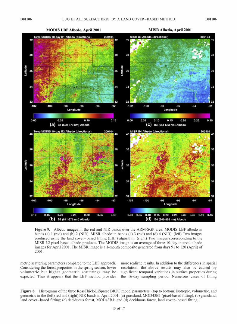
metric scattering parameters compared to the LBF approach.Considering the forest properties in the spring season, lowervolumetric but higher geometric scatterings may beexpected. Thus it appears that the LBF method provides
more realistic results. In addition to the differences in spatialresolution, the above results may also be caused bysignificant temporal variations in surface properties duringthe 16-day sampling period. Numerous cases of fitting
Figure 8. Histograms of the three RossThick-LiSparse BRDF model parameters: (top to bottom) isotropic, volumetric, andgeometric in the (left) red and (right) NIR bands in April 2001: (a) grassland, MOD43B1 (pixel-based fitting); (b) grassland,land cover–based fitting; (c) deciduous forest, MOD43B1; and (d) deciduous forest, land cover–based fitting.
Figure 9. Albedo images in the red and NIR bands over the ARM-SGP area. MODIS LBF albedo inbands (a) 1 (red) and (b) 2 (NIR). MISR albedo in bands (c) 3 (red) and (d) 4 (NIR). (left) Two imagesproduced using the land cover–based fitting (LBF) algorithm. (right) Two images corresponding to theMISR L2 pixel-based albedo products. The MODIS image is an average of three 10-day interval albedoimages for April 2001. The MISR image is a 1-month composite generated from days 91 to 120 (April) of2001.
D01106 LUO ET AL.: SURFACE BRDF BY A LAND COVER–BASED METHOD
13 of 17
D01106

failure for the geometric parameter may lead to biases forother BRDF parameters.
4.2. Comparison of Albedo Maps
[33] Another way of assessing the agreement between thedifferent methodologies is a direct comparison of the albedovalues produced by different approaches. Figure 9 displaysclear-sky albedo computed at local solar noon for the red andNIR bands over the ARM-SGP area. These images corre-spond to MODIS LBF albedo in bands 1 (red, Figure 9a) and2 (NIR, Figure 9b), and to MISR albedo in bands 3 (red,Figure 9c) and 4 (NIR, Figure 9d). The LBF-derived albedomaps correspond to an average of three MODIS 10-dayclear-sky albedo composites (1–10, 11–20, and 21–30 April) from 2001. The MISR-derived albedo mapscorrespond to a 1-month composite created by mosaickingindividual MISR orbits from day 91 to 120 during 2001.These data are extracted from the MISR Level 2 LandSurface Data product, and albedo is derived using themodified Rahman’s BRDF model employed in MISR dataprocessing (Diner et al., 1999). Albedo over the white areasin Figures 9c and 9d could not be determined because ofpersistent cloudiness observed in MISR data within entiretime interval.[34] Figure 9 shows that the MODIS LBF and MISR
produce surface albedo maps with similar spatial patternsand magnitude even though results are based on differentmethodologies and different sensors. However, the LBFalbedo maps are much less influenced by cloud contam-ination and retrieval failures. This is most apparent ifcomparing the northwest corners of the MISR albedoimages (Figures 9c and 9d). In addition, the MISR productgenerally produces larger albedo values than the LBFapproach for the NIR band in the southern part of thestudy area. This phenomenon likely relates to the tem-poral mismatch between the MODIS LBF and MISR datapoints (an average of three 10-day composites versus a
1-month composite, respectively). Detailed analysis showsthat the MISR albedo data in the southern part of the imageare filled mostly from observations made on April 25 (aMISR compositing uses one point during a month). As aresult, the noted discrepancy between data sets is caused bythe rapid changes of surface vegetation properties in thespring season. This is also illustrated in Figures 10a–10c,which show three MODIS LBF 10-day NIR images for thesoutheastern portion of the study area (32�–38�N, 92�–98�W). These images clearly show significant changes insurface albedo in springtime. Figure 10 also reemphasizesthe advantage of the LBF approach for mapping rapidchanges in surface properties over short time intervals.[35] Pixel-by-pixel comparisons between MISR and
MODIS LBF albedo in the red and NIR bands are presentedin Figure 11 for April 2001. Results are grouped into thefive major land cover types identified in the ARM SGParea. In most cases the data points are distributed around the1:1 line. Correlation coefficients (R) between the two datasets vary from 0.55 to 0.92 (mostly greater than 0.8). Thedifferences in spatial resolution between MISR and MODISimages and resampling during reprojection step may con-tribute to scattering of the points and toward reducing thecorrelation coefficient. The mean bias (�D) is also shown inFigure 11. It is an average of differences between the MISRand MODIS albedos. Positive �D means MISR albedo isgreater than MODIS on average. Both R and �D are indica-tors of any systematic discrepancies that may exist betweenthe two data sets. Mean biases are small. The absolutevalues of mean biases on Figure 11 are less than 0.01 for thered band and less than 0.037 for the NIR band. Anotherimportant parameter also shown in Figure 11 is the standarddeviation (d) of the bias. The values of d are of magnitudearound 0.01 for the red band and 0.02 for the NIR band. Ingeneral, MISR albedo is slightly larger than MODIS albedo.Such bias may be caused by many factors, such as differ-ences in calibration, atmospheric corrections, and spectral
Figure 10. Albedo images in the NIR band for the southeast corner of Figure 9, derived by the MODISLBF algorithm for 10-day intervals: (a) 1–10 April 2001, (b) 11–20 April 2001, and (c) 21–30 April2001.
D01106 LUO ET AL.: SURFACE BRDF BY A LAND COVER–BASED METHOD
14 of 17
D01106

Figure 11. Scatterplots of MISR albedo plotted against MODIS albedo derived by the land cover-basedfitting algorithm for two spectral bands ((top) red and (bottom) NIR) for April 2001: (a) evergreenneedleleaf forest, (b) deciduous broadleaf forest, (c) open shrublands, (d) grasslands, and (e) croplands.
Figure 12. Scatterplots of MISR albedo plotted against MODIS albedo derived by the land cover–based fitting algorithm for two spectral bands ((top) red and (bottom) NIR) for July 2001: (a) evergreenneedleleaf forest, (b) deciduous broadleaf forest, (c) open shrublands, (d) grasslands, and (e) croplands.
D01106 LUO ET AL.: SURFACE BRDF BY A LAND COVER–BASED METHOD
15 of 17
D01106

response functions of the MODIS and MISR instruments[Trishchenko et al., 2002]. This bias is also consistent withthe findings of Kahn et al. [2004].[36] Among all land cover types, grasslands (Figure 11d)
show the best correlation between sensors, while the ever-green needleleaf forest (Figure 11a) shows less correlation.These differences can be explained, at least partially, by thedifference in BRDF models used. The RossThick–LiSparsemodel used for MODIS data processing is more suitable to asurface covered by shorter vegetation, while the Rahman’smodel used in the MISR products is more accurate for tallervegetation such as forest canopies [Privette et al., 1997].[37] Pixel-by-pixel scatterplots for July 2001 are shown in
Figure 12. Again, good agreement is found between MODISLBF and MISR data sets. The best correlations are foundbetween grasslands and croplands (Figures 12d and 12e),while the weakest correlations are found for evergreenneedleleaf forest (Figure 12a). It is worth noting that aconsiderable number of missing and cloud contaminatedpixels are present in the MISR composite albedo map forJuly (not shown). Cloud contamination may also partiallycontribute to the observed scattering of data points. Whenalbedo comparisons include results derived for othermonths, a good agreement is generally found. The averagebiases in Figure 12 for the red and near-infrared bands areusually less than 0.01 and 0.015, the standard deviation ofbiases usually being less than 0.02 and the correlationcoefficients typically being larger than 0.80.
5. Concluding Remarks
[38] The objectives of this work were to (1) develop amethodology suitable for retrieving surface BRDF/albedoproperties from MODIS data available at 500-m spatialresolution and at 10-day time intervals; (2) overcome thedifficulties in the pixel-based fitting method that arecaused by using a small or insufficient number of clear-sky data points in the derivation of BRDF parameters;and (3) generate a spatially and temporally completeBRDF/albedo product over the ARM SGP area. Toachieve these objectives, a land cover–based fitting(LBF) method was proposed, and applied to MODIS500-m clear-sky directional reflectance data. Clear-skyalbedo composites for 10-day intervals were derived fromthe MOD09A1/MYD09A1 surface reflectance product.The RossThick–LiSparse model was used to describe theshape of BRDF. A robust statistical preprocessing wasimplemented to provide input for the model inversion. Allobservations were divided into data bins according to solarzenith angle (SZA), view zenith angle (VZA) and Sun-satellite relative azimuth angle (RAA) for a given land covertype and NDVI range. A single statistical value for each databin was produced using robust estimation. The BRDF modelparameters were derived through the fitting procedure.[39] The proposed LBF approach has several advantages.
First, it increases the size of samples used in the BRDFfitting procedure, thus making the retrieval of BRDF shapesmore reliable. Second, it allows the implementation of apreprocessing procedure that performs data binning, whichserves to reduce noise and prevent bias caused by an unevendistribution of observational geometries. Third, it is often theonly available method for producing surface BRDF/albedo
products from historical data sets, which are commonlyonly available as a multiday clear-sky composite. Fourth,LBF-derived BRDF and albedo products may be suitablefor direct applications in the studies of the regionalphenological cycle and land surface modeling. Land cover–based schemes are often used to parameterize surface albedoproperties in climate and GCM modeling.[40] While the LBF approach complements the pixel-
based fitting (PBF) strategy currently employed in thederivation of the MODIS standard BRDF/albedo product(MOD43), it has some advantages over the standard(PBF-derived) product. These include higher spatial resolu-tion, shorter sampling interval, higher successful fitting rate,and capability to produce spatially complete product. Itperforms better and generates more realistic results whenthe surface vegetation state changes quickly and number ofclear-sky pixels are limited because of frequent cloudiness.[41] The methodology presented in this paper is rather
general. It can be applied to other regions and data fromother sensors. Because our approach is based on land cover–type sampling instead of pixel-based sampling, it can easilybe applied to the data processing of multiday clear-skycomposite data assembled from multiple platforms, such asTerra/MODIS, Aqua/MODIS, SPOT/VEGETATION andNOAA/AVHRR. A spectral correction procedure must beimplemented to merge data from similar but not identicalsensors to account for the differences in their spectralresponses [Trishchenko et al., 2002]. With such an approach,a more comprehensive multisatellite surface product can begenerated.[42] A good agreement between MISR-derived and
LBF-derived albedo was found. Correlations between thesedata sets are usually larger than 0.80, and mean biases andtheir standard deviations are typically below 0.01 and 0.02.The distribution of model parameters derived using LBFapproach also compares reasonably well with standardMOD43 product. It demonstrates more realistic featuresand higher success rates of model inversion.
[43] Acknowledgments. Authors are grateful to C. Schaaf for helpwith MODIS BRDF/albedo data and G. Schmidt for help with the MODISreprojection tool. Authors are also thankful to their colleagues, A. Davidsonand D. Pouliot, for their help on editing the manuscript. MODIS andMISR data were acquired through the NASA Distributed Active ArchiveCenter (DAAC). This research was supported by the U.S. Department ofEnergy Atmospheric Radiation Measurement (ARM) Program undergrants DE-FG02-02ER63351 and DE-FG02-01ER63166.
ReferencesAckerman, T. P., and G. M. Stokes (2003), The atmospheric radiationmeasurement program, Phys. Today, 56(1), 38–43.
Chen, J., and J. Cihlar (1997), A hot spot function in a simple bidirectionalreflectance model for satellite applications, J. Geophys. Res., 102,25,907–25,913.
Cihlar, J., et al. (2002), GeoComp–n, an advanced system for the proces-sing of coarse and medium resolution satellite data. Part 2: Biophysicalproducts for northern ecosystems, Can. J. Remote Sens., 28, 21–44.
Cihlar, J., R. Latifovic, J. Chen, A. Trishchenko, Y. Du, G. Fedosejevs,and G. Guindon (2004), Systematic corrections of the AVHRR imagecomposites for temporal studies, Remote Sens. Environ., 89, 217–233.
Csiszar, I., G. Gutman, P. Romanov, M. Leroy, and O. Hautecoeur (2001),Using ADEOS/POLDER data to reduce angular variability of NOAAAVHRR reflectances, Remote Sens. Environ., 76, 399–409.
Diner, D. J., et al. (1998), Multi-angle Imaging SpectroRadiometer (MISR)instrument description and experiment overview, IEEE Trans. Geosci.Remote Sens., 36, 1072–1087.
Dirmeyer, P. A., and J. Shukla (1994), Albedo as a modulator of climateresponse to tropical deforestation, J. Geophys. Res., 99, 20,863–20,878.
D01106 LUO ET AL.: SURFACE BRDF BY A LAND COVER–BASED METHOD
16 of 17
D01106

Gutman, G. (1987), The derivation of vegetation indices from AVHRRdata, Int. J. Remote Sens., 8, 1235–1243.
Gutman, G., A. Gruber, D. Tarpley, and R. Taylor (1989), Application ofangular models to AVHRR data for determination of the clear-skyplanetary albedo over land surfaces, J. Geophys. Res., 94, 9959–9970.
Hall, D. K., G. A. Riggs, V. V. Salomonson, N. DiGiromamo, and K. J.Bayr (2002), MODIS snow-cover products, Remote Sens. Environ., 83,181–194.
Houghton, J. T., Y. Ding, D. J. Griggs, M. Noguer, P. J. van der Linden,X. Dai, K. Maskell, and C. A. Johnson (Eds.) (2001), Climate Change2001: The Scientific Basis: Contribution of Working Group I to theThird Assessment Report of the Intergovernmental Panel on ClimateChange, Cambridge Univ. Press, New York.
Ingram, W. J., C. A. Wilson, and J. F. B. Mitchell (1989), Modeling climatechange: An assessment of sea ice and surface albedo feedbacks, J. Geo-phys. Res., 94, 8609–8622.
Iqball, M. (1983), An Introduction to Solar Radiation, 390 pp., Elsevier,New York.
Jin, Y., C. Schaaf, F. Gao, X. Li, A. Strahler, C. Bruegge, and J. Martonchik(2002), Improving MODIS surface BRDF/albedo retrieval with MISRmulti-angle observations, IEEE Trans. Geosci. Remote Sens., 40,1593–1604.
Jin, Y., C. B. Schaaf, F. Gao, X. Li, A. H. Strahler, W. Lucht, and S. Liang(2003a), Consistency of MODIS surface bidirectional reflectancedistribution function and albedo retrievals: 1. Algorithm performance,J. Geophys. Res., 108(D5), 4158, doi:10.1029/2002JD002803.
Jin, Y., C. B. Schaaf, C. E. Woodcock, F. Gao, X. Li, A. H. Strahler,W. Lucht, and S. Liang (2003b), Consistency of MODIS surface bidirec-tional reflectance distribution function and albedo retrievals: 2. Validation,J. Geophys. Res., 108(D5), 4159, doi:10.1029/2002JD002804.
Kahn, R., et al. (2004), MISR calibration, and implications for low-light-level aerosol retrieval over dark water, J. Atmos. Sci., in press.
Knyazikhin, Y., J. V. Martonchik, R. B. Myneni, D. J. Diner, and S. W.Running (1998), Synergistic algorithm for estimating vegetation canopyleaf area index and fraction of absorbed photosynthetically active radiationfrom MODIS and MISR data, J. Geophys. Res., 103, 32,257–32,276.
Kuusk, A. (1991), The hot spot effect in plant canopy reflectance, inPhoton-Vegetation Interactions, edited by R. B. Myneni and J. Ross,pp. 139–158, Springer, New York.
Latifovic, R., J. Cihlar, and J. Chen (2003), A comparison of BRDF modelsfor the normalization of satellite optical data to a standard Sun-target-sensor geometry, IEEE Trans. Geosci. Remote Sens., 41, 1889–1898.
Latifovic, R., Z.-L. Zhu, J. Cihlar, C. Giri, and I. Olthof (2004), Landcover mapping of North and Central America—Global land cover 2000,Remote Sens. Environ., 90, 116–127.
Li, X., and A. H. Strahler (1992), Geometric-optical bidirectional reflec-tance modeling of the discrete crown vegetation canopy: Effect of crownshape and mutual shadowing, IEEE Trans. Geosci. Remote Sens., 30,276–292.
Li, Z., J. Cihlar, X. Zhang, L. Moreau, and L. Hung (1996), The bidirectionaleffect in AVHRR measurements over boreal regions, IEEE Trans. Geosci.Remote Sens., 34, 1308–1322.
Li, Z., L. Moreau, J. Cihlar, and D. W. Deering (1997), An evaluation ofkernel-driven bi-directional models using PARABOLA measurements,Can. J. Remote Sens., 23, 120–130.
Li, Z., M. C. Cribb, and A. P. Trishchenko (2002), Impact of surfaceinhomogeneity on solar radiative transfer under overcast conditions,J. Geophys. Res., 107(D16), 4294, doi:10.1029/2001JD000976.
Liang, S., H. Fang, M. Chen, C. J. Shuey, C. Walthall, C. Daughtry,J. Morisette, C. Schaaf, and A. Strahler (2002), Validating MODISland surface reflectance and albedo products: Methods and preliminaryresults, Remote Sens. Environ., 83, 149–162.
Lucht, W., and P. Lewis (2000), Theoretical noise sensitivity of BRDF andalbedo retrieval from the EOS-MODIS and MISR sensors with respect toangular sampling, Int. J. Remote Sens., 21, 81–98.
Lucht, W., and J.-L. Roujean (2000), Considerations in the parametricmodeling of BRDF and albedo from multiangular satellite sensor obser-vations, Remote Sens. Rev., 18, 343–379.
Lucht, W., C. B. Schaaf, and A. H. Strahler (2000), An algorithm for theretrieval of albedo from space using semiempirical BRDF models, IEEETrans. Geosci. Remote Sens., 38, 977–998.
Martonchik, J. V. (1997), Determination of aerosol optical depth and landsurface directional reflectances using multi-angle imagery, J. Geophys.Res., 102, 17,015–17,022.
Moody, E., M. D. King, S. Platnick, C. B. Schaaf, and F. Gao (2004),Spatially complete global surface albedos: Value-added datasets derivedfrom Terra MODIS land products, IEEE Trans. Geosci. Remote Sens., inpress.
Nicodemus, F. E., J. C. Richmond, J. J. Hsia, I. Ginsberg, and T. Limperis(1977), Geometric considerations and nomenclature for reflectance, NBSMonogr. 160, U.S. Dep. of Commer., Washington, D. C.
Press, W. H., S. A. Teukolsky, W. T. Vetterling, and B. P. Flannery (1992),Numerical Recipes in FORTRAN: The Art of Scientific Computing, 2nded., pp. 675–683, Cambridge Univ. Press, New York.
Privette, J. L., T. F. Eck, and D. W. Deering (1997), Estimating spectralalbedo and nadir reflectance through inversion of simple BRDF modelswith AVHRR/MODIS-like data, J. Geophys. Res., 102, 29,529–29,542.
Rahman, H., B. Pinty, and M. Verstraete (1993), Coupled surface atmo-sphere reflectance (CSAR) model: 2. Semiempirical surface model usablewith NOAA advanced very high resolution radiometer data, J. Geophys.Res., 98, 20,791–20,801.
Ross, J. (1981), The Radiation Regime and Architecture of Plant Stands,391 pp., Springer, New York.
Roujean, J.-L., M. Leroy, and P.-Y. Deschamps (1992), A bidirectionalreflectance model of the Earth’s surface for the correction of remotesensing data, J. Geophys. Res., 97, 20,455–20,468.
Schaaf, C. B., et al. (2002), First operational BRDF, albedo and nadirreflectance products from MODIS, Remote Sens. Environ., 83, 135–148.
Stokes, G. M., and S. Schwartz (1994), The Atmospheric RadiationMeasurement (ARM) program: Programmatic background and designof cloud and radiation test bed, Bull. Am. Meteorol. Soc., 75, 1201–1221.
Strugnell, N. C., W. Lucht, and C. B. Schaaf (2001), A global albedo dataset derived from AVHRR data for use in climate simulations, Geophys.Res. Lett., 28, 191–194.
Trishchenko, A. P. (2002), Removing unwanted fluctuations in the AVHRRthermal calibration data using robust techniques, J. Atmos. Oceanic Tech-nol., 19, 1939–1954.
Trishchenko, A. P. (2004), Concept of a new multiangular satellite missionfor improved bidirectional sampling of surface and atmosphere proper-ties, in Earth Observing Systems IX, edited by W. L. Barnes and J. J.Butler, Proc. SPIE Int. Soc. Opt. Eng., 5542, 97–108.
Trishchenko, A. P., J. Cihlar, and Z. Li (2002), Effects of spectral responsefunction on the surface reflectance and NDVI measured with moderateresolution sensors, Remote Sens. Environ., 81, 1–18.
Trishchenko, A. P., K. Khlopenkov, and Y. Luo (2004), Retrieval ofBRDF for pure landcover types from MODIS and MISR using anangular unmixing approach, in Weather and Environmental Satellites,edited by T. H. Vonder Haar and H.-L. A. Huang, Proc. SPIE Int. Soc.Opt. Eng., 5549, 167–175.
Wanner, W., X. Li, and A. H. Strahler (1995), On the derivation of kernelsfor kernel-driven models of bidirectional reflectance, J. Geophys. Res.,100, 21,077–21,090.
Wanner, W., A. H. Strahler, B. Hu, P. Lewis, J.-P. Muller, X. Li, C. B.Schaaf, and M. J. Barnsley (1997), Global retrieval of bidirectionalreflectance and albedo over land from EOS MODIS and MISR data:Theory and algorithm, J. Geophys. Res., 102, 17,143–17,161.
Wu, A., Z. Li, and J. Cihlar (1995), Effects of land cover type and green-ness on advanced very high resolution radiometer bidirectional reflec-tances: Analysis and removal, J. Geophys. Res., 100, 9179–9192.
�����������������������R. Latifovic and A. P. Trishchenko, Canada Centre for Remote Sensing,
Earth Sciences Sector, Natural Resources Canada, 588 Booth Street,Ottawa, Ontario, Canada K1A0Y7. ([email protected])Y. Luo, Noetix Research, Inc., 403-265 Carling Avenue, Ottawa, Ontario,
Canada K1S 2E1.Z. Li, Department of Meteorology and Earth System Science Inter-
disciplinary Center, University of Maryland, College Park, MD 20742,USA.
D01106 LUO ET AL.: SURFACE BRDF BY A LAND COVER–BASED METHOD
17 of 17
D01106


![Climate effects of dust aerosols over East Asian arid and ...meto.umd.edu/~zli/PDF_papers/Huang_et_al_jgrd51703.pdf · semiarid is according to Feng and Fu’s [2013] method. The](https://static.fdocuments.in/doc/165x107/5ae440187f8b9a5d648f13ea/climate-effects-of-dust-aerosols-over-east-asian-arid-and-metoumdeduzlipdfpapershuangetal.jpg)