Supporting note for the Earth Observation for Ecosystem ...
12
Supporting note for the Earth Observation for Ecosystem Accounting database (Copernicus products) Produced by UNEP-WCMC under contract to EEA
Transcript of Supporting note for the Earth Observation for Ecosystem ...

Supporting note for the Earth Observation for Ecosystem Accounting database (Copernicus products)
Produced by UNEP-WCMC under contract to EEA

Supporting note for the Earth Observation for Ecosystem Accounting database (Copernicus products)
1 | P a g e
1 Introduction Ecosystem accounting requires a reliable measurement of the extent of different ecosystems and a set of condition characteristics (stock) and the ecosystem services they deliver (flow) at different points in time. These accounting items are, respectively, recorded in ecosystem extent, condition and ecosystem service supply and use accounts.
This note is intended to support the design and use of a database to link the data needs of ecosystem accounting producers in Europe to key earth observation data sources. The database is presented as Appendix A and provides an update to a similar database produced in 2018. The database comprises of products derived via the European Union’s Copernicus programme for Earth Observation (EO) and monitoring. The updated database includes additional Copernicus land services products that have come online since 2018, or have been significantly updated since then. It has also been restructured to match the Ecosystem Condition Typology proposed for the revised System of Environmental-Economic Accounting (Experimental) Ecosystem Accounting (SEEA EEA) Framework (see Figure 1). The SEEA EEA handbook is currently being revised into a formal statistical framework for ecosystem accounting (to be labelled as SEEA EA).
An expanded database with a more simplified structure has been developed in collaboration with the Earth Observation for Ecosystem Accounting (EO4EA) initiative1. This captures metadata from Earth Observation data hosted by other agencies with a mandate for environment monitoring and management. These data were via an interactive workshop session of the EO4EA All Hands Meeting in 2020 and follow-on engagements with participants. The workshop session was delivered on behalf of the EEA with support from UNEP-WCMC and is reported on in separate report.2
2 Updating the Copernicus Database The Copernicus programme consists of the Sentinels, downstream services to use the Sentinel data and derived products (collectively referred to as EO herein). The accessibility and ability of Copernicus products and services to monitor ecosystem characteristics over space and time make them well-suited for supporting ecosystem accounting. In particular, the land services theme of the Copernicus programme provides a strong data foundation for many components of terrestrial ecosystem accounts. Across the EU, there are both Pan-European as well as local components. The following is a summary of the suite of Copernicus Land Services across the different components:
• Global (biophysical variables at mid to low scale resolution which describe the state and the evolution of vegetation, land cover, energy budget at the surface, the cryosphere and the water cycle).
• Pan-European (CORINE Land Cover Map, High Resolution Layers of land cover characteristics, Biophysical parameters and Related Pan-European Products).
• Local (Based on very high resolution data for areas of thematic focus. Includes Urban Atlas, Riparian Zones, Natura 2000 Estate and Coastal Zones).
• Imagery and Reference Data (EU Digital Elevation Model, EU River Network, Image Mosaics).
1 https://www.eo4ea.org/ 2 See: DRAFT: Earth Observation for Ecosystem Accounting (EO4EA) database

Supporting note for the Earth Observation for Ecosystem Accounting database (Copernicus products)
2 | P a g e
The Copernicus land services website was reviewed at the beginning of October 2020 and results were captured in the database.3 In total 47 main and additional Earth Observation based products were identified on the website for inclusion in the database. Where an individual product contained a main product and an additional product that was relevant to different ecosystem accounting themes, these were captured as two distinct entries in the database. Where there were multiple products that reflected different years of observation these are captured as a single entry in the database and the multiple editions communicated as a discrete set of temporal coverages (e.g., Corine Land Cover products only enter the database once but these are available for 2000, 2006, 2012 and 2018). 4
In addition to the 47 products in the database, there is also a viewer for evaluating hotspots of land cover change in the global vegetation component of Copernicus.5 There is also a Ground Based Observations for Validation (GBOV) service that provides multiple years of high quality in-situ measurements to validate core global land services products. 6 In the Pan-European Component there is also a European Ground Motion Service being developed to provide regular information regarding ground motion phenomena over Europe and across national borders.7 These three services are not included in the database.
2.1 Organising the database This section explains the methodology employed to evaluate the potential of Copernicus products for calculating ecosystem accounts, identifying key metadata requirements and constructing a database to support practitioners to identify appropriate Copernicus products for different accounting purposes. For account producers, the thematic accuracy of the Copernicus product will be a key concern (i.e., the degree to which the product or services relates to the accounting item of interest, specifically ecosystem extent, condition, services). A conceptual model was constructed to aid matching Copernicus products into different accounting themes in the database. This is in line with the most recent proposals for the SEEA EEA revision process. This is presented in Figure 1 for each accounting module, with examples of how the data type for the product matched to different ecosystem accounting themes.
As shown in Figure 1, a Copernicus product was considered to be primarily relevant to ecosystem extent if it provided data on: Land Cover (i.e., physical and biological cover, following the SEEA CF description); Land Use (i.e., activities taking place on land or institutional arrangements for land, also following the SEEA CF description); or, Ecological (i.e., mapping of vegetation classes, ecosystem classes or habitat mapping, SEEA EEA TR description).
The approach for ecosystem condition accounting has received considerable attention within the ecosystem accounting community via the SEEA EEA revision process. Via this process an Ecosystem Condition Typology has been proposed (See Table 5.1, draft Chapter 5, SEEA EA8). This typology has been adopted for assigning Copernicus products to different ecosystem condition variables. An important change to the previous database is that products related to water availability are now considered to provide data on physical ecosystem condition (rather than functional, as previously). In
3 https://land.copernicus.eu/ 4 Whilst LUCAS products are available and used for reference data, these are based on in-situ data, rather than Earth Observation. Hence they are not included in the database 5 https://land.copernicus.eu/global/hsm 6 https://land.copernicus.eu/global/gbov 7 https://land.copernicus.eu/user-corner/technical-library/european-ground-motion-service 8
https://seea.un.org/sites/seea.un.org/files/documents/EEA/2_seea_eea_rev._ch5_gc_mar2020_final.pdf
Supporting note for the Earth Observation for Ecosystem Accounting database (Copernicus products)
3 | P a g e
addition, as per Table 2.2 in the 5th MAES (2018) Report, products providing information on ecosystem pressures are considered relevant for ecosystem condition accounting.9 As shown by Figure 1, a Copernicus product was considered to be primarily relevant to ecosystem condition if it provided data on physical, chemical, composition, structural, functional or landscape (including seascape) characteristics.
For ecosystem services, the CICES Group Level classification for data relating to provisioning, regulating and maintenance, and cultural services was employed. In addition, data on ecosystem service demand (e.g., population estimates) was also included as high level criterion for matching Copernicus products, as this can help move beyond modelling ecosystem service potential supply to actual use (see Figure 1). Finally, Auxiliary (data) was also considered a relevant criterion for organising Copernicus products that were relevant to modelling ecosystem services flow (for example Digital Elevation Models). This reflects a similar proposal within the draft ecosystem condition accounting chapter of the SEEA EA, which proposes to capture such data as ‘Ancillary Data’.
Whilst some Copernicus products could be used in the compilation of more than one type of ecosystem account, it was decided that each product should only matched to one theme of either ecosystem extent, condition or services. This was to minimise the potential for the same dataset to enter the accounting framework via multiple points. Accordingly, the following binary match criteria are employed in the database:
• No match – implies no significant association of a Copernicus product with an accounting theme, or that the product has a more appropriate (primary) ecosystem accounting purpose.10
• Match – implies the Copernicus product provides data that is directly associated with an accounting theme and with reasonable confidence. For example, using land cover data to represent ecosystem extent.
9 http://ec.europa.eu/environment/nature/knowledge/ecosystem_assessment/pdf/5th%20MAES%20report.pdf 10 Where a product contained a main product and a distinct additional product with different primary accounting purposes these were may enter the database as distinct entries. The rationale for this is described latter in this section.

Supporting note for the Earth Observation for Ecosystem Accounting database (Copernicus products)
4 | P a g e
Figure 1: Conceptual model for matching Copernicus product to updated ecosystem accounting themes

Supporting note for the Earth Observation for Ecosystem Accounting database (Copernicus products)
5 | P a g e
There will also be key metadata requirements that Copernicus products and services will have to meet in order to support different analytical uses. As parameters chosen for inclusion in the accounts should be underpinned by datasets that allow a reliable quantitative analysis of trends at suitable spatial and temporal scale, the following metadata will be a key concern for account producers and is captured in the database:
• Ecosystem specificity, i.e. the degree to which the EO product can be used across all ecosystem types, or just a few, e.g. land, or specific to one ecosystem type, e.g. grasslands.
• Access (capture the weblink so that users can readily access the product)
• Status, i.e. if the Copernicus product is ‘operational’, ‘pre-operational’, ‘demonstration’ or ‘in development’
• Temporal coverage (i.e., is the product for one-time point or available as time series)
• Spatial coverage and resolution (i.e. does the maximum spatial resolution achieve the 100m target for ecosystem accounting proposed for EEA ecosystem accounts?)
An assessment of the potential use, limitations and options for development could then be undertaken for each product. Initial thoughts in these regards are captured in the database. It is anticipated that these can be updated and refined through future experimentations.
2.2 Results from the updated Copernicus Database Figure 2, provides a breakdown of 47 Copernicus products reviewed to different ecosystem accounts in the database. As Figure 2 reveals, Copernicus products are best suited to describing ecosystem extent (12 matches out of 47 products) and condition (28 out of 47). Only 2 products were identified as ‘Matches’ for ecosystem services. 5 products were identified as not being a match (‘None’) for any of the three accounting modules (e.g., because they required significant processing, such as image mosaics).
Figure 2: Number of matches between Copernicus products in Ecosystem Accounting Modules
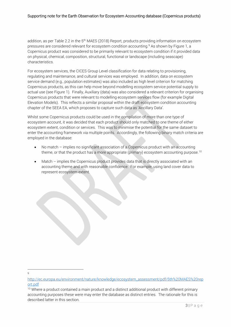
2.3 Results for Ecosystem Extent Figure 2 identifies 12 Copernicus products that were relevant to informing on ecosystem extent (or at least land cover as a pragmatic approximation). Figure 3 identifies that a majority of matched products
12
28
25
Account Matches
Extent Condition Services None

Supporting note for the Earth Observation for Ecosystem Accounting database (Copernicus products)
6 | P a g e
relate to land cover products (10 out of 12). Corine Land Cover (CLC) is the land cover product currently used to define MAES (Tier I) ecosystem extent accounts (with editions for 2000; 2006; 2012 and 2018 available). It is highlighted that the SEEA-EEA aims for different ecosystem types to be delineated such that there are no gaps in ecosystem coverage or overlaps between different types (i.e. approach that is mutually exclusive and collectively exhaustive – the MECE principle. The CLC Product satisfies the MECE principle for the entire EEA-39 area and is now the core dataset for ecosystem extent and land accounting in Europe.
The EEA has modified the CLC status layers from the Copernicus programme for the purpose of consistent statistical analysis in the land cover change accounting system the Agency maintains.11 CLC also provides the potential to undertake more detailed ecosystem accounting using the 44 CLC Level 3 classes it contains, which the EEA have used to develop more detailed (Tier II and III) ecosystem extent accounts (up to a sub-division of 32 different ecosystem types at European level in Tier III).
Additional, thematic, land cover products are also available from the Copernicus Land Services programme. While these products do not satisfy the MECE principle, they could support accounting for specific individual ecosystem types (e.g., Grassland), areas or experimenting with integration possibilities with CLC. The High Resolution Water and Wetness (for wetlands), Forest and Grassland Layers could be of interest for integration with CLC, given the higher spatial resolution they provide. Similarly, the Riparian Zones and Urban Atlas provide high resolution data for these ecosystem areas. There is also a high resolution land cover / land use product under development for coastal zone areas, expected at the end of 2020. Collectively, these high resolution data can help improve ecosystem extent accounts compiled using CLC by contributing input data for features that may not be picked up at the resolution of Minimum Mapping Units (25ha) or change (5ha) achieved via the CLC product currently. Initial experiments in this regard indicate such changes are likely to be very low, even in the context of the relative stability of land cover flows in Europe.
There is also now a global, annual mid resolution layer for land cover and water bodies extent from the global land services component that could also support ecosystem extent accounting outside of Europe, albeit the land cover product is only available for 2015 and 2018. These are included in the results presented in Figure 3.
The single ‘Land Use’ products identified in Figure 3 relates to the Urban Atlas (albeit it is a land cover observation). Delineation of Riparian Areas was considered to be best represented by Ecological Data as it employs a combination of land cover, land use and other geo-data sources in the modelling approach for the delineation.
11 https://www.eea.europa.eu/data-and-maps/data/corine-land-cover-accounting-layers
Supporting note for the Earth Observation for Ecosystem Accounting database (Copernicus products)
7 | P a g e
Figure 3: Number of matches between Copernicus products and ecosystem extent criteria
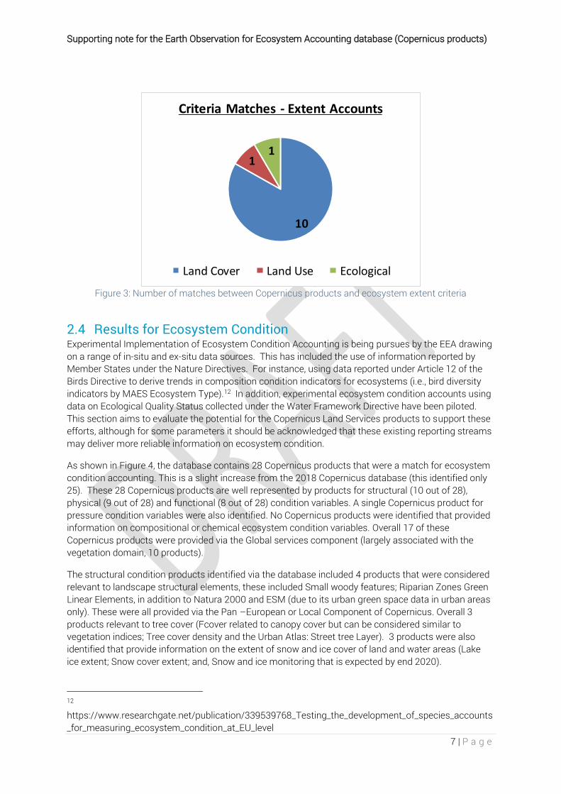
2.4 Results for Ecosystem Condition Experimental Implementation of Ecosystem Condition Accounting is being pursues by the EEA drawing on a range of in-situ and ex-situ data sources. This has included the use of information reported by Member States under the Nature Directives. For instance, using data reported under Article 12 of the Birds Directive to derive trends in composition condition indicators for ecosystems (i.e., bird diversity indicators by MAES Ecosystem Type).12 In addition, experimental ecosystem condition accounts using data on Ecological Quality Status collected under the Water Framework Directive have been piloted. This section aims to evaluate the potential for the Copernicus Land Services products to support these efforts, although for some parameters it should be acknowledged that these existing reporting streams may deliver more reliable information on ecosystem condition.
As shown in Figure 4, the database contains 28 Copernicus products that were a match for ecosystem condition accounting. This is a slight increase from the 2018 Copernicus database (this identified only 25). These 28 Copernicus products are well represented by products for structural (10 out of 28), physical (9 out of 28) and functional (8 out of 28) condition variables. A single Copernicus product for pressure condition variables were also identified. No Copernicus products were identified that provided information on compositional or chemical ecosystem condition variables. Overall 17 of these Copernicus products were provided via the Global services component (largely associated with the vegetation domain, 10 products).
The structural condition products identified via the database included 4 products that were considered relevant to landscape structural elements, these included Small woody features; Riparian Zones Green Linear Elements, in addition to Natura 2000 and ESM (due to its urban green space data in urban areas only). These were all provided via the Pan –European or Local Component of Copernicus. Overall 3 products relevant to tree cover (Fcover related to canopy cover but can be considered similar to vegetation indices; Tree cover density and the Urban Atlas: Street tree Layer). 3 products were also identified that provide information on the extent of snow and ice cover of land and water areas (Lake ice extent; Snow cover extent; and, Snow and ice monitoring that is expected by end 2020).
12 https://www.researchgate.net/publication/339539768_Testing_the_development_of_species_accounts_for_measuring_ecosystem_condition_at_EU_level
10
11
Criteria Matches - Extent Accounts
Land Cover Land Use Ecological
Supporting note for the Earth Observation for Ecosystem Accounting database (Copernicus products)
8 | P a g e
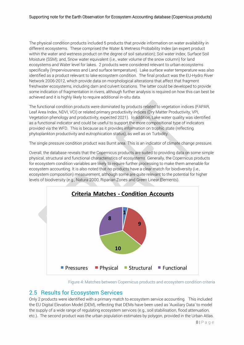
The physical condition products included 5 products that provide information on water availability in different ecosystems. These comprised the Water & Wetness Probability Index (an expert product within the water and wetness product on the degree of soil saturation); Soil water index; Surface Soil Moisture (SSM); and, Snow water equivalent (i.e., water volume of the snow column) for land ecosystems and Water level for lakes. 2 products were considered relevant to urban ecosystems specifically (Imperviousness and Land surface temperature). Lake surface water temperature was also identified as a product relevant to lake ecosystem condition. The final product was the EU-Hydro River Network 2006-2012, which provide data on morphological alterations that affect that fragment freshwater ecosystems, including dam and culvert locations. The latter could be developed to provide some indication of fragmentation in rivers, although further analysis is required on how this can best be achieved and it is highly likely to require additional in-situ data.
The functional condition products were dominated by products related to vegetation indices (FAPAR, Leaf Area Index, NDVI, VCI) or related primary productivity indices (Dry Matter Productivity, VPI, Vegetation phenology and productivity, expected 2021). In addition, Lake water quality was identified as a functional indicator and could be useful to support the more compositional type of indicators provided via the WFD. This is because as it provides information on trophic state (reflecting phytoplankton productivity and eutrophication status), as well as on Turbidity.
The single pressure condition product was Burnt area. This is an indicator of climate change pressure.
Overall, the database reveals that the Copernicus products are suited to providing data on some simple physical, structural and functional characteristics of ecosystems. Generally, the Copernicus products for ecosystem condition variables are likely to require further processing to make them amenable for ecosystem accounting. It is also noted that no products have a clear match for biodiversity (i.e., ecosystem composition) measurement, although some are quite relevant to the potential for higher levels of biodiversity (e.g., Natura 2000, Riparian Zones and Green Linear Elements).
Figure 4: Matches between Copernicus products and ecosystem condition criteria
2.5 Results for Ecosystem Services Only 2 products were identified with a primary match to ecosystem service accounting. This included the EU Digital Elevation Model (DEM), reflecting that DEMs have been used as ‘Auxiliary Data’ to model the supply of a wide range of regulating ecosystem services (e.g., soil stabilisation, flood attenuation, etc.). The second product was the urban population estimates by polygon, provided in the Urban Atlas.
1
9
10
8
Criteria Matches - Condition Accounts
Pressures Physical Structural Functional

Supporting note for the Earth Observation for Ecosystem Accounting database (Copernicus products)
9 | P a g e
These data are considered to be useful in modelling ecosystem service flow as they provide numbers of potential beneficiaries from ecosystem services and support estimating ecosystem service demand.
The two products identified above are considered relevant to ecosystem services as they are of little relevance to extent or condition (although population pressure could be a condition measure). It should be appreciated that many of the Copernicus products captured in the database will also be useful for various ecosystem service modelling approaches. For example, the Urban Atlas Street Tree Layer can be linked to urban ecosystem services such as removal of particulate matter and aesthetic enjoyment. In addition, the JRC are developing air quality regulation models where Leaf Area Index is a model input.
Experience within the KIP INCA project with respect to Ecosystem Service Accounting by the JRC has identified that many different datasets are often needed to model ecosystem services supply and use (e.g., As Auxiliary data for modelling pollination and outdoor recreation). 13 These include data on ecosystems as supplied (e.g., from CLC), the characteristics the underpin services supply (e.g., distribution and abundance of pollinators) and where demand for the service intersects with supply (e.g., distribution of yields in pollinated crops). This is clearly to be expected, ecosystem services supply is entirely dependent on the configuration of ecosystems and their condition. Whilst the database has been structured to inform on primary uses of Copernicus products, there are clearly multiple products that will be relevant to modelling ecosystem services supply (i.e., Auxiliary data).
3 Key Messages The analysis of the database revealed where Copernicus land monitoring services can provide long-term support to ecosystem accounting in Europe. The data basis for Ecosystem Extent Accounting is now well assured via the CLC product and established methods to make these products consistent in a way the can support ecosystem (and land) accounting.
Momentum is building within the ecosystem accounting community to move beyond a reliance on land cover information for Ecosystem Extent Accounting. High resolution Copernicus products have become available for certain ecosystem types and areas that my deliver more ecologically robust ecosystem extent accounts. However, the proposal likely to emerge in the revised version of the SEEA EA, will be to use the IUCN Global Ecosystem Typology as the global ecosystem type classification system (IUCN GET).14 It would also be useful to assess the potential for the Copernicus services products to support delineating ecosystems using this typology and clearly identify additional data requirements to achieve this. This would support a more ecologically orientated approach to ecosystem extent accounting, based on delineating ecosystems in terms of functional similarities rather than just their physical land cover characteristics.
With respect to Ecosystem Condition Accounting, the database reveals that the Copernicus products are suited to providing data on some simple physical, structural and functional characteristics of ecosystems. However, in most cases, Copernicus products for ecosystem condition variables are likely to require further processing to make them amenable for ecosystem accounting. It is also highlighted that no products were identified that provided information on ecosystem compositional or chemical ecosystem condition variables.
13 https://publications.jrc.ec.europa.eu/repository/handle/JRC110321 14 https://seea.un.org/content/iucn-global-ecosystem-typology-v101-descriptive-profiles-biomes-and-ecosystem-functional

Supporting note for the Earth Observation for Ecosystem Accounting database (Copernicus products)
10 | P a g e
In order to get a better understanding of the potential of Earth Observation to deliver information on Ecosystem Condition (including compositional characteristics), the EAA & UNEP-WCMC (via EO4EA) has been liaising with GEO Biodiversity Observation Network (GEO BON). The GEO BON initiative is developing a data platform for hosting and accessing a large number (>100) of global spatial datasets for Essential Biodiversity Variables (EBVs).15 GEO BON have recently mapped the set of EBVs to the SEEA EA Accounting modules, following the approach presented herein.16 These are included in the aforementioned expanded database, developed in collaboration with the Earth Observation for Ecosystem Accounting (EO4EA) initiative.
The secondary applications of Copernicus products for informing Ecosystem Services modelling as Auxiliary data should be evaluated further. A first step would be a detailed review of the Ecosystem Services Accounts compiled by the JRC via KIP INCA to identify the specific Copernicus products utilised. In addition, Biophysical Ecosystem Modelling Guidelines are being produced to support the SEEA EEA under the auspices of UNSD. These should also be reviewed to allow identify the scope of support Copernicus Land Services can provide at the European and Global level.
Whilst the possibilities for Copernicus to support Ecosystem Service modelling are potentially numerous, there is clearly a lack of regularly derived products on ecosystem services supply and use. The development of these products would be very helpful for the ecosystem accounting and assessment community in Europe. In particular, for facilitating consistent and comparative analysis at the continental scale. Efforts at the global scale are proceeding along these lines, for instance via the AIRES initiative.17
Further experimentation is clearly very necessary to establish if there is a clear, real match between Copernicus products and ecosystem accounts, rather than the potentials identified via the database. Some of this has now been established via KIP-INCA. The need for these tests for thematic and statistical consistency should not be underestimated. This has been demonstrated already in the context of using the CLC product for consistent time series Ecosystem Extent Accounting in Europe. A key part of this experimentation should be evaluating the best combinations of Earth Observation and other data to deliver the best representations for accounting themes of interest.
15 https://geobon.org/geo-bon-and-un-system-of-environmental-economic-accounting-seea-collaboration-for-ebvs-eesvs/ 16 https://GEO BON.org/geo-bon-and-un-system-of-environmental-economic-accounting-seea-collaboration-for-ebvs-eesvs/ 17 http://aries.integratedmodelling.org/

Supporting note for the Earth Observation for Ecosystem Accounting database (Copernicus products)
11 | P a g e
Appendix A: Copernicus Database (Excel)