Supplemental Information Request 10 - Canada.ca · been provided as an attachment to this...
109
Supplemental Information Request 10 Human Health Risk Assessment References: EIS Guidelines – Section 2.7.1.5, p. 48 (PDF 53) EIS Guidelines – Section 2.6.4.2, p. 42 (PDF 47) EIS Guidelines – Section 2.7.3.5, p. 68 (PDF 73) EIS Main Report – Section 6.2.11.3, p. 6.132 (PDF 638) EIS Main Report – Section 5.11.3, p. 5.169 (PDF 494) EIS Main Report – Section 6.2.11, p. 6.131 (PDF 637) Related Comments: CEAR #284 (Health Canada) CEAR #306 (Ontario Ministry of the Environment) CEAR #520 Health Canada’s letter dated June 25, 2013. CEAR #521 Ontario Ministry of the Environment letter dated June 27, 2013 CEAR #559 Health Canada’s Letter dated August 22, 2013 CEAR #560 Ministry of the Environment Letter dated August 22, 2013 Rationale: In their letters, Health Canada and Ministry of the Environment noted the lack of a detailed human health risk assessment for this Project, as per section 2.7.3.5 of the EIS Guidelines. Specifically, the Guidelines require detailed, quantitative and qualitative risk assessment methods to examine the potential effects of the Project on human health, specifically related to potential chemical releases to the environment. Health Canada and Ministry of the Environment noted that in the absence of a human health risk assessment they are unable to verify statements made in the EIS regarding potential human health effects of the Project. Information Request: The Panel understands that SCI is in the process of completing a human health risk assessment and will be in consultation with Health Canada in this regard. The Panel requests that SCI provide the Panel with their assessment on impacts to human health.
Transcript of Supplemental Information Request 10 - Canada.ca · been provided as an attachment to this...
Supplemental Information Request 10
Human Health Risk Assessment
References:
EIS Guidelines – Section 2.7.1.5, p. 48 (PDF 53)
EIS Guidelines – Section 2.6.4.2, p. 42 (PDF 47)
EIS Guidelines – Section 2.7.3.5, p. 68 (PDF 73)
EIS Main Report – Section 6.2.11.3, p. 6.132 (PDF 638)
EIS Main Report – Section 5.11.3, p. 5.169 (PDF 494)
EIS Main Report – Section 6.2.11, p. 6.131 (PDF 637)
Related Comments:
CEAR #284 (Health Canada)
CEAR #306 (Ontario Ministry of the Environment)
CEAR #520 Health Canada’s letter dated June 25, 2013.
CEAR #521 Ontario Ministry of the Environment letter dated June 27, 2013
CEAR #559 Health Canada’s Letter dated August 22, 2013
CEAR #560 Ministry of the Environment Letter dated August 22, 2013
Rationale:
In their letters, Health Canada and Ministry of the Environment noted the lack of a detailed human health risk assessment for this Project, as per section 2.7.3.5 of the EIS Guidelines. Specifically, the Guidelines require detailed, quantitative and qualitative risk assessment methods to examine the potential effects of the Project on human health, specifically related to potential chemical releases to the environment. Health Canada and Ministry of the Environment noted that in the absence of a human health risk assessment they are unable to verify statements made in the EIS regarding potential human health effects of the Project.
Information Request:
The Panel understands that SCI is in the process of completing a human health risk assessment and will be in consultation with Health Canada in this regard. The Panel requests that SCI provide the Panel with their assessment on impacts to human health.

SCI Response:
SCI has prepared, in consultation with Health Canada, a human health risk assessment (HHRA) in relation to the proposed Project. The HHRA is a stand-alone report and has been provided as an attachment to this supplemental information request.

Human Health Risk Assessment for the Proposed Marathon PGM-Cu Project Report prepared for: STILLWATER CANADA INC. 1127 Barton Street Thunder Bay, ON P7B 5N3 Report prepared by: ECOMETRIX INCORPORATED 6800 Campobello Road Mississauga, Ontario L5N 2L8 13-2029 November 2013

Human Health Risk Assessment for the Proposed Marathon PGM-Cu Project
Rina Parker Environmental Risk Assessment Specialist
Janeen Tang Environmental Risk Assessment Specialist
Don Hart Project Reviewer
Brian Fraser Project Principal
Human Health Risk Assessment for the Proposed Marathon PGM-Cu Project Executive Summary
13-2029 November 2013 i
EXECUTIVE SUMMARY
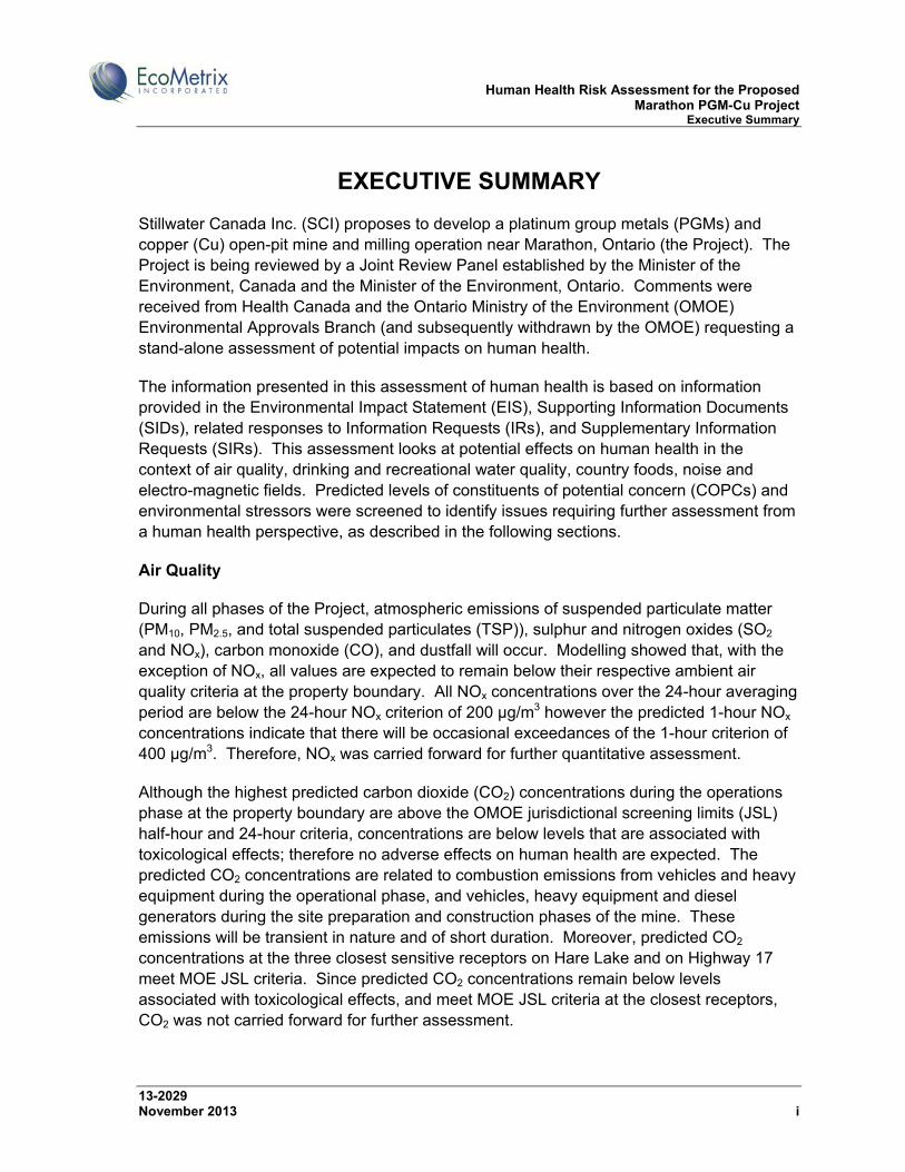
Stillwater Canada Inc. (SCI) proposes to develop a platinum group metals (PGMs) and copper (Cu) open-pit mine and milling operation near Marathon, Ontario (the Project). The Project is being reviewed by a Joint Review Panel established by the Minister of the Environment, Canada and the Minister of the Environment, Ontario. Comments were received from Health Canada and the Ontario Ministry of the Environment (OMOE) Environmental Approvals Branch (and subsequently withdrawn by the OMOE) requesting a stand-alone assessment of potential impacts on human health.
The information presented in this assessment of human health is based on information provided in the Environmental Impact Statement (EIS), Supporting Information Documents (SIDs), related responses to Information Requests (IRs), and Supplementary Information Requests (SIRs). This assessment looks at potential effects on human health in the context of air quality, drinking and recreational water quality, country foods, noise and electro-magnetic fields. Predicted levels of constituents of potential concern (COPCs) and environmental stressors were screened to identify issues requiring further assessment from a human health perspective, as described in the following sections.
Air Quality
During all phases of the Project, atmospheric emissions of suspended particulate matter (PM10, PM2.5, and total suspended particulates (TSP)), sulphur and nitrogen oxides (SO2 and NOx), carbon monoxide (CO), and dustfall will occur. Modelling showed that, with the exception of NOx, all values are expected to remain below their respective ambient air quality criteria at the property boundary. All NOx concentrations over the 24-hour averaging period are below the 24-hour NOx criterion of 200 µg/m3 however the predicted 1-hour NOx concentrations indicate that there will be occasional exceedances of the 1-hour criterion of 400 µg/m3. Therefore, NOx was carried forward for further quantitative assessment.
Although the highest predicted carbon dioxide (CO2) concentrations during the operations phase at the property boundary are above the OMOE jurisdictional screening limits (JSL) half-hour and 24-hour criteria, concentrations are below levels that are associated with toxicological effects; therefore no adverse effects on human health are expected. The predicted CO2 concentrations are related to combustion emissions from vehicles and heavy equipment during the operational phase, and vehicles, heavy equipment and diesel generators during the site preparation and construction phases of the mine. These emissions will be transient in nature and of short duration. Moreover, predicted CO2 concentrations at the three closest sensitive receptors on Hare Lake and on Highway 17 meet MOE JSL criteria. Since predicted CO2 concentrations remain below levels associated with toxicological effects, and meet MOE JSL criteria at the closest receptors, CO2 was not carried forward for further assessment.

Human Health Risk Assessment for the Proposed Marathon PGM-Cu Project Executive Summary
13-2029 November 2013 ii
Concentrations of metals associated with particulates are predicted to be well below provincial air quality criteria. Concentration of various polycyclic aromatic hydrocarbons (PAHs) and volatile organic compounds (VOCs) associated with combustion were also predicted to be well below provincial air quality criteria. Therefore no associated human health related risks are expected and no metals, PAHs or VOCs in air were carried forward for further assessment.
Drinking Water Quality
The potable water supply well for the Project is proposed to be located within 200 metres of the proposed mine services complex and to produce water from the deeper bedrock unit. The proposed location of the potable water supply well is cross- or up-gradient from the PSMF and MRSA and therefore will not be affected by mine-related sources.
Groundwater in the Town of Marathon and Pic River First Nation (PRFN) is used for potable purposes. The Town of Marathon Official Plan shows that an area to the south of the Project site is designated as a Groundwater Protection Zone. The Groundwater Protection Zone is not hydraulically connected to the shallow groundwater at the Project site and therefore there is no potential for the Project site to impact the Town’s drinking water supply. The Town’s wells are 6 km from the southern edge of the Process Solids Management Facility (PSMF). The groundwater supply wells for PRFN are located over 15 km from the southern edge of the PSMF and Mine Rock Storage Area (MRSA). There is no connectivity between the groundwater flow paths for the Project site and the groundwater supply wells for PRFN and therefore there is no potential for the Project site to impact the drinking water supply for the PRFN.
No interaction/pathway between groundwater affected by the Project and the potable water supply for the Project, Town of Marathon or PRFN was identified. Therefore no COPCs in drinking water were carried forward for further assessment.
Surface Water Quality
During operations, excess water from the PSMF and drainage from the MRSA will report to Hare Lake and the Pic River, respectively. Surface water quality in Hare Lake and the Pic River are predicted to meet applicable regulatory surface water quality benchmarks, which are protective of aquatic life and of human health. Therefore, no COPCs in surface water during operations were identified for further assessment.
Post-closure, runoff from the reclaimed PSMF and MRSA will report to Stream 6 and the Pic River, respectively. Surface water concentrations of all COPCs in Stream 6 and the Pic River are not predicted to exceed water quality objectives for the protection of aquatic life, livestock or drinking water or will be in the range of existing background concentrations; therefore, no adverse effects on human receptors are anticipated from exposure pathways

Human Health Risk Assessment for the Proposed Marathon PGM-Cu Project Executive Summary
13-2029 November 2013 iii
related to surface water quality. Therefore, no COPCs in surface water post-closure were identified for further assessment.
Groundwater at the Project site represents a potential pathway for COPCs from potential source areas. Mass loading rates at the base of the PSMF and MRSA were conservatively assumed to be transported to the surface waters without attenuation. Even under these circumstances, surface water quality was predicted to remain indistinguishable from background. No COPCs in surface water receiving groundwater loadings were therefore identified for further assessment.
After mitigation of metal concentrations (if necessary) when the pits fill to capacity, any ongoing leaching of metals from pit walls, rubble, and rock in the adjacent MRSA is not anticipated to adversely affect water quality in the pit complex nor in downstream surface water quality in the Pic River. The predicted long-term, steady-state pit water quality after mine closure is comparable to background. Therefore, no COPCs in impounded water at the mine site after closure were carried forward to further assessment.
Country Foods
No herbicide or pesticide use is anticipated at the mine site or along the proposed transmission line corridor therefore no COPCs related to herbicide or pesticide use are identified for country foods.
No COPCs in soils or terrestrial vegetation were identified as a concern for country foods in relation to air emissions. Predicted air concentrations meet applicable provincial criteria at the property boundary, with the exception of NOx. The predicted exceedances for NOx will not result in accumulation in soils or country foods. Metals in air that could be of potential concern for accumulation in soils and country foods are far below provincial criteria at the property boundary. Iron approaches its ambient air quality criterion (AAQC), but is not of potential concern for soils or country foods. Therefore, no Project-related COPCs in country foods were identified in relation to airborne emissions.
No COPCs in country foods were identified in relation to waterborne emissions. As noted above, the predicted quality of surface water receiving seepage, impounded water, runoff and effluent discharges from the mine site is generally expected to remain near background levels and/or meet applicable surface water quality benchmarks, and therefore no adverse effects on country foods or human receptors are anticipated from exposure pathways related to surface water.
Noise
Current noise levels in the vicinity of the Project site are typical of a rural setting, dominated by natural sounds. Current noise levels at the intersection of Highway 17 and Peninsula Road are higher, characteristic of an urban hum. A noise assessment was carried out to
Human Health Risk Assessment for the Proposed Marathon PGM-Cu Project Executive Summary
13-2029 November 2013 iv
assess noise levels at noise sensitive receptors in close proximity the Project site, along Highway 17 transportation corridor, along the transportation corridor to the potential concentrate rail load-out facility, and at the potential concentrate rail load-out facility.
During all phases of the Project, noise from the Project site is predicted to be well within OMOE standards at the noise sensitive receptors (NSRs) closest to the Project site – north Hare Lake cottage, south Hare Lake cottage, Peninsula Inn, Travelodge Hotel, Wayfare Inn and May’s Gifts. Noise from the Project site was not carried through for further assessment.
The analysis of impulsive noise related to rail car shunting at potential rail siting locations in Marathon and Schreiber that may be used to ship concentrate indicated that noise levels can be maintained below OMOE Standards at all sensitive receptor locations. Therefore, no adverse effects from noise on human health (i.e., nuisance noise) are expected. Nuisance noise was not carried through for further assessment.
Airblast (blast overpressure) and ground vibrations are anticipated during the development of access roads and the open pits. All overpressures and ground vibrations at the closest sensitive receptors are predicted to be below the MOE NPC 119 guideline limits (128 dBL for overpressure and 12.5 mm/s for ground vibrations). Most blast consultants and environmental scientists have concluded that adverse health effects from infrequent (< 5 occurrences per day) transient overpressures do not occur below levels of 140 dBL. For ground vibrations, the threshold of human perception is in the order of 0.15 – 0.2 mm/s in more sensitive individuals. No adverse effects from blasting on human health are expected; therefore, vibration and overpressure from blasting was not carried through for further assessment.
Electro-magnetic Fields
Health Canada and the Federal-Provincial-Territorial Radiation Protection Committee believe that there is insufficient scientific evidence to conclude that exposures to EMFs from power lines cause health problems. Further, the closest receptor to the proposed project power line is a cottage on Hare Lake, and it is approximately 2 to 3 km from this line. Therefore, exposure to EMFs was not identified as a human health issue requiring further assessment.
Summary of the Human Health Risk Assessment
Based on the results of the human health risk assessment, Project-related air quality, surface and ground water quality, noise and EMFs do not present a human health risk. Regulatory standards which are intended to be protective of ecological and human health will be met. Further, given the site location and setting, the potential exposure pathways to the human receptors identified in the conceptual models are considered negligible; therefore, no further quantitative assessment of human health risks is required, with the

Human Health Risk Assessment for the Proposed Marathon PGM-Cu Project Executive Summary
13-2029 November 2013 v
exception of NOx. The 1-hour NOx concentrations were carried forward for further quantitative assessment based on occasional predicted exceedances of the 1-hour criterion of 400 µg/m3.
Although the results of the risk characterization for NOx present hazard quotients (HQs) above 1.0 at the property boundary, these exceedances are not considered significant. Exceedances are intermittent both spatially and temporally, occurring at only one or two locations along the entire property boundary and approximately between 0.1% and 1% of the time. Additionally, these results are based on worst-case conditions, and do not represent average concentrations experienced on a regular basis.
HQs at Hare Lake are within the acceptable range (<1), indicating that the Cottager at Hare Lake will not be exposed to unacceptable NOx concentrations throughout the duration of the Project. Since NOx exceedances are limited to the Project site and will likely occur less than 0.1% of the time, it is not anticipated that the Mine Worker and Resource User would be exposed to unacceptable risk. Additionally, the Resource User will only infrequently be on site at best.
Human Health Risk Assessment for the Proposed Marathon PGM-Cu Project Table of Contents
13-2029 November 2013 vi
TABLE OF CONTENTS Page
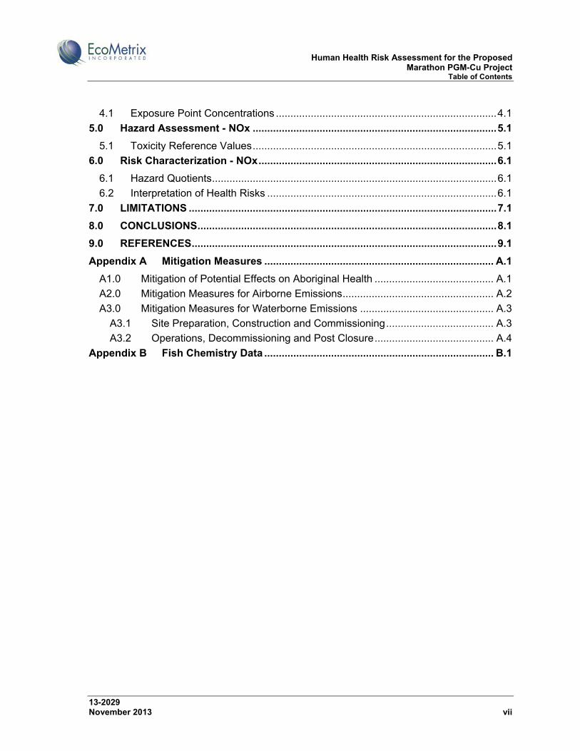
1.0 INTRODUCTION ...................................................................................................... 1.1
1.1 Environmental Assessment Framework ............................................................... 1.1
1.2 Marathon PGM-Cu Project ................................................................................... 1.2
1.3 Environmental Impact Statement Submission and Requests for Additional Information ...................................................................................................................... 1.7
1.4 Scope of Work ...................................................................................................... 1.7
1.4.1 Spatial Boundaries of the Assessment .......................................................... 1.7
1.4.2 Temporal Boundaries of the Assessment ..................................................... 1.8
2.0 SITE DESCRIPTION ................................................................................................ 2.1
2.1 Communities ......................................................................................................... 2.1
2.2 Current Uses of Lands and Resources for Traditional and Recreational Purposes 2.2
2.3 Air ......................................................................................................................... 2.9
2.4 Surface Water ..................................................................................................... 2.10
2.5 Groundwater ....................................................................................................... 2.12
2.6 Fisheries ............................................................................................................. 2.12
2.7 Vegetation .......................................................................................................... 2.13
2.8 Wildlife ................................................................................................................ 2.13
3.0 PROBLEM FORMULATION .................................................................................... 3.1
3.1 Constituents of Potential Concern and Environmental Stressors ......................... 3.1
3.1.1 Air .................................................................................................................. 3.2
3.1.2 Water ........................................................................................................... 3.12
3.1.3 Country Foods ............................................................................................. 3.29
3.1.4 Noise ........................................................................................................... 3.30
3.1.5 Electro-Magnetic Fields ............................................................................... 3.38
3.2 Potential Human Receptors ................................................................................ 3.39
3.2.1 Cottager ....................................................................................................... 3.39
3.2.2 Mine Worker ................................................................................................ 3.40
3.2.3 Resource User ............................................................................................ 3.40
3.3 Potential Exposure Pathways ............................................................................. 3.41
3.3.1 Pathways Related to Air Emissions ............................................................. 3.41
3.3.2 Pathways Related to Water Emissions ....................................................... 3.42
3.3.3 Country Food Pathways .............................................................................. 3.43
3.4 Conceptual Site Model ....................................................................................... 3.44
4.0 Exposure Assessment - NOx ................................................................................ 4.1
Human Health Risk Assessment for the Proposed Marathon PGM-Cu Project Table of Contents
13-2029 November 2013 vii
4.1 Exposure Point Concentrations ............................................................................ 4.1
5.0 Hazard Assessment - NOx .................................................................................... 5.1
5.1 Toxicity Reference Values .................................................................................... 5.1
6.0 Risk Characterization - NOx .................................................................................. 6.1
6.1 Hazard Quotients .................................................................................................. 6.1
6.2 Interpretation of Health Risks ............................................................................... 6.1
7.0 LIMITATIONS .......................................................................................................... 7.1
8.0 CONCLUSIONS ....................................................................................................... 8.1
9.0 REFERENCES ......................................................................................................... 9.1
Appendix A Mitigation Measures ............................................................................... A.1
A1.0 Mitigation of Potential Effects on Aboriginal Health ......................................... A.1
A2.0 Mitigation Measures for Airborne Emissions .................................................... A.2
A3.0 Mitigation Measures for Waterborne Emissions .............................................. A.3
A3.1 Site Preparation, Construction and Commissioning ..................................... A.3
A3.2 Operations, Decommissioning and Post Closure ......................................... A.4
Appendix B Fish Chemistry Data ............................................................................... B.1
Human Health Risk Assessment for the Proposed Marathon PGM-Cu Project Table of Contents
13-2029 November 2013 viii
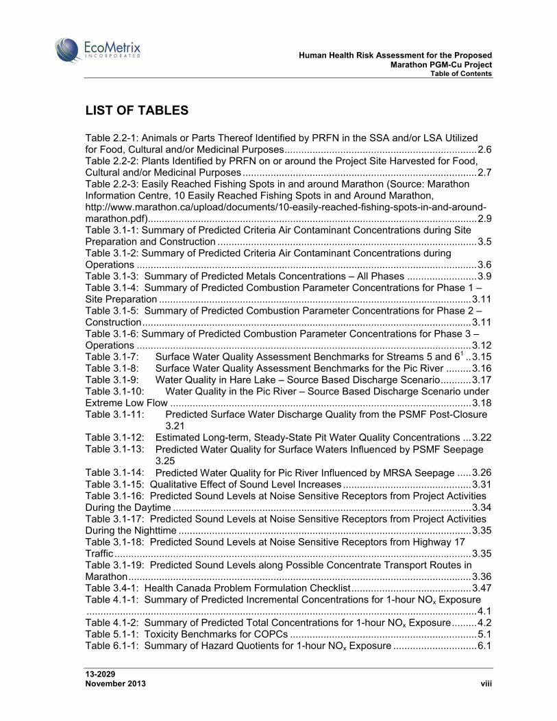
LIST OF TABLES Table 2.2-1: Animals or Parts Thereof Identified by PRFN in the SSA and/or LSA Utilized for Food, Cultural and/or Medicinal Purposes ..................................................................... 2.6 Table 2.2-2: Plants Identified by PRFN on or around the Project Site Harvested for Food, Cultural and/or Medicinal Purposes .................................................................................... 2.7 Table 2.2-3: Easily Reached Fishing Spots in and around Marathon (Source: Marathon Information Centre, 10 Easily Reached Fishing Spots in and Around Marathon, http://www.marathon.ca/upload/documents/10-easily-reached-fishing-spots-in-and-around-marathon.pdf) ...................................................................................................................... 2.9 Table 3.1-1: Summary of Predicted Criteria Air Contaminant Concentrations during Site Preparation and Construction ............................................................................................. 3.5 Table 3.1-2: Summary of Predicted Criteria Air Contaminant Concentrations during Operations .......................................................................................................................... 3.6 Table 3.1-3: Summary of Predicted Metals Concentrations – All Phases ......................... 3.9 Table 3.1-4: Summary of Predicted Combustion Parameter Concentrations for Phase 1 – Site Preparation ................................................................................................................ 3.11 Table 3.1-5: Summary of Predicted Combustion Parameter Concentrations for Phase 2 – Construction ...................................................................................................................... 3.11 Table 3.1-6: Summary of Predicted Combustion Parameter Concentrations for Phase 3 – Operations ........................................................................................................................ 3.12 Table 3.1-7: Surface Water Quality Assessment Benchmarks for Streams 5 and 61 .. 3.15 Table 3.1-8: Surface Water Quality Assessment Benchmarks for the Pic River ......... 3.16 Table 3.1-9: Water Quality in Hare Lake – Source Based Discharge Scenario ........... 3.17 Table 3.1-10: Water Quality in the Pic River – Source Based Discharge Scenario under Extreme Low Flow ............................................................................................................ 3.18 Table 3.1-11: Predicted Surface Water Discharge Quality from the PSMF Post-Closure 3.21 Table 3.1-12: Estimated Long-term, Steady-State Pit Water Quality Concentrations ... 3.22 Table 3.1-13: Predicted Water Quality for Surface Waters Influenced by PSMF Seepage 3.25 Table 3.1-14: Predicted Water Quality for Pic River Influenced by MRSA Seepage ..... 3.26 Table 3.1-15: Qualitative Effect of Sound Level Increases .............................................. 3.31 Table 3.1-16: Predicted Sound Levels at Noise Sensitive Receptors from Project Activities During the Daytime ........................................................................................................... 3.34 Table 3.1-17: Predicted Sound Levels at Noise Sensitive Receptors from Project Activities During the Nighttime ......................................................................................................... 3.35 Table 3.1-18: Predicted Sound Levels at Noise Sensitive Receptors from Highway 17 Traffic ................................................................................................................................ 3.35 Table 3.1-19: Predicted Sound Levels along Possible Concentrate Transport Routes in Marathon ........................................................................................................................... 3.36 Table 3.4-1: Health Canada Problem Formulation Checklist ........................................... 3.47 Table 4.1-1: Summary of Predicted Incremental Concentrations for 1-hour NOx Exposure ............................................................................................................................................ 4.1 Table 4.1-2: Summary of Predicted Total Concentrations for 1-hour NOx Exposure ......... 4.2 Table 5.1-1: Toxicity Benchmarks for COPCs ................................................................... 5.1 Table 6.1-1: Summary of Hazard Quotients for 1-hour NOx Exposure .............................. 6.1
Human Health Risk Assessment for the Proposed Marathon PGM-Cu Project Table of Contents
13-2029 November 2013 ix
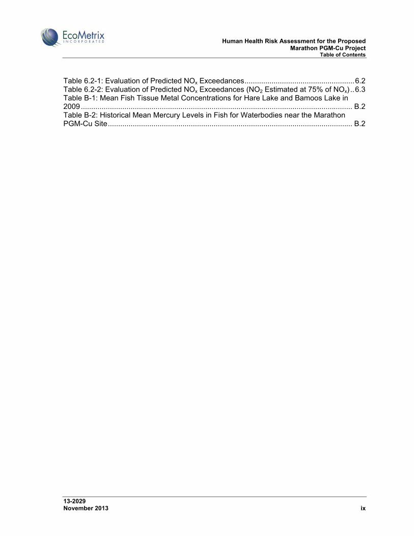
Table 6.2-1: Evaluation of Predicted NOx Exceedances ..................................................... 6.2 Table 6.2-2: Evaluation of Predicted NOx Exceedances (NO2 Estimated at 75% of NOx) .. 6.3 Table B-1: Mean Fish Tissue Metal Concentrations for Hare Lake and Bamoos Lake in 2009 ................................................................................................................................... B.2 Table B-2: Historical Mean Mercury Levels in Fish for Waterbodies near the Marathon PGM-Cu Site ...................................................................................................................... B.2

Human Health Risk Assessment for the Proposed Marathon PGM-Cu Project Table of Contents
13-2029 November 2013 x
LIST OF FIGURES Figure 1.1-1: Location of the proposed Marathon PGM-Cu Project .................................... 1.2 Figure 1.2-1: Existing conditions at the proposed Marathon PGM-Cu Project site ............. 1.5 Figure 1.2-2: Conceptual layout of the proposed Marathon PGM-Cu Project site representing conditions at the end of the operational phase of mine life ............................ 1.6 Figure 1.4-1: Site Study Area for the Marathon PGM-Cu Project EIS .............................. 1.10 Figure 1.4-2: Local Study Areas for the Marathon PGM-Cu Project EIS .......................... 1.11 Figure 1.4-3: Regional Study Area for the Marathon PGM-Cu Project EIS ...................... 1.12 Figure 2.1-1: Communities within 100 km of the Project Site ............................................. 2.2 Figure 2.2-1: Trap Line License Areas in the Vicinity of the Project site (the black outline shows the mining lease area associated with the Project) ................................................. 2.5 Figure 2.4-1: Watersheds Draining the Project Site .......................................................... 2.11 Figure 3.1-1: Noise Sensitive Receptors in the Vicinity of the Marathon PGM-Cu Project Site .................................................................................................................................... 3.32 Figure 3.4-1: Human Health Conceptual Site Model for Operations and Decommissioning .......................................................................................................................................... 3.45 Figure 3.4-2: Human Health Conceptual Site Model after Closure ................................... 3.46
Human Health Risk Assessment for the Proposed Marathon PGM-Cu Project Acronyms and Abbreviations
13-2029 November 2013 xi
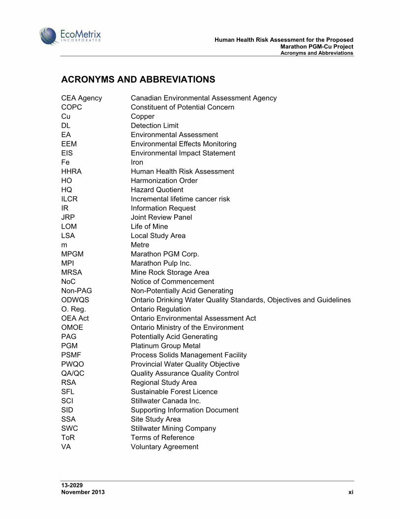
ACRONYMS AND ABBREVIATIONS CEA Agency Canadian Environmental Assessment Agency COPC Constituent of Potential Concern Cu Copper DL Detection Limit EA Environmental Assessment EEM Environmental Effects Monitoring EIS Environmental Impact Statement Fe Iron HHRA Human Health Risk Assessment HO Harmonization Order HQ Hazard Quotient ILCR Incremental lifetime cancer risk IR Information Request JRP Joint Review Panel LOM Life of Mine LSA Local Study Area m Metre MPGM Marathon PGM Corp. MPI Marathon Pulp Inc. MRSA Mine Rock Storage Area NoC Notice of Commencement Non-PAG Non-Potentially Acid Generating ODWQS Ontario Drinking Water Quality Standards, Objectives and Guidelines O. Reg. Ontario Regulation OEA Act Ontario Environmental Assessment Act OMOE Ontario Ministry of the Environment PAG Potentially Acid Generating PGM Platinum Group Metal PSMF Process Solids Management Facility PWQO Provincial Water Quality Objective QA/QC Quality Assurance Quality Control RSA Regional Study Area SFL Sustainable Forest Licence SCI Stillwater Canada Inc. SID Supporting Information Document SSA Site Study Area SWC Stillwater Mining Company ToR Terms of Reference VA Voluntary Agreement

Human Health Risk Assessment for the Proposed Marathon PGM-Cu Project Acronyms and Abbreviations
13-2029 November 2013 xii
Catalogue of Supporting Documents
SID1 Number Reference Citation
1 Marathon PGM-Cu Project Site - Aquatic Resources Baseline Report. Prepared by EcoMetrix Incorporated.
EcoMetrix, 2012a
2 Soil Conditions at the Marathon PGM-Cu Project Site. Prepared by EcoMetrix Incorporated.
EcoMetrix, 2012b
3 Baseline Water Quality Report for the Marathon PGM-Cu Project. Prepared by EcoMetrix Incorporated.
EcoMetrix, 2012c
4 Geological Conditions at the Marathon PGM-Cu Project Site. Prepared by EcoMetrix Incorporated.
EcoMetrix, 2012d
5 Geochemical Assessment of Mine Components at the Marathon PGM-Cu Project. Prepared by EcoMetrix Incorporated.
EcoMetrix, 2012e
6 Water Quality and COPC Fate Modeling for the Marathon PGM-Cu Project. Prepared by EcoMetrix Incorporated.
EcoMetrix, 2012f
7 Cumulative Effects Assessment for the Marathon PGM-Cu Project. Prepared by EcoMetrix Incorporated.
EcoMetrix, 2012g
8 Green House Gas and Climate Change Assessment for the Marathon PGM-Cu Project. Prepared by EcoMetrix Incorporated.
EcoMetrix, 2012h
9 Human Health Risk Assessment for the Marathon PGM-Cu Project. Prepared by EcoMetrix Incorporated.
EcoMetrix, 2012i
10 Fish Habitat Compensation Strategy for the Marathon PGM-Cu Project. Prepared by EcoMetrix Incorporated.
EcoMetrix, 2012j
11 Impact Assessment Report – Navigable Waters – Marathon PGM-Cu Project.
EcoMetrix, 2012k
12 Marathon PGM-Cu Project Traffic Impact Study. Prepared by Engineering Northwest Ltd.
ENL, 2012
13 Alternatives Assessments Report for the Process Solids Storage Facility and the Mine Rock Storage Area for the Marathon PGM-Cu Project. Prepared by Knight Piesold Ltd. Includes the following appendix material:
Marathon PGM-Cu Project – 2011 Winter Site Investigation Summary (KPL Ref. No. NB101-446/2-2)
Marathon PGM-Cu Project – 2011 Summer and Fall Site Investigation Summary (KPL Ref. No. NB101-446/2-3)
Improved Option 3 PSMF Preliminary Stability Analysis (KPL Ref. No. NB11-00452)
Improved Option 3 PSMF Seepage Analysis (KPL Ref. No. NB11-00455)
Combined Storage Area PSMF Preliminary Stability Analysis (KPL Ref. No. NB12-00055)
Knight Piesold, 2012
1 Supporting Information Document.
Human Health Risk Assessment for the Proposed Marathon PGM-Cu Project Acronyms and Abbreviations
13-2029 November 2013 xiii
Combined Storage Area Seepage Analysis (KPL Ref. No. NB12-00093)
Combined Storage Area PSMF and MRSA Conceptual Closure Plan (KPL Ref. No. NB12-00078)
Marathon PGM-Cu Improved Option 3 PSMF – Water/Solids Balance Update (KPL Ref. No. NB12-00035)
Marathon PGM-Cu Combined Storage Area PSMF – Water/Solids Balance (KPL Ref. No. NB12-00080)
Marathon PGM-Cu Combined Storage Area PSMF – Wet Scenarios Water Balance (KPL Ref. No. NB12-00081)
Marathon PGM-Cu Combined Storage Area PSMF – Dry Scenarios Water Balance (KPL Ref. No. NB12-00111)
Mine Rock Storage Area Runoff Water Management (KPL Ref. No. NB12-00114)
14 Baseline Technical Report – Air, Marathon PGM-Cu Environmental Assessment. Prepared by True Grit Consulting Limited
TGCL, 2011a
15 Baseline Technical Report – Noise, Marathon PGM-Cu Environmental Assessment. Prepared by True Grit Consulting Limited
TGCL, 2011b
16 Baseline Report – Hydrogeology, Marathon PGM-Cu Project. Prepared by True Grit Consulting Limited
TGCL, 2012a
17 Impact Assessment – Hydrogeology, Marathon PGM-Cu Project Environmental Assessment. Prepared by True Grit Consulting Limited
TGCL, 2011c
18 Air Quality Impact Assessment, Marathon PGM-Cu Environmental Assessment. Prepared by True Grit Consulting Limited
TGCL, 2012b
19 Impact Assessment Technical Report – Noise, Marathon PGM-Cu Environmental Assessment. Prepared by True Grit Consulting Limited
TGCL, 2012c
20 Draft Conceptual Closure Plan, Marathon PGM-Cu Project. Prepared by True Grit Consulting Limited
TGCL, 2012d
21 Technical Report – Worker Health and Safety, Marathon PGM-Cu Environmental Assessment. Prepared by True Grit Consulting Limited
TGCL, 2012e
22 Baseline Hydrologic Conditions at the Marathon PGM-Cu Project Site. Prepared by Calder Engineering.
Calder, 2012a
23 Marathon PGM-Cu Project - Surface Water Hydrologic Impact Assessment. Prepared by Calder Engineering.
Calder, 2012b
24 Baseline Economic and Social Conditions in the Vicinity of the Marathon PGM-Cu Project. Prepared by gck Consulting Ltd.
gck, 2012a
25 Economic and Social Impact Assessment for the Marathon PGM-Cu Project. Prepared by gck Consulting Ltd.
gck, 2012b
Human Health Risk Assessment for the Proposed Marathon PGM-Cu Project Acronyms and Abbreviations
13-2029 November 2013 xiv
26 Marathon PGM-Cu Project Terrestrial Baseline Environment Program. Prepared by Northern BioScience.
Northern BioScience, 2012a
27 Marathon PGM-Cu Project – Assessment of Impacts on Birds. Prepared by Northern BioScience.
Northern BioScience, 2012b
28 Marathon PGM-Cu Project – Assessment of Impacts on Woodland Caribou. Prepared by Northern BioScience.
Northern BioScience, 2012c
29 A Stage 1 and Stage 2 Archaeological Assessment of Hare Lake and Hare Creek, North of Marathon, McCoy Township, Ontario. Prepared by Ross Archaeological Research Associates.
Ross Archaeological Research Associates, 2009
30 Stage I and II Archaeological Assessment of the Marathon PGM property, north of Marathon Ontario. Prepared by Woodland Heritage Services Ltd.
Woodland Heritage Services Ltd., 2008
31 Marathon Platinum Group Metals – Copper Mining Project Baseline Assessment of the Aquatic and Terrestrial Environment. Prepared by Golder Associates.
Golder Associates, 2009
32 Environmental Baseline Assessment Marathon PGM-Cu Project. Prepared by NAR Environmental Consultants Inc.
NAR, 2007
33 Technical Report on the Updated feasibility Study for the Marathon PGM-Cu Project, Marathon, Ontario, Canada. Prepared by MICON International Ltd.
MICON, 2010

Human Health Risk Assessment for the Proposed Marathon PGM-Cu Project Introduction
13-2029 November 2013 1.1
1.0 INTRODUCTION
1.1 Environmental Assessment Framework
Stillwater Canada Inc. (SCI) proposes to develop a platinum group metals (PGMs) and copper (Cu) open-pit mine and milling operation near Marathon, Ontario (Figure 1.1-1). A Notice of Commencement (NoC) of an environmental assessment (EA) in relation to the proposed Marathon PGM-Cu Project (the “Project”) was filed by the Canadian Environmental Assessment Agency (CEA Agency) under Section 5 of the Canadian Environmental Assessment Act on April 29, 2010 (updated July 19, 2010).
The EA was referred to an independent Review Panel by the Federal Minister of the Environment on October 7, 2010. On March 23, 2011 SCI entered into a Voluntary Agreement (VA) with the Province of Ontario to have the Project subject to the Ontario Environmental Assessment Act (OEA Act). This agreement was the instrument that permitted the provincial government to issue a Harmonization Order (HO) under Section 18(2) of the Canada-Ontario Agreement on Environmental Assessment Cooperation to establish a Joint Review Panel for the Project between the Minister of the Environment, Canada and the Minister of the Environment, Ontario.
The HO was issued on March 25, 2011. The Terms of Reference (ToR) for the Project Environmental Impact Statement (EIS) and the agreement establishing the Joint Review Panel (JRP) were issued on August 8, 2011.

Human Health Risk Assessment for the Proposed Marathon PGM-Cu Project Introduction
13-2029 November 2013 1.2
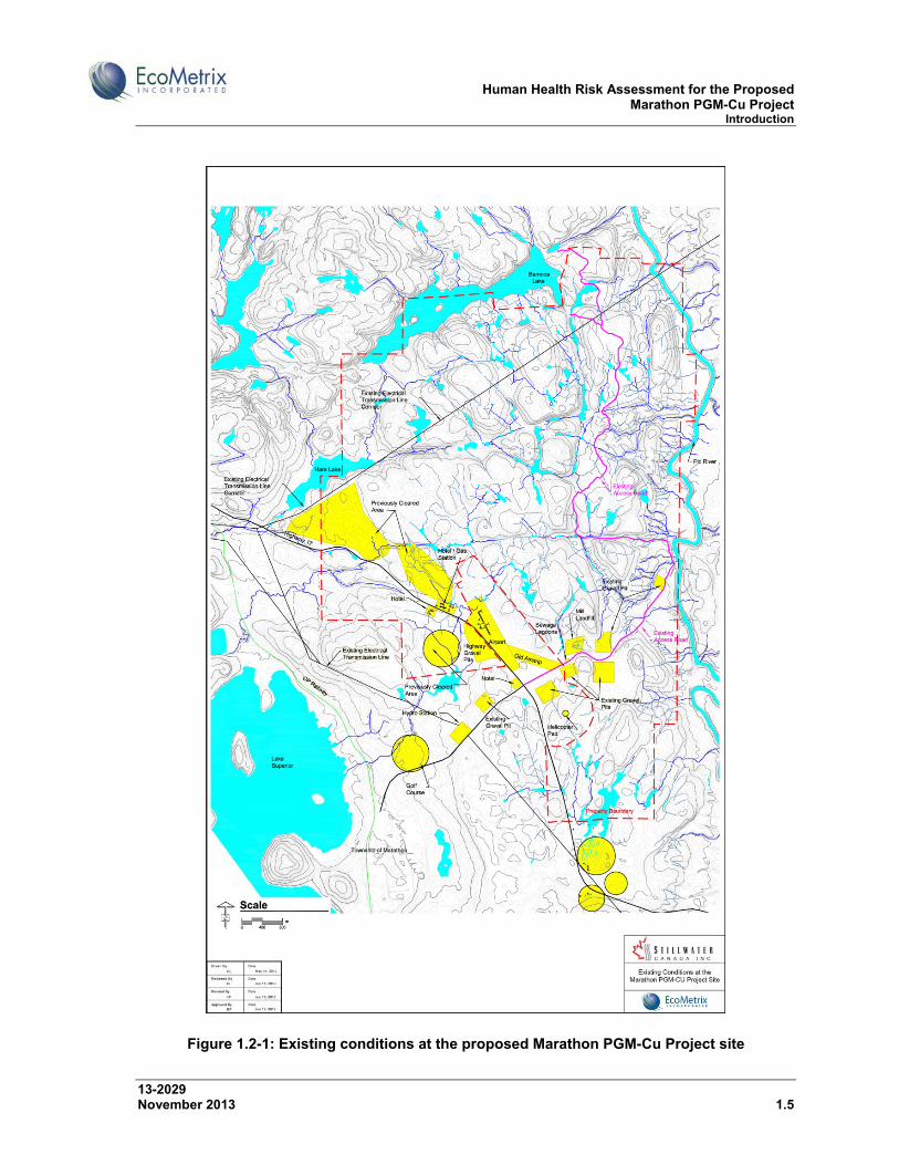
Figure 1.1-1: Location of the proposed Marathon PGM-Cu Project
1.2 Marathon PGM-Cu Project
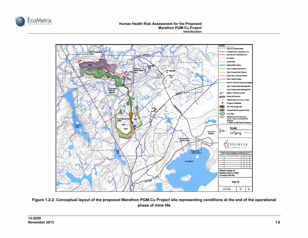
The Project contemplates the development of an open pit mining and milling operation. Existing conditions on and around the site and the conceptual general layout of the components of the mine site, the transmission line corridor and access road are provided in Figures 1.2-1 and 1.2-2, respectively.
Human Health Risk Assessment for the Proposed Marathon PGM-Cu Project Introduction
13-2029 November 2013 1.3
One primary pit and satellite pits to the south are proposed to be mined. Ore will be processed (crushed, ground, concentrated) at an on-site processing facility. Final concentrates containing copper and platinum group metals will be transported off-site via road and/or rail directly or via ship to a smelter and refinery for subsequent metal extraction and separation. The total mineral reserve (proven and probable) is estimated to be approximately 120 million tonnes.
During the operations phase of the Project, ore will be fed to the mill at an average rate of approximately 25,000 to 28,000 tonnes per day. The operating life of the mine is estimated to be approximately 10 to 12 years.
Approximately 192 to 288 million tonnes of mine rock2 will be excavated. Non-potentially acid generating (non-PAG) mine rock will be permanently stored in a purposefully built Mine Rock Storage Area (MRSA) located east of the primary pit. The non-PAG or so-called Type 1 mine rock will also be used in the construction of access roads, dams and other site infrastructure as needed. Drainage from the MRSA will be collected, stored, treated (as necessary) and discharged to the Pic River. As part of the strategy to manage potentially acid generating (PAG) mine rock, or Type 2 Mine Rock, that may be excavated from the pits, contingency for the management of approximately 20 million tonnes of mine rock has been accounted for in the mine design. The Type 2 mine rock will be managed on surface during mine operations in temporary stock piles with drainage directed into the open pits. This material will be relocated to the bottom of the primary and satellite pits and covered with water to prevent potential acid generation and covered with Type 1 materials.
Process solids3 will be managed in the Process Solids Management Facility (PSMF), as well as in the open pit(s). The PSMF will be designed to hold approximately 108 million tonnes of material, and its creation will require the construction of dams. Two streams of process solids will be generated. An estimated 85 to 90% of the total amount of process solids produced will be non-acid generating, or so-called Type 1 process solids. The remaining ten to fifteen percent of the process solids could be potentially acid generating and referred to as Type 2 process solids. The Type 2 process solids will be stored below the water table in the PSMF or below water in the pits to mitigate potential acid generation and covered with Type 1 materials. Water collected within the PSMF, as well as water collected around the mine will be managed in the PSMF for eventual reclamation in the milling process. Excess water not needed in the mill will be discharged, following treatment as is necessary, to Hare Lake.
2 Mine rock is rock that has been excavated from active mining areas but does not have sufficient ore grades to process for mineral extraction. 3 Process solids are solids generated during the ore milling process following extraction of the ore (minerals) from the host material.

Human Health Risk Assessment for the Proposed Marathon PGM-Cu Project Introduction
13-2029 November 2013 1.4
Access to the Project site is currently provided by the Camp 19 Road, opposite Peninsula Road at Hwy 17. The existing road runs east towards the Pic River before turning north along the river to the Project site (approximately 8 km). The existing road will be upgraded and utilized from its junction with Hwy 17 for approximately 2.0 km. At this point a new road running north will be constructed to the future plant site. The primary rationale for developing the new road is to move traffic away from the Pic River. The new section of road will link two sections of forest access roads located on the site.
Power to the Project site will be provided via a new 115 kV transmission line that will be constructed from a junction point on the Terrace Bay-Manitouwadge transmission line (M2W Line) located to the northwest of the primary pit. The new transmission line will run approximately 4.1 km to a substation at the mill site. The width of the transmission corridor will be approximately 30 m. A pole line will follow the main Camp #19 access corridor to provide supplemental power, or approximately 25kV, at start up and for communications to site.
Reasonable steps will be taken to reclaim some disturbed areas of the Project footprint in a progressive manner. Natural drainage patterns will be restored as much as possible. The ultimate goal of mine decommissioning will be to reclaim land within the Project footprint to permit future use by resident biota, as determined through consultation with the public, Aboriginal peoples and government. A certified Closure Plan for the Project will be prepared as required by Ontario Regulation (O.Reg.) 240/00 as amended by O.Reg.194/06 “Mine Development and Closure under Part VII of the Mining Act” and “Mine Rehabilitation Code of Ontario”..
Human Health Risk Assessment for the Proposed Marathon PGM-Cu Project Introduction
13-2029 November 2013 1.5
Figure 1.2-1: Existing conditions at the proposed Marathon PGM-Cu Project site
Human Health Risk Assessment for the Proposed Marathon PGM-Cu Project Introduction
13-2029 November 2013 1.6
Figure 1.2-2: Conceptual layout of the proposed Marathon PGM-Cu Project site representing conditions at the end of the operational
phase of mine life
Human Health Risk Assessment for the Proposed Marathon PGM-Cu Project Introduction
13-2029 November 2013 1.7
1.3 Environmental Impact Statement Submission and Requests for Additional Information
SCI submitted the Main Environmental Impact Statement (EIS) and a number of Supporting Information Documents in June 2012. The JRP responded to this submission with a series of Information Requests on 26 November 2012, which SCI responded to over the period March to July 2013. The JRP issued a series of Supplemental Information Requests (SIRs) on 30 August 2013. This report has been prepared in response to SIR #10 – Human Health Risk Assessment.
1.4 Scope of Work
Comments on the Project EIS were received from Health Canada requesting a stand-alone assessment of potential impacts on human health. The OMOE initially made and then effectively withdrew a similar request. The purpose of this report is to provide an assessment of potential human health risks during all phases of the Project (i.e. site preparation, construction, operation, decommissioning and post closure). The objectives are:
to assess potential effects on human health in the context of air quality, drinking and recreational water quality, country foods, noise and electro-magnetic fields, and
to review information concerning Aboriginal people’s health-related traditional activities, including country foods consumption (hunting, fishing, trapping, harvesting of plants).
This report follows guidance from “Useful Information for Environmental Assessments” (Health Canada, 2010a) and Section 2.7.3.5 of the EIS Guidelines for the Project. The assessment of human health is based on information provided in the EIS, supporting technical documents (SIDs), responses to Information Requests (IRs), and Supplementary Information Requests (SIRs). This report is designed to facilitate the external review of information relevant to human health by following a human health risk assessment approach based on guidance from Health Canada and OMOE.
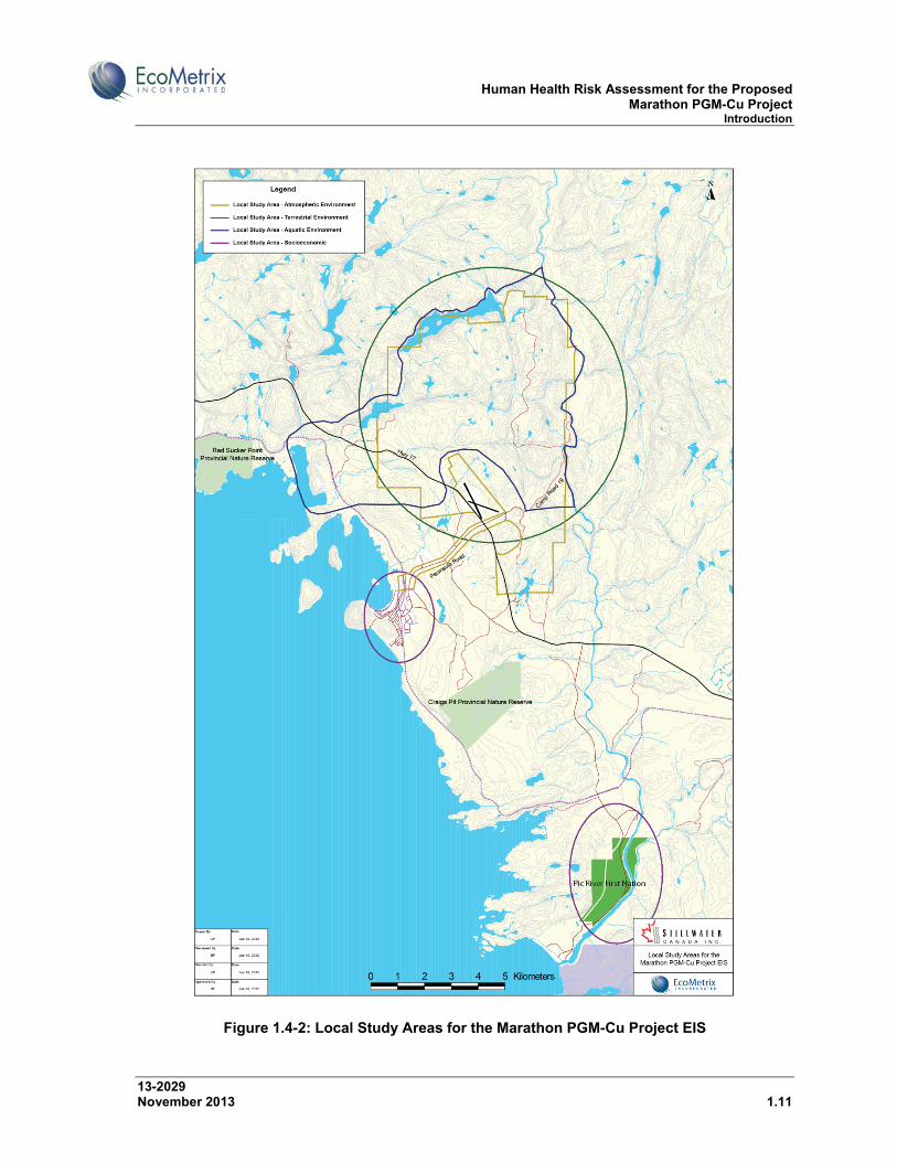
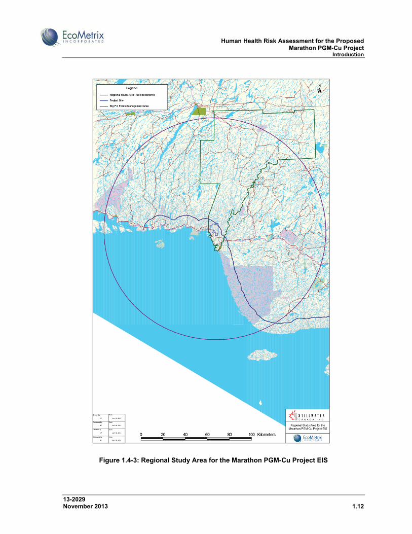
1.4.1 Spatial Boundaries of the Assessment
The spatial and temporal boundaries of the Project for the assessment of potential Project-environment interactions are reviewed here and discussed in further detail in Section 2 of the Main EIS Report. Three spatial scales were considered: the Site Study Area (SSA), the Local Study Area (LSA) and the Regional Study Area (RSA).
The SSA is the direct footprint of the Project where direct land disturbance will occur, as shown in Figure 1.4-1. The LSA and RSA for different assessment components (atmospheric, aquatic, terrestrial and socio-economic) are shown in Figure 1.4-2 and Figure

Human Health Risk Assessment for the Proposed Marathon PGM-Cu Project Introduction
13-2029 November 2013 1.8
1.4-3. The LSA generally corresponds to the area extending out from the SSA where local subwatersheds drain, where residual air quality and/or noise effects could reasonably be expected to occur and where local wildlife movements on and off the site could reasonably be expected to occur. The LSA also includes the most proximate non-native and First Nation communities. The RSA is the area within which cumulative effects are assessed, as appropriate.
1.4.2 Temporal Boundaries of the Assessment
The temporal boundaries for the proposed Project are defined by the duration of the individual Project phases:
Phase I Site Preparation, Phase II Construction and Commissioning, Phase III Operations, and Phase IV Decommissioning and Post Closure.
The site preparation and construction phases will be concordant over a period of approximately 18 to 24 months. This period will be followed by an operations phase estimated to last about 10 to 12 years. Though the site will be reclaimed on an ongoing basis to the extent practical during site preparation, construction and operations, a relatively intensive period of reclamation and decommissioning will commence following the cessation of operations. This intensive period of reclamation and decommissioning is anticipated to last approximately two years.
Environmental monitoring activities will take place on the site thereafter to verify the success of reclamation and decommissioning activities, and to confirm that on-site water quality has stabilized such that there are no longer-term geochemistry concerns. As discussed in IR 3.3, the water quality in the primary open pit represents a potential longer-term concern. It has been estimated that the primary pit will take approximately 40 years to fill to the level at which it would naturally overflow. Appropriate mitigation strategies can be implemented before complete filling to protect surface and groundwater quality outside the pit. Monitoring of the PSMF over a 10-year period is expected to provide sufficient information on trends in chemistry to know whether or not future effects following closure can be expected and may require mitigation or implementation of contingency measures.
The assessment of potential human health risks related to the atmospheric release of COPCs focuses on the site preparation, construction, commissioning, and operation phases of the Project. Project-related releases of COPCs to air during the decommissioning phase are expected to be similar to those during the construction and commissioning phase. No Project-related emissions to air are expected during the post-closure phase.

Human Health Risk Assessment for the Proposed Marathon PGM-Cu Project Introduction
13-2029 November 2013 1.9
The assessment of potential human health risks related to the aqueous release of COPCs focuses on the operation, decommissioning and post-closure phases of the Project. Project-related releases of COPCs to water during the site preparation, construction and commissioning phases are expected to be minimal and bounded by predicted effects during the operation, decommissioning and post-closure phases of the Project.

Human Health Risk Assessment for the Proposed Marathon PGM-Cu Project Introduction
13-2029 November 2013 1.10
Figure 1.4-1: Site Study Area for the Marathon PGM-Cu Project EIS
Human Health Risk Assessment for the Proposed Marathon PGM-Cu Project Introduction
13-2029 November 2013 1.11
Figure 1.4-2: Local Study Areas for the Marathon PGM-Cu Project EIS
Human Health Risk Assessment for the Proposed Marathon PGM-Cu Project Introduction
13-2029 November 2013 1.12
Figure 1.4-3: Regional Study Area for the Marathon PGM-Cu Project EIS
Human Health Risk Assessment for the Proposed Marathon PGM-Cu Project Site Description
13-2029 November 2013 2.1
2.0 SITE DESCRIPTION
This section provides a brief summary of the existing environment, including information concerning country foods consumption by Aboriginal people and other hunters/trappers.
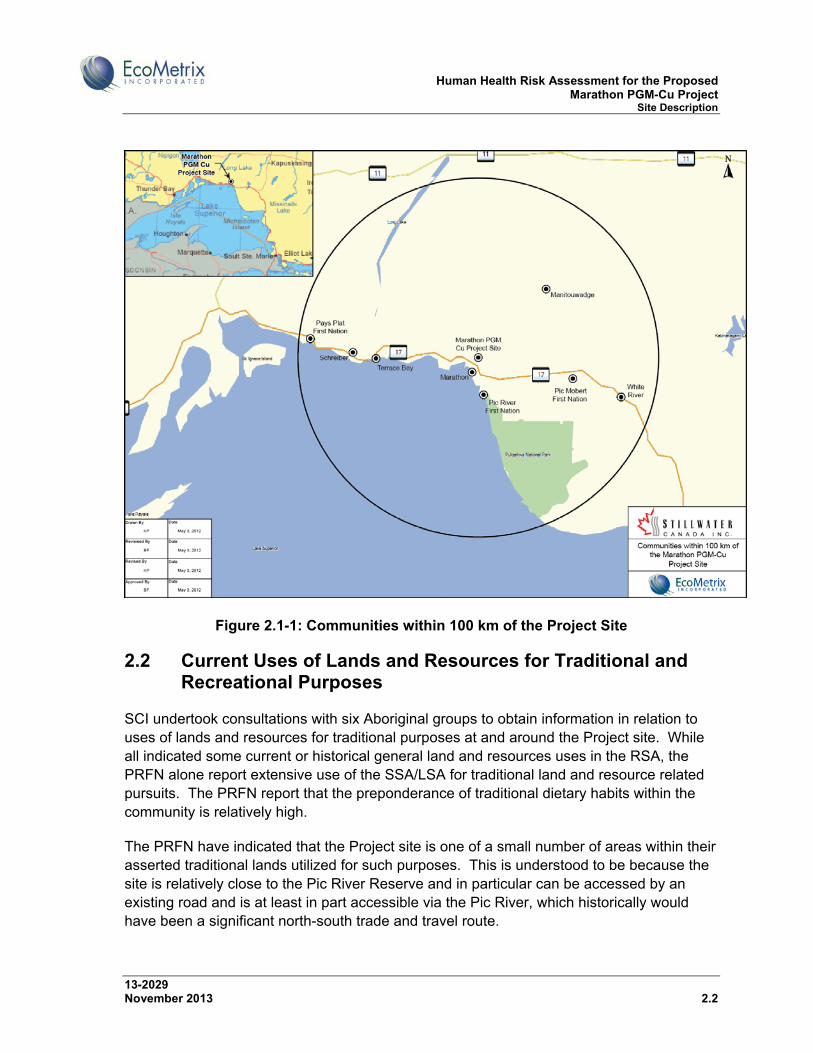
2.1 Communities
Figure 2.1-1 shows the location of communities within 100 km of the Project Site. The Town of Marathon is the closest population centre to the Project site, located 10 km south of the site. The current population of Marathon is 3,353 (2011 Census).
Stillwater Canada Inc. and its predecessor Marathon PGM Corp. have been engaged in consultation with a number of Aboriginal communities with respect to the Project since 2004, including:
Pic River First Nation (PRFN); Pic Mobert First Nation (PMFN); Pays Plat First Nation (PPFN); Red Sky Métis Independent Nation (RSMIN); Jackfish Métis, a community-based affiliate organization of the Ontario Coalition of
Aboriginal People (OCAP); and Superior North Shore Métis Council (SNSMC), a chartered community council of the
Métis Nation of Ontario (MNO).
The closest First Nation community to the site is the PRFN. The PRFN reserve at Heron Bay is located about 20 km south of the Project site and the on-reserve population is estimated to be about approximately 500.
The Robinson-Superior Treaty confers certain rights to aboriginal peoples in the area in which the Project site is located. The PRFN claims exclusive Aboriginal title over a traditional territory that includes the Project site.
Human Health Risk Assessment for the Proposed Marathon PGM-Cu Project Site Description
13-2029 November 2013 2.2
Figure 2.1-1: Communities within 100 km of the Project Site
2.2 Current Uses of Lands and Resources for Traditional and Recreational Purposes
SCI undertook consultations with six Aboriginal groups to obtain information in relation to uses of lands and resources for traditional purposes at and around the Project site. While all indicated some current or historical general land and resources uses in the RSA, the PRFN alone report extensive use of the SSA/LSA for traditional land and resource related pursuits. The PRFN report that the preponderance of traditional dietary habits within the community is relatively high.
The PRFN have indicated that the Project site is one of a small number of areas within their asserted traditional lands utilized for such purposes. This is understood to be because the site is relatively close to the Pic River Reserve and in particular can be accessed by an existing road and is at least in part accessible via the Pic River, which historically would have been a significant north-south trade and travel route.
Human Health Risk Assessment for the Proposed Marathon PGM-Cu Project Site Description
13-2029 November 2013 2.3
The PRFN report extensive traditional land and resources uses in the general vicinity of the Project site such as hunting, trapping, fishing, plant harvesting and timber harvesting. Speckled and rainbow trout, moose, “partridge”, rabbit, beaver and blueberries were identified as preferred country foods (PRFN KPI Program 2013). Rabbit, “partridge” and fish are harvested year-round as needed. Moose hunting season is in the fall. The PRFN host a moose camp in October. Some duck hunting occur in the spring however the region is not a good flyway. Gull eggs are collected in the spring and blueberries are collected in the summer. The airport was identified as a good spot for berry picking. The PRFN have not provided specific consumption rates for country foods but estimate that most of the community consumes at least some country foods each week. In particular, moose is estimated to be consumed three times per week on average. Large animals, such as moose and other seasonally-available animals, are frozen for consumption year-round.
The information provided to SCI by the other local Aboriginal groups was more generic in nature but similarly identified the harvesting and use of animals and plants by their members in the RSA. As indicated in IR 8.2, Pic Mobert First Nation (PMFN) undertake traditional activities such as hunting, fishing and trapping to supplement their monetary economy and provide food. Almost half of the PMFN fish, and a smaller number hunt. An estimated 10 to 20% of their food is from country food sources however this amount varies by season and by family, with fall hunting providing a larger portion of country food than other seasons. There is no indication currently however of regular use of the LSA by PMFN, given the approximate 50 km distance from the Project site to the PMFN reserve.
Pays Plat First Nation (PPFN) reported that they historically used the area alongside the lower reaches of Hare Creek (Stream 5), the stream that drains Hare Lake to Lake Superior, as a camp/transient accommodation site and for related purposes in connection with past travel back and forth to Pic River First Nation to collect payments under the Robinson-Superior Treaty. This area has cultural importance to the PPFN. As noted in IR response 16.7, no effects or impacts from the Project have been identified in relation to PPFN use of this area.
As indicated in IR 17.2, the Métis Nation of Ontario (MNO) regional TKLU study notes the use/harvesting of several species of animals and plants in the RSA/LSA, (including land within a “claim boundary” attributed to Stillwater) including moose, rabbits, partridge, upland game birds, walleye (Three Finger Lake), lake trout (Bamoos Lake), pike, speckled trout (Bamoos Lake and rivers downstream), sturgeon (Pic River), perch (Bamoos Lake) as well as berries. Most of this activity appears to be focused in the RSA and to some extent the LSA; there was no specific information provided in the report on animal or plant harvesting use within the SSA.
Outdoor recreational activities such as hiking, hunting, fishing, trapping and snowmobiling are popular in the region. As it pertains specifically to the Project site, the existing access road, which forms the southern limit of the site before turning north along the Pic River,
Human Health Risk Assessment for the Proposed Marathon PGM-Cu Project Site Description
13-2029 November 2013 2.4
provides access to the Pic River and can also be used to access the interior of the site, though access to the interior of the Project site has been limited for the last number of years by a security gate. There is a snowmobile trail that extends from Marathon across Hwy 17 along the current site access road and across the Pic River to the northeast. The Project site overlaps Wildlife Management Unit 21A. To manage wildlife resources in a wildlife management unit, the MNR issues Outdoors Cards, hunting licences, validation tags and game seals. The Project site falls within Fish Management Zone 7. Fish managed in this zone include: Walleye, Sauger, Largemouth and Smallmouth bass, Northern Pike, Yellow Perch, Sunfish, Brook Trout, Brown Trout, Lake Trout, Splake, Chinook Salmon, Atlantic Salmon, and Lake Whitefish. There is no recreational or Aboriginal fishing in the SSA, as most of the waterbodies in the SSA are fishless or the fish community is limited to forage fish (SID #1, EcoMetrix, 2012a). The LSA would include opportunities to collect coolwater large-bodied fish such as Yellow Perch and Northern Pike, as well as resident and migrating salmonids.
Additional information on traditional land and resource use by Aboriginal groups is presented in IRs 8.2, 15.2 and 17.2. Mitigation measures related to potential effects on Aboriginal health are summarized in Appendix A, Section A1.0.
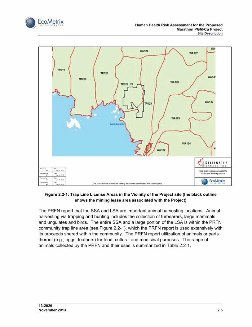
2.2.1.1 Animal Harvesting
As described in the Main EIS Report, there are two registered trap lines in the SSA, one of which is registered to the PRFN and is held in trust for the community, whereas the other is registered to an individual who is a member of the PRFN community. The two trap line permit areas within the boundaries of the Project site (TR022, TR023) are shown in Figure 2.2-1. There is a trapper cabin located in TR023, to the northeast of the Project site, on Pukatawagan Lake. The majority of this trapping currently occurs in close proximity to the Camp 19 and site access roads.
The primary furbearers harvested over two winters on TR023 (2007-08 and 2008-09) were American marten (Martes americana), beaver (Castor canadensis), red fox (Vulpes vulpes), red squirrel (Tamiasciurus hudsonicus), fisher (Martes pennant), Canada lynx (Lynx canadensis) and weasel. In the 1990s, a small number of coyote (Canis latrans) and grey wolf were also harvested from TR023. Beaver are common in the study area with a number of active beaver lodges throughout. A beaver lodge survey was conducted in 2009 identifying 12 active lodges. American marten are the most heavily harvested and most sought after furbearer in the study area. Although harvest numbers cannot be assumed to directly reflect the population, it appears that marten are much more common than some other medium sized furbearers including fisher and Canada lynx.
As indicated in IR 17.2, while the Métis report trapping in the RSA, there are no known Métis traplines in the LSA or SSA.
Human Health Risk Assessment for the Proposed Marathon PGM-Cu Project Site Description
13-2029 November 2013 2.5
Figure 2.2-1: Trap Line License Areas in the Vicinity of the Project site (the black outline
shows the mining lease area associated with the Project)
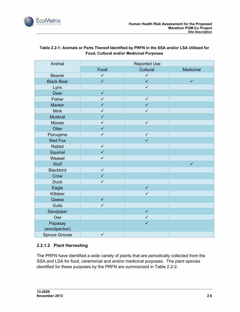
The PRFN report that the SSA and LSA are important animal harvesting locations. Animal harvesting via trapping and hunting includes the collection of furbearers, large mammals and ungulates and birds. The entire SSA and a large portion of the LSA is within the PRFN community trap line area (see Figure 2.2-1), which the PRFN report is used extensively with its proceeds shared within the community. The PRFN report utilization of animals or parts thereof (e.g., eggs, feathers) for food, cultural and medicinal purposes. The range of animals collected by the PRFN and their uses is summarized in Table 2.2-1.
Human Health Risk Assessment for the Proposed Marathon PGM-Cu Project Site Description
13-2029 November 2013 2.6
Table 2.2-1: Animals or Parts Thereof Identified by PRFN in the SSA and/or LSA Utilized for
Food, Cultural and/or Medicinal Purposes
Animal Reported Use Food Cultural Medicinal
Beaver Black Bear
Lynx Deer
Fisher Marten Mink
Muskrat Moose Otter
Porcupine Red Fox Rabbit
Squirrel Weasel
Wolf Blackbird
Crow Duck Eagle
Killdeer Geese Gulls
Sandpiper Owl
Papasay (woodpecker)
Spruce Grouse
2.2.1.2 Plant Harvesting
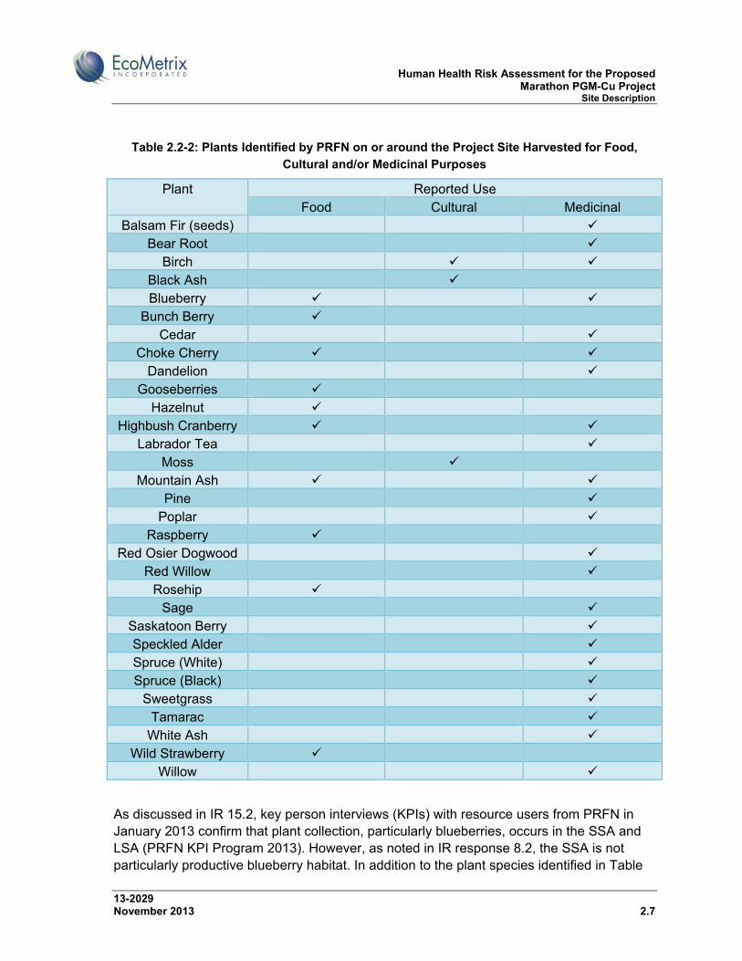
The PRFN have identified a wide variety of plants that are periodically collected from the SSA and LSA for food, ceremonial and and/or medicinal purposes. The plant species identified for these purposes by the PRFN are summarized in Table 2.2-2.
Human Health Risk Assessment for the Proposed Marathon PGM-Cu Project Site Description
13-2029 November 2013 2.7
Table 2.2-2: Plants Identified by PRFN on or around the Project Site Harvested for Food,
Cultural and/or Medicinal Purposes
Plant Reported Use Food Cultural Medicinal
Balsam Fir (seeds) Bear Root
Birch Black Ash Blueberry
Bunch Berry Cedar
Choke Cherry Dandelion
Gooseberries Hazelnut
Highbush Cranberry Labrador Tea
Moss Mountain Ash
Pine Poplar
Raspberry Red Osier Dogwood
Red Willow Rosehip
Sage Saskatoon Berry Speckled Alder Spruce (White) Spruce (Black)
Sweetgrass Tamarac
White Ash Wild Strawberry
Willow
As discussed in IR 15.2, key person interviews (KPIs) with resource users from PRFN in January 2013 confirm that plant collection, particularly blueberries, occurs in the SSA and LSA (PRFN KPI Program 2013). However, as noted in IR response 8.2, the SSA is not particularly productive blueberry habitat. In addition to the plant species identified in Table
Human Health Risk Assessment for the Proposed Marathon PGM-Cu Project Site Description
13-2029 November 2013 2.8
2.2-2, Section 5.11.7.4 of the Main EIS Report indicates that timber is harvested by members of PRFN for firewood and other purposes within the LSA; no specific harvest locations for timber were identified in the SSA.
Reports provided to SCI by the three Métis organizations note that plant collection and use for food, cultural and medicinal purposes is also important to local Métis people. Each organization provided information on plants collected in the RSA, and in the case of the MNO, in the LSA. The MNO report blueberry, raspberry and other berry and edible fruit collection in the RSA and LSA, including along the banks of rivers that flow from areas within the Project claim boundaries. The Métis organizations did not provide SSA-specific plant species information.
2.2.1.3 Fish Harvesting
As described in the Main EIS Report, there is no recreational or Aboriginal fishery in the SSA. Local recreational and Aboriginal fishing activity is focused around the Project site on the Pic River, which contains a variety of coldwater and coolwater fish species, in Bamoos Lake, which has a resident Lake Trout population, and Lake Superior and its tributary streams. Hare Lake does not appear to be actively/regularly fished. The primary large-bodied fish species here include Yellow Perch and Northern Pike.
A number of different fish species are reportedly harvested by PRFN by a variety of means (net, hook, trap) in the general vicinity of the Project site, however the SSA does not provide food fish harvesting opportunities. The waterbodies and connecting channels within the SSA are largely fishless, with resident fish communities where they occur being limited to forage fish such as stickleback. The LSA includes Bamoos Lake, Hare Lake, Hare Creek, Angler Creek (Stream 6), the near shore area of Lake Superior in the vicinity of watercourses that drain the Project site (Hare Creek, Angler Creek [Stream 6]) and the Pic River, and fishing is generally reported by PRFN in these locations. The PRFN have a commercial fish licence for Lake Superior.
Fish species of interest as reported by the PRFN include4: carp (Lake Superior), Lake Trout (Bamoos Lake, Lake Superior), Muskellunge (Pic River), perch (Hare Lake, Lake Superior), Walleye (Pic River, Lake Superior), smelt (Pic River), Brook Trout (Bamoos Lake), Lake Sturgeon (Pic River, Lake Superior), suckers (ubiquitous), whitefish (Bamoos Lake, Lake Superior) and migratory salmonids such as Rainbow Trout, Coho Salmon and Chinook Salmon (Lake Superior, Pic River, Hare Creek, Angler Creek [Stream 6]).
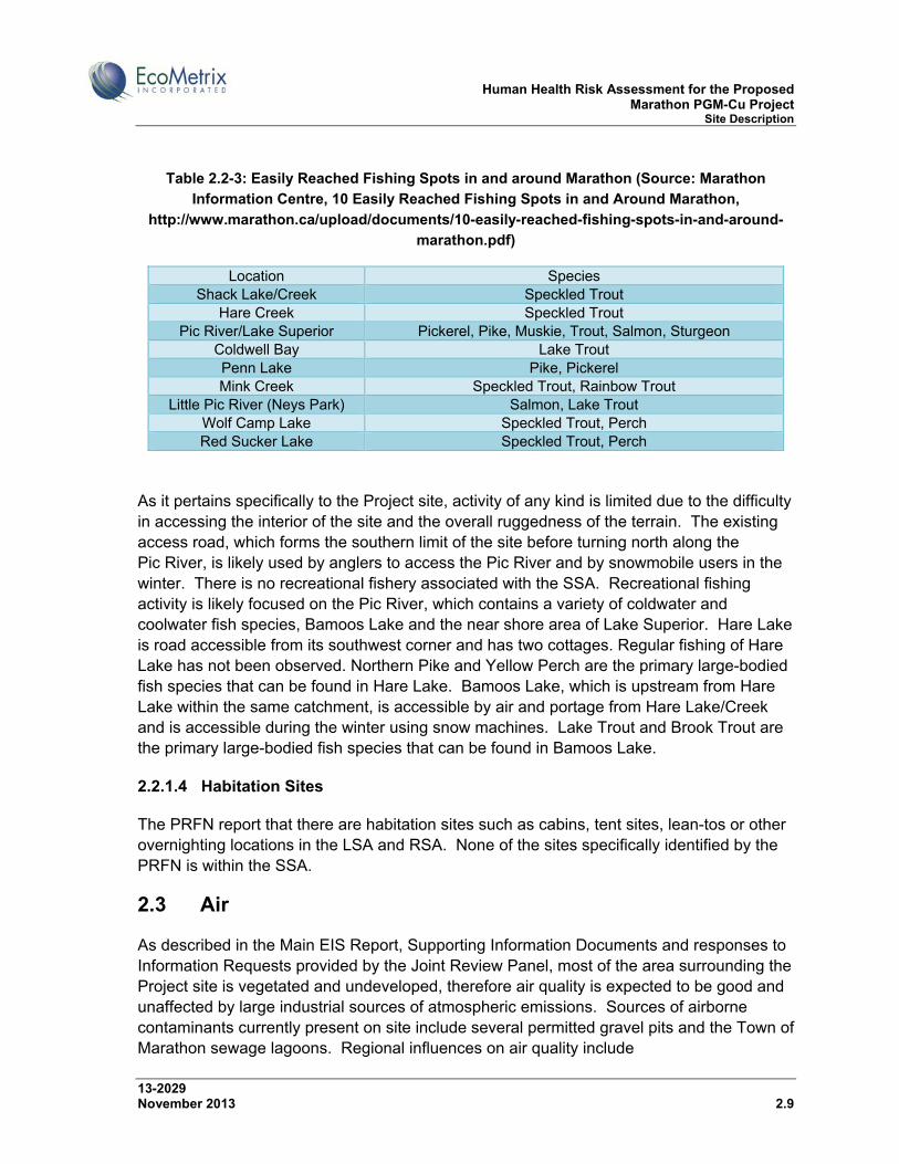
The Marathon Visitors Centre has published a list of ten easily reached fishing spots in and around Marathon. This list is presented in Table 2.2-3 below.
4 Locations of fish in parentheses from SID #1 (EcoMetrix, 2012a) based on baseline program and OMNR data.
Human Health Risk Assessment for the Proposed Marathon PGM-Cu Project Site Description
13-2029 November 2013 2.9
Table 2.2-3: Easily Reached Fishing Spots in and around Marathon (Source: Marathon
Information Centre, 10 Easily Reached Fishing Spots in and Around Marathon,
http://www.marathon.ca/upload/documents/10-easily-reached-fishing-spots-in-and-around-
marathon.pdf)
Location Species Shack Lake/Creek Speckled Trout
Hare Creek Speckled Trout Pic River/Lake Superior Pickerel, Pike, Muskie, Trout, Salmon, Sturgeon
Coldwell Bay Lake Trout Penn Lake Pike, Pickerel Mink Creek Speckled Trout, Rainbow Trout
Little Pic River (Neys Park) Salmon, Lake Trout Wolf Camp Lake Speckled Trout, Perch Red Sucker Lake Speckled Trout, Perch
As it pertains specifically to the Project site, activity of any kind is limited due to the difficulty in accessing the interior of the site and the overall ruggedness of the terrain. The existing access road, which forms the southern limit of the site before turning north along the Pic River, is likely used by anglers to access the Pic River and by snowmobile users in the winter. There is no recreational fishery associated with the SSA. Recreational fishing activity is likely focused on the Pic River, which contains a variety of coldwater and coolwater fish species, Bamoos Lake and the near shore area of Lake Superior. Hare Lake is road accessible from its southwest corner and has two cottages. Regular fishing of Hare Lake has not been observed. Northern Pike and Yellow Perch are the primary large-bodied fish species that can be found in Hare Lake. Bamoos Lake, which is upstream from Hare Lake within the same catchment, is accessible by air and portage from Hare Lake/Creek and is accessible during the winter using snow machines. Lake Trout and Brook Trout are the primary large-bodied fish species that can be found in Bamoos Lake.
2.2.1.4 Habitation Sites
The PRFN report that there are habitation sites such as cabins, tent sites, lean-tos or other overnighting locations in the LSA and RSA. None of the sites specifically identified by the PRFN is within the SSA.
2.3 Air
As described in the Main EIS Report, Supporting Information Documents and responses to Information Requests provided by the Joint Review Panel, most of the area surrounding the Project site is vegetated and undeveloped, therefore air quality is expected to be good and unaffected by large industrial sources of atmospheric emissions. Sources of airborne contaminants currently present on site include several permitted gravel pits and the Town of Marathon sewage lagoons. Regional influences on air quality include
Human Health Risk Assessment for the Proposed Marathon PGM-Cu Project Site Description
13-2029 November 2013 2.10
residential/commercial/ institutional heating from the Town of Marathon, Pic River First Nation and nearby rural properties, fugitive emissions from traffic along Highway 17, fugitive emissions from airport traffic, and fugitive emissions from other nearby industrial sources, such as the Hemlo gold mine.
2.4 Surface Water
The Project site falls entirely within the Lake Superior watershed. A major watershed divide separates the site along a north-south axis, with land to the west of the divide draining to Lake Superior directly and the land to the east of the divide draining to the Pic River and subsequently to Lake Superior at Heron Bay. Figure 2.4-1 provides a subwatershed map showing the six subwatersheds in which mine-related infrastructure is located or into which drainage from mine-related infrastructure reports. Subwatersheds 1, 2, 3 and 8 are tributaries to the Pic River. Subwatersheds 5 and 6 drain directly to Lake Superior. The six subwatersheds draining the mine footprint include:
Stream 1 subwatershed (labeled as sub-basin 101) – area of 4.4 km2; drains the southeast portion of the site, including small portions of the plant area, PSMF and proposed site access road;
Stream 2 subwatershed (labeled as sub-basin 102) – area of 3.5 km2; drains the middle of the eastern half of the site, including the MRSA;
Stream 3 subwatershed (labeled as sub-basin 103) – area of 2.1 km2; drains the middle of the eastern half of the site north of the Stream 2 subwatershed, including the MRSA;
Stream 8 subwatershed (labeled as sub-basin 108) – area of 0.53 km2; drains the northeast portion of the site north of the Stream 3 subwatershed, including a small portion of the MRSA;
Stream 5 subwatershed (labeled as sub-basin 105) – area of 48.3 km2; drains the northwest portion of the site and includes Bamoos Lake and Hare Lake; and
Stream 6 subwatershed (labeled as sub-basin 106) – area of 11.0 km2; drains the southwest portion of the site, including the PSMF.
Watersheds and watercourses within or near the Project site include small streams, ponds and lakes, many of which are maintained by active or inactive beaver dams or debris jams. More detailed descriptions of the features of the subwatersheds are provided in Section 5.4 of the Main EIS Report, SID #1 (EcoMetrix, 2012a), SID #20 (Calder, 2012a) and the response to IR #2.1.
Baseline chemical analysis of surface water showed that Project area waters are generally of high quality, with most parameters meeting Provincial Water Quality Objectives (PWQOs). Where exceedances of PWQOs occur, the exceedances are generally small and typical of regional background conditions.

Human Health Risk Assessment for the Proposed Marathon PGM-Cu Project Site Description
13-2029 November 2013 2.11
Figure 2.4-1: Watersheds Draining the Project Site
Human Health Risk Assessment for the Proposed Marathon PGM-Cu Project Site Description
13-2029 November 2013 2.12
2.5 Groundwater
As described in the Main EIS Report, SID #16 (TGCL, 2012a) and subsequent responses to information requests, groundwater flow generally mimics the surface topography of the site; that is, groundwater enters the system as recharge from precipitation, runoff, and snow melt and leaves the system at discharge zones such as lakes, rivers, creeks and low-lying areas, as well as through evapotranspiration. A groundwater flow model was developed that confirmed that topography strongly controls the water table elevation.
In general, the majority of groundwater flow is expected to occur at a local scale within the upper few tens of metres of the groundwater surface. Infiltration in the uplands is expected to flow through the overburden and upper bedrock to the adjoining ravines and valleys. The very low hydraulic conductivity of bedrock at depth precludes intermediate and regional flow systems from acting as significant contaminant transport pathways or sources of groundwater inflow to pits. Water is interpreted to exit the groundwater flow system almost exclusively as discharge to surface water bodies.
Baseline groundwater quality in both the overburden and bedrock was characterized by hardness, turbidity, iron and manganese concentrations that exceeded the Ontario Drinking Water Quality Standards (ODWQSs), though none of the standards exceeded were related to human health.
2.6 Fisheries
As described in the Main EIS Report, SID #1 (EcoMetrix, 2012a) and subsequent responses to information requests, there is no recreational or Aboriginal fishery in the SSA. Most of the small head water lakes and ponds and their associated connecting channels are fishless, likely because they are topographically isolated from potential source populations. The steep relief isolates the interior of the watershed. Where fish are present on the mine site, they are limited to forage fish species.
The lower reach of the small streams that drain to the Pic River (Streams 2, 3 and 4) provide habitat for some resident species (e.g., sculpin), as well as some nursery habitat for migratory salmonids. Stream 1 is isolated at most times from the Pic River by a perched culvert. Pic River supports a diverse fish community, including Lake Sturgeon.
The Stream 5 subwatershed includes Bamoos Lake, Hare Lake and Hare Creek. Bamoos Lake is to the north of the Project site and has a resident Lake Trout population. Hare Lake is also to the north of the Project site and the primary large-bodied fish here include Northern Pike and Yellow Perch. Hare Creek provides spawning and nursery habitat for migratory salmonids from Lake Superior. Lake-run fish cannot migrate through Hare Creek to Hare Lake because of natural (waterfall) obstructions, the severity of which is likely flow dependent and therefore access to more upstream areas of Hare Creek will vary within and among years.
Human Health Risk Assessment for the Proposed Marathon PGM-Cu Project Site Description
13-2029 November 2013 2.13
Portions of the upper part of the Stream 6 subwatershed have Threespine Stickleback. The lower reach of Stream 6 supports a minor migratory Steelhead run in the spring from Lake Superior but suitable coldwater fish habitat is limited as the channel cuts through a deep, wide sand/clay lens. Fish from Lake Superior cannot move to the middle or upper reaches of Stream 6 because of a natural falls barrier.
2.7 Vegetation
As described in the Main EIS Report, SID #26 (Northern Bioscience, 2012a) and subsequent responses to information requests, over 90% of the area defined by the Project-related claim block and lease areas is forested. Non-forest communities (including wetlands) cover less than 5% of this area. Birch-dominated mixedwood forest makes up about 79% of the study area. Balsam fir, black spruce and white spruce are the most common secondary tree species, usually with a rich understorey of mountain maple, beaked hazel, and other tall shrubs. White birch-black spruce stands on shallow (less than 30 cm) silty soils are common on slopes and tops of low hills. Upland black spruce dominates stands on silty soils occur mainly on deeper glaciolacustrine deposits and make up about 12% of the study area. These stands almost always include balsam fir, white birch and a tall shrub understorey. Black spruce forest on peat is uncommon (total area less than 2 ha) and is confined to a few small bedrock depressions filled with organic soils. Stands dominated by jack pine and trembling aspen are absent in the study area, although these species are generally common in northwestern Ontario. Non-forest communities, which are largely represented by rock barren and wetland ecosites, comprise a relatively small proportion of the Project site.
2.8 Wildlife
As described in the Main EIS Report, SID #26 (Northern Bioscience, 2012a) and subsequent responses to information requests, a total of 18 mammal species were observed either during targeted surveys or incidentally as part of other baseline studies completed between 2007 and 2011. An additional 29 species of mammals potentially occur in the study area. The density and distribution of mammals on the Project site is typical of the region. Species of interest include moose, black bear, grey wolf and various furbearers.
The Project is located in the Boreal Softwood Shield, Ontario Bird Conservation Region 8. A total of 88 bird species were observed in the study area during the 2008-2010 breeding seasons. The species composition and density is typical of a mature mixedwood forest bird community, with a diversity of warblers, thrushes, sparrows and vireos. White-throated Sparrow, Black-throated Green Warbler, and Winter Wren are among the most common. The habitat characterisitics of the study area do not suggest that there is significant overwintering use by birds. Most of the area is boreal forest with no open water most years from November to April. Open fields where wintering raptors congregate are absent. The Project site is not likely a significant migratory corridor for birds or a stopover location.
Human Health Risk Assessment for the Proposed Marathon PGM-Cu Project Problem Formulation
13-2029 November 2013 3.1
3.0 PROBLEM FORMULATION
A human health risk assessment (HHRA) is typically comprised of the following four components:
Problem Formulation;
Exposure Assessment;
Hazard Assessment; and
Risk Characterization.
This section provides the problem formulation which is the framework and methodology for the HHRA and includes the identification of constituents of potential concern (COPCs) and environmental stressors (Section 3.1), human receptors (Section 3.2) and operable exposure pathways (Section 3.3). The problem formulation culminates in the development of the conceptual site model (Section 3.4) which illustrates the potential pathways by which human receptors could be exposed to COPCs related to the Project. The COPCs that exceed appropriate human health-based guidelines and background concentrations and have the potential to affect the health of human receptors through operable exposure pathways were carried forward to the exposure and hazard assessment, and risk characterization.
3.1 Constituents of Potential Concern and Environmental Stressors
Project activities will result in releases to air and surface and ground water. These releases have the potential to influence the quality of environmental media, as well as human health. The screening of predicted air concentrations for the HHRA is presented in Section 3.1.1. The screening of predicted water concentrations for the HHRA is presented in Section 3.1.2. Based on the screening of COPCs, country foods are discussed in Section 3.1.3. The potential effects of noise and EMFs on human health are discussed in Sections 3.1.3 and 3.1.5. The mine is currently in the design phase therefore predicted concentrations of COPCs in the environment resulting from Project activities were used in this assessment. Detailed information on the mathematical models used to predict concentrations of COPCs in the atmospheric and aquatic environment is provided in the Supporting Information Documents (SIDs), as updated and supplemented in responses to Information Requests (IRs) that were prepared in response to the Joint Review Panel’s sufficiency review. The purpose of this section is to screen COPCs and environmental stressors using guidelines protective of human health.
Predicted concentrations of COPCs in air and water during various phases of the Project are compared to appropriate federal and/or provincial screening benchmarks, in addition to baseline concentrations where appropriate. Concentrations of COPCs that are predicted to exceed
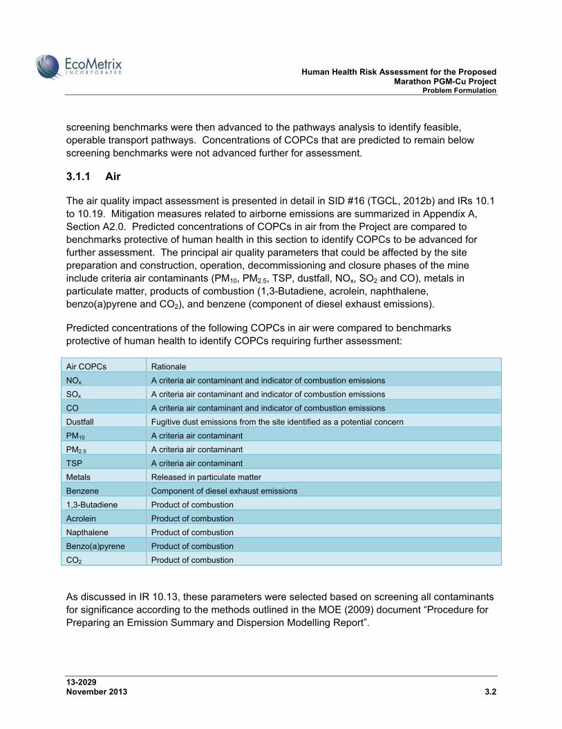
Human Health Risk Assessment for the Proposed Marathon PGM-Cu Project Problem Formulation
13-2029 November 2013 3.2
screening benchmarks were then advanced to the pathways analysis to identify feasible, operable transport pathways. Concentrations of COPCs that are predicted to remain below screening benchmarks were not advanced further for assessment.
3.1.1 Air
The air quality impact assessment is presented in detail in SID #16 (TGCL, 2012b) and IRs 10.1 to 10.19. Mitigation measures related to airborne emissions are summarized in Appendix A, Section A2.0. Predicted concentrations of COPCs in air from the Project are compared to benchmarks protective of human health in this section to identify COPCs to be advanced for further assessment. The principal air quality parameters that could be affected by the site preparation and construction, operation, decommissioning and closure phases of the mine include criteria air contaminants (PM10, PM2.5, TSP, dustfall, NOx, SO2 and CO), metals in particulate matter, products of combustion (1,3-Butadiene, acrolein, naphthalene, benzo(a)pyrene and CO2), and benzene (component of diesel exhaust emissions).
Predicted concentrations of the following COPCs in air were compared to benchmarks protective of human health to identify COPCs requiring further assessment:
Air COPCs Rationale
NOx A criteria air contaminant and indicator of combustion emissions
SOx A criteria air contaminant and indicator of combustion emissions
CO A criteria air contaminant and indicator of combustion emissions
Dustfall Fugitive dust emissions from the site identified as a potential concern
PM10 A criteria air contaminant
PM2.5 A criteria air contaminant
TSP A criteria air contaminant
Metals Released in particulate matter
Benzene Component of diesel exhaust emissions
1,3-Butadiene Product of combustion
Acrolein Product of combustion
Napthalene Product of combustion
Benzo(a)pyrene Product of combustion
CO2 Product of combustion
As discussed in IR 10.13, these parameters were selected based on screening all contaminants for significance according to the methods outlined in the MOE (2009) document “Procedure for Preparing an Emission Summary and Dispersion Modelling Report”.
Human Health Risk Assessment for the Proposed Marathon PGM-Cu Project Problem Formulation
13-2029 November 2013 3.3
The air quality assessment considered sensitive receptors at May’s Gifts, the North Hare Lake Cottage and the South Hare Lake Cottage to evaluate air quality specifically at these locations since they were the closest sensitive receptors to the Project site. A sensitive receptor at the Kingdom Hall Church, in the Town of Marathon, was assessed to evaluate ground-level air concentrations originating from the proposed Marathon rail load-out facility. In addition to these four discrete receptors, ground-level air concentrations were calculated for all of the 15,000 receptors, including the entire property boundary, the majority of the Pic River to the east of the property boundary, and a portion of the Town of Marathon. The receptor grid (105 km2) extended south into the Town of Marathon as far as the former Marathon Pulp property, encompassing the northernmost residentially-zoned areas, Wilson Memorial Hospital, Holy Saviour School, motels along Peninsula Road and several churches. Since Pic River First Nation (PRFN) and the southern limits of the Town of Marathon are farther than the receptors included within the modelling grid, concentrations at PRFN and the southern limits of the Town of Marathon will be lower than any of the modelled concentrations.
Baseline air quality was determined from on-site monitoring and published regional concentrations. A full discussion on baseline air quality is presented in SID #12 (TGCL, 2011a), IR 10.5, IR 10.10.1, and 10.14.
Modelling during site preparation, construction and operations was performed using AERMOD to predict air quality at receptor locations within the modelling boundary. The modelled concentrations are incremental concentrations from the Project. As indicated in SID #16 (TGCL, 2012b), activities conducted during construction and commissioning of the mine (Phase 2) are similar to those that will be carried out during mine decommissioning, although Phase 2 emissions are expected to be greater given the activities that are associated with site preparation, such as drilling and blasting. Given the similarities between the two phases, emissions from Phase 2 were considered a conservative estimate of emissions expected during decommissioning and closure (Phase 4). As a result, no further assessment of Phase 4 emissions was conducted. Additionally, no emissions from the site are expected during post-closure phase of the mine.
The following sections provide the screening of criteria air contaminants, metals and products of combustion in air related to atmospheric releases to the environment from the Project using benchmarks protective of human health. Predicted concentrations of COPCs in air are compared to the selected background and benchmark values. No further evaluation is considered necessary for COPCs that do not exceed natural background and benchmark values.
3.1.1.1 Criteria Air Contaminants
The highest concentrations of criteria air contaminants (CACs) will occur within the SSA since the Project emission sources are either fugitive (e.g., road dust, wind erosion) or result from
Human Health Risk Assessment for the Proposed Marathon PGM-Cu Project Problem Formulation
13-2029 November 2013 3.4
emissions from short stacks. The highest modelled concentrations for suspended particulate matter (PM10, PM2.5, TSP, dustfall) and indicators of combustion emissions (NOx, SO2, CO) on the Project site, at May’s Gift, and the North and South Hare Lake cottages during all phases of the Project are presented in Table 3.1-1 and Table 3.1-2. During operations concentrations are also presented along Peninsula Road since there is the potential that concentrate will be transported to a rail load-out facility in Marathon.
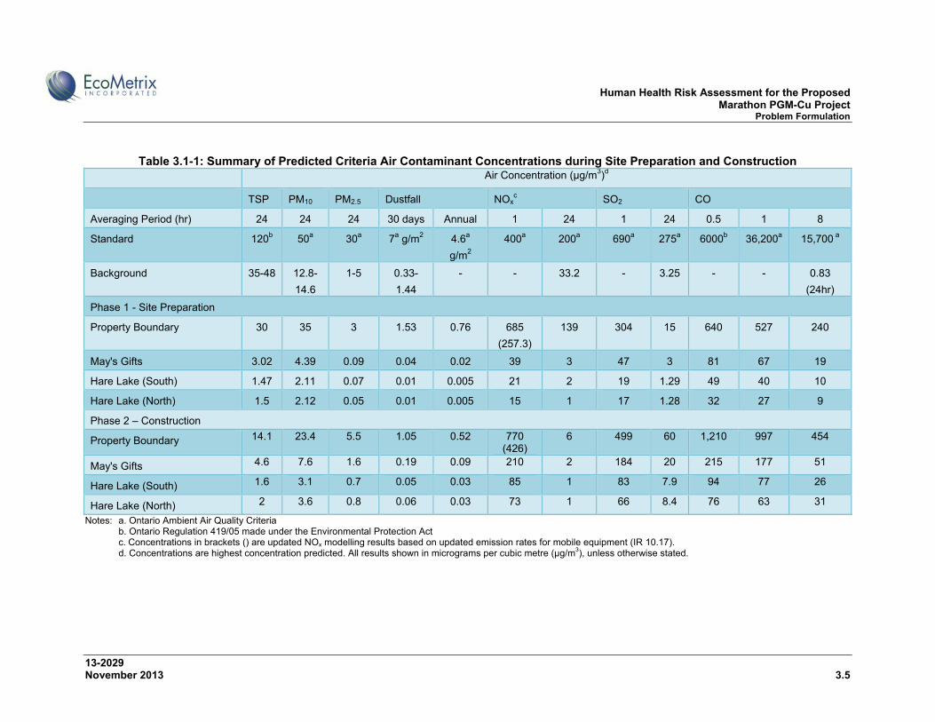
Human Health Risk Assessment for the Proposed Marathon PGM-Cu Project Problem Formulation
13-2029 November 2013 3.5
Table 3.1-1: Summary of Predicted Criteria Air Contaminant Concentrations during Site Preparation and Construction Air Concentration (µg/m3)d
TSP PM10 PM2.5 Dustfall NOxc SO2 CO
Averaging Period (hr) 24 24 24 30 days Annual 1 24 1 24 0.5 1 8
Standard 120b 50a 30a 7a g/m2 4.6a
g/m2
400a 200a 690a 275a 6000b 36,200a 15,700 a
Background 35-48 12.8-
14.6
1-5 0.33-
1.44
- - 33.2 - 3.25 - - 0.83
(24hr)
Phase 1 - Site Preparation
Property Boundary 30 35 3 1.53 0.76 685
(257.3)
139 304 15 640 527 240
May's Gifts 3.02 4.39 0.09 0.04 0.02 39 3 47 3 81 67 19
Hare Lake (South) 1.47 2.11 0.07 0.01 0.005 21 2 19 1.29 49 40 10
Hare Lake (North) 1.5 2.12 0.05 0.01 0.005 15 1 17 1.28 32 27 9
Phase 2 – Construction
Property Boundary 14.1 23.4 5.5 1.05 0.52 770 (426)
6 499 60 1,210 997 454
May's Gifts 4.6 7.6 1.6 0.19 0.09 210 2 184 20 215 177 51
Hare Lake (South) 1.6 3.1 0.7 0.05 0.03 85 1 83 7.9 94 77 26
Hare Lake (North) 2 3.6 0.8 0.06 0.03 73 1 66 8.4 76 63 31
Notes: a. Ontario Ambient Air Quality Criteria b. Ontario Regulation 419/05 made under the Environmental Protection Act c. Concentrations in brackets () are updated NOx modelling results based on updated emission rates for mobile equipment (IR 10.17). d. Concentrations are highest concentration predicted. All results shown in micrograms per cubic metre (µg/m3), unless otherwise stated.
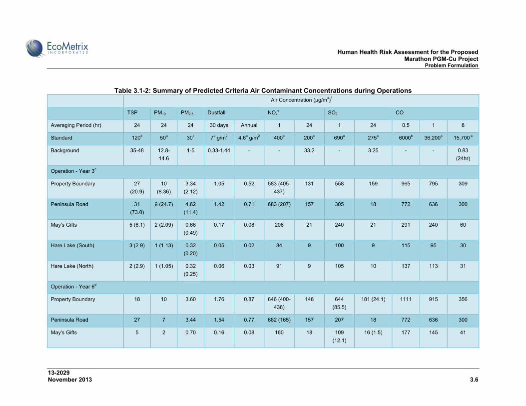
Human Health Risk Assessment for the Proposed Marathon PGM-Cu Project Problem Formulation
13-2029 November 2013 3.6
Table 3.1-2: Summary of Predicted Criteria Air Contaminant Concentrations during Operations Air Concentration (µg/m3)f
TSP PM10 PM2.5 Dustfall NOxe SO2 CO
Averaging Period (hr) 24 24 24 30 days Annual 1 24 1 24 0.5 1 8
Standard 120b 50a 30a 7a g/m2 4.6a g/m2 400a 200a 690a 275a 6000b 36,200a 15,700 a
Background 35-48 12.8-
14.6
1-5 0.33-1.44 - - 33.2 - 3.25 - - 0.83
(24hr)
Operation - Year 3c
Property Boundary 27
(20.9)
10
(8.36)
3.34
(2.12)
1.05 0.52 583 (405-
437)
131 558 159 965 795 309
Peninsula Road 31
(73.0)
9 (24.7) 4.62
(11.4)
1.42 0.71 683 (207) 157 305 18 772 636 300
May's Gifts 5 (6.1) 2 (2.09) 0.66
(0.49)
0.17 0.08 206 21 240 21 291 240 60
Hare Lake (South) 3 (2.9) 1 (1.13) 0.32
(0.20)
0.05 0.02 84 9 100 9 115 95 30
Hare Lake (North) 2 (2.9) 1 (1.05) 0.32
(0.25)
0.06 0.03 91 9 105 10 137 113 31
Operation - Year 6d
Property Boundary 18 10 3.60 1.76 0.87 646 (400-
438)
148 644
(85.5)
181 (24.1) 1111 915 356
Peninsula Road 27 7 3.44 1.54 0.77 682 (165) 157 207 18 772 636 300
May's Gifts 5 2 0.70 0.16 0.08 160 18 109
(12.1)
16 (1.5) 177 145 41
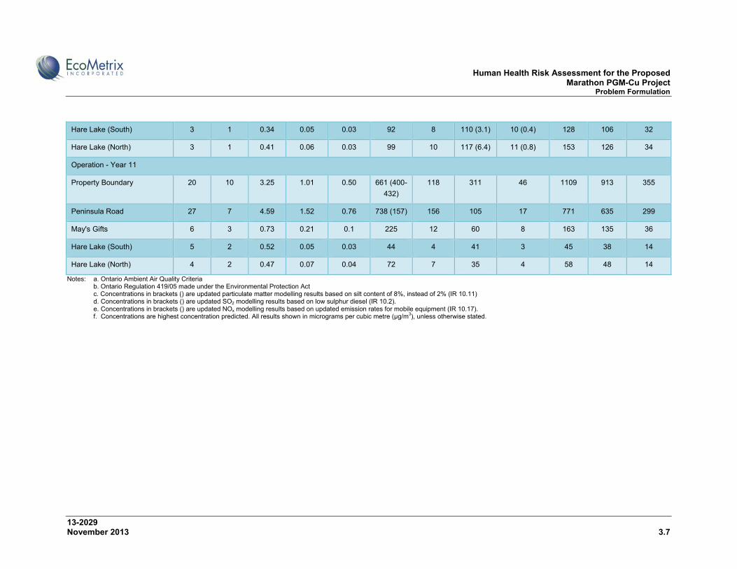
Human Health Risk Assessment for the Proposed Marathon PGM-Cu Project Problem Formulation
13-2029 November 2013 3.7
Hare Lake (South) 3 1 0.34 0.05 0.03 92 8 110 (3.1) 10 (0.4) 128 106 32
Hare Lake (North) 3 1 0.41 0.06 0.03 99 10 117 (6.4) 11 (0.8) 153 126 34
Operation - Year 11
Property Boundary 20 10 3.25 1.01 0.50 661 (400-
432)
118 311 46 1109 913 355
Peninsula Road 27 7 4.59 1.52 0.76 738 (157) 156 105 17 771 635 299
May's Gifts 6 3 0.73 0.21 0.1 225 12 60 8 163 135 36
Hare Lake (South) 5 2 0.52 0.05 0.03 44 4 41 3 45 38 14
Hare Lake (North) 4 2 0.47 0.07 0.04 72 7 35 4 58 48 14
Notes: a. Ontario Ambient Air Quality Criteria b. Ontario Regulation 419/05 made under the Environmental Protection Act c. Concentrations in brackets () are updated particulate matter modelling results based on silt content of 8%, instead of 2% (IR 10.11) d. Concentrations in brackets () are updated SO2 modelling results based on low sulphur diesel (IR 10.2). e. Concentrations in brackets () are updated NOx modelling results based on updated emission rates for mobile equipment (IR 10.17). f. Concentrations are highest concentration predicted. All results shown in micrograms per cubic metre (µg/m3), unless otherwise stated.
Human Health Risk Assessment for the Proposed Marathon PGM-Cu Project Problem Formulation
13-2029 November 2013 3.8
In response to IR 10.11, TGCL remodelled particulate emissions during Year 3 of operations based on a higher silt content (increased to 8% from 2%) for unpaved roads. Year 3 was remodelled since it was originally predicted to produce the highest particulate matter results. These results are presented in Table 3.1-2 in parentheses. In response to IR 10.2, TGCL remodelled SO2 emissions during Year 6 of operations based on use of low sulphur diesel fuel. Year 6 was remodelled since it was originally predicted to produce the highest SO2 emissions.
In response to IR 10.17, TGCL remodelled NOx emissions in accordance with direction provided by the US EPA Office of Air Quality Planning and Standards on NOx emission rates for mobile equipment operating on roads for US EPA AP42 (1995) and based on eliminating receptors within 8 m of the road centreline (the exclusion zone). The updated NOx concentrations are shown in parentheses in Table 3.1-1 and Table 3.1-2.
With the exception of NOx, all predicted CAC concentrations are below applicable criteria. Concentrations for all CACs were compared to AAQCs (MOE, 2012) and O.Reg 419/05. NOx was carried forward for further quantitative assessment in the HHRA.
3.1.1.2 Metals
Maximum air concentrations of metals in particulate during all phases of the Project are presented in Table 3.1-3. Project concentrations (incremental concentrations) were compared against O.Reg 419/05 and AAQCs. Baseline concentrations were 90th percentile data from NAPS for rural properties (Egbert, Point Petre, Burnt Island) from 1989 to 2008, as described in IR 10.10.1. For parameters without these criteria, concentrations were compared against Jurisdictional Screening Levels (JSLs) (MOE, 2008) and MOE (2009) de minimus levels (threshold concentrations). For calcium and magnesium, concentrations were compared against compound-specific effects screening limits (ESLs) obtained from the Texas Commission on Environmental Quality (TCEQ, 2013). ESLs are similar to MOE JSLs in that they are used to evaluate potential for effects to occur as a result of exposure concentrations of the compounds in air. ESLs are based on data concerning health effects, nuisance odours and effects on vegetation. Table 3.1-3 also presents baseline airborne metals concentrations as presented in the response to IR 10.10.1.
All Project-related air concentrations of metals are below their respective air criteria at the property boundary; usually by one to two orders of magnitude, therefore they are not expected to have an impact on human health and were not considered further in this HHRA.
.
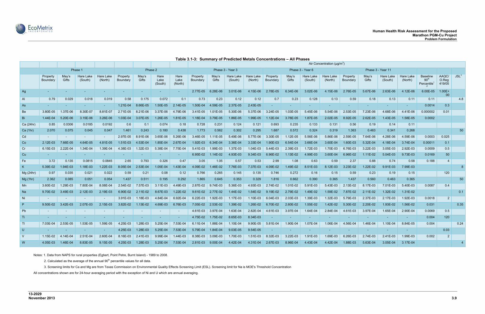
Human Health Risk Assessment for the Proposed Marathon PGM-Cu Project Problem Formulation
13-2029 November 2013 3.9
Table 3.1-3: Summary of Predicted Metals Concentrations – All Phases
Air Concentration (µg/m3)
Phase 1 Phase 2 Phase 3 - Year 3 Phase 3 - Year 6 Phase 3 - Year 11
Property Boundary
May’s Gifts
Hare Lake (South)
Hare Lake (North)
Property Boundary
May’s Gifts
Hare Lake
(South)
Hare Lake
(North)
Property Boundary
May’s Gifts
Hare Lake (South)
Hare Lake (North)
Property Boundary
May’s Gifts
Hare Lake (South)
Hare Lake (North)
Property Boundary
May’s Gifts
Hare Lake (South)
Hare Lake (North)
Baseline 90th
Percentile1
,2
AAQC/O.Reg 419/05
JSL3
Ag - - - - - - - - 2.77E-05 6.28E-06 3.01E-06 4.15E-06 2.78E-05 6.34E-06 3.02E-06 4.15E-06 2.76E-05 5.67E-06 2.63E-06 4.12E-06 6.00E-05 1.00E+00
Al 0.79 0.029 0.018 0.019 0.58 0.175 0.072 0.1 0.73 0.23 0.12 0.12 0.7 0.23 0.128 0.13 0.59 0.18 0.13 0.11 0.11 4.8
As - - - - 1.21E-04 8.66E-05 1.50E-05 2.14E-05 1.50E-04 4.59E-05 2.37E-05 2.43E-05 - - - - - - - - 0.0014 0.3
Be 3.80E-05 1.37E-06 8.30E-07 8.81E-07 2.71E-05 8.21E-06 3.37E-06 4.79E-06 3.41E-05 1.01E-05 5.30E-06 5.37E-06 3.24E-05 1.03E-05 5.45E-06 5.54E-06 2.53E-05 7.23E-06 4.68E-06 4.41E-06 0.000002 0.01
Bi 1.44E-04 5.20E-06 3.15E-06 3.26E-06 1.03E-04 3.07E-05 1.26E-05 1.81E-05 1.18E-04 3.79E-05 1.86E-05 1.99E-05 1.12E-04 3.78E-05 1.87E-05 2.02E-05 8.92E-05 2.62E-05 1.43E-05 1.58E-05 0.0002
Ca (24hr) 0.85 0.0306 0.0185 0.0192 0.6 0.1 0.074 0.18 0.728 0.231 0.124 0.121 0.693 0.235 0.133 0.131 0.56 0.19 0.14 0.11
Ca (1hr) 2.070 0.075 0.045 0.047 1.461 0.243 0.180 0.438 1.773 0.562 0.302 0.295 1.687 0.572 0.324 0.319 1.363 0.463 0.341 0.268 50
Cd - - - - 2.97E-05 8.91E-06 3.65E-06 5.26E-06 3.46E-05 1.11E-05 5.49E-06 5.77E-06 3.30E-05 1.12E-05 5.56E-06 5.86E-06 2.59E-05 7.64E-06 4.28E-06 4.59E-06 0.0003 0.025
Co 2.12E-03 7.66E-05 4.64E-05 4.81E-05 1.51E-03 4.53E-04 1.85E-04 2.67E-04 1.92E-03 6.34E-04 3.36E-04 3.33E-04 1.90E-03 6.54E-04 3.66E-04 3.60E-04 1.60E-03 5.32E-04 4.18E-04 3.74E-04 0.00011 0.1
Cr 6.15E-03 2.22E-04 1.34E-04 1.39E-04 4.38E-03 1.32E-03 5.38E-04 7.75E-04 5.41E-03 1.99E-03 1.37E-03 1.04E-03 5.44E-03 2.39E-03 1.72E-03 1.70E-03 6.76E-03 3.22E-03 3.05E-03 2.92E-03 0.0009 0.5
Cu - - - - - - - - 6.95E-02 1.14E-02 4.93E-03 9.34E-03 6.96E-02 1.13E-02 4.99E-03 3.60E-04 6.96E-02 1.11E-02 5.04E-03 9.73E-03 0.0169 50
Fe 3.72 0.135 0.0815 0.0845 2.65 0.793 0.326 0.47 3.05 1.05 0.57 0.53 2.99 1.08 0.63 0.59 2.37 0.88 0.74 0.58 0.188 4
K 5.39E-02 1.94E-03 1.18E-03 1.22E-03 8.05E-04 2.53E-04 1.05E-04 1.43E-04 4.09E-02 1.46E-02 7.76E-03 7.37E-03 4.09E-02 1.49E-02 8.51E-03 8.12E-03 3.23E-02 1.22E-02 9.91E-03 7.99E-03 8
Mg (24hr) 0.97 0.035 0.021 0.022 0.59 0.21 0.08 0.12 0.766 0.265 0.145 0.135 0.746 0.272 0.16 0.15 0.59 0.23 0.19 0.15 120
Mg (1hr) 2.362 0.085 0.051 0.054 1.437 0.511 0.195 0.292 1.865 0.645 0.353 0.329 1.816 0.662 0.390 0.365 1.437 0.560 0.463 0.365 50
Mn 3.60E-02 1.29E-03 7.80E-04 8.08E-04 2.54E-02 7.57E-03 3.11E-03 4.49E-03 2.87E-02 9.74E-03 5.36E-03 4.93E-03 2.74E-02 1.01E-02 5.91E-03 5.43E-03 2.13E-02 8.17E-03 7.01E-03 5.40E-03 0.0087 0.4
Na 9.70E-02 3.49E-03 2.12E-03 2.19E-03 6.90E-02 2.11E-02 8.67E-03 1.22E-02 9.61E-02 2.77E-02 1.44E-02 1.54E-02 9.19E-02 2.79E-02 1.49E-02 1.59E-02 7.87E-02 2.11E-02 1.32E-02 1.31E-02 0.1
Ni - - - - 3.91E-03 1.18E-03 4.84E-04 6.92E-04 6.22E-03 1.92E-03 1.17E-03 1.10E-03 6.04E-03 2.03E-03 1.39E-03 1.32E-03 5.79E-03 2.37E-03 2.17E-03 1.92E-03 0.0018 2
P 9.50E-02 3.42E-03 2.07E-03 2.15E-03 3.82E-02 1.13E-02 4.69E-03 6.76E-03 7.05E-02 2.53E-02 1.39E-02 1.26E-02 6.70E-02 2.60E-02 1.55E-02 1.42E-02 5.30E-02 2.20E-02 1.93E-02 1.56E-02 0.031 0.35
Pb - - - - - - - - 4.61E-03 3.97E-04 1.63E-04 2.82E-04 4.61E-03 3.97E-04 1.64E-04 2.84E-04 4.61E-03 3.97E-04 1.65E-04 2.90E-04 0.0069 0.5
Ti - - - - - - - - 4.75E-02 1.75E-02 8.65E-03 8.34E-03 - - - - - - - - 0.004 120
Tl 7.03E-04 2.53E-05 1.53E-05 1.59E-05 4.25E-03 1.28E-03 5.25E-04 7.53E-04 6.11E-04 1.88E-04 1.10E-04 9.90E-05 5.81E-04 1.90E-04 1.07E-04 1.06E-04 4.56E-04 1.46E-04 1.10E-04 8.84E-05 0.004 0.24
U - - - - 4.25E-03 1.28E-03 5.25E-04 7.53E-04 5.79E-04 1.84E-04 9.03E-05 9.54E-05 - - - - - - - - 0.03
V 1.15E-02 4.14E-04 2.51E-04 2.60E-04 8.16E-03 2.41E-03 9.99E-04 1.44E-03 8.38E-03 3.09E-03 1.70E-03 1.51E-03 8.32E-03 3.22E-03 1.91E-03 1.69E-03 6.26E-03 2.74E-03 2.41E-03 1.99E-03 0.002 2
W 4.05E-03 1.46E-04 8.83E-05 9.15E-05 4.25E-03 1.28E-03 5.25E-04 7.53E-04 2.81E-03 9.00E-04 4.42E-04 4.31E-04 2.67E-03 8.96E-04 4.43E-04 4.42E-04 1.88E-03 5.63E-04 3.05E-04 3.17E-04 4
Notes: 1. Data from NAPS for rural properties (Egbert, Point Petre, Burnt Island) - 1989 to 2008.
2. Calculated as the average of the annual 90th percentile values for all data.
3. Screening limits for Ca and Mg are from Texas Commission on Environmental Quality Effects Screening Limit (ESL). Screening limit for Na is MOE's Threshold Concentration
All concentrations shown are for 24-hour averaging period with the exception of Ni and U which are annual averaging.

Human Health Risk Assessment for the Proposed Marathon PGM-Cu Project Problem Formulation
13-2029 November 2013 3.10
3.1.1.3 Products of Combustion
Predicted air concentrations during site preparation, construction, and operation, for combustion parameters are presented in Tables 3.1-6 through 3.1-8. Emissions of all benzene, 1,3-butadiene, acrolein, naphthalene, benzo(a)pyrene, and carbon dioxide (CO2) result from the combustion of fuel, either in mobile mine equipment, passenger vehicles, the diesel generator associated with the mobile crushing unit, or the emergency diesel generators.
Predicted concentrations of benzene, acrolein and naphthalene were low and well below applicable O.Reg. 419/05 and AAQC criteria for all phases of mine life, ranging from 0.004% to 3.7% of their respective criteria.
As discussed in IR 10.19, the highest predicted CO2 concentrations at the property boundary occur during the operational life of the mine and range from 159,752 µg/m3 to 162,596 µg/m3 (88 to 90 ppm). These concentrations were above the MOE JSL criteria of 63,000 µg/m3 for a half hour averaging period and 21,000 µg/m3 for a 24 hour averaging period. Predicted concentrations above JSL criteria indicate that results cannot be considered insignificant; however, they are not exceedances of regulatory criteria. Further assessment of CO2 is required to evaluate the significance of the predicted concentrations.
Ambient CO2 concentrations in the environment generally range from about 350 to 450 ppm (or 630,000 to 810,000 µg/m3). Indoor CO2 concentrations typically range from 600 ppm to 800 ppm in well-ventilated occupied buildings and 1,000 ppm in poorly ventilated buildings. From a cumulative effects perspective, ambient CO2 concentrations near the property boundary could therefore range from about 438 to 540 ppm. These concentrations are within the range of values expected in indoor environments (Erdmann et. al., 2002).
Available toxicological data for CO2 reports the potential for adverse health effects in humans, animals and plants at levels greater than 5,000 ppm (US BLM, no date). The US Navy’s continuous exposure guidance level (CEGL) for a 90-day continuous exposure period and NASA’s Spacecraft Maximum Allowable Concentration (SMAC) for a 1,000 day continuous exposure are also 5,000 ppm. The workplace CO2 exposure criterion published by the United States Occupational Safety and Health Administration (OSHA) is 5,000 ppm for an 8 hour work day or a 40-hour work week below which adverse health effects are not expected.
Given that the predicted Project CO2 ground level concentrations and cumulative CO2 concentrations are predicted to be well below levels that are associated with toxicological effects, no adverse effects on human health or the environment are expected. Moreover, predicted CO2 concentrations at the three closest sensitive receptors on Hare Lake and on Highway 17 meet MOE JSL criteria. Since predicted CO2 concentrations remain below levels associated with toxicological effects, and meet MOE JSL criteria at the closest receptors, CO2 was not carried forward for further assessment.

Human Health Risk Assessment for the Proposed Marathon PGM-Cu Project Problem Formulation
13-2029 November 2013 3.11
During all phases of the project, annual emissions of CO2 are a minor contributor to provincial annual emissions and therefore will have a negligible contribution to global warming. For example, during operations the average annual greenhouse gas emissions from the operation of the mine was estimated at 206,026 metricT/yr CO2e (carbon dioxide equivalents). These emissions are considered minor compared to provincial and federal annual GHG CO2e emission rates (0.1% and 0.03%, respectively) (TGCL, 2012b).
Table 3.1-4: Summary of Predicted Combustion Parameter Concentrations for Phase 1 – Site Preparation
Location Maximum Concentration (µg/m3)
Benzene 1,3-Butadiene Acrolein CO2
Averaging Period 24 h 24 h 0.5 h 24 h 0.5 h 24 h
Criteria 2.3b 300c 4.5a 0.4a 63,000d 21,000d
Phase 1 - Site Preparation
Property Boundary 3.31E-02 1.40E-03 9.67E-03 3.27E-03 45,973 15,551
May’s Gifts 4.26E-03 1.22E-04 8.93E-04 3.02E-04 2,421 819
Hare Lake (South) 2.23E-03 7.28E-05 5.23E-04 1.77E-04 1,297 439
Hare Lake (North) 1.86E-03 5.39E-05 3.90E-04 1.32E-04 1,112 376
Notes: a. Ontario MOE - O.Reg 419/05, Schedule 3 standards. b. Ontario Ambient Air Quality Criteria (AAQC). c. Ontario MOE – O.Reg 419/05, Upper Risk Thresholds (URT). d. Ontario Jurisdictional Screening Limits (JSL). Screened out contaminants are not included in this table.
Table 3.1-5: Summary of Predicted Combustion Parameter Concentrations for Phase 2 –
Construction Location Maximum Concentration (µg/m3)
Benzene 1,3-Butadiene Acrolein Naphthalene Benzo(a)pyrene CO2
Averaging Period 24 h 24 h 0.5 h 24 h 24 h Annual 0.5 h 24 h
Criteria 2.3b 300c 4.5a 22.5b 0.005c 63,000a 63,000d 21,000d
Phase 2 – Construction
Property Boundary 2.92E-04 4.16E-05 2.92E-04 9.05E-05 4.29E-06 8.22E-07 43,458 14,700
May’s Gifts 2.70E-04 1.13E-05 7.92E-05 2.46E-05 7.15E-07 1.37E-07 8,012 2,710
Hare Lake (South) 6.60E-05 2.77E-06 1.93E-05 5.99E-06 2.32E-07 4.45E-08 2,764 935
Hare Lake (North) 1.46E-04 6.14E-06 4.29E-05 1.33E-05 3.02E-07 5.79E-08 4,287 1,450
Notes: a. Ontario MOE - O.Reg 419/05, Schedule 3 standards. b. Ontario Ambient Air Quality Criteria (AAQC). c. Ontario MOE – O.Reg 419/05, Upper Risk Thresholds (URT).

Human Health Risk Assessment for the Proposed Marathon PGM-Cu Project Problem Formulation
13-2029 November 2013 3.12
d. Ontario Jurisdictional Screening Limits (JSL). Screened out contaminants are not included in this table.
Table 3.1-6: Summary of Predicted Combustion Parameter Concentrations for Phase 3 –
Operations Location Maximum Concentration (µg/m3)
Benzene Acrolein Naphthalene CO2 24 h 1 h 24 h 24 h 0.5 h 24 h
Criteria 2.3a 4.5a 0.4a 22.5a 63,000b 21,000b
Phase 3 – Year 3
Property Boundary 7.40E-02 2.00E-03 8.20E-04 0.012 162,596 55,000
May’s Gifts 8.60E-03 4.70E-04 1.93E-04 1.42E-03 24,291 8,217
Hare Lake (South) 7.68E-03 2.70E-04 1.11E-04 1.26E-03 6,360 2,151
Hare Lake (North) 1.42E-02 2.75E-04 1.13E-04 2.35E-03 12,651 4,279
Phase 3 – Year 6
Property Boundary 8.49E-02 0.014 5.77E-03 1.42E-02 161,872 54,755
May’s Gifts 1.17E-02 4.21E-04 1.73E-04 1.94E-03 24,185 8,181
Hare Lake (South) 8.16E-03 2.85E-04 1.17E-04 1.34E-03 6,661 2,253
Hare Lake (North) 9.31E-03 2.95E-04 1.21E-04 1.54E-03 12,698 4,295
Phase 3 – Year 11
Property Boundary 2.93E-02 7.04E-03 2.89E-03 -- 159,752 54,038
May’s Gifts 8.87E-03 2.97E-04 1.22E-04 -- 24,144 8,167
Hare Lake (South) 5.77E-03 1.99E-04 8.18E-05 -- 4,586 1,551
Hare Lake (North) 6.65E-03 2.17E-04 8.91E-05 -- 12,253 4,145
Notes: a. Ontario O.Reg. 419/05 (Schedule 3) or AAQC criteria. b. MOE Jurisdictional Screening Limits (JSL). Screened out contaminants are not included in this table
3.1.2 Water
The surface water quality impact assessment is presented in detail in SID #6 (EcoMetrix, 2012f), as updated and supplemented in applicable responses to IRs and SIRs from the JRP. Additional water quality assessments are described in IRs 9.10.2 and 24.15, and SIRs 4 and 5. Mitigation measures related to waterborne emissions are summarized in Appendix A, Section A3.0. Predicted concentrations of COPCs in surface water from the Project were compared to benchmarks protective of aquatic and human health in this section to identify COPCs to be advanced for further assessment. This screening of COPCs was conducted for predicted surface water quality related to surface water releases and groundwater drainage to the surface water receiving environment.
Predicted concentrations of COPCs in surface water were compared to surface water quality benchmarks. The selection of benchmark values is described in SID #6 (EcoMetrix, 2012f).
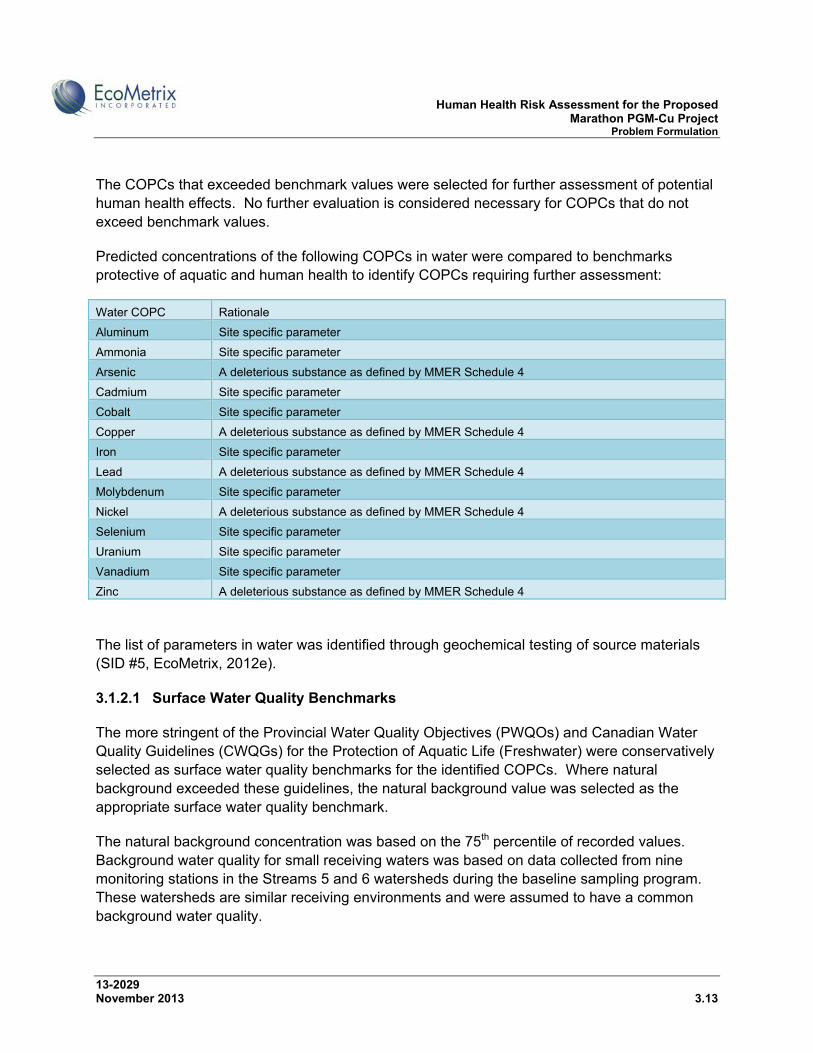
Human Health Risk Assessment for the Proposed Marathon PGM-Cu Project Problem Formulation
13-2029 November 2013 3.13
The COPCs that exceeded benchmark values were selected for further assessment of potential human health effects. No further evaluation is considered necessary for COPCs that do not exceed benchmark values.
Predicted concentrations of the following COPCs in water were compared to benchmarks protective of aquatic and human health to identify COPCs requiring further assessment:
Water COPC Rationale
Aluminum Site specific parameter
Ammonia Site specific parameter
Arsenic A deleterious substance as defined by MMER Schedule 4
Cadmium Site specific parameter
Cobalt Site specific parameter
Copper A deleterious substance as defined by MMER Schedule 4
Iron Site specific parameter
Lead A deleterious substance as defined by MMER Schedule 4
Molybdenum Site specific parameter
Nickel A deleterious substance as defined by MMER Schedule 4
Selenium Site specific parameter
Uranium Site specific parameter
Vanadium Site specific parameter
Zinc A deleterious substance as defined by MMER Schedule 4
The list of parameters in water was identified through geochemical testing of source materials (SID #5, EcoMetrix, 2012e).
3.1.2.1 Surface Water Quality Benchmarks
The more stringent of the Provincial Water Quality Objectives (PWQOs) and Canadian Water Quality Guidelines (CWQGs) for the Protection of Aquatic Life (Freshwater) were conservatively selected as surface water quality benchmarks for the identified COPCs. Where natural background exceeded these guidelines, the natural background value was selected as the appropriate surface water quality benchmark.
The natural background concentration was based on the 75th percentile of recorded values. Background water quality for small receiving waters was based on data collected from nine monitoring stations in the Streams 5 and 6 watersheds during the baseline sampling program. These watersheds are similar receiving environments and were assumed to have a common background water quality.
Human Health Risk Assessment for the Proposed Marathon PGM-Cu Project Problem Formulation
13-2029 November 2013 3.14
Background water quality for the Pic River was based on data collected from four stations on the Pic River—a station upstream of the Project site, two stations adjacent to the Project site, and one station downstream of the Project site during the baseline sampling program.
Further detail regarding the selection of assessment benchmarks is provided in SID #6 (EcoMetrix, 2012f).
The selected surface water quality benchmarks for Streams 5 and 6, and the Pic River are provided in Table 3.1-7 and Table 3.1-8, respectively. The Canadian Water Quality Guidelines for the Protection of Livestock and Health Canada Guidelines for Canadian Drinking Water Quality are also shown in these tables. The Canadian Drinking Water Quality Guidelines are equal to or lower than Ontario Drinking Water Quality Standards for the identified COPCs. The selected surface water quality benchmarks are considered protective of country foods and human health because they are generally more stringent than water quality guidelines for the protection of drinking water and livestock. They are set to be protective of fish and are considered protective of fish consumers because, with the exception of arsenic, the selected benchmarks are less than the US EPA’s national recommended water quality criteria for the protection of human health for consumption of water and fish. Natural background concentrations of arsenic in many surface waters exceed the US EPA criteria for arsenic. The US EPA is currently re-assessing the arsenic criteria.
In summary, the selected surface water quality benchmarks are considered protective of drinking and recreational uses, fish consumption and country foods such as fish and game.
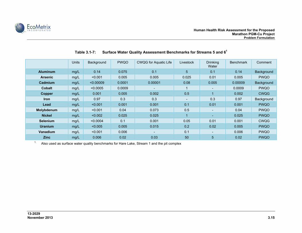
Human Health Risk Assessment for the Proposed Marathon PGM-Cu Project Problem Formulation
13-2029 November 2013 3.15
Table 3.1-7: Surface Water Quality Assessment Benchmarks for Streams 5 and 61
Units Background PWQO CWQG for Aquatic Life Livestock Drinking
Water Benchmark Comment
Aluminum mg/L 0.14 0.075 0.1 5 0.1 0.14 Background
Arsenic mg/L <0.001 0.005 0.005 0.025 0.01 0.005 PWQO
Cadmium mg/L <0.00009 0.0001 0.00001 0.08 0.005 0.00009 Background
Cobalt mg/L <0.0005 0.0009 - 1 - 0.0009 PWQO
Copper mg/L 0.001 0.005 0.002 0.5 1 0.002 CWQG
Iron mg/L 0.97 0.3 0.3 - 0.3 0.97 Background
Lead mg/L <0.001 0.001 0.001 0.1 0.01 0.001 PWQO
Molybdenum mg/L <0.001 0.04 0.073 0.5 - 0.04 PWQO
Nickel mg/L <0.002 0.025 0.025 1 - 0.025 PWQO
Selenium mg/L <0.0004 0.1 0.001 0.05 0.01 0.001 CWQG
Uranium mg/L <0.005 0.005 0.015 0.2 0.02 0.005 PWQO
Vanadium mg/L <0.001 0.006 - 0.1 - 0.006 PWQO
Zinc mg/L 0.006 0.02 0.03 50 5 0.02 PWQO 1. Also used as surface water quality benchmarks for Hare Lake, Stream 1 and the pit complex
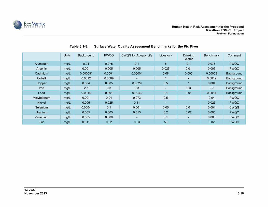
Human Health Risk Assessment for the Proposed Marathon PGM-Cu Project Problem Formulation
13-2029 November 2013 3.16
Table 3.1-8: Surface Water Quality Assessment Benchmarks for the Pic River
Units Background PWQO CWQG for Aquatic Life Livestock Drinking Water
Benchmark Comment
Aluminum mg/L 0.04 0.075 0.1 5 0.1 0.075 PWQO
Arsenic mg/L 0.001 0.005 0.005 0.025 0.01 0.005 PWQO
Cadmium mg/L 0.00009* 0.0001 0.00004 0.08 0.005 0.00009 Background
Cobalt mg/L 0.0012 0.0009 - 1 - 0.0012 Background
Copper mg/L 0.004 0.005 0.0029 0.5 1 0.004 Background
Iron mg/L 2.7 0.3 0.3 - 0.3 2.7 Background
Lead mg/L 0.0014 0.001 0.0043 0.1 0.01 0.0014 Background
Molybdenum mg/L 0.001 0.04 0.073 0.5 - 0.04 PWQO
Nickel mg/L 0.005 0.025 0.11 1 - 0.025 PWQO
Selenium mg/L 0.0004 0.1 0.001 0.05 0.01 0.001 CWQG
Uranium mg/L 0.005 0.005 0.015 0.2 0.02 0.005 PWQO
Vanadium mg/L 0.005 0.006 - 0.1 - 0.006 PWQO
Zinc mg/L 0.011 0.02 0.03 50 5 0.02 PWQO
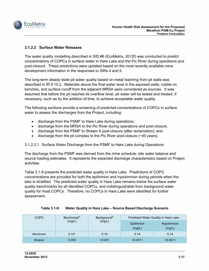
Human Health Risk Assessment for the Proposed Marathon PGM-Cu Project Problem Formulation
13-2029 November 2013 3.17
3.1.2.2 Surface Water Releases
The water quality modelling described in SID #6 (EcoMetrix, 2012f) was conducted to predict concentrations of COPCs in surface water in Hare Lake and the Pic River during operations and post-closure. These predictions were updated based on the most recently available mine development information in the responses to SIRs 4 and 5.
The long-term steady-state pit water quality based on metal leaching from pit walls was described in IR 9.10.2. Materials above the final water level in the exposed walls, rubble on benches, and surface runoff from the adjacent MRSA were considered as sources. It was assumed that before the pit reaches its overflow level, pit water will be tested and treated, if necessary, such as by the addition of lime, to achieve acceptable water quality.
The following sections provide a screening of predicted concentrations of COPCs in surface water to assess the discharges from the Project, including:
discharge from the PSMF to Hare Lake during operations; discharge from the MRSA to the Pic River during operations and post-closure; discharge from the PSMF to Stream 6 post-closure (after reclamation); and discharge from the pit complex to the Pic River post-closure (~40 years).
3.1.2.2.1 Surface Water Discharge from the PSMF to Hare Lake during Operations
The discharge from the PSMF was derived from the mine schedule, site water balance and source loading estimates. It represents the expected discharge characteristics based on Project activities.
Table 3.1-9 presents the predicted water quality in Hare Lake. Predictions of COPC concentrations are provided for both the epilimnion and hypolimnion during periods when the lake is stratified. The predicted water quality in Hare Lake remains below the surface water quality benchmarks for all identified COPCs, and indistinguishable from background water quality for most COPCs. Therefore, no COPCs in Hare Lake were identified for further assessment.
Table 3.1-9: Water Quality in Hare Lake – Source Based Discharge Scenario
COPC Benchmarka
(mg/L) Backgrounda
(mg/L) Predicted Water Quality in Hare Lake
Epilimnion
(mg/L)
Hypolimnion
(mg/L)
Aluminum 0.14* 0.14 0.14 0.14
Arsenic 0.005 <0.001 <0.0011 <0.0011
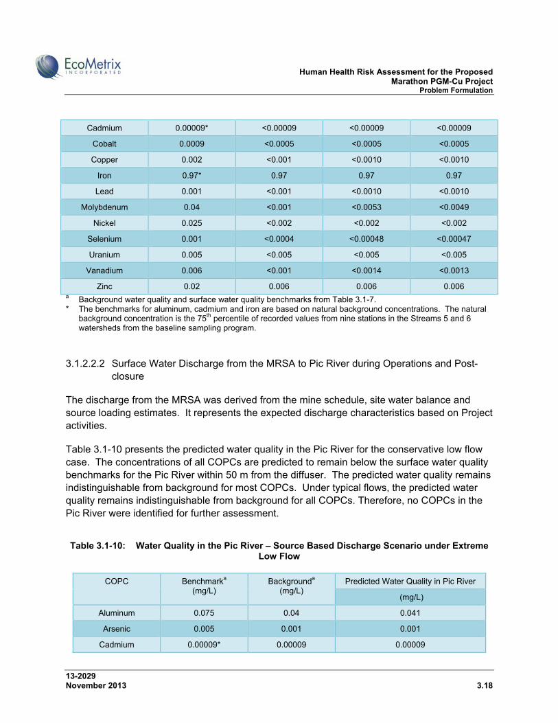
Human Health Risk Assessment for the Proposed Marathon PGM-Cu Project Problem Formulation
13-2029 November 2013 3.18
Cadmium 0.00009* <0.00009 <0.00009 <0.00009
Cobalt 0.0009 <0.0005 <0.0005 <0.0005
Copper 0.002 <0.001 <0.0010 <0.0010
Iron 0.97* 0.97 0.97 0.97
Lead 0.001 <0.001 <0.0010 <0.0010
Molybdenum 0.04 <0.001 <0.0053 <0.0049
Nickel 0.025 <0.002 <0.002 <0.002
Selenium 0.001 <0.0004 <0.00048 <0.00047
Uranium 0.005 <0.005 <0.005 <0.005
Vanadium 0.006 <0.001 <0.0014 <0.0013
Zinc 0.02 0.006 0.006 0.006 a Background water quality and surface water quality benchmarks from Table 3.1-7. * The benchmarks for aluminum, cadmium and iron are based on natural background concentrations. The natural
background concentration is the 75th percentile of recorded values from nine stations in the Streams 5 and 6 watersheds from the baseline sampling program.
3.1.2.2.2 Surface Water Discharge from the MRSA to Pic River during Operations and Post-closure
The discharge from the MRSA was derived from the mine schedule, site water balance and source loading estimates. It represents the expected discharge characteristics based on Project activities.
Table 3.1-10 presents the predicted water quality in the Pic River for the conservative low flow case. The concentrations of all COPCs are predicted to remain below the surface water quality benchmarks for the Pic River within 50 m from the diffuser. The predicted water quality remains indistinguishable from background for most COPCs. Under typical flows, the predicted water quality remains indistinguishable from background for all COPCs. Therefore, no COPCs in the Pic River were identified for further assessment.
Table 3.1-10: Water Quality in the Pic River – Source Based Discharge Scenario under Extreme
Low Flow
COPC Benchmarka (mg/L)
Backgrounda (mg/L)
Predicted Water Quality in Pic River
(mg/L)
Aluminum 0.075 0.04 0.041
Arsenic 0.005 0.001 0.001
Cadmium 0.00009* 0.00009 0.00009

Human Health Risk Assessment for the Proposed Marathon PGM-Cu Project Problem Formulation
13-2029 November 2013 3.19
Cobalt 0.0012* 0.0012 0.0012
Copper 0.004* 0.004 0.004
Iron 2.7* 2.7 2.7
Lead 0.0014* 0.0014 0.0014
Molybdenum 0.04 0.001 0.001
Nickel 0.025 0.005 0.005
Selenium 0.001 0.0004 0.0005
Uranium 0.005 0.005 0.005
Vanadium 0.006 0.005 0.005
Zinc 0.02 0.011 0.011
Notes: a Background water quality and surface water quality benchmarks from Table 3.1-8. * The benchmarks for cadmium, cobalt, copper, iron and lead are based on natural background concentrations.
The natural background concentration is the 75th percentile of recorded values from four stations in the Pic River from the baseline sampling program.
3.1.2.2.3 Surface Water Discharge from the PSMF to Stream 6 Post-closure
After mine closure, the natural flow regime of the Stream 6 subwatershed will be restored. The PSMF will be revegetated and natural stream channels and ponds will be created to collect surface runoff and direct it to the southwest where an outlet structure will be created to link the upper part of the watershed—which is the PSMF—and the lower part of the watershed.
It is expected that the runoff water quality will be similar to existing background conditions once the natural flow regime in the Stream 6 subwatershed has been restored. Subsurface flows from a portion of the PSMF may surface in the upper part of the watershed and may contain trace levels of COPCs from the process solids.
Table 3.1-11 provides predicted surface discharge quality for the PSMF post-closure at two locations:
the outlet of the ponds downstream of the PSMF along Stream 6 above Highway 17 which represents drainage from the PSMF; and
an existing cascade located approximately 1 km upstream from the outlet to Lake Superior.
The cascade impedes the passage of migrating and resident fish to the middle and upper reaches of Stream 6 and limits the fishery to the lower segment of the river. After mine closure and reclamation of the PSMF, there will not be a food fish community within the upper part of
Human Health Risk Assessment for the Proposed Marathon PGM-Cu Project Problem Formulation
13-2029 November 2013 3.20
the Stream 6 watershed, consistent with current conditions. The lower part of Stream 6, below the cascade/waterfall, is the only location where food fishing would be possible.
All COPCs are predicted to be in the range of the existing background concentrations and/or below surface water quality benchmarks at both locations in Stream 6. Therefore, no COPCs in Stream 6 following mine closure were identified for further assessment.

Human Health Risk Assessment for the Proposed Marathon PGM-Cu Project Problem Formulation
13-2029 November 2013 3.21
Table 3.1-11: Predicted Surface Water Discharge Quality from the PSMF Post-Closure
COPC Benchmarka (mg/L)
Canadian Water Quality Guideline for the Protection of Livestock
(mg/L)
Canadian Drinking
Water Quality Guideline
(mg/L)
Backgrounda
(mg/L) Stream 6 Above Hwy 17 Post-
Closure Stream 6 Above Cascade
Post-Closure
Predicted Maximum Concentration
(mg/L)
Predicted Maximum Concentration
(mg/L)
Aluminum 0.14* 5 0.1 0.14 0.14 0.14
Arsenic 0.005 0.025 0.01 <0.001 <0.002 <0.001
Cadmium 0.00009* 0.08 0.005 <0.00009 <0.00009 <0.00009
Cobalt 0.0009 1 - <0.0005 <0.0005 <0.0005
Copper 0.002 0.5 1 0.001 0.0018 0.0014
Iron 0.97* - 0.3 0.97 0.97 0.97
Lead 0.001 0.1 0.01 <0.001 <0.001 <0.001
Molybdenum 0.04 0.5 - <0.001 <0.009 <0.005
Nickel 0.025 1 - <0.002 <0.002 <0.002
Selenium 0.001 0.05 0.01 <0.0004 <0.0008 <0.0006
Uranium 0.005 0.2 0.02 <0.005 <0.005 <0.005
Vanadium 0.006 0.1 - <0.001 <0.003 <0.002
Zinc 0.02 50 5 0.006 0.0061 0.0060
Notes: a Background water quality and surface water quality benchmarks from Table 3.1-7. * The benchmarks for aluminum, cadmium and iron are based on natural background concentrations. The natural background concentration is the 75th
percentile of recorded values from nine stations in the Streams 5 and 6 watersheds from the baseline sampling program.
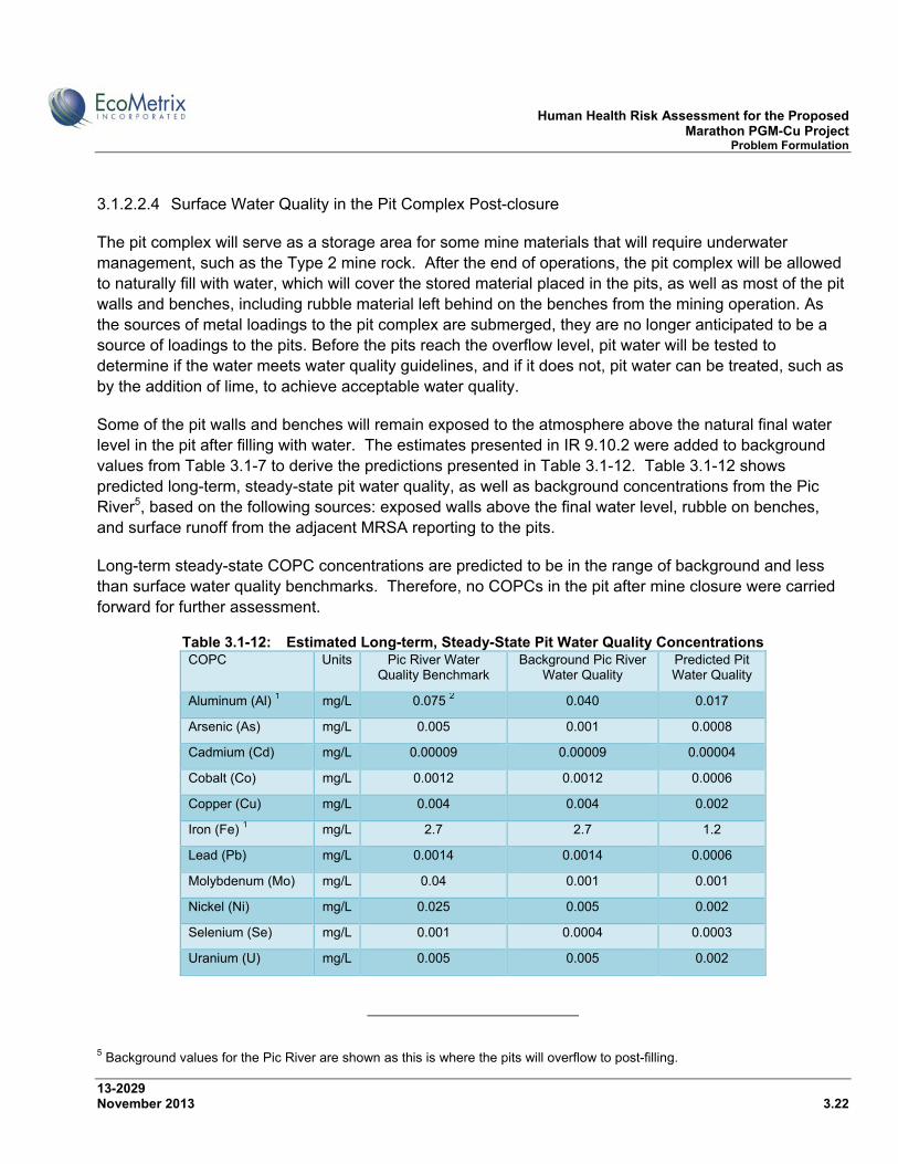
Human Health Risk Assessment for the Proposed Marathon PGM-Cu Project Problem Formulation
13-2029 November 2013 3.22
3.1.2.2.4 Surface Water Quality in the Pit Complex Post-closure
The pit complex will serve as a storage area for some mine materials that will require underwater management, such as the Type 2 mine rock. After the end of operations, the pit complex will be allowed to naturally fill with water, which will cover the stored material placed in the pits, as well as most of the pit walls and benches, including rubble material left behind on the benches from the mining operation. As the sources of metal loadings to the pit complex are submerged, they are no longer anticipated to be a source of loadings to the pits. Before the pits reach the overflow level, pit water will be tested to determine if the water meets water quality guidelines, and if it does not, pit water can be treated, such as by the addition of lime, to achieve acceptable water quality.
Some of the pit walls and benches will remain exposed to the atmosphere above the natural final water level in the pit after filling with water. The estimates presented in IR 9.10.2 were added to background values from Table 3.1-7 to derive the predictions presented in Table 3.1-12. Table 3.1-12 shows predicted long-term, steady-state pit water quality, as well as background concentrations from the Pic River5, based on the following sources: exposed walls above the final water level, rubble on benches, and surface runoff from the adjacent MRSA reporting to the pits.
Long-term steady-state COPC concentrations are predicted to be in the range of background and less than surface water quality benchmarks. Therefore, no COPCs in the pit after mine closure were carried forward for further assessment.
Table 3.1-12: Estimated Long-term, Steady-State Pit Water Quality Concentrations COPC Units Pic River Water
Quality Benchmark Background Pic River
Water Quality Predicted Pit Water Quality
Aluminum (Al) 1 mg/L 0.075 2 0.040 0.017
Arsenic (As) mg/L 0.005 0.001 0.0008
Cadmium (Cd) mg/L 0.00009 0.00009 0.00004
Cobalt (Co) mg/L 0.0012 0.0012 0.0006
Copper (Cu) mg/L 0.004 0.004 0.002
Iron (Fe) 1 mg/L 2.7 2.7 1.2
Lead (Pb) mg/L 0.0014 0.0014 0.0006
Molybdenum (Mo) mg/L 0.04 0.001 0.001
Nickel (Ni) mg/L 0.025 0.005 0.002
Selenium (Se) mg/L 0.001 0.0004 0.0003
Uranium (U) mg/L 0.005 0.005 0.002
5 Background values for the Pic River are shown as this is where the pits will overflow to post-filling.
Human Health Risk Assessment for the Proposed Marathon PGM-Cu Project Problem Formulation
13-2029 November 2013 3.23
Vanadium (V) mg/L 0.006 0.005 0.002
Zinc (Zn) mg/L 0.020 0.011 0.005
Notes: 1. Dependent on geochemical characteristics of solubility and pH control 2. Dissolved concentration
3.1.2.3 Groundwater Releases
Groundwater represents a potential pathway for COPCs from mine components such as the PSMF and MRSA. In response to IR 24.15, predicted groundwater loadings were used to assess the potential effects of groundwater originating from the MRSA and PSMF on the surface water environments. Mass loading rates at the base of the PSMF and MRSA were conservatively assumed to be transported to surface waters without attenuation, dilution or dispersion during groundwater transport.
During operations, loadings from mine components such as the PSMF and MRSA may affect groundwater quality however these loadings are anticipated to be relatively minor. Therefore, rather than assess potential groundwater effects during operations, the overall effects were assessed assuming maximum potential loadings at the end of the operation.
Groundwater discharging from beneath the PSMF is predicted to flow to three subwatersheds:
portion of Cell #2 flows north to the Stream 5 watershed which includes Hare Lake and discharges to Lake Superior;
portions of Cells #1 and #2 flow west to the Stream 6 watershed which flows to Lake Superior; and
portion of Cell #1 flows east to the Stream 1 watershed which flows to the Pic River and eventually discharges to Lake Superior.
The MRSA will be reclaimed and re-graded as necessary to improve drainage. The natural surface water drainages for Streams 2 and 3 will be restored after it has been demonstrated that water quality would be protective of aquatic biota therein. Groundwater discharging from beneath the MRSA is predicted to either flow towards the main pit or the Pic River and its tributaries.
The following sections provide a screening of predicted concentrations of COPCs in surface water resulting from groundwater releases from the Project site, which include:
groundwater discharge from the PSMF to Streams 5, 6 and 1; and groundwater discharge from the MRSA to the Pic River.

Human Health Risk Assessment for the Proposed Marathon PGM-Cu Project Problem Formulation
13-2029 November 2013 3.24
3.1.2.3.1 Groundwater Discharge from the PSMF
Table 3.1-13 provides the predicted water quality in the Stream 5, 6, and 1 subwatersheds, based on PSMF seepage. The estimated seepage from the PSMF typically represents only a small percent increase in concentrations compared to background, indicating that it is unlikely that there will be any measurable impact on surface water quality associated with PSMF seepage. The predictions for surface water quality influenced by groundwater seepage from the PSMF indicate that all COPCs are anticipated to remain within the range of existing background concentrations and/or below their respective water quality benchmarks. Therefore, no COPCs in Streams 5, 6 and 1 were identified for further assessment based on groundwater discharge from beneath the PSMF.

Human Health Risk Assessment for the Proposed Marathon PGM-Cu Project Problem Formulation
13-2029 November 2013 3.25
Table 3.1-13: Predicted Water Quality for Surface Waters Influenced by PSMF Seepage COPC Units Stream 5 and
6 Benchmark Stream 5 Stream 6 Stream 1
Benchmark Stream 1
Background Predicted Background Predicted Background Predicted
Aluminum mg/L 0.14 0.14 0.14 0.14 0.14 0.075 0.040 0.041
Arsenic mg/L 0.0050 <0.0010 0.0010 <0.0010 0.0011 0.0050 <0.0010 0.0010
Cadmium mg/L 0.00009 <0.00009 0.00009 <0.00009 0.00009 0.00009 <0.00009 0.00009
Cobalt mg/L 0.00090 <0.00050 0.00050 <0.00050 0.00051 0.0012 0.0012 0.0012
Copper mg/L 0.0020 0.0010 0.0010 0.0010 0.0010 0.004 0.0040 0.0040
Iron mg/L 0.97 0.97 0.97 0.97 0.97 2.7 2.7 2.7
Lead mg/L 0.0010 <0.0010 0.0010 <0.0010 0.0010 0.0014 0.0014 0.0014
Molybdenum mg/L 0.040 0.0010 0.0015 0.0010 0.0040 0.040 <0.0010 0.0011
Nickel mg/L 0.025 0.0020 0.0020 0.0020 0.0020 0.025 0.0050 0.0050
Selenium mg/L 0.0010 <0.00040 0.00041 <0.00040 0.00047 0.0010 <0.00040 0.00040
Uranium mg/L 0.005 <0.005 0.005 <0.005 0.005 0.005 <0.005 0.005
Vanadium mg/L 0.0060 <0.0010 0.0010 <0.0010 0.0013 0.0060 0.0050 0.0050
Zinc mg/L 0.020 0.0060 0.0060 0.0060 0.0062 0.020 0.011 0.011

Human Health Risk Assessment for the Proposed Marathon PGM-Cu Project Problem Formulation
13-2029 November 2013 3.26
3.1.2.3.2 Groundwater Discharge from the MRSA
Table 3.1-14 provides the average background water quality in the Pic River compared to predicted quality of the Pic River when influenced by conservative predictions of groundwater loadings from the MRSA to surface water. Background water quality for the Pic River was based on data collected from four stations on the Pic River—a station upstream of the Project site, two stations adjacent to the Project site, and one station downstream of the Project site during the baseline sampling program, as summarized in SID #6 (EcoMetrix, 2012f). The background water quality and the predicted water quality are essentially the same, indicating that no measureable impact on Pic River water quality from MRSA groundwater seepage is expected.
The predictions for surface water quality influenced by groundwater seepage from the MRSA indicate that all COPCs are anticipated to remain indistinguishable from background water quality. Therefore, no COPCs in the Pic River were identified for further assessment based on groundwater discharge from beneath the MRSA.
Table 3.1-14: Predicted Water Quality for Pic River Influenced by MRSA Seepage
COPC Benchmarka (mg/L)
Background Pic River Water
Quality (mg/L)
Predicted Pic River Water
Quality (mg/L)
Percent Difference to Background
Aluminum 0.075 0.04 0.040 0.01%
Arsenic 0.005 0.001 0.0010 0.07%
Cadmium 0.00009* 0.00009 0.00009 0.002%
Cobalt 0.0012* 0.0012 0.0012 0.004%
Copper 0.004* 0.004 0.0040 0.007%
Iron 2.7* 2.7 2.7 0.000005%
Lead 0.0014* 0.0014 0.0014 0.001%
Molybdenum 0.04 0.001 0.0010 0.02%
Nickel 0.025 0.005 0.0050 0.003%
Selenium 0.001* 0.0004 0.0004 0.07%
Uranium 0.005 0.005 0.0050 0.002%
Vanadium 0.006 0.005 0.0050 0.01%
Zinc 0.02 0.011 0.011 0.005%
Notes: a Background water quality and surface water quality benchmarks for Pic River from Table 3.1-8. * The benchmarks for cadmium, cobalt, copper, iron, lead, and selenium are based on natural background
concentrations. The natural background concentration used is conservatively the 75th percentile of recorded values from four stations in the Pic River from baseline sampling program.
Human Health Risk Assessment for the Proposed Marathon PGM-Cu Project Problem Formulation
13-2029 November 2013 3.27
3.1.2.4 Drinking Water
It is proposed that potable water will be supplied to the Project site by a groundwater supply and could be supplemented as required by potable water from the Town of Marathon or a bulk water supplier. Groundwater will be pumped to the surface, treated to ensure groundwater quality meets Ontario Drinking Water Quality Standards, and supplied to the site as needed through water distribution works.
The potable water supply well for the Project is proposed to be located within 200 metres of the proposed mine services complex. The proposed mine services complex will be located at the south end of the mill site, just east of satellite pit complex.
The presence of limited overburden and the practicality of running long pipelines for potable water supply through bedrock trenches to the mine services complex do not make it practical to target a supply location substantially further than 200 metres from the proposed mine services complex. At this time, no specific depth has been targeted other than the general plan to seal the well through the overburden and/or upper bedrock and produce water from the deeper bedrock unit. The total depth is anticipated to be on the order of 200 metres but will depend on more detailed study during the permitting process and conditions encountered during drilling.
Groundwater flow pathways from the PSMF and MRSA are expected to generally follow surface water flow. The PSMF is expected to drain to Streams 5, 6 and 1, and the MRSA is expected to drain to the Pic River. Specifically, groundwater discharge from a portion of Cell #2 of the PSMF is expected to surface in Stream 5, groundwater discharge from portions of Cells #1 and #2 is expected to surface in Stream 6, and groundwater discharge from a small portion of Cell #1 is expected to surface in Stream 1.
Given the baseline hydrogeological conditions and location of proposed mine workings, the proposed location of the potable water supply well is expected to be cross- or up-gradient from potential sources of mine-related COPCs and therefore will not be affected by mine-related sources. Therefore, no interaction/pathway between groundwater affected by the Project and the potable water supply for the Project was identified.
The nearest community water supplies are in the Town of Marathon and on the PRFN reserve. There is no connectivity between the groundwater flow paths for the Project site and the Town of Marathon and PRFN groundwater supply wells. The Town of Marathon’s water supply wells are in a different groundwatershed and approximately 6 kilometres from the southern edge of the PSMF; there is no potential for them to be impacted by Project site groundwater. The Project site is outside the area designated by the Town as a groundwater protection zone. PRFN’s water supply wells near Long Lake are located over 15 km from the southern edge of the PSMF and MRSA; there is no potential for them to be impacted by Project site groundwater. There is no foreseeable risk of Project site
Human Health Risk Assessment for the Proposed Marathon PGM-Cu Project Problem Formulation
13-2029 November 2013 3.28
groundwater migrating into the capture zones of the wells in either the Town of Marathon or PRFN.
The groundwater flow modelling (SID #15, TGCL, 2012a) does not predict groundwater originating in the PSMF to flow in the direction towards wells along the highway.
In summary, no interaction/pathway between groundwater affected by the Project and the potable water supply for the Project, Town of Marathon or PRFN or more local wells was identified. Therefore no COPCs in drinking water were carried forward for further assessment.

Human Health Risk Assessment for the Proposed Marathon PGM-Cu Project Problem Formulation
13-2029 November 2013 3.29
3.1.3 Country Foods
No herbicide or pesticide use is anticipated at the mine site or along the proposed transmission line corridor therefore no COPCs related to herbicide or pesticide use were identified for country foods.
No COPCs in soils or terrestrial vegetation were identified as a concern for country foods in relation to air emissions. Predicted air concentrations meet applicable provincial criteria at the property boundary, with the exception of NOx. The predicted exceedances for NOx will not result in accumulation in soils or country foods. Metals in air that could be of potential concern for accumulation in soils and country foods are far below provincial criteria at the property boundary (Table 3.1-3). Iron approaches its AAQC, but is not of potential concern for soils or country foods. Therefore, no Project-related COPCs in country foods were identified in relation to airborne emissions.
No COPCs in country foods were identified in relation to waterborne emissions. The predicted quality of surface waters receiving seepage, impounded water, runoff and effluent discharges from the mine site is expected to remain near background levels and/or meet applicable surface water quality benchmarks, and therefore no adverse effects on country foods or human receptors are anticipated from exposure pathways related to surface water.
Baseline concentrations of COPCs in fish are provided in Appendix B. At this time, fish are the only country foods for which baseline concentrations are available. The analytical results for fish chemistry are presented and discussed in Appendix B. Fish chemistry data for Hare and Bamoos lakes are summarized in Table B-1. As discussed above, no adverse effects on fish or fish consumers are anticipated from the Project based on the comparison of predicted surface water quality to surface water quality benchmarks for the protection of aquatic life and fish consumers.
The comparison of baseline concentrations of mercury in fish and fish consumption guidelines indicates that mercury concentrations in Northern Pike from Hare Lake and Lake Trout from Bamoos Lake are higher than the consumption guideline of 0.26 μg/g for women of child-bearing age and children under 15 years old. The higher mercury levels in Northern Pike and Lake Trout compared to Spottail Shiner and Lake Chub indicate, as expected, that mercury bioaccumulates through the food chain. Restrictions on the consumption of sport fish in the area as the result of mercury levels in bigger, older fish, are common. Information regarding fish consumption restrictions can be found in the Guide to Eating Ontario Sport Fish (OMOE, 2011).
As described in IR 12.10.1, IR 9.3.1 and SID #5, testing of mine-related solids (mine rock, process solids), as well as water generated through the testing of mine-related solids (mill process water samples), has not detected mercury at method detection limits. Mercury loadings to the receiving environment are not anticipated as a result of the extraction or processing of the ore body. As described in IR 12.10.1 and 12.10.2, discharges from the
Human Health Risk Assessment for the Proposed Marathon PGM-Cu Project Problem Formulation
13-2029 November 2013 3.30
Project will be subject to the Metal Mining Effluent Regulation (MMER) and SCI will monitor mercury concentrations in waters receiving mine drainage during operations and during the mine closure phase, as appropriate, as part of the routine surface water quality monitoring program. SCI will also measure sulphate levels and dissolved oxygen levels to monitor conditions that might favour mercury methylation in sediments in Hare Lake. In the event that mercury concentrations in receiving waters or fish tissues increase, an action plan would be developed and implemented to reverse the situation that caused the increase. Different treatment technologies are available to minimize sulphates as required, including chemical treatment, semi-permeable membranes, ion exchange and biological mechanisms.
3.1.4 Noise
The acoustic environment impact assessment as well as a description of the potential noise sources is presented in detail in SID #17 (TGCL, 2012c) and in SIR #1. A summary of the predicted noise impacts for the Project as it relates to human health is presented here. A noise assessment was conducted for the Project that considered noise sensitive receptors (NSRs) in four focus areas, as described below and shown in Figure 3.1-1:
Project site (SSA): The nearest known NSR is a residence and commercial development (May’s Gifts) located on the north side of Hwy 17 approximately 3.4 km southwest of the closest proposed open pit and processing building. Other nearby NSRs include two cottages on the north and south ends of Hare Lake;
Hwy 17 transportation corridor (LSA): NSR include, in addition to May’s Gifts, three motels in the Town of Marathon - the Travelodge Hotel, the Peninsula Inn and the Wayfare Inn;
Town of Marathon transportation corridors (LSA): Peninsula Road is the main arterial road, which is bordered by institutional, commercial, enterprise, light industrial, heavy industrial, rural and residential zones. Peninsula Road may be used for concentrate transport and is currently the significant urban background noise source. NSRs include churches, motels, residences, hospital, and a library; and,
Rail Load-out Facility (LSA and RSA): There are two proposed locations for the rail load-out facility in the Town of Marathon, as well as one in Schreiber (see SIR #1). The closest NSR for both proposed locations in Marathon include the Kingdom Hall church and the Harbour Inn.
The NSRs nearest to the Project site are the north Hare Lake cottage, south Hare Lake cottage, Peninsula Inn, Travelodge Hotel, Wayfare Inn and May’s Gifts. To identify noise effects at the NSRs, the predicted sound levels were compared to provincial noise standards for stationary sources established by the Ontario MOE, the baseline noise conditions as established in the Baseline Noise Report, and traffic noise guidelines
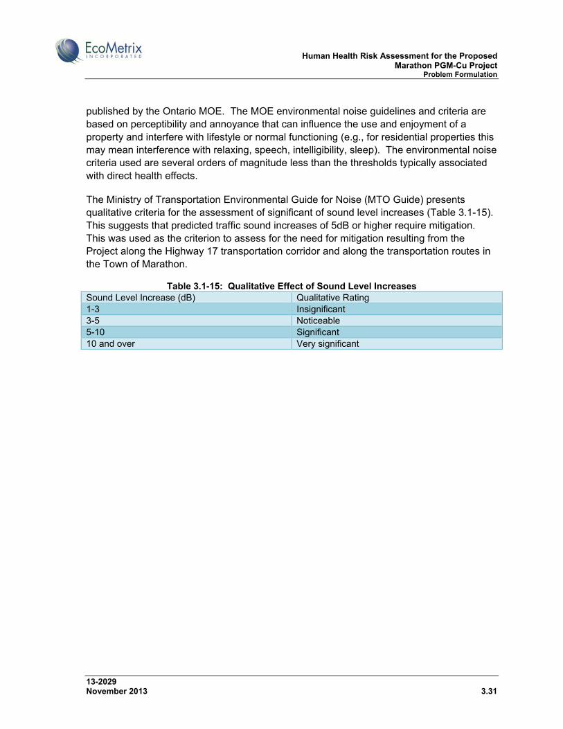
Human Health Risk Assessment for the Proposed Marathon PGM-Cu Project Problem Formulation
13-2029 November 2013 3.31
published by the Ontario MOE. The MOE environmental noise guidelines and criteria are based on perceptibility and annoyance that can influence the use and enjoyment of a property and interfere with lifestyle or normal functioning (e.g., for residential properties this may mean interference with relaxing, speech, intelligibility, sleep). The environmental noise criteria used are several orders of magnitude less than the thresholds typically associated with direct health effects.
The Ministry of Transportation Environmental Guide for Noise (MTO Guide) presents qualitative criteria for the assessment of significant of sound level increases (Table 3.1-15). This suggests that predicted traffic sound increases of 5dB or higher require mitigation. This was used as the criterion to assess for the need for mitigation resulting from the Project along the Highway 17 transportation corridor and along the transportation routes in the Town of Marathon.
Table 3.1-15: Qualitative Effect of Sound Level Increases Sound Level Increase (dB) Qualitative Rating 1-3 Insignificant 3-5 Noticeable 5-10 Significant 10 and over Very significant

Human Health Risk Assessment for the Proposed Marathon PGM-Cu Project Problem Formulation
13-2029 November 2013 3.32
Figure 3.1-1: Noise Sensitive Receptors in the Vicinity of the Marathon PGM-Cu Project Site
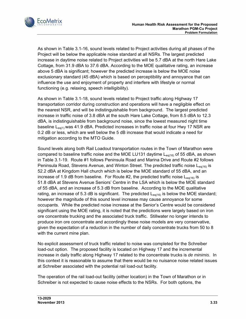
Human Health Risk Assessment for the Proposed Marathon PGM-Cu Project Problem Formulation
13-2029 November 2013 3.33
As shown in Table 3.1-16, sound levels related to Project activities during all phases of the Project will be below the applicable noise standard at all NSRs. The largest predicted increase in daytime noise related to Project activities will be 5.7 dBA at the north Hare Lake Cottage, from 31.9 dBA to 37.6 dBA. According to the MOE qualitative rating, an increase above 5 dBA is significant; however the predicted increase is below the MOE noise exclusionary standard (45 dBA) which is based on perceptibility and annoyance that can influence the use and enjoyment of property and interfere with lifestyle or normal functioning (e.g. relaxing, speech intelligibility).
As shown in Table 3.1-18, sound levels related to Project traffic along Highway 17 transportation corridor during construction and operations will have a negligible effect on the nearest NSR, and will be indistinguishable from background. The largest predicted increase in traffic noise of 3.8 dBA at the south Hare Lake Cottage, from 8.5 dBA to 12.3 dBA, is indistinguishable from background noise, since the lowest measured night time baseline Leq(1) was 41.9 dBA. Predicted increases in traffic noise at four Hwy 17 NSR are 0.2 dB or less, which are well below the 5 dB increase that would indicate a need for mitigation according to the MTO Guide.
Sound levels along both Rail Loadout transportation routes in the Town of Marathon were compared to baseline traffic noise and the MOE LU131 daytime Leq(16) of 55 dBA, as shown in Table 3.1-19. Route #1 follows Peninsula Road and Marina Drive and Route #2 follows Peninsula Road, Stevens Avenue, and Winton Street. The predicted traffic noise Leq(16) is 52.2 dBA at Kingdom Hall church which is below the MOE standard of 55 dBA, and an increase of 1.9 dB from baseline. For Route #2, the predicted traffic noise Leq(16) is 51.8 dBA at Stevens Avenue Seniors’ Centre in the LSA which is below the MOE standard of 55 dBA, and an increase of 5.3 dB from baseline. According to the MOE qualitative rating, an increase of 5.3 dB is significant. The predicted Leq(16) is below the MOE standard; however the magnitude of this sound level increase may cause annoyance for some occupants. While the predicted noise increase at the Senior’s Centre would be considered significant using the MOE rating, it is noted that the predictions were largely based on iron ore concentrate trucking and the associated truck traffic. Stillwater no longer intends to produce iron ore concentrate and accordingly these noise models are very conservative, given the expectation of a reduction in the number of daily concentrate trucks from 50 to 8 with the current mine plan.
No explicit assessment of truck traffic related to noise was completed for the Schreiber load-out option. The proposed facility is located on Highway 17 and the incremental increase in daily traffic along Highway 17 related to the concentrate trucks is de minimis. In this context it is reasonable to assume that there would be no nuisance noise related issues at Schreiber associated with the potential rail load-out facility.
The operation of the rail load-out facility (either location) in the Town of Marathon or in Schreiber is not expected to cause noise effects to the NSRs. For both options, the

Human Health Risk Assessment for the Proposed Marathon PGM-Cu Project Problem Formulation
13-2029 November 2013 3.34
predicted noise levels at the closest NSRs are below the MOE impulsive noise standards (see SIR #1).
Overall, sound levels at NSRs from project activities, the Highway 17 transportation corridor, the Town of Marathon transportation corridor, and the rail load-out facilities in the Town of Marathon and Schreiber are not expected to have an impact on human health, and were not considered further in this HHRA.
Table 3.1-16: Predicted Sound Levels at Noise Sensitive Receptors from Project Activities During the Daytime
Highest Predicted Hourly Leq(1) (dBA) Baseline (Lowest Daytime)
(dBA)
Noise Standard1
(dBA) Location Site Preparation Construction/Operations (All
Years)
May’s Gifts 36.7 46.8 53.4 53.4
Wayfare Inn 36.9 49.1 51.2 51.2
Peninsula Inn
36.5 48.7 52.5 52.5
Travelodge 39.0 43.5 53.9 53.9
North Hare Lake Cottage
25.5 37.6 31.9 45
South Hare Lake Cottage
23.6 33.9 31.2 45
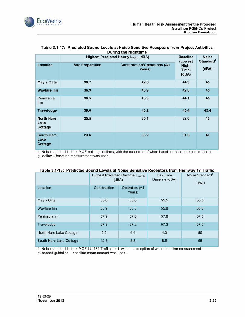
Human Health Risk Assessment for the Proposed Marathon PGM-Cu Project Problem Formulation
13-2029 November 2013 3.35
Table 3.1-17: Predicted Sound Levels at Noise Sensitive Receptors from Project Activities During the Nighttime
Highest Predicted Hourly Leq(1) (dBA) Baseline (Lowest
Night Time) (dBA)
Noise Standard1
(dBA) Location Site Preparation Construction/Operations (All
Years)
May’s Gifts 36.7 42.6 44.9 45
Wayfare Inn 36.9 43.9 42.8 45
Peninsula Inn
36.5 43.9 44.1 45
Travelodge 39.0 43.2 45.4 45.4
North Hare Lake Cottage
25.5 35.1 32.0 40
South Hare Lake Cottage
23.6 33.2 31.6 40
1. Noise standard is from MOE noise guidelines, with the exception of when baseline measurement exceeded guideline – baseline measurement was used. Table 3.1-18: Predicted Sound Levels at Noise Sensitive Receptors from Highway 17 Traffic
Highest Predicted Daytime Leq(16) (dBA)
Day Time Baseline (dBA)
Noise Standard1
(dBA) Location Construction Operation (All
Years)
May’s Gifts 55.6 55.6 55.5 55.5
Wayfare Inn 55.9 55.8 55.8 55.8
Peninsula Inn 57.9 57.8 57.8 57.8
Travelodge 57.3 57.2 57.2 57.2
North Hare Lake Cottage 5.5 4.4 4.0 55
South Hare Lake Cottage 12.3 8.8 8.5 55
1. Noise standard is from MOE LU 131 Traffic Limit, with the exception of when baseline measurement exceeded guideline – baseline measurement was used.

Human Health Risk Assessment for the Proposed Marathon PGM-Cu Project Problem Formulation
13-2029 November 2013 3.36
Table 3.1-19: Predicted Sound Levels along Possible Concentrate Transport Routes in Marathon
Receptor Location Height (m)
Option 1 – Predicted Daytime
Leq(16) (dBA)
Option 2 – Predicted Daytime
Leq(16) (dBA)
Day Time Baseline
Leq(16) (dBA)
LU 131 Traffic Limit Leq(16) (dBA)
Option 1 - Increase
Over Baseline
(dBA)
Option 2- Increase
Over Baseline
(dBA) Anglican Church
Steven’s Avenue 1.5 52.1 54.2 52.1 55 0.0 2.1
Bayview Apartments
Steven’s Avenue 1.5 48.0 52.3 48.0 55 0.0 4.3
4.5 48.1 52.3 48.1 55 0.0 4.2 6.0 48.4 52.2 48.4 55 0.0 3.8 Senior’s Centre
Steven’s Avenue 1.5 46.5 51.8 46.5 55 0.0 5.3
4.5 48.6 53.1 48.6 55 0.0 4.5 Catholic Church
Steven’s Avenue 1.5 51.8 54.2 51.8 55 0.0 2.4
Condominium North corner of Peninsula Road and Hemlo Drive
1.5 55.3 56.5 55.3 55 0.0 1.2
4.5 54.8 56.1 54.8 55 0.0 1.3 6.0 54.7 56.1 54.7 55 0.0 1.4 Harbour Inn Peninsula Road 1.5 54.5 56.0 54.5 55 0.0 1.5 Hospital Peninsula Road 1.5 55.2 55.8 55.2 55 0.0 0.6 4.5 52.7 53.4 52.7 55 0.0 0.7 Library Peninsula Road 1.5 52.3 52.9 52.3 55 0.0 0.6 4.5 51.7 52.4 51.7 55 0.0 0.7 Pic Motel Peninsula Road 1.5 51.3 51.3 49.8 55 1.5 1.5 Kingdom Hall Church
Peninsula Road 1.5 52.2 51.9 50.3 55 1.9 1.6
Zero-100 Motor Inn
Peninsula Road 1.5 54.9 56.1 54.9 55 0.0 1.2
Residence North corner of Peninsula Road and Industrial Park Road
1.5 57.3 57.3 56.1 55 1.2 1.2
Residence North corner of Peninsula Road and Ontario Street (Across from Hospital)
1.5 57.9 58.6 57.9 55 0.0 0.7
Residence South corner of Peninsula Road and Ontario Street (Across from Hospital)
1.5 61.5 62.2 61.5 55 0.0 0.7
Residence Northeast corner of Ontario Street and Alberta Street
1.5 44.3 45.2 44.3 55 0.0 0.9
Residence North End of Steedman Drive
1.5 40.5 41.3 40.5 55 0.0 0.8
Residence Southwest corner of Sund Cresent and Peninsula Road
1.5 50.0 50.7 50.0 55 0.0 0.7
Residence East corner of Stevens Avenue and Drake Street
1.5 52.0 53.7 52.0 55 0.0 1.7
Residence West side of Whitman Court
1.5 39.8 43.6 39.8 55 0.0 3.8
4.5 40.1 43.4 40.1 55 0.0 3.3

Human Health Risk Assessment for the Proposed Marathon PGM-Cu Project Problem Formulation
13-2029 November 2013 3.37
3.1.4.1 Blasting
Airblast (blast overpressure) and ground vibrations are anticipated during the development of access roads and the open pits. Blast overpressure (airblast) and ground vibration calculations are discussed in the Explotech Engineering Ltd. (Explotech) report Analysis of Blast Vibrations and Overpressure from the proposed Stillwater Marathon PGMC Development, and in IR 11.6.
Given that within consistent media, ground vibrations and overpressure decrease with increasing distance, the analysis focussed on the closest sensitive receptors to the required blasting operations, specifically:
May’s Gifts Residence Peninsula Inn Wayfarer Inn Travelodge Hotel North Hare Lake Cottage South Hare Lake Cottage
For the pit complex, the closest separation distance between required blast and sensitive receptor is approximately 3300m (May’s Gifts Residence). Similarly, for the borrow pit, Process Solids Management Facility (PSMF) and access road blasting, the closest separation distances are 545m (Peninsula Inn), 615m (May’s Gift Residence) and 660m (Wayfare Inn) respectively.
The MOE NPC 119 Guidelines for ground vibration and overpressure are 12.5mm/s and 128dBL respectively for monitored operations. As demonstrated in the Explotech analysis, all ground vibrations and overpressures at the closest sensitive receptors are calculated to be below the NPC guideline limits.
With respect to blast overpressures, the NPC 119 128 dBL guideline limit is equivalent to a 35 km/hr wind. As such, the ultimate effects of a 128 dBL blast overpressure on receptor structures and persons will be effectively the same as a 35 km/hr wind. Wind gusts at this level and above are routinely experienced in the Marathon area. In fact, the potential harm from a cyclical wind pressure is in fact greater than that associated with a transient blast overpressure pulse. While on a calm, windless day, the transient blast overpressure may startle some individuals, this is strictly a nuisance effect.
Most blast consultants and environmental scientists have concluded that adverse health effects from infrequent (< 5 occurrences per day) transient overpressures do not occur below levels of 140 dBL (Hirsch 1968; US Department of Defense 1973; US EPA 1974). There are no scientifically established human health implications correlated to transient blast overpressures at NPC 119 guideline levels. Thousands of quarries and mines operate
Human Health Risk Assessment for the Proposed Marathon PGM-Cu Project Problem Formulation
13-2029 November 2013 3.38
within North America with no documented cases of adverse health effects from periodic blasting on surrounding persons to our knowledge.
For ground vibrations, the threshold of human perception is in the order of 0.15 – 0.2mm/s in more sensitive individuals. This base threshold is intimately dependent on the individual and the ambient vibration levels at the point of reception. It is very common for structures and persons housed therein to routinely be subjected to vibrations well above the NPC 119 guideline limit. Sources of these vibrations include road traffic, air traffic, vibration from adjacent construction and manufacturing facilities, and occupancy influences to name but a few.
Additionally, the human body is routinely subjected to vibrations an order of magnitude higher than the 12.5 mm/s guideline limit through routine activities such as traveling in vehicles.
The NPC 119 guideline limits have been established at sufficiently conservative levels so as to mitigate nuisance effects as opposed to strictly alleviating damage potential. For construction projects in Ontario, the provincial standard limit for blast induced vibrations is 50 mm/s (>40Hz). That is to say that if blasting were required on Highway 17, which runs through the claim and lease boundary, the vibration limit imposed on the construction project would be 50mm/s or a value four (4) times higher than those under NPC 119 guideline limit.
As detailed in the Explotech report, calculated maximum vibration levels over the life of the development are below 3 mm/s or 75% below the guideline of 12.5 mm/s. At the NPC 119 guideline limit, there are no scientifically established human health implications correlated to transient blast vibrations.
Overall, as demonstrated in the Explotech analysis, all ground vibrations and overpressures at the closest sensitive receptors are predicted to be below the NPC guideline limits; therefore, no adverse effects on human health are expected.
3.1.5 Electro-Magnetic Fields
Low frequencies of electric and magnetic fields (EMFs) are produced every time electricity and electrical appliances are used. The EMFs produced from electrical transmission lines also emit extremely low frequencies of EMFs (below 300 Hertz). The EMFs from electrical devices and power lines can cause weak electric currents to flow through the human body. However, these currents are much smaller than those produced naturally by the brain, nerves and heart, and are not associated with any known health risks. Exposure to EMFs is greatest directly underneath the transmission line, but diminishes significantly as distance from the source increases. Health Canada (2010b) and the Federal-Provincial-Territorial Radiation Protection Committee (2008) believe that there is insufficient scientific evidence

Human Health Risk Assessment for the Proposed Marathon PGM-Cu Project Problem Formulation
13-2029 November 2013 3.39
to conclude that exposures to EMFs from power lines cause health problems; therefore no Canadian government guidelines for exposure to EMFs have been set.
As discussed in Section 1.4 of the Main EIS Report, power to the Project site will be provided via a new 115 kV transmission line that will be constructed from a purposefully built junction point on the Marathon-Manitouwadge transmission line located about 4 km northeast of Highway 17, heading south and subsequently east over a distance of about 3.8 km to an electrical substation near the mill site. The width of the transmission corridor will be approximately 30 m.
The new transmission line will not be constructed near residential populations; therefore, residents of the Town of Marathon or the surrounding municipalities are not expected to be exposed to EMFs from the transmission line. Workers may be exposed to EMFs; however, exposure diminishes significantly as distance from the source increases. The magnetic field directly underneath a typical 120 kV transmission line ranges from 2.5 to 3.0 microtesla (25 to 30 milligaus). At 30 m distance from a 120 kV transmission line the magnetic field decreases to 0.16 to 0.26 microtesla (Hydro Quebec, n.d.).
The current Canadian position on EMFs, as articulated by Health Canada (2010b) and the Federal-Provincial-Territorial Radiation Protection Committee (2008), is that there is insufficient scientific evidence to conclude that exposures to EMFs from power lines cause health problems. Further, the closest receptor to the proposed project power line is a cottage on Hare Lake, and it is approximately 2 to 3 km from this line. Therefore, exposure to EMFs as a human health issue was not considered further within this assessment.
3.2 Potential Human Receptors
Three types of human receptors were identified for this human health risk assessment:
Cottager living on Hare Lake; Mine Worker; and Resource user (Aboriginal people and recreational hunters/trappers).
The adult and toddler life-stages for the Cottager and local Resource User were considered. The toddler life-stage was selected as potentially having the highest life-stage exposures due to a low body weight combined with a tendency to put objects in the mouth resulting in inadvertent soil ingestion and dermal contact.
3.2.1 Cottager
The cottager is assumed to reside at Hare Lake year-round and during all phases of the Project. This is a clearly conservative assumption as cottage residents at Hare Lake only reside there on a seasonal basis.
Human Health Risk Assessment for the Proposed Marathon PGM-Cu Project Problem Formulation
13-2029 November 2013 3.40
It is assumed that cottage residents consume local game, fish and plants obtained from in and around Hare Lake. Based on Stillwater communications with one cottage resident, drinking water is obtained from the Town of Marathon, and not from Hare Lake. Water from Hare Lake is assumed to be used for bathing and recreation.
3.2.2 Mine Worker
To represent workers and visitors at the mine site, an adult mine worker was assessed. The mine worker is anticipated to be a 12-hour shift worker and was assumed to reside the other half of the day in local communities. This receptor would be protective of any occasional visitors to the site, construction workers, as well as office workers who spend most of the day indoors.
While on-site, it is assumed that the mine worker spends a significant amount of time outdoors; therefore, the main source of exposure is through inhalation of dust, particulates, and vehicle emissions. It is also assumed that the mine worker would be restricted from consuming any country foods (game, fish and plants) obtained from the site. Drinking water on-site would be obtained from the potable water supply at the mine services complex. Drinking water while residing in local communities would be from their potable water supply.
An employee Accommodations Complex is proposed to be will be built in the Town of Marathon to house construction and possibly some operations employees. The complex is anticipated as a pre-engineered, wood-framed two-storey structure, comprised of individual modular units, with shared bathroom, shower facilities, and common areas. The proposed site for the complex is serviced by Town water and sewer. A preliminary assessment indicates that no upgrades to the Town water and sewer systems to service the site will be necessary as both are well under capacity at the present time. It is currently envisaged that the complex will be available for continued use following the end of the Project. Employees will also be accommodated in three existing motels owned by SCI.
Worker health and safety issues are addressed in SID #19 (TGCL, 2012e).
3.2.3 Resource User
The local resource user represents members of First Nation and other aboriginal communities who may hunt, trap, fish and gather plants in the vicinity of the Project, such as a resident of the PRFN community, or possibly a Métis who lives in Marathon. The local resource user would also be protective of recreational hunters/trappers, who are expected to consume less country foods than First Nation people such as Pic River. Current consumption of traditional country foods by Aboriginal people as reported to SCI is described in Section 2.2.
Human Health Risk Assessment for the Proposed Marathon PGM-Cu Project Problem Formulation
13-2029 November 2013 3.41
3.3 Potential Exposure Pathways
The following exposure routes were considered as potential exposure pathways for human receptors:
Ingestion of water; Dermal contact with water; Ingestion of sediment; Dermal contact with sediment; Inhalation of dust and vapours; Incidental ingestion of soils; Dermal contact with soils; and Ingestion of country foods.
Not all of the exposure routes are applicable to each of the receptor groups.
The Cottager may be exposed to COPCs through incidental ingestion of and dermal contact with soil, ingestion of country foods (plants, game and fish), inhalation of dust and vapours. It is assumed that the cottager receives some exposure from swimming (dermal contact and incidental ingestion of water and sediment). The cottager was assumed to obtain drinking water not influenced by emissions from the mine; therefore, drinking water ingestion was not identified as an operable pathway.
The Mine Worker is expected to be exposed to COPCs mainly through the air inhalation pathway from dust on-site and vapours. The mine worker may also be exposed to COPCs through incidental ingestion of and dermal contact with soil. Since the mine worker is assumed to be restricted from consuming country foods, food ingestion was not identified as an operable pathway. Drinking water on-site is expected to be obtained from outside of the areas of mine influence (as discussed in Section 3.1.2.4); therefore, drinking water ingestion is not considered an operable pathway.
The Resource User is exposed to COPCs mainly through ingestion of country foods: plants (berries, Labrador tea), game (moose, mallard, etc.), and fish. It is assumed that the local resource user consumes a greater amount of country foods from areas in the vicinity of the Project than other potential receptors. The local resource user may receive some exposure from swimming (dermal contact and incidental ingestion of water and sediment) and from inhalation of dust and vapours. The resource user is assumed to obtain drinking water not influenced by emissions from the mine (e.g., from the Pic River reserve, as discussed in Section 3.1.2.4); therefore, drinking water ingestion is not considered an operable pathway.
3.3.1 Pathways Related to Air Emissions
Based on the assessment of air quality, air emissions are not expected to present a significant risk to human health during any phase of the Project. The predicted air quality for
Human Health Risk Assessment for the Proposed Marathon PGM-Cu Project Problem Formulation
13-2029 November 2013 3.42
receptors nearest to the Project, such as those at Hare Lake and May’s Gifts, meets applicable regulatory criteria. Air quality at the PRFN reserve, over 12 km to the south, will be well within applicable regulatory criteria. Predicted concentrations indicate that there will be occasional exceedances of the 1-hour NOx criterion of 400 µg/m3 at the Project boundary, therefore this COPC was carried forward for further assessment.
Metals in particulates are not predicted to exceed applicable regulatory criteria at the Project boundary, therefore no adverse effects on soils, terrestrial plants or wildlife are anticipated and no impacts on human health from the consumption of terrestrial plants or wildlife in the Project area are expected to result because of the Project. (Plant consumption from within the SSA will be minimal both due to access restrictions and because the majority of the SSA will be developed for the Project.) The Ontario air quality standards are designed to be protective of human health and the environment. The health based standards are generally no observed adverse effect levels (NOAELs) or lowest observed adverse effect levels (LOAELs) with uncertainty factors applied. Air standards are protective of the most sensitive receptor (e.g., children, adults, plants, property, or wildlife). Ontario air quality standards for metals consider protection due to indirect pathways resulting from atmospheric deposition, such as exposure from deposition on soil and plants, transfer to the food chain through deposition on crops, and through dermal contact and ingestion of soil. As such, since predicted project-related metal concentrations in particulates are well below their respective criteria, deposition of metals on soil and plants followed by food chain transfer would be considered negligible pathways. Therefore, human health effects due to ingestion of country foods in the vicinity of the Project are not expected.
In summary, pathways related to air emissions from the Project are not expected to present any risk to human health. The only COPC that screened through for further assessment was NOx, based on occasional exceedances of the 1-hour NOx criterion of 400 µg/m3.
3.3.2 Pathways Related to Water Emissions
The Project is not anticipated to adversely affect drinking water quality because no interaction between groundwater affected by the Project and the potable water supply for the Project, Town of Marathon and PRFN is expected.
Based on the assessment of surface water quality described in SID #6, IR 9.10.2, and SIRs 4 and 5 surface water releases from the PSMF and MRSA, and long-term water quality in the pit complex are not expected to present a significant risk to human health and the use of country foods. The predicted surface water quality in Hare Lake (receiving surface water releases from the PSMF) and the Pic River (receiving surface water releases from the MRSA) is expected to remain below applicable surface water quality benchmarks for all identified COPCs, and be indistinguishable from background water quality for most COPCs. The long-term, steady-state pit water quality is predicted to be comparable to background. Post-closure concentrations of COPCs in Stream 6, once natural drainage patterns have

Human Health Risk Assessment for the Proposed Marathon PGM-Cu Project Problem Formulation
13-2029 November 2013 3.43
been restored, are not predicted to exceed water quality guidelines for the protection of aquatic life, livestock or drinking water therefore no adverse effects on wildlife or human receptors are anticipated from exposure pathways related to surface water quality.
Based on the assessment of groundwater releases from the Project, as described in IR 24.15, groundwater releases from the PSMF and MRSA to the surface water environments are not expected to present a significant risk to human health during any phase of the Project. Loadings of COPCs from the PSMF and MRSA were conservatively assumed to be delivered directly to surface waters. The predicted long-term surface water quality of Streams 1, 5 and 6 (downgradient of the PSMF) and the Pic River (downgradient of the MRSA) is expected to remain essentially the same as background water quality for all COPCs.
Adverse effects on surface water quality are not predicted, therefore adverse effects on fish are not anticipated.
Bamoos Lake does not receive drainage from the Project therefore water quality in Bamoos Lake is not anticipated to be affected by the Project. Water quality in Hare Lake, Stream 5 and the Pic River is not predicted to be adversely affected by releases from the mine site. Therefore, any fishery resources in these areas are not expected to be affected by Project-related releases of COPCs and no impacts on human health from fish consumption in the Project area are expected to result because of the Project. Similarly, no impact on aquatic plants and wildlife with linkages to the aquatic environment is expected to result from Project-related releases of COPCs to the surface water environments.
Three Finger Lake, a small lake at the south end of the Project Claim Boundary near the TransCanada Highway, was identified as a location for walleye fishing by local Aboriginal users. This lake is located outside the SSA and LSA for the aquatic environment, and well beyond the influence of the Project. Therefore, no Project-related impacts on human health from fish consumption at Three Finger Lake are anticipated.
No COPCs in surface water were identified for further assessment because no adverse effects on wildlife are anticipated and no impacts on human health from the consumption of wildlife in the Project area are expected to result because of the Project.
In summary, no exposure pathways related to surface water and groundwater releases from the Project were identified as requiring further assessment based on the screening of predicted concentrations of COPCs and identification of operable pathways.
3.3.3 Country Food Pathways
Potential exposure pathways for human receptors from current consumption by Aboriginal people and hunters/trappers of traditional country foods during all phases of the Project were considered.
Human Health Risk Assessment for the Proposed Marathon PGM-Cu Project Problem Formulation
13-2029 November 2013 3.44
No herbicide or pesticide use is anticipated at the mine site or along the transmission line corridor therefore no COPCs in country foods related to herbicide or pesticide use are anticipated during any phase of the Project.
Soils and vegetation are not anticipated to be adversely affected by air emissions because predicted concentrations of particulate matter, metals and PAHs meet applicable provincial criteria during all phases of the Project. Therefore, no COPCs in off-site country foods were identified in relation to air emissions.
The predicted quality of impounded water and surface water receiving seepage, runoff and effluent discharges from the mine site is expected to remain near background levels and/or meet applicable surface water quality benchmarks. Therefore, no COPCs in country foods were identified in relation to waterborne emissions.
In summary, no risks to human health from current consumption by Aboriginal people and hunters/trappers of traditional country foods are anticipated during any phase of the Project.
3.4 Conceptual Site Model
Figure 3.4-1 and Figure 3.4-2 provide conceptual site models for the operations and decommissioning, and post-closure phases, respectively. The conceptual site models show sources of Project emissions, environmental media, biological compartments, exposure routes and receptors. For each receptor type, the potential operable pathways are identified on the figure. An operable exposure pathway consists of a contaminant source, release mechanism, transport mechanism within the relevant environmental medium (or media), point of exposure and exposure route to a receptor. Table 3.4-1 provides the Health Canada problem formulation checklist.
Figure 3.4-1 and Figure 3.4-2 present the potential operable pathways from source to receptor. Incomplete exposure pathways, marked by an ‘x’, indicate that there is no exposure pathway for COPCs to the receptor. Potential exposure pathways, marked by a ‘’, indicate that there is an exposure pathway for COPCs; however, the exposure is considered negligible. Complete exposure pathways marked by a ‘’, indicate that there is an exposure pathway for COPCs that requires further assessment.
The exposure to all COPCs except NOx is considered negligible based on the identification of COPCs, receptors and exposure pathways discussed in Sections 3.1 through 3.3. Predicted air and water quality resulting from emissions from the Project site were compared to appropriate benchmarks protective of human health. Potential receptors and operable exposure pathways were discussed. Potential impacts on human health related to all COPCs except NOx were screened out. Predicted maximum 1-hour concentrations of NOx during construction and operations were carried through to the exposure assessment, hazard assessment, and risk characterization stages.
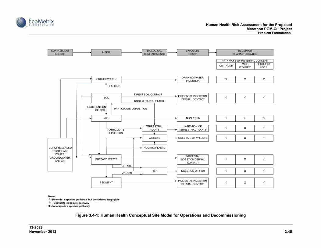
Human Health Risk Assessment for the Proposed Marathon PGM-Cu Project Problem Formulation
13-2029 November 2013 3.45
Figure 3.4-1: Human Health Conceptual Site Model for Operations and Decommissioning
COTTAGERMINE
WORKERRESOURCE
USER
X X X
LEACHING
DIRECT SOIL CONTACT
ROOT UPTAKE/ SPLASH
PARTICULATE DEPOSITION
UPTAKE
UPTAKE
Notes:√ - Potential exposure pathway, but considered negligible√√ - Complete exposure pathwayX - Incomplete exposure pathway
COPCs RELEASED TO SURFACE
WATER, GROUNDWATER,
AND AIR
√√
√
√
√INGESTION OF FISH
INGESTION OF TERRESTRIAL PLANTS
√ √√INHALATION
INCIDENTAL INGESTION/ DERMAL CONTACT
√
FISH
SURFACE WATER
SEDIMENT
INCIDENTAL INGESTION/DERMAL
CONTACT
X
√ X
√ X
√
SOURCE COMPARTMENTS ROUTE
√ √
AIR
SOIL
DRINKING WATER INGESTION
MEDIACONTAMINANT RECEPTOR
CHARACTERIZATION
PATHWAYS OF POTENTIAL CONCERN
BIOLOGICAL EXPOSURE
RESUSPENSION OF SOIL
PARTICULATE DEPOSITION
GROUNDWATER
√INCIDENTAL INGESTION/ DERMAL CONTACT
AQUATIC PLANTS
X √
√ X
√
INGESTION OF WILDLIFEWILDLIFE
TERRESTRIAL PLANTS

Human Health Risk Assessment for the Proposed Marathon PGM-Cu Project Problem Formulation
13-2029 November 2013 3.46
Figure 3.4-2: Human Health Conceptual Site Model after Closure
COTTAGERRESOURCE
USER
X X
LEACHING
DIRECT SOIL CONTACT
ROOT UPTAKE/ SPLASH
PARTICULATE DEPOSITION
UPTAKE
UPTAKE
Notes:√ - Potential exposure pathway, but considered negligible√√ - Complete exposure pathwayX - Incomplete exposure pathway
SEDIMENTINCIDENTAL INGESTION/
DERMAL CONTACT√ √
√
FISH INGESTION OF FISH √ √
WILDLIFE INGESTION OF WILDLIFE √ √
COPCs RELEASED TO SURFACE
WATER, GROUNDWATER,
AND AIR
AQUATIC PLANTS
SURFACE WATERINCIDENTAL
INGESTION/DERMAL CONTACT
√
X
TERRESTRIAL PLANTS
INGESTION OF TERRESTRIAL PLANTS
X X
RESUSPENSION OF SOIL
PARTICULATE DEPOSITION
AIR INHALATION X
PATHWAYS OF POTENTIAL CONCERN
GROUNDWATERDRINKING WATER
INGESTION
SOILINCIDENTAL INGESTION/
DERMAL CONTACTX X
CONTAMINANT MEDIA
BIOLOGICAL EXPOSURE RECEPTORSOURCE COMPARTMENTS ROUTE CHARACTERIZATION
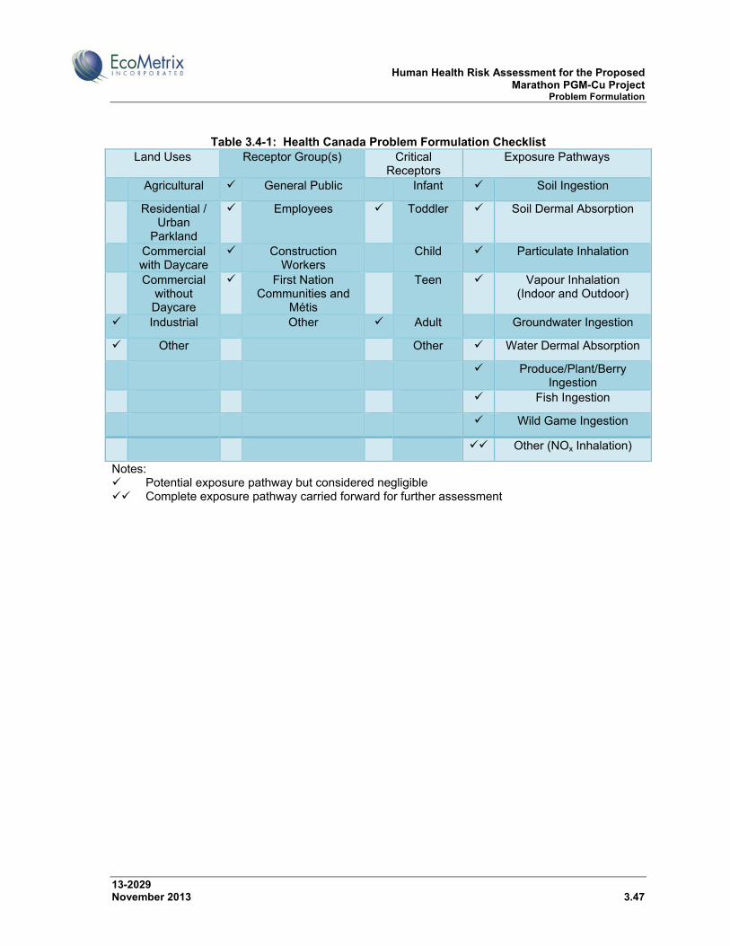
Human Health Risk Assessment for the Proposed Marathon PGM-Cu Project Problem Formulation
13-2029 November 2013 3.47
Table 3.4-1: Health Canada Problem Formulation Checklist Land Uses Receptor Group(s) Critical
Receptors Exposure Pathways
Agricultural General Public Infant Soil Ingestion
Residential / Urban
Parkland
Employees Toddler Soil Dermal Absorption
Commercial with Daycare
Construction Workers
Child Particulate Inhalation
Commercial without Daycare
First Nation Communities and
Métis
Teen Vapour Inhalation (Indoor and Outdoor)
Industrial Other Adult Groundwater Ingestion
Other Other Water Dermal Absorption
Produce/Plant/Berry Ingestion
Fish Ingestion
Wild Game Ingestion
Other (NOx Inhalation)
Notes: Potential exposure pathway but considered negligible Complete exposure pathway carried forward for further assessment
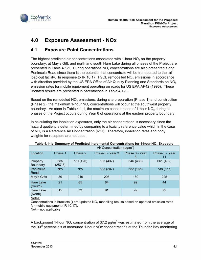
Human Health Risk Assessment for the Proposed Marathon PGM-Cu Project Exposure Assessment
13-2029 November 2013 4.1
4.0 Exposure Assessment - NOx
4.1 Exposure Point Concentrations
The highest predicted air concentrations associated with 1-hour NOx on the property boundary, at May’s Gift, and north and south Hare Lake during all phases of the Project are presented in Table 4.1-1. During operations NOx concentrations are also presented along Peninsula Road since there is the potential that concentrate will be transported to the rail load-out facility. In response to IR 10.17, TGCL remodelled NOx emissions in accordance with direction provided by the US EPA Office of Air Quality Planning and Standards on NOx emission rates for mobile equipment operating on roads for US EPA AP42 (1995). These updated results are presented in parentheses in Table 4.1-1.
Based on the remodeled NOx emissions, during site preparation (Phase 1) and construction (Phase 2), the maximum 1-hour NOx concentrations will occur at the southwest property boundary. As seen in Table 4.1-1, the maximum concentration of 1-hour NOx during all phases of the Project occurs during Year 6 of operations at the eastern property boundary.
In calculating the inhalation exposures, only the air concentration is necessary since the hazard quotient is determined by comparing to a toxicity reference value which in the case of NOx is a Reference Air Concentration (RfC). Therefore, inhalation rates and body weights for receptors are not used.
Table 4.1-1: Summary of Predicted Incremental Concentrations for 1-hour NOx Exposure Air Concentration (µg/m3)
Location Phase 1 Phase 2 Phase 3 - Year 3 Phase 3 - Year 6
Phase 3 - Year 11
Property Boundary
685 (257.3)
770 (426) 583 (437) 646 (438) 661 (432)
Peninsula Road
N/A N/A 683 (207) 682 (165) 738 (157)
May's Gifts 39 210 206 160 225
Hare Lake (South)
21 85 84 92 44
Hare Lake (North)
15 73 91 99 72
Notes: Concentrations in brackets () are updated NOx modelling results based on updated emission rates for mobile equipment (IR 10.17). N/A = not applicable
A background 1-hour NOx concentration of 37.2 µg/m3 was estimated from the average of the 90th percentile’s of measured 1-hour NOx concentrations at the Thunder Bay monitoring
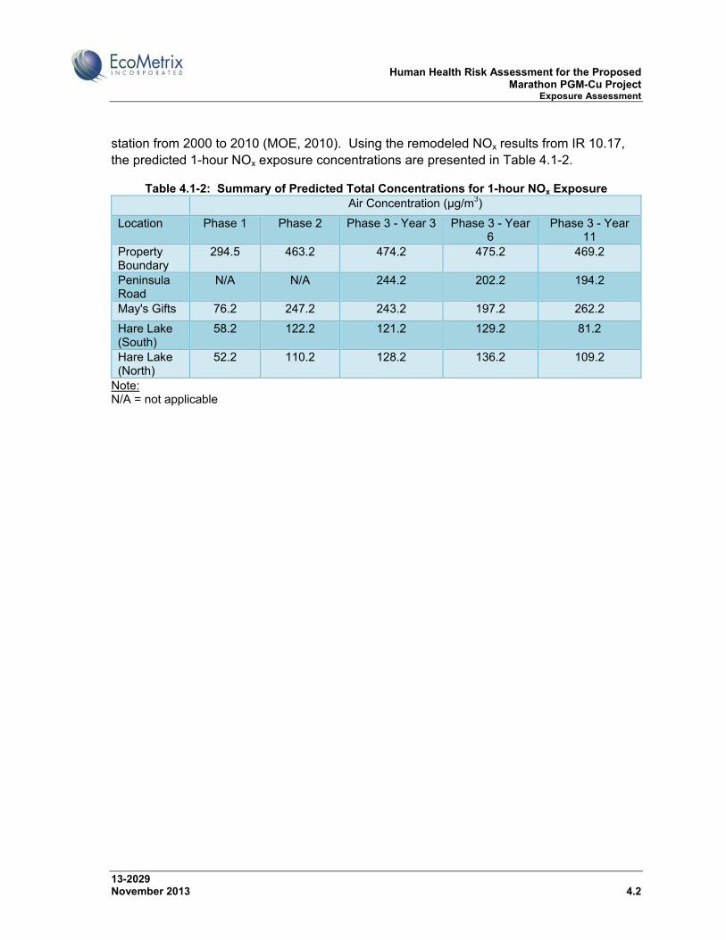
Human Health Risk Assessment for the Proposed Marathon PGM-Cu Project Exposure Assessment
13-2029 November 2013 4.2
station from 2000 to 2010 (MOE, 2010). Using the remodeled NOx results from IR 10.17, the predicted 1-hour NOx exposure concentrations are presented in Table 4.1-2.
Table 4.1-2: Summary of Predicted Total Concentrations for 1-hour NOx Exposure Air Concentration (µg/m3)
Location Phase 1 Phase 2 Phase 3 - Year 3 Phase 3 - Year 6
Phase 3 - Year 11
Property Boundary
294.5 463.2 474.2 475.2 469.2
Peninsula Road
N/A N/A 244.2 202.2 194.2
May's Gifts 76.2 247.2 243.2 197.2 262.2
Hare Lake (South)
58.2 122.2 121.2 129.2 81.2
Hare Lake (North)
52.2 110.2 128.2 136.2 109.2
Note: N/A = not applicable

Human Health Risk Assessment for the Proposed Marathon PGM-Cu Project Hazard Assessment
13-2029 November 2013 5.1
5.0 Hazard Assessment - NOx
5.1 Toxicity Reference Values
The hazard assessment involves identification of Toxicity Reference Values (TRVs) that are used to assess human health effects. The Ontario MOE has established a 1-hour Ambient Air Quality Criteria (AAQC) for NO2 of 400 µg/m3 (Table 5.1-1). This criterion is also the maximum acceptable 1-hour NO2 National Ambient Air Quality Objective (NAAQO). Although, NOx is the sum of nitric oxide (NO) and nitrogen dioxide (NO2), the criterion is based on NO2 since adverse health effects occur from NO2 at lower concentrations than NO.
Table 5.1-1: Toxicity Benchmarks for COPCs COPC Averaging Period TRV (µg/m3) Reference NO2 1-hour 400 MOE (2012)
HC (2006)
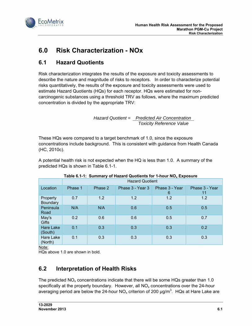
Human Health Risk Assessment for the Proposed Marathon PGM-Cu Project Risk Characterization
13-2029 November 2013 6.1
6.0 Risk Characterization - NOx
6.1 Hazard Quotients
Risk characterization integrates the results of the exposure and toxicity assessments to describe the nature and magnitude of risks to receptors. In order to characterize potential risks quantitatively, the results of the exposure and toxicity assessments were used to estimate Hazard Quotients (HQs) for each receptor. HQs were estimated for non-carcinogenic substances using a threshold TRV as follows, where the maximum predicted concentration is divided by the appropriate TRV:
Hazard Quotient = Predicted Air Concentration
Toxicity Reference Value
These HQs were compared to a target benchmark of 1.0, since the exposure concentrations include background. This is consistent with guidance from Health Canada (HC, 2010c).
A potential health risk is not expected when the HQ is less than 1.0. A summary of the predicted HQs is shown in Table 6.1-1.
Table 6.1-1: Summary of Hazard Quotients for 1-hour NOx Exposure Hazard Quotient
Location Phase 1 Phase 2 Phase 3 - Year 3 Phase 3 - Year 6
Phase 3 - Year 11
Property Boundary
0.7 1.2 1.2 1.2 1.2
Peninsula Road
N/A N/A 0.6 0.5 0.5
May's Gifts
0.2 0.6 0.6 0.5 0.7
Hare Lake (South)
0.1 0.3 0.3 0.3 0.2
Hare Lake (North)
0.1 0.3 0.3 0.3 0.3
Note: HQs above 1.0 are shown in bold.
6.2 Interpretation of Health Risks
The predicted NOx concentrations indicate that there will be some HQs greater than 1.0 specifically at the property boundary. However, all NOx concentrations over the 24-hour averaging period are below the 24-hour NOx criterion of 200 µg/m3. HQs at Hare Lake are

Human Health Risk Assessment for the Proposed Marathon PGM-Cu Project Risk Characterization
13-2029 November 2013 6.2
within the acceptable benchmark, indicating that the Cottager at Hare Lake will not be exposed to unacceptable NOx concentrations throughout the duration of the Project.
The predicted 1-hour NOx exceedances are not considered significant, since they are “worst case” and intermittent both spatially and temporally, occurring at only one or two locations along the property boundary and only approximately 1% of the time (as discussed in more detail below). Modelled concentrations are the highest 1-hour concentration measured over the 43,800 hours modelled, are based on worst-case conditions, and do not represent average or typical concentrations experienced on a regular basis.
Predicted Project related NOx exceedances are related primarily to the use of mobile equipment in the operational areas of the mine (open pit, mill site, MRSA, PSMF). Since these vehicles are not stationary and move from place to place, emissions also move from locations closest to the property boundary to locations farther away, where impacts at the claim boundary will be lower. However, the modelling assumed that all equipment would be run at full capacity coincidentally; therefore, the assessment is considered to be conservative. Meteorological conditions such as wind direction and intensity also play a significant role in predicted air quality.
In the response to IR 10.18, an evaluation of predicted NOx exceedances for all phases of mine life was completed and the results are summarized in Table 6.2-1. The percentage of time that airborne NOx concentrations are predicted to exceed the AAQC criterion on a “worst case” basis is less than 0.3% of the time in Phases 1 and 2, and around 1% during operations (Phase 3).
Table 6.2-1: Evaluation of Predicted NOx Exceedances
Phase of Mine Life % of Total Time Exceeding1, 2 1 0.13% 2 0.28%
3 – Y3 1.05% 3 – Y6 1.12%
3 – Y11 0.82% Notes:
1. Over a total of 43,800 hours modelled (5 years).
2. Results compared to O.Reg. 419/05 NOx criterion of 400 ug/m3 for one-hour averaging.
For this assessment, all NOx emissions were conservatively assumed to be NO2 and all NO2 was assumed to be conserved in the environment – no adjustments were made for the transformation of NO2 into other compounds in the environment due to reaction with ozone or other compounds. This provides further conservatism in the assessment.
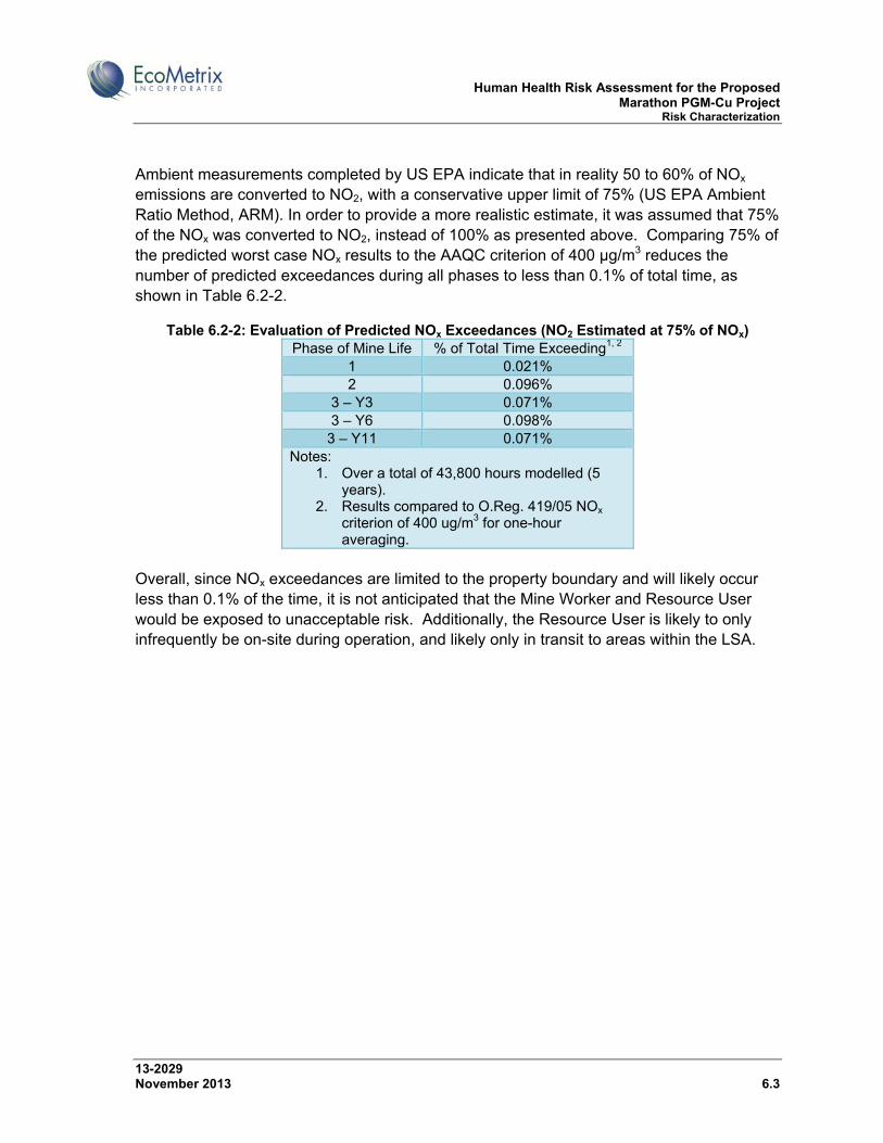
Human Health Risk Assessment for the Proposed Marathon PGM-Cu Project Risk Characterization
13-2029 November 2013 6.3
Ambient measurements completed by US EPA indicate that in reality 50 to 60% of NOx emissions are converted to NO2, with a conservative upper limit of 75% (US EPA Ambient Ratio Method, ARM). In order to provide a more realistic estimate, it was assumed that 75% of the NOx was converted to NO2, instead of 100% as presented above. Comparing 75% of the predicted worst case NOx results to the AAQC criterion of 400 µg/m3 reduces the number of predicted exceedances during all phases to less than 0.1% of total time, as shown in Table 6.2-2.
Table 6.2-2: Evaluation of Predicted NOx Exceedances (NO2 Estimated at 75% of NOx) Phase of Mine Life % of Total Time Exceeding1, 2
1 0.021% 2 0.096%
3 – Y3 0.071% 3 – Y6 0.098%
3 – Y11 0.071% Notes:
1. Over a total of 43,800 hours modelled (5 years).
2. Results compared to O.Reg. 419/05 NOx criterion of 400 ug/m3 for one-hour averaging.
Overall, since NOx exceedances are limited to the property boundary and will likely occur less than 0.1% of the time, it is not anticipated that the Mine Worker and Resource User would be exposed to unacceptable risk. Additionally, the Resource User is likely to only infrequently be on-site during operation, and likely only in transit to areas within the LSA.

Human Health Risk Assessment for the Proposed Marathon PGM-Cu Project Limitations
13-2029 November 2013 7.1
7.0 LIMITATIONS
The information summarized in this HHRA indicates that there will be minimal Project effects on environmental constituent concentrations and therefore on human health, including risks from harvesting country foods. Consultation with the PRFN identified the country foods harvested in the LSA and, in the case of moose, an approximate frequency of consumption. A quantitative site-specific evaluation of risk from country foods would require more detailed information on consumption rates for most food items. SCI will consult further with Pic River First Nation, who are the primary resource users in the Project area, on whether and when such a quantitative evaluation would be useful.
As part of ongoing aquatic environmental effects monitoring (EEM) for the mine during operations, water quality, sediment quality, benthic communities and fish chemistry will be analyzed, and in addition terrestrial environmental monitoring will be undertaken.

Human Health Risk Assessment for the Proposed Marathon PGM-Cu Project Conclusions
13-2029 November 2013 8.1
8.0 CONCLUSIONS
Based on the results of this human health risk assessment, Project-related air quality, water quality, noise and EMFs do not present a human health risk. Regulatory standards which are intended to be protective of ecological and human health will be met. Further, given the site location and setting, the potential exposure pathways to the human receptors identified in the conceptual models are considered negligible. Therefore, no further quantitative assessment of human health risks is required, with the exception of NOx. Predicted air concentrations meet applicable provincial criteria at the property boundary, with the exception of NOx. NOx does not accumulate in soils or country foods. The 1-hour NOx concentrations were carried forward for further quantitative assessment based on occasional predicted exceedances of the 1-hour criterion of 400 µg/m3.
Although the results of the risk characterization for NOx present hazard quotients (HQs) above 1.0 at the property boundary, these exceedances are not considered significant. Exceedances are intermittent both spatially and temporally, occurring at only one or two locations along the entire property boundary and approximately between 0.1% and 1% of the time. Additionally, these results are based on worst-case conditions, and do not represent average concentrations experienced on a regular basis.
HQs at Hare Lake are within the acceptable HQ range (<1), indicating that the Cottager at Hare Lake will not be exposed to unacceptable NOx concentrations throughout the duration of the Project. Since NOx exceedances are limited to the Project site and will likely occur less than 0.1% of the time, it is not anticipated that the Mine Worker and Resource User would be exposed to unacceptable risk. Additionally, the Resource User will infrequently be on site, during situations where guided access is provided by SCI.
No herbicide or pesticide use is anticipated at the mine site or along the proposed transmission line corridor therefore no risks related to herbicide or pesticide use are identified for country foods.
Metals in air that could be of potential concern for accumulation in soils and country foods are far below provincial criteria at the property boundary. Iron approaches its ambient air quality criterion (AAQC), but is not of potential concern for soils or country foods. Therefore, no risks related to consumption of country foods were identified in relation to airborne emissions.
The predicted quality of surface water receiving seepage, impounded water, runoff and effluent discharges from the mine site is generally expected to remain near background levels and/or meet applicable surface water quality guidelines. Therefore, no risks related to consumption of country foods were identified in relation to waterborne emissions.
Human Health Risk Assessment for the Proposed Marathon PGM-Cu Project References
13-2029 November 2013 9.1
9.0 REFERENCES
Erdmann, C., Steiner, K.C., and Apte, M.G. 2002. Indoor Carbon Dioxide Concentrations and Sick Building Syndrome Symptoms in the Base Case Revisited: Analyses of the 100 Building Dataset. Proceedings Indoor Air 2002.
Federal-Provincial-Territorial Radiation Protection Committee. 2008. Response Statement to Public Concerns Regarding Electric and Magnetic Fields (EMFs) from Electrical Power Transmission and Distribution Lines. Retrieved from, http://www.hcsc.gc.ca/ewh-semt/radiation/fpt-radprotect/emf-cem-eng.php
Health Canada. 2006. Regulations Related to Health and Air Quality. National Ambient Air Quality Objectives (NAAQO). Retrieved from http://www.hc-sc.gc.ca/ewh-semt/air/out-ext/reg-eng.php\
Health Canada. 2010a. Useful Information for Environmental Assessments. Retrieved from, http://www.hc-sc.gc.ca/ewh-semt/pubs/eval/environ_assess-eval/index-eng.php
Health Canada. 2010b. Electric and Magnetic Fields at Extremely Low Frequencies. Retrieved from, http://www.hcsc.gc.ca/hl-vs/iyh-vsv/environ/magnet-eng.php
Health Canada. 2010c. Part I: Guidance on Human Health Preliminary Quantitative Risk Assessment (PQRA). Version 2.0. September.
Hydro Quebec. n.d. Electric and Magnetic Fields Sources and Intensity. Retrieved from, http://www.hydroquebec.com/sustainable-development/champs/force.html
OMOE (Ontario Ministry of the Environment). 1995a. Sound Level Limits for Stationary Sources in Class 1 & 2 Areas (Urban). Publication NPC 205. October.
OMOE. 1995b. Sound Level Limits for Stationary Sources in Class 3 Areas (Rural). Publication NPC 232. October.
OMOE. 1997. Noise Assessment Criteria in Land Use Planning. Publication LU 131. October.
OMOE. 2008. Jurisdictional Screening Level (JSL) List - A Screening Tool for Ontario Regulation 419: Air Pollution - Local Air Quality. February.
OMOE. 2010. Air Pollutant Data. Thunder Bay 1-hour NOx. Retrieved from, http://www.airqualityontario.com/history/
OMOE. 2011. Guide to Eating Ontario Sport Fish 2011-2012. Twenty-sixth Edition, Revised. Queen’s Printer for Ontario

Human Health Risk Assessment for the Proposed Marathon PGM-Cu Project References
13-2029 November 2013 9.2
OMOE. 2012. Ontario’s Ambient Air Quality Criteria. April.OMTO (Ontario Ministry of Transportation). 2006. Environmental Guide for Noise (MTO Guide). October.
PRFN KPI (Pic River First Nation Key Person Interview) Program. 2013. Community-based research involving interviews with community members in person in January 2013.
Suter, G.W. II. 1996. Risk Characterization for Ecological Risk Assessment of Contaminated Sites. Oak Ridge National Laboratory. Oak Ridge.
Suter, G.W.II., B.E. Sample, D.S. Jones. T.L. Ashwood, and J.M. Loar. 1995. Approach and Strategy for Performing Ecological Risk Assessments for the U.S. Department of Energy’s Oak Ridge Reservation: 1995 Revision. U.S. Department of Energy.
Texas Commission on Environmental Quality. 2013. Effects Screening Levels. Retrieved from, http://www.tceq.texas.gov/toxicology/esl/list_main.html.
US Department of the Interior, Bureau of Land Management, Appendix C, Health Risk Evaluation for Carbon Dioxide (CO2). Retrieved from http://www.blm.gov/pgdata/etc/medialib/blm/wy/information/NEPA/cfodocs/howell.Par.2800.File.dat/25apxC.pdf.
US EPA (US Environmental Protection Agency). 1995. Compilation of Air Pollutant Emission Factors. Fifth Edition. AP-42. January.
Human Health Risk Assessment for the Proposed Marathon PGM-Cu Project Appendix A
13-2029 November 2013 A.1
Appendix A Mitigation Measures
A1.0 Mitigation of Potential Effects on Aboriginal Health
The Project is not anticipated to result in any risks related to the consumption of country foods. PRFN in particular expressed concern however about the potential impact of the Project on their use of the area in which the Project is located for traditional resource use.
A primary mitigation strategy proposed by SCI to address this concern involved reduction of the extent to which it is necessary to disturb land to accommodate the mining operation.
To the extent possible, given the limitations related to the location of key mine infrastructure, SCI has accommodated the input it has received in this regard. This has resulted in a substantial reduction in the footprint of the development to limit the spatial extent of those areas that will be affected by the mine. The footprint of the current mine design represents about a 30% decrease relative to the footprint of the design provided in the initial Project Description. Many of the changes reflected in the current conceptual mine design were made in response to comments received by Aboriginal peoples and/or communities including:
the removal of Bamoos Lake as a process solids storage option; the re-routing of the site access road away from its current route, which is in close
proximity to the Pic River; the removal of the portion of the MRSA that was west of the primary pit (the “west
mine rock storage area); and the removal of the process water pond from the PSMF.
Minimization of site access restriction is also proposed to mitigate the impact of the Project on PRFN and other Aboriginal people during the operating life of the mine. SCI will provide Aboriginal peoples safe access to and through areas of the SSA that are outside of the primary areas of mining activity. This includes developing a protocol for use of the initial portion of the Camp 19 Road from which there is access to the Pic River. Though no restrictions are envisaged for this section of road at present, mine-related traffic on this section of road is a concern from a public safety point of view. SCI is committed to working with local Aboriginal groups (as well as other local users) to develop a protocol that will ensure continued safe use of the road to access locations of interest that do not fall within the mine areas of industrial activity. Continued access to Bamoos Lake has specifically been identified by the PRFN as a priority. SCI will provide PRFN a safe access route that facilitates a similar level of access to Bamoos as currently exists. Continued access to areas outside the relatively small footprint of the mine pits and infrastructure should mitigate the potential effect of the Project to the PRFN specifically and to other Aboriginal people that may more occasionally use the area for various purposes.

Human Health Risk Assessment for the Proposed Marathon PGM-Cu Project Appendix A
13-2029 November 2013 A.2
Another mitigation strategy relative to accommodating Aboriginal interests will be the associated plans for mine decommissioning and closure. Some previous engagement with Aboriginal peoples over conceptual closure planning strategies has occurred within the context of the EA process. Further formal Closure Plan-specific engagement is planned and will be an integral part of the closure planning process. Prior to acceptance of the closure plan by the Provincial MNDM Director, which is required prior to the commencement of construction, SCI will continue to consult with Aboriginal peoples and in particular the PRFN to discuss the concepts developed for closure and seek further information, opinion and guidance. It is assumed that these additional consultations will include discussions of potential end uses for the site, and more specifically how, the site can be reclaimed to support land and resource uses envisioned by Aboriginal peoples and other stakeholders.
SCI will also continue to engage PRFN and other interested Aboriginal groups in the Project monitoring activities. The monitoring program can be used as a mean to communicate results of environmental monitoring to help alleviate potential concerns Aboriginal resource users may have regarding Project impacts.
A2.0 Mitigation Measures for Airborne Emissions
As discussed in TGCL (2012b), mitigation of emissions of airborne compounds throughout all for phases of the Project will be accomplished through a variety of measures. The mitigation measures discussed below are “in-design” mitigation measures and have already been accounted for in the air modelling.
Fugitive emissions of TSP, PM10, PM2.5 and metals associated with dust generated from vehicular traffic on unpaved roads will be mitigated in mine life Phases 1 and 2 by the application of water and in Phase 3 by the use of environmentally friendly, commercially-available dust inhibitors to unpaved road surfaces. Examples of commercially-available inhibitors include calcium chloride (CaCl2), magnesium chloride (MgCl2) or other commercially-available products, such as DustStop, a product whose manufacturer claims to achieve better than 99% reduction in fugitive dust generation from unpaved roadways. Conservative mitigation factors of 50% were used for the application of water and 80% for the application of commercial products. Dust emissions in the winter months when snow cover is prevalent are expected to be insignificant. Wetting and/or chemical addition will be carried out in accordance with a Dust Management Plan that will be prepared and implemented for the site. During the operational phase of the mine, trucks hauling concentrate will be covered to prevent losses during transport. In addition, posted speed limits on site roads will help minimize entrainment of road dust during vehicle travel.
Fugitive emissions from aggregate storage piles and the exposed beach of the PSMF will be mitigated by minimizing the amount of beach exposed and by the use of wetting techniques on storage pile surfaces and the PSMF (summer months). Snow cover over the winter months is expected to provide mitigation for dusting. In addition, the active ore
Human Health Risk Assessment for the Proposed Marathon PGM-Cu Project Appendix A
13-2029 November 2013 A.3
stockpile at the secondary crusher will be housed within a dome beneath a skirted stacker conveyor system designed to reduce the potential for fugitive dust from wind erosion and conveyor drops.
Particulate emissions from crushing operations will be controlled in the mill using control equipment, such as baghouses or scrubbers. Emissions from mobile crushing operations will be mitigated through the use of water sprays.
Emissions of CACs from on-site vehicles, heavy equipment and the diesel generator will be minimized through the use of low sulphur fuels, implementation of anti-idling policies and through the purchase and maintenance of newer vehicles and equipment that meet or exceed strict emission criteria in accordance with U.S.EPA tiered standards (Tier 2 or better). In addition, building heating equipment will be by propane-fired equipment, with low NOx and VOC emission rates. Construction of a transmission line to provide continuous duty power to the site eliminates the need for using continuous duty diesel generating equipment on site and minimizes on-site NOx and VOC emissions.
Mitigation of TSP, PM10, PM2.5 and metals from mill processing equipment such as crushers, grinders and conveyors will be achieved through the installation and use of baghouses.
A3.0 Mitigation Measures for Waterborne Emissions
Aspects of the conceptual mine design and conceptual closure plan related to protection of water quality are summarized in the following sections. The mitigation measures discussed below are “in-design” mitigation measures and have already been accounted for in the water quality modelling.
A3.1 Site Preparation, Construction and Commissioning
Project activities within the Hare Lake watershed are limited to land clearing, temporary access including water/drain crossings to clear land and construction of the overland pipeline and offshore diffuser. These activities will have limited effect on surface water quality in Hare Lake. They may cause mobilization of suspended solids into natural surface waters, but this can be prevented through the implementation of standard sediment control practices.
Project activities within the Pic River watershed are limited to land clearing, temporary access including water/drain crossings to clear land, preparation of the pits and MRSA, construction of the four catch basins, and construction of the offshore diffuser. These activities will have limited effect on surface water quality in the Pic River. They may cause mobilization of suspended solids into natural surface waters, but this can be prevented through the implementation of standard sediment control practices.

Human Health Risk Assessment for the Proposed Marathon PGM-Cu Project Appendix A
13-2029 November 2013 A.4
Storm water and subsequent seepage from the MRSA will be collected in four catch basins at the drainages east of the mine rock stockpile. These catch basins will be constructed prior to mine rock placement. Discussion of potential mitigation measures for the discharge from these catch basins is addressed in the operations phase.
Project activities within the Stream 6 watershed are limited to land clearing, temporary access including water/drain crossings to clear land and construction of the PSMF. These activities will have limited effect on surface water quality in Stream 6. They may cause mobilization of suspended solids into natural surface waters, but this can be prevented through the implementation of standard sediment control practices.
A3.2 Operations, Decommissioning and Post Closure
SCI has committed to building water treatment plants at both the PSMF and MRSA which will be capable of treating COPCs, if required, to be protective of receiving water quality. All waters collected from the Project site during operations, will be managed in the PSMF for use in the milling process. Excess water not needed in the mill will be discharged, following treatment as necessary, to Hare Lake via an overland pipeline and offshore diffuser. It is anticipated that drainage from the MRSA will be collected, stored, tested, treated and discharged as necessary to the Pic River through an offshore diffuser, there may be times when the drainage could be collected for use by the mill.
Solids losses to surface watercourses and waterbodies will be minimized by employing best management practices for erosion control, such as:
isolating disturbed areas with sediment curtains or similar structures; maintaining appropriate work area setbacks from surface water features; maintaining vegetative buffers between surface water features and active areas
where possible; grading and/or covering surfaces to reduce erosion potential; controlling run-off from erosion-sensitive features; and providing settling ponds or basins in which solids can be collected.
These practices at work locations around the Project site should effectively mitigate the potential for adverse effects to water quality during site preparation, construction, reclamation and decommissioning activities.
More detail on mitigation measures is presented in IR 4.3.5, IR 22.3 and IR 24.15.
A3.2.1 PSMF
The PSMF will be managed primarily as a closed loop system for most of the year, with only relatively small volumes of excess water to discharge to the environment at specific times of the year under controlled and monitored conditions. The PSMF will not discharge

Human Health Risk Assessment for the Proposed Marathon PGM-Cu Project Appendix A
13-2029 November 2013 A.5
effluent to the environment during extreme low flow scenarios as makeup water will coincidentally be needed for operations.
Hare Lake will receive the discharge from the PSMF during the operations phase. The discharge will enter Hare Lake through an offshore multi-port diffuser. The diffuser will induce mixing within close proximity of the discharge location and water quality in Hare Lake will meet Provincial Water Quality Objectives.
Under average conditions, discharge rates from the PSMF to Hare Lake vary over the operations phase from 0 m3, at the beginning of operations when there is storage capacity in the PSMF as the result of the initial raise of the dams, to a maximum of 1.5 million m3 during years 2 and years 8.5 to 11.5, when storage capacity is relatively low. A minimum dilution ratio of 6:1 - with respect to the Hare Lake inflow to PSMF discharge - will be maintained under the proposed discharge regime. Although the assessment of water quality indicates that water quality at the Hare Lake outlet will meet all applicable regulatory requirements (see Section 6.2.3 of the Main EIS Report; SID #6). A water management facility has been included in the current mine design plan within which water will be treated as required prior to discharge to ensure it meets the discharge quality objectives and limits as set in the required Environmental Compliance Approval (ECA) to be issued by the MOE for the system.
The seepage mitigation strategy for the PSMF embankments will include the following:
Installation of a HDPE geomembrane on the upstream face of the embankments; Anchoring of the HDPE geomembrane to low permeability bedrock via a concrete
plinth; Deposition of fine grained process solids along the upstream face of the PSMF
embankments to develop a low permeable blanket/deposit adjacent to the geomembrane, plinth and upstream foundation areas;
Cleaning and treatment of the bedrock surface with slush grout the plinth to fill any discontinuities and irregularities in the bedrock to minimize potential seepage through the near surface bedrock; and
Injection grouting will be completed to decrease bedrock permeability at locations such as faults, shears or deeper fractured bedrock zones.
If necessary based on ongoing environmental monitoring results, a pump-back system could be implemented on a contingency plan basis. During decommissioning, the PSMF will be revegetated and natural stream channels and ponds will be created to collect surface runoff and direct it to the southwest where an outlet structure will be created to link the upper part of the watershed (which is the PSMF) and the lower part of the Stream 6 watershed.
Human Health Risk Assessment for the Proposed Marathon PGM-Cu Project Appendix A
13-2029 November 2013 A.6
A3.2.2 MRSA
During operations, water draining the MRSA will be periodically discharged as required. The MRSA sits within four small subwatersheds. Water draining each of these subwatersheds will be collected and managed in retention ponds at the natural drainage locations of the MRSA. The MRSA collection system will be managed so as to minimize the amount of water discharged to the Pic River. Water from the retention ponds will be pumped when required to a common water management plant, treated if necessary, and released into the Pic River via an offshore diffuser. The drainage may also be pumped for use in the mill.
The diffuser will induce rapid mixing within its immediate vicinity. At 50 m from the discharge and over a width of approximately 10 m, the discharge mixes with ambient river water at a ratio of approximately 240:1 under the annual average river flow condition and approximately 36:1 under the extreme low river flow condition.
A water management plant for water from the MRSA collection system has been accounted for in the mine design. Water would be treated as required to ensure it meets the discharge quality limits set in the ECA to be issued by the MOE for the system.
At closure, when stormwater run-off and seepage water quality from the MRSA have been consistently measured and proven to meet the applicable criteria, the catch basins will be dewatered and removed. Accumulated sediment in the catch basins will be excavated and transferred to Cell #1 of the PSMF or a Satellite Pit for storage. The catch basin embankments will be breached and contoured to suit the surrounding topography to promote natural flow. The basin and embankment areas will be re-graded and seeded and the existing stream beds will be restored.
A3.2.3 Pit Complex
After operations, the pit complex will serve as a storage area for some mine materials that require underwater management. Potentially acid generating (PAG) material will be deposited in pit(s) not being used for fish habitat compensation, be below the water table and remain saturated. The water level in the pits and adjacent groundwater elevations will rise after the dewatering system has been turned off. The pits are not anticipated to significantly alter regional groundwater flow or baseflow to the Pic River. The host bedrock for the pits has very low permeability. Water in the pits as they fill will be contained within the pits until long-term equilibrium and the natural flow regime is achieved (i.e. 40 plus years). It is expected that the fishery in the pit(s) used for fish habitat compensation is likely to comprise only small fish typical of the SSA.
Before the pit water reaches overflow levels, pit water quality will be tested to determine if water quality guidelines are met. Lime could be added to adjust pH in the pits during or after the addition of PAG material to achieve acceptable water concentrations. After submersion, PAG materials will not generate further acidity or leach metals. If pit water
Human Health Risk Assessment for the Proposed Marathon PGM-Cu Project Appendix A
13-2029 November 2013 A.7
quality at the end of the operation is unacceptable for direct release, pit water will be managed and treated (e.g., bulk lime) before discharge. The main pit will drain into Stream 2; however, some or all of the flow could also drain into Stream 3 depending on final pit wall elevations and the need to balance/maintain flows in both systems.
As discussed in IR 3.3, the primary pit is estimated to take approximately 40 years to fill to the level at which it would naturally overflow. Type 2 mine rock will be relocated to the bottom of the pit(s) at mine closure from temporary stockpiles on surface and some Type 2 material may occur in the pit walls. These sources could generate minor acidity and metal leaching from the pit and Type 2 rock before the materials are completely submerged below water. Water quality in the pit will be monitored regularly as the pit fills. No water will leave the pit through surface or groundwater before the pit is completely filled. Appropriate mitigation strategies can be implemented before complete filling to protect surface and groundwater quality outside the pit. This could include, for example, pH adjustment of the pit water by lime addition, a standard and proven method to neutralize pH and remove metals from water. No additional acidity or metal leaching will occur once materials are under water.
Any effects on water quality inside the PSMF will be evident in the first few years following mine closure. Should water quality changes inside the PSMF occur, they will be detected over a relatively short time period following closure.
Although no adverse effects on water quality associated with the PSMF are anticipated, the PSMF will be monitored in several ways to provide early detection of any water quality changes. The groundwater downgradient of and below the PSMF will be monitored during operations. At closure, wells will also be installed within the process solids. These wells will provide information on the quality of water within the process solids that will be the source of potential seepage from the PSMF and therefore will represent an early warning if water quality may be unacceptable.
Monitoring programs will include the evaluation of pore water quality in the near surface solids within the PSMF. Techniques have been advanced to allow identification of water quality effects in the shallow zone of the solids and influences on runoff and infiltrating water quality. The top 0.5 to 1.0 metres of the process solids will be sampled at least annually for several years in the post-closure period. Any changes in water quality in the shallow process solids will be evaluated. The trends will provide an indication of stabilization, or of potential future increases in metals and/or acidic conditions. If monitoring indicates an increase in acidic conditions, plans for mitigation can be developed. Monitoring of the PSMF over a 10-year period will provide sufficient information on trends in chemistry to know whether or not future effects following closure can be expected and may require mitigation or implementation of contingency measures.
Human Health Risk Assessment for the Proposed Marathon PGM-Cu Project Appendix B
13-2029 November 2013 B.1
Appendix B Fish Chemistry Data
As reported in SID #1 (EcoMetrix, 2012a), Northern Pike (Esox lucius) and Spottail Shiner (Notropis hudsonius) were collected in Hare Lake and Lake Trout (Salvelinus namaycush) and Lake Chub (Couesius plumbeus) were collected in Bamoos Lake in 2009 for metals analysis. Boneless, skinless fillets and liver samples were collected from five Northern Pike from Hare Lake and five Lake Trout from Bamoos Lake. Five composite samples of whole-body Spotttail Shiner from Hare Lake and five composite samples of whole-body Lake Chub from Bamoos Lake were collected.
The analyses of baseline concentrations of metals in fish tissues collected during the 2009 season were compared to OMOE records for mercury in fish from Bamoos Lake, Gowan Lake and Lake Superior in the vicinity of the Town of Marathon. The 2009 data were also compared to consumption guidelines in the Guide to Eating Ontario Sport Fish (OMOE, 2011) to determine any potential risks associated with eating these fish.
A summary of mean metal concentrations for whole-body Spottail Shiners and Northern Pike muscle and liver tissues from Hare Lake and whole-body Lake Chub and Lake Trout muscle and liver tissues is presented in Table B-1. Mean levels of mercury in muscle tissue for a variety of fish from Lake Superior, Bamoos Lake and Gowan Lake are provided in Table B-2 for comparison.
Mean mercury concentrations in Northern Pike muscle and liver tissue from Hare Lake were above the value (0.61 µg/g) at which consumption restrictions for the general population begin (Food Directorate of Health Canada; see OMOE, 2011). Two of the five Northern Pike muscle samples exceeded the total consumption restriction value of 1.84 µg/g. These data indicate that young children (i.e., <15 years old) and women of child-bearing age should avoid eating Northern Pike from Hare Lake, as all samples exceeded the 0.52 µg/g total restriction concentration advisory for this portion of the population..
Mean mercury concentrations in Lake Trout muscle and liver tissue from Bamoos Lake were below 0.61 μg/g, the value at which consumption restrictions for the general population begin. One Lake Trout muscle sample and two Lake Trout liver samples were slightly above the 0.61 μg/g guideline but none exceeded the total consumption restriction advisory level of 1.84 μg/g. All five Lake Trout muscle and liver samples exceeded 0.26 μg/g, the value at which consumption restrictions begin for children under 15 and women of child-bearing age. Two of five Lake Trout muscle samples and three of the five Lake Trout liver samples exceeded the total restriction value of 0.52 μg/g for this portion of the population. These data indicate that children and women of childbearing age should avoid eating Lake Trout from Bamoos Lake.
Human Health Risk Assessment for the Proposed Marathon PGM-Cu Project Appendix B
13-2029 November 2013 B.2
Table B-1: Mean Fish Tissue Metal Concentrations for Hare Lake and Bamoos Lake in 2009 Hare Lake Bamoos Lake
Spottail Shiner
Northern Pike Lake Chub
Lake Trout
Parameter n Units MDL whole muscle liver whole muscle liver
Aluminum 5 mg/kg 2 <2 <2 2 1 <2 2 Arsenic 5 mg/kg 0.01 0.07 0.24 0.07 0.05 0.11 0.13 Cadmium 5 mg/kg 0.1 <0.1 <0.1 0.3 <0.1 <0.1 0.8 Cobalt 5 mg/kg 0.1 <0.1 <0.1 <0.1 <0.1 <0.1 <0.1 Copper 5 mg/kg 0.1 0.8 0.2 11.8 0.8 0.3 24.8 Iron 5 mg/kg 1 16 3 168 17 3 149 Lead 5 mg/kg 0.02 0.04 <0.02 <0.02 0.01 <0.02 <0.02 Mercury 5 mg/kg 0.002 0.182 2.084 1.510 0.079 0.539 0.526 Molybdenum 5 mg/kg 0.01 0.04 0.02 0.13 0.04 0.01 0.19 Nickel 5 mg/kg 0.1 0.3 0.1 0.1 0.2 0.1 <0.1 Selenium 5 mg/kg 0.2 0.9 0.9 3.1 0.9 0.7 9.8 Zinc 5 mg/kg 0.1 54.8 3.7 41.6 61.3 3.0 33.8 Notes: MDL – method detection limit Means were calculated using half MDL when the sample metal concentration was below the MDL.
Table B-2: Historical Mean Mercury Levels in Fish for Waterbodies near the Marathon PGM-Cu Site MercuryWaterbody Species n (mg/kg) Lake Superior Lake Trout 390 0.41 Northern Pike 1 0.74 Rainbow Trout 5 0.26 Walleye 12 0.24 Longnose Sucker 196 0.79 White Sucker 56 0.78 Redhorse Sucker 7 0.91 Lake Whitefish 154 0.48 Round Whitefish 17 0.23 Cisco 1 1.50 Burbot 5 0.91 Gizzard Shad 7 0.24 Rainbow Smelt 12 0.28 Bamoos Lake Lake Trout 13 0.37 Gowan Lake Northern Pike 6 1.37 Note: Data from the MOE Sport Fish Contamination Program, 1976 to 2007.