Superstore Development, Bolsover, Derbyshire ...
25
Superstore Development, Bolsover, Derbyshire. Archaeological Evaluation Method Statement SLR Ref: 406.03364.00007 April 2012
Transcript of Superstore Development, Bolsover, Derbyshire ...

Superstore Development, Bolsover, Derbyshire.
Archaeological Evaluation Method Statement
SLR Ref: 406.03364.00007
April 2012
Optimisation Developments Ltd i SLR Project Ref 406.03364.00007 Archaeological Evaluation Method Statement April 2012
SLR
CONTENTS 1.0 INTRODUCTION .......................................................................................................... 1 2.0 SITE LOCATION AND DESCRIPTION ........................................................................ 1 3.0 ACKNOWLEDGEMENTS ............................................................................................ 3 4.0 ARCHAEOLOGICAL AND HISTORICAL BACKGROUND ......................................... 4
4.1 Discussion of potential..................................................................................... 7 4.2 Development Impacts ....................................................................................... 8
5.0 AIMS AND OBJECTIVES ............................................................................................ 9 5.1 Aims ................................................................................................................... 9 5.2 Objectives ......................................................................................................... 9
6.0 METHODOLOGY ....................................................................................................... 10 6.1 Professional Standards .................................................................................. 10 6.2 Sources of information ................................................................................... 10 6.3 Methods (fieldwork) ........................................................................................ 10 6.4 Methods (Evaluation Report) ......................................................................... 16 6.5 Methods (Publication) .................................................................................... 17 6.6 Methods (Archive)........................................................................................... 17 6.7 Methods (Copyright) ....................................................................................... 18 6.8 Methods (Health and Safety) .......................................................................... 18 6.9 Methods (Project Monitoring) ........................................................................ 19
7.0 RESOURCES AND ORGANISATION........................................................................ 20 7.1 Staff and Roles ................................................................................................ 20 7.2 Timing .............................................................................................................. 20 7.3 Insurance ......................................................................................................... 20
8.0 CONCLUSION ........................................................................................................... 21
9.0 BIBLIOGRAPHY ........................................................................................................ 21 10.0 CLOSURE .................................................................................................................. 22
FIGURES
Figure 1: Site location and application area Figure 2: Site location detail Figure 3: Extract from William Senior’s Survey of Bolsover, c 1630 (after Riden and Fowkes 2008) Figure 4: Extract from Joseph Colbeck’s Survey of Bolsover Manor, 1739 (after Riden and Fowkes 2009) Figure 5: 1877 OS map data showing site subdivided into strips and amalgamated strips Figure 6 1898 OS map data, Sherwood Lodge established and site being developed Figure 7 Location of previous archaeological investigations (light blue 1992, purple 1993 and dark blue 2008). Figure Proposed layout from drawing “(SK)27 Proposed Layout 27” provided by Race Cottam Associates 13.02.12 Figure 9: Trench location plan Figure 10 Trench layout in relation to 1877 OS map features Figure 11 Trench locations in relation to 1739 Colbeck Survey of Bolsover
Optimisation Developments Ltd 1 SLR Project Ref 406.03364.00007 Archaeological Evaluation Method Statement April 2012
SLR
1.0 INTRODUCTION
This document is a method statement for an archaeological evaluation prepared by SLR Consulting on behalf of Optimisation Developments Ltd (hereafter also referred to as the Client). This kind of document is sometimes also referred to as a Written Scheme of Investigation (WSI) or Project Design. The evaluation will investigate the archaeological potential of an area of land (‘the Site’) located off Oxcroft Lane, Bolsover, Derbyshire, centred on National Grid Reference 447424,370666 (NGR SK474706). The nearest postcode is S44 6NF.
The purpose of this report is to present the methodology for a trial trench evaluation. The evaluation will establish the presence/absence and nature of any archaeological remains at the trench locations and inform consideration of a planning application for the entire site.
An archaeological desk based assessment (“DBA” Nash 2011) has previously been prepared for the site, which has been subject to previous investigations associated with earlier development of the Site (Wall 1992, Priest 1993, Jones 1995 and Lewis 2008).
The local planning authority has requested an archaeological evaluation of the site prior to determination of the planning application for development. This is consistent with national planning policy on archaeology and planning (PPS5) as well as the provisions of the Bolsover District Council’s Historic Environment Supplementary Planning Document (2006) and the saved measures from the Local Plan (adopted 2000, saved 2007).
This method statement has been prepared in consultation with the Derbyshire County Council Development Control Archaeologist (DCCDCA, Steve Baker) who advises Bolsover District Council on archaeological aspects of the planning process, and draws upon the brief prepared by Steve Baker.
The Client wishes to make an application to demolish existing buildings on the site and redevelop it for a superstore.
2.0 SITE LOCATION AND DESCRIPTION
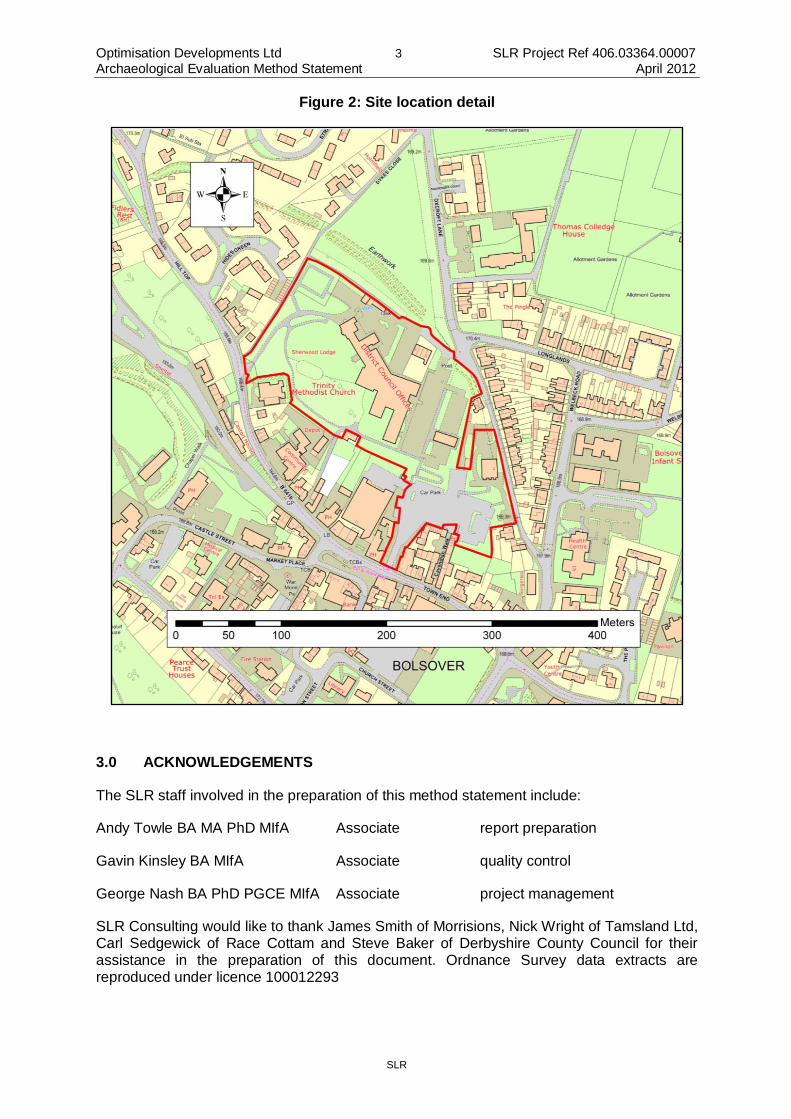
The development area is an irregular parcel of land, approximately 3.25 hectares containing Bolsover District Council Offices and Police Station, extensive car parking, a memorial garden and an area of remnant parkland associated with Sherwood Lodge (which is now part of the complex of council buildings). The current site access is from Oxcroft Lane on the northern side and Town End at the western limit of the site.
The Site is located within the area of Medieval Bolsover, close to its northern limit. The bank and ditch which bounded the settlement (“intrenchment”) is located to the north of the Site, and passes through the development area at the north eastern limit. This part of Bolsover was not part of the built-up historic core, which was centred on the castle and a planned settlement to the south and west of the site under consideration here.
The Site occupies high ground within the town, which slopes from north down to the south. The south eastern corner of the site is located on ground which slopes steeply to the south. The current surface of the site is at around 170m AOD at its centre.
The solid geology beneath the site consists of Magnesian Limestone (“Cadeby Formation- Dolostone”). Previous archaeological investigations at the Site indicate that this is overlain in

Optimisation Developments Ltd 2 SLR Project Ref 406.03364.00007 Archaeological Evaluation Method Statement April 2012
SLR
part by naturally deposited clay and made ground. There is evidence for modern truncation to bedrock in places (Priest 1993:4) and made ground to a maximum depth of 1.1m.
Figure 1: Site location and application area
Optimisation Developments Ltd 3 SLR Project Ref 406.03364.00007 Archaeological Evaluation Method Statement April 2012
SLR
Figure 2: Site location detail
3.0 ACKNOWLEDGEMENTS
The SLR staff involved in the preparation of this method statement include:
Andy Towle BA MA PhD MIfA Associate report preparation
Gavin Kinsley BA MIfA Associate quality control
George Nash BA PhD PGCE MIfA Associate project management
SLR Consulting would like to thank James Smith of Morrisions, Nick Wright of Tamsland Ltd, Carl Sedgewick of Race Cottam and Steve Baker of Derbyshire County Council for their assistance in the preparation of this document. Ordnance Survey data extracts are reproduced under licence 100012293

Optimisation Developments Ltd 4 SLR Project Ref 406.03364.00007 Archaeological Evaluation Method Statement April 2012
SLR
4.0 ARCHAEOLOGICAL AND HISTORICAL BACKGROUND
The archaeological background for the Site is described in greater detail in the Desk Based Assessment (Nash 2011), and it is recommended that the DBA is read in conjunction with this Method Statement. A brief summary of the results of the DBA is given here.
Prehistoric archaeological remains are known to be present within the development area in the form of unstratified flint artefacts. These have been recovered during earlier investigations at the site, where an assemblage of 57 flints was recorded, some of which have been dated to the Mesolithic and Neolithic periods (Riden and Fowkes 2008: 4; Nash 2011: 8). These were recovered from an area east and south of Sherwood Lodge (Wall 1992: 5-6) beneath the current council offices at the site.
Romano-British archaeological remains have also been identified within the development area. These were present as a ditched enclosure, pits and gullies observed cutting both the limestone bedrock and overlying natural silty clay (Wall 1992: 4-5, Jones 1995) and as residual artefacts present in later deposits. The features contained Romano-British pottery, iron-working debris, a fragment of a Millstone Grit beehive quern and animal bone. The dateable ceramics spanned the late 1st Century through to the 4th Century AD. A total of 184 sherds of Romano-British pottery were recovered during the 1992 evaluation and a further 275 sherds during subsequent mitigation work ahead of construction of the council buildings (Jones 1995: 96).
There are currently no known Early Medieval remains from the Site, although settlement within the vicinity is likely to have been present immediately before the establishment of the castle in the 11th Century.
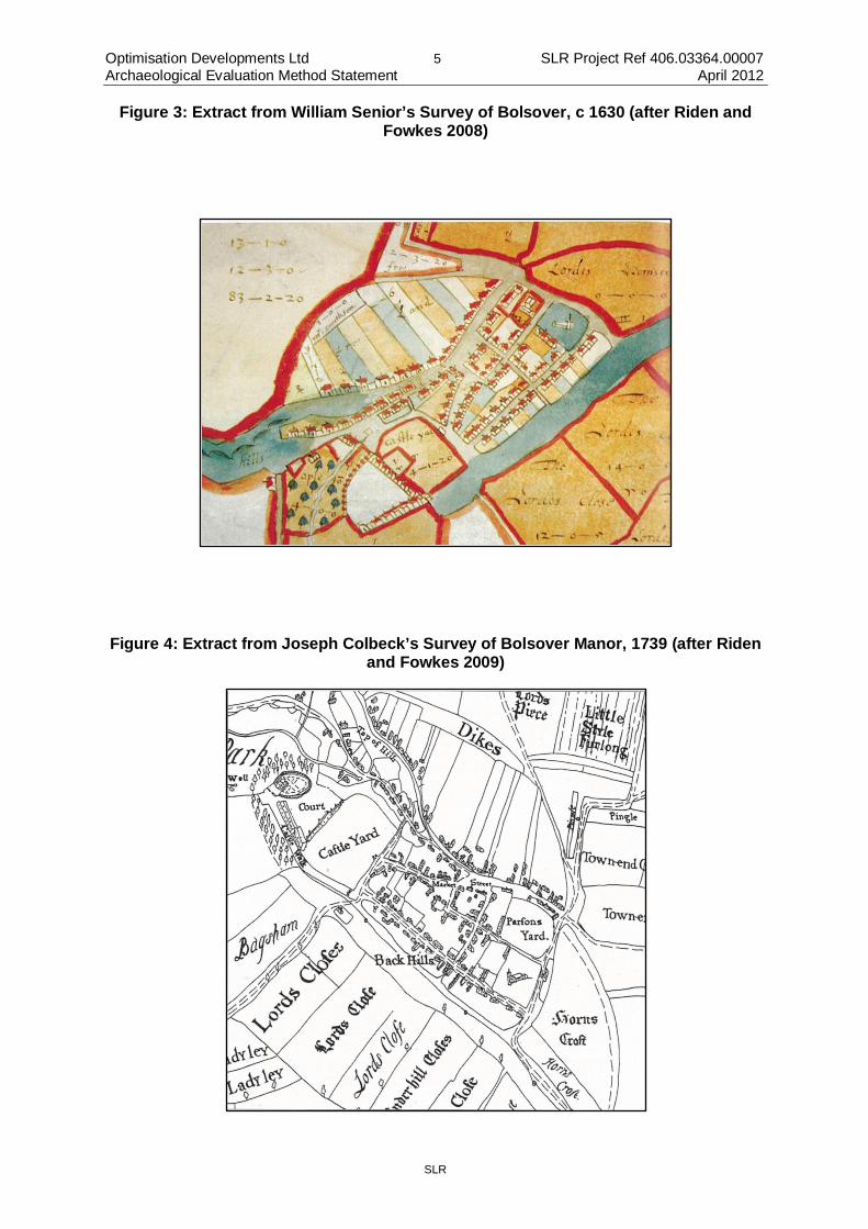
Medieval pottery has been recovered during previous investigations at the Site, although these were from secondary deposits, and may be from manuring of fields during this period. The only known structure from this period within the site is the town entrenchment, visible as a surviving earthwork close to the northern entrance from Oxcroft Lane. The Medieval use of the site is thought to have been predominantly agricultural, with this part of Bolsover shown on later maps (e.g. William Senior’s map of 1630) to have been subdivided into strips assumed to have been established during the Medieval period (as burgage plots). It is likely that buildings would have been present fronting onto the street to the south of the fields. The Medieval urban settlement of Bolsover is not thought to have extended beyond the street frontage across the site up to the entrenchment. The 1995 excavations found evidence for undated boundary ditches on the alignment of the posited burgage plots, interpreted as part of the Medieval occupation of the site (Jones 1995: 104).
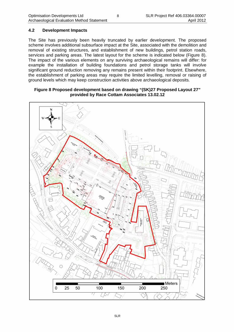
The post-Medieval occupation of the site was essentially still rural up to 1877 (Figure 5), with the northernmost burgage strips amalgamated into a large field, but remnant strips were still present elsewhere. By the time of the 1898 Ordnance Survey map (Figure 6), Sherwood Lodge had been established within ornamental grounds and the site began to be developed in a piecemeal fashion during the subsequent 20th and early 21st Centuries.
The previous archaeological investigations at the site demonstrate that there are areas of modern disturbance at the site outside of the footprint of the modern buildings, but also islands of archaeological survival from the prehistoric periods onwards. The Romano-British enclosure remains the most significant feature identified to date.
Optimisation Developments Ltd 5 SLR Project Ref 406.03364.00007 Archaeological Evaluation Method Statement April 2012
SLR
Figure 3: Extract from William Senior’s Survey of Bolsover, c 1630 (after Riden and Fowkes 2008)
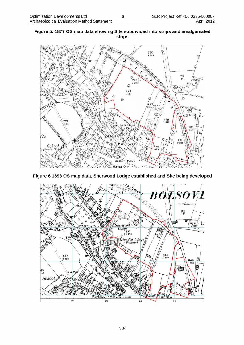
Figure 4: Extract from Joseph Colbeck’s Survey of Bolsover Manor, 1739 (after Riden and Fowkes 2009)
Optimisation Developments Ltd 6 SLR Project Ref 406.03364.00007 Archaeological Evaluation Method Statement April 2012
SLR
Figure 5: 1877 OS map data showing Site subdivided into strips and amalgamated strips
Figure 6 1898 OS map data, Sherwood Lodge established and Site being developed

Optimisation Developments Ltd 7 SLR Project Ref 406.03364.00007 Archaeological Evaluation Method Statement April 2012
SLR
4.1 Discussion of potential
The central and eastern part of the Site has been extensively developed during the 20th and early 21st Centuries, which may be presumed to have caused extensive damage to any archaeological remains present. However, previous investigations have demonstrated the survival of archaeology in some areas outside the footprints of buildings. These investigations have been limited to relatively small scale investigations and do not allow confident prediction of what will be present across the rest of the site. The extent of the Romano-British enclosure to the west of previous investigations remains to be defined and fully characterised. The southern-most portion of the site includes a narrow part of the street front which may have had Medieval buildings present.
Figure 7 Location of previous archaeological investigations (light blue 1992, purple 1993 and dark blue 2008).
Optimisation Developments Ltd 8 SLR Project Ref 406.03364.00007 Archaeological Evaluation Method Statement April 2012
SLR
4.2 Development Impacts
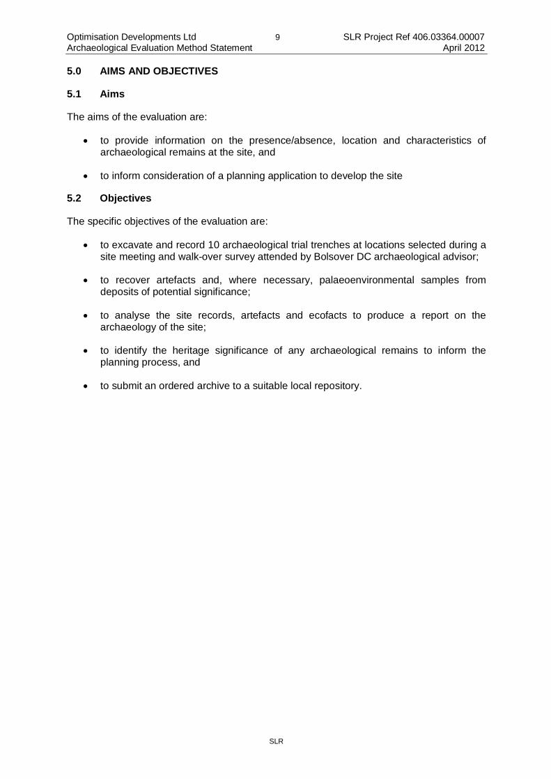
The Site has previously been heavily truncated by earlier development. The proposed scheme involves additional subsurface impact at the Site, associated with the demolition and removal of existing structures, and establishment of new buildings, petrol station roads, services and parking areas. The latest layout for the scheme is indicated below (Figure 8). The impact of the various elements on any surviving archaeological remains will differ: for example the installation of building foundations and petrol storage tanks will involve significant ground reduction removing any remains present within their footprint. Elsewhere, the establishment of parking areas may require the limited levelling, removal or raising of ground levels which may keep construction activities above archaeological deposits.
Figure 8 Proposed development based on drawing “(SK)27 Proposed Layout 27” provided by Race Cottam Associates 13.02.12
Optimisation Developments Ltd 9 SLR Project Ref 406.03364.00007 Archaeological Evaluation Method Statement April 2012
SLR
5.0 AIMS AND OBJECTIVES
5.1 Aims
The aims of the evaluation are:
• to provide information on the presence/absence, location and characteristics of archaeological remains at the site, and
• to inform consideration of a planning application to develop the site
5.2 Objectives
The specific objectives of the evaluation are:
• to excavate and record 10 archaeological trial trenches at locations selected during a site meeting and walk-over survey attended by Bolsover DC archaeological advisor;
• to recover artefacts and, where necessary, palaeoenvironmental samples from deposits of potential significance;
• to analyse the site records, artefacts and ecofacts to produce a report on the archaeology of the site;
• to identify the heritage significance of any archaeological remains to inform the planning process, and
• to submit an ordered archive to a suitable local repository.
Optimisation Developments Ltd 10 SLR Project Ref 406.03364.00007 Archaeological Evaluation Method Statement April 2012
SLR
6.0 METHODOLOGY
6.1 Professional Standards
SLR Consulting is a Registered Organisation with the Institute for Archaeologists (IfA). SLR’s work is undertaken to the highest professional standards: this document has been prepared with reference to the IfA’s Standard and Guidance for archaeological field evaluation (2008).
6.2 Sources of information
Sources consulted in the preparation of this document include:
• Brief prepared by Steve Baker;
• Archaeological desk based assessment (Nash 2011);
• Earlier Excavation Reports (Wall 1992, Priest 1993, Jones 1995 and Lewis 2008);
• “Bolsover: Castle, Town and Colliery” (Riden and Fowkes 2008) and
• “The North Derbyshire Archaeological Survey” (Hart 1984).
6.3 Methods (fieldwork)
A plan of all known services and hazards has been provided by the client prior to commencement of site work: the trench locations will be checked against this and may be adjusted accordingly.
The archaeologists will conform to the Client’s arrangements for notification of entering and leaving the site.
Before any excavations are started, a scan using a Cable Avoidance Tool will be undertaken by the archaeologists on site, the location of any anomalies clearly indicated. There will be no excavation of live cables.
A mechanical excavator equipped with a toothless ditching bucket and banksman is to be used to open the trenches under archaeological supervision.
The Derbyshire County Council Development Control Archaeologist will be informed of the start date of site works before they commence, with as much notice as possible provided.
Any variations to the archaeological programme will only be undertaken after consultation with, and the approval of both the Client and the Derbyshire County Council Development Control Archaeologist (except for safety reasons). Any variations will be fully recorded and circulated to all parties before implementation.
The trenching locations are sited to investigate areas of greatest potential survival, avoid disturbing current users of the site, avoid damaging tree roots for the established mature trees on the site, and avoid known services.
All trenches are to be secured behind Heras fencing to ensure public safety.
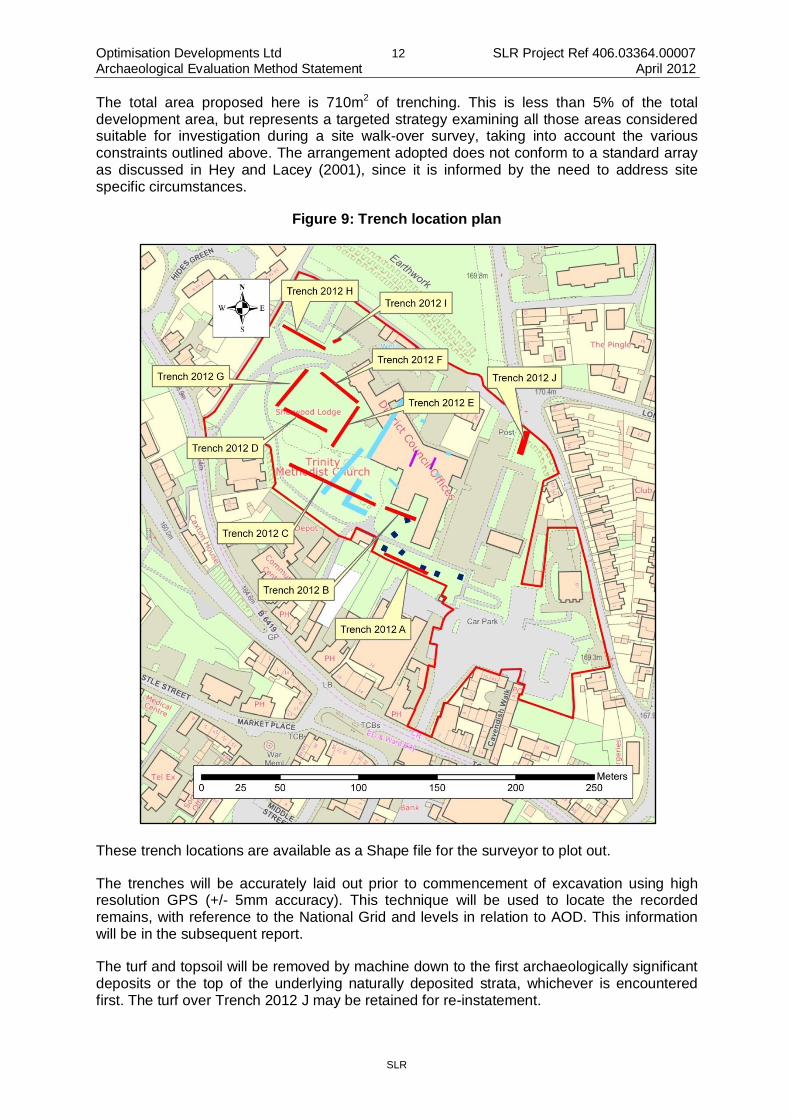
The proposed trenching plan is as follows (see Figure 9 below):
Optimisation Developments Ltd 11 SLR Project Ref 406.03364.00007 Archaeological Evaluation Method Statement April 2012
SLR
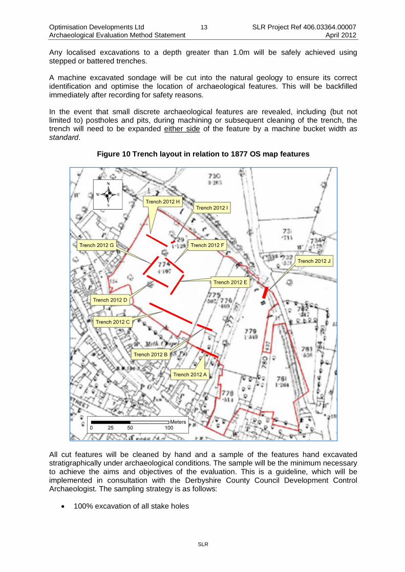
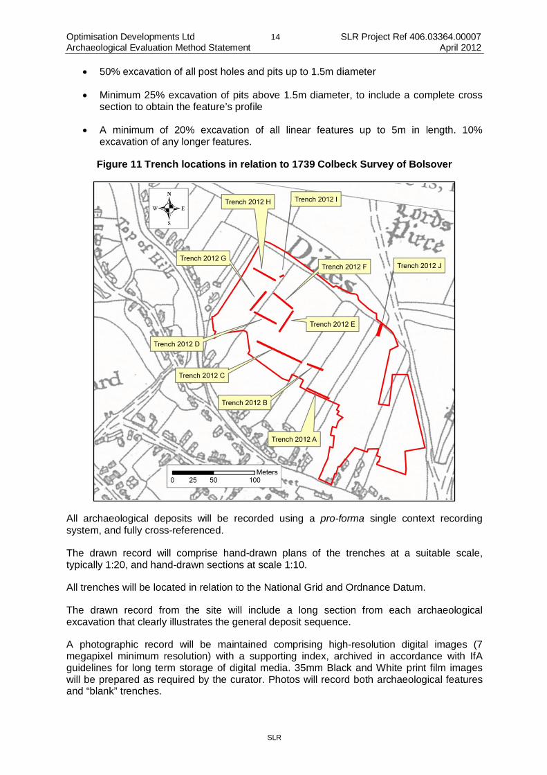
• Trench 2012 A: 30m x 2m linear trench oriented approximately north west – south east close in grassed area close to southern limit of site (note 2008 evaluation trenches close by this area). This trench cuts across the line of three field divisions shown on the 1877 Ordnance Survey (and earlier) mapping, which may have originated as Medieval burgage plot boundaries (Figure 10).
• Trench 2012 B: 20m x 2m linear trench oriented approximately north west – south east in a grassed area close to current council building (note 2008 evaluation trenches close by this area). This is located across the line of subdivisions shown on the 1877 Ordnance Survey map, which may have originated in Medieval burgage plot boundaries, and possibly a post-Medieval farm building (barn?) (Figure 10).
• Trench 2012 C: 60m x 2m linear trench oriented north east – south west within the relict parkland. Traces of ridge and furrow in the current surface suggest that this area has not been disturbed by modern development, and therefore the potential for archaeological survival is higher than other areas. The Trench is aligned perpendicular to the surface corrugation. This is located across the line of a field boundary shown on the 1739 Colbeck Survey (Figure 11), which may have originated in a Medieval burgage plot boundary.
• Trench 2012 D: 30m x 2m linear trench oriented north west – south east in area of relict parkland. This is located across the line of a field boundary shown on the 1739 Colbeck Survey (Figure 11), which may have originated in a Medieval burgage plot boundary.
• Trench 2012 E: 30m x 2m linear trench oriented north east – south west in area of relict parkland.
• Trench 2012 F: 30m x 2m linear trench oriented north west – south east in area of relict parkland close to Sherwood Lodge.
• Trench 2012 G: 30m x 2m linear trench oriented north east – south west in area of relict parkland.
• Trench 2012 H: 30m x 2m linear trench oriented north west to south east parallel and to the south of the southern limit of the memorial garden, close to the north western limit of the site.
• Trench 2012 I: 5m x 2m linear trench oriented north east – south west in grassed area close to the memorial garden. Adjacent trees constrain the size of this trench
• Trench 2012 J: 15m x 2m linear trench oriented north– south across the line of the denuded earthworks adjacent to the site entrance. This trench may require stepping to achieve a depth approaching 2m. This will be undertaken in discussion with the County Council Development Control Archaeologist. Prior to excavation the pre-excavation surface will be recorded (high resolution topographic survey) to permit reinstatement to the original profile. Currently the development proposals will impact on this location, if the design changes to ensure preservation in situ, then this trench may not be necessary. Spoil from this excavation will be stored on plastic sheeting and plant movements minimised to avoid unnecessary damage to the earthwork.
• Contingency Allocation equivalent to 20 x 2m of trenching to be used to address queries arising out of the initial trenching above, to be arranged in agreement with County Council Development Control Archaeologist.
Optimisation Developments Ltd 12 SLR Project Ref 406.03364.00007 Archaeological Evaluation Method Statement April 2012
SLR
The total area proposed here is 710m2 of trenching. This is less than 5% of the total development area, but represents a targeted strategy examining all those areas considered suitable for investigation during a site walk-over survey, taking into account the various constraints outlined above. The arrangement adopted does not conform to a standard array as discussed in Hey and Lacey (2001), since it is informed by the need to address site specific circumstances.
Figure 9: Trench location plan
These trench locations are available as a Shape file for the surveyor to plot out.
The trenches will be accurately laid out prior to commencement of excavation using high resolution GPS (+/- 5mm accuracy). This technique will be used to locate the recorded remains, with reference to the National Grid and levels in relation to AOD. This information will be in the subsequent report.
The turf and topsoil will be removed by machine down to the first archaeologically significant deposits or the top of the underlying naturally deposited strata, whichever is encountered first. The turf over Trench 2012 J may be retained for re-instatement.
Optimisation Developments Ltd 13 SLR Project Ref 406.03364.00007 Archaeological Evaluation Method Statement April 2012
SLR
Any localised excavations to a depth greater than 1.0m will be safely achieved using stepped or battered trenches.
A machine excavated sondage will be cut into the natural geology to ensure its correct identification and optimise the location of archaeological features. This will be backfilled immediately after recording for safety reasons.
In the event that small discrete archaeological features are revealed, including (but not limited to) postholes and pits, during machining or subsequent cleaning of the trench, the trench will need to be expanded either side of the feature by a machine bucket width as standard.
Figure 10 Trench layout in relation to 1877 OS map features
All cut features will be cleaned by hand and a sample of the features hand excavated stratigraphically under archaeological conditions. The sample will be the minimum necessary to achieve the aims and objectives of the evaluation. This is a guideline, which will be implemented in consultation with the Derbyshire County Council Development Control Archaeologist. The sampling strategy is as follows:
• 100% excavation of all stake holes
Optimisation Developments Ltd 14 SLR Project Ref 406.03364.00007 Archaeological Evaluation Method Statement April 2012
SLR
• 50% excavation of all post holes and pits up to 1.5m diameter
• Minimum 25% excavation of pits above 1.5m diameter, to include a complete cross section to obtain the feature’s profile
• A minimum of 20% excavation of all linear features up to 5m in length. 10% excavation of any longer features.
Figure 11 Trench locations in relation to 1739 Colbeck Survey of Bolsover
All archaeological deposits will be recorded using a pro-forma single context recording system, and fully cross-referenced.
The drawn record will comprise hand-drawn plans of the trenches at a suitable scale, typically 1:20, and hand-drawn sections at scale 1:10.
All trenches will be located in relation to the National Grid and Ordnance Datum.
The drawn record from the site will include a long section from each archaeological excavation that clearly illustrates the general deposit sequence.
A photographic record will be maintained comprising high-resolution digital images (7 megapixel minimum resolution) with a supporting index, archived in accordance with IfA guidelines for long term storage of digital media. 35mm Black and White print film images will be prepared as required by the curator. Photos will record both archaeological features and “blank” trenches.
Optimisation Developments Ltd 15 SLR Project Ref 406.03364.00007 Archaeological Evaluation Method Statement April 2012
SLR
Palaeoenvironmental samples will be taken from those deposits considered of potential (e.g. buried soil horizons, ditch fills, waterlogged deposits displaying good organic preservation and deeply stratified deposits) in accordance with English Heritage guidelines. These would comprise bulk sediment samples of up to 40 litres, to a maximum of six samples in the first instance. It is not anticipated that significant waterlogged deposits or deeply stratified remains will be encountered on this site, but if unexpected remains are uncovered a detailed strategy for their sampling and recording will be arranged in consultation with the regional English Heritage Science advisor, Client and palaeoenvironmental specialist. The Derbyshire County Council Development Control Archaeologist requires that assessment analysis involves processing of 100% of the sample.
Samples will be recovered for scientific dating if required by the Derbyshire County Council Development Control Archaeologist, and where they may contribute to the archaeological aims of the project.
Samples of brick and tile will be recovered as advised by the County Council Development Control Archaeologist
Artefacts and ecofacts will be collected and recorded stratigraphically. All artefacts will be labelled, packed and stored in appropriate materials and conditions to ensure that no deterioration occurs. All artefact/ecofact processing/storage will be carried out in accordance with UKIC (United Kingdom Institute for Conservation) guidelines and will accord with relevant Institute for Archaeologists Guidelines on Finds Work.
The retention/discard of artefacts/ecofacts will be determined in discussion with the Derbyshire County Council Development Control Archaeologist, depending upon the nature of material recovered and the analytical potential of the assemblage. Discarded material will be recorded before disposal. For example 20th Century material may be noted and discarded. An exhaustive list of all artefact types recovered from excavations across the UK is not included here: the option to define a retention/discard policy is allowed for in light of the material uncovered during the evaluation.
The Treasure Act 1996 (and as amended by the Treasure Designation Order 2002 No 2666). This Act replaced the common law of treasure trove in England, Wales and Northern Ireland, which was previously the only legal protection afforded to antiquities. Under the law of treasure trove, finds of gold or silver had to be reported to the coroner and could be declared treasure trove and the property of the Crown if they had been deliberately hidden with the intention of recovery and their owner, or heirs were unknown. The 1996 Act removed the need to establish that objects were hidden with the intention of being recovered, except in a very few cases; it sets out the precious metal content required for a find to qualify as treasure; and it extends the definition of treasure to include other objects found in archaeological association with finds of treasure. Six categories of object are now classed as treasure:
• Any object other than a coin which is at least 10% silver or gold by weight and more than 300 years old.
• Any coins that are at least 10% silver or gold by weight and come from a single find, provided the find contains at least two coins with a gold or silver content of at least 10%. The coins must be at least 300 years old at the time of discovery. Where finds consist of coins that are less than 10% gold or silver by weight, there must be at least 10 coins in the find and they must be at least 300 years old at the time of discovery for the find to be considered treasure.
• Any object, of whatever, composition, that is found in the same place as, or that had previously been together with, another object that is treasure.

Optimisation Developments Ltd 16 SLR Project Ref 406.03364.00007 Archaeological Evaluation Method Statement April 2012
SLR
• any object (other than a coin), any part of which is base metal, which, when found is one of at least two base metal objects in the same find which are of prehistoric date;
• any object, (other than a coin) which is of prehistoric date, and any part of which is gold or silver.
• Any object that would previously have been treasure trove but does not fall within the specific categories given above.
The Act also introduces a Code of Practice for the voluntary recording of archaeological finds.
Any human remains identified will be initially left in situ until the relevant authorities have been informed of the discovery. If removal is necessary, any necessary licenses will be arranged, in accordance with the provisions of Section 25 of the Burial Act of 1857.
All excavations will be backfilled with the material excavated. Trenches will not be backfilled until inspected by the DCCDCA (unless for health and safety purposes).
6.4 Methods (Evaluation Report)
After the completion of the fieldwork a formal report will be prepared. The report will contain the following elements:-
• non-technical summary;
• table of contents;
• introduction with acknowledgements, including a list of all those involved in the project and the location and description of the evaluation area;
• statement of the project aims and objectives;
• account of the project methodology undertaken, with an assessment of the same;
• brief summary of the archaeological/historical background of the area, indicating past and present land use, accompanied by relevant maps;
• description of the archaeological works, including any archaeologically significant features/deposits or potential features/deposits identified within the site;
• discussion of the location, nature, extent, date, quality, condition and significance of any archaeological deposits/features uncovered.
• High resolution digital colour images of work in progress and significant features.
• Plans and section drawings at appropriate scales (to include as a minimum: a location map at not less than 1:25000 and a site plan at not less than 1:500 showing all trench locations in relation to OS background mapping). To show empty trenches and example sections where no significant archaeological remains are identified, as well as plans and sections of those trenches with remains. Levels in relation to Ordnance Datum will be shown. A photograph of each trench will be reproduced.
• Other maps, plans, drawings and photographs as appropriate.
• A description of the finds and palaeoenvironmental samples collected including an exposition of the methodologies employed with a statement on the presence or
Optimisation Developments Ltd 17 SLR Project Ref 406.03364.00007 Archaeological Evaluation Method Statement April 2012
SLR
absence of material and an assessment of preservation. An interpretation of the finds including reference to any unusual or important features of the assemblage will also be included. Specialist reports will be included of all important groups of finds, materials and samples as necessary;
• interpretation of the results with a statement of the significance of any identified archaeological features/sites on a local, regional and national scale;
• identification of any implications for the proposed development arising from the work;
• bibliography of sources consulted and a supplementary bibliography of any sources identified, but not available for consultation and
• an index to the project archive and a statement of its location/proposed repository.
The report will include assessments of any artefacts and environmental samples collected during the site works. All artefacts considered vulnerable will be assessed by a specialist conservator with a view to identifying any long-term storage issues.
All assessment work will be carried out in accordance with the procedures defined in MAP 2 which sets out the management of post-excavation work.
X-radiography of metal finds will be undertaken in line with Guidelines on the X-radiography of archaeological metalwork (English Heritage 2006) as appropriate and as advised by the relevant specialist. This will be subject to the arrangement of additional funding from the client since the extent and costs cannot be accurately anticipated in advance.
Where assessment by specialists identifies recommendations for further analysis, and these are required by the Derbyshire County Council Development Control Archaeologist, then the work will be subject to separate specification and costing with the agreement of the Client.
SLR will take into account any observations on the content of the draft report made by the Client and the Derbyshire County Council Development Control Archaeologist before the final version is issued.
Bound paper copies of the report and digital copies in PDF format will be provided to the Client, the Derbyshire County Council Development Control Archaeologist and the local Historic Environment Record.
6.5 Methods (Publication)
A summary of the work will be provided for the Derbyshire Archaeological Journal. A short report of the work may also be required to be submitted to a local journal. If appropriate this would be subject to separate specification and costing agreement the Client and Derbyshire County Council Development Control Archaeologist.
6.6 Methods (Archive)
SLR Consulting will complete the online OASIS form at http://ads.ahds.ac.uk/project/oasis/ at completion of the project.
The project archive will consist of all original records, artefacts, ecofacts/samples and all documentation that relates to the archaeological works. The archaeological contractor will endeavour to persuade the legal owner of the artefacts to transfer them to relevant repository.
Optimisation Developments Ltd 18 SLR Project Ref 406.03364.00007 Archaeological Evaluation Method Statement April 2012
SLR
The archive will comply with the United Kingdom Institute for Conservation (Archaeology Section) Guidelines for the Preparation of Excavation Archives for Long-Term Storage (1990) the Society of Museum Archaeologists Towards An Accessible Archive (1995) and to the reasonable requirements of the recipient Museum.
The archive will be deposited after the completion of the site works, with the agreement of the Client. There is currently no accessioning museum of record serving Bolsover District.
The archive will be prepared according to Procedures for the Transfer of Archaeological Archives (Museum in Derbyshire 2003). Temporary storage pending deposition will be with SLR Consulting in Warrington. There is currently no accessioning museum of record serving Bolsover District. Paper/photographic/digital archives with no retained finds or samples may be deposited at Derbyshire Record Office (DRO) in Matlock. If this is the case then DRO should be contacted once the archive is prepared. The development control archaeologist should be notified in writing of the DRO accession number once deposition has taken place.
6.7 Methods (Copyright)
SLR will retain full copyright of any commissioned reports, tender documents or other project documents, under the Copyright, Designs and Patents Act of 1988 with all rights reserved; the contractor will provide an exclusive licence to the Client for the use of such documents by the Client in all matters directly relating to the project as described in this Method Statement.
6.8 Methods (Health and Safety)
SLR Consulting and its sub-contractors must operate in accordance with the health and safety procedures as set out in:-
• The Health and Safety Work Act (1974) and related legislation.
• CDM regulations 2007
• The Standing Conference of Archaeology Unit Managers Health and Safety Manual 2002).
• The Council for British Archaeology Handbook no. 6, Safety in Archaeological Fieldwork (1989).
The Client will provide the archaeological contractor with any information regarding hazardous contaminants present in the surface materials and sub-surface strata at the site. Appropriate measures will then be taken by the contractor to ensure the health and safety of its staff who may come into contact with such contaminants. Measures may include on-site adaptation of the agreed evaluation strategy.
The archaeologists will prepare a site-specific health and safety risk assessment, to be read and acknowledged by all staff on site.
All necessary protective clothing and equipment will be used. The archaeologists on site will wear hard hats, gloves, reflective jackets and protective footwear at all times.
A First-Aid kit and Accident Book will be kept on site at all times.
Optimisation Developments Ltd 19 SLR Project Ref 406.03364.00007 Archaeological Evaluation Method Statement April 2012
SLR
6.9 Methods (Project Monitoring)
The project will be monitored by the Client and the Derbyshire County Council Development Control Archaeologist
Ideally the monitoring will include:
• at least one site meeting to confirm the fieldwork is being undertaken correctly and discuss the findings and
• discussion of the draft report and archive before submission of the final report and/or publication.
SLR will provide the Client and the Derbyshire County Council Development Control Archaeologist with progress reports as required during the archaeological works.
Optimisation Developments Ltd 20 SLR Project Ref 406.03364.00007 Archaeological Evaluation Method Statement April 2012
SLR
7.0 RESOURCES AND ORGANISATION
7.1 Staff and Roles
7.1.1 Quality Assurance
George Nash
7.1.2 Project Manager
George Nash
7.1.3 Site Director:
Andy Towle
7.1.4 Site Archaeologists
TBC
7.1.5 Archaeological Illustrator:
Caroline Malim
7.1.6 Lithic Specialist
George Nash
7.1.7 Palaeoenvironmentalist
John Carrott (PRS)
7.1.8 Ceramic Specialist
Ruth Leary (tbc).
7.2 Timing
Tbc. Duration: approximately four weeks of site work.
7.3 Insurance
SLR Consulting is adequately insured to undertake the work.
7.3.1 Contingency
The Client will be informed of the potential need to reserve a contingency to cover the costs of conserving exceptional remains, such as metalwork or waterlogged organic artefacts. If there are delays to the work, arising from interrupted site access, inclement weather or exceptional remains, additional time will be required, and costs incurred.

Optimisation Developments Ltd 21 SLR Project Ref 406.03364.00007 Archaeological Evaluation Method Statement April 2012
SLR
8.0 CONCLUSION
The evaluation results will inform consideration of the planning application to develop the site, and assist in the preparation of a suitable impact mitigation strategy if required.
If archaeological remains are discovered during the evaluation, and the development proceeds, then mitigation of the development impact is likely to be required by the local planning authority. This could include any or all of the following elements:
• further evaluation trial trenching;
• a watching brief on ground works;
• excavation and recording of archaeological remains ahead of or during site works;
• preservation in situ, with site works designed to avoid the remains (such as car parks placed on imported fill to avoid disturbance of archaeological remains).
Any required archaeological mitigation work should be integrated into the construction programme to minimise the impact on the timetable and avoid unplanned delays. The methodology for this would be set out in a separate method statement prepared in agreement with the local authority archaeologist..
9.0 BIBLIOGRAPHY
Baker S 2012 Brief for Pre-Application Archaeological Evaluation: Land at Sherwood Lodge, Bolsover.
Hart C (1984) The North Derbyshire Archaeological Survey. Sheffield City Museums
Hey G and Lacey M (2001) Evaluation of Archaeological Decision-Making Processes and Sampling Strategies. Oxford Archaeological Unit. Published by Kent County Council. ISBN 0904 220 265. Available from: http://www.persona.uk.com/kent/Core_docs/CD-06_7_2.pdf
Jones A (1995) “Sherwood Lodge, Bolsover, Archaeological Investigations, 1992-3”. Derbyshire Archaeological Journal 116: 84-106
Lewis B (2008) Archaeological Evaluations at Sherwood Lodge, Bolsover, Derbyshire (SK4742870611). Trent and Peak Archaeology Report.
Margary I (1973) Roman Roads of Britain.
Nash G (2011) Superstore Development, Bolsover, Derbyshire: Archaeological Desk Based Assessment. SLR Consulting Report Ref 406.03364.00007.
Priest V (1993) Sherwood Lodge, Bolsover: Excavations at the Social Services Building. T&PAT Report.
Riden P and Fowkes D (2008) Bolsover: Castle, Town and Colliery. ISBN 978-86077-484-3
Wall I (1992) Sherwood Lodge Bolsover. Archaeological Evaluation Report on Trial Excavation. Creswell Heritage Trust Report.

Optimisation Developments Ltd 22 SLR Project Ref 406.03364.00007 Archaeological Evaluation Method Statement April 2012
SLR
10.0 CLOSURE
This report has been prepared by SLR Consulting Limited with all reasonable skill, care and diligence, and taking account of the manpower and resources devoted to it by agreement with the client. Information reported herein is based on the interpretation of data collected and has been accepted in good faith as being accurate and valid.
This report is for the exclusive use of Optimisation Developments Ltd; no warranties or guarantees are expressed or should be inferred by any third parties. This report may not be relied upon by other parties without written consent from SLR.
SLR disclaims any responsibility to the client and others in respect of any matters outside the agreed scope of the work.

AYLESBURY 7 Wornal Park, Menmarsh Road, Worminghall, Aylesbury, Buckinghamshire HP18 9PH T: +44 (0)1844 337380 BELFAST 24 Ballynahinch Street, Hillsborough, Co. Down, BT26 6AW Northern Ireland T: +44 (0)28 9268 9036 BRADFORD-ON-AVON Treenwood House, Rowden Lane, Bradford-on-Avon, Wiltshire BA15 2AU T: +44 (0)1225 309400 BRISTOL Langford Lodge, 109 Pembroke Road, Clifton, Bristol BS8 3EU T: +44 (0)117 9064280 CAMBRIDGE 8 Stow Court, Stow-cum-Quy, Cambridge CB25 9AS T: + 44 (0)1223 813805 CARDIFF Fulmar House, Beignon Close, Ocean Way, Cardiff CF24 5HF T: +44 (0)29 20491010 CHELMSFORD Unit 77, Waterhouse Business Centre, 2 Cromar Way, Chelmsford, Essex CM1 2QE T: +44 (0)1245 392170 DUBLIN 7 Dundrum Business Park, Windy Arbour, Dundrum, Dublin 14 Ireland T: + 353 (0)1 2964667
EDINBURGH No. 4 The Roundal, Roddinglaw Business Park, Gogar, Edinburgh EH12 9DB T: +44 (0)131 3356830 EXETER 69 Polsloe Road, Exeter EX1 2NF T: + 44 (0)1392 490152 FARNBOROUGH The Pavilion, 2 Sherborne Road, South Farnborough, Hampshire GU14 6JT T: +44 (0)1252 515682 GLASGOW 4 Woodside Place, Charing Cross, Glasgow G3 7QF T: +44 (0)141 3535037 HUDDERSFIELD Westleigh House, Wakefield Road, Denby Dale, Huddersfield HD8 8QJ T: +44 (0)1484 860521 LEEDS Suite 1, Jason House, Kerry Hill, Horsforth, Leeds LS18 4JR T: +44 (0)113 2580650 MAIDSTONE 19 Hollingworth Court, Turkey Mill, Maidstone, Kent ME14 5PP T: +44 (0)1622 609242 NEWCASTLE UPON TYNE Sailors Bethel, Horatio Street, Newcastle-upon-Tyne NE1 2PE T: +44 (0)191 2611966
NOTTINGHAM Aspect House, Aspect Business Park, Bennerley Road, Nottingham NG6 8WR T: +44 (0)115 9647280 ST. ALBAN’S White House Farm Barns, Gaddesden Row, Hertfordshire HP2 6HG T: +44 (0)1582 840471 SHEFFIELD STEP Business Centre, Wortley Road, Deepcar, Sheffield S36 2UH T: +44 (0)114 2903628 SHREWSBURY Mytton Mill, Forton Heath, Montford Bridge, Shrewsbury SY4 1HA T: +44 (0)1743 850170 STAFFORD 8 Parker Court, Staffordshire Technology Park, Beaconside, Stafford ST18 0WP T: +44 (0)1785 253331 WARRINGTON Suite 9 Beech House, Padgate Business Park, Green Lane, Warrington WA1 4JN T: +44 (0)1925 827218 WORCESTER Suite 5, Brindley Court, Gresley Road, Shire Business Park, Worcester WR4 9FD T: +44 (0)1905 751310