Sunshine Coast Timber Supply Area - British ColumbiaSunshine Coast Timber Supply Area, including...
33
Sunshine Coast Timber Supply Area Vegetation Resources Inventory Strategic Inventory Plan PREPARED BY: GERRY SOMMERS & WARREN NIMCHUK AUGUST 2005 REVISED MARCH 2006
Transcript of Sunshine Coast Timber Supply Area - British ColumbiaSunshine Coast Timber Supply Area, including...

Sunshine Coast
Timber Supply Area
Vegetation Resources Inventory
Strategic Inventory Plan
PREPARED BY:
GERRY SOMMERS &
WARREN NIMCHUK
AUGUST 2005 REVISED MARCH 2006


VSIP: Sunshine TSA Page i
August 2005
Revised March 2006
EXECUTIVE SUMMARY
The objective of the Vegetation Resources Inventory (VRI) Preliminary Strategic
Inventory Plan (VSIP) is to outline the VRI activities and products that address forest management and inventory issues in the Sunshine Coast Timber Supply Area (TSA 39).
The stakeholders for this project include International Forest Products, Terminal Forest Products Ltd, British Columbia Timber Sales, Weyerhaeuser Company Limited, and
Ministry of Forests and Range.
The benefits of a new inventory are numerous. The resulting information will assist in;
- ongoing operational planning; - provision of better estimates of the current and future timber supply; and
- helping to address numerous forest management issues within the TSA.
Examples of management issues that exist for the TSA include; - the productivity and volumes of stands; - classification of non forested polygons and improved species composition; and
- height and age estimation of second growth forest stands (accounting for 52% of the forested landbase)
Information relating to these issues will be significantly clearer following the completion
of an inventory.
The following VRI activities and products are planned:
1. Conduct a Phase I photo-interpretation over the entire Sunshine Coast (Sunshine) TSA. The Phase I database will support timber-emphasis inventories, habitat
mapping, ecosystem mapping, riparian mapping, and other applications. 2. Conduct Phase 2 timber emphasis ground sampling in the Vegetated Treed area of
the TSA (augmenting the previous samples that were established between 1997 and 1999) to provide statistically valid timber volumes and polygon-specific tree
attributes for the subsequent timber supply reviews. The ground sampling will include Net Volume Adjustment Factor (NVAF) sampling to check loss factors and taper equations.

VSIP: Sunshine TSA Page ii
August 2005
Revised March 2006
3. Conduct finer polygon delineation and timber emphasis ground sampling in the second growth stands in the Sunshine TSA to improve species composition
descriptions and spatial data for these stands.
These VRI activities and products will support timber supply objectives and other resource specific interpretations. They may be implemented in smaller units (e.g.,
Management Zones) across the TSA. They may also be jointly implemented to address common management issues within the Coast Region.
VSIP: Sunshine TSA Page iii
August 2005
Revised March 2006
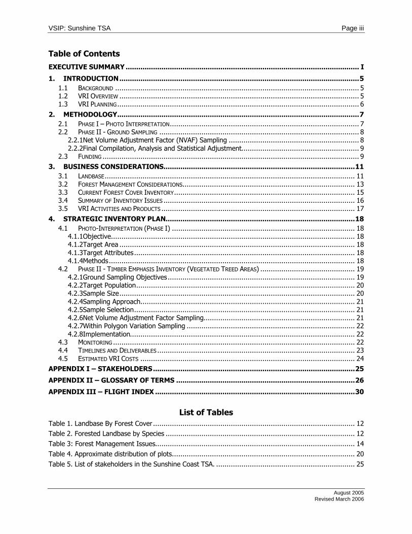
Table of Contents
EXECUTIVE SUMMARY ............................................................................................................... I 1. INTRODUCTION..................................................................................................................5
1.1 BACKGROUND .................................................................................................................... 5 1.2 VRI OVERVIEW .................................................................................................................. 5 1.3 VRI PLANNING ................................................................................................................... 6
2. METHODOLOGY...................................................................................................................7 2.1 PHASE I – PHOTO INTERPRETATION.......................................................................................... 7 2.2 PHASE II - GROUND SAMPLING ............................................................................................... 8
2.2.1Net Volume Adjustment Factor (NVAF) Sampling .............................................................. 8 2.2.2Final Compilation, Analysis and Statistical Adjustment........................................................ 9
2.3 FUNDING .......................................................................................................................... 9 3. BUSINESS CONSIDERATIONS...........................................................................................11
3.1 LANDBASE....................................................................................................................... 11 3.2 FOREST MANAGEMENT CONSIDERATIONS.................................................................................. 13 3.3 CURRENT FOREST COVER INVENTORY...................................................................................... 15 3.4 SUMMARY OF INVENTORY ISSUES ........................................................................................... 16 3.5 VRI ACTIVITIES AND PRODUCTS ............................................................................................ 17
4. STRATEGIC INVENTORY PLAN..........................................................................................18 4.1 PHOTO-INTERPRETATION (PHASE I) ....................................................................................... 18
4.1.1Objective.................................................................................................................... 18 4.1.2Target Area ................................................................................................................ 18 4.1.3Target Attributes......................................................................................................... 18 4.1.4Methods..................................................................................................................... 18
4.2 PHASE II - TIMBER EMPHASIS INVENTORY (VEGETATED TREED AREAS) ............................................. 19 4.2.1Ground Sampling Objectives ......................................................................................... 19 4.2.2Target Population........................................................................................................ 20 4.2.3Sample Size................................................................................................................ 20 4.2.4Sampling Approach...................................................................................................... 21 4.2.5Sample Selection......................................................................................................... 21 4.2.6Net Volume Adjustment Factor Sampling........................................................................ 21 4.2.7Within Polygon Variation Sampling ................................................................................ 22 4.2.8Implementation........................................................................................................... 22
4.3 MONITORING ................................................................................................................... 22 4.4 TIMELINES AND DELIVERABLES .............................................................................................. 23 4.5 ESTIMATED VRI COSTS ...................................................................................................... 24
APPENDIX I – STAKEHOLDERS................................................................................................25 APPENDIX II – GLOSSARY OF TERMS .....................................................................................26 APPENDIX III – FLIGHT INDEX ...............................................................................................30
List of Tables Table 1. Landbase By Forest Cover ................................................................................................ 12 Table 2. Forested Landbase by Species .......................................................................................... 12 Table 3: Forest Management Issues............................................................................................... 14 Table 4. Approximate distribution of plots....................................................................................... 20 Table 5. List of stakeholders in the Sunshine Coast TSA. .................................................................. 25

VSIP: Sunshine TSA Page iv
August 2005
Revised March 2006
List of Figures Figure 1. The VRI management inventory process. .......................................................................... 10

VSIP: Sunshine TSA Page 5
August 2005
Revised March 2006
1. INTRODUCTION
1.1 Background
This Vegetation Resources Inventory (VRI) Strategic Inventory Plan (VSIP) outlines VRI activities and products needed to address forest management and inventory issues in the Sunshine Coast Timber Supply Area (TSA 39). The VSIP provides details for photo
interpretation in the TSA. Following VSIP approval, the next steps would include the preparation of project implementation plans (VPIPs) based on this VSIP, and the
implementation of the VPIPs.
The Sunshine VRI Committee is comprised of willing participants operating within the
Sunshine Coast Timber Supply Area, including International Forest Products Ltd., British Columbia Timber Sales, Terminal Forest Products Ltd, Weyerhaeuser Company Limited, and the Ministry of Forests and Range.
1.2 VRI Overview
The VRI is a vegetation (forest) inventory process that has been approved by the Resources Inventory Committee (RIC) to assess the quantity and quality of BC’s timber
and vegetation resources. The VRI estimates overall population totals and averages, as well as individual polygon attributes, for timber and non-timber resources. Its design is
simple, reasonably efficient, statistically defensible, and addresses issues raised by the Forest Resources Commission in its 1991 report, The Future of Our Forests.
The VRI consists of several components (Appendix II):
1. BC Land Cover Classification Scheme (BCLCS).
2. Photo Interpreted Estimates (Phase I). 3. Ground Sampling (Phase II) – timber emphasis, ecology, coarse woody debris. 4. Net Volume Adjustment Factor (NVAF) sampling.
5. Within Polygon Variation (WPV) sampling. 6. Statistical Adjustment.
One or more of these components can address specific forest management or inventory
issues. For more detailed information, VRI manuals are available through the Internet at http://ilmbwww.gov.bc.ca/risc/pubs/teveg/index.htm.

VSIP: Sunshine TSA Page 6
August 2005
Revised March 2006
1.3 VRI Planning
The VRI planning process requires that a Strategic Inventory Plan (VSIP) and Project
Implementation Plan (VPIP) are developed for defined units (e.g. TSA, TFL). A VSIP outlines VRI products to address forest management issues and provides strategic direction for implementing the inventory activities. A VPIP details the operational
activities identified in the VSIP (e.g., ground sampling or photo interpretation projects) and identifies project areas, priorities, and roles and responsibilities.
The VRI planning process is an important component of the overall VRI process and related activities (see Figure 1). The intent of the VRI planning process is to ensure that
baseline products meet a range of applications and they are efficiently implemented. These processes and activities include:
1. Forest management decision processes (land integration planning); 2. Identifying forest management issues; 3. VRI Strategic planning (prepare a VSIP);
4. VRI operational planning (prepare VPIPs); and 5. Implementation, including development and maintenance of procedures and
standards: a). Management inventories;
b). Database management; c). Data interpretation.
The steps for preparing a VSIP include:
1. Licensee stakeholders work with MOFR staff to develop issue statements related to VRI.
2. The Sunshine Coast Licensees, including all agencies and stakeholders, meets to
refine issues and discuss why these issues need to be considered fundable. The purpose of this meeting is to:
a). Introduce the VRI tools and process; b). Table new issues and issues recorded to date;
c). Discuss issues that can be funded or not (under current funding mechanisms); this discussion provides general direction for developing the VSIP. This
discussion also affects the extent of photo interpretation and the number and type of VRI plots.
d). Suggest the VRI tools to address currently fundable issues as well as those
issues that may be funded in the future.

VSIP: Sunshine TSA Page 7
August 2005
Revised March 2006
3. Sunshine Coast Licensees meeting minutes are prepared and circulated to all participants for review and feedback.
4. Sunshine Coast Licensees prepares a final VSIP, which incorporates items agreed to in Step 5 and is signed off by committee members.
5. VPIP process begins.
The steps for preparing a VPIP include:
1. Review and update VSIP recommendations. 2. Secure funding. 3. Identify project activities, geographic areas, and costs. 4. Specify roles and responsibilities for project implementation. 5. Prepare VPIP.
2. METHODOLOGY
VRI is a MoFR approved process consisting of the following four components.
2.1 Phase I – Photo Interpretation
Prior to commencing the Phase I of a VRI project, a Vegetation Resource Inventory Project Implementation Plan (VPIP) for Photo Interpretation- must be completed and
subsequently approved by the Ministry of Forests and Range. This plan will detail photo acquisition requirements, the VRI Phase I process, standards for adherence, and a photo interpretation plan to carry out the Phase I of the VRI.
Phase I is the photo interpretation phase of a VRI and entails polygon delineation and attribute estimation by certified photo interpreters through the use of aerial
photographs or softcopy images. The delineation identifies the location of the forest resources and the attribute estimation component provides estimates of numerous
attributes including land cover type, crown closure, tree species, height, age, stand structure, volume, basal area, density, slope position, moisture and nutrient regime,
snags, shrubs, herbs, and bryoids.
Estimation of attributes from field reference points is based upon field procedures using a combination of air and ground calibration points.

VSIP: Sunshine TSA Page 8
August 2005
Revised March 2006
2.2 Phase II - Ground Sampling
Prior to commencing Phase II, a Vegetation Resource Inventory Project Implementation Plan (VPIP) for Ground Sampling must be completed and subsequently approved by the Ministry of Forests and Range. This plan details the Phase II sample selection process
and standards for adherence.
Specifically the Phase II VPIP plan will;
• detail the Phase II project and sampling objectives; • target and identify sample populations and sample selection and sample size
details;
• discuss how existing Phase II sample data will be applied to the new inventory; • identify gaps in the sample coverage;
• quantify any additional sample data that will need to be collected to address
these gaps; • include discussion of the field program;
• discuss the proposed data compilation, analysis, and statistical adjustment; and, • include the proposed implementation schedule.
The samples (samples are “plot clusters” and consist of a main plot and up to 4 associated auxiliaries) selected for the Phase II ground sampling are based on the delineated polygons and attributes estimated during Phase I. Samples are selected
randomly and are based on achieving a resultant sampling error of less than 15 percent for forest stand volume that are proportionally distributed across the different target
populations.
The VPIP will also include details on a proposed NVAF program (see section 2.2.1)
including sample size and sample selection.
2.2.1 Net Volume Adjustment Factor (NVAF) Sampling
As per the Ministry of Forests and Range Vegetation Resource Inventory standards, all new Ground Sampling Vegetation Resource Inventories must complete Net Volume
Adjustment Factor Sampling.

VSIP: Sunshine TSA Page 9
August 2005
Revised March 2006
This sampling involves detailed stem analysis of sample trees that have been randomly selected from the Phase II plots. The NVAF is used to correct the VRI estimates of net
close tree utilization for all species and the NVAF adjusted VRI ground sample volumes are used to correct the VDYP yield table model. Additional detail is described in section
4.2.6.
2.2.2 Final Compilation, Analysis and Statistical Adjustment
Adjustment to the Phase I using the results of Phase II sampling data for the entire VRI project area is the final VRI phase. The NVAF information is utilized to adjust the Phase
II sample estimates for hidden decay and taper equation bias and the Phase II plot estimates are used to adjust the Phase I photo interpretation attribute estimates. The
final product is a statistically valid new inventory, supported by re-adjustment of photo-estimated attributes based on ground samples.
2.3 Funding
The Sunshine Licensees develops criteria for setting VRI activity priorities and products identified during the planning process. Inventory funding, or follow-up resource-specific
management interpretations, is excluded from the planning process since funding mechanisms may vary. Currently, funding for VRI activities are FIA eligible.

VSIP: Sunshine TSA Page 10
August 2005
Revised March 2006
1. Forest Management
Decision Processes - Timber Supply Review
- Forest Practices Code
2. Resource-Specific Issues
(Discussion Paper) - Identified by stakeholders
3. VRI Product Planning (VSIP)
- What VRI products, where - Non-spatial products
- Spatial products
5C. Incosada Database - VIF (attributes) - VEG (graphics)
5. Implementation - Management Inventories
5A. Management Inventories - Partial VRI products
5B. Other data sources
4. Multi-Year Project Implementation Plan (VPIP)
- Funding - Priorities
- Area sequence - Plot location coordination
6. Data Interpretation - Timber Management
- Ecosystem Interpretation - Habitat Interpretation
Resource Specific Interpretation (Information Development)
Implementation (Data Collection & Analysis)
Planning (VSIP&VPIP)
Applications (Decisions) - Forest & Range Practices Act
Figure 1. The VRI management inventory process.

VSIP: Sunshine TSA Page 11
August 2005
Revised March 2006
3. BUSINESS CONSIDERATIONS
3.1 Landbase
The Sunshine Coast Timber Supply Area (TSA) is situated along the southwest coast of British Columbia, extending from Howe Sound in the south to the head of Bute Inlet in the north. The TSA covers approximately 1.5 million hectares and is part of the
Sunshine Coast Forest District, one of eight districts in the Coast Forest Region.
The mountainous topography and associated high rainfall in the Sunshine Coast TSA
produces a diverse climate and ecology. The landscape ranges from rocky shorelines and coastal plains to rugged ice-capped mountains. The Coast Mountains dominate the
TSA, with nutrient-rich, moist floodplains in valley bottoms and alpine meadows at higher elevations. Several significant coastal fjords, most notably Bute, Toba and Jervis inlets occur in the TSA.
The forests of the Sunshine Coast TSA are diverse. The main tree species in the forested landbase are hemlock/balsam/spruce, Douglas fir, cedar, and alder-dominated
stands. In this report, we have assumed that the forested landbase corresponds to the Vegetated Treed (VT) landbase (BC Landcover Classification Scheme, or BCLCS).
About 28% of the TSA land base is considered productive forest land managed by the B.C. Forest Service (approximately 428 000 hectares). Currently about 52% of this
forested land base is considered available for harvesting (14% of the total TSA land base). A summary of the TSA land base is provided in Table 11.
1 Sunshine Coast TSA Analysis Report, Ministry of Forests June 2001

VSIP: Sunshine TSA Page 12
August 2005
Revised March 2006
Table 1. Landbase By Forest Cover
Area description Hectares Percentage of Total TSA Area
Total TSA Area 1 555 092 ha 100 % Total Productive Forest Land 427 594 27.5 %
Reductions:
Areas of low productivity / non-merchantable stands
16 223 ha 1.0 %
Environmentally Sensitive Areas 7 085 ha 0.5 %
Unstable Terrain 27 558 ha 1.8 %
Goat Winter Range 2 849 ha 0.2 %
Riparian 9 568 ha 0.6 %
Non Commercial Cover (Brush) 76 ha 0.0
Inoperable Area
135 245 ha 8.7 %
Wildlife Tree Patches 4 878 ha 0.3 %
Other 306 ha 0.0 %
Total deductions from the Timber
Harvesting Land Base 203 788 ha 13.1 %
Timber Harvesting Land Base (Total TSA area – Total
Reductions) 223 806 ha 14.4 %
The species profile and age distribution for the TSA is provided in Table 2.2 Table 2. Forested Landbase by Species
Leading species Area (ha) THLB% Hemlock/Balsam/Spruce 97,580 43.6 Douglas-fir 94,670 42.3 Western Red Cedar 17,457 7.8 Alder 10,519 4.7 Deciduous* 2,686 1.2 Pine 894 0.4 Grand Total 100.0
*black cottonwood, bigleaf maple, red alder
2 Sunshine Coast TSA Analysis Report, June 2001

VSIP: Sunshine TSA Page 13
August 2005
Revised March 2006
3.2 Forest Management Considerations
Significant forest management issues in the Sunshine Coast TSA were highlighted in the
last timber supply review determination (TSR 2 – Jan 1, 2002). These issues have been summarized in Table 3.
Additional emerging data needs are considered to be relevant to the Sunshine Coast
TSA and could be addressed with a completed VRI. These include:
1. The completion of an inventory within park boundaries i.e. To aid in identifying
forest health issues; 2. Check growth and yield predictions as discussed in the last TSR;
3. Meet market certification requirements; 4. Updating of disturbance layer; and
5. Second growth forest stands (accounting for 52% of the forested landbase) requires better species composition, height and age estimation.

VSIP: Sunshine TSA Page 14
August 2005
Revised March 2006
Table 3: Forest Management Issues
VRI Implication
Issue3 Photo-Interpretation
(Phase I)
Ground Sampling (Phase II)
Remarks
1 Phase II adjustment to forest cover file (>1999) indicates volume is overestimated by 14%:
Required
Required
Volume estimates from VRI ground sampling (separate VSIP) will provide additional data to adjust inventory estimates. VRI data is also required to complete accurate timber supply calculations for each of the Landscape Units in the TSA.
2 Critical Wildlife Habitat (goat, grizzly, marbled murrelet):
Required
Required
This requires better polygon estimates and delineation provided through a Phase I VRI.
3 Operability criteria: re examine the distribution
Required
Required
VRI may provide additional information to use in confirming the distribution of merchantable timber in the TSA.
4 Stand & Landscape Biodiversity:
Required
Required
Spatial data derived from the photo interpretation and ground sampling may provide additional information useful in delineating wildlife tree patches, ungulate winter ranges, seral stage and stand attributes.
5 Riparian management: Required
Required
Spatial data from photo interpretation may provide additional information for riparian area designation.
6 Land use planning: Required
Required
Updated forest cover data provided by the VRI could be used to in the process of identifying areas of interest specific to the land use objective at hand. VRI data is also required to complete accurate timber supply calculations for each of the Landscape Units in the TSA.
7 Archaeological Assessment (incorporate information into next TSR):
Required Required There is potential to use VRI data in modeling.
8 Visual Quality Objectives: Required Optional VRI will provide updated spatial information useful in effectively assessing visual impact of timber harvesting activities.
9 Productivity Required Required Old growth site index bias is an acknowledged problem in the forest inventories of British Columbia. Conclusions from various OGSI and SIBEC projects have indicated that site productivity has generally been underestimated by the inventory file data. In the Sunshine TSA, no local studies were completed prior to the last TSR to assess the accuracy of the site productivity estimates. As a result, no site productivity adjustments were applied in the base case of the analysis.

VSIP: Sunshine TSA Page 15
August 2005
Revised March 2006
3.3 Current Forest Cover Inventory
The Sunshine Coast TSA was re-inventoried between 1991 and 1993. The inventory file
has been continually updated to 1999. A Phase I VRI was not carried out prior to the last timber supply review, as due to the recent inventory, District staff felt funds would be better spent by initiating a Phase II VRI in the TSA.
In 2003, the licensees initiated a project to update the inventory to VRI standards. The first step was to capture new photography. 2005 marks the third year of attempts to
capture 1:15,000 scale color aerial photographs. To date, approximately 85% of the TSA has been flown.
In the last TRS (January 1, 2002), the timber supply implications of using the forest cover data adjusted with VRI Phase II data were found to be as follows:
1. All existing coniferous stands over 21 years of age, and all lodgepole pine-leading and deciduous leading stands were assumed to be unmanaged, and the volumes for these stands were underestimated using VDYP.
2. As mentioned above, the results of a Phase II VRI were used to adjust heights, ages and volumes for existing stands in the TSA. When Ministry staff compared
the VRI data to the forest cover inventory file, the data suggested that the forest cover files underestimated existing stand volumes by approximately 14%.
3. District staff also confirmed that comparisons of cruised volumes for harvested stands suggested that volumes for existing stands were underestimated by the forest cover inventory.
The Chief Forester stated the following in the AAC Rationale for Sunshine Coast TSA (January 1, 2002);
‘While I am satisfied that the VRI data (Phase II) provides an improved assessment of existing stand volumes relative to the original (forest cover) inventory file, I am also
mindful that the methodology associated with this inventory is relatively new, and that some uncertainty is still inherent in the application of the data to pre-existing inventory
data, in particular for timber supply review purposes.’ 4
The Chief Forester also recommended that prior to the next timber supply in the Sunshine Coast TSA, district staff should work with the appropriate agencies to reduce
the uncertainty in the VRI data and its application to the timber supply review.
4 AAC Rationale for Sunshine Coast TSA (January 1, 2002)

VSIP: Sunshine TSA Page 16
August 2005
Revised March 2006
There have been no inventory updates since 1999. The MOFR have completed an “ad hoc” update for TSR 3 using Landsat imagery, forest cover and FDPs. The regular
updates still need to be completed.
In preparation for a new inventory, 1:15 000 color photo is being acquired for the
Sunshine TSA. Appendix 3 (Flight Index) summarizes the completion status of the Sunshine TSA aerial photography program up to the summer of 2005.
3.4 Summary of Inventory Issues
The following inventory issues were identified by stakeholders. The relevant VRI required for improvement (Phase I or Phase II/NVAF) is noted in ();
1. Check volume estimates for stands over 21 years of age and all lodgepole pine and deciduous leading stands from VDYP models (I).
2. Second growth forest stands require better species composition, growth type group height and age estimation (i.e. those young stands that as a result of succession need to be described more accurately) (I).
3. Inaccurate individual polygon descriptions in deciduous types, urban areas and private lands (I).
4. The current forest inventory has not had a disturbance update since 1999 (I).
5. Inventory to be brought up to VRI standards (i.e. all vegetated area outside the productive forest is not classified to VRI standard) (I and II/NVAF).
6. Silviculture history and free growing information requires significant improvement (I).
7. Improved operability line delineation (I and II/NVAF).
8. Quantify non-recoverable (gross) losses from windthrow, insects and disease (I and II/NVAF).
9. Completion of woodlot inventories (this plan recommends to include woodlots) (I).
10. Check and update species composition labels for deciduous and deciduous-coniferous mixed stands (I).
11. A site index adjustment study is required (I).
12. Confirm accuracy of loss factors and taper equations (II/NVAF).
13. More detailed information to support wildlife habitat supply (I and II/NVAF).
14. The overall timber inventory appears to be under-estimated (I and II/NVAF).
15. Depth of knowledge to support certification (I and II/NVAF).
16. Overall improved data management (I and II/NVAF).

VSIP: Sunshine TSA Page 17
August 2005
Revised March 2006
3.5 VRI Activities and Products
The following VRI activities and products are needed to address the forest management
issues identified for the Sunshine Coast TSA. These recommendations are based on the issues identified in Table 3 and Section 3.4, including the discussions at the stakeholders meeting.
1. Acquire new photography (currently being completed).
2. Work required to collect and clean-up past silviculture (Part of Phase I).
3. Conduct a Phase I photo-interpretation for the entire Sunshine Coast TSA. The Phase I database will support timber-emphasis inventories, habitat mapping,
ecosystem mapping, riparian mapping, and other applications over the TSA.
4. Conduct Phase II timber emphasis ground sampling in the vegetated-treed areas of
the TSA, to provide statistically valid timber volumes and polygon-specific tree attributes. These data will support the next timber supply review (TSR) in the Sunshine TSA.
5. In concert with the ground sampling, conduct Net Volume Adjustment Factor (NVAF) sampling to check loss factors and taper equations for several tree species.

VSIP: Sunshine TSA Page 18
August 2005
Revised March 2006
4. STRATEGIC INVENTORY PLAN
This section outlines a preliminary strategic inventory plan to develop the specific VRI
products discussed in Section 3.5.
4.1 Photo-Interpretation (Phase I)
4.1.1 Objective
The objective of a VRI Phase I is to improve TSA polygon information − especially in
areas where specific management issues occur − using photo interpretation. The VRI
product is a spatial database consisting of unadjusted photo-interpreted estimates. Ground sampling (VRI Phase II), is used to check and adjust the photo-interpreted
estimates. This process is outlined in a separate document (see Section 2 – Phase II Ground Sampling).
4.1.2 Target Area The target area for populating the Phase I database with ecological attributes is the
entire Sunshine Coast Timber Supply Area landbase (including woodlots, parks, and proposed protected areas. Small, isolated private lots may be also included but large
regions of private land will be excluded). There will be no re-delineation of parks or proposed park areas.
4.1.3 Target Attributes All attributes listed on the VRI photo interpretation attribute form will be targeted. These attributes will be interpreted to current VRI photo interpretation standards
utilizing as much information as possible from the historical data sources to decrease the cost of field work.
4.1.4 Methods Provincially Certified Photo Interpreters will complete the Phase I polygon delineation and attribute estimation according to the most current MoFR VRI standards. It is
anticipated that the 1:15 000 color photos will assist in the identification of species composition which is a concern in the current forest inventory, and will further assist in the identification of deciduous stands, and improve classification of Non Forested
Polygons.

VSIP: Sunshine TSA Page 19
August 2005
Revised March 2006
There are five general categories of data that are estimated during the attribute estimation of polygons:
1. Ecology: Data to be collected is to include surface expression, modifying process, site situation and slope position, alpine designations, and soil nutrient regime.
2. Land Classification – Land cover component: Data to be collected is to include treed
(broadleaf, coniferous, mixed) terrain identification if trees are absent including snow, water, rock, and soil moisture regime.
3. Site Index – Data to be collected is to include species, source, and site index.
4. Tree Attributes – Data to be collected is to include crown closure, tree layer, vertical complexity, species and age of leading and second species, basal area, density, and snag frequency
5. Non-treed attributes- Data to be collected is to include: Shrub height and crown
closure, herb type and percent cover, and Bryoid percent cover.
Air and ground field calibration will be established by the photo interpreters to gain local
knowledge and improve VRI attribute estimation. Prior to any field sampling plan, a comprehensive analysis of current forest cover descriptions, existing inventory data
sources and cruise plot information will be completed. This analysis will identify where knowledge gaps currently exist and will ensure that future Phase I VRI data collection
will occur only in the most important priority types. According to the last TSR, the majority of the THLB is occupied by stands 100 years or less. It is anticipated that the majority of field samples will occur in these stands which would aid in addressing
several 2nd growth concerns that are identified in section 3.4.
This approach will ensure that the limited resources allocated to the field data collection
program will be effectively spent.
4.2 Phase II - Timber Emphasis Inventory (Vegetated Treed Areas)
4.2.1 Ground Sampling Objectives The main objective of the ground sampling timber emphasis inventory is to:

VSIP: Sunshine TSA Page 20
August 2005
Revised March 2006
Install an adequate number of Phase II VRI sample clusters to statistically adjust the photo interpreted timber inventory attributes in the Vegetated Treed (VT) areas of the TSA, to achieve a sampling error between 10 and 15% (95% probability) for overall net timber volume in the VT area, and reasonably accurate individual polygon adjusted estimates.
Net timber volume is gross volume less stumps, tops, decay, waste, and breakage.
Decay and waste will be estimated using VRI call grading/net factoring and NVAF sampling. Breakage will be estimated using existing loss factors.
The licensees intend to complete a Phase II VRI program once the Phase I is complete since the existing Phase II plots will be more than 11 years old and implemented on a different inventory base. Part of this initiative will be to assess the previously completed
Phase II program to determine how these plots will contribute to the planned Phase II program. The original design of the VRI Phase II plot was intended to provide an
unbiased estimate that could be revisited over time. At this point, few VRI programs have utilized the Phase II plots as monitoring plots.5
4.2.2 Target Population The target population will be the vegetated treed (VT) portion of the TSA located on crown land that is also considered operable by the operability linework. The operable
area within the TSA will be priorized for ground sampling as it provides cost effective VRI ground sampling and focuses sampling activities in the portion of the landbase that is particularly important to the stakeholders.
Table 4. Approximate distribution of plots.
4.2.3 Sample Size The estimated number of sample clusters that will be installed in the VT area is yet
to be determined because the decision to implement a new Phase II program or
build upon the previous program will need to be discussed between the licensees and MFR Forest Analysis and
Inventory Branch and documented in the Phase II VPIP.
5 J.S. Thrower and Associates Ltd. personal communication
Leading species Area % Number of Plots Douglas-fir 42.3 tbd Balsam-Hemlock-Spruce 43.6 tbd Western Red Cedar 7.8 tbd Other** 6.3 tbd Grand Total 100.00 tbd ** Pine, Alder and deciduous

VSIP: Sunshine TSA Page 21
August 2005
Revised March 2006
Once determined, these samples would be distributed among leading-species strata proportional to their area (Table 4).
4.2.4 Sampling Approach VRI Timber Emphasis Plots (TEP) should be used to gather data following the current VRI Ground Sampling Manual. These TEPs could provide a sampling framework for
additional sampling, such as monitoring (where a subset of the TEPs would be re-measured over time).
4.2.5 Sample Selection Sample polygons would be selected using the MOFR probability of selection proportional to size with replacement (PPSWR). The selection process would follow the procedures
outlined in the document, “Sample Selection Procedures for Ground Sampling v3.3”, which was produced by the Ministry of Sustainable Resource Management, Terrestrial
Information Branch, in December 2002.
4.2.6 Net Volume Adjustment Factor Sampling As per the MSRM standards, the net volume adjustment factor (NVAF) sampling is
mandatory for the inventory. NVAF sampling involves detailed stem analysis of sample trees, calculation of actual net volume, and calculation of the ratio between actual net volume and estimated net volume; it will be used to statistically adjust the estimate of
net merchantable volume of VRI ground samples.
The objective of the NVAF portion of the inventory is to complete destructive tree
sampling and obtain local information for hidden decay, waste, and stem taper in order to statistically adjust the cruiser calls for net volume.
In the ground sampling phase of the NVAF process, ground sampling crews will provide detailed enhanced cruising (net factoring and call grading) of all the trees (live, dead,
standing or fallen) within the selected auxiliaries at the same time as they are conducting regular timber emphasis sampling within the TSA. Once the enhanced data is collected, the NVAF enhanced tree data will be compiled in a tree matrix and a
sample design for selected trees will be developed.
A minimum of 60 trees (50 live, 10 dead) will be selected from at least 17 VT polygons.
Part of this initiative will be to assess the previously completed NVAF program to determine how these trees will contribute to the planned NVAF program. The finalized

VSIP: Sunshine TSA Page 22
August 2005
Revised March 2006
ground-sampling plan will provide additional details on stratification of destructive sampling plots.
All NVAF planning and implementation will follow the Net Volume Adjustment Factor Sampling Standards and Procedures, MSRM, Version v4.0, March 2004.
4.2.7 Within Polygon Variation Sampling WPV sampling provides data to estimate the overall individual-polygon error. It is assessed as the difference between adjusted polygon value and “true” value for that
polygon based on intensive sampling. Typically, 10 to 20 polygons selected from a target population are intensively cruised using a combination of 20 to 50 full measure
and count plots per sample polygon. WPV sampling will not be implemented at this time.
4.2.8 Implementation The timber inventory should be coordinated with photo-interpretation work and be implemented as follows:
§ Step 1- a small batch of sample clusters (e.g., 40) should be installed over the
target population in the first field season (or first half of field season). Re-calculate the sample size based on new CV estimates.
§ Step 2- install remaining plots in the second field season (or the second half of a field season), if required.
A VPIP for ground sampling should be developed following MOF guidelines in
Vegetation Resources Inventory Guidelines for Preparing a Project Implementation Plan for Ground Sampling.
The choice of implementing a new Phase II program or building upon the previous
program will be discussed between the licensees and MoFR’s Forest Analysis and Inventory Branch and documented in the Phase II VPIP.
4.3 Monitoring
MOFR is responsible for monitoring this VRI planning process and ensuring that the final VSIP is approved.

VSIP: Sunshine TSA Page 23
August 2005
Revised March 2006
4.4 Timelines and Deliverables
Fiscal Year
Project Area (Landscape
Units)
Photo Preparation
Polygon Delineation
Sample Design
Field Data Collection
Polygon Descriptions
Digital Map Production
& Deliverables
Quality Control
2005 Budget dependant
Fall 2005 Fall 2005 Fall 2005
Fall 2005 Oct 2005-March 2006
Oct 2006-March 2006
On going
2006 Budget dependant
Spring 2006 Spring 2006 April 2006
June-Sept 2006
Oct 2006-March 2007
Oct 2006-March 2007
On going
2007 Budget dependant
Spring 2007 Spring 2007 April 2007
June-Sept 2007
Oct 2007-March 2008
Oct 2007-March 2008
On going

VSIP: Sunshine TSA Page 24
August 2005
Revised March 2006
4.5 Estimated VRI Costs
VRI Task Estimated Cost Phase I – 1:15,000 Color Photo acquisition
$185,000
Phase I – Polygon Delineation and Attribute Estimation*
0.85 to $1.25 per hectare = $1.2 million to $2.8 million
Phase I – Air and Ground Calibration* $100 - $150/air call $250 - $300/ground call
Phase I – Air and Ground Calibration Helicopter Cost
Dependent upon the sample plan air calls and ground call access*
TOTAL PHASE I COSTS Phase II –VPIP, Sample Packages, Analysis, Adjustment, and Report
$50 000.00
Phase II - Sampling $100 000.00
Phase II – Sampling Helicopter Cost $50 000.00 NVAF VPIP update, Compilation, Analysis and Reporting
$25, 000.00
NVAF Sampling Helicopter Costs $25,000.00
• assumes 1.5 million hectares
• assumes approximately 95 full mapsheet equivalents
*Neither VRI nor the previous reinventory standards (manuals) specify how many calibration points are required in a mgt unit to
support photo interpretation. Each case is unique and depends on:
• the amount and composition of productive forest • amount of existing, usable calibration data • distribution of existing calibration data • knowledge and skill of the interpreter(s) and their familiarity with the area • lots of other considerations, including available budget.
MOF set "benchmarks" for the number of air calls and ground observations with measurements (these replaced the earlier ground
calls) that would be established. These were not a Standard, but more a "Best Practice" to ensure that the interpreters had
adequate data to be confident in their attribute estimates. Note, also, that this "benchmark" specified that the air and ground calls
were done by the individual interpreters in the areas they were assigned, to calibrate themselves for later work with the photos. 6
6 Email document from Derek Challenger, MoFR, June 23, 2005

VSIP: Sunshine TSA Page 25
August 2005
Revised March 2006
APPENDIX I – STAKEHOLDERS
Table 5. List of stakeholders in the Sunshine Coast TSA.
Agencies Participant
MOFR Terrestrial Information Branch Jon Vivian, Derek Challenger
Licensees Participant
BC Timber Sales Rob Martin
International Forest Products Ltd. Ian Robertson, Gerry Sommers
Terminal Forest Products Ltd. Dave Marquis
Weyerhaeuser Company Limited Rob Harder

VSIP: Sunshine TSA Page 26
August 2005
Revised March 2006
APPENDIX II – GLOSSARY OF TERMS
Inventory Unit An inventory unit is the target population from which the samples are chosen. The
inventory unit could be a specific a geographic area (e.g. TFL or TSA) where a specific set of attributes is needed. The size of the inventory unit depends upon the sampling
objectives.
Landcover Classification The BC Land Cover Classification Scheme (BCLCS) was designed specifically to meet
VRI requirements, in addition to providing general information useful for “global vegetation accounting” and “integrated resource management.” The BCLCS is
hierarchical and reflects the current state of the landcover (e.g., presence or absence of vegetation, type and density of vegetation) and such fixed characteristics as landscape position (i.e., wetland, upland, alpine). There are two main classes of polygons:
Vegetated and Non-Vegetated.
Management VRI Management VRI are specialized inventories that provide detailed information required
for specific resource management, i.e., day-to-day forest management. One or more VRI sampling procedures may be used for management inventories. Management
inventories may focus on specific resource types (e.g., timber, range, ecology), geographic areas (e.g., landscape unit, TFL), attribute sets (e.g., Douglas-fir leading stands, age class 4+). They may use one or more of the following tools (e.g., photo-
interpretation, ground sampling, NVAF sampling).
National Forest Inventory (NFI)
The NFI provides information on Canada’s resources across all provinces and allows the
Federal Government a consistent framework for reporting on Canada's inventory, including reporting on the Criteria and Indicators and the Kyoto protocols. The
inventory unit for the NFI is the entire country, although it is implemented province-by-province. BC’s provincial CMI system will provide the data needed for the NFI as well as
provincial reporting.
Net Volume Adjustment Factor (NVAF) Sampling NVAF sampling provides factors to adjust net tree volume estimated from net factoring and taper equations. The adjustment accounts for hidden decay and possible taper

VSIP: Sunshine TSA Page 27
August 2005
Revised March 2006
equation bias. NVAF sampling involves detailed stem analysis of sample trees, calculation of actual net volume, and calculation of the ratio between actual net volume
and estimated net volume (where estimated net volume is obtained from net factoring and taper equations). The NVAF (and VRI net factoring) replaces the existing loss
factors for inventory applications. It does not, however, replace the loss factors for revenue applications.
Photo-Interpretation Photo-interpretation involves subjective delineation of polygons and photo estimation of attributes for all polygons in an inventory unit. Medium scale aerial photographs
(1:15,000) are most often used in photo-interpretation. However, if existing photo-based inventory is acceptable, the database can be translated into VRI format and upgraded to include the additional VRI attributes.
Post-Stratification Post-stratification involves dividing inventory unit into mutually exclusive sub-populations (strata) after ground sampling has been completed. Samples that fall in
each post-stratum are analyzed separately and the results are applied to the corresponding population post-strata to improve the precision of the inventory’s overall
averages and totals.
Pre-Stratification Pre-stratification divides an inventory unit into mutually exclusive sub-populations
(strata) before ground sampling to provide estimates for specific areas, or to increase the confidence in the overall estimates by considering special characteristics of each stratum.
Resource-Specific Interpretations Resource-Specific Interpretations (RSI) use the Resource Inventory Committee (RIC) standard VRI baseline data products (provincial CMI or management inventory), in
combination with other data sets and analysis (outside of that required to produce VRI), to produce information to address specific-resource management issues (e.g., TSR
review, important ecosystems and habitats). These interpretations include ecosystem interpretations and habitat interpretations.
Sample Size The sample size for an inventory is the minimum number of ground samples to be
established in an inventory unit to meet the target precision.

VSIP: Sunshine TSA Page 28
August 2005
Revised March 2006
Statistical Analysis Statistical analysis or adjustment is the process of adjusting the values of the photo-interpretation variables using ground sampling observations. Ground observations are
compared to photo-estimated values to develop adjustment factors by species groups. These factors are then applied to the polygons in the photo interpretation database to
produce the final adjusted database.
Sub-unit Sub-unit describes the inventory unit within an Inventory Unit. For example, if the
inventory unit is defined as the Vegetated Treed area in a TSA, then a sub-unit may be defined by a specific geographic area (e.g., operable landbase) or stand type (e.g.,
problem forest types) within the Vegetated Treed area in the TSA.
Target Precision Target precision expresses the amount of variation in key attributes (e.g., timber volume) desired in the final results. Target precision, usually expressed as the
coefficient of variation (CV), is used to calculate the minimum sample size for subsequent ground sampling. The current target precision for timber volume is +10%
(90% or 95% probability); stakeholders define the probability (uncertainty) level.
Vegetation Resources Inventory (VRI) VRI is an improved vegetation inventory process for assessing quantity and quality of
BC’s vegetation resources. The VRI process is designed to include a flexible set of sampling procedures for collecting vegetation resource information. The VRI is
essentially a toolbox of procedures, which include:
� Photo-interpretation: the delineation of polygons from aerial photography and the estimation of resource attributes.
� Ground sampling: the establishment of plot clusters in selected polygons to measure timber, ecological, and/or range attributes.
� NVAF Sampling: stem analysis sampling of individual trees for net volume adjustment.
� WPV Sampling: intensive sampling of selected polygons to determine the error between the estimated attribute values and the “true” attribute values.
�� Statistical Adjustment: the adjustment of the photo-interpreted estimates for all
polygons in an inventory unit or management unit using the values measured during ground sampling.

VSIP: Sunshine TSA Page 29
August 2005
Revised March 2006
The VRI can be deployed over the entire province measuring timber and non-timber resources, or over a large management unit (management VRI) measuring selected
resources in specific portions of the landbase. The VRI sampling process produces spatial and non-spatial databases that can be used in multiple resource management
applications including timber, ecosystem, and wildlife habitat management.
Within Polygon Variation Sampling WPV sampling provides information for expressing the true individual polygon error,
assessed as the difference between the adjusted polygon value and the “true” value for that polygon. The “true” value for the polygon is an estimate derived from a small
sample of polygons that are intensively sampled on the ground.

VSIP: Sunshine TSA Page 30
August 2005
Revised March 2006
APPENDIX III – FLIGHT INDEX

VSIP: Sunshine TSA Page 31
August 2005
Revised March 2006