Sundaland: Basement character, structure and plate ...searg.rhul.ac.uk/pubs/hall_etal_2009_IPA SE...
27
IPA09-G-134 PROCEEDINGS, INDONESIAN PETROLEUM ASSOCIATION Thirty-Third Annual Convention & Exhibition, May 2009 SUNDALAND: BASEMENT CHARACTER, STRUCTURE AND PLATE TECTONIC DEVELOPMENT Robert Hall* Benjamin Clements* Helen R. Smyth** ABSTRACT Sundaland is a heterogeneous region assembled by closure of Tethyan oceans and addition of Gondwana fragments. Basement structure influenced Cenozoic tectonics. Understanding Cenozoic basins requires a knowledge of the Mesozoic and Early Cenozoic history of Sundaland which is illustrated by a new plate tectonic reconstruction. Continental blocks rifted from Australia during the Late Jurassic and Early Cretaceous are now in Borneo, Java and Sulawesi, not West Burma. The Banda and Argo blocks collided with the SE Asian margin between 110 and 90 Ma. At 90 Ma the Woyla intra-oceanic arc collided with the Sumatra margin and subduction beneath Sundaland terminated. A marked change in deep mantle structure at about 110°E reflects different subduction histories north of India and Australia. They were separated by a transform that was leaky from 90 to 75 Ma and slightly convergent from 75 to 55 Ma. From 90 Ma, India moved rapidly north with north-directed subduction within Tethys and at the Asian margin. It collided with an intra-oceanic arc at about 55 Ma, west of Sumatra, and continued north to collide with Asia in the Eocene. Between 90 and 45 Ma Australia remained close to Antarctica and there was no subduction beneath Sumatra and Java. During this interval Sundaland was largely surrounded by inactive margins with some strike-slip deformation and extension, except for subduction beneath Sumba–Sulawesi. At 45 Ma Australia began to move north; subduction resumed beneath Indonesia and has continued to the present. The deep NW-SE structural trend of Borneo–West Sulawesi was either inherited from Australian basement or * SE Asia Research Group, Royal Holloway University of London ** CASP, University of Cambridge Cenozoic deformation. The structure of now- subducted ocean lithosphere influenced the Cenozoic development of eastern Indonesia including important extension that began in the Middle Miocene in Sulawesi and led to the formation of the Banda Arc. INTRODUCTION SE Asia has grown by closure of Tethyan oceans between Gondwana and Asia, principally by migration of continental blocks rifted from the Gondwana margins, resulting in a mosaic of blocks separated by sutures which typically include arc and ophiolitic rocks. The former positions of many of the blocks that now make up Asia are still uncertain. Mesozoic and older reconstructions are based on a variety of evidence including that from palaeomagnetism, lithofacies, faunal provinces, ages of magmatism and dating of structural events and have many uncertainties. Reconstructing the intervening Tethyan oceans is difficult since they have disappeared by subduction. However, although there has been disagreement about the original location, ages of rifting and arrival of blocks (cf. Audley Charles, 1988 and Metcalfe, 1988) it is now generally accepted that the continental core of Sundaland was assembled from an Indochina– East Malaya block and a Sibumasu block that separated from Gondwana in the Palaeozoic. They amalgamated with the South and North China blocks in the Triassic. The widespread Permian and Triassic granites of the Tin Belt are the products of associated subduction and post- collisional magmatism (Hutchison, 1989). How far east Sundaland extended is not clear. The area east of the Indochina–East Malaya block is now largely submerged or covered with younger rocks. Hamilton (1979) drew a NE-SW line from Java to Kalimantan as the approximate southeast boundary of Cretaceous continental crust and showed much of the area offshore of Sarawak as
Transcript of Sundaland: Basement character, structure and plate ...searg.rhul.ac.uk/pubs/hall_etal_2009_IPA SE...

IPA09-G-134
PROCEEDINGS, INDONESIAN PETROLEUM ASSOCIATION Thirty-Third Annual Convention & Exhibition, May 2009
SUNDALAND: BASEMENT CHARACTER, STRUCTURE AND PLATE TECTONIC
DEVELOPMENT
Robert Hall* Benjamin Clements*
Helen R. Smyth**
ABSTRACT Sundaland is a heterogeneous region assembled by closure of Tethyan oceans and addition of Gondwana fragments. Basement structure influenced Cenozoic tectonics. Understanding Cenozoic basins requires a knowledge of the Mesozoic and Early Cenozoic history of Sundaland which is illustrated by a new plate tectonic reconstruction. Continental blocks rifted from Australia during the Late Jurassic and Early Cretaceous are now in Borneo, Java and Sulawesi, not West Burma. The Banda and Argo blocks collided with the SE Asian margin between 110 and 90 Ma. At 90 Ma the Woyla intra-oceanic arc collided with the Sumatra margin and subduction beneath Sundaland terminated. A marked change in deep mantle structure at about 110°E reflects different subduction histories north of India and Australia. They were separated by a transform that was leaky from 90 to 75 Ma and slightly convergent from 75 to 55 Ma. From 90 Ma, India moved rapidly north with north-directed subduction within Tethys and at the Asian margin. It collided with an intra-oceanic arc at about 55 Ma, west of Sumatra, and continued north to collide with Asia in the Eocene. Between 90 and 45 Ma Australia remained close to Antarctica and there was no subduction beneath Sumatra and Java. During this interval Sundaland was largely surrounded by inactive margins with some strike-slip deformation and extension, except for subduction beneath Sumba–Sulawesi. At 45 Ma Australia began to move north; subduction resumed beneath Indonesia and has continued to the present. The deep NW-SE structural trend of Borneo–West Sulawesi was either inherited from Australian basement or * SE Asia Research Group, Royal Holloway University of
London ** CASP, University of Cambridge
Cenozoic deformation. The structure of now-subducted ocean lithosphere influenced the Cenozoic development of eastern Indonesia including important extension that began in the Middle Miocene in Sulawesi and led to the formation of the Banda Arc. INTRODUCTION SE Asia has grown by closure of Tethyan oceans between Gondwana and Asia, principally by migration of continental blocks rifted from the Gondwana margins, resulting in a mosaic of blocks separated by sutures which typically include arc and ophiolitic rocks. The former positions of many of the blocks that now make up Asia are still uncertain. Mesozoic and older reconstructions are based on a variety of evidence including that from palaeomagnetism, lithofacies, faunal provinces, ages of magmatism and dating of structural events and have many uncertainties. Reconstructing the intervening Tethyan oceans is difficult since they have disappeared by subduction. However, although there has been disagreement about the original location, ages of rifting and arrival of blocks (cf. Audley Charles, 1988 and Metcalfe, 1988) it is now generally accepted that the continental core of Sundaland was assembled from an Indochina–East Malaya block and a Sibumasu block that separated from Gondwana in the Palaeozoic. They amalgamated with the South and North China blocks in the Triassic. The widespread Permian and Triassic granites of the Tin Belt are the products of associated subduction and post-collisional magmatism (Hutchison, 1989). How far east Sundaland extended is not clear. The area east of the Indochina–East Malaya block is now largely submerged or covered with younger rocks. Hamilton (1979) drew a NE-SW line from Java to Kalimantan as the approximate southeast boundary of Cretaceous continental crust and showed much of the area offshore of Sarawak as

Tertiary subduction complex, implying west Borneo was part of Sundaland some time in the Cretaceous. Metcalfe (1988, 1990, 1996) separated a SW Borneo block from the Indochina–East Malaya block along an approximately N-S terrane boundary and suggested it had a South China origin, as did his Semitau block, and had moved south after rifting in the Late Cretaceous, opening the proto-South China Sea. Many workers, including Hamilton (1979), Metcalfe (1988, 1990, 1996), Williams et al. (1988) have suggested broadly south-directed subduction beneath Borneo during the Cretaceous and Early Cenozoic and Metcalfe (1996) shows most of the area north, east and south of Borneo as accreted crust within which are several small continental blocks. There was another important episode of rifting around northern Australia in the Jurassic (Hamilton, 1979; Pigram & Panggabean, 1984; Audley-Charles et al., 1988; Metcalfe, 1988; Powell et al., 1988). Several major blocks have been interpreted to have rifted from northwest Australia before India-Australia separation began and oceanic crust formed soon after breakup is still preserved close to western Australia. However, reconstructing the Indian Ocean has proved difficult since a major part of Wharton Basin south of Java formed during the Cretaceous Quiet Zone (Fullerton et al., 1989), anomalies there are not well mapped, and much of the ocean floor has been subducted at the Sunda Trench. Magnetic anomalies remain off west Australia but identifying the fragments that rifted, leaving these anomalies, and their present position is controversial. Luyendyk (1974) suggested that Borneo and Sulawesi had rifted away from Australia but this suggestion seems to have been mainly forgotten or overlooked. A major rifted fragment was later named Mt Victoria Land (Veevers, 1988) or Argoland (Powell et al., 1988). Ricou (1994) suggested that Argoland corresponds to the Paternoster ‘plateau’ which he interpreted to have collided with Borneo in the Paleocene. Audley-Charles (1983, 1988) suggested Argoland is now in south Tibet, but since Metcalfe (1990, 1996) it has most commonly been identified with West Burma (Figure 1), although this suggestion was considered by Metcalfe himself as “speculative”. Metcalfe (1996) observed there was “as yet no convincing
evidence for the origin of this [West Burma] block”, but correlated it with NW Australia, on the basis of Triassic (quartz-rich) turbidites above a pre-Mesozoic schist basement, and speculated that the block might have provided a source for quartz-rich sediments on Timor. Charlton (2001) preferred an Argoland in south Tibet and suggested that West Burma was Australian but removed from the present Banda Sea region (his Banda Embayment terrane) in the Early Cretaceous. In contrast, Mitchell (1984, 1992) argued the Triassic turbidites in Burma were deposited on the southern margin of Asia, and Barber & Crow (2009) interpreted West Burma as an extension of the West Sumatra block, now separated from it by opening of the Andaman Sea. For these authors West Burma has been part of SE Asia since the Triassic. There have been suggestions that north Sumatra also includes continental fragments. Pulunggono & Cameron (1984) proposed that their Sikuleh and Natal continental fragments could represent blocks rifted from Sundaland or accreted to it. Metcalfe (1996) suggested these were continental fragments with a NW Australian origin. However, Barber (2000) and Barber & Crow (2005) reviewed these suggestions and argued that there is no convincing evidence for any microcontinental blocks accreted to the margin of Sundaland in the Cretaceous. They interpreted the Sikuleh and Natal fragments as part of the Woyla Terrane or Nappe which is an intra-oceanic arc that was thrust onto the Sumatran Sundaland margin in the mid Cretaceous. Mitchell (1993) had previously suggested West Burma was part of the same intra-oceanic arc thrust onto the Asian margin in the late Early Cretaceous. If the continental fragments rifted from the Australian margin are not in West Burma or Sumatra, where are they? Recent work suggests they are now in West Sulawesi, East Java and Borneo. First we briefly summarise the Cretaceous to Early Cenozoic tectonic character of the Sundaland margin, the evidence for their present location of the continental fragments and the timing of their rifting and arrival, and then present a reconstruction that shows how these fragments moved from Australia to SE Asia. We then outline some implications of the new reconstructions.

SUBDUCTION HISTORY Until recently reconstructions of Gondwana breakup and Asian accretion have been largely schematic with maps for widely spaced time intervals (e.g. Audley-Charles et al., 1988; Metcalfe, 1988, 1990, 1996). Heine et al. (2004), Heine & Muller (2005) and Whittaker et al. (2007) made the first detailed reconstructions of the ocean basins (Figure 2) and used hypothetical Indian ocean anomalies to speculate on aspects of the Mesozoic history of SE Asia. The reconstructions by Heine et al. (2004) and Heine & Muller (2005) assume that West Burma was rifted from the Australian margin. For the reasons discussed above, this interpretation is rejected here. In addition, the movement of the Argo fragment from Australia to West Burma also requires exceptionally high spreading rates (approximately 11 cm/year between 156 and 136 Ma using maps of Heine & Muller, 2005) and ignores the Woyla intra-oceanic arc. Most previous reconstructions have assumed subduction at the Sumatra-Java margin throughout the Mesozoic and Early Cenozoic. However, although there is good evidence from magnetic anomalies for India’s rapid northward movement in the Late Cretaceous and Early Cenozoic, and hence subduction to the north of India, magnetic anomalies south of Australia indicate very slow separation of Australia and Antarctica until about 45 Ma (Royer & Sandwell 1989). Hence there is no requirement for subduction beneath Indonesia, and the only way in which subduction could have been maintained during the Late Cretaceous and Early Cenozoic is to propose a hypothetical spreading centre between Australia and Sundaland which moved northward until it was subducted, as suggested by Heine et al. (2004) Heine & Muller (2005) and Whittaker et al. (2007). Ridge subduction is often suggested to produce slab windows associated with volumetrically or compositionally unusual magmatism (e.g. Thorkelson & Taylor, 1989; Hole et al., 1995; Thorkelson, 1996; Gorring & Kay, 2001). Such a slab window should have swept westward beneath Java and Sumatra during the Late Cretaceous and Paleocene according to the Whittaker et al. (2007) model, but there is no record of magmatism of this age in Java, and almost none in Sumatra (Hall, 2009).
P wave and S wave seismic tomography also indicate a different subduction history north of India compared to that north of Australia. In the mantle below 700 km there is a marked difference in structure west and east of about 100°E (Hall et al., 2008). To the west there are a series of linear high velocity anomalies trending roughly NW–SE interpreted as subducted remnants of Tethyan oceans by van der Voo et al. (1999). East of 100°E there is only a broad elliptical anomaly oriented approximately NE–SW. The position of the deep lower mantle anomaly fits well with that expected from Indian–Australian lithosphere subducted northward at the Java margin since about 45 Ma, and proto–South China Sea lithosphere subducted southward at the north Borneo trench since 45 Ma, with contributions from several other subduction zones within east Indonesia, such as those associated with the Sulu Arc, and the Sangihe Arc. There is no evidence for a similar series of Tethyan oceans to those subducted north of India, consistent with the absence of subduction during the Late Cretaceous and Paleocene. Therefore, one assumption of this reconstruction is a cessation of subduction beneath the Sundaland margin between 90 Ma and 45 Ma (Smyth et al., 2008; Hall et al., 2008; Hall, 2009) caused by collision of Gondwana fragments. CONTINENTAL FRAGMENTS AND THEIR PAST AND PRESENT POSITIONS East Java–West Sulawesi and SW Borneo There have been many suggestions that there was a collision between a Gondwana continental fragment and the Sundaland margin in the mid Cretaceous (e.g. Sikumbang, 1986, 1990; Hasan, 1990, 1991; Wakita et al., 1996; Parkinson et al., 1998) with a suture located in the Meratus region. Geochemical evidence (Elburg et al., 2003) and zircon dating (van Leeuwen et al., 2007) indicate continental crust may lie beneath much of west Sulawesi and it has an Australian origin (van Leeuwen et al., 2007). Recent studies in East Java show that at least the southern part of the island is underlain by continental crust (Smyth, 2005; Smyth et al., 2007, 2008). The igneous rocks of the Early Cenozoic Southern Mountains volcanic arc contain Archaean to Cambrian zircons similar to those of Gondwana crust and suggest a west Australian origin for the

fragment (Smyth et al., 2008). Continental crust is also suggested to underlie parts of the southern Makassar Straits and East Java Sea between Kalimantan and Java based on basement rocks encountered in exploration wells (Manur & Barraclough, 1994). Here we consider all these areas as a single fragment, East Java–West Sulawesi, recognising that it may be a number of smaller fragments, interpreted to have rifted from the West Australian margin, and added to Sundaland in the mid Cretaceous at a suture running from West Java towards the Meratus Mountains and then north (Hamilton, 1979; Parkinson et al., 1998). The evidence for the origin of SW Borneo is very limited. Metcalfe (1988, 1990, 1996) based his suggestions of an Asian origin on palaeontological evidence from rocks found in Sarawak and NW Kalimantan. There are rocks with Cathaysian faunas and floras, but all are found within the Kuching zone (Hutchison, 2005) or NW Kalimantan Domain (Williams et al., 1988) in, or closely associated with, melanges and deformed ophiolites. We suggest these rocks are not part of the SW Borneo block but are fragments of ophiolitic and Asian continental material accreted to it during the Cretaceous. The SW Borneo block has its northern limit at about the position of the Boyan zone (Williams et al., 1988) and further south there is very little to indicate its origin. Williams et al. (1988) imply that SW Borneo was part of Sundaland in the Cretaceous and intruded by subduction-related granites formed in a continuation of an east Asian magmatic arc. The Schwaner Mountains are dominated by Cretaceous igneous rocks which intrude a poorly dated metamorphic basement suggested to be Permo-Triassic (e.g. Williams et al., 1988; Hutchison, 2005). There are Devonian limestones from the Telen River in the Kutai basin (Rutten, 1940) with a fauna resembling that of Devonian limestones from the Canning Basin (M.Fadel, pers. comm., 2009). There are also alluvial diamonds and those from SE Kalimantan resemble diamonds from NW Australia (Taylor et al., 1990). SW Borneo is interpreted here to be a continental block rifted from the West Australian margin, and added to Sundaland in the Early Cretaceous. The northern edge of the block would have been a south-dipping subduction zone as proposed by many authors (e.g. Hamilton, 1979; Williams et al.,
1988; Tate, 1991; Hutchison, 1996; Moss, 1998). The suture is suggested to run south from the Natuna area along the structural lineament named the Billiton Depression (Ben-Avraham 1973; Ben-Avraham & Emery 1973) and originally interpreted by Ben-Avraham & Uyeda (1973) as a transform fault associated with Cretaceous opening of the South China Sea. The age of collision is interpreted from ages of radiolaria in rocks associated with basic igneous rocks that represent accreted oceanic crust and sedimentary cover (e.g. Wakita et al., 1994, 1998), the age of high pressure–low temperature (HP–LT) metamorphic rocks in accretionary complexes (Parkinson et al., 1998), ages of subduction-related magmatism, ages of post-collisional rocks (Sikumbang, 1986, 1990; Yuwono et al., 1988), and the widespread paucity of magmatism in Sumatra, Java and Borneo after about 80 Ma until the Eocene (Hall, 2009). We suggest that the SW Borneo fragment arrived at about 110 Ma, and the East Java–West Sulawesi block collided at about 90 Ma. Collision of the Woyla arc with the Sumatran Sundaland margin is suggested to have occurred at the same time as the East Java–West Sulawesi fragment docked. Australian margin SW Borneo is interpreted here as a block separated from the Banda embayment. This is consistent with the limited evidence for its origin, such as detrital diamonds, and its size. A small Inner Banda block is shown on the reconstructions and is interpreted to move mainly with the Banda block, but to have moved relative to it during the collision of the Argo block, and may now underlie part of Sabah and northern West Sulawesi. This block is speculative and could be dispensed with by allowing stretching of the main Banda block as it rifted, and deformation after it docked, but which is difficult to portray in a rigid plate model. The East Java–West Sulawesi block is interpreted as the Argo block, consistent with Palaeozoic to Archaean ages of zircons found in igneous rocks in East Java, which would be expected in detrital sediments in the offshore continuation of the Canning Basin, although it is further west than proposed for West Sulawesi by

van Leeuwen et al. (2007). The age of separation of the blocks is interpreted from their reconstructed positions in the West Australia margin where oceanic crust is preserved. SW Borneo must have accreted to Sundaland before the arrival of the East Java–West Sulawesi block since it is inboard of it and therefore is interpreted to have left the Australian margin first. Its area and shape fit well into the Banda embayment south of the Sula Spur and north of Timor. The East Java–West Sulawesi block is interpreted to have separated a little later as rifting propagated west and south (Pigram & Panggabean, 1984; Powell et al., 1988; Fullerton et al., 1989; Robb et al., 2005) where Late Jurassic Indian ocean crust now remains in the Argo abyssal plain. Indian margin The size of Greater India remains uncertain. Ali & Aitchison (2005) reviewed this problem and concluded that Greater India terminated at the Wallaby Fracture where they suggested there was continental crust beneath the Wallaby and Zenith seamounts, in contrast to others (Colwell et al., 1994; Robb et al., 2005) who suggested that the seamounts are basaltic. This weakens their argument that it is possible to define the limit of Greater India by using the Wallaby-Zenith Fracture Zone but is nonetheless the preferred limit of Greater India for many authors. In contrast, other authors have traced Greater India as far north as the Cape Range Fracture Zone at the southern edge of the Exmouth Plateau (e.g. Greater India 5 of Powell et al., 1988) or to the Platypus Spur at the northern edge of the Exmouth Plateau (e.g. Lee & Lawver, 1995). Both the Ali & Aitchison (2005) and Lee & Lawver (1995) limits to Greater India are shown on the reconstructions with the area between the Wallaby-Zenith Fracture Zone and the Platypus Spur coloured by a different shade of pink. Pacific margin The most difficult of all the margins to reconstruct for the Mesozoic and Early Cenozoic is that of Asia, mainly because most of the evidence is offshore. An east-facing Andean margin linked to Pacific subduction is commonly assumed. There was widespread granite magmatism in mainland eastern China
during the Late Jurassic and Early Cretaceous. For the earlier part of this period a subduction origin is generally accepted but during the Cretaceous the situation is less clear. Cretaceous granites are known in North China but it is debated if they were formed at a subduction margin (e.g. Lin & Wang, 2006; Li & Li, 2007; Yang et al., 2007). In the SE China margin Jahn et al. (1976) argued that there was a Cretaceous (120–90 Ma) thermal episode related to west-directed Pacific subduction. In South China around Hong Kong acid magmatism ceased in the Early Cretaceous (Sewell et al., 2000). It is not known if acid magmatism continued in a belt to the east, because this area is offshore. Early Cretaceous granites are reported from Vietnam (Nguyen et al. 2004; Thuy et al. 2004) with youngest ages of 88 Ma. If these are subduction-related it implies a trench somewhere beneath the present South China Sea. Zhou et al. (2008) used geophysical data to propose that a Jurassic–Early Cretaceous subduction complex can be traced south from Taiwan along the present northern margin of the South China Sea and was displaced to Palawan by opening of the South China Sea. This restoration of the Early Cretaceous margin would account for subduction-related granites in Vietnam but it is unclear where to continue this belt, or if it did continue south. There is little evidence anywhere of subduction-related magmatism younger than about 80 Ma and the Late Cretaceous was a period of rifting and extension of the South China margin (e.g. Taylor & Hayes, 1983; Zhou et al., 2008). Dredged continental crust (Kudrass et al., 1986) from the Dangerous Grounds indicates the presence of a continental basement with Cathaysian affinities. If the suture identified by Zhou et al. (2008) is correctly located this suggests addition of an Asian-origin block which Zhou et al. (2008) named Cathaysia. As noted above, many authors have suggested west or south-directed subduction beneath north Borneo in the Late Cretaceous and Early Cenozoic (e.g. Hamilton, 1979; Taylor & Hayes, 1983; Williams et al., 1988; Tate, 1991) although notably Moss (1998) drew attention to problems with a subduction-related interpretation for the Rajang Group. He suggested that subduction had ceased by about 80 Ma after arrival of micro-continental fragments now beneath the Luconia Shoals and Sarawak leaving a remnant ocean

and a foreland basin in northern Borneo. His interpretation is preferred here. It is impossible to reconcile the many different interpretations, none of which provide palaeogeographic reconstructions, but it is difficult to do better simply because there is so little evidence. In this model we have interpreted a block similar to that of Zhou et al. (2008) although since the term Cathaysia is widely used for South China we suggest it is named the Dangerous Grounds block. It is arbitrarily moved towards the Asian margin from 160 to 90 Ma to account for subduction melanges and magmatism between South China, Vietnam and NW Borneo. METHODOLOGY The reconstructions were made using the ATLAS computer program (Cambridge Paleomap Services, 1993) and a plate motion model for the major plates as described by Hall (2002). The model uses the Indian-Atlantic hotspot frame of Müller et al. (1993) from 0 to 120 Ma and a palaeomagnetic reference frame before 120 Ma using poles provided by A.G. Smith (personal communication, 2001). Movements of Australia and India are from Royer & Sandwell (1989). The model now incorporates about 170 fragments, compared to approximately 60 of Hall (1996) and 120 of Hall (2002). Here, the model is extended back to 160 Ma and a spreading history in the now-subducted Tethys and Indian Oceans has been interpreted, based on the timing of rifting of blocks from western Australia, now identified in SE Asia, and geological evidence from SE Asia about timing of magmatism and collision. On all reconstructions (Figures 3 to 10) areas filled with green are mainly arc, ophiolitic, and accreted material formed at plate margins. Areas filled in cyan are submarine arc regions, hot spot volcanic products, and oceanic plateaus. Eurasian crust is coloured in shades of yellow. Areas that were part of Gondwana in the Jurassic are coloured in shades of red. To the west of Australia ocean currently remaining Cretaceous ocean crust is shown in shades of blue; Jurassic and other oceanic crust older than 120 Ma is shaded green. The northern limit of Greater India 1 is the Wallaby-Zenith Fracture Zone
which is the limit to Greater India advocated by Ali & Aitchison (2005), and is almost the same as that used by Hall (2002). The northern limit of Greater India 2 is aligned with the Platypus Spur at the northern edge of the Exmouth Plateau as suggested by Lee & Lawver (1995). The Greater India 5 suggested by Powell et al. (1988) is at the Cape Range Fracture Zone at the southern edge of the Exmouth Plateau and is approximately midway between these two suggestions. Two symbols are shown in western Australia on all the reconstructions: the yellow square labelled Pil is the northern edge of the Archaean Pilbara block, and the white diamond labelled Kim is the Kimberley diamond area. RECONSTRUCTIONS 160 Ma to 110 Ma Rifting in the Banda and Argo regions began at about 160 Ma (Fullerton et al., 1989), possibly due to initiation of south-directed subduction at the north Gondwana margin. The rifting is interpreted to have begun earlier in the east, and propagated west (Figure 3). The reconstructions use the simplest possible interpretation of ocean crust formation, generally with symmetrical spreading. The orientation and age of the magnetic anomalies was inferred from preserved oceanic crust close to western Australia, and the requirement that the Banda and Argo fragments arrive at the Sundaland margin at 110 Ma and 90 Ma. This is essentially an Occam’s Razor approach. It is possible that the actual history of spreading was more complicated. South of the Exmouth Plateau there is evidence for a complex history of spreading between about 132 Ma and 120 Ma (Figure 4) and there were repeated ridge jumps to the continent–ocean boundary. If the discovery of possible Late Jurassic anomalies in the Wharton Basin (Barckhausen et al., 2008) proves correct a more complex model will be required although the age of ocean crust could be accounted for by relatively small modifications to the model here, such as another early India-Australia ridge jump, asymmetrical spreading at the mid-ocean ridge, or a small shift in the position of the transform boundary that developed after 90 Ma (see below). No old oceanic crust is preserved in the Banda embayment so the initial movement of the Banda fragment is determined by the orientation and

size of the Sula Spur, and implies a re-orientation of the spreading direction at about 150 Ma. The movement of the Argo fragment is determined by the preserved magnetic anomalies of the Argo abyssal plain and the assumption of symmetrical spreading. After separation of the Argo block the spreading centre propagated west along the Greater India continent–ocean boundary to form the Woyla Arc (Figure 3). The Woyla Arc is an Late Jurassic–Early Cretaceous intra-oceanic arc (Barber et al., 2005) estimated to have begun to form at about 160 Ma and to have collided with the Sumatra margin between 98 and 92 Ma (M.J. Crow, pers. comm., 2008). This arc is speculated to have continued west into another intra-oceanic arc, here named the Incertus (Latin: uncertain) Arc. A possible candidate for this arc is the Zedong terrane of southern Tibet (Aitchison et al., 2007b) which is an intra-oceanic arc formed in the Late Jurassic. India began to separate from Australia at about 140 Ma (Figure 4). Oceanic crust remains off west Australia today. There were a series of ridge jumps (Robb et al., 2005) before the inferred final spreading centre was established close to the former Indian continent–ocean boundary at 125 Ma. From 125 Ma the spreading is assumed to have been symmetrical. The new spreading centre between Australia and India implies a ridge-ridge-ridge triple junction with the three spreading centres active until 110 Ma. 110 Ma to 90 Ma The Woyla Arc and the Banda and Argo blocks moved northwards as the subduction hinge rolled back and the ocean south of them (Tethys III of Metcalfe, 1990; Ceno-Tethys of Metcalfe, 1996) widened (Figure 5). At 110 Ma the Banda block finally collided with the Sundaland margin at the Billion Depression suture of Ben-Avraham (1973) which was the continuation of an approximately NE-SE transform. The age of arrival of this block, which became SW Borneo, is extremely uncertain. The block must have arrived earlier than the East Java–West Sulawesi block which was in place by about 90 Ma. There is discontinuity in radiolaria ages in cherts from the Lubok Antu melange from Sarawak during
the Aptian-Albian (Jasin, 2000) which suggests an interval between 125 and 100 Ma. After collision of the SW Borneo block a new subduction zone was initiated on its south side which closed the ocean that remained between the Woyla Arc–Argo and Sumatra–SW Borneo (Figure 6). The Early Cretaceous active margin ran from Burma through Sumatra into West Java and continued northeast through SE Borneo into West Sulawesi marked by ophiolites and HP–LT subduction-related metamorphic rocks in Central Java, the Meratus Mountains of SE Borneo and West Sulawesi (Hamilton, 1979; Mitchell, 1993; Parkinson et al., 1998). K-Ar ages of HP–LT metamorphic rocks compiled by Parkinson et al. (1998) from the Luk Ulo complex, Java range from 124 to 110 Ma, and those from the Meratus from 119-108 Ma, suggest subduction was underway on the south side of the SW Borneo block by 108 Ma, thus indicating an older collision. The 110 Ma age chosen is arbitrary but there is no significant difference to the model if an older age such as 120 Ma is used. 90 Ma change The intra-oceanic Woyla Arc collided with the Sumatran margin in the mid Cretaceous (Figure 6) adding arc and ophiolitic rocks to the southern margin of Sumatra (Barber et al., 2005) at the same time as the Argo fragment accreted to form East Java (Smyth et al., 2008) and West Sulawesi (van Leeuwen et al., 2007). The age of this collision is inferred to be approximately 90 Ma, although the collision could have been diachronous, and any age between about 92 to 80 Ma is possible, as indicated by ages of cherts in melanges (e.g. Wakita et al., 1994, 1998) and beginning of a widespread hiatus in magmatism (e.g. Williams et al., 1988; McCourt et al., 1996; Barber et al., 2005, Hall, 2009). The inferred suture is a transpressional strike-slip boundary in the region of the present Meratus Mountains. The collision also coincides with the cessation of acid magmatism in Vietnam (Nguyen et al., 2004) and the interpreted change to extensional tectonics in the South China margin (e.g. Zhou et al., 2008). The speculative Dangerous Grounds block became part of the Asia margin at about 90 Ma (Figure 6). It is from this time that Sundaland is suggested to have become an almost completely elevated and emergent

continental region surrounded by inactive margins. The most important change at 90 Ma was the termination of subduction beneath Sundaland which did not resume until 45 Ma. Further west, north of India, there was also a change in the subduction boundary to the south side of the Incertus Arc with a polarity flip from SW- to NE-dipping. Although there was no subduction beneath Sumatra and Java between 90 and 45 Ma, India moved rapidly north, especially from about 80 Ma, with north-directed subduction within Tethys and at the Asian margin. The difference in movement of Australia and India was accommodated by a transform boundary. 90 to 45 Ma The Indian and Australian plates were separated by a broadly transform boundary from about 90 to 45 Ma (Figures 6 to 9) suggested to be the eastern “end of Tethys” from 90 Ma. It is important to note that this is not a device created for the model but a prediction that follows from the India-Australia plate motions determined by Royer & Sandwell (1989). Between 90 and 75 Ma the boundary is almost pure strike-slip with very slight extension of the order of a few 10s of kilometres: a leaky transform (Figure 6 and 7). From 75 to 55 Ma the boundary was convergent (Figure 8), with the amount of convergence increasing northwards from about 10°S. This implies either subduction of the Indian Plate beneath Australia or vice-versa. The amount is small and would have been approximately 500 km at the northern end of the transform boundary. Since this region of the Indian and Australia plates was entirely subducted beneath north Sumatra before 10 Ma it is impossible to know what was the polarity of this subduction zone. However, it is possible that its final remnants could be the enigmatic N-S striking slab dipping steeply east that lies beneath Burma (Ni et al., 1989; Satyabala, 1998, 2000; Guzman-Speziale & Ni, 2000) implying India subducted beneath Australia. The reconstructions also account for the very early ages suggested for India-Asia collision (55 Ma or older) by collision between the Incertus intra-oceanic arc and the northern margin of Greater India (Figure 8). Arc-continent collision terminated subduction at this position, the arc
was carried north with India and is now in Tibet as the Zedong terrane (Aitchison et al., 2007b). The subducted slab broke off, was over-ridden by India, and the slab has now sunk deep in the lower mantle where is visible as the prominent linear anomaly trending NW–SE (van der Voo et al., 1999; Hall et al., 2008). Because all the crust south of Sundaland is oceanic and has been subducted it has been difficult to judge the character of the Late Cretaceous–Paleocene Sundaland margins because there are no anomalies and there is little geological evidence on land. Many authors (e.g. Audley-Charles et al. 1988; Metcalfe, 1988, 1990, 1996; Barber et al., 2005) have depicted subduction schematically, or assumed it for reconstructions older than 45 Ma (e.g. Lee & Lawver, 1995; Hall, 1996, 2002). As discussed above, Heine et al (2004), Heine & Muller (2005) and Whittaker et al. (2007) have made reconstructions using hypothetical Indian Ocean anomalies (Figure 2) but their predictions of the nature of the Sumatra and Java boundaries are inconsistent with the geology of Indonesia. One would generally expect significant igneous activity to accompany subduction, and during periods of slab window subduction there should be a record of abundant and possibly compositionally unusual magmatism. It would be unusual for igneous activity to cease for 35 million years along a subduction boundary more than 2000 km in length. However, the period 80 to 45 Ma is marked by an almost complete absence of a volcanic and plutonic record in Java and Sumatra. Furthermore, the Whittaker et al. (2007) model predicts quite different intervals of extension and compression in the Sundaland margins from those observed, for example in Java the interval of 60 to 50 Ma “corresponds with a known period of extension” when this is a period with almost no geological record in Java, and they observe themselves that their “reconstructions from 50 Ma show an advancing upper plate in Sumatra suggesting that a compressive regime should have existed, however extension is observed from geological evidence”. The predictions of the model presented here for the Sundaland margins of Indonesia are very different. For the period 90 Ma to 45 Ma the rotation model is no different from that of Hall (2002), but with the addition of the hypothetical

anomalies that were constructed from the inferred movement of the Banda–Argo–Woyla blocks it is possible to see and examine the implications for the Sundaland margins. Around most of Sundaland, except north of Sumatra, there was no subduction during most of this period. Australia was not moving north and there was an inactive margin south of Sumatra and Java until 70 Ma (Figure 7). Thus, no significant igneous activity is expected. There could have been some subduction in north Sumatra, west of the India–Australia transform boundary, where there is a record of minor Paleocene volcanic activity (Crow, 2005). From 70 Ma the model predicts slight extension until 65 Ma and then significant dextral strike-slip motion at the Sumatra and Java margin. Further east it predicts NW-directed subduction beneath Sumba and West Sulawesi between 63 Ma and 50 Ma (Figure 8). In the latest Cretaceous and Paleocene there was calc-alkaline volcanism in Sumba and West Sulawesi which has been interpreted as subduction-related (e.g. van Leeuwen 1981; Hasan 1990; Abdullah et al., 2000; Elburg et al., 2002; see Hall, 2009, for review) which fits well with the model. It is difficult to interpret how this latest Cretaceous and Paleocene NW-directed subduction zone continued north into the Pacific. It is possible there was a west-dipping subduction system very far from the Asian margin where extension is recorded. There are many small Late Cretaceous volcanic arc fragments in places from Halmahera (Hall et al., 1988), the Philippines (e.g. Lewis et al., 1982; Karig, 1983), the Philippine Sea (Klein & Kobayashi, 1981; Tokuyama, 1985) to Kamchatka (Levashova et al., 1998). At the moment it is impossible to reconstruct the Cretaceous–Paleocene West Pacific in detail but it is clear that there were many intra-oceanic arcs within the Pacific basin. 45 Ma to present For the period after 45 Ma (Figure 9), there are no major differences between the model presented here and that of Hall (2002). The reconstruction of the Proto-South China Sea has changed slightly to incorporate new information. The Luconia shelf is interpreted to have been in its present position relative to Sarawak but there must have been some relative movement within
the Dangerous Grounds block to allow subduction of the Proto-South China Sea between the Eocene and Early Miocene, perhaps along the West Baram line (cf. Clift et al., 2008). The deeper rift structures in Sarawak and offshore Sarawak indicate that the Luconia shelf was part of Sundaland by the Eocene (Hutchison, 2005). There are also small differences in the reconstruction of the Celebes Sea and its subduction history to allow for northward subduction beneath the Sulu Arc (Hall & Wilson, 2000; Hutchison et al., 2000). The north Makassar Straits are interpreted to be underlain by continental not oceanic crust (Hall et al., 2009). The reconstruction of the Banda region has been improved, based on detailed identification of ocean floor anomalies (Hinschberger et al., 2000, 2001). The structure of the now-subducted ocean floor south of Indonesia, and that of the rifted NW Australian margin, probably influenced the development of the region. The oldest oceanic crust in the southern ocean remained in the Banda embayment within the Australian plate and had formed as the Banda block rifted from Australia in the Late Jurassic. At about 15 Ma (Figure 10) this old oceanic crust arrived at the Java Trench and the trench propagated east at the continent-ocean boundary along the northern edge of the embayment. The remaining oceanic lithosphere then fell away into the mantle and the subduction hinge rolled back into the embayment. This caused major extension in the Australia–SE Asia convergent zone, beginning in Sulawesi and continuing east, leading to the present complexities of the Banda Arc. Oceanic crust older than 120 Ma is coloured on the figures. The discontinuity between spreading orientation north of NW Australia is important as it was the place where the Banda slab roll-back began. This explains very well why there is a discontinuity between normal subduction in the Sunda Arc and roll-back in the Banda Arc. DISCUSSION The SW Borneo–Sundaland boundary is the Billiton depression (Ben-Avraham, 1973) and was a major strike-slip suture (Figures 5 and 6). The east boundary of the SW Borneo block is also a strike-slip boundary with the Pacific from 140 to 90 Ma, and the mainly strike-slip

character of the boundary with E Java–West Sulawesi during the final stages of convergence before 90 Ma may explain why the Meratus suture has been reactivated as an elongate mountain belt resembling a flower structure within SE Kalimantan. There have been many previous suggestions of Gondwana continental crust beneath West Sulawesi. We propose that East Java, SW Borneo, and possibly parts of Sabah, may also be underlain by continental crust of Australian origin. This proposal provides two possible explanations for the deep structural trends, now oriented approximately NW-SE, that are often identified across the whole of Borneo and commonly traced southeastwards into Sulawesi and north towards the Dangerous Grounds. Many of these features show no sign of having been active faults during most of the Cenozoic, some may have been reactivated at intervals during the Cenozoic and most are not active faults at present, although they are commonly represented in this way. However, they do appear to have influenced the development of the region during the Cenozoic, and there are indications of changing basement character, depth to basement and changes in sedimentary thicknesses across them. One possible explanation for them is that they are basement structures inherited from Australia where there are deep and old structures that can be traced offshore across the NW Shelf and western Australia. An alternative, or additional, explanation is that these faults were active during the phase of Late Cretaceous–Paleocene subduction beneath Sumba and West Sulawesi (Figure 8). Their orientation means that they may have formed or been reactivated at this stage as they are parallel to the convergence direction. From 45 Ma there was a change in convergence direction as Australia began to move north and their orientation would have meant that movement on them ceased. This would explain why they influence later development but, in most cases, do not appear to have been active structures during most of the Cenozoic. The Walanae Fault in SW Sulawesi appears to be another fundamental structure, in this case formed at or close to the continental margin which from the Late Eocene to Early Miocene was a transform boundary (Figure 9) in our
model, an interpretation supported by geological evidence from South Sulawesi (T.M. van Leeuwen, pers. comm., 2007). The reconstructions show that this fault may be traced north along the Sundaland margin and this became the Palu-Koro Fault. We suggest that both of these are ancient faults that have been repeatedly reactivated, as appears to be the case for many other major faults in Indochina and East Asia. The great age of ocean crust in the Banda embayment induced massive extension in eastern Indonesia when it arrived at the Java Trench in the Miocene (Figure 10). There are many manifestations of this, including magmatism from western Sulawesi eastwards, metamorphic ages in the Banda Arc, development of young ocean basins, and development of the enigmatic and exceptionally deep basin of the Weber Deep. We suggest that Sulawesi geology is open to a reinterpretation involving important extension from the Middle Miocene, which caused crustal thinning before the Pliocene thickening which continues today, and which led to the formation of the inter-arm basins of Gorontalo Bay and Bone Gulf. CONCLUSIONS In our model there is no continental West Burma block. The Argo and Banda blocks account for the areas of continental crust rifted from the Australian margin and fit well into the areas where there is now evidence for continental basement in Indonesia. The East Java–West Sulawesi block is not underlain by Archaean basement as suggested by Smyth et al. (2007, 2008) but by sediments (up to Triassic age) derived from Archaean, Proterozoic and Palaeozoic basement in western Australia. This better accounts for the range of ages in the zircon data and with the existence of long-lived structures and pathways feeding sediment to the offshore Canning Basin. The Woyla Arc initiated close to the northern edge of India. If the initial rifting did occur along the continent–ocean boundary there could be some small microcontinental fragments brought north with it, such as Sikuleh and Natal, but this is not a requirement and we follow Barber & Crow (2005) in assuming there are none. The arc collided with the Sumatra margin

at about 90 Ma. The life of the Woyla arc fits well with what is known of its history (M.J. Crow, pers. comm., 2008) and this feature of our model could be tested by palaeomagnetism as suggested by Barber et al. (2005). The continuation of the Woyla Arc into our proposed Incertus Arc fits very well with the position of the major linear high velocity anomaly in the deep mantle interpreted as a subduction zone that India has passed over (van de Voo, 1999; Aitchison et al., 2007a; Hall et al., 2008). The 90 Ma collision of the Woyla arc in Sumatra caused a reversal of arc polarity and a change in subduction direction which then led India to collide with the arc at about 55 Ma, at the time identified by Leech et al. (2005) but which was not the India–Asia collision they inferred. This came later at a time that remains the subject of dispute (e.g. Rowley, 1996; Aitchison et al., 2007a) The 90 Ma collisions of the Woyla Arc and the Argo block terminated subduction at most of the Sundaland margins. Dynamic topographic responses to the termination of subduction and collisional thickening both contributed to creating a large elevated and emergent continent from the mid Cretaceous, increasing the area of Sundaland which had been emergent from the Late Triassic. The period from about 90 to 45 Ma was mainly a time of erosion, non-deposition, and sediment recycling. Subduction did not resume until 45 Ma, as Australia began to move north, and sedimentary basins began to form across the region in response to the new regional stresses (Hall & Morley, 2004; Hall, 2009) that then developed. ACKNOWLEDGEMENTS We are especially grateful to the consortium of oil companies who have supported our projects in SE Asia for many years. We thank colleagues in Indonesia at the Pusat Survei Geologi Bandung, Lemigas, Indonesian Institute of Sciences, and Institut Teknologi Bandung, and many colleagues in the UK, Europe and SE Asia. We thank Alan Smith and Lawrence Rush for assistance with reconstruction problems, and Mike Audley-Charles, Tony Barber, Mike Cottam, Mike Crow, Charles Hutchison, Mike Sullivan and Theo van Leeuwen for suggestions
and discussion of many of the ideas in this paper. REFERENCES Abdullah, C. I., Rampnoux, J.-P., Bellon, H., Maury, R. C. & Soeria-Atmadja, R. 2000. The evolution of Sumba Island (Indonesia) revisited in the light of new data on the geochronology and geochemistry of the magmatic rocks. Journal of Asian Earth Sciences 18, 533-546. Aitchison, J. C., Ali, J. R. & Davis, A. M. 2007a. When and where did India and Asia collide? Journal of Geophysical Research 112, B05423, doi:10.1029/2006JB004706. Aitchison, J. C., McDermid, I. R. C., Ali, J. R., Davis, A.M. & Zyabrev, S. V. 2007b. Shoshonites in southern Tibet record Late Jurassic rifting of a Tethyan intraoceanic island arc. Journal of Geology 115, 197-218. Ali, J. R. & Aitchison, J. C. 2005. Greater India. Earth-Science Reviews 72, 169-188. Audley-Charles, M. G. 1983. Reconstruction of eastern Gondwanaland. Nature 306, 48-50. Audley-Charles, M. G. 1988. Evolution of the southern margin of Tethys (North Australian region) from early Permian to late Cretaceous. In: Audley-Charles, M. G. & Hallam, A. (Eds.), Gondwana and Tethys. Geological Society of London Special Publication, 37, 79-100. Audley-Charles, M. G., Ballantyne, P. D. & Hall, R. 1988. Mesozoic-Cenozoic rift-drift sequence of Asian fragments from Gondwanaland. Tectonophysics 155, 317-330. Barber, A. J. 2000. The origin of the Woyla Terranes in Sumatra and the Late Mesozoic evolution of the Sundaland margin. Journal of Asian Earth Sciences 18, 713-738. Barber, A. J. & Crow, M. J. 2005. Chapter 4: Pre-Tertiary stratigraphy. In: Barber, A. J., Crow, M. J. & Milsom, J. S. (Eds.), Sumatra: Geology, Resources and Tectonic Evolution. Geological Society London Memoir, 31, 24-53.
Barber, A. J. & Crow, M. J. 2009. The structure of Sumatra and its implications for the tectonic assembly of Southeast Asia and the destruction of Paleotethys. Island Arc, (in press). Barber, A. J., Crow, M. J. & de Smet, M. E. M. 2005. Chapter 14: Tectonic evolution. In: Barber, A. J., Crow, M. J. & Milsom, J. S. (Eds.), Sumatra: Geology, Resources and Tectonic Evolution. Geological Society London Memoir, 31, 234-259. Barckhausen, U., Gibbons, A., Hoernle, K., Werner, R., Hauff, F. & Mueller, D. R. 2008. Seafloor spreading anomalies of the south-eastern Indian Ocean revisited. American Geophysical Union, Fall Meeting 2008, abstract T53G-04. Ben-Avraham, Z. 1973. Structural framework of the Sunda shelf and vicinity. PhD Thesis, Woods Hole Oceanographic Institute & MIT, 269 pp. Ben-Avraham, Z. & Emery, K. O. 1973. Structural framework of Sunda Shelf. American Association of Petroleum Geologists Bulletin 57, 2323-2366. Ben-Avraham, Z. & Uyeda, S. 1973. The evolution of the China Basin and the Mesozoic palaeogeography of Borneo. Earth and Planetary Science Letters 18, 365-376. Cambridge Paleomap Services 1993. ATLAS version 3.3. Cambridge Paleomap Services, P.O. Box 246, Cambridge, U.K. Charlton, T. R. 2001. Permo-Triassic evolution of Gondwanan eastern Indonesia, and the final Mesozoic separation of SE Asia from Australia. Journal of Asian Earth Sciences 19, 595-617. Clift, P., Lee, G. H., Duc, N. A., Barckhausen, U., Long, H. V. & Zhen, S. 2008. Seismic reflection evidence for a Dangerous Grounds miniplate: No extrusion origin for the South China Sea. Tectonics 27, doi:10.1029/2007TC002216. Colwell, J. B., Symonds, P. A. & Crawford, A. J. 1994. The nature of the Wallaby (Cuvier) Plateau and other igneous provinces of the west Australian margin. AGSO Journal of Australian Geology and Geophysics 15, 137-156.
Crow, M. J. 2005. Chapter 8: Tertiary volcanicity. In: Barber, A. J., Crow, M. J. & Milsom, J. S. (Eds.), Sumatra: Geology, Resources and Tectonic Evolution. Geological Society London Memoir, 31, 98-119. Elburg, M., van Leeuwen, T., Foden, J. & Muhardjo 2002. Origin of geochemical variability by arc-continent collision in the Biru area, Southern Sulawesi (Indonesia). Journal of Petrology 43, 581-606. Elburg, M., van Leeuwen, T., Foden, J. & Muhardjo 2003. Spatial and temporal isotopic domains of contrasting igneous suites in western and northern Sulawesi, Indonesia. Chemical Geology 199, 243-276. Fullerton, L. G., Sager, W. W. & Handschumacher, D. W. 1989. Late Jurassic-Early Cretaceous evolution of the eastern Indian Ocean adjacent to northwest Australia. Journal of Geophysical Research 94, 2937-2954. Gorring, M. L. & Kay, S. M. 2001. Mantle processes and sources of Neogene slab window magmas from Southern Patagonia, Argentina. Journal of Petrology 42, 1067–1094. Guzman-Speziale, M. & Ni, J. F. 2000. Comment on "Subduction in the Indo-Burma region: Is it still active?" by S. P. Satyabala. Geophysical Research Letters 27, 1065-1066. Hall, R. 1996. Reconstructing Cenozoic SE Asia. In: Hall, R. & Blundell, D. J. (Eds.), Tectonic Evolution of SE Asia. Geological Society London Special Publication, 106, 153-184. Hall, R. 2002. Cenozoic geological and plate tectonic evolution of SE Asia and the SW Pacific: computer-based reconstructions, model and animations. Journal of Asian Earth Sciences 20, 353-434. Hall, R. 2009. Hydrocarbon basins in SE Asia: understanding why they are there. Petroleum Geoscience, in press. Hall, R. & Morley, C. K. 2004. Sundaland Basins. In: Clift, P., Wang, P., Kuhnt, W. & Hayes, D. E. (Eds.), Continent-Ocean Interactions within the East Asian Marginal

Seas. Geophysical Monograph, 149, American Geophysical Union, Washington, D.C., 55-85. Hall, R. & Wilson, M. E. J. 2000. Neogene sutures in eastern Indonesia. Journal of Asian Earth Sciences 18, 787-814. Hall, R., Audley-Charles, M. G., Banner, F. T., Hidayat, S. & Tobing, S. L. 1988. Basement rocks of the Halmahera region, eastern Indonesia: a Late Cretaceous-Early Tertiary arc and fore-arc. Journal of the Geological Society of London 145, 65-84. Hall, R., van Hattum, M. W. A. & Spakman, W. 2008. Impact of India-Asia collision on SE Asia: the record in Borneo. Tectonophysics 451, 366-389. Hall, R., Cloke, I. R., Nur’Aini, S., Puspita, S. D., Calvert, S. J. & Elders, C. F. 2009. The North Makassar Straits: what lies beneath ? Petroleum Geoscience, in press. Hamilton, W. 1979. Tectonics of the Indonesian region. U.S. Geological Survey Professional Paper. Hasan, K. 1990. The Upper Cretaceous flysch succession of the Balangbaru Formation, Southwest Sulawesi, Indonesia. Ph.D. Thesis, University of London, 337 pp. Hasan, K. 1991. Upper Cretaceous flysch succession of the Balangbaru Formation, Southwest Sulawesi. Indonesian Petroleum Association, Proceedings 20th annual convention, Jakarta 1991 20, 183-208. Heine, C. & Müller, R. D. 2005. Late Jurassic rifting along the Australian North West Shelf: margin geometry and spreading ridge configuration. Australian Journal of Earth Sciences 52, 27-39. Heine, C., Müller, R. D. & Gaina, C. 2004. Reconstructing the lost Eastern Tethys Ocean Basin: Constraints for the convergence history of the SE Asian margin and marine gateways. In: Clift, P., Wang, P., Kuhnt, W. & Hayes, D. E. (Eds.), Continent-Ocean Interactions within the East Asian Marginal Seas. Geophysical Monograph, 149, American Geophysical Union, Washington, D.C., 37-54.
Hinschberger, F., Malod, J.-A., Rehault, J.-P., Dyment, J., Honthaas, C., Villeneuve, M. & Burhanuddin, S. 2000. Origine et evolution du bassin Nord-Banda (Indonesie): apport des donnees magnetiques. Comptes Rendus de l'Academie des Sciences, Paris 331, 507-514. Hinschberger, F., Malod, J. A., Dyment, J., Honthaas, C., Rehault, J. P. & Burhanuddin, S. 2001. Magnetic lineations constraints for the back-arc opening of the Late Neogene South Banda Basin (eastern Indonesia). Tectonophysics 333, 47-59. Hole, M. J., Saunders, A. D., Rogers, G. & Sykes, M. A. 1995. The relationship between alkaline magmatism, lithospheric extension and slab window formation along continental destructive plate margins. In: Smellie, J. L. (Ed.), Volcanism Associated with Extension at Consuming Plate Margins. Geological Society of London Special Publication, 81, 265-285. Hutchison, C. S. 1989. Geological Evolution of South-East Asia. Oxford Monographs on Geology and Geophysics, Clarendon Press, 376 pp. Hutchison, C. S. 1996. The 'Rajang Accretionary Prism' and 'Lupar Line' Problem of Borneo. In: Hall, R. & Blundell, D. J. (Eds.), Tectonic Evolution of SE Asia. Geological Society of London Special Publication, 106, 247-261. Hutchison, C. S. 2005. Geology of North-West Borneo. Elsevier, 444 pp. Hutchison, C. S., Bergman, S. C., Swauger, D. A. & Graves, J. E. 2000. A Miocene collisional belt in north Borneo: uplift mechanism and isostatic adjustment quantified by thermochronology. Journal of the Geological Society, London 157, 783-793. Jahn, B.-M., Chen, P. Y. & Yen, T. P. 1976 Rb-Sr ages of granitic rocks in southeastern China and their tectonic significance. Geological Society of America Bulletin 87, 763-776. Jasin, B. 2000. Significance of Mesozoic Radiolarian Chert in Sabah and Sarawak. Proceedings Geological Society of Malaysia Annual Conference, 123-130.

Karig, D. E. 1983. Accreted terranes in the northern part of the Philippine archipelago. Tectonics 2, 211-236. Klein, G. de V. & Kobayashi, K. 1981. Geological summary of the north Philippine Sea based on Deep Sea Drilling Project Leg 58 results. In: Klein, G. de V. & Kobayashi, K. et a. (Eds.), Deep Sea Drilling Project, Initial Reports. 58, US Government Printing Office, Washington, 951-961. Kudrass, H. R., Wiedecke, M., Cepeck, P., Kreuser, H. & Muller, P. 1986. Pre-Quaternary rocks dredged from the South China Sea (Reed Bank area) and Sulu Sea, during Sonne Cruises in 1982-1983. Marine Petroleum Geol. 3, 19-30. Lee, T.-Y. & Lawver, L. A. 1995. Cenozoic plate reconstruction of Southeast Asia. Tectonophysics 251, 85-138. Leech, M. L., Singh, S., Jain, A. K., Klemperer, S. L. & Manickavasagam, R. M. 2005. The onset of India-Asia collision: Early, steep subduction required by the timing of UHP metamorphism in the western Himalaya. Earth and Planetary Science Letters 234, 83-97. Levashova, N. M., Shapiro, M. N. & Bazhenov, M. L. 1998. Late Cretaceous paleomagnetic data from the Median Range of Kamchatka, Russia: tectonic implications. Earth and Planetary Science Letters 163 235-246. Lewis, S. D., Mrzowski, C. L. & Hayes, D. E. 1982. The origin of the West Philippine Basin by inter-arc spreading. In: Balce, G. R. & Zanoria, A. S. (Eds.), Geology and Tectonics of the Luzon-Marianas Region. Philippine SEATAR Committee, Special Publication, 31-52. Li, Z.-X. & Li, X.-H. 2007. Formation of the 1300-km-wide intracontinental orogen and postorogenic magmatic province in Mesozoic South China: A flat-slab subduction model. Geology 35, 179-182. Lin, W. & Wang, Q. 2006. Late Mesozoic extensional tectonics in the North China block: a crustal response to subcontinental mantle removal? Bulletin de la Société Géologique de France 177, 287-297.
Luyendyk, B. P. 1974. Gondwanaland dispersal and the early formation of the Indian Ocean. In: Luyendyk, B. P. & Davies, T. A. (Eds.), Deep Sea Drilling Project, Initial Reports. 26, US Government Printing Office, Washington, 945-952. Manur, H. & Barraclough, R. 1994. Structural control on hydrocarbon habitat in the Bawean area, East Java Sea. Indonesian Petroleum Association, Proceedings 23rd annual convention, Jakarta, 1994 1, 129-144. McCourt, W. J., Crow, M. J., Cobbing, E. J. & Amin, T. C. 1996. Mesozoic and Cenozoic plutonic evolution of SE Asia: evidence from Sumatra, Indonesia. In: Hall, R. & Blundell, D. J. (Eds.), Tectonic Evolution of SE Asia. Geological Society of London Special Publication, 106, 321-335. Metcalfe, I. 1988. Origin and assembly of Southeast Asian continental terranes. In: Audley-Charles, M. G. & Hallam, A. (Eds.), Gondwana and Tethys. Geological Society of London Special Publication, 37, 101-118. Metcalfe, I. 1990. Allochthonous terrane processes in Southeast Asia. Philosophical Transactions Royal Society of London A331, 625-640. Metcalfe, I. 1996. Pre-Cretaceous evolution of SE Asian terranes. In: Hall, R. & Blundell, D. J. (Eds.), Tectonic Evolution of SE Asia. Geological Society London Special Publication, 106, 97-122. Mitchell, A. H. G. 1984. Post-Permian events in the Zangbo suture zone, Tibet. Journal of the Geological Society, London 141, 129-136. Mitchell, A. H. G. 1992. Late Permian-Mesozoic events and the Mergui group Nappe in Myanmar and Thailand. Journal of SE Asian Earth Sciences 7, 165-178. Mitchell, A. H. G. 1993. Cretaceous-Cenozoic tectonic events in the western Myanmar (Burma)-Assam region. Journal of the Geological Society of London 150, 1089-1102. Moss, S. J. 1998. Embaluh group turbidites in Kalimantan: evolution of a remnant oceanic

basin in Borneo during the Late Cretaceous to Palaeogene. Journal of the Geological Society 155, 509-524. Müller, R. D., Royer, J.-Y. & Lawver, L. A. 1993. Revised plate motions relative to hotspots from combined Atlantic and Indian Ocean hotspot tracks. Geology 21, 275-278. Nguyen, T. T. B., Satir, M., Siebel, W. & Chen, S. 2004. Granitoids in the Dalat zone, southern Vietnam: age constraints on magmatism and regional geological implications. International Journal of Earth Sciences 93 329-340. Ni, J. F., Guzman-Speziale, M., Bevis, M., Holt, W. E., Wallace, T. C. & Seager, W. R. 1989. Accretionary tectonics of Burma and the three-dimensional geometry of the Burma subduction zone. Geology 17, 68-71. Parkinson, C. D., Miyazaki, K., Wakita, K., Barber, A. J. & Carswell, D. A. 1998. An overview and tectonic synthesis of the pre-Tertiary very high-pressure metamorphic and associated rocks of Java, Sulawesi and Kalimantan, Indonesia. Island Arc 7, 184-200. Pigram, C. J. & Panggabean, H. 1984. Rifting of the northern margin of the Australian continent and the origin of some microcontinents in eastern Indonesia. Tectonophysics 107, 331-353. Powell, C. M., Roots, S. R. & Veevers, J. J. 1988. Pre-breakup continental extension in East Gondwanaland and the early opening of the eastern Indian Ocean. Tectonophysics 155, 261-283. Pulunggono, A. & Cameron, N. R. 1984. Sumatran microplates, their characteristics and their role in the evolution of the Central and South Sumatra Basins. Indonesian Petroleum Association, Proceedings 13th Annual Convention, 121-144. Ricou, L. E. 1994. Tethys reconstructed - plates, continental fragments and their boundaries since 260 Ma from Central America to Southeastern Asia. Geodinamica Acta 7, 169-218. Robb, M. S., Taylor, B. & Goodliffe, A. M. 2005. Re-examination of the magnetic lineations of the Gascoyne and Cuvier Abyssal Plains, off
NW Australia. Geophysical Journal International 163, 42-55. Rowley, D. B. 1996. Age of initiation of collision between India and Asia: a review of stratigraphic data. Earth and Planetary Science Letters 145, 1-13. Royer, J.-Y. & Sandwell, D. T. 1989. Evolution of the eastern Indian Ocean since the Late Cretaceous; constraints from Geosat altimetry. Journal of Geophysical Research 94, 13755-13782. Rutten, M. G. 1940. On Devonian limestones with Clathrodictyon cf. spatiosum and Heliolites porosus from eastern Borneo. Proceedings Koninklijke Nederlandse Akademie van Wetenschappen, Amsterdam 43, 1061-1064. Satyabala, S. P. 1998. Subduction in the Indo-Burma region: Is it still active? Geophysical Research Letters 25, 3189-3192. Satyabala, S. P. 2000. Reply to comment on ''Subduction in the Indo-Burma region: Is it still active?'' by S. Satyabala. Geophysical Research Letters 27, 1067-1068. Satyana, A. H., Nugroho, D. & Surantoko, I. 1999. Tectonic controls on the hydrocarbon habitats of the Barito, Kutei, and Tarakan Basins, eastern Kalimantan, Indonesia: major dissimilarities in adjoining basins. Journal of Asian Earth Sciences 17, 99-122. Sewell, R. J., Campbell, S. D. G., Fletcher, C. J. N., Lai, K. W. & Kirk, P. A. 2000. The Pre-Quaternary Geology of Hong Kong, 181 pp. Sikumbang, N. 1986. Geology and tectonics of Pre-Tertiary rocks in the Meratus Mountains, South-East Kalimantan, Indonesia. Ph.D. Thesis, University of London (Unpublished), 401pp. Sikumbang, N. 1990. The Geology and Tectonics of the Meratus Mountains, South Kalimantan, Indonesia. Geologi Indonesia. Journal of the Indonesian Association of Geologists 13, 1-31. Smyth, H. R. 2005. Eocene to Miocene basin history and volcanic history in East Java,
Indonesia. Ph.D. Thesis, University of London, 476 pp. Smyth, H. R., Hamilton, P. J., Hall, R. & Kinny, P. D. 2007. The deep crust beneath island arcs: inherited zircons reveal a Gondwana continental fragment beneath East Java, Indonesia. Earth and Planetary Science Letters 258, 269-282. Smyth, H. R., Hall, R. & Nichols, G. J. 2008. Early Cenozoic volcanic arc history of East Java, Indonesia: the stratigraphic record of eruptions on a continental margin in a tropical setting. In: Draut, A. E., Clift, P. D. & Scholl, D. W. (Eds.), Formation and Applications of the Sedimentary Record in Arc Collision Zones. Geological Society America Special Publication, 436, 199-222. Tate, R. B. 1991. Cross-border correlation of geological formations in Sarawak and Kalimantan. Bulletin of the Geological Society of Malaysia 28, 63-96. Taylor, B. & Hayes, D. E. 1983. Origin and history of the South China Sea Basin. In: Hayes, D. E. (Ed.), The Tectonic and Geologic Evolution of Southeast Asian Seas and Islands, Part 2 Geophysical Monographs Series, 27, American Geophysical Union, 23-56. Taylor, W. R., Jaques, A. L. & Ridd, M. 1990. Nitrogen-defect aggregation characteristics of some Australasian diamonds: Time-temperature constraints on the source regions of pipe and alluvial diamonds. American Mineralogist 75, 1290-1310. Thorkelson, D. J. 1996. Subduction of diverging plates and the principles of slab window formation. Tectonophysics 255, 47-63. Thorkelson, D. J. & Taylor, R. P. 1989. Cordilleran slab windows. Geology 17, 833-836. Thuy, N. T. B., Satir, M., Siebel, W., Venneman, T. & Long, T. V. 2004. Geochemical and isotopic constraints on the petrogenesis of granitoids from the Dalat zone, southern Vietnam. Journal of Asian Earth Sciences 23, 467-482. Tokuyama, H. 1985. Dredged igneous rocks from the Amami Plateau. In: Shiki, T. (Ed.),
Geology of the Northern Philippine Sea. Tokai University Press, 50-56. van der Voo, R., Spakman, W. & Bijwaard, H. 1999. Tethyan subducted slabs under India. Earth and Planetary Science Letters 171, 7-20. van Leeuwen, T. M. 1981. The geology of southwest Sulawesi with special reference to the Biru area. In: Barber, A.J., Wiryosujono, S. (Eds.) The Geology and Tectonics of Eastern Indonesia. Geological Research and Development Centre, Bandung, Special Publication 2, 277-304. van Leeuwen, T. M., Allen, C. M., Kadarusman, A., Elburg, M., Michael Palin, J., Muhardjo & Suwijanto 2007. Petrologic, isotopic, and radiometric age constraints on the origin and tectonic history of the Malino Metamorphic Complex, NW Sulawesi, Indonesia. Journal of Asian Earth Sciences 29, 751-777. Veevers, J. J. 1988. Morphotectonics of Australia's northwestern margin - a review. In: Purcell, P. G. & Purcell, R. R. (Eds.), The North West Shelf Proceedings of Petroleum Exploration Society of Australia Symposium, PESA, Perth, WA, 19-27. Wakita, K. & Metcalfe, I. 2005. Ocean plate stratigraphy in East and Southeast Asia. Journal of Asian Earth Sciences 24, 679-702. Wakita, K., Munasri & Widoyoko, B. 1994. Cretaceous radiolarians from the Luk-Ulo Melange Complex in the Karangsambung area, Central Java, Indonesia. Journal of Southeast Asian Earth Sciences 9, 29-43. Wakita, K., Sopaheluwakan, J., Miyazaki, K., Zulkarnain, I. & Munasri 1996. Tectonic Evolution of the Bantimala Complex, South Sulawesi, Indonesia. In: Hall, R. & Blundell, D. J. (Eds.), Tectonic Evolution of SE Asia. Geological Society of London Special Publication, 106, 353-364. Wakita, K., Miyazaki, K., Zulkarnain, I., Sopaheluwakan, J. & Sanyoto, P. 1998. Tectonic implications of new age data for the Meratus complex of south Kalimantan, Indonesia. Island Arc 7, 202-222.

Whittaker, J. M., Müller, R. D., Sdrolias, M. & Heine, C. 2007. Sunda-Java trench kinematics, slab window formation and overriding plate deformation since the Cretaceous. Earth and Planetary Science Letters 255, 445-457. Widiyantoro, S. & van der Hilst, R. V. 1997. Mantle structure beneath Indonesia inferred from high-resolution tomographic imaging. Geophysical Journal International 130, 167-182. Williams, P. R., Johnston, C. R., Almond, R. A. & Simamora, W. H. 1988. Late Cretaceous to Early Tertiary structural elements of West Kalimantan. Tectonophysics 148, 279-298. Yang, J.-H., Wu, F.-Y., Chung, S.-L., Lo, C.-H., Wilde, S. A. & Davis, G. A. 2007. Rapid exhumation and cooling of the Liaonan
metamorphic core complex: Inferences from 40Ar/39Ar thermochronology and implications for Late Mesozoic extension in the eastern North China Craton. Bulletin of the Geological Society of America 119, 1405-1414. Yuwono, Y. S., Priyomarsono, S., Maury, R. C., Rampnoux, J. P., Soeria, A. R., Bellon, H. & Chotin, P. 1988. Petrology of the Cretaceous magmatic rocks from Meratus Range, Southeast Kalimantan. Journal of Southeast Asian Earth Sciences 2, 15-22. Zhou, D., Sun, Z., Chen, H., Xu, H., Wang, W., Pang, X., Cai, D. & Hu, D. 2008. Mesozoic paleogeography and tectonic evolution of South China Sea and adjacent areas in the context of Tethyan and Paleo-Pacific interconnections. Island Arc 17, 186–207.

Figure 1–Reconstructionsat165Maand80MamodifiedfromWakita&Metcalfe(2005).TheseinterprettheArgoblockasriftedfromtheNWAustralianmarginintheLateJurassicandadded toAsiaas theWestBurmablock in theCretaceous.SWBorneo is interpretedasseparated fromAsia during the Cretaceous by formation of the Proto-South China Sea(ProtoSCS).

Figure 2 – A.Reconstructionat150MamodifiedfromHeine&Muller(2005).TheWestBurmaandSikulehblocksareinterpretedasriftedfromNWAustraliaintheLateJurassicandadded toSEAsiaintheCretaceous.Abbreviationsare:BEBandaEmbayment,BHBird’sHead, ExP Exmouth Plateau, M Meratus Block, ScP Scott Plateau, WB West Burma. B.Reconstruction at 75–70Mamodified fromWhittaker et al. (2007) shows the NE-SWspreading centre interpreted to have been subducted beneath the SE Asia promontorybetween 70 and 20Ma as it moved west. NE arrows indicate India plate motion and WSW arrows show Sundaland motion for the 75–70 Ma interval. Colour indicates inferredageofoceancrust.

Figure 3 – Reconstruction at 150 Ma. The Banda blocks had separated forming the Banda embayment and leaving the Sula Spur. The Argo block separated slightly later accompanied by a reorientation of spreading in the Banda embayment. Spreading propagatedwestandfollowedalinewhichmayhavebeenthecontinent-oceanboundaryofGreaterIndia2toformtheWoylaArc.ThearcandcontinentalfragmentsmovedawayfromtheGondwanamarginsasthesubductionhingerolledback.

Figure 4–Reconstructionat135Ma.IndiahadbeguntoseparatefromAustraliawhichstillremainedfixed to Antarctica. Spreading in the Ceno-Tethyswas predominantly orientedNW-SE andtheBanda,ArgoblocksandtheWoylaArcmovedtowardsSEAsiaastheCeno-Tethyswidened.ExPExmouthPlateau,PilPilbara,KimKimberley.
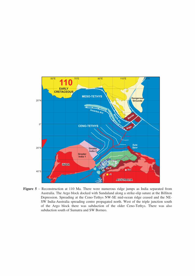
Figure 5 – Reconstruction at 110Ma. There were numerous ridge jumps as India separated fromAustralia.TheArgoblockdockedwithSundalandalongastrike-slipsutureattheBillitonDepression.Spreadingat theCeno-TethysNW-SEmid-ocean ridgeceasedand theNE-SWIndia-Australia spreadingcentrepropagatednorth.Westof the triple junction south of the Argo block there was subduction of the older Ceno-Tethys. There was also subductionsouthofSumatraandSWBorneo.

Figure 6–Reconstructionat90Ma.TheArgoblockdockedwithSWBorneoalongthestrike-slipMeratussuture, formingEastJavaandWestSulawesi,and theWoylaArcdockedwiththe Sumatra margin of Sundaland. The collisions terminated subduction. However,India continued tomove north by subduction beneath the IncertusArcwhich required formationofabroadlyN-StransformboundarybetweentheIndianandAustralianplates.AustraliabegantoseparatefromAntarcticabutataverylowrate.

Figure 7 –Reconstruction at 70Ma. Indiawas nowmoving rapidly northwith rapid spreading tothe south.Therewere large offsets of the ridge by transform faults, someofwhich arestillpreservedintheWhartonBasinbetweenthe90ERidgeandtheInvestigatorFracture. There was no significant relative motion between Australia and Sundaland and no subductionbeneathSumatraandJava.

Figure 8 – Reconstruction at 55Ma.Australia–Sundalandmotionwas slightly convergent causingsubductionalongtheeasternSundalandmarginbeneathSumbaandWestSulawesi.Thissubduction may have continued north outboard of the Asian margin. The Australian–Sundaland plate boundary was a dextral strike-slip zone south of Java and was a transtensional strike-slip zone south of Sumatra. The Incertus Arc and the northern marginofGreaterIndiahadcollidedandthearcwascarriednorthontheIndianPlate.

Figure 9–Reconstructionat45Ma.AustraliabegantomoverapidlyawayfromAntarctica.Australiaand India became part of a single plate, possibly reflecting the earliest India and Asiacontact,butalternativelyasa resultofchanges inplatemotions in thePacific.Ataboutthis time therewere arc-continent collisions inNewGuinea, andmajor changes in the WestPacific,formingmarginalbasinssuchastheCelebesSeaandPhilippineSea.South-directedsubductionoftheProto-SouthChinaSeabeganbelowBorneo.

Figure 10 –Reconstruction at 15 Ma. Ocean crust older than 120 Ma remained in the Banda embayment and arrived at the Java trench causing the trench to move eastwards along thecontinent–ocean boundary south of the Sula Spur. Almost all of this crust had been subductedexcepttheareawithmanyanomaliesintheArgoabyssalplainandoffwesternAustralia.