Summit Township Recreation · PDF fileRecreation Planning Committee ... With all those issues...
92
Summit Township Recreation Plan 2013-2017 edition
Transcript of Summit Township Recreation · PDF fileRecreation Planning Committee ... With all those issues...

Summit Township
Recreation Plan
2013-2017 edition

ii
Recreation Advisory Committee
Kurt Rudolph, Chair
Todd Emmons, Township Board Liaison
Michael Way, Township Board Liaison
Natalie Stopyak, Planning Commission Liaison
Aaron Bush
Jim Guerriero
Charles Neese
Marilyn Waite
Township Staff and Consultant
John Worden, Township Zoning Administrator
Grant Bauman, Region 2 Planning Commission
Plan Approval and Adoption
Recreation Planning Committee ..................................................................................................................... February 18, 2013
Summit Township Board of Trustees ................................................................................................................. March 26, 2013
Michigan Department of Natural Resources ........................................................................................................... July 24, 2013
The 2013-2017 edition of the Summit Township Recreation Plan will expire on December 31, 2017

iii
Table of Contents
Chapter 1 Page
Community Description ........................................................................................................................................................ 1-1
Location ................................................................................................................................................................................... 1-2
A Brief Socioeconomic Summary ............................................................................................................................................ 1-2
The Health of Jackson County Residents................................................................................................................................ 1-4
Chapter 2 ............................................................................................................................................................................. Page
Administrative Structure ....................................................................................................................................................... 2-1
Authorization ........................................................................................................................................................................... 2-2
Organizational Structure .......................................................................................................................................................... 2-2
Sources of Funding ................................................................................................................................................................. 2-3
Parks and Recreation Budgeting ............................................................................................................................................. 2-4
Relationships with Other Public Agencies ............................................................................................................................... 2-4
Schools .............................................................................................................................................................................. 2-4
Local, County, State, and Private Parks and Recreation Facilities .................................................................................... 2-4
Chapter 3 Page
Recreation and Resource Inventories ................................................................................................................................. 3-1
Recreation Inventory ............................................................................................................................................................... 3-2
Park Classifications and Standards ................................................................................................................................... 3-2
Parks and Recreation Facilities in Summit Township......................................................................................................... 3-2
Parks and Recreation Facilities in the Surrounding Area ................................................................................................... 3-7

iv
Resource Inventory ............................................................................................................................................................... 3-10
Recreation Events and Programs .................................................................................................................................... 3-11
Historic Sites .................................................................................................................................................................... 3-12
Transportation .................................................................................................................................................................. 3-13
Water Resources ............................................................................................................................................................. 3-13
Topography and Soils ...................................................................................................................................................... 3-14
Land Use .......................................................................................................................................................................... 3-14
Chapter 4 Page
Description of the Planning and Public Input Processes .................................................................................................. 4-1
Description of the Planning Process ........................................................................................................................................ 4-2
Description of the Public Input Process ................................................................................................................................... 4.2
Recreation Survey ............................................................................................................................................................. 4-2
Public Meeting (Open House) ............................................................................................................................................ 4-4
Publicizing the Planning Efforts .......................................................................................................................................... 4-4
One-Month Review Period ................................................................................................................................................. 4-4
Letters of Transmittal ......................................................................................................................................................... 4-4
Committee Meetings .......................................................................................................................................................... 4-4
Public Hearings .................................................................................................................................................................. 4-5
Other Planning Efforts ........................................................................................................................................................ 4-5

v
Chapter 5 Page
Goals and Objectives ............................................................................................................................................................ 5-1
Goals and Objectives .............................................................................................................................................................. 5-2
Goal #1 .............................................................................................................................................................................. 5-2
Goal #2 .............................................................................................................................................................................. 5-2
Background Information .......................................................................................................................................................... 5-2
Collaboration with Other Recreation Providers .................................................................................................................. 5-3
Trail Development .............................................................................................................................................................. 5-3
Chapter 6 Page
Action Program ..................................................................................................................................................................... 6-1
Action Program ........................................................................................................................................................................ 6-2
Background Information .......................................................................................................................................................... 6-2
Appendices
Appendix A Page Maps ...................................................................................................................................................................................... A-1
Appendix B Population Summary............................................................................................................................................................ B-1
Appendix C Jackson Community Comprehensive Plan 2000-2025 ...................................................................................................... C-1
Appendix D Recreation and Resource Inventories ................................................................................................................................ D-1
Appendix E Description of the Planning and Public Input Processes ................................................................................................. E-1

vi
Maps
Map Page
1 Location ........................................................................................................................................................................ A-2
2 School Districts ............................................................................................................................................................. A-3
3 Parks and Recreation Facilities .................................................................................................................................... A-4
4 Draft Non-Motorized Plan ............................................................................................................................................. A-5
5 Water Resources .......................................................................................................................................................... A-6
6 Prime Farmland and Greenways .................................................................................................................................. A-7
7 Future Land Use ........................................................................................................................................................... A-8
8 Action Program ............................................................................................................................................................. A-9

Chapter 1
Community Description Summit Township Recreation Plan
2013-2017 Edition

Chapter 1 Community Description
Summit Township Recreation Plan 1-2
A priority of Summit Township is to develop a recreation plan which responds to the recreational needs and desires of its residents. Given that charge, this plan provides a clear picture of the recreation opportunities available to residents re-gardless of who provides them. This review includes nontraditional opportunities such as historic districts/structures and shopping opportunities as well as traditional parks and recreation facilities.
In addition to its rich network of aquatic features, Summit Township and its surroundings are home to a variety of commu-nities, neighborhoods, and districts. The presence of trail corridors requires an intensive review of how that asset can be further integrated into the Township. With all those issues in mind, a sincere effort was spent in developing this recreation plan which represents the projected needs for recreation facilities and services during the early years of the 21st Century.
Location
Summit Township is located near the center of Jackson County, surrounding the southern two-thirds of the City of Jack-son. The Vandercook Lake CDP (Census Designated Place) is located along the eastern border of the municipality and adjacent to the lake from which the name of the unincorporated settlement is derived (see Map 1, Appendix A). Summit Township is also bordered by Blackman Township to the north, the Townships of Leoni and Napoleon Township to the east, Columbia Township to the southeast, Liberty Township to the south, Hanover Township to the southwest, Spring Ar-bor Township to the west, and Sandstone Township to the northwest. A number of major roadways traverse the approxi-mately thirty (30) square mile municipality: United States Highway 127 (freeway)/Meridian Road (US- 127), Brooklyn Road (M-50/BL-127), and Michigan Highway 60 (freeway) (M-60).
Jackson County is located in south-central Lower Michigan, close to the border with Northwest Ohio and Northeast Indi-ana. The Jackson Urbanized Area is located in the center of the County and covers much of Summit Township (see Map 1, Appendix A). The junction of I-94 and US-127 is located just north of the City of Jackson, earning the Area the nick-name of “Crossroads of Michigan.” Those roads connect Jackson directly to Ann Arbor and Detroit to the east, Battle Creek and Kalamazoo to the west, and Lansing to the north.

Chapter 1 Community Description
Summit Township Recreation Plan 1-3
A Brief Socioeconomic Summary
The composition of Summit Township’s population has an effect upon its recreational needs. Pertinent demographic components are listed below along with a brief paragraph describing the local situation. Each component is described in greater detail in Appendix B of this document.
� Population History & Projections. The 2010 population for Summit Township was 22,508 people. The Township’s population increased significantly between 1930 and 1980, especially during the 1950’s and 1960’s. The population also increased between 1990 and 2010. Based upon this pattern, it is reasonable to expect that the population of Summit Township will range between 22,700 and 23,900 people in 2020 and 22,900 and 25,300 people in 2030. Approximately one-fifth (21.0%) of township residents (4,721 people) lived in the Vandercook Lake CDP (Census Designated Place) in 2012.
� Age & Gender of the Population. Baby boomers (people aged 45 to 64 in 2010) and Generation X (people aged 25-44 in 2010) comprised approximately one half of the populations of Vandercook Lake (52.5%).and the rest of Summit Township (49.8%). Generation Y (people aged 10 to 24 in 2010) comprised approximately one fifth of the population of the CDP (20.0%) and the rest of the Township (19.0%). More than one-half of the residents of the Vandercook Lake CDP (51.8%) and the rest of the Township (52.8%) were female in 2010.
� Household & Family Composition. Over two-thirds of households in the CDP (71.4%) and the rest of the Town-ship (67.2%) were comprised of families in 2010. However, well over three-quarters of non-family households in Vandercook Lake (81.0%) and the rest of the Township (86.4%) were comprised of one person in 2010. Only a small portion (1.6%) of the Township’s residents resided in group quarters in 2010 and none of them lived in the CDP.
� Racial & Ethnic Composition. Race and ethnicity are not significant issues for recreation given that the vast major-ity of the residents of the Vandercook Lake CDP (95.3%) and the rest of the Township (88.1%) were white in 2010.
� Disabilities of Residents. More than one-seventh (15.4%) Jackson County residents were disabled in some way in 2010.1 Older residents were more apt to have a disability than their younger neighbors. People with ambulatory (mobility) difficulties also made up a greater percentage of those disabled as age increased.
1 Information on disabilities was not available for the Vandercook Lake CDP or Summit Township

Chapter 1 Community Description
Summit Township Recreation Plan 1-4
� Income. The median income for all Summit Township households ($52,559) was greater than the median for Vandercook Lake ($44,153). The same is true for median family and non-family households. It should also be noted that the median incomes for non-family households were significantly less than those for family households.
The Health of Jackson County Residents2,3
Almost one-third (30.9%) of Michigan residents were considered obese in 2010 (Centers for Disease Control) and the 10th most obese state in the United States in 2011 (Trust for America’s Health).4,5 Increased physical activity and de-creased sedentary behavior are associated with lower rates of obesity, and it reduces the risk for many of the diseases associated with obesity, such as diabetes and heart disease, according to the United States Surgeon General.6 These statistics point to a need for more active recreational opportunities in all communities. Those opportunities may include providing more walkable neighborhoods as well as the provision of actual recreational opportunities such as athletic fields (e.g., soccer, baseball, etc.) and courts (e.g., basketball, tennis, etc.).
The 2011 Jackson County Community Health Assessment indicates that nearly one-third (31.6%) of survey respondents reported being overweight and well over one-third (37.0%) reported being obese, which means that less than one-third (29.9%) of respondents reported a healthy weight.7 From 2008 to 2011, the percentage of those overweight decreased 5.8% and the percentage of those obese increased 4.7%, representing an undesirable trend. “Overweight and obesity substantially increase the risk for cardiovascular disease, type 2 diabetes, hypertension, lipid disorders, stroke, gallblad-der disease, osteoarthritis, sleep apnea, respiratory problems, psychological disorders, stress incontinence, and cancers of the endometrium, breast, prostate and colon,” according to Promoting Healthy Weight in Michigan through Physical Ac-
2 Information of health was not available for the Vandercook Lake CDP or Summit Township. 3 An earlier version of this section appeared in the 2008-2012 edition of this document and was adapted from text originally prepared for the current edition of the Jackson Com-munity Comprehensive Plan (see Appendix C). 4 Centers for Disease Control & Prevention (2012). Retrieved from http://www.cdc.gov/obesity/data/adult.html/#History 5 Trust for America’s Health (2011). Retrieved from http://www.healthyamericans.org/report/88/. 6 U.S. Department of Health and Human Services (2010). The Surgeon General’s Vision for a Health and Fit Nation. Rockville, MD: U.S. Department of Health and Human Ser-vices, Office of the Surgeon General. 7 Health Improvement Organization (2012). Jackson County Community Health Assessment. Publication pending.

Chapter 1 Community Description
Summit Township Recreation Plan 1-5
tivity and Nutrition. A couple factors of particular relevance to community growth, development, and planning contribute to unhealthy weight, according to that report:8
� “Inadequate community infrastructure limits the ability of people to be active. These include lack of accessible indoor and outdoor exercise facilities, neighborhood sidewalks, walking paths, and bicycle trails. Additionally, inclement weather, lack of adequate recreational opportunities, fear of unsafe neighborhoods, and unattractive/unpleasant local environments may prevent people from exercising.”
� “Programs and policies are necessary to promote smart community growth and the establishment of urban and rural environments supportive of physical activity. Active community environments provide access to safe favorable condi-tions for physical activity and promote the development of social support networks that encourage activity.”
Promoting Healthy Weight in Michigan through Physical Activity and Nutrition recommends cooperation among state and local units of government and residents in the promotion of active environments, including the following actions.
1. “Develop walkable communities by widening and maintaining or building sidewalks, safe roadway crossings, and aes-thetically pleasing areas.”
2. “Encourage bicycling by developing, maintaining, and promoting the use of bike paths.” 3. “Require [that] all urban planning and re-design incorporate the concepts of active community environments and
[thereby] promote physical activity.”
The 2011 Jackson County Community Health Assessment indicates that slightly less than one-half (46.6%) of residents meet the guidelines for moderate physical activity (at least 5 times a week for at least 30 minutes) and slightly more than one-quarter (28.6%) meet the guidelines for vigorous physical activity (at least 3 times a week for at least 20 minutes). Overall, only slightly more than one-half (53.8%) of residents meet at least one of these guidelines (either moderate or vigorous physical activity). Therefore, almost one-half of the residents in Jackson County are not getting the recommend-ed amount of physical activity.
8 Promoting Healthy Weight in Michigan through Physical Activity and Nutrition is part of a series entitled “Informing the Debate: Health Policy: Options for Michigan Policymakers,” published by Michigan State University's Institute for Public Policy and Social Research (IPPSR) and Institute for Health Care Studies (ICHS).
Chapter 1 Community Description
Summit Township Recreation Plan 1-6

Chapter 2
Administrative Structure Summit Township Recreation Plan
2013-2017 Edition

Chapter 2 Administrative Structure
Summit Township Recreation Plan 2-2
Authorization
In response to identified recreation needs, the Summit Township Board formed the Recreation Planning Committee under the authority of Public Act 156 of 1917 (Recreation and Playgrounds). The Act:
� authorizes “cities, villages, counties, townships and school districts to operate systems of public recreation and play-grounds” (emphasis added). It also allows those entities to:
� “operate a system of public recreation and playgrounds; acquire, equip and maintain land, buildings or other rec-reational facilities; employ a superintendent of recreation and assistants; [and] vote and expend funds for the op-eration of such system.”
� “operate such a system independently or they may cooperate in its conduct in any manner which they may mutu-ally agree; or they may delegate the operation of the system to a recreation board created by any or all of them, and appropriate money, voted for this purpose, to such board.”
� The act also allows park systems to operate on “(1) property under its custody and management; (2) other public property . . .; [and] (3) private property, with the consent of the owners.”
PA 156 of 1917 may be viewed online at:
http://www.legislature.mi.gov/(S(ebmra5bwaifiwqzgaj2orpnw))/mileg.aspx?page=getObject&objectName=mcl-Act-156-of-1917
Organizational Structure
The Recreation Planning Committee is charged with producing this recreation plan and advising the Township Board on recreation issues and grant opportunities. However, the Summit Township Board maintains final authority concerning lo-cal recreation issues. Staff and consultants advise the Township during the development of recreation plan updates and amendments as well as on grant applications and other recreation issues. The Township may also rely on organized vol-unteer labor for specific projects on an as-needed basis.

Chapter 2 Administrative Structure
Summit Township Recreation Plan 2-3
Organizational Chart
Membership on the Recreation Planning Committee consists of four township residents as well as liaisons from the Town-ship’s Board and Planning Commission. The Township’s Supervisor, Clerk, and Treasurer, in addition to four trustees, comprise the Board. The Township’s Zoning Administrator is the primary staff person on recreation issues. Region 2 Planning Commission staff also advises the Township when requested. Summit Township may utilize volunteers for spe-cific recreation projects.
Sources of Funding
Summit Township identifies several potential sources of revenue for recreation:
� general tax fund dollars; � grants awarded for specific projects; and � donations from the general citizenry and philanthropic organizations.
General tax fund dollars are used for recreation, including the cost of producing this document. The Township may solicit grants for the acquisition of parkland and the development of a park or recreational facility (e.g., trails, playgrounds, picnic shelters, sports facilities, etc.). Donations to be used at the discretion of the Township or for a specific facility or program will also be accepted. A portion of the local match required of most grants may also come from the general fund or dona-tions. Grants for parks and recreational facilities are likely to come from several sources:
Summit Township Board
Recreation Planning Committee
Township Staff and Consultants

Chapter 2 Administrative Structure
Summit Township Recreation Plan 2-4
� The Michigan Department of Natural Resources
� The Michigan Natural Resources Trust Fund � The Land and Water Conservation Fund1
� The Michigan Department of Transportation � Michigan Transportation Alternatives Program (TAP)1
� The Jackson County Road Commission � The 1% annual allocation of state transportation (Act 51) fund for non-motorized facilities.
Parks and Recreation Budgeting
Summit Township currently owns some trails, but it does not own, staff, or maintain any other recreation facilities.2 Con-sequently, the need for full-time recreation staff is not anticipated. The Township currently contracts with the City of Jack-son for trails maintenance. As maintenance responsibilities increase with the development of the trail system, the Town-ship will continue to contract with the City, a private company, or the Jackson County Parks and Recreation Commission for trail maintenance.
Relationships with Other Public Agencies
Summit Township is not the only supplier of parks and recreational opportunities to its residents.
Schools
Vandercook Lake Public Schools serve a major population center within the Township (i.e., the Vandercook Lake CDP)) and Jackson Public Schools also serve many school-aged residents (see Map 2, Appendix A). Hanover-Horton Schools, the Western School District, and East Jackson Community Schools also serve some students living along the perimeter of the Township. The Jackson County Intermediate School District (which includes Vandercook Lake and Jackson Public Schools) provides educational services to residents and local school districts. Please refer to Chapter 3 for a more de-tailed description of the recreational facilities and programs provided by schools.
1 This is a Federal program administered locally by the State of Michigan.
2 Summit Township is responsible for maintaining all of the roadside trails listed in Table 3-8.

Chapter 2 Administrative Structure
Summit Township Recreation Plan 2-5
Local, County, State, and Private Parks and Recreation Facilities
Jackson County and the City of Jackson are major recreation providers in and around Summit Township. Some of the nearby townships and villages also maintain parks. The State of Michigan provides a variety of recreational facilities as well in the form of nearby state game, wildlife, and recreation areas; state historic parks; and state parks throughout the State (although none of those facilities are located in the study area). A variety of private entrepreneurs and quasi-public agencies also provide recreation facilities and programs in and around Summit Township. Recreational programs take place in many of the facilities listed above. Those programs are sponsored by a variety of public, quasi-public, and private boosters. Please refer to Chapter 3 for a more detailed description of recreation facilities in the Summit Township Area.

Chapter 2 Administrative Structure
Summit Township Recreation Plan 2-6

Chapter 3
Recreation and Resource Inventories Summit Township Recreation Plan
2013-2017 Edition

Chapter 3 Recreation and Resource Inventories
Summit Township Recreation Plan 3-2
Recreation Inventory
In order to plan for future parks and recreation facilities it is important to prepare a complete inventory of existing re-sources and facilities. The following inventory is comprised of all known parks and recreation facilities and programs available in Summit Township, not just those owned and managed by the Township. The parks, facilities, and programs were identified through local knowledge and review of current and historic documents and maps.
Park Classifications and Standards
It is also important to be able classify parks and recreation facilities in order to identify the need for additional parkland and recreation facilities in Summit Township. Park systems are comprised of several types of parks:
� Mini-Parks — Small parks (less than an acre) which address limited, isolated, or unique recreational needs. � Neighborhood Parks — Informal active and/or passive recreation parks which serve as the focus of the neighbor-
hood; this park type also serves as a mini-park for the area immediately adjacent to the facility. � Community Parks — Parks which serve a broader focus than a neighborhood and may also preserve a unique land-
scape or open space; this park type also serves as a neighborhood park for the area immediately adjacent to the facili-ty.
� Regional Parks — Parks which serve the entire county as well as preserving unique landscapes and open spaces; this park type also serves as a community park for the area surrounding the facility.
� Connector Trails — Linear parks which serve as non-motorized connectors among neighborhoods, business areas, parks, schools, and other destinations.
Parks and Recreation Facilities in Summit Township
Parks and recreation facilities found in Summit Township are provided by Jackson County, Vandercook Lake Public Schools, and a variety of private and quasi-public entities as well as the Township.

Chapter 3 Recreation and Resource Inventories
Summit Township Recreation Plan 3-3
Summit Township Recreation Facilities
Summit Township does not own or maintain any parkland. The Township, however, does maintain the Probert Road Trail, a connector trail which extends eastward from the bike path along Francis Street into Ella Sharp Park (please see the following table and the Map 4, Appendix A).
Township Recreation Facilities
Key Name Description BFA1
A Probert Road Trail Along the north side of Probert Road, extending from Ella Sharp Park (City of Jack-son) eastward to Francis Street.
4
� Accessibility — It is important that the trail be accessible to people with disabilities. After all, an estimated one-sixth of township residents were disabled in some way during 2006-2010 and over one quarter (26%) of disabled residents 65 years of age or older had an ambulatory (mo-bility) difficulty. Accordingly, the trail was rated according to its level of barrier free access. The number listed under the BFA column in the above table equates to the barrier-free rating listed in the adjacent table.
� Past Grants — The Michigan Department of Natural Resources has awarded Summit Township no recreation grants.
1 The analysis of barrier free access was provided by Summit Township, based upon its knowledge of the parks and understanding of barrier-free access. A professional analysis may produce different results.
Barrier-Free Access (BFA) Analysis
Key Description
1 = None of the facilities/park areas meet accessibility guidelines
2 = Some of the facilities/park areas meet accessibility guidelines
3 = Most of the facilities/park area meet accessibility guidelines
4 = The entire park meets accessibility guidelines
5 = The entire park was developed/renovated utilizing universal design

Chapter 3 Recreation and Resource Inventories
Summit Township Recreation Plan 3-4
Other Public Parks
Although Summit Township does not own or maintain any parkland, Vandercook Lake County Park —a community park— is located within the municipality as is much of Sparks Foundation (Cascades) County Park —a regional park— (please see the following table and the Map 3, Appendix A). The City of Jackson’s Ella Sharp Park — a 533 acre regional park)— also borders the Township. Given the 22,508 residents in 2010 and the estimated population of 22,706-23,886 people in 2020, the parkland listed above more than satisfies the minimum acreage recommended by the National Recreation and Park Association.2
Other Public Parks in Summit Township
Key Name Description
B Sparks Foundation County (Cascades) Park
Water access, an illuminated waterfall, golf courses, a banquet facility, a band shell, a fishing pier,: green space, picnic areas, a basketball court, playground structures, a handicap accesi-
ble urban fishery; and modern restrooms and portable toilets − 442.8 acres
C Vandercook Lake County Park Water access, a swimming area, a boat launch; green space, a picnic area, ball diamonds, a
playground area, kayak rental, and restrooms − 20.7 acres
Other Connector Trails
Various other trails also traverse Summit Township (please see the following table and the Map 4, Appendix A). For ex-ample, the Intercity Trail and Falling Water Trail corridor connect the City of Jackson with the Village of Concord, passing though Summit Township and the community of Spring Arbor. That non-motorized corridor will also provide access to other trails proposed for Jackson County.
2 10 acres per 1,000 population according to: http://www.prm.nau.edu/prm423/recreation_standards.htm

Chapter 3 Recreation and Resource Inventories
Summit Township Recreation Plan 3-5
Other Connector Trails in Summit Township
Key Name Description
D Intercity Trail The trail extends southeastward into the Township from Jackson to Weatherwax Road.
E Falling Water Trail An extension of the Intercity Trail, extending from Weatherwax Road southeast to Concord.
F Weatherwax Road Trail A parallel trail along the western edge of the road, extending from the Intercity Trail to Horton Road.
G Spring Arbor Road Trail A parallel trail along the northern side of the road, extending from east of Robinson Road (Lumen Christi) to south of Morrell Road (Pollys).
H High Street Trail A parallel trail along the southern side of the street (into Sparks Foundation County Park), extending from Spring Arbor Road to the Cascades Park Trail System (City of Jackson).
I Francis Street Bike Lanes Paved shoulders, extending between South Street and McDevitt Road.
J South Street Bike Lanes Paved shoulders, extending between Francis Street and M-50 (Cooper St//Brooklyn Rd.).
K McDevitt Avenue Bike Lanes Paved shoulders, extending between Francis Street and Old McDevitt Road, and a four (4) foot wide sidewalk, extending between Maurice Avenue and Old McDevitt Road, on the north side of the roadway.
Local Schools
Schools also provide a variety of recreational facilities (please see the following table and the Map 3, Appendix A). For example, elementary schools provide numerous playgrounds aimed at different age groups and sports fields. Middle and high schools provide football fields, ball diamonds and tennis courts. Elementary, middle, and high schools provide gym-nasiums. Because of those facilities, schools generally function as community parks.
Vandercook Lake Public Schools serve students living in the CDP and all of its facilities are located in the unincorporated settlement. Jackson Public Schools serves much of the Township and one of its elementary schools is located within the municipality. Several private schools are also located in the municipality.

Chapter 3 Recreation and Resource Inventories
Summit Township Recreation Plan 3-6
Schools in Summit Township
Key Name District Facilities
L Vandercook High Vandercook Lake PS Football fields, track, ball fields, and tennis & basketball courts – 21 acres.
M Townsend Elementary Vandercook Lake PS Ball fields, basketball court, and play equipment – 18 acres.
N Dibble Elementary Jackson PS Basketball court, ball field, picnic table, and play equipment – 4.5 acres.
O Lumen Christi High Private Football field, tennis courts, track, softball & baseball fields, soccer fields, and basketball court – 43.5 acres.
P Jackson Christian Elementary Private Ball field, basketball court, soccer fields, and play equipment – 8 acres.
Q Jackson Christian High Private Soccer field – 10 acres.
R Paragon Charter Academy Private Basketball court, soccer field and playground equipment.
Quasi-Public and Private Recreation Facilities
A number of quasi-public and private entities also maintain recreational facilities in Summit Township (please see the fol-lowing table and the Map 3, Appendix A). For example, the Township is home to the AMF Summit Lanes and the Dahlem Center, which contains an environmental education center. Facilities provided by other quasi-public and private entities also have some recreational value. For instance, the Jackson District Library (JDL) provides access to books, films, and a variety of enrichment programs. The JDL’s Summit Branch is located in Vandercook Lake (please see the City of Jack-son and Jackson County Recreation Plan for more detail on JDL facilities).

Chapter 3 Recreation and Resource Inventories
Summit Township Recreation Plan 3-7
Other Recreation Facilities3
Key Name Facilities
S AMF Summit Lanes Bowling lanes, billiards, and child care – 7.5 acres.
T Dahlem Center Nature and environmental education center – 200 acres.
U Grande Golf Club 18-hole course - 400 acres.
V Jackson Country Club 27-hole course, pool, tennis courts, and fitness center – 550 acres.
W Hickory Hills Golf Club 36-hole course and cross-country skiing – 250 acres.
Parks and Recreation Facilities in the Surrounding Area
Parks and recreation facilities provided by a number of public, quasi-public, and private institutions are also located in the surrounding area.
Other Municipal and County Parks
Some of the surrounding municipalities also provide parks to their residents (please see the City of Jackson and Jackson County Recreation Plan for more facilities).
� City of Jackson — the City maintains a total of 27 parks (please see the City of Jackson and Jackson County Recrea-tion Plan for more detail).
� Blackman Township — Rod Mills Memorial Park � Hanover Township — Bibbins Lake Park, Perrin Park, Veteran’s Ball Field � Leoni Township — Peter Alex Ball Park, Leoni Community Park, Bender Park, and a public boat launch � Napoleon Township — Napoleon Village Park, Napoleon Lions Park, and girls’ softball field � Spring Arbor Township — Fritz Gallagher Park and Harmony Park � County of Jackson — the County maintains another 14 parks outside of the Township (please see the City of Jack-
son and Jackson County Recreation Plan for more detail).
3 Sparks Foundation County (Cascades) Park also contains the 9-hole Cascades Short Course and driving range and the 18- hole Championship Golf Course.

Chapter 3 Recreation and Resource Inventories
Summit Township Recreation Plan 3-8
Other Public School Districts
Vandercook Lake Public Schools is the only district located entirely within Summit Township and all of its facilities are lo-cated in the Vandercook Lake CDP (Census Designated Place). Although Jackson Public Schools serves much of the Township, most of its schools are located in the City of Jackson. Several other public school districts also serve small portions of Summit Township although they maintain no facilities in the municipality (please see the City of Jackson and Jackson County Recreation Plan for more school districts).
� Jackson Public Schools — covers the City of Jackson and portions of Blackman, Liberty, Napoleon, and Summit Townships. The district, maintains the following facilities outside of the Township:
� Bennett Elementary � Cascades Elementary � Dibble Elementary � Frost Elementary
� Hunt Elementary � McCulloch Academy � Northeast Elementary � Sharp Park Academy
� Middle School at Parkside � Jackson High � T. A. Wilson Academy
� East Jackson Community Schools —covers portions of Blackman, Leoni, Summit, and Waterloo Townships. The district maintains the following facilities outside of the Township:
� Bertha Robinson Elementary � Memorial Elementary � East Jackson Middle-High
� Hanover-Horton School District — covers the Village of Hanover and portions of Hanover, Liberty, Pulaski, Spring Arbor and Summit Townships. The district maintains the following facilities outside of the Township:
� Hanover-Horton Elementary � Hanover-Horton Middle � Hanover-Horton High
� Western School District — covers the Village of Parma and portions of Concord, Parma, Sandstone, Spring Arbor and Summit Townships. The district maintains the following facilities outside of the Township:
� Bean Elementary � Parma Elementary
� Warner Elementary � Western Middle
� Western High � Woodville Comm. Center

Chapter 3 Recreation and Resource Inventories
Summit Township Recreation Plan 3-9
Local Colleges
There are several local colleges in the surrounding area. Jackson Community College’s main campus is located in Sum-mit Township. Baker College’s local campus is located in Blackman Township. Finally, Spring Arbor University’s main campus is located in the unincorporated village of Spring Arbor.
Many colleges provide access to collegiate sports and athletic facilities. Township residents can also avail themselves of the other recreational facilities and programs hosted by those institutions. For example, The Potter Center (Jackson Community College) “is comprised of the most versatile and complete performing arts complex in the area.”4 The Ganton Gallery (Spring Arbor University) “is one of the largest, single-room galleries in Michigan.”5
State Parks
The Michigan Department of Natural Resources (DNR), a significant provider of regional parks and recreation facilities, maintains parkland which extends into Jackson County (please see the City of Jackson and Jackson County Recreation Plan for a full listing of state recreation facilities in Jackson County). For example, Walter J Hayes State Park —which ex-tends into Norvell Township— provides opportunities for boating, fishing, picnicking, metal detecting, playing (i.e., play-grounds), swimming, and camping. The Waterloo Recreation Area —which extends into the townships of Grass Lake, Leoni, and Waterloo— provides opportunities for cross-county skiing, snowmobiling, boating, fishing, hiking, mountain biking, swimming, horseback riding, picnicking, playing (i.e., playgrounds), and camping. The Sharonville State Game Ar-ea —which extends into the townships of Grass Lake and Norvell— provide opportunities for hunting. Finally, the DNR also maintains eight boat launches in Jackson County.
Jackson County Fairground
The Jackson County Fair is held every August in the City of Jackson. However, it is important to note that the Fairground also hosts other special events throughout the year, including the annual ‘Nite Lights at the Fairgrounds.’
4 http://www.jccmi.edu/events/pottercenter/theatres.htm 5 http://www.arbor.edu/edu_detail.aspx?id=37930

Chapter 3 Recreation and Resource Inventories
Summit Township Recreation Plan 3-10
Golf Courses
In addition to the public courses associated with the Ella Sharp and Sparks Foundation (Cascades) County Parks, a varie-ty of private courses are available to Summit Township residents. Many of those courses are open to the general public (please see the City of Jackson and Jackson County Recreation Plan for a complete listing of golf courses in Jackson County).
Recreation and Sport Centers
The YMCA of Jackson provides a variety of sports and recreational activities. Allskate Fun Center and Optimist Ice Arena are also located in the City of Jackson. Finally, Airport Lanes, and Suburban Bowling Lanes provide opportunities for bowling.
Public and Private Facilities with Recreational Benefits
Various other facilities in the surrounding area (provided publicly and privately) also have recreational benefits:
� Cemeteries — Cemeteries provide important green space. They can also be used as safe places to walk/exercise and contemplate nature (please see the City of Jackson and Jackson County Recreation Plan for a listing of cemeter-ies in Jackson County).
� Sidewalks — Existing sidewalks are used for exercise as well as transportation and may even connect with non-motorized trails.
� Shopping and Eating — Many people enjoy shopping and going out to eat. Consequently, nearby local downtowns and other commercial districts provide recreation because of their restaurants and/or shops (please see the City of Jackson and Jackson County Recreation Plan for more on shopping and eating opportunities in Jackson County).
Resource Inventory
In addition to recreation facilities, Summit Township and the surrounding area is also home to a wide variety of cultural and natural resources. The Township is graced with a slightly rolling landscape, including some hills, low broad valleys, the Grand River and some of its tributaries, and a number of lakes and wetlands. It also has access to major transporta-tion routes and has become increasingly urbanized. This type of landscape is amenable to the development of trails.

Chapter 3 Recreation and Resource Inventories
Summit Township Recreation Plan 3-11
Recreation Events and Programs
Summit Township does not maintain any recreation programming or provide any events. However, local schools, Jack-son County, and the City of Jackson do actively provide recreation programming and host events. It should also be point-ed out that many of the recreation providers listed above also provide recreational programs. For example, the various bowling alleys also host bowling leagues.
Local Schools
Schools are the primary providers of recreation facilities and programs for children. Sporting teams, band programs, and school plays provide recreational opportunities for the entire community.
� Vandercook High School is a member of the Cascade Conference. The Jayhawks regularly compete against Addison, East Jackson, Grass Lake, Hanover-Horton, Manchester, Michigan Center, and Napoleon.
� Jackson Lumen Christi and Jackson High Schools are members of the Capital Area Activities Conference. The Titans and the Vikings regularly compete against Charlotte, Dewitt, East Lansing, Fowlerville, Grand Ledge, Haslett, Holt, Io-nia, Jackson Northwest, Lake Odessa, Lakewood, Lansing Catholic, Lansing Everett, Lansing Sexton, Lansing Waver-ly, Mason, Okemos, St. Johns, and Williamston.
� Jackson Christian High School is a member of the Southern Central Athletic Association. The Royals regularly com-pete against Burr Oak, Camden-Frontier, Climax-Scotts, Litchfield, North Adams-Jerome, Pittsford, Tekonsha, and Waldron.
Jackson County
The Sparks Foundation County (Cascades Falls) Park —located in Summit Township and the City of Jackson— hosts a variety of events (please see the City of Jackson and Jackson County Recreation Plan for more detail). The Jackson County Parks Association also hosts a variety of work-bees and recreational events in the various parks.
City of Jackson
The City of Jackson provides a wide variety of recreation programming. Those programs are available to Township resi-dents who also reside in the Jackson Public School District (please see the City of Jackson and Jackson County Recrea-tion Plan for more detail on programs).

Chapter 3 Recreation and Resource Inventories
Summit Township Recreation Plan 3-12
Clubs and Organizations
There are a variety of clubs and organizations that organize recreational activities. For example, the Jackson Fitness Council organizes a variety of events aimed at active living. The Grand River Environmental Action Team (GREAT) hosts canoeing and kayaking excursions. The Cascades Cycling Club and a running club are also active in the area. The Dahlem Conservancy provides guided nature hikes on the grounds of the Dahlem Center. Finally, the Jackson County Convention and Visitors Bureau (JCCVB) promotes birding birdsinjackson.com which identifies Sparks Foundation County (Cascades) Park and Ella Sharp Park as prime bird watching locations.
Historical Sites
Historical sites are important cultural and recreational resources.
State and/or National Registers
Summit Township hosts two sites on Michigan’s register of state historic sites.
National and State Historical Sites
Structure Address/Loction
Registers*
NR SR HM
McCain School 3517 McCain Road � �
Thomas Wilson House 3600 Vrooman Road �
*NR = National Register ; SR = State Register; AND HM = Historic Marker
A total of 56 other sites are located throughout Jackson County, many within the City of Jackson. Michigan’s State Histor-ic Preservation Office describes each site through its ‘Historic Sites Online’ database. 6
6 http://www.mcgi.state.mi.us/hso/advancesearch.asp

Chapter 3 Recreation and Resource Inventories
Summit Township Recreation Plan 3-13
City of Jackson Historic Districts
The Under the Oaks Neighborhood in nearby Jackson is a locally designated historic district. The City has also designat-ed 42 other local historic districts. The City’s Historic Preservation Ordinance (Chapter 13 of the City Code) describes each of the sites.
Transportation
Jackson County and Summit Township share a well-connected transportation system. Interstate 94 (I-94) traverses the County from east-to-west, north of the Township. I-94 provides access to the major metropolitan areas of Chicago and Detroit. United States Highway 127 (US-127) runs along the eastern edge of the Township. It provides access to the Lansing area and other points north as well as Adrian and Toledo to the south. A couple of Michigan highways (i.e., M-50/BL-127 and M-60), Horton/South Jackson Road, Francis Street, McDevitt Road, Spring Arbor Road, and a variety of other county primary roads provide access to those major roadways. The Francis Street bus line also extends into the Township as far south as Clark Street, east of Ella Sharp Park. The InterCity Trail and Falling Water Trail provide and im-portant non-motorized corridor connecting the City of Jackson to the Village of Concord, with plans statewide to incorpo-rate the facilities into a trail connecting Port Huron (Lake Huron) to South Haven (Lake Michigan).7
Water Resources
Many wetland areas and a number of lakes are located within Summit Township, the largest of which are Browns and Vandercook Lakes (see Map 5, Appendix A). This drainage system generally flows in a northerly direction into the Grand River and its tributaries. The northwest portion of the Township drains into Sandstone Creek via the McCain Drain while the remainder drains into the Grand River via the Mercedes and Ferguson Drains.
Summit Township is located entirely within the Upper Grand River Watershed, which eventually drains into Lake Michi-gan. However, other watersheds are located to the south of the Township within the study area (see Map 4, Appendix A). The River Raisin Watershed, located to the southeast, eventually drains into Lake Erie. The Kalamazoo River Watershed, located to the southwest, eventually drains into Lake Michigan.
7 See Route #1 proposed in the Great Lake-To-Lake Trails brochure.

Chapter 3 Recreation and Resource Inventories
Summit Township Recreation Plan 3-14
Topography and Soils
Elevations of land in Summit Township fluctuate 172 feet in height. The low point of 926 feet above sea level is located to the northeast along the border with the City of Jackson. The high point of 1,098 feet above sea level is located near the southwest corner of the Township. Low areas throughout the Township are easy to identify as they are dominated by wetlands and are unsuitable for development.
The types of soils found in Jackson County are important to its development. For example, while agricultural land remains in Summit Township, only a small portion of the proposed agricultural preservation extends into the southwest corner of the municipality (see Map 6, Appendix A). However, a possible network of greenways which “generally follows wetland areas, drainage ways, and forested lands” is located in Summit Township (please see the City of Jackson and Jackson County Recreation Plan for more information on agricultural preservation areas and greenways).
Land Use
The ‘2025 Jackson County Land Use Plan’ map contained in the 2000-2025 edition of the Jackson Community Compre-hensive Plan shows a mix of residential, commercial, and industrial land uses within the City of Jackson, Summit Town-ship, and the other surrounding townships, extending along major thoroughfares.(see Map 7, Appendix A). The map also shows a mix of residential and commercial uses in and around the County’s various villages and some of its lakes. Small concentrations (i.e., nodes) of industrial development are recognized along some of the County’s major roads. The rest of the County will continue to be primarily agricultural.

Chapter 4
Descriptions of the Planning and Public Input Processes Summit Township Recreation Plan
2013-2017 Edition

Chapter 4 Descriptions of the Planning and Public Input Processes
Summit Township Recreation Plan 4-2
Description of the Planning Process
The steps utilized to develop the 2013-2017 edition of the Summit Township Recreation Plan included the following:
1. Summit Township recognized the need to update the Recreation Plan.
2. Summit Township administration contracted with Region 2 Planning Commission staff to facilitate the development of the 2008-2012 edition of the Plan in the summer of 2012.
3. Region 2 staff updated the community description; administrative structure; and recreation and resource inventories within the Plan, including new mapping, and reported the findings to the Recreation Planning Committee.
4. The Recreation Planning Committee conducted an online recreation survey in the fall of 2012.
5. The Recreation Planning Committee utilized the input collected from the various public involvement efforts and the information produced by Region 2 staff to develop the goals and objectives and action program included in the Plan.
6. The Recreation Planning Committee provided the plan for public review from January 15th through February 15th of 2013 and held a public hearing on February 18, 2013. The Plan was approved by the Committee and recommended for adoption by the Township Board after the public hearing was closed.
7. The Summit Township Board of Trustees adopted the Plan on March 26, 2013.
Description of the Public Input Process
A variety of methods were employed to incorporate public input into the development of this recreation plan:
Recreation Survey
An online recreation survey was conducted during fall of 2012 at www.summittwp.com (please see Appendix E). Despite efforts to publicize the opportunity, only 17 people responded to the survey. The survey results include:
1. How do you rate the non-motorized trail system extending throughout Summit Township?
17.6% Excellent 47.1% Good 17.6% Fair 5.9% Poor 11.8% No Response
2. How many times have you used the trail system in the last year?
5.9% None 58.5% 1-10 0.0% 11-20 29.4% +20 5.9% No Response 3. Do you support the expansion/improvement of the trail system within Summit Township?

Chapter 4 Descriptions of the Planning and Public Input Processes
Summit Township Recreation Plan 4-3
29.4% Yes 64.7% No 5.9% No Response
If yes, would you be willing to financially support the expansion/improvement and maintenance of the system?
41.2% Yes 41.2% No 17.6% No Response
4. Which trails and bike lanes do you use?
Independent Trails
13.2% Inter City Trails 28.9% Falling Water Trail
Roadside Trails
2.6% Probert Rd Trail 21.2% Weatherwax Rd Trail 10.5% Spring Arbor Rd Trail 0.0% High St Trail
Bike Lanes
0.0% South St 7.9% Old McDevitt Lanes 2.6% Francis to Ella Sharp Park
Other
2.6% “other this”
5. Where would you like to see the trail system expanded?
“Cascades” “Down the whole of mcdevitt from shell to buddies” “More places inside the township” “Areas that reach more of the people who use the trail” “S Jackson/Horton Rd neighborhoods to Falling Water”
“This is question answer 5” “Question 5” “Need to hook into Cascades area- Down Kibby Road” “Yes please” “None”
6. Are there other recreation facilities you would like to see within Summit Township? If yes, please list.
“Scuba Diving” “something for youth” “Place to play pool” “tennis” “Disc Golf”
“Fishing” “Scuba Diving and pet training opportunities” “This is question answer 6” “Question 6” “other recreation facilities”
It should be noted that surveys conducted during the summers of 2002 and 2007 establish solid support for the development of a trail system throughout Summit Township as well as other facilities (please see the 2008-2012 edition of this plan).

Chapter 4 Descriptions of the Planning and Public Input Processes
Summit Township Recreation Plan 4-4
Plan Review Meeting (Open House)
An open house for Summit Township residents and business owners was held on January, 14, 2013 at the Township Hall at 7:00 pm (please see Appendix E). Potential projects suggested during the open house consisted of suggestions for improving the trail system:
� “To make a connection from Ferguson Corners to the City on Horton Road using either the north, south or a combination of both sides,” and
� “Make a connection to the Falling Waters Trail by way of Ridgeway from the dead end to Lowe Road to Horton Road.”
Publicizing the Planning Effort
The following efforts were made to publicize the process for updating the recreation plan (see Appendix E):
� September 19, 2012 and September 20, 2012 interviews with Jim Dunn, Township Supervisor, on JTV (cable television) and WKHM (AM radio), respectively, regarding the survey;
� September 30, 2012 (survey), January 3, 2013 (open house), and January 17, 2013 (public hearing) ads in the Jackson Citizen Patriot, respectively;
� October 9, 2012 (survey), January 8, 2013 (open house), and January 22, 2013 (public hearing) ads in the Brooklyn Exponent, respectively;
� October 4, 2012, article in the Jackson Citizen Patriot; � December 18, 2012 article in the Brooklyn Exponent; and. � January 2013 flyers on the open house and one month review period distributed by Summit Township.
One Month Review Period
The recreation plan was submitted for a one-month public comment period which began on January 15, 2013 and ended on February 15, 2013 (please see Appendix E). The plan was available for review in the Summit Township Office and the Summit Branch of the Jackson District Library as well as online at www.summittwp.com. No ideas were generated during the review period.
Letters of Transmittal
Letters of transmittal were sent to the County of Jackson and the Region 2 Planning Commission (R2PC) alerting those bodies of the recreation planning effort (please see Appendix E).
Committee Meetings
All meetings of Summit Township’s Recreation Planning Committee are open to the public.

Chapter 4 Descriptions of the Planning and Public Input Processes
Summit Township Recreation Plan 4-5
Public Hearing and Plan Approval
A public hearing on the recreation plan was held on February 18, 2013 at 7:00 p.m. in the Township Hall, during a regular meeting of the Recreation Planning Committee (please see Appendix E). A Resolution of Approval was then passed by the Committee (please see Appendix E). The Township’s Board of Trustees passed a Resolution of Adoption on March 26, 2013 at 7:00 p.m. in the Township Hall, during a regular meeting (please see Appendix E).
Other Planning Efforts
Comprehensive and other recent planning efforts in each of the member units of local government often included a recreation component:1
Route #1 of The Great Lake-To-Lake Trails — The Michigan Trails and Greenways Alliance’s “The Great Lake-To-Lake Trails” project was created in 2009 to accelerate the development of five cross-state trails, including Route #1, from South Haven to Port Huron
1 Each of these planning efforts included a public involvement component.

Chapter 4 Descriptions of the Planning and Public Input Processes
Summit Township Recreation Plan 4-6
Route #1 is proposed to traverse southern Lower Michigan, linking Greater Jackson with the Battle Creek and Kalamazoo metropolitan areas to the west and the northern reaches of Metropolitan Detroit to the east. The trail will also intersect with two Amtrak routes, creating several multimodal (i.e., pedestrians, bicyclists, and trains) recreation opportunities. Locally, Route #1 will utilize Jackson County’s Falling Waters Trail and the City of Jackson’s Intercity Trail and Grand River ArtsWalk.2
Jackson County Regional Trailway Study — Summit Township; the parks departments of Jackson County and the City of Jackson; the townships of Blackman and Spring Arbor; the Falling Waters Trail Committee; and the Lakelands Trail effort joined together in 2002 to develop the Jackson County Regional Trailway Study (please see Map A). Upon completion of background information and the development of a concept plan, public meetings were held at Blackman Township Hall, Summit Township Hall, and Jackson City Hall to present the materials and solicit public comment. Several other public meetings were also held at Jackson City Hall (2) and the Summit Township Hall to present the revisions made to the concept plan after the first series of meetings. A preliminary master plan was based upon the background information, the concept plan, and the feedback gained from the public forum. The final trailways study contains the following elements (organized to accommodate Route #1 of the Great Lake-To-Lake Trails):3
2 The images concerning the Great Lake-to-Lake Trails were taken from a flyer published by the Michigan Trails and Greenways Alliance in January 2011. 3 Please refer the trail map in Appendix A as well as the full study for greater detail.

Chapter 4 Descriptions of the Planning and Public Input Processes
Summit Township Recreation Plan 4-7
� Route #1 Corridor: o Lakelands Trail (Extension) – 15.4 mi.
� Henrietta Loop – 19.9 mi. � Portage Lake Trail – 6.5 mi.
o Blackman Township Loop (Partial) – 8.0 mi. o Intercity Trail – 7.5 mi. o Falling Waters Trail – 11.5 mi.
� Other trail corridors: o North Trail – 7.6 mi. o Airport Trail – 5.5 mi. o Hanover Trail – 8.9 mi. o Summit Township Loop – 7.2 mi. o Ella Sharp Park Trail and Cascades Park – 4.4 mi. o South Trail – 19.5 mi. o Connection to Existing Trail on Page Avenue – 0.3 mi.
Significant segments of Route #1 of The Great Lake to Lake Trails traversing Jackson County are complete. For example, the majority of the Intercity Trail was already in place at the time the Jackson County Regional Trailway Study was released (although more construction is required); the Grand River ArtsWalk, a 1½ mile extension of the Intercity Trail to the north city limits, has since been completed. A 10½ mile section of the Falling Waters Trail was also completed from the east village limits of Concord to Weatherwax Road.
Other Trail Efforts — The following recreation plans include proposed projects designed to supplement the basic framework provided by the Study:4
�� City of Jackson & Jackson County Joint Recreation Plan — City and County of Jackson �� Heart of the Lakes Area Recreation Plan — Village of Brooklyn and the townships of Columbia, Napoleon, and Norvell �� Grass Lake Area Recreation Plan — Grass Lake Township and the Village of Grass Lake �� Leoni Township Recreation Plan — Leoni Township �� Village of Concord Recreation Plan — Village of Concord
The other documents listed above were first catalogued in the 2010-2014 edition of the City of Jackson & Jackson County Joint Recreation Plan, an interim effort at updating the Jackson County Regional Trailway Study. The Region 2 Planning Commission — through its regional transportation program — is currently coordinating the development of the Jackson County Non-motorized Transportation Plan. The new plan will synthesize the various local and state trails efforts into a single document, replacing the original study. The Summit Township Recreation Plan contains projects that will connect its neighborhoods to the trails identified in the Jackson County Regional Trailway Study as well as Route #1 of The Great Lake-To-Lake Trails.
4 Please see the individual recreation plans for greater detail.

Chapter 4 Descriptions of the Planning and Public Input Processes
Summit Township Recreation Plan 4-8
Jackson Community Comprehensive Plan — “The purpose of [the Jackson Community Comprehensive Plan] is to establish policies to guide the future growth and development of the Jackson Community. These policies, established at the community-wide level, are intended to assist local units of government, including the County’s villages, townships, and the City of Jackson as they develop, amend, and implement their community plans, and zoning ordinances.” A total of 16 goals and their associated policies and actions were developed. Several of those goals had a recreation component (please see Appendix B for a full listing of the policies and actions associated with the goals):
���� Create a Walkable Community ���� Historic Preservation ���� Culture ���� Preservation of Open Space
2008-2012 edition of the Summit Township Recreation Plan — In addition to the development of a non-motorized transportation system, a goal of the previous edition of this document was:
“Collaborate with and facilitate the efforts of other providers to develop trails and other new recreation facilities which will be available to Township residents such as, but not limited to:
� Playgrounds, � Natural areas, and � Picnic areas.”
This goal was based upon surveys conducted during the summers of 2002 and 2007 which established solid support for the development of other recreation facilities as well as a trail system (please see the 2008-2012 edition of this plan).

Chapter 5
Goals and Objectives Summit Township Recreation Plan
2013-2017 Edition

Chapter 5 Goals and Objectives
Summit Township Recreation Plan 5-2
Goals and Objectives
The following goals were developed for the recreation plan:
Goal #1
Continue to develop and augment the proposed county-wide trail system as it traverses Summit Township (please see Appendix A).
Goal #2
Collaborate with and facilitate the efforts of other providers to develop trails and other new recreation facilities which will be available to Township residents such as, but not limited to:
� Playgrounds, � Natural areas, and � Picnic areas.
Background Information
Input into developing the goals and objectives listed above included:
� existing recreation facilities available to Summit Township residents, regardless of the provider; � the health, age, and disabilities of Township residents; � possible funding and acquisition opportunities for land and facilities; � responses from Township recreation survey conducted in the fall of 2012 and the recreation open house held in the
winter of 2013; and � Route #1 (South Haven to Port Huron) of the proposed Great Lake-To-Lake Trails; the countywide trail network
proposed in the Jackson County Regional Trailway Study and expanded upon in the City of Jackson & Jackson County Joint Recreation Plan and other local recreation plans; and the Jackson Community Comprehensive Plan.
Summit Township is blessed with an abundance of recreation facilities within its boundaries and the surrounding area (please see Chapter 3). For example, Vandercook Lake Public Schools, Jackson Public Schools, various private schools, Jackson Community College, and Jackson County Parks maintain a wide variety of recreation facilities within the Township. The Jackson Intermediate School District, Jackson County Parks, and the City of Jackson also provide important recreation facilities and programs within the study area. Various private entities also host notable recreation facilities within the Township and the study area.

Chapter 5 Goals and Objectives
Summit Township Recreation Plan 5-3
Collaboration with Other Recreation Providers
Because of the wealth of recreation facilities available to its residents —few of which are provided directly by the municipality— Summit Township decided that the most meaningful recreation contribution it could make to the Greater Jackson Community is trail development (please see Chapter 4). This policy was established during the preparation of the 2007-2011 edition and continued through the 2008-2012 edition of this recreation plan. However, the 2007 recreation survey conducted in the Township identified a variety of public recreation facilities residents of the township desire. Amongst the most popular are playgrounds, natural areas, and picnic areas. Without any parkland of its own —other than trails— the Township continues to feel that the best way to provide those facilities is to facilitate their development in other parks by collaborating with other recreation providers whenever opportunities arise. Collaboration and facilitation will most likely take the form of technical and financial assistance in return for universal access to the new facility by Summit Township residents.
Trail Development
Route #1 of the proposed Great Lake-To-Lake Trails provides a statewide vision of a trail traversing Summit Township as it extends from Lake Michigan to Lake Huron by utilizing existing and proposed trails. The trails proposed in the Jackson County Regional Trailway Study, and expanded upon in the City of Jackson & Jackson County Joint Recreation Plan and other local recreation plans, will result in a non-motorized network which connects Summit Township to proposed countywide system and statewide trail. The Jackson Community Comprehensive Plan supports the creation of a walkable community.
Obesity and generally being overweight are highlighted as concerns within the 2011 Jackson County Community Health Assessment and the Jackson Community Comprehensive Plan. For example, the Comprehensive Plan developed the following objectives to address that issue:
� “Sidewalks should be encouraged to be provided in neighborhoods, subdivisions, and site condominium projects; and commercial areas.”
� “Pedestrian networks are encouraged to be developed which link subdivisions, neighborhoods, business districts, downtown areas, recreational areas; and connected to a system of regional pedestrian and bicycle trails.”
� “Within downtown areas of the County pedestrian travel should be given priority over automobile and vehicular travel.” � “Several recreation plans for local units of government call for the construction of recreational trails. In addition, the
Jackson County Trailways Plan recommends several additional trails and trail extensions. These recommendations should be implemented as funding becomes available. Finally, trailways should be coordinated with the plans for trails in adjacent counties.”

Chapter 5 Goals and Objectives
Summit Township Recreation Plan 5-4

Chapter 6
Action Program Summit Township Recreation Plan
2013-2017 Edition

Chapter 6 Action Program
Summit Township Recreation Plan 6-2
Action Program
The following trail projects comprise the recreation action program Summit Township would like to implement between 2013 and 2017 (please see Map 8, Appendix A):
1. Vandercook Lake County Park Trail:
a. Parkway Street – McDevitt Avenue to 4th Street,
b. Avenue A – 4th Street (north) to 4th Street (south), and
c. 4th Street – Avenue A to Avenue B;
2. Spring Arbor Trail Connector to the Falling Water Trail:
a. Robinson Road – Spring Arbor Road to Kibby Road, and
b. cross-country – Kibby Road to Falling Water Trail;
3. Horton Road Connector to the Falling Water Trail:
a. Cantabury Lane – Falling Water Trail to Lancashire Road,
b. Lancashire Road – Cantabury Road to Kenilworth Road,
c. Kenilworth Road/Dartmoor Lane – Lancashire Road to Ridgeway Road, and
d. Ridgeway Road – Dartmoor Lane to Horton Road; and
4. Kibby Road Connectors to the Falling Water Trail:
a. Natural Lane – Kibby Road to Falling Water Trail,
b. cross-country – Kibby Road to Falling Water Trail along the western Jackson City Limits
Background Information
The Plan’s goals and objectives are the basis for the action program listed above. For example, the first goal espouses the development and augmentation of the countywide trail system as it traverses Summit Township. The Vandercook Lake County Park Trail provides a non-motorized connection between the county park and the community of Vandercook Lake. The other pathways connect the Falling Water Trail with its adjacent neighborhoods and other nearby non-motorized trails and recreation facilities (please see Appendix A). Please note that intergovernmental cooperation will be necessary for the successful implementation of the trail program, fulfilling the intent of the second goal.

Appendix A
Maps Summit Township Recreation Plan
2013-2017 Edition

Appendix A Maps
Summit Township Recreation Plan A-2

Appendix A Maps
Summit Township Recreation Plan A-3

Appendix A Maps
Summit Township Recreation Plan A-4

Appendix A Maps
Summit Township Recreation Plan A-5

Appendix A Maps
Summit Township Recreation Plan A-6

Appendix A Maps
Summit Township Recreation Plan A-7

Appendix A Maps
Summit Township Recreation Plan A-8

Appendix A Maps
Summit Township Recreation Plan A-9

Appendix A Maps
Summit Township Recreation Plan A-10

Appendix B
Population Summary Summit Township Recreation Plan
2013-2017 Edition

Appendix B Population Summary
Summit Township Recreation Plan B-2
Demographic details about the residents of Summit Township pertinent to the provision of parks and recreation are de-tailed in this appendix. For example:
� Population History & Projections establish the need for general recreational facilities (standards for which are based upon the size of the population).
� The Age & Gender of the Population further refines the need for general recreational facilities balanced among various age groups and gender interests.
� Group Quarters & Household & Family Composition further refines the need for general recreational facilities balanced between family-oriented and individual activities.
� Racial & Ethnic Composition further refines the need for general recreational facilities balanced among the vari-ous interests of racial and ethnic groups.
� The Disabilities of Residents establish the need for special recreation facilities and disability accommodations to general recreation facilities.
� Income illustrates the need for publicly-funded recreational facilities.
Summit Township contains the Vandercook Lake CDP (Census Designated Place), an unincorporated settlement (see Map 1, Appendix A). This affords an opportunity to also provide demographic information on the CDP and the remainder of the Township. Accordingly, the demographics for Summit Township are compared with the demographics of Vander-cook Lake and the remainder of the Township.1 The following citations regarding the sources of demographic data are used throughout the appendix:
� U.S. Census Bureau − the data were selected from decennial (i.e., every ten years) censuses going back to 1930.
� 2010 U.S. Census − the data were chosen from the 2010 census.
� American Community Survey − the data were picked from the estimates compiled for the time period cited.
� Region 2 Planning Commission (R2PC) − projections were made by R2PC staff, based upon past trends.
Please see the end notes for definitions which may further clarify the differences among the types of census data.i
1 Wherever possible, the data for the Vandercook Lake CDP was subtracted from the data for Summit Township in order to more accurately portray existing conditions.

Appendix B Population Summary
Summit Township Recreation Plan B-3
Population History & Projections
Summit Township was home to 22,508 residents in 2010, according to the US Census, with 4,721 (i.e., 21.0%) of them living in the Vandercook Lake Census Designated Place (CDP). The adjacent figure shows a significant pop-ulation increase in the Township between 1930 and 1980, especially during the 1950s and 1960s. The population then declined slightly during the 1980s before growth re-sumed in the 1990s and the first decade of the 21st Centu-ry. It is interesting to note that the population of Vander-cook Lake decreased slightly from 4,809 in the Year 2000.
Population projections are estimates, usually based on past trends of real growth. The period of time used in this study is 2010 through 2040 (30 years from the official 2010 census data). Various factors play a role in the future population of a given area (e.g., births, deaths, in-migration, and out-migration). A change in one factor affects the others. In the follow-ing figure, population has been projected at five year intervals which can easily be changed as situations occur (nationally as well as locally) which affect local migration patterns, such as a new industrial or housing development.
A simple projection model has been used to estimate population growth that might reasonably be expected in the future for the Township. The Linear Method is based upon the following formulas.2
2 “Pn” is the future population level, "Po" is the base population level, "r" is the growth rate, “Pm” is the past population, “Y1” is the historic time period (20 years), and “Y2” is the future time period (5 years).
6,7547,177 10,215
18,101
21,754
22,113
21,130
21,534
22,508
5,000
10,000
15,000
20,000
25,000
1930 1940 1950 1960 1970 1980 1990 2000 2010
Population History −−−− 1930-2010
( )rPoPn += 1 21 YYPm
PmPor
−
=
Source: U.S. Census Bureau
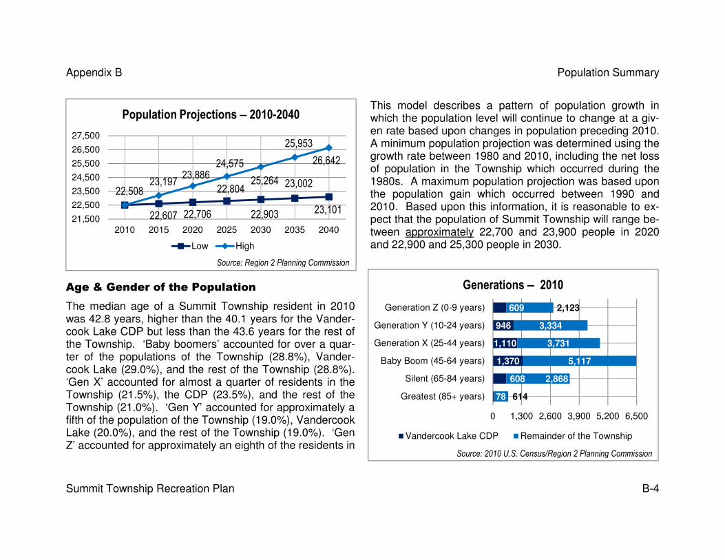
Appendix B Population Summary
Summit Township Recreation Plan B-4
This model describes a pattern of population growth in which the population level will continue to change at a giv-en rate based upon changes in population preceding 2010. A minimum population projection was determined using the growth rate between 1980 and 2010, including the net loss of population in the Township which occurred during the 1980s. A maximum population projection was based upon the population gain which occurred between 1990 and 2010. Based upon this information, it is reasonable to ex-pect that the population of Summit Township will range be-tween approximately 22,700 and 23,900 people in 2020 and 22,900 and 25,300 people in 2030.
Age & Gender of the Population
The median age of a Summit Township resident in 2010 was 42.8 years, higher than the 40.1 years for the Vander-cook Lake CDP but less than the 43.6 years for the rest of the Township. ‘Baby boomers’ accounted for over a quar-ter of the populations of the Township (28.8%), Vander-cook Lake (29.0%), and the rest of the Township (28.8%). ‘Gen X’ accounted for almost a quarter of residents in the Township (21.5%), the CDP (23.5%), and the rest of the Township (21.0%). ‘Gen Y’ accounted for approximately a fifth of the population of the Township (19.0%), Vandercook Lake (20.0%), and the rest of the Township (19.0%). ‘Gen Z’ accounted for approximately an eighth of the residents in
22,508
22,607 22,706
22,804
22,903
23,002
23,101
23,19723,886
24,575
25,264
25,953
26,642
21,500
22,500
23,500
24,500
25,500
26,500
27,500
2010 2015 2020 2025 2030 2035 2040
Population Projections −−−− 2010-2040
Low High
78
608
1,370
1,110
946
609
614
2,868
5,117
3,731
3,334
2,123
0 1,300 2,600 3,900 5,200 6,500
Greatest (85+ years)
Silent (65-84 years)
Baby Boom (45-64 years)
Generation X (25-44 years)
Generation Y (10-24 years)
Generation Z (0-9 years)
Generations −−−− 2010
Vandercook Lake CDP Remainder of the Township
Source: Region 2 Planning Commission
Source: 2010 U.S. Census/Region 2 Planning Commission

Appendix B Population Summary
Summit Township Recreation Plan B-5
the Township (12.1%), the CDP (12.9%), and the rest of the Township (11.9%). Members of the ‘Greatest’ and ‘Silent’ Generations accounted for less than a fifth of the population of the Township (18.5%), Vandercook Lake (14.5%), and the rest of the Township (19.6%).
More than half (52.1%) of Summit Township residents were fe-male in 2010. This observation also holds true for the Vander-cook Lake CDP (51.8%) and the remainder of the Township (52.2%). The median age of women was greater than males in the Township (44.5 and 41.1, respectively), Vandercook Lake (41.4 and 39.1, respectively), and the remainder of the Town-ship (45.3 and 41.7, respectively).
Age −−−− 2010
Vandercook Lake CDP
Remainder of Twp.
Summit Township
Total population 4,721 17,787 22,508 Under 5 years 287 980 1,267
5 to 9 years 322 1,143 1,465 10 to 14 years 352 1,187 1,539 15 to 19 years 341 1,267 1,608 20 to 24 years 253 880 1,133 25 to 29 years 272 815 1,087 30 to 34 years 242 906 1,148 35 to 39 years 283 939 1,222 40 to 44 years 313 1,071 1,384 45 to 49 years 363 1,202 1,565 50 to 54 years 402 1,346 1,748 55 to 59 years 331 1,390 1,721 60 to 64 years 274 1,179 1,453 65 to 69 years 214 922 1,136 70 to 74 years 152 686 838 75 to 79 years 139 671 810 80 to 84 years 103 589 692 85 to 89 years 60 383 443
90 years and over 18 231 249
Source: 2010 U.S. Census
52.2%
51.8%
52.1%
0% 10% 20% 30% 40% 50% 60%
Remainder of the Township
Vandercook Lake CDP
Summit Township
Gender −−−− 2010
Female MaleSource: 2010 U.S. Census

Appendix B Population Summary
Summit Township Recreation Plan B-6
Group Quarters & Household & Family Composition
Almost all of the residents of Summit Township lived in households in 2010. For example, only a small portion (1.6%) of the Township’s 22,508 residents lived in group quarters. None of the 4,721 residents of the Vandercook Lake CDP lived in group quarters and only a small portion of the population of the remainder of the Township (2.0%) lived in group quar-ters. It should be noted that more than one third (38.7%) of those residents living in group quarters were institutionalized in 2010 (i.e., under formally authorized supervised care or custody in an institution).
There were 9,149 households in Summit Township in 2010, with 1,842 (i.e., 20.1%) of them located in Vandercook Lake. Over two-thirds of the households across the Township (68.2%), the CDP (71.4%), and the rest of the Township (67.2%) were comprised of families. However, the overwhelming majority of non-family households across the Township (85.5%), Vandercook Lake (81.0%), and the rest of the Township (86.4%) were comprised of a householder liv-ing alone. The average household size was 2.42 people and the average family size was 2.92 people across the Township. The average household size was 2.56 people and the average family size was 2.99 people in the CDP. The average household size was 2.39 people and the av-erage family size was 2.90 in the rest of the Township.
Racial & Ethnic Composition
The overwhelming majority of the populations of the Township (89.6%), the Vandercook Lake CDP (95.3%), and the rest of the Township (88.1%) were white in 2010. African Americans were the most populous minority comprising small but significant portions of the populations of the Township (5.3%), Vandercook Lake (1.3%), and the rest of the Township (6.3%). Mixed race residents were the next most populous minorities in the Township (2.5%), the CDP (2.3%), and the rest of the Township (2.6%). Finally, Hispanics (i.e., Latinos/Latinas) also comprised small but significant portions of the populations of the Township (2.7%), Vandercook Lake (2.3%), and the remainder of the Township (2.8%).
2.56 2.39 2.42 2.99 2.90 2.92
0.0
1.0
2.0
3.0
4.0
Vandercook LakeCDP
Remainder ofSummit Township
Total
Household & Family Size −−−− 2010
Average household size Average family size
Source: 2010 U.S. Census

Appendix B Population Summary
Summit Township Recreation Plan B-7
Disability of Residents
It is estimated that significant segments of the population of Jackson County had some type of disability in-2010. 3,4 For example, an estimated one-sixth (15.4%) of residents were disabled in some way. The rate of disabilities increases with age. Over one-third (37.8%) of residents aged 65 years or older were disabled. In comparison, only one-twentieth (5.4%) of residents under the age of 18 years were disa-bled. Disabled residents with an ambulatory (mobility) diffi-culty also increased with age: essentially none (0%) under the age of 18, approximately one out of thirteen (7.7%) be-tween 18 and 64 years of age, and over one quarter (26%) for those 65 years of age and older.
Income
The estimated median income for all households in Summit Township ($52,559) from 2006 through 2010 was greater than the median income for Vandercook Lake CDP house-holds ($44,153).5 The estimated median income for all fami-ly households in Summit Township ($66,134) during the same time period was also greater than the median income for all family households in Vandercook Lake ($55,893). Fi-
3 Information on disabilities was not available for the Vandercook Lake CDP or Summit Township 4 A disability is “a long-lasting physical, mental, or emotional condition,” according to the U.S. Census Bureau. “This condition can make it difficult for a person to do activities such as walking, climbing stairs, dressing, bathing, learning, or remembering. This condition can also impede a person from being able to go outside the home alone or to work at a job or business.” 5 Median income means that ½ of the household incomes were greater and ½ were less than the stated amount.
Estimated Median Income −−−− 2006-2010
Vandercook Lake CDP
Summit Township
All Households $44,153 $52,559 All Family Households $55,893 $66,134
Married Couple Family Households $63,636 $73,901 Non-Family Households $21,625 $29,703
Source: 2006-2010 American Community Survey
1,992
13,497
8,256
0 30,000 60,000 90,000 120,000
<18
18-64
>64
Estimated Disabled Population in
Jackson County −−−− 2010
Disabled Population Remainder of Population
Source: 2010 American Community Survey

Appendix B Population Summary
Summit Township Recreation Plan B-8
nally, the estimated median income for non-family households in Summit Township ($29,703) was greater than the medi-an income for non-family households in the CDP ($21,625).
End Notes
i These following definitions are excerpted from the glossary webpage of American FactFinder, the website of the U.S. Census Bureau:
• American Community Survey − The American Community Survey is a large, continuous demographic survey conducted by the Census Bureau that will eventually provide accurate and up-to-date profiles of America's communities every year. Questionnaires are mailed to a sample of addresses to obtain information about house-holds -- that is, about each person and the housing unit itself. The survey produces annual and multi-year estimates of population and housing characteristics and pro-duces data for small areas, including tracts and population subgroups.
• Census (Decennial) − The census of population and housing, taken by the Census Bureau in years ending in 0 (zero). Article I of the Constitution requires that a cen-sus be taken every ten years for the purpose of reapportioning the U.S. House of Representatives.
• Continuous Measurement System − This system is a re-engineering of the method for collecting the housing and socio-economic data traditionally collected in the de-cennial census. It provides data every year instead of once in ten years. It blends the strength of small area estimation from the census with the quality and timeliness of the continuing surveys. This system includes a large monthly survey, the American Community Survey, and additional estimates through the use of administrative rec-ords in statistical models. It was in a developmental period that started in 1996 and, in 2005, began full-scale national implementation. This survey [replaced] the ‘long-form’ for the 2010 decennial census of population and housing.
• Long Form − The decennial census questionnaire, sent to approximately one in six households for the 1980, 1990, and 2000 censuses, contains all of the questions on the short form, as well as additional detailed questions relating to the social, economic, and housing characteristics of each individual and household. Information de-rived from the long form is referred to as sample data, and is tabulated for geographic entities as small as the block group level in 1980, 1990, and 2000 census data.
• Sample Data − Population and housing information collected from the census long form for a one in six sample of households in the United States and Puerto Rico, and on a continuous basis for selected areas in the American Community Survey.
• Short Form − The decennial census questionnaire, sent to approximately five of six households for the 1980, 1990, and 2000 censuses. For Census 2000, the ques-tionnaire asked population questions related to household relationship, sex, race, age and Hispanic or Latino origin and housing questions related to tenure, occupancy, and vacancy status. The 1990 short form contained a question on marital status. The questions contained on the short form also are asked on the long form, along with additional questions.

Appendix C
Jackson Community Comprehensive Plan 2000-2025 Summit Township Recreation Plan
2013-2017 Edition

Appendix C Jackson Community Comprehensive Plan
Summit Township Recreation Commission Page C-2
Selected Health Concern – Overweight and Obesity Risk Factors1
“The US Surgeon General has called for action to prevent and decrease overweight and obesity. The Health consequences of overweight and obesity have been labeled as ‘a public health issue that is among the most burdensome faced by the na-tion.’ This national health problem manifests itself in premature death and disability, high health care costs, loss of produc-tivity, and social stigmatization. According to the Surgeon General’s call to action ‘To Prevent and Decrease Overweight and Obesity, 2001,’ there are many factors which cause overweight and obesity. ‘For each individual, body weight is determined by the combination of genetic, metabolic, behavioral, environmental, cultural, and social economic influences. Behavior and environmental factors rare large contributors to overweight and obesity and provide the greatest opportunity for actions and interventions designed for prevention and treatment.’”
“The availability of data regarding overweight and obesity specific to the area of Jackson County is lacking. Data regarding obesity for the State of Michigan is available through the Behavioral Risk Factor Surveillance System (BRFSS, 2001). The data reveals that in 1991, 15.2% of the State’s population was obese. At that time, Michigan’s rate of obesity was tied for third highest in the Nation with the State of West Virginia. Only the states of Mississippi and Louisiana exceeded Michigan in the rate of obesity. In the year 2001 Michigan’s rate of obesity had climbed to 24.4%, the third highest state in the nation, following the states of Mis-sissippi and West Virginia. Sixty-one percent of Michigan’s population is either obese or overweight.”
1 This section was excerpted from the Demographics Chapter of the Jackson Community Comprehensive Plan 2000-2025.
Obesity Trends, Michigan 1991-2001
Year % Obese
1991 15.2
1995 17.7
1998 20.7
1999 22.1
2000 21.8
2001 24.4 Source: Behavioral Risk Factor Surveillance System, 2001
“Many argue that ‘urban sprawl’ has contributed to ‘waistline sprawl’ in that it supports an automobile-friendly environ-ment rather than an environment where other modes of active transport (walking, cycling, and other non-motorized
vehicles) are encouraged.”

Appendix C Jackson Community Comprehensive Plan
Summit Township Recreation Commission Page C-3
Actual Causes of Death in the United States, 2000.
“The National Center for Chronic Disease Prevention and Health Promotion, an agency of the Center for Disease Control provides data on the actual causes of death in the United States for the year 2000. The category ‘Poor Diet / Physical Inactivity’ ranks second, in terms of the percentage of all deaths, at 16.6%, close-ly behind tobacco use at 18.1%.”
Factors Contributing to Unhealthy Weight
“The report ‘Health Policy Options for Michigan Policy Makers: Promoting Healthy Weight in Michigan Through Physical Activity and Nutrition’ identifies factors which contribute to unhealthy weight. While several factors contribute to this problem, the report identifies factors which are of particular relevance to community growth, development, and planning. The report notes:
‘Physical and Social environmental barriers are present in Michigan that negatively affect physical activity and nutrition. Inadequate community infrastructure limits the ability to be active. These include lack of accessible indoor and outdoor exercise facilities, neighborhood sidewalks, walking paths, and bicycle trails. Additionally, inclement weather, lack of ad-equate recreational opportunities, and unattractive or unpleasant local environments may prevent people from exercis-ing.’
‘Programs and policies are necessary to promote smart community growth and the establishment of urban and rural envi-ronments supportive of physical activity. Active community environments provide access to safe favorable conditions for physical activity and promote the development of social support networks that encourage activity.’”2
“The report notes that various state departments, community planners, and community members should work together to promote active environments. The report also lists a series of policy recommendations, including the following specific rec-ommendations relative to what the report labels ‘active community environments.’3
2 Kreulen Pg. 10
3 Kreulen Pg. 18
Actual Causes of Death, United States 1990 and 2000
% Of Deaths
Cause 1990 2000
Tobacco 19 18.1
Poor diet and physical inactivity 14 16.6
Alcohol Consumption 5 3.5
Microbial Agents 4 3.1
Toxic Agents 3 2.3
Motor Vehicles 1 1.8
Firearms 2 1.2
Sexual Behavior 1 0.8
Illicit Drug Use <1 0.7
Source: National Center for Chronic Disease Prevention and Health Promotion

Appendix C Jackson Community Comprehensive Plan
Summit Township Recreation Commission Page C-4
1. Develop walkable communities by widening and maintaining our building sidewalks, safe roadway crossings, and aesthetically pleasing areas.
2. Encourage bicycling by developing, maintaining, and promoting the use of bike paths. 3. Require all urban planning and re-design - incorporate the concepts of active community environments and there by
promote physical activity.”
Issues, Goals, Policies & Actions4
“The purpose of [the Jackson Community Comprehensive Plan] is to establish policies to guide the future growth and devel-opment of the Jackson Community. These policies, established at the community-wide level, are intended to assist local units of government, including the County’s villages, townships, and the City of Jackson as they develop, amend, and im-plement their community plans, and zoning ordinances.”
“The policies formulated and adopted as a result of the process in preparing the Jackson Comprehensive Community Plan primarily address land use and development issues which either transcend the boundary lines of local units of government, or are county-wide in nature. This regional perspective is critical. The strength of our governmental structure which is com-prised of 19 townships, 6 villages and the City of Jackson, is the ability to deliver local government that is close to the peo-ple. Within the planning process this governmental structure provides each local unit the opportunity to determine how its community should grow and develop, and ultimately, the shape and form of the future community. The weakness in this ar-rangement of local units of government is the tendency to overlook the implications of decisions which have regional signifi-cance.”
A total of sixteen land use issues were identified. Issues with a recreation component are reprinted in their entirety:
���� Create a Walkable Community ���� Farmland Preservation ���� Historic Preservation ���� Planning Coordination ���� Maximum Housing Choice ���� Open Ethical Governance and Citizen Participation ���� Sewer and Water Extension ���� Culture
���� Urban Development ���� Overzoning and Strip Commercial Development ���� Protection of Ground and Surface Water Quality ���� Wetlands ���� Preservation of Open Space ���� Economic Diversity ���� Innovative Planning and Zoning ���� The Movement of People and Goods
4 This section was excerpted from the Issues, Goals, Policies & Actions Chapter of the Jackson Community Comprehensive Plan 2000-2025.

Appendix C Jackson Community Comprehensive Plan
Summit Township Recreation Commission Page C-5
Create a Walkable Community
“The automobile is firmly embedded in our culture. It simultaneously offers a measure of freedom; and yet also limits the freedom of movement both for the younger and older segments of our population, and to our citizens generally, through traf-fic congestion. In our urban areas, space is consumed for parking which negates the possibility for the creation of compact pedestrian-oriented development patterns. The automobile allows us freedom to work in distant places and live in rural are-as, but also requires an expansive network of roads and highways to get us there.”
“Considerable attention has been focused recently on the health of our citizens. Physical inactivity and obesity of our citizens has been defined by health professionals as a serious threat to community health and well-being. While it is acknowledged that every citizen is free to make individual choices regarding means and mode of transportation, there is a need to insure that our communities are walkable. Indeed, within the concept of community, social contact and interaction, the sense of human scale, and community identity, are elemental.”
Goal: “Community plans, development decisions, and ultimately the shape and form of our communities shall of-fer the opportunity for employment, commerce, recreation, and social interaction within community centers and neighborhoods which are walkable.”
Policies and Actions
1. “Within defined community centers and neighborhood areas as identified in this plan, and the plans of local communities of government in Jackson County, development should be promoted which is compact and which fosters higher densi-ties.”
2. “Sidewalks should be encouraged to be provided in neighborhoods, subdivisions, and site condominium projects; and commercial areas.”
3. “Pedestrian networks are encouraged to be developed which link subdivisions, neighborhoods, business districts, down-town areas, recreational areas; and connected to a system of regional pedestrian and bicycle trails.”
4. “Parking shall be encouraged to be located in areas that do not impede pedestrian travel.” 5. “Within downtown areas of the County pedestrian travel should be given priority over automobile and vehicular travel.” 6. “Local communities should review their commercial zoning districts to promote commercial uses which thrive on pedes-
trian traffic to be grouped together, and to assure that commercial uses which are oriented toward vehicular traffic are es-tablished as permitted uses in separate commercial zoning districts. Small commercial areas which offer goods and ser-vices to neighborhood areas should be encouraged.”
7. “Communities should review their patterns of residential distribution and attempt to promote and strengthen neighbor-hoods which offer parks, elementary schools, and neighborhood commercial areas within walking distance.”

Appendix C Jackson Community Comprehensive Plan
Summit Township Recreation Commission Page C-6
8. “Several recreation plans for local units of government call for the construction of recreational trails. In addition, the Jackson County Trailways Plan recommends several additional trails and trail extensions. These recommendations should be implemented as funding becomes available. Finally, trailways should be coordinated with the plans for trails in adjacent counties.”
Historic Preservation
“The community of today grew out of the community of the past. Current development patterns, street networks, neighbor-hoods, clusters of buildings, and single buildings themselves are reflective of the unique mix of culture and history in which the Jackson Community grew and developed. This unique history gave the community identity and is a reflection of commu-nity heritage.”
“Today’s mass culture, and the influence of the mass media, in conjunction with the consolidation and growth of businesses and industries within the economy has resulted in development which is a replica of development which is occurring in com-munities across the nation. Forces of community development today tend to result in ubiquity. Sameness results in a loss of identity.”
“As our economy has grown nationally, and the implications of this growth have been experienced locally, both the benefits and the liabilities of such growth become manifest. While products have become more varied and accessible, the commer-cial delivery system which provides these products through “big box” stores, and drive-thru “fast-food” restaurant has tended to reduce the diversity and appearance of the urban landscape. As a result, the importance of historic preservation has nev-er been greater, and over time becomes more and more important to maintain community identity and diversity. The preser-vation of historic buildings and structures provides a vital link to our heritage.”
Goal: “Jackson County communities shall identify historic and cultural resources and develop policies, pro-grams, and regulations to promote their continued use and survival.”
Policies and Actions
1. “Historic and unique community features, structures, and buildings should be identified, mapped and preserved.” 2. “Jackson County communities should educate developers, and the public at large, about the availability of tax credits of-
fered through the State of Michigan for historic preservation, and encourage this application of these credits.” 3. “Local planning commissions should consider the impacts of development decisions on historic and cultural resources.”

Appendix C Jackson Community Comprehensive Plan
Summit Township Recreation Commission Page C-7
Culture
“The concept of a community implies more than simply a place to live, work, engage in commerce, and play. Communities are places of social interaction, where people meet face to face. Communities provide the structure necessary for cultural growth and development.”
“Communities are places where governance occurs. They’re places where people pray. They’re places where information is exchanged. Communities are elementally important in our cultural system, acting as clearinghouses for all that makes peo-ple human. They are the bartering places for the exchange of ideas and cultures. The Comprehensive Plan should support this important role.”
Goal: “Community Centers should facilitate social interaction and assemblage, and provide a space for, and en-hance, culture.”
Policies and Actions
1. “Buildings and structures which facilitate or enhance our culture: city, township, and village halls; schools; libraries; mu-seums; and churches should be identified, mapped, and protected.”
2. “Indoor and outdoor places of public assemblage and opportunity for public gathering should be promoted within our community centers.”
3. “Communities should inventory, promote, and maintain their public spaces, and promote their use and safety.”
Preservation of Open Space
“To many citizens in Jackson County, the rural areas of the County are appealing because of the open space which exists there. Many residents have, in fact, selected home sites in rural areas because of the open rural quality such areas afford. Obviously, with additional development in rural areas comes a loss in open space and the values which attracted rural de-velopment in the first place.”
Goal: “Preservation of Open Space shall be encouraged.”
Policies and Actions
1. “Local units of government are encouraged to apply cluster-zoning provisions to preserve open space and maintain rural character.”
2. “Policies contained within this report to encourage development to be located within existing urban and developed areas and to encourage higher densities should be implemented.”

Appendix C Jackson Community Comprehensive Plan
Summit Township Recreation Commission Page C-8
The Community Plan5
“The Jackson Community Comprehensive Plan is intended to provide guidance for the future growth and development of the Jackson County area. The Plan was prepared in accordance with generally accepted practices for the development of com-prehensive plans.”
1. “The Plan is long-range. The Plan provides a policy guide for growth and development from the date of adoption of the Plan in 2005, through the year 2025. It is intended to provide a long-range vision for the Community based upon antici-pated economic growth, population and household projection, the existing pattern of development, and preferred growth and development patterns.”
2. “The Plan is intended to be general in nature rather than specific. Because the Plan is a statement of policy, it is ex-pressed as a generalized, or conceptual, plan for future land use, rather than indicating specific land uses for specific parcels of land.”
3. “The Plan is intended to be flexible. The Plan can be amended following the adherence to legal requirements as estab-lished in state law. Communities, and the events which affect them, are subject to change over time. The Plan is not in-tended to be static, but can be revised as needed to respond to change in circumstance.”
4. “The Plan is a statement of policy. It is advisory in nature, setting forth the vision for the future.”
Greenways Plan
The “’Greenways Plan’ for the Jackson Community, identifies a network of greenways proposed throughout Jackson County. This network generally follows wetland areas, drainage ways, and forested lands (see Appendix A). The network recognizes these areas as a part of Jackson County’s natural system which should be preserved. The preservation of this system helps to assure high quality surface water, wildlife habitat and movement, diversity, and can be used to help define urban growth.”
“Much of the Greenways Plan tends to be self-implementing. Development in wetland areas is limited by the practical diffi-culties associated with the development of these of lands. Soils in these areas are wet, compressive strength to support de-velopment is lacking, and the cost of developing in wetland areas is high. In addition, wetlands are protected by the Michi-gan Natural Resources and Environmental Protection Act, Act 451 of 1994.”
“The prohibition of all forms of development within this area is not necessary. Some very low-density development can be incorporated without damage to the integrity of the greenway. Roads and highways transect the network at numerous loca-tions throughout the County. As this Plan is further developed and implemented it may be likely that there are strategic
5 This section was excerpted from the Plan Chapter of the Jackson Community Comprehensive Plan 2000-2025.

Appendix C Jackson Community Comprehensive Plan
Summit Township Recreation Commission Page C-9
points within the network that require some type of preservation action. In some locations the width of the greenway is very narrow. Conservation easements may be a good means of assuring continuity in these areas.”
“The Greenways Plan sets a foundation for the development of the Comprehensive Land Use Plan within the natural system which exists in Jackson County. In some instances greenways may help to define urban areas and separate these urban areas from rural areas of the County.”
“For all of the foresaid reasons and simply so citizens have the opportunity for contact with nature, the implementation of the Plan would significantly improve the quality of life in Jackson County.”
The Land Use Plan
The “Land Use Plan sets forth a spatial vision for the future growth and development of the Jackson Community (see Ap-pendix A). It is intended, generally, to promote future development within areas which are currently developed. These areas tend to contain the infrastructure necessary to support growth and development. They are areas where higher densities and intensities of land use are to be encouraged. The Plan recognizes the importance of making the urban areas which exist within the County better places to live. The Plan focuses cultural amenities within these areas, and encourages beautifica-tion and redevelopment programs, and special attention to the provision of parks in neighborhood areas, and the provision of a network of pedestrian and bicycle pathways. Generally, as a matter of governmental policy, development within rural are-as is to be discouraged.”
“The Plan identifies industrial, commercial, residential and agricultural and open space areas. Industrial areas are clustered within the community at locations where existing industrial land uses already exist, and where infrastructure is sufficiently provided, or proposed to be provided to accommodate these intense uses. As such, industrial areas are located along major transportation arteries which afford access to jobs for the residents of Jackson County, as well as transportation to other re-gions of the state and nation for receipt seat of materials for the production process, and the distribution of goods and prod-ucts produced in the Jackson area.”
“Proposed commercial areas follow existing patterns of commercial development, and allow for commercial expansion with-in, and adjacent to, these commercial areas. Continued growth and development of small commercial areas in rural villages and population settlements is encouraged. Small commercial development which would serve neighborhoods, though not shown on the Plan Map, are encouraged to be developed. The Plan supports the development of commercial areas which are intensive and compact in which many commercial services are offered to customers within in a small area. This pattern of commercial development will reduce the need for automobile travel.”

Appendix C Jackson Community Comprehensive Plan
Summit Township Recreation Commission Page C-10
“The principles which have been applied to the location of industrial and commercial uses on the land use plan also apply to residential uses. Generally, areas proposed for higher intensity residential development are located in areas of existing resi-dential development. These areas are associated with the urban area of the City of Jackson, and urbanizing portions of Blackman, Leoni, Spring Arbor, and Summit Townships.”
“Additional urban development is proposed in lakes areas where sewer systems exist or are planned, and in the Village are-as of Brooklyn, Concord, Grass Lake, Hanover, Parma and Springport. Further development is proposed in the unincorpo-rated areas of Michigan Center, Spring Arbor and Vandercook Lake.”
“Residential development in rural areas will continue, but should not be encouraged. Within rural areas local townships should pursue and encourage clustered housing with secured, permanent open space to be preferred over large lot single family development.”
“Existing agriculture should be encouraged in rural areas of the County, particularly where there are prime soils, or produc-tive farms.”

Appendix D
Recreation and Resource Inventories
Summit Township Recreation Plan 2013-2017 Edition

Appendix D Recreation and Resource Inventories
Summit Township Recreation Plan D-2
NRPA PARK STANDARDS
TYPE OF AREA USE SERVICE AR-EA SIZE
ACRES/ 1,000 SITE FEATURES
Mini-Park Specialized facilities that serve a concentrated or limited population or specific group such as tots or senior citizens.
Less than 1/4 mile radius
1 acre or less
.25 to .50 Within neighborhoods and in proximity to apartment complex-es, townhouses or housing for the elderly.
Neighborhood Park or Playground
Area for intense recreation activities, such as field games, court games, crafts, playground apparatus area, skating, picnicking, wading pools, etc.
¼ to ½ mile ra-dius to serve a population up to 5,000 - a neigh-borhood.
15 acres 1 to 2 Suited for intense development. Easily accessible to neighbor-hood populations geographically centered with safe walking and bike access. May be developed as a school park facility
Community Park Area of diverse environmental quality. May in-clude areas suited for intense recreational facili-ties, such athletic complexes, large swimming pools. May be an area of natural quality for out-door recreation, such as walking, viewing, sit-ting, AND PICNICKING. May be any combina-tion of the above, depending upon site suitability and community need.
More than one neighbor-hood 1 to 2 mile radi-us
15+ Acres
5 to 8 May include natural features, such as water bodies, and areas suited for intense development. Easily accessible to neighbor-hood served.
Source: Roger A. Lancaster, Ed; 1983. Recreation, Park and Open space Standards and Guidelines, Alexandria, Virginia: National Recreation and Park Association, p. 56-57.

Appendix D Recreation and Resource Inventories
Summit Township Recreation Plan D-3
Jackson County Park Inventory Matrix
Park Gre
en
sp
ace
Wate
r F
eatu
res
Ben
ch
es
18-h
ole
GC
9-H
ole
GC
Dri
vin
g R
an
ge
Cam
pin
g�� ��
Ball D
iam
on
ds
Vo
lle
yb
all
Ten
nis
Bask
etb
all
Pla
yg
rou
nd
s
Win
ter
Sp
ort
s�� ��
Resta
ura
nt
Restr
oo
ms
Rec. C
en
ter/
Gy
m
Path
ways
Pic
nic
Sh
elt
ers
Pic
nic
Are
a
Gri
lls
Mark
ers
Sw
imm
ing
Bo
at
Lau
nch
Fis
hin
g
Clark Lake • • • • • • • • • • •
Clear Lake • • • • • • •
Gillett's Lake • • • • • • • • •
Grass Lake • • • • • • • • • • • •
Lime Lake • • • • • • • •
Little Wolf Lake • • • • • • • •
Minard Mills • • • • • • • •
Pleasant Lake • • • • • • • • • • • • •
Portage Lake • • • • • • • •
Round Lake • • • • • • • •
Alfred A. Snyder • • • • • • • •
Sparks Found • • • • • • • • • • • • • • • • • • •
Swains Lake • • • • • • • • • • • • • •
Vandercook Lk • • • • • • • • • • • •
Vineyard Lake • • • • • • • • •
� Sixty modern campsites with water and electricity; hot showers, restrooms, a sanitary dump station & water. � Sledding & toboggan hill, skating pond & warming house, cross country skiing.

Appendix D Recreation and Resource Inventories
Summit Township Recreation Plan D-4
City of Jackson Park Inventory Matrix
Park Gre
en
Sp
ac
e
Wate
r F
eat
Ben
ch
es
18-h
ole
GC
9-H
ole
GC
Dri
vin
g R
an
ge
Cam
pin
g*
Ball D
iam
.
Vo
lle
yb
all
Ten
nis
Bask
etb
all
Pla
yg
r ou
nd
Win
t . S
prt
s.
Resta
ura
nt
Restr
oo
ms
Rec C
tr./G
ym
/Path
way
s
Pic
nic
Sh
elt
.
Pic
nic
Are
a
Gri
lls
Mark
ers
Sw
imm
ing
Bo
at
Lau
nch
Fis
hin
g
Beech Tree •
J.J. Best Ballfield •
Blackman Park • •
Gov. Austin Blair Memorial. • •
Bloomfield Park • • • • •
Betsy Butterfield • • • • •
Norm Creger Memorial. • •
Exchange Park • • • • •
Bucky Harris • • •
Martin Luther King Ctr. • • • • • • • • • •
Kiwanis • • • •
Laurel Lane Playground • • •
Leekes • • •
Lions • • • • • •
Loomis • • • • • • • • • • •
Nixon Memorial • • • • •
Optimist • • • •
Partnership • • • •
Rotary • • • • •
Ella Sharp • • • • • • • • • • • •
Under the Oaks •
Withington • • • •
Inter-City Trail •
New Leaf •
Downtown Riverfront • • •

Appendix E
Description of the Planning and Public Input Processes Summit Township Recreation Plan
2013-2017 Edition

Appendix E Recreation and Resource Inventories
Summit Township Recreation Plan E-2
Online Survey Promotion
Jackson Citizen Patriot, Sunday, September 30, 2012, page A6
Brooklyn Exponent, Tuesday, October 9, 2012, page 3

Appendix E Recreation and Resource Inventories
Summit Township Recreation Plan E-3
Plan Review Meeting (Open House) Promotion
Brooklyn Exponent, Tuesday, January 8, 2013, page 3
Jackson Citizen Patriot, Thursday, January 3, 2013, page B7

Appendix E Recreation and Resource Inventories
Summit Township Recreation Plan E-4
The above article appeared on page 5 of the Tuesday, December
18, 2012 edition of the Brooklyn Exponent.

Appendix E Recreation and Resource Inventories
Summit Township Recreation Plan E-5
One Month Review Period
The adjacent flyer, providing an opportunity to review and comment upon the draft recreation plan, was posted at the following locations:
� Lumen Christi Catholic High School, � Vandercook Lake Public Schools, � the Summit Branch of the Jackson District Library, and � the Summit Township Office.
The flyer shown on page E-3 was posted at the same loca-tions. The draft plan was available for review at the following locations:
� the Summit Township Office, � the Summit Branch of the Jackson District Library, and � www.summittwp.com – the Summit Township Website.
Letters of Transmittal
The letters of transmittal to the following are located on the next two pages of this appendix:
� Jackson County � Region 2 Planning Commission

Appendix E Recreation and Resource Inventories
Summit Township Recreation Plan E-6

Appendix E Recreation and Resource Inventories
Summit Township Recreation Plan E-7

Appendix E Recreation and Resource Inventories
Summit Township Recreation Plan E-8
Public Hearing Noticing
Brooklyn Exponent, Tuesday, January 22, 2013, page 6C
Jackson Citizen Patriot, Thursday, January 17, 2013

Appendix E Recreation and Resource Inventories
Summit Township Recreation Plan E-9

Appendix E Recreation and Resource Inventories
Summit Township Recreation Plan E-10

Appendix E Recreation and Resource Inventories
Summit Township Recreation Plan E-11

Appendix E Recreation and Resource Inventories
Summit Township Recreation Plan E-12

Appendix E Recreation and Resource Inventories
Summit Township Recreation Plan E-13

Appendix E Recreation and Resource Inventories
Summit Township Recreation Plan E-14